Download canberra_study_within_11.pdf
56
Aeronautical Study of Canberra Aerodrome Report by Hyder Consulting Pty Ltd June 2011
Transcript of Download canberra_study_within_11.pdf
Aeronautical Study of Canberra Aerodrome
Report by Hyder Consulting Pty Ltd
June 2011
Office of Airspace Regulation Page 2 of 56
Aeronautical Study of Canberra Aerodrome June 2011 Version: 0.4
DOCUMENT SPONSOR: OFFICE OF AIRSPACE REGULATION PROJECT NUMBER: 10/20 TRIM REFERENCE: ED11/167595 FILE REF: EF10/12665
Document control:
Version Issue/Nature of Revision Date 0.1 Draft for internal review April 2011
0.2 Updated Risk Assessment June 2011
0.3 Incorporates CASA feedback July 2011 0.4 Incorporates Defence and Airservices feedback August 2011
Office of Airspace Regulation Page 3 of 56
Aeronautical Study of Canberra Aerodrome June 2011 Version: 0.4
1 Executive Summary The Office of Airspace Regulation (OAR)1 within the Civil Aviation Safety Authority (CASA) commissioned Hyder Consulting Pty Ltd (Hyder) to provide a third party, independent and objective review of the airspace within 45 Nautical Miles (NM) of Canberra aerodrome, Australian Capital Territory, within Tower hours (TWR HR) of operation. This aeronautical study was commissioned in response to the Government’s expectation under the Australian Airspace Policy Statement (AAPS) for CASA to undertake regular and ongoing studies to meet its obligations under Section 13 of the Airspace Act 2007 (Act). The OAR undertakes a risk based approach in determining which locations are studied. The purpose of this review was to conduct an Aeronautical Study (including a risk assessment) of the airspace within 45 NM of Canberra aerodrome, Australian Capital Territory, within TWR HR of operation. Throughout this report the term Canberra refers to Canberra aerodrome. Particular emphasis was placed on the safety of Passenger Transport2 (PT) operations.
1.1 Operational Context Canberra Airport is leased by Canberra Airport Group Pty Limited and operated by the Capital Airport Group Pty Limited. The published Airport Master Plan – 2009 provides long term development concepts to cater for future growth. Airservices Australia (Airservices) supplied movement data shown in the following table:
2008/09 Movements
2008/09 ATM
2009/10 Movements
2009/10 ATM
Arrivals 33,825 25,640 32,336 24,795 Departures 33.796 25,640 32,691 24,793 Circuit 16,858 14,944 Total movements 84,479 51,280 79,971 49,588 - scheduled 44,548 44,122 43,748 43,613 - non-scheduled 3,811 3,773 2,835 2,773 - military 2,495 0 2,283 0 - general aviation 33,618 3,381 31,097 3,196 - other 7 4 8 6 Total flight types 84,479 51,280 79,971 49,588
Table 1 - Airservices data validation Reports 2008/09 and 2009/10 Note: Air Transport Movements (ATM)
The Bureau of Infrastructure, Transport and Regional Economics (BITRE) within the Department of Infrastructure and Transport, records the passenger count for Canberra as 3,258,788 for the twelve months to June 2010. The Aerodrome Operator published data on movements and passengers in the Canberra Airport Master Plan 2009. At that time, passenger numbers were around 3 million per annum. Canberra is located 6.5 kilometres (km) (3.5 NM) southwest of the Civic centre of Canberra situated in the Majura valley flanked by various mountains. The airspace surrounding Canberra Control Zone (CTR) is Class C airspace3 from the surface (SFC) to an altitude of 3,500 Feet (FT) Above Mean Sea Level (AMSL).
1 A full list of abbreviations and acronyms used within this report can be found at Annex A. 2 For the purposes of this study, PT services can be defined as activities involving Regular Public Transport (RPT) and all non-freight-only Charter operations. 3 Details of the classes of airspace used in Australia can be found in Annex B.
Office of Airspace Regulation Page 4 of 56
Aeronautical Study of Canberra Aerodrome June 2011 Version: 0.4
Canberra is a towered aerodrome which is not staffed continuously. Outside TWR HR, non-controlled aerodrome procedures apply.
1.2 Findings and Conclusions Class C airspace with surveillance is appropriate with respect to safety, environment, efficiency and equity. It provides a safe level of Air Traffic Services (ATS) and is appropriate for the levels and type of aircraft operating through the airspace. The review has assessed safety as comprising a number of medium risks in relation to mid air collisions, Class C/ATS, remedy of safety defects, dealing with complexity, upgrading of navaids and communications. Extension of TWR HR was also raised but is considered a low risk at current traffic levels. No extreme, very high or high risks were found. With respect to environment, noise effects are considered to be high risk, emissions medium risk and low risk in relation to Environment Protection and Biodiversity Conservation Act 1999 (EPBC). Efficiency in general was rated medium risk and Class C radar low risk as befits its application. Equitable access issues were rated as a low risk. In terms of specifics: The Control Area (CTA) design provides efficient access to Visual Flight Rules
(VFR) flights; The CTA Lower Limit (LL) should be redesigned to meet Advisory Circular (AC)
2-5-1 (0) requirements for a minimum of 700 FT from terrain; Lowest safe altitudes should be reviewed against AC 2-5-1 (0) in areas where
wind generators have been installed; Defence should review the linking of Air Traffic Control (ATC) to activation of
Defence Firing Areas within Majura Field Firing Range for inclusion in Aeronautical Information Publication (AIP);
Two segments of Area Navigation (RNAV) Global Navigation Satellite System (GNSS) RWY 30 should be reviewed so as to be contained within controlled airspace as required by AC 2-5-1 (14.1) and Civil Aviation Safety Regulation (CASR) Part 173 Manual of Standards (MOS);
Airservices should insert KATIA into the relevant sections of Designated Airspace Handbook (DAH) and En-route Supplement Australia (ERSA);
The current volume and mix of traffic outside of TWR HR does not justify a change in TWR HR;
The prohibition of DHC8 Q400 series use of RWY 30 for arrivals and enhancement of all weather capability should be reviewed;
The sufficiency of visual aids, runways and taxiways should be reviewed, including consideration to lack of a full length taxiway creating crossing problems, precision approach capability and High Intensity Approach Lighting (HIAL) for RWY 17;
A number of stakeholders believe that the equity of access to circuit training during peak hours should be reviewed;
Airspace around Pig Hill should be reviewed to allow better access for the hang gliders;
Office of Airspace Regulation Page 5 of 56
Aeronautical Study of Canberra Aerodrome June 2011 Version: 0.4
Specification of CTR as Aerodrome Reference Point (ARP) should be reviewed in relation to Distance Measuring Equipment (DME) arcs;
Class C LL 5,500 FT AMSL step in the south west should be reviewed in relation to extending 20 DME to 22 DME; and
Canberra operators should approach the local Regional Airspace and Procedures Advisory Committee (RAPAC) to declare Danger Areas (DA) for the training areas ‘Barton’ and ‘Kings’ and have the areas depicted on the Canberra Visual Terminal Chart (VTC) and Visual Navigation Chart (VNC).
1.3 Recommendations It is important to note that the study may make recommendations based on existing and projected data. The following comment as summarised by Chief Justice Sir Harry Gibbs of the High Court of Australia has been considered while conducting the study:
Where it is possible to guard against a foreseeable risk which, though perhaps not great, nevertheless cannot be called remote or fanciful, by adopting a means which involves little difficulty or expense, the failure to adopt such means will in general be negligent.4
CASA applies a precautionary approach when conducting aeronautical studies and therefore the following recommendations are made:
1. Airservices should insert Instrument Flight Rules (IFR) waypoint KATIA into the relevant sections of DAH and ERSA. [CASA comment: The waypoint KATIA has been included in ERSA, effective 25 August 2011].
2. Canberra operators should approach the local RAPAC to declare DA for the training areas ‘Barton’ and ‘Kings’ and have the areas depicted on the Canberra VTC and VNC.
3. Airservices should review the lowest safe altitudes in the areas where wind generators have been installed for compliance with the criterion in AC 2-5-1 (0).
4. The airport operator to review pilot comments including the prohibition of DHC8 Q400 series use of RWY 30 for arrivals and enhancement of all weather capability.
1.4 Next Steps Stakeholders are requested to provide feedback on the study to [email protected] no later than 23 September 2011. CASA will consider feedback received to be public information and will normally attribute feedback, however requests to remain anonymous will be considered. Following the consultation and feedback period CASA will finalise and publish their final recommendations.
4 Gibbs, Chief Justice Sir Harry. Turner v State of South Australia (1982). High Court of Australia before Gibbs CJ, Murphy, Brennan, Deane and Dawson JJ.
Office of Airspace Regulation Page 6 of 56
Aeronautical Study of Canberra Aerodrome June 2011 Version: 0.4
Contents 1 EXECUTIVE SUMMARY............................................................................................3 2 INTRODUCTION ......................................................................................................7 3 AIRSPACE ...........................................................................................................11 4 AERODROME.......................................................................................................19 5 CONSULTATION ...................................................................................................27 6 DATA..................................................................................................................33 7 SUMMARY OF INCIDENTS AND ACCIDENT DATA.......................................................35 8 RISK ASSESSMENT ..............................................................................................37 9 FINDINGS AND CONCLUSIONS ...............................................................................47 10 RECOMMENDATIONS ............................................................................................48 11 NEXT STEPS........................................................................................................48 12 REFERENCES ......................................................................................................49 ANNEX A – ABBREVIATIONS AND ACRONYMS.................................................................51 ANNEX B – AUSTRALIAN AIRSPACE STRUCTURE............................................................54 ANNEX C – STAKEHOLDERS.........................................................................................55 ANNEX D – DEFINITIONS AND EXPLANATION OF TERMS ..................................................56
Office of Airspace Regulation Page 7 of 56
Aeronautical Study of Canberra Aerodrome June 2011 Version: 0.4
2 Introduction The Office of Airspace Regulation (OAR)5 within the Civil Aviation Safety Authority (CASA) has carriage of the regulation of Australian-administered airspace, in accordance with section 11 of the Airspace Act 2007 (Act). Section 12 of the Act requires CASA to foster both the efficient use of Australian-administered airspace and equitable access to that airspace for all users. CASA must also take into account the capacity of Australian-administered airspace to accommodate changes to its use. In exercising its powers and performing its functions, CASA must regard the safety of air navigation as the most important consideration.6 Section 3 of the Act states that ‘the object of this Act is to ensure that Australian-administered airspace is administered and used safely, taking into account the following matters: a. protection of the environment; b. efficient use of that airspace; c. equitable access to that airspace for all users of that airspace; and d. national security.’ With respect to safety the requirements are considered in the following order:
a. safety of the airspace; b. protection of the environment; c. efficient use of that airspace; and d. equitable access to that airspace for all users of that airspace.
2.1 Overview of Australian Airspace In line with the International Civil Aviation Organization (ICAO) Annex 11 and as described in the Australian Airspace Policy Statement (AAPS), Australian airspace is classified as Class A, C, D, E and G depending on the level of service required to manage traffic safely and effectively. Class B and F are not currently used in Australia. The classification determines the category of flights permitted and the level of Air Traffic Services (ATS) provided. Annex B provides details of the classes of airspace and types of services (Instrument Flight Rules (IFR) and Visual Flight Rules (VFR)) used in Australia. Within this classification system aerodromes are either controlled (i.e. Class C or Class D) or non-controlled. Non-controlled aerodromes in Australia are subject to Common Traffic Area Frequency (CTAF) procedures. Pilots of aircraft operating at all registered, certified, Military and CASA designated aerodromes are required to carry and use a Very High Frequency (VHF) radio. Further information about aircraft operations at non-controlled aerodromes can be found on the CASA website: http://casa.gov.au/wcmswr/_assets/main/pilots/download/nta_booklet.pdf.
5 Abbreviations and Acronyms are given in Annex A 6 Civil Aviation Act 1988, Section 9A – Performance of Functions
Office of Airspace Regulation Page 8 of 56
Aeronautical Study of Canberra Aerodrome June 2011 Version: 0.4
2.2 Purpose The purpose of this review was to conduct an Aeronautical Study (including a risk assessment) of the airspace within 45 Nautical Miles (NM) of Canberra Aerodrome, Australian Capital Territory, within Tower hours (TWR HR) of operation. Throughout this report the term Canberra refers to Canberra aerodrome. Canberra is a towered aerodrome which is not staffed continuously. Outside TWR HR non-controlled aerodrome procedures apply. The study formed part of the OAR program of work to review Australia’s airspace as required by the Act. The outcome of the study, through the completion of the risk assessment, was to demonstrate that all sensible and practicable precautions are in place to reduce the risk of operating in the airspace to acceptable levels. For the purpose of this study, a multifaceted approach was used including quantitative and qualitative analysis consisting of Stakeholder interviews, site visits and reference to previous studies. The risk based approach primarily addressed safety but was also able to accommodate matters of environment, efficiency and equitable access. Options were considered for good practice to mitigate the identified airspace risks. Options which can be applied or adapted to the Australian environment were based upon proven international good practice, consistent with the Government’s airspace policy as described in the Aviation White Paper.
2.3 Scope The scope of the study included identification and consultation with stakeholders to gather necessary data and information relating to airspace issues around Canberra. This included consultation with aerodrome operators, Airservices Australia (Airservices), Charter operators, Department of Defence (Defence), Emergency Services operators, Flying Training Schools and Passenger Transport (PT) operators. The study’s scope also considered CASA’s responsibilities in adopting a proactive approach to assess the Australian airspace system and its operations, and to identify and pursue airspace reform opportunities. The AAPS offers clear guidance to CASA on the Government’s airspace strategy and policy, as well as processes to be followed when changing the classification or designation of particular volumes of Australian administered airspace. The scope of this study was not intended to examine aerodrome facilities and infrastructure issues unless any weakness or failings in these areas had a significant impact on the safety of airspace operations in the vicinity of Canberra. Other areas that were considered out of scope are: operations out of TWR HR (the subject of a separate review); the Tidbinbilla Restricted Areas (RA); the proposed airport at Williamsdale; and the proposed housing development at Tralee.
Office of Airspace Regulation Page 9 of 56
Aeronautical Study of Canberra Aerodrome June 2011 Version: 0.4
2.4 Objective
The objective of this study was to examine the airspace around Canberra aerodrome to determine the appropriateness of the current airspace classification. This was accomplished by: a. Investigating through stakeholder consultation, the appropriateness of the
current airspace classification, access issues, instrument approach design7 issues, expected changes to the current traffic levels and mix of aircraft operations within the existing airspace;
b. Assessing the opportunity to adopt proven international best practice airspace systems adapted to benefit Australia’s aviation environment as required by the AAPS8;
c. Analysis of current traffic levels and mix of aircraft operations within the existing airspace in relation to the level of services provided;
d. Identifying any threats to the operations, focussing as a priority on the safety and protection of PT services;
e. Carrying out a qualitative and quantitative risk assessment of the current airspace environment and the expected impact of any changes;
f. Identifying appropriate and acceptable risk mitigators to the known threats; g. Reviewing extant Aeronautical Information Publication (AIP) entries for
applicability; h. Ensuring that the issues are passed onto the relevant stakeholder group for
their consideration; and i. Providing assurance to the Executive Manager - Airspace and Aerodrome
Regulation Division of the levels of airspace risk associated with operations at Canberra Aerodrome.
The OAR issues a review of its Permanent Legislative Instruments on a bi-annual basis. Any changes to airspace determined by this study with respect to airspace classifications, air routes, Prohibited Areas (PA), RA or Danger Areas (DA) will be reflected in these Instruments. An explanation of terminology in relation to these areas can be found in Annex D.
2.5 Methodology The risk assessment considers available surveillance and takes into account the differences with respect to Australian airspace notified under Article 38 of the Convention on International Civil Aviation (Chicago 1944). Given the large number of differences listed in AIP, the relevance to Canberra aerodrome remains to be established. It also considers CASA’s responsibilities in adopting a proactive approach to assessing the Australian airspace system and its operations, and to identify and pursue reform opportunities. The methodology was expanded in terms of three ‘due diligence’ steps: Step 1 – Concept and Scope; Step 2 – Stakeholder Consultation; and Step 3 – Ranking and Draft recommendations.
7 Refer to Civil Aviation Safety Regulation (CASR) Manual of Standards (MOS) Part 173. 8 To view the AAPS (2010) visit http://casa.gov.au/scripts/nc.dll?WCMS:STANDARD::pc=PC_90462
Office of Airspace Regulation Page 10 of 56
Aeronautical Study of Canberra Aerodrome June 2011 Version: 0.4
2.5.1 Concept and Scope At inception, work focussed on data collection and familiarisation with previous reports, procedures and charts in order to reach an understanding of context sufficient to satisfy the due diligence test of causation. Refer sections 3 – Airspace and 4 – Aerodrome.
2.5.2 Stakeholder Consultation Stakeholder consultation included site visits and interviews followed by a workshop presentation and discussion. The data analysis included consideration of movements and incident rates. Statistics of 84,479 total movements at Canberra Airport in 2008/09 exceed the heuristic rules for predicting collision pairs from movements in the absence of fast-time modelling. Fast time modelling of collision pairs was not required for this review. Rather, a qualitative description and risk ranking was applied having regard to incident reports. Consultation was focussed on identification of issues and corresponding options for mitigation actions. Refer sections 5 – Consultation, 6 – Data and 7 – Summary of Incidents and Accidents.
2.5.3 Ranking and Draft Recommendations This section considers evaluation and ranking of options. Refer sections 8 – Risk Assessment, 9 – Findings and Conclusions, 10 – CASA Recommendations and 11 – Next Steps
Office of Airspace Regulation Page 11 of 56
Aeronautical Study of Canberra Aerodrome June 2011 Version: 0.4
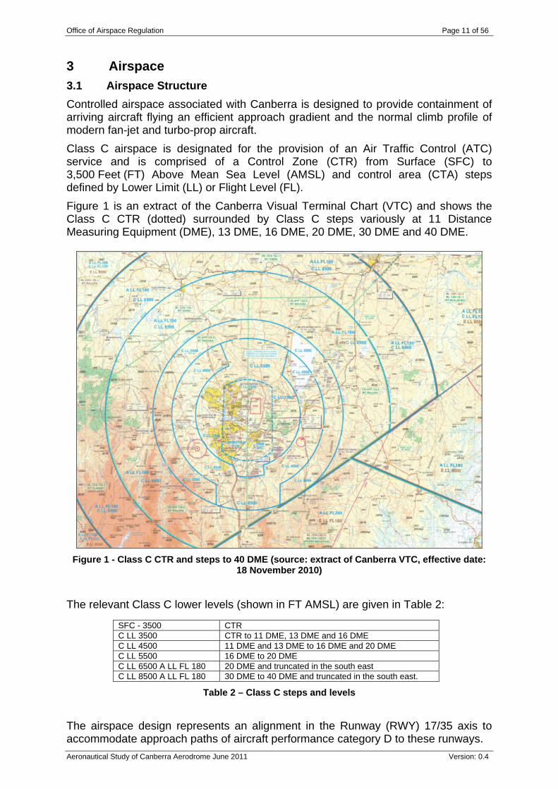
3 Airspace 3.1 Airspace Structure Controlled airspace associated with Canberra is designed to provide containment of arriving aircraft flying an efficient approach gradient and the normal climb profile of modern fan-jet and turbo-prop aircraft. Class C airspace is designated for the provision of an Air Traffic Control (ATC) service and is comprised of a Control Zone (CTR) from Surface (SFC) to 3,500 Feet (FT) Above Mean Sea Level (AMSL) and control area (CTA) steps defined by Lower Limit (LL) or Flight Level (FL). Figure 1 is an extract of the Canberra Visual Terminal Chart (VTC) and shows the Class C CTR (dotted) surrounded by Class C steps variously at 11 Distance Measuring Equipment (DME), 13 DME, 16 DME, 20 DME, 30 DME and 40 DME.
Figure 1 - Class C CTR and steps to 40 DME (source: extract of Canberra VTC, effective date: 18 November 2010)
The relevant Class C lower levels (shown in FT AMSL) are given in Table 2:
SFC - 3500 CTR C LL 3500 CTR to 11 DME, 13 DME and 16 DME C LL 4500 11 DME and 13 DME to 16 DME and 20 DME C LL 5500 16 DME to 20 DME C LL 6500 A LL FL 180 20 DME and truncated in the south east C LL 8500 A LL FL 180 30 DME to 40 DME and truncated in the south east.
Table 2 – Class C steps and levels
The airspace design represents an alignment in the Runway (RWY) 17/35 axis to accommodate approach paths of aircraft performance category D to these runways.
Office of Airspace Regulation Page 12 of 56
Aeronautical Study of Canberra Aerodrome June 2011 Version: 0.4
Note: Aircraft performance categories relate to approach speed categories. They are defined in AIP for holding and Instrument Approach to Land (IAL). Table 3 defines the aircraft performance categories:
Aircraft Performance Category
Approach Speeds
Category A Less than 91 knots
Category B Greater /equal 91 knots Less than 121 knots
Category C Greater /equal 121 knots Less than 141 knots
Category D Greater /equal 141 knots Less than 166 knots
Category E Greater /equal 166 knots
Table 3 – Aircraft approach speed performance categories
The truncated CTR design east and west of the airport provides efficient access to arriving and departing VFR flights and minimises their entry into the overlying CTA.
A comparison was made between the existing airspace and the guidance material contained in CASA Advisory Circular (AC) number AC 2-5-1(0). The result of this comparison indicates that the airspace generally conforms to AC 2-5-1(0). Exceptions are further discussed below.
Canberra is designated as a controlled aerodrome. The Aerodrome Reference Point (ARP) of the aerodrome is normally used as the origin for aerodrome mapping and as a single point of origin for airspace design relating to the CTR.
A DME may be used as the mapping reference point if located within 0.5 NM of the ARP. Canberra DME is approximately 1.0 NM north of the ARP and therefore requires the approval of the Director of Aviation Safety, or a delegate within CASA as DME arcs are used in determining CTA boundaries.
The radii of arcs delineating the CTR boundary are 9 NM to the north and 8 NM to the south and contain Aircraft Performance Category D aircraft operations in accordance with specified distances from the RWY 17 and RWY 35 thresholds respectively. The eastern and western boundaries are formed by straight lines set 5 NM parallel to the RWY 17/35 axis. The parallel boundaries only provide a minimum distance of 5 NM from the ARP to RWY 12 or RWY 30 and are suitable for Aircraft Performance Categories A and B.
Airspace within 45 NM Canberra is comprised of controlled airspace Classes A, C, E and uncontrolled Class G as follows: Class A lower level FL180; Class C steps are defined laterally within DME arcs centred on the Canberra
DME of 11, 13, 16, 20, 30 and 40 NM radii and vertically extending to the overlying Class A at FL180;
Class C CTR from SFC to 3,500 FT AMSL; Class E commences at 40 DME from 8,500 FT AMSL to FL125; and Outside Canberra TWR HR of operation, Class C airspace within 30 NM
Canberra, at and below 8,500 FT AMSL, becomes Class G.
Office of Airspace Regulation Page 13 of 56
Aeronautical Study of Canberra Aerodrome June 2011 Version: 0.4
The CTA steps are generally concentric in design with extended elongated segments at 3,500 FT AMSL and 4,500 FT AMSL to the south and 3,500 FT AMSL to the north to accommodate Instrument Approach and Departure procedures to RWY 17 and RWY 35. The vertical design accommodates Canberra’s elevation of 1,886 FT AMSL by increasing the standard vertical profile by 2,000 FT. The CTA steps provide a minimum containment of 500 FT clear of CTA base (vertically) for modern jet aircraft descent profile at 2.5 degrees to 10 NM from touchdown and then 3 degrees to touchdown. Terrain identified as ‘Tidbinbilla Peak’ located 18 NM south west of Canberra is 5,297 FT AMSL and is under the CTA step LL 5,500 FT AMSL. The conclusion to be drawn from this is the CTA Lower Limit does not provide a minimum of 700 FT from terrain and therefore should be redesigned to meet AC 2-5-1(0) requirements.
Note the AC requirement is 700 ft Above Ground Level (AGL):
‘AC2-5-1(0) Guidance for controlled airspace design, paragraph 13.1.3 states: ‘A lower limit of a control area shall be established at a height above ground or water of not less than 700 ft. AGL.’
Also, lowest safe altitudes should be reviewed against this criterion in areas where wind generators have been installed.
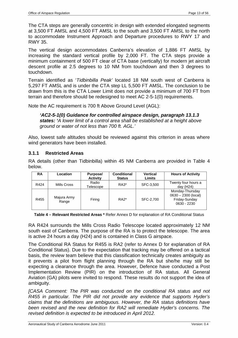
3.1.1 Restricted Areas RA details (other than Tidbinbilla) within 45 NM Canberra are provided in Table 4 below.
RA Location Purpose/ Activity
Conditional Status
Vertical Limits
Hours of Activity
R424 Mills Cross Radio Telescope RA3* SFC-3,500 Twenty four hours a
day (H24)
R455 Majura Army Range Firing RA2* SFC-2,700
Monday-Thursday 0630 – 2300 (local)
Friday-Sunday 0630 - 2230
Table 4 – Relevant Restricted Areas * Refer Annex D for explanation of RA Conditional Status RA R424 surrounds the Mills Cross Radio Telescope located approximately 12 NM south east of Canberra. The purpose of the RA is to protect the telescope. The area is active 24 hours a day (H24) and is contained in Class G airspace. The Conditional RA Status for R455 is RA2 (refer to Annex D for explanation of RA Conditional Status). Due to the expectation that tracking may be offered on a tactical basis, the review team believe that this classification technically creates ambiguity as it prevents a pilot from flight planning through the RA but she/he may still be expecting a clearance through the area. However, Defence have conducted a Post Implementation Review (PIR) on the introduction of RA status. All General Aviation (GA) pilots were invited to respond. These results do not support the idea of ambiguity. [CASA Comment: The PIR was conducted on the conditional RA status and not R455 in particular. The PIR did not provide any evidence that supports Hyder’s claims that the definitions are ambiguous. However, the RA status definitions have been revised and the new definition for RA2 will remediate Hyder’s concerns. The revised definition is expected to be introduced in April 2012.
Office of Airspace Regulation Page 14 of 56
Aeronautical Study of Canberra Aerodrome June 2011 Version: 0.4
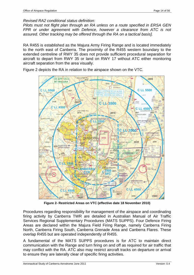
Revised RA2 conditional status definition: Pilots must not flight plan through an RA unless on a route specified in ERSA GEN FPR or under agreement with Defence, however a clearance from ATC is not assured. Other tracking may be offered through the RA on a tactical basis]. RA R455 is established as the Majura Army Firing Range and is located immediately to the north east of Canberra. The proximity of the R455 western boundary to the extended centreline of RWY 35 does not provide sufficient procedural separation for aircraft to depart from RWY 35 or land on RWY 17 without ATC either monitoring aircraft separation from the area visually. Figure 2 depicts the RA in relation to the airspace shown on the VTC.
Figure 2- Restricted Areas on VTC (effective date 18 November 2010) Procedures regarding responsibility for management of the airspace and coordinating firing activity by Canberra TWR are detailed in Australian Manual of Air Traffic Services Regional Supplementary Procedures (MATS SUPPS). Four Defence Firing Areas are declared within the Majura Field Firing Range, namely Canberra Firing North, Canberra Firing South, Canberra Grenade Area and Canberra Flares. These overlap R455 but are operated independently of R455. A fundamental of the MATS SUPPS procedures is for ATC to maintain direct communication with the Range and turn firing on and off as required for air traffic that may conflict with the RA. ATC also may restrict aircraft tracks on departure or arrival to ensure they are laterally clear of specific firing activities.
Office of Airspace Regulation Page 15 of 56
Aeronautical Study of Canberra Aerodrome June 2011 Version: 0.4
An aircraft conducting the published missed approach from a RWY 35 instrument approach has the potential to conflict both laterally and vertically with the Firing Areas, therefore requiring the firing activity to be temporarily suspended. There are also other examples of instances where ATC may require firing to be stopped until an aircraft is clear. It is clear that ATC is required to be available to manage the Firing Areas; however this is not a condition for R455 to be active. MATS SUPPS provide Latitude/Longitude definitions of the Firing Areas. These areas are intended to permit more efficient use of the adjacent CTR. There is no relationship between the boundaries of the Firing Areas and the boundaries of R455. A review of the dimensions of all the Firing Areas and R455 is being undertaken by Defence.
3.1.2 Flying Training Areas There are no flying training areas within 45 NM Canberra designated in AIP or depicted on AIP charts. The loss of all flight training organisations from Canberra has significantly reduced the need to establish specific areas for flight training normally associated with ab-initio training. The Chief Flying Instructor (CFI) of a Flying Training organisation is responsible for establishing locally promulgated flying training boundaries and providing a briefing to Student Pilots on areas approved for their training beyond the aerodrome traffic circuit. Local agreements are in place with ATC for training carried out in Class G and some manoeuvres in CTA in areas labelled ‘Barton’ and ‘Kings’ on informal overlays to Canberra VTC. Barton Aerobatic Area lies to the north west of Canberra between 16 DME and 20 DME. Kings Training Area is a larger area to the north east between 11 DME and 30 DME.
3.2 Airspace Management This section covers IFR and VFR tracks, TWR HR, Approach and Departure Procedures, and Opposite Traffic Flow.
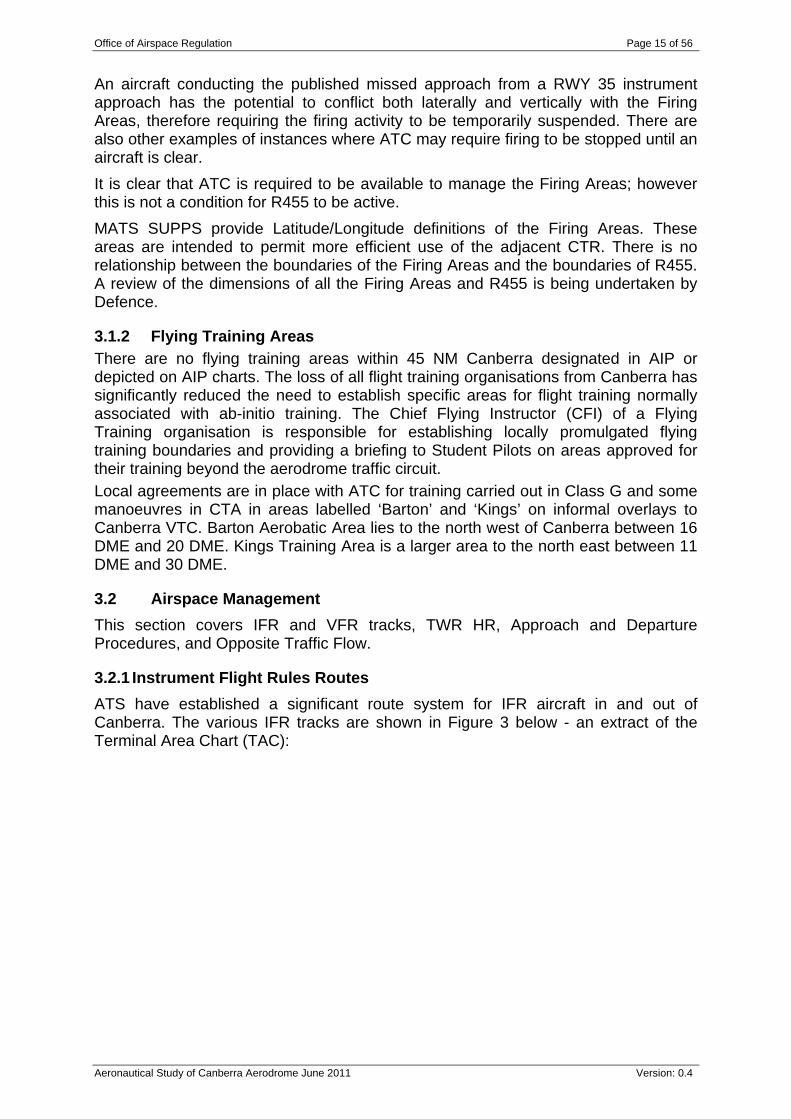
3.2.1 Instrument Flight Rules Routes ATS have established a significant route system for IFR aircraft in and out of Canberra. The various IFR tracks are shown in Figure 3 below - an extract of the Terminal Area Chart (TAC):
Office of Airspace Regulation Page 16 of 56
Aeronautical Study of Canberra Aerodrome June 2011 Version: 0.4
Figure 3 - TAC depicting airspace and air routes to and from Canberra (effective date 18 November 2010)
3.2.2 Visual Flight Rules Tracking In addition to aircraft operating within the Canberra circuit area, VFR category aircraft tend to track in many different directions as required by the pilot. GA flights at Canberra include local scenic flights, travel flights to other destinations and some training flights. Two local scenic VFR routes over Canberra city are promulgated in the En-Route Supplement Australia (ERSA).
3.2.3 Tower Hours Normal TWR HR are 0600 to 2300 daily (local time). Standard TWR roster provides for three staff. Procedures are in place to provide ATS services for out of TWR HR movements e.g. for Very Important Person (VIP) flights.
The surveillance system may be subject to outages, including for maintenance, usually occurring overnight which does not result in airspace restrictions. During an upgrade to the Airservices system, the loss of surveillance only occurs in the Tower environment. Back-up information is available from Mount Majura and is displayed on the Tower Situational Awareness Display (TSAD). There is no loss of surveillance in the overlying airspace that is managed from Melbourne Centre.
During a total loss of air traffic services, Class C airspace is declared Temporary Restricted Airspace and entry is governed by pre-existing contingency procedures. This has not happened in last 12 months.
Office of Airspace Regulation Page 17 of 56
Aeronautical Study of Canberra Aerodrome June 2011 Version: 0.4
3.2.4 Approach and Departure procedures Canberra has a variety of IFR arrival procedures: DME or Global Positioning System (GPS) Arrival Procedures, using the Non-Directional Beacon (NDB) or VHF Omni-Directional Radio Range (VOR), provide descent to a circling approach on all published inbound routes and three Sectors covering all tracks within 360 degrees. Canberra has a number of runway aligned instrument approaches for pilots to choose from. In addition to procedures based on navigation aids, Area Navigation (RNAV) Global Navigation Satellite System (GNSS) and Performance Based Navigation (PBN) procedures are available to suitably equipped aircraft. Safety, efficiency and capacity in the airspace is enhanced through the combined use of published Standard Instrument Departures (SID) and Standard Arrival Route (STAR) tracks designed to segregate traffic and allow ATC to monitor arrivals and departures without active intervention, thereby reducing ATC and pilot workload. Aircraft are also able to follow predetermined flight paths to join ATS routes or terminate via an instrument approach providing pilots with predictability. Required Navigation Performance Authorisation Required (RNPAR) approach and departure procedures are approved for use by Qantas B737-800 aircraft and generally overlay existing procedures. These procedures are authorised by CASA under trial of RNPAR by QANTAS. The major feature of these procedures is the utilisation of satellite based navigation and curved approach paths employing a high degree of lateral (within 0.3 NM) containment and vertical approach guidance. SIDs provide transitions to and from commonly used ATS routes. Radar procedures are also available during ATC hours.
3.2.5 Opposite traffic flow Operational requirements can often require an aircraft departing from the reciprocal runway in use. Environmental conditions such as temperature, density altitude and wind velocity may affect climb performance to the extent RWY 17 is required on departure as it has a lower climb gradient than RWY 35 SID procedures. In these circumstances when RWY 35 is nominated as the duty runway, delay may be required to fit into the opposite traffic flow.
3.3 Surveillance This section covers radar coverage and other types of surveillance within the scope of the study.
3.3.1 Radar Coverage The closest Airservices radar surveillance facility to Canberra is located at Mount Majura (MJA), approximately 7km north northwest. It is reported that MJA provides surveillance coverage down to the ground at Canberra. In the event of failure of the MJA radar head, other facilities provide coverage to approximately 3,500 FT AMSL. Figure 4 below shows the Canberra area radar coverage at 4,000 FT AMSL.
Office of Airspace Regulation Page 18 of 56
Aeronautical Study of Canberra Aerodrome June 2011 Version: 0.4
Figure 4 - Canberra radar coverage at 4,000 FT AMSL
Terminal Area Radar (TAR) and Monopulse Secondary Surveillance Radar (MSSR) data are provided from MJA and sent to Melbourne and processed with other sources and used in TWR and Terminal Control Unit (TCU) Eurocat display systems. Alternate surveillance coverage exists when MJA data is not available however surveillance it is not available below 4,000 FT AMSL. A loss of surveillance is catered for by degraded mode contingency plans that enable ATC to continue providing control services, albeit at a reduced rate.
3.3.2 Tower Situational Awareness Display A dedicated backup TSAD is located in the TWR. TSAD is not authorised to be used for separation by ATC and is limited in its application as a situational awareness tool.
3.3.3 See and Avoid
See and avoid is the basis of VFR to VFR separation and is supported by alerted traffic information by ATC. IFR flights may also be assigned responsibility by ATC for see and avoid separation by day, between other IFR or VFR flights, when they have conflicting traffic in sight.
Well defined ICAO and Civil Aviation Safety Regulation (CASR) Part 172 Manual of Standards (MOS) procedures apply to Class C airspace. ‘See and avoid’ is available to VFR /VFR flights.
Canberra
Office of Airspace Regulation Page 19 of 56
Aeronautical Study of Canberra Aerodrome June 2011 Version: 0.4
4 Aerodrome This section provides the background to the aerodrome, its location, airspace users and review of aeronautical information.
4.1 Aerodrome Location
Canberra is located 6.5 km (3.5 NM) south east of the Civic centre of Canberra city. It is situated in the Majura valley flanked by various mountains.
Figure 5 below identifies the location of the aerodrome relative to the city of Canberra.
Figure 5- Canberra Area (source: Google Earth)
Canberra Aerodrome
Canberra City
Office of Airspace Regulation Page 20 of 56
Aeronautical Study of Canberra Aerodrome June 2011 Version: 0.4
4.2 Background Canberra city is the capital of Australia, located in the Australian Capital Territory, 236 km (128 NM) south west of Sydney and 470 km (254 NM) north east of Melbourne. According to the 2006 census, Canberra has a population of 334,000 making it the sixth largest city in Australia.
The published Canberra Airport Master Plan - 2009 provides long term development concepts to cater for future growth. With respect to airspace, the Master Plan notes that “Airport Master Plans do not include the scope of airspace, nor are they required to. They are ground facility planning documents. They may briefly look at ATS interface arrangements and traffic flows but they do not fully consider airspace”. Examining the issue of Regulatory Impact on Airport Master Planning requirements in Australia from a CASA OAR perspective is outside the scope of this Airspace review. Canberra is a security controlled airport.
Figure 6 below depicts the Australian Capital Territory in the context of surrounding towns: Goulburn, Wagga Wagga, Albury, Wodonga and Cooma.
Figure 6 - Canberra and surrounds (source World Aeronautical Chart (WAC) (parts of 3457 – Canberra and 3470 – Melbourne with overlap to 3456 - Sydney))
Bureau of Meteorology provide a range of weather statistics for the monitoring station at Canberra. Mean max and min temperatures are 19.7 and 6.5 degrees respectively. Mean rainfall is 616 mm. The average number of rainy days is 106, clear days 100 and cloudy days 125. Mean daily sunshine is 7.7 hours and mean cloud cover at 3 pm is 4.3 octas (each a cover of one eighth of the sky). The mean 3:00 pm local wind speed is 19 km/hr (1939 – 2010). Canberra experiences fog for short periods. This is generally during the winter months when fog forms during the night and does not disperse until mid morning. During these periods disruption to flights occurs as visibility and cloud base reduce below Instrument Landing System (ILS) and departure minima. While departing
Office of Airspace Regulation Page 21 of 56
Aeronautical Study of Canberra Aerodrome June 2011 Version: 0.4
flights may be delayed, arrivals may incur major disruption should they divert to alternate aerodromes.
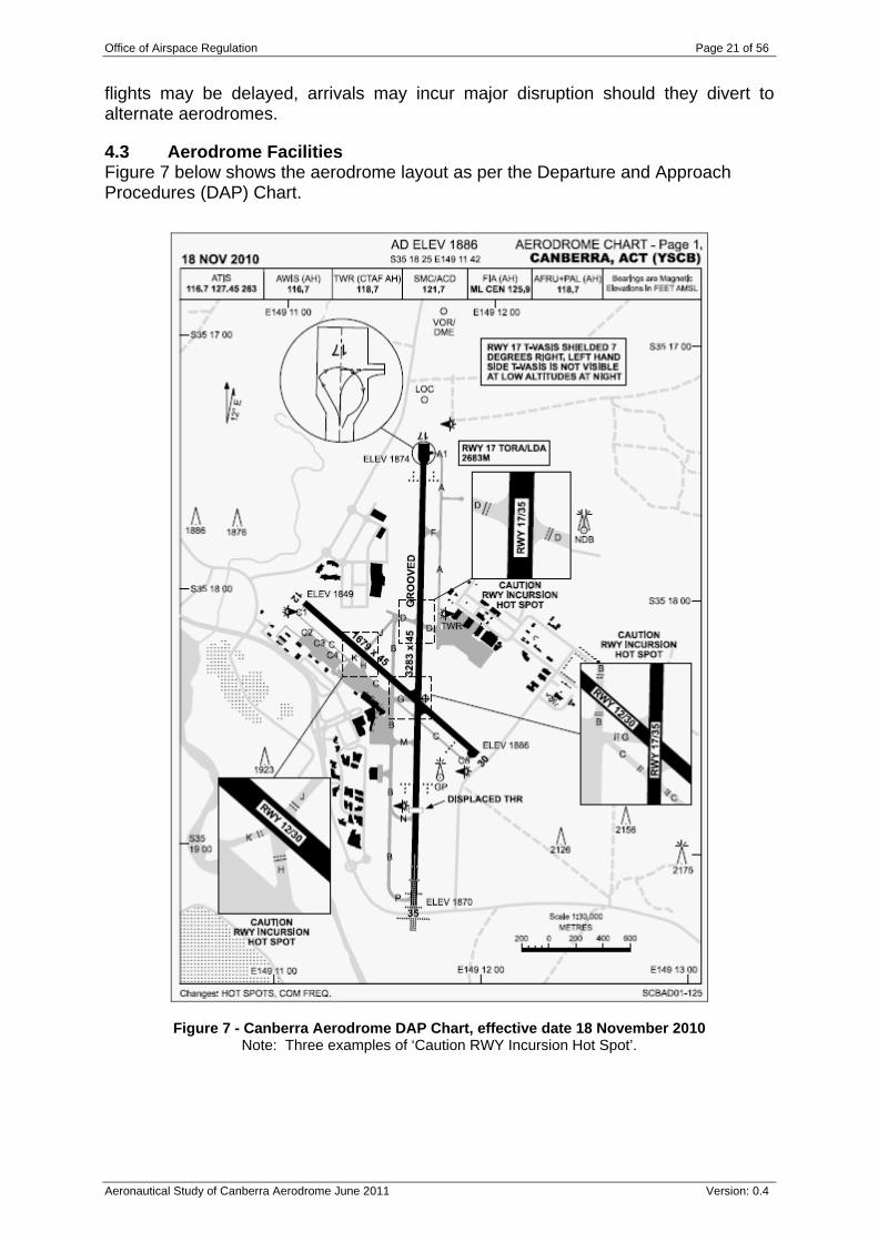
4.3 Aerodrome Facilities Figure 7 below shows the aerodrome layout as per the Departure and Approach Procedures (DAP) Chart.
Figure 7 - Canberra Aerodrome DAP Chart, effective date 18 November 2010 Note: Three examples of ‘Caution RWY Incursion Hot Spot’.
Office of Airspace Regulation Page 22 of 56
Aeronautical Study of Canberra Aerodrome June 2011 Version: 0.4
4.3.1 Runways
There are two RWYs at Canberra:
RWY 17/35 is grooved 3,282 metres (m) x 45 m. PT operations are mostly carried out on this RWY. The larger aircraft and capacities are B744 (383 persons), B772 (288), A332 (282), B763 (228) and A333 (220). Full length departures from RWY 35 are only available if required by the pilot; and
RWY 12/30 is sealed 1,679 m x 45 m. It is often used by some PT operations such as Dash 8 (but excluding DHC 8 Q400), Charter, air work and GA aircraft. There is no prohibition on the use of RWYs 12/30. However their use is governed by Canberra Noise Abatement requirements as detailed in AIP DAP.
4.3.2 Taxiways and Aprons
RWY 17/35 has no full length taxiway (TWY) to the ends of the runway, but rather has TWY B on the east side and TWY A on the west side, crossing the RWY at TWY D. Refer to Figure 7. The annotation ‘Caution RWY Incursion Hot Spot’ occurs three times on the DAP chart.
There is a turning node at the northern end of RWY 17/35 for wide body aircraft.
4.3.3 Radio Navigation and Landing Aids
Canberra has a number of navigation aids to assist aircraft with navigation and landing:
DME Glide Path ILS Localiser (LOC) Middle Marker NDB (Canberra) NDB (Church Creek) Outer Marker VOR
4.3.4 Aeronautical Information Publication Departure and Approach Procedures
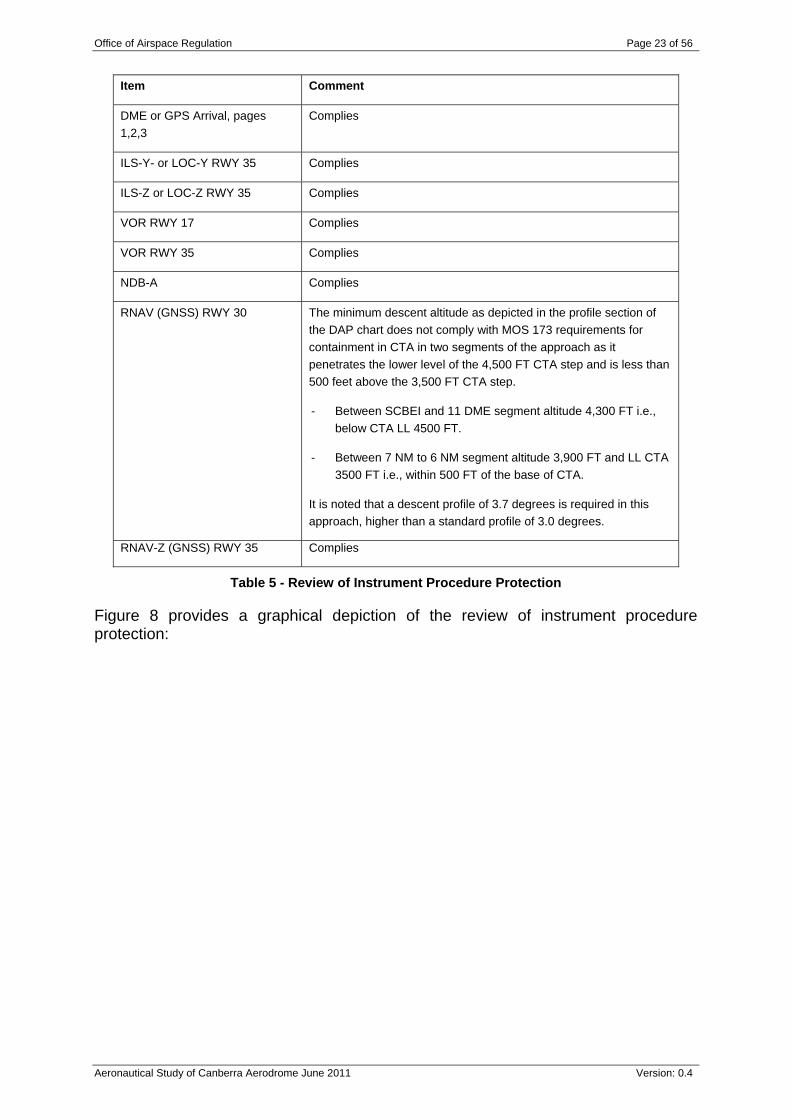
Instrument approach and departure procedures for Canberra are published in AIP. The ILS is available on a 24 hour basis. However training flights require prior approval from ATC as a means of integrating their training into the scheduled traffic. SID/STAR designs provide general procedures for aircraft operating to the IFR. A review of all Canberra instrument approach procedures was carried out to ascertain if they were contained within controlled airspace as required by AC 2-5-1 (14.1) and CASR Part 173 MOS. Table 5 summarises the results:
Office of Airspace Regulation Page 23 of 56
Aeronautical Study of Canberra Aerodrome June 2011 Version: 0.4
Item Comment
DME or GPS Arrival, pages 1,2,3
Complies
ILS-Y- or LOC-Y RWY 35 Complies
ILS-Z or LOC-Z RWY 35 Complies
VOR RWY 17 Complies
VOR RWY 35 Complies
NDB-A Complies
RNAV (GNSS) RWY 30 The minimum descent altitude as depicted in the profile section of the DAP chart does not comply with MOS 173 requirements for containment in CTA in two segments of the approach as it penetrates the lower level of the 4,500 FT CTA step and is less than 500 feet above the 3,500 FT CTA step.
- Between SCBEI and 11 DME segment altitude 4,300 FT i.e., below CTA LL 4500 FT.
- Between 7 NM to 6 NM segment altitude 3,900 FT and LL CTA 3500 FT i.e., within 500 FT of the base of CTA.
It is noted that a descent profile of 3.7 degrees is required in this approach, higher than a standard profile of 3.0 degrees.
RNAV-Z (GNSS) RWY 35 Complies
Table 5 - Review of Instrument Procedure Protection
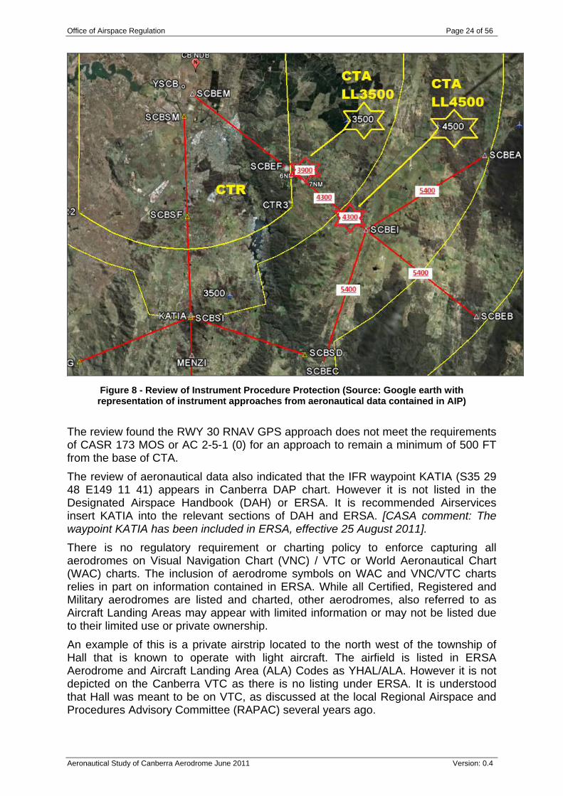
Figure 8 provides a graphical depiction of the review of instrument procedure protection:
Office of Airspace Regulation Page 24 of 56
Aeronautical Study of Canberra Aerodrome June 2011 Version: 0.4
Figure 8 - Review of Instrument Procedure Protection (Source: Google earth with representation of instrument approaches from aeronautical data contained in AIP)
The review found the RWY 30 RNAV GPS approach does not meet the requirements of CASR 173 MOS or AC 2-5-1 (0) for an approach to remain a minimum of 500 FT from the base of CTA. The review of aeronautical data also indicated that the IFR waypoint KATIA (S35 29 48 E149 11 41) appears in Canberra DAP chart. However it is not listed in the Designated Airspace Handbook (DAH) or ERSA. It is recommended Airservices insert KATIA into the relevant sections of DAH and ERSA. [CASA comment: The waypoint KATIA has been included in ERSA, effective 25 August 2011]. There is no regulatory requirement or charting policy to enforce capturing all aerodromes on Visual Navigation Chart (VNC) / VTC or World Aeronautical Chart (WAC) charts. The inclusion of aerodrome symbols on WAC and VNC/VTC charts relies in part on information contained in ERSA. While all Certified, Registered and Military aerodromes are listed and charted, other aerodromes, also referred to as Aircraft Landing Areas may appear with limited information or may not be listed due to their limited use or private ownership. An example of this is a private airstrip located to the north west of the township of Hall that is known to operate with light aircraft. The airfield is listed in ERSA Aerodrome and Aircraft Landing Area (ALA) Codes as YHAL/ALA. However it is not depicted on the Canberra VTC as there is no listing under ERSA. It is understood that Hall was meant to be on VTC, as discussed at the local Regional Airspace and Procedures Advisory Committee (RAPAC) several years ago.
Office of Airspace Regulation Page 25 of 56
Aeronautical Study of Canberra Aerodrome June 2011 Version: 0.4
4.4 Airspace Users Canberra is serviced by four scheduled PT operators. There are also a small number of GA and sports aviation aircraft located at the aerodrome, together with Royal Australian Air Force (RAAF) 34 Squadron (SQN). Regular visitors to the aerodrome, or users of the circuit, include freight and charter operators and other training organisations remote to Canberra. The aerodrome and airspace is frequently in use for Navigation Aid training and GA VFR flying training.
4.4.1 Passenger Transport Brief details of individual operators are given below: Qantas Airways operate two jet flights to Adelaide, five to Brisbane, nine to Melbourne, one to Perth and five to Sydney per day. Also three per week to Darwin and eight Dash-8 to Sydney and one to Melbourne. Virgin Blue Airlines operate one flight to Adelaide, four or five to Brisbane, five or six to Melbourne, seven to Sydney and one each to the Gold Coast, Hobart and Townsville. Tiger Airways operate one flight to Melbourne per day. Brindabella Airlines operate three flights per day to Newcastle, two per day to Albury, except once on Friday and one to Tamworth on Friday (only). All Brindabella aircraft park overnight at Canberra.
4.4.2 General Aviation Operators Royal Flying Doctor Service (RFDS) operate PC12 and BE200 aircraft and average one or two flights into Canberra per week to pick up patients. The RFDS utilises the airport on an as required basis. Snowy Hydro SouthCare Rescue Helicopter Service provides the aero-medical and rescue helicopter services to the ACT and south eastern New South Wales. The Bell 412 helicopter is a critical tool. The SouthCare base is at Hume. Privately owned GA aircraft (Cessna 172 etc) use Canberra in small numbers. The Canberra Aero Club meet weekly. A number of Air freight companies are operating regularly to/from Canberra Aerodrome including Pel Air, Corporate Air and Toll Priority. Canberra Flying School are affiliated with Goulburn Flying School. Wagga Flying School have access to the Wagga ILS but come to Canberra for exposure to Class C airspace. There are also itinerants, particularly from Bankstown and Camden.
4.4.3 Sports Aviation Recreational Aviation (RA-Aus) aircraft (ultra lights) such as RV7 reside at Canberra. The Association says that RA-Aus members would happily pay charges to attend meeting /reunions etc at Canberra. Australian Capital Territory Hang Gliding and Paragliding Association (ACTHPA) organise hang gliding and paragliding. Three areas are utilised by ACTHPA (they all have wind monitors linked to a website www.acthpa.org). The three areas are:
Lake George Range (2,654 - 2,989 FT AMSL)
Office of Airspace Regulation Page 26 of 56
Aeronautical Study of Canberra Aerodrome June 2011 Version: 0.4
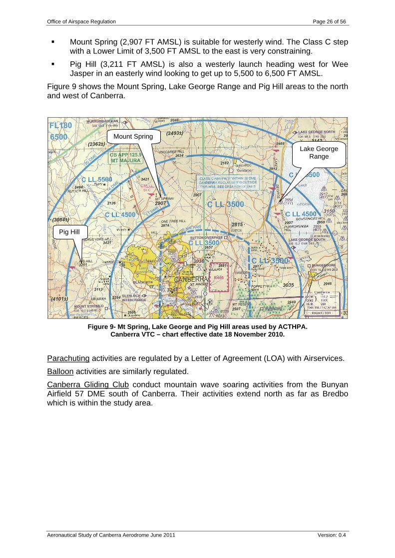
Mount Spring (2,907 FT AMSL) is suitable for westerly wind. The Class C step with a Lower Limit of 3,500 FT AMSL to the east is very constraining.
Pig Hill (3,211 FT AMSL) is also a westerly launch heading west for Wee Jasper in an easterly wind looking to get up to 5,500 to 6,500 FT AMSL.
Figure 9 shows the Mount Spring, Lake George Range and Pig Hill areas to the north and west of Canberra.
Figure 9- Mt Spring, Lake George and Pig Hill areas used by ACTHPA.
Canberra VTC – chart effective date 18 November 2010.
Parachuting activities are regulated by a Letter of Agreement (LOA) with Airservices. Balloon activities are similarly regulated. Canberra Gliding Club conduct mountain wave soaring activities from the Bunyan Airfield 57 DME south of Canberra. Their activities extend north as far as Bredbo which is within the study area.
Pig Hill
Mount Spring
Lake George Range
Office of Airspace Regulation Page 27 of 56
Aeronautical Study of Canberra Aerodrome June 2011 Version: 0.4
5 Consultation The review set out to consult widely and engage with stakeholders on identification of issues. The review team sought input from a number of stakeholders who operate in and around Canberra aerodrome. Generative stakeholder interviews were conducted during March and April 2011. Comments were sought from the following organisations: ACTHPA; Aerodrome Operators; Airservices; Balloon operator; Canberra Aero Club; Canberra Flying School Canberra Gliding Club; CASA; Emergency Services operator; Freight operator; PT Operators; RA-Aus; and RAAF 34 SQN.
5.1 Civil Aviation Safety Authority The review team consulted with the local CASA Aviation Safety Advisor (ASA). CASA employs ASA throughout Australia as an integral mechanism for providing safety promotion and educational material to the various industry segments. The discussion centred mainly on flying training areas given as a part time role as a CFI. Points made include: A view that training areas are only designated where CASA consider there to be
a hazard to other aircraft. The Canberra Aero Club had this view; Canberra and possibly other flying schools would use the Bartons and Kings
areas. Canberra and Goulburn Flying Schools operate independently; they are busy at weekends with two to three aircraft each.
Canberra is a Security controlled aerodrome and locked gates prevent access to the apron. Extra time has to be allowed for a security officer to admit pilots and students to the apron and release them afterwards.
Each Flying School Operations Manual contains a map of their training areas, but information is not necessarily shared across different schools.
With a southwest wind the Flying Schools prefer RWY 30 and rarely request RWY 35.
There were differing opinions as to whether the 4:00 pm to 6:00 pm time is too busy to be an issue to the Controllers. [CASA comment: During peak periods
Office of Airspace Regulation Page 28 of 56
Aeronautical Study of Canberra Aerodrome June 2011 Version: 0.4
when all operations cannot be accommodated within the Canberra airspace, priority is given to aircraft in accordance with AIP Enroute 1.4, paragraph 10.3] 9
Parachute and balloon activities are regulated and present no problems.
5.2 Aerodrome Operator The Review team interviewed representatives of Capital Airport Group on 28 March 2011 concerning current operations and airport development plans. The approved Canberra Airport Master Plan was used as a basis for discussion, but only insofar as airspace is affected. The Master Plan is a significant reference document containing comprehensive background detail on aircraft noise issues affecting current and future development of flight paths (Master Plan - Ch14). The emphasis on community issues and the development of a ‘High Noise Corridor’ to the south of the airport and the ‘Noise Abatement Area’ provide future limitations of flight paths and therefore play a role in how airspace may be designed. The Plan indicates that unless there is political intervention to introduce noise sharing, which appears highly unlikely in the mid to long term, there will be very limited opportunity or requirement to change the current airspace. Airservices conducted a noise study of flight paths in 2009. Further consideration of noise is out of scope of this review.
One exception to this is a reference to precision Instrument approaches in the future to RWYs 12/30. Current CTR/CTA design is not aligned on the RWY 12/30 axis and would require an increase of CTR and lowering of CTA steps to ensure the Instrument approaches would be contained in controlled airspace. The time frame to introduce these measures is well beyond the scope of this study.
As there are two half length TWY to opposite ends of RWY 17/35, aircraft have to cross the main RWY.
Clearance above wind farms was also raised as an issue.
5.3 Passenger Transport Services 5.3.1 Brindabella Interview The Brindabella fleet based at Canberra comprises several 30 seater BAE Jetstream J41’s and five 18 seater Metroliners. With respect to aircraft fitment of Traffic Alert and Collision Avoidance System (TCAS), the Jetstreams are fitted but do not have GPS. On the other hand, the Metroliners do not have TCAS but three of the five are RNAV approved.
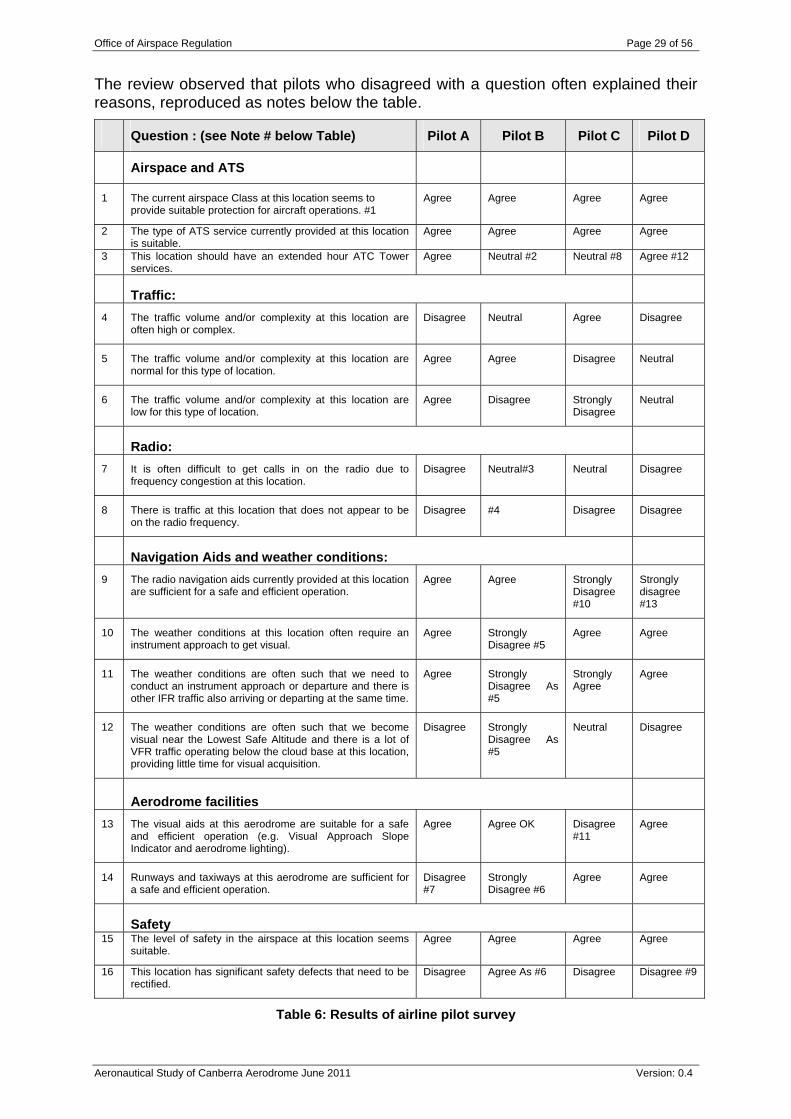
5.3.2 Survey of Airline Pilots regarding Canberra For the other PT operators, a survey was conducted amongst a sample of PT pilots that operate regularly into Canberra. The survey sought their views on the current airspace architecture; provision of ATS; air traffic density and complexity; radio communications; navigation aids; weather conditions; aerodrome facilities; and any perceived safety issues at Canberra. The following results were obtained as given on Table 6 as a five point scale ranging from ‘Strongly disagree’ through ‘Disagree’, ‘Neutral’ and ‘Agree’ to ‘Strongly agree’.
9 AIP Enroute 1.4, paragraph 10.3 can be found on the Airservices website: http://www.airservicesaustralia.com/publications/pending/aip/enroute.pdf
Office of Airspace Regulation Page 29 of 56
Aeronautical Study of Canberra Aerodrome June 2011 Version: 0.4
The review observed that pilots who disagreed with a question often explained their reasons, reproduced as notes below the table.
Question : (see Note # below Table) Pilot A Pilot B Pilot C Pilot D
Airspace and ATS
1 The current airspace Class at this location seems to provide suitable protection for aircraft operations. #1
Agree Agree Agree Agree
2 The type of ATS service currently provided at this location is suitable.
Agree Agree Agree Agree
3 This location should have an extended hour ATC Tower services.
Agree Neutral #2 Neutral #8 Agree #12
Traffic:
4 The traffic volume and/or complexity at this location are often high or complex.
Disagree Neutral Agree Disagree
5 The traffic volume and/or complexity at this location are normal for this type of location.
Agree Agree Disagree Neutral
6 The traffic volume and/or complexity at this location are low for this type of location.
Agree Disagree Strongly Disagree
Neutral
Radio:
7 It is often difficult to get calls in on the radio due to frequency congestion at this location.
Disagree Neutral#3 Neutral Disagree
8 There is traffic at this location that does not appear to be on the radio frequency.
Disagree #4 Disagree Disagree
Navigation Aids and weather conditions:
9 The radio navigation aids currently provided at this location are sufficient for a safe and efficient operation.
Agree Agree Strongly Disagree #10
Strongly disagree #13
10 The weather conditions at this location often require an instrument approach to get visual.
Agree Strongly Disagree #5
Agree Agree
11 The weather conditions are often such that we need to conduct an instrument approach or departure and there is other IFR traffic also arriving or departing at the same time.
Agree Strongly Disagree As #5
Strongly Agree
Agree
12 The weather conditions are often such that we become visual near the Lowest Safe Altitude and there is a lot of VFR traffic operating below the cloud base at this location, providing little time for visual acquisition.
Disagree Strongly Disagree As #5
Neutral Disagree
Aerodrome facilities
13 The visual aids at this aerodrome are suitable for a safe and efficient operation (e.g. Visual Approach Slope Indicator and aerodrome lighting).
Agree Agree OK Disagree #11
Agree
14 Runways and taxiways at this aerodrome are sufficient for a safe and efficient operation.
Disagree #7
Strongly Disagree #6
Agree Agree
Safety
15 The level of safety in the airspace at this location seems suitable.
Agree Agree Agree Agree
16 This location has significant safety defects that need to be rectified.
Disagree Agree As #6 Disagree Disagree #9
Table 6: Results of airline pilot survey
Office of Airspace Regulation Page 30 of 56
Aeronautical Study of Canberra Aerodrome June 2011 Version: 0.4
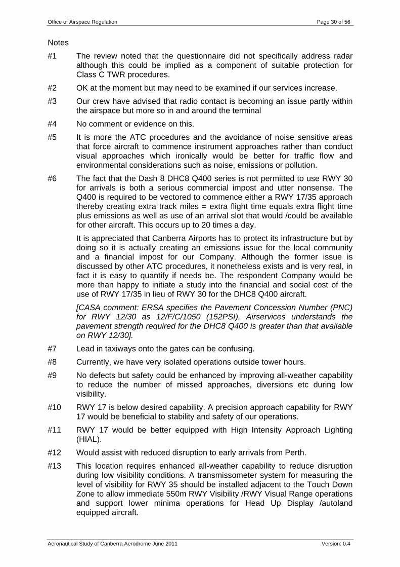
Notes #1 The review noted that the questionnaire did not specifically address radar
although this could be implied as a component of suitable protection for Class C TWR procedures.
#2 OK at the moment but may need to be examined if our services increase. #3 Our crew have advised that radio contact is becoming an issue partly within
the airspace but more so in and around the terminal #4 No comment or evidence on this. #5 It is more the ATC procedures and the avoidance of noise sensitive areas
that force aircraft to commence instrument approaches rather than conduct visual approaches which ironically would be better for traffic flow and environmental considerations such as noise, emissions or pollution.
#6 The fact that the Dash 8 DHC8 Q400 series is not permitted to use RWY 30 for arrivals is both a serious commercial impost and utter nonsense. The Q400 is required to be vectored to commence either a RWY 17/35 approach thereby creating extra track miles = extra flight time equals extra flight time plus emissions as well as use of an arrival slot that would /could be available for other aircraft. This occurs up to 20 times a day.
It is appreciated that Canberra Airports has to protect its infrastructure but by doing so it is actually creating an emissions issue for the local community and a financial impost for our Company. Although the former issue is discussed by other ATC procedures, it nonetheless exists and is very real, in fact it is easy to quantify if needs be. The respondent Company would be more than happy to initiate a study into the financial and social cost of the use of RWY 17/35 in lieu of RWY 30 for the DHC8 Q400 aircraft.
[CASA comment: ERSA specifies the Pavement Concession Number (PNC) for RWY 12/30 as 12/F/C/1050 (152PSI). Airservices understands the pavement strength required for the DHC8 Q400 is greater than that available on RWY 12/30].
#7 Lead in taxiways onto the gates can be confusing. #8 Currently, we have very isolated operations outside tower hours. #9 No defects but safety could be enhanced by improving all-weather capability
to reduce the number of missed approaches, diversions etc during low visibility.
#10 RWY 17 is below desired capability. A precision approach capability for RWY 17 would be beneficial to stability and safety of our operations.
#11 RWY 17 would be better equipped with High Intensity Approach Lighting (HIAL).
#12 Would assist with reduced disruption to early arrivals from Perth. #13 This location requires enhanced all-weather capability to reduce disruption
during low visibility conditions. A transmissometer system for measuring the level of visibility for RWY 35 should be installed adjacent to the Touch Down Zone to allow immediate 550m RWY Visibility /RWY Visual Range operations and support lower minima operations for Head Up Display /autoland equipped aircraft.
Office of Airspace Regulation Page 31 of 56
Aeronautical Study of Canberra Aerodrome June 2011 Version: 0.4
As a consistency check, some questions were repeated. For example, questions 4, 5 and 6 test whether traffic volume is high /complex, normal or low. From the answers, it has been inferred that the respondents lean to ‘normal’, rather than ‘high’ or ‘low’.
5.4 General Aviation Operators Canberra Aero Club is concerned about equity of access. For example, restrictions on circuit training during peak hours. However, procedures exist for equitable access to the airport. Any change to these arrangements should be raised through RAPAC. [CASA comment: During peak periods when all operations cannot be accommodated within the Canberra airspace, priority is given to aircraft in accordance with AIP Enroute 1.4, paragraph 10.3]
5.5 Sports Aviation RA-Aus consider encroaching buildings such as Brand Depot as introducing ‘go-round’ hazards. However, the review noted that buildings must comply with strict airport engineering requirements and are located outside established obstacle clearance areas. ERSA provides cautionary advice on the proximity of building and turbulence under certain wind conditions. ACTHPA have discussed a proposal to lift airspace at Mount Spring with Airservices. The ACTHPA proposal for Pig Hill is for airspace to be lifted to 5,500 FT AMSL from 4,500 FT AMSL. While the airspace is consistent with CASA advisories the Review believes that further consideration is warranted of raising the airspace around Pig Hill to allow better access for the hang gliders. However, the Review also notes that changes to CTA Class C to the east of Pig Hill could have an adverse effect on DME/GPS arrival procedures. ACTHPA will need to submit an Airspace Change Proposal (ACP) to change the Class C 4,500 FT AMSL step around Pig Hill. The ACP would then go through the normal channels including RAPAC, before any change is made. Canberra Gliding Club expressed concern at any airspace changes that affect their activities which extend north as far as Bredbo. Bredbo is within the study area.
5.6 Defence Consultation was conducted with RAAF 34 SQN which operates the VIP fleet. 34 SQN have ideas about converting 9 NM ARP to DME. This remains a discussion point at most aerodromes where arcs are based on either the RWY thresholds or ARP, however DME suffers from the same issue if an aircraft is not equipped. Instrument approach and departure design takes the boundary into account and use of GPS also provides easier reference. 34 SQN have ideas about extending Class C LL 5,500 FT AMSL step in the south west from 20 DME to 22 DME. It is unclear as to the reason behind this. Current STAR and IAL designs conform to the existing 20 DME boundary. 5.7 Airservices Airservices are the Air Navigation Service Provider (ANSP). Airservices passenger and traffic movement data provided by CASA’s OAR is summarised in Section 6. Receipt of various Airservices reports and data is gratefully acknowledged. All reasonable efforts were made to validate the data for accuracy and completeness.
Office of Airspace Regulation Page 32 of 56
Aeronautical Study of Canberra Aerodrome June 2011 Version: 0.4
Airservices observed that the lack of a full length taxiway creates crossing problems but considered that these relate only to efficiency. The Review noted the ‘hot spots’ on the Aerodrome Chart ‘Caution: RWY Incursion Hot Spot’.
The review believes that there is a safety issue in airport design when aircraft are required to cross an active runway. In the case of PT operations at Canberra, all departing aircraft from RWY 17 must cross RWY 17 to reach the RWY departure end and a high percentage of arrivals to RWY 35 exiting north of TXY D must cross the RWY 35 to return to the apron area.
This could be a major issue for ATC particularly in low visibility conditions. The extension of TWY B would avoid crossing RWY 17 /35 and therefore reduce the risk of runway incursions. Other proposed runway and taxiway developments have no airspace consequences, although Canberra Approach considered that the truncation of the steps by a diagonal line to the west of Canberra constrains the capacity of controlled airspace.
Office of Airspace Regulation Page 33 of 56
Aeronautical Study of Canberra Aerodrome June 2011 Version: 0.4
6 Data In order to make an accurate evaluation of the airspace it is important that all reasonable precautions have been taken to ensure that the data being reviewed is correct and reliable. Data for this study has been gathered from a number of sources. These sources include, but are not limited to: Airspace Research Application (ARA); Aviation Safety Incident Reports (ASIR); Air Safety Occurrence Reports (ASOR); Bureau of Infrastructure, Transport and Regional Economics (BITRE); and AIP.
The following describes some of the data sources.
6.1 Airspace Research Application Airservices ARA database was developed to enhance their situational awareness of traffic at aerodromes throughout Australia and identify locations of interest that may trigger further research. CASA obtains ARA data from Airservices to assist in the analysis of collision risk at aerodromes that are under review. ARA data consists of aircraft movements, passenger numbers and aircraft incidents from sources such as Avdata Australia (Avdata), Electronic Safety Incident Reports (ESIRs), submitted flight plans and location specific intelligence reports. The following ARA reports were sourced from Airservices: a. Aircraft Types by Port – This report identifies aircraft by type arriving and
departing from the port during a selected period.10 The data is used to estimate the proportion of aircraft types that are utilising an aerodrome. This report is also used to identify VFR and IFR traffic by analysing the aircraft seating capacity and the number of movements per aircraft type. Generally all rotary winged aircraft are considered to be VFR traffic as well as aircraft that have approximately three or less seating capacity. From these data, an estimate of traffic mix at Canberra was made as follows:
IFR high capacity – 54,000 movements p.a. IFR medium capacity – 6,000 movements p.a. IFR low capacity – 3,000 movements p.a. VFR low capacity – 17,000 movements p.a.
Total – 80,000 movements p.a. b. Data Validation Reports – This report is used to validate the trigger report;
identify the number of circuits flown per annum and add VFR traffic. c. ESIRs – ESIRs are an electronically submitted air safety occurrence report
which forms part of the ESIR system, maintained by Airservices. The ESIR system permits systemic analysis and trend monitoring of incidents. This data is also submitted to the Australian Transport Safety Bureau (ATSB).
10 This data is extracted from the aircraft register database (maintained by CASA) using the aircraft callsign only, therefore there may be some inaccuracies.

Office of Airspace Regulation Page 34 of 56
Aeronautical Study of Canberra Aerodrome June 2011 Version: 0.4
6.2 ATSB - Aviation Safety Incident Reports All accidents and incidents involving Australian registered aircraft, or foreign aircraft in Australian airspace must be reported to the ATSB. The ATSB maintains its own database, the Safety Investigation Information Management System (SIIMS), in which all reported occurrences are logged, assessed, classified and recorded. The information contained within SIIMS is dynamic and subject to change based on additional and/or updated data. Each individual report is known as an ASIR and for identification purposes is allocated its own serial number.
6.3 Air Safety Occurrence Reports ASORs are an electronically submitted air safety occurrence report, which forms part of the ASOR system, maintained by Defence. The ASOR system permits systemic analysis and trend monitoring of incidents. This data is also submitted to the ATSB.
6.4 Bureau of Infrastructure, Transport and Regional Economics BITRE data consists of international, domestic and regional PT services. It is important to note that it does not include charter or other non-scheduled activity. The BITRE Data is reported by financial year and is available on their website.
6.5 Aeronautical Information Publications AIP include the various Charts – En-Route Chart (ERC), TAC, VNC, VTC, and WAC as sampled in the report figures, as well as DAP and ERSA.
14
Source http://www.bitre.gov.au/Info.aspx?NodeId=96
Office of Airspace Regulation Page 35 of 56
Aeronautical Study of Canberra Aerodrome June 2011 Version: 0.4
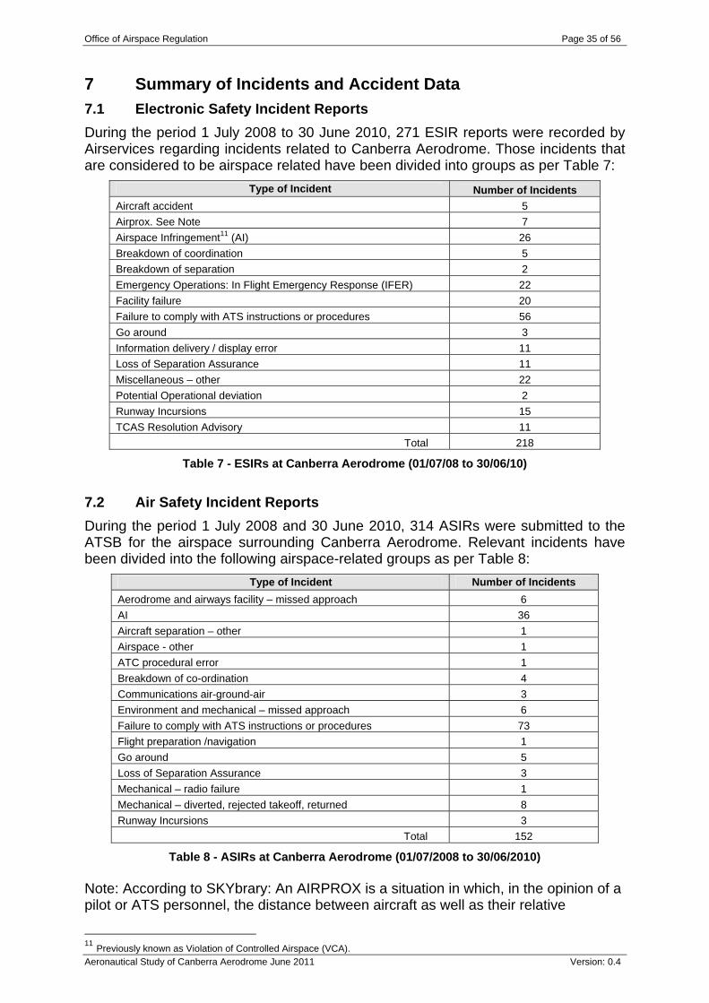
7 Summary of Incidents and Accident Data 7.1 Electronic Safety Incident Reports During the period 1 July 2008 to 30 June 2010, 271 ESIR reports were recorded by Airservices regarding incidents related to Canberra Aerodrome. Those incidents that are considered to be airspace related have been divided into groups as per Table 7:
Type of Incident Number of Incidents Aircraft accident 5 Airprox. See Note 7 Airspace Infringement11 (AI) 26 Breakdown of coordination 5 Breakdown of separation 2 Emergency Operations: In Flight Emergency Response (IFER) 22 Facility failure 20 Failure to comply with ATS instructions or procedures 56 Go around 3 Information delivery / display error 11 Loss of Separation Assurance 11 Miscellaneous – other 22 Potential Operational deviation 2 Runway Incursions 15 TCAS Resolution Advisory 11
Total 218
Table 7 - ESIRs at Canberra Aerodrome (01/07/08 to 30/06/10) 7.2 Air Safety Incident Reports During the period 1 July 2008 and 30 June 2010, 314 ASIRs were submitted to the ATSB for the airspace surrounding Canberra Aerodrome. Relevant incidents have been divided into the following airspace-related groups as per Table 8:
Type of Incident Number of Incidents Aerodrome and airways facility – missed approach 6 AI 36 Aircraft separation – other 1 Airspace - other 1 ATC procedural error 1 Breakdown of co-ordination 4 Communications air-ground-air 3 Environment and mechanical – missed approach 6 Failure to comply with ATS instructions or procedures 73 Flight preparation /navigation 1 Go around 5 Loss of Separation Assurance 3 Mechanical – radio failure 1 Mechanical – diverted, rejected takeoff, returned 8 Runway Incursions 3
Total 152
Table 8 - ASIRs at Canberra Aerodrome (01/07/2008 to 30/06/2010) Note: According to SKYbrary: An AIRPROX is a situation in which, in the opinion of a pilot or ATS personnel, the distance between aircraft as well as their relative
11 Previously known as Violation of Controlled Airspace (VCA).
Office of Airspace Regulation Page 36 of 56
Aeronautical Study of Canberra Aerodrome June 2011 Version: 0.4
positions and speed have been such that the safety of the aircraft involved may have been compromised. (ICAO Doc 4444: PANS-ATM).
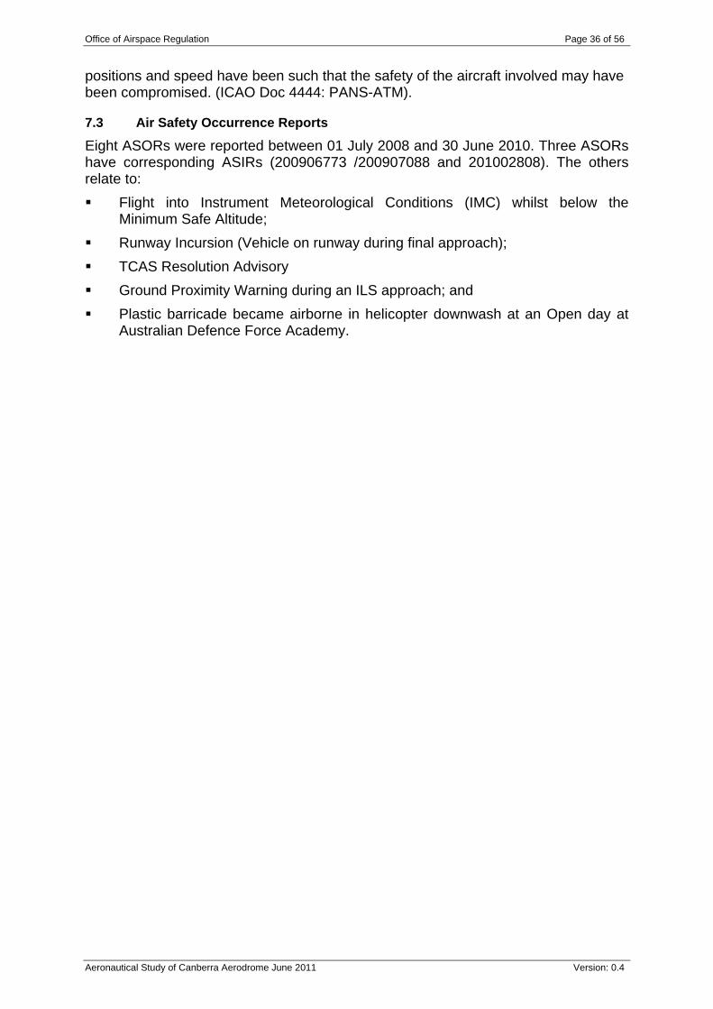
7.3 Air Safety Occurrence Reports Eight ASORs were reported between 01 July 2008 and 30 June 2010. Three ASORs have corresponding ASIRs (200906773 /200907088 and 201002808). The others relate to: Flight into Instrument Meteorological Conditions (IMC) whilst below the
Minimum Safe Altitude; Runway Incursion (Vehicle on runway during final approach); TCAS Resolution Advisory Ground Proximity Warning during an ILS approach; and Plastic barricade became airborne in helicopter downwash at an Open day at
Australian Defence Force Academy.
Office of Airspace Regulation Page 37 of 56
Aeronautical Study of Canberra Aerodrome June 2011 Version: 0.4
8 Risk Assessment One definition of safety is ‘freedom from unacceptable risk’, which is to invoke the risk based approach. In addition to consideration of harm to humans and damage to assets, other consequences such as environment, efficiency and equity can be accommodated within the risk based likelihood / consequence framework. In seeking to deliver good safety outcomes to all aviation participants, the AAPS extends the previous focus on PT Operations to include commercial and recreational users. In addition to major airlines using the new terminal, there are other aircraft operations based at Canberra.
8.1 Concept and Scope The first step of the study documented in sections 3 – Airspace and 4 – Aerodrome included to gather and validate necessary data and information related to airspace issues around Canberra. The Concept and Scope has been defined in order to demonstrate understanding of the subject matter and the due diligence test of causation. Considerations have included physical layout, environment, services and facilities, terrain, weather, approaches and departures, current airspace, ATC and Pilot procedures, aircraft movements and incidents (section 7). Previous reports and considerations including National Airspace System of the United States of America (NAS) characteristics were considered as briefing material for stakeholder consultations (section 5).
8.2 Risk identification and analysis The second step proceeded from consultation with Stakeholders (section 5). This included, where available, consultation with Airservices, PT operators, Charter operators, Flying Training Schools, Defence, Emergency Services operators and Aerodrome Operators. The Stakeholder consultations focussed on the due diligence tests of foreseeability and preventability that is, for every issue or credible threat raised, Stakeholders were encouraged to set out their preferred options/sensible precautions for risk mitigation. The test of ‘sensibility’ was covered under the second step task of preventability with Stakeholders suggesting preferred options. Options for good practice to mitigate the airspace risks identified which can be applied or adapted to the Australian environment are based upon proven international good practice. These options must be consistent with the Government’s airspace policy as described in the Aviation White Paper. Comment: The White Paper outlines the legislative and policy framework outlined above as a starting point of a top-down strategic approach. Other options may arise from a bottom-up tactical approach. It is the synthesis of these two viewpoints that defines the relative contributions of different measures and techniques and their attendant risk reduction. An understanding of relative risk reduction per dollar spent is also an extremely useful ranking technique. A semi-quantitative risk matrix approach as further described below was used to scale a variety of consequences (and opportunities). Likelihood is increasingly less relevant (after the accident ‘it happened’) but provides a useful tool for risk ranking by consequence type.
Office of Airspace Regulation Page 38 of 56
Aeronautical Study of Canberra Aerodrome June 2011 Version: 0.4
The various points and issues (concerns) raised in the technical reviews and by stakeholders were wide ranging. They have been categorised under common headings of: Airspace and Restricted Areas, Aerodrome and Incidents and Accidents.
8.2.1 Airspace and Restricted Areas This section summarises findings and issues arising from section 3 above: The truncated CTA design to the east and west of Canberra provides efficient
access to VFR flights; The airspace largely conforms to AC number AC 2-5-1(0); The vertical design largely accommodates Canberra’s elevation of 1,886 FT
AMSL However, the CTA LL does not always provide a minimum of 700 FT from terrain and therefore should be redesigned to meet AC 2-5-1 (0) requirements. Also, lowest safe altitudes should be reviewed against this criterion in areas where wind generators have been installed.
A review of the dimensions of all Majura Firing Areas and R455 is being undertaken by Defence.
8.2.2 Aerodrome This section summarises findings and issues arising from section 4 above: A review of all Canberra instrument approaches indicated that RNAV (GNSS)
RWY 30 in two segments is not contained within controlled airspace as required by AC 2-5-1 (14.1) and CASR Part 173 MOS;
The review also indicated that the IFR waypoint KATIA appears in Canberra DAP chart but is not listed in DAH or ERSA. Airservices should insert KATIA into the relevant sections of DAH and ERSA.
8.2.3 Consultation This section summarises findings and issues arising from section 5 above: The survey of airline pilots was positive as to the suitability of current Class C classification and ATC services: There was support for extended TWR HR; Traffic volume and complexity was considered normal for this location; Radio congestion was not an issue; Several Pilots strongly disagreed that navigation aids are sufficient for a safe
and efficient operation. Weather conditions often require an instrument approach;
There was some disagreement as to the sufficiency of visual aids, runways and taxiways; and
However, the safety seemed suitable and the only significant safety defects that need to be rectified were review on the prohibition of DHC8 Q400 series use of RWY 30 for arrivals and enhancement of all weather capability.
The GA operators raised concerns about equity of access, especially as regards circuit training during peak hours. Sports Aviation interest requested a review of airspace around Pig Hill to allow better access for the hang gliders.
Office of Airspace Regulation Page 39 of 56
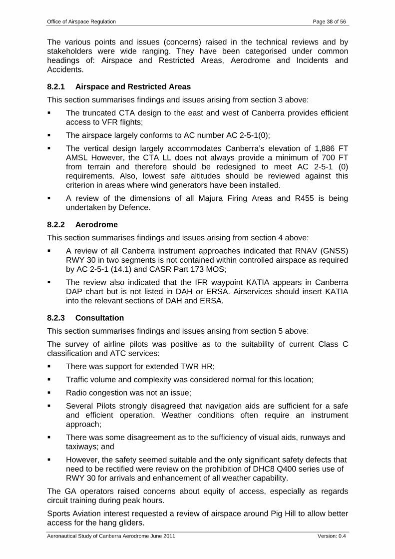
Aeronautical Study of Canberra Aerodrome June 2011 Version: 0.4
34 SQN raised a number of issues in relation to ARP/DME arcs and extending Class C LL 5,500 FT AMSL step in the south west from 20 DME to 22 DME. Airservices made observations about the lack of a full length taxiway creating crossing problems. This was said to be a matter of efficiency although the review believes safety is also an issue.
8.2.4 Incidents and Accident Data This section further summarises incidents and accidents that occurred in the two years detailed in section 7: The most numerous ESIR were failure to comply with ATS (56), AI (26),
IFER (22) and other (22); The ASIR included Failure to comply with ATS (73), AI (36); and ASOR occurred in low numbers and provided no additional insights.
Treating the risk assessment sequence of hazard identification, control and monitoring as an Arrow of Time leads to the following appreciation of where incidents lie and how they are evaluated. Refer Table 9:
Hazard identification Control Layer(s) Control Layer(s) Loss of control
Accident / near miss
Aircraft known to system ATC not aware of conflict
ATC does not recognise threat
Separation or segregation fails
Balance of probability Unalerted see-and-avoid TCAS and Transponder
ASIR (number of): (Operational Non-compliance) - Published information (26) Airspace – Other (1) VCA (Airspace incursion) - Controlled airspace (35) - VCA (Airspace incursion) - PRD(1) Operational - Communications - Air-ground-air(3) Operational - Flight preparation / Navigation - Lost / unsure (1)
ATC Procedural error (1) Breakdown of co-ordination (4) (Operational Non-compliance) - Verbal instruction (47)
Aircraft separation (other – 4) Operational - Consequential events - Missed approach / go-around (5) Operational - Runway events - Runway Incursion(3)
Breakdown of Separation (3)
ESIR (number of): Failure to comply ATS Instructions/Procedures (56) Information Delivery / Display Error (11) Miscellaneous Other (22) Violation of Controlled Airspace (26)
Breakdown of Co-ordination (5) Facility Failure (20) Potential Operational Deviation (2)
Go Around (3) Runway Incursion (15)
Airprox(7) Breakdown of Separation (2) Loss of Separation Assurance (11)
Aircraft Accident (5) TCAS Resolution Advisory (11)
Total number of hazards that happened = 182
Total number of failures of first layer of control = 79
Total number of failures at the second level of control = 30
Total occurrence of loss of control = 23
Total potential accidents /near misses = 16
Table 9 - Summary of Hazard occurrences.
Note: the failure rate for a single incident based on 168,958 movements over two years equals 5.92 E-6 per incident in scientific terms (say 6 chances per million per movement). Table 10 presents the summary failure rates for each class of incident.
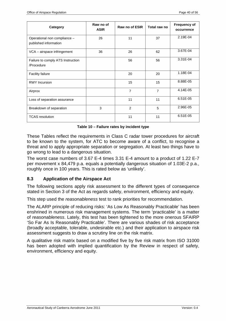
Office of Airspace Regulation Page 40 of 56
Aeronautical Study of Canberra Aerodrome June 2011 Version: 0.4
Category Raw no of
ASIR Raw no of ESIR Total raw no
Frequency of occurrence
Operational non compliance – published information
26 11 37 2.19E-04
VCA – airspace infringement 36 26 62 3.67E-04
Failure to comply ATS Instruction /Procedure
56 56 3.31E-04
Facility failure 20 20 1.18E-04
RWY Incursion 15 15 8.88E-05
Airprox 7 7 4.14E-05
Loss of separation assurance 11 11 6.51E-05
Breakdown of separation 3 2 5 2.96E-05
TCAS resolution 11 11 6.51E-05
Table 10 – Failure rates by incident type
These Tables reflect the requirements in Class C radar tower procedures for aircraft to be known to the system, for ATC to become aware of a conflict, to recognise a threat and to apply appropriate separation or segregation. At least two things have to go wrong to lead to a dangerous situation. The worst case numbers of 3.67 E-4 times 3.31 E-4 amount to a product of 1.22 E-7 per movement x 84,479 p.a. equals a potentially dangerous situation of 1.03E-2 p.a., roughly once in 100 years. This is rated below as ‘unlikely’.
8.3 Application of the Airspace Act The following sections apply risk assessment to the different types of consequence stated in Section 3 of the Act as regards safety, environment, efficiency and equity. This step used the reasonableness test to rank priorities for recommendation. The ALARP principle of reducing risks: ‘As Low As Reasonably Practicable’ has been enshrined in numerous risk management systems. The term ‘practicable’ is a matter of reasonableness. Lately, this test has been tightened to the more onerous SFAIRP ‘So Far As Is Reasonably Practicable’. There are various shades of risk acceptance (broadly acceptable, tolerable, undesirable etc.) and their application to airspace risk assessment suggests to draw a scrutiny line on the risk matrix. A qualitative risk matrix based on a modified five by five risk matrix from ISO 31000 has been adopted with implied quantification by the Review in respect of safety, environment, efficiency and equity.
Office of Airspace Regulation Page 41 of 56
Aeronautical Study of Canberra Aerodrome June 2011 Version: 0.4
10K 100K 1M 10M 100MNot significant Minor Moderate Major Extreme
10 Almost M M H VH VHcertain 100K 1M 10M 100M 1000M
1 Likely L M H VH VH10K 100K 1M 10M 100M
1 in 10 Possible L L M H H1K 10K 100K 1M 10M
1 in 100 Unlikely L L L M M1K 10K 100K 1M
1 in 1000 Rare L L L L M1K 10K 100K
Risk Assessment - Evaluation
Figure 10- Risk Matrix
Note: categories of risk are: VH – Very High Risk – intolerable except extraordinary circumstances; H – High Risk – undesirable unless reduction impractical or grossly
disproportionate; M – Medium Risk – subject to reduction So Far As Is Reasonably Practicable
(SFAIRP); and L - Low Risk – broadly acceptable subject to good practice and compliance with
standards 8.3.1 Safety Table 11 reviews the Pilot Survey and summarises the issues raised:
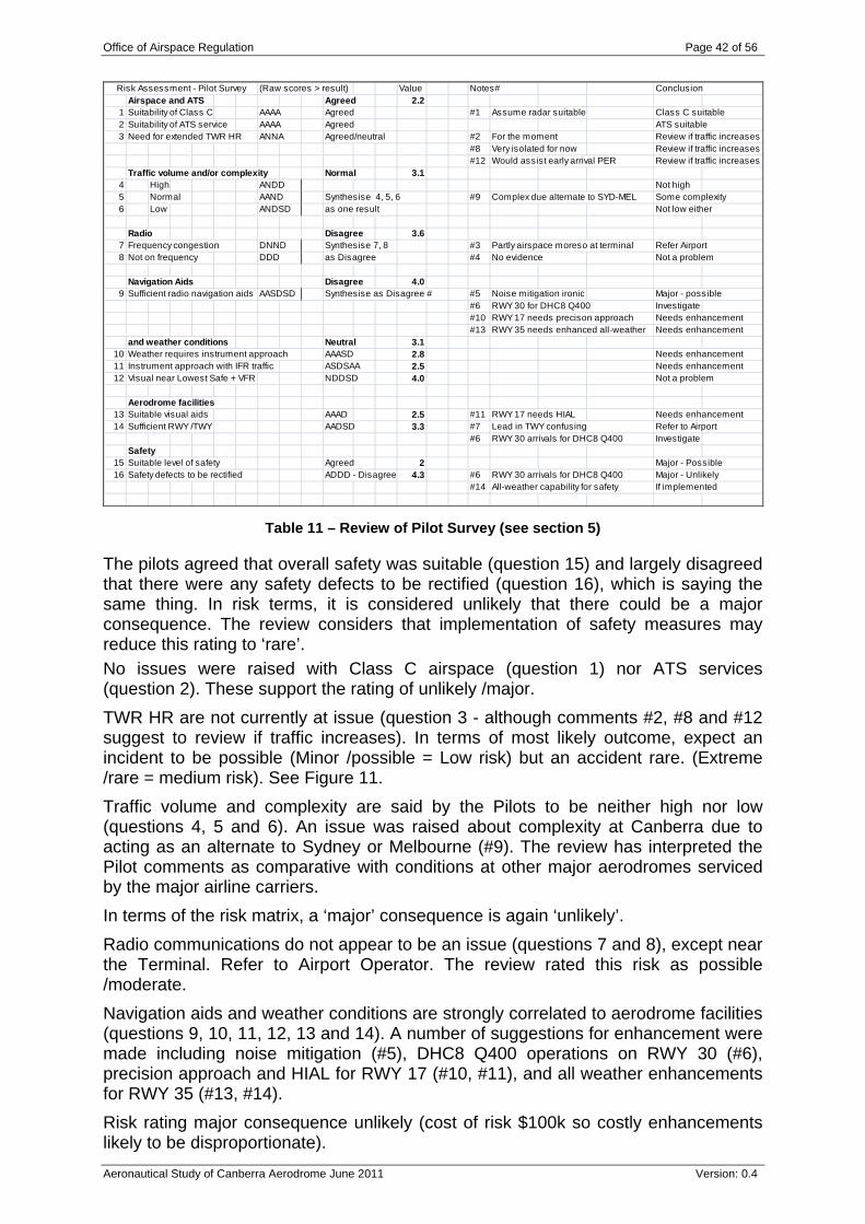
Office of Airspace Regulation Page 42 of 56
Aeronautical Study of Canberra Aerodrome June 2011 Version: 0.4
Risk Assessment - Pilot Survey (Raw scores > result) Value Notes# ConclusionAirspace and ATS Agreed 2.2
1 Suitability of Class C AAAA Agreed #1 Assume radar suitable Class C suitable2 Suitability of ATS service AAAA Agreed ATS suitable3 Need for extended TWR HR ANNA Agreed/neutral #2 For the moment Review if traffic increases
#8 Very isolated for now Review if traffic increases#12 Would assist early arrival PER Review if traffic increases
Traffic volume and/or complexity Normal 3.14 High ANDD Not high5 Normal AAND Synthesise 4, 5, 6 #9 Complex due alternate to SYD-MEL Some complexity6 Low ANDSD as one result Not low either
Radio Disagree 3.67 Frequency congestion DNND Synthesise 7, 8 #3 Partly airspace moreso at terminal Refer Airport8 Not on frequency DDD as Disagree #4 No evidence Not a problem
Navigation Aids Disagree 4.09 Sufficient radio navigation aids AASDSD Synthesise as Disagree # #5 Noise mitigation ironic Major - possible
#6 RWY 30 for DHC8 Q400 Investigate#10 RWY 17 needs precison approach Needs enhancement#13 RWY 35 needs enhanced all-weather Needs enhancement
and weather conditions Neutral 3.110 Weather requires instrument approach AAASD 2.8 Needs enhancement11 Instrument approach with IFR traffic ASDSAA 2.5 Needs enhancement12 Visual near Lowest Safe + VFR NDDSD 4.0 Not a problem
Aerodrome facilities13 Suitable visual aids AAAD 2.5 #11 RWY 17 needs HIAL Needs enhancement14 Sufficient RWY /TWY AADSD 3.3 #7 Lead in TWY confusing Refer to Airport
#6 RWY 30 arrivals for DHC8 Q400 InvestigateSafety
15 Suitable level of safety Agreed 2 Major - Possible16 Safety defects to be rectified ADDD - Disagree 4.3 #6 RWY 30 arrivals for DHC8 Q400 Major - Unlikely
#14 All-weather capability for safety If implemented
Table 11 – Review of Pilot Survey (see section 5)
The pilots agreed that overall safety was suitable (question 15) and largely disagreed that there were any safety defects to be rectified (question 16), which is saying the same thing. In risk terms, it is considered unlikely that there could be a major consequence. The review considers that implementation of safety measures may reduce this rating to ‘rare’. No issues were raised with Class C airspace (question 1) nor ATS services (question 2). These support the rating of unlikely /major. TWR HR are not currently at issue (question 3 - although comments #2, #8 and #12 suggest to review if traffic increases). In terms of most likely outcome, expect an incident to be possible (Minor /possible = Low risk) but an accident rare. (Extreme /rare = medium risk). See Figure 11. Traffic volume and complexity are said by the Pilots to be neither high nor low (questions 4, 5 and 6). An issue was raised about complexity at Canberra due to acting as an alternate to Sydney or Melbourne (#9). The review has interpreted the Pilot comments as comparative with conditions at other major aerodromes serviced by the major airline carriers. In terms of the risk matrix, a ‘major’ consequence is again ‘unlikely’. Radio communications do not appear to be an issue (questions 7 and 8), except near the Terminal. Refer to Airport Operator. The review rated this risk as possible /moderate. Navigation aids and weather conditions are strongly correlated to aerodrome facilities (questions 9, 10, 11, 12, 13 and 14). A number of suggestions for enhancement were made including noise mitigation (#5), DHC8 Q400 operations on RWY 30 (#6), precision approach and HIAL for RWY 17 (#10, #11), and all weather enhancements for RWY 35 (#13, #14). Risk rating major consequence unlikely (cost of risk $100k so costly enhancements likely to be disproportionate).
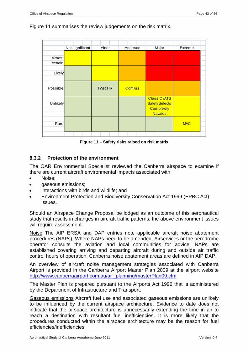
Office of Airspace Regulation Page 43 of 56
Aeronautical Study of Canberra Aerodrome June 2011 Version: 0.4
Figure 11 summarises the review judgements on the risk matrix.
Not significant Minor Moderate Major Extreme
Almostcertain
Likely
Possible TWR HR Comms
Class C /ATSUnlikely Safety defects
ComplexityNavaids
Rare MAC
Figure 11 – Safety risks raised on risk matrix
8.3.2 Protection of the environment The OAR Environmental Specialist reviewed the Canberra airspace to examine if there are current aircraft environmental impacts associated with: • Noise; • gaseous emissions; • interactions with birds and wildlife; and • Environment Protection and Biodiversity Conservation Act 1999 (EPBC Act)
issues.
Should an Airspace Change Proposal be lodged as an outcome of this aeronautical study that results in changes in aircraft traffic patterns, the above environment issues will require assessment. Noise The AIP ERSA and DAP entries note applicable aircraft noise abatement procedures (NAPs). Where NAPs need to be amended, Airservices or the aerodrome operator consults the aviation and local communities for advice. NAPs are established covering arriving and departing aircraft during and outside air traffic control hours of operation. Canberra noise abatement areas are defined in AIP DAP. An overview of aircraft noise management strategies associated with Canberra Airport is provided in the Canberra Airport Master Plan 2009 at the airport website http://www.canberraairport.com.au/air_planning/masterPlan09.cfm The Master Plan is prepared pursuant to the Airports Act 1996 that is administered by the Department of Infrastructure and Transport. Gaseous emissions Aircraft fuel use and associated gaseous emissions are unlikely to be influenced by the current airspace architecture. Evidence to date does not indicate that the airspace architecture is unnecessarily extending the time in air to reach a destination with resultant fuel inefficiencies. It is more likely that the procedures conducted within the airspace architecture may be the reason for fuel efficiencies/inefficiencies.
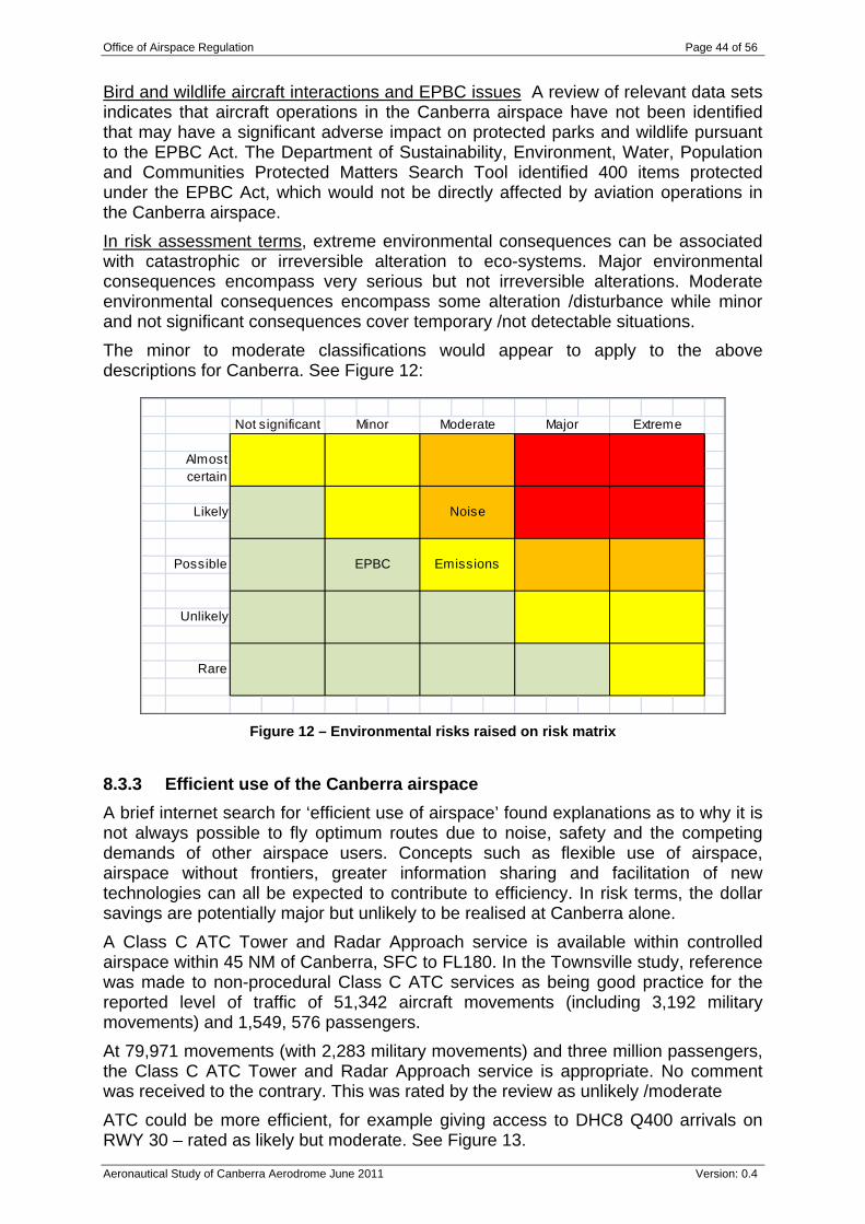
Office of Airspace Regulation Page 44 of 56
Aeronautical Study of Canberra Aerodrome June 2011 Version: 0.4
Bird and wildlife aircraft interactions and EPBC issues A review of relevant data sets indicates that aircraft operations in the Canberra airspace have not been identified that may have a significant adverse impact on protected parks and wildlife pursuant to the EPBC Act. The Department of Sustainability, Environment, Water, Population and Communities Protected Matters Search Tool identified 400 items protected under the EPBC Act, which would not be directly affected by aviation operations in the Canberra airspace. In risk assessment terms, extreme environmental consequences can be associated with catastrophic or irreversible alteration to eco-systems. Major environmental consequences encompass very serious but not irreversible alterations. Moderate environmental consequences encompass some alteration /disturbance while minor and not significant consequences cover temporary /not detectable situations. The minor to moderate classifications would appear to apply to the above descriptions for Canberra. See Figure 12:
Not significant Minor Moderate Major Extreme
Almostcertain
Likely Noise
Possible EPBC Emissions
Unlikely
Rare
Figure 12 – Environmental risks raised on risk matrix
8.3.3 Efficient use of the Canberra airspace A brief internet search for ‘efficient use of airspace’ found explanations as to why it is not always possible to fly optimum routes due to noise, safety and the competing demands of other airspace users. Concepts such as flexible use of airspace, airspace without frontiers, greater information sharing and facilitation of new technologies can all be expected to contribute to efficiency. In risk terms, the dollar savings are potentially major but unlikely to be realised at Canberra alone. A Class C ATC Tower and Radar Approach service is available within controlled airspace within 45 NM of Canberra, SFC to FL180. In the Townsville study, reference was made to non-procedural Class C ATC services as being good practice for the reported level of traffic of 51,342 aircraft movements (including 3,192 military movements) and 1,549, 576 passengers. At 79,971 movements (with 2,283 military movements) and three million passengers, the Class C ATC Tower and Radar Approach service is appropriate. No comment was received to the contrary. This was rated by the review as unlikely /moderate ATC could be more efficient, for example giving access to DHC8 Q400 arrivals on RWY 30 – rated as likely but moderate. See Figure 13.
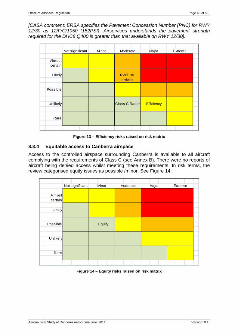
Office of Airspace Regulation Page 45 of 56
Aeronautical Study of Canberra Aerodrome June 2011 Version: 0.4
[CASA comment: ERSA specifies the Pavement Concession Number (PNC) for RWY 12/30 as 12/F/C/1050 (152PSI). Airservices understands the pavement strength required for the DHC8 Q400 is greater than that available on RWY 12/30].
Not significant Minor Moderate Major Extreme
Almostcertain
Likely RWY 30 arrivals
Possible
Unlikely Class C Radar Efficiency
Rare
Figure 13 – Efficiency risks raised on risk matrix
8.3.4 Equitable access to Canberra airspace Access to the controlled airspace surrounding Canberra is available to all aircraft complying with the requirements of Class C (see Annex B). There were no reports of aircraft being denied access whilst meeting these requirements. In risk terms, the review categorised equity issues as possible /minor. See Figure 14.
Not significant Minor Moderate Major Extreme
Almostcertain
Likely
Possible Equity
Unlikely
Rare
Figure 14 – Equity risks raised on risk matrix
Office of Airspace Regulation Page 46 of 56
Aeronautical Study of Canberra Aerodrome June 2011 Version: 0.4
8.3.5 Airspace Reform As required by the AAPS, this study takes into account the Government’s requirement that CASA will continue the reform of Australia’s airspace and move towards closer alignment with the ICAO system and adoption of international best practice. This includes adopting of proven international airspace systems adapted to benefit Australia’s aviation environment. The Government’s airspace strategy recognises that international airspace systems (such as the NAS) include a range of characteristics that should be considered and implemented as appropriate by CASA. Even so, changes to existing airspace classification or designation should be the consequence of a clear and consistent risk management process. Differences with respect to Australian airspace notified under Article 38 of the Convention on International Civil Aviation (Chicago 1944) were considered. By pursuing a proactive process of consultation, stakeholders were expected to contribute to identification of opportunities. In addition to workshops and interviews, expert opinion can be given appropriate weight. As described in the safety, environment, efficiency and equity evaluation presented above, there are no specific issues at Canberra to say that Class C radar airspace is inappropriate.
Office of Airspace Regulation Page 47 of 56
Aeronautical Study of Canberra Aerodrome June 2011 Version: 0.4
9 Findings and Conclusions Class C airspace with surveillance is appropriate with respect to safety, environment, efficiency and equity. It provides a safe level of ATS and is appropriate for the levels and type of aircraft operating through the airspace. The review has assessed safety as comprising a number of medium risks in relation to mid air collisions, Class C / ATS, remedy of safety defects, dealing with complexity, upgrading of navaids and communications. Extension of TWR HR was also raised but is considered a low risk at current traffic levels. No extreme, very high or high safety risks were found. With respect to environment, noise effects are considered to be high risk, emissions medium risk and low risk in relation to EPBC. Efficiency in general was rated medium risk and Class C radar low risk as befits its application. Equitable access issues were rated as a low risk. In terms of specifics: The CTA design provides efficient access to VFR flights; The CTA LL should be redesigned to meet AC 2-5-1 (0) requirements for a
minimum of 700 FT from terrain; Lowest safe altitudes should be reviewed against AC 2-5-1 (0) in areas where
wind generators have been installed; Defence should review the linking of ATC to activation of Defence Firing Areas
within Majura Field Firing Range for inclusion in AIP; Two segments of RNAV GNSS RWY 30 should be reviewed so as to be
contained within controlled airspace as required by AC 2-5-1 (14.1) and CASR Part 173 MOS;
Airservices should insert KATIA into the relevant sections of DAH and ERSA; The current volume and mix of traffic outside of TWR HR does not justify a
change in TWR HR; The prohibition of DHC8 Q400 series use of RWY 30 for arrivals and
enhancement of all weather capability should be reviewed; The sufficiency of visual aids, runways and taxiways should be reviewed,
including consideration to lack of a full length taxiway creating crossing problems, precision approach capability and HIAL for RWY 17;
A number of stakeholders believe that the equity of access to circuit training during peak hours should be reviewed;
Airspace around Pig Hill should be reviewed to allow better access for the hang gliders;
Specification of CTR as ARP should be reviewed in relation to DME arcs; Class C LL 5,500 FT AMSL step in the south west should be reviewed in
relation to extending 20 DME to 22 DME; and
Canberra operators should approach the local RAPAC to declare Danger Areas (DA) for the training areas ‘Barton’ and ‘Kings’ and have the areas depicted on the Canberra VTC and VNC.
Office of Airspace Regulation Page 48 of 56
Aeronautical Study of Canberra Aerodrome June 2011 Version: 0.4
10 Recommendations It is important to note that the study may make recommendations based on existing and projected data. The following comment as summarised by Chief Justice Sir Harry Gibbs of the High Court of Australia has been considered while conducting the study:
Where it is possible to guard against a foreseeable risk which, though perhaps not great, nevertheless cannot be called remote or fanciful, by adopting a means which involves little difficulty or expense, the failure to adopt such means will in general be negligent.12
CASA applies a precautionary approach when conducting aeronautical studies and therefore the following recommendations are made:
1. Airservices should insert the IFR waypoint KATIA into the relevant sections of DAH and ERSA. [CASA comment: The waypoint KATIA has been included in ERSA, effective 25 August 2011].
2. Canberra operators should approach the local RAPAC to declare DA for the training areas ‘Barton’ and ‘Kings’ and have the areas depicted on the Canberra VTC and VNC.
3. Airservices should review the lowest safe altitudes in the areas where wind generators have been installed for compliance with the criterion in AC 2-5-1 (0).
4. The airport operator to review pilot comments including the prohibition of DHC8 Q400 series use of RWY 30 for arrivals and enhancement of all weather capability.
11 Next steps Stakeholders are requested to provide feedback on the study to [email protected] no later than 23 September 2011. CASA will consider feedback received to be public information and will normally attribute feedback, however requests to remain anonymous will be considered. Following the consultation and feedback period CASA will finalise and publish their final recommendations.
12 Gibbs, Chief Justice Sir Harry. Turner v State of South Australia (1982). High Court of Australia before Gibbs CJ, Murphy, Brennan, Deane and Dawson JJ.
Office of Airspace Regulation Page 49 of 56
Aeronautical Study of Canberra Aerodrome June 2011 Version: 0.4
12 References Advisory Circular 2-5-1(0). Airservices Australia Data Validation Reports for 12 months to June 2009 and
2010. Airspace Act 2007. Air Safety Incident Reports 01 July 2008 to 30 June 2010. Aviation White Paper. Bureau of Meteorology, 2006. CASA Instrument number CASA 443/05 of 9 November 2005. Civil Aviation Regulation (CAR) 1988, Regulation 166. Convention on International Civil Aviation (Chicago, 1944). Electronic Safety Incident Reports for the period 1 July 2008 to 30 June 2010. ICAO Annex 11, 2008. International Standards Organisation (ISO) 31000 – 2009: Risk management.
Office of Airspace Regulation Page 50 of 56
Aeronautical Study of Canberra Aerodrome June 2011 Version: 0.4
Annexes:
A. Abbreviations and Acronyms B. Australian Airspace Structure C. Stakeholders D. Definitions and Explanation of Terms
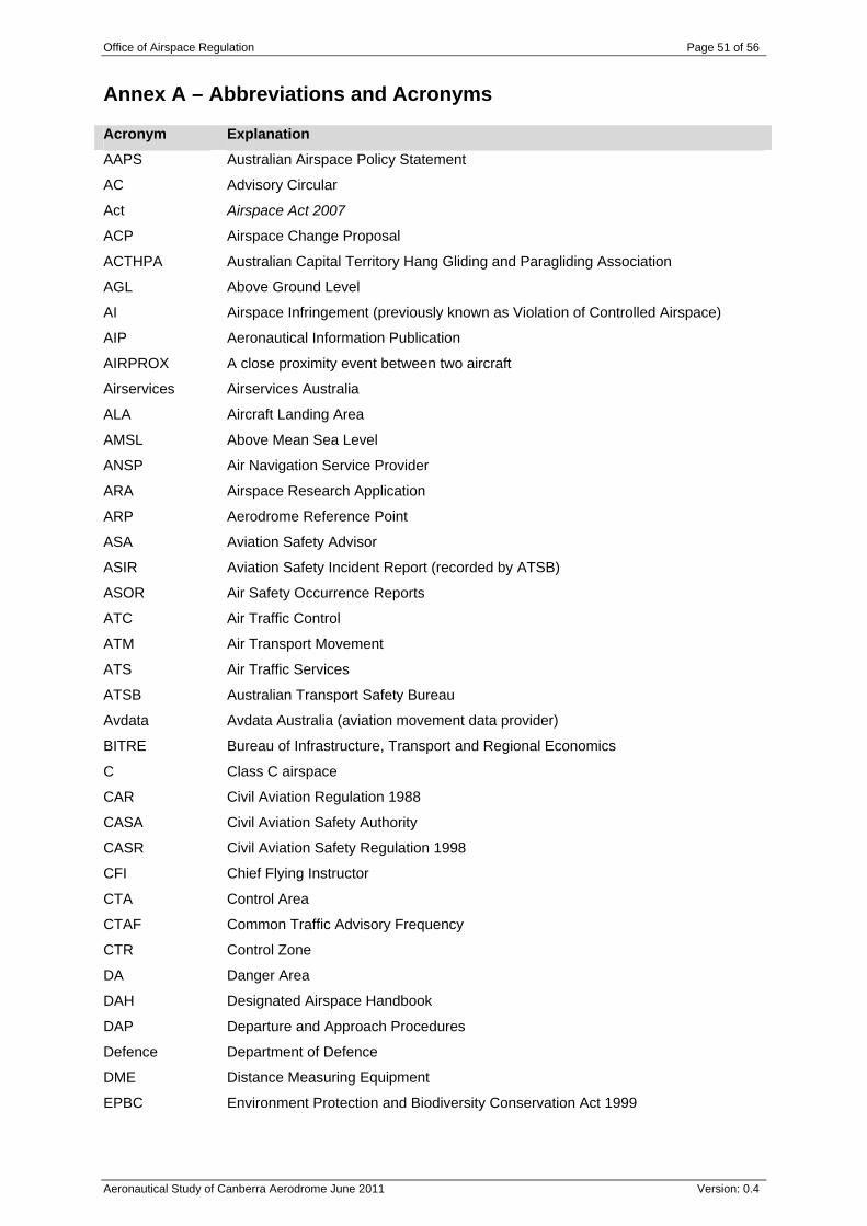
Office of Airspace Regulation Page 51 of 56
Aeronautical Study of Canberra Aerodrome June 2011 Version: 0.4
Annex A – Abbreviations and Acronyms Acronym Explanation
AAPS Australian Airspace Policy Statement
AC Advisory Circular
Act Airspace Act 2007
ACP Airspace Change Proposal
ACTHPA Australian Capital Territory Hang Gliding and Paragliding Association
AGL Above Ground Level
AI Airspace Infringement (previously known as Violation of Controlled Airspace)
AIP Aeronautical Information Publication
AIRPROX A close proximity event between two aircraft
Airservices Airservices Australia
ALA Aircraft Landing Area
AMSL Above Mean Sea Level
ANSP Air Navigation Service Provider
ARA Airspace Research Application
ARP Aerodrome Reference Point
ASA Aviation Safety Advisor
ASIR Aviation Safety Incident Report (recorded by ATSB)
ASOR Air Safety Occurrence Reports
ATC Air Traffic Control
ATM Air Transport Movement
ATS Air Traffic Services
ATSB Australian Transport Safety Bureau
Avdata Avdata Australia (aviation movement data provider)
BITRE Bureau of Infrastructure, Transport and Regional Economics
C Class C airspace
CAR Civil Aviation Regulation 1988
CASA Civil Aviation Safety Authority
CASR Civil Aviation Safety Regulation 1998
CFI Chief Flying Instructor
CTA Control Area
CTAF Common Traffic Advisory Frequency
CTR Control Zone
DA Danger Area
DAH Designated Airspace Handbook
DAP Departure and Approach Procedures
Defence Department of Defence
DME Distance Measuring Equipment
EPBC Environment Protection and Biodiversity Conservation Act 1999
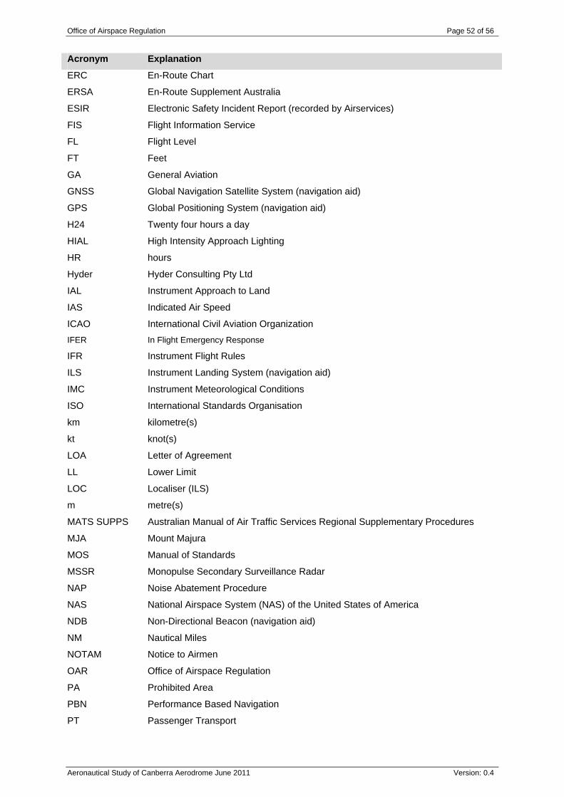
Office of Airspace Regulation Page 52 of 56
Aeronautical Study of Canberra Aerodrome June 2011 Version: 0.4
Acronym Explanation
ERC En-Route Chart
ERSA En-Route Supplement Australia
ESIR Electronic Safety Incident Report (recorded by Airservices)
FIS Flight Information Service
FL Flight Level
FT Feet
GA General Aviation
GNSS Global Navigation Satellite System (navigation aid)
GPS Global Positioning System (navigation aid)
H24 Twenty four hours a day
HIAL High Intensity Approach Lighting
HR hours
Hyder Hyder Consulting Pty Ltd
IAL Instrument Approach to Land
IAS Indicated Air Speed
ICAO International Civil Aviation Organization IFER In Flight Emergency Response
IFR Instrument Flight Rules
ILS Instrument Landing System (navigation aid)
IMC Instrument Meteorological Conditions
ISO International Standards Organisation
km kilometre(s)
kt knot(s)
LOA Letter of Agreement
LL Lower Limit
LOC Localiser (ILS)
m metre(s)
MATS SUPPS Australian Manual of Air Traffic Services Regional Supplementary Procedures
MJA Mount Majura
MOS Manual of Standards
MSSR Monopulse Secondary Surveillance Radar
NAP Noise Abatement Procedure
NAS National Airspace System (NAS) of the United States of America
NDB Non-Directional Beacon (navigation aid)
NM Nautical Miles
NOTAM Notice to Airmen
OAR Office of Airspace Regulation
PA Prohibited Area
PBN Performance Based Navigation
PT Passenger Transport
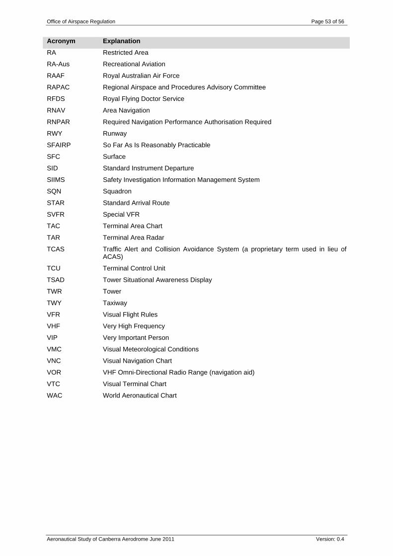
Office of Airspace Regulation Page 53 of 56
Aeronautical Study of Canberra Aerodrome June 2011 Version: 0.4
Acronym Explanation
RA Restricted Area
RA-Aus Recreational Aviation
RAAF Royal Australian Air Force
RAPAC Regional Airspace and Procedures Advisory Committee
RFDS Royal Flying Doctor Service
RNAV Area Navigation
RNPAR Required Navigation Performance Authorisation Required
RWY Runway
SFAIRP So Far As Is Reasonably Practicable
SFC Surface
SID Standard Instrument Departure
SIIMS Safety Investigation Information Management System
SQN Squadron
STAR Standard Arrival Route
SVFR Special VFR
TAC Terminal Area Chart
TAR Terminal Area Radar
TCAS Traffic Alert and Collision Avoidance System (a proprietary term used in lieu of ACAS)
TCU Terminal Control Unit
TSAD Tower Situational Awareness Display
TWR Tower
TWY Taxiway
VFR Visual Flight Rules
VHF Very High Frequency
VIP Very Important Person
VMC Visual Meteorological Conditions
VNC Visual Navigation Chart
VOR VHF Omni-Directional Radio Range (navigation aid)
VTC Visual Terminal Chart
WAC World Aeronautical Chart
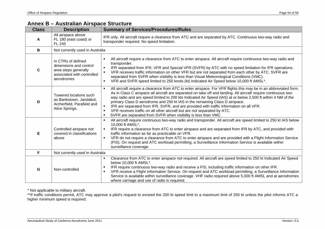
Office of Airspace Regulation Page 54 of 56
Aeronautical Study of Canberra Aerodrome June 2011 Version: 0.4
Annex B – Australian Airspace Structure Class Description Summary of Services/Procedures/Rules
A All airspace above FL 180 (east coast) or FL 245
IFR only. All aircraft require a clearance from ATC and are separated by ATC. Continuous two-way radio and transponder required. No speed limitation.
B Not currently used in Australia
C
In CTRs of defined dimensions and control area steps generally associated with controlled aerodromes
All aircraft require a clearance from ATC to enter airspace. All aircraft require continuous two-way radio and transponder.
IFR separated from IFR, VFR and Special VFR (SVFR) by ATC with no speed limitation for IFR operations. VFR receives traffic information on other VFR but are not separated from each other by ATC. SVFR are
separated from SVFR when visibility is less than Visual Meteorological Conditions (VMC). VFR and SVFR speed limited to 250 knots (kt) Indicated Air Speed below 10,000 ft AMSL*.
D Towered locations such as Bankstown, Jandakot, Archerfield, Parafield and Alice Springs.
All aircraft require a clearance from ATC to enter airspace. For VFR flights this may be in an abbreviated form. As in Class C airspace all aircraft are separated on take off and landing. All aircraft require continuous two-way radio and are speed limited to 200 kts Indicated Air Speed (IAS) at or below 2,500 ft within 4 NM of the primary Class D aerodrome and 250 kt IAS in the remaining Class D airspace.
IFR are separated from IFR, SVFR, and are provided with traffic information on all VFR. VFR receives traffic on all other aircraft but are not separated by ATC. SVFR are separated from SVFR when visibility is less than VMC.
E Controlled airspace not covered in classifications above
All aircraft require continuous two-way radio and transponder. All aircraft are speed limited to 250 kt IAS below 10,000 ft AMSL*,
IFR require a clearance from ATC to enter airspace and are separated from IFR by ATC, and provided with traffic information as far as practicable on VFR.
VFR do not require a clearance from ATC to enter airspace and are provided with a Flight Information Service (FIS). On request and ATC workload permitting, a Surveillance Information Service is available within surveillance coverage.
F Not currently used in Australia
G Non-controlled
Clearance from ATC to enter airspace not required. All aircraft are speed limited to 250 kt Indicated Air Speed below 10,000 ft AMSL*.
IFR require continuous two-way radio and receive a FIS, including traffic information on other IFR. VFR receive a Flight Information Service. On request and ATC workload permitting, a Surveillance Information
Service is available within surveillance coverage. VHF radio required above 5,000 ft AMSL and at aerodromes where carriage and use of radio is required.
* Not applicable to military aircraft. **If traffic conditions permit, ATC may approve a pilot's request to exceed the 200 kt speed limit to a maximum limit of 250 kt unless the pilot informs ATC a higher minimum speed is required.
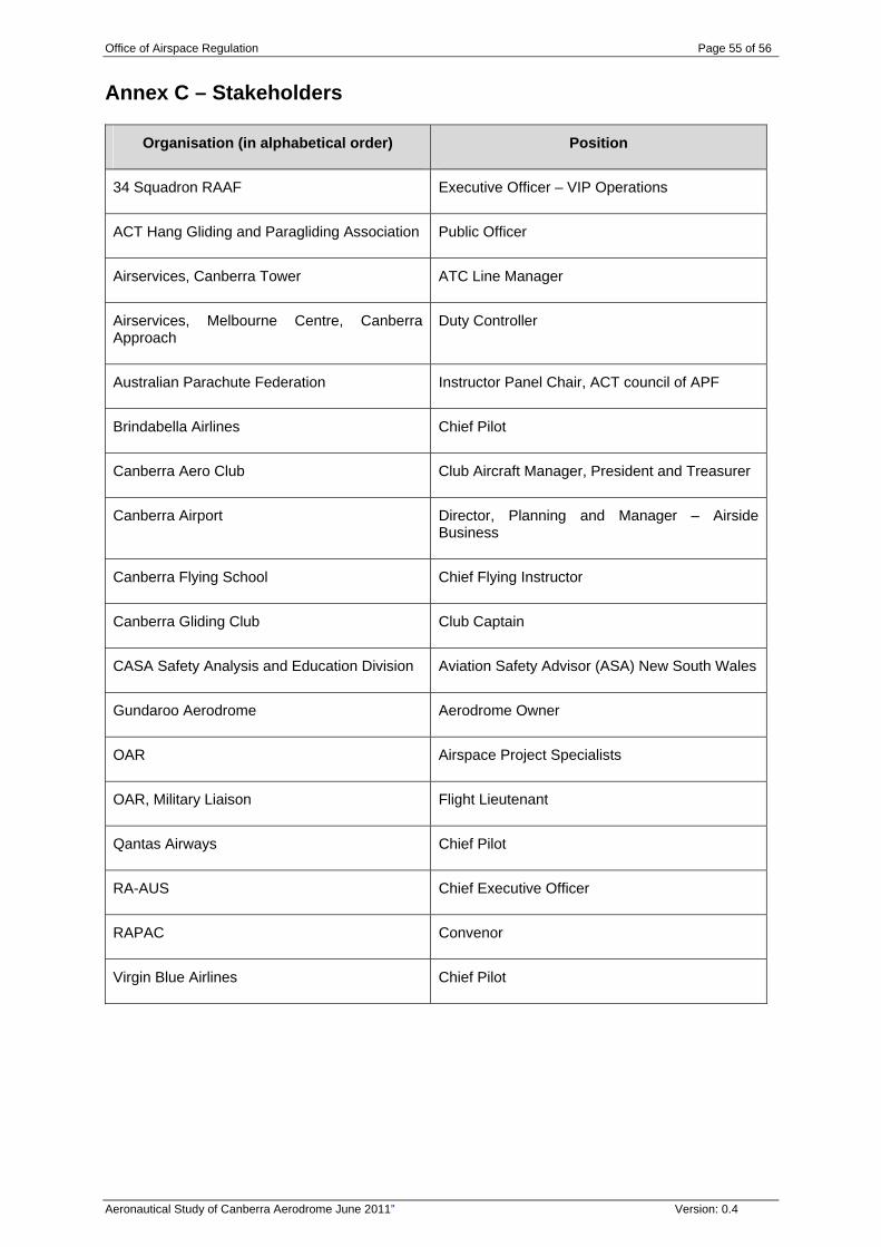
Office of Airspace Regulation Page 55 of 56
Aeronautical Study of Canberra Aerodrome June 2011” Version: 0.4
Annex C – Stakeholders
Organisation (in alphabetical order) Position
34 Squadron RAAF Executive Officer – VIP Operations
ACT Hang Gliding and Paragliding Association Public Officer
Airservices, Canberra Tower ATC Line Manager
Airservices, Melbourne Centre, Canberra Approach
Duty Controller
Australian Parachute Federation Instructor Panel Chair, ACT council of APF
Brindabella Airlines Chief Pilot
Canberra Aero Club Club Aircraft Manager, President and Treasurer
Canberra Airport Director, Planning and Manager – Airside Business
Canberra Flying School Chief Flying Instructor
Canberra Gliding Club Club Captain
CASA Safety Analysis and Education Division Aviation Safety Advisor (ASA) New South Wales
Gundaroo Aerodrome Aerodrome Owner
OAR Airspace Project Specialists
OAR, Military Liaison Flight Lieutenant
Qantas Airways Chief Pilot
RA-AUS Chief Executive Officer
RAPAC Convenor
Virgin Blue Airlines Chief Pilot
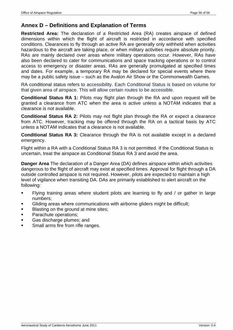
Office of Airspace Regulation Page 56 of 56
Aeronautical Study of Canberra Aerodrome June 2011 Version: 0.4
Annex D – Definitions and Explanation of Terms Restricted Area: The declaration of a Restricted Area (RA) creates airspace of defined dimensions within which the flight of aircraft is restricted in accordance with specified conditions. Clearances to fly through an active RA are generally only withheld when activities hazardous to the aircraft are taking place, or when military activities require absolute priority. RAs are mainly declared over areas where military operations occur. However, RAs have also been declared to cater for communications and space tracking operations or to control access to emergency or disaster areas. RAs are generally promulgated at specified times and dates. For example, a temporary RA may be declared for special events where there may be a public safety issue – such as the Avalon Air Show or the Commonwealth Games. RA conditional status refers to accessibility. Each Conditional Status is based on volume for that given area of airspace. This will allow certain routes to be accessible. Conditional Status RA 1: Pilots may flight plan through the RA and upon request will be granted a clearance from ATC when the area is active unless a NOTAM indicates that a clearance is not available. Conditional Status RA 2: Pilots may not flight plan through the RA or expect a clearance from ATC. However, tracking may be offered through the RA on a tactical basis by ATC unless a NOTAM indicates that a clearance is not available. Conditional Status RA 3: Clearance through the RA is not available except in a declared emergency. Flight within a RA with a Conditional Status RA 3 is not permitted. If the Conditional Status is uncertain, treat the airspace as Conditional Status RA 3 and avoid the area.
Danger Area The declaration of a Danger Area (DA) defines airspace within which activities dangerous to the flight of aircraft may exist at specified times. Approval for flight through a DA outside controlled airspace is not required. However, pilots are expected to maintain a high level of vigilance when transiting DA. DAs are primarily established to alert aircraft on the following: Flying training areas where student pilots are learning to fly and / or gather in large
numbers; Gliding areas where communications with airborne gliders might be difficult; Blasting on the ground at mine sites; Parachute operations; Gas discharge plumes; and Small arms fire from rifle ranges.