DOCUMENT RESUME ED 393 785 SO 026 250 · DOCUMENT RESUME. SO 026 250. Rollans, Maureen ... the...
118
ED 393 785 AUTHOR TITLE INSTITUTION SPONS AGENCY PUB DATE NOTE AVAILABLE FROM PUB TYPE EDRS PRICE DESCRIPTORS IDENTIFIERS ABSTRACT DOCUMENT RESUME SO 026 250 Rollans, Maureen A Handbook for Teaching Archaeology in Saskatchewan Schools. Western Heritage Services, Inc. Saskatoon (Saskatchewan). Saskatchewan School Trustees Association, Regina. 92 119p.; Also funded by the Saskatchewan Family Foundation, Heritage Branch and Saskatchewan Research Council. Western Heritage Services, Inc., 563 Fifth Ave. N., Saskatoon, Saskatchewan, S7K 2R1 Canada. Guides Non-Classroom Use (055) MF01/PC05 Plus Postage. *Anthropology; *Archaeology; Art Education; Canada Natives; Canadian Studies; Curriculum Guides; Elementary Secondary Education; *Enrichment Activities; Ethnography; Foreign Countries; *Interdisciplinary Approach; Language Arts; Mathematics; Multicultural Education; Resource Materials; Social Studies Native Studies; Saskatchewan This handbook is a general resource to assist Saskatchewan, Canada educators in preparing archaeological units of study for their classrooms, or in using archaeological concepts in existing units of study. Divided into nine chapters, including the introduction (chapter 1), each contain different sources of information. Chapter contents include: (2) contains background information about archaeology, including an introduction to the subject and Canadian heritage legislation; (3) reviews the precontact and early historic periods of Saskatchewan; (4) discusses archaeology as a career; (5) is a case study of how one Saskatchewan archaeological site has been studied; (6) is a discussion of how archaeological themes can be integrated into a number of content areas; (7) describes 10 different kinds of classroom and outdoor activities, suitable for a variety of grades and areas of study, and reflecting the multidisciplinary nature of archaeology; (8) is an annotated list of resource materials; (9) contains information about some of the different archaeological groups who do work with the public in Saskatchewan and abroad; and (10) is a glossary of archaeological terms used throughout the handbook. (DOE) *********************************************************************** Reproductions supplied by EDRS are the best that can be made from the original document. ***********************************************************************
Transcript of DOCUMENT RESUME ED 393 785 SO 026 250 · DOCUMENT RESUME. SO 026 250. Rollans, Maureen ... the...

ED 393 785
AUTHORTITLE
INSTITUTION
SPONS AGENCYPUB DATENOTE
AVAILABLE FROM
PUB TYPE
EDRS PRICEDESCRIPTORS
IDENTIFIERS
ABSTRACT
DOCUMENT RESUME
SO 026 250
Rollans, MaureenA Handbook for Teaching Archaeology in SaskatchewanSchools.Western Heritage Services, Inc. Saskatoon(Saskatchewan).Saskatchewan School Trustees Association, Regina.92119p.; Also funded by the Saskatchewan FamilyFoundation, Heritage Branch and Saskatchewan ResearchCouncil.Western Heritage Services, Inc., 563 Fifth Ave. N.,Saskatoon, Saskatchewan, S7K 2R1 Canada.Guides Non-Classroom Use (055)
MF01/PC05 Plus Postage.*Anthropology; *Archaeology; Art Education; CanadaNatives; Canadian Studies; Curriculum Guides;Elementary Secondary Education; *EnrichmentActivities; Ethnography; Foreign Countries;*Interdisciplinary Approach; Language Arts;Mathematics; Multicultural Education; ResourceMaterials; Social StudiesNative Studies; Saskatchewan
This handbook is a general resource to assistSaskatchewan, Canada educators in preparing archaeological units ofstudy for their classrooms, or in using archaeological concepts inexisting units of study. Divided into nine chapters, including theintroduction (chapter 1), each contain different sources ofinformation. Chapter contents include: (2) contains backgroundinformation about archaeology, including an introduction to thesubject and Canadian heritage legislation; (3) reviews the precontactand early historic periods of Saskatchewan; (4) discusses archaeologyas a career; (5) is a case study of how one Saskatchewanarchaeological site has been studied; (6) is a discussion of howarchaeological themes can be integrated into a number of contentareas; (7) describes 10 different kinds of classroom and outdooractivities, suitable for a variety of grades and areas of study, andreflecting the multidisciplinary nature of archaeology; (8) is anannotated list of resource materials; (9) contains information aboutsome of the different archaeological groups who do work with thepublic in Saskatchewan and abroad; and (10) is a glossary ofarchaeological terms used throughout the handbook. (DOE)
***********************************************************************
Reproductions supplied by EDRS are the best that can be madefrom the original document.
***********************************************************************

PERMISSION TO REPRODUCE ANDDISSEMINATE THIS MATERIAL
HAS BEEN GRA TED BY
TO THE EDUCATIONAL RESOURCESINFORMATION CENTER (ERIC)
U.S. DEPARTMENT OF EDUCATIONahead Edueallenal Resealed and Irnprovemoni
EDUCATIONAL RESOURCES INFORMATIONCENTER (ERIC)
This document has been reproduced asreceived from the person or organizationoriginating it.
0 Minor changes have been made toimprove reproduction quality.
Points of view or opinions slated in thisdocument do not necessarily representofficial OERI position or policy
A HANDBOOKFOR TEACHING ARCHAEOLOGY IN
SASKATCHEWAN SCHOOLS
By Maureen Rollans
Western Heritage Services, Inc.
Funded by
Saskatchewan Family Foundation, Heritage BranchSaskatchewan School Trustees Association
and
Saskatchewan Research Council
EBEST COPY AVAILABLE

ACKNOWLEDGEMENT
The author would like to acknowledge the assistance of the SaskatchewanSchool Trustees Association, the Heritage Branch of Saskatchewan Family Founda-tion, and the Saskatchewan Research Council. Without their financial support, thisproject would never have been attempted.
Thanks also to my reviewers, both from the educational and archaeologicalcommunities. These include Gail Bear, Ronald Boden, Carol Casswell and her associ-ates at the Regina School Division, Jim Finnigan, Carlos Germann, Terry Gibson,Carol Hibbert, Tim Jones, David Meyer, Bill Rollans, Shaun Ross, Susan Voitka andher associates at Greystone Heights School, Ernie Walker and Dale Yellow lees.
Thanks finally to Phyllis Lodoen for several excellent original pen illustrationsthat are contained within these pages.

First published by Saskatchewan Research Council in 1990. Revised by WesternHeritage Services in 1991 and again in 1992. Copies available from
Saskatchewan School Trustees Association400 2222 Thirteenth AvenueRegina, SaskatchewanS4P 3M7
Western Heritage Services563 5th Avenue NorthSaskatoon, SaskatchewanS7K 2R1
4

TABLE OF CONTENTS
Acknowledgement i
CHAPTER 1: Introduction to the Handbook 1
CHAPTER 2: Archaeological Background Information 3Introduction to Archaeology 3Archaeological Inventory 3Testing and Excavation 4Recording Location and Context 5Dating a Site and Materials within a Site 8After Excavation 10Further Reading 11
CHAPTER 3: The Precontact and Early Historic Periods inSaskatchewan 13
The Precontact Period a Southern Saskatchewan 13Pleistocene Hunti rs Period 13Early Precontact Period 13Middle Precontact Period 16Late Precontact Period 17
The Precontact Period in Northern Saskatchewan 18Athabasca/Transition Forests 20Boreal Forest 20
Historic Period 22Further Reading 22
CHAPTER 4: Ca-Leers in Archaeology 25Aspects of the Job 25Archaeological Specializations 25Educational Requirements 26Job Opportunities 27Further Reading 28
CHAPTER 5: An Archaeological Case Study 29An Introduction to Bushfield West 29Assessment of the Site 29Excavation of the Site 30
ii5

Results and Interpretations 31Conclusion 32
CHAPTER 6: Archaeology and Curriculum 33Required Areas of Study 33Grade Level 35
Grade 1 35Grade 2 35Grade 3 36Grade 4 36Grade 5 37Grade 6 39Grade 7 41Grade 8 42Grade 9 44Grade 10 45Grade 11 46Grade 12 47
Archaeology and the Common Essential Learnings 47
CHAPTER 7: Classroom and Outdoor Activities 491. Newspaper Stratigraphy 492. Climate Change/Culture Change 503. Making Maps 52
3A. Making a Mapping Board 523B. Mapping a Site 53
4. Cemetery Archaeology 565. Art Activities 61
5A. Making Prehistoric-styled Pots 615B. Pottery Pu771es 625C. Rock Art 635D. Beading 65
6. Solving Artifact Mysteries 687. Analysis and Classification 708. Garbage Can Archaeology 719. Simulated Excavation 7310. Field Trips 74
10A. Tours of Archaeological Excavations 7410B. Trips to Archaeological Sites Without Excavations 76
CHAPTER 8: Resource Materials Available 79Fact Sheets 79Videotapes and Films 81Filmstrip and Slide Sets 85

Artifact Replicas 86Multimedia Kits 87References for Teaching Archaeology in Schools 87Periodicals 88Other Publications 89Books and Periodicals 91
CHAPTER 9: Public Archaeology in Saskatchewan 101Saskatchewan Heritage Branch 101Saskatchewan Archaeological Society 102Wanuskewin Heritage Park 103Western Heritage Services 104Saskatchewan Museums 105Volunteer Opportunities 105Further Reading 106
CHAPTER 10: Glossary of Archaeological Terms 109

CHAPTER 1:
INTRODUCTION TO THE HANDBOOK
As the study of people through the ages, from the first human inhabitants ofthe earth to people in all parts of the world today, anthropology is a vast and fascinat-ing topic of study. It seems that today, more than ever, we need to gain the, perspec-tives that anthropology can provide in order to come to terms with the fact that ourway of doing things is not the only way, nor is it necessarily the best way. By under-standing how humans relate to each other and to their physical environment, weimprove our ability to make responsible decisions that take into account the conse-quences of our actions on our environment and social relationships.
Archaeology is a subdivision of anthropology which deals specifically with thestudy of past human activity by finding, describing and explaining the materials thatpeople have left behind. In these investigations, it is necessary to go to the site of theactivity, uncover the evidence, gather all available clues, and finally interpret whatactivities occurred. Archaeology provides us with the perspective of change in hu-man activity through time, and differences among groups of people.
There are so many reasons to include archaeology in school curriculum, notnecessarily as a separate course, but within existing core areas of study. Archaeologyprovides the subject matter for a wide variety of "hands-on" individual and groupactivities that stimulate student interest, independent learning, social interaction, andcommunication (see Chapter 6, in this volume). These exercises can also developcritical and creative thinking: from rudimentary levels such as classification, throughmaking inferences and developing hypotheses, and finally to high level skills such asdeveloping and testing alternative hypotheses, and using research results to developbroad generalizations about culture. The skills involved in archaeological researchand interpretation include manipulation of numbers, graphing, and computer liter-acy. The multidisciplinary nature of the subject makes it a useful umbrella underwhich a variety of required areas of study can be taught. Perhaps most importantly,archaeology is an exotic and fascinating subject for most people, and is capable ofcapturing even the imagination of students who might otherwise lack interest inacademic pursuits.
This handbook is a general resource to assist Saskatchewan educators in pre-paring archaeological units of study for their classrooms, or in using archaeologicalconcepts in existing units of study. It is divided into nine chapters, including this in-troduction, each containing different sources of information. Chapter 2 contains
8

2: Chapter 1
background information about archaeology, including an introduction to the subjectand heritage legislation. In Chapter 3, the precontact and early historic periods ofSaskatchewan are reviewed. Chapter 4 discusses archaeology as a career. Chapter 5is a case study of how one archaeological site has been studied in Saskatchewan.Chapter 6 is a discussion of how archaeological themes can be integrated into a num-ber of areas of study. In Chapter 7, ten different kinds of classroom and outdooractivities are described; these are suitable for a variety of grades and areas of study,reflecting the multidisciplinary nature of archaeology. Chapter 8 is an annotated listof resource materials (some available locally) which could be used by teachers andstudents in their study of archaeology. Chapter 9 contains information about some ofthe different archaeological groups who do work with the public in Saskatchewanand abroad. And finally, Chapter 10 is a glossary of archaeological terms usedthroughout this handbook.
Words that are included in the glossary are underlined the first timethey appear in the handbook text.
9

CHAPTER 2:
ARCHAEOLOGICAL BACKGROUNDINFORMATION
INTRODUCTION TO ARCHAEOLOGY
Archaeology is the study of past human activity by finding, describing andexplaining the materials that people have left behind. One of the most commonmisconceptions is that archaeology is the study of all ancient animal forms (for ex-ample, dinosaurs). In fact, those investigations are part of the science of palaeontol-ogy.
Archaeological research begins with choosing a problem. The problem canrange from having to recover as much information as possible in a limited amount oftime if a site is in danger, to wanting to test a specific theory about how people be-have. Once a problem is identified, the archaeologist must decide where to do theresearch (the study area), and the best methods to use.
Before looking for archaeological materials in the study area, the archaeologistmust obtain a research permit from the provincial government (see information onthe Saskatchewan Heritage Branch in Chapter 9). Because archaeological materialsare protected by legislation, you need to have both a good reason for doing the re-search and the qualifications to carry out the research properly.
After much planning, the archaeologist is finally able to leave the office and dothe most well-known part of the researchfieldwork.
ARCHAEOLOGICAL INVENTORY
Unless the research problem requires the study of specific archaeological sites,the first part of archaeological fieldwork is to take an inventory of all sites in thestudy area. A site is a location which contains evidence that people performed someactivity there in the past. Sites are recognized by finding artifacts and features leftbehind by people in the past.
An artifact is anything which has been made or changed by humans. How-ever, many items, particularly those that have been used by humans but not changed,have an archaeological importance that is not easily recognized unless they are found
0

4: Chapter 2
closely associated with other items or artifacts. For example, rocks in fields are com-mon and not usually of interest to archaeologists; however, if an archaeologist finds50 rocks arranged in a circle, this cultural feature provides a clue about the structuresthat people built at that site.
A site can be found in a number of ways. Often sites are discovered, perhapsaccidentally, by ordinary people who then contact an archaeologist. But usuallyarchaeologists look for sites. They survey by walking along lines, a set distance apartto that they get consistent coverage over the study area. While surveying, they forartifacts or features on the ground surface, or in places where the sub-surface is madevisible, such as in rodent burrows or along the eroded banks of streams. To findburied sites, they may dig into the ground in areas that seem likely to contain sitesbecause of suitable vegetation or landscape.
TESTING AND EXCAVATION
If sites are found during an inventory, they are marked on maps. Then theyare tested (or assessed) to find out how important the site iswill it help answer theresearch problem? Assessment can involve collecting all of the artifacts lying on thesurface of the field, and carefully mapping the location of each item. Or it may in-volve using shovels to dig a series of square test pits; these tests give the archaeolo-gists an idea of how deep the site is buried, and if parts of the site remain undisturbedbelow the ground surface.
Figure 1: Some of the tools used in archaeological excavation
Archaeological Background Information: 5
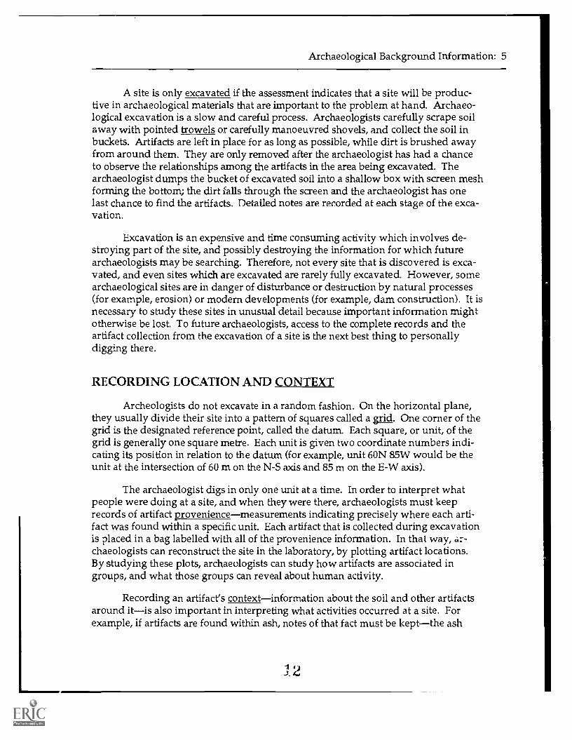
A site is only excavated if the assessment indicates that a site will be produc-tive in archaeological materials that are important to the problem at hand. Archaeo-logical excavation is a slow and careful process. Archaeologists carefully scrape soilaway with pointed trowels or carefully manoeuvred shovels, and collect the soil inbuckets. Artifacts are left in place for as long as possible, while dirt is brushed awayfrom around them. They are only removed after the archaeologist has had a chanceto observe the relationships among the artifacts in the area being excavated. Thearchaeologist dumps the bucket of excavated soil into a shallow box with screen meshforming the bottom; the dirt falls through the screen and the archaeologist has onelast chance to find the artifacts. Detailed notes are recorded at each stage of the exca-vation.
Excavation is an expensive and time consuming activity which involves de-stroying part of the site, and possibly destroying the information for which futurearchaeologists may be searching. Therefore, not every site that is discovered is exca-vated, and even sites which are excavated are rarely fully excavated. However, somearchaeological sites are in danger of disturbance or destruction by natural processes(for example, erosion) or modern developments (for example, dam construction). It isnecessary to study these sites in unusual detail because important information mightotherwise be lost. To future archaeologists, access to the complete records and theartifact collection from the excavation of a site is the next best thing to personallydigging there.
RECORDING LOCATION AND CONTEXT
Archeologists do not excavate in a random fashion. On the horizontal plane,they usually divide their site into a pattern of squares called a aid. One corner of thegrid is the designated reference point, called the datum. Each square, or unit, of thegrid is generally one square metre. Each unit is given two coordinate numbers indi-cating its position in relation to the datum (for example, unit 60N 85W would be theunit at the intersection of 60 m on the N-S axis and 85 m on the E-W axis).
The archaeologist digs in only one unit at a time. In order to interpret whatpeople were doing at a site, and when they were there, archaeologists must keeprecords of artifact proveniencemeasurements indicating precisely where each arti-fact was found within a specific unit. Each artifact that is collected during excavationis placed in a bag labelled with all of the provenience information. In that way, ar-chaeologists can reconstruct the site in the laboratory, by plotting artifact locations.By studying these plots, archaeologists can study how artifacts are associated ingroups, and what those groups can reveal about human activity.
Recording an artifact's contextinformation about the soil and other artifactsaround itis also important in interpreting what activities occurred at a site. Forexample, if artifacts are found within ash, notes of that fact must be keptthe ash
I 2

,- 4
1' 7
.,,,./
`'4.1
11
ill74
; i0
. Id
11)1
y, 9
i. /
2,,i,
/ 1.
, A
.-/,.
. ,.''
'.
.
Figu
re 2
: Arc
haeo
logi
sts
exca
vatin
ga
site
. Ind
ivid
uals
wor
k in
squ
are
units
set
up
in a
gri
d ar
rang
emen
t.D
irt t
hat i
s ex
cava
ted
is s
ifte
d th
roug
hsc
reen
s. T
he in
divi
dual
in th
e ba
ckgr
ound
is p
repa
ring
tom
ap th
esi
te w
ith a
sur
veyo
r's tr
ansi
t and
trip
od.
4
Archaeological Background Information: 7
feature should be photographed and mapped (artifact locations noted and sketched).Although the ash itself is not always collected, it is an important due to the humanactivities associated with the artifacts. Another example would be a projectile pointsticking into a bone: an important relationship could be overlooked if the artifactswere separated during excavation and no notes of their association' kept.
Another aspect of the context of the artifact are the non-artifacts, also called thematrix, that surround the artifact. This material contains clues used in paleoenviron-mental (past environments) studies. The size of the sediment grains in the matrix canreveal whether the site was in an area that was flooded regularly, or whether it was ina low area where strong winds usually dropped their sediment load. When found inarchaeological sites, seeds and pollen from plants can reveal the vegetation at the siteand the surrounding area. In conjunction with the vegetation remains, the remains ofsmall animals such as snails and insects can provide dues about the climate at thetime that the site was occupied.
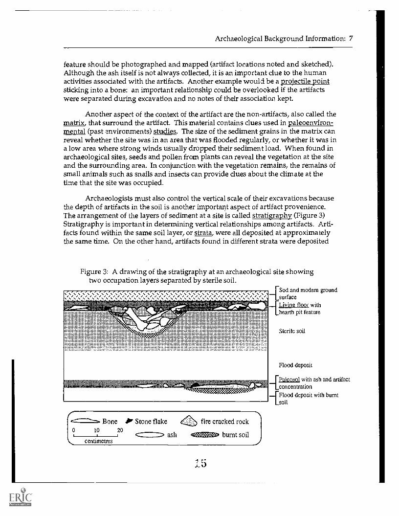
Archaeologists must also control the vertical scale of their excavations becausethe depth of artifacts in the soil is another important aspect of artifact provenience.The arrangement of the layers of sediment at a site is called stratigraphy (Figure 3)Stratigraphy is important in determining vertical relationships among artifacts. Arti-facts found within the same soil layer, or strata, were all deposited at approximatelythe same time. On the other hand, artifacts found in different strata were deposited
Figure 3: A drawing of the stratigraphy at an archaeological site showingtwo occupation layers separated by sterile soil.
7,111PA,<3
Bone 11' Stone flake fire cracked rock0 10 20
ashcentimetres
burnt soil
4Sod and modem groundsurface
iLiving floor withhearth pit feature
Sterile soil
Flood deposit
4Paleosol with ash and artifactconcentration
[Flood deposit with burntsoil

8: Chapter 2
at different times, perhaps by completely different people. For that reason, archaeolo-gists must excavate in layerspreferably in natural strata. If natural strata are diffi-cult to identify, archaeologists excavate in arbitrary levels, in order to keep somecontrol of depth and relationships among artifacts.
Notes about provenience and context are kept on level record forms (see Fig-ure 4). These are standardized forms which are filled out for each level of each unitwhich is excavated. The forms have spaces for writing information about what unitwas dug, how deep the level was, what was collected, and observations about thematrix, unusual associations of artifacts, and any other useful information.
DATING A SITE AND MATERIALS WITHIN A SITE
There are a number of ways of finding out the age of archaeological materials.Relative dating is determining the age of something in comparison with somethingelse excavated at the same site, rather than determining the age in years. The theorybehind the most common form of relative dating is the law of superposition: sedi-ments are deposited layer upon layer. Because artifacts are found within these strata,archaeologists apply the same law to them. If a site has not been disturbed, deeperartifacts were deposited by humans before the more shallow onesthat is, the deeperthe artifact, the older it is. However, there is no direct relationship between the depthand the number of years since the rate at which sediments are deposited at a site isnever constant. This type of relative dating cannot be used in comparing differentsites, since the depositional rate at each site is unique due to the different naturalforces at work. An absolute date, or the age of a site in years, is more difficult todetermine.
Some materials such as bone or charcoal can be Carbon-14 dated. RadioactiveCarbon-14 is present in the air in a fairly constant proportion to the non-radioactiveCarbon-12. Plants and animals absorb carbon molecules into their cells when theybreath, with a proportion of C-12 to C-14 equal to that found in the air. When theorganism dies, the unstable C-14 decays into the stable C-12 at a very slow but knownrate. The amount of C-14 remaining in an organic material can be measured and usedto determine how many years have past since the plant or animal died.
Materials which have been heated to high temperatures (for example, potteryor fire-cracked rock) can be dated using a process called thermoluminescence (TL)dating. Minerals are exposed to natural radiation in the soil. As a result, these miner-als give off light T Then heated, called TL. Heating to a high enough temperatureerases all of the TL in the minerals. An object that was heated in the past is heatedagain in the lab. The amount of TL given off is measured to determine the amount ofradiation the object has absorbed from the soil since the original heating occurred.Soil samples must also be collected from around the object so that the backgroundradiation can be measured. The TL given off by the object can then be translated into
11. 0

Archaeological Background Information: 9
Figure 4: A level form used byWestern Heritage Services
TYPE OF UNIT SCREEN SIZE Site Number /Name
LiExcavation 6 mm
AssessmentUnit
Level
LEVEL TYPE LEVEL THICKNESS DEPTH
Arbitrary 5 cm Depth below Surface
LINatural/Cultural Depth below Datum
UNIT CORNER MEASUREMENTS
UPPER NE
LOWER NE
Sterile
DebitageBone
FCR
Tools
PotteryOther# bags
Matrix Sample Flotation Sample[to recover organic materials]
Map of Unit Profile
NW
NW
NE NW
SE
SE
SE
SW
SW
SW
NOTES: Matrix; Features; Samples; Disturbance; Concentrations; etc.
NAME: DATE:
17

10: Chapter 2
the approximate number of years that have elapsed since the original heating.
If there are no materials which can be absolutely dated in a site, dates can beapproximated by comparing diagnostic artifacts such as projectile points or pottery tosimilar artifacts from sites at which absolute dates were obtained. This technique iscalled cross-dating. Artifact shapes illustrated in the timelines in Chapter 3 are diag-nostic of particular time periods.
AFTER EXCAVATION
The fieldwork of archaeological inventory, assessment and excavation are onlya small part of the archaeologist's job. For every month spent in the field, about threemonths must be spent in the laboratory processing and analyzing the informationgathered (see Figure 5). In the laboratory, artifacts are cleaned and catalogued so thatthey can be permanently identified by number. Archaeologists study each artifactindividually, taking measurements and making detailed descriptions.
Phyllis Lodoen
Figure 5: An archaeologist working in the laboratory, cataloguing andanalyzing artifacts.
11. 8

Archaeological Background Information: 11
For each site, archaeologists have a responsibility to write a report describingnot only what was found, but also describing the environment and history of thestudy area, the research problems investigated, the methods used. All of this infor-mation leads to conclusions about what the data reveal about human activity at thesite. In order to draw conclusions about the data, the archaeologists must comparewhat they find to similar artifacts and features known from other sources. Importantsources include other sites that have been excavated and people familiar with aspectsof the group responsible for creating the site (for example First Nations Elders).
Thorough reporting of data and conclusions allows other archaeologists andmembers of the public to benefit from the knowledge obtained through the research.These reports are kept on file by Resource ManagementArchaeology department ofthe Saskatchewan Heritage Branch, and are sometimes adapted for more widespreaddistribution. When the site reports are completed, the artifacts and artifact recordsare sent to the Museum of Natural History in Regina 07 another approved repository.There, they are stored, displayed or loaned to local museums. All artifact collectionsremain available for study by future researchers who have new questions to ask.
FURTHER READING
More detailed information about the science of archaeology can be obtained byreading or viewing the following material. These resources are described in moredetail in Chapter 8.
Archaeological Survey of Albertan.d. "Dig and Discover: Archaeological Excavation for the Classroom."
An unpublished fact sheet.
Cable Regina and the Saskatchewan Archaeological Society1988 "Discovering Saskatchewan's Past," various episodes in this video
series.
Cork, Barbara and Stuart Reid1984 The Young Scientist Book of Archaeology. Highgate Press, Usborne
Publishing Ltd., London.
Epp, Henry T. and Ian Dyck1983 Tracking Ancient Hunters; Prehistoric Archaeology in Saskatche-
wan. Saskatchewan Archaeological Society, Regina.
Fladmark, Knut R.1978 A Guide to Basic Archaeological Field Procedures. Publication #4,
Department of Archaeology. Vancouver: Simon Fraser University.
1.9

12: Chapter 2
Hackwell, W. John1986 Digging to the Past; Excavations in Ancient Lands. New York:
Charles Scribner's Sons
Resource ManagementArchaeology1991 Field Manual for Avocational Archaeologists. Saskatchewan Herit-
age Branch, Regina.
Hole, Frank and Heizer, Robert F.1977 Prehistoric Archaeology: A Brief Introduction. New York: Holt,
Rinehart, and Winston.
Museum of Natural HistoryThe Past in Place. A film.
National Film Board of Canada and the Canadian Museum of ManDigging Up Canada's History. A film strip series.
Robbins, Maurice and Irving, Mary B.1981 The Amateur Archaeologist's Handbook (3rd edition). Cambridge:
Harper & Row.
Saskatchewan Archaeological Society"Studying Saskatchewan's Ancient Human History." A slide show.

CHAPTER 3:
THE PRECONTACT AND EARLY HISTORICPERIODS IN SASKATCHEWAN
Human history in the province of Saskatchewan has been greatly influencedby our environment. That environment has changed greatly over the past 12,000years. Figure 6 shows modern vegetation in the province.
THE PRECONTACT PERIOD IN SOUTHERN SASKATCHEWAN
This first section will deal with the precontact period in the plains and par-kland areas of Southern Saskatchewan. It is based largely upon I. Dyck's summaryin Epp and Dyck, 1984. A timeline illustrating the cultural sequences is presented inFigure 7.
PLEISTOCENE HUNTERS PERIOD
(TO 10,500 YEARS B.P.)
From the last advance of the glaciers until about 14,000 years ago (the exactdate is uncertain), ice covered most of the Province and humans could not live here.Then slowly over the next 4000 years, the ice retreated northward and spruce forestsand grasslands moved in from the south.
The end of the Ice Age, or Pleistocene epoch, is marked by the extinction ofmany species of large mammals such as mammoths, giant sloths, and camels. Theseextinctions take place about 11,500 B.P. At the same time, a human culture of biggame hunters, known as Clovis, became established across much of North America.A continuing debate among archaeologists and paleontologists is whether humanhunting contributed to the extinctions. In Saskatchewan, the only evidence of thesehunters are large spear heads that have been found on the ground surface.
EARLY PRECONTACT PERIOD
(10,500 TO 7500 YEARS B.P.)
As the climate warmed, bison became the prominent animal in the plainsenvi :onment. By about 9500 B.P., the grasslands reached their modern position near
2 1

14: Chapter 3
WOLLASTONLAKE
LL MINSTER
NORTHkIATrIAF..
CREELAKE
Ow-
'11(111"litt. Rift
RE1NQEERLAKE
MIONTRLAX.AL
vitir
PRINCE(ALBERT
'
eltAt
V
464*
.
TUNDRA TRANSITION
ATHABASCA
BOREAL FOREST
PARKLAND
PRAIRIES
Figure 6: A map of Saskatchewan showing the modern vegetation zones.These zones have changed significantly over the past 12,000 years.
0 9 HST COPY AVAILABLE

The Precontact and Early Historic Periods in Saskatchewan: 15
Figure 7: Timeline for southern Saskatchewan.
YearsB.P. ENVIRONMENT
ARCHAEOLOGICALEVIDENCE
ARTIFACT STYLES
250
500--
750,
1000
1250
1500
1750
2000
3000
4000
5000
6000
7000
8000
9°°0 """
10,000-
11,000-
12,000-
Hot, dry climate
Cool, moist climate
Hot, dry climate
Climate is similar totoday
IAltithermal
(hot, dry period,grasslands expand
further north)
Grasslands reach theirpresent position. Modemanimals (bison, antelope)
End of the Pleistocene
Ice to the north, spruceforest in the south.mammoths, camels, giantbison present
Guns are introduced
The horse spreads tosouthern Saskatchewan
Bow and arrow are rustused
Ceramics begin toappear at archaeologicalsites in Saskatchewan
Evidence of humans insouthern Saskatchewanbecomes widespread
The Gowen site wasused as a campsite andbison processing area
Atlatl and dart becot.teUle main huntingweapons
Prehistoric hunters killedbison at the Herron Edensite
Artifacts have onlybeen h on theground surface inSaskatchewan
Hunting with heavyspears
PlainsSide-notched
1 i
PrairieSide-notched
1Avonlea
Besant
I iI A
-PelicanLake
i f! 1Mcean 4Oxbow
IA
MummyCave
/ 1 XLusk1
1Scottsbluff.
EdenV
FolsomAgateBasini _ _ _AL
Ai
Il
<zou
N-1
E-.C.)
E-,
8c...)DJtza.
..1,W
0(=t
2
t<E-zoUfll
ae4.
cnCO gU0 EE- i42
a.
BEST COPY AVAILABLE

16: Chapter 3
Saskatoon and the climate was more like it is today. Humans adapted to their chang-ing environment by becoming more specialized, hunting mainly bison on the grass-lands. This hunting specialization lasted until historic times, although the huntingtechnology changed. Most of the archaeological cultures of the Early PrecontactPeriod (such as Folsom and Agate Basin) are known at this time only from surfacefinds of unique projectile point styles and associated artifacts such as scrapers, knives,and fleshers; this makes it difficult to determine details of the lifestyles of the people.
There are only two known buried archaeological sites from this period. TheHeron Eden site near Prelate was first tested in the summer of 1989. There, more than9,000 years ago, people killed large bison (perhaps an extinct giant species) usingheavy spears tipped with stone points called Scottsbluff and Eden. Details from thissite will unfold in the years to come. About 8,000 B.P., another group of people usingScottsbluff technology camped at the Niska Site near Ponteix.
MIDDLE PRECONTACT PERIOD
(7500 TO 1850 B.P.)
About 7500 years ago, the weather turned warmer and drier than today, andthe grasslands extended about 100 km further north than their present position. Dur-ing the driest and hottest periods, people probably had to take refuge in the park-lands and other areas on the periphery of the plains. Sites in the heart of the plainsare rare from this time period.
The atlatl and dart became the main hunting weapons during the MiddlePrecontact. The atlatl is a long wooden devise with a hook on one end which acts asan extension of the arm; when a stone-tipped dart which is hooked into the end of theatlatl is propelled, it flies much further and with more force than would be possiblewith the human arm alone. Smaller projectile points, called Mummy Cave, tippedthese darts early in the Middle period (7700 to 4700 B.P.). The Gowen Site (see thefirst article by E. Walker in Linnamae and Jones, 1988) is a 6000 year old MummyCave habitation site and bison processing area located in what is now Saskatoon; itillustrates the success of the atlatl as a hunting weapon. The Norby cite in Saskatoonis a 5700 years old bison kill site. It was also from this period that the earliest evi-dence of humans in the area of Wanuskewin Heritage Park has been found, althoughearlier occupations may yet be discovered in the park (see the second article by E.Walker in Linnamae and Jones, 1988).
By 5000 B.P., the weather was more moist, and was gradually becoming muchlike what we experience today. Sites representing a full range of human activitieshave been found all over southern Saskatchewan dating from this time onward. Thisindicates that human activity increased greatly at this time. The Oxbow style ofprojectile point (4700 to 3050 B.P.) is one of the most common styles found on the
24

The Precontact and Early Historic Periods in Saskatchewan: 17
plains; it is named after the site in southeastern Saskatchewan where it was firstrecognized. A separate group of points is found at sites which date from the samegeneral time period as Oxbowthe McKean/Duncan/Hanna group (4150 to 3100B.P.). Appearing during a time that was wetter than today, the culture named PelicanLake (3300-1850 B.P.) is not as well known in Saskatchewan, although it is againnamed after a site in Saskatchewan; it is characterized by uniquely shaped, well madepoints and knowledge of bison jumping and pounding (corralling) techniques. Thesethree archaeological cultures are also found up into the boreal forest (see "ThePrecontact Period in Northern Saskatchewan" which follows).
LATE PRECONTACT PERIOD
(2000 TO 170 B.P.)
It should be noticed that this period overlaps slightly with the previous period.This is due to the arbitrary nature of this classification system. The Pelican Lake dartpoint style continued up to 1850 B.P., while a new style called Besant appears at 2000B.P. The division between the two periods is marked by the appearance of pottery inSaskatchewan's archaeological record with the Besant phase. These Besant style potsare generally conoidal shaped (see the Laurel pot in Figure 8), and made using a cord-wrapped paddle and an anvil.
Like projectile points, differences in pot shapes and designs is important in thestudy of time and cultural groups. By tracing similarities in style, it appears thatpottery technologies may have been introduced to Saskatchewan from the east, wheresimilar styles appear slightly earlier in the archaeological record. Pottery also allowssome unique research opportunities, such as analysis of ancient finger prints to deter-mine whether or not groups relied on specialists to make the majority of the commu-nity's pots.
Some archaeologists choose to group Besant with the Middle Precontact Periodbecause of the continued presence of atlatl dart points in Besant sites. By 1750 B.P., anew culture called Avon lea appeared, in which the bow and arrow had replaced theatlatl and dart as the mostly popular hunting weapon. The new weapon improvedthe ability of people to hunt, enabling them to stay hidden as they shot their prey, andallowing a greater degree of accuracy. Avon lea was first recognized at a site in Sas-katchewan. Avon lea arrow heads are small, thin, and well made. The ceramics of theculture are similar in shape to Besant, but are decorated differently. Avon lea andBesant cultures coexisted in southern Saskatchewan until 1150 B.F.
The climate had several fluctuations in the last 1000 years, from severedroughts lasting several hundred years to moist warm climates. The drought condi-tions greatly affected the ability of agricultural peoples living in the Missouri areasouth of Saskatchewan to maintain their farming lifestyle. However, the people in

13: Chapter 3
the Saskatchewan plains and parklands continued to be successful in their bisonhunting and plant gathering lifestyle. Prairie Side-notched points coexisted with andwere succeeded by the more square-based Plains Side-notched points. The these laterarrow heads are the most common style in Saskatchewan archaeological sites.
Even before Europeans arrived in the Province, their influence reached Sas-katchewan through trading of goods among First Peoples groups. Horses filtered upfrom the south, and trade goods including guns came in from the east. These foreigninfluences forever changed the way of life in the plains and parkland. They increasedthe mobility of the Indians, their wealth (in some cases) and their ability to kill largenumbers of animals. Many of the early historic descriptions of First Peoples groupswere made after these changes had already taken place. Although archaeologistsdepend upon many of these historic accounts to find analogies for the materials theyfind in the archaeological record, they must take into consideration the vast changesthat had already occurred. As Europeans came into the province, they also broughtdisease with them; epidemics of small pox devastated the First Nations peoples.
There has been a noticeable lack of precision in this discussion of First Nationspeoples in the precontact period of Southern Saskatchewan. Movement of peopleand tribes has been common throughout human history on the plains. Correlatingarchaeological sites with particular First Nations groups is usually very difficultunless the sites are very recent.
THE PRECONTACT PERIOD IN NORTHERN SASKATCHEWAN
Northern archaeology in Saskatchewan is still a new area of study. The area isso far from major population centers that industrial development has been limited,and little rescue archaeology has been necessary. The archaeological sites that arethere generally contain very little organic material because the acid in the forest soilsdecays bone and wood very quickly. There is also little flooding or deposits of sedi-ment, so most sites lie near or on the surfacestratified sites are limited to some rivervalleys and sand dune areas. The precontact period in the North is still not very wellknown, so the information below (largely taken from D. Meyer in Epp and Dyck,1984) will be adapted as more research is done.
At the time of European contact, there were two groups of people in NorthernSaskatchewan. The first were the Dene who relied upon caribou, and followed thecaribou onto the tundra of the Northwest Territory in the summer and into theAthabasca and transitional forests in the winter. The second group were the Creewho lived in the boreal forests, relying on a wide variety of resources (caribou,moose, elk, mule deer, beaver, muskrat, snowshoe hare, waterfowl, grouse, fish),mostly near northern lakes and rivers. This division of northern peoples seems alsoto apply to precontact times (Figure 8).

The Precontact and Early Historic Periods in Saskatchewan: 19
Figure 8: Timeline of the precontact period in northern Saskatchewan.
Years ENVIRONMENTB.P.
250
500
750
1000
1250
1500
1750
2000 Climate is similar totoday
3000 Weather coolsTrees move south
4000
5000
6000
7000 Warmer weatherTrees move far north of
8000present location
Saskatchewan becomes
9000 free of glaciers
10.000 Glaciers in northernSaskatchewan
11,000
12.000
ARCHAEOLOGICAL EVIDENCEAthabasca/Transition Zone
(Caribou Hunters)Boreal Fore.-
(Mixed Hunter/Uatherers)
ig:s1
TallheileiTradition
(Dene)
tit e.Arctic Small
Tool Tradition
Little evidence of humans inarea
AgateBasin
2 7
*FilClearwater .,";"; Pehonan
Lake
Laurel
Oxbow
Blackduck
IPelicanLake
McKean
I
Early Side-notchedNear Norbert Site
Lusk

20: Chapter 3
ATHABASCA/TRANSITION FORESTS
28
This is the area in Saskatchewan from the Churchill River northward. Al-though Saskatchewan was ice-free by 8500 B.P., the first people in the north arrivedbetween 7000 and 8000 years ago. Their culture, called the Agate Basin complex, isknown from a very few spear points found in the far north of the Provincean areawhich would have been within the winter range of the barren ground caribou. Thesepoints are similar to ones used earlier in southern Saskatchewan to hunt herds ofbison, but it is not clear whether it was the people who moved north, or just theirhunting technology.
As the climate warmed, the tree line moved far north of its present location,and barren ground caribou would rarely have entered the province. This is probablythe reason that no evidence has been found of human occupation in Northern Sas-katchewan during the cultural period (6000 to 3500 B.P.) which has been named theShield Archaic where it occurs further north and east.
About 3500 B.P., the climate began to deteriorate, which resulted in the treeline moving south, the caribou wintering well within Saskatchewan, and early Inuitpeople moving south to hunt the caribou. The artifacts of this period, representingthe Arctic Small Tool Tradition, are completely different from artifacts from southernSaskatchewan, and include finely crafted crescent-shaped blades, and projectilepoints which are pointed at both ends. Most of these sites have been found aroundLake Athabasca.
By 2600 B.P., the area was inhabited by people who appear to be ancestors ofthe Athapaskan groups who reside in the area today. These people, represented inthe archaeological record by artifacts of the Taltheilei Tradition, used projectile pointswith notches near the base. The archaeological evidence suggests that these peoplecentered their lives upon the herds of barren ground caribou, hunting with notchedprojectile points that were often made of bone.
This is the area in Saskatchewan from the Churchill River south to the park-lands. The people in this area were greatly influenced by the plains and parklandscultures to the south and the forest peoples to the southeast. No evidence of earlyprecontact cultures have been found in the area.
The earliest materials that have been found in the area are along the ChurchillRiv 3. at the Near Norbert Site, which have been assigned to the Early Side-notchedTradition. These materials are probably close to 5000 years old and are very similarto projectile point styles on the plains. Since the parkland extended further north at
T'OREAL FOREST

The Precontact and Early Historic Periods in Saskatchewan: 21
this time, it is not surprising that some southern peoples travelled up the ChurchillRiver system and discovered the riches further north.
Oxbow points like the ones common in the plains from 3500 to 5000 B.P. havebeen found along the Churchill and Clearwater Rivers and near La Loche. Exactdates for the northern Oxbow sites have not been obtained because of a lack of dat-able materials. Copper artifacts, traded from people in the Great Lakes region to theeast, are found in sites from this period. Plains points (McKean and Pelican Lakestyles) from succeeding periods are also found in the area.
The next major culture is called Laurel, and it is found in the eastern part of thearea. It originated in an area to the southeast, in western Ontario, southeastern Mani-toba, and northern Minnesota. In those areas, it dates from 2100 B.P. to 1000 B.P.This culture is identified by the presence of a collection of different artifact types:conoidal ceramic pots that were made using the coiling technique and decorated withtool impressions, stemmed and notched projectile points, and harpoons. In the areasof Boreal forest not occupied by Laurel peoples, a northern expression of the Besantculture is present.
Blackduck is the next cultural tradition found occasionally in the eastern borealforest of Saskatchewan which has its origins further southeast. The main characteris-tic of this tradition is another unique style of pottery, with globular pots (round withrounded bottom) with a heavily decorated small neck and flaring rim. This culturedates from about 1150 550 B.P., and is also associated with small points and tubularsmoking pipes.
The Clearwater Lake culture is found across boreal forest area dating fromabout 600 B.P. Again it is recognized by a unique pottery style similar in shape toBlackduck but with different rim shapes and decorations. Other artifacts are alsosimilar to Blackduck, but the assemblage also includes ground stone adzes (bladeswith the cutting edge at right angles to the handle, used in wood work such as canoemanufacturing). The rock paintings drawn on outcrops along the Churchill River arethought to date from this period. This culture is thought to be directly ancestral tothe modern Cree.
Dating from the same time, the Pehonan culture is one which combines charac-teristics of the Clearwater Lake and southern Plains Side-notched cultures. Althoughthe Pehonan pottery is similar to Clearwater Lake, it is often slightly different inshape and has decorations more like Plains pottery; the arrow heads at Pehonan sitesare also like the Plains Side-notched ones. Bushfield West, near Nipawin, is a charac-teristic Pehonan site which dates to about 350 B.P. Pehonan may be the archaeologi-cal representation of Cree who wintered in the parklands and came in contact withsouthern tribes.
2.9

22: Chapter 3
HISTORIC PERIOD
(260 B.P OR 1691 A.D. TO PRESENT)
Traditionally, the boundary between prehistory and history has been markedby the arrival of the first Europeans who kept written records of their activities inSaskatchewan. In this handbook, precontact has been used to refer to the period andpeoples before the arrival of Europeans. Because this contact occurred at differenttimes in different parts of the province, and because the early records are not continu-ous, it is difficult to place a firm date on the beginning of the Historic Period. Thefirst description is by Henry Kelsey, who visited the Touchwood Hills in 1691. Morecontinuous records do not begin until 1754 when the Hudson's Bay Company beganto send employees inland from York Factory winter with the Cree. In 1774, the firstcontinuously occupied fur trade site was established at Cumberland Lake (althoughtemporary posts were built as early as 1751). Away from the major fur trade andexplorer routes, some areas do not appear in historic records until the early 1900s, bywhich time European settlers and missionaries were present in most parts of theprovince.
In the archaeological record, the historic period is marked by the appearance oflarge quantities of European goods at archaeological sites. Some historic archaeologi-cal sites were inhabited by Europeans (such as fur trade posts and early homesteads)while other sites were inhabited by descendants of the precontact peoples, who wereinteracting with Europeans. Some European trade goods filtered into the provincewith the establishment of fur trade posts on the western part of Hudson's Bay in 1682(not always through direct trade with Europeans but more often through tradeamong the First Nations groups); trade goods became more frequent as fur tradeposts became established in Saskatchewan.
Historical archaeology fills in the story of Saskatchewan's past by revealinginformation about everyday events and people that are often left out of written histo-ries. It differs from precontact archaeology in the availability of written records asanother source of i ,rmation. The fur trade, Northwest Mounted Police, early Metislifestyles and the resistance of 1885, early homesteading, and even the industrializa-tion of the 20th century are illuminated in a new light when archaeological sites fromthese periods are investigated.
FURTHER READING
More detailed information about the precontact and early historic periods inSaskatchewan can be obtained by reading the following material. These resources aredescribed in more detail in Chapter 8.
The Precontact and Early Historic Periods in Saskatchewan: 23
Bryan, Liz1991 The Buffalo People. The University of Alberta Press, Edmonton.
Epp, Henry T. and Ian Dyck1983 Tracking Ancient Hunters; Prehistoric Archaeology in Saskatche-
wan. Regina: Saskatchewan Archaeological Society.
Helgason, Gail1987 The First Albertans. Edmonton: Lone Pine Publishing.
Linnamae, Urve and Tim E. H. Jones (eds.)1988 Out of the Past. Saskatoon: Saskatoon Archaeological Society.
McGhee, Robert1989 Ancient Canada. Canadian Museum of Civilization, Ottawa.
Saskatchewan Archaeological Society"Studying Saskatchewan's Ancient Human History." A slide show.
'3I

CHAPTER 4:
CAREERS IN ARCHAEOLOGY
ASPECTS OF THE JOB
Archaeology involves two general types of work. For two to four months ofevery year, most archaeologists participate in fieldwork. Because sites are usuallysituated in distant areas, fieldwork often temporarily takes archaeologists away fromtheir families and friends. Fieldwork demands that a person enjoy physical outdooractivity. Not only is the nature of archaeological fieldwork physical, but the sites areoften very remote, and may require the archaeologist to walk or canoe long distancesand camp in primitive conditions. Working and living in close quarters with a crewalso demands that an archaeologist be easy-going and considerate of others.
Archaeologists spend most of the winter months in the laboratory or office.Our climate makes outdoor work difficult in the winter, and the analysis of archaeo-logical artifacts and site information usually takes much longer that does the gather-ing of the data in the field. Even the preparation for yearly fieldworklibrary andarchival research and making logistical arrangements such as seasonal staff hiringand facility rentalstakes a lot of work. In both winter and summer, an archaeolo-gist must also have a great deal of patience in order to conscientiously complete theOften repetitive tasks involved in finding and analyzing artifacts.
ARCHAEOLOGICAL SPECIALIZATIONS
No archaeologist is capable of being an expert in all aspects of the field. Thesmaller the area of specialization, the easier it is to gain a comprehensive knowledgeof the subject and keep abreast of developments in the field by other archaeologists.
Most archaeologists specialize in a certain area of the world, or a certain timeperiod. All classical archaeologists, for example, study the civilizations in the OldWorld. However, each would specialize further and study a more limited subjectsuch as Pre-dynastic Egypt.
Some archaeologists specialize in the analysis of one particular category ofartifact, although they must have a familiarity with a wide range of artifacts.Zooarchaeologists, for example, specialize in the analysis of animal remains at ar-chaeological sites, and can determine not only the species of animals, but often their
,3,;?

26: Chapter 4
sex, age, and physical condition. Lithic analysts study stone artifacts, determiningwhat kind of rock was used, where it came from, how the tool was made, and what itwas used for.
Some archaeologists are more involved with writing reports, and rarely get achance to examine the artifacts. They must pull together all of the information aboutthe site, its artifacts, and their distributions within the site. Then they must interpretwhat human behavior was involved in creating the patterns seen in the archaeologi-cal record.
In attempting to interpret the human behavior represented in the archaeologi-cal record, some archaeologists rely on experiments which attempt to reproduce thepatterns observed in archaeological artifacts or sites. This specialty is called experi-mental archaeology.
Archival research demands a familiarity with libraries and archives, and theirwide range of literature sources and historic documents. It is necessary to providearchaeological projects with historical background.
Paleoenvironmental studies are now an integral part of most large archaeologi-cal projects. However, the specialized knowledge necessary to identify and interpretclues such as pollen grains is far beyond the capability of most archaeologists.
Computer applications are also becoming essential for cataloguing archaeo-logical data, and helping to recognize patterns in that data. Some archaeologistsspecialize in creating computer applications which are personalized for the specialneeds of each project.
Public education is a growing specialization of archaeology in Saskatchewan.If archaeologists only talk to each other, their research is of very limited value. Open-ing sites up to visitors, working in museum settings, and writing for a general audi-ence allow archaeologists to spread the news of their discoveries.
The manager of each archaeological project must assemble teams of thesespecialists to work together. Each person's knowledge contributes to greater under-standing of the archaeological record.
EDUCATIONAL REQUIREMENTS
Although the choice of specialization has much to do with the course of train-ing required, and the employment opportunities that will result, all archaeologistsmust first obtain a bachelor's degree from a university. Therefore, a matriculationprogram in high school, with a strong background in a variety of social sciences and
33

Careers in Archaeology: 27
sciences, is essential. Archaeology is usually considered a subdiscipline of Anthro-pology in Canadian universities, but occasionally is a separate discipline. Prospectivearchaeologists should therefore enrol in a four-year program in Anthropology orArchaeology. Specific courses depend upon the interests of the students.
Although technical jobs in archaeology (excavation or cataloguing and analyz-ing artifacts, for example) usually require a minimum of a B.A. degree, competitionfor jobs is often stiff. In addition, in most Provinces, only people who hold at least aMaster of Arts or Science degree in Anthropology or Archaeology can obtain permitsto carry out independent excavations. Therefore, any student considering a full timecareer in archaeology is advised to obtain a M.A., which takes an additional 2 to 4years to complete.
Archaeologists wishing to find long-term employment in Universities, govern-ment departments, or museums should continue in their education to obtain a PhD inAnthropology. In order to receive this degree, a student must prove that he/she hasthe ability to make important and unique contributions to the field of archaeology. APhD usually takes 4 to 7 years to complete.
Students interested in Classical Archaeology must follow a different educa-tional course, usually through Departments of Classics in universities. Their jobopportunities are usually in university and museum settings.
JOB OPPORTUNITIES
Archaeologists usually gain employment in the following arenas: consultantcompanies and research groups (for example, Western Heritage Services), universi-ties, Provincial and Federal Government departments (for example, SaskatchewanHeritage Branch, Canadian Parks Service), and museums (for example, Museum ofNatural History in Regina, Canadian Museum of Civilization).
Unfortunately, the job opportunities for archaeologists are fairly limited.Many of the jobs are with consultant groups that specialize in doing research associ-ated with proposed land developments. Because of the nature of the research, thenumber of positions available fluctuates with the general economic climate. Thesejobs are often short term, because the projects are generally small in scale and unpre-dictable in availability. Competition for more permanent jobs is often fierce, but forthose dedicated to the subject, jobs can usually be obtained.
Outside of the university setting, archaeological research depends mainlyupon public support. This funding can be through government grants, or throughlegislation that requires private companies to pay for studying sites that are endan-gered by proposed developments. Active lobbying by members of the public islargely responsible for the heritage legislation that currently protects archaeological
3 4

28: Chapter 4
resources in the province. It is only through continued public support that the qualityand quantity of archaeological research in Saskatchewan can be maintained andperhaps grow.
FURTHER READING
More detailed information about archaeology as a career can be obtained byreading the following material. These resources are described in more detail in Chap-ter 8.
Archaeological Survey of Alberta1989 "Archaeology as a Career." An unpublished fact sheet.
Cable Regina and the Saskatchewan Archaeological Society1987 "Discovering Saskatchewan's Past."
The first two episodes of this video series in particular deal witharchaeology as a science and a profession.
35

CHAPTER 5:
AN ARCHAEOLOGICAL CASE STUDY
AN INTRODUCTION TO BUSHFIELD WEST
Bushfield West is one of the most interesting precontact sites ever studied inSaskatchewan. Archaeologists from the Museum of Natural History discovered thesite in the early 1960s on a floodplain of the Saskatchewan River, near the town ofNipawin. While studying the Francois Finlay fur trade post, they noticed a scatter ofbone and stone tools on the surface of the neighbouring ploughed field.
ASSESSMENT OF THE SITE
In 1976, the site was revisited by a group of archaeologists from the Saskatche-wan Research Council (SRC). They were in the area to find and study the archaeo-logical sites that would be affected by a hydroelectric development sponsored by theSaskatchewan Power Corporation (SaskPower). The archaeologists collected artifactslying on the surface of the field, carefully mapping the location of each item. Theyalso used shovels to dig a series of square test pits. These tests gave them an idea ofhow deep the site was buried, and if any parts of the site remained undisturbed be-low the plough zone. This assessment of Bushfield West indicated that much of thesite was undisturbed and had great potential for revealing the cultural history of thearea. The archaeologists therefore recommended that more research be done at thesite.
By 1982, it was known that the building of Francois Finlay hydroelectric damwould result in the flooding of Bushfield West. Archaeologists from the SRC werehired by SaskPower to revisit the site. They planned to thoroughly test the site andexcavate large blocks in order to retrieve as much information as possible.
The SRC archaeologists divided the site with a grid. Along each grid line, theyexcavated 50 x 50 cm test pits spaced 12 m apart. These tests were supposed to indi-cate the size of the site and patterns in the arrangement of artifacts. The test pits wereexcavated in levels which corresponded to the natural stratigraphic layers in the soil.
The stratigraphy at Bushfield West was uncomplicated . The plough zone(Level 1) was 8 to 15 cm thick. Below that was a thin level of grey sand (Level 2) thatwas deposited when the river flooded. Below the sand was a black layer 3 to 6 cm in
36

30: Chapter 5
thickness that was identified as a paleosol (Level 3). As is the case at Bushfield West,these dark coloured soil layers often contain evidence of human activity.
Test pits were dug well below the paleosol, to make sure that no deeper levelscontaining artifacts were present. Artifacts were collected in bags that were labelledwith the test pit coordinates and the stratigraphic level in which the artifacts werefound.
The assessment confirmed that most of the artifacts at Bushfield West restedon the surface of the easily recognized paleosol, except in areas where the paleosolhad been mixed with the upper soil layers through ploughing. The site covered anarea of 1.5 hectares, with the evidence of human activity concentrated in certainplaces.
EXCAVATION OF THE SITE
The methods used in excavating Bushfield West took advantage of theknowledge gained in the assessment. Because the artifacts were limited to a thinlayer, the original ground surface upon which people livedthe living floorcouldbe uncovered in large blocks to study how artifacts were distributed across the site.Areas were chosen for excavation because they had contained interesting artifacts orfeatures in the assessment. In order to compare differences in activities from one partof the site to another, the archaeologists excavated in large blocks of neighbouring1 x 1 m units that were aligned with the site grid.
At Bushfield West, the excavation methods were chosen to recover as muchuseful information as possible. The top levels of soil could be shaved off with shovelsand discarded because the assessment indicated that they were essentially sterile. Asthe excavation neared the level of the paleosol, shovels were exchanged for trowelsfor more careful digging. After using paint brushes to remove the last soil fromaround the artifacts on the living floor, each 1 x 1 m unit was sketched and photo-graphed. Then the paleosol level, including the artifacts, was excavated. All of thecontents of each 50 x 50 cm block of living floor was collected in a bag. This process isdifferent from the standard practice of collecting only the artifacts and sifting the dirtbefore discarding it. Each bag was labelled with the appropriate coordinate numbersindicating the location of the unit.
In the laboratory, archaeologists sifted each bag through window screen (2 mmmesh). Those items that were too large to pass through the screen were sorted, re-moving the non-artifacts and dividing the artifacts into different categories for analy-sis. The result of using these excavation methods is that archaeologists were able todiscover and analyze thousands of tiny artifacts and seeds that would normally havebeen overlooked in excavations, and which would have fallen through screens withlarger mesh.
37

An Archaeological Case Study: 31
RESULTS AND INTERPRETATIONS
The information gathered from Bushfield West is impressive. By the end ofthe 1984 field season, a total of 624 m2 had been excavated. Through excavations andtests at the site, archaeologists collected approximately 250,000 artifacts. TerryGibson, an archaeologist now with Western Heritage Services, Saskatoon, had theresponsibility of making sense of all of this information.
With so many artifacts found, it was necessary to use a computer cataloguingsystem to organize the information. The system is a database, with each recordrepresenting a single artifact or a group of similar artifacts found within the samelevel and unit. Within each record is a series of fields which contain it formationabout precisely where the artifact was found, and a complete description of the arti-factits weight, size, the material from which it was made, and what it is thought tobe. Below are some examples of what was found at Bushfield West and how it wasinterpreted. These illustrate the kinds of questions that can be answered using ar-chaeological information.
Artifacts were often clustered around hearths. Remarkably, many of thesehearths and associated artifact clusters were completely surrounded by sterile soil.This lack of loosely scattered artifacts suggests that the site was flooded soon after theoccupation, capping the remains and protecting them from disturbance.
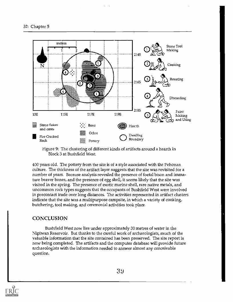
An example of this kind of clustering, and Terry Gibson's interpretation of theactivities represented, is illustrated in Figure 9. The clusters of artifacts around ahearth suggest activities that were associated with a round dwelling, although noremains of the actual structure were found. On the east and southeast sides of thehearth, large numbers of stone flakes and cores from which those flakes were re-moved indicate that stone tool manufacturing was the most important activityaround the hearth. The analysis of bone, burnt bone and pottery pieces indicate thatbison was probably cooked in a pot, and young beaver was roasted over the fire.
Spills of ochre (iron oxide) and grinding tools for making the ochre into paintfound near the hearth, indicate that paint was made there and perhaps used in cere-monial activities. Two small trash dumps were at the edge of the dwelling, withpottery sherds discarded in the southwest corner, and bone, flakes, and broken toolsthrown in the northwest. Because the area to the west of the fire was clear of artifactsand its living floor surface was unusually compacted, it appears that the area hadbeen kept clean for sitting or sleeping, which after an extended time had compressedthe soil.
The archaeological evidence has also revealed some general information aboutthe site. Pollen recovered from the paleosol has been analyzed and indicates that thefloodplain upon which Bushfield West sits was covered with birch trees at the time ofoccupation. Radiocarbon dates of bone and charcoal indicate that the site was about
0
32: Chapter 5
13E
_ Stone flakes=and cores
II Fire CrackedRock
115E 117E
Bone
Ochre
Pottery
119E
214S
Stone ToolMaking
Cooking
Roasting
Hearth
c-st DwellingBoundary
PaintMakingand Using
Figure 9: The clustering of different kinds of artifacts around a hearth inBlock 3 at Bushfield West.
400 years old. The pottery from the site is of a style associated with the Pehonanculture. The thickness of the artifact layer suggests that the site was revisited for anumber of years. Because analysis revealed the presence of foetal bison and imma-ture beaver bones, and the presence of egg shell, it seems likely that the site wasvisited in the spring. The presence of exotic marine shell, rare native metals, anduncommon rock types suggests that the occupants of Bushfield West were involvedin precontact trade over long distances. The activities represented in artifact clustersindicate that the site was a multipurpose campsite, in which a variety of cooking,butchering, tool making, and ceremonial activities took place.
CONCLUSION
Bushfield West now lies under approximately 30 metres of water in theNipiwan Reservoir. But thanks to the careful work of archaeologists, much of thevaluable information that the site contained has been preserved. The site report isnow being completed. The artifacts and the computer database will provide futurearchaeologists with the information needed to answer almost any conceivablequestion.

CHAPTER 6:ARCHAEOLOGY AND CURRICULUM
REQUIRED AREAS OF STUDY
This section will explore how archaeological ideas can be introduced for anumber of required areas of study. This is not meant to be a progressive curriculum,with each year based upon the previous years' teachings. Rather, it is meant to pro-vide a wide range of ideas for fitting archaeology into the curriculum, because of theinterests of the teachers, the interests of the students, or to take greater advantage ofopportunities for class involvement in archaeological research.
By suggesting ways in which archaeological themes can be introduced throughthe existing Sask. Ed. curriculum, this section will explore how archaeology can tietogether various required areas of study into one integrated unit (see Devine 1989). Italso provides suggestions for integrating the subject matter of archaeological fieldtrips into regular curriculum, ensuring that maximum benefit is achieved through theout-of-school experience, should the opportunity arise. The curriculum for Sas-katchewan schools is undergoing a major revision, so some of the specific suggestionsfor integrating archaeology may be out of date within a few years. However, thesuggestions will indicate the wide applicability of archaeology. The concepts andactivities that are introduced in this section are independent, and do not require thatarchaeology has been the subject of previous years' or previous classes' study.
Social Studies
In social studies, archaeology should be introduced as an important method ofgathering information about the past, information about everyday events and peoplethat were often left out of written histories. That is why historic as well as precontactsites are studied by archaeologists. During any class discussions of past historicalevents and different cultures, archaeological reflection can be practiced as a means ofpracticing critical and creative thinking:
What kinds of materials would be left behind after such an event?Which of these would survive after several hundred years of abandonment?What would be unique about the materials that would give archaeologists
clues about the time that the event occurred, and what people were in-volved (male or female, culture or nationality, status of participants withintheir culture)?
el 0

34: Chapter 6
What aspects of this culture would distinguish it from all others in the archaeo-logical record?
What information could you retrieve from the archaeological record about this[kinship system, religion, language, economic system, political system,modes of transportation, food production, or world view]?
Science
Archaeological ideas can be introduced in science classes at all levels fromgrades 1-12. It provides suitable material for covering most of the Dimensions ofScientific Literacy which form the backbone of the new curriculum. Ecologicaiconcepts, geography and geology, are all integral to archaeological research. Butprobably its biggest contribution to pre-university students is the ease with which itcan be used to get students involved in the procedures of scientific investigation(observation, measurement, classification, experimentation, cornnumicadon, formu-lating hypotheses, formulating theories and models and making predictions usinganalogies). It can introduce them to the "scientific point of view" which guides thisinvestigation (including the belief that the world is ordered and can be understood,that there are many methods for investigation, and that attitudes such as open-mindedness and accuracy are important). See the 1976 Saskatchewan EducationCurriculum Guide for Chemistry 20 and 30 (pages 58 80) for further discussion ofscientific investigation, and the importance of getting students to understand itsnature.
Language Arts
Recording information is integral to collecting archaeological materials. Jour-nal entries are made daily in the field, recording the weather, who was present, whatwas done, what was found, and some preliminary interpretations. Students visitingarchaeological sites or taking part in archaeologically oriented activities could writesuch a journal entry. An important aspect of archaeology is formally reporting whathas been found and how it has been interpreted. This can be done through writtenreports, aural presentations (perhaps accompanied by slides or displays), posterdisplays or exhibits, or even video. Creativity can be brought out in fictional accountsof archaeologists uncovering the mysteries of the past, or elaborate reconstructions ofpast cultures based on archaeological information but using imagination to fill in thegaps. All of these types of activities allow students the opportunity to use archaeo-logical terminology in context, and develop their communication skills.
Mathematics
Archaeology can provide subject matter for exercises to develop plotting skills,numerical calculations such as percentage and averaging problems, geometric con-cepts, and measuring skills.

Archaeology and Curriculum: 35
Arts Education
Reproducing artifacts and archaeological sites allows students to be creative.The most valuable activities for giving students a sense of life in the past are thosewhich attempt to reproduce artifacts as authentically as possible, using the materialsand techniques that would have been available to the Prehistoric people. Reproduc-tions f?:-.!scribed in Activity 5 of Chapter 7 can be adapted for any grade.
Archaeological interpretations could also be presented in visual form, as illus-trations or even as dramatic recreations of the events that may have taken place at asite. These forms of expressions can bring life to interpretations that can seem static ifpresented only in tables of data and factual reports.
Native Studies
Archaeology can be used as a means of studying the long prehistory of nativepeople in Saskatchewan and the rest of the Americas. Much of what is known aboutthe day to day lifestyle of Indians at the time of European contact and before isknown through archaeological evidence.
GRADE LEVEL
Grade 1
Science
Classification is introduced at this level. If artifact collections are available, usethese as an interesting alternative to buttons or pieces of paper. They can be sortedaccording to many properties: size, colour, what they are made of, etc. More com-plex classification activities, such as dividing groups into subgroups, can be usedwith older students (see Activity 7).
The effect of environment on plants is introduced. Allow the students to con-sider what would happen to the plants in our environment if the weather suddenlybecame colder or dryer, as it has in the past. If plants change or die, what happens tothe animals (including humans) who rely on those plants?
Grade 2
Science
Classification activities become more complex (involving subgroups and theintroduction of the idea that grouping is arbitrary), so an archaeological classificationexercise, such as Activity 7, could be used.
z12

36: Chapter 6
Students learn that living things adapt to their environment and to seasonalchanges in their environment. How does this fact make it possible for archaeologiststo sometimes know what season people visited an archaeological site? (seeseasonality in glossary).
Since dinosaurs are popular at this age, it would be appropriate to explain thedifference between archaeology and paleontology.
Grade 3
Math
Archaeological examples can be used to practice measurement such as length,and mass of artifacts.
Science
Environmental changes in the past have had effects upon the development ofliving things, including humans. What was the environment like in Saskatchewan25,000 years ago, and how did that affect the ability of humans to live here?
The study of precontact peoples is useful in getting students to understandecological concepts: that humans are part of the food web. Have them imagine life inthe past, and all of the things in the environment that they would have to rely upon tosurvive. Do all of these parts of the web leave evidence in the archaeological record?
Humans change their environment. Consider the changes that humans areresponsible for now with the changes 100 years ago, and 1000 years ago. 100 yearsago people built houses and forts, they cleared land and farmed, they build townsand cities. 1000 years ago people hunted animals and gathered wild foods, they cuttrees for their tents, and they burnt areas to attract animals with the fresh youngplants that would grow back. It is because humans change their environment inunique ways that archaeologists recognize human activity at sites even when thereare no human bones to prove that people were there.
Grade 4
Social Studies
The 1973 curriculum guide puts the emphasis of grade 4 social studies uponSaskatchewan, and the emphasis is will remain the same in the upcoming update.Saskatchewan archaeology should be referred to in most sections of Units II (WhoAre Our People?) and III (What Is Our Story?).
Some of the activities in Unit II make reference to Pa leo-Indians, archaeologicalsites, and artifacts. The use of artifacts or pictures of artifacts can be used to construct

Archaeology and Curriculum: 37
time lines of Saskatchewan history. However, it is important to stress that the origi-nal context of those artifacts (in archaeological sites) is what really reveals the infor-mation about age and function of the artifact, and the lifestyles of the people whoused them. Some aspects of the First Nations religions can be studied through sitessuch as vision quests, medicine wheels, and rock art sites. Cultural change as a resultof contact between Europeans and Aboriginal Peoples in the historic period can beused to understand some of the cultural change in the precontact period. Likewise,the reasons for population changes today (changing economics, gradual climateshifts, technological developments) can illuminate the past archaeological record andshow that population changes are ongoing and are not always due to catastrophes.
In Unit III, archaeology has made important contributions to our understand-ing of the "Indian Way of Life". Early explorers and later anthropologists recordedsome of the more spectacular aspects of Aboriginal Peoples lifestyles. First Nationselders and scholars have knowledge about many of the most common and many ofthe most important activities of the precontact and historic periods. However, manyof the day to day practices of precontact peoples can only be studied in detail througharchaeological excavations. Similarly, many historic periods and events in Saskatch-ewan (for example, the fur trade era, the Resistance of 1885, the settlement period)can be more fully understood only after archaeological investigationsnot just toretrieve artifacts for museum displays, but to flesh out the events, by understandingwhat the artifacts in context can tell us about the people involved and how they livedfrom day to day.
Math
Because students are beginning to construct line graphs in grade 4, plotting thelocation of artifacts within an excavation unit using coordinates would be a goodactivity. Students can calculate the areas of sites or excavations (if they are rectangu-lar) using formulas.
Science
Grade 4 science students study the cycle of matter and energy between livingand non-living objects in the environment. Living things die, decay, and becomefood for other living things. Most organic substancesthings that were once alive orpart of a living thingdo not survive in the archaeological record. Students candiscuss the reasons behind this.
Grade 5
Social Studies
The 1973 Saskatchewan Education Curriculum Guide puts the emphasis ofgrade 5 social studies upon Canada, and the emphasis is expected to remain the same
44

38: Chapter 6
in the upcoming revision. Canadian archaeology could be referred to in mostsections of Units II (Who Are the People of Canada?) and III (What Is Canada'sStory?). Although these emphasis are likely to change very soon, they will bediscussed here in order to provide general ideas for future archaeological topics.
The initial part of Unit II discusses the precontact inhabitants of Canada, theirlifestyle and their technology. The contribution of archaeology to our knowledgeabout those people should be discussed. Knowledge of peoples whose descendantsdid not survive long into the historic period comes almost entirely through archaeol-ogy (see, for example, P. Such in "Further Reading" of Chapter 8). If artifacts arestudied in this unit, they should again be placed within the context of archaeologicalsites and the lifestyles of the people who used them. First Nations resource peopleare valuable for demonstrations because they not only have the technical skills butcan also offer first-hand interpretations of the Indian way of life today; however,archaeologists can also make interesting alternative resource people for craft demon-strations and artifact reconstructions. Many archaeologists have studied techniquesfor stone tool making, pottery making, and other crafts and skills that were necessaryfor survival in precontact times.
In Unit III, Canada's story is also being fleshed out by historical archaeology.Early historic records were written by people who were seldom objective observers:they were often writing to serve their own ends and to make superiors happy. Exca-vation at historic sites fleshes out these observations, and often illuminates theirinaccuracies; this is well illustrated in the historical chapter in The First Albertans (see"Books and Periodicals", Chapter 8). Archaeological sites have been studied from allperiods of Canadian History, from the Norse settlement in Newfoundland (seeVinland Mystery in "Videotapes and Films" of Chapter 8), to the search for theNorthwest Passage (see Beatty and Geiger in "Books and Periodicals", Chapter 8),numerous fur trade posts (Fort Pitt and Fort Carlton), Northwest Mounted Policeposts (Fort Walsh), clashes between cultures (Batoche), gold rush sites (Chilcoot Trailin the Yukon), early settlement period homesteads, and industrial sites such as coalmines (Leitch Colleries in the Crowsnest Pass of Alberta). There are also opportuni-ties for practicing interviewing skills in the oral history activity described near theend of Unit II, an invaluable skill for archaeological research of recent historical sites.
Math
The grade 5 math curriculum introduces mean values, for which archaeologi-cal examples such as artifact numbers per unit or artifact measurements are useful.Simple percentage problems can be introduced (denominators of 2, 5, 10, or 100)using archaeological examples. The skill of copying pictures from one grid to asecond grid of a different size can be practiced by sketching onto a small grid thedistribution of artifacts on the floor of an excavation unit (the excavation unit can bedivided up lightly traced lines or string).
45

Archaeology and Curriculum: 39
Science
The study of time in grade 5 science stresses that recorded history is but asmall portion of time. To stress this, precontact dates of archaeological interest can belabelled on the time line (especially on the 10,000 year time line).
The study of erosion and deposition are important to understanding howarchaeological sites are formed after the original inhabitants have abandoned thelocation. Different forces work to bury the site (for example, flooding), move theartifacts around in the grouni (plant roots), and weather the artifacts (running wa-ter). These can be demonstrated in the classroom (see Activity 1) or can be observedin field situations.
The effect of heating and cooling on rock can be demonstrated with whatarchaeologists call fire cracked rock (fcr). It is formed by heating rocks and immers-ing them in water. Water was often boiled this way in precontact times, creating lotsof fcr in most archaeological sites.
An Indian fire drill can be used for studying friction. Try making one out ofnatural materials and use punk of moss to see if you can actually get a fire going:willow for the bow, leather for the string, and soft dry grass or birch bark for tinder.
Grade 6
Social Studies
The new grade 6 social studies curriculum focuses upon the Atlantic. Unit Ideals with location. Archaeological examples would be useful in talking aboutatlases, maps, and grids, as these are all essential in recording where sites andartifacts are found, and what the environment is like in those locations. Archaeologyfits directly into Unit II, where it is stressed as one of the ways of learning about pre-historical (pre-contact) periods.
The entire theme of Unit II-interactions among different groups of peopleand their environment both before and after contactis central to archaeology in theNew World. Historical archaeology should be included in this unit as a means oflearning about common people and minorities who are usually left out of historicaldocuments. It has only been recently that many of these groups have been writingtheir own story, thus entering into our historical records. The archaeological recordhas always been less biased than the historical record. The archaeological record (theartifacts in the ground) is the voice of people who left the artifacts behind, whetherthey were rich or poor, whether or not they could read or write. Archaeologistsinterpret the people's story from those sites and artifacts. Archaeologicalinterpretations, like historical documents, can also have biases, since mostarchaeologists continue to come from a European academic tradition. However,
46

40: Chapter 6
increasing cooperation between archaeologists and descendants of the groups theyare studying (whether First Nations groups, African Americans, or others) andincreasing numbers of archaeologists from non-European traditions are helping to.thange this.
Math
In grade 6 math, archaeological excavations can be used to illustrate how areasof irregular shapes can be determined. By counting the individual 1 x 1 m units, onecan calculate the total area of the excavation. More complex percentage problems canbe broached (for example, percentage of artifacts with certain characteristics).
Archaeological excavations and materials also provide an opportunity to prac-tice making and interpreting scale drawings, as the site and its individual featuresand artifacts are drawn.
Also at this stage, students gather data to construct simple bar and line graphs.Archaeology can provide many practical applications for such visual display of infor-mation, such as illustrating the relative numbers of different kinds of artifacts, orcomparing the numbers of artifacts in different levels of an excavation.
Science
In grade 6 science, the chemical and physical processes involved in decomposi-tion can be explained using the contents of an archaeological site as an example:physical processes such as root action, freeze-thaw, and water erosion combine withchemical processes to decompose organic materials, and weather many of the inor-ganics.
Ecology is described in the 1971 Sask. Ed. grade 6 Science Curriculum Guide as"made up of living and non-living components which are generally interdependent,and changes in any component affects the system" (p. 140). Discuss the differencesbetween how modern humans, early settlers, and precontact humans changed theirenvironment to suit their needs. How do these changes affect the plants and animalsin the environment? (See also discussion of grade 5 science).
If animal skeletons are available, students can assemble the bones to look likethe animal they came from. While doing this, they should carefully examine thebones, noting how each is slightly different. If more than one animal is available,compare bones from different animals but from the same parts of the body and notethe similarities and differences: the differences relate to the special adaptations ofeach animal.
Archaeological methods of dating can be substituted for discussions of paleon-tological techniques for dating, and many of the processes are closely related. The
47

Archaeology and Curriculum: 41
suggested activity (page 148 the 1971 curriculum) of observing daily changes in milkthat has been left out in the sun can be related to changes in styles of projectile pointsthrough time. Just as a single glass of milk can be dated by comparing it with therecord of observations of similar glasses over a week, a single point can be dated bycomparing it to the sequence of point styles that has been developed through excava-tions in Saskatchewan (see the time lines in Chapter 3).
Grade 7
Social Studies
The Sask. Ed. curriculum guide for Grade 7 highlights Canada's relationship tothe world, particularly with the countries surrounding the Pacific Ocean. Unit I dealswith the concept of "Location". In geographical terms, the physical environmentprofoundly affects human life, and in turn, humans affect their environment. Beforearchaeologists work in an area, they consult topographic maps to get an idea of land-forms and water sources, they find out about the climate and vegetation of an area,and what animals would have been native to the area in the past. This advance re-search about the environment of their study area allows the archaeologist to hypothe-size about if there will be archaeological sites in the area, the most likely places thatthey will be found, and the kinds of activities that will likely be represented at thesite. Making and using maps during archaeological investigations of a site also pro-vide useful practice in geographical concepts.
In Unit II, "Resources", students can compare lists of resources from the pointof view of precontact peoples, early settlers, and contemporary Saskatchewan society.Do the differing distributions of these resources account for differences in populationdistribution in the various time periods?
"Change", stressed in Unit IV, has always been a major interest of archaeolo-gists. They have documented the continual changes in human cultures through time,and have attempted to understand what factors bring about such change. It shouldbe stressed that, although changes in recent times have been more dramatic, changehas occurred throughout human history.
Unit V stresses "Interaction", another interest of Archaeology. Linkages havebeen important throughout the archaeological record. In Saskatchewan, there isevidence of long distance trading and social networks back thousands of years; thereis evidence for trade of stone materials, and exotic items such as shell, but no doubt ofother items as well (items that may have decayed, such as food items). The fur tradeinvolved new people, new exotic goods, and new markets; however, the process, andthe transfer of knowledge and information that occurred at the same time, remainedessentially the same. Natural barriers such as the Rocky Mountains, and naturallinkages such as water systems, were historically very important. We can tracechanges in the importance of these linkages and barriers by finding the sources of

42: Chapter 6
exotic raw materials, tracing the sites where the materials are found, and relatingthese networks to the natural linkages and barriers in the environment.
Math
Because grade 7 students begin to measure and construct angles from 0° to180° using a protractor, they would benefit greatly from the practical application ofangles in mapping sites as described in the Activities 3 and 4 of Chapter 7.
Science
Archaeology fits best into the fourth theme of grade 7 science (Man and theEnvironment). Discuss the differences between how modern humans and precontacthumans changed their environment to suit their needs. How do the changes affectthe plants and animals in the environment? Discuss the different adaptations ofpeople, past and present, to the various biomes of Saskatchewan (prairie, coniferousforest, etc.); how have people changed the biomes.
Grade 8
Social Studies
Culture is stressed in Unit I of the grade 8 social studies curriculum. Archaeol-ogy studies past cultures, their patterns, changes and why they occur. Although theirdata base is limited by what people leave behind and what survives the forces ofnature through time, archaeology attempts to study all aspects of culture and culturalchange.
In Unit IV, Interdependence, students can consider the effects of changingtechnology on changing interdependence from early precontact times, through furtrade times, through early settlement period to today. Make sure they are aware thateven in precontact times, people were interdependent: cooperation was essential tosurvive (cooperative bison hunting, for example).
Math
In grade 8 math, the Pythagorean Theorem is used to determine the length ofthe hypotenuse given the other two sides. This is a common calculation used byarchaeologists in measuring out perfectly square units along a grid line: they knowthe two points along the grid line, and using those as two corners of the square, theymark the other two corners at the intersection of the calculated hypotenuse and thelength of one side of the square (see Figure 10).
Students also measure and construct angles from 0° to 360° using a protractor.At this level, students could map a site from any datum as long as the datum did notmove (see Activities 3 and 4, Chapter 7).
49

Archaeology and Curriculum: 43
0 2 4 6x x 1. The site grid line has 2 points
marked which will become the cornersof a square unit. The hypotenuse of aright angled triangle with two equalsides would be the square root of(2'2)+(2*2) or 2.83 m.
0 2 4 6
2 1 /2.83
3(
0 2 46
2. Two tape measures are held withtheir ends at each of the corners. Thethird corner is marked at theintersection of 2.83 m and 2 m on thetape measures.
3. The final corner of the squareis placed at the intersection of 2.83 mand 2 m again, but what was theshorter tape measure in step 2 is nowthe longer one (the hypotenuse).
6 4. This process results in a perfectsquare, with all sides equal and allangles right. Why? Verify this bymeasuring the side opposite the gridline.
Figure 10: An explanation of how the Pythagorean Theorem is used byarchaeologists to set out square excavation units.
Science
Archaeology is an excellent subject to introduce in grade 8 earth sciences.After deposition, archaeological sites become part of the environment, subject to thesame forces of weathering and erosion as all other objects. Choose an actual or animaginary archaeological site. Describe the surroundings (slopes, water sources,climate, vegetation). Identify the activities that took place. Consider the artifacts thatwould be left behind and where they would be deposited. Discuss the physical andchemical processes that would affect the site (decay, changes in artifacts and theirplacement due to erosion). Could an archaeologist excavating the site account for any
50

44: Chapter 6
of these changes (they can attempt to account for movement due to gravity, they canoften distinguish natural weathering and erosion from purposeful breakage andshaping of artifacts).
Study of the soils at an archaeological site can provide dues of past climatesand vegetation, because of the fact that different soils form under different condi-tions.
Humans have always depended upon water for survival. When surveying anarea for archaeological sites, the land bordering rivers and lakes is investigated par-ticularly closely because sites are far more likely to be discovered. Look at maps tosee where settlements are located today in Saskatchewan. Although major roads andrailways have an impact upon where towns are located, and which towns thrivethrough time, the presence of a dependable water source remains important.
Archaeological examples can be used when discussing radio-carbon and otherdating methods.
In discussing glacial geology, relate it to human activity in the New World.Human habitation of Saskatchewan was not possible before the retreat of glaciers.Glacial lake terraces, the edges of glacial lakes that have since shrunk or dried up, arelikely places to find very old archaeological sites, and can give clues to the approxi-mate age of a site.
Contour maps are used in archaeology, both in determining where to look forsites, and in mapping a site to give an idea of relief. Profile maps are often drawn toillustrate characteristics of stratigraphy observed on the walls of a unit or to illustratearchaeological features in cross section. Profiles are often drawn by measuring thedistance a point is removed horizontally and vertically from a reference point, andplotting that point on the profile drawing.
Grade 9
Social Studies
As its title suggests, "Roots of Society", the new Sask. Ed. curriculum for grade9 social studies, is the most appropriate location in the school curriculum of K-12 for aSaskatchewan archaeology unit, including field trips or out of school activities. Al-though Unit I ("Time") stresses archaeological techniques and interpretations, theremainder of the curriculum also presents general archaeological themes of change,causality, culture, and technology. Field trips to archaeological sites, with or withoutongoing excavations, would be useful in the fall for Unit I, or in the spring, withstudies of the world view of First Peoples in Unit IV, and technology and adaptationto the environment in Unit V.
51

Archaeology and Curriculum: 45
The Curriculum and Activity Guides and the bibliography for grade 9 socialstudies will be useful sources of information and ideas about archaeology and theway it can be presented in the classroomnot just to grade 9 classes but to othergrade levels as well. This handbook should provide some useful supplementaryinformation.
Math
Grade 9 math students would be able to map even a large site with multipledatum points because they understand: 1) how to draw angles, 2) the nature of sup-plementary angles, 3) corresponding angles and alternate angles, formed when paral-lel lines are cut by a transversal, are congruent. They are then able to draw a scaledrawing (a map) of the site, understanding the nature of similar triangles (see Activ-ity 3b).
Science
In stressing the characteristics of a world without energy beyond human mus-cle power, the grade 9 science teacher could use precontact or early historic Sas-katchewan peoples as an example. Their lifestyle was very different from ours today.Could we go back to such a lifestyle? Are the natural resources still available tosustain such a lifestyle?
Grade 10
In high school, it becomes difficult to arrange out-of-school activities of anyextended length. Trips to archaeological sites and excavations require more time thanis available for single class periods. However, the complexities of archaeologicalresearch can more easily be accomplished by upper level students, making it desir-able for detailed archaeological units to be taught. Secondary school teachers with aninterest in teaching archaeology are urged to consider developing new curriculumsfor social science courses devoted to archaeology, and get them approved by Sask.Ed. as options. For example, a Grade 11 summer school course in archaeologicaltheory and techniques is taught through the Toronto Board of Education, and in-cludes practical experience in Board-run excavations and laboratories.
Social Science
One of the themes in grade 10 social science is exploration. The historicaldocuments (journals, reports, etc.) concerning explorers and traders, the routes theytook, the groups of people with whom they came into contact, and the nature of thatcontact, often do not tell the entire story of the events. The documents may leave outcritical information that makes it difficult to trace the route of their exploration. Theexplorers describe their activities from their own point of view, often embellishing thetruth to serve their own purposes. When the original documents have been lost or
52
46: Chapter 6
the explorer does not survive the trip, the journeys become even more mysterious.Archaeology has had a role to play in filling in the blanks left by historical studies ofearly exploration. For example, studies of archaeological sites related to the FranklinExpedition to find the Northwest Passage have shed new light on that disastrousvoyage (see Beatty and Geiger 1988, in Chapter 8). Archaeological sites along theroute of De Soto's exploration into the southeastern United States have revealed thebrutality of those first encounters and the devastation that resulted to the First Peo-ples (see Milanich and Milbrath 1989, in Chapter 8).
Science
Soil chemistry is an option at the grade 10 level. Although it is usually consid-ered in agricultural or forestry terms, the study of soil chemistry is also important toarchaeology: specifically the effect of soils on archaeological materials.
Computing Science
Electronic Spreadsheets have become indispensable for archaeologists whomust analyze large amounts of numerical information. Tables can easily be generatedwhich not only list data, but performs calculations such as average values, sums,percentages, etc. Grade 10 students could use data from measurements or descrip-tions of artifacts, or from characteristics of sites (numbers of features, feature meas-urements).
Grade 11
Science
The benefits of teaching archaeology to illustrate the nature of scientific inves-tigation were discussed earlier in this chapter in the "Area of Study" section.
Computing Science
Most archaeological cataloguing systems are computer data bases. Each rec-ord represents a single artifact or a group of artifacts which comes from the samelevel of one unit. The records are made up of fields which contain information aboutwhere the artifact was found, and descriptive information about the artifact (its size,weight, the material of which it is made, and what it is thought to be). The data basesystem used by many archaeologists in western Canada is called MacAdemTM (avail-able through Western Heritage Services, see Chapter 9). It is based upon a series ofmultiple choice categories which the cataloguer fills in to describe each record asaccurately as possible. Each record also contains a space for notes, in which the cata-loguer can insert information which is not covered in the programmed categories.Grade 11 students can used an archaeological collection to devise a workable artifactdatabase or catalogue.
5;3

Archaeology and Curriculum: 47
Grade 12
Canadian History
One of the focuses of this course is upon the cultural forces involved in theearly exploration and settlement of this country, and on the First Peoples who inhab-ited the country before and after this contact. The course explores how these forcesshaped our national identity. Archaeology can help move history away from famouspersonalities to the effect of it ;Ajor events and trends on the lives of everyday people.It can do this by studying in detail the things left behind by those people, eventhough the individuals may not have written diaries or gained the high profile whichensures one's immortalization in history.
Science
The benefits of teaching archaeology to illustrate the nature of scientific inves-tigation were discussed earlier in this chapter in the "Area of Study" section.
ARCHAEOLOGY AND THE COMMON ESSENTIAL LEARNINGS
Archaeology offers the subject matter and the activity opportunities to effec-tively incorporate all of the Common Essential Learnings (C.E.L.$) into the educationof pre-university studer s. The activities in the next chapter incorporate all of theC.E.L.s into the: programs. For clarification, an icon representing the C.E.L. willappear in the margin of the text beside the stage in the activity which exercises thatC.E.L. in particular (understanding that the C.E.L.s overlap in different learningsituations).
Communication
Archaeology as a discipline requires participants to be able to study litera-ture, take notes about their research, and report their findings in written andverbal form. Activities based upon the subject of archaeology (such as thosein the next chapter) stress class and small group discussions, note-taking,and the composition of reports. The language of archaeology (special termsand meanings such as those listed in the glossary in Chapter 10) provides aninteresting means of expanding student vocabulary.
Numeracy
Archaeological activities provide practical situations for using mathematicalconcepts. Those activities give students an opportunity to practice doingproblem-oriented calculations and measurements accurately and in theappropriate situations. Some archaeological problems demand that students
54
23

48: Chapter 6
be able to organize their numerical information in the form of tables andgraphs. They must also be able to interpret that numerical information anduse it to solve research problems, and perhaps predict the outcomes of fur-ther experiments or observations.
Critical and Creative Thinking
The introduction of a topic such as archaeology, that tends to be relativelyunknown to students and yet holds the natural allure of the old and mysteri-ous, is a valuable means of exercising critical and creative thinking skills.Archaeology is problem oriented and provides students the opportunities togenerate appropriate questions, consider methods of answering those ques-tions and evaluating the methods they chose. The tentative nature of ar-chaeological interpretation forces students to be flexible, and prepared toalter their interpretations when the evidence demands it.
Technological Literacy
The arrowhead symbol indicates archaeology's concern with our under-standing human technological literacy and how it has changed throughtime. Studying the technologies of different cultures makes students betterable to be objective and critical about the technology of our own culture andits effects on our environment and society. Archaeological research alsoinvolves the effective operation of various tools and pieces of equipmentsuch as scales, surveying equipment, and computers.
Personal and Social Values and Skills
Archaeological activities and information can contribute to the teaching ofthis C.E.L. in a number of ways. Because it is the study of people throughtime and in many environments, it generates a respect for the richness ofhuman achievements and adaptability. Much of archaeological researchinvolves working closely and effectively in group situations, which allowsstudents to practice coordinating their efforts, designating tasks to specificpeople, cooperating, resolving conflict, and reaching consensus about theirconclusions.
Independent Learning
Archaeology provides stimulating material to foster independent learning.Students follow the problems from proposal, through research design, con-ducting the research, analysis of the results, presenting the conclusions, andevaluating the entire process. Participation in archaeological activities cancertainly make learning fun.

CHAPTER 7:
CLASSROOM AND OUTDOORACTIVITIES
The following activities are meant to provide teachers with ideas.Feel free to copy information for use in your class or adapt the activities tosuit your special needs. The symbols in the margins indicate the predomi-nant Common Essential Learning that is being exercised in that stage of theactivity.
1. NEWSPAPER STRATIGRAPHY
Target Group
Grade 6 science (paleontology and fossils)Grade 8 science (erosion and deposition)
Purpose
To demonstrate the law of superposition.To demonstrate a common form of relative dating.To demonstrate problems of redeposition, or other disturbance to
archaeological deposits.
Activity
This is a simple discussion activity which makes stratigraphic con-cepts easy to understand. Bring a newspaper to school every day for a weekand make a show of setting it on your desk, gradually forming a pile(DEPOSITION). At the end of one week, ask the students to describe whatyou did. Ask them where the oldest newspaper is lying, and how theyknow that. Pull out a flyer that has no date on it from out of or on top of anewspaper and ask the following questions:
BHow old is the flyer?How do they know that?
If you went through the newspapers in the pile one at a time looking for an

1
50: Chapter 7
article, would the order of the papers in the pile remain the same?
Compare the newspapers with floods of a river, as in the Followingscenario. A river is jammed with ice one spring, and the flood is like a tem-porary reservoir of standing water, depositing a new layer of sediment onthe ground surface along its banks. After the jam breaks and the waterrecedes, people visit that river bank. They drop artifacts as they preparetheir nets and fish, and then leave. The next year, the river floods again,covering up the things left by the people. One year, heavy spring runoffcauses the river to flood again. This time the water rushes over the groundand erodes the ground surface rather than depositing more sediment. Theflooded river cuts through the fishing site, and carries some of the artifactsaway, dropping them downstream when the water current slows down.These redeposited artifacts are not necessarily younger than the artifactslying below them. This is one reason why archaeologists must take carefulnote of artifacts and their contextartifacts jumbled tDgether with pebblesand bones of a similar weight have probably been redeposited, and the lawof superposition no longer applies. Brainstorm about other types of distur-bance that would be possible at an archaeological site (roots, burrowinganimals, scavengers, etc.). How would these forms of disturbance be recog-nized at an archaeological site? (Roots push artifacts aside, burrowing ani-ma's throw artifacts behind them and leave holes for artifacts to fall into,scavengers remove bones from the site.)
2. CLIMATE CHANGE/CULTURE CHANGE
This activity is adapted from one out of the Teacher's Resource Packetfrom the Smithsonian Institution (see "References for Teaching Archaeologyin Schools", Chapter 8).
Target Group
Grade 6, and others
Purpose
To practice interviewing techniques.To provide an understanding of the relationship between culture and
environment, and to illustrate that the relationship is as importantnow as it was in the past.
57

Classroom and Outdoor Activities: 51
Activity
Atmospheric Environment Service in Regina (phone 780-5739) housesclimate data for stations across Saskatchewan. For a small fee ($1.05/micro-fiche page, subject to change), you can obtain the records of monthly, daily,or yearly totals of precipitation for your local area. Students can use thisinformation to construct graphs of average yearly rainfall over the past 30 or40 years. Discuss patterns in the graphs: wet periods, dry periods, andgeneral trends in recent years.
Armed with the graphs, students can interview local farmers orranchers to find out how the specific fluctuations in rainfall have affectedtheir operationstheir overall productivity, new management techniquesthey have been forced to adopt, or new species they have had to introduce.If there is an obvious trend in the recent years on their graphs, ask the farm-ers what the future of their operation will be if the trend persists.
Students can summarize and report their findings in written form, orcan make oral presentations. Have them relate their findings to the archaeo-logical record by considering some of the following questions:
Does our society continue to adapt to climatic changes? Yes, bu'i:because of our lifestyle, we do not normally adapt by moving tomore hospitable areas, as people often did in the past.
What adaptive measures can we practice that were unavailable toprecontact peoples in the province? We have more control overthe species that grow in an area, but we have still have no controlover the climate.
What kinds of evidence will be available to future archaeologists tohelp them study the adaptations of rural Saskatchewan peoples?plant and animal remains, farm machinery, historic records ofclimate and food production

52: Chapter 7
3. MAKING MAPS
Mapping a site is a great way to get field experience without disturb-ing a site (see Activity 10B). Any kind of site can be mapped, from featuresin a school yard, to features in an old farm yard, to tipi rings in a stone circlesite.
3A. MAKING A MAPPING BOARD
Target Group
Grades 7 and up, or the teacher can make one for use by the group inthe next activity.
Purpose
To create a devise for measuring angles in the field.To practice drawing angles and understanding degrees in a circle.Option: This activity can be used in conjunction with the teaching of
latitude and longitude to young students.
Figure 11: Diagram of a mapping board. The board would be an-chored to the ground with long nails in the center, and two corners.
330 30
320 40
310 50
{00 60
1012
230130
220140
210 74'5'3

Classroom and Outdoor Activities: 53
Activity
A mapping board is easy to make and can be used to map sites. Stu-dents can make their own, or mapping teams can cooperate to make theirboard. At least one board per team is necessary for a mapping activity.
On a sheet of paper, draw as large a circle as possible using a com-pass (the exact size is unimportant). Enlarge the centre point so that it isclearly visible. Draw a line bisecting the circle. Use a protractor and ruler todivide the circle up into 10° segments. Choose two perpendicular lines andmake them thicker. Draw tick marks around the circumference of the circleindicating the degree divisions (this step can be missed, and students canestimate the divisions when they use the board in mapping).
Cut out the circle and paste it onto a piece of heavy cardboard orplywood (a square piece is easiest to use, but it can be any shape). If asquare is used, align the two thicker lines on the circle so that they pointtoward the midline of each side of the square, or toward the corners. Printnumbers around the outside of the circle, indicating the degree measure-ments. Because the mapping board is used by securing it to the groundusing long nails, these same nails can be used to make holes through thecenter and two corners of the board. The mapping board (see Figure 11) isready for use in the mapping activity which follows.
3B. MAPPING A SITE
Target Group
Can be adapted for grades 7 and up. Younger students may enjoymapping a site, although they will need help drawing the mapback in the classroom.
Purpose
To practice rudimentary mapping skills.To make scale drawings, using information obtained in the site sur-
vey.To use geometric relationships such as corresponding, alternate, and
supplementary angles, and similar triangles in a practical situ-ation.
Equipment
Each mapping team should have the following:
60

54: Chapter 7
In the fieldmapping board (see Activity 3A)compass (optional, several groups can share one)a long measuring tape (minimum 30 metres)three long nailsnote pad and pencil
In the classroomrulersprotractorsgraph paper
Activity
Before beginning the activity, the instructor should choose any out-door site with soft ground (to stick nails into) and objects or features whichcan be mapped. These features need not be archaeological, but can be fea-tures in the landscape such as fence posts, the waters edge, a clump of trees,etc. Divide the site into sections, each of which will be mapped by a differ-ent student team. If the students are in grades 7 or 8, make5ure the sitesections are small enough to be mapped with the tape length available (thefurthest object is within one tape length of the mapping board). Theboundaries of the sections can be marked with flagging tape, string, or py-lons.
Divide the class into teams of three students each. Each student teamwill cooperate to perform the following tasks. Place the mapping board inany convenient place within the area to be mapped (at the south end of thesite will ensure that younger students do not have to measure greater than180°). Stick the center nail through the board: this will be the datum pointfor that area. Place a compass along the 0° line and rotate the board until thecompass needle points to north (or approximate the alignment of the boardto north). Secure the mapping board in place by pushing two more nailsinto the corner holes until they are flush with the board.
To map the site, hook the end of the tape measure on the center nailof the mapping board. Student 1 unwinds the tape measure and walks to afeature that is to be mapped. Student 2 makes tkure that the end of the tapedoes not become unhooked. Student 3 writes down a description of what isbeing mapped (briefly, for example, "Ring #1" or "North corner of cellardepression"). Student 1 then calls out the distance from the feature to thedatum (mapping board). Student 2 calls out the angle indicated by the tapealong the mapping board. Student 3 writes down both figures next to thefeature description (see Table 1). The team continues with these tasks untilall features in their section have been mapped. Make sure that the students
61

Classroom and Outdoor Activities: 55
This board is thedatum. It isaligned to north(indicated by thedashed line). Inother words, the 0mark is towardthe north.
Angle #1 ismeasured using themapping board.
Angle #2 issupplementarywith Angle #1and is calculatedby subtractingAngle #1 from180°.
Because Angle #3 isalternate with Angle
#2, the two arecongruent.
This dotted linerepresents a tapemeasure stretchedbetween the two boards.
3
This board is thesub-datum. Byrotating theboard until thetape runs along360° subtractAngle #3, theboard is alignedto north (a lineparallel to thenorth alignmentof the datum).
Figure 12: Diagram and explanation of the geometric relationshipswhich allows surveyors to move datums while keeping the properalignments.
take turn performing the different tasks. In order to eventually tie the sec-tional maps together, it is essential that the teams include the datums ofsurrounding teams as points to be mapped.
If an accurate master map of the site is the goal of this activity, and ifthe students are familiar with geometric relationships such as the congru-ence of corresponding and alternate angles (Grade 9 or higher), the mappingboards should be aligned more carefully so that the individual team mapscan later be joined up (see Figure 12). This entails coordination and coopera-tion between groups, and should be supervised by the teacher. Begin with amain datuma single board which has been aligned to north and securedwith three nails. Choose a sub-datum and place a mapping board on itsecured with a central nail. Stretch a tape measure from the datum to thesub-datum and measure the distance and angle from the datum (Angle #1).Calculate the number of degrees in the supplementary angle (Angle #2).Rotate the sub-datum board until the tape measure lies along the measure-ment equal to Angle #2 (which is congruent to the alternate angle#3)subtracted from 360°, and secure the subdatum with two more nails. Thesub-datum board will now also be aligned to north. To make sure that thestudents understand the geometry of changing datums, discuss the steps inFigure 12 in class before going into the field. This process of tieing datums
2

56: Chapter 7
together can be repeated, creating as many sub-datums, or sub-sub-datumsas required for the numbers of student teams involved.
Archaeologists like to relate their datums to a relatively permanentpoint such as the corner of a buildings, or a survey bench mark. This allowsfuture archaeologists to easily find the site and features by first finding thepermanent reference point. Students can tie their information to a perma-nent reference point: after securing the mapping board to the site's maindatum point, measure and record the distance and direction from datum tothe permanent reference point.
In the classroom, students can use the information recorded by Stu-dent 3 to draw a map of the site. On graph paper, a point is chosen as thedatum, and the features are plotted using a protractor to measure the angleand a ruler to measure the distance (see Figure 14 with the next activity).Maps of adjacent groups can be joined by overlaying the common datumpoint, and retaining the north alignment (make sure the vertical lines on thegraph paper remain vertical). This will result in a composite map of the site.If the team datums have not be aligned as illustrated in Figure 12, the sec-tions of the composite map will probably not match up very closely. Alter-natively, each student can individually plot the points from all of thegroups.
4. CEMETERY ARCHAEOLOGY
Target Group
This activity can be adjusted to suit the interests and abilities of mostgrades, but is most suitable for students from grades 7 upward(see also Activity 3).
Purpose
To practice the steps taken by archaeologists in their studies:1) identifying research problems2) choosing the best methods to use3) collecting the data4) analyzing the data5) presenting the results.
To illustrate how archaeologists use artifacts to deduce characteristicsof a culture, and to study changes in the culture over time.
To practice mapping skills.To foster respect for cemeteries as historic sites (getting away from
the idea that cemeteries are spooky).
C3

Classroom and Outdoor Activities: 57
Necessary EquipmentIn the Field
surveying equipment (see Activity 3B)tombstone record forms
In the Classroomrulersprotractorsgraph papercalculators or computer spreadsheets to analyze the data (to calcu-
late average figures, percentages, etc.)
Activity
Because of ethical concerns when dealing with people's ancestors,students should be prepared for this activity by taking part in thoroughdiscussions about proper respect for the dead and their belongings. Makesure the class understands the gravity of their project: that they are studyingreal artifacts which, although created by people in the past, continue to beimportant symbols to friends and relatives of the deceased today. Archae-ologists must show similar sensitivity and responsibility when dealing witharchaeological sites, and try not to disturb remains unless it is unavoidable.Students should be given the option of not taking part in the activity, and allparents should be informed about the nature of the activity, so that theirconcerns can be dealt with to avoid unnecessary offence. Choose a cemeteryto study, and make sure that grounds keepers are aware of and supportiveof the activity.
Cemeteries hold a wealth of information about a community and itschanges over time, much of which can be studied by looking at the tomb-stones. Get the students to brainstorm about what kinds of information acemetery can reveal about a community: how old the community is,changes that have occurred in length of life span, life span differences asrelated to social group or sex, family size and composition, changes in ethniccomposition of the community over time, religious beliefs concerning death,dates of epidemic diseases or tragedies and which groups these affected, etc.The history and growth of the cemetery can also be explored, by looking atthe distribution and clirt-nology of tombstones, and by looking at changes intombstone style over time. Have the students decide which kinds of ques-tions interest them the most; they can even form hypotheses about specificrelationships that they plan to test by observation in the cemetery. As aclass, make a list of the kinds of information that should be recorded aboutthe cemetery in order to provide the necessary information to answer thequestions (including such things as location of stones, size of stone, material
64
LI?)
C

58: Chapter 7
of which it is made, date of birth and death, sex, surname. Use this list todesign a tombstone record form (Figure 13).
At the cemetery, break the class into groups of 3-5 students, each witha section of the cemetery to study (about 5-15 tombstones, depending uponamount of time available). Make sure that adult supervision is sufficient tokeep all students under control. Have the students map their section of thecemetery by choosing a datum (starting point), and measuring the distanceand direction of other tombstones from their datum. (Refer to Activity 3Bfor detailed instructions for mapping a site.) The map can be a rough sketch,made by pacing off distances and estimating angles, or it can be quite exact,using compasses, a mapping board (see Activity 3A), tape measures, or evena surveyor's transit. If a detailed map is being made, it is easier to record themeasurements in a notebook (see Table 1) and draw the map back in theclassroom using rulers and protractors (see Figure 14). Make sure that eachgroup also maps the datum of the neighbouring group, so that the sectionmaps can be joined together to form a map of the cemetery. The mapsshould indicate major features of the environment (trees, brush, and largehills, etc.) as well as a separate number for each tombstone.
Then each group must record the necessary information about eachtombstone in their section. The use of standardized forms ensures that allgroups will record the same types of information (Figure 13). Unique fea-tures (the presence of more than one person's name on one stone, for ex-ample) can be mentioned in notes at the bottom of the form. Make sure thatdescriptions can be matched with individual tombstone locations drawn onthe map (include the distance and angle from datum on the record form forinsurance).
Back in class, the students can pool their information, building up adatabase of all tombstones and their location in the cemetery (this can bedone in a computer database, if the expertise is available). Each group canbe made responsible for answering one of the questions, and can use thedata to determine if they can see any consistent relationships among thedifferent categories of information. Groups can report their findings to theclass, showing their map and graphs of their data. Class discussion of theresults should include examination of assumptions, the validity of the sam-ple (is it large enough to prove the findings?), and accuracy and relevance ofthe interpretations.
After the reports have been made, discuss as a class what surprisingthings the study has indicated about the community. Ask the students toconsider how their questions dictated the methods of their fieldwork.Discuss how your study would have been different if the cemetery was
cJMIK

Classroom and Outdoor Activities: 59
Figure 13:Forms can be made up to contain any type of information that intereststhe class. Multiple choice answers allows some consistency in descrip-tion between groups; answers can be elaborated in the notes at thebottom of the form. If this form is made up on a computer database, theinformation gathered in the field can later be entered into the computer;students can then practice using the computer to manipulate the infor-mation and generate tables or charts to show information such as aver-age figures for different classes of tombstone (for example, averagewidth of tombstone for each sex class). Alternatively, maps can bedrawn indicating the distribution of different surnames or religionaffiliation within the cemetery.
TOMBSTONE RECORD FORM
Tombstone Number: Group Number:Distance from datum: Angle from datumSex: Male Female Surname:
Year of Birth: Year of Death: Direction Facing:
Size: Width Height ThicknessShape: Rectangle Rounded Rectangle Cross OtherMaterial type: Marble Granite Cement OtherType of Decoration: Engraved Carving Sculpture Colour
None OtherSubject of decoration: Supernatural Figure Human Animal
Flower Cross Geometric Design OtherExtent of Decoration: Ornate Moderately Ornate Plain
Religious Affiliation: Catholic Protestant Other UnclearEpitaph.:
Other Notes:
66

60: Chapter 7
scheduled for destruction, and this was your last chance to save informationabout this important site (you would have tried to retrieve as muchinformation as possible, even if it was not directly related to the questionswhich you were trying to answer, because future archaeologists would haveto rely on your notes to answer new questions).
Table 1: Mapping Data for a Fictional Cemetery
Subject Direction (0 off magnetic N) Distance (m)Datum (Tombstone 1) 0 0Tombstone 2 90 5Tombstone 3 90 10Tombstone 4 0 5Tombstone 5 (Datum for Group 2) 45 7.1Tree cluster (N end) 70 14Tree cluster (S end) 100 12
Figure 14: Map drawn from data in Table 1.
4CM)
5fl
1 (datum) 20 42.3)
,[Legend
N <a) Tombstone
1
%Trees0 1 2m
6

Classroom and Outdoor Activities: 61
5. ART ACTIVITIES
One of the ways archaeologists learn about past lifestyles is by tryingto copy the artifacts and features that they find, using only materials thatwould have been available to the people they are studying. Some of these"replication studies" can be incorporated into art classes.
5A. MAKING PREHISTORIC-STYLED POTS
Target Group
Can be adapted for students of any age.
Purpose
To demonstrate the techniques used by precontact craftspeople.To develop students' appreciation for the skill possessed by the
craftspeople.
Activity
With a few adjustments, the pottery techniques presented in t 1978Sask. Ed. Division II Curriculum Guide (pp. 167-173, 179-188, 235) can beused to reconstruct the process used in precontact times to produce potteryin Saskatchewan. For younger students, pinch pots can be formed usingcommercial clay and dried. For older students, natural materials can beused. Native clay can be dug from local sources. It can be mixed with tem-per (sand, crushed rock or crushed fired pottery) at a ratio of about 4 partsclay to 1 part temper. This paste mixture is then formed into pinch or coiledpots, thoroughly dried, and fired in open fires. The firing technique is themost difficult (see below), and often results in broken pots. The processinvolved in creating pottery from scratch can be simplified (by eliminatingthe firing, for example) according to student interests, abilities and timeavailability; however, participation in the entire sequence of tasks will createa fuller appreciation of the precontact way of life. The form of pot can beentirely original, but older student may want to copy the shape and designpatterns of precontact vessels from different areas of Saskatchewan (Figure15).
Firing Technique:
Make sure the pots are completely dry (at least seven days of dryweather). After obtaining permission from fire authorities, dig a pit andbuild a large bonfire in it. Let the fire burn down to hot coals. Place the potsnear the fire to slowly heat up. Place the pots in the coals to heat further.

62: Chapter 7
::: ::::::::::::.:........:associated with
Plains Side-notchedClearwater Lake
PunctateLaurel conoidal
vessel
Figure 15: Some precontact pot shapes and designs found inSaskatchewan.
Dig the pots into the coals, putting coals inside and around the pots. Burythe pots and coals under ashes and dirt and let them heat for several hours.Finally, carefully rake the pots out of the fire.
Make sure the students are aware of the danger of firing, and thattheir pots may break in the process. If breakage occurs, stress the fact thatthe pots of precontact potters usually broke as well, either during firing or ineveryday use. Archaeologists who dig up the pot fragments (called sherds),try to reconstruct the pots, to determine their form and what they were usedfor. The students can collect the broken pieces from their pots and try toreconstruct them using masking tape or gluea task made particularlydifficult if the sherds from several broken pots are mixed together or if someof the pieces are lost in the dirt and ashes. Boxes or basins filled with sandare helpful in giving support to glued pieces as they dry. This additionalactivity can turn a "failure" into an interesting and useful learning experi-ence, as students get to experience one of the painstaking tasks often under-taken by archaeologists.
5B. POTTERY PUZZLES
If time is limited, or if a less extensive activity is desired, this activitywill provide an informative and entertaining alternative to Activity 5A.
Target Group
Can be adapted for grades 3 to 6.
69

Classroom and Outdoor Activities: 63
Purpose
To illustrate precontact pottery typesTo illustrate problems encountered by archaeologists in pottery re-
construction.
Activity
Have students design and draw a picture of a pot in a similar style tothose made by Saskatchewan's precontact peoples (see examples in Figures15). They should include some form of decoration along the rim, neck orshoulders of the vessels (incised decoration is easiest to draw). Finally, theyshould colour the pots in earth tones, either simulating the mottled blacks,greys, and browns of vessels that have been fired in open fires, or simulatingthe painting of pots with precontact materials such as red or yellow ochre(iron oxides). After the drawings are completed, have the students cut outtheir pictures and cut them into puzzle pieces (10-20 pieces, depending ofthe skill level of the students and the time available). Divide the class intogroups of five or fewer students and have them mix up their pieces. Eachgroup should then exchange their pieces for those of another group, andattempt to reconstruct the vessels.
After the activity is completed, discuss the problems that they en-countered using some of the following questions:
Could they easily distinguish which "sherds" belonged with whichvessel?
Could they tell what part of the vessel each sherd represented (therim, the neck, etc.)?
What additional problems would an archaeologist encounter if he orshe discovered the remains of the vessels? Some or most of thepieces would probably be missing, and the actual number ofvessels would be unkr own at first.
5C. ROCK ART
Target Group
Can be adapted for students of any age.
Purpose
To demonstrate the techniques used by precontact craftspeople.To develop students' appreciation for the skill possessed by the
craftspeople.
70

64: Chapter 7
ear
C.Figure 16: Petroglyphs from the St. Victor site. Tim Jones, an anthro-
pologist who specializes in rock art, identifies the figures as a manbeating a drum and bison or elk and grizzly bear tracks.
Rock art is one of the few precontact drawing forms which has with-stood the ravages of nature and remains available for archaeologists tostudy. Common subjects were simple human figures, animal shapes, oranimal footprints (Figure 16). Images were either painted on (pictograph) orcarved into (petroglyph) the stone surface. Students can be introduced tothe art form by attempting it themselves.
If sandstone outcrops occur in or near your area, obtain one or severallarge flat slabs (the softer the better for petroglyphs).
5Ci. Pictograph
Mix a thick batch of tempura or other paint type on a piece of wood.Or for greater authenticity, attempt to make natural paints and stains bycrushing berries or ochre (iron oxide), and mix them with water or grease.Students can experiment with making and using different paint materials tosee which work best. Apply the paint to the rock surface with natural"brushes" made from sticks or twigs, feathers, or any other items the stu-dents come up with.
71

Classroom and Outdoor Activities: 65
5Cii. Petroglyph
For petroglyphs, students can draw a simple shape or figure withcharcoal or pencil on the stone. This can be done individually, or workingtogether in groups. Incise the shape using a rock to rub and peck at thesandstone, or use a strong stick to rub sand mixed with water against thesandstone to wear grooves into the rock. The process of creating the petro-glyph can take an extremely long time, and creates a great respect for thepatience as well as the skill of the precontact craftspeople. To avoid monot-ony and fatigue, this activity might best be done in a relay system of stu-dents working in ten minute shifts, in conjunction with another activity.
Because sandstone erodes easily, petroglyphs are often extremelyfaint and difficult to make out. Making rubbings of the petroglyphs is auseful way to copy the glyph and often reveals details that would not showin a photograph. Have students make rubbings of their petroglyphs (seemethods outlines in Sask. Ed. Division I and II Art curriculum guides).
5D. BEADING
The bow loom has been widely used by North American Indiangroups. Although shell and bone beads were used in precontact times, glassbeads obtained through the fur trade became the most popular in morerecent times.
Target Group
Grade 5 to adult.
Purpose
To illustrate beading methods.To improve eye-hand coordination and exercise creativity.
Activity
Have students collect suitable branchesstrong yet flexiblefor theirlooms. Using a knife or sharp rock, notch the stick about 1 cm from eitherend. Warp threads travelling along the length of the bow usually numberfrom 6 to 10, and should be one bead's width apart or slightly more. Theycan be strung onto the bow in two ways.
The first, illustrated in Figure 17, involves tieing a long thread to oneend of the stick and wrapping it from end of the stick to the other, tightly sothat the stick bows. Brace the stick against the ground or table to maintain

66: Chapter 7
Tie warp threadstightly together
Use a notchedpiece of cardboardto separate thethreads
Figure 17a: Bow loom from the side. A string is wrapped tightly around the twoends of the stick, making the stick bend. Keep wrapping until at least five warpthreads travel from one end to the other. Notching the stick will keep the warpthreads from slipping. The warp threads are tied together tightly near the bowends. A piece of cardboard with one notch per warp is inserted, with eachwarp thread firmly pushed into the corresponding notch; the notches on thiscardboard should be slightly farther apart than the width of a bead.
cardboard
)11i
t":'41111
tie
Figure 17b: Bow loom from above.warp threads
bead thread
Figure 17c: To bead, tie bead thread firmly to one of the warp threads. String onefewer beads than there are warp threads onto the bead thread. Bring the threadand the beads under the warp, and arrange the beads so that there is one beadbetween each two warp threads. Push firmly with one finger from below thebeads, pushing the beads up between the warp threads. Bring the bead threadaround the outer warp thread and push the needle back through the beads, thistime above the warp. Pull the bead thread tight. Continue with a new set ofbeads.
73

Classroom and Outdoor Activities: 67
the bow as you wrap. When you have the desired number of warp threadsbetween the bow ends, tie the loose thread end to the bow. Tie the warpthreads tightly together near each of the bow ends, and then insert a notchedpiece of cardboard to keep the warp threads the desired width apart (aboutone bead's width).
The second method is to cut two rectangles of heavy leather. Punchone hole in each rectangle large enough to fit over the bow end. Using athreaded heavy leather needle, pierce one piece of leather and knot thethread. Pierce the second piece of leather, leaving a length of thread be-tween the leather pieces about 10 cm shorter than the length of the bow.Pierce the first leather again, about one bead's width from the first needlehole, leaving the same length of thread between the leathers. Continuesewing between the leather pieces until you have the desired number ofwarp threads, and tie the thread end securely. Bend the loom stick and loopthe leather rectangles over either end, securing them in the stick notches.
To bead, tie the beading thread securely to an outside warp at least 5cm from the bow end. Thread a thin beading needle and one fewer beadsthan there are warp threads onto the bead thread. Bring the bead thread andbeads under the warp threads, and arrange the beads so that they fall onebetween each two warp threads. From below the beads, press with onefinger along the bead row, pushing the beads up against the warp threads,making sure that one warp thread falls between each two beads. Bring thebead thread out below the outside warp, and insert the beading needle backthrough the row of beads, this time above the warp threads. Thread anotherrow of beads onto the bead thread and repeat the process, remembering tobring the bead thread around the outside warp. Continue until the bead-work is the desired length, and tie off the bead thread securely. Remove thewarp threads and beads from the loom, leaving long thread ends. Knot thewarps together at each end. The bead work can be left as it is, or it can besewn (hiding the warp ends underneath the beads) to a piece of leather orheavy cloth to form a bracelet, bookmark, or decoration on an item of cloth-ing.
74

68: Chapter 7
6. SOLVING ARTIFACT MYSTERIES
The point of any analysis or classification activity is missed if objectsare given a name simply because that is what it would be called in a book.The form of an object must be described because it is an essential clue to thefunction of the object. Once described, archaeologists compare the form ofthe artifact with the form of similar items with which they are familiar. Theymake an analogy, assuming that similarity in form between two objects alsomeans similarity in what the objects were used for. They call a flat thinpointed stone tool an "arrowhead", not simply because arrowheads havebeen described from other archaeological sites, but because the tool sharesproperties with items known to be used to tip arrows today. The followingactivity explores the problems involved in artifact analysis and is looselybased upon one by Parker B. Potter Jr. (Archaeology and Education 1:1:11-13).
Target Group
Grade 4 to 12.
Purpose
To illustrate the fact that artifacts do not come out of the ground withan identity, but that their identity is created by the archaeologist.
To introduce the concept of analogy, and how it is often ised in ar-chaeological interpretation.
Activity
Hold up two objects in front of the class, one which is of a familiartype (for example, a framed picture, an arrowhead) and one which is unfa-miliar (for example, a kitchen gadget, or a mechanical part). Lead a classdiscussion about the nature of the two objects using some of the followingquestions:
Have you ever seen either object before? No (because you have justbrought them from home).
What are these objects? The familiar object will be instantly labeled,whereas the unfamiliar one will probably not be.
After some guessing as to the nature of the second object, reaffirmwhat has just happened: although the two objects have neverbeen seen before, one was easily identified, whereas the other wasnot.
Why were you able to identify one object and not the other? The

Classroom and Outdoor Activities: 69
students had seen things similar to the familiar object before,whereas the other object was entirely new.
When archaeologists find objects, some are easily identified, as witharrowheads, whereas some are more problematic. Those that are unfamiliarare described, and compared with objects that are known from a livingsituation (a form of analogy); if two items are similar in form, it is assumedthat they are also similar in function. Suitable analogies can be looked for inearly accounts of the tools that were being used by the Indian groups whenthe first Europeans arrived, or similar objects may have been used by earlysettlers, many of whom still live in Saskatchewan and remember the oldways. The context of an artifact (the other debris around it) can also provideimportant clues. For example, if an unknown artifact was found near scrap-ers and fleshers, an archaeologist would assume that the unknown artifactwas also used in hide processing; the search for analogies would begin inhistorical descriptions of hide processing, or by talking with modern peoplewho process hides using traditional methods. Finding analogies in livingsituations does not provide proof of an artifact's function, but it allows animportant starting point for the interpretation of human activities at a siteinterpretations which may have to change if other pieces of the archaeologi-cal data are inconsistent with the assumed artifact function.
Getting back to the subject of the unfamiliar item in the classroom,provide the students with a clue to the identity of the itemfor example, theroom in your house from which it came. Pass the item around the class, andhave the students take careful note of the properties of the objectits size,weight, how it is made, shape. This analysis can involve the use of instru-ments such as scales and calipers. Ask the students to make an analogy witha known item that has similar properties, and suggest some activities thatthe unknown item would be suitable for. If possible, experiment with someof the students' ideas to see if the mystery artifact would indeed performwell in the way suggested. Discuss which is the best interpretation of theitemthe interpretation that is most consistent with all of the properties ofthe artifact. Finally, tell the students what the item is actually supposed tobe used for.
The point of the activity is that all artifacts are unknown when theyemerge from the ground. The archaeologist must assign meaning to theobject by comparing it with objects with which he/she is familiar. Thisprocess can be almost instantaneous, it might take months of research to finda suitable analogy, or a suitable interpretation might never be uncovered.
76

70: Chapter 7
7. ANALYSIS AND CLASSIFICATION
Archaeology is much more than excavation. Elaborate activities canbe based upon what happens in the laboratoryartifact analysis and classi-fication.
Target Group
Can be adapted for grades 1 and up.
Purpose
To illustrate one way that archaeologists group artifacts for analysis.To illustrate that archaeological classifications usually have greater
significance than simply groups of similar artifactsthe distin-guishing group characteristics relate to artifact age or function.
To illustrate the importance of finding artifacts in context.
Activity
Dump a box of assorted buttons on the desk (or have each studentbring a selection of buttons from home). With students working individu-ally or in small groups, give each group a handful of buttons. Have thestudents divide their buttons into groups of similar buttons (based uponwhichever characteristics they wantsize, colour, shape, number of holes,what they are made of). Lead a discussion about the classifications that thestudents developed:
Why did you divide the buttons the way you did?What do the differences between the groups mean? (For example, are
different groups of buttons used for different purposes?).
These are difficult question to answer because the characteristics uponwhich the classification is based were arbitrarily chosen.
But what if the buttons were found during an excavation by an ar-chaeologist? Then there would be other types of information available 1) tohelp decide which criteria are important in classifying the buttons, and 2) tohelp interpret the meaning of the categories. For example, buttons found inthe following stratigraphic context would suggest some interesting ideas.
Plastic buttonsMetal buttons
Bone buttons and wood buttonsno buttons present
7

Classroom and Outdoor Activities: 71
Using the example of site stratigraphy illustrated above, or anothersimilar one, discuss the importance of finding artifacts in some context. Theadditional information of artifact context helps answer a number of ques-tions such as the following:
Did the clothing worn by the people who left behind the buttonschange through time? (changing methods of fastening, and styleof fastening)
What does the change in the material used to make the buttons tellus? (changing technology, changing style preferences)
If precontact artifact collections are available from a local collector ormuseum, the above activity can be repeated for artifacts. Artifact groups caneven be divided into subgroups, particularly if a wide variety of tool andmaterial types are present.
The button activity can also be related to one of the projectile pointclassification systems used by the archaeologists in Saskatchewan (illus-trated on the timelines, Figures 7 and 8). Have students use what they havelearned about button classification to write a brief report about changes inpoint styles through time. A preliminary class discussion could consider thefollowing questions:
What do differences in point size and style mean? (different peoplemay have made them, the people's style preference changed,different weapons were used)
Could the sequence have been determined without the excavationinformation which revealed which points lie close to the surfaceand which are deeper?
8. GARBAGE CAN ARCHAEOLOGY
This activity is adapted from one by Patti Bell (see "References forTeaching Archaeology in Schools", Chapter 8). Archaeologists study thethings that people leave behindin other words archaeologists study otherpeople's garbage. Garbage cans are great for explaining the law of super-position, as new garbage is deposited on top of garbage that was already inthe can. By using familiar materials such as our own garbage, students arebetter able to understand archaeological ideas and techniques.
Target Group
Suitable for grades 5 to adult.
78

72: Chapter 7
Purpose
To illustrate that archaeological methods can be applied to our ownculture.
To illustrate the stratigraphy and how it relates to age of materials.To gain practice in careful observation and recording of information.To practice interpreting the meaning of groups of artifacts in context.To practice working in groups to organize tasks and reach consensus
in interpretations.
Materials Required
several pairs of rubber gloves (preferably one pair per student)one full garbage can per five studentsone plastic drop sheet per each group (could be large garbage bag
opened up)note pads and pencils
Activity
Collect cans of garbage from different parts of the school, or bringsome from home. Try to get ones with little or no wet material. This activityis best done in a large open area such as a gymnasium or out of doors, al-though it can also be done in a room with several large tables. Divide stu-dents up into groups of a maximum of five. Each group receives a dropcloth, several pairs of rubber gloves and a can full of garbage. The groupmust organize themselves and designate one person as record keeper, andanother as spokesperson.
The students lay the drop cloth out and begin "excavating" theirgarbage cancarefully removing items, beginning at the top. Each item isplaced on the drop cloth. The students identify each one, and analyze it forany information that could help them understand who the people were whothrew it away, what activity they used it in, and when they disposed of it.The record keeper identifies each item by number and writes down as manyof the student observations concerning that item as possible. After theyhave completed the garbage can excavation, or when 30 minutes remain inthe time allotted for the activity, the students can discuss within their groupwhat they have discovered about the garbage can culture by answeringsome of the following questions:
What activities are represented by the garbage?When did the activities take place?
Classroom and Outdoor Activities: 73
In what order did the activities occur, if there is more than one activ-ity represented?
What is known about the people who threw away these items? Whowere they, and how many where there?
Where did the garbage cans come from?
Finally, have each group in turn share what they have discoveredabout their garbage cultures with the rest of the class. The spokesperson forthe group can lead the explanation, but other students in the group shouldbe encouraged to add comments when the spokesperson has finished. Therest of the class can then suggest alternate interpretations for the garbage.An optional conclusion for this activity would be for each student to write areport about the activity, explaining their interpretations and exploring theassumptions behind those interpretations.
9. SIMULATED EXCAVATION
Target Group
Can be adapted for grades 4 and up.
PurposeTo practice excavation and interpretation techniques used by archae-
ologists.To exercise a variety of critical and creative thinking skills.To practice working cooperatively in group situations.
Activity
An excellent step by step description of how to set up a simulatedexcavation is described in the Archaeological Survey of Alberta's Dig andDiscover: Archaeological Excavation for the Classroom (see "Fact Sheets",Chapter 8). The pilot version of the Sask. Ed. Grade 9 Social Studies ActivityGuide also contains instructions for a simulated excavation (Activity 6 in thepilot version of the guide). Students can create their own sites or the teachercan create a site (perhaps in the high jump pit in the school yard). Dig 2 is asimulation game which is commercially available and very popular (see"Multimedia Kits" in Chapter 8).
Try to ensure that proper archaeological techniques are followed asclosely as possible to avoid the deterioration of the activity into a treasurehunt. Relate the units to a grid system, and use small tools (trowels, spoons,grapefruit knives, etc.) to carefully scrape away the soil. Make sure thatnotes are carefully recorded. This kind of activity will only work if mean-
so

74: Chapter 7
ingful patterns of artifacts are buried, because the activity should depend asmuch upon interpretation of where things were found as what things werefound. Because archaeologists depend upon the law of uniformitarianism,students should be able to make interpretations about what they find duringan excavation by considering what they would have to do to leave behindthe same patterns of artifacts.
Final projects could include a catalogue of artifacts (containing aAjeluding
of each artifact and where it was found), and a final report in-uding information about the methods that were used, the results of the
excavation, and an interpretation of those results.
10. FIELD TRIPS
10A. TOURS OF ARCHAEOLOGICAL EXCAVATIONS
Target Group
Grade 4 and up (and younger students if there are opportunities forspecial activities at the site)
Purpose
The purpose of the activity can vary with the desires of the teacherand archaeologist
Activity
One of the best ways to learn about archaeology is to visit an an ac-tive excavation with opportunities for class participation. Unfortunately,these opportunities are rare. They should be taken advantage of wheneverpossible, even if the timing of the trip is not ideal. Most archaeologicalprojects are too small and of short duration to provide opportunities forschool groups. Without a doubt, if an archaeological project is capable ofincorporating school tours into their schedule, they will advertise this serv-ice to local school boards and museums.
Archaeological excavation can only be done in the warmth of sum-mer, usually some time from the middle of May to the end of September.This leaves little time for school groups to become involved, even if both theschools and archaeologists are willing. The core area study sections intowhich archaeology fits most easily are usually taught outside the short fieldseason, making out-of-school trips difficult to coordinate.
81

Classroom and Outdoor Activities: 75
There are several solutions to these problems. One is to book the tourwhenever the opportunity presents itself, and tie it in to your curriculum inwhatever way you can (see Chapter 6 for some ideas). Another possibility isto have a more limited tour of an archaeological site with surface features,such as a tipi ring site, a medicine wheel, or a rock art site (see Activity 10B).A final option is the simulated excavation activity which could be carriedout in the high jump pit in the school yard, or in a neighbourhood lot (seeActivity 9).
If a tour of an archaeological site is possible, there are several pointsto keep in mind. Tours of excavations are most interesting for students in atleast grade 4, particularly if the archaeologists are not prepared with specifichands-on activities. Find out the following information before visiting thesite:
1. how to get there2. if there are any group age and numbers restrictions3. what to bring and what to wear4. what kinds of activities will take place and5. what kinds of preparation can be done in class before the tour.
Archaeological projects vary greatly in their degree of school programdevelopment. Some have special staff to deal with school groups, and de-veloped tour outlines. Others have no formal tour agenda, but are willing toaccommodate school groups whenever possible. Although the archaeologistwill usually guide the school group, it is sometimes necessary for the teacherto take the lead in instructing the class during the visit.
If a teacher or archaeologist is giving a tour of an archaeological siteor excavation, they should be sure to include the following information:
1. Students should understand what archaeology, artifacts, and sitesare.
2. The purpose of the archaeological research at the site being visitedshould be explained, as well as how the site was discovered.
3. The site should be placed into the context of Saskatchewan historyor the precontact period.
4. The nature of archaeological excavation ''could be briefly ex-plained, using the activities at the site being visited as an example.
5. Emphasize the fact that all aspects of the excavation are recordedin notes, drawings, and photographs.
6. Students must achieve some understanding of how archaeologicalmaterials are interpreted to explain something about life in thepast.
82

76: Chapter 7
7. Archaeological sites and materials are delicate and important.They must be treated with respect.
10B. TRIPS TO ARCHAEOLOGICAL SITES WITHOUT EXCAVATIONS
Even if there are no active excavations in your area, undevelopedarchaeological sites can provide opportunities for other activities: findingfeatures or mapping the site. If you want to visit an undeveloped archaeo-logical site for a field trip, there are several steps to take.
The first step is to plan what type of activity you want to do. Excava-tion is out of the question without the involvement of a professional archae-j 3ologist and crew (which runs into large expenses). School groups would be
2 better prepared to find all cif the features in the site, and make an accuratemap of the site (see Activity 3B). Individual features such as tipi rings orcellar depressions can also be measured, described, and drawn to scale.
The second step is to find a suitable site. Heritage ResourcesAr-chaeology (787-2809, see Chapter 9) is a government organization that keepsan inventory of all archaeological sites in Saskatchewan. Staff at HRA willbe able to suggest a suitable site in your area. If you know of a site that hasnever been recorded, you snould consider filling out a Saskatchewan Ar-chaeological Resource Record form so that the site will be added to theprovincial inventory (this can be developed into a classroom activity initself). Forms and assistance are available from HRA.
Third, and before visiting the site, obtain permission from the land-owner. Either travel to the site to get an idea of the vehicle access, terrain,and visible archaeological features, or ask the landowner about the site andits surroundings. This will save unnecessary work if the site or its location isnot really suitable.
The fourth step is to do some background research on the site. Forexample, if the site is an early homestead, the class could write to the Sas-katchewan Archives Board (University of Saskatchewan, Saskatoon, S7NOWO) and try to find out the name of the landowner.
The fifth step is to apply for an archaeological permit from HeritageResourcesArchaeology. This involves describing the site location and theactivity. Filling out a permit proposal a useful learning experience for theclass in itself. Forms and assistance are again available from HRA. Underproposed amendments to the Heritage Properties Act, it would be necessaryto hold permits only for those school activities that would have a lastingimpact upon the site (because they involved collecting artifacts, for
83

Classroom and Outdoor Activities: 7'7
example). If these amendments are passed, activities such as mapping siteswould not require permits.
The sixth step is to prepare the class by discussing the activity. In-clude a thorough discussion of rules in the field.
1. Close all gates as soon as you go through them2. Do not chase cows or other farm animals3. Do not litter4. Finally and most importantly, DO NOT REMOVE OR DISTURB
ARTIFACTS. If someone picks up a stone tool, bone fragment, orpiece of metal, make sure that they put it back down in exactly thesame place. In that way, an archaeologist studying the site laterwill find the artifacts in their original locations.
The seventh step is the field work itself. It is essential to instill a senseof the importance of the research on the students. The goal is to get as muchinformation as possible about the site so that the class can gain a betterunderstanding of the lives of people in the past. But at the same time, theclass has a responsibility to preserve the site so that it can be studied byindividuals in the future.
Field work can be followed by analysis of the data, report writing,journal writing, or classroom presentations.
84
78: Chapter 7
85

CHAPTER 8:
RESOURCE MATERIALS AVAILABLE
This section is a database of materials (books, videos, films, etc.) on the subjectof archaeology which would be of interest to educators. Many of these resourceswould be more useful for teachers in developing their own curriculum, than forstudents in acquiring an introduction to the subject. Where the information is avail-able, the suggested target group has been specified.
FACT SHEETS
Alberta Culture Historic Sites Service
The Historic Sites Service, in cooperation with the Archaeological Survey ofAlberta, has designed a series of brief fact sheets to complement Head-Smashed-InBuffalo Jump Interpretive Centre programs. Western Heritage Services has obtainedpermission to copy and distribute these fact sheets (see Chapter 9 for more distribu-tion information).
Archaeology
This is a good introduction to archaeology and how the science has been ap-plied to this important site.
Ethnography and Ethnology
The importance of ethnographic and ethnologic information in interpretingprecontact archaeological sites is discussed.
The Plains People of Southern Alberta: The Blackfoot
Although the Blackfoot probably never moved very far into Saskatchewan, thisbrief description of their life style and how it adapted to changing seasons and condi-tions is a good example of a Plains Indian culture.
Plant and Animal Resources
This fact sheet describes the different plants and animals used by Plains Indi-ans and what they were used for.

80: Chapter 8
The Plains Bison
This fact sheet describes the plains bison, characteristics of its behavior, and itsimportance to the Plains Indians.
Hunting Techniques
Five different precontact methods for hunting plains animals, particularlybison, are described. Each depended upon a knowledge of animal behavior and theenvironment.
The Anatomy of the lump
Although describing Head-Smashed-In in particular, this can be used in dis-cussing the characteristics shared by successful buffalo jumps, and the evidence thatremains for archaeologists to uncover.
Archaeological Survey of Alberta
The Archaeological Survey of Alberta has produced an excellent series of fourfact sheets for educators. Although they contain information specific to Alberta,much of the material is applicable to Saskatchewan. The fact sheets are available forthe cost of copying and mailing from Western Heritage Services (see information inChapter 9).
Alberta Archaeology in the Classroom: A Resource List for Teachers
This is a detailed up-to-date resource list which contains audio-visual materi-als, print materials, films and slide sets, multimedia kits, and teacher references.
Archaeology as a Career
This contains detailed information about the nature of archaeology as a careerand how best to pursue it. It also contains suggestions for activities for students ingrades 9-12.
Dig and Discover: Archaeological Excavation for the Classroom
Details of excavation methodology, artifact analysis, and how best to plan andconduct a simulated excavation are discussed. This fact sheet is highly recommendedfor anyone wishing to embark on a simulated excavation, or anyone wishing to de-vise other activities which develop excavation skills.
Prehistoric Technology
Alberta's prehistory and early history are detailed, followed by a discussion ofprecontact tools and how they were made, and suggested classroom activities.
87

Resource Materials Available: 81
Woodland Cultural Centre
This centre publishes a number of education materials about Iroquois peoplespast and present. The following books can be obtained by sending $5.00 per volumeplus $5.50 shipping and handling to
The Woodland Cultural CentreP.O. Box 1506, 184 Mohawk StreetBrantford, OntarioN3T 5V6
Longhouse of One Family
Woodland Indian Agriculture
Woodland Indian Foods
Native Clothing
Woodland Indian Games
Reserve Communities: A Six Nation History Unit($10.00 for this volume)
VIDEOTAPES AND FILMS
ACCESS Alberta
The following videos were produced by ACCESS Alberta. They can be ob-tained by contacting ACCESS at 1-800-352-8293.
Head-Smashed-In: A Buffalo Hunt
ACCESS produced this programme which explains the mechanics of a success-ful bison jump, using Head-Smashed-In as the location. (1984, 30 min.)
Spirits in Stone
In this programme, archaeologists explain stone features such as tipi rings,medicine wheels and rock art. (30 min.)
British Broadcasting Corporation
The Footsteps series, by the BBC and run on the Arts and Entertainment Net-work are valuable videos on archaeological subjects. Titles of archaeological interestinclude:
88

82: Chapter 8
Australia's Twilight of the Dreamtime
Lost City of the Incas
Images of Another World
Mysteries of Mankind
Children of Eve
Official copies of these programs can be obtained by contactb.g:
British Broadcasting Corporation (BBC)Broadcasting HouseLondon, EnglandW1A IAA
Cable Regina and the Saskatchewan Archaeological Society
Discovering Saskatchewan's Past
This valuable series of twenty half-hour programme's were produced in 1987to 1989. They deal with almost every aspect of Saskatchewan archaeology. Lists oftitles and copies of the programmes are available for loan to members from the Sas-katchewan Archaeological Society business office (see Chapter 9). Sales of the copiescan also be arranged.
Museum of Natural History
Two films were produced in the late 1970s by the Museum on the topic ofarchaeology. Both were aimed at general audiences. They are available for loan from
Dr. Margaret HannaCurator of ArchaeologySaskatchewan Museum of Natural History2340 Albert StreetRegina, SaskatchewanS4P 3V7
Carlton's Buried Past
This film describes the archival research and archaeological excavation thatwas necessary to accurately reconstruct the fort at Fort Carlton Historic Park. It pro-vides a history of the fort, from its establishment in 1810, through its destruction in1885 and to its reconstruction. The film is a good illustration of how archaeology canact as an important tool in understanding the history of an area. (25 min. 55 sec.)
89

Resource Materials Available: 83
The Past in Place
This film explains the importance of archaeological site preservation. Becausearchaeologists are trying to maximize the information they gather about a site, theymust study artifacts in context. That is why they dig carefully and record detailednotes. If sites are disturbed, whether they are eroded by nature or destroyed byhuman actions, most of that information is lost. (18 min. 33 sec.)
Wanuskewin Heritage Park
The Secrets of Wanuskewin
This videotape presents an introduction to the Wanuskewin Heritage Park.Although the archaeology at the park is mentioned, the video focuses upon the spir-itual significance of the site to the Indians past and present. (1987, video, 25 min.). Itis available through the Wanuskewin Heritage Park Office (see Chapter 9).
National Film Board of Canada
The National Film Board distributes a number of films and videos dealing witharchaeological topics. The regional office is located at 424 21st Street E, Saskatoon,but films are also available through many public libraries in the province. Phone theoffice (975-4245) to inquire about availability and rental costs.
The Dig
This film highlights methods used by one British Columbia highschool teacherto bring archaeology alive for his students through excavations of simulated sites andinnovative classroom exercises. (1990, film or video, 22 minutes)
The Land that Devours Ships
Underwater archaeology is the topic of this programme; it follows archaeolo-gists as they explore the H.M.S. Breadalbane, that sank in the Arctic Ocean in 1853.(1984, film or video, 58 min., 15 sec.)
The Lost Pharaoh: The Search for Akhenaten
Canadian archaeologist Dr. Donald Redford pieces together the life of thepharaoh Akhenaten. (1980, film or video, 56 min, 35 sec.)
The Mystery of Bay Bulls
Parks Canada's underwater archaeological excavation of Sapphire, a 300 yearold frigate, is followed. (1979, film only, available from Winnipeg, 13 min., 58 sec.)
90

84: Chapter 8
The Vinland Mystery
The only Norse settlement in North America, L'Anse Aux Meadows, is thesubject of this archaeological investigation. (1984, film and video, 28 min., 59 sec.)
National Geographic Society
The National Geographic Society covers archaeological subjects regularly in itsmagazine and in its television programs. For more information, conta-±
National Geographic Society17th and M Streets, N.W.Washington, DC 20036phone number: (202) 857-7000
Public Broadcasting Service (PBS)
Programs such as NOVA and Odyssey on PBS often deal with archaeologicalthemes. Although expensive, these three interesting videos are available for sale from
Public Broadcasting Service (PBS)1320 Braddock PlaceAlexandria, Virginia.phone number: (703) 739-5000
Buried in Ice
From the Nova series, this is a documentary about the multidisciplinary studyof the graves of individuals involved in the failed Franklin expedition in search of theNorthwest Passage. Suitable for highschool students. (1988, 60 min).
Other People's Garbage
This is one of the Odyssey series. Archaeologists, anthropologists, and histori-ans learn about another way of life from the things it threw away. Suitable for grades7-12. (1984, 60 min).
Seeking the First Americans
Another in the Odyssey series, archaeologists across the United States searchfor clues about the first North Americans. Suitable for high school students. (1984, 60min).
91

Resource Materials Available: 85
Saskatchewan Education and the Canadian Broadcasting Corporation
A Fine Science
This video contains short clips of a number of research projects, not all ar-chaeological. It provides a short introduction to Saskatchewan rock paintings, radio-carbon dating, the Tipperary Creek Site (in Wanuskewin Heritage Park), and thearchaeological Collections Registration Program (1986, 30 min). It is availablethrough the Resource Centre (see Chapter 9).
FILMSTRIP AND SLIDE SETS
McIntyre Media Limited
This company distributes filmstrips produced by other groups. They providefree previews of their materials. For catalogues, prices and distribution information,phone 1-800-268-1470 or write
McIntyre Media Limited30 Kelfield StreetRexdale, OntarioM9W 5A2
Canadian Arctic Prehistory
Ontario Prehistory
The Prehistory of the Maritimes
The Prehistory of Newfoundland and Labrador
The Prehistory of British Columbia
Quebec Prehistory
These are part of the Canada's Visual History series of slide sets. Each setincludes 30 colour 35 mm slides on the topic of the prehistory of a specific region inCanada. They are an excellent resource and good value at $45.00/set (subject tochange). The accompanying teacher's guide contains an annotation for each slide, abibliography and suggested classroom activities. They were produced by the Na-tional Film Board of Canada in cooperation with the Canadian Museum of Civiliza-tion. Suitable for grades 9 to 12.
Digging Up Canada's History
This set of four filmstrips, four cassettes, and a teacher's guide was produced
92

86: Chapter 8
by the National Film Board of Canada in cooperation with the Canadian StudiesDirectorate. They provide an overview of archaeology suitable for grades 7 to 12.Individual filmstrips are "Archaeologists in Action", "Head-Smashed-In BuffaloJump, "Red Bay and the Basque Whalers", and "Acadian House". The set costs$219.45 (subject to change).
Discovering the Past
This set of three filmstrips, three cassettes, and three teacher's guides focuseson the Classical Archaeology of ancient European and Mediterranean civilizations.Individual filmstrips are "The Skills of the Archaeologist", "Digging Up History",and "Evidence in Writing".
To Know the Hurons
This kit contains four filmstrips, four cassettes, four teacher's guides, 20 colour35 mm slides with notes, five replicas of Huron artifacts, eight student activity cardsand two maps. It was produced in cooperation with the Canadian Museum of Civili-zation and teaches archaeology and Ontario prehistory through a discussion of anarchaeological dig at a Huron site.
Canadian Indian People
This set of two filmstrips and audio tapes comes with a teacher's guide. Thefirst of the strips is 4503, Indian Arts and Crafts, which examines arts from precontacttimes until present (1976). The second is #504, The Medicine Wheel, examines theimportance of the circle as a symbol. The strips are available from
E.T.H.O.S.2250 Midland AvenueUnit 9Scarborough, OntarioM1P 1G6.
Saskatchewan Archaeological Society
Studying Saskatchewan's Ancient Human History
The Saskatchewan Archaeological Society lends a set of 55 colour slides, 20min. 30 sec. cassette tape, and transcription to interested individuals free of charge.The slide show provides an introductic to Saskatchewan archaeology by illustratingsome of its famous sites and artifacts. The text is most suitable for grades 6 to adult.For more information or to make bookings, contact the Saskatchewan ArchaeologicalSociety (see Chapter 9).
93

Resource Materials Available: 87
ARTIFACT REPLICAS
There are companies that specialize in making realistic replicas of stone, bone,antler, and shell artifacts from various times and places. For catalogue or furtherinformation, contact
or
Lithic Laboratories1103 - 405 - 5th Avenue NorthSaskatoon, Saskatchewan57K 6Z3
Lithics Artifacts Casting CompanySusan Heller198 Binnington RoadBuffalo, New York 14226
Lithic Casting LabRoute 1, Box 102Troy, Illinois 62294
MULTIMEDIA KITS
Dig 2
Jerry Lipetzky
This is an archaeology simulation game which includes 35 student guides, oneteacher's guide with overview, a unit time chart, daily lesson plans, teaching options,student forms for reproduction, and directions. The game involves teams of studentscreating hypothetical civilization, making artifacts, and bury the artifacts which arethen excavated and interpreted by another student team. Although first made avail-able in 1969, the simulation has been so successful that a new version was issued in1982. It is available from
Interact Publishers, Inc.Box 997Lakeside, California 92040
REFERENCES FOR TEACHING ARCHAEOLOGY IN SCHOOLS
As time goes by, more and more archaeologists and educators are discoveringthe benefits of introducing students to archaeological concepts at a young age. Peri-
94

88: Chapter 8
odicals and publications which provide ideas in curriculum development are becom-ing increasingly common.
PERIODICALS
Anthro. Notes
This is a National Museum of Natural History Newsletter for Teachers. It ispublished three times a year and is distributed free of charge. It contains articlesabout a variety of anthropological topics, suggested activities, reference materials,and summer fieldwork opportunities. To be added to the mailing list, contact
P. Ann KauppPublic Information OfficeDepartment of AnthropologyStop 112Smithsonian InstitutionWashington, DC 20560
Archaeology and Education
This international bi-annual newsletter became established in the Fall of 1989.It is a forum for archaeologists and educators to discuss their attempts at archaeologi-cal curriculum development, and includes concrete examples and information. It isavailable by subscription by writing
Archaeology and EducationArchaeological Resource Centrec/o Danforth Technical School840 Greenwood AvenueToronto, OntarioM4J 4B7
Teaching Anthropology Newsletter
This Canadian periodical is published free of charge twice annually. It pro-mc tes pre-university anthropology by providing curriculum information to teachers,creating a forum for an exchange of ideas, and establishing a dialogue between teach-ers and professors of anthropology. The Fall 1990 (Number 17) edition was devotedto precollege archaeology, but most of the issues. To be added to the mailing list,contact
Teaching Anthropology Newsletterc/o Paul A. Erickson, EditorDepartment of Anthropology
85

Resource Materials Available: 89
St. Mary's UniversityHalifax, Nova ScotiaB3H 3C3
OTHER PUBLICATIONS
Archaeology and Education: A Successful Combination for Precollegiate Students
Edited by Karen Ann Holm and Patricia J. Higgins
This publication is an excellent collection of eleven articles by teachers andarchaeologists and a valuable annotated bibliography. All illustrate how archaeologycan be used in teaching K-12 students. The papers had originally been presented atmeetings of the American Anthropological Association in 1983 and the XI Interna-tional Congress of Anthropological and Ethnological Sciences. Although the publica-tion is out of stock at the University of Georgia, Western Heritage Services has ob-tained permission to reproduce it and distribute it (see Chapter 9)
Can You Dig It? A Classroom Guide to South Carolina Archaeology
Nancy Hawkins, Stanley South, Tom Charles, and Margaret Walden
This useful manual is published by the South Carolina Institute of Archaeol-ogy and Anthropology and describes archaeological activities for teachers to use. It isintended for South Carolina educators (it lists sites and museums in the state, forexample) but can be adapted to suit other areas. To obtain copies, contact
South Carolina Institute of Archaeology and AnthropologyBruce Rippeteau, State Archaeologist1321 Pendleton StreetUniversity of South CarolinaColumbia, South Carolina 29208
Classroom Archaeology: An Archaeology Activity Guide for Teachers
Nancy W. Hawkins, 1984
This is a useful and comprehensive (180 page) educator's manual containingsuggested resources and archaeological activities for students. Authorized copies areavailable for the cost of reprinting from Western Heritage Services (see Chapter 9).
Practicing Anthropology in Precollege Education
This is a special issue (Vol. 8, No. 314, 1986) of Practicing Anthropology. Itcontains a collection of fourteen articles by teachers and anthropologists about theirefforts to bring anthropology into the classrooms of North America. Twc the
96

90: Chapter 8
articles are specifically archaeological, and include some curriculum ideas and sug-gested resources. It is available for $5.00 (US funds) from
The Society for Applied AnthropologyBusiness OfficeP.O. Box 24083Oklahoma City, Oklahoma 73124-0083
Proceedings 1988, American Society for Conservation Archaeology
Edited by A. E. Rogge and John Montgomery
The theme of this symposium was "Fighting Indiana Jones in Arizona", andpapers dealt with many aspects of bringing archaeology to Arizona's public. Papersof particular interest to educators are "Archaeology is More than a Dig" by Shurban,and "Archaeology in the Classroom" by Benge and Miller, but the other papers willprovide some general ideas for innovative curriculum development. Copies of theconference proceedings can be obtained from
American Society for Conservation Archaeologyc/o John MontgomeryStation 9Eastern New Mexico UniversityPortales, New Mexico 88130
Project Archeology: Saving Traditions (P.A.S.T.)
This is a flexible multi-disciplinary curriculum currently being tested in theUnited States. It uses archaeology as a vehicle for emphasizing skills needed forscience, mathematics, social studies and language arts. The target grades are rightfrom grade 1 through high school. It is presented in three units: The Artifact, The Site,and The Culture. For more information about content and prices of the entire curricu-lum or individual units, contact
Sopris West, Inc.1140 Boston AvenueLongmont, Colorado 80501
Protection of Archaeological Sites
Patti Bell, 1987
This is a collection of twenty activities developed for K-8 students. Althoughmost are specific for Arizona prehistory, they contain some useful ideas. Availablefor the cost of printing from
97

Resource Materials Available: 91
Patti BellP.O. Box 1858
Bozeman, Montana 59771
Sleuthing Through History: An Introduction to Archaeology
Although concentrating upon Old World archaeology, this collection of penciland paper exercises are useful for introducing archaeology, its purpose, selectingwhich sites to study, dating techniques and artifact function. The package includes ateacher's guide and reproducible student activities. It is most appropriate for highschool students, although it could be adapted for younger ones. It is available from
Social Studies School Service10,000 Culver BoulevardPost Office Box 802Culver City, California 90230
Teacher's Resource PacketAnthropology
This folder is available free of charge from the Smithsonian Institution. Itcontains background information, suggested activities, and resource lists for a varietyof topics in anthropologyNorth American Indians, ethnicity, anthropological field-work in other societies, evolution, archaeology. It is available from the same sourceas Anthro. Notes.
BOOKS AND PERIODICALS
Archaeology
This is a magazine aimed at non-archaeologists which contains informa-tion about current research, new exhibits, books, and films. Travel guidespublished in spring issues each year provide information on sites in the Oldand New Worlds that are open to the public for visits or volunteer opportuni-ties. For subscription information, write
ArchaeologyP.O. Box 50260
Boulder, Colorado 80321-0260
Archaeology and Public EducationThis is a quarterly publication by the Society for American Archaeology:
Committee on Public Education. It contains information about new
U 8
92: Chapter 8
publications about archaeology that are aimed at a general audience, publiclectures, new archaeological curriculum, and other items of general interest.For more information or to get on the mailing list, contact
Ed FriedmanBureau of ReclamationDenver Federal CenterP.O. Box 25007Attention D-5530Denver, Colorado 80225-0007phone: (303) 236-9026
Beatty, Owen and John Geiger1988 Frozen in Time. Saskatoon: Western Producer Prairie Books.
This is a popular account of a multidisciplinary study of the archaeo-logical sites that remain from the failed Franklin expedition in search of theNorthwest Passage. It would make fascinating reading for high school stu-dents and adults.
British Archaeological News
This is a newsletter which contains information about current research,courses, and voluntee.:. opportunities. It is available from
Council for British Archaeology112 Kennington RoadLondon, EnglandSEll 6RE
Chu, J.1982 Kidigger: Exercises in Critical and Creative Thinking Through
Archaeology. Morestown, New jersey (Box 402, Morestown, N.J.,08057).
This is a collection of 26 games and exercises that use archaeologicaltechniques to develop children's creative and critical thinking skills. Theactivities, ranging from vocabulary exercises to practicing outdoor survivalskills, are aimed at grades 1-7.
Cook, Barbara and Sturand Reid1987 The Young Scientist Book of Archaeology. EDC Publishing, Tulsa,
Oklahoma.
99

Resource Materials Available: 93
Although this publication has an Old World focus, it is a useful andstimulating introduction to archaeological techniques aimed at young teenag-ers.
Daniels, Steve and Nicolas David1982 The Archaeology Workbook. University of Pennsylvania Press,
Philadelphia.
This contains exercises based upon information from real excavations.It is suitable for high school students.
Devine, Heather1989 Archaeology in Social Studies: An Integrated Approach. The His-
tory and Social Science Teacher, 24, 3, 140-147.
This article explores the many arguments for teaching archaeology atthe K-12 level, ideas for field trip, excavation, and experimental archaeologyactivities.
Dyer, James1983 Teaching Archaeology in Schools. Aylesbury, England: Shire Publi-
cations Ltd.
Although aimed at the British school system and archaeological oppor-tunities, this book contains many useful ideas for activities and resource mate-rials for use by teachers ($6.75).
Epp, Henry T.1991 Long Ago Today. Saskatchewan Archaeological Society, Saskatoon.
This is the first book dealing with Saskatchewan archaeology andprecontact times that has been written for a general audience. It tells the storyof the earliest people in Saskatchewan and how we have learned about themthrough archaeology. It would be suitable for older students (grades 9 - 12).
Epp, Henry T. and Ian Dyck1983 Tracking Ancient Hunters; Prehistoric Archaeology in Saskatch-
ewan. Saskatchewan Archaeological Society, Regina.
This is an important introduction to Saskatchewan archaeology, al-though it is too technical for most pre-university students and is already some-what dated. Although out of print, this book might still be available throughlibraries or occasionally in used book stores.
100
94: Chapter 8
Fladmark, Knut R.1978 A Guide to Basic Archaeological Field Procedures. Publication #4,
Department of Archaeology. Vancouver: Simon Fraser University.
A comprehensive, step by step, guide to carrying out archaeologicalfield investigations. Although rather detailed, this would be useful back-ground for anyone attempting a simulated excavation who has never partici-pated in actual archaeological fieldwork.
Gebhard, Krysztof M.1985 Community as Classroom: A Teacher's Practical Guide to Oral
Histories. Regina: Saskatchewan Archives Board. (3303 Hill Av-enue, Regina, Saskatchewan, S4S 0X3).
This guide contains useful suggestions for organizing oral historyprojects. A copy of the guide was distributed in 1985 to each school withgrades 7-12.
Hackwell, W. John1986 Digging to the Past; Excavations in Ancient Lands. New York:
Charles Scribner's Sons
This is a v. 11 illustrated book suitable for grades 5 and up. It introducesthe reader to classical archaeology and its techniques.
Helgason, Gail1987 The First Albertans. Edmonton: Lone Pine Publishing.
This popular book about Alberta archaeology was initiated by the Ar-chaeological Survey of Alberta. It successfully brings the archaeological recordto life, as the prehistory and early history of Alberta is described and illus-trated in drawings which are both accurate and well-executed. Although thebook was not written specifically for children, it could be enjoyed by studentsin graces 7-12. It is available through the Den of Antiquity (see Chapter 9).
Hole, Frank and Heizer, Robert F.1977 Prehistoric Archaeology: A Brief Introduction. New York: Holt,
Rinehart, and Winston.
This is a widely used introductory text on archaeology aimed at univer-sity level students.
Jones, Tim E. H.1988 Annotated Bibliography of Saskatchewan Archaeology and Prehis-
tory. Saskaioon: Saskatchewan Archaeological Society.
101

Resource Materials Available: 95
This is an important collection of titles of interest to Saskatchewanarchaeology, with index and annotations. Most of the references are technicalreports but the collection also contains popular journal and newspaper articles.It is available through the Den of Antiquity (see Chapter 9).
Knoll, Patricia C.1990 Listing of Education in Archaeological Programs: The LEAP
Clearinghouse, 1987-1989 Summary Report. Archaeological Assist-ance Division, National Park Service, U. S. Department of the Inte-rior
This publication is a catalogue of information contained in a computer-ized database compiled buy the National Park Service. The LEAPClearinghouse contains information about public education ventures in theUnited States, from curriculums, to films, to newspaper articles, to publicparticipation excavations. Contacts for all ventures are listed along with adescription of the product or event. To obtain a copy of the catalogue, contact
Archaeological Assistance DivisionNational Park ServiceU. S. Department of the InteriorP.O. Box 37127Washington, DC 20013-7127
Linnamae, Urve and Tim E. H. Jones (eds.)1988 Out of the Past. Saskatoon: Saskatoon Archaeological Society.
The Saskatoon Archaeological Society produced this book which ex-plores the prehistory and early history of the Saskatoon area, through descrip-tions of some of its most important archaeological sites. The book is aimed atreaders who already have some knowledge of archaeology, but could provideuseful information for upper level students and teachers.
Macaulay, David1979 Motel of the Mysteries. Boston: Houghton Mifflin.
This is a humorous account of a fictional excavation of a 20th centurysite in the year 4000 A.D. High school students could use this book as the basisfor discussions about archaeology and how assumptions influence the inter-pretations that are made.
McGhee, Robert1989 Ancient Canada. Canadian Museum of Civilization, Ottawa.
n 2

96: Chapter 8
This is a beautifully illustrated volume describing sites across the court-try.
Mc Nett, Charles W. Jr., Louana M. Lackey, and Ann S. Ferren1985 Artifacts, Burials, and Computers: Teaching the ABC's of Archaeol-
ogy Through New Curriculum Modules, in Archaeology and Educa-tion: A Successful Combination for Precollegiate Students. KarenAnn Holm and Patricia J. Higgins (eds.), pp. 77-84. The Universityof Georgia, Anthropology Curriculum Project, Athens.
A series of ten self-contained modules, including teachers' guides,aimed at teaching American Indian Archaeology to middle school students aredescribed and evaluated. Information about the modules, and requests forcopies of the modules and teachers' guides should be addressed to
Charles Mc Nett, Jr.,ChairmanDepartment of AnthropologyThe American University4400 Massachusetts Avenue NWWashington, DC 20016
Milanich, Jerald, and Susan Milbrath, editors1989 First Encounters: Spanish Explorations in the Caribbean and the
United States 1492-1570. University of Florida Press and the FloridaMuseum of Natural History, Gainesville.
These readable essays provide a blend of historical research and archae-ology in an effort to illuminate the important events in the decades following1492. They illustrate how archaeology can be used to illuminate historicalproblems. It would be suitable for upper level students.
Onderdonk, Richard1986 Piaget and Archaeology. Archaeology. Nov/Dec: 80.
This article discusses the benefits of archaeological study to the cogni-tive development of students.
Past-TimesThis bi-monthly newsletter is distributed with the Saskatchewan Ar-
chaeological Society Newsletter and is aimed at younger readers (grades 6 to9). It contains a variety of activities, articles, stories, and contests on archaeo-logical themes. It is available free of charge to members of the SaskatchewanArchaeological Society (see Chapter 9 for details).
103

Resource Materials Available: 97
Pickering, Robert B.1987 I Can Be an Archeologist. Chicago: Children's Press.
This provides a general introduction to the kinds of activities performedby archaeologists and physical anthropologists. It is aimed at beginning read-ers.
Pokotylo, David1988 Blood from Stone: Making and Using Stone Tools in Prehistoric
British Columbia. Vancouver: University of British Columbia Mu-seum Note No. 11.
This publication resulted from a travelling museum exhibit about stonetool technology. In bilingual text, it includes a good introduction to techniquesfor making stone tools, interpreting scatters of stone tools at archaeologicalsites, and how these tools are used today by northern native peoples. It isaimed at adults, but would also be useful for upper level students.
Putt, Neal1991 Place Where the Spirit Lives. Winnipeg: Pemmican Publications
Inc.
Although specific to Manitoba, this well illustrated book combinesstories from archaeology and oral tradition of Manitoba's First Nations peo-ples. The result is a tremendous source of information about lifeways in NorthAmerica for the past 11,000 years. Suitable for grades 6 through 9.
Resource ManagementArchaeology, Heritage Branch1991 Avocational Archaeology Field Manual. Saskatchewan Community
Services, Regina.
This is a booklet for non-professionals interested in doing archaeologi-cal research in Saskatchewan. It provides information on obtaining archaeo-logical permits, recording sites, mapping features, and collecting and record-ing artifacts. It is available from the Heritage Branch of Saskatchewan FamilyFoundation (see Chapter 9).
Robbins, Maurice and Irving, Mary B.1981 The Amateur Archaeologist's Handbook (3rd edition). Cambridge:
Harper & Row.
This is a non-technical description of how to do archaeological field-work, from planning, surveying, excavating, and analyzing artifacts. It isaimed at adults, but could also be used by most high school students.
104

98: Chapter 8
Saskatchewan Archaeological Society Newsletter
This bi-monthly newsletter is invaluable for keeping up with develop-ments in Saskatchewan archaeology and opportunities for becoming involved.It is available free of charge to members of the Saskatchewan ArchaeologicalSociety (see Chapter 9 for details).
Smardz, Karolyn E.1989 Toronto Students Dig Into Their Past! The Archaeological Resource
Centre. Teaching Anthropology Newsletter. 14 (Spring): 2-7.
This article describes an elaborate archaeological program entirelyfunded by the Toronto Board of Education, and discusses the benefits of in-cluding archaeological research in pre-university education.
Snow, Dean R.1990 The Archaeology of North America. New York: Chelsea House
Publishers.
This is an introductory look at precontact archaeological sites and an-cient cultures in North America. Suitable for ages 10 and up.
Stone, Peter and R. MacKenzie, eds.1989 The Excluded Past: Archaeology in Education. London: Unwin
Hyman.
This is a collection of papers which were presented at the 1st World Archaeo-logical Congress in 1986. They explore the successes and failures around the world inbringing archaeology into the classroom. The title of the volume refers to the fact thatmuch of human history was never written downthe history of precontact or indig-enous peoples, the history of everyday livingand is overlooked in most historyclasses and textbooks. Archaeology is essential in telling the rest of the human story.
Such, Peter1978 Vanished Peoples: The Archaic Dorset & Beothuk People of New-
foundland. NC Press.
This book describes cultures which, because of racism, did not survive longinto the historic period. The information comes both from historical sources and fromarchaeological research. It is suitable for Social Studies 20 and 30. It is available from
105
1

Resource Materials Available: 99
Beaverbooks150 Lesmill Rd.Don Mills, OntarioM3B 2T5
Tirrell, P. B.1983 Archaeology for Elementary and Secondary Students, in Anthropol-
ogy and Multicultural Education: Classroom Applications. YolandaT. Moses and Patricia J. Higgins (eds), Athens, Georgia: The Univer-sity of Georgia, Anthropology Curriculum Project. pp. 44-82. (zipcode: 30602).
This article describes in detail two archaeology programs developed bythe University of Oklahoma's Stovall Museum. The first is a sixth grade uniton prehistory which involves a simulated excavation, artifact analysis, andartifact reproduction. The second is a high school program in which studentsexcavate at a site for two weeks under the supervision of Museum staff. Anappendix contains a resource list and samples of classroom exercises.
Young Archaeology
This quarterly magazine is produced by the Young Archaeologists Club inBritain. It contains articles, field trip announcements, a list of pen pals, competitions,jokes, all aimed at young people. School subscriptions (3 copies of the magazine) areavailable for £7.00. For more information contact
Young Archaeologists Club37 Mick legate, YorkEngland, Y01 1PQ

CHAPTER 9:
PUBLIC ARCHAEOLOGY
IN SASKATCHEWAN
The shortage of established curriculum materials and programs for use bySaskatchewan teachers is a problem. Several organizations are making attempts toimprove the situation.
SASKATCHEWAN HERITAGE BRANCH
Through understanding how people have interacted with their environment inthe past, we gain perspective on the modern world, realizing the ingenious wayshumans have found to solve the problems of survival. Archaeological sites hold akey to the past, and are a resource to protect so that everyone can benefit from theinformation that they contain. In Saskatchewan, the Heritage Property Act was estab-lished in 1980 to preserve our archaeological resources for the benefit of all people,now and in the future. The Heritage Branch is the provincial government body dedi-cated to enforcing this Act.
Archaeologists at the Heritage Branch are responsible for reviewing develop-ments in the Province and determining which ones will likely have a negative impacton the archaeological sites of an area. Those developments that threaten archaeologi-cal sites must be preceded by archaeological research in the area; this is paid for bythe company doing the development. Archaeologists at the Heritage Branch mustmake sure that the necessary inventory of the area is done, and that any sites whichare discovered are either studied thoroughly or else avoided by the developers.
An up-to-date inventory of all archaeological sites in the province is housed at-the Resource ManagementArchaeology program of the Heritage Branch. Includedin the inventory is information about where the site is located, what the surroundingenvironment is like, and what the site contains. At present, over 10,000 sites havebeen recorded in the province.
The Provincial Government grants permits to individuals who want to exca-vate archaeological sites or collect artifacts. At present, only people holding Masters'degrees in archaeology, or who have equivalent experience doing research and re-porting their findings, are qualified to excavate a site. People who do not meet those
I 0

102: Chapter 9
qualifications, but who can demonstrate that they are capable of carrying out theresearch, can obtain a Restricted Research Permit which allows them to survey andcollect artifacts from the surface of a site. Archaeologists in the Heritage Branch arethen responsible for making sure that the permit holder fulfils all of the permit re-quirements: recording sites, cataloguing artifacts, and submitting reports. Althoughall artifacts collected after the Heritage Property Act was established ultimately be-long to the people of Saskatchewan, they may remain in the possession of the collec-tor as long as they are properly recorded and the collection is made available to indi-viduals wanting to study it. Collectors are encouraged to donate their artifacts even-tually to a local or regional museum. The Museum of Natural History in Regina isthe main repository for archaeological materials in Saskatchewan, and forms anotherpart of the Heritage Branch (see "Saskatchewan Museums," below).
If someone should accidently discover an archaeological site, they should notdisturb it. Once disturbed, some of the information which a site contains is lost for-ever. Any questions about sites or artifacts that have been discovered, questionsabout recording sites or artifacts, or questions about the archaeological resources inthe province, should be directed to
Resource ManagementArchaeologySaskatchewan Heritage Branch3211 Albert StreetRegina, SaskatchewanS4S 5W6phone: 787-5772.
SASKATCHEWAN ARCHAEOLOGICAL SOCIETY
The Saskatchewan Archaeological Society (SAS) is a group of individuals,professional archaeologists and non-professionals, who share an interest in archaeol-ogy. Chapters of the Society are located throughout the province, meeting on a regu-lar basis for public lectures and occasional field trips to local archaeological sites.
The SAS is involved in many public education ventures. Their Regional Ar-chaeological Volunteers program is a network of knowledgeable amateur archaeolo-gists across the province who are committed to providing information about archae-ology to anyone who is interested, and to protect the archaeological resources in theirarea; they are often available to come and talk to classes or accompany them on fieldtrips to archaeological sites, although they do not have the authority to conduct ar-chaeological excavations.
Long Ago Today, a popular book about Saskatchewan archaeology and lifeduring the distant past, was published by the SAS. It is aimed at people who have noexperience with archaeology. A new Certification Program provides weekend and
1 08

Public Archaeology in Saskatchewan: 103
summer opportunities for taking short seminars and obtaining practical training in anumber of different archaeological specializations. The Society also offers an annualfield school, held at an archaeological site in the province, which provides non-pro-fessionals with instruction in archaeological field and laboratory techniques.
The Society's bi-monthly newsletter and annual journal contain up-to-datearticles about the archaeology of the province, and often advertise opportunities tovisit or volunteer on archaeological sites. Distributed as a bi-monthly supplement tothe newsletter is Past-Times, a periodical about archaeology aimed at young readers.
The Den of Antiquity, a small bookstore located in the Society's business office,carries titles of archaeological interest. Although some of these are fairly technical innature, others were written with non-archaeologists in mind. A complete title andprice list is available from the Society. Some of the publications mentioned in Chap-ter 8 are sold through the Den of Antiquity, while others can be found in the SASlibrary which is also located at this office.
For more information about the Society or Saskatchewan archaeology in gen-eral, contact
Saskatchewan Archaeological Society,#5 8161st Avenue North,Saskatoon, SaskatchewanS7K 1Y3phone: 664-4124.
WANUSKEWIN HERITAGE PARK
Wanuskewin Heritage Park opened to the public in June 1992 to rave reviews.It is located 3 km north of Saskatoon. The visitor centre interprets the history andculture of the Northern Plains Peoples from precontact times to present. Within thepark are 21 archaeological sites. The self guiding outdoor tours take the visitor past amedicine wheel, buffalo jumps, tipi rings and buffalo pounds. School tours can alsobe booked. Pilot versions of curriculum materials targetted at Grade 4 Social Studieshave recently been developed to compliment tours to the site or to be used independ-ently. Other materials are being developed on an ongoing basis (including Grade 9Social Studies materials). For more information, contact
Wanuskewin Heritage ParkR.R. #4Saskatoon, SaskatchewanS7K 1M7phone: 931-6767.
109
104: Chapter 9
WESTERN HERITAGE SERVICES
The archaeologists at Western Heritage Services, Saskatoon were responsiblefor putting together this handbook. The Saskatchewan School Trustees Associationhas provided every school board in the province with a copy which can be copied asneeded for individual use. Copies can also be obtained by contacting
Maureen RollansWestern Heritage Services563 - 5th Avenue NorthSaskatoon, SaskatchewanS7N 2R1phone: 975-3863
Western Heritage Services has also been committed to making archaeologicalresearch more accessible to the general public and schools in particular. In Chapter 8,it was indicated that some of the resources are available through Western HeritageServices. In order to obtain authorized photocopies of the original materials, or formore information about the Western Heritage's archaeological services, contactMaureen at the address above.
Charges for authorized photocopies are determined as follows: postage plus$0.10 per page (these may be reduced with large orders). You will be sent an invoicewhich is to be paid upon receipt of materials.
The titles that are in the Western Heritage Services Library are as follows:
From the Archaeological Survey of Alberta:Alberta Archaeology in the Classroom: A Resource List for Teachers (19
PP.)Archaeology as a Career (12 pp.)Dig and Discover: Archaeological Excavation for the Classroom (26 pp.)Prehistoric Technology (21 pp.)
From the Alberta Culture Historic Sites Service:Archaeology (7 pp.)Ethnography and Ethnology (3 pp.)The Plains People of Southern Alberta: The Blackfoot (3 pp.)Plant and Animal Resources (4 pp.)The Plains Bison (3 pp.)Hunting Techniques (4 pp.)The Anatomy of the Jump (4 pp.)
110

Public Archaeology in Saskatchewan: 105
Archaeology and Education: A Successful Combination forPrecollegiate Students, edited by Karen Ann Holm and Patricia J.Higgins (116 pp.)
Classroom Archaeology: An Archaeology Activity Guide for Teachers,by Nancy W. Hawkins (p. 179)
SASKATCHEWAN MUSEUMS
There are several hundred museums in Saskatchewan. The main repositoryfor archaeological materials in Saskatchewan is at the Museum of Natural History inRegina. Archaeologists at the museum occasionally undertake public excavations,and are available to answer questions about artifacts and archaeological sites. Formore information contact
Museum of Natural History2340 Albert StreetRegina, SaskatchewanS4P 3V7phone: 787-2815.
Local museums are also a valuable source of information about the history andprecontact period of an area. Classroom trips to local museums can be rewarding,particularly when tied in with a specific unit of study. In addition, museums mayhave artifact collections which can be studied, or the staff may know of local collec-tors who can be contacted for information or artifact borrowing. Contact a museumin your area to find out about the services it can offer. For general information aboutSaskatchewan museums, contact
Museums Association of Saskatchewan2205 Victoria AvenueRegina, SaskatchewanS4P 0S4phone: 780-0297.
VOLUNTEER OPPORTUNITIES
Many sites around the world welcome visitors and archaeological volunteers.Some of these are developed archaeological sites with interpretive centres, such asHead-Smashed-In Buffalo Jump in southern Alberta. The Center for American Ar-chaeology, Kampsville Archaeological Center (Kampsville, Illinois 62053) offerseducational research programs for junior and senior high school students, non-pro-fessionals, and separate workshops for teachers.

106: Chapter 9
Earthwatch is an organization which funds scientific field research projects onthe condition that the project includes non-professionals as volunteers. Volunteerspay money to work for two weeks in the field of their choice. Each year, severalarchaeological projects are involved with the Earthwatch program. For more infor-mation, contact
EarthwatchThe Center for Field Research680 Mount Auburn StP.O. Box 403Watertown, MA 02272.
Others archaeological excavations are primarily research oriented, but incorpo-rate informal visitor and volunteer programs which vary greatly in their degree ofelaboration. Usually volunteer programs are only open to people over a certain age(often sixteen or eighteen years). Magazines such as Archaeology and British Ar-chaeological News (Council for British Archaeology, 112 Kennington Road, London,SEll 6RE) contain listings of opportunities for field experiences for non-archaeolo-gists.
In Saskatchewan, opportunities for public involvement in excavations exist,but they are not available on a regular basis. Only 67 archaeological research permitswere issued in 1989, and most of these were for small assessments of developmentimpacts. Only a small percentage (about 15-20%) of the archaeological projects are ofthe scope that they can incorporate a public program. Often these programs aregeared to a specific audience, such as members of Archaeological Societies. Thosethat are geared to a wider audience are generally advertised in local newspapers,museums, School Boards, and the Saskatchewan Archaeological Society Newsletter(see Chapter 8). The Saskatchewan Archaeological Society Office (664 4124) has aninformal Volunteer Registry in an attempt to coordinate volunteer opportunities inthe province.
FURTHER READING
More detailed information about public involvement in archaeology can beobtained by reading the following material. These resources are described in moredetail in Chapter 8.
Epp, Henry T. md Ian Dyck1983 Tracking Ancient Hunters; Prehistoric Archaeology in Saskatch-
ewan. Regina: Saskatchewan Archaeological Society.
112

Public Archaeology in Saskatchewan: 107
Heritage ResourcesArchaeology1991 Avocational Archaeology Field Manual. Saskatchewan Family Founda-
tion, Regina.
Linnamae, Urve and Tim E. H. Jones (eds.)1988 Out of the Past. Saskatoon: Saskatoon Archaeological Society.
Saskatchewan Archaeological Society Newsletter
1_ 3

CHAPTER 10:
GLOSSARY OF
ARCHAEOLOGICAL TERMS
The entries below explain how terms used in archaeology and related subjectsare defined for the purposes of this Handbook.
anthropology: the study of hurr,,,ns which can be divided into four specializations:archaeology, defined below, cultural anthropology, the study of living humangroups, linguistic anthropology, the study of language in cultures, and physicalanthropology, the study of human variation and evolution.
anvil: something that is used as a hard surface on which to pound. In pottery mak-ing, this term refers to the rounded stone or hardened clay form that is held on theinside of a pot while a paddle is used to hit the outside of the pot in order to shapeit against the anvil. In stone tool manufacture, an anvil is a large flat stone placedupon the ground that other stones are hit- against in order to break them.
archaeology: the study of past human activity by finding, describing and explainingthe materials that people have left behind.
artifact: anything that has been made or changed by humans (for example, a spearpoint, piece of pottery, broken bison bone).
assessment: the testing of an archaeological site in order to determine its nature andresearch potential.
atlatl: the Aztec word for a spear thrower or throwing board (see diagram below,which is base upon an illustration in Gail Helgason's First Albertans, see Chapter8).
114
Phyllis Lodoen

110: Chapter 10
atlatl dart: a lightweight spear that was thrown using an atlatl.
B.P.: precisely, this stands for "before physics" or before 1950 when Carbon 14 datingwas developed, but it is commonly translated as "before present".
boreal forest: a broad belt of forest stretching across northern Europe, Asia andNorth America. Common trees are white and black spruce, birch, pine and fir.
Carbon-14 (C-14) dating: a method for determining the age of organic materials (likebone and charcoal) that relies on the natural decay of radio-active carbon-14 intocarbon-12; also called radiocarbon dating.
catalogue: to identify and assign a unique number to each excavated artifact, muchas books are identified in a library.
classification system: a means of organizing information or collections by dividingthe whole into groups of items that share similar characteristics.
conoidal: a word used to describe a ceramic pot which is essentially cone shaped; ithas a long body gradually narrowing to a rounded or pointed base.
context: the location of an artifact in relation to nearby materials (other features orartifacts, specific soil layer or type, etc. ) that can shed light on the human activityassociated with that artifact.
core: the part of a rock that is left over after a craftsperson has removed one or moreflakes in order to make stone tools from them.
dating: determining the approximate age of an artifact or site.
absolute dating: assigning an age in years, using a method such as C-14 dating orthermoluminescence dating.
cross-dating: determining approximate age in years by comparing diagnosticartifacts, such as projectile points, to similar artifacts from sites at which abso-lute dates were obtained.
relative dating: determining the age of something in comparison with somethingelse excavated at the same site, rather than in calendar years. The most com-mon factor used in determining a relative age is that the deeper an artifact isfound, the older it is in relation to more shallow artifacts at the site.
datum: a fixed arbitrary point from which all measurements during the excavationare taken, so that site maps can be drawn.
135

Glossary of Archaological Terms: 111
debitage: the flakes and shatter of stone which result from knapping.
diagnostic artifact: an artifact style or type which is exclusively found in sites of aparticular age or culture (for example, an Oxbow point or Avon lea ceramics).
excavation (archaeological): both the process and the result of careful digging andrecording of information at a site.
extinction: the death of all members of a species of plant or animal.
experimental archaeology: a specialization in which archaeologists attempt to repli-cate things they observe in the archaeological record in an effort to understand thehuman behavior represented in that record. For example, they might attempt tomake a specific artifact using the materials that would have been available in thepast, they might use artifacts in a number of ways in an attempt to reproduce thewear patterns observed in ancient artifacts, or they might engage in some activityand study the patterns in artifact distributions that result.
feature: a structure in the ground which cannot be removed from a site withoutdisturbing some of the components and which is the result of a human activity(for example, a fire pit or a tipi ring).
field (data base): the smallest unit of information in a computer data base (see alsorecord).
fieldwork: the stages of researchinventory, assessment and excavation that takeplace in the outdoor world, in study areas and archaeological sites as opposed tothe office, laboratory, or library.
fire-cracked rock (fcr): a stone which has cracked or broken as a result of beingheated.
flake: a thin piece of stone which has resulted either from two rocks being hit to-gether (percussion flaking) or from the use of a pointed bone or antler to press asmall piece off a stone tool (pressure flaking).
grid: a pattern of squares that divide a site up into units, as though a piece of graphpaper were draped over a site.
hammerstone: a rounded stone, showing characteristic signs of having beenpounded on the ends, which is used to hit other smaller stones during knapping.
hearth: an area of ash, burned artifacts, and burned earth which was once a fireplace.
inventory: 1) finding archaeological sites, or 2) the file of known sites in an area.
11'.6

112: Chapter 10
jumping (as in bison jumping): a method of hunting which involves luring or driv-ing a herd of animals over a cliff and to their deaths.
knapping: making or altering stone tools.
level: the vertical units of excavation.
arbitrary level: one with a pre-set depth that is independent of what is beingexcavated.
natural level: one consistent with the natural layers in the soilwhether thelayering is due to human activity or the sequence of changing environments.
living floor: a level uncovered during excavation that represents the ground surfaceat the time that people occupied a site.
mapping: noting the provenience of an artifact or drawing a scale diagram of theposition of an artifact or feature in a unit.
matrix: the non-artifacts which surround the artifacts in the grounddirt, seeds,roots, etc.
ochre: an iron oxide which occurs naturally and is used by people as a natural pig-ment in paints and dyes. It is red or yellow in colour.
organic material: any material that was once part of a living organism, either plant oranimal.
outcrops: bedrock that is exposed on the ground surface; no soil has developed ontop of it.
palaeontology: the study of fossil animals.
paleoenvironmental studies: the study of sediments, plant or animal remains inorder to interpret what the environment of a site was like in the past.
paleosol: a dark coloured soil layer that at one time was a stable ground surfacecovered with vegetation. The dark colour is the result of the decay of the vegeta-tion and other organic materials.
petroglyph: a form of precontact art in which pictures are engraved onto rock.
pictograph: a form of precontact art in which pictures are painted onto rock.
Pleistocene Epoch: the Ice Age, that lasted from approximately 2 million years agountil 10,500 years ago.
117

Glossary of Archaological Terms: 113
plough zone: a layer of soil that has been churned by a farmer's plough.
pounding (as in bison pounding): a method of hunting which involved luring ordriving animals into a corral structure where they are then killed.
projectile point: a worked piece of stone, bone or metal used to tip a spear, dart orarrow. The arrow points are commonly known as arrowheads.
provenience: the location of an artifact within a specific unit and level. This may beexact measurements (for example, 12 cm from N wall, 65 cm from W wall, 13cm below surface of unit 63N 85W) or may be within a limited area (for ex-ample, level 2, northeast quarter of unit 63N 85W).
precontact: before contact with Europeans
prehistoric: before written records were kept about an area and its people.
precolumbian: anything prior to European contact (usually used in relation to theSpanish Conquest in Central and Southern America).
processing area: this is an area, usually associated with a nearby habitation site or akill site, in which there is evidence that animals were butchered, and the partswere treated (depending upon the needs of the people at that time): hides werecured, meat was cut and often dried, bones were broken to extract marrow andboiled to extract grease, pemmican was made.
provenience: the location of an artifact in three dimensional space.
radiation: energy emitted by radioactive or unstable chemical elements such asuranium.
record (data base): a single entry in a computer data base. Each record contains anumber of fields of information. For example, in a database of library collections,each book would be a separate record, and each record would contain fields ofinformation such as the title, author, publisher, and date.
seasonality studies: because all environments change with the season, archaeologistscan study the season that people visited a site by looking at environmental cluessuch as the presence of egg shell (at spring sites) or lots of saskatoon berry seeds(at late summer sites).
sherd: a broken piece of pottery.
site (archaeological): a location with evidence of past human activity. There aremany types of sites commonly found in Saskatchewan:
11 8

114: Chapter 10
habitation site: one which shows evidence of people doing a variety of activi-ties associated with day-to-day living. It may actually have the remains ofdwellings.
kill site: one which shows evidence that animals were killed at the site.burial: a site with human remains. These sites are rarely excavated in Sas-
katchewan.ceremonial site: a site with presumed spiritual significance, such as a vision
quest site, rock art site, or a medicine wheel.
sterile: without evidence of human activity.
stratified: having more than one stratigraphic layers.
stratigraphy: the study of the layers in sediment deposits; these layers or strata arelaid down by natural sources (eg. floods, mud slides, vegetation) or culturalsources (human activity). The thickness of particular strata had no direct relation-ship to age, since very large deposits can result from a single event.
superposition (the law of): a law which states that geological strata are depositedlayer upon layer, and that therefore the deep strata are older than the more shal-low strata.
survey (archaeological): the systematic search for archaeological sites.
temper: crushed material or sand that is added to clay in the process of makingpottery. The temper adds strength to the resulting pot.
thermoluminescence: a method of absolute dating that determines the age of pot-tery, or other materials which have been heated to high temperatures.
transitional forests: the forest area lying between the tundra in the north and theboreal forest in the south.
trowel: a digging tool used by archaeologists which has a wooden handle and adiamond-shaped blade. This is the same kind of tool that bricklayers call a "point-ing trowel".
uniformitarianism (law of): a general assumption that the forces acting in the worldtoday (eg. gravity, erosion, human behavior) are basically the same ones that haveacted throughout Earth's history.
unit: a square excavation area, usually 1 x 1 m or 2 x 2 m in size.
119