DOCUMENT RESUME ED 376 024 SE 054 365 AUTHOR Hartley ... · DOCUMENT RESUME ED 376 024 SE 054 365...
91
DOCUMENT RESUME ED 376 024 SE 054 365 AUTHOR Hartley, Scott; Woods, Martha TITLE Living Water. Eno River State Park: An Environmental Education Learning Experience Designed for the Middle Grades. INSTITUTION North Carolina State Dept. of Environment, Health, and Natural Resources, Raleigh. Div. of Parks and Recreation. PUB DATE Oct 92 NOTE 96p.; For other Environmental Education Learning Experiences, see SE 054 364-371. AVAILABLE ,FROM North Carolina Division of Parks and Recreation, P.O. Box 27687, Raleigh, NC 27611-7687. PUB TYPE Guides Classroom Use Teaching Guides (For Teacher) (052) EDRS PRICE MF01/PC04 Plus Postage. DESCRIPTORS Classification; Computation; Ecology; Entomology; Environmental Education; Experiential Learning; Field Trips; Grade 5; Grade 6; Integrated Activities; Intermediate Grades; Maps; *Marine Biology; Natural Resources; *Outdoor Activities; *Outdoor Education; Teaching Guides; Water Pollution; *Water Quality; *Water Resources IDENTIFIERS Dichotomous Keys; Environmental. Management; *North Carolina; pH; Rivers; State Parks; Water Quality Analysis; Watersheds ABSTRACT This learning packet, one in a series of eight, was developed by the Eno River State Park in North Carolina for Grades 5-6 to teach about various aspects of water life on the Eno River. Loose -leaf pages are presented in nine sections that contain: (1) introductions to the North Carolina State Park System, the Eno River State Park, and to the park's activity packet; (2) a summary of the activities that includes major concepts and objectives covered; (3) pre-visit activities on map trivia and dichotomous classification keys; (4) on-site activities on river flow, pH values, water bugs and river sediment; (5) post-visit activities on water pollution; (6) a list ol7 69 related vocabulary words; (7) park and parental permission forms for the visit; and (8) blank pages for taking notes. Contains 24 references and includes a separate educator's guide. (MDH) **********-c************************************************************ Reproductions supplied by EDRS are the best that can be made from the original document. ***********************************************************************
Transcript of DOCUMENT RESUME ED 376 024 SE 054 365 AUTHOR Hartley ... · DOCUMENT RESUME ED 376 024 SE 054 365...

DOCUMENT RESUME
ED 376 024 SE 054 365
AUTHOR Hartley, Scott; Woods, MarthaTITLE Living Water. Eno River State Park: An Environmental
Education Learning Experience Designed for the MiddleGrades.
INSTITUTION North Carolina State Dept. of Environment, Health,and Natural Resources, Raleigh. Div. of Parks andRecreation.
PUB DATE Oct 92
NOTE 96p.; For other Environmental Education LearningExperiences, see SE 054 364-371.
AVAILABLE ,FROM North Carolina Division of Parks and Recreation, P.O.Box 27687, Raleigh, NC 27611-7687.
PUB TYPE Guides Classroom Use Teaching Guides (For
Teacher) (052)
EDRS PRICE MF01/PC04 Plus Postage.DESCRIPTORS Classification; Computation; Ecology; Entomology;
Environmental Education; Experiential Learning;Field Trips; Grade 5; Grade 6; Integrated Activities;Intermediate Grades; Maps; *Marine Biology; NaturalResources; *Outdoor Activities; *Outdoor Education;Teaching Guides; Water Pollution; *Water Quality;*Water Resources
IDENTIFIERS Dichotomous Keys; Environmental. Management; *NorthCarolina; pH; Rivers; State Parks; Water QualityAnalysis; Watersheds
ABSTRACTThis learning packet, one in a series of eight, was
developed by the Eno River State Park in North Carolina for Grades5-6 to teach about various aspects of water life on the Eno River.Loose -leaf pages are presented in nine sections that contain: (1)
introductions to the North Carolina State Park System, the Eno RiverState Park, and to the park's activity packet; (2) a summary of theactivities that includes major concepts and objectives covered; (3)
pre-visit activities on map trivia and dichotomous classificationkeys; (4) on-site activities on river flow, pH values, water bugs andriver sediment; (5) post-visit activities on water pollution; (6) a
list ol7 69 related vocabulary words; (7) park and parental permissionforms for the visit; and (8) blank pages for taking notes. Contains24 references and includes a separate educator's guide. (MDH)
**********-c************************************************************
Reproductions supplied by EDRS are the best that can be madefrom the original document.
***********************************************************************

U.S. DEPARTMENT OF EDUCATIONOffice of Educational Research and ImprovementEDUCATIONAL RESOURCES INFORMATION
CENTER (ERIC)
The document has peen reproduced asreceived I rom the person or ofganIzation°igniting It
0 Minor charges have been made to improvereproduction quality
Points of vmw or Opinions stated in this docu-ment do not necessarily represent OfficialOERI position or ool.oi
II
-PERMISSION TO REPRODUCE THISMATERIAL HAS BEEN GRANTED BY
James B. Halley
TO THE EDUCATIONAL RESOURCESINFORMATION CENTER (ERIC)."
Eno River State ParkAn Environmental Education Learning Experience
Designed for the Middle Grades
2 .
BET AVAILABLE

"Without life, there would still be water.Without water no life."
David Quammen. Natural Acts.A Sidelong View of Science and Nature.

This Environmental Education Learning Experiencewas developed by
Scott Hartley and Martha WoodsLead Interpretation and Education Ranger and Ranger
Eno River State Park
Funding for this publication was generously provided by
CNACwroiew Power & uawCan Ow/
N.C. Division of Parks and RecreationDepartment of Environment, Health, and Natural Resources
James G. MartinGovernor
William W. Cobey, Jr.Secretary
ii 4

Other Contributors . . .
Park volunteers;
Association for the Preservation ofthe Eno River Valley. Inc.;
Riffle and Pool Naturalists..
The N.C. Department of Public Instruction;
The N.C. Division of Water Resources;
The N.C. Department of Environment, Health,and Natural Resources;
and the many individuals and agencies who assistedin the review of this publication.
5(X) copies of this public documentwere printed at a cost of$3.430 or $6.86 per copy
® Printed on recycled paper.10-92
ifi 5

1 ' 1 1
1. IntroductionIntroduction to the North Carolina state Parks System 1.1
Introduction to Eno River State Park 1.2
Introduction to the Activity Packet for Eno River State Park 1.3
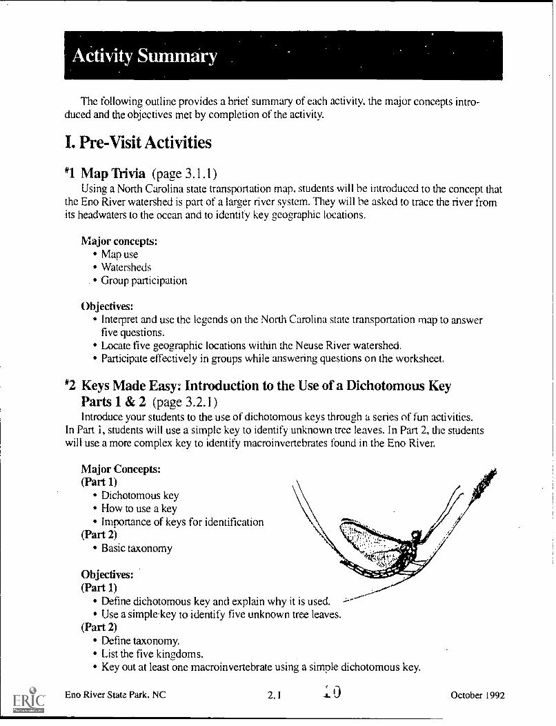
2. Activity Summary 2.1
3. Pre-Visit Activities#1 Map Trivia 3.1
#2 Keys Made Easy 3.2
4. On-Site Activities"1 Go With The Flow 4.1
'2 Mind Your p's and H's 4.2#3 Sediment: The "S" 4.3'4 Water Bugs 4.4
5. Post-Visit Activities'1 Fragile Waters 5.1
#2 Troubled Waters 5.2
6. Vocabulary 6.1
7. References 7.1
'8. Forms 8.1
9. Notes 9.1
6
iv

11 I
preserving and protectingr North Carolina's naturalresources is actually a rela-tively new idea. The seeds ofthe conservation movementwere planted early in the 20thcentury when citizens werealerted to the devastation of .
Mount Mitchell. Loggingwas destroying a well-knownlandmark the highest peakcast of the Mississippi. Asthe magnificent forests of thismile-high peak fell to theaxe of the lumbermen,alarmed citizens beganto voice their opinions.Governor Locke Craigjoined them in their effortsto save Mount Mitchell.Together they convincedthe legislature to pass a billestablishing Mount Mitchellas the first state park.
a
That was in 1915. TheNorth Carolina State ParksSystem has now beenestablished for more thanthree-quarters of a century.What started out as one smallplot of public land has growninto 59 properties across thestate, including parks,
Eno River State Park, NC
recreation areas, trails, rivers,lakes and natural areas. Thisvast network of land boastssome of the most beautifulscenery in the world andoffers endless recreationopportunities. But our stateparks system offers muchmore than scenery and recrea-tion. Our lands and waterscontain unique and valuablearchaeological, geological andbiological resources whichare an important part of ournatural heritage.
1
As one of North Carolina'sprincipal conservation agen-cies, the Division of Parksand Recreation is responsiblefor the more than 125,000acres that make up our stateparks system. The Divisionmanages these resourcesfor the safe enjoyment of thepublic, and protects andpreserves them as a part ofthe heritage we will pass onto generations to come. Animportant component of ourstewardship of these landsis education. Through ourinterpretation and environ-mental education services, theDivisibn of Parks and Recrea-tion strives to offer enlighten-ing programs which lead toan understanding andappreciation of our naturalresources. The goal of ourenvironmental educationprogram is to generate anawareness in all individtialswhich cultivates responsiblestewardship of V trth.
For more information contact:
N.C. Division of Parks andRecreation
P.O. Box 27687Raleigh, N.C. 27611-7687
919/ 733-PARK
October 1992

I..
Introduction to Eno River 'State ParkI
fforts to establish Eno./River State Park beganin 1965 when the city ofDurham proposed building.a reservoir on the Eno. In re-sponse, a group of concernedcitizens formed the Associa-tion for the Preservation ofthe Eno River Valley. TheAssociation was successful ingaining community supportfor its proposal that a statepark be established along theriver. In May of 1972, the stateof North Carolina approvedthe idea, and the city ofDurham withdrew its plansto construct the reservoir. By1975, 1,100 acres of land hadbeen acquired with the helpof the Association, the NatureConservancy and the Divisionof Parks and Recreation. To-day the park protects 11 milesof river and over 2,100 acresof associated land in Orangeand Durham counties.
Life In and Alongthe Eno River
Eno River State Parkprovides important habitat fora host of animals and plants.A mixture of steep rockyridges and bottomlands createsseveral distinct plant commu-nities. Many of the wildflow-ers and shrubs found in thepark are normally found inthe mountains and foothillsof North Carolina. Shrubs,including mountain laurel andCatawba rhododendron, andwildflowers, such as yellowlady's slipper, showy orchisand wild geranium, find suit-able habitat in the river valley.The river hosts 56 species offish. Two are unique to theNeuse (of which the Eno isa part) and Tar river basinsthe Roanoke bass and theCarolina madtom (a catfish).
Freshwater mussels,including the endangered greenfloater, and numerous aquaticmacroinvertebrates, are foundin the river. These wonderfully-adapted creatures can be usedas indicator species to monitorwater quality.
Water quality in the riveris presently good. The riveris classified as a public watersupply and is also suitablefor swimming, fishing andwading. Continuing develop-ment and water withdrawalsupstream give cause for con-cern about the river's quality.Only through sustainedvigilance and protectionefforts can the river's waterquality be preserved.
Heare ate hoot of NAM., ( an4.C I 1.511l pm. 1ft pern....
Eno River State Park, NC 1.2
Carolina madtom
October 1992

Introductiop to the Activity Packet forEno River State Park
NOTE: On-site activities,weather and river conditionspermitting, will be held on thebanks of the river and in theriver. Students will wade inshallow rocky areas. Theyshould dress appropriately (longpants and tennis shoes) andbring a change of clothing. Thestudents may encounter ticks,poison ivy and snakes, thoughthis is not likely as long asstudents stay in appropriateareas. Chemical reagents areused in water quality testing.Because misuse of thesechemicals can be hazardous.standard chemical protectionprocedures will be required.Goggles and rubber gloves willbe provided for all studentshandling testing kits. Thesemust be worn at all times duringtest procedures. The educatorwill assist in seeing that allsafety precautions are followed.It is also the responsibility ofthe educator to be aware ofspecial considerations, medicalneeds, etc. of participants andbe prepared to take appropriateprecautionary measures. Parkstaff should be informed of anyspecial considerations prior tothe group's arrival at the park.
rr he environmental edu-cation learning experi-
ence, Living Water, was de-veloped to provide hands-onenvironmental educationactivities for the classroomand the outdoor setting ofEno River State Park. Thiseducator's activity packet.designed to be implementedin grades 5 and 6, meets estab-lished curriculum objectivesof the North Carolina Depart-ment of Public Instruction.Three types of activities areincluded:
1) pre-:visit activities2) on-site activities3) post-visit activities
On-site activities will beconducted at the park, whilepre-visit and post-visit activi-ties are desi:ned for the class-room environment. Pre-visitactivities should be introducedprior to the park visit so thatstudents will have the neces-sary background and vocabu-lary for the on-site activities.We encourage you to use the
ta: 11.u.w ;..<s KtylMers"emoted ON panwnoco
Eno River State Park, NC
post-visit activities to reinforceconcepts, skills and vocabularylearned in the pre-visit and on-site activities. These activitiesmay be performed indepen-dently or in a series to buildupon the students' newly gainedknowledge and experiences.
The environmental educa-tion learning experience,Living Water. will expose thestudent to the following majorconcepts:
Water QualityIndicator SpeciesWater TestingWatershedsAquatic SamplingAquatic InsectPopulationsNatural ResourceManagementStewardship of NaturalResources
The first occurrence of avocabulary word used in theseactivities is indicated in boldtype. Their definitions arelisted in the back of the activitypacket. A list of the referencematerials used in developingthe activities follows the vo-cabulary list.
This document was designedto be reproduced, in pa.-1 or en-tirety, for use in North Carolinaclassrooms. If you wish tophotocopy or adapt it for otheruses, please credit the N.C. Di-vision of Parks and Recreation.
1 . 3 October 1992
9
Activity Summary
The following outline provides a brief summary of each activity, the major concepts intro-duced and the objectives met by completion of the activity.
I. Pre-Visit Activities
*1 Map Trivia (page 3.1.1)Using a North Carolina state transportation map, students will he introduced to the concept that
the Eno River watershed is part of a larger river system. They will he asked to trace the river fromits headwaters to the ocean and to identify key geographic locations.
Major concepts:Map useWatersheds
. Group participation
Objectives:Interpret and use the legends on the North Carolina state transportation map to answerfive questions.Locate five geographic locations within the Neuse River watershed.Participate effectively in groups while answering questions on the worksheet.
*2 Keys Made Easy: Introduction to the Use of a Dichotomous KeyParts 1 & 2 (page 3.2.1)Introduce your students to the use of dichotomous keys through a series of fun activities.
In Part i, students will use a simple key to identify unknown tree leaves. In Part 2, the studentswill use a more complex key to identify macroinvertebrates found in the Eno River.
Major Concepts:(Part 1)
Dichotomous keyHow to use a keyImportance of keys for identification
(Part 2)Basic taxonomy
Objectives:(Part 1)
Define dichotomous key and explain why it is used.Use a simplkey to identify five unknown tree leaves.
(Part 2)Define taxonomy.List the five kingdoms.Key out at least one macroinvertebrate using a simple dichotomous key.
Eno River State Park, NC 2. 1 J- October 1992

I/. On-Site Activities
#1 Go with the Flow (page 4.1.1)Gt.,( wet while taking physical measurements of the river. Students will use their
measurements to calculate water flow in the Eno River.
Major Concepts:Measurement of water flowHuman influence on water flowNatural influences on water flowHow natural and human influences affectaquatic life
Objectives:Calculate the rate of water flow using measurementsand a mathematical formula.List three human actions that affect water flow.List three natural influences on water flow.Describe the important relationship between waterquantity and quality.Describe three problems that can result from river waterquantity extremes.Describe three problems that can result from river water quality changes.Discuss at least two things people can do to help protect rivers and water quality.
leVW-oc.440--;;;,,, ";.
. ---V. ----- Ir.' la° 1.d.' ----. 0 .
,,,e....... ,..----- . -'' -- t 1we.... ge ..... "----. - '-
... 0.7 re° , . , -' c .... '...0.0 , t ...' ...".
_.....el, 4 . .....,... '
:4Y
-""
\ pro' 9 0
*2 Mind Your p's and H's - The Power of Hydrogen (page 4.2.1)Learn to measure pH by using hands-on methods to determine the pH values of several
different liquids including water from the Eno River.
Major Concepts:Water qualitypH testingpH range (acid-neutral-base)pH range that supports aquatic life
Objectives:Demonstrate the use of litmus paper and the LaMotte test kit for determining pH.Analyze samples to demonstrate pH range.List three natural influences which can affect the pH rating of a river.List three human influences which can affect the pH ratings of a river.Know the North Carolina Environmental Management Commission pH range for aquaticmacroinvertebrates.
1ST COPY MAIM
Eno River State Park. NC1
2.2 October 1992

#3 Sediment: The "S" Word (page 4.3.1)Through a simple experiment, students will learn one method of meascring sediment. Using
what they observe, students will discuss where sediment comes from, how it affects water qualityand ways to control sediment.
Major Concept:Water qualityObservation skillsMeasurements of sedimentEffects of sediment on aquatic life
Objectives:Demonstrate how to measure sediment levels using the Imhoff cones.Describe three ways sediment affects aquatic life.List three origins of sediment and three possible ways to control the level of sedimentin the river.List the most important causes of stream degradation in North Carolina today.
'4 Water Bugs (page 4.4.1)Get wet, have fun, and learn while doing it. Students will use different methods to collect and
identify aquatic organisms.
Major Concepts:Water qualityAquatic samplingIndicator speciesAquatic habitatsBasic anatomyAdaptationsSpecies identificationHuman influence on water quality
MA71.YI
.. 4u wit*hog. loom. orUewkap.
Objectives:Describe three characteristics of an aquatic macroinvertebrate.Identify three macroinvertebrates.Define indicator species.Name three indicator species and explain how they are used to determine water quality.Use keys and field guides to identify unknown aquatic specimens.Use a dissecting microscope.List three or more ways humans affect aquatic life.Describe the differences between nymph and larva.
Eno River State Park, NC
2
2.3 October 1992

2
111-
-11nr'
Post-Visit Activities
licColtrry Age. Hai,o 110I Mu* ham sal Isallos KN.n
gsrnsoad pecasoase
*1 Fragile Waters (page 5.1.1)Using a topographic map and land use cutouts, students will make decisions about the devel-
opment of a portion of the Eno River's watershed.
Major Concepts:Human impact on the Eno River watershedWater qualityLand use planning and its effect on the Eno and areas further downstreamResource management
Objectives:Evaluate the effects of different imaginary land uses on the Eno River watershed.Discuss and list five ways to minimize damaging effects in the Eno watershed.List two animal species endemic to the Neuse River and Tar River watersheds.
*2 Troubled Waters (page 5.2.1)After reading a story about the discovery made by two young river enthusiasts, students will
create their own ending. Optionally, the class can develop an action plan to correct an aquaticpollution problem in their community.
Major Concepts:Water pollutionProblem solvingCreative writingCause and effect relationships
Objectives:Identify two potential cause and effect relationships involving aquatic pollution.List and evaluate two alternative solutions to aquatic pollution.Create an action plan to reduce aquatic pollution.
Eno River State Park, NC
Ia. 3
2.4 October 1992

Pre-Visit Activity #1
k
nap Trivia
Curriculum objectives:
Grade S -'Communication Skills:listening and visual compre-hension, study skills.
'Guidance: competency andskill for interacting withothers.Math: measurementSocial Science: organize,analyze information, drawconclusions; use maps,participate effectively ingroups.
Grade 6 -'Communication Skills:listening and visual compre-hension, study skills.Math: measurement
'Social Science: organize andanalyze information, drawconclusions; use maps, par-ticipate effectively in groups.
Location: ClassroomGroup size:
30 students, class sizeEstimated time:
30-40 minutesAppropriate season: AnyMaterials:
Provided by educator:Map Trivia Worksheet(1 copy per group of4 students), current NorthCarolina transportation maps(1 map per group of 4 stu-dents). Maps are availablethrough your local tourismoffice or the:
N.C. Dept of Economic andCommunity Development
N. 'el & Tourism Division430 N. Salisbury St.Raleigh, N.C. 27603l-800-VISITNCor 919/ 733-4171
Educator's Information:his activity is designed toillustrate the concept that
the Eno River is part ofa larger river system. \.
Students will trace theriver from its headwatersto the ocean, using maplegends and identifying keygeographic locations alongthe water course. Studentswill participate in a groupactivity to obtain the answersfor the worksheets.
Provide otv North Caro-lina transportation map andone worksheet for every fourstudents.
Note: If your students usethe 1992/93 North CarolinaTransportation Map (golfcourse on cover), please havethe students use the scale ontheir worksheet. The scale onthe 1992/93 map is incorrect.
Have each group of stu-dents answer questions on theworksheet, using the map asa reference.
After the groups havefinished answering the ques-tions, have each group answerone of the questions andexplain how they got theanswer. Continue with eachgroup reporting their answeruntil all questions have beenanswered and discussed.
Eno River State Park, NC 3.1.1 1.4
Major Concepts:
Map useWatershedsGroup participation
Objectives.
Interpret and use thelegends on the NorthCarolina transportationman to answer fivequestions.Locate five geographiclocations within theNeuse River watershed.Participate effectivelyin groups while answer-ing questions on theworksheet.
October 1992

.
Map TriviaInstructions: Using the North Carolina transportation map, answer the following questions.
1. What is the name of thecounty where the Enc Riverbegins?
2. Name the countiessurrounding Orange County.
3, What is the name of thetributary that joins the Enonear Camp Butner?
4. List the counties the EnoRiver flows through beforebecoming the Neuse Rivernear Camp Butner?
5. Approximately how longis the Eno River?in milesin kilometers
6. What is the name of thereservoir into which the EnoRiver flows?
7. What is the name of theriver which eventually carriesthe water from the Eno to theocean?
8. What is the first townwith a population over 2.000through which the Eno Riverflows?
9. What is the name of thesound into which the waterfrom the Eno River flows?
10. Approximately howmany miles are therebetween Durham and NewBern in a straight line?
kilometers ?
11. List the state parks andrecreation areas located alongthe path that the Eno Rivertakes to the ocean?
12. What is the approximate. distance from Ranger. NC to
Wi ialchone NC?in milesin kilometers
70 70C 5
12124*Eno River State Park. NC
13. What is the map symbolfor park campsites?
14. List the towns or citieswith a population over 10,000that water from the Eno Riverflows past on its way to theocean?
15. What is the closestlatitude and longitude toEno River State Park?
16. New Bern is closest towhat latitude and longitude?
17. Name the points ofinterest (see map symbols)within three miles of the Enoand Neuse Rivers from EnoRiver State Park to New Bern.
18. Name the national forestfound along the Neuse River.
19. Name the river locatedwest and south of the EnoRiver near Burlington.
20. Near what large city doesthe river from question 19reach the ocean?
21. Name the river locatednorth and east of Falls Lake.
22. Near what city does the .
river from question 21 reachthe ocean?
SCALE Of WEIS 0411 INCH EQUALS APPROX I.1 MILES
SCAII OF KILOME TORS ONE IPEC.I EQUAL S APPROX ?I KILOMETERS
I MITI IS !DUAL TO I 609 RILOMITERS
3.1.2t)
October 1992r

A
Map Trivia
1: Orange County
2. Caswell, Person,Durham, Alamance,Chatham
3. Flat River
4. Two Orange andDurham
5. Approximately 33 milesApproximately 53 kilo-meters
6. Falls Lake
7. Neuse River
8. Hillsborough
9. Pamlico Sound
10. Approximately 120milesApproximately 193kilometers
Eno River State Park, NC
11. Eno River State Park,Falls Lake StateRecreation Area,Waynesboro State Park(on 92/93 or later maps),Cliffs of the NeuseState Park
12. Approximately 500milesApproximately 805kilometers
13. A tent
14. Durham, Raleigh,Goldsboro, Kinston,New Bern
15. 79 degrees latitude,36 degrees longitude
16. 77 degrees latitude,35 degrees longitude
17. Bennett Place, StagvilleCenter, ClemmonsEducational State Forest,Waynesboro State Park(on 92/93 or later maps),Cliffs of the Neuse StatePark, Caswell Memorial& CSS Neuse,TryonPalace
18. Croatan NationalForest
19. Haw River
20. Wilmington, NC
21. Tar River
22. Washington, NC
3.1.3 October 1992

A
Curriculum objectives:Grade 5 -
'Communication Skills:listening and visual compre-hension, study skills
Science: earth science,environment
Math: measurement
Grade 6 -Communication Skills:listening and visual compre-hension, study skills
'Science: earth science,environmentMath: measurement
Location: Classroom
Group size:30 students, class size
Estimated time:Part 1 - 20 to 30 minutes.Part 2 - 30 to 50 minutes.
Appropriate season: any
Materials:Provided by educator:
copies of the activity sheetsand a ruler (1 per student):"Key to 10 Common Leaves","10 Common Leaves", "KeyTo Common Macroinverte-brates Found at Fews Ford,Eno River State Park","Aquatic Life Illustrations"
Eno River State Park, NC
Major Concepts:Part 1:
Dichotomous keyHow to use a keyImportance of keys foridentification
Part 2:Basic taxonomy
Objectives:Part 1:
Define dichotomous keyand explain why it is used.Use a simple key to iden-tify five unknown leaves.
Part 2:Define taxonomy.List the five kingdoms.Key out at least onemacroinvertebrate usinga simple dichotomouskey.
An Introductionto the Use of aDichotomous Key
Educator's Information:
rr his two-part.activity1 introduces students to a
simple dichotomous key.Students will learn what adichotomous key is, why keysare useful and how to use asimple identification key.
Part 1 will give the studentan introduction to the use ofa simple key and why keys areuseful. In Part 2. the studentswill key out several macroin-
3.2.1 -11. 7
a
vertebrates, using the samekey that they will use at thepark in On-Site Activity '4 -
Water Bugs.
Instructions for Part 1:Have the students read the
Student's Information. Discusstaxonomy and how organismsare grouped into naturallyrelated groups. Define a keyand discuss why keys are use-ful. Explain how a key works.Separate the students intogroups of four or five. Handout copies of the "Key to 10Common Leaves." Next handout copies of "10 CommonLeaves." Have each groupwork through the key to iden-tify each of the 10 leaves. Asa class. go over the answersand discuss any difficultiesencountered.
Instructions for Part 2:Split the students into groups
of four or five. Hand eachgroup a copy of "Aquatic LifeIllustrations" and a copy of"Key To Common Macroin-vertebrates." As a class, workthrough the key to identifyanimal number 1 then havethe students work within theirgroups to identify the rest ofthe macroinvertebrates. Wheneach group is done, have eachgroup share how they identi-fied one of their macroinverte-brates. Discuss the difficultiesencountered and reinforcethe importance of keys.
October 1992

Siudent's Intormation:
rTaxonomy is the branch1 of biology that deals with
the classification of organ-isms into established catego-ries. The word, taxonomy,comes from the Greek wordsmeaning arrangement and law.Through taxonomy, organ-isms are arranged into relatedgroups based on similaritiesin morphology, anatomy,physiology, genetics, ecologyand distribution.
All organisms are firstdivided into large groupsknown as kingdoms. Thereare five kingdoms Monera,Protista, Fungi, Plantae andAnima lia. Each kingdom isthen split several more timesinto more closely relatedgroups until we finally get toa specific organism.
Eno River State Park, NC
Keys:
A key is an essential toolin the science of taxonomy.It is defined as an ordered listof significant characteristicsof a group of organisms usedto identify unknown organ-isms. Simply put, a key isa list of characteristics thatdescribe an organism. Keysare used by scientists andstudents to identify unknownorganisms. They often con-tain a combination of pictures,drawings and written descrip-tions.
Dichotomous Keys:
Most keys are dichoto-mous, meaning dividing orbranching into two parts. Adichotomous key, therefore,is a key that divides the char-acteristics that describe anorganism into two choices.At each level of the key, youpick the choice that bestdescribes the organism youare trying to identify.
3.2.2
How a Key Works:
Here's how a dichotomouskey works. A list of charac-teristics is arranged as a seriesof either/or statements. Foreach pair of statements, onlyone will be a correct descrip-tion of the unknown organ-ism. For example, if youwere handed a leaf froma pine tree to, identify, youwould start at the top of thekey with these two choices:
1. Leaf long andneedle-like or
2. Leaf not needle-like.
A pine needle is longand needle-like so you wouldchoose statement 2 and con-tinue to the next choice underthat side of the dichotomouskey.
October 1992

CJ
'Key
to10
omm
on. L
eave
s
Lea
f lo
ng&
nee
dle
-lik
e
Lea
ves
in g
roup
of
2;le
ss th
an 1
0 cm
long
Lea
ves
in g
roup
of
3;m
ore
than
10
cm lo
ng
Shor
tleaf
pin
eL
oblo
lly p
ine
(Tre
e L
eave
s)L
eaf
not n
eedl
e-lik
e
Lea
f w
ith lo
bes
Edg
e of
leaf
with
out t
eeth
Edg
e of
leaf
with
teet
h
1
Lea
f w
ith 5
lobe
s;pe
tiole
3.5
cm
or
long
er
1
Lea
f w
ith 3
lobe
s;pe
tiole
sho
rter
than
3.5
cm
Swee
t gum
Red
map
le
Petio
le o
f le
af1
cm o
r lo
nger
Petio
le o
f le
af le
ssth
an 1
cm
Whi
te o
ak
Lea
f pe
tiole
less
than
2 c
m
Sass
afra
s
Lea
f pe
tiole
long
erth
an 2
cm
Tul
ip p
opla
r
Cen
timet
ers
1121
3141
5161
7181
9110
111
112
1
3141
5In
ches
Lea
f w
ithou
t lob
es
Lea
f ed
gew
ith te
eth
Lea
f w
ithou
t tee
th
Eac
h to
oth
with
spi
neA
mer
ican
hol
ly
Tip
Wav
y-ed
ged
Will
ow o
ak
Tee
th w
ithou
t spi
nes
Riv
er b
irch
Fin
e-to
othe
d
--(C
oars
e-to
othe
d
Sin
gle-
toot
hed
AN
Dou
bled
-too
thed
-...
Bla
de
Sin
us
Lobe Vei
n
Mid
ribLe
af B
ase
Pet
iole

10 Common Leaves
1.
4.
2.
5.
6.
7. 8.
Eno River State Park. NC 3.2.4 ti
10.
October 1992

Key
TO
FoU
ndom
mon
Mac
roili
veile
brat
est F
ews
Ford
, Eno
Riv
er S
toPa
rk
Dou
ble
shel
l
She
ll ne
arly
uni
form
in s
hape
(ro
unde
d)
Fre
shw
ater
cla
m (
M)
She
ll lo
nger
than
wid
e
With
she
lls
Mac
roir,
erte
brat
es
Sin
gle
shel
l
Spi
ral s
hell
Fre
shw
ater
mus
sel (
I)P
ouch
sna
.: ;!)
i
Tw
o pa
irs o
f win
gsex
tend
ing
over
abd
omen
1
iI
Bee
tle-li
keT
hin
body
with
wid
eap
pear
ance
spre
ad le
gsI
i
With
out s
hells
Coi
led
shel
l
Ram
shor
n sn
ail (
I)
Lege
ndP
ollu
tion
Tol
eran
ceIn
dex
Val
ue
( I )
- In
tole
rant
Gro
upI
(M)
- M
oder
ate
Gro
up II
(T)
- T
oler
ant
Gro
up II
I
Obv
ious
legs
Thr
ee p
ails
of l
egs
it
Hin
dle
gsA
ctiv
e on
shor
tw
ater
sur
face
Whi
rligi
g be
etle
adul
t (M
)W
ater
str
ider
adul
t (M
)
Hin
d le
gs lo
ng
Sw
ims
on b
ack
two
long
oar
-like
legs
1N
o w
ings
Ent
ire b
ody
soft/
cylin
dric
alB
ody
with
har
dene
dex
oske
leto
n, fl
atte
ned
Mor
e th
an th
ree
pairs
of l
egs
Act
ive
wat
er ._ -,.
Wat
er s
corp
ion
adul
tunde
rsu
rfac
e
. \ (M)
No
appe
ndag
essm
allBod
y w
hite
to g
reen
ish
with
or w
ithou
t a p
orta
ble
case
eff'.
34#
1411
1Num
e.
Cad
disf
ly la
rva
(I)
Bod
y da
rk, h
ead
with
prom
inen
t pin
cher
s
gill
tufts
at b
ase
ofla
tera
l app
enda
ges
Dob
sonf
ly la
rva
(I)
tail-
like
Tai
lIlik
eap
pend
ages
roun
d!
Tw
ota
iled
Cra
wls
on
rock
s,bl
ack
body
Bac
ksw
imm
er a
dult
(M)
Riff
le b
eetle
adu
lt (M
)
Wat
er p
enny
Riff
le b
eetle
larv
a (I
)
Long
con
spic
uous
tail
appe
ndag
es
Tai
l app
enda
ges
bnst
le-li
ke
Sto
nefly
nym
ph (
I)--
-4.1
0419
t
May
fly n
ymph
(I)
Cat
erpi
llar-
like
Dis
tinct
hea
d,N
o di
stin
ct h
ead,
bod
y B
ody
with
enla
rged
abd
omen
tape
red
at b
oth
ends
suc
tion
disk
sat
bot
h en
ds
No
obvi
ous
legs
Wor
m-li
ke Bod
y w
ithou
tsu
ctio
n di
sks
Bla
ck fl
y la
rva
(T)
Cra
ne fl
y la
rva
(M)
Leec
h (T
)F
resh
wat
er w
orm
(T
)
no g
ill tu
fts
1F
ish
fly (
I)
Lobs
ter-
like
rl
Cra
yfis
h (M
)
Tai
l app
enda
ges
broa
d &
oar
-lik
e
Dam
selfl
y ny
mph
(M
)
Sho
rt in
cons
picu
ous
tail
appe
ndag
es
Dra
gonf
ly n
ymph
(M
)
Shr
imp-
like
body
flat
tene
dto
sid
e, s
wim
s w
ith le
gs
Cs
Scu
d (M
)
G IM
FK
ra k
m, A
N 1
.1.,4
1,1,
61N
rol

Aquatic Life Illustrations
T.
If 11 V 1, p
t 511,
"" '6 A. St s C
4

A
1. ttillolt. oak 2. Sassafras3. Sweet fnun
4. Si/or/leg/pine
7. American holly
5. Tulip poplar6. River birch
8. White oak
Eno River State Park, NC 3.2.7 0 ,.. October 1992

Answer Sheet to Aquatic Life Illustrations.
2. crayfish
.0 .)
.11
1 .
5. freshwater mussel.0 art. Agrow< kamel,
O In, Mow.
sal Br.Y Pololober...rEno River State Park. NC
1. backswirnmer adult
4. stonefly nymph
3.2.8
3. water penny
6. leech
kepnnted by pernusilon
October 1992

()n-Site Activity #1'I'
Go With The Flow
Curriculum objectives:
Grade 5 -'Communication Skills:listening and visual compre-hension.
Guidance: competency andskill for interacting withothers.
'Healthful Living: recre-ational safety.
"Math: measurement, prob-ability and statistics.
'Science: earth science,environment.
'Social Science: organizeand analyze information,draw conclusions; partici-pate effectively in groups.
Grade 6 -'Communication Skills:listening and visual compre-hension.
'Guidance: competency andskill for interacting withothers.
'Healthful Living: environ-mental health, recreationalsafety.
Math: measurement, prob-ability and statistics.
Science: ecology.'Social Science: organizeand analyze information,draw conclusions; partici-pate effectively in groups.
Location:Fews Ford Access Area
Group size: 8 students
Estimated time: 20 minutes
Appropriate season:April through October
Eno River State Park. NC
Materials:
Provided by park:life jackets, throw ropes,100 ft tape measure, metalyardstick, stopwatches,tennis balls, boundary ropes,charts, activity sheets, clip-boards, pencils
Provided by educator:worksheets (one per student),pencils
Special considerations:See the safety message onintroduction page 1.3.
Calculating WaterFlow in the Eno River
Major Concepts:
Measurement of waterflowHuman influences onwater flowNatural influences onwater flowHow human and naturalinfluences affect aquaticlife
Objectives:
Calculate the rate of waterflow using measurementsand a mathematical for-mula.List three human actionsthat affect water flow.List three natural influ-ences on water flow.Describe the importantrelationship betweenwater quantity and quality.
Describe three problemsthat can result fromriver water quantityextremes.Describe three problemsthat can result fromriver water qualitychanges.Discuss at least twothings people can do tohelp protect rivers andwater quality.
McCallar. berys. Frtvorbtor,C bob. /ow ard Ibbblatten
....mod by rennimuk
(1:1I
4. 1 . 1 October 192

I n this activity, the studentswill learn a simple method
for determining water flow.They will then use this infor-mation to explore the waysthat water flow and waterquality are affected by humanand natural factors. They willalso be asked to think of waysthey can influence local gov-ernment to protect waterquality.
To prepare your students fortheir visit we recommend thepre-visit activity, Map Trivia.
Have students read Student'sInformation. Discuss thisinformation in class prior toyour visit.
Instructions:
a
4. Select four students to mea-sure the rate of flow. Havetwo students, each with a ball,go to the upstream end of theflow space. Have two otherstudents, each with a stop-watch, go to the downstreamend of the flow space. Thestudent with ball '1 shouldplace it in the river upstreamfrom the beginning of the flowspace and hold his/her hand inthe air. As the ball passes thebeginning of the flow space,he/she quickly drops his/her
a
hand. This is the signal for thestudeit with stopwatch '1 tostart the stopwatch. The stop-watch is stopped the momentthe ball passes out of the flowspace. He or she will thenretrieve the ball, and they willrepeat this four more times.The students with ball #2 andstopwatch '2 will follow thesame procedure. The otherstudents will record the flowrates on their worksheets as thestudents with the stopwatchesannounce them.
1. Lead a brief discussionconcerning the importance ofwater flow in maintainingwater quality. Explain that inthis activity, the students willlearn how to calculate waterflow and thus he able to evalu-ate this aspect of the EnoRiver's water quality.
2. Explain the method formeasuring water flow andsafety procedures that must befollowed.
3. Select three students toget in the water. Have twostudents measure the lengthand width, and one studentmeasure the depth of the flowspace. Have the other studentswrite down the measurementson their worksheets.
wecsi,tvt.w`c°"`,cc4
\,c)c,0 "t
o
scot, -o' c.00
wo"no
.,r+V
1+ 1.40^s-
0.1614-si'*"OW4cor
rtstt
GOslot
occ)"°t1''Vol1`141
c-sgc"$teq:c
Nft
k41%\ -%41. se. 41.
c17::
0
Eno River State Park. NC 4.1.2
C)0.4 C1111
EST COPY AVAILABLE
October 1992

5. Have all the students deter-mine the four averages andthen calculate the water flowrate in cubic feet/second. Dis-cuss these results and whatthey might mean-to the EnoRiver's water quality.
6. Lead a discussion of factorsthat affect water flow (naturaland human), and how thesefactors in turn affect aquaticlife. (Natural factors affectini-zwater flow include drought,flooding and natural stream
Eno River State Park, NC
obstruction, i.e., beaver damsor log jams. Human activitiesinclude dams, irrigation, andindustrial use. These naturaland unnatural water controlscan adversely impact aquaticorganisms by reducing waterflow and decreasing waterquality.)
7. Ask the students how theycan influence the governmentto protect our water resources.Be sure to emphasize theimportance of everyone being
involved in caring for ourresources (stewardship). TheEno River Association is anorganization that exemplifiesstewardship. If time allows,the leader will briefly explainhow the park was createdwith the help of the Eno RiverAssociation.
4.1.3 October 1992

Student's. Information: Water Flow
Water flow refers to theamount of water mov-
ing in a river or stream. Someof the ways that we expressthe rate of flow are gallons persecond, cubic feet per secondor acre feet per second (anacre foot is equal to one acreof water one foot deep or325,850 gallons of water).Thefollowing exercise will showyou how to estimate waterflow in cubic feet per second.Why is this important? Readthe following story and dis-cover why water flow is suchan important concept.
The river is the Colorado. Itbegins in the Colorado Rockiesand empties 1,450 miles laterinto Mexico's Gulf of Califor-nia. The Colorado provideswater fOr seven western states.This includes water for humanconsumption as well as irriga-tion for farms and domesticlivestock. The Colorado is oneof the most controlled rivers,in the world; it has scores ofdams, hundreds of miles ofaqueducts and tunnels, dozensof pumping stations, thousandsof miles of canals, and morethan 30 hydroelectric plants.Water is pumped from theColorado to cities like SanDiego, California; Las Vegas,Nevada; Denver, Colorado andPhoenix, Arizona. Each year16.5 million acre feet of waterare diverted from the Colorado(multiply 16.5 million times325,850 to see how many gal-lons are taken from the river
Eno River State Park, NC
each year). Sometimes thewater level is so low thatrafters can not run certainrapids in the Grand Canyon.
Dams above the canyoncontrol how much watermoves through the canyon.This has had a big impacton aquatic life. For example,before the Colorado wasdammed, the river flowedcold and carried lots of mudand silt during the springfloods and slowed to a warmclear trickle in the fall. Nativeaquatic species were welladapted to these specific con-ditions. Now dams trap sedi-ment in huge reservoirs andconstantly release clear coldwater from the bottom of thelake. This creates excellenthabitat for introduced species,like trout, but is contributingto the near extinction of sev-eral native species of fish thatdo not tolerate the cold water.
By the time the ColoradoRiver reaches the Gulf ofCalifornia there is barely atrickle, and at times the riverdries up before it reaches thegulf. Even if there is waterflowing, evaporation hascaused it to become so saline(at this point the salt contentaverages 700 parts per mil-lion) that it is much too saltyto use for irrigation.
A huge delta and estuaryat the mouth of the Coloradoused to be one of the mostproductive in the Southwest,but a decrease in water flowhas caused that to change.In 1922 ecologist AldoLeopold explored the delta.He described it "as a milk andhoney wilderness whereegrets gathered like a prema-ture snow storm, jaguarsroamed, and wild melonsgrew." Since that time twomarine animals have becomeendangered, one a porpoiseand one a large fish called atotoaba. The totoaba spawnedin the estuary, and the tidecarried their eggs up into thenatural nursery of the delta.According to saltwateragronomist Nicholas Yensen,"the river was like the Nile inits importance to the delta,unknown species may havedisappeared- as a result of thedecrease in water flow.
304.1.4 October 1992

Water Flow BasicsYou might be surprised
to learn that even the Eno isaffected by low water flow.Such conditions can haveadverse effects on the entireaquatic community.
When water levels arelow, the water temperaturecan increase and result inless dissolved oxygenbeing available. This canbe dangerous to macroin-vertebrates and fish.
Algae can spread rapidlyduring, low water flow,and it uses tremendousamounts of oxygen as itdecays. Fish kills canoccur because of insuffi-cient dissolved oxygen.
.- _st s';
-
During low water levelsthere is less habitat forriver animals, and theybecome more vulnerableto predators.
Last but not least, youmight be forced to con-serve water during lowflow periods to make sureyou have enough to drinkand bathe.
We have talked a lot aboutlow water levels but high flowlevels affect us also. Heavyrains wash exposed soil intothe river. This sediment cansuffocate macroinvertebrates,kill fish eggs, and alter habi-tat. A lot of towns and citiesdivert rain water into storm
. .,
. . i ... k 1 k"1 ' . ... ................Z: A" st........"..
-,. . :' 2 ,.. 1 :. k.....Z.N.". ZZ..1 PP - '."''--: -,;1-- k
''%.:1$, " .....:kC'": C
\.- ..<.-- \' .(:. 1.-
- ...!-' '.
1 ; `z ' '" \ ".\\-\ '. k-.:. -. t \i'. ...'. .. \ ." r'7-: 1' ''''-
. - N.... -'s \ ' '-2;
,;I...I!' l `I 4 ' st44t..:" ' ' t. ..... ... . '
'e-....:
i .4-. N ' -0.
s .....,._ -,.' --: .'t ' .. -CN ' ;, \ -; 1.. 1.:7. A, ....1_ t, / 1' ;..e1-... 3: .i. .,.. ..4,3_..i, .... .., &
---.... 1-..4......:., .7., .4... ..,a .>,.. ....,.,. ,---
.._---.
. .'. ,.. \....,s, ..."Y.; 0..0 '... 2.0 .....
1 7 '-4------ .(:-.. ' \4:- -;, ;#-..\-.:-,,\'`'A.', 7,;:r74_ ,
.......,
,.._ ..... _
-;--, - __r-n- --; (-... -1 : ; -. ' 3. a ,7-1 ..4:; .
..... ..- .57" --7--.. ';- .7-.- ' .-: i 4.c - --*
drains that empty into rivers.This storm water brings allkinds of nasty things into theriver: vehicle oil and gas frompavement; chemicals usedin fanning and lawn care;overflow from waste watertreatment plants; and trashfrom dumps and othersources.
As you can see, water flowis very important to us. Usingwater wisely and protectingour river's watershed fromunwise use are two ways wecan help maintain a healthyand more natural water flow.
..... .
.v.% -
_ -
to-
Eno River State Park, NC 41531
HC140, 40.0.0 1011 boom I. we am MAY P00...
14,00.11m 100000a
October 1992

cubic7771
Worksheet for On-Site Activity #1
How To CalanateWater Flow
Average length of flow space 0- Average depth of flow space
Average width of flow space 0- Time of flow through space
Solving for 0 = water flow rate in cubic ft./sec.
Equation:10x0x0-0
Average length of flow space
North bank ft. + South bank ft. = + 2 = in
Average width of flow space
Up river ft. + Down river ft. = + 2 = ft.
Average depth of flow space
1 in. +2. in. + 3. in. + 4. in. + 5. in. =
E Illr]dr= in. + 12 in. = ft.
eAverage rate of flow through flow spaceBall 1
1. sec.+ `). sec. +3. sec.+4. sec. + 5. sec.= [ se]Ball 2
1. sec.+ 2. sec. + 3. sec.+4. sec.+ 5. sec.= sec]
[Ball 1 sec] +ft3all 2 sec] 10= sec.
Equation: ft. x
O 0ft. x ft. + sec. =
0
Eno River State Park. NC 4.1.6 a2 October 1992

oz.
Answer Sheet for On-Site Activity #1. (An Example)
How To Calculate WaterFlow
Average length of flow space 0- Average depth of flow space
Average width of flow space TimeTime of flow through space
Solving for = water flow rate in cubic ft./sec.
Equation: 0 x t + 0= 0
O Average length of flow spaceNorth bank 80 ft. + South bank 95 ft. = 175 :
O Average width of flow spaceUp river 75 ft. + Down river 83 ft. = 158 ± 2 = I 79 ft.
87.5 it.
1
Average depth of flow space
E1. 10 in. + 2. 18 in. + 3. 24 in. + 4. 12 in. + 5. 6 70
OAverage rate of flow through
Ball 1
70+ 5 = 14 in. + 12 in. 1.17 ft.
flow space
1. 20 sec.+2. 22 sec.+3. 18 sec.+4. 23 sec.+5. 21 sec.= [104 se
Ball 2
1. 21 sec.+ 2. 26 sec.+3. 24 sec.+4. 21 see.±5. 22 sec.= [114 se]
Ball 1 104 se] 4-[all 2 114 sec] ÷ 10 = 21.8 sec.
Equation: 87.5 ft. x 79 ft. x 1.16 ft. + 21.8 sec. = 367.82 cubic ft./sec.
0 0 0 0 0Eno River State Park, NC 4.1.7 4).3 October 1992

On-Site Activity #2 Mind Your p's' and H's
Curriculum objectives:
Grade 5 -'Communication Skills:listening and visual compre-hension
Healthful Living: schoolsafetyMath: measurementScience: earth science,environment
Social Science: organize,analyze information, drawconclusions
Grade 6 -'Communication Skills:listening and visual compre-hension
Heakhful Living: environ-mental health, home safety
'Math: measurement'Science: ecology'Social Science: organize,analyze information, drawconclusions
Location:,Fews Ford Access Area
Group size: 8 studentsEstimated time: 20 minutesAppropriate season:
April to October
Materials:Provided by the educator:
pencils, student worksheet(one copy per student)
Provided by the park:test paper, LaMotte Test Kit,"pH Ranges That SupportAquatic Life" poster, "SamplepH Range" poster, sample .items (distilled water, EnoRiver water , vinegar, lemonjuice, Liquid Plumber Tm ,RolaidsTM, Coca- ColaTM,soap, Formula 409TM,baking soda)
Eno River State Park, NC
Major Concepts:
Water qualitypH testingpH range(acid- neutral -base)pH range that supportsaquatic life
Objectives:
Demonstrate the useof litmus paper and theLa Motte test kit fordetermining pH.Analyze samples todemonstrate pH range.List three natural influ-ences which can affectthe pH rating of a river.List three human influ-ences which can affectpH ratings of a river.Know the North CarolinaEnvironmental Manage-ment Commission pHrange for aquatic macro-invertebrates.
Special considerations:Chemical reagents are
used in water quality testing.Because misuse of thesechemicals can be hazardous,standard chemical protectionprocedures will be required.Goggles and rubber gloves willbe provided for all studentshandling testing kits. Thesemust be worn at all times dur-ing test procedures. The educa-tor will assist in seeing that allsafety precautions are followed.
4.2.13 4
The Power ofHydrogen
Educator's Information:
T n this activity, studentsI will test the pH of severalhousehold products, as wellas river water. Park staff willlead a discussion focusing onhow the pH scale works,what pH ranges aquatic lifewill tolerate. and natural andhuman influences which canchange pH. The students willuse litmus paper to test the pHof several items and recordtheir results on the "SamplepH Range" worksheet. Theywill also use a LaMotte testkit to test the pH of distilledwater and Eno River waterand record their results on the"Sample pH Range" work-sheet. Park staff and studentswill discuss their results andcompare them to the "pHRanges That Support AquaticLife" poster. They will notethe extreme ranges of thesamples and be able to deter-mine which animals mightbe able to live in water withthose pH's.
Have the students read theStudent's Idol:nation prior tothe park visit.
October 1992

Instructions:
1. Review the pH informationprovided in the Student's In-formation. Discuss what theterm pH means and how it ismeasured. Be sure to use anexample, such as if there wasa change in a river's pH from6 to 5, it would mean that theriver is now 10 times moreacidic; from 6 to 4 would meanit is 100 times more acidic.
2. Have two students test thepH of the Eno River waterusing the LaMotte Test Kit.Have one student read how itis done from the instructionswith the test kit while the otherstudent does the test. Havethe students then test the pHof the distilled water and thepH of the rain water using theLaMotte Test Kit.
3. Discuss the results, reinforc-ing the Student's Information.(The Eno River water shouldfall between 6.0-9.0 to meetthe North Carolina standardsfor freshwater. Generally, thepH falls between 6.5-7.5, thebest range for macroinverte-brates).
Review how aquatic lifeis affected by pH. Be sure tocover the concept of toleranceranges for different organisms.Use an example such as theone on mayfly nymphs. Also,discuss the range of pH toler-ance found on the "pH RangesThat Support Aquatic Life"poster.
Eno River State Park. NC
4. Discuss with the studentsthat the rain water, collectedin a park rain gauge, will havea varying pH. (Results for thepark have been from 5.4 to6.5.) Review the acid precipi-tation section of the Student'sInformation. Emphasize thatrain is naturally acidic, witha pH around 5.5. Rain isbuffered by the soil, resultingin stream water with a pHbetween 6 and 8. Note thatthere are naturally acidicbodies of water, particularlyin the eastern part of the state.Finally discuss what acid pre-cipitation is, where it comesfrom, and what types ofchanges it can cause to thepH of the stream water.
5. Discuss other ways the pHof streams is changed, rein-forcing the Student's Informa-tion, particularly:
pH increases with in-creases in effluent fromsewage treatment plants(effluent is high in am-monia which neutralizesacids)pH increases withphotosynthesis in plants(photosynthesis removescarbon dioxide, CO)pH increases withaeration by riffles andrapids (aeration addsoxygen, 0,)pH decreases with anincrease in rainfall (rainwater is typically moreacidic)
pH decreases withdecomposition of plants(decompositionremoves 02)pH decreases with respi-ration (animal breathingreleases CO,)
6. Discuss the pH of house-hold products (the pH ofmany products used for clean-ing is basic, while the pH ofitems that taste sour is acidic).Explain the test procedureusing litmus paper. Note thatlitmus paper can test a broad,range of pH and that eachlitmus paper type covers aspecific range within the pHscale.
7. Have one student comeforward and pick a product totest. Prior to testing, have thestudent decide if the productw;11 be basic, acidic or neutral.Have the student select a stripof litmus paper from within therange they think appropriateand place it in the product.Match the color on the litmuspaper chart. Discuss theresults and have the studentmark the class poster. Allstudents should mark theirown worksheet.
354.2.2 October 1992

8. Continue this process untilall products are tested.
To test RolaidsTM, soap andbaking soda, dissolve the prod-ucts with an equal amount ofdistilled water. Remind thestudents that pure, deionizedwater contains equal numbersof H+ and OH- ions and is con-sidered neutral, pH of 7. Notethat this will slightly buffer thetrue pH of these products, butthe products will still provideexamples of basic pH's. Pointout that RolaidsTM and bakingsoda are both basic (pH of 9)and that baking soda could beused for acid indigestion justas well as Rolaidsrm. Discusssome of the foods that give usacid indigestion.
Eno River State Park, NC
[Pizza (tomatoes), chili (toma-toes), orange juice (citric acid),etc.] We, too, are living organ-isms and can not toleratedrastic changes in pH! To test"you," have a student placethe tip of a strip of paper on hisor her tongue. Have the classdecide if the student is acidic,basic, or neutral prior to thetest.
9. Sum up the activity byemphasizing that aquatic lifeis affected when the pH variesa great deal from neutral.
A change in the pH of ariver can be one of the firstindicators of water qualityproblems and can quicklyaffect the aquatic life in the
stream. The Eno River istested each month for pH, dis-solved oxygen, temperature,water flow and macroinverte-brate population and diversity.These tests are done by theRiffle and Pool Naturalists,a Streamwatch group that hasadopted the Eno River. Thisvigilant testing of the riveridentified a chemical spillwhich put the pH over 12 fora period of time. It has alsoprovided data to help establishwater flow regulations con-trolling the amount of waterthat can be removed from theriver. The Eno River fortu-nate to have so many goodstewards!
4.2.3 October 1992

Student's Information: Mind Your p's and H's
T he term pH means (p)owerof (H)ydrogen ion activity.
Scientists use the pH scale todefine the degrees of acidity/basicity in soil and water. Onone end of the scale, a pH of0 is extremely acidic (manyhydrogen ions, 11+), whereas atthe other end of the scale, a pHof 14 is extremely basic (manyhydroxide ions, 0H-). A pHof 7 is neutral (equal numbersof H+ and OH- ions), beingneither acidic nor basic. pH ismeasured on a logarithmicscale with each number repre-senting a factor of ten. Thus,a change in a river's pH from6 to 5 means that the river isnow 10 times more acidic:from 6 to 4 means it is 100times more acidic.
North Carolina has estab-lished water quality standards.For all freshwaters, exceptswamps, the acceptable pHrange is 6.0 9.0 (swamps canhave a pH as low as 4.3).
Aquatic life is affected whenthe pH varies a great deal fromneutral. Different organismstolerate varying ranges of pH,and the population of aquaticorganisms will change if thepH changes favor certainspecies. For example. mayflynymphs do best when the pHis around 6.5, but they usuallycan not survive if the pH dropsbelow 5.0. Most macroinver-tebrates do best if the pH isbetween 6.5 and 7.5.
The pH of rainfall is natu-rally acidic, usually registering
from 5 to 5.5. However, manysoils are somewhat basic and"buffer" the rainwater byraising its pH, making it lessacidic. As a result. despite thepH of non-polluted rain beingaround 5.5, the pH of moststream water is between 6and 8. However, you can findnaturally acidic water inswamplands, bogs and black-water rivers in the eastern partof the state. There, the soilscontain large amounts of peat(partially decayed plant mate-rial) which is acidic.
Some acidic waters are notnatural, but the result of acidprecipitation. Acid precipita-tion falls in the form of rain,snow, fog, sleet and hail. Theacidity results primarily fromthe mixing of water vapor withsulphur dioxide (from coalburning power plants) and ni-trous oxides (from cars andtrucks) in the atmosphere.Acid precipitation can causechanges in the pH of ourwaterways.
The pH of water increases(becomes more alkaline orbasic) with increases in the fol-lowing: effluents from sewagetreatment plants (the effluent ishigh in ammonia), photosyn-thesis in plants (photosynthesis
removes carbon dioxide, CO,),and aeration by riffles and rap-ids (aeration adds oxygen, 0,).
The pH of water decreases(becomes more acidic) witheach of the following:increases in rainfall (allowinglittle or no buffering from thesoil), decomposition of plants(decomposition removes 02)and respiration (animal breath-ing releases CO.,).
Changes in pH can givevaluable clues to water qualitychanges. A pH change, eitheran increase or decrease, maybe an indication of biologicalprocesses such as decom-position of organic matter,photosynthetic activity or anincrease/decrease in pollutantlevels.
Monitoring the pH of ourstreams and rivers is of greatimportance. It is one of themethods we use to determinethe health of Our v aters.Through monitoring, we candetect extremely high or lowpH's that would kill mostaquatic organisms. It can alertus to changes in our waterquality and help us to protectour waters by giving us cluesto the source of the changes.
pH ScaleAcid
0 1 It 2
0NG
Base3 4 [5 8 11 8 9 10 11 12i 13 14M W N WO E E EO A U AE K T KRA A
R
T LE
M0E
A
E
S
0NG
Eno River State Park, NC 4.2.4 October 1992

Worksheet-for On-Site Activity #2
Sample pH RangeAcid
1 2 3 4 5Neutral
8 9 10 11
Base12 13 146 7
H2O (Distilled)
H2O (Eno River)
H2O (Rain)
Vinegar
Lemon Juice
1
Liquid Plumber'
Yourself
Rolaids'
Coca-Cola'
Baking Soda
Formula 409'
Soap_
Eno River State Park. NC 4.2.5 38 October 1992

pH R
ange
s T
hat S
uppo
rt A
quat
icL
ife
Aci
dic
2N
eutr
al6
7B
asic
910
1112
1314
Bac
teri
a
Plan
ts(a
lgae
, wat
er-w
illow
,ar
row
head
)
Cat
fish
, Suc
kers
, Car
p,so
me
inse
cts
Bas
s, C
rapp
ie
Mus
sels
, Sna
ils, C
lam
s
Lar
gest
Var
iety
of
Ani
mal
s(m
ayfl
ies,
sto
netli
es,
cadd
isfl
ies)
Ltit
(tltI
ttAttt
iKto
NiN
t4N
\ktit
itt\t4
'N\*
b.ba
wbi
wbi
,w
39

A
Curriculum objectives:
Grade 5 -'Communication Skills:listening and visual compre-hensionMath: measurement
Science: earth science,environment
'Social Science: organize andanalyze information, drawconclusions
Grade 6 -'Communication Skills:listening and visual compre-hension
Healthful Living: environ-mental health
"Math: measurement'Science: ecologySocial Science: organize andanalyze information, drawconclusions
Location:Fews Ford Access Area
Group size: 8 studentsEstimated time: 20 minutesAppropriate season:
April to OctoberMaterials provided by park:
Imhoff Cones (2), 2000 ml ofwater with high suspendedsolids level
Major Concepts:
Water qualityObservation skillsMeasurements ofsedimentEffects of sediment onaquatic life
Eno River State Park, NC
Objectives:
Demonstrate how tomeasure sediment levelsusing the Imhoff cones.Describe three ways sedi-ment affects aquatic life.List three origins of sedi-ment and three possibleways to control the levelof sediment in the river.List the most importantcauses of stream degra-dation in North Carolinatoday.
Educator's Information:
Tn this activity, students willlobserve and determine theamount of sediment in thetest cones. They will discussthe origin of sediment, howsediment is tested in streamsand lakes, and the effect ofsedimentation and turbidityon aquatic life.
Instructions:
1. Park staff will prepare a1,000 ml sample of sediment-laden water in an Imhoff coneprior to the arrival of thestudents.
2. When the studentsarrive the group leader willdiscuss sediment and turbidity.At this point, the leader willpour another 1,000 ml ofsediment-laden water into asecond Imhoff cone.
4.3.1
a
3. Have the students com-pare the two samples andobserve that the second conecontains more suspended sedi-ment; the larger particles aresettling to the bottom, and thewater near the surface of thecone is clearing. The first conecontains layc7S of sediment onthe bottom; the water appearsuniform in clarity from thesurface to the first layer ofsediment. Ask the students toexplain why the water in thefirst cone is less turbid. (Thewater in the first cone is lessturbid because it had time tosettle and has not been dis-turbed - like a quiet pool.)
4. Ask the students wheresediment comes from, itseffect on aquatic life, andways to control sediment ina watershed. Go over the keypoints from the Student's In-formation, stressing that somesediment is natural, but thatmost of the heavy sedimentwe see in our streams is dueto human activities. Have thestudents list several animalsor plants which might be dis-turbed or killed due to heavysediment loads. Then havethem list ways that sedimentcould be controlled. Encour-age them to suggest anypersonal actions they couldtake to decrease the sedimentrunoff into our waters.
October 1992

ormation: Sedimen The "S" Word
Sedimentation and turbidityare the major causes of
stream degradation in NorthCarolina today. Sediment clogsfish gills, destroys habitatneeded for egg-laying, blockssunlight, carries pollutants andburies plant life.
Sediments are solid materi-als, usually soil particles, thatsettle to the bottom of a river,stream or lake. As a rule,particles of silt, clay and or-ganic materials settle to theriver bottom, especially inimpounded or slow-movingstretches of river. Thesesettled particles (sedimenta-tion) can accumulate andsmother the eggs of fish andaquatic insects that were laidon the river bottom. Sedimentsettles into spaces betweenrocks making these micro-habitats unsuitable for mayflynymphs. stoney nymphs.caddisfly larvae and otheraquatic insects which requiresuch spaces.
Turbidity results fromsolids remaining suspendedin the water. The water is nolonger clear, but cloudy ormuddy. Suspended solidsvary, ranging from clay, siltand plankton to industrialwastes and sewage. They maycome from soil erosion, wastedischarge, and urban runofffrom streets and parking lots.They also may be the resultof excess nutrients, for whentoo much phosphorous and
Eno River State Park. NC
nitrogen get into the water,an over abundance of algaemay grow. Depending on thesource(s) of the solids, turbidwater may be almost anycolor: white, red-brown, green,gray, purple, etc.
At higher levels of turbidity.water loses its ability to sup-port a diversity of aquaticorganisms. Waters becomewarmer as suspended particlesabsorb heat from sunlight. Thehigher the concentration ofparticles, the higher the watertemperature rises, whichmeans there is less oxygenavailable. Also, turbidity re-duces the amount of lightpenetrating into the waterwhich decreases photosynthe-sis; that in turn further reducesoxygen concentrations. Thus,fish and other aquatic creaturesmay die of suffocation.
Additionally, suspendedsolids may clog fish gills, re-duce growth rates and decreaseresistance to disease. as well asprevent egg and larval devel-opment.
Sediment:Where It Comes From
Sediment is the result ofrain or other precipitation fall-ing on exposed surfaces andcarrying materials from theminto streams and lakes. Sedi-ment occurs naturally in smallamounts in any body of water.
4.3.2 42
Natural erosion of river banksor shorelines is one example.However, humans add signifi-cantly to sediment loads in anumber of ways. Road con-struction, timber harvesting,allowing livestock to overgraze (so that the soil is bared),clearing land for buildings,and farming all can contributeto sediment problems in ourwater unless sediment controlmethods are used.
Sediment:Stop It From the Start
With appropriate controlmethods sediment can bestopped before it becomes aproblem. Here are severalways:
1. Planning - anytime aproject is planned near a bodyof water, appropriate sedimentcontrol methods should he in-cluded before the projectstarts.
2. Buffer areas - leavingwide undisturbed strips ofvegetation between a projectand a body of water is essen-tial in helping stop excessivesediment from reaching thewater.
3. "Silt fence" - string afine mesh net between theproject and the body of water.When this fence is erectedproperly it can trap a lot ofsediment.
October 1992

4. Ground cover - afterinitial clearing, for a project,all exposed areas should beseeded with grass or plantedwith some other ground coverand covered with straw toprevent the soil from beingwashed away.
Eno River State Park. NC
5. Contour farming -farmers can plow with thecontour of the land and leavebuffer areas along the edgesof their fields. They can alsotry to keep cover crops onexposed soil to minimizeerosion.
3
6. Overgrazing - livestockshould be moved at the firstsign of erosion. The numberof animals should not be morethan an area can handle. Bufferareas along water should befenced. Watering areas shouldbe located where the banksare not steep. These wateringareas should be fenced off andnew areas should be used whenerosion becomes a problem.
4.3.3 October 1992

On-Site A0i0ty'f:4 Water Bugs
Curriculum objectives:Grade 5 -
'Communication Skills:listening and visualcomprehension
Guidance: competency andskill for interacting withothers
Healthful Living: recreationalsafetyMath: measurementScience: earth science.environment
Social Science: organize andanalyze information; drawconclusions; participateeffectively in groups
Grade 6 --Communioation Skills:listening and visual compre-hension
'Guidance: competency andskill for interacting withothers
Healthful Living: environ-mental health, recreationalsafetyMath: measurementScience: ecology
'Social Science: organize andanalyze information; drawconclusions; participateeffectively in groups
Special considerations: See thesafety message on introductionpage 1.3.Location: Fews FordGroup size:16 students, 2 adultsEstimated time: 1 hourAppropriate season:
April to October
Materials:Provided by park:
kick net, seine net, dip net,wide mouth plastic jars, aquari-ums, plastic tubs, dissectingscopes, clipboards, remarkableboard, field guides, laminatedfish keys, laminated invertebratekey, aquarium nets, plasticspoons, glass dishes, table, lifejackets, extra activity sheets, ex-amples of adult macroinverte-brates
Provided by the educator:worksheets, pencil (one per
student)Make sure participants bring a
complete change of clothes andwear clothes and shoes that theydon't mind getting wet and/ordirty.
Major Concepts:
Water qualityAquatic samplingIn&r:ator speciesAquatic habitatsBasic anatomyAdaptationsSpecies identificationHuman influence onwater quality
Objectives:
Describe three character-istics of an aquatic macro-invertebrate.Identify three macroin-vertebrates.Define indicator species.Name three indicatorspecies and explain howthey are used to deter-mine water quality.Use keys and field guidesto identify unknownaquatic specimens.Use a dissecting scope.List three or more wayshumans affect aquatic life.Describe the differencesbetween nymph and larva.
2 '(" -----11z,-,..r
1111F.,...." --Mrs 1-1,1 ...7m. -(-
--**- ----=21.,,,.--.___
x-
Eno River State Park, NC 4.4.1
%, allenkw. Ilartani PuhlNrn
.e.nroni tr. prryn...34
-October 1992

T o prepare your students fortheir visit, we recommend
the pre-visit activities: MapTrivia and Keys Made Easy.
The purpose of this activityis to introduce students to mac-roinvertebrates and aquaticorganisms and hoN,-, they canbe used as indicator species todetermine the health of the river.
The students will be involvedin collecting macroinvertebratesin the river and must be dressedappropriately. Park staff willrope off the area where sam-pling will occur. Life jacketsand a first aid kit will be avail-able. Park staff will discusssafety considerations and theeducator will assist in seeingthat all safety precautions arefollowed. The students willwork in groups of four or five,with one person recording thedata. After completing the
orksheet, students will aatherand discuss their results withthe park staff.
Have the studentsread the Student's Infor-mation and complete Pre-Visit Activity *2- KeysMade Easy. Discuss thesetopics as a class priorto your visit.
Instructions:1. Park staff will lead a brief
discussion focusing on: macro-invertebrates (macros), whatthey are and why they are impor-tant; metamorphosis, what itis and how it is accomplished;and indicator species, what theyare and how they are used todetermine the health of a river.Park staff will also cover howto use sampling equipment andsafety precautions that mustbe followed when using theequipment.
2. Separate the students intogroups of four or five and havethem collect aquatic samplesfollowing all safety procedures.
3. After collecting samples,each group should identify theaquatic macroinvertebrates usingthe "Key to Common Macroin-vertebrates." They should alsouse field guides and dissectingscopes to aid in identification.Have them record their answerson the "Aquatic Sampling DataSheet" and use their results to
determine the Stream IndexValue (relative health) ofthe river.
The Stream Index Valuegroups macros into threegroups based upon howtolerant or sensitive theyare to changes in waterquality.
Group I includes macrosthat are very intolerant to waterpollution. The dominant pres-ence of Group I species is anindication of good water quality.Group I is given an index valueof 3.
Group II includes macros thatare moderately tolerant to areduction in water quality. Theyare given an index value of 2.
Group III represents macrosthat are tolerant to pollution.Their dominance indicates poorwater quality. They are given anindex value of 1. The studentswill learn how to calculate theStream Index Value by usinga simple formula:
( 3 x number of Group I )
( 2 x number of Group II )+ ( I x number of Group III )= Stream Index Value
4. After the students haveidentified their specimens anddetermined the Stream IndexValue, park staff will lead agroup discussion summarizingwhat they've learned, whatthey've identified from the river,and the importance of indicatorspecies and the Stream IndexValue.
A EC. 1.1 boom. 1 as.8 P61,611k n. pm...mu
Eno River State Park. NC 4.4Ift
October 1992

"Water, Water everywherenor any drop to drink." Sosays the sailor in SamuelTaylor Coleridge's "Rime ofthe Ancient Marine?' as theirboat is becalmed at sea. Fortu-nately, in our area water iseverywhere and there seemsto be plenty to drink. But thatmay be changing. Let's takea closer look at water anddiscover what a fragile andsensitive resource it is.
What is water? Thedictionary defines water as acolorless, odorless transparentliquid occurring on earth asrivers, lakes, oceans. etc., andfalling from the clouds as rain,snow, ice, etc. Water occupiesmore than 70 percent of theearth's surface, and it makesup approximately 60 percentof the human body. You mayhave heard the saying "Wateris life." Think about it for aminute. Can you think of anyliving organism that does notdepend on water?
David Quammen, in hisbook, Natural Acts, A SidelongView of Science and Naturesays, "Without life, therewould still be water. Withoutwater no life."
Recipe for a River
Water comes in many forms.To really appreciate it you needto pick out one of its manyforms and get to know it per-sonally. For your visit to Eno
Eno River State Park. NC
River State Park you need toknow more about water in theform of a river.
What is a river? A riveris defined as a natural flow ofwater which empties into anocean, a lake, or another river.It is the result of springs,streams and creeks joiningtogether to produce a largervolume of flow. These smallerbodies of water are calledtributaries. The land that ariver and its tributaries flowthrough is called a watershed.A healthy river must have awell protected watershed be-cause any kind of disturbanceto the watershed has an effecton the river.
Life in a River
The various forms of lifefound in a river can be com-pared to a fine stew or soup.Just like a river, a fine stewor soup needs lots of differentingredients. Usually the moreyou add, the better the stew.A stew also needs smallamounts of spices to makeit taste just right. If you tryto make a stew with just oneingredient, or if you leave outan important spice, your stewis not going to be good.
Here then is a recipe fora fine healthy river.
Some sunlight- just enoughfor algae, moss, diatoms andaquatic plants to photosynthe-size. (Too much sun heats upthe water and robs ii of dis-solved oxygen.)
Fallen leaves - they providethe main source of energy forariver system. In the fall, leavesdrift down from the trees intothe water where they soon sinkto the bottom or get caught inlogjams or wedged betweenrocks. At this point, bacteriaand fungi climb aboard theleaves and begin to "munchout," causing the leaves todecompose and break downinto smaller pieces. The half-eaten leaves, bacteria andfungi are eventually sweptdownstream where they pro-vide food for munchers,grazers and filter feeders thewonderfully adapted macroin-vertebrates (macros), such asstoney nymphs, mayflynymphs, and caddisfly larvae.These organisms further breakdown the leaves into a veryfine mulch called detritus.In addition to the munchers,grazers and filter feeders, thereare other types of macroinver-tebrates that prey on othermacroinvertebrates. Lots ofdifferent kinds of macros area sign of a healthy river.
4.4.3 October 1992

Dissolved oxygen andcarbon dioxide - all theanimals in the river need dis-solved oxygen to breathe.These same animals breatheout carbon dioxide which isessential for algae and otheraquatic plants. These plants inturn take in the carbon dioxideand give off oxygen.
Aquatic plants and ani-mals - aquatic plants likeriverweed and water willowprovide cover for macros andsmall minnows. All theaquatic animals in the riverprovide food for each otherand non-aquatic animals in acomplex food web. When allthese various plants and ani-mals die or excrete waste, theyreturn essential nutrients thatwere borrowed so that theycould live.
Various minerals - thefine spices of a river includecalcium bicarbonate, potas-sium, nitrates and phosphates.These ingredients help balancea river's pH, provide buildingmaterial for the shells ofsnails, mussels, clams andcrayfish, help fish breathemore efficiently and act asnatural fertilizers essential foraquatic plants.
These are just the minimumingredients needed for ahealthy river. Now mind you,a river needs only naturalingredients, unnatural ingredi-ents can have a bad affect ona river. David Quammen sumsup what makes a healthy riverwhen he talks about a troutstream. "A good trout streammust first be an excellentinsect stream, a superior haven
for algae and fungi and bacte-ria. a prime dumping groundfor dead leaves, a surpassingreservoir of oxygen andcalcium. It will then also,and thereby, be a good ospreystream, a favorite amongotters, a salvation to dippersand kingfishers and bankswallows and heron, mergan-sers and Canada geese andwater shrews, mink andmuskrat and beaver. Not tomention the occasional griz-zly bear. And who knows butthat, sometime, a humanmight want to drink."
If there are plentiful num-bers of many different speciesof plants and animals in ariver, then we have a healthyriver. Taking samples of theseaquatic plants and animals isa means to monitor the qualityof a river's waters.
/4,10K1*,0 101I 1.1. 1.....11.ra04 /wow..
Eno River State Park. NC 4.4.4
47October 1992

Key
To
Com
mon
Mac
roin
vert
eli9
rate
Fou
nd a
t Few
s F
ord,
Eno
Riv
er S
tate
Par
k
Dou
ble
shel
l
Mac
roin
vert
ebra
tes
1
With
out s
hells
With
she
lls
Sin
gle
shel
l
She
ll ne
arly
uni
form
in s
hape
(ro
unde
d)
Fre
shw
ater
cla
m (
M)
She
ll lo1
nger
than
wid
e
Fre
shw
ater
mus
sel (
I)
1s
Spi
ral s
hell
Pou
ch s
nail
(I)
1
Coi
led
shel
l
Ram
shom
sna
il (I
)
Obv
ious
legs
Leg
end
Pol
lutio
n T
oler
ance
(I )
Into
lera
nt(M
) -
Mod
erat
e(T
)T
oler
ant
Inde
x V
alue
Gro
upI
Gro
up II
Gro
up Il
l
Thr
ee p
airs
of l
egs
Tw
o pa
irs o
f win
gsex
tend
ing
over
abd
omen
1
Thi
n bo
dy w
ith w
ide
spre
ad le
gsB
eetle
-like
appe
aran
ce
Hin
d le
gssh
ort
Whi
rligi
g be
etle
adul
t (M
)
Act
ive
onw
ater
sur
face
Wat
er s
trid
erad
ult (
M)
Hin
d le
gs lo
ng
Sw
ims
on b
ack
two
long
oar
-like
legs
,
Bac
ksw
imm
er a
dult
(M)
Riff
le b
eetle
adu
lt (M
)
Bod
y w
ith h
arde
ned
exos
kele
ton,
flat
tene
d
Act
ive
unde
rw
ater
sur
face
No
win
gs
Ent
ire b
ody
soft/
cylin
dnca
l
Bod
y w
hite
to g
reen
ish
with
or w
ithou
t a p
orta
ble
case
Cad
disf
ly la
rva
(I)
Wat
er s
corp
ion
No
tail-
like
adul
tap
pend
ages
smal
l rou
nd
Nr
Tw
o ta
iled
Cra
wls
on
rock
s,bl
ack
body
zi 8
Tai
l-lik
eap
pend
ages
Dob
sonf
ly la
rva
(I)
1
Thr
ee ta
iled
Long
con
spic
uous
tail
appe
ndag
es
Tai
l app
enda
ges
T14
211P
&ec
rZirl
ce:
bnst
le-li
ke
Mor
e th
an th
ree
pairs
of l
egs
Bod
y da
rk, h
ead
with
prom
inen
t pin
cher
s
1
Cat
erpi
llar-
like
Dis
tinct
hea
d,N
o di
stin
ct h
ead,
bod
y B
ody
with
enla
rged
abd
omen
tape
red
at b
oth
ends
suc
tion
disk
sat
bot
h en
ds
1
No
obvi
ous
legs
1
1
Wor
m-li
ke
1
Bla
ck fl
y la
rva
(T)
Cra
ne fl
y la
rva
(M)
Bod
y w
ithou
tsu
ctio
n di
sks
Leec
h (T
) F
resh
wat
er w
orm
(T
)
gill
tufts
at b
ase
ofla
tera
l app
enda
ges
Wat
er p
enny
Riff
le b
eetle
larv
a (I
)
Sto
nefly
nym
ph (
I)
no g
ill tu
fts ,
Fis
h fly
(I)
Lobs
ter-
like
Cra
yfis
h (M
)
-ess
iejla
do,g
rftw
k-,
May
fly n
ymph
(I)
Dam
selfl
y ny
mph
(M
)
Sho
rt in
cons
picu
ous
tail
appe
ndag
es1
Dra
gonf
ly n
ymph
(M
)
Shr
imp-
like
body
flat
tene
dto
sid
e, s
wim
s w
ith le
gs
43
Scu
d (M
)
/WM
.

Worksheet for On-Site Activity #4
Aquatic SamplingName: Date:Location: Temperature: Air WaterMethods used to sample: Stream Index Value:
Instructions:Use the "Key to Common Macroinvertebrates" or "Pollution Tolerance of Macroinverte-brates" chart to identify organisms. Record the species of organisms found in the spacebelow, using the chart to classify them by their tolerance levels. (See example below.)
Group I1.
3.
4.
5
7.
Total =
Group II1.
3.
4.
5.
6.
7.
Total
Group III1.
3.
4.
5.
6.
7.
Total =
Calculate the Stream Index Value by multiplying the number of species of organismsin each group by the index value for that group. Then, add the resulting three numbersto obtain the Stream Index Value (see example below.)
( 3 x no. of species - Group I)
( 2 x no. of species - Group II)+ ( I x no. of species Group III)= Stream Index Value
CumulativeIndex Values23 and above17 to 2211 to 1610 to less
StreamIndex Rating
ExcellentGood
FairPoor
EXAMPLE:Group I1. stonefly
2. mayfly
3. mussels
4. riffle beetle
5. caddisfly
6.
Group II1. drazonflv
2. crayfish
3.
Group III1. black fly
2. freshwater worm
3.
(3 x 5) + (2 x 2) + (1 x 2) = 21[21 is the stream index value, which is a good rating according to the chart above]
Adapted from A Field Manual for Water Duality Monitoring. An Environmental Education Program for Schools by Mark K.Mitchell and William B. Stapp.
Eno River State Park, NC 4.4.6 October 1992

Pollution Toleran& of Macroinvertebrates
Group I - Index Value = 3These macroinvertebrates can not tolerate pollution or changes in water quality. Their presence ordominance generally indicates good water quality.
mayfly nymph
-,4116111--Att
stonetly nymph
water penny(riffle beetle larva)
`c,,rfc5'
Hellgrammite(dobsontly larva)
riffle beetle adult
caddisfly larva
97;-? gjk%
freshwater mussel
right-handed pouch snail
Group II - Index. Value = 2These macroinvertebrates can exist in a wide variety of water quality conditions.
dragonfly nymph
freshwater clam
whirligig beetle
411ka
damselfly nymph
"441Mei**'
scud
7(t14,
water strider
crayfish
,.
Group III - Index Value =1These macroinvertebrates can exist in polluted water. Their dominance indicates poor waterquality.
black fly larva leech
C
..ra/1.1 Igung EaeolovC 1.11 I.. 1 ts..11. T.1.1.11 "Ittionr yr ppm... 0 I
freshwater worm
Eno River State Park. NC 4.4.7 October 1992
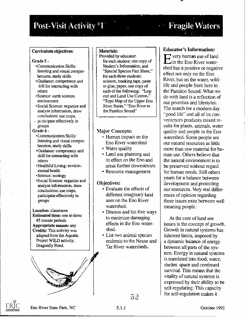
A
Curriculum objectives:
Grade 5 -Communication Skills:listening and visual compre-hension, study skills
Guidance: competency and;kill for interacting withothersScience: earth science,environmentSocial Science: organize andanalyze information, drawconclusions; use maps,
. pz rticipate effectively ingroups
Grade 6 -Communication Skills:listening and visual compre-hension, study skills
Guidance: competency andskill for interacting withothers
Healthful Living: environ-mental health
Science: ecologySocial Science: organize andanalyze information, drawconclusions; use maps,participate effectively ingroups
Location: classroomEstimated time: one to three
45 minute periodsAppropriate season: anyCredits: This activity was
adapted from the AquaticProject WILD activity,Dragonfly Pond.
Materials:Provided by educator:
for each student: one copy ofStudent's Information, and"Special Species Fact Sheet,"for each three students:scissors, masking tape, pasteor glue, paper, one copy ofeach of the following: "Leg-end and Land Use Cutouts,""Topo Map of the Upper EnoRiver Basin," "Eno River tothe Pamlico Sound"
Major Concepts:Human impact on theEno River watershedWater qualityLand use planning andits effect on the Eno andareas further downstreamResource management
Objectives:Evaluate the effects ofdifferent imaginary landuses on the Eno Riverwatershed.Discuss and list five waysto minimize damagingeffects in the Eno water-shed.List two animal speciesendemic to the Neuse andTar River watersheds.
Eno River State Park, NC
52
OP
Educator's Information:El very human use of landLe in the Eno River water-shed has a positive or negativeeffect not only on the EnoRiver, but on the water, wild-life and people from here tothe Pamlico Sound. What wedo with land is a reflection ofour priorities and lifestyles.The search for a modem day"aood life" and all of its con-veniences produces mixed re-sults for plants, animals, waterquality and people in the Enowatershed. Some people seeour natural resources as littlemore than raw material for hu-man use. Others believe thatthe natural environment is tobe preserved without regardfor human needs. Still othersyearn for a balance betweendevelopment and protectingour resources. Very real differ-ences of opinion regardingthese issues exist between wellmeaning people.
At the core of land useissues is the concept of growth.Growth in natural systems hasinherent limits, imposed bya dynamic balance of energybetween all parts of the sys-tem. Energy in natural systemsis translated into food, water,shelter, space and continuedsurvival. This means that thevitality of natural systems isexpressed by their ability to beself-regulating. This capacityfor self-regulation makes it
5.1.1 October 1992

possible for all natural mem-bers of an ecosystem to livein harmony. All life forms ofany ecosystem must be con-sidered. The macroinverte-brates in the water are just asnecessary to a habitat as theplants and fish. It is this natu-ral dynamic balance, with allits inherent and essential parts,that much of human land usehas tended to disturb. Humanactivities often go beyondthe natural limits of a setting.Humans have the ability toimport energy sources thatallow a system to exceed itsnatural limits - or to removeenergy sources that are neces-sary for a system to stay inbalance. For example, peoplecan dam rivers to providepower, drinking water andirrigation. Water from the rivercan be used in factories, mills,sewage treatment and otherindustries that need largeamounts of water to producecertain products. All of theseactivities could affect life inthe Eno River watershed.
The purpose of this activityis to encourage students towrestle with development,local economy and resourcemanagement issues. The stu-dents will use the Eno Riverwatershed as a microcosmof environmental concernsin making management deci-sions. They will contend withthe arrangement of overlap-ping and conflicting land usesin an effort to preserve the EnoRiver watershed. When thestudents reach some kind of
Eno River State Park, NC
agreement about local issues,they will discuss how whatthey have done affects theriver downstream. The activityends with the idea that theplanet is, in fact, a single riverwatershed.
Instructions:
1. Prepare copies of theland use cutout sheet, the"Tope Map of the Upper EnoRiver Basin," the Student'sInformation and "Special Spe-cies Fact Sheet" ahead of time.Explain the activity. Tell thestudents that they will beresponsible for arranging thepattern of land use around theEno River in such a way as tominimize the impact on theriver. Remind them that someof these land uses might beconflicting and therefore theywill have to make some verytough management decisions.Pass out the Student's Informa-tion and "Special Species FactSheet" and have the studentsread them.
2. Divide the class intogroups of three to five, witheach group representing oneof the interest groups or takingon the role of the town com-missioners.
Students will stay in thesegroups until the end of theactivity. Each group mustdecide where to place all theland uses.
Possible interest groups:Residents - people whowant to live there.Farmers want to use theland to raise food.Businesses want to useland for commerce andGrowth.State park wants to pre-serve and protect water-shed for plants and wild-life, recreation, drinkingwater and historic sites.Highway department -wants to build a bypassroad to ease traffic con-gestion in town.Textile factory wants toconstruct a huge factorythat would provide 500jobs and boost localeconomy.School representatives -want to build a newschool to accommodatemore students due torapid growth of the town.Hospital representativespropose building a newhospital to service thecommunity in the futurebecause of expectedgrowth and developmentin the area.County and state repre-sentatives - believe it isessential to have a biggerlandfill and a newer,more efficient waste-water treatment plant.
5 35.1.2 October'1992

3. Pass out the "TopoMap of the Upper Eno RiverBasin." Read the followingtext to the students:
You will be using an en-largement of an actual topo-graphic map of the upper EnoRiver basin. Topographic isderived from Greek wordstopos. meaning place. andgraphein, meaning to write ordraw. Thus. a topographic(topo) map is a drawing orpicture of a place. One featureon a topo map is contourlines. Contour lines are thinlines that indicate the contourof the land and its elevc!ion.The distance between contourlines on your map is 10 feet.Where the lines are very closetogether there is steep terrain.Level terrain apr)-:iars wherecontour lines are further apart.Knowing how steep or flat theterrain is in this activity willdictp. where certain land usescan occur. For example, youwould not want to put a land-fill on a steep ridge. A legendexplaining other map symbolsis included on the "Legendand Land Use Cutouts" page.
Spend some time discussingfeatures and symbols on thetopo map. Practice locatingridges, summits, rivers, high-ways, etc.
Then read the followingtext aloud:
Notice that there are twospecies of plants and three spe-cies of animals on the map
Eno River State Park, NC
where they might naturallyoccur. These species are eitherstate protected or Faye specialhabitat requirements. The pur-pose of placing these on thetopo is to make the decisionsmore realistic. Information onthese species is on the "SpecialSpecies Fact Sheet."
4. Pass out the "Land UseCutouts" sheet and the "TopoMap." Have the students cutout the land use pieces. Whenthey fasten the cutouts to their"Topo Map," suggest that theyuse small loops of tape. Thiswill allow them to change theirminds before they paste themdown.
5. Place the following ruleson the chalkboard:
all land use cutouts mustbe used; the cutouts maybe cut smallercutouts may touch, butmay not overlapno cutout, except for thestate park, can touch orcover a "Special Species"circleexcept for the state parkand the vegetable farm,all cutouts must touch anew or existing roadvegetable farm and land-fill must be on relativelylevel landboth textile factory andwaste water treatmentplant must touch the riverno cutout can touch orcover an existing build-ing
5.1.3
6. Once the students havecut out the necessary materialsand are ready to make landuse decisions, have themcreate a list of pros and consfor each land use. Guide theclass discussion so the conse-quences of each land use areconsidered. Record these onthe chalkboard.
7. Have the students workin their groups long enough tobegin to seriously grapple withthe challenge.
8. Invite each group todisplay and describe theirwork in progress. Encouragediscussion of their choices.In the discussions emphasizethat:
no land use can beexcludedwildlife habitat must bepreservedeveryone within theirsmall group must agree
Discuss how their planswill impact the various interestgroups.
Look for the consequencesof their proposed land useplans. Be firm about this beinga very difficult set of choices.Remind them that for certainhabitats this is a "no-win"situation in many ways. Thebest that can be hoped for isthat the land use plans willminimize the threats to theriver and the special plantsand animals.
October 1992

9. Display all the final landuse plans for everyone to seeand discuss. Analyze and dis-cuss the merits of each of theapproaches. Point out that al-though their solutions may notbe perfect, they can minimizethe damage to the Eno River.
10. Pass out the "EnoRiver to the Pamlico Sound"sheet. Choose one of thegroups' land use plans andconnect their topo to the "EnoRiver to the Pamlico Sound."
11. Ask the students tobrainstorm possible effectsthat their land use plans couldhave on the water quality andpeople downstream. For ex-ample, you could emphasizethe effluent from the textilefactory. How will it be treated?Where? By whom? Wherewill it go? What effect will ithave on water quality?
12. Ask the students tolook again at all of the landuses in this activity. Whatcould the people who are actu-ally in charge of these variousland uses do in their practicesto minimize the damage toEno River and the specialspecies? End the activity witha discussion of solutions,rather than of problems. Forexample, some industries havedeveloped new technologythat allows them to removeharmful waste using a scrub-bing filter. Maybe such a filtercould be used on their textilefactory. Some communitieshave used new technology
Eno River State Park. NC
to collect methane gas (acommon gas generated bydecomposing garbage) fromlandfills and use it as a sourceof energy.
13. Ask the students tocreate a list of things they,personally, can do to beginto reduce the potentiallydamaging effects of their ownlifestyles on the downstreamhabitats. If possible invite themto report periodically, through-out the school year, on theirprogress in carrying out thesenew practices. Discuss withthem the concept that all thewaters of the planet are, in fact,part of a single Eno River.
Extensions:
1. Trace the Eno River fromits origin to the Pamlico Sound.List all the sites that mightlower the quality of the watersin their journey to the soundand suggest how to reverse theprocess of lowering waterquality.
2. Take a field trip to Cliffsof the Neuse State Park nearGoldsboro to collect similardata on the river the Eno feedsinto, the Neuse. For moreinformation contact:
Cliffs of the Neuse State ParkRoute 2 Box 50Seven Springs, N.C. 28578(919) 778-6234
5.1.4
3. Collect newspaper ar-ticles for local water and landrelated issues as a currentevents activity.
4. Learn more about envi-ronmental impact statements.Try to obtain actual statementsconcerning land use in yourarea. See what concerns areaddressed in these documents.
5. Find out about zoninglaws and land use regulationsin your area. Would the plansthe student groups proposedfor the upper Eno River beallowed in your community?
6. Send a representativesample of the students' landuse plans to the park. (Wewould appreciate the feed-back.)
October 1992

Student's Information: FragileWaters
rr he Eno River watershed1 is located in an area that
is growing rapidly. Home-owners and industry arespreading out from our citiesinto the country. They seekundeveloped land to use andhelp our local economy bycreating new jobs. This isgood but sometimes develop-ment conflicts with protect-ing the river and the specialspecies that live in the water-shed. This is where differentpeople have different ideasabout how to best use theland and water from the EnoRiver and still insure that theEno is clean.
.;
s.%-;
"t
-
\ '
Think back to your visit tothe Eno River. We know thatthe Eno provides drinkingwater for Hillsborough andRaleigh. We know that wateris taken from the Eno forsewage treatment, irrigationand use in industry. Many dif-ferent forms of recreation areenjoyed in the Eno Riverwatershed. The Eno Riverand its watershed providecrucial habitat for many plantand animal species. TheRoanoke bass and Neuse Riverwaterdog are two animals thatare endemic to the Neuse andTar river watersheds, of whichthe Eno is part. Endemicmeans they are found in thesewatersheds and nowhere elseon earth!
So how do we make landuse decisions that will benefitthe local economy and stillprotect our natural resources?The following activity isdesigned to give you a tastefor how difficult the decisionmaking process can be.
- .

1' 1'
Yellow lady's-slipper orchid
A rare wildflower in thisarea. It requires soils that areclose to a neutral pH (mostsoils in our region are acidic)and a mature tree canopy togive partial shade. It takes aminimum of 15 years for thisorchid to grow from seed toa flowering plant.
TM !m.p.g./C 100 Id.WI MaNnK Ill,pr.1.1.
Roanoke bass
An endemic fish thatrequires clean swift flowingrivers with rock and gravelbottoms. The Roanoke bassis a favorite game fish in thisarea.
Eno River State Park. NC
American ginseng
A medicinal plant that hasbeen over-collected to sellin this country and overseas.Ginseng is very rare in thisarea and is becoming rare inthe mountains where it wasonce plentiful. This plant hasbeen used for centuries for itsreported medicinal powers.
Thorey's grayback draw Ifly
A type of dragonfly that .
very special habitat require-ments. It needs wet seeps ormarshy areas near springs toraise its young. This dragonflyis also interesting because ithunts mainly in the forestinstead of over water likemost dragonflies.
Yellow lampmussel
Almost all mussels requireclean water to live in. Since thelampmussel is a filter-feeder, itpasses large volumes of waterthrough its system to strain outits food. If the water in whichit lives is polluted, the pollut-ants can become concentratedin the mussel's tissue and killit or impair its ability to repro-duce. The yellow lampmussel'spresence in a river is an indica-tor of good water quality.
'?5.1.6 October 1992
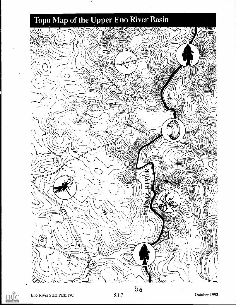
Topo Map of the Upper Eno River Basin
/4
LJ
, I I
Eno River State Park, NC 5.1.7
58
--
iii I 1-
October 1992

Building
Light-duty road
Unimproved road
Power line
LEGEND FOR TOPO MAP
= = = = =Elevation heights 550
Summit symbol
Topo lines (10 ft. intervals)
ROAD
DRYCLEANERS
GROCERY
FIRESTATION
GASSTATION
SHOPPINGMALL
WASTE WATERTREATMENT
PLANT
SCHOOL
TEXTILE FACTORY
\HOSPITAL
Eno River State Park. NC
OFFICE COMPLEX
VEGETABLE FARM
STATE PARK
5.1.8 59
LANDFILL
October 1992

M
Dur
ham Ral
eigh
Gol
dsbo
ro
Kin
ston
Neu
se R
iver
141
103*
New
Ber
n
Pam
lico
Sou
nd
Gil
4'o
ti64?
.
Atla
ntic
Oce
an

I A
Curriculum objectives:
Grade 5 -Communication Skills:listening and visual compre-hension, writing, studyskills
Guidance: competency andskill for interacting withothersScience: earth science,environment
Social Science: organize andanalyze information, drawconclusions: use maps.participate effectively ingroups
Grade 6 --Communication Skills:listening and visual compre-hension, writing, studyskills
Guidance: competency andskill for interacting withothers
Healthful Living: environ-mental health ,
Science: ecologySocial Science: organize andanalyze information, drawconclusions: use maps,participate effectively ingroups
Location: classroomEstimated time: two or more
45 minute class periods.Appropriate season: any
Credits: This activity wasadapted from the Aquatic,Project WILD activity,Something's Fishy Here!
Materials:Provided by educator:
Student's Information and"Troubled Waters" story (oneper student)
Eno River State Park, NC
Major Concepts:
Water pollutionProblem solvingCreative writingCause and effect relation-ships
Objectives:
Identify two potentialcause andeffect relation-ships involving aquaticpollution.
List and evaluate twoalternative solutions toproblems with aquaticpollution.
Create an action plan toreduce aquatic pollution.
62
Instructions:
1. Have the students readthe Student's Information.
2. Have each student readthe story.
3. After the students havefinished reading, discuss thestory with them. Ask the stu-dents to think about as manydifferent endings to the storyas possible. Ask each studentto write an ending to the story.
4. Divide the class intosmall groups. Have eachgroup discuss how they thinkthe story should end, sharingthe ending they wrote.
5. Have each group presentone or more of their endingsto the rest of the class. List theessential points of each end-ing on the chalkboard.
5.2.1 October 1992

6. Discuss the variousendings with the entire class.Identify cause and effect rela-tionships. Look for possiblerelationships between thestory and problems regardingwater use in the Eno Riverwatershed or an aquatic habi-tat in your community.
7. Next, have the studentsgenerate a list of possibleaquatic problems that theybelieve exist in their commu-nity. Then go through the list,noting which problems theymight be able to solve. Forexample, pollution in a nearbybrook is far more realistic forthem to address than an entirewatershed. It is important thatthe students be able to experi-ence some success in devel-oping a plan to tackle theproblem. Have them form
Eno River State Park,.NC
groups that have a commoninterest in one or more of the"solvable" problems anddevelop an outline listing stepson how to find out more aboutthe problem. Once they havedeveloped this outline, haveeach group report back to theclass. Or, decide on one prob-lem and work on it as a class.
8. If several groups outlinedseparate problems, ask theclass to select the problem theywould most like to address.Assure them that choosing onedoes not make the others lessimportant. To be most effectivein solving a problem, it helpsfor everyone to get behind oneeffort. Remind the students todevelop an attitude for a cleanenvironment. Have them seeksolutions rather than only placeblame.
0 3
9. Once a specific issueis chosen, have the class list10 things that can be done tomake that problem less dam-aging to aquatic habitats.
10. Act as facilitator to theclan- by helping them developan action plan. Establish a timeline and specific assignments.
11. Once the students haveimplemented their action plan,or have completed a project,please send a brief summaryreport to the park so we canshare your efforts to clean uplocal aquatic areas with othergroups.
5.2.2 October 1992

nvironmental pollution_Lid is an issue everywhere onthe planet. Often individualsfeel overwhelmed, helpless andunable to do anything to help.Yet successful action to reduceenvironmental problems oftenstarts through the actions ofan individual. School childrenhave initiated projects thatimproved the safety of neigh-borhoods, created parkland,and preserved major habitatsfor wildlife. When a group ofindividuals join together thechances of solving these prob-lems increases. For example,Eno River State Park owes itscreation to an individual whoformed a group called theAssociation for the Preserva-tion of the Eno River Valley.
The city of Durham wantedto build a reservoir that wouldhave flooded the entire EnoRiver valley. By workingtogether, the group was ableto acquire some land and sellthe idea of a park to the state
of North Carolina. As a result,Eno River State Park was bornand the reservoir project wasabandoned. All of this workoriginated from one person'sdecision to take action.
There is still much to bedone to protect aquatic habitatsin the Eno River watershed.Reducing or eliminating pollu-tion is one area where indi-viduals can make a difference.Significant aesthetic improve-ments can result from reducingtwo common forms of waterpollution litter and sedimenta-tion. Other forms of pollutionare harder to detect and con-trol. Much work needs to bedone to identify and eliminatesources of pollution in lakes,rivers, groundwater and oceans.
Pollution is a term that is,at times, difficult to define.Even in nature, pure water can-not be found. When precipita-tion falls from the sky it picksup carbon dioxide and other
I I I
gases and becomes more acidand capable of dissolvingsome rocks. Water is knownas the "universal solvent."This means that it can dissolvemany kinds of substances.Water can also carry sus-pended particles such as soiland plant material. These par-ticles reduce the penetrationof light into water whichaffects the plants living belowthe water's surface. Watertemperature and the amountof dissolved gases also changeover time and affect theaquatic life.
We tend to think of pollu-tion as something that isdamaging and unnatural. Ad-ditionally, water pollution isusually described in relationto the use humans make of thewater in which the pollutant isfound. For example, if condi-tions in the Eno River reachthe point where Roanokebass, a sought after gamefish,start to die, the river would
-- -,-!z;1'1,
z.....04 , .s., - sk' - 4. ..' .
''' i j..k.,111 ..,4.:411.4
r,,,./ I I i?pi,' '-''.. *--- t:..N ". !.-- .
`..fAt.t, I
4' .
///1/1 A. 0tlfil''ff.,e1K
. 4, .
4-
- _---.--
Eno River State Park, NCG4
5.2.3
t r e
I t
4cCdfarry Fru...,Iwo Meal W 12 IftivhOort
October 1992

definitely be labeled polluted.It is quite possible that theriver could have been calledpolluted much earlier, sincemacroinvertebrates weredying but no one had done anysampling. Moreover, it mightalso still support other typesof fish that can tolerate morepollution than a Roanoke bass.In other words, water could bedescribed as polluted for someorganisms and not for others.
The presence of chemicalsin water affects certain organ-isms depending upon the
Eno River State Park. NC
chemicals' concentration.Some chemicals can be toxicto some organisms even at verylow concentrations. Scientistsusually measure the concentra-tion of materials in ratios, com-paring the parts of the chemicalsubstance to the parts of watercontaining it. When concentra-tions of materials reach criticallevels, certain organisms die.For example, living thingsneed the oxygen that is dis-solved in water.When oxygenlevels fall below certain points,organisms die. The warmerthe water, the less oxygen it
can hold. Some animals needmore oxygen than others,therefore warm water can bedescribed as polluted for somekinds of organisms and not forothers.
The purpose of this activityis to recognize our potentialfor making a contributionto the environmental qualityof life in our own communityand our responsibilities foractions affecting life in theEno River watershed.
5.2.4 October 1992

Merlin and Barre werebrother and sister. They
lived in an old wooden houseright beside the Eno River, justa little ways downstream fromHillsborough. Merlin was inthe sixth grade and his sisterBarre in the fifth.
Ever since they were ableto walk, their parents had takenthem down to the riverside toplay. As they grew older, theydiscovered many wonderfulthings living in the river. Withhomemade nets and aquariumsthey Nould spend hourscatching and watching cray-fish, water striders, stoneflynymphs, minnows, frogs andturtles. They learned how tohandle and release these crea-tures without harming themor themselves.
Often in the spring andsummer, the entire familywould spend a day picnickingand fishing. Merlin liked tocatch feisty Roanoke bassbecause they fought so hard.After admiring them, he wouldrelease them. Barre was the
expert at finding and catchingthe biggest crayfish. Shewould also spend more timelooking at the aquatic insectsthan Merlin. These bizarreanimals were fascinating to herand she already knew the namesof most of the common ones.The river provided endlessopportunities for adventure.There was always somethingnew waiting to be discovered.
Springtime was eagerly an-ticipated by Barre and Merlin.Spring meant warmer weather.fresh air, wildflowers and lotsof new life in the river. Thisspring was especially impor-tant to Barre. Every year thefifth grade class had an envi-ronmental science fair. Stu-dents would choose a topicand develop a display to bejudged at the fair. This year thetheme for the fair was waterquality. Bane had decidedto learn more about aquaticinsects and the kind of waterquality they needed to survive.She also planned to catch someaquatic insects to display alivein her aquarium at the fair.
Merlin had promised to helpher. With his help, she wouldhave a good chance of win-ning the Most UnusualAnimal Display." Bane couldhardly wait to go to the riverand collect the aquatic insectsfor her display.
Finally, the day before thescience fair arrived. Merlinand Barre walked down theshort trail to the Eno River.Signs of spring were every-where. Trout lilies, violets,and crested-dwarf iris were inbloom. Fresh new green leaveswere unfurling on every treeand shrub. Butterflies andbees floated and buzzed in theclean warm air. Their hopesran high, what a great day!They were sure to catch lotsof neat aquatic insects. Merlinand Barre made their waydown the slippery bank of theEno and out onto a gravel barthat stuck out into the river.The water was shallow hereand moved swiftly over smallrocks and gravel. Here theyplanned to pick up rocks andgently scrape the clinging
.; 6Eno River State Park, NC 5.2.5 October 1992

insects off them. Merlin hada dip net to catch some min-nows and water striders.
Barre eagerly started pick-ing up rocks while Merlin triedto catch the minnows. Thefirst rock she picked up had noinsects on it, neither did thesecond or third rock. Merlinhad not caught any minnowsor even seen any water striders.Where were all the insects?They both looked aroundpuzzled. Merlin then noticedsome dead aquatic insectsfloating on the surface in apool behind the gravel bar.Barre and Merlin lookedaround carefully and foundhundreds of dead insects float-ing on the surface and washedup on the bank. There wereeven some dead minnows.It took a few moments toregister. Barre forgot all aboutwhat this would mean for herscience display. They bothfelt genuine concern. Thesefascinating animals that hadprovided them with hours ofenjoyment were all dead!What could have happened?They soon realized that therewas a mystery to be solved!
What would SherlockHolmes have done undersimilar circumstances? Right!Look for clues. Hundreds ofaquatic insects don't keel overfrom fear of being exposed inpublic at a science fair! Therehad to be a really good reason.Barre and Merlin were deter-mined to discover the answer.
Eno River State Park, NC
A quick glance over thesurrounding area revealedlittle evidence of foul play.Merlin did note that there wasa condition common to all ofthe dead aquatic insects. Theywere slippery to the touch andseemed to be coated with asoapy substance. Barre sawthe foamy suds first. The sudswere clinging to the rocks andcollecting in the still watersof the deeper pool upstream.They started upstream search-ing for more clues. Beyondthe deep pool the suds werescarce. Carefully they movedfurther upstream until theycame to where the river flowedthrough town. Beyond this, anew black-topped parking lotsporting a brand new mini-shopping mall, signaled theedge of the town. There theydiscovered something new.Under fresh packed soil,tucked beside the fence, stormdrains were partially buried.They were opened to allowflow of water into the Eno.
That night at dinner Barreand Merlin talked with theirparents. They decided to mapthe area of the new shoppingcenter and identify the storesthat might have soap in theirwaste water.
Merlin and Barre sat downand compiled a list of theshopping center's stores. Theyproduced several possibilities- Floyd's Cleaners, Davis'Wash and Dry Laundromat,Geiger's Car Wash, andTillotson's Auto Body. They
decided to record observationson a daily basis for a week.They agreed to take turnslooking for evidence. (Gooddetectives keep records, notepatterns and follow trailsbefore they draw conclusionsor make accusations.)
gnu evening when it wasBane's turn to observe, hermother drove her to the shop-ping center. What she foundmade her very excited. Whenshe got home she rushed intoMerlin's room and cried,"We've got them! WhenMom drove me to the shop-ping center we drove over abig bump in the parking lotnear the car wash. They havea big black hose running intothe drain pipe. They connectit after dark! I saw it - I knowit! They let it flow into thestorm drains from their storagetanks. That's where the soapis coming from! We gotta dosomething Merlin! Wheredo we go? What do we do?"
G5.2.6 October 1992

Acid - having a pH less than 7; the chemical state of water or other substance in which thehydrogen (H4-) ions exceed the hydroxyl (OH--) ions. For example, a car's battery acid has a pHof 1. See pH scale.
Acid Precipitation (including acid rain) - any form of precipitation that is acidic as a result ofmixing with sulphur or nitrogen compounds in the atmosphere. Sulphur and nitrogen compoundscan come from coal burning power plants and car emissions.
Adaptation - a change in the structure or activity of an organism that produces a better adjustmentto its environment, thus enhancing its ability to survive and reproduce. For example, the flattened,oval shape of the larva of the riffle beetle (called a water penny) is an adaptation that helps it clingto the surface of rocks in swift flowing waters.
Aeration - The process of exposing to the air or to causing air to circulate through.
Algae - primitive one-celled or multi-cellular plants that contain chlorophyll, but has no true root,stem, or leaf. Normally found in water or damp places.
Alkaline - see Base.
Ammonia - a colorless, strong smelling gas composed of nitrogen and hydrogen. It has a pHof 12,
Anatomy - the branch of biology that deals with the structure of plants and animals.
Aquatic life - A plant or animal growing or living in or upon water.
Average - the numerical result obtained by dividing the sum of two or more quantities by the totalnumber of quantities; for example, 2 + 4 + 6 + 8 = 20 and 20/4 = 5 therefore, 5 is the average ofthe four numbers.
Base - having a pH greater than 7; the chemical state of water or other substance in which thehydroxyl (OH-) ions exceed the hydrogen (H+) ions. For example, soap has a pH of 10. See pHscale.
Biochemistry - the branch of chemistry that deals with the life processes of plants and animals.
Biology- the science that deals with the origin, history, physical characteristics, life processes andhabits of plants and animals.
Classification - The grouping of organisms into categories based on shared characteristics ortraits. For example, any animal that has feathers is considered a bird and placed in the Class Ayes.Furthermore, if the bird has its eyes in front rather than on the side of its head, it is a member of theOrder Strigiformes (the owls).
Eno River State Park, NC
G 86.1 October 1992

Community - a group of plants and animals living in a specific region under similar conditions,and interacting with each other through food webs and other relationships.
Contour Lines - thin lines found on a topographical map that indicate elevation. They show thecontour of the land.
Decomposer - an organism whose feeding action results in decay, rotting or decomposition.The primary decomposers are bacteria and fungi. They are very important parts of a healthyecosystem.
De^orriposition - to rot or to break apart into basic components. Decomposition makes nutrients,such as nitrogen and phosphorous, available for use by other organisms.
Detritus - dead organic matter, such as fallen leaves, twigs, and other plant and animal materialwhich exist in any ecosystem.
Dichotomous - divided into two parts, groups or classes, such as a dichotomous key. Using adichotomous key, one can identify an unknown organism by following the one branch of each pairthat best describes the organism.
an animal
Has 4 or more legs
Has 4 legs and scales Has legs and antennae I
lizard insect
1
Has 2 or fewer legs
1
Has feathers
bird
1
Has no eyelids and no legs
snake
Distribution - the act of scattering or spreading out; the geographic range of an organism.
Dissolved Oxygen (DO) - the amount of oxygen gas molecules dissolved in water. Fish and otheraquatic animals depend on DO for respiration.
Ecosystem - plants, animals and their physical surroundings which interact with environmentalconditions, such as temperature and rainfall, forming an interdependent system.
Effluent - a liquid flowing out. The outflow of a sewer, septic tank, etc.
Endangered Species - a species that verges on extinction in all or a significant part of its range.
Endemic - found only in a particular region or area. For example, the Carolina madtom is aspecies of catfish found only in the Tar and Neuse rivers. Thus, it is endemic to the Tar and Neuserivers.
Erosion - the process by which soil particles are carried away by wind, water, freezing andthawing, or a combination of these factors.
Evaporation - the natural process by whicn water changes into vapor.
Eno River State Park, NC 61 -(.)
October 1992

Food Chain - the transfer of energy and material through a series of organisms as each one is fedupon by the next. For example:
Detritus > caddisfly larvae > sunfish > otter
Food Web - the interlocking pattern of food chains which exist in an ecosystem.
Habitat - the environmental conditions of the area where a plant or animal naturally grows or lives;its environment.
Indicator Species - an organism whose presence or absence in a particular environment can beused to determine the health of that particular environment.
Insect - any animal in the Class Insecta. Has a head, thorax, abdomen, and three pairs of legs on thethorax. As adults they usually have one or two pairs of wings attached to the thorax.
Irrigation - the pumping of water from ponds, lakes, or rivers through pipes or canals to supplycrops with water during dry periods.
Key - an ordered list of significant characteristics of a group of organisms used to identifyunknown species.
Larva - (larvae, plural) the immature form of an animal that changes structurally when it becomesan adult, usually by complex metamorphosis.
Latitude - measured in degrees, the distance north or south from the equator. For example,Durham is at 36° N latitude.
Longitude - the distance measured in degrees east or west of the prime meridian (0° longitude) atGreenwich, England. Durham is at 79° W longitude.
Macroinvertebrate - macro means large, invertebrate means without a backbone. An invertebrateusually large enough to be seen without the aid of magnification.
Metamorphosis - meta means change, morphe means form. A change in form, structure orfunction as a result of development. A physical transformation undergone by various animalsduring development from the larval stage to the adult form. For example, through metamorphosis,a hellgrammite (larval form) becomes a Dobsonfly (adult form). The change from tadpole (larvalform) to frog (adult form) is another example of metamorphosis.
Molecular Biology- the branch of biology that deals with the chemical and physical composition,and the activities of the molecules of living matter.
Mussel - any of the various freshwater or saltwater bivalves (meaning the two shells), held togetherby a strong muscle.
Non-permeable - not open to passage or penetration, especially by fluids.
Eno River State Park, NC 6.3
4
October 1992
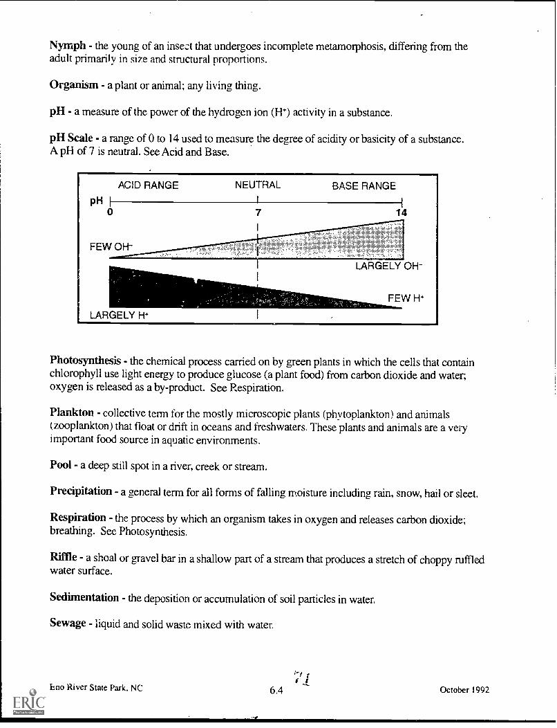
Nymph - the young of an insect that undergoes incomplete metamorphosis, differing from theadult primarily in size and structural proportions.
Organism - a plant or animal; any living thing.
pH - a measure of the power of the hydrogen ion (H+) activity in a substance.
pH Scale - a range of 0 to 14 used to measure the degree of acidity or basicity of a substance.A pH of 7 is neutral. See Acid and Base.
Photosynthesis - the chemical process carried on by green plants in which the cells that containchlorophyll use light energy to produce glucose (a plant food) from carbon dioxide and water,oxygen is released as a by-product. See Respiration.
Plankton - collective term for the mostly microscopic plants (phytoplankton) and animals(zooplankton) that float or drift in oceans and freshwaters. These plants and animals are a veryimportant food source in aquatic environments.
Pool - a deep still spot in a river, creek or stream.
Precipitation - a general term for all forms of falling moisture including rain, snow, hail or sleet.
Respiration - the process by which an organism takes in oxygen and releases carbon dioxide;breathing. See Photosynthesis.
Riffle - a shoal or gravel bar in a shallow part of a stream that produces a stretch of choppy ruffledwater surface.
Sedimentation - the deposition or accumulation of soil particles in water.
Sewage - liquid and solid waste mixed with water.
Eno River State Park, NCf
6.4ti
October 1992

Soil - a collection of organic and inorganic particles, mainly composed of clay, silt, sand, andgravel.
clay - less than 1/256 of a millimeter (mm) in diametersilt - between 1/256 and 1/16 of a mm in diametersand between 1/16 and 2 mm in diametergravel - over 2 mm in diameter
Species - A biological classification of organisms. All organisms of a single distinct kind that havea high degree of similarity, and can mate and produce fertile offspring.
Stewardship - the act of people taking responsibility to maintain and protect a clean and healthyenvironment.
Stream Index Value - the relative health of a water body. It is based on the tolerance or sensitiv-ity of a macroinvertebrate to changes in water quality and calculated using a simple formula.
Taxonomy - a system of arranging animals and plants into natural, related groups based on somefactor common to each, such as structure, embryology, biochemistry, etc.
Threatened Species - a species that could become endangered in the future if it is not given somekind of protection.
Topographic - an accurate and detailed drawing of surface features of a particular region. Thesesurface features include mountains, valleys, rivers, lakes, highways, bridges, etc.
Tributary - a stream or river flowing into a larger stream or river. The Eno River is a tributaryof the Neuse River.
Turbidity - cloudiness caused by particles suspended in water.
Volume - a quantity, bulk, mass, or amount. The amount of space occupied in three dimensions.
Waste Water Treatment Plant - a facility where household, business and industrial sewage aretreated to remove harmful bacteria and chemicals.
Water - a colorless, transparent liquid occurring on the earth's surface as rivers, lakes, oceans, etc.A chemical compound of hydrogen and oxygen, H20.
Water Treatment Plant - A facility where water is treated with chemicals, processed anddistributed to homes, businesses and industries for drinking and other clean water uses.
Watershed - The total land area that drains directly or indirectly into a particular stream, riveror lake.
Eno River State Park, NC
Nt4 (.4
6.5 October 1992
1

Sla
References
Borror, J. Donald and E. Richard White.1990. A Field Guide to Insects of AmericaNorth of Mexico. Houghton Miffilin Co.Boston, MA.
Coker, Robert E. 1954. Streams, Lakes,Ponds. University of North Carolina Press,Chapel Hill, NC.
Hall, Stephen and Dawson Sather. 1988.Inventory of the Natural Areas andWildlife Habitats of Orange County. NorthCarolina. Sponsored by the Triangle LandConservancy in coordination with theNorth Carolina Natural Heritage Program.For information, contact theNatural Heritage Program,Division of Parks & Recreation,512 North Salisbury Street,Raleigh, NC. 27604-1148.Phone 919-733-7701.
North Carolina Department of Transporta-tion. 1992-1993. North Carolina Transpor-tation Map. North Carolina Dept. ofTransportation. Maps can be obtainedfrom: Travel & Tourism Division,430 N. Salisbury St., Raleigh, NC. 27603.Phone 1-800-VISITNC or 919-733-4171.
Kejellstrom, Bjorn. 1975. Be ExpertWith Map & Compass, The "Orienteering"Handbook/New Revised Edition. CharlesScribner's Sons, New York, NY.
Linnsennanier, Walter. 1972. Insects Of TheWorld. McGraw Hill Co. New York, NY.
McCafferty, Patrick W. 1981. AquaticEntomology, The Fisherman's AndEcologist's Illustrated Gt, le to Insects andTheir Relatives. Illustrations by Arwin V.Provonsha. Jones and Bartlett Inc.,Boston, MA.
Eno River State Park, NC
Mitchell, Mark and William Stapp. 1990.Field Manual for Water Quality Monitor-ing. An Environmental Education Programfor Schools. Thomson-Shore Printers,Dexter, MI.
Nebel, Bernard and Edward Komondy.1981. Environmental Science, The WayThe World Works. Prentice-Hall Inc.,Englewood Cliffs, NJ.
Needham, James and Paul Needham.1962. A Guide to The Study of FreshwaterBiology. Holden-Day Inc. Oakland, CA.
O'toole, Christopher, ed. 1986. The Ency-clopedia of Insects. Facts on File Inc.,New York, NY.
Penak, W. Robert. 1989. Freshwater Inver-tebrates of The U.S. The Ronald Press Co.,New York, NY.
Pfeiffer, C. Boyd and Mark Sosin. 1987.Aquatic Resources Education Curriculum.Kendall/Hunt Publishing Co.,Dubuque, IA.
Quammen, David. 1985. Natural Acts,A Sidelong View of Science and Nature.Nick Lyons Books, New York, NY.
Reid, K. George and Herbert Zim. 1967.Golden Guide, Pond Life. Golden PressInc., New York, NY.
Division of Water Resources. StreamWatch News, "pH What Does it Mean."Feb. 1991. Division of Water Resources,Department of Environment, Health, andNatural Resources, 512 North SalisburyStreet, Raleigh, NC. 27604-1148.Phone 919-7334064.
7.1 it' 3 October 1992

Taylor, Mark. 1989. StreamwatchingWith Kids, An Outing Leader's Guide.Reprinted by North Carolina WildlifeResource Commission, Department ofEnvironment, Health, and NaturalResources, 512 North Salisbury Street,Raleigh, NC. 27604-1148. Phone 919-733 -7123.
United States Dept. of Agriculture. July1986. Teaching Soil and Water Conserva-tion, A Classroom and Field Guide.Soil Conservation Service,United States Department of Agriculture,4405 Bland Road, Raleigh, NC. 27609.Phone 919-790-2887.
United States Department of Agriculture.1989. Key to The Major InvertebrateSpecies of Stream Zones. Soil Conserva-tion Service Publication SCS-TP-161Water Quality Indicators Guide,United States Department of Agriculture,4405 Bland Road, Raleigh, NC. 27609.Phone 919-790-2887.
Western Regional Environmental Educa-tion Council. 1987. Aquatic Project Wild.For information contact theWildlife Resources Commission,512 North Salisbury St.,Raleigh, NC. 27604-1148.Phone 919-733-7123.
Wiessinger, John. 1990.Right Before Your Eyes,"All Eyes." #9009.Box 453, Ethna, NY. 13602.
Wiessinger, John. 1990.Right Before Your Eyes,"Flying Dragons." #9020.Box 453, Ethna, NY. 13062.
Wildlife Resources Commission. March1991. Wildlife in North Carolina. "SpecialIssue, Endangered Species."Wildlife Resource Commission,Department of Environment, Health, andNatural Resources,512 North Salisbury Street,Raleigh, NC. 27604-1148.Phone 919-733-7123.
Winborne, Ferne B. 1989. A Guide toStreamwalking. Division of WaterResources, Department of Environment,Health & Natural Resources,512 North Salisbury Street,Raleigh, NC. 27604-1148.Phone 919-733-4064.
Eno River State Park, NC 7.2 October 1992

SCHEDULING WORKSHEET
Date request received Request received by
1) Name of group (school)
2) Contact personname phone (work) (home)
address
3) Day /date /time of requested program
4) Program desired and program length
5) Meeting place
6) Time of arrival at park Time of departure from park
7) Number of students Age range (grade)
8) Number of chaperones
9) Areas of special emphasis
10) Special considerations of group (e.g. allergies, health concerns, physical limitations)
11) Have you or your group participated in park programs before? If yes, please indicate previous
programs attended:
If no, mail the contact person an Educator's Guide.
12) Are parental permission forms required? If yes do they have these forms?
If they do not, mail contact person a Parental Permission form.
, have read the entire Educator's Guide andunderstand and agree to all the conditions within it.
Return to: Eno River State ParkRoute 2 Box 436-CDurham, North Carolina 27705
8.1
75

PARENTAL PERMISSION FORM
Dear Parent:
Your child will soon be involved in an exciting learning adventure an environmental educationexperience at . Studies have shown that such "hands-on"learning programs improve children's attitudes and performance in a broad range of school subjects.
In order to make your child's visit to "nature's classroom" as safe as possible we ask that youprovide the following information and sign at the bottom. Please note that insects, poison ivy andother potential risks are a natural part of any outdoor setting. We advise that children bringappropriate clothing (long pants. rain gear, sturdy shoes) for their planned activities.
Child's name
Does your child:
Have an allergy to bee stings or insect bites?
If so, please have them bring their medication and stress that they, or the group leader, beable to administer it.
Have other allergies?
Have any other health problems we should be aware of?
In case of an emergency, I give permission for my child to be treated by the attendingphysician. 1 understand that I would be notified as soon as possible.
Parent's signature date
Parent's name Home phone(please print) Work phone
Family Physician's name phone
Alternate Emergency Contact
Name phone
Eno River State Park, NC 8.2 October 1992

NORTH CAROLINA PARKS & RECREATIONPROGRAM EVALUATION
Please take a few moments to evaluate the program(s) you received. This will help us improve
our service to you in the future.
1. Program title(s) Date
Program leader(s)
2. What part of the program(s) did you find the most interesting and useful?
3. What part(s) did you find the least interesting and useful?
4. What can we do to improve the program(s)?
5. General comments
LEADERS OF SCHOOL GROUPS AND OTHER ORGANIZED YOUTH GROUPS
PLEASE ANSWER THESE ADDITIONAL QUESTIONS:
6. Group (school) name
7. Did the program(s) meet the stated objectives or curriculum needs?
If not, why?
Please return the completed form to park staff. Thank you.
77Eno Lver State Park, NC 8.3 October 1992

78Eno River State Park, NC 9.1 October 1992

Notes4.
Eno River State Park; NC 9.2
0111 WO. Imre W Lou Nelwan
October 1992

I
d o
Eno River State Park, NC 9.3
144C41.7 1 Sabowo,1141 Maw kw. old NAM NOMalms.
&gird
October 1992

Eno River State Park, NC 9.4 (j 1 October 1992

EDUCATOR'S GUIDE
Eno River State Park

Funding for this publicationwas generously provided by
paCarolina Power i Light Company
N.C. Division of Parks and RecreationDepartment of Environment, Health.
and Natural Resources
James G. MartinGovernor 8310-92
William W. Cobey, Jr.Secretary

I
kt.
Since its creation in 1916, the North Carolina State ParksSystem has provided its visitors with opportunities for educa-tional experiences and programs. Through the years, we havecontinued to revise and update our programming to make it
-more informative and more tailored to the needs of our state'sschool system.
Our state parks system provides a wonderful outdoorclassroom for learning about our North Carolina heritage.Each of our unique state parks offers a variety ofenviron-mental education opportunities which highlight our state'snatural and cultural resources. All of our environmentaleducation programs are designed to meet curriculum require-
ments of the North Carolina Department of Public Instruction.Subject areas covered include science, social studies, art,mathematics and communication skills.
The goal of our environmental education program is togenerate an awareness in all individuals which cultivatesresponsible stewardship of the earth.
-, e;.-4.",-..,--,..9-:---.- --5,::--.1--- --.__:-....-- ,.-.4-:.4.---
::. ,. ..,,,,e_t-5-4.,
..., ...., , . :-....F........ ...,,,,,,..
, .. --..
,..- , A
84 1
4.4.4
4.: '7"
/ft

Efforts to establish Eno River State Park began in 1965in response to the city of Durham's proposal to huild a reservoiron the Eno. A group of concerned citizens formed the Associationfor the Preservation of the Eno River Val ley. The Associationwas successful in gaining support from the community, and itproposed that a state park he established along the river. In May1972 the state of North Carolina approved the idea and the cityDurham withdrew its plans to construct the reservoir. By 1975.1,100 acres of land had been acquired with the help of the Asso-ciation, the Nature Conservancy and the Division of Parksand Recreation. Today the park. located just north of Durham,protects 11 miles of river and over 2,100 acres of associated landin Orange and Durham counties. Four access areas along theriver provide access to 20 miles of hiking trails.
Combine easy access, 2,100 acres of land along a major river,and unique animal and plant life and you have the recipe for arewarding educational experience.
......" O...., ,.....-..... 1 -- -7 ..,,,.. ,...-7 ---
Z.* .:41.. ; '.. .0.s'f- -r t
- I '; ..' " -C.- s , -V4IC 4. i s \kt, - ^r. A.,.
'1 /, -."r. ,/e .. di . Kt./ ': 7.... :g. e'r'''f i --.'
e..,
.,,,An
. ./.. 1 i i
C.- -7..,:,
ik.14
reA;...
-
- -
UJ 2
. -. 4.,
I nal.i,.101I 11, am 14 hkroro 1111ItzIrrt
;trnrit.1 h, prany,

Environmental Education
Our specially developed, curriculum-based EnvironmentalEducation Learning Experiences arc available by reservation only(see section on how to schedule a program). These programs aresupplemented by an activity packet which includes suggestedactivities for before and after your visit.
Programs are geared to different grade levels and provide afun and exciting way to learn about different topics. Some ofthese topics include: birds, mammals. Fish. macroinvertebrates,astronomy and plant identification. Many of our programs can headapted to meet special requests.
Groups are welcome to visit the park for self guided expedi-tions.
- -
sflerly 41.1 I loolith11.1,4 1..nes riser° 11,10tvri
A<PnweJI, penntalo. 63

$
Eno River State Park's most valuable natural resource is theEno River and the aquatic life that lives there. The river and rivercorridor provide critical habitat for both aquatic and terrestrialspecies. Nine species of freshwater mussels, lour of them on thestate threatened and endangered list. arc known to occur in theriver. The Roanoke bass and Neuse River waterdos! (an aquaticsalamander) are found only in the Neuse. of which the Eno is apart. and Tar River basins in North Carolina. The 56 species offish recorded for the river represent 25 percent of the speciesknown for the state.
The river is presently classified WS-111 and Class C whichmeans it. is suitable for fish and wildlife use. boating, fishing anddrinking water. Only through continued vigilance and protectionefforts can the river's water quality he preserved.
I_
The park provides important habitat for a host of animals andplants. A mixture of steep rocky ridges and hottomlands createseveral distinct plant communities. Many of the wildflowers andshrubs found in the park are normally found in our state's moun-tains and foothills. Some of the park's most outstanding flowersinclude mountain laurel. Catawba rhododendron, yellow lady'sslipper, showy orchis, and wild geranium to name just a few.
Somewhat harder to observe is the animal life in the park.More than 150 species of birds have been observed in the park.Deer are common and can be seen alorw all hiking trails if youare quiet and patient! Signs of animal feeding and tracks giveaway the presence of beaver, fox. raccoon. mink, muskrat, graysquirrel, and if you're very observant and lucky. bobcat and riverotter. Butterflies and a wide variety of insects can readily heobserved in the fields near the picnic area at Fews Ford.
87 4

I I 1
Eno Trace Trail: This is a self-guided nature trail. Brochuresin a box at the beginning of the trail interpret sites from numberedposts along the trail. The easy .5-mile trail follows the river andloops hack along a small ridge offering a view of the river below.During the spring, wildflowers blanket the ground along the trail.The Trace trail is accessed from the picnic area. Use cautionwhen descending the short steep rocky section from the picnicarea.
Fanny's Ford Trail: This easy 1-mile loop trail is accessedby crossing the suspension bridge over the Eno and following anold mill road 1-mile to the Fanny's Ford Trail. The trail takes youto Fanny's Ford, then back down the river past an old grist millsite. Several forest types can he observed along the trail. Smallsprings and vernal pools near the trail provide breeding habitatfor frogs, toads and salamanders. Along the river look for basking,turtles. water snakes on logs and beaver signs. Total le,f2th of trailfrom picnic area is 3 miles.
Buckquarter Creek Trail: Access this moderate 1.5-mileloop trail from the Fews Ford parking area. The trail follows theriver upstream across a rocky ridge and then back to its begin-ning. On the ridge, the steep rock outcrop on the right side of thetrail gives way to the wide bottomlands of Buckquarter Creek.Enjoy the view and use caution here. Look for wildflowers,birds and animal signs. Listen for owls calling in the afternoonat Buckquarter Creek bridge.
Eight additional hiking trails are located in the park. Contactpark staff for additiorL information.

Scheduling a Trip toEno River State Perk
Groups are encouraged to visit the park during all seasonsof the year for hikes. exploration, environmental educationprograms and activities. Leaders may choose to conduct theirown activities or enlist the help of park staff.
To Make a Reservation
Because our Environmental Education Learning Experiencesinvolve all park staff and several volunteers, it is necessary tocontact the park one month in advance.
For other types of programs including special requests, pleasecontact the park at least two weeks in advance.
c"'..".
'ONO 44n4,...
7--

Please provide the following information:
Name of group (school).Name, address, work and home telephone numbers of thegroup contact person.Date. time of arrival and meeting place at the park.Departure time from the park.Number of participants and adult leaders.A maximum of 30 participants is recomniended. Pleasehave one adult leader per 8 students. Adult leaders areresponsible for Illaintaining control of the grottp.Aae range and/or special needs of participants.Desired activities, assistance needed by park.
Bad Weather Policy and Cancellations
Our Environmental Education Learning Experiences areheld outside. If weather conditions prohibit us from holding theprogram outside, we will provide a modified version at the parkoffice. If you make a reservation for a Environmental Education
Learning Experience, plan to come regardless of the weather. Ifyou make a reservation for another type of program, we
can reschedule in case of bad weather. If youneed to cancel your trip please notify the
park as soon as possible.
4
"'"'"
7 j
!Th
Strabila 1.,lo.,MI N.... Balkh iiht.hen
Reproged t ratrInum.

1
1. Complete any appropriate pm-visit activities.2. Visit the park without the participants prior to the scheduled
group trip. This will give you a chance to become familiar withacilities and park staff, and provide .\,,ou with an opportunity to
identify potential problems.3. Discuss behavior expectations with adult leaders and
participants when planning the trip. Discuss the park rules listed.Emphasize safety.
4. Inform the group about poison ivy. ticks and snakes.Discuss the need to use insect repellant in the spring and earlysummer.
5. Inform your group of the need to dress appropriately for theseason. Shoes suitable for wading and walking on slippery trails,clothes that students don't mind getting wet or dirty, a towel anda complete change of clothes are recommended for the Environ-mental Education Learning Experience, Living Water.
6. Have everyone wear a name tag. For safety, please color-code them for groups. Establish a buddy system for youngerstudents.
7. Group leaders are responsible for obtaining a consent,form from each participant including a list of any health consid-erations and medical needs. These forms are available at the parkand in the Environmental Education Learning Experience packet.
8. If your group plans,to collect any plant, animal or mineralwithin the park, a Research Activity Permit is required. Contactthe park to obtain a permit application at least 30 days in advance.
9. Assign jobs to students and/or leaders. Leaders couldbe responsible for lunches, moving groups from one place toanother and enforcing rules. If students are working in smallgroups they could each be assigned a task to accomplish.
8

Please obey the following rules:1. To help you get the most out of the experience and increase
the chance of observing wildlife. he as quiet as possible while in the
park2. On hikes. walk behind the leader at all times.Stay on the trails.
Running is not permitted.3. All plants and animals within the park are protected.
Breaking plants and harming animals is prohibited in all state parks.This allows future visitors the same opportunity to enjoy our naturalresources.
4. Picnic only in designated picnic areas. Help keep the park clean
and natural: do not litter.5. Always wear shoes or waders when wading in the river.
No hare feet.6. Avoid the river during high water. Riverside trails can be very
slick and are sometimes completely underwater after a heavy rain.7. In case of accident or emergency. contact park staff
immediately.
1 I
1. Complete post-visit activities in'the EnvironmentalEducation Learning Experience packet.
2. Build upon the field experience and encourage participants toseek answers to questions and problems encountered at the park.
3. Relate the experience to classroom activities andcurriculum through reports, projects. demonstrations. displays andpresentations.
4. Give tests or evaluations, if appropriate, to determineif students have gained the desired information from theexperience.
5. File a written evaluation of the experience with the park. Evalu-ation forms are available from park staff and in the EnivironmentalEducation Learning Experience activity packet.
9 92

Facilities at Fews Ford
Restrooms: Restrooms are available only at the Park Office.
Picnic Area: Picnic tables and grills, available on a first-comebasis. are located adjacent to the trail to the suspension bridge.Water is available from March to November.
Primitive Group Camping: One area with live large level tentpads is available for organized groups. A small fee is chargedfor the use of this area, which is available by reservation only.Facilities include one fire ring (bring your own firewood sincecollecting live or dead wood is not allowed), one picnic table,three benches and a pit toilet. Drinking water is not available.There is no vehicular access to the group camping area. Campersmust carry their gear .5 mile to the site.
Primitive Backpack Camping: Five sites are available on afirst-come basis. A pit toilet is available. Campers must carryeverything they need 1 mile to the sites. Fires are not allowed atthis area. A modest fee is charged.
_ - .
. ,- . . ---- .
. 7 \"S..
M 'ilter, n..ddla I n-nsI vyI 11d.. ;Idteto and hulk. ntlia.rs
Rnpnwed writ...eon
(4)3 10

0 ,
Location:The park office is located at Fews Ford Access Area, six miles
north of Durham at the end of Cole Mill Road. Do not confuse uswith West Point on the Eno, located on Roxboro Road.
Address:Eno River State ParkRoute 2 Box 436-CDurham. North Carolina 27705
Telephone:(919) 383-1686
Office Hours: -
Monday-Friday 8 a.m. to noon and most weekend afternoons.
Hours of Operation for Fews Ford Access Area:November February 8 a.m. 6 p.m.March and October 8 a.m. 7 p.m.April. May and September 8 a.m. 8 p.m.June-August 8 a.m. 9 p.m.
Hours of Operation for Cole Mill Access:Open 9 a.m. and close one-half hour earlier than the above times.
Hours of Operation for Pleasant Green Access:Open 8:30 a.m. and close one-half hour earlier than the above
times.
11 94
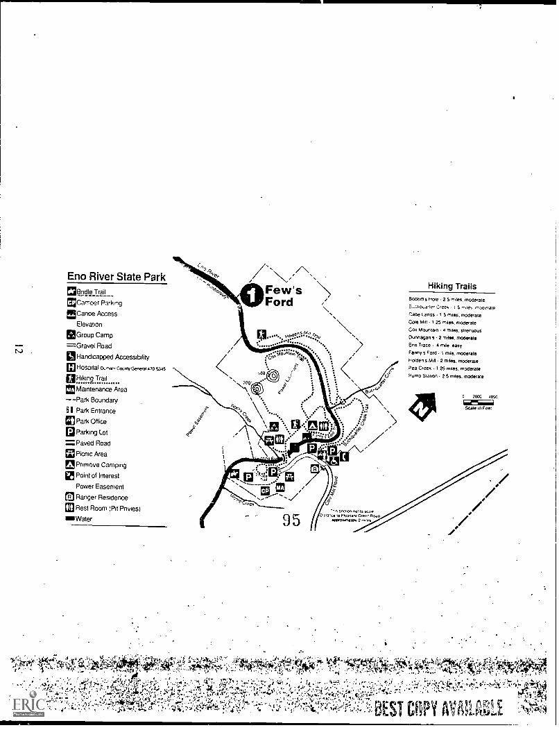
Eno River State Park1313nd le Trail
MCamoer Parking
EiCanoe Access
Elevation
gaGroup Camp
=Gravel Road
ISHandicapped Accessibility
60Hospital County Genera, 470 5345
ElHiking Trail
en Maintenance Area
--Park Boundary
I Park Entrance
CD Park Office
Parking Lot
=Paved RoadPicnic Area
Primitive Camping
Point of Interest
Power Easement
Ranger Residence
p
A
110 Rest Room IN Privies)
IS Water
Few'sFord
14;;;........
,
Hiking TrailsBoobal s Hole 2 5 notes. moderate
Creek 15 n-..les moderate
r:abe Lands I 5 notes. moderate
Cote mot 1 25 Wes. moderate
Coo Mountain a ma's, strenuous
Dunnagan s - 2 Mass. moderate
Eno "Nate 4 mile easyFanny s Ford 1 rntle. moderate
Holden s Mal 2 miles. moderate
Pea Creek I 25 miles, moderate
Pump Station 2 5 miles. moderate
,ee
95snctOn n0110 se-3,e
o SranCe 10 Pleasant Green Ana.aGeroxenately 2 rones
0 20.00 4000
612261Sea* m Feet

0
0.>
o
4.2
a00 97? 2
0
-3G.
PumpStation
9 6