Document Objectives / Requirements€¦ · This is a beginner’s guide to flying VFR within the UK...
36
UKV TRD 7.1 (21 Apr 10) VFR PLANNING & PROCEDURES Fly UK Virtual Airways P - 1 - Document Objectives / Requirements This document explains the fundamental concepts of flying VFR and the technicalities related to this form of flying. A basic knowledge of reading charts and basic understanding of instrumentation is required. You must also be familiar with rules regarding VFR or at least be familiar about them. You must also be familiar with understanding METAR’s as this is not covered in this document and is an important factor for VFR flying. Practical Training Sessions Available Please note the Fly UK Training Academy also offer a practical one2one online training sessions on this subject. VFR Procedures - http://www.flyuk.aero/en/index.php?page=new_training_acad&act=book&id=28 VFR Comms - http://www.flyuk.aero/en/index.php?page=my_training_acad&act=book&id=29 Full VFR Course - http://www.flyuk.aero/en/index.php?page=new_training_acad&act=book&id=32 Contents This document contains: VFR Procedures VFR Planning Introduction to VFR Phraseology Introduction to VFR checklists and formalities Introduction At Fly UK we encourage a high standard of flying and we aim to help and support all our members to the best of our ability. If we all follow these guidelines when flying VFR, it will help you to understand how to fly your aircraft to a better standard.
Transcript of Document Objectives / Requirements€¦ · This is a beginner’s guide to flying VFR within the UK...

UKV TRD 7.1 (21 Apr 10)
VFR PLANNING & PROCEDURES
Fly UK Virtual Airways P - 1 -
Document Objectives / Requirements
This document explains the fundamental concepts of flying VFR and the technicalities related to this form of flying.
A basic knowledge of reading charts and basic understanding of instrumentation is required. You must also be familiar with rules regarding VFR or at least be familiar about them. You must also be familiar with understanding METAR’s as this is not covered in this document and is an important factor for VFR flying.
Practical Training Sessions Available
Please note the Fly UK Training Academy also offer a practical one2one online training sessions on this subject.
VFR Procedures - http://www.flyuk.aero/en/index.php?page=new_training_acad&act=book&id=28 VFR Comms - http://www.flyuk.aero/en/index.php?page=my_training_acad&act=book&id=29 Full VFR Course - http://www.flyuk.aero/en/index.php?page=new_training_acad&act=book&id=32
Contents
This document contains:
VFR Procedures VFR Planning Introduction to VFR Phraseology Introduction to VFR checklists and formalities
Introduction
At Fly UK we encourage a high standard of flying and we aim to help and support all our members to the best of our ability. If we all follow these guidelines when flying VFR, it will help you to understand how to fly your aircraft to a better standard.

UKV TRD 7.1 (21 Apr 10)
VFR PLANNING & PROCEDURES
Fly UK Virtual Airways P - 2 -
VFR Procedures.
This document will introduce you to VFR Procedures. This is a beginner’s guide to flying VFR within the UK and will consist of a flight from Blackpool Airport (EGNH) to Welshpool (EGCW). The flight will include a normal VFR departure from Runway 28 at Blackpool followed by a MATZ penetration from Warton (EGNO) and finally a zone transit through Liverpool.
All of this may sound quite daunting to you but it really couldn’t be easier. If you are flying offline then you have nothing to worry about as you won’t have any ATC to speak to. If you are flying online however; then there is a good chance that you will have some form at Control along the way. So for that purpose, I will be going into some basic phraseology that will help you along the way.
The aircraft we will be using today is the Piper Seneca III which is one of the most popular multi engine piston (MEP) aircraft around. The model is the Carenado Seneca (payware).
INTENTIONALLY BLANK

UKV TRD 7.1 (21 Apr 10)
VFR PLANNING & PROCEDURES
Fly UK Virtual Airways P - 3 -
The Airspace & Route.
Before we can go anywhere, we need to first of all find a suitable route. VFR routes are very simple really and will usually follow distinct features. Distinct features can be things such as, VRP’s (Visual Reference Points) Towns, Lakes, Junctions or other well known landmarks.
VRP’s are specific points on the chart that are clearly displayed. VRP’s are usually very easy to spot from the air and are often points on the edge of control zones to which VFR entry routes start and end. Below is an example of the Liverpool Zone and the associated VRP’s.
So as we can see here, we can see the main section of the Liverpool CTR. Our routing today will take us through the Liverpool Zone via VRP’s Sea-Forth and Neston. We will look at this in more detail a little further on.
UKV TRD 7.1 (21 Apr 10)
VFR PLANNING & PROCEDURES
Fly UK Virtual Airways P - 4 -
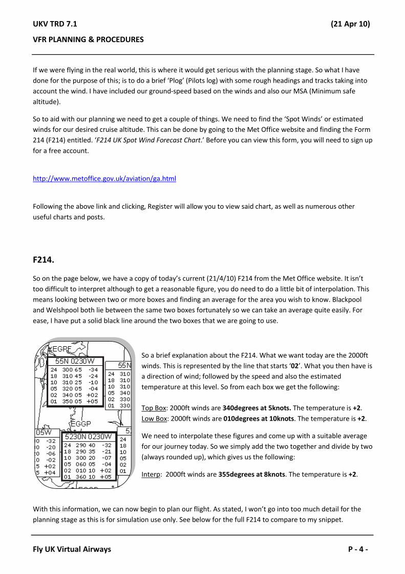
If we were flying in the real world, this is where it would get serious with the planning stage. So what I have done for the purpose of this; is to do a brief ‘Plog’ (Pilots log) with some rough headings and tracks taking into account the wind. I have included our ground-speed based on the winds and also our MSA (Minimum safe altitude).
So to aid with our planning we need to get a couple of things. We need to find the ‘Spot Winds’ or estimated winds for our desired cruise altitude. This can be done by going to the Met Office website and finding the Form 214 (F214) entitled. ‘F214 UK Spot Wind Forecast Chart.’ Before you can view this form, you will need to sign up for a free account.
http://www.metoffice.gov.uk/aviation/ga.html
Following the above link and clicking, Register will allow you to view said chart, as well as numerous other useful charts and posts.
F214.
So on the page below, we have a copy of today’s current (21/4/10) F214 from the Met Office website. It isn’t too difficult to interpret although to get a reasonable figure, you do need to do a little bit of interpolation. This means looking between two or more boxes and finding an average for the area you wish to know. Blackpool and Welshpool both lie between the same two boxes fortunately so we can take an average quite easily. For ease, I have put a solid black line around the two boxes that we are going to use.
So a brief explanation about the F214. What we want today are the 2000ft winds. This is represented by the line that starts ‘02’. What you then have is a direction of wind; followed by the speed and also the estimated temperature at this level. So from each box we get the following:
Top Box: 2000ft winds are 340degrees at 5knots. The temperature is +2.Low Box: 2000ft winds are 010degrees at 10knots. The temperature is +2.
We need to interpolate these figures and come up with a suitable average for our journey today. So we simply add the two together and divide by two(always rounded up), which gives us the following:
Interp: 2000ft winds are 355degrees at 8knots. The temperature is +2.
With this information, we can now begin to plan our flight. As stated, I won’t go into too much detail for the planning stage as this is for simulation use only. See below for the full F214 to compare to my snippet.

UKV TRD 7.1 (21 Apr 10)
VFR PLANNING & PROCEDURES
Fly UK Virtual Airways P - 5 -

UKV TRD 7.1 (21 Apr 10)
VFR PLANNING & PROCEDURES
Fly UK Virtual Airways P - 6 -
So we have now established that in order to plan our flight we will be using the following winds:
355degrees at 8knots.
This gives us a nice estimate to work with and will allow us to work out our ground-speed and drift calculations. Before you get too worried, I won’t be going into drift calculations in detail as this requires a CRP flight computer used for real world flying. Instead we will use a simple online calculator and use the figures we get from there.
The next step is to basically find out what headings we need to fly in order to get to our desired waypoints. I have decided that we are going to fly the following route today.
Standard South Departure from Blackpool routing St.Annes Pier and Southport Pier. We will then fly to VRPSeaforth and then ask for a Zone Transit through Liverpool to VRP Neston. After Neston we will route down to Wrexham and then finally onto the Welshpool NDB.
Now we have ascertained our routing, we can begin to work out our headings and distances and begin to put them on our ‘Plog’.
Please note: The way I am doing this is the proper way to do it, and as they would do so in the real world. However for simulation use, I am making abbreviations and cutting a few corners. If you do not feel like doing itthe following way then that is perfectly fine and you can fly as you wish.
Assuming you have CAA VFR Charts, you will be able to draw lines on the map and then measure the distances and the initial tracks which will make life somewhat easier for you. However if you don’t then not to worry!
After some time we should have some figures to put on our ‘Plog’.
The ‘Plog’ I have created is on the page below. As I have already said, I am not going to explain in huge detail how I came to get my calculations. They are simply rough estimates using lines on a map, a ruler and a protractor. There a couple of complexities such as magnetic variation and wind correction and these I will touch on briefly a little bit later. If you specifically want to go through anything regarding the ‘Plog’ then there are one2one training sessions available from the Training Academy. Alternatively speak to myself (Adam UKV1212) or George (UKV1130).
For best viewing of the ‘Plog’ please rotate the next page.

UKV TRD 7.1 (21 Apr 10)
VFR PLANNING & PROCEDURES
Fly UK Virtual Airways P - 7 -

UKV TRD 7.1 (21 Apr 10)
VFR PLANNING & PROCEDURES
Fly UK Virtual Airways P - 8 -
The Plog.
So there is our ‘Plog’. On it you can see a variety of headings, distances and times for each of our legs. Please remember, these figures are for simulation use only. Although they are approximates; they should be accurate.
The very good thing about today is the wind. The wind is predominately Northerly so we have a nice tailwind all the way along this journey. Also because our journey for the most part is almost directly South there is very little wind correction to add, infact only a few degrees which makes our life very easy indeed!
Before we move on; here is a link to a basic, but useful ‘Online Wind Component Calculator’
http://www.aeroplanner.com/calculators/avcalccrs.cfm
We will cover this more in depth later on in the document and go through a couple of examples. Now let’s quickly go through each leg of the ‘Plog’:
Leg 1) Southport (S’port) Pier to VRP/Seaforth.
We measured our Track on the map as 182degrees. With the wind variation we add one degree to the West, this gives us our True Heading. We also add a further 3degrees to the True Heading to give us our Magnetic Heading. For each leg I have used a magnetic variation of 3degrees West. This means that we have to add 3degrees onto each of our legs to compensate for the magnetic variation in the area.
From our estimated True Air Speed (TAS) and the wind calculations, we can also work out our Ground Speed. Once we have our Ground Speed we can work out how long each leg will take us. So this first leg at a Ground Speed of 169knots will take us 5 minutes.
We can work this out by doing the following:
169 knots divided by 60 (number of minutes in an hour) gives us how many miles per minute we will do. Therefore 169 / 60 = 2.81. So we will do 2.81 nautical miles per minute at this speed.
Once we have this number we then divide the distance to fly by our miles per minute to work out how many minutes it will take us to fly that leg. So…
13.5nm divided by 2.81 gives us how long the leg will take us in minutes. Therefore 13.5 / 2.81 = 4.8. If there is a decimal point in the number we need to do some rounding. If the decimal point is .5 or greater, then round it up. If it is less than .5 then round it down. In this case 4.8 will get rounded up to 5 minutes.

UKV TRD 7.1 (21 Apr 10)
VFR PLANNING & PROCEDURES
Fly UK Virtual Airways P - 9 -
Leg 2) VRP/Seaforth to VRP/Neston.
This leg, we measured our Track to be 184degrees. Taking into account the wind we add a further one degree on to find our True Heading of 185degrees. Add a further 3degrees for the magnetic variation and we get a Magnetic Heading of 188degrees.
Again, we have a Ground Speed of 169 knots so once again divided by 60 gives us 2.81 miles per minute.
Our distance on this leg is 12nm so divide that by 2.81 gives us our time. For this leg, we have conjured up a time of 4 minutes.
This is our shortest leg on the journey!
Leg 3) VRP/Neston to Wrexham.
On this leg, we measured our Track to be 171degrees. Again, with the wind calculations we don’t need to add anything on at all, as we have almost a direct tailwind! So on this occasion our True Heading is the same as our Track. We need to add variation, so once again on goes another 3degrees to the West. This then makes our Magnetic Heading which I have calculated to be 174degrees.
Ground Speed wise we have 168 knots. You should know the score by now, so let’s divide 168 knots by 60. This gives us 168 / 60 = 2.8. This is basically the same as last time and gives us 2.8 nautical miles per minute, so don’t expect any major differences time wise!
Now that we have our miles per minute, we can work out how long it will take to travel 17nm. So let’s do a quick calculation… 17 / 2.8 = 6.01. We can round this down to 6 minutes.
Leg 4) Wrexham to Welshpool (WPL NDB).
On our final leg we have measured our Track as 192degrees. This time our drift angle is slightly more acute and so it is necessary to take 2degrees of drift into account taking our True Heading to 194degrees. Adding our magnetic variation of 3degrees West will then give us a Magnetic Heading of 197degrees.
Ground Speed wise is exactly the same as the last leg. We have 168 knots across the ground. Doing the calculations again gives us: 168 / 60 = 2.8 nautical miles per minute.
Finally we need to work out how long this leg will take. We have a leg distance of 30nm so by doing the calculation we get the following: 30 / 2.8 = 10.7. We therefore round this up to 11 minutes.

UKV TRD 7.1 (21 Apr 10)
VFR PLANNING & PROCEDURES
Fly UK Virtual Airways P - 10 -
Wind Calculation.
We will have a quick look at wind variation, and how the wind affects our aircraft in flight and what we have to do to compensate for it. See diagrams below:
Let’s have a brief look at the diagram above. For clarity, the track of the aircraft is the large yellow arrow. The wind direction is dictated by the blue set of arrows and the black dotted line is the aircrafts longitudinal axis. In this instance, we can see from the diagram that the aircraft is facing the way it is travelling, because the wind is straight down the longitudinal axis, so therefore no correction is needed. This would be the same whether the aircraft had a direct headwind or a tailwind.
It gets a little more complex as the wind hits the aircraft from different angles. We need to offset this drift and point the aircraft in a certain direction to compensate for the strength of the wind.
INTENTIONALLY BLANK

UKV TRD 7.1 (21 Apr 10)
VFR PLANNING & PROCEDURES
Fly UK Virtual Airways P - 11 -
This next diagram shows what happens when we get a wind hitting the aircraft from the left.
As we can see, the wind is now coming from the left of the aircraft (relative to the direction of travel). So in theory, the wind is going to blow the aircraft off its track. To stop the wind from doing this, the pilot will pitch the aircraft into the wind and compensate. Once again, the yellow arrow is the aircrafts direction of travel, and we can quite easily note that the longitudinal axis (the black arrow), is not in line with the direction of travel. So in essence, all you are doing is exchanging some of the aircrafts forward motion to keep it on track. In theory this is quite simple, however it can become a little tricky when trying to work out what angle to offset by, which is where the calculator or CRP-5 comes in. (CRP-5 being a real world wind calculation device).
INTENTIONALLY BLANK
UKV TRD 7.1 (21 Apr 10)
VFR PLANNING & PROCEDURES
Fly UK Virtual Airways P - 12 -
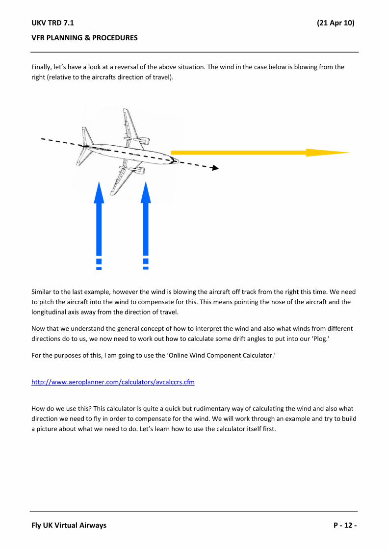
Finally, let’s have a look at a reversal of the above situation. The wind in the case below is blowing from the right (relative to the aircrafts direction of travel).
Similar to the last example, however the wind is blowing the aircraft off track from the right this time. We need to pitch the aircraft into the wind to compensate for this. This means pointing the nose of the aircraft and the longitudinal axis away from the direction of travel.
Now that we understand the general concept of how to interpret the wind and also what winds from different directions do to us, we now need to work out how to calculate some drift angles to put into our ‘Plog.’
For the purposes of this, I am going to use the ‘Online Wind Component Calculator.’
http://www.aeroplanner.com/calculators/avcalccrs.cfm
How do we use this? This calculator is quite a quick but rudimentary way of calculating the wind and also what direction we need to fly in order to compensate for the wind. We will work through an example and try to build a picture about what we need to do. Let’s learn how to use the calculator itself first.

UKV TRD 7.1 (21 Apr 10)
VFR PLANNING & PROCEDURES
Fly UK Virtual Airways P - 13 -
This is a very easy piece of software to use, so let’s have a go. We need to first of all tell it what Course we want our aircraft to fly; in our case today this is going to be 180degrees (South).
We then need to tell it what direction the wind is blowing from and also the speed of the wind in knots. We have entered 090degrees at a speed of 20 knots.
We then have to put in our True Air Speed (TAS), which for example purposes is 105 knots.
We then need to hit ‘Calculate!’
When we have clicked ‘Calculate’, you may notice that the empty boxes have now been filled. The software has worked out what Heading we need to fly in order to compensate for the wind. It has worked out that we need to fly a Heading of 169degrees. It has also worked out that our Ground Speed will be 103 knots.
UKV TRD 7.1 (21 Apr 10)
VFR PLANNING & PROCEDURES
Fly UK Virtual Airways P - 14 -
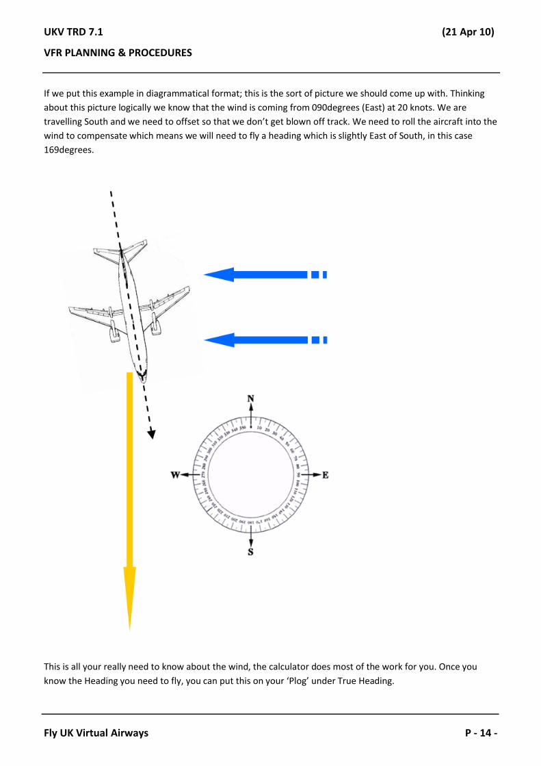
If we put this example in diagrammatical format; this is the sort of picture we should come up with. Thinking about this picture logically we know that the wind is coming from 090degrees (East) at 20 knots. We are travelling South and we need to offset so that we don’t get blown off track. We need to roll the aircraft into the wind to compensate which means we will need to fly a heading which is slightly East of South, in this case 169degrees.
This is all your really need to know about the wind, the calculator does most of the work for you. Once you know the Heading you need to fly, you can put this on your ‘Plog’ under True Heading.
UKV TRD 7.1 (21 Apr 10)
VFR PLANNING & PROCEDURES
Fly UK Virtual Airways P - 15 -
Magnetic Variation.
First of all, what is magnetic variation? Magnetic variation is basically the difference between Magnetic North and True North. It varies from place to place and generally depends what part of the world you are in as to the magnitude of declination.
The UK generally sits in area where the variation is between 2.5degrees and 5degrees. This variation is of a Westerly direction. If we have Westerly variation, then we will add it onto our True Heading to give us a Magnetic one. If we have Easterly variation then we take it away from our True Heading to give us a Magnetic one. We can use the following rhyme to help us remember this:
“Variation West, Magnetic Best. Variation East, Magnetic Least.”
If the magnetic variation is Westerly; then the Magnetic Heading will be the biggest number out of the True and Magnetic Headings. If we have Easterly variation then our Magnetic Heading will be the smallest number of our True and Magnetic Headings. Here are a few examples.
We have a True Heading of 215degrees. The magnetic variation in the area is 5degrees West. What is our Magnetic Heading?
Back to our rhyme. “Variation West, Magnetic Best.” Taking this into account, we now know that our Magnetic Heading will be larger than our True Heading, so we add the variation on. 215 + 5 = 220. So the heading we would fly in this case is 220degrees. Let’s have a look at a couple more!
We have a True Heading of 040degrees. The magnetic variation in the area is 8degrees East. What is our Magnetic Heading?
So… “Variation East, Magnetic Least.” Our Magnetic Heading is going to be less than our True Heading, so we are going to have to subtract our variation from our heading. 40 – 8 = 32. This will give us a Magnetic Heading of 032degrees. Time for one more, this time with a little twist…
We have a True Heading of 355degrees. The magnetic variation in the area is 10degrees West. What is our Magnetic Heading?
The observant ones amongst you will have now noticed that there are only 360degrees we can fly and that adding our variation isn’t going to work. However our rhyme still make sense… and this is how.
“Variation West, Magnetic Best.” So let’s do the maths on it. 355 + 10 = 365. You are now thinking, how can we fly a heading of 365?! We can’t, so there is another rule we have in case this happens. If you ever produce a number greater than 360degrees in regards to a heading, then all you do is simply minus 360!
365 – 360 = 5. So in this case, the heading we fly is 005degrees. Simple really!

UKV TRD 7.1 (21 Apr 10)
VFR PLANNING & PROCEDURES
Fly UK Virtual Airways P - 16 -
The Pre-Flight.
Now that we have covered the planning stages of the flight we can start to think about flying our route! We have completed our ‘Plog’ and we have all the numbers we need to be able to successfully complete the flight.
Normally, we would go out and do a walk around the aircraft to make sure that everything was working properly and make sure we have ample fuel for the trip.
Because this isn’t a particularly long flight, we have the added bonus of not having to carry that much fuel. The Seneca has an economy fuel burn rate of 78 litres per hour (both engines operative). For this flight I have decided that we will carry 200 litres of fuel. At economy rate we should be able to achieve a TAS of 160 knots on about 65% - 70% power. This should give us an endurance of around 2 hour 35 minutes.
Some useful Seneca (PA34-200T) Information:
Fuel Capacity: 353 litres.
Fuel Burn Rate (LRC): 61 litres/per hour. Fuel Burn Rate (Econ): 77 litres/per hour.Fuel Burn Rate (HSC): 89 litres/per hour.
Long Range Cruise (LRC) @ 45% Power = 144 knots TAS.Economy Cruse (Econ) @ 65% Power = 165 knots TAS.High Speed Cruise (HSC) @ 75% Power = 179 knots TAS.
Now that we are happy with the fuel, we can jump in the aircraft and begin our checks!
INTENTIONALLY BLANK

UKV TRD 7.1 (21 Apr 10)
VFR PLANNING & PROCEDURES
Fly UK Virtual Airways P - 17 -
The Flight.
After all the planning, it is now time to get into the aircraft and get ourselves in a position to taxi to the runway. Because Blackpool (EGNH) is a controlled airfield, we will need to ask for permission to taxi (there is no requirement to request engine start at Blackpool).
Just before we get our taxi clearance, it is worth listening to the ATIS (Automatic Terminal Information Service). This will give us some important information regarding the airfield. Below is a transcript of the Blackpool ATIS for today.
“Blackpool Information, acknowledge receipt of information India, Time 1-3-1-2 (1312z), Runway in use 2-8(28). Surface Wind 2-5-0 degrees (250), 1-3 knots (13). Visibility 1-5 Kilometres (15), Few 1 Thousand, 5 Hundred feet (1,500). Temperature plus 1-2 (12), Dewpoint plus 8 (8). QNH 1-0-0-6 millibars (1006). Glideslope Runway 2-8 (28) is Unserviceable. Personnel operating in vicinity of Runway.”
So what does all this mean..?
Put simply the above means the following: Blackpool information India is current, it was created at 1312z. Runway 28 is in use and the surface wind is 250degrees at 13knots. The Visibility is 15km and there are few clouds at 1,500ft. The temperature is +12C and the dew point is +8C. The QNH is 1006mb. We then have some supplementary information stating that the Glideslope for Runway 28 isn’t working and that there are people working in the vicinity of Runway 10/28.
Armed with this information, we can now request taxi!
Aircraft: Blackpool Tower, Good Afternoon, Golf – Delta – Alpha – Romeo – Alpha (G-DARA) has India 1006 at Westair for Taxi.
Tower: Golf – Romeo – Alpha, Blackpool Tower, Good Afternoon, information India is current QNH correct, taxi hold Charlie 2 Runway 28 via Bravo, Runway 07 and Charlie, QNH 1006.
Aircraft: Taxi hold Charlie 2 Runway 28 via Bravo, 07 and Charlie, 1006 G-RA.
Note: You must only use an abbreviated callsign if ATC have addressed you using it, otherwise use your fullcallsign. G-DARA, can be abbreviated as G-RA (Golf – Romeo – Alpha). As you may have noticed, the Tower instantly replied to us using G-RA, this means we can use G-RA as well.

UKV TRD 7.1 (21 Apr 10)
VFR PLANNING & PROCEDURES
Fly UK Virtual Airways P - 18 -
We have now been cleared to taxi to the holding point for Runway 28. Our instructions have told us to take ‘Bravo, Runway 07 and Charlie.’ The ‘Red-Line’ shows the path we are going to take.
INTENTIONALLY BLANK

UKV TRD 7.1 (21 Apr 10)
VFR PLANNING & PROCEDURES
Fly UK Virtual Airways P - 19 -
When we reach the holding point, we will do a quick power check, there are full checklists available, however all we are going to do today is check the magneto’s, the condition levers and the mixture. Once these are done, we can request permission to depart. At this point you should expect some form of departure clearance.
Aircraft: G-RA is Charlie 2, ready for departure.
Tower: G-DARA hold position, clearance VFR routing St.Annes Pier and Southport Pier, next frequency when advised will be Warton Radar on 129.525. For conspicuity Squawk 3655.
Aircraft: G-RA is cleared VFR pier to pier next frequency when advised is Warton on 129.525. Squawk 3655.
Tower: G-RA, the readback correct do you require a backtrack?
Aircraft: Negative backtrack G-RA.
Tower: G-RA, with a left hand turn out, Runway 28 cleared take-off, the winds 250 degrees at 13 knots.
Aircraft: Left turn, cleared take off, G-RA.

UKV TRD 7.1 (21 Apr 10)
VFR PLANNING & PROCEDURES
Fly UK Virtual Airways P - 20 -
We have been cleared to enter Runway 28 and take-off. We also have to remember that we have been give a left hand turn out, this should be quite apparent seeing as it is the way we want to go, but seeing as it was part of our clearance, we must abide by it. Before we take off, we need to do some quick checks. You can use the acronym ‘ATPL’ for this.
A – Approach Path Clear.T – Transponder (as required).P – Pitot Heat (as required).L – Lights (as required).
We use ‘as required’ because different aircraft checklists have different procedures. My own way of doing it, is Transponder to mode ‘ALT’, Pitot Heat set to ‘On’ and Landing Light(s) & Strobes set to ‘On’. When we pass 1,000ft we turn the Landing Light(s) to ‘Off’.
As we pass over the beach, we start our left hand turn towards St.Annes pier. Tower should now be hurrying you off to Warton Radar as you about to enter the MATZ (Military Aerodrome Traffic Zone). Also, in true Blackpool fashion; it has started to rain!

UKV TRD 7.1 (21 Apr 10)
VFR PLANNING & PROCEDURES
Fly UK Virtual Airways P - 21 -
Tower: G-RA contact Warton Radar on 129.525, good day!
Aircraft: Warton 129.525, many thanks. G-RA.
Note: We are now going to change radio frequencies over to Warton Radar. We must always use our full callsign when we first speak to a new controller. It is quite important that we get in touch with Warton quite quickly, as Blackpool lies very close to the MATZ. We need permission to enter their MATZ.
Aircraft: Warton Radar, good Afternoon G-DARA, request Basic Service and MATZ penetration.
Radar: G-DARA, Warton Radar, good Afternoon to you, Basic Service pass your details.
Aircraft: G-DARA Basic Service and we’re a Piper Seneca Turbo from Blackpool to Welshpool routing Pier to Pier then Seaforth, passing altitude 1,000ft climbing to 3,000ft QNH 1006, request MATZ penetration.
Radar: G-RA, cleared to transit Southbound not above height 3,000ft on Warton QFE 1004mb, there is a Hawk in the visual circuit, Woodvale is active, suggest you remain clear.
Aircraft: Cleared transit Southbound not above height 3,000ft QFE 1004, roger the Hawk and Wilco G-RA.
Radar: G-RA, correct, report when you wish to free-call enroute.
Aircraft: G-RA.
Note: Warton have cleared us across their MATZ at 3,000ft on their QFE (height above field). They have also advised us that RAF Woodvale is active and that we should remain outside of their ATZ (Aerodrome Traffic Zone). We are also receiving a Basic Service. This is a service outside controlled airspace that controllers offer. They provide you with pressure updates and occasionally traffic reports.
Here is a layout of the Woodvale ATZ. We need to either remain outside of the ‘Red Dotted Circle’ or remain above 2,500ft (QFE) as advised by Warton Radar. Woodvale is a fairly active General Aviation RAF Station. It is home to the 10 AEF Squadron and has around ten Grob 115E Tutor aircraft based there. It is usually quite a busy area in terms of movements, and there are aircraft performing aerobatic manoeuvres.
UKV TRD 7.1 (21 Apr 10)
VFR PLANNING & PROCEDURES
Fly UK Virtual Airways P - 22 -
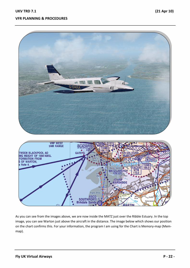
As you can see from the images above, we are now inside the MATZ just over the Ribble Estuary. In the top image, you can see Warton just above the aircraft in the distance. The image below which shows our position on the chart confirms this. For your information, the program I am using for the Chart is Memory-map (Mem-map).

UKV TRD 7.1 (21 Apr 10)
VFR PLANNING & PROCEDURES
Fly UK Virtual Airways P - 23 -
As we approach Southport Pier, we should start thinking about looking at our ‘Plog.’ Our first heading should be 186degrees and should take us approximately 5 minutes. So as we pass over the Pier we turn onto our heading and we start out stopwatch.
UKV TRD 7.1 (21 Apr 10)
VFR PLANNING & PROCEDURES
Fly UK Virtual Airways P - 24 -
As we pass abeam RAF Woodvale we should have a look at our time; as the airfield is a convenient half way point marker, and so we should be around the 2 minute 30 seconds region. This is also a good time to request a frequency change to Liverpool Radar, as we will need to speak to them to organise a zone transit.
Aircraft: G-RA, request frequency change to Liverpool Radar, 119,850.
Radar: G-RA, Squawk 7000, free-call Liverpool, good day.
Aircraft: Squawk 7000 and free-call Liverpool, thanks for your help, G-RA.
Note: We are now going to switch over to Liverpool Radar. Liverpool is quite a busy airport, so expect the frequency to be fairly busy, don’t butt in and wait your turn. If you feel you are getting too close to their airspace without having checked-in; then simply enter an orbit and wait until you can speak. DO NOT enter controlled airspace without permission. Also, if when you speak to the Radar controller you are told to stand-by, simply remain silent until you are called.
Aircraft: Liverpool Radar, good Afternoon, G-DARA.
Radar: G-DARA, Liverpool Radar, good Afternoon, pass your message.
Aircraft: G-DARA, is a Piper Seneca from Blackpool to Welshpool, currently 2 miles East of Woodvale, routing Seaforth request a Zone Transit routing Seaforth and Neston at 3,000ft.
Radar: G-RA, it’s a Basic Service, Squawk 4431, remain outside of controlled airspace, will call you back.
Aircraft: Basic Service and 4431 you have, will remain outside, G-RA.
- - - Break In Communication - - -
Radar: G-RA, Liverpool Radar.
Aircraft: Pass your message, G-RA.
Radar: G-DARA, cleared to transit Liverpool Controlled Airspace, not above altitude 3,000ft VFR routing Seaforth and Neston, Liverpool QNH is 1006mb, report entering Controlled Airspace.
Aircraft: Cleared to transit Liverpool Controlled Airspace not above 3,000ft VFR routing Seaforth and Neston QNH 1006; Wilco, G-RA.
Note: What we have above is a typical conversation between us and Liverpool Radar. Most of the time this is how it will proceed, however from time to time if they are quiet, you won’t have to wait for them to come back to you with a clearance, they may be able to pass it the second you ask. We have also been asked to report when entering controlled airspace.

UKV TRD 7.1 (21 Apr 10)
VFR PLANNING & PROCEDURES
Fly UK Virtual Airways P - 25 -
We have now arrived overhead Seaforth, so we need to inform Radar that we are entering controlled airspace. We do this by simply stating. ‘G-RA has entered controlled airspace.’ The Radar controller will then simply say, ‘G-RA, roger, Radar Control Service report leaving at Neston.’ We would then readback ‘Radar Control Service, Wilco, G-RA.’
UKV TRD 7.1 (21 Apr 10)
VFR PLANNING & PROCEDURES
Fly UK Virtual Airways P - 26 -
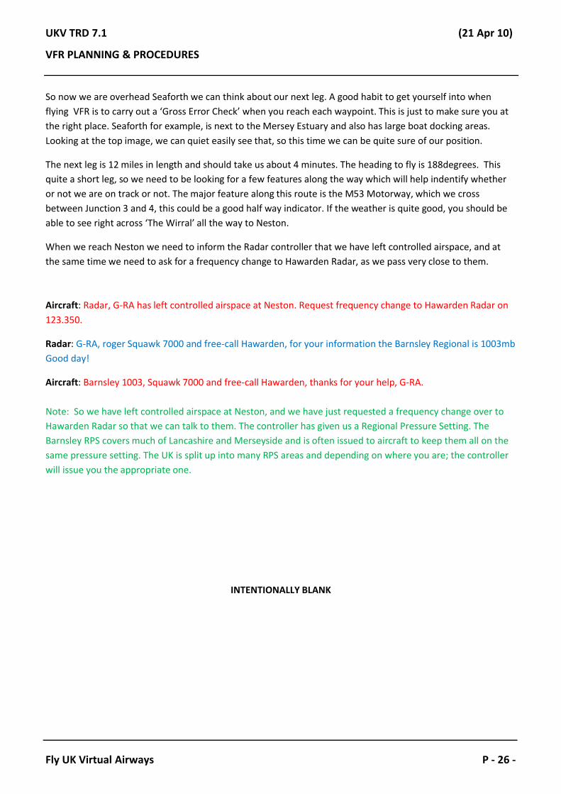
So now we are overhead Seaforth we can think about our next leg. A good habit to get yourself into when flying VFR is to carry out a ‘Gross Error Check’ when you reach each waypoint. This is just to make sure you at the right place. Seaforth for example, is next to the Mersey Estuary and also has large boat docking areas. Looking at the top image, we can quiet easily see that, so this time we can be quite sure of our position.
The next leg is 12 miles in length and should take us about 4 minutes. The heading to fly is 188degrees. This quite a short leg, so we need to be looking for a few features along the way which will help indentify whether or not we are on track or not. The major feature along this route is the M53 Motorway, which we cross between Junction 3 and 4, this could be a good half way indicator. If the weather is quite good, you should be able to see right across ‘The Wirral’ all the way to Neston.
When we reach Neston we need to inform the Radar controller that we have left controlled airspace, and at the same time we need to ask for a frequency change to Hawarden Radar, as we pass very close to them.
Aircraft: Radar, G-RA has left controlled airspace at Neston. Request frequency change to Hawarden Radar on 123.350.
Radar: G-RA, roger Squawk 7000 and free-call Hawarden, for your information the Barnsley Regional is 1003mb Good day!
Aircraft: Barnsley 1003, Squawk 7000 and free-call Hawarden, thanks for your help, G-RA.
Note: So we have left controlled airspace at Neston, and we have just requested a frequency change over to Hawarden Radar so that we can talk to them. The controller has given us a Regional Pressure Setting. The Barnsley RPS covers much of Lancashire and Merseyside and is often issued to aircraft to keep them all on the same pressure setting. The UK is split up into many RPS areas and depending on where you are; the controller will issue you the appropriate one.
INTENTIONALLY BLANK

UKV TRD 7.1 (21 Apr 10)
VFR PLANNING & PROCEDURES
Fly UK Virtual Airways P - 27 -
Let’s have a look at our next leg. From Neston, we are going to route to Wrexham, which is a large town to the South. However to get to Wrexham, we will have to fly very close to Hawarden which is a large Airbus factory which see’s a lot of movements by large aircraft. So we should give Hawarden a courtesy call to let them know that we are going to be passing close to the West. As for a ‘Gross Error Check’, Neston is a small town, with a large area of Marsh-Land next to it. That should be a sufficient check, and quite easy to spot.

UKV TRD 7.1 (21 Apr 10)
VFR PLANNING & PROCEDURES
Fly UK Virtual Airways P - 28 -
Aircraft: Hawarden Radar, good afternoon, G-DARA.
Radar: G-DARA, Hawarden Radar, very good afternoon, pass your message.
Aircraft: G-DARA, is a Piper Seneca from Blackpool to Welshpool just South of Neston, 2,900ft VFR on the Barnsley 1003mb routing Wrexham and Welshpool request a Traffic Service if able.
Radar: G-RA, Roger Squawk 7433.
Aircraft: 7433, G-RA.
Radar: G-RA, you are identified 4miles North West of Hawarden it’s a Traffic Service, Hawarden QNH is 1006mb.
Aircraft: Traffic Service, QNH 1006 G-RA.
Note: We have now made contact with Hawarden Radar and this time we have asked for a Traffic Service. This is better than a Basic Service and you will be issued with traffic reports during your service for any traffic that may affect you.
From Neston we need to fly a heading of 174degrees for approximately 6 minutes. Our half way point is conveniently abeam Hawarden itself, and we should pass about 2miles to the West of the airfield. We need to remain below 3,000ft on this leg, as we have Class ‘A’ airspace above us.
INTENTIONALLY BLANK

UKV TRD 7.1 (21 Apr 10)
VFR PLANNING & PROCEDURES
Fly UK Virtual Airways P - 29 -
As we approach our half way marker I have noticed that the weather is getting somewhat groggy. After a quick enquiry we find that the visibility is around the 9km mark which is still within our limits, so for the time being, we continue with our flight as planned!

UKV TRD 7.1 (21 Apr 10)
VFR PLANNING & PROCEDURES
Fly UK Virtual Airways P - 30 -
As we carry on down our leg, we eventually arrive overhead Wrexham albeit a minute early! As we pass overhead we need to do a quick ‘Gross Error Check.’ Wrexham is a large town, which has two major roads leading into it and also has two railway lines going into it, these would be good features to look for!

UKV TRD 7.1 (21 Apr 10)
VFR PLANNING & PROCEDURES
Fly UK Virtual Airways P - 31 -
Now that we are overhead Wrexham, we can think about turning onto heading for our final leg! We need to fly a heading 197degrees for 30 miles. This should take us about 11 minutes. This is our longest leg, and again conveniently, our half way point is just underneath a large town called ‘Oswestry.’ At some point along this leg, we should get in touch with Shawbury Zone and ask them for a Basic Service, as they will be in a better position to give us a service.
As we make the turn at Wrexham, we need to start our stopwatch for the final time. In a couple of minutes we will get in contact with Shawbury Zone for our final Basic Service.
It is now time to switch frequency over to Shawbury Zone.
Aircraft: Hawarden, G-RA request frequency change to Shawbury Zone on 120.775 .
Radar: G-RA, roger my service terminates, Squawk 7000, free-call Shawbury 120.775, good-day.
Aircraft: Squawk 7000 free -call Shawbury, good-day G-RA.
- - - Break In Communication // Switch Frequencies- - -
Aircraft: Shawbury Zone, good Afternoon, G-DARA.
Radar: G-DARA, Shawbury Zone, good afternoon, pass your details.
Aircraft: G-DARA, is a Seneca from Blackpool enroute to Welshpool, we’re 3 miles South of Wrexham routing Whiskey Papa Lima 2,900ft VFR on the QNH 1006mb, request a Basis Service.
Radar: G-RA, Basic Service you have, Barnsley Regional is 1003mb, report when you have Welshpool in sight.
Aircraft: Basic Service, 1003mb and Wilco, G-RA.
INTENTIONALLY BLANK
UKV TRD 7.1 (21 Apr 10)
VFR PLANNING & PROCEDURES
Fly UK Virtual Airways P - 32 -
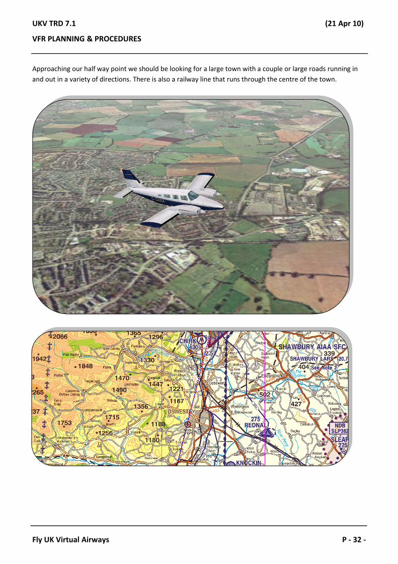
Approaching our half way point we should be looking for a large town with a couple or large roads running in and out in a variety of directions. There is also a railway line that runs through the centre of the town.

UKV TRD 7.1 (21 Apr 10)
VFR PLANNING & PROCEDURES
Fly UK Virtual Airways P - 33 -
As we progress towards Welshpool, we should start looking out for the airfield. As we were asked to report the field in site. To aid us in looking for the field, Welshpool has an NDB, we can tune this into our radio.
The frequency is 323KHz but please note the NDB only has a range of about 10miles due to the terrain.
Although perhaps not very clear, if you look at the ADF needle (the furthest instrument to the left, just below the clock) it is pointing straight forward. This indicates that relative to the nose of the aircraft, the airfield is straight ahead!
At this point, we are only probably about 10 miles out, so we should start a gradual descent down and keep a good lookout for the field which should be just off the nose. We know where the field is, so we can give the controller a call and request the frequency change.
Aircraft: Shawbury, G-RA field in sight request frequency change to Welshpool Radio on 128.000.
Radar: G-RA, Free-call Welshpool. Good-day.
Aircraft: To Welshpool, many thanks G-RA.
- - - Break In Communication // Switch Frequencies- - -

UKV TRD 7.1 (21 Apr 10)
VFR PLANNING & PROCEDURES
Fly UK Virtual Airways P - 34 -
Aircraft: Welshpool Radio, good Afternoon, G-DARA request airfield information.
Radio: G-DARA, Welshpool Radio good afternoon Sir, we’re on 22 Left Hand the QFE 998mb.
Aircraft: 22 Left Hand 998mb. Field in sight, we’re positioning for a straight in Runway 22 G-RA.
Radio: G-RA, roger nothing known to effect.
Aircraft: Long finals 22 to Land, G-RA.
Radio: G-RA, roger winds 260 degrees at 13 knots.
Aircraft: G-RA.
Note: You may have noticed that there have been absolutely no clearances in this transcript. That is because ‘Radio Positions’ are not allowed to give clearances. They can give advisory information and that’s about it.Everything you do at an ‘Air Ground Airfield’ is entirely pilots discretion, and you simply have to state your intentions. Now that we have the field in site, we can position for a final approach and land.

UKV TRD 7.1 (21 Apr 10)
VFR PLANNING & PROCEDURES
Fly UK Virtual Airways P - 35 -
As we get closer to the airfield, keep a good look out for traffic as remember there is no official control service here, everyone has to look out for themselves.
From the image above, we are in a position to be able to make a safe landing, the runway is clear and there is nothing else in the area. Once we have landed we should vacate the Runway and taxi on the grass towards the parking area, or if there is nothing else about then we can backtrack the Runway.
Aircraft: G-RA backtracking 22.
Radio: G-RA roger, landing time 45, you can park on the concrete apron if you wish.
Aircraft: Concrete apron, thanks a lot G-RA.
Note: This then concludes our flight. All we need to do now is taxi to concrete apron and shut down. When speaking to ‘Air Ground Airfields’ don’t expect things to be overly formal. The transcripts within this document reflect experiences that I have had in the real world, and it is never uncommon to hear people speak this way. When required, keep it formal and concise especially on busy frequencies.

UKV TRD 7.1 (21 Apr 10)
VFR PLANNING & PROCEDURES
Fly UK Virtual Airways P - 36 -
That concludes our VFR flight for today. There is a lot to cover when flying VFR, and I hope that this document has helped you to understand the concept of VFR flight a little bit more. There are training sessions available from the Training Academy should you wish to go through anything within this document in more depth, and there are a number of people within the Fly UK Community who have real world experience in this region, so feel free to ask questions. Happy flying!
END OF DOCUMENT