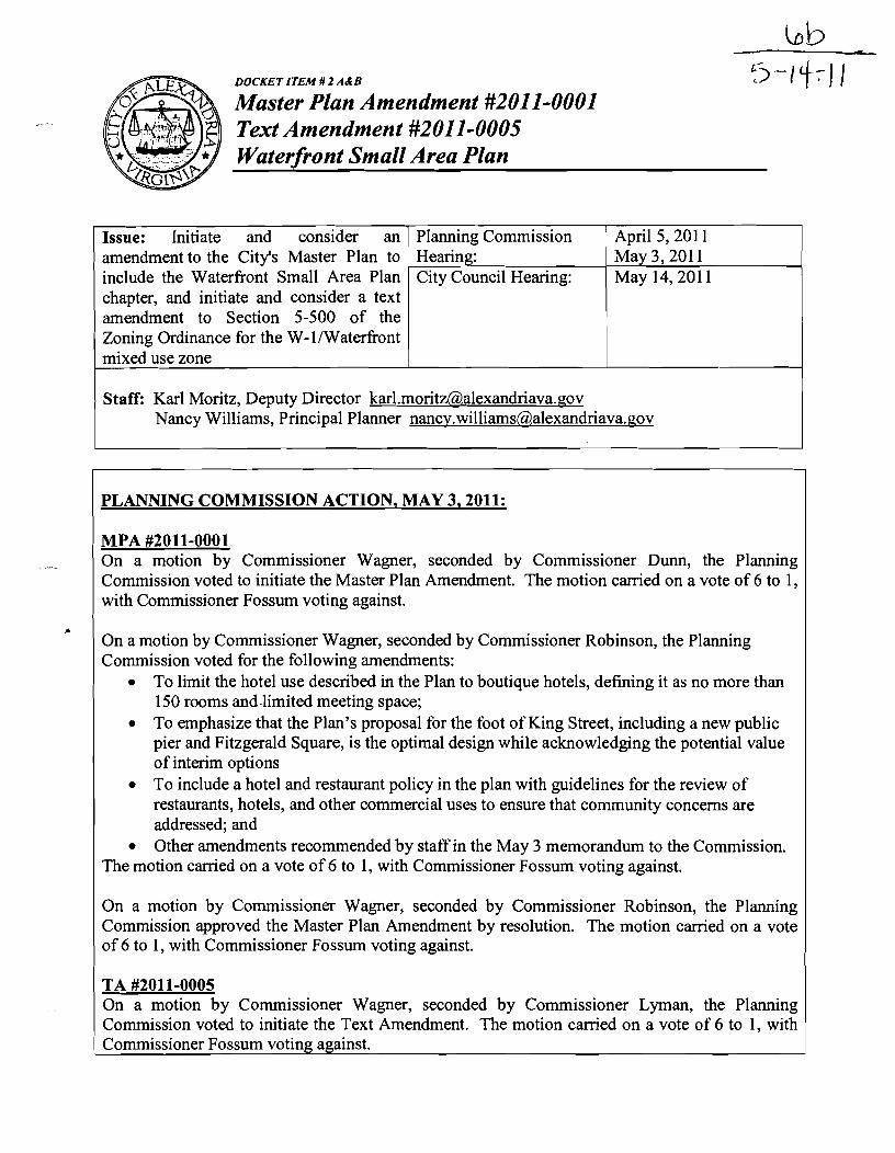
DOCKET ITEM Master Plan Amendment #2011-0001...
94
DOCKET ITEM # 2 A&B Master Plan Amendment #2011-0001 Text Amendment #2011-0005 Waterfront Small Area Plan PLANNING COMMISSION ACTION, MAY 3,2011: MPA #2011-0001 April 5,201 1 May 3, 201 1 May 14,201 1 Issue: Initiate and consider an amendment to the City's Master Plan to include the Waterfront Small Area Plan chapter, and initiate and consider a text amendment to Section 5-500 of the Zoning Ordinance for the W-1/Waterfront mixed use zone On a motion by Commissioner Wagner, seconded by Commissioner Dunn, the Planning Commission voted to initiate the Master Plan Amendment. The motion carried on a vote of 6 to 1, with Commissioner Fossurn voting against. Staff: Karl Moritz, Deputy Director karl.moritz@,alexandriava.aov Nancy Williams, Principal Planner nancy.williams~,alexandriava.~ov Planning Commission Hearing: City Council Hearing: On a motion by Commissioner Wagner, seconded by Commissioner Robinson, the Planning Commission voted for the following amendments: To limit the hotel use described in the Plan to boutique hotels, defining it as no more than 150 rooms and.limited meeting space; To emphasize that the Plan's proposal for the foot of King Street, including a new public pier and Fitzgerald Square, is the optimal design while acknowledging the potential value of interim options To include a hotel and restaurant policy in the plan with guidelines for the review of restaurants, hotels, and other commercial uses to ensure that community concerns are addressed; and Other amendments recommended by staff in the May 3 memorandum to the Commission. The motion carried on a vote of 6 to 1, with Commissioner Fossum voting against. On a motion by Commissioner Wagner, seconded by Commissioner Robinson, the Planning Commission approved the Master Plan Amendment by resolution. The motion carried on a vote of 6 to 1, with Commissioner Fossum voting against. TA #2011-0005 On a motion by Commissioner Wagner, seconded by Commissioner Lyman, the Planning Commission voted to initiate the Text Amendment. The motion carried on a vote of 6 to 1, with Commissioner Fossum voting against.
-
Upload
nguyencong -
Category
Documents
-
view
214 -
download
1
Transcript of DOCKET ITEM Master Plan Amendment #2011-0001...
DOCKET ITEM # 2 A&B
Master Plan Amendment #2011-0001 Text Amendment #2011-0005 Waterfront Small Area Plan
PLANNING COMMISSION ACTION, MAY 3,2011:
MPA #2011-0001
April 5,201 1 May 3, 201 1 May 14,201 1
Issue: Initiate and consider an amendment to the City's Master Plan to include the Waterfront Small Area Plan chapter, and initiate and consider a text amendment to Section 5-500 of the Zoning Ordinance for the W-1 /Waterfront mixed use zone
On a motion by Commissioner Wagner, seconded by Commissioner Dunn, the Planning Commission voted to initiate the Master Plan Amendment. The motion carried on a vote of 6 to 1, with Commissioner Fossurn voting against.
Staff: Karl Moritz, Deputy Director karl.moritz@,alexandriava.aov Nancy Williams, Principal Planner nancy.williams~,alexandriava.~ov
Planning Commission Hearing: City Council Hearing:
On a motion by Commissioner Wagner, seconded by Commissioner Robinson, the Planning Commission voted for the following amendments:
To limit the hotel use described in the Plan to boutique hotels, defining it as no more than 150 rooms and.limited meeting space; To emphasize that the Plan's proposal for the foot of King Street, including a new public pier and Fitzgerald Square, is the optimal design while acknowledging the potential value of interim options To include a hotel and restaurant policy in the plan with guidelines for the review of restaurants, hotels, and other commercial uses to ensure that community concerns are addressed; and Other amendments recommended by staff in the May 3 memorandum to the Commission.
The motion carried on a vote of 6 to 1, with Commissioner Fossum voting against.
On a motion by Commissioner Wagner, seconded by Commissioner Robinson, the Planning Commission approved the Master Plan Amendment by resolution. The motion carried on a vote of 6 to 1, with Commissioner Fossum voting against.
TA #2011-0005 On a motion by Commissioner Wagner, seconded by Commissioner Lyman, the Planning Commission voted to initiate the Text Amendment. The motion carried on a vote of 6 to 1, with Commissioner Fossum voting against.

Master Plan Amendment #2011-0001 Text Amendment #20 1 1-0005
Waterfront Small Area Plan
On a motion by Commissioner Wagner, seconded by Commissioner Jennings, the Planning Commission voted to recommend approval of the Text Amendment. The motion carried on a vote of 6 to 1, with Commissioner Fossum voting against.
Reason: The Planning Commission endorses the Waterfiont Plan, saying that it balances the aspirational with the practical by setting forth a strong and clear vision for a world-class waterfront that is also technically and financially attainable; that it meets the needs of all Alexandrians while safeguarding nearby neighborhoods; that its adds more open space than it does new development; that it finds multiple avenues to bring Alexandria's history back to life along the water; and that it addresses major challenges such as flooding and parking in cost-effective and harmonious ways. It creates a waterfront that keeps what Alexandrians love the most, and it provides a clear path forward to achieving what they have been missing. Over the last 2 years and 100 meetings, Alexandrians were unequivocal about what they wanted for their waterfront and this plan delivers on those goals in an inspired and practical way.
James McCall, Alexandria Archaeological Commission, asked that the plan be deferred so that the community can review a new version of the document with all the changes proposed, including AAC7s.
John Gosling, President, Old Town Citizens Association, said that OTCA has not taken a position on the changes, including options for the ODBC parking lot, and asked for a delay so it can review the information.
Eric DeSoto, Board Chairman, Old Dominion Boat Club, discussed the history of the ODBC as a charitable club, the fact that the parking lot is the only boat yard left in Alexandria, and the ODBC's plan to make improvements to the property. He noted that settlement efforts took place to end the federal law suit but that on January 11,20 11 a court decision confirmed that the ODBC is the property owner of 1 and 2 King Street, with riparian rights. He raised concerns about whether the Planning Commission's decision affects ODBC's rights to improve its property and about the City rezoning or master planning the ODBC property from the WPR zone to a public use zone could be considered unreasonable and confiscatory. He explained that ODBC representatives have met during the past month with City staff and Planning Commissioners to discuss conceptual ideas for the parking lot. He described the two options published by the staff and indicated that ODBC had agreed they could be published, although ODBC would continue to talk to staff about concerns they have with Option B. He also added that the Eisenhower boat storage and the Torpedo Factory docks were identified as incentives to ODBC to allow public access along the water and to allow parts of the parking lot to be made smaller.
Andrew MacDonald, 21 7 Columbus Street, objected to the plan and requested a deferral.
Van Van Fleet, 26 Wolfe Street, identified himself as the only dissenting voice on the Waterfront Committee support for keeping Fitzgerald Square in the plan. He also objects to the 3-4 hotels and the marina at Robinson Terminal South and supports a deferral.
Master Plan Amendment #20 1 1 -000 1 Text Amendment #20 1 1-0005
Waterfront Small Area Plan
Peter Pennington, Vice Chairman, Waterfront Committee, recommended that Fitzgerald Square remain in the plan along with ideas about solving the ODBC parking lot issue.
Beal Lowen, 321 South Lee Street, said the ODBC is the only remaining boat yard in the City and the club is committed to being good citizens; he believes Option A is a good option.
Michael Peck, 420 N. Union Street, thinks the ODBC members are good citizens and spoke about Virginia law granting certain legal rights to citizens who live within 300 feet of a property.
William Rogalski, Jr., 408 Hanson Lane, raised concerns about the cost of the plan and requested a deferral so that more information could be obtained.
Julie Van Fleet, 26 Wolfe Street, asked for a deferral so that the community has more time to consider the ODBC options.
Boyd Walker, Chair, Greater Alexandria Preservation Alliance, referred to a petition against the rezoning of the waterfront including hotels, increased density and adjustments to the height restrictions. He asked that the hotels be taken out of the plan before moving forwarded.
Elizabeth Baldwin, 428 N. Union Street, referred to a lawsuit she and several of her neighbors brought against the Washington Post and stated they will continue to pursue the case if the Planning Commission continues to pursue hotels at Robinson Terminal.
Sarita Schotta, 104 Prince Street, expressed concern about congestion, traffic, noise, bus and parking issues that residents along the waterfront face.
Bert Ely, 200 S. Pitt Street, asked for a deferral to review new information, including the restaurantlhotel policy, and expressed continuing concerns about costs and revenues of the plan.
Poul Hertel, 12 17 Michigan Court, referred to his testimony on the plan last month that included alternative schemes for the foot of King Street. He indicated Option B, with some modifications, is closer to his preference for the foot of King Street.
Robert Montague, 207 Prince Street, Vice President of the Northern Virginia Conservation Council, stated that he has been involved in the waterfront planning process since 1973 beginning with Founders Park. He asked for a deferral and raised concerns about open space. He added that he believes the ODBC should be a part of the waterfront plan but that hotels and parking lots should not.
Bill Schaeffer, 327 N. St. Asaph, compared the plan to National Harbor and stated that she thinks Option A is better because she does not want to see cars at the foot of King Street.
John Bly, 418 N. Union Street, raised concerns about legal costs and lower property values if the zoning for Robinson Terminal is changed.
Master Plan Amendment #2011-0001 Text Amendment #2011-0005
waterfront Small Area Plan
Katy Cannady, 20 East Oak Street, prefers Options A and B to Fitzgerald Square because they are less expensive. She asked why the FAR is still being increased from 2.0 to 3.0 for hotels on the development sites if Fitzgerald Square is no longer there.
Jeremy Taylor, 213 S. Royal Street, objects to both Options A and B and asked that the entire plan be rejected because the plan was done in a clandestine manner and contains too much density.
PLANNING COMMISSION ACTION, APRIL 5,2011: The Planning Commission closed the public hearing and continued the discussion of the Master Plan Amendment and Text Amendment to the May 3 hearing. Chairman Komoroske stated that the Planning Commission may reopen the public hearing if deemed necessary. Speakers:
Bert Ely, 200 South Pitt Street, spoke in opposition, raising questions about permitting issues, congestion and costs. He suggested the plan adoption be postponed.
Judy Noritake, representing the Parks and Recreation Commission, spoke in support of the Plan, describing it as a park plan that integrates art, history and commerce. She stressed the fact that the Commission is geographically representative of the entire City, and spoke to the importance of park maintenance and a profitable marina.
Andrew MacDonald, 217 N. Columbus Street, spoke in opposition as a private citizen. He thought there should be options such as more parkland instead of hotels and economic models for the options. He criticized the process as not involving residents. As a member of HARC, he submitted a letter from that Commission stating support of the art and history components of the Plan.
Nathan Macek, Chair, Waterfront Committee, spoke in support of the Plan as necessary to guide redevelopment and City investments, and providing a balance between economic development and parks. He added several suggestions related to parking, balance of uses, density controls, the Waterfront Park building and h d i n g for Windmill Hill Park.
Michael Wenk, Alexandria House HOA, spoke in support and said the concerns expressed by the speakers, including flood control, open space, connectivity, access, history, development, and regulatory controls, have been included in the Plan.
John Gosling, President, Old Town Civic Association, spoke in opposition, citing a recent OTCA poll reflecting the need to reduce density and to include more open space, a stronger commitment to civic/cultural uses, limits on commercial uses including hotel rooms, the elimination of the
I Waterfront Park building and a demonstration that the Plan is revenue neutral.
Master Plan Amendment #20 1 1 -000 1 Text Amendment #2011-0005
Waterfront Small Area Plan
Andrew Palmieri, Chairman-elect, Chamber of Commerce, spoke in support of the Plan, citing a long public participation process, the fact that the Plan is consistent with the City's Economic Sustainability Plan, and that development in the Plan is needed to make it economically sustainable.
Tina Leone, President and CEO, Chamber of Commerce, spoke in support. She explained that the Chamber, representing 900 businesses with half of those businesses resident-owned, considers the waterfront an asset for the entire City and hotels to be good uses because they have lower impacts and higher revenues than alternative uses.
Bill Lowen, 321 S. Lee Street, expressed concern about the process, and objection to the idea of a promenade along the River. He thought the process should be slowed down and that decisions are being made without good data.
Charlotte Hall, representing the Alexandria Convention and Visitors Association, spoke in support of the Plan. She stated it is consistent with the City's Economic Sustainability Plan and the Council's Strategic Plan, and it will create a world class waterfront. She added that as Vice President of the Potomac Riverboat Company, she supports an expanded commercial marina, indicating that PRC now docks three boats at National Harbor because the City's current marina lacks space.
Jody Manor, owner of Bittersweet restaurant and ACVA board member, spoke in support, citing the extensive public participation and the enhancement of public access and public open space. He stated that the waterfront today does not serve as the cultural, public or economic asset it should be. He indicated that ACVA urges support of the Plan in its entirety so that the waterfront can achieve its potential as a recreational resource and economic tool.
John Renner, business owner and Chair of the Public Affairs Committee of the ACVA, spoke in support of the Plan generally and of the concept of hotel use and tourism specifically. He stated that hotels promote public access to the water, generate 6 times the revenue that residential uses do, and cited the recent investment of $400 million by hotels in Alexandria.
Kenneth Wire, McGuire Woods, representing the owner of the Sheet Metal Workers building, requested that the Plan be amended to reference the potential for a rezoning for that site that is compatible with uses in the Plan should the building redevelop in the future.
James McCall, Chair, History Plan Committee of the Alexandria Archeological Commission, expressed AAC's support of the history component of the Plan, and suggested a series of specific additions and changes to the text.
Miles Holtzman, President, Old Dominion Boat Club, asked to preserve the right to speak at the May Planning Commission meeting and stated that the City and ODBC were currently in discussion regarding possible options for the foot of King Street.
Master Plan Amendment #2011-0001 Text Amendment,#2011-0005 I
Waterfront Small Area Plan
Lauren Garcia, Vice Chair, Alexandria Economic Development Partnership, indicated the AEDP Board supports and urges adoption of the Plan, stating that the PIan includes unique open space and other improvements that will benefit a variety of stakeholders and will draw investment to help pay for the improvements.
Boyd Walker, Alexandria Preservation Alliance, spoke in opposition to the Plan and expressed concem about the Plan's lzck of concern about history and historic sites on the Waterfront.
Matthew Harwood, AIexandria Commission for the Arts, spoke in support of the Plan's incorporation of public art, but raised concem about finding a new home for the Art League.
Bill Harvey, 2 1 51 Jamieson Avenue, raised concern about the Plan as a whole indicating it is not tied to Alexandria and a concern that the proposed piers would be exposed to ice, currents flotsom and jetsam. He proposed a scaled down version of the piers.
Van Van Fleet, 26 Wolfe Street, supports the Plan's deferral indicating it has no backing from residents, and stating a need for an economic analysis, regulatory approvals have not been obtained, the piers are too long, replacement parking for Dandy and Chadwicks' is needed, and too much density has been proposed--including space for 14 Virtue size equivalent restaurants. He recommended implementation of flood mitigation and bulkhead repairs now.
WiIliam Rogalski, Jr., 408 Hansen Lane, spoke against the Plan, suggesting a deferral so that a smaller plan could be devised with the necessary costtbenefit analysis.
Bruce Miller, 410 Hansen Lane, encouraged the Commission to get answers to the questions raised at the hearing.
Woody Moms, American Medical Group, One Prince Street, supports an improved w a t d o n t but objects to a building in Waterfront Park.
Bob Wood, 711 Potomac Street, recommended caution because he sees the Plan as one for economic development only.
Val Hawkins, President and CEO, AEDP, spoke in support. He has been a resident of Alexandria for 37 years and noted the monumental work that went into this Plan by staff, citizens and the various involved stakeholders. He stated the AEDP adopted a resolution in support of the Plan stating its consistency with the City's Strategic Plan and Economic Sustainability Plan.
Poul Hertel, 1271 Michigan Court, provided an alternative Plan with the Beachcomber as the cultural center, housing a museum with possibly a restaurant. He recommended that the Waterfront Park building be removed and the ODBC parking lot remain but in modified form.

Master Plan Amendment #2011-0001 Text Amendment #2011-0005
Waterfront Small Area Plan
Julie Van Fleet, 26 Wolfe Street, also recommended an alternative from the Waterfkont Alliance that does not includes hotels, but does include flood control and uses the Robinson Terminal South location for a maritime museum, the Seaport Foundation, an art museum and the Archeological Museum. She suggested thinking outside the box on the Cummings and Robinson Terminal North sites.
Robert Riker, 118 Waterford Place, raised questions about the value of Robinson Terminal, private marina development, ODBC piers, and commercial boating generally.
Katy Cannady, 20 East Oak, spoke against the Plan, stating it violates the Waterfront Park settlement agreement and did not include an interactive citizen's participation process.
Joe Demshar, 302 Prince Street, raised issues about the vision for the waterfront and the cost of the Plan.
Dana de Montigny, 302 Prince Street, spoke against the Plan and the density, arguing that changing the waterfront would change Old Town and its authenticity.
Michael Hobbs, 419 Cameron Street, discussed the fact that there are many areas of consensus in the Plan, but scale and density are points of contention.
John Bly, 418 N. Union Street, stated there is a need for more meetings in order to have greater dialogue and a consensus Plan.
Michael Vea, 420 N. Union Street, opposed the Plan; he has studied the Plan and it will drive him out of Alexandria if adopted; he is concerned about the use of Robinson Terminal North as a hotel.

Master Plan Amendment #2011-0001 Text Amendment #2011-0005
Waterfront Small Area Plan
I. BACKGROUND
The Waterfront Plan proposed for adoption is the culmination of a great effort, over two years, and many people's involvement. The Department of Planning and Zoning began the planning process in April 2009. Extensive community outreach, including some 100 small group, community-wide, and staff meetings have occurred. There have been activities such as charrettes, tours, and topical nights on art, history, and the marina. The Planning Commission and City Council have conducted work sessions and briefings on the Plan's overall content as well as specific issues.
Technical expertise was also applied during the planning process in the areas of marine engineering; flood mitigation; architecture, park and public space design through staff and consultants; hotel and marina market assessments through consultants; preliminary regulatory and permitting analysis through consultants and communication with the District of Columbia, the Corps of Engineers, the Commonwealth of Virginia, and the National Park Service (NPS) for pier and marina expansion; parking and traffic analysis through consultants; production of Art and History Waterfront Plans by the City's art and history communities; and more. The Plan also benefited from the Old Town Area Parking Study, the Potomac River Waterfront Flood Mitigation Study, and the Waterfront Traflc Impact Study, with results integrated into the Plan.
The public outreach meetings and activities along with technical expertise facilitated a vision to create a 21'' century waterfront that meets the needs of residents and visitors alike and that is sustainable economically and environmentally. The vision then helped to shape a series of illustrative designs for redevelopment of the waterfront.
Although the Plan looks toward the future, it is also bolstered by past planning efforts, all of which share the goals of a publicly-oriented and accessible waterfront; multi-modal connectivity via a walkway and bicycle trail; creation of parks and open space; and redevelopment of remaining development sites through a mixture of uses to promote an active waterfront. While some objectives have been realized, the Plan's overarching goal is to enhance what has been accomplished to-date by:
expanding the provision of open and public space; strengthening the visual and physical connectivity along the waterfront; generating more water-oriented and related public activity along the waterfront; fostering adaptive reuse of historic buildings; and guiding redevelopment of the limited remaining development sites.
Master Plan Amendment #2011-0001 Text Amendment #20 1 1 -0005
Waterfront Small Area Plan &
11. ISSUES
During the planning process, several key issues were discussed, and remain critical to any conversation about the waterfront. Additionally, City Council, during a work session on February 8, 201 1, highlighted a series of issues for further, more detailed review: flood mitigation, parking, a smaller scale Waterfront Park Building, and implementation issues such as costs/revenues and phasing. Information was released on March 23, 201 1 to the public, regarding those items, and it is also provided in this staff report as Attachments 7, 8, 9 and 10 respectively. Summaries of these and other issues/solutions are included below.
A. Flood Mitigation
Participants in the planning process urged that a solution to the frequent flooding in Old Town be included in the Plan. The Plan reflects the flood mitigation approach determined to be the most cost effective, and it incorporates those solutions into improvements to parks and public spaces. Flood mitigation will be one of the first priorities for Plan implementation.
In 2007, the Transportation & Environmental Services Department conducted an initial assessment of flooding along the City of Alexandria's waterfront within the - Potomac River watershed. That assessment led to the 2010 Potomac River Waterfront Flood Mitigation Study to determine the causes of the flooding problem, identify potential solutions, analyze these potential solutions and recommend the best solutions. Three flood levels were examined in the study: [Nuisance (4 feet NAVD88), Intermediate (8 feet NAVD88) and Extreme (100-year, 10.2 feet NAVD8 8)].
The flood study area is bounded by Third Street to the north, Fairfax Street to the west, the Capital Beltway to the south, and the Potomac River to the east and, then, is further divided into four focus areas: Jones Point, King Street, Waterfront Commercial, and North Union.
Twenty-seven flood mitigation measures were identified and discussed in a series of public and staff meetings that occurred from October 2007 through November 2008. During that process, a numerical scoring system was developed to select mitigation measures to consider further. The following nine mitigation measures were selected for detailed evaluation using this scoring system.
Structural measures: provide dry flood proofing; acquire properties; elevate structures; construct engineered structural barriers (i.e., waterfront floodwall and Jones Point berm); construct an elevated walkway that would also be a floodwall structure; and increase the inlet and road elevation in the vicinity of the Lower King Street area. L

Master Plan Amendment #2011-000 1 Text Amendment #2011-0005
Waterfront Small Area Plan
Nonstructural measures: relocate internal supplies, products/goods above the flooding depth; improve the City's floodplain and zoning ordinances; and improve the sandbag programs or provide other temporary flood deterrents
A benefit-cost analysis (BCA) was performed for the six structural mitigation measures. A BCA was not computed for the proposed nonstructural mitigation measures. Therefore, nonstructural mitigation measures were evaluated only for applicability and technical feasibility. The historic nature of the City adds to the cost and complexity of the mitigation measures considered. Additionally, conceptual designs were developed for the floodwall, Jones Point berm, the elevated walltway, and roadway improvements.
After considerable analysis of different flood levels and a variety of potential flood mitigation areas, the study found that the most cost-effective level of protection is 6 feet NAVD88, which has a recurrence interval of approximately 10 years. At higher protection elevations, the physical size and cost of the work increases dramatically, and BCA drops quickly.
The study does not recommend a single flood mitigation solution, but rather a series of measures are recommended to provide protection against flood events on the Potomac River, including several of the structural measures that can be constructed by the City: (1) inlet and roadway improvements along King Street, Union Street and The Strand; (2) an elevated walkway approximately 1,280 feet in length; and (3) approximately 550 feet of floodwall. An additional recommendation involves flood proofing private properties that are currently vulnerable to nuisance flooding. This idea would require participation from private property owners, although the City can provide expertise and guidance.
The Plan incorporates the three recommended structural flood mitigation measures as follows: The first, inlet and roadway improvements include raising the roadway elevation and associated drainage structures in the vicinity of the intersections of King Street and The Strand and King Street and Union Street. The City encounters flooding in these areas due to storm drain and because of the low elevations of the catch basins. The improvements would raise the roadway by approximately a foot to one and a half feet, as well as raising storm drain manholes and catch basins, reducing the most frequent occurrences of flooding in this area. The frequency of shallow nuisance flooding could be reduced from over 150 times a year to about 10 times a year, depending on the roadway elevations that are achieved.
In the case of the second and third structural recommendations, namely an elevated walkway and floodwall system, the Plan includes a variation of these so that, instead of the full structures being located along the promenade, blocking the river view, they are in part naturally incorporated into the parks and landscape along this area. The layout of these structural elements is shown in concept in this Plan. The exact
Master Plan Amendment #20 1 1-000 1 Text Amendment #20 1 1-0005
Waterfront Small Area Plan - locations will be developed in the implementation phase as more extensive engineering analysis and design takes place.
The effectiveness of the proposed flood protection up to Elevation 6.0 is dependent upon the entire limits of the mitigation being constructed. If the improvements are phased in over time, the flood protection will not be realized until the final phase is completed. More information regarding flood mitigation is included in Attachment 7 - Flood Mitigation Measures and Graphics.
B. Parking
Early in the planning process, many people identified parking as a critical issue that would have to be fully addressed for the Plan to succeed. The Plan includes a comprehensive approach to Old Town parking management.
In the past year, the City prepared a comprehensive study of Old Town parking supply and demand, developed recommended strategies based on the new information, worked through the summer with a community stakeholder group to prioritize solutions, and began their implementation. Enforcement has been increased, new parking wayfinding signs will be installed this spring, and new multi-space parking meters are being installed. - The Old Town parking initiatives have been conducted jointly with waterfront planning, which the Plan describes in some depth on pages 1 14-121.
A key finding is that - even at peak times -- there are many unused parking garage spaces within 3-4 blocks of the KingIUnion intersection. This finding made it clear that there is a big opportunity to improve Old Town parking by getting people to use garages, especially when parking for more than a few hours.
The Plan shows that, numerically, existing parking demand and capacity leave room to park any increase in cars attracted to the waterfront. There are more than 700 unused spaces available today at peak times in public garages; additional close-by private garages are willing to open for public parking when and if there is demand. Adding garage attendants and valet parking programs to the toolbox increases garage capacity even more.
Beyond its parking analysis, however, the Plan recognizes that having theoretical capacity is only part of the answer; action steps need to be taken and then continued into the future so that an assessment of parking can be made and steps taken to address parking on a regular basis.
Specifically, the Plan would formally extend and continue the progress made in the rls
past year on Old Town parking issues through a Waterfront Parking Implementation Plan. The Parking Implementation Plan would be both a living document and a public

Master Plan Amendment #2011-0001 Text Amendment #20 1 1-0005
Waterfront Small Area Plan
process to monitor conditions, evaluate options, and take action. The Parking Implementation Plan must include specific triggers, such as development activity or renewed utilization/capacity studies, with the necessary enhanced capacity that must be available. This level of detail and commitment by the City to the Plan's outline for the future is absolutely required. The Plan, on page 120, lists specific measures which, at a minimum, must be included in any Implementation Plan, including:
Monitoring public garage capacity at peak times on a regular basis and using an 85% capacity measure to trigger the need to make additional capacity available;
Requiring additional parking capacity at the point that new demand generators are constructed on the waterfront;
Implementing a systematic valet parking program for Old Town, King Street and the waterfront core area;
Protecting parking in residential areas after testing and monitoring the effects of waterfront development.
The Plan calls for an interagency team with support by affected stakeholders to create the Parking Implementation Plan. Additional summary information on parking is in Attachment 8 - Parking Summary.
C. Proposed Waterfront Park Restaurant Building
No Plan recommendation has inspired as much debate as the proposal to construct a building along the western edge of Waterfront Park. The Waterfront Park building was initially proposed for three main reasons:
It would both finance and hide a replacement surface parking lot for the Old Dominion Boat Club.. .and, in the process, result in a larger amount of open space at the heart of the waterfront.
Proposed for restaurant use, it would provide additional options for waterfront dining, something identified early on by Alexandrians as one of the things they wanted most from the Plan.
It would activate Waterfront Park and connect King Street to The Strand redevelopment sites.
The Plan document proposes two options for a restaurant building within Waterfront Park. Both options yield approximately 30,000 square feet of development. Staff was asked to develop a smaller option.

Master Plan Amendment #2011-0001 Text Amendment #20 1 1-0005
Waterfront Small Area Plan a
The new proposal, developed at the request of the City Council and community, is for a much smaller scale building: narrower, not as long, and much shorter in height. The conceptual design is a largely glass structure, taking architectural cues from the Mount Vernon orangery, resulting in a low-slung market style building which activates Waterfront Park and is better integrated into the neighborhood fabric. The building's design creates a large roof top space suitable for seasonal outdoor dining, offering panoramic views of the Potomac River.
The proposed building is approximately 60 feet in depth and 175 feet in length along The Strand, yielding approximately 10,500 square feet. It would leave more than 180 feet of park depth from shoreline to the new building, thereby extending far less (35 feet less) into the park than earlier designs. The exterior faqade of the building, with exception of two gable elements, is only 14 feet high above the adjacent walkway fronting Waterfront Park, and steps back to a maximum height of 18 feet at the roof parapet. This lower height mitigates most of the potential view blocking of rear-facing tenants in the adjacent buildings.
A building at this location is important because it would help connect the waterfront between King Street and points south and north along the waterfront by enlivening the area, drawing people into the park, providing them with opportunities for outdoor and indoor dining, and affording them great views of -. people along the adjacent walkway, Point Lumley Park, and the water and marinas. Finally, a restaurant would provide sufficient tax revenues to significantly contribute to the high level of maintenance required for expanded parkland and public space envisioned by the Plan. More information regarding the new smaller scale option for the Waterfront Restaurant Building is in Attachment 9 - Waterfront Park Restaurant Building.
D. Plan Costs and Revenues
The great majority of recommendations in this Plan call for additions and improvements to waterfront public spaces, the shoreline, and the marina. Because there are few redevelopment sites on the waterfront, many people expressed concern that the potential revenues from new development would not be sufficient to support the Plan's recommendations.
The Plan is able to balance costs and revenues, including enhanced maintenance levels, by carefully calibrating permitted densities and land uses to be those which generate the greatest public benefits with the lowest neighborhood impacts. The following summarizes anticipated costs and revenues associated with the Plan, as does Attachment 10 - Waterfront CostsIRevenues and Phasing:
The Plan balances costs and revenues. &
At build-out, a redevelopment scenario with a mixture of housing, hotel, and restaurant.retai1 yields net tax revenue of $4.8 million in 201 1 dollars
Master Plan Amendment #20 1 1-000 1 Text Amendment #2011-0005
Waterfront Small Area Plan
per year. With a phased build-out over 15 years, cumulative tax revenues at the end of 15 years will reach $42 million in 201 1 dollars.
The park and public space improvements recommended in the Plan would cost up to $39 million while flood mitigation would cost $6.5 million (all in 201 1 dollars). Even including flood mitigation, the Plan's projected revenues will exceed expenditures within 20 years.
Once public improvements are made, $1.0 million of the net tax revenue per year can be used to help the City maintain the new improvements and improve maintenance on existing parks.
Hotels are a major reason why the Plan can pay for itself. On average, a square foot of hotel space generates six times the tax revenue of a square foot of housing.
Over the past month, City staff extensively validated the cost estimates for the Plan with government and private industry experts. The analysis included comparisons to recent and current waterfront projects at National Harbor, Washington DC, and Arlington.
Numerous figures were double-checked and some figures were adjusted, but only a few changes were substantial:
o About $4.7 million was added to the contingency fund and engineering cost estimates. In the interest of being extra conservative, City staff chose to increase the contingency fund from 15% to 30% of total cost and increase the expected desigdengineering cost from 15% to 20%.
o The proposed civic/cultural building rose in price from $1.6 million to $3.6 million. Smaller or less expensive buildings are possible; the new estimate shows the cost of a high quality 10,000 square foot building.
o Completing flood mitigation at the same time as other improvements provide some cost savings.
o Operating costs have been included in the costhevenue calculation. The costlrevenue scenario contains an increase of $1 million per year in operating costs over current levels by year 11. That figure would cover not only increased operating costs due to new facilities, but also an increased level of maintenance for existing parks, public spaces, and marina areas.
Master Plan Amendment #20 1 1-000 1 Text Amendment #20 1 1-0005
Waterfront Small Area Plan r )
o The capital costs of the Plan include the purchase of a waterborne debris skimmer and the operating costs cover additional staff for its operation.
E. Plan Phasing Program
There is considerable flexibility in how waterfront improvements could be phased. The proposed phasing would prioritize flood mitigation, improvements that provide both public amenities and economic value, and improvements at the heart of the waterfront: the foot of King Street.
Staff divided the Waterfront into 10 "phasing locations." Public Improvements that are logically completed at the same time were grouped into elements. The cost and relative timing of each element is estimated.
The timeframes for phasing are: 0-3 years, 4-6 years, and 7-1 5 years.
Flood mitigation is a high priority.
The phasing analysis anticipates that the King StreetIThe Strand/Union Street flood mitigation work and the Point Lumley Park improvements, - including floodwall elements, would be completed in the first three years, the Fitzgerald SquareIWaterfront Park initiatives in years 4-6, and the balance of the recommended improvements in years 7- 1 5. However, the timing of the phasing elements is very flexible and can respond to opportunities that may occur. For example, if agreement is reached on the Old Dominion Boat Club parking lot issue, then the Fitzgerald Square and Waterfront Park initiatives could accelerate and Point Lumley Park initiatives could be scheduled later.
Public art and historic interpretation could occur in any phase, but will also be considered as part of any of the proposed improvements.
For the mixed use redevelopment scenario noted under costslrevenues above, it is also anticipated that redevelopment will occur in the three identified phases as well: 0-3 years, 4-6 years, and 7-15 years.
In years 0-3, anticipated redevelopment includes the Beachcomber, redevelopment of the Cummings warehouse at 220 South Union Street, and adaptive reuse of the historic buildings in that block.
In years 4-6, anticipated redevelopment includes Robinson Terminal North and the balance of the redevelopable properties in the a.
CummingsITurner block.

Master Plan Amendment #2011-0001 Text Amendment #20 1 1-0005
Waterfront Small Area Plan
In years 7- 15, the anticipated redevelopment is Robinson Terminal South.
More information on costs/revenues/phasing is contained in Attachment 10 - Costs/Revenues/Phasing.
F. Hotels
The Plan does not require hotels. The Plan would permit hotels, and would encourage hotels in locations where the public should feel welcome.
The mixed use redevelopment scenario includes 625 hotel rooms spread over the three sites: 250 at Robinson Terminal South, 200 at Robinson North, and 175 in the Cummings/Turner block.
o The actual number of hotel rooms constructed will depend on many factors, including market conditions, developer interest, and public participation in the development review process.
o If built, the hotels could yield fewer rooms than anticipated or involve smaller hotels.
o To help illustrate a potential hotel: a 250-room hotel on Robinson Terminal South could be similar to the Hotel Monaco near Market Square. The Hotel Monaco is a good neighbor: while there is cab activity at the entrance, King Street is not congested; hotel activity does not congest the nearby sidewalks; the hotel is quiet; and the hotel appears to accommodate the parking demand it generates.
o Reducing the number of hotel rooms to 500 (replaced with housing) would reduce net annual revenues available to pay for the Plan from $4.8 million to $3.5 million per year. Reducing hotel rooms to 375 would further reduce net annual revenues to $2.8 million.
Hotel uses have reduced impacts on traffic and parking. Hotels generate fewer trips than many other non-residential uses (such as office and retail) and these trips are spread out over the day, rather than concentrated during rush hours. Hotels also demand fewer parking spaces, as a large share of guests arrive by means other than driving a car that needs to be parked.'
A 2011 Hotel Technical Memorandum prepared by W-ZHA is included in the Plan as Appendix 3; it covers an area defined for study purposes as East Alexandria; rooms for this area currently totals 2,780 according to Smith Travel Research. These properties maintained an effective 2009

Master Plan Amendment #2011-0001 Text Amendment #20 1 1 -0005
Waterfront Small Area Plan -,
occupancy of just over 70%, which is considered healthy by industry standards.
There is only one hotel included in the Plan study area, namely the Crowne Plaza. Due to current zoning restrictions on land use, there is no opportunity to create high quality lodging along the Potomac River in Alexandria. The Plan and a rezoning as outlined in Section IV would allow hotels under the W- 1 zone for development sites in the planning area with an SUP. This will allow access to this yet untapped and highly desirable feature of Old Town. Redevelopment sites identified the Plan will be afforded a geographic premium unavailable to any other property in the City.
More summary information on hotels is included in Attachment 11 - Hotel Use Analysis.
111. KEY PLANNING ELEMENTS AND DEVELOPMENT SITES
A. Planning Elements
There are several key planning elements which are integral to the Plan's ability to enhance past and present goals of expanding public access, parkland, and connectivity; improving public amenities to enliven the waterfront through water- based and land-based activity; incorporating the use of art and history; increasing the waterfront's financial and environmental sustainability; preserving historic structures; and completing the redevelopment of remaining development sites. These include:
Establishing the foot of King Street as the gateway to the City by extending the King Street pier out into the water, creating a signature harbor for Alexandria's waterfront and a hub for water taxis.
Rediscovering The Strand as a place for fun with new parks offering activities for families and individuals, new waterfront dining options, historic ships, and highlighting The Strand as one of several cultural anchors along the waterfront with new opportunities to learn about Alexandria's history.
Creating new places for people to get together and enjoy themselves, by adding approximately five acres of public space, including new public piers, new parks and plazas, re-opened alleys, pedestrian-oriented streets, and a continuous walkway along the waterfront.
Making sure new development contributes to our quality of life, by guiding the transformation of three remaining development sites in the core

Master Plan Amendment #2011-000 1 Text Amendment #2011-0005
Waterfront Small Area Plan
of the planning area: Robinson Terminal North and South and the 200 Block of Union Street, so as to provide restaurants and outdoor dining, hotels, retail, a marina, and adaptive reuse of the historic warehouses.
Sustaining our shoreline and environmental resources by creating a more natural shoreline, introducing native plants, fortifying the bulkhead, and integrating flood mitigation.
Incorporating history through interpretative activities and uses that reflect the history of the waterfront, architecture that recalls the past, adaptive reuse of buildings, use of materials in creating or enhancing public spaces and buildings, marking historical places, and more.
Incorporating art through an art walk; public art and features; and creative, fun and educational art and cultural activity and utilizing art and history as unifylng features along the waterfront.
B. Remaining Development Sites
Very few redevelopment sites remain along the waterfront. The Plan identifies three private sites, as depicted on page 84, and includes Development Goals and Guidelines for each one. The sites are:
Robinson Terminal North Robinson Terminal South Cummings/Tumer Block
Beyond technical regulatory provisions, the adopted land use plans that now govern the waterfront have little guidance for redevelopment. The Plan, with its Goals and Guidelines and other tools, provides greater clarity regarding the City's expectations for redevelopment and greater certainty that redevelopment will address public expectations. The more refined approach for each development site focuses on design, historic importance and amenities and, most importantly, each site's physical connection with the new public open spaces and facilities in the Plan.
As to each site, the Plan proposes opportunity for a mixed use scenario with active ground floor uses. A system of active frontages is integral in connecting waterfkont places, as illustrated on pages 86 and 87 of the Plan. Further, the Plan proposes some increase to what existing zoning already permits, but does so with additional requirements. Thus, increases in density are permitted but only with SUP approval, and only if the proposed development is found to comply with the specific Development Goals and Guidelines outlined below.
Master Plan Amendment #20 1 1-0001 Text Amendment #2011-0005
Waterfront Small Area Plan -.
Each of the Development sites will continue to be subject to the W-1 zone, but, as Section IV outlines, the zone text is proposed to be modified to allow hotels with SUP approval; to allow additional density with SUP approval; and to require compliance with the Development Goals and Guidelines in the Plan. No height limits are proposed to change with the exception of the portion of Robinson Terminal North to the west of Union Street, which is proposed to increase fiom 55 ft. to 66 ft. This change will align the Zoning Ordinance with the Height Districts for this area.
As to Robinson Terminal South and the CummingsITurner block, each are located within both the Old and Historic Alexandria District and the Potomac River Vicinity Height District, making them already subject to design guidelines and standards in existing zoning regulations that will not change at sections 6-404 and 10-1 05(A)(4)).
IV. PROPOSED ZONING CHANGES
The W-1 zone was adopted as part of the City's Zoning Ordinance in 1982. It has remained relatively the same since that time, with some few changes in 1992. The zone has provided the development rights for several of the private properties developed since that time along the River, including Fords Landing, Harborside and Rivergate. The Plan recommends amending that zone as to the three remaining sites on the waterfiont for which future private development is anticipated. a
As discussed in great detail at pp. 84 - 101 in the Plan, these sites are currently zoned W-1 which already allows some development opportunities, and are subject to certain BAR and height district regulations. However, under the current W-1 Zone, the particular type and design of development that is most conducive to coexistence with public parks, activity and access ways along the waterfront is not as clearly defined. If the W-1 Zone is not changed, those sites are likely to develop as private townhouses.
It is significant to note that the proposed zoning changes to W-1 do not delete any rights that exist today. To the extent a developer prefers the existing zoning, with its permitted uses and densities, the ability to develop in accord with those rules continues. The additional use and density are provided as incentives to achieve the particular development and design the Plan has outlined as most desirable.
The following specific W-1 Zone changes are recommended, consistent with the information about uses, density and height in the Plan document itself and reIying on the DeveIopment Goals and Development GuideIines listed in the PIan document.
1. Hotel Use: Amendment to section 5-503 to add hotels as a use, provided a SUP is approved and the development is consistent with the Design Goals and Guidelines in the Waterfront Plan for the site. A central part of the Plan is to .-.
encourage hotels as opposed to private residential uses, especially townhouses because residential essentially makes the land closest to the river private. The design
Master Plan Amendment #2011-0001 Text Amendment #2011-0005
Waterfront Small Area Plan
guidelines do provide some flexibility for residential uses, already allowed in the W-1 zone, but they are best on the blocks away from the river. However, residential development could still be allowed along the river if there is a showing that it can coexist with the planned public activity, provide a welcoming presence to visitors, and preferably not include permanent owner-occupied units. (See, e.g, for Robinson Terminal North, Guideline #4 at p. 90.)
2. FAR Increase: Amendment to section 5-504 to allow increased FAR for the three development sites, provided a SUP is approved and provided the development is consistent with the Design Goals and Guidelines in the Waterfront Plan for the site. The current densities allowed in the W-1 zone are lower than the maximum permitted under the 1983 Robinson Terminal Settlement Agreement with the Federal Government and City, and lower than what will permit a quality development with underground parking to be built. Therefore, the proposed zoning allows FAR up to the maximums provided in the 1983 Robinson Terminal Settlement Agreement, and consistent with the amounts shown in the chart on p. 101 of the Plan. A more detailed chart with additional information, including a before and after comparison of FAR for each part of each development is included as Attachment 12 - Detailed Zoning Chart. This table replaces the table located in the Plan document at p. 101. The table is expanded to show calculations for all of the individual parcels. In addition, it is expanded to show how the entire CumminglTurner block could redevelop under the proposed zoning (the table in the Plan document assumed that some parcels would redevelop but others would not). The table is also revised to more accurately convey the potential for redevelopment under current zoning.
As an example, the chart shows that for Robinson Terminal North, current zoning allows a FAR of 2.0; the 1983 Settlement Agreement and proposed zoning actually allows an effective FAR of somewhat less than that, or 1.69. The lower number includes the entire land within the site in the calculation, although some of it may not be used for development. As to Robinson Terminal South, current zoning allows an FAR of 2.0; the 1983 Settlement Agreement and proposed zoning allow a bit more than that, or 2.32. For the Cummings Turner block, the proposed zoning increases the FAR from 2.0 to 3.0, but the increase is necessary to achieve a cohesive development of the block's separate parcels, as well as retention of the historic buildings. The physical model of the waterfront which has been on public display at City Hall for six weeks demonstrates the ability of these FAR numbers to result in buildings that are well designed, do not overwhelm the surrounding area, provide breaks through the blocks and significant open space, and otherwise work compatibly with the adjacent residential neighborhood as well as with nearby active open space areas.
In order to achieve the increased FAR, the zoning requires that the developments obtain SUP approval and comply with the long list of Development Goals and Guidelines set out in the Plan. Those Guidelines are detailed and tailored to address
Master Plan Amendment #2011-0001 Text Amendment #2011-0005 ,
Waterfront Small Area Plan A
the multitude of issues at each individual site while at the same time providing the City with an opportunity for enhanced development and quality design over what current zoning would produce.
3. Height Correction for one block: Amendment to section 5-507 to state that maximum heights throughout the W-1 Zone will be those that are shown on the height district maps. No height limits are proposed to change on any W-1 zoned land, with the exception of that portion of Robinson Terminal North that is west of North Union Street, which will c!lange from 55 to 66 feet, consistent with the current height district map for that land and for the parcels nearby in Height District #4. (See Plan Figure 26, p. 85.) Nor does the zoning change the fact that, except for that one block, all the remaining developable land is within Height District #3 and is already required to obtain SUP approval for any height over 30 feet, and the process relies on certain design criteria and standards in the zoning ordinance at section 6-404.
4. Elimination of unsuitable uses: Amendment to section 5-503 to delete two uses: rooming house and tourist home. These uses, historically part of the City's Zoning Ordinance, including the W-1 zone, are not compatible or suitable for the City's waterfront. There are no existing developed parcels that would be - appropriate for either a rooming house or tourist home; there have been no applications to use waterfront property for those uses in the last 30 years; and those uses would not be suitable or compatible with the development concepts for the future development sites.
Staff recommends that the Planning Commission recommend approval of these zoning text changes because they allow reasonable development, compatible uses, and a design and scale of development particularly suitable for each of the development sites in the Plan.
V. SCHEDULE AND NEXT STEPS
The Planning Commission is scheduled to meet twice on this item, with the first meeting scheduled for April 5, 201 1 and the second for May 3, 201 1. City Council action is then anticipated in May and/or June 201 1. Once adopted, there are a number of recommendations in the Plan which can begin immediately as the City prepares to undertake the phasing program outlined in Section 11. Some immediate steps might include.
(1) Working in partnership with the community on planning and organizational matters relating to implementation.
(2) Continuing to interface with regulatory agencies to further discussion and 1
processes regarding permitting. (3) Initiating the Parking Implementation Plan.

Master Plan Amendment #2011-0001 Text Amendment #20 1 1-0005
Waterfront Small Area Plan
(4) Preparing for solicitation of engineering and design studies. (5) Continuing to work with the art and history communities on
implementation aspects of their plans. (6) Meeting with property owners regarding redevelopment sites.
VI. STAFF RECOMMENDATION Staff recommends that the Planning Commission take the following actions:
A. Initiate and adopt by Resolution the Waterfront Small Area Plan as an amendment to the City's Master Plan; and
B. Initiate and recommend approval of the proposed text amendment revising Section 5-500 of the Zoning Ordinance, W-11Waterfront mixed use zone.
VII. ATTACHMENTS
1) Master Plan Amendment Resolution 2) Zoning Ordinance Text Changes 3) April 22 Memo to the Planning Commission 4) May 2 Combined Sewer Impacts Memo 5) May 3 Guide to Text Changes Memo to Planning Commission
The following attachments are under separate index tabs: 6) Waterfront Plan with Appendices 7) Flood Mitigation 8) Parking 9) Restaurant Building 10) Costs/Revenues/Phasing 1 1) Hotel Use Analysis 12) Detailed Zoning Chart 13) Letters

Master Plan Amendment #20 1 1-000 1 Text Amendment #20 1 1-0005
Waterfront Small Area Plan - RESOLUTION NO. MPA 2011-0001
WHEREAS, under the Provisions of Section 9.05 of the City Charter, the Planning Commission may adopt amendments to the Master Plan of the City of Alexandria and submit to the City Council such revisions in said plan as changing conditions may make necessary; and
WHEREAS, in 2009, Department of Planning and Zoning staff began the process to create the Waterfront Small Area Plan as a proposed amendment to the City's 1992 Master Plan; and
WHEREAS, the boundaries for the Waterfront Small Area Plan consist of Daingerfield Island at its north end and Jones Point Park at its southern end (both national parks). In between, the plan is bounded to the east by the Potomac River and to the west by (from north to south) East Abingdon Drive beginning just north of Marina Drive to the railroad tracks, Continuing southeast along the railroad tracks to a point just west of Pitt Street, Continuing east along Bashford Lane to North Royal Street, Continuing south along North Royal Street to Third Street, Continuing east along Third Street to North Fairfax Street, Continuing south along North Fairfax Street to Queen Street, Continuing east along Queen Street to a point approximately 100 feet west of North Union Street, Continuing south about 100 feet west of Union Street to Wolfe Street, Following along the northern, western, and southern boundary of Windmill Hill Park until it meets South Union Street, Continuing south on South Union Street to Jones Point Park; and e
WHEREAS, the Department of Planning and Zoning has held nearly 100 meetings and events since 2009 with the community, City staff, technical experts, and work sessions with Planning Commission and City Council to gather information and ideas, and to create a vision, goals, and guiding principles for the Waterfront Small Area Plan; and
WHEREAS, these efforts have resulted in the proposed Waterfront Small Area Plan chapter of the City's 1992 Master Plan which is designed to promote an expansion of open and public space, visual and physical connectivity, wider opportunities for water-oriented and land-side recreation, adaptive reuse of historic buildings, and guidelines for the limited number of remaining redevelopment sites along the waterfront; and
WHEREAS, the Planning Commission heard a presentation and held a public hearing on the amendment to the City's 1992 Master Plan to create a Waterfront Small Area Plan chapter on April 5,201 1; and
WHEREAS, after hearing such presentation and public testimony, the Planning Commission voted to initiate the amendment to the City's 1992 Master Plan to create the Waterfront Small Area Plan chapter on May 3,201 1; and
RESOLUTION NO. MPA #2011-0001
WHEREAS, the Planning Commission finds that:
1. The proposed amendment is necessary and desirable to guide and accomplish the coordinated, harmonious, and sustainable use, development and enjoyment of the Waterfront Small Area section of the City; and
2. The proposed amendment is consistent with the overall goals and objectives of the 1992 Master Plan; and
3. The proposed amendment shows the Planning Commission's long-range and sustainable recommendations for the general development of the Waterfront Small Area Plan; and
4. Based on the foregoing findings and all other facts and circumstances of which the Planning Commission may properly take notice in making and adopting a master plan for the City of Alexandria, adoption of the amendment for the Waterfront Small Area Plan chapter of the 1992 Master Plan will, in accordance with present and probable future needs and resources, best promote the health, safety, morals, order, convenience, prosperity and general welfare of the residents of the City;
NOW, THEREFORE, BE IT RESOLVED by the Planning Commission of the City of Alexandria that:
1. The attached document titled Alexandria Waterfront Draft Small Area Plan dated February 25,201 1, any appendices to such document and as such documents may have been amended by the Planning Commission on May 3,201 1 are hereby adopted as an amendment to the 1992 Master Plan of the City of Alexandria, Virginia in accordance with Section 9.05 of the Charter of the City of Alexandria, Virginia creating the Waterfront Small Area Plan chapter of said Master Plan.
2. This resolution shall be signed by the Chairman of the Planning Commission and attested by its secretary, and a true copy of this resolution forwarded and certified to the City Council.
ADOPTED the 3rd day of May, 2011.
Komoroske, Chairman m " Alexandria Planning Commission
ATTEST: Faroll Hamer, Secretary

Text Amendment #2011-0005 W-1 ~Waterfiont Mixed Use Zone
A T T A C H M E P ~ ~ - - - PROPOSED ZONING TEXT CHANGES
Sec. 5-500 W-IIWaterfi-ont mixed use zone.
5-501 Purpose. The W-1 zone is intended to promote mixed use development with suitable public amenities along appropriate portions of the city's waterfront by permitting a mixture of residential, commercial, cultural and institutional uses and by allowing greater densities than would otherwise be permitted to the extent the proposed mix of uses, the design and the location warrant.
5-502 Permitted uses. The following uses are permitted in the W-1 zone: (A) Single-family dwelling; (A. 1) Two-family dwelling; (A.2) Townhouse dwelling; (B) Multifamily dwelling; (C) Business and professional office; (D) Public building; (E) Public park, athletic field or other outdoor recreation facility; (F) Public utility service yard andlor electrical receiving or transforming
station, provided the use andlor structure was in existence prior to 1982 and the use has been continued thereafter;
(G) Acces s~ ry uses, as permitted by section 7- 100.
5-503 Special uses. The following uses may be allowed in the W-1 zone pursuant to a special use permit:
(A) Commercial outdoor recreation facility; (B) Commercial shipping and freight terminal; (C) Facilities used for docking or berthing of boats or ships, including public
or private marinas and/or boat docks with related facilities limited to water and electricity connections;
(D) Health and athletic club; (E) Home for the elderly; (F) Nursery school; (G) Outdoor food and crafts market; (H) Personal service establishment; (I) Privately owned public use building such as civic auditorium or
performing arts center; (J) Restaurant; (K) Retail shopping establishment; (7; (W Tr-; (N) Utilities, as permitted by section 7- 1200. (0) Hotel, consistent with the Development Goals and Guidelines for
Develo~ment Sites in the Waterfront small area plan.

Text Amendment #20 1 1 -0005 W-l/Waterfront Mixed Use Zone
5-503.1 Prohibited uses. Any use which is not a permitted, special or accessory use pursuant to this section 5-500 is prohibited.
5-504 Floor area ratio. The permitted floor area ratio of a development in the W- 1 zone depends on whether a single use or mixture of uses is proposed and whether a special use permit is sought.
(A) Single use. If a parcel is developed for only commercial use or for only residential use, the maximum permitted floor area ratio is:
(1) Commercial: .75, or (2) Residential: 1.0
In the case of either (1) or (2), an additional .25 of retail use is permitted. (B) Mixed use. If a parcel is developed for both commercial and residential
use, and the residential use constitutes at least 25 percent of the floor space of the development, the maximum permitted floor area ratio is 1.0 plus an additional .25 of retail use.
( C ) Mixed use or residential/SUP. If at least 50 percent of the floor space of the proposed development is for residential use and if the commercial use within such a development does not exceed a floor area ratio of .75, then, with a special use permit, the maximum permitted floor area ratio may be increased to an amount not to exceed 2.0.
JD) Development sites in waterfront plan/SUP. For property that is part of a development site identified in the waterfront small area plan, with a special use permit, the maximum floor area ratio may be increased provided the development meets and is consistent with the Development Goals and Guidelines listed in the Waterfront plan for the property.
5-505 Density and lot requirements. (A) Density. Gross density shall not exceed 30 dwelling units per acre. (B) Lot size.
(1) Each structure containing multifamily dwellings shall be located on a lot with a minimum of 1,452 square feet of land area for each dwelling unit.
(2) Each townhouse dwelling shall be located on a lot with a minimum of 1452 square feet of land area.
(3) Each other principal use shall be located on a lot with no minimum land area requirement except that which occurs as a result of other applicable regulations, such as yards, floor area ratio and parking.
( C ) Lot width andfrontage. (1) For multifamily dwellings, the minimum lot width at the
front lot and building line shall be 50 feet. (2) For townhouses, the minimum lot width at the front lot and
building line shall be 18 feet for all lots except interior lots for which the minimum lot width at the front lot and building line shall be 26 feet.
Text Amendment #20 1 1 -0005 W- 1 IWaterfiont Mixed Use Zone
L.
(3) For all other principal uses, there shall be no minimum lot and building line requirements except those which occur as a result of other applicable regulations.
5-506 Yard requirements. (A) Front yard. No front yard is required except as may be applicable
pursuant to the supplemental yard and setback regulations of section 7- 1000 and the zone transition requirements of section 7-900.
( B ) Side yards. No side yards are required except in the following cases: (1) Each interior end unit in a group of townhouses shall provide
a side yard of at least 8 feet. (2) Multifamily residential buildings shall provide two side yards
based on a setback ratio of 1 :2 and a minimum of 16 feet. ( C ) Rear yard. Each lot shall provide a rear yard of at least 8 feet, except
that each multifamily residential building shall provide a rear yard based on a setback ratio of 1 :2 and a minimum distance of 16 feet.
5-507 Height. The maximum permitted height of buildings is S#hek the height shown in the applicable height district mav.
5-508 Open and usable space. Residential uses shall provide a minimum of 300 square feet of open and usable space per dwelling unit, exclusive of any area required for 1D
off-street parking. The location and shape of such space shall be subject to the director's determination that it is functional and usable space for residents, visitors and other persons. Such open space may be located on landscaped roofs or other areas fully open to the sky which are not at ground level and which are accessible to all residents of the development if the director determines that such space functions as open space for residents to the same extent that ground level open space would. In addition, each use, development or project adjacent to the Potomac River shall provide an open space walkway and bike way adjacent to the high watermark of the Potomac River.
5-509 Ground Joor occupancy regulations. (A) No room or space used for residential purposes or commercial purposes,
other than restaurant or retail room or space, shall be permitted on the ground floor of any building.
(B) The provisions of section 5-509(A) shall not apply if publicly accessible waterfront or waterfront-related amenities are provided in conjunction with a proposed building, subject to approval of a site plan for such amenities and building pursuant to section 11-400.
(C) Publicly accessible waterfront or waterfkont-related amenities may include, but are not limited to, pedestrians walkways and landscaped open space areas connected to the walkwayhikeway required along the waterfront by section 5-508, boat docking facilities, or similar improvements that enhance pedestrian access to and enjoyment of the waterfront area. The planning commission, or city council on appeal,

Text Amendment #20 1 1-0005 W- 11Waterfiont Mixed Use Zone
shall approve the site plan submitted pursuant to section 5-509(B) if the commission or council in its reasonable discretion determines that the amenities to be provided enhance the publicly oriented vitality of the waterfront area.
(D) As used in this section 5-509, "ground floor" means that floor of a building which is approximately or most nearly level with the ground surface in the general vicinity of the building and includes the headroom above such floor.
(E) The residential building exclusions of section 1 1 -404(A) shall not apply to any site plan submitted under the provisions of this section 5-500. Nothing in this section 5-509 shall excuse compliance with the use regulations of this section 5-500, including any requirement for a special use permit of section 5-503, or with the floodplain regulations of section 6-300.
(F) Any ground floor room' or space used for residential purposes or commercial purposes other than restaurant or retail room or space, in a building for which a preliminary site plan was approved on or before June 28, 1988, shall be deemed to meet the requirements of this section 5-509.
5-51 0 Underground utilities. All developments containing new or replacement utility facilities within the development shall provide for underground installation of said facilities.
5-51 1 Use limitations. Health club use shall include health, athletic, and bath clubs or establishments, massage establishment, including facilities incidental to such uses; provided, however, that a special use permit granted for the operation of a massage establishment as defined in section 1 1-4-1 of the city code shall apply exclusively to the permittee named therein and shall not be transferable to any other firm or individual. 5-512 Additional regulations for single-family, two- family and townhouse dwellings.
(A) Lot size. Each single-family dwelling shall be located on a lot with a minimum land area of 5,000 square feet. In the case of a two-family dwelling, the lot shall contain 2,500 square feet of land area for each dwelling unit.
( B ) Frontage. When measured at both the front lot line and the front building line, each single-family dwelling and two-family duplex dwelling requires a minimum of 50 feet of frontage, and a semi-detached dwelling requires a minimum frontage of 37.5 feet for each dwelling unit .
( C ) Yards. For residential uses the following yard requirements apply: Each single-family, and two-family dwelling shall provide a front yard of 20 feet; a rear yard based on a 1 : 1 setback ratio and a minimum of eight feet; and side yards based on a 1 :3 setback ratio and a minimum of eight feet. Each interior end unit townhouse shall provide a side yard based on a 1 :3 setback ratio and a minimum of eight feet.

Text Amendment #2011-0005 W- 1 /Waterfront Mixed Use Zone
rh
(D) Mixed use. When a development includes both residential and nonresidential uses, the residential lot size, frontage and yard regulations shall be applicable to the residential component of the development.
5-51 3 Accessory apartments. One or two apartment dwelling units, located on a floor or floors above retail or commercial uses, shall be permitted as an accessory use. Such apartments shall be categorized as nonresidential for the purpose of applying the area and bulk regulations of this zone, and each such apartment shall provide the parking required for a multifamily dwelling unit of equivalent size.
(Ord. No. 3606, $ 5 6--9, 12-12-92; Ord. No. 3612, $ 8 1,3, 1-23-93; Ord. No. 3629, $ 5 1 --4,5- 15-93; Ord. No. 3753, $ 1,9-27-94)

ATTACHMENT 3
City of Alexandria, Virginia
MEMORANDUM
DATE: APRIL 22,201 1
TO: CHAIRMAN AND MEMBERS OF PLANNJNG COMMISSION
FROM: FAROLL HAMER, DIRECTOR OF PLANNJNG & ZONJNG
SUBJECT: WATERFRONT SMALL AREA PLAN JNCLCTDJNG A FLOOD MITIGATION PLAN AND ZONJNG TEXT AMENDMENT
BACKGROUND: On April 5,201 1, the Planning Commission received the staff report on the Waterfront Small Area Plan and held a public hearing on the proposed plan and the related zoning text amendment. At the end of the public hearing, the Commissioners made comments and asked questions prompted by the proposed Plan, the staff report, and comments fiom the public: the live testimony at the public hearing as well as public comments submitted by letter, email, or posted on the Waterfront Plan website and Facebook pages.
The Chairman of the Commission closed the public hearing, and indicated that he would consider reopening testimony only for substantive changes. The following changes recommended by the staff are based on comments, presentations and testimony at the April 5 hearing. In addition, new information concerning the Old Dominion Boat Club discussions is included, but as these discussions have not been completed there is no specific staff recommendation for their implementation, other than that the Planning Commission acknowledge the discussions and the possibility of an agreement with the ODBC in the future. For these reasons, the Planning Commission will not to take additional testimony at the May 3 Commission meeting. Citizens who wish to speak further on the Waterfront Plan will have that option at the City Council hearing on it on May 14.
SUMMARY OF RECOMMENDED CHANGES TO THE PLAN: This memorandum reviews staffs proposed changes to the Waterfront Plan. With the exception of the ODBC- related issues, the changes proposed are ones that respond to public requests (testimony, letters and ernails, etc.) or clarify concept that are well-known elements of the Plan.
Eliminate the Watediont Park restaurant building and add language supporting an active park through other means.
Minor changes to the language for Rivergate and Oronoco Bay Parks regarding potential designs for the observation area at the foot of Montgomery Street and the location of the children's play area (response to public input fiom Rivergate homeowner's association).
Add the language about redevelopment of the Sheetmetal Worker's Union building requested at the public hearing by a representative of the building's owners, regarding the importance of the connection to the public spaces if redevelopment takes place.
Add the cost of Windmill Hill Park implementation to the overall cost of the plan, as requested by the Waterfront Committee in their public testimony.
Make a series of editorial changes designed to strengthen the connection of plan recommendations to the History Plan. These changes do not raise new ideas, but give more emphasis to ideas in the History Plan appendix by bringing them into the main body of the plan, and by reordering some paragraphs, etc. This responds to testimony fiom the history community.
Add language providing flexibility in the spending of the $3.6 million included in the plan budget for a civic/cultural building. The overall goal is the creation of a history and/or cultural "anchor" in The Strand, and these h d s are intended to implement that vision - which could be implemented in a variety of ways, only one of which is a civic building in Point Lumley Park. This responds to testimony from the history community.
Add language clarifying that the proposed piers can be of a different length or design from those shown in the plan illustratives (responding to several expressions of concern over the pier length).
Add language detailing how restaurants and hotels would be reviewed during the SUP process to determine if they have unacceptable off-site impacts.
Further reduce the square footage of restaurants assumed for the revenue estimates - initially 109,000 square feet in the draft plan - to 50,000 square feet, in response to several expressions of concern about the amount in the assumption.
Potential changes due to discussions with ODBC, including potential that the parking lot will not completely move but may be reconfigured or reduced to improve public access to the river and/or to Waterfront Park. These discussions will affect the placement of the King Street pier, which could, for example, move south to be centered on Waterfront Park.
Added language to the development guidelines noting that consideration should be given to hotel parking ratios of 0.5Iroom.
DISCUSSION: For the Planning Commission's consideration of the proposed plan and text amendment, staff has structured this memorandum by highlighting each of the key elements of

the plan, public comments (if any) and staffs response. In some cases,' staff is recommending changes to the plan based upon the public input and in other cases staff reiterates why it believes the recommended approach should be approved.
Rather than review all of the key elements, the Planning Commission may prefer to move directly to the issues for which there is the most debate. These are:
#2: History elements #17: Parking #18: Waterfront Park building #19: Fitzgerald Square and the ODBC parking lot #20: The harborlmarina area, including cost and regulatory status of the piers #2 1 : Restaurants #22: Hotels #23: Increasing densities on redevelopment sites #24: Development goals and guidelines for the redevelopment sites
WATERFRONT PLAN KEY ELEMENTS
1. Integrated Flood Mitigation System: address the most frequent nuisance flooding by elevating roadways in the vicinity of the foot of King Street and mitigate the average 10- year flood in the waterfront core area through a system of low walls integrated into the landscape and automated floodgates at street ends (to preserve views).
The Planning Commission received a suggestion that the City consider a flood mitigation system for the entire length of the Waterfront. The City investigated that option in the 2010 Potomac River Waterpont Flood Mitigation Study, which looked at a number of options to mitigate flooding such as:(a) nuisanceflooding (Elevation 4.0) which has a 1.5 year return interval; (b) Elevation 6.0flooding with a return interval of 10 years; (c) an intermediate level (Elevation 8.0) which has a 30 year return interval and (d) an extreme level (Elevation 10.2) which has a 100 year return interval. The plan incorporates the recommendations in the Flood Mitigation Study. Those recommendations include an Elevation 6.Oflood mitigation option to address flooding that is somewhat higher than nuisance but below intermediate. Elevation is measured as feet above the North American vertical ~ a t u m , and is generally referred to as feet above sea level. Because much of the Waterfront is already at elevation 4.5 feet, another 1.5 feet ofprotection that is integrated into the landscape would yield a total of 6 feet ofprotection above sea level. This level ofprotection would be built from approximately King Street to Robinson Terminal South and between Thompsons Alley and Queen Street. The plan also includes an increase in the roadway elevation in the vicinity of King Street at The Strand and Union Street, another element recommended in the Flood Mitigation Study. This would
reduce shallow nuisance flooding at the waterfront from approximately 150 times a year to approximately 10 to 15 times a year.
Neither the Flood Mitigation Study nor the Waterfront Plan recommend flood mitigation to protect at the extreme flood level. n i s option is not only more expensive, but it would entail physical impacts that the City staflbelieve are not appropriate as they would create physical and visual barriers to the water. Flood mitigation elements were investigated along other portions of the City S waterfront. These options are also not recommended due to their significant costs and adverse effects.
A question was raised at the Planning Commission public hearing regarding the impact on the City's combined sewer system from the proposed development in the Waterfront Plan, particularly the construction of hotels. As can be seen in the attached exhibit (Attachment I), the area of the Waterfront Plan is almost entirely sewed by separate sanitary and storm sewers, and any new construction would be connected to separate sanitary and storm sewers. Any development or redevelopment within the limits of the Waterfront plan will not add additional flow to the City's combined sewer system.
Stagrecommends no changes to the draft Plan.
2. History Elements: The plan wholly incorporates the Waterfiont History Plan and provides recommendations throughout the plan to support implementation of the history recommendations. The plan budget includes $3.6 million for a civic building to potentially house a museum or history center and identifies a number of other options for these uses, including historic warehouses in the 200 block of South Union.
The Historic Alexandria Resources Commission and the Archaeology Commission have formally expressed support for the history elements of the Waterfront Plan.
James McCall, the principal author of the Waterfiont History Plan, provided testimony at the public hearing that requests a number of language changes to strengthen the plan. Staff agrees with these changes, which are detailed in Attachment 2.
One key recommendation was to strengthen its commitment to a southern history/cultural anchor as recommended in the art and history plans. The plan recommends establishment of the anchor and provides options for its implementation, but stagagrees the wording can be improved to emphasize the City's commitment. fie proposed language is shown on page 28.
Planning staff also note that the language can be added to the plan to clarlfi that the $3.6 million could be used to implement the southern cultural anchor recommended by both the Art and Histoty Plans as well as the Waterfront Plan itseu- in whatever form that implementation takes.
3. Transportation and Circulation, including pedestrian, bicycle, and vehicular (auto, transit and travel by water): the plan includes a variety of recommendations to improve travel accessibility and safety by every mode. Key recommendations include increasing the frequency and hours of the King Street Trolley; separating commercial and pleasure boat activities and greatly increasing the capacity for commercial boat operations; adding services for bicyclists, including more bicycle parking, so that visitors can anive by bicycle and then explore the Waterfront area by foot; giving priority to the pedestrian in high pedestrian traffic areas such as the unit block of King Street, The Strand, and the street ends of Prince Street and Duke Street. (pp. 106-1 10, 1 12, 1 13).
Comments received have been favorable of these concepts and staffrecommends no changes to the draft Plan.
4. Complete the continuous waterfront walkway, embracing the Art Walk and History Plan proposals, including cultural anchors at key points along the Waterfront (p. 37).
Comments received have been favorable of these concepts and staffrecommends no changes to the draft Plan.
5. Gateway North/Canal Center: recommendations related to the establishment of a gateway for the Art Walk (p. 38).
No comments were received on this concept and staffrecommends no changes to the draft Plan.
6. Tide Lock Park: increase programming and add physical elements that explain or evoke the importance of the canal site in the City's history; add public art, possibly incorporating glass; add a kayak launching ramp in the cove at Tide Lock Park; enhance the observation area at the end of Montgomery Street (p. 39).
The Rivergate homeowner's association is opposed to a kayak launch, citing concern about parking. Staff notes that there are numerous on and off-street parking spaces in the nearby vicinity, especially during evenings and weekends. StafShad previously proposed a kayaklcanoe rental facility in this location but changed it to the much less intensive use of a launching are in response to the Rivergate homeowner's concerns.
The Rivergate HOA also notes with concern that one of the plan illustratives shows addedparking spaces at the foot of Montgomery Street. Staffagrees with the Rivergate HOA that this should be changed in the drawing because it is not a recommendation of the Plan.
The Rivergate HOA suggests that the observation area be angled toward the north to better capture views of the nation's capital, rather than facing directly east as shown in the graphics. Staffnotes that the graphics are illustrative of design concepts and
changes to the designs are anticipated; nevertheless, staflagrees that the language of recommendation 3.1 7 should be changed to add "and possibly angled to the north to better capture views of the nation 's capital. "
7. Rivergate Park and the Dee Campbell Rowing Facility: relatively modest changes due to limited parking and proximity to residences, such as reorienting walking paths to be closer to the river, enhancing landscaping to create more appealing public spaces, implementing Art Walk recommendations such a s artist-designed seating, and naturalizing shoreline where possible. No changes are recommended for the rowing facility (p. 40).
No comments were received on these ideas and staflrecommends no changes to the draft Plan.
8. Oronoco Bay Park: a series of recommendations to provide more activities for families and children (including play structures that may be artist-designed), to improve the park's ability to host events both large and small, to improve the natural environment, and to implement the public art and history recommendations. The recommendations include extending the existing curved boardwalk, re-creating a marsh or wetland at the location of "Ralph's Gut," adding a small wooded area, and replacing riprap, where possible, with a L
more natural shoreline. Several of the recommendations for Oronoco Bay Park come from the Art and History plans, a s well as input from the Parks and Recreation Commission (p. 43).
Most of the elements of the plan for Oronoco Bay Park were suggested by community organizations, who have responded positively to how they were incorporated into the Plan.
The Rivergate homeowner 3 association has expressed concern about some elements of the plan, however.
The Rivergate HOA is opposed to a children 'splay area in Oronoco Bay Park, but if one is built, suggests that it be located as far away from Rivergate as possible. Staffnotes that the plan does recommend that the children's play area be located in the northern half of the park, and agrees that the language should be changed - in part because it is premature to designate a location for the children's play area and that the best location may not be where the plan now shows it. Staffsuggests creating a separate recommendation for the children's play area that does not speczh a particular location for it.
The Rivergate HOA is opposed to planting additional trees in the northwest corner of Oronoco Bay Park, citing concerns about impacts on views and accessibility.

i
Representatives of the owners of the Sheet Metal Workers building, immediately adjacent to Oronoco Bay Park, requested the following be added as a recommendation in the Plan: "Ifthe Sheet Metal Workers building were to be redeveloped, such redevelopment shall provide a high level ofpedestrian and visual connectivity between the redeveloped property and Oronoco Bay Park. Provided that the redevelopment is compatible with the uses in Oronoco Bay Park, a rezoning may be considered. " Staflsupports this request.
9. Founders Park: retain the current character of the park with modest landscaping improvements such as additional shede trees that do not block views and replacing riprap, where possible, with a more natural shoreline. Implement art and history recommendations (p. 49).
No comments were received on these issues and staflrecommends no changes to the draft Plan.
10. Thompsons Alley: rebuild and realign the bulkhead, adding a much wider promenade; relocate the fire boat and Seaport Foundation to the foot of Duke Street; improve the Thompsons Alley area as an outdoor dining venue and improve views; screen restaurant back-of-house activities from pedestrians; improve access for patrons of commercial boats (p. 51).
No comments were received on these issues and staflrecommends no changes to the draft Plan.
1 1 . Chart House and Food Court: support improvements to the public realm around the Food Court and Chart House to be more user-friendly and appealing to visitors; support changes to the structure of, and uses within, the Food Court building to improve its success, including the potential use of the Food Court building as a food market hall or cultural venue (p. 53).
The community has repeatedly expressed a desire to see a more successful use in the Food Court and has indicated that physical changes to the building and the public realm are desirable. The language in the proposed plan reflects those community interests and provides both guidelines andflexibility to support changes to the Food Court to make it more successful, including physical changes to the building and the public spaces that surround it, as well as changes in use, including food market hall, cultural uses, or other use. The company that controls the Food Court has indicated they are exploring restaurant uses.
Staffis recommending no changes to the Plan.
12. Torpedo Plaza and Cameron Street Wharf: The plan supports a series of improvements to the public realm and supports more active uses outdoors; supports

celebrating the Torpedo Factory with public art at a variety of scales in the public spaces around the building, and finding opportunities for interpretation of the significant historic events that occurred at this location (p. 55).
No comments were received on these issues and staffrecommends no changes to the draft Plan.
13. Torpedo Factory Art Center: Work with the Torpedo Factory governing board to identifjl and implemai initiatives to strengthen the arts center and its role, including improvements to the retail arcade and entryways to make them more user-friendly and accessible (p.56).
No comments were received on these issues and staffrecommends no changes to the draft Plan.
14. Point Lumley Park and The Strand south of Waterfront Park: create a new public park, drawing inspiration for the Strand's role in Alexandria's history as a working waterfront; establish the Strand as a cultural anchor with emphasis on history and art; create a comfortable pedestrian-oriented zone along The Strand.
Apart from the history recommendations mentioned earlier, no comments were received - on these issues and staffrecommends no changes to the draft Plan.
15. Windmill Hill Park to Jones Point Park: the plan reflects the current approved park plans for Windmill Hill Park and Jones Point Park; recommends improvements to the bike trail over the long term.
The Waterfront Committee requested that the cost of implementing the Windmill Hill Park plan be added to the cost of the Waterfront Plan. Stafihas not prepared a cost estimate of all of the elements in the Windmill Hill Park plan, but notes that the bulkhead replacement and shoreline improvements - the largest cost element by far - is estimated to cost about $5.5 million. Adding this cost to the Waterfront Plan S "budget" would increase the cost of the plan to $44.5 million and would increase the amount of time until the plan "pays for itself' by a couple of years.
Staffagrees that implementing the Windmill Hill Park is as important as implementing the other elements of the Waterfront Plan and agrees to add the cost to the overall cost of the Plan.
16. Tide Lock Park to Daingerfield Island: the plan requests that the National Park Service begin a master planning effort for Daingerfield Island, in part to explore suggestions
-*
made by Alexandrians for a waterside boardwalk and other features; to pursue opportunities to improve access between Potomac Yard and the Mount Vernon Trail; and to support redevelopment that improves the relationship of buildings to the street.
NO

There were no comments on these elements of the plan and staffrecommends no changes.
17. Parking: The plan recommends that implementation of the parking recommendations begin immediately upon adoption of the plan. The Waterfront Plan calls for a Parking Implementation Plan to developed with members of the public and based on the analysis and recommendations in the Waterfront Plan. The Parking Implementation Plan will be able to be more specific that the small area plan and will include "triggers;" that is, limits on the approval of new parking demand generators until the necessary parking capacity can be demonstrated.
This post-plan-adoption parking implementation will build on the work already being done and will have four areas of particular focus: active management of parking spaces, especially parking garage capacity and utilization; reviewing Waterfront development for parking impacts and comparing to available capacity; implementing a broad valet parking program for Old Town and King Street, with emphasis on the Waterfront core area; and protection of residential areas. (p. 120)
The Planning Commission received testimony requesting additional protections related to parking, most notably a "pilot " program or demonstration that the City is being successful. Regular monitoring ofparking conditions and program success is a major element of the Plan's parking recommendations. Through the proposed restaurant/hotel policy, Planning s taf is strengthening the review ofpotential generators of new parking demand and ensuring that actual parking capacity is taken into account. The plan already states that before new restaurant uses that place signzjkant new demand for parking are allowed through the SUPprocess, parking solutions to meet the demand will need to be calculated, ident$ed and discussed in the SUP report recommendations in order to ensure that suficientparking is in place contemporaneously with the opening of the restaurant.
18. Alternatives to the Waterfront Park building: The plan proposed a building over a relocated ODBC parking lot to provide activity in Waterfront Park and link King Street to a reactivated Strand.
In light of the ODBC's opposition to the relocation of their parking lot along the western edge of Waterfront Park, staflis no longer recommending a restaurant building in Waterfront Park.
As an alternative, stafproposes language containing options that would support more active use of Waterfront Park. Some of these options, including small scale activities for families and children and a stage, are already in the Waterfront Plan.
The Ianguage for the plan would state the importance of activity linking the south Strand to King Street, and would note that this goal could be accomplished with:
Food and other carts, tables and chairs, small scale recreation activities, and programming of events, displays or performances providing entertainment, culture, history and the arts.
Kiosks and other temporary or seasonal structures sewing as outdoor cafes, unique retail (such as made in Alexandria items), cultural or history-themed displays.
An open-air market structure or pergola, suitable for farmer's markets, art shows, and the like ...p ossibly glass enclosed in winter to support ice skating and other winter recreation activities.
A new public pier, which will sene both to bring park users out onto the water as well as a location for water taxis and other boats to bring visitors to Alexandria.
Permanent and/or visiting historic ships and other ships of character.
A stage supporting performances, movies, and other entertainment or cultural events, using the natural slope of Waterfront Park and the low berms or seating walks of the flood mitigation strategy to allow park users to view the stage.
19. Alternatives to Fibgerald Square and the ODBC parking lot: The plan calls for Ilb
reorienting the ODBC parking lot 90 degrees to the rear of W a t h o n t Park, by doing so, creating a new public plaza ("Fitzgerald Square") at the foot of King Street. Fitzgerald Square would create an important activity hub that greatly strengthens the connection between King Street and the Potomac River and connect the arts and leisure activities of the Torpedo Factory area with the history, culture and recreation activities of Waterfront Park and the Strand. The location of a new pier in close proximity to the foot of King Street would provide natural wayfinding, with visitors arriving by boat seeing King Street ahead of them as well as everything on the waterfront from the Chart House to Robinson Terminal South.
The court decision early this year clarified that the Old Dominion Boat Club (ODBC) owns the land upon which its parking lot and club house sit. ODBC has expressed that it does not like the proposal to reorient their parking lot 90 degrees or a new public pier in close proximity to their property. The Waterfront Park building proposal was incumbent upon the ODBCparking lot relocation; with that relocation concept no longer an option, the restaurant building is also no longer an option.
As the president of the ODBC noted at the April 5 public hearing, the ODBC and City have been engaging in discussions to determine i fa mutually agreeable alternative to the current arrangement can be found.
-.L
While the City and representatives of the ODBC have been in discussions on and oflfor many years, the most recent discussions between the City and the ODBC were reinitiated

in recent months. While negotiations of this type are often heldjust between the two impactedparties, because the public is the ultimate global stakeholder, and because the Waterfront Small Area Plan is currently under public consideration, it was determined that open discussion of the alternatives under active discussion was in the public interest.
Alternatives discussed between the City and the ODBC in recent months have included a wide range of solutions, rangingfrom minor changes to the current the ODBCparking lot status, to more radical ideas such as the ODBC moving to a new building and compound on the Strand with a new array of boat slips being constructed, and the City obtaining the current ODBC building and ODBC parking lot in exchange. This ODBC facilities building replacement and land exchange alternative, while positively embraced by the ODBC, was determined too expensive for the City to finance, and was set aside as a viable alternative.
Other alternatives have been discussed and two alternatives with similar but also very different characteristics have emerged as the two core alternatives determined by both parties worthy offirther discussion.
Option A was produced by the ODBC team; it is a variation of one presented by the City (which was itselfrepresentative of a plan drafted and considered by ODBC and the City in the late 1990's). Option B was produced by the City stag
Option A would create a walkway of about 10 feet in width from the foot of King Street adjacent to the river running across the foot of the ODBCparking lot (which would remain in place) and then connecting to the existing walkway along the river at Waterfront Park. In exchange, ODBC wants the City to grant them the City-owned pleasure boat pier with 28 slips (plus T-head) in pant of the Torpedo Factory which is immediately adjacent to the north ODBCpier, as well as the City providing a boat storage facility for ODBC on Eisenhower Avenue adjacent to Lake Cook The desired City public plaza on the Strand which would provide visual and physical access to Waterfront Park would not be provided under the ODBC proposal.
Option B is one put forth by the City staff knowing that ODBC had issues with the river walkway alternative described above. This new alternative for consideration would change the ODBCparking lot from its current rectangular shape stretching from the river to the Strand Street, to a new "L" shaped alternative which would start at the river and then turn at a right angle towards the ODBC building and then connect to the foot of King Street (see Option B). It would eliminate the current gap between the ODBC - parking and the ODBC building, and create a more complete compound for all of the ODBC 's facilities. The new parking area at the foot of King Street would be considered a '>eakparking " area and would otherwise remain unused and provide a view of the river from King Street during off-peakperiods. In exchange the ODBC would transfer to the City some 50' oflthe top of their current parking lot as access to, and as an addition to Waterfont Park. This near equal land exchange would give the public better access to

Waterfront Park at its planned public pier, and at the same time provide the ODBC a solution that met its parking and water access needs, provides a contiguous compound and represents an equitable land exchange. In this alternative the City would not have to provide an Eisenhower Avenue boat storage facility. How the Torpedo Factory pleasure boat slip pier would be handled would be subject to further discussion and negotiation. The City's view is that this should remain a pier owned by the City and available to the public.
It should be noted that both alternatives include a reloc~ted and redesigned King Street pier, as requested by the ODBC to move activity away from their property.
The ODBC representatives requested that this statement about the discussions be included in this memorandum:
"Representatives of Old Dominion Boat Club have continued dialogue with representatives of the Alexandria City Manager's Office and the Department of Planning and Zoning. Since that time, productive discussions have continued, the purpose being to establish a framework of conceptual ideas wherein the City and the ODBC, could continue moving toward a mutually beneficial outcome that would result in the North/South connectivity desired by the City. At all times in said dialogue, it was understood among parties that any formal agreement -.
between the two entities would be subject to an approval by the ODBC membership and appropriate decision making bodies within the City of Alexandria. It was also made clear on several occasions, that should the City be unsuccessful in gaining approval of its Small Area Water-ont Plan, that it was the intention of the ODBC to continue its efforts to improve itselfwith regard to its Parking Lot/Boat Yard fence, bulkheads, and the exterior of its building.
All said improvements would be made in a manner consistent with appropriate regulation and designed in way to enhance the intent of the City's vision for the Alexandria Water-ont. "
Staff continues to believe that the proposal for Fitzgerald Square, the King Street Pier, and Waterfont Park contained in the draft Waterfront Plan is the optimal design but also want the Planning Commission to have the opportunity to weigh the pros and cons of these alternatives, which may have a greater likelihood of implementation. Staff will review the pros and cons of the options at the May 3 Planning Commission meeting.

O~
tion
"A"
April 21,201 1
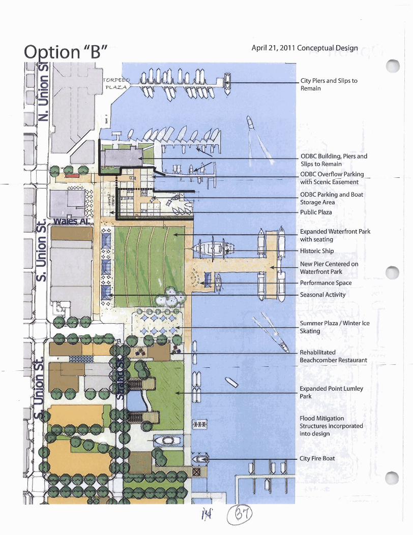
O ~ t i o n "B" April 21,201 1 Conceptual Design
DBC Overflow Parking ------
ith Scenic Easement
ODBC Parking and Boat
Expanded Waterfront F6rk
New Pier qnterea on Waterfront Park
Summer Plaza /Winter Ice
Begchamber Restaurant - - - - - - -
Expanded Point Lumley
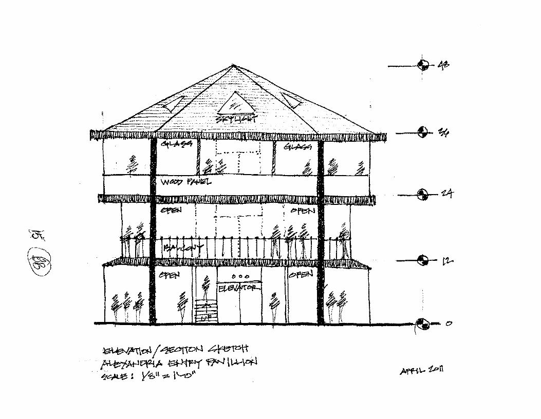

20. Harborlmarina area: Extending piers into the ~otomac River as public spaces and for commercial boat operations; designating Robinson Terminal South for a potential pleasure boat marina (pages 68 and 70).
In general, there has been public support for these concepts but concern about specifics. Support for the extended piers as public spaces and for water taxis, etc.; support for separating commercial and pleasure boat marinas and expanding capacity of both; and support for an upgraded pleasure boat marina that could be operated at a profit by the private sector. Public comments on this element of the plan have focused on the expense and length of the main piers; the greater potential for longer piers to be damaged, especially by ice and floating debris; and the challenge of getting regulatoly approval.
Although the plan does not specifi exact lengths, widths or designs of the piers or marina, the model and the illustratives in the plan could easily be interpreted as recommending a single design. Staff agrees that shorter piers - even substantially shorter - and designs other than the "crab claws" in the plan could work well. Staffrecommends that language be added to the plan to make it clear that a range of design options should be considered.
Staffhas included the cost of the piers in the plan "budget" including annual and long- range maintenance costs. There was testimony that some additional dredging would likely be needed due to the pilings for the new piers disturbing the river current. It was not really possible to estimate the potential additional cost for dredging when the pier designs are as conceptual as they are. If/when the City gets to the next step in pier design, costs and other economic issues will be taken into account and weighed against anticipated benefits. There are, however, elements in the plan that have the eflect of reducing the need for dredging in other area, which will reduce the potential increase in dredging costs over the life of the Plan.
A number of speakers expressed concern about the ability of the City to get regulatory approval for the piers and the marina. Until recently, most of the concern was that the District of Columbia would not approve them, but the City received an official letter from the DC government that cleared that hurdle. Additional approvals are needed, of course, including approvalsji-om the National Park Service, the Army Corps of Engineers, the Coast Guard, and state environmental agencies. City staflhas met with the Corps of Engineers, DC and the Commonwealth to provide them with an overview of the concept design for the Waterfront Plan and to review their regulatoly processes. Consistent with their review and approvalprocesses, the City would submit a Joint Application to the Corps and other regulatory agencies once: (a) the plan is approved, (b) additional engineering and design work for the piers is complete, and (c) construction drawings are substantially complete. As noted above, final design of the piers would be done so as to minimize costs, silting and other environmental impacts. More information on the

A question raised at the public hearing is whether the plan addresses marina operations, maintenance, and amenities. The plan does address these - on page 17 in a general way and more specifically on pages 59 and 67, which describe the expanded commercial and pleasure boat marinas, and on page 139, where the plan notes that a new marina at Robinson Terminal South would likely require space for a dock master oflce, showers, and a laundry room, which could total about 1,100 square feet. The Plan's expectation is that these services would be provided onsite by the operator, and potentially incorporated into the Robinson Terminal South redevelopment
21. Restaurants: Restaurants and other retail are a permitted use in the W-1 zone; the plan does not increase the square footage of restaurants currently permitted on the three redevelopment parcels or in any of the existing buildings within the plan area where restaurants are currently a permitted use. However, the plan does encourage ground floor active uses in certain locations, and the plan encourages hotels as a use, and both of these indirectly encourage restaurants. The plan produced anticipated restaurant square footage to prepare revenue estimates. With the elimination of the Waterfront Park restaurant building, the square footage of that estimate is reduced to 73,000 square feet, and the annual net tax revenue from planned development decreases from $4.8 million to $4.3 million (active frontages shown on pp 86-87; revenue discussion in the April 5,201 1 staff report).
Several speakers at the public hearing expressed concern about the potential square footage of restaurants. The concerns come in two forms: concern about impacts on existing businesses, and concerns about other off-site impacts, such as parking and noise.
Representatives from the business community test@ed at the public hearing that a more active Waterfront will support, not diminish, the economic health of nearby businesses. As the 2009 Gibbs King Street Retail Study noted, the Waterfront now serves as a weak anchor to the King Street retail corridor. Moreover, Mr. Gibbs pointed out that visitors are now leaving the Waterfront with money in their pockets - money that they wozild have been happy to spend in a Waterfront store or restaurant. So it is not just that a more appealing waterfront will attract more visitors, it will likely induce those who already shop or dine to spend more per visit. Mr. Gibbs estimated that those who currently shop or dine in Old Town could support another 100,000 sf of retail and food and beverage space - approximately $100 million per year in additional annual sales.
Staffis recommending language to address both forms of concern -for both restaurants and hotels, because similar concerns have been raised with regard to hotels.
Staffproposes a "Waterfront Restaurant/Hotel Policy" for inclusion in the Waterfront plan that provides detailed criteria for assessing neighborhood compatibility and offsite impacts during the SUP process for both restaurants and hotels. The proposed policy is similar to the existing Old Town Restaurant Policy. The criteria include but are not

limited to findings that the use does not create significant negative impacts on the vitality and character of King Street or nearby residential neighborhoods.
The draft policy is attached as Attachment 3.
Concern was also expressed that the Waterfront Plan relies to a great extent on restaurant and hotel tax revenues to pay for the Plan's parks, piers, and promenades. It is certainly a challenge to attempt to finance improvements for an entire Waterfont on the revenues of three development sites. Ultimately, however, the amount and type of land use recommended for each site is driven not by revenue goals but by best professional planning objectives, namely neighborhood compatibility and helping to create the best possible experience for visitors to the Waterfront. A graphic showing locations of active groundfloor uses in the Waterfront Core Area are attached as Attachment 4 and 5.
The assumption for restaurant square footage in the revenue estimates includes: the Beachcomber (3,600 square feet), about 19,000 square feet of groundfloor restaurant in the Cummings/Turner block, about 20,000 square feet at Robinson Terminal North and about 30,000 square feet at Robinson Terminal South.
The draft plan used an estimate of 109,000 square feet of restaurant, which has since been reduced to 73,000 square feet by the elimination of the Waterfront Park restaurant. To firther help allay concerns and to illustrate that the restaurant square footage figure is for revenue estimates only, staflproposes firther reducing the restaurant square footage assumption to 50,000 square feet, which would result in annual net tax revenues of $4.1 million. It should be noted that the 50,000 square feet of restaurant space used in the revenue estimates could be partially met with outdoor dining square footage. Outdoor dining is encouraged by the plan and is likely to be lucrative (albeit seasonal). Outdoor dining square footage would reduce the "need" for indoor square footage to meet revenue estimates.
The reduction in assumed restaurant buildout adds 1-3 years the amount of time needed for the plan to ')ay for itselJ: "
Testimony was received that the Waterfront Plan calls for the equivalent of 14 Virtue restaurants. The recently-approved Virtue is 7,900 square feet indoors and 803 square feet outdoors for a total of 8,703 square feet. The 50,000 square feet now used for revenue estimates is equal to 6-8 Virtues -spread out over 8 blocks.
Staflrecommends reducing the restaurant component of the revenue estimate and the inclusion of the Waterfront Plan Restaurant/Hotel Policy in the Plan.
22. Adding hotel as a permitted use in the W-1 zone: The overwhelming rationale for staff to recommend adding hotels as permitted use in the W-1 zone is their compatibility with nearby residential neighborhoods as well as their contribution to an active and public Waterfront. Of course it is helpful for planned development to be able to contribute
18

financially to plan implementation, but the revenue calculations were developed well after the hotels were proposed in the early drafts of the Plan.
A number of speakers strongly supported the hotels and others strongly opposed or expressed concern about the potential impacts. Planning staff believes equally strongly that hotels are a highly desirable element that should be included in the Waterfront Plan. The Waterfont Plan's "supplemental material" as well as the April 5 staffreport and the staffpresentation at the April 5public hearing addressed the benefits and impacts of hotels in some detail. One of the points in the discussion: the more than 900 hotel rooms within a few bloch on upper King Street: the Lorien (107 rooms), the Hampton Inn (80), the HiIton (246), the Embassy Suites (268), and the Wyndham resort (200). The Planning Commission received comments from upper King Street residents stating that these hotels are good neighbors.
Nevertheless, staff understands that concerns remain. In order to ensure that the individual and cumulative impacts of hotels are fully addressed during the SUPprocess, staffproposes a "Waterfront Restaurant/Hotel Policy" for inclusion in the Waterfont Plan that provides detailed criteria for assessing neighborhood compatibility and offsite impacts during the SUPprocess for both restaurants and hotels. As noted above in the restaurant discussion, the proposedpolicy is similar to the existing Old Town Restaurant Policy. The criteria include but are not limited toJindings that the use does not create sign$cant negative impacts on the vitality and character of King Street or nearby residential neighborhoods.
The draftpolicy is attached as Attachment 2.
Hotels account for about halfof the estimated net tax revenues used to balance the plan's costs and revenues.
23. Increasing permitted densities on the three redevelopment sites: All of the redevelopment parcels are zoned W-1 which permits residential, office and retail development at an FAR of up to 2.0 with an SUP. The W-1 zone text amendment would allow an increase to 3.0 FAR but only with SUP approval and only if the proposed development is found to comply with the specific Development Goals and Guidelines in the Plan. Development within the Old and Historic Alexandria district would be subject to the OHAD Design Guidelines and to BAR review.
There are three main development sites in the plan, and the plan pays considerable attention to each. Density recommendations came at the end of a staff analysis that started by listing the multiple objectives for private development, and then determined what kinds of uses and densities best provide those qualities, and then created the Plan's development guidelines to help ensure that development projects contain the desired attributes:

Authentic: The guidelines and recommendations were chosen so that redevelopment' would have buildings, uses, and design that reflect Alexandria's identity.
Welcoming and accessible: There are places on the waterfront Alexandrians just can't go because they are privately owned and inaccessible. The Plan's goal: not just that one can go there, but that one would want to go there, and one would enjoy him or herself when they are there.. .creating places where activity can happen without bothering people.
Historic: Alexandria history inspires the urban design, the orientation of buildings, the placement of open space, the delineation of alleys in private development.. .just as it inspires the design of the public spaces. The guidelines are developed to help preserve and celebrate our history.
Compatible: The planned uses and the designs respect the neighborhood - in terms of height, of course, but also architecture, noise, and parking. The 50 foot height limit would be retained (with the exception of the western "half' of Robinson Terminal North where the height limit would increase fkom 55 to 66 feet).
Financially feasible/successfirl: There will be public benefits when redevelopment replaces the watdont warehouses, but redevelopment will not take place if there isn't a profit-making opportunity. More than that, it is in the City's interest that the businesses in the new buildings be successful over the long term.
Contributing: Redevelopment is expected to contribute in three ways: the development adds desired physical amenities (and the plan has high expectations for the development sites), the new uses contribute to the daily life of the Waterfront; and the development spins off tax revenues to pay for other improvements desired by the
XS Appealing: over the course of the planning process, there was a lot of input about what people felt would draw them to the waterfront, and what they would enjoy doing when they get there.
The overall increase in development potential (over what is currently allowed) is about 160,000 square feet spread over the three sites (about 8 blocks). For Robinson Terminal North, the increase in development potential is about 43,000 square feet; on the CummingdTumer block, about 62,000 square feet; and on Robinson Termjnal South, about 53,000 square feet. A development table is attached for the Planning Commission's easy reference; it has not been changed fiom the table included in the previous staff report. i&;;:-gj& -- The Planning Commission received testimony in oppositzon to bnd in support of the proposed densities and alternatives such as purchasing portions of the redevelopment

Tabl-. Private Redevelopment Sites: Density and Heighmnalysis Private Development Sites Settlement (1983) Currently Allowed Proposed (2011 Plan) Change
Site Land Existing Area Development
sq. ft. sq. ft. Robinson 141,181 91,814 Terminal North
1 Robinson Terminal Soutn Cummings/ Turner Block (Total)
220 5. Union St. 21,299 21,240
203,205,211 26,148 19,232 Strand
St., 2, 6, 10 Prince
Total 367,257
Development 1 FAR / 2zt I Developmer I I I
sa. ft. I I ft. I sa. ft.
Currently Max Development FAR Height FAR Height Max
Allowed vs Proposed
sa. ft. ft. sa. ft.
Note: The Currently Allowed column depicts the maximum potential development on a site, taking into consideration current zoning, height restrictions, and other limitations. For Robinson Terminal North in particular, height restrictions do not permit development to reach the 2.0 FAR permitted by the current zoning.
I Table 4: Private Redevelopment Sites: Uses I --- --
l ~ r i v a t e Develodment Sites: Uses
121 1 Strand 1 1 Chadwicks I 1

parcels for museums or open space were suggested. The Planning Commission requested ,
additional information about when proposed redevelopment would require an SUP.
o An SUP is currently required for developmentprojects to go above 30 feet in height in the Height District 3, which covers all of the redevelopment sites except the western halfof Robinson Terminal North, which is in Height District 4 where an SUP is not required to achieve permitted heights. The plan would not change that requirement. It is very Jif$cult to imagine a financially viable redevelopment proposal that would not exceed 30 feet in height (even recently built waterfront- area townhouses considerably exceed 30 feet in height), so it is likely that most redevelopment will require un SUP.
o An SUP is required for restaurants, retail, hotel, health club, personal services, hotels, outdoor food and crafts markets (among other uses) and the plan would not change that requirement.
o Parking reductions also require an SUP and the plan would not change that. o The proposed text amendment would require an SUP for the additional density
(above that permitted by the W-1 zone today) provided by the Plan.
24. Development goals and guidelines for the redevelopment sites: These goals and guidelines provide detailed guidance for the three redevelopment sites and make clear the City's expectations regarding urban design, ground floor uses, compatibility, use, pedestrian and streetscape, historic interpretation, public art, parking, bulk and scale, shoreline treatments, and public amenities.
Much of the public discussion of the redevelopment sites concerns density and land use; the Planning Commission received little comment on the development guidelines. As shown elsewhere in this stafreport (see item #2), the history community requested a clarzfiing change to make it clear that Robinson Terminal North is the site of West's Point, where the City began.
The Washington Post Company, as the owners of the Robinson Terminals, provided the most detailed comments. They requested greaterflexibility in the location of land uses on their parcels, particularly greater freedom to build housing at the water's edge. The Post also expressed concern about the number and expense ofpublic amenities.
Planning staff is very concerned about the compatibility of residential development and active use ofpublic spaces. Residential development is not prohibited near the water, but could be approved only if it were found to coexist well with planned activity, provide a welcoming presence to waterfont uses, and preferably not include permanent owner- occupied units.
As for the amount ofpublic amenities, the plan notes that the "speciJic amenities to be provided will be determined during the development review process" and then the plan

During the considerable amount of analysis and discussion ofparking issues, staff conducted research into current parking ratios for hotels and found that in areas such as Old Town Alexandria and the waterfront, the zoning ordinance requirement of 1.0 space per room requires more parking spaces than are needed. The number ofparking spaces will be determined as part of the development review process, and the issue of the number ofparking spaces is especially important because of a) the concern about parking supply and demand in the Waterfont core area and also b) the very high cost of providing below grade parking at the Waterfront. Staff suggests adding language to the development guidelines for each redevelopment site indicating that parking ratios as low as 0.5 spaces per room may be considered if it can be demonstrated that the resulting parking is adequate for hotel guests, hotel restaurant patrons, and other visitors to the hotel.

-- Additional Questions by Planning Commissioners
On April 5,200, Planning Commissioners asked several questions that are not answered above.
Q: Where will park maintenance and operations be?
A: The plan suggests park maintenance facility options in Oronoco Bay Park and in Waterfront ParWPoint Lumley Park. An early option was to locate some space in the new parking garage in Waterfront Park, but that is no longer in the Plan. Truch and larger wheeled equipment can also be stored in nearby existing garages. Park buildings that have restrooms or services for users can also support maintenance.
Q: Explain linkages in the plan - where one initiative is dependent or related to another. For example, the Waterfront Park building is related to relocation of the Old Dominion Boat Club (ODBC) parking lot.
A: Staffis now recommending that the Waterfont Park restaurant building be removedfom the Plan. The City is continuing to explore, with ODBC, new locations or conjigurations of ODBC operations that are mutually beneficial, but it does not appear that a relocated parking lot in Waterfront Park is on the table any longer.
Other important linkages in the Plan.
The first phase offlood mitigation (elevating King Street and The Strand) can occur relatively independently, but would likely coincide with conversion of the unit block of King to a more pedestrian-oriented space. The larger flood mitigation project would need to be coordinated with improvements to Waterfront Park and Point Lumley Park.
Progress on an expanded Point Lumley Park could support quality redevelopment and there are benefits to working on the public realm in concert with adjacent development.
Redevelopment in the Cummings/Turner block requires a historic resources preservation plan for the historic warehouses.
The civic building in Point Lumley Park is located on land owned by Robinson Terminal; the plan recommends that the site be used for civic purposes but key decisions (such as ownership, use andprogrammingj would occur in conjunction with the land owner, most likely when there is an active development proposal.
The Waterfront Plan is different than some recent small area plans where redevelopment is dependent on the provision of very expensive infrastructure occurring before development takes place. The largest single infrastructure project in the Waterfront Plan is the flood mitigation project, which is needed whether or not (or whenever) the redevelopment takes place.

e Q: How do you address concern over funding being committed before revenues come to pass? A
lot of jurisdictions take on the obligations because a plan looks good but then revenues don't materialize as quickly as anticipated. Alexandria is too small a jurisdiction to face that problem.
A: The Waterfront Plan is different than some recent small area plans where redevelopment is dependent on the provision of vely expensive infratstructzrre. The largest single infrastructure project in the Waterfront Plan is flood mitigation infrastructure, which is needed whether or not (or whenever) the redevelopment takes place. As noted above, there are other elements for which there are benefits to planning public investments as the private sector is making its investments, such as planning Point Lumle;~ Park as plans for the redevelopment of the Cummings/Turner block move ahead.
As a result, the City has the flexibility to delay public expenditures until revenues materialize, or otherwise be as conservative as it wishes in the timing ofpublic investments ahead of revenues.
Staffprepared the costs and revenue estimates to demonstrate that the plan is not financially unrealistic - but does not want to overstate the link between new development and the planned improvements, which will provide broad public benefit.
Q: Would a statement of work from the consultants help us understand the vision for the plan? Ilc
A: The statement of work for the consultant team does not contain the vision for the Plan, as it was executed at the start of the planningprocess before meetings with the public were held and the plan's visioningprocess was community-based. Chapter 2, pages 20-21 of the plan identz3es Goals and Objectives on which the plan is based and repeats them in Appendix 1 where the Community Participation process is outlined in detail, identzfiing the iterative process utilized for formulation of a vision; goals, objectives and ideas; an Activity Map on which to locate the ideas; development of the Concept Plan to put more shape to the Activity Map; and then ultimately formulation of the Plan. Each milestone was an interactive process with the City utilizing a variety of tools to achieve community input and feedback, including meetings, special events and outreach, the website, charrettes a model and more.
Q: How can staff respond to those speakers who have asked what alternatives were considered?
A: Under some circumstances, a planning process can be aided by developing some clear alternatives from which the public can make choices. What often seems to work better for small area plans is to begin by engaging the community about general principles and goals and then working with them to gradually refine the broad concepts and to reach agreement on details. This approach was particularly apt for the Waterfront, which has an enormous number of important stakeholders and a very constrained set of options for the three redevelopment sites.

Among the significant changes to the plan that are related to community suggestions:
Added a plaza at foot of King Street and a historical sailing ship at the pier
Realigned King Street Pier to the south.
Separated the pleasure boat and commercial marinas
Designed improvements to the public pathway between Founders Park and the marina, and designed improvements to the public realm surrounding the Food Court
Flood mitigation has been increased in emphasis and moved up in the phasing program, as well as integrated as part of landscaping and buildings
The high emphasis on parking, including the proposed Parking Implementation Plan and Parking Implementation Committee to ensure that progress on parking issues is continues and keeps pace as new uses are added under the plan
Elimination of the jetty
Elimination of the Waterfront Park building
Included a policy for reviewing proposed restaurants and hotels
Encouraged the development of History and Art Plans to help shape those aspects of the plan and integrated their recommendations
Q: What is "Alexandria" about this plan?
A: There are a number of elements of the Plan that are common to any historic waterfront settlement: waterfont related commercial uses, multiple piers and wharfs, rail tracks, etc. The plan interprets these historic uses in new public parks and civic buildings featuring history and shipbuilding (recommendations 3.87 & 3.89). However, the plan also recommends a number of elements which are specific to Alexandria. The most important is to preserve and adaptively reuse all existing historic buildings (3.92). This includes the obvious 18th and 19th century warehouses but also some early 20th century buildings like the Beachcomber (3.91) whose cultural significance may be greater than its architectural merit.
Recommendations for new development also reflect the scale, mass and materials of historic buildings, streets and alleys. In particular, the town's 1752 Ordinance required the roof ridge of a dwelling to be parallel to the street, so that water drained to one's own property and not a neighbor. However, this condition did not apply to the commercial waterfront. Because every foot of shoreline was economically valuable, the warehouse buildings developed in a long, narrow plan form extending east/west, perpendicular to the waterfront and the street. These buildings were generally separated by narrow alleys for loading access, fire separation and drainage.

This historic Alexandria urban form is illustrated in the plan, the model and the new development guidelines. In addition, alterations to any existing buildings and new development will have to be reviewed and approved by the BAR, using the Design Guidelines chapter on Buildings Along the Waterfront and the Additional Standards - Potomac River vicinity in the Zoning Ordinance.
Q: What is the legal status of each property and does the proposed restaurant building needs an amendment to Settlement Agreement for Waterfront Park?
A: A memorandum prepared by legal staffimmediately follows.

City of Alexandria, Virginia
MEMORANDUM
DATE: APRIL 22,201 1
TO: CHAIRMAN AND MEMBERS OF THE PLANNING COMMISSION
FROM: JOANNA C. ANDERSON, ASSISTANT CITY ATTORNEY CHRISTOPHER P. SPERA, DEPUTY CITY ATTORNEY JAMES L. BANKS, JR., CITY ATTORNEY
SUBJECT: LEGAL STATUS OF PROPERTIES WITHIN THE WATERFRONT SMALL AREA PLAN
This memo responds to Commissioner Fossom's request, at the Planning Commission's April 5, 20 1 1 meeting, that we provide the Planning Commission with information regarding the legal status of the properties within the Waterfront Small Area Plan. We take that request to mean the
". - ownership of those parcels and any binding agreements that limit or impact development rights outside of the City's Zoning Ordinance given that there has been a long history of legal matters involving Alexandria's Watefiont.
Although this memo provides a summary of some of the legal matters surrounding Alexandria's Waterfront, it is important to note that adoption of the Waterfront Small Area Plan is not necessarily dependent on the legal status of these properties. The proposed plan is to become part of the City's Master Plan, and will be a future plan for the properties within it. Unless the property is already owned by the City, the plan is not implemented unless and until the property owner comes in to the City for the approvals to develop the property, or the City acquires the property. Therefore, a small area plan can, and typically is, approved before the private properties are ready to be developed. The Planning Commission is also considering an amendment to the W-1 zone that would allow for the development considered in the Waterfront Small Area Plan, however the new use, hotel, and the increased density being allowed as a result of this zoning change is only available to the property owner through the special use permit process.
Background In the early 1970's the Federal Government filed litigation pertaining to the ownership rights of the properties along the waterfront. Years of discussion among the National Park Service, the City of Alexandria, and the private owners of property along the waterfront culminated in the

of ~fexandria to protect and enhance the Waterfront. As a result of that plan, the Federal Government entered into a number of settlement agreements with the City and with some of the individual private property owners on the waterfront. These agreements also include deeds on the subject properties that set forth certain restrictions for the properties, typically in the form of restrictive easements in favor of the United States government. Most of the properties that were included in the federal litigation entered into settlement agreements, however, as described further below, the federal litigation on the properties that did not settle recently came to a conclusion in fivor of the property owners and against the federal government, leaving a number of properties free of federal claims, restrictions or encumbrances.
As shown on the attached map, the properties that were subject to this federal litigation span the whole waterfront. While all of the properties that are subject to the federal litigation are within the boundaries of the currently proposed Waterfront Small Area Plan, many of them are outside of the core area of the plan. The properties included in the federal litigation that are within the core area of the currently proposed Waterfront Small Area Plan are in large part addressed in either the 198 1 Settlement Agreement between the United States and the City of Alexandria, the 1983 Settlement Agreement among the United States, the City of Alexandria, and Robinson Terminal Warehouse Corporation ("Robinson Terminal") or the 201 1 resolution of the remaining land in the federal litigation. Lastly, there are some properties that have leases that may be of note.
1981 Settlement Agreement between the United States and the City of Alexandria The City of Alexandria entered into a Settlement Agreement with the Federal Government in 198 1 that impacted the properties owned by the City at that time. The resulting deed was amended as it pertained to Oronoco Park and added Andrews Park to the settlement agreement properties in 1985. For purposes of discussion, these settlement agreements will collectively be referred to as the "1 98 1 Settlement Agreement." The properties identified as being owned by the City that were addressed by this settlement agreement include:
Pomrnander Walk Waterfront Park Kiriakowl2 1 1 Harbor Center Founders Park Oronoco Bay Park Andrews Park
Additionally, the 198 1 Settlement Agreement addressed certain street ends and public streets that the City must keep as dedicated streets or keep open to pedestrian access only. Lastly, the 1981 Settlement Agreement required the City to use its best efforts to install and maintain a continuous public walkway along the Potomac River. After entering into the settlement
agreement in 198 1, the City adopted the W-1 and WPR zones for the properties along the Waterfront in 1982. Both zones have been amended since then in accordance with subsequent settlement agreements or changes proposed by the City that are still in compliance with 198 1 Settlement Agreement.
It is our opinion that the Waterfront Small Area Plan improvements as currently proposed comply with the requirements of the 1981 Settlement Agreement. If something is ultimately proposed in the Waterfront Small Area Plan that is not in compliance with the 1981 Settlement Agreement, then the National Park Service would need to agree to an amendment to the 198 1 Settlement Agreement in order for the City to implement that proposal. The National Park Service has been actively included by the City in the Waterfront Small Area Plan process and it is currently reviewing the plan to confirm its agreement that the Small Area Plan complies with the requirements of the 198 1 Settlement Agreement.
1983 Settlement Agreement between the United States, City of Alexandria and the Robinson Terminal. In 1983 the Robinson Terminal Warehouse Corporation entered into a settlement agreement with the Federal Government and the City of Alexandria that addressed its two tracts of land known as Robinson Terminal North and Robinson Terminal South. That settlement agreement provided zoning parameters including use, height, and FAR for the Robinson Terminal tracts and also required that Robinson Terminal dedicate certain public parks to the City. While the uses listed for these sites do not specifically list hotel as a permitted use, the uses listed imply that hotel was included in the broader category of commercial use. Therefore, it is our opinion that the proposed zoning parameters for the Robinson Terminal North and the Robinson Terminal South tracts are consistent with the 1983 Settlement Agreement. As discussed above, the National Park Service is currently reviewing the Waterfront Small Area Plan and will confirm its opinion regarding this matter. The idea of a hotel use has been discussed at length with the National Park Service and they have expressed that the hotel use is consistent with what they would like to see on the Waterfront as well as the terms of the 1983 Settlement Agreement.
2010 Federal District Court Opinion While most of the properties that were included in the Federal Government litigation entered into settlement agreements in the 1980's, there were a number of properties that chose not to do so. Instead, they continued the litigation. In August 2009 the United States District Court for the District of Columbia ruled in favor of the land owners with respect to the federal claims on those remaining parcels. In January 201 1, the United States Court of Appeals for the District of Columbia upheld the District Court's opinion. As the time for appealing that decision to the United States Supreme Court has run with no appeal, that decision is now final. Therefore, the following properties are no longer subject to the Federal Government lawsuit and the ownership

&
of the properties remahs with the land owners of record. The owners of each property are noted in parenthesis.
1 and 2 King Street (Old Dominion Boat Club) 0 Prince Street, 200 Strand, 210 Strand, Old Town Yacht Basin (City of Alexandria) 204 Strand (Anita Mann) 208 Strand (Robert Sweeney)
The legal status of these properties as relates to the proposed Waterfront Small Area Plan, therefore, is the same as any other property that is within a small area plan.
Other properties to Note that are not subject to Settlement Agreements There are a two other properties on the Waterfront that, while not involved in the Federal Government litigation, may be of interest to the Planning Commission. First, the properties that surround the City of Alexandria Marina including the current location of the Chart House Restaurant, the Food Court, and the office building on the corner of Union Street and King Street ("City Marina") are owned by the City of Alexandria and are the subject of a lease agreement between the City of Alexandria and the Alexandria Waterfront Restoration Group. The lease was initially executed in 1986 for a 60 year term. The lease does not prevent the City from adopting a small area plan to address the future goals, expectation, or controls for these properties. If the small area plan were to recommend changes to the use of these properties that is not already permitted under the lease, then an amendment to the lease would be required to effectuate the recommendation. In this case, there are no new uses recommended, although the Plan anticipates an enhanced and revised Food Court building, whch may require special use permit approval for that facility.
Second, the Waterfront Small Area Plan designates the Cummings/Turner block as a potential development block. These properties were not involved in the Federal litigation discussed above and are not subject to a specific settlement agreement.
cc: Mark Jinks, Deputy City Manager Faroll Hamer, Director, Planning and Zoning

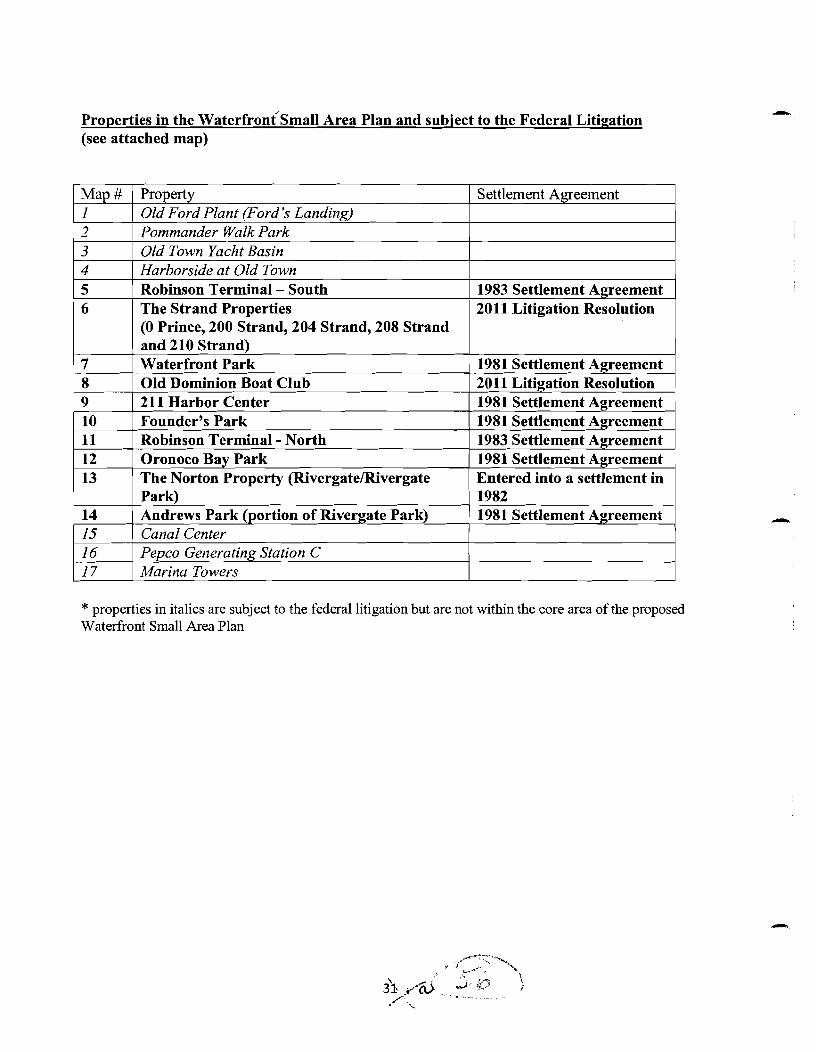
Properties in the waterfrontsmall Area Plan and subject to the Federal Litigation (see attached map)
I Mau # 1 Pro~ertv I Settlement Alrreement 1 2
Old Ford Plant (Ford's Landing) Pommander Walk Park
3 4
Old Town Yacht Basin Harborside at Old Town
5 6
7 8 9
Robinson Terminal - South The Strand Properties (0 Prince, 200 Strand, 204 Strand, 208 Strand and 210 Strand)
10 11
1983 Settlement Agreement 2011 Litigation Resolution
Waterfront Park ' 1981 Settlement Agreement
12 13
117 I Marina Towers
Old Dominion Boat Club 2 11 Harbor Center Founder's Park Robinson Terminal - North
14 15 16
* properties in italics are subject to the federal litigation but are not within the core area of the proposed Waterfront Small Area Plan
2011 Litigation Resolution 1981 Settlement Agreement 1981 Settlement Agreement 1983 Settlement A~reement
Oronoco Bay Park The Norton Property (RivergateRivergate Park)
,,/::;\<
" 1 i_/.. \ 6 . J.. a - P S 1-
, 2.-
lC : , .:
' -..
1981 Settlement Agreement 1 Entered into a settlement in 1982
Andrews Park (portion of Rivergate Park) Canal Center Peuco Generatina Station C
1981 Settlement Agreement
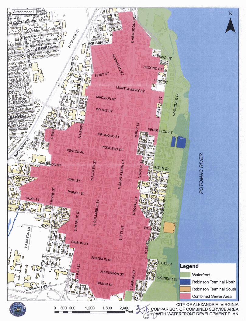
NVld lN3VUd013A3a INOtlJtl31VM HlI V3tlV331At13S a3N18W03 JO OOP'Z 008' 1 ^^" ' 009 OOE 0 VlNl9tllA 'VltlQNW3lV JO A113

/
Attachment 2
Suggested Changes to the Waterfront Plan by the Alexandria Archaeology Commission
Background: On March 16,201 1, the Alexandria Archaeological Commission voted to approve the history components of the Waterfront Plan, requesting some additional language to strengthen the identity of The Strand as the "Southern Cultural Anchor" of the waterfront; to include definitions of the historic theme for each waterfront character area in Chapter 3; and other changes as identified by James McCall, Chair of the AAC History Plan Committee. Staff recommends the following changes in response to the AAC requests:
1. Emphasize Alexandria's history as the foundation for the planning and design of the Waterfront and identify the "cultural anchors'' as a core and unifying concept
Planning Staffs Suggested Response:
o Add the following language to the Executive Summary on page xi:
The City is the beneficiary of exceptional efforts by two groups of hardworking Alexandrians that resulted in the Waterfront History Plan and the Public Art Proposal. These efforts recognize the important contributions of history and art to Alexandria, especially at the waterfront. This plan is an opportunity to add back history that's been missing from the waterfront for too long. Toward that end, it incorporates six Art and Culture Theme Areas as guiding elements for each of the character areas of the Plan. The Art and Culture Theme Areas, like the character areas, are linked by the proposed Art Walk desimed to help unify them and other elements of the waterfront together. These Art and Culture Theme Areas are reflected in Figure 1. As one moves from one Art and Culture Theme Area to another one will be introduced to the rich history of that given area through interpretation, art, architecture, activities and more. Additionally, a History Center in the vicinity of the 200 block of The Strand is proposed. There, one would be able to learn not only about the waterfront's maritime history but also about other cultural resources, along the waterfront, and throughout the City. The History Center would be the history counterpart to the Torpedo Arts Center a few blocks north This plan not only incorporates the concepts and ideals contained in the Public Art Proposal and the Waterfront History Plan but it also includes each plan in its entirety as Avpendices 5 and 6, respectively.
o Reorder the first 4 sections of the Executive Summary on pages ix and x so that the section related to art and history is first, followed by the section entitled "A Strand that is lively, fun, and uniquely Alexandrian," and then the section entitled "At the heart of the Waterfront, a new gateway to the City.":

o Move Figure 10 on page 27 to the ~ iecu t ive Summary and relabel it Figure 1.
o Replace the first paragraph of Chapter 2 with the following:
To help shape the vision, goals and obiectives of the Plan, information was gathered from many important sources including the public, technical resources, and more. However, a key source of information came from the history community. Having information regarding the subareas of each Culture and Theme Area dating from the beginning of Alexandria's founding to today was essential to ensuring a document that is authentically Alexandrian.
In addition to the above, and the past planning efforts described in Chapter 1, information for the planning process was gathered relating to cornrnunitv assets, marina design, circulation and parking; historic preservation and conservation; park planning and more. Information from Citywide planning efforts such as the Open Space Plan. the Transportation Master Plan and the Eco-Citv Action Plan was also utilized. With the benefit of this information, a design for the waterfront emerged through development of the planning principles, goals and obiectives and then through an Activitv Map. followed bv a Concept Plan and now a Small Area Plan.
The planning principles are highlighted below with the goals and obiectives highlighted on pages 20-22.
o Reorganize page 17 to start with the text titled "A plan which is uniquely Alexandrian - Art and History Themes" as the first principle.
2. Strengthen the Small Area Plan's commitment to the Southern Cultural Anchor and History Center, which is an essential element of the Waterfront.
Planning Staffs Suggested Response
o Add the following underlined text to page 135 of the Implementation Chapter:
The Plan recommends establishing a southern cultural anchor and history center in the waterfront area as recommended by the Alexandria Waterfront History Plan, as a compliment to the Torpedo Factory Arts Center. The Southern Cultural Anchor may include a maritime museum, a history center encompassing elements from Alexandria's existing history museums (and be a starting point for further explorations of Alexandria's history) and a museum shop. The history center could also include a relocated or expanded Archaeology Museum, if an assessment determines that relocation is the best option for the Archaeology Museum. Other potential elements of the southern cultural anchor include a ship of character, the Seaport Foundation, and uses in the restored historic warehouses. Funding for the elements of the southern cultural anchorhistory center could come
from a number of sources, including as part of the proposed Point Lumlev civic building. developer contributions, direct Citv hndinn and/or private contributions.
3. Develop and explain the themes of the character areas.
Planning Staffs Suggested Response
o Add the following opening sentences to each theme area:
o The theme for Gateway North is Illuminations and it denotes light, recognizing that it has been the location of electrical companies and lighting can be utilized as a form of art to highlight this area and other cultural areas along the waterfront.
o The theme for Rivergate and Tidelock Park is Ambitions and represents Alexandria's early ambitions as the gateway from the Ohio Valley and the West to the world. It will celebrate the engineering accomplishments of the Alexandria Canal and the aqueduct bridge and note the City's efforts to act as the transition port between sea, canal, road and rail and will address Alexandria of the 1820s- 1850s.
o The theme for Oronoco Bay Park is Transformations. Based on history Oronoco Bay and West's Point can form the Northern Cultural Anchor of the waterfront with the park offering open space and performing arts events. It should quietly evoke Ralph's Gutt, the original crescent bay, and the importance of Alexandria as a rail center starting in the 1850's.
o The theme for West's Point is Origins with West's Point representing the origins of Alexandria and the idea of America in the early to mid- 1 8th century and the importance of tobacco to the development of the town. The time period was the colonial era.
o The theme for Founders Park is Foundations and should celebrate the creation of Alexandria as well as Alexandria, DC, and its development as a trading and commercial center. The park is for passive use, and interpretation should center on the founding to incorporation period, 1749-1 779 and through the founding of the District of Columbia through retrocession to Virginia in 1847.
o The theme for Marina to Queen Street is Witness to War. This section of the waterfront crosses Alexandria's major wartime experiences with its varied commercial past through the 2oth century. It will also be one location to discuss its role in the slave trade and African American contributions. It will reflect aspects of the 1860's through the World Wars.

o The theme for the King Street at the River area is /Gateway. This area should convey the historic sense of arrival and focus, celebrating the bustle of Alexandria as the point of entrance and departure in the past and present.
o The theme for The Strand is the Working Seaport and the 100 and 200 blocks of The Strand and South Union Street contain the last observable vestiges of Alexandria's golden maritime era from the last half of the 1 8th century to the early 2oth century. This area should evoke the character of the heyday of the waterfront in The Strand and use it as the Southern Cultural Anchor.
4. Support the Requested Arts and History Master Plan
Planning Staffs Suggested Response
o Add the underlined sentence to the fourth paragraph on page 134:
The Plan recommends, as an implementation element, that an implementation advisory model be explored, including the potential establishment of one or more committees charged with elements of plan implementation andlor operations. The Waterfront Committee will be part of any implementation equation. Also, the plan encourages the arts and history commissions to continue their cooperation on the Waterfront Plan to assist with implementation of the plan. Both moups will respect existing policies set by City Council for each commission, including the policy on acquired art..
5. Clarify the interpretation of West's Point
Planning Staffs Suggested Response:
o Add the underlined language to #6 of the Development Guidelines as follows:
History interpretation consistent with recommendations of the Waterfront History Plan should inform every aspect of design of the design of the redevelopment and adjacent public spaces, with particular attention given to the West's Point site which is the area which extends from the water west up Oronoco Street to Union Street and represents the origins of Alexandria.
6. The Beachcomber can be viable even if not a restaurant and should be preserved. Planning Staff's Suggested Response:
Planning Staffs Suggested Response:
o Add the following underlined sentence to the paragraph on page 73

The Beachcomber/Potomac Arms building is a 3,630 square footlormer restaurant building originally built over the water in the early 1950s. Over time the water all around and underneath the building was filled, in part with the excess from a concrete business located adjacent to this building. The site was a restaurant for only a few years and later became a gun shop and military surplus store. There is some interest in the public and the private sector in restoring the building to active use as a restaurant, or other uses, although the building is not historic in a classic historic preservation sense. The City supports the restoration to uses that are found to be economic all^ viable.
7. Explicitly state that historical and archaeological resources will be protected and preserved and used in park
Planning Staffs Suggested Response:
Pursuant to Section 1 1 of the Zoning Ordinance, any ground disturbing activity within public parks, described in section 11-403, would trigger a site plan and, therefore, the archaeological assessment and protection described in Section 1 1-4 1 1. Only public streets, sidewalks, alleys, sewers or retaining walls - but not buildings, structures or parking lots - are exempt from this requirement per 1 1 -404(F).
Therefore, virtually everything in the master plan, except perhaps some of the flood mitigation work and the portion of &re Fitzgerald Square within a public right-of-way, already require archaeological protection measures by the zoning ordinance.
8. Depict the Historic Shoreline throughout the plan.
Planning Staffs Suggested Response
o Add a graphic of the historic shoreline to page 3 above the Historic Periods graphic and add the following underlined sentence to the second paragraph on page 77:.
This property is located on one of the most historically significant sites in the City, and redevelopment proposals must make a special effort to find opportunities to recall or interpret the site's history in the design and function of the project and its surroundings. The southern end of the original shoreline can be found on this property. History should inform every decision about uses, activities, structures, plantings, architecture and design, names, and programming. Robinson Terminal South's location in relation to the northern-adjacent sites, including the expanded Point Lumley Park and potential Curnmings/Turner redevelopment area creates a unique opportunity to implement a coordinated design strategy which illustrates the significance of Point Lumley and which is compatible in nature with the scale and character of the surrounding Old Town

o Add the following underlined phrase to the third paragraph on page 45:
Because the property is located on one of the most historically significant sites in the City - West's Point, where Alexandria originated - redevelopment proposals must make a special effort to find opportunities to recall or interpret the site's history in the design and b c t i o n of the project and its surroundings. History should inform every decision about uses, activities, structures, plantings, architecture and design, names, and programming.

Attachment 3 POLICY FOR
RESTAURANTIHOTELICOMMERCIAL USES
Restaurants, hotels, entertainment venues, marinas and other commercial establishments along the waterfront will provide activity and destinations for visitors and residents, allowing enjoyment of the City's Potomac River location. Such uses, however, must be sited in appropriate locations and designed in such a way to ensure that goals of the Waterfront Plan are achieved, including:
Providing activity to attract additional users to the Waterfront: Locating active uses consonant with public open spaces, development sites, and the Potomac River; and Maintaining compatibility with the adjacent residential neighborhood.
Restaurants, hotels, farmers' markets, retail, personal services, private recreational facilities, and marinas each require SUP approval in the Waterfront area. The SUP process is designed so that each use is reviewed and assessed for its appropriateness at a specific location and for its ability to coexist with adjacent and nearby uses without impacts to the character of the area, the plan goals as a whole, and the enjoyment of nearby property.
.* The Old Town Small Area Plan (and the King Street Retail Strategy by reference), includes the City's policy with regard to restaurants, establishing guidelines to assist in SUP decision-making. The Old Town Restaurant Policy requires that Council review each restaurant application for its impacts on noise, late night hours, alcohol, parking and litter. A similar approach should be taken to protect the Waterfront, King Street and the nearby residential areas as to future uses and SUP review.
WATERFRONT RESTA URQNTBOTEL POLICY
Each SUP for a restaurant, hotel, entertainment venue, or other commercial use on the Waterfront should be reviewed according to the following guidelines:
1. City Council shall not approve an SUP for a use on the Waterfront unless it finds that the use does not create significant negative impacts on the vitality and character of King Street or nearby residential neighborhoods.
2. City Council shall consider the cumulative effect of the proposal and the number of already established uses in the immediate area.
3. In the case of an expansion or other intensification, the entire operation shall be taken into account in determining the impact on King Street and nearby residential neighborhoods.
4. In making its determination, City Council shall consider the following factors as applied to the proposed use:
a. Restaurant i. The potential for undue congestion of pedestrians or vehicles;

l)h
ii. The extent to which the use is open in the late night hours and situated so '
as to potentially disturb residential areas; iii. The extent to which alcohol consumption will predominate over food and
I
situated so as to potentially disturb residential areas; iv. The availability of parking; unless parking is supplied for restaurant use,
no new restaurant or similar facility within the Waterfront core area shall be approved prior to the adoption of a Parking Implementation Plan for the
I Waterfront by City Council;
v. The predicted extent of litter generated; vi. The potential for inappropriate noise; and
vii. The extent to which other restaurants already exist in the same location; restaurant uses should not be collocated in such a way as to detract fiom the character and authenticity of the Waterfront by creating a monoculture similar to a food court environment.
b. Hotel I
i. The potential for undue congestion of pedestrians or vehicles ii. The type and size of hotel, and whether it is designed to attract large
conventions or banquets. I
iii. The ability of the hotel to accommodate all of its service needs on site, including loading and delivery operations. rlr
iv. Parking must be provided on site. Although the Plan anticipates low parking ratios, the applied ratio must be consistent with industry standards.
v. Parking garages must be operated so that they are open to the public at I
least at peak times vi. A restaurant within a hotel that is open to the public shall be the subject of
a separate SUP. I
vii. The location of the hotel and whether it's layout is designed to produce the least impact on nearby residential areas and on the lower King Street area. I
c. Other commercial uses: Factors from the above lists shall be applied as relevant I
to the specific SUP under consideration. ~

Attachment 4
.. a1 r,
) I * Proposed Public Space - Required Active Frontage
b e . Desirable Active Frontage
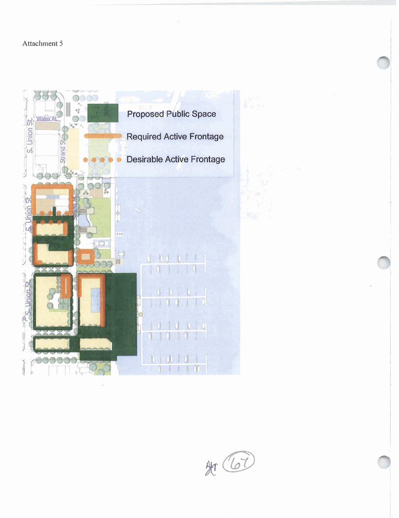
Attachment 5

City of Alexandria, Virginia
MEMORANDUM
DATE: MAY 2,201 1
TO: THE HONORABLE MAYOR AND MEMBERS OF CITY COUNCIL
FROM: RICHARD J. BAIER, P.E., LEED AP, DIRECTOR, T&ES /
This memo is in response to the April 25, 201 I , email (attached) from Mr. Bert Ely pertaining to sanitary sewer issues associated with the Waterfront Plan. Mr. Ely's email raised a number of issues, specifically:
Development and redevelopment in the Waterfront Plan will substantially increase sewage flow in the combined sewer that could trigger costly sewer investments in the waterfront area.
There are no sanitary sewers in the waterfront area that flow directly into the Alexandria Sanitation Authority (ASA) treatment plant.
All of the additional sanitary sewer flow in the Waterfront Plan will overflow into the Potomac River after a heavy rain.
The properties identified in the Waterfront Plan for future development or redevelopment are Robinson Terminal (North and South) and the Cummingsflurner Properties. Figure 1 (attached) shows the location of the above properties and the location of the combined sewer service area. As the figure shows, the area served by the Waterfront Plan is almost entirely served by separate sanitary and storm sewers. Sanitary sewer flow from the properties in the Waterfront Plan flows into the City's local sanitary sewers, which discharge into the Potomac Interceptor, a trunk sewer owned by the Alexandria Sanitation Authority (ASA). This interceptor sewer begins at the intersection of Pendleton and N. Union Streets and flows downstream directly to the ASA Advanced Wastewater Treatment Facility (ASA).
Sewer flows enter the upstream end of the Potomac Interceptor via a combined sewer located along Pendleton Street. During periods of dry weather, all of the flows from the Pendleton Street

combined sewer flow directly into the Potomac Interceptor and are conveyed to the ASA treatment facility. During certain types of rain events, excess combined sewer flows, which are a mixture of storm water and sanitary wastewater, that do not enter the Potomac Interceptor overflow through a permitted combined sewer outfall at the end of Pendleton Street into Oronoco Bay. Additional combined sewer flows also enter the Potomac Interceptor from a combined sewer at the end of Royal Street, upstream of the Royal Street combined sewer outfall. Once flows enter the Potomac Interceptor at Pendleton Street or from any connection downstream, they cannot overflow from this pipe and are conveyed to the ASA facility.
Mr. Ely's email includes an exhibit from the City's GIs sewer mapping, known as the Sewer Viewer. The pipes shown on the Sewer Viewer are based on limited field data and are intended to show general sewer location information. As pointed out by Mr. Ely, the Potomac Interceptor is incompletely depicted on the Sewer Viewer and is not shown as continuing uninterrupted to the ASA treatment facility. Since this has been identified by Mr. Ely, staff is working to more accurately depict the connectivity on the City's GIs mapping. Mr. Ely also points out that the Potomac Interceptor is identified by color as a combined sewer on the Sewer Viewer. This is because it carries combined sewer flows from the upstream collection system, but all of the flows in this Potomac Interceptor are conveyed to the treatment plant and do not have any opportunity to overflow. Because the flows cannot overflow before reaching ASA, staff considers thc Potomac Interceptor to function as a separate sanitary sewer, even though it contains combined flows.
Table 1 (attached) shows a likely development scenario that could occur under the zoning proposed in the Waterfront Plan and the corresponding sanitary sewer flows in gallons per day (gpd). These flows arc compared to the existing flows as well as the flows resulting from a likely development scenario that could occur under the current zoning on the same properties. The difference in flows between the current and proposed zoning is not great; nevertheless, the difference would be even less if more of the redevelopment under current zoning were residential. The flows generated by the Waterfront Plan are compared to the Potomac Interceptor's existing flows and total capacity in Figure 2 (attached). As can be seen in Figure 2, the Potomac Interceptor has considerable capacity to accommodate the additional sanitary sewer flows anticipated in the Waterfront Plan. The total sanitary sewer flow anticipated to be generated by the Waterfront Plan is less than one percent of the available capacity in the Potomac Interceptor.
The City's combined sewer system and overflows are managed and permitted under a permit issued by the Virginia Department of Environmental Quality. The City is in compliance with this permit and proposed redevelopment projects will not affect its compliance status. There are however, independent of the waterfront planning process, several new regulatory initiatives underway at the state and federal level which may, in the future, require the City to take additional measures to stay in compliance with its permit. In effect, the bar is being raised for the City to remain in compliance. The extent or type of improvements to the Combined Sewer

System that the City may undertake in the future as part of our permit obligations will be based on the existing combined sewer system, not necessarily triggered by new development that occurs in the combined area or adjacent areas. The City has actively and successfully managed the combined sewer system by proactive planning and investments in separation and improvements to minimize combined sewer overflows. The approved FY2012 CIP contains $6 million for sewer separation projects over the next 10 years. New development in CSO areas will increase that investment through City-required developer paid efforts.
In summary, all sanitnryf70ws generated in the Waterfront Plan area will be conveyed directly to the ASA treatment facility and cannot ovetjlow into the Potomac River. The Potomac ' Interceptor has significant available capacity to convey the anticipated flows to the plant. The total sanitary sewer flows anticipated in the proposed Waterfront Plan are slightly less than one percent of the total capacity of the Potomac Interceptor. If one looks at only the flow impact of current zoning with proposed zoning, that impact shrinks to between three- and four-tenths of one percent. Development and redevelopment projects in the Waterfront Plan area will not increase any of the City's financial requirements associated with the permitted combined sewer system.
If you have any questions, please contact me at 703-746-4025 or Emily Baker, City Engineer at 703-746-4045.
Attachments
cc: Mark Jinks, Deputy City Manager Michele Evans, Deputy City Manager Emily Baker, P.E. City Engineer William Skrabak, Director, Office of Environmental Quality Faroll Hamer, Director, Planning & Zoning
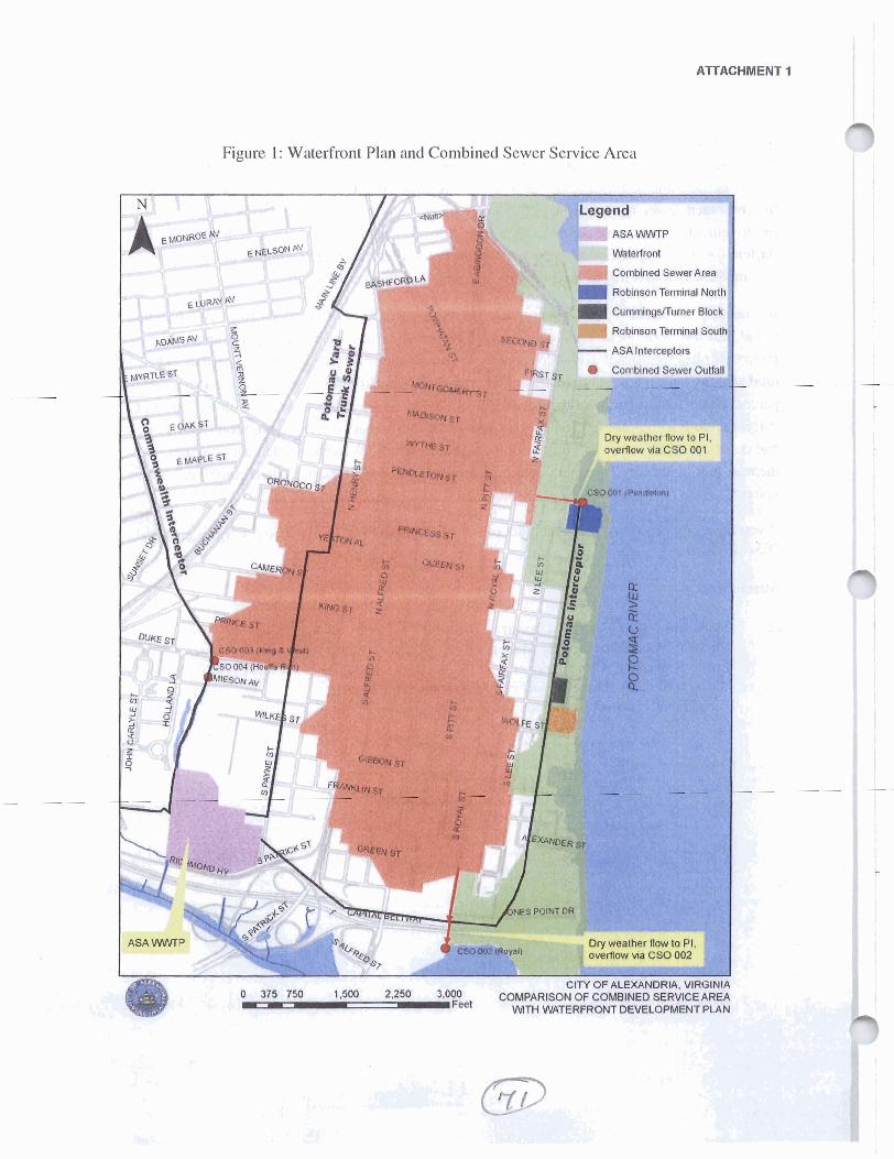
ATTACHMENT 1
Figure 1: Watel-front Plan and Combined Sewcr Service Area i. 8 ',
Dfv weather flow to P
%Mned Sewer Arm
Rablnson W n a l
t3fm OF ALEXANDRIA. VIRGINI*
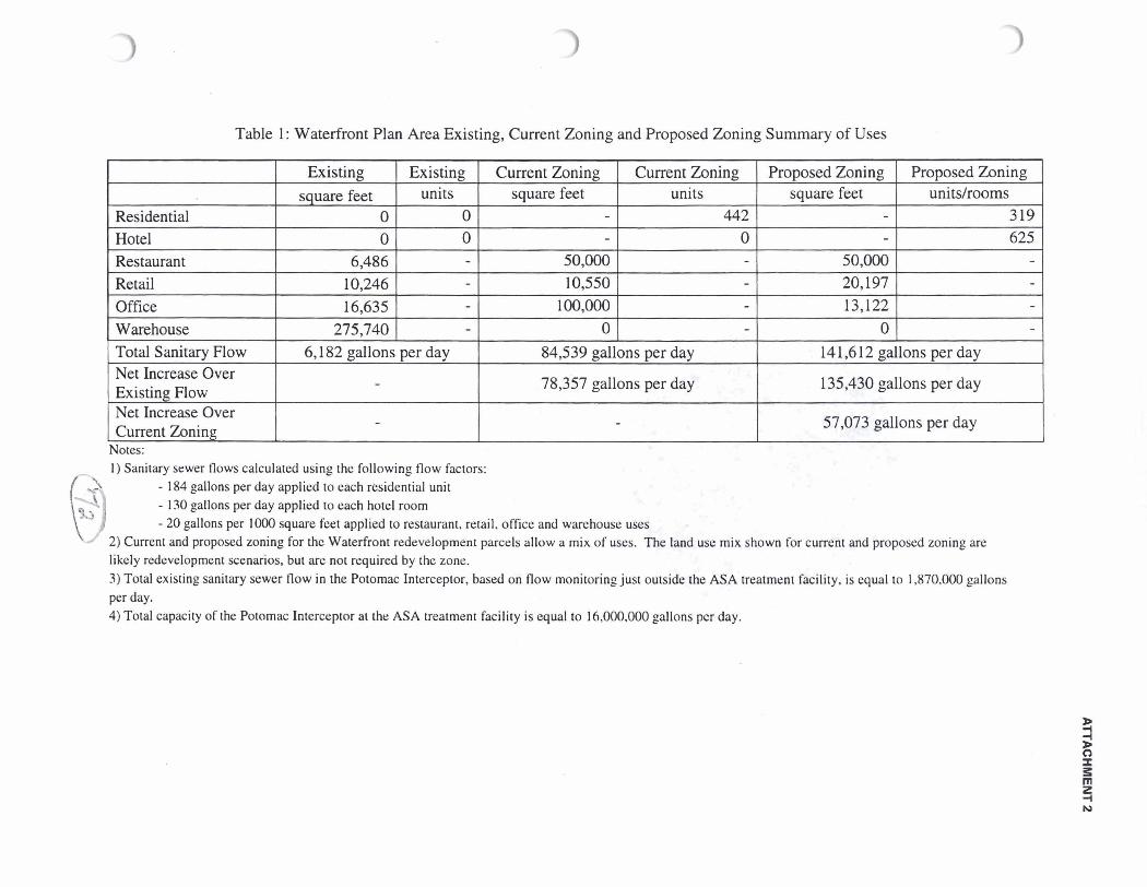
Table 1 : Waterfront Plan Area Existing, Current Zoning and Proposed Zoning Summary of Uses
Residential Hotel Restaurant Retail Office Warehouse
Net Increase Over Existing Flow I Total Sanitary Flow
78,357 gallons per day
Existing square feet
0 0
6,486 10,246 16,635
275.740 6,182 gallons per day 14 1,6 12 gallons per day
Existing units
0 0 - - - -
84,539 gallons per day
Net Increase Over Current Zoning
135,430 gallons per day
57,073 gallons per day
Current Zoning square feet
- -
50,000 10,550
100,000 0
-
Notes: 1 ) Sanitary sewer flows calculated using the following flow factors:
6 - 184 gallons per day applied to each residential unit - 130 gallons per day applied to each hotel room - 20 gallons per 1000 square feet applied to restaurant, retail. office and warehouse uses
2) Current and proposed zoning for thc Waterfront redevelopment parcels allow a mix of uses. The land use mix shown for current and proposed zoning are likely redevelopment scenarios, but are not required by the zone. 3) Total existing sanitary sewer flow in the Potomac Interceptor, based on flow monitoring just outside the ASA treatment facility, is equal to 1,870,000 gallons per day. 4) Total capacity of the Potomac Interceptor at the ASA treatment facility is equal to !6,000.000 gallons pcr day.
Current Zoning units
442 0 - - - -
-
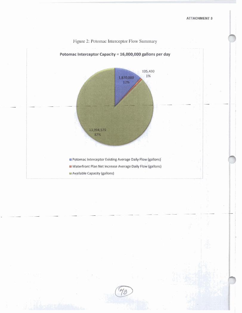
ATTACHMENT 3
Figure 2: Potomac Interceptor Flow Summary
Potomac lnterceptor Capacity = 16,000,000 gallons per day
Potomac lnterceptor Existing Average Daily Flow (gallons)'
Water f ront Plan Net Increase Average Daily Flow (gallons)
Available Capacity (gallons)
- - C C, -
_'
2 :
e t - - - - -. <
, - 5 -. J m
+
C - C 3 T - 4
/
LC- ,
*
/ - ,- 7' u. LT -.
G d C
-.
S. 2 Vi '2
-. c A - - .) - 2. - E Y V1 ?
< 2
-.
V:
Y1 8
r;
;T


Map showing combined sewer area, on the page followkg page 28 of F a d Homer's May 3,2011,
memorand& to the Phuming Commission
In fact, the map reproduced on the next page as Fig. 1 shows ady that the waterfront area is nat served exclusively by combined sewem; it is served in part by separate storm m e r s . That inaportamt distinction is clear k the fellowing Fig. 2, which hays alongside the map in Hamer's May 3 memrandum a map of the City's & o m sewers in the waterfront area. That is, mtase amas b and mar the waterfko~zt colored - p e e are areas served in part by storm sewers.
Fig. 3 pairs the map in Pig. 1 with a map of sewers in the waterfront area with &sanitary features," i.e.,
sewers and combed sewers. As F'ig. 3 sh-aws, san.&ary sewage im the waterfront area either fhws &wtly into s combined sewer or it flows into a sanitary sewer that flows into a combined sewer. -.--., - - - •1, i---; - - W' . . - r
. iLL_.- . . is'&A?!!..~h LP.,. .-i..&-& . ), ! .- * There are no sanitary sewers in the waterfront area that flow directly to the City's treatment plant. Since all sanitary sewage in the waterfront area eventually flows into a combined sewer, development and redevelopment h a g the waterfront m fact will add additional flow to the City's combined sewers in the waterfront area. That additional flow will increase the amount of raw sewage flowing into the Potomac, and down to Chesapeake Bay, after a heavy rain.
'ry , , & ' - I - . . J n k W" t''.T: ''*'-r*7jyj ' ; ' . = + ' c
I.' . < w # l b : 3 ,
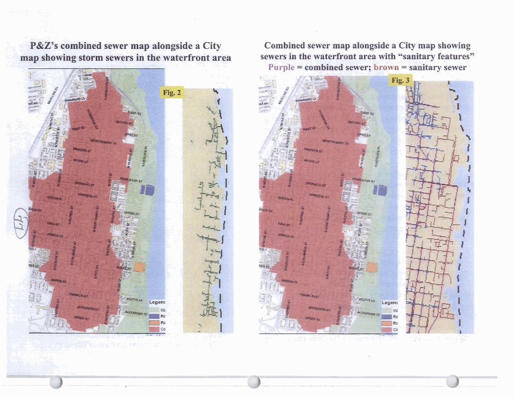
3 .
sj :,? :- ... -. . A , - - m &.:.*a .A r 8
B,.dP&Z's combined sewer map alongside a City -L-
mrp showing starm sewers in-th.e waterfront area Combined sewer map alongside a City map showing
sewers in the waterfront area with "sanitary features" '*urel: = wrnbined sewer; brown = sanitarv sewer
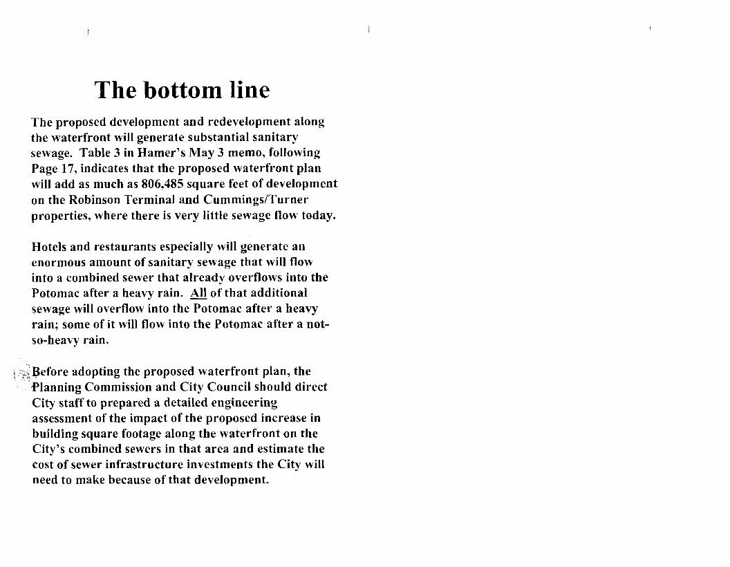
The bottom line The proposed development and redevelopment along the waterfront will generate substantial sanitary sewage. Table 3 in Hamer's May 3 memo, following Page 17, indicates that the proposed waterfront plan will add as much as 806,485 square feet of development on the Robinson Terminal and CummingsITurner properties, where there is very little sewage flow today.
Hotels and restaurants especially will generate an enormous amount of sanitary sewage that will flow into a combined sewer that already overflows into the Potomac after a heavy rain. &l of that additional sewage will overflow into the Potomac after a heavy rain; some of it will flow into the Potomac after a not- so-heavy rain.
, I :.%Before v h j adopting the proposed waterfront plan, the Planning Commission and City Council should direct City staff to prepared a detailed engineering assessment of the impact of the proposed increase in building square footage along the waterfront on the City's combined sewers in that area and estimate the cost of sewer infrastructure investments the City will need to make because of that development.
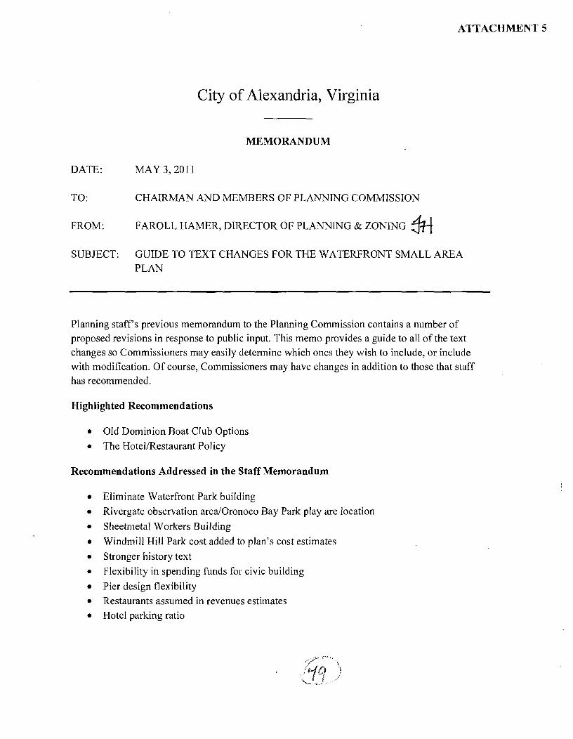
ATTACHMENT 5
City of Alexandria, Virginia
MEMORANDUM
DATE: MAY 3,201 1
TO: CHAIRMAN AND MEMBERS OF PLANNING COMMISSION
FROM: FAROLL HAMER, DIRECTOR OF PLANNING & ZONING fi SUBJECT: GUIDE TO TEXT CHANGES FOR THE WATERFRONT SMALL AREA
PLAN
Planning staffs previous memorandum to the Planning Commission contains a number of proposed revisions in response to public input. This memo provides a guide to all of the text changes so Commissioners may easily determine which ones they wish to include, or include with modification. Of course, Commissioners may have changes in addition to those that staff has recommended.
Highlighted Recommendations
Old Dominion Boat Club Options The HotelIRestaurant Policy
Recommendations Addressed in the Staff Memorandum
Eliminate Waterfront Park building Rivergate observation area1Oronoco Bay Park play are location Sheetmetal Workers Building Windmill Hill Park cost added to plan's cost estimates Stronger history text Flexibility in spending funds for civic building Pier design flexibility Restaurants assumed in revenues estimates Hotel parking ratio

HIGHLIGHTED RECONIMENDATIONS
Address potential changes due to discussions with ODBC, including potential that the parking lot will not completely move but may be reconfigured or reduced to improve public access to the river and/or to Waterfront Park. These discussions will affect the placement of the King Street pier, which could, for example, move south to be centered on Waterfront Park. Staff believes that the draft Plan's proposal for a relocated parking lot, Fitzgerald Square, the King Street Pier, and Waterfront Park is the optimal design but would also like the Plan to acknowledge that there is value to coming to an agreement with ODBC in the near term.
Staff suggests language to include in the Plan would be a new paragraph on page 62, just prior to the recommendations, which would state:
While the King Street Pier/Fitzgerald Square concept is the optimal design for this very important location on the waterfront, the Plan acknowledges the value of reaching an agreement with the ODBC that would improve public access to the Potomac River andor Waterftont Park. Options under discussion include one which would add a public path along the river ftom King Street to Waterftont Park and one which widens the Strand into a public plaza between King Street and Waterftont Park. Other options may be considered.
Add language detailing how restaurants and hotels would be reviewed during the SUP process to determine if they have unacceptable off-site impacts.
The language - in the form of a proposed restaurant and hotel policy - are detailed in the staff memorandum for the May 3 Planning Commission meeting. There are two updates:
I . Restaurant parking text revision: Planning Commissioners received a draft of this policy that included text that staff intended to remove before it was released. Among the factors for which restaurants will be reviewed is parking. Staff intended that the factor be described as "The availability of parking." Staff does not recommend the additional language saying no restaurant will be approved until there is a Council-approved Parking Implementation Plan, since restaurants may be proposed that fully address parking concerns prior to the approval of the parking implementation plan.
2. The Old Town Civic Association provided the Planning Commission with suggested changes to the policy. Staff has met with OPTCA representatives and discussed its proposal and can support many of the proposed changes. Attached is an updated staff recommendation incorporating the OTCA text that staff supports as well as OTCA's proposal.

POLICY FOR RESTAURANT/HOTEL/COMMERCIAL USES
REVISED STAFF RECOMMENDATION, INCORPORATING OTCA CHANGES
The cultural and historic ambience of Old Town provide the primary attraction for visitors and for residents. Restaurants, hotels, entertainment venues, marinas and other commercial establishments along the waterfront will provide activity and destinations for rcsiclenls and visitors-iilttFft;liCtttttd. . .. a, allowing enjoyment of the City's Potomac River location. Such uses, however, must be sited in appropriate locations and designed in such a way to ensure that goals of the Waterfront Plan are achieved, including:
. . ' ' ~ 1 - ~ ~ & ~ - h k ~ ~ 1 i l 1 ~ i l ~ c i 1 1 1 ~ crlio\ mcnt ..
of the .i\atcl-Sronl Ihr ~.c\idcnts a n d visilors aliltc; -- a Approprialelv -localin(? tw&-w+uses consonant with public open spaces,
development sites, and the Potomac River: t i l d
--w Maintaining compatibility with both-the historical and rcsidcntial character of'thc adjacent e&kw&tkneighborhood.
Restaurants, hotels, farmers' markets, retail, personal service, private recreational facilities, and marinas each require SUP approval in the Waterfront area. The SUP process is designed so that each use is reviewed and assessed for its appropriateness at a specific location and for its ability to coexist with adjacent and nearby uses without impacts to the character of the area, the plan goals as a whole, and the enjoyment of nearby property.
'I hc Sm:111 Are:) Plan l i~r the ~idiacent area of Old 'Town states the City's polic? tlinC Ihc fragile balance bel\\een tlic 1.esidentia1 and commncscial i~rt ' i?~ nust st bc prcser\eii if both arc to s c n ~ strong and if thc arnbi-cncc oSOld 'l'oun is to be preser.i.cd. F~~rthcr. the commerci:~l areas conlain n mix of activities t l i : l t j s ~ ~ ~ i q u ~ , , j l l ~ i n the 1nct_r:gpglita11 arcaI-ynd t [ l ~ t ~ j i x lieccls 10 be protectccl if the character oI'OId I ' o ~ n is to be ~lrcscrtcd."
The Old Town Small Area Plan (and the King Street Retail Strategy by reference) includes the City's policy with regard to restaurants, establishing guidelines to assist in SUP decision-making. The Old Town Restaurant Policy requires that Council review each restaurant application for its impacts on noise, late night hours, alcohol, parking, litter and the balance of retail and restaurant uses. A similar approach should be taken to protect the Waterfront, King Street and the nearby residential areas as to future uses and SUP review.
WATERFRONTRESTAURANTmOTEL POLICY
I Each SUP for a restaurant, hotelz entertainment, or other commercial use on the Waterfront must be reviewed, and appropriate findings made, according to the following guidelines:

1 . City Council shall not approve an SUP for a use on the Waterfront unless it finds that the use does not create significant negative impacts on the vitality and character of King
I Street or f i gc hi~rac>-g~ rg!ii-c~j<n~n~_c~~tof nearby residential neighborhoods 2. City Council shall consider the cumulative effect of the proposal and the number of
1 already established uses in the ~ i n e a s 1 ~ ~ ~ area. 3. In the case of an expansion or other intensification, the entire operation shall be taken
into account in determining the impact on King Street and nearby residential neighborhoods.
4. In making its determination, City Council shall consider the following factors as applied to the proposed use:
a. Restaurant i. The potential for undue congestion of pedestrians or vehicles;
ii . The extent to which the use is open in the late night hours and situated so as to potentially disturb residential areas;
iii. The extent to which alcohol consumption will predominate over food consiunption and situated so as to potentially disturb residential areas;
iv. The availability of parking; v. The predicted extent of litter generated;
vi. The potential for loud or otherwise inappropriate noise; and vii. The extent to which other restaurants already exist in the same b&gs.
Restaurant uses should not % . , 5 ,, - located in
such proximity as to detract from the character and authenticity of the Waterfront by creating a monoculture similar to a food court or "restaura~~t row" environment.
b. Hotel i. The potential for undue congestion of pedestrians or vehicles;
% . 11. The type and size of hotel, and whether it is designed to attract k g e
conventions, *banquets. or other functions (such as tradc shows); iii. The ability of the hotel to accommodate, and screen all of its service needs
on site, including loading and delivery operations. iv. Parking for visitors, customers and employees must be provided on site.
Although the Plan anticipates low parking ratios, the applied ratio must be consistent with industry standards.
v. Parking garages must be operated so that-they are open to the public at least at peak times.
vi. A restaurant within a hotel that is open to the public shall be the subject of a separate SUP and the same requirements as other restaurants.
vii. The location of the hotel and whether it% layout is designed to produce the least impact on nearby residential areas and on the lower King Street area.
c. Other commercial uses: Factors from the above lists shall be applied as relevant to the specific SUP under consideration.

POLICY FOR RESTAURANT/HOTEL/COMMERCIAL USES
I Proposed OTCA edits
The cultural and historic ambience of Old Town provide the primary attraction for visitors and for residents. Restaurants, hotels, entertainment venues, marinas and other commercial establishments along the waterfront will provide activity and destinations for residents ancl visitors-, allowing enjoyment of the City's Potomac River location. Such uses, however, must be sited in appropriate locations and designed in such a way to ensure that goals of the Waterfront Plan are achieved, including:
M w W ~ ~ i & ~ ~ ~ ~ ~ ~ f f t & l ~ i i l i ~ i ~ i c i n ~ c n j o ~ i n c n t ..
of the natcrfront for residents tuid \ isitors alike; Appropriately Mtug- loca t ing &uses consonant with public open spaces, development sites, and thc I'otoniac Riber; and
Maintaining compatibility with both_the hislorical and residential c11:lractcr ofthc adjacent ws-kkdneighborhood.
Restaurants, hotels, farmers' markets, retail, personal service, private recreational facilities, and marinas each require SUP approval in the Waterfront area. The SUP process is designed so that each use is reviewed and assessed for its appropriateness at a specific location and for its ability to coexist with adjacent and nearby uses without impacts to the character of the area, the plan goals as a whole, and the enjoyment of nearby property.
T'he Stnall Area Plan the adiaccnt area of Old 'l'onn states lhe ('i1p.s 1,olic~ that thc Sragilc balance belxxecn the rcsiden~icll a~id commercial iJrCaS "must bc ~ c s c r \ e t l iS both arc to rcmain xtrong and iS~11e ambicncc oEOld I'olin is to be presericd. I:ur~licr. the commercial areas conlain - - a mix or'_rictjjjlies - that is unique \sithill tI~~j~m!rgpolit~l~i arca. and that.il1.i~ neecls l o b protcctcd if the character of Old I'oun i y Lo bc ~vuscr\ed."
The Old Town Small Area Plan (and the King Street Retail Strategy by reference) includes the City's policy with regard to restaurants, establishing guidelines to assist in SUP decision-making. The Old Town Restaurant Policy requires that Council review each restaurant application for its impacts on noise, late night hours, alcohol, parking, litter and the balance of retail and restaurant uses. A similar approach should be taken to protect the Waterfront, King Street and the nearby residential areas as to future uses and SUP review.
WA TERFRONT RESTAURANTmOTEL POLICY
I Each SUP for a restaurant, hotel, entertainment, or other commercial use on the Waterfront must be reviewed, and appropriate findings made, according to the following guidelines:

1. City Council shall not approve an SUP for a use on the Waterfront unless it finds that the use does not create significant negative impacts on the vitality and character of King
I Street or t1-1~ character t~ndc~!j(fi~r~cnt or nearby residential neighborhoods 2. City Council shall consider the cumulative effect of the proposal and the number of
I already established uses in the k + i + & i i + - n ~ i z r l > ~ area. 3. In the case of an expansion or other intensification, the entire operation shall be taken
into account in determining the impact on King Street and nearby residential neighborhoods.
4. In making its determination, City Council shall consider the following factors as applied to the proposed use:
a. Restaurant i. The potential for undue congestion of pedestrians or vehicles;
ii . The extent to which the use is open in the late night hours and situated so as to potentially disturb residential areas;
iii. The kxtent to which alcohol consumption will predominate over food co nsu ~nption and t;iruatt.d-sc~t;~eptci~t ittcl-w! kt&&&k.asthe number or bar seats, icany. and tlic stalldine arcas iii the vicinity ofbt1.1.s;
iv. The +x+MGkyt+fcutent to which of'Gstl.cet parkinguill be provided lhr tlie resti~uranl's patrons ancl enlploj ecs;
v. TL predicted extent of litter generated; vi. The potential for loud or otherwise inappropriate noise; and
vii. The extent to which other restaurants already exist in the same I*-a+iult~. 7 , Restaurant uses should not V- - -. . - , --- *located in
such proximity as to detract from the character and authenticity of the Waterfront by creating a monoculture similar to a food court or "restaurant row" environment.
b. Hotel i. The potential for undue congestion of pedestrians or vehicles;
ii. The type and size of hotel, and whether it is designed to attract kwge conventions, *banquets, or otl~cl. [unctions (such as trade shows);
iii. The ability of the hotel to accommodate, and screen all of its service needs on site, including loading and delivery operations.
iv. Parking for visitors, customers and employees must be provided on site. Although the Plan anticipates low parking ratios, the applied ratio must be consistent with industry standards.
v. Parking garages must be operated so that %*=-:I substnntirll proporlion of spaces -they are open and dedicated for public use -te &e pdd-hat least at peak times.
vi. A-restaurant within a hotel that is open to the public shall be the subject of a separate SUP with its own parking plan.
vii. The location of the hotel and whether i t 3 layout is designed to produce the least impact on nearby residential areas and on the lower King Street area.
c. Other commercial uses: Factors from the above lists shall be applied as relevant to the specific SUP under consideration.

d. Sttrridtrriis: City C O U I I C ~ ~ sliall ;~dopt si+Ak&s - a . . , 'a-standards (iiiclucli~i~ s i ~ c liniils and spacc standards) Ibr thc ayplicatiot~ of thcsc f21ctoss. and criteria to mcasurc thc - clclrrec -- lo n hicli-t& ggdgrck arc r p c ~

ADDRESSED IN THE STAFF MEMORANDUM
Eliminate the Waterfront Park restaurant building and add language supporting an active park through other means (page 66).
Delete recommendation 3.71 and add to recommendation 3.72:
Implement a redesigned Waterfiont Park to include a new landscaped lawn fiamed by the existing willow oaks and new tree plantings. f l
pmk-Encourage the active eniovment o f Waterfiont Park with elements such as:
o Food and other carts, tables.and chairs, small scale recreation activities, and propamminn o f events, displavs or performances providinn entertainment, culture, histow and the arts.
o Kiosks and other temporarv or seasonal structures servinn as outdoor cafes, unique retail (such as made in Alexandria items), cultural or historv-themed displavs.
o An open-air market structure or pergola, suitable for farmer S markets, art shows, and the like, possiblv glass enclosed in winter to support ice skating and other winter recreation activities.
o A new public pier, which will serve both to brina park users out onto the water as well as a location for water taxis and other boats to bring visitors to Alexandria.
o Permanent and/or visiting historic ships and other ships o f character.
o A stane suaportinn performances, movies, and other entertainment or cultural events, using the natural slope o f Waterfiont Park and the low berms or seating walls o f the flood mitigation stratem to allow park users to view the stane.
Delete references to the restaurant building from the Implementation chapter.
Minor changes to the language for Rivergate and Oronoco Bay Parks regarding potential designs for the observation area at the foot of Montgomery Street and the location of the children's play area (response to public input from Rivergate homeowner's association) (page 43).
Revise recommendation 3.17: At the end of Montgomery Street, consider low-impact hardscape options and enhance the observation area at the point, possibly with a set of steps leading down to the river and vertical elements to fiame the view, and possiblv angled to the north to better capture views o f the nation's capital.
Revise recommendation 3.3 1 to separate the discussion of a children's play area into a new recommendation and delete the reference to a location. The new recommendation would read:
. . F A small children's play area is proposed, with recreation and water features - uniquely designed by artists -perhaps comprised of recycled materials or carefully screenedflotsam@om the river so children will see a direct relationship to natural and cultural cycles.
Add the language about redevelopment of the Sheetmetal Worker's Union building requested at the public hearing by a representative of the building's owners, regarding the importance of the connection to the public spaces if redevelopment takes place (page 44). The new recommendation would read:
I f the Sheet Metal Workers buildinn were to be redeveloped, such redevelo~ment shall provide a high level o f pedestrian and visual connectivitv between the redeveloped pro-pertv and Oronoco Bay Park. Provided that the redevelopment is compatible with the uses in Oronoco Bav Park, a rezoninn may be considered.
Add the cost of Windmill Hill Park implementation to the overall cost of the plan, as requested by the Waterfront Committee in their public testimony.
Add a new paragraph to the Implementation chapter (page 13 1):
Windmill Hill Park: This phase includes the improvements to Windmill Hill Park contained in the approved park plan, includinn the bulkhead repair and shoreline improvement projects.
Make a series of editorial changes designed to strengthen the connection of plan recommendations to the History Plan. These changes do not raise new ideas, but give more emphasis to ideas in the History Plan appendix by bringing them into the main body of the plan, and by reordering some paragraphs, etc. This responds to testimony from the history community.
The language changes are detailed on pages 32-27 of the staff memorandum for the May 3 Planning Commission meeting.
Add language providing flexibility in the spending of the $3.6 million included in the plan budget for a civic/cultural building. The overall goal is the creation of a history and/or cultural "anchor" in The Strand, and these funds are intended to implement that vision - which could be implemented in a variety of ways, only one of which is a civic building in Point Lumley Park. This responds to testimony from the history community.

Add a sentence to the discussion of the Civic Building on page 140: The funds identified for the construction o f a civic building are intended to be used to implement the southern cultural anchor recommended bv both the Art and History Plans as well as the Waterfront Plan itself- even i f that implementation does not include a new buildinn.
Add language clarifying that the proposed piers can be of a different length or design from those shown in the plan illustratives (responding to several expressions of concern over the pier length).
Amend recommendation 3.75 :
Constvuct a new pier, centered on the new public park between King Street and Wales Alley, w. Expanded docking locations for commercial boats may also be provided in the marina immediately upriverfiom the current water taxi stop in front of the Chart House. designs shown in this plan are illustrative; the ultimate design will be determined during the implementation phase and may be o f a different length, width or location from that shown in the Plan.
Further reduce the square footage of restaurants assumed for the revenue estimates - initially 109,000 square feet in the draft plan -to 50,000 square feet, in response to several expressions of concern about the amount in the assumption.
Amend the paragraph at the top of page 126 of the Plan to read:
For the purposes o f estimating revenue, the Plan anticipates 7F89;888 50,000 square feet of restaurant space, including restaurants in three hotels, &+&I0
. . 1 ? - and an operating Beachcomber.;
Added language to the development guidelines noting that consideration should be given to hotel parking ratios of 0.5/room.
The development guidelines would be amended to read: Parking for new buildings should be accommodated on site and below grade. Although the Plan anticipates low parkinx ratios, the applied ratio must be consistent with industry norms for similar hotels.
The same language would be included in the Restaurant~Hotel/Commercial Uses Policy (in the hotel section).


![DOCKETITEM#5 SpecialUsePermit#2011-0045 ...dockets.alexandriava.gov/fy11/091711ph/di6.pdfSection4-11-500 ofthe1992ZoningOrdinance City Alexandria,Virginia. IX]THEUNDERSIGNED, havingobtained](https://static.fdocuments.in/doc/165x107/5f515955e5f918157102c8c9/docketitem5-specialusepermit2011-0045-section4-11-500-ofthe1992zoningordinance.jpg)