· Web viewThis process will seek to greatly improve the breadth of background information...
62
In order to minimize the environmental impacts of the Secretariat’s processes, and to contribute to the Secretary-General’s initiative for a C-Neutral UN, this document is printed in limited numbers. Delegates are kindly requested to bring their copies to CBD Distr. GENERAL UNEP/CBD/SBSTTA/13/ INF/12 13 January 2008 ENGLISH ONLY SUBSIDIARY BODY ON SCIENTIFIC, TECHNICAL AND TECHNOLOGICAL ADVICE Thirteenth meeting FAO, Rome, 18–22 February 2008 Item 4.1 of the annotated agenda * DEVELOPMENT OF AN INTERACTIVE MAP (IMAP) AND REVIEW OF SPATIAL DATABASES CONTAINING INFORMATION ON MARINE AREAS BEYOND THE LIMITS OF NATIONAL JURISDICTION Background document to options for preventing and mitigating the impact of some activities to selected seabed habitats, and ecological criteria and biogeographic classification system of marine areas in need of protection Note by the Executive Secretary EXECUTIVE SUMMARY Several recent international meetings have agreed on the need to establish and effectively manage representative networks of marine protected areas (MPAs), as an essential tool for conserving not only biodiversity and habitats, but also fish stocks. Efforts undertaken by numerous organizations around the world demonstrate the progress that has been made in planning and implementing marine protected areas, particularly in coastal and nearshore zones. However, with respect to areas beyond national jurisdiction, or high seas, there are still gaps and challenges to implement and enforce existing, and develop new, policies and measures to ensure the conservation, protection and sustainable management/use of deep ocean ecosystems, including the resources and services they provide. For specific human impacts, such as fishing, there is significant work underway to address these through implementation of the UNGA61 Sustainable Fisheries Resolution (A/61/105) to regulate bottom fishing and prevent significant adverse impacts on vulnerable marine ecosystems. Despite these challenges, a growing body of knowledge on cold-water * UNEP/CBD/SBSTTA/13/1. /…
Transcript of · Web viewThis process will seek to greatly improve the breadth of background information...
In order to minimize the environmental impacts of the Secretariat’s processes, and to contribute to the Secretary-General’s initiative for a C-Neutral UN, this document is printed in limited numbers. Delegates are kindly requested to bring their copies to meetings and not to request additional copies.
CBD
Distr.GENERAL
UNEP/CBD/SBSTTA/13/INF/1213 January 2008
ENGLISH ONLY
SUBSIDIARY BODY ON SCIENTIFIC, TECHNICAL AND TECHNOLOGICAL ADVICE
Thirteenth meetingFAO, Rome, 18–22 February 2008Item 4.1 of the annotated agenda*
DEVELOPMENT OF AN INTERACTIVE MAP (IMAP) AND REVIEW OF SPATIAL DATABASES CONTAINING INFORMATION ON MARINE AREAS BEYOND THE LIMITS
OF NATIONAL JURISDICTION
Background document to options for preventing and mitigating the impact of some activities to selected seabed habitats, and ecological criteria and biogeographic classification system of
marine areas in need of protection
Note by the Executive Secretary
EXECUTIVE SUMMARY
Several recent international meetings have agreed on the need to establish and effectively manage representative networks of marine protected areas (MPAs), as an essential tool for conserving not only biodiversity and habitats, but also fish stocks. Efforts undertaken by numerous organizations around the world demonstrate the progress that has been made in planning and implementing marine protected areas, particularly in coastal and nearshore zones. However, with respect to areas beyond national jurisdiction, or high seas, there are still gaps and challenges to implement and enforce existing, and develop new, policies and measures to ensure the conservation, protection and sustainable management/use of deep ocean ecosystems, including the resources and services they provide. For specific human impacts, such as fishing, there is significant work underway to address these through implementation of the UNGA61 Sustainable Fisheries Resolution (A/61/105) to regulate bottom fishing and prevent significant adverse impacts on vulnerable marine ecosystems. Despite these challenges, a growing body of knowledge on cold-water corals, seamounts, and highly migratory species is creating a basis for setting priorities for protection of high-seas areas.
As part of the increasing efforts of many researchers, institutions, and Governments to better understand deep-sea and open-ocean areas, a number of organizations are building databases to support the relevant decision-making process. This note was prepared in response to the request made by the Conference of the Parties to the Convention on Biological Diversity (decision VIII/24, paragraph 44 (c)). It attempted to bring together spatial databases on high-seas marine protected areas (HSMPAs) and habitats, and outline how future management and collaborations may continue to develop. The United Nations Environment Programme World Conservation Monitoring Centre (UNEP-WCMC) has compiled a number of these sources of spatial data on areas beyond national jurisdiction as well as produced an Interactive Map (IMap) that highlights up-to-date information on high-seas protective measures, critical
* UNEP/CBD/SBSTTA/13/1./…

UNEP/CBD/SBSTTA/13/INF/12Page 2
habitats and species, and allows users to turn data layers on and off. The IMap can be found at: http://www.cbd.int/marine/tools.shtml (linked to http://bure.unep-wcmc.org/marine/highseas).
We expect that this information should assist with the increasing interest in developing a network of marine protected areas on the high seas. The information gathered in this note with the development of selection criteria, such as vulnerability and representativeness, for priority high-seas areas in need of protection, will facilitate the development and implementation of the frameworks necessary to move forward on conservation of high-seas resources.
Major findings from this note are as follows:
(a) The Interactive Map (IMap) sheds some light on current knowledge of high-seas protection measures; however, it is built on old technology. Transferring this data to an information module for inclusion in the redeveloped World Database on Protected Areas (to be released in 2008) will allow for a more robust, web-based, interactive system of data on high-seas marine resources and areas. The user instructions for IMap are found in annex I.
(b) Over 40 different data sources containing information about marine areas beyond national jurisdiction have been identified (annex IX). Future collaborative efforts should be focused on developing strong linkages between these ongoing research initiatives and designating points of contact from each institution or initiative.
(c) Criteria for designating marine protected areas in the high seas have been discussed, inter alia, at expert workshops and meetings held in Canada (December 2005), Mexico (January 2007), and the Azores, Portugal, (October 2007). Once agreed upon, such criteria could be linked with available scientific data and information sources, such as those identified in annex IX in this note, to determine gaps in knowledge and to establish priority actions.
(d) A recommended approach to high-seas data management and information flow is outlined in figure 3. Key partners, including the World Commission on Protected Areas (WCPA) Marine High Seas Task Force, The Sea Around Us program at the University of British Columbia, and the Ocean Biogeographic Information System (OBIS), would work with UNEP-WCMC and other institutions to inform at least six information modules relevant to high-seas conservation and marine protected areas. All of this could be linked through the World Database on Protected Areas.
/…

UNEP/CBD/SBSTTA/13/INF/12Page 3
I. INTRODUCTION
1. More than two-thirds of the world’s surface is covered by oceans and seas. About 64% of this surface are ocean areas beyond the limits of national jurisdiction. Recent assessments of marine life, including deep-sea corals and migratory species, have revealed the high level of biodiversity that exists in waters more than 200 miles from the shoreline. The 1982 United Nations Convention on the Law of the Sea (UNCLOS) commits countries to protect the marine environment and use marine resources wisely even if beyond national boundaries. Although there are a number of international agreements (e.g. the UN Fishstock Agreement) and bodies (e.g. Regional Fisheries Management Organizations) in place, these ecosystems and biodiversity in areas beyond national jurisdiction are still at risk and threatened by human activities, which currently are not (or only partly, inadequately or in a fragmented manner) covered by existing governance mechanisms and legislative / policy measures (UNEP 2006).
2. The high seas, or marine areas beyond national jurisdiction, are a topic of growing interest. Research and management are evolving fast, due to a realization that they must catch up with exploitation, the largest current threat to the high seas. Destructive deep-sea fishing is of particular concern due to the impact on deep-water fish stocks and on vulnerable deep-sea biodiversity, ecosystems and habitats. Impacts on seamounts are almost completely due to fishing (Rogers 2004). Illegal, unreported and unregulated (IUU) fishing, carried out by vessels operating outside existing regional management agreements and without regard for sustainable fishing practices, accounts for 30% of the world’s fish catch (Riddle 2006) and is one of the major reasons why the international community is failing to conserve and manage high-seas stocks (Gianni and Simpson 2005). Despite the existence of science-based management plans, actions to implement these plans are not often carried through by decision-makers.
3. While conservation efforts for the world’s marine environment have increased and expanded in recent years, there is still a great deal of work that needs to be done in order to meet a variety of global targets, particularly the target of the Convention on Biological Diversity’s programme of work on protected areas (decision VII/28, annex), which states “By 2010, terrestrially and 2012 in the marine area, a global network of comprehensive, representative and effectively managed national and regional protected area systems is established.” Efforts are needed to develop systems of protected areas that reflect ecologically representative marine areas in the high seas as well as identify suitable approaches for managing and enforcing offshore environments. The 2007 UNEP Global Marine Assessments report reiterates previous findings: key knowledge gaps exist in the high-seas and deep-ocean realms. While advances have been made in the understanding of threats and deep-sea biology, there is a need to begin correlating conservation planning with policy.
4. One of the potential actions recommended to address the conservation and sustainable use of the high seas is the development of marine protected areas in areas beyond national jurisdiction. The Conference of the Parties to the Convention on Biological Diversity, in decision VIII/24, paragraph 44 (c), requested the Executive Secretary to” collaborate in the further development of spatial databases containing information on marine areas beyond the limits of national jurisdiction, including the distribution of habitats and species, in particular rare or fragile ecosystems, as well as the habitats of depleted, threatened or endangered species.” Though HSMPAs are not currently defined by any international body, high-seas protection measures have been adopted through a number of arrangements, as discussed in this note. In addition, there are several efforts in place regarding proposals for HSMPAs, including a list of 50 priority sites being developed by the IUCN High Seas Task Force, a design for a global network of high-seas marine reserves (Greenpeace), and other initiatives.
5. Because there are no legal HSMPAs currently in place, comprehensive mapping of key habitats and species should allow for a more informed selection of HSMPA sites in conjunction with the application of MPA selection criteria. Mapping should also aid the incorporation of biological data into the future
/…
UNEP/CBD/SBSTTA/13/INF/12Page 4
development of high-seas ecoregions. Mapping HSMPAs allows spatial gaps in the partial and fragmentary management tools already existing to be identified. Overlaying physical and biological data (bathymetry, seamounts and cold-water corals) allows identification of locations that are potentially high in biodiversity or vulnerable. The analysis of high-seas fishing pressure in the form of catches from dredging and bottom trawling allows the likely naturalness of locations to be assessed, given their historical fishing pressure. Finally, one global marine ecoregional approach developed by the IUCN World Commission on Protected Areas (WCPA) was plotted to allow “representativeness” of existing management areas to be assessed (Kelleher, Bleakley et al. 1995).
6. The United Nations Environment Programme-World Conservation Monitoring Centre (UNEP-WCMC), using a range of information and data provided by high seas experts, coordinated the study for this note and the production of an interactive map service (IMap). While this note does not provide a complete representation of high-seas data, it provides a background on IMap by briefly reviewing existing high-seas management regimes and ecoregional approaches, and identifying databases with critical relevant content. Importantly, it outlines how high seas spatial information, particularly on HSMPAs, could be collected and disseminated in the future. This is an essential step in the development and application of high-seas spatial data to research and decision-making. The present note takes into consideration comments submitted by Parties, other Governments and organizations as well as experts, from 26 October to 23 November 2007, during which time the note was posted on the Convention website for peer review (notification 2007-130). The study for this note was conducted with the financial support from the European Commission.
II. THE INTERACTIVE MAP (IMAP)
7. The Interactive Map, or IMap, is an up-to-date internet-accessible map of protective measures related to high-seas marine protected areas (HSMPAs) and key habitat distributions, such as deep-sea corals and seamounts, and ecological regions. The IMap can be found at http://www.cbd.int/marine/tools.shtml (linked to http://bure.unep-wcmc.org/marine/highseas).
8. IMap was built using an interactive map service (IMS). ArcIMS is one solution for delivering dynamic maps and Geographic Information System (GIS) data via the web. This IMS enables integration and publication of data from multiple sources and the creation of a central metadata repository for the publication and browsing of metadata by the web.
9. The IMap offers tools for viewing, querying spatial and attribute data, and performing spatial analysis tasks, such as selecting and measuring features. A full list of instructions for using IMap is included in annex I. Using the ArcIMS viewers, the user can: (i) pan and zoom the map extent; (ii) query spatial and attribute data; (iii) measure distances on the map; (iv) create buffers around features; and (v) print a hard copy of map display.
10. The Convention on Biological Diversity describes an MPA as “any defined area within or adjacent to the marine environment, together with its overlying waters and associated flora, fauna and historical and cultural features, which has been reserved by legislation or other effective means, including custom, with the effect that its marine and/or coastal biodiversity enjoys a higher level of protection than its surroundings” (decision VII/5, paragraph 10). This definition incorporates all protection levels of the IUCN categories. Therefore, for the purposes of IMap, all high-seas management regimes were included if they were spatially explicit, included any areas beyond national jurisdiction, or conferred greater protection on any subset of taxa. The following management regimes were included: Regional Fisheries Management Organizations (RFMOs), closures within RFMOs, Regional Seas Conventions, and marine mammal sanctuaries beyond national jurisdiction. Non-spatially explicit management regimes or international conventions governing the high seas are not included. Those seeking overviews of high-seas legal regimes and management should refer to the reports by Gjerde (2006) and Kimball (2005).
/…
UNEP/CBD/SBSTTA/13/INF/12Page 5
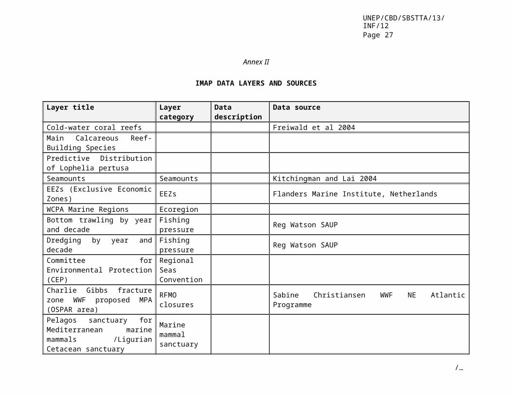
11. The IMap tool includes a variety of data (see annex II) from multiple sources, such as spatially explicit management regimes, including any marine areas beyond national jurisdiction, protecting all or a subset of taxa. Following is a list of data layers in IMap:
(a) Physical data: bathymetry, seamounts (high biodiversity and vulnerable);(b) Biological data: Cold-water coral reefs: (high biodiversity and vulnerable);(c) Ecoregions: WCPA Marine regions (representativeness);(d) Fishing pressure: Catches from dredging and bottom trawling by decade;
(e) Regional Fisheries Management Organizations (RFMOs) including species-specific RFMOs;
(f) Closures within RFMOs;(g) Regional Seas Conventions; and(h) Marine mammal sanctuaries
Additional data layers could be considered in the future, including oceanographic features such as temperature, salinity, and oxygen, geomorphology and seabed sediment type as global data are available.
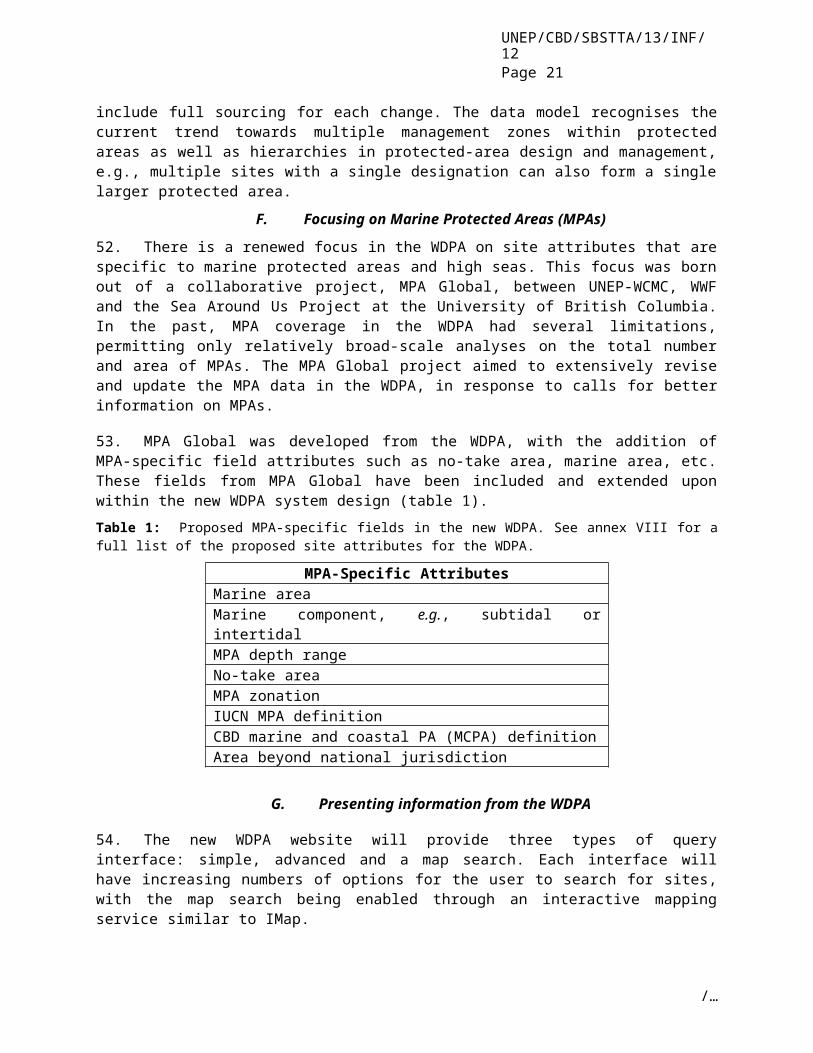
III. MPA CRITERIA AND ECOREGIONALIZATION
12. Marine protected area (MPA) criteria are essentially characteristics that candidate sites for protection can be judged against in order to gauge their relative importance. Criteria are used to aid the site selection process and provide transparency, covering a broad range of aspects. For example, the main categories of the IUCN criteria for MPAs are naturalness, economic importance, social importance, scientific importance, international or national significance, practicality or feasibility and duality or replication (Kelleher 1999). The list of criteria for MPA selection considers all aspects relating to the area including existing activities and how those activities can be managed in any new arrangements.
13. The MPA selection criteria have been incorporated into the goals of international conventions. The Conference of the Parties to the Convention on Biological Diversity called for comprehensive, effectively managed and ecologically representative MPAs, that, inter alia, through a global network, contribute to achieving the objectives of the Convention and the 2010 biodiversity target (decision VII/28). This has spurred particular interest in “ecological representativeness” as a criterion for establishing MPAs. One approach for adopting selection criteria into MPA siting is ecoregionalization. International discussions on criteria for the establishment of MPAs in marine areas beyond national jurisdiction were discussed, inter alia, at a Scientific Experts’ Workshop on Criteria for Identifying Ecologically or Biologically Significant Areas beyond National Jurisdiction (6-8 December 2006, Ottawa), a Joint Expert Meeting on Biogeographic Criteria for the Classification of Open and Deep Ocean Areas (22-24 January 2007, Mexico), and an Expert Workshop on Ecological Criteria and Biogeographic Classification Systems for Marine Areas in Need of Protection (2-4 October 2007, Azores, Portugal).
14. An ecologically representative network of MPAs should, by definition, capture the full range of ecological variability of the area in question in its protected sites. This requires a mapping process to determine the variation. Bio- or ecoregionalization is essentially a classification process that aims to partition a large area into distinct regions using quantitative analysis and expert opinion. An ecologically representative network of MPAs would be expected to have at least one MPA site in each ecoregion. In essence, developing a classification system of open-ocean and deep-sea regions ensures that key habitat types and species are represented in the high-seas MPA network.
15. Regions can be classified through quantitative analysis of a range of environmental and biological data across the area, which is then combined with expert opinion (Grant, Constable et al. 2006) or they can be developed qualitatively by experts synthesising existing information and extrapolating using expert judgment (Vierros 2007). The type and scale of data used are dependent on the objectives of the ecoregionalization. For example, an ecoregionalization designed to inform the establishment of a global network of MPAs for protecting marine mammals might use coarse-scale data of relevance to the specific
/…
UNEP/CBD/SBSTTA/13/INF/12Page 6
taxa under consideration. Examples of the types of data used in bioregionalization in the marine environment include physical oceanography (e.g., water masses, fronts, gyres and wave energy), geomorphology (depth, substratum, sediment), biological oceanography (primary and secondary production), and biological data (fish stock, marine mammal distribution and abundance) (Grant, Constable et al. 2006). Benthic and pelagic bioregionalizations would be based on different but partly overlapping data sets.
16. Six different approaches have been made to global marine ecoregionalization (annex III). Of these, two focus on coastal areas: Marine Ecoregions of the World (MEOW) and Large Marine Ecoregions (LME) (annex III). The main limitation to global ecoregionalization is acquiring global data. The only purely data-driven global ecoregionalization process (Longhurst 1998) uses oceanographic rather than species data. Although there are global initiatives to map marine species globally, it is likely to be several years before a global ecoregionalization that includes marine species distribution is possible (Vierros 2007).
17. Creating ecoregions requires the delineation of boundaries, even if these do not exist in reality. Boundaries are more likely to be gradual in the ocean due to the fluid nature of the environment and may even shift over time. Due to strong relationships among physical parameters, biological parameters and species, many ecoregionalization approaches produce similar boundaries. The biogeochemical provinces in Longhurst’s (1998) coastal biome overlap significantly with Sherman and Alexander’s LMEs (Pauly et al. 2001). Some of Longhurst’s boundaries are also fairly close to those suggested by taxonomic biogeographers (Spalding, Fox et al. 2006). HSMPAs facilitate delineation of these spatial boundaries, and thus their effective management.
IV. MANAGEMENT REGIMES
18. This section provides further information on the protective measures related to HSMPAs plotted on the Imap, including an up-to-date summary of spatially explicit management regimes in the high seas. It does not include overarching international agreements nor does it provide an opinion on the suitability or otherwise of these management regimes for protecting the high seas. Both these topics have been covered in depth by Gjerde (2006) and Kimball (2005). Management regimes related to the protection of the high seas are divided into three main types: Regional Fisheries Management Organizations (RFMOs) and their closures, Regional Seas Conventions, and marine mammal sanctuaries.
A. Regional Fisheries Management Organizations
19. Regional Fisheries Management Organizations (RFMOs) and Agreements (RFMAs) are intergovernmental organizations or commissions established by Regional Fisheries Management Conventions or other international agreements (Kimball 2005). They can vary considerably in their scope (Kimball 2005), ranging from organizations applying an ecosystem-based approach to manage all human activities and marine resources under their auspices (e.g. CCAMLR), to those addressing specific fisheries (and their impacts) in the context of the sustainable management and use of only a small group of species (e.g., ICCAT) (Appendices 4 and 5).
1. Regional Fisheries Management Organizations dealing with overall marine resources
20. The Convention on the Conservation of Antarctic Marine Living Resources, CCAMLR, is a conservation organization with the attributes of an RFMO and has formally adopted the ecosystem approach. CCAMLR is part of the Antarctic Treaty system. The Southern Ocean, under CCAMLR management, is particularly plagued by Illegal, Unreported, and Unregulated (IUU) fishing, especially for Patagonian toothfish (Gianni and Simpson 2005). Although CCAMLR has not managed to
/…

UNEP/CBD/SBSTTA/13/INF/12Page 7
completely address this problem, it has successfully implemented methods to limit the access of IUU fishing vessels to ports in the area (Riddle 2006) and significantly reduced the illegal catch of toothfish. Annex V to the Protocol on Environmental Protection to the Antarctic Treaty (Madrid 1991) provides for the designation of areas, including marine areas, as Antarctic Specially Protected Areas (ASPAs) or Antarctic Specially Managed Areas (ASMAs). The Committee for Environmental Protection (CEP), established under the Protocol, provides advice to the Antarctic Treaty Consultative Meeting on proposed areas. ASPAs may be designated to protect outstanding environmental, scientific, historic, aesthetic or wilderness values, and require a permit for entry. ASMAs may be designated to assist in the planning and coordination of activities, avoid possible conflicts, improve cooperation between Parties or minimize environmental impacts. Under an agreement between the ATCM and CCAMLR, if a proposed marine ASPA/ASMA is likely to affect CCAMLR-related activities, including harvesting of marine living resources, the proposal must receive the prior approval of CCAMLR. CCAMLR and the ATCM are currently discussing options for the development of a marine protected areas system as part of joint arrangements for conservation of Antarctic marine biodiversity. At the 2007 Annual Meeting, CCAMLR’s Commission agreed to management measures to protect vulnerable marine ecosystems, such as cold water corals, from significant adverse impacts of bottom fishing, including the establishment of an assessment process in accordance with United Nations’ General Assembly Resolution 61/105.
21. The General Fisheries Commission of the Mediterranean, GFCM, aims to promote the development, conservation and management of living marine resources; formulate and recommend conservation measures; and encourage cooperative training projects. It closed Mediterranean waters deeper than 1000 m to bottom trawling in 2005 (FAO 2007), and in January 2006 closed three additional areas to bottom trawling that were shallower than 1000 m, including a deep-sea coral reef, an area of rare corals and a seamount (IUCN 2007). Mediterranean countries also now require that trawlers use a minimum mesh-size opening of 40 mm in the "cod end" section of their nets in order to allow smaller, juvenile fish to escape, thereby conserving breeding stocks. This measure should also help to reduce accidental catches of non-target species (FAO 2007).
22. The Northwest Atlantic Fisheries Organization, NAFO, agreed to incorporate an ecosystem approach into its mandate in 2006 (Gjerde 2006). As of 1 January 2007, and until 31 December, 2010, four areas containing seamounts have been closed to all fishing activities involving demersal fishing gears (NAFO 2007). As of 1 January 2008, 20% of the area suitable for fishing at each seamount may be opened to a small-scale, exploratory fishery. However, if hard corals are encountered, the fishery will be subject to closure. These measures will be reviewed in 2010, when they may be ended, extended, or made permanent (Gjerde 2006). Furthermore, the 2007 Annual Meeting of NAFO (24-28 September 2007, Lisbon, Portugal) agreed to close a large area on the Great Banks (NAFO Division 3O) to bottom fisheries for the next five years. During this time, a coral monitoring and research programme in this area will deliver much needed data to devise future strategies for the protection of corals. In order to give effect to and implement the resolutions on sustainable fisheries adopted at the 2006/2007 sessions of the UN General Assembly, NAFO also decided to convene an extraordinary meeting of the Fisheries Commission in Montreal, in spring 2008 to consider strategies and measures to address vulnerable marine ecosystems particularly in the deep seas.
23. The Northeast Atlantic Fisheries Commission, NEAFC, closed five areas to bottom fishing on an interim three-year basis in response to a proposal from Norway and a request from OSPAR in late 2004 (Hatton Bank, Hecate and Faraday Seamounts, Reykjanes ridge, Altair seamounts and Antialtair seamounts). NEAFC agreed to close Hatton Bank and three areas of Rockall Bank from November 2006 until 2009, based on advice solicited from the International Council for the Exploration of the Seas (ICES). However, one of the areas recommended by ICES, “South Rockall”, was not accepted. OSPAR (the Convention for the Protection of the Marine Environment of the North-East Atlantic) has expressed an interest in incorporating these temporarily protected areas into its regional network of MPAs (Gjerde 2006). Contracting Parties include the EU, the Faroe Islands, Norway, Greenland, Iceland and the Russian Federation (NEAFC 2007).
/…
UNEP/CBD/SBSTTA/13/INF/12Page 8
24. In October 2006 the Southeast Atlantic Fisheries Organization, SEAFO, agreed to cease all deep-sea fishing activities in 10 areas for three years as of 1 January 2007. Similar to the NAFO closures, small-scale exploratory fishing may resume in 2008 in 20% of these areas, but if hard corals are encountered, an immediate temporary closure would be declared (Gjerde 2006). As of 1 January 2007, Parties include Angola, the European Union, Namibia and Norway (SEAFO 2007).
25. The South Indian Ocean Fisheries Agreement, SIOFA, aims to ensure the long-term conservation and sustainable use of fishery resources other than tuna, in areas outside national jurisdiction in the southern Indian Ocean. SIOFA was adopted in July 2006 by six countries, the Comoros, France, Kenya, Mozambique, New Zealand and Seychelles, and the European Community (FAO 2007).
26. Negotiations to develop a South Pacific Regional Fisheries Management Organization (SPRFMO) were initiated by Australia, Chile and New Zealand in 2006 and would control unregulated fishing in international waters. These negotiations are ongoing. The fourth international meeting was held from 10 to 14 September 2007 in Noumea, New Caledonia. While negotiations are taking place for the development of long-term management measures, participants agreed in 2007 to interim measures to protect vulnerable marine ecosystems from significant adverse impacts of bottom fishing, in accordance with UNGA Resolution 61/105.
27. In 2006, the Russian Federation, the Republic of Korea, Japan and the United States met to establish a mechanism to regulate deep-sea fishing in an area in the Northwestern Pacific Ocean, where the first deep-sea bottom fisheries emerged in the late 1960s (Gjerde 2006). In 2007, the parties agreed to interim measures (to take effect no later than December 2007) to protect vulnerable marine ecosystems from significant adverse impacts of bottom fishing, in accordance with UNGA Resolution 61/105.
2. Regional Fisheries Management Organizations dealing with specific species or groups of species only
28. The objective of the Commission for the Conservation of Bluefin Tuna (CCSBT) is to ensure, through appropriate management, the conservation and optimum utilization of the Southern Bluefin Tuna (SBT) fishery. The Commission also provides an internationally recognized forum for other countries or entities to actively participate in SBT issues (CCSBT 2007). Australia, Japan, Republic of Korea and New Zealand are member parties, and Taiwan is a member of the ”Extended Commission” (Internet-Guide-to-International-Fisheries-Law 2007). In 2003, the CCSBT agreed to invite countries with an interest in the fishery to participate in its activities as formal Cooperating Non-Members (without rights to vote). This is regarded as a transitional process to full membership. Cooperating Non-Members are required to adhere to catch limits and conservation objectives of the CCSBT. The Philippines, South Africa and the EU were accepted as Cooperating Non-Members in 2004, 2006 and 2006 respectively. Indonesia may also join this status soon (CCSBT 2007). The proper functioning of the Commission has been severely impeded due to disputes between members regarding the level of fishing, which has not fully been resolved (Internet-Guide-to-International-Fisheries-Law 2007).
29. The main objectives of the Inter-American Tropical Tuna Commission (IATTC) are to maintain the populations of tuna and other fish species taken by tuna vessels in the Eastern Pacific Ocean and to cooperate in the gathering and interpretation of factual information to facilitate the maintenance of these fish populations at a level that permits maximum sustainable catches year after year. Since extension of jurisdiction in the region, IATTC has strengthened its role in tuna management and has continued an extensive research programme (Internet-Guide-to-International-Fisheries-Law 2007). IATTC was revised in 2003 to incorporate the precautionary approach and many principles of the United Nations Fish Stock Agreement. It has also agreed to reduce and potentially eliminate bycatch of dolphins in purse seine fisheries and bycatch of sharks and marine turtles (Kimball 2005). IATTC, ICCAT and IOTC have developed lists of vessels that are authorised to fish in their areas.
/…

UNEP/CBD/SBSTTA/13/INF/12Page 9
30. The International Commission for the Conservation of Atlantic Tunas (ICCAT) is responsible for the conservation of tunas and tuna-like species in the Atlantic Ocean and adjacent seas. ICCAT has implemented trade sanctions against eight different countries for non-compliance with ICCAT measures: two against ICCAT member states (Equatorial Guinea and Panama) and six against non-member states (Belize, Bolivia, Cambodia, Honduras, Sierra Leone, and St. Vincent and the Grenadines). These measures are effective, but anecdotal evidence suggests that the vessels involved are now registered under different countries (Riddle 2006). Taiwanese fishing companies have built a fleet of vessels that fall just under the 24 m minimum length for application of most ICCAT measures. These vessels have been operating in the Caribbean and affecting shark stocks and causing billfish bycatch (Gianni and Simpson 2005). Blue and mako sharks are caught as bycatch in the tuna and swordfish fisheries regulated by ICCAT. ICCAT has been collecting data on sharks since the mid-1990s with the intention of gathering enough information to assess whether the current levels of catch and bycatch are sustainable over the long term (Pew-Institute-for-Ocean-Science 2005).
31. The objective of the Indian Ocean Tuna Commission (IOTC) is to promote cooperation among its members to ensure, through appropriate management, the conservation and optimum utilization of stocks covered by this Agreement and encourage sustainable development of these fisheries (IOTC 2007). There are few vessels flagged to Taiwan on the IOTC list of authorized vessels, but a relatively large fleet of Taiwanese-flagged longline vessels is likely to be fishing in the Indian Ocean area (Gianni and Simpson 2005).
32. The objective of the North Atlantic Salmon Conservation Organization (NASCO) is to contribute, through consultation and cooperation, to conservation, restoration, enhancement and rational management of salmon stocks subject to the Convention, taking into account the best scientific evidence available to it (NASCO 2007). Parties to NASCO include Canada, Denmark (in respect of the Faroe Islands and Greenland), European Union, Iceland, Norway, Russian Federation and United States of America (NASCO 2007).
33. Parties to the North Pacific Anadromous Fish Commission (NPAFC) include the primary states of origin for salmon stocks in the North Pacific: Canada, Japan, Republic of Korea, Russia and the United States (NPAFC 2007). The main objective of the Convention is to promote the conservation of anadromous stocks in the Convention Area. Its conservation measures include:
(a) Prohibition of directed fishing for anadromous fish in the Convention Area;
(b) Minimizing to greatest extent the incidental taking of anadromous fish; and
(c) Prohibition of the retention on board a fishing vessel of anadromous fish taken as an incidental catch during fishing for non-anadromous fish (NPAFC 2007).
Riddle (2006) maintains that NPAFC provides an exceptional example of success through international cooperation with regards to stopping illegal high-seas driftnet fishing in the North Pacific. The Convention set a precedent by allowing officers of other states to board, inspect, and seize non-flag vessels when in violation of the Convention (Riddle 2006).
34. The aim of the Western and Central Pacific Fisheries Commission (WCPFC) is to ensure, through effective management, the long-term conservation and sustainable use of highly migratory fish stocks in the western and central Pacific Ocean in accordance with the 1982 UN Convention on the Law of the Sea and the 1995 UN Fish Stocks Agreement. Fifteen nations in the region have ratified and acceded to the Convention since November 2004.
B. Regional seas conventions and action plans and similar regional programmes
35. Regional Seas Conventions are agreements, generally with accompanying action plans, established by groups of countries sharing common seas. About half are formulated under the auspices of the United Nations Environment Programme’s Regional Seas Programme. Although the Regional Seas Programme
/…
UNEP/CBD/SBSTTA/13/INF/12Page 10
plays an important role in regional cooperation (Kelleher 1999), these agreements are limited in their coverage of areas beyond national jurisdiction (Kimball 2005), especially in comparison to RFMOs. Only four out of 13 conventions cover areas beyond national jurisdiction (OSPAR, Mediterranean, South Pacific and the Antarctic Treaty) (Kimball 2005) (annex VI). Some Conventions that precede UNEP include the Northeast Atlantic, Baltic Sea and Antarctic.
36. The Pacific Regional Environment Programme (SPREP), a regional intergovernmental organization now based in Samoa, was initially established in 1982 as a programme of the South Pacific Commission. SPREP has grown into the main organization responsible for conservation collaboration and environmental management in the Pacific, and its Secretariat serves as the Secretariat for three conventions (the Apia Convention, the SPREP or Noumea Convention, and the Waigani Convention). SPREP encourages community-based conservation areas extending into the marine environment (Kelleher 1999)
37. The 1992 Convention for the Protection of the Marine Environment of the North-East Atlantic (OSPAR) is the current instrument guiding international cooperation on the protection of the marine environment of the North-East Atlantic (OSPAR 2004). Parties to the OSPAR Convention committed to developing an ecologically coherent network of MPAs by 2010. This includes a large proportion of the Northeast Atlantic that is beyond national jurisdiction. OSPAR has expressed an interest in incorporating the temporarily protected areas under NEAFC (see RFMOs) into their regional network of MPAs (Gjerde 2006). However, some Parties do not believe that OSPAR has the competence to establish and manage such MPAs without an agreement at the international level. There are 16 Parties to the OSPAR Convention: Belgium; Denmark; EC; Finland; France; Germany; Iceland; Ireland; Luxembourg; Netherlands; Norway; Portugal; Spain; Sweden; Switzerland; and the United Kingdom (Owen 2006).
38. The Convention for the Protection of the Marine Environment and the Coastal Region of the Mediterranean (CPMECRM) was adopted in 1995 in Barcelona and entered into force in 2004. It covers the maritime waters of the Mediterranean Sea proper, inclusive of its gulfs and seas (though not the internal waters of the Contracting Parties) with the main aim of protecting the area from pollution.
39. The Antarctic Treaty System/ Madrid Environmental Protocol commits the Signatory Parties to the "comprehensive protection of the Antarctic environment" and designates Antarctica as a "natural reserve, devoted to peace and science". It came into force in June 1961 after ratification by the 12 countries then active in Antarctic science. The Treaty covers the area south of 60°S latitude. The treaty remains in force indefinitely. The success of the treaty is demonstrated by growth in membership. Forty-four countries have acceded to it. Consultative (voting) status is open to all countries that have demonstrated their commitment to the Antarctic by conducting significant research. The Treaty has adopted over 200 recommendations and negotiated five separate international agreements. These, together with the original Treaty, provide the rules that govern activities in Antarctica.
C. Marine mammal sanctuaries
40. Some marine mammal species, particularly cetaceans, have life-history patterns that include extensive migrations to grounds where feeding, breeding, and nursing take place. For instance, Gray Whales travel thousands of miles between the Bering and Baja seas each year to breed, raise their offspring, and feed. Other groups, such as the beaked whales, are deep divers and are often found in high seas areas. The International Whaling Commission (IWC) established its first sanctuary in the Antarctic in the 1930s to provide an area of immunity to whales from the commercial whaling sector. See annex VII for a summary of the following sanctuaries mentioned below:
(a) The Indian Ocean Whale Sanctuary was established by the IWC in 1979, extending south to 55°S latitude, as an area where commercial whaling is prohibited. Designation of sanctuaries like this requires three-quarters majority vote by the Commission. The Indian Ocean Sanctuary was initially
/…

UNEP/CBD/SBSTTA/13/INF/12Page 11
established for 10 years and has been extended twice for 10-year intervals (http://www.iwcoffice.org/index.htm);
(b) The Southern Ocean Whale Sanctuary is recognised as part of a host of treaties aimed at protecting Antarctica (Hoyt 2005); and
(c) The Pelagos Sanctuary was created as a result of data accumulated during research cruises in the Ligurian Sea over nearly three decades. It is included in the list of Specially Protected Areas of Mediterranean Importance (SPAMIs) and is the largest of these sites. SPAMIs are designated under the Barcelona Convention (see Regional Seas Conventions). It was agreed by Italy, France and Monaco and ratified in 2003.
V. HIGH-SEAS SPATIAL DATA MANAGEMENT
41. This section deals with future collaboration and management of high-seas spatial data. It outlines the role of UNEP-WCMC and partners in the acquisition, management and application of high- seas data. Current research initiatives and important databases relevant to knowledge of high-seas species, habitats, and processes are reviewed in annex IX.
A. High-Seas Marine Protected Area data and the World Database on Protected Areas (WDPA)
42. Information management for areas beyond national jurisdiction (high seas) will follow the same process of data acquisition and integration used for the World Database on Protected Areas (WDPA). However, there will be a targeted approach on the sourcing of data on high seas, the acquisition and integration of these spatial datasets into the WDPA, visualization through a web mapping service as well as integration into other conservation datasets held at UNEP-WCMC.
43. This process will seek to greatly improve the breadth of background information held on high seas, including the standardization of data formats and production of streamlined up-to-date and Internet-accessible outputs for a wide range of processes.
B. WDPA - Background
44. The WDPA is the only global repository of information on marine and terrestrial protected areas. As a joint project of IUCN - the World Conservation Union and UNEP-WCMC, it has been in existence since 1981 and is playing an increasingly important role in delivering on the mandates of the United Nations Millennium Development Goals and the CBD. UNEP-WCMC has a long history of sourcing, acquiring and integrating data from around the world into standardized spatial and aspatial datasets. The WDPA is one product of many developed as a result of this unique experience.
C. WDPA - Protected Area Information Management
45. The WDPA and the data-flow management process that encompasses it are currently being redeveloped. The WDPA receives data from all over the world in a variety of formats, projections, languages and structures that need comparison with, and verification against, existing information in the database and integration into a standard structure (Fig. 1).
/…

UNEP/CBD/SBSTTA/13/INF/12Page 12
Fig. 1. Overview of current information flow into the WDPA
46. With the current system, UNEP-WCMC is unable to effectively interact with the 192 United Nations member countries and their respective protected-area agencies to the degree necessary for adequate information exchange. This is due to the large amounts of data available, a diverse range of stakeholders, and limited staff and budget for management of the WDPA.
D. WDPA redevelopment
47. To address these shortcomings, UNEP-WCMC, supported by ESRI (technical partner) and the private sector, is developing a new WDPA system, moving towards distributed data management, allowing data providers to upload, edit and download protected areas data through a web-enabled spatial and aspatial database platform.
48. This technological development of the WDPA system places the responsibility for data quality in the hands of the data provider. This provides UNEP-WCMC with a renewed ability to integrate, manage and serve this information with limited resources (whether human or financial) in standardised format via the web or other media.
/…
Primary Data SourceNational PA AgencyNGO/IGOConsortium Member
Secondary Data SourceReports/JournalsWorkshopsCollaborative Projects
Digital Data TypesGIS Polygons/PointsAttribute Tables
Non-Digital Data TypesPaper mapsPaper tables
Compare to existing spatial and attribute
data
Resolve discrepancies in data by communicating
with data source
ArcSDE Protected Areas
Geodatabase
SQL Server Protected Areas Attribute
Database
Update existing spatial and attribute
data
Perform spatial integrity/validation
procedures
Add new spatial and attribute data
WDPAWeb Interface
ImapS
Verification by users

UNEP/CBD/SBSTTA/13/INF/12Page 13
Fig. 2. Overview of the future information flow into the redeveloped WDPA System
49. This new system (Fig. 2) will enable the protected-areas community (e.g., World Commission on Protected Areas), data providers and any interested parties to engage fully with the WDPA. UNEP-WCMC will be able to call on the experience and knowledge of the protected-areas community to aid the verification of any submitted data and enable the data provider to track the progress of their data submission through a systematic assessment process. Interested parties will also be able to comment on the data presented in the WDPA through a Wiki-style interactive site
E. Information collected by the WDPA
50. Spatial data, such as site-boundary details, is of fundamental importance to the success of any analysis looking at gaps, trends or representativeness of protected-area networks. Therefore a system that will enable automated transfer of spatial data via the internet from national authorities and other entities with relevant data would be a huge step forward.
51. Coupled with the redevelopment of the WDPA is the re-evaluation of the site attributes (supporting information) that the WDPA stores about individual protected areas. Our knowledge of new approaches in the design and management of protected areas has directly influenced the data model and attributes in the new system. The management of data within the WDPA will include the ability to track changes at the individual attribute level as well as at the site level. This will include full sourcing for each change. The data model recognises the current trend towards multiple management zones within protected areas as well as hierarchies in protected-area design and management, e.g., multiple sites with a single designation can also form a single larger protected area.
F. Focusing on Marine Protected Areas (MPAs)
52. There is a renewed focus in the WDPA on site attributes that are specific to marine protected areas and high seas. This focus was born out of a collaborative project, MPA Global, between UNEP-WCMC, WWF and the Sea Around Us Project at the University of British Columbia. In the past, MPA coverage in the WDPA had several limitations, permitting only relatively broad-scale analyses on the total number and area of MPAs. The MPA Global project aimed to extensively revise and update the MPA data in the WDPA, in response to calls for better information on MPAs.
/…
Web-baseduploading and editing of datasets/ attribute tables
Data source cross checks new data with existing site
data in WDPA
UNEP-WCMC verifies data upload with data source
UNEP-WCMC undertakes attribute and spatial integrity/validation
procedures
Web-based analysis and reporting tools
Web-based data viewing, e.g. IMapS, ArcGIS Explorer
Data ProvidersNational PA agenciesNGO/IGOPark ManagersWCPA members
Web-based data download, e.g. KML, Shapefile, WFS
PA experts, e.g. WCPA, verify
data
Comments via WDPA-Wiki

UNEP/CBD/SBSTTA/13/INF/12Page 14
53. MPA Global was developed from the WDPA, with the addition of MPA-specific field attributes such as no-take area, marine area, etc. These fields from MPA Global have been included and extended upon within the new WDPA system design (table 1).
Table 1: Proposed MPA-specific fields in the new WDPA. See annex VIII for a full list of the proposed site attributes for the WDPA.
MPA-Specific AttributesMarine areaMarine component, e.g., subtidal or intertidalMPA depth rangeNo-take areaMPA zonationIUCN MPA definitionCBD marine and coastal PA (MCPA) definitionArea beyond national jurisdiction
G. Presenting information from the WDPA
54. The new WDPA website will provide three types of query interface: simple, advanced and a map search. Each interface will have increasing numbers of options for the user to search for sites, with the map search being enabled through an interactive mapping service similar to IMap.
55. The WDPA system will use ArcGIS Server and ArcGIS Explorer to provide high-performance map services, globe services (2D/3D), geoprocessing services and data download to all users. The data delivery options available within the WDPA will be based on accepted standards, such as Web Map Services (WMS) and Web Feature Services (WFS), although it will also include other commonly used download options such as ESRI shapefiles and Google Earth KML. Access to key reports derived from the WDPA will be written as web-service enabled ASP.net/Coldfusion components to enable external bodies to query the database directly from their own website.
H. Focusing on High Seas
56. UNEP-WCMC and the WDPA, as well as the data management process that flows around it, have the tools to acquire, integrate, coordinate, manage and present data on the high seas now and in the future (Fig. 3).
/…

UNEP/CBD/SBSTTA/13/INF/12Page 15
Error: Reference source not found
57. The focus of the WDPA is the collation, management and publication of data on protected areas. The web, GIS and database technologies employed in the redevelopment enable the WDPA to also encompass information modules containing attributes and spatial information specific to themes such as species, habitats, management effectiveness, legislation, and so on.
58. These modules can link directly to databases (spatial or attribute) held by other organizations or data partners (that actively seek to maintain and update these records) as well as store data directly in a standard structure. Figure 3 above shows the proposed development of a number of information modules, each of which would contain data that could feed into a high-seas information module and vice versa. The content of each information module would be developed in consultation with experts and key partners. For the high-seas module, the criteria developed to prioritise marine areas for protection could function as a framework for additional information to be collated from data providers and partners (table 2). Where the information contained with a module specifically relates to a protected area, it is possible to link directly to that site record in the WDPA.
59. The ability to link directly from the WDPA portal into these readily available resources is important to the breadth of information that UNEP-WCMC can offer to the scientific community, the private sector, and national governments as well as in its continued support of a wide range of analyses and processes. Additional funding will be required for all module development.
Table 2: Potential key data partners for the high-seas information module and/or UNEP-WCMC and the WDPA as a whole
Possible Data Partners
Data Provided
OBIS Marine speciesTNC Marine Ecoregionalization of the World, marine and
terrestrial protected areasWWF Terrestrial Ecoregions, marine and terrestrial protected
areas including proposed areasECOLEX Legislation on protected areaDOALOS UN Atlas of the OceansIUCN Expert opinion from WCPA, High Seas Task Force, marine
and terrestrial protected areas, Red List, global marine species assessment
NOAA Marine managed areas ERA Antarctic protected areas FAO Mapping of vulnerable seabeds
VI. CONCLUSIONS AND RECOMMENDATIONS
60. The lack of knowledge, the multitude of organizations and key players involved, the difficulties to implement and enforce measures in areas beyond national jurisdiction make the establishment of effective high-seas marine protected areas a complex and challenging task. Nevertheless, in the light of proven impacts and emerging threats to vulnerable deep-water biodiversity and ecosystem, this has become an urgent need. Very short-term regional closures are not sufficient for adequate, sustainable protection of key species and habitats in open-ocean and deep-sea environments. Threats to areas beyond national jurisdiction continue to put pressure on marine resources. However, the number of organizations developing proposals for high-seas marine protected areas and approaches for planning marine
/…
WDPA

UNEP/CBD/SBSTTA/13/INF/12Page 16
conservation on a grand scale provides much promise for the future. Approaches to developing high-seas protected areas currently exist within the context of regional fisheries management organizations, which have closed areas to protect seamounts, cold-water corals, and certain fisheries. Several regions and organizations, including Greenpeace and the IUCN High Seas Task Force, have developed proposals for HSMPAs.
61. Developing closely linked databases containing high-seas spatial and other data will enhance current HSMPA efforts. The data regarding these existing and potential protected areas can be most effectively managed and made accessible through one central mechanism, such as the WDPA that provides the best available science for making decisions. This approach will also allow for identification of remaining knowledge gaps and the development of plans for how to move forward in spite of these gaps.
62. Recommendations based on this note and further development of the IMap tool include:
(a) Identify the scope and cost of a high-seas information module to be incorporated into the redeveloped World Database on Protected Areas, using data layers and lessons learned from the IMap system;
(b) Dedicate efforts to collate key data as identified in this note, leading to the development and application of high seas spatial data to research and decision-making;
(c) Expand the information module initiated by IMap with the addition of further biodiversity and habitat information, following agreement from a range of input;
(d) Integrate final science-based selection criteria for representative networks of HSMPAs with available data and generate a prioritized list of data gaps to guide future work;
(e) Create a mechanism for increased collaboration among the many institutions that are working to advance the protection and sustainable management of species, habitats, fisheries, migration routes, in the open ocean and deep-water systems beyond national jurisdiction; and
(f) Produce global analyses and reports, via the collective group of organizations contributing to this body of high-seas knowledge, for the purpose of informing policymakers.
/…

UNEP/CBD/SBSTTA/13/INF/12Page 17
REFERENCES
/…

UNEP/CBD/SBSTTA/13/INF/12Page 18
Annex II
IMAP DATA LAYERS AND SOURCES
Layer title Layer category Data description Data sourceCold-water coral reefs Freiwald et al 2004Main Calcareous Reef-Building SpeciesPredictive Distribution of Lophelia pertusaSeamounts Seamounts Kitchingman and Lai 2004EEZs (Exclusive Economic Zones) EEZs Flanders Marine Institute, NetherlandsWCPA Marine Regions EcoregionBottom trawling by year and decade Fishing pressure Reg Watson SAUPDredging by year and decade Fishing pressure Reg Watson SAUPCommittee for Environmental Protection (CEP)
Regional Seas Convention
Charlie Gibbs fracture zone WWF proposed MPA (OSPAR area) RFMO closures Sabine Christiansen WWF NE Atlantic Programme
Pelagos sanctuary for Mediterranean marine mammals /Ligurian Cetacean sanctuary
Marine mammal sanctuary
Indian Ocean Whale Sanctuary Marine mammal sanctuary
http://www.iwcoffice.org/conservation/sanctuaries.htm or WDCS Australasia [email protected]
Southern Ocean Sanctuary Marine mammal sanctuary
Grant et al 2006 and http://www.antarctica.ac.uk/About_Antarctica/Treaty/protocol.html
Noumea Convention (Convention for the Protection of Natural Resources and Environment of the South Pacific Region)
Regional Seas Convention
Kimbal 2005
Barcelona Convention or Convention for the Protection of the Marine Environment and the Coastal
Regional Seas Convention
Kimbal 2005
/…

UNEP/CBD/SBSTTA/13/INF/12Page 19
Region of the Mediterranean (CPMECRM)
OSPAR Regional Seas Convention
GFCM (General Fisheries Commission of the Mediterranean) RFMO http://www.oceanlaw.net/orgs/gfcm.htm
NAFO (Northwest Atlantic Fisheries Organization) RFMO http://www.nafo.int/about/frames/about.html
NEAFC (Northeast Atlantic Fisheries Commission) RFMO
http://www.neafc.org/measures/measures-2007/9_hatton-rockall-closures-07.htm
SEAFO (South East Atlantic Fisheries Organization) RFMO http://www.seafo.org/welcome.htm
South Pacific Regional Fisheries Management Organization RFMO http://www.southpacificrfmo.org/Home/
South Indian Ocean Fisheries Agreement (SIOFA) RFMO WCMC- area no. 15 in Map 4 of seamounts report
CCAMLR (Convention on the Conservation of Antarctic Marine Living Resources)
RFMO WCMC- area no. 1 in Map 4 of seamounts report
WCPFC (Western and Central Pacific Fisheries Commission)
Species-specific RFMO
WCMC- area no. 17 in Map 4 of seamounts report
IATTC (Inter-American Tropical Tuna Commission)
Species-specific RFMO
http://www.oceanlaw.net/orgs/iattc.htm
IOTC (Indian Ocean Tuna Commission)
Species-specific RFMO
http://www.oceanlaw.net/texts/summaries/iotc.htm
ICCAT (International Commission for the Conservation of Atlantic Tunas)
Species-specific RFMO
http://www.oceanlaw.net/orgs/iccat.htm
NASCO (North Atlantic Salmon Conservation Organization)
Species-specific RFMO
WCMC- area no. 10 in Map 4 of seamounts report
CCSBT (Commission for the Conservation of Southern Bluefin Tuna)
Species-specific RFMO
WCMC- area no. 3 in Map 4 of seamounts report
NPAFC (North Pacific Anadromous Fish Commission)
Species-specific RFMO
WCMC- area no. 12 in Map 4 of seamounts report
/…

UNEP/CBD/SBSTTA/13/INF/12Page 20
GFCM (General Fisheries Commission of the Mediterranean) 3 areas closed to bottom trawling
RFMO closures http://www.fao.org/fi/body/rfb/GFCM/gfcm_mapandmem.htm
NAFO (Northwest Atlantic Fisheries Organization): 4 seamounts closed for 3 years
RFMO closures NAFO website, part 5 of Article 12
NEAFC (Northeast Atlantic Fisheries Commission): 2 areas closed for 3 years
RFMO closures NEAFC website http://www.neafc.org/measures/measures-2007/9_hatton-rockall-closures-07.htm
Closed areas within CCAMLR (6 ASPAs and 2 ASMAs) RFMO closures Colin Harris ERA Cambridge UK
SEAFO 10 areas for 3 years closed to trawl RFMO closures http://www.seafo.org/welcome.htm
Bathymetry Bathymetry GEPCO
/…
UNEP/CBD/SBSTTA/13/INF/12Page 21
Annex III
REVIEW OF CURRENT GLOBAL MARINE ECOREGIONALIZATION APPROACHES
Ecoregional approach and author
Area covered Classification Factors considered Method used
Large Marine Ecosystem (LME)(Sherman and Alexander 1989)
Coastal areas from river basins and estuaries to the seaward boundaries of continental shelves and the outer margins of the major current systems
64 LMEs, each one approx 200 km2
Bathymetry, hydrography, productivity, and trophically dependent populations
Expert consultation
Marine Ecoregions of the World (MEOW)(Spalding, Fox et al. 2006)
Coasts and continental shelves only
12 realms, 58 provinces, 229 ecoregions
Review and synthesis of existing biogeographic boundaries and expert consultation
Ecological geography of the sea(Longhurst 1998)- now updated 2007
Global oceans, including high seas
4 biomes, 57 biogeochemical provinces
Abiotic factors only: satellite imagery and physical oceanography
(Bailey 1998) Global oceans as well as terrestrial
Oceans are divided into 3 domains (polar, temperate, tropical) and 14 divisions. Continents have four domains (humid tropical, dry, humid temperate, polar) and 15 divisions
Boundaries of oceanic ecoregions are based primarily on the hydrologic regions of Dietrich and continental ecoregions based on the climatic zones of Koppen-Trewartha
WCPA marine regions (Kelleher, Bleakley et al. 1995)
Global oceans, including high seas 18 marine regions Biogeography, political and
practical boundaries
UNESCO International Oceanographic Commission (IOC) workshop
Global oceans, including high seas Under development Under development
Review and synthesis of existing biogeographic boundaries and expert consultation
/…

UNEP/CBD/SBSTTA/13/INF/12Page 22
Annex IV
SUMMARY OF REGIONAL FISHERIES MANAGEMENT ORGANIZATIONS (RFMOS) DEALING WITH HIGH-SEAS AREAS
Name of RFMO Acronym Area covered Fisheries covered Challenges in that area Recent regulations
RFMOs dealing with most marine resources in the area
Convention on the Conservation of the Antarctic Marine Living Resources*
CCAMLR
Area defined ecologically, continues north of CEP and includes South Georgia
All fisheries are managed following the ecosystem approach. This approach, although incorporating all species, does not include factors such as pollution
Predominantly IUU fishing
Conservation measures have been introduced which prevent bottom trawl gear use and to assess the impacts of bottom fishing on vulnerable marine ecosystems.
General Fisheries Commission of the Mediterranean
GFCM All Mediterranean waters
All living marine resources; Administered by FAO
Ban on towed trawl nets and dredges deeper than 1000 metres in 2005; three areas closed to bottom trawling in shallower waters in 2006; trawlers being required to have a minimum mesh-size of 40 mm in the “cod end” section of their nets in order to allow juvenile fish to escape and reduce bycatch
Northwest Atlantic Fisheries Organization NAFO
Northwest Atlantic- those areas outside or straddling EEZs
Most fishery resources of the Northwest Atlantic except salmon, tunas, marlins, whales, and sedentary species (e.g. shellfish) (NAFO 2007).
4 seamounts closed for 3 years to demersal fishing gears (2007-2010)
Northeast Atlantic Fisheries Commission NEAFC
Atlantic and Arctic Oceans east of a line extending south from the southern tip of GreenlandOverlaps with NASCO, ICCAT and OSPAR.
Fish stocks; However, NEAFC is the only RFMO that applies to species fished by means of bottom-trawling (Owen 2006)
Hekate, Faraday, Reykjanes ridge, Altair, Antialtair, areas closed (2005-2007)2 areas (Hatton Bank and Rockall Bank [North west Rockall bank, Logachev mounds, West Rockall mounds]) closed for 3 years (2007 to 2009)
Southeast Atlantic Fisheries Organization
SEAFO South East Atlantic Ocean, including the EEZs of member
All fisheries resources, including discrete high-seas fish stocks
10 areas closed to trawling for 3 years from 1 Jan 2007
* CCAMLR is a conservation organisation with the attributes of an RFMO.
/…

UNEP/CBD/SBSTTA/13/INF/12Page 23
countriesSouth Indian Ocean Fisheries Agreement SIOFA South Indian Ocean All fishery resources other than tuna Agreement adopted in July 2006. Not
yet in force.
South Pacific Regional Fisheries Management Organization
Proposed area: Eastern part of the South Indian Ocean through the Pacific towards the EEZs of South America. Overlaps with WCPFC and IATTC
It could cover both pelagic and demersal discrete high-seas stocks and stocks that straddle high seas and EEZs of coastal states (Anon. 2007).
High-seas trawling
SPRFMO is under development. Interim measures adopted by participants to the negotiations to establish SPRFMO came into effect on 30 September 2007: Observers and ship locator monitoring systems are to be used, and vessels must remain at least five nautical miles from deep-water corals and other vulnerable marine ecosystems.
North Western Pacific Ocean (Japan, Republic of Korea, Russian Federation and the USA)
FAO statistical area No. 61
Sustainable management of fish stocks and protection of vulnerable marine ecosystems in the high-seas areas of the North Western Pacific Ocean
Latest implementation Dec 2007
/…

UNEP/CBD/SBSTTA/13/INF/12Page 24
Annex V
SUMMARY OF SPECIES-SPECIFIC REGIONAL FISHERIES MANAGEMENT ORGANIZATIONS DEALING WITH AREAS BEYOND NATIONAL JURISDICTION
Species-specific RFMOs
Name of RFMO Acronym Area covered Fisheries covered Challenges in that area Recent regulations
Commission for the Conservation of Southern Bluefin Tuna
CCSBTThe Convention does not define any specific geographical area.
Southern Bluefin tuna management only
Inter-American Tropical Tuna Commission IATTC
The area of competence of the Commission is defined as the "Eastern Pacific Ocean." There is no precise definition in terms of longitudes and latitudes.Overlaps with the proposed South Pacific Regional Fisheries Management Organization
Yellowfin and skipjack tuna; fish used as bait for tuna and other fish taken by tuna vessels (Internet-Guide-to-International-Fisheries-Law 2007)
International Commission for the Conservation of Atlantic Tunas
ICCAT
All waters of the Atlantic Ocean and adjacent seas, including the Mediterranean Sea. There is no precise definition in terms of longitude and latitude.Overlaps with NEAFC and NASCO
Tuna and tuna-like species
Taiwanese fishing vessels operating in the Caribbean;Blue and mako sharks are caught as bycatch in the tuna and swordfish fisheries
ICCAT has implemented trade sanctions against 8 countries for noncompliance with its measures
Indian Ocean Tuna Commission
IOTC The Indian Ocean and adjacent seas, north of the Antarctic
Tuna and tuna-like species Taiwanese vessels operating in the Indian
/…

UNEP/CBD/SBSTTA/13/INF/12Page 25
Convergence, insofar as it is necessary to cover such seas for the purpose of conserving and managing stocks that migrate into or out of the Indian Ocean. FAO Statistical Areas 51 and 57
Ocean without authorization from IOTC
North Atlantic Salmon Conservation Organization
NASCO The Convention applies to salmon stocks that migrate beyond areas of fisheries jurisdiction of coastal States of the Atlantic Ocean north of 36°N latitude; Overlaps with ICCAT and NEAFC
Salmon stocks Salmon farms
North Pacific Anadromous Fish Commission under the Convention for the Conservation of Anadromous Stocks in the North Pacific Ocean
NPAFC The waters of the North Pacific Ocean and its adjacent seas north of 33 degrees North Latitude and beyond 200-miles zones of the coastal States.
Chum salmon, coho salmon, pink salmon, sockeye salmon, chinook salmon, cherry salmon, steelhead trout(NPAFC 2007)
In 2006, there was a significant increase in suspected high- seas drift netting in the west of the Convention Area.(NPAFC 2006)
Each Party has the authority to board, inspect and detain fishing vessels of the other Parties found operating in violation of the Convention (NPAFC 2007)
To deal with high-seas fishing for salmon, the NPAFC recently drafted guidelines for boarding vessels of non-member countries targeting salmon in the area. NPAFC is also examining the possibility of applying the FAO’s Port State Control Measures (NPAFC 2006)
Western and Central Pacific Fisheries Commission
WCPFC Overlaps with proposed South Pacific RFMO Only highly migratory species
The WCPFC entered into force in 2004 (Kimball 2005). In 2006 it passed measures to prevent the accidental killing of seabirds by longline fishing vessels in the Pacific (Birdlife International 2006)
/…

UNEP/CBD/SBSTTA/13/INF/12Page 26
Annex VI
REVIEW OF REGIONAL SEAS CONVENTIONS COVERING AREAS BEYOND NATIONAL JURISDICTION
Name Acronym/Alternative name Area and Location Comments Recent Regulations
Convention for the Protection of Natural Resources and Environment of the South Pacific Region
South Pacific Regional Seas Convention /Noumea Convention
Areas of high seas enclosed from all sides by the 200 nautical mile zones of the member countries
The Secretariat of the Pacific Regional Environmental Programme’s (SPREP) mandate is to promote cooperation in the Pacific islands region and to provide assistance in order to protect and improve the environment and to ensure sustainable development for present and future generations (SPREP 2007). Includes oversight of the 1976 Convention on the Conservation of Nature in the South Pacific.
Convention for the Protection of the Marine Environment and the Coastal Region of the Mediterranean
CPMECRM /Barcelona Convention Overlaps with ICCAT
The specially protected areas and biological diversity it governs are applicable to the seabed and subsoil as well as the sea. CPMECRM selects special protected areas of Mediterranean interest (SPAMIs) (Kimball 2005) (see Pelagos marine mammal sanctuary)
Convention for the Protection of the Marine Environment of the North-East Atlantic
OSPAR Same area as NEAFC
Might incorporate recent NEAFC closures in to their network of MPAs
Antarctic Treaty System/ Madrid Environmental Protocol
Antarctic
Sets out principles for environmental protection;bans all commercial mineral resource activity; andrequires environmental impact assessment (EIA) of all activities before they are allowed to go ahead.
/…
UNEP/CBD/SBSTTA/13/INF/12Page 27
Annex VII
SUMMARY OF MARINE MAMMAL SANCTUARIES INCLUDING AREAS BEYOND NATIONAL JURISDICTION
Name Area and Location Mandate Recent regulationsIndian Ocean Whale Sanctuary
Entire Indian Ocean extending south to 55°S latitude (103.6 million km2)(Hoyt 2005)
To protect whales from commercial whaling and encourage cetacean research and conservation(Hoyt 2005)
Adopted by the International Whaling Commission in 1979, it prohibits commercial whaling. It was initially established for 10 years, and its duration has since been extended twice.
Southern Ocean Whale Sanctuary
Overlaps with CEP and CCAMLR Adopted by the International Whaling Commission in 1994, prohibits commercial whaling, reviewed at 10- year intervals and open to revision by IWC
Pelagos Sanctuary for Mediterranean Marine Mammals
87, 000 km2, 53% of which is beyond national jurisdiction (Kimball 2005)It extends over a large part of the western Mediterranean, between Tuscany, the continental French coast (Cote d’Azur) and northern Sardinia.
To protect whales and dolphins in prime cetacean habitat in the Mediterranean waters of France, Monaco and Italy (Hoyt 2005)
There has been little change in terms of management, but the agreement represents an important step forward towards the effective protection of animals and marine mammals living in the area.
/…

UNEP/CBD/SBSTTA/13/INF/12Page 28
Annex VIII
PROPOSED SITE ATTRIBUTES IN THE NEW WDPA
Attribute Field Structure Field ContentSite Name Local/English User defined. Allow any language character set.
Country (includes State, Province)
UN-defined country and State-level dataset. Drop down selection on online data provider interface
Region Organization-defined regional dataset. Drop-down selection on online data provider interface
Designation Country-specific designation list. Convention/CriteriaStatus Status and Site Event Predefined options complete with definitions
Status DateDay Format in numbers, e.g., 01, 02. 00 - unknownMonth Format in numbers, e.g., 01, 02. 00 - unknownYear Format in numbers, e.g., 1980, 2000.
Total AreaDocumented Total Area Numbers added but format (whether acres, hectares, metres or kilometres) must
be specified. Automatic conversion via online data provider interface into database standard.
GIS AreaMarine Area Documented Total Marine Area
GIS AreaMarine Component Drop-down selection on online data provider interface
MPA Depth Range
Minimum DepthNumbers added but format (feet or metres) must be specified. Automatic conversion via online data provider interface into database standard. Maximum Depth
Freshwater Area
Documented Total Freshwater Area
Numbers added but format (whether acres, hectares, metres or kilometres) must be specified. Automatic conversion via online data provider interface into database standard. GIS Area
No Take Area Type Drop down selection for user
/…

UNEP/CBD/SBSTTA/13/INF/12Page 29
Documented No Take Area Numbers added but format (whether acres, hectares, metres or kilometres) must be specified. Automatic conversion via online data provider interface into database standard.GIS Area
MPA Zonation Drop-down selection on online data provider interfaceMPA Definition Users confirm that site falls under IUCN definition of MPA
Protected Area Definition Users confirm that site falls under IUCN definition of PA
CBD Marine and Coastal PA (MCPA)
Users confirm that site falls under CBD definition of MCPA.
IUCN Management Category
IUCN_cat Drop-down selection on online data provider interface
IUCN_Certified Options to search contact list/add contact who certified the category
Location
LAT_DD/DMS Location stored in database as decimal degrees (DD). Automatic conversion via online data provider interface of Degrees Minutes Seconds (DMS) into decimal degrees. LON_DD/DMS
Bounding_DD Bounding coordinates in decimal degreesBounding_ DMS Bounding coordinates in degrees, minutes, seconds
Site Governance Drop-down selection on online data provider interface
Site Type Predefined options complete with definitionsSite Ownership
/…

UNEP/CBD/SBSTTA/13/INF/12Page 30
Annex IX
REVIEW OF CURRENT DATABASES AND RESEARCH INITIATIVES REGARDING AREAS BEYOND NATIONAL JURISDICTION
DATABASE CONTACT DESCRIPTION URL
Deep Sea Floor Image Database System
Kiyoshi OthukaJapan Marine Science & Technology [email protected]
The Japan Marine Science & Technology Center has collected 300,000 precious images of deep-sea floor collected by the manned submersible survey vessels, "Shinkai 2000" and "Shinkai 6500", the remote controlled unmanned exploration system, "Dolphin 3K" and the towed deep sea exploration system "Deep Tow Camera". We expect that the number of precious image data, for example video or photography which this centre only obtains, will increase at the rate of many thousands. The deep Sea Floor Image Database System organizes many precious image data on a database, and it is possible to enter and search the data by simple operations in this system.
Ocean Floor databases
Dr Bill Ryan [email protected] Bill [email protected] Suzanne [email protected] O'Hara [email protected]
The Ridge Multibeam Synthesis is a compilation of multibeam bathymetry data, digital elevation models, and shaded relief images of the seafloor from the world's mid-ocean ridges. This effort is funded by the Marine Geology and Geophysics program, run by the Ocean Sciences Division, National Science Foundation. The primary focus of this data synthesis is to provide open access over the Internet to multibeam bathymetry data collected during scientific research expeditions seeking to understand crustal creation in the deep oceans. The morphology of the seabed at spreading centres represents the surficial record of the fundamental processes of magmatic construction and tectonic disruption that contribute to crustal formation. Bathymetry data also provide an essential integrating framework for interdisciplinary research as basemaps for other physical, biological, and chemical oceanographic studies. Many of the datasets within this compilation were acquired with the support of the RIDGE200 programs of the NSF.
http://ocean-ridge.ldeo.columbia.edu/
/…

UNEP/CBD/SBSTTA/13/INF/12Page 31
/…
DATABASE CONTACT DESCRIPTION URLEvaluation of Sub-Sea Physical Environmental Data for the Beaufort Sea OCS and Incorporation into a Geographic Information System (GIS) Database
Chief, Alaska Environmental Studies [email protected]
The contractor will interpret all available geophysical survey data, geologic data sets, and data from site-specific survey reports for the Beaufort Sea OCS and from Liberty and Northstar pipeline survey projects. This information will be incorporated into a GIS database. Data sets will be created for ice gouging, strudel scour, and other surface and sub-bottom features, including an important marine habitat (i.e., the Boulder Patch) and high-profile features of archaeological importance.
Gulf of Mexico GLORIA mapping program
[email protected] In the late summer and fall of 1985, the USGS conducted surveys of the US Exclusive Economic Zone (EEZ) in the Gulf of Mexico and around Puerto Rico and the U.S. Virgin Islands. The 1985 survey abutted an area surveyed in 1982 as part of the Outer Continental shelf geohazards work that focused on the Texas-Louisiana continental slope and preliminary work for the Deep Sea Drilling Project in the Mississippi Fan. The collected GLORIA data was processed and digitally mosaiced to produce continuous imagery of the seafloor. The 1982 and 1985 datasets were combined to produce sidescan coverage of the EEZ in the Gulf of Mexico. A total of 16 digital mosaics of a 2degree by 2degree (or smaller) area with a 50-m pixel resolution were completed for the Gulf of Mexico. The individual mosaics were later combined to produce an overview of the Gulf of Mexico. A reduced version of the completed digital mosaic of the Gulf of Mexico is provided at http://kai.er.usgs.gov/gloria/gomex/index.html.
http://kai.er.usgs.gov/gloria/gomex/index.html
PETDBPetrological Database of the Ocean Floor
Kerstin LehnertSenior Staff Associate, LDEOColumbia UniversityTel.: (845) 365-8506Email: [email protected]
A searchable petrologic and chemical database for ocean-floor basalts http://petdb.ldeo.columbia.edu/petdb/
GEOROC Geochemistry of Rocks of the Oceans and Continents
Published chemical and isotopic data as well as extensive "metadata" for rocks, minerals and melt/fluid inclusions, including igneous rocks from oceanic islands and large igneous provinces (seamounts, oceanic plateaus, submarine ridges, and oceanic and continental flood basalts)
http://georoc.mpch-mainz.gwdg.de/Start.asp
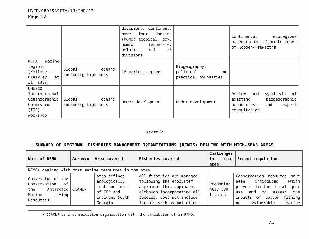
UNEP/CBD/SBSTTA/13/INF/12Page 32
NGDC National Geophysical Data Center
National Geophysical Data Center E/GC 325 Broadway Boulder, Colorado USA 80305-3328 Fax: 303-497-6513 Tel.:303-497-6826 Email: [email protected]
NGDC manages all types of data from the ocean floor. Bathymetry, topography, and global relief imagery.Contains: Geophysical dataBathymetry, gravity, magnetics, and sub-bottom profiles (single-channel and multi-channel) collected on thousands of oceanographic surveys covering millions of km from the world's oceans, all searchable online. NGDC also manages sidescan sonar image data.Descriptions and analyses of over 100 000 seafloor and lakebed cores, grabs, dredges, and drill samples worldwide. Data include an index to marine and lacustrine geological samples, data from international ocean drilling, a marine minerals bibliography and geochemical database, grain size, gridded total sediment thickness data, and other data files.Bathymetry and topography, including marine trackline and multibeam data, gridded global relief and coastal relief models for the US, hydrographic surveys of US waters, bathymetry of the Great Lakes, estimated depths from satellite altimetry, and digital coastlines.NGDC operates the World Data Center for Marine Geology & Geophysics, Boulder, the International Hydrographic Organization Data Center for Digital Bathymetry, and participates in numerous cooperative programs, including multiple international mapping projects.
http://www.ngdc.noaa.gov/mgg/mggd.htmlhttp://www.ngdc.noaa.gov/mgg/geology/geologydata.html
/…

UNEP/CBD/SBSTTA/13/INF/12Page 33
Vents Programme
Seattle Offices:NOAA Western Regional Center Pacific Marine Environmental LaboratoryBldg. 3 7600 Sand Point Way NE Seattle WA 98115-6349 206-526-6239Fax: 206-526-6815 Newport Offices:Ocean Environment Research DivisionMark O. Hatfield Marine Science Center2115 Marine Science Drive Newport, OR 97365 Tel.: 541-867-0274Fax: 541-867-3907 Division LeaderSteve [email protected]
Contains data and information about acoustic monitoring, chemical oceanography, geology/geohysics, hydrothermal plume studies, modelling and physical oceanography. Has various interactive sub webpages with maps and data.
http://www.pmel.noaa.gov/vents/
National Data Buoy Center [email protected] Hourly observations from a network of about 60 buoys and 60 C-MAN stations that
measure wind speed, direction, and gust; barometric pressure; and air temperature http://www.ndbc.noaa.gov/
NOAA Center for Operational Oceanographic Products and Services (CO-OPS)
Steve Kempler, GDAAC [email protected]
Historical and real-time observations and predictions of water levels, coastal currents and other meteorological and oceanographic data http://co-ops.nos.noaa.gov/
National Center for Atmospheric Research Selected Data for Oceanic Research
[email protected], COADS Data Set, sea-surface temperature, surface wind and wind stress, air-sea heat budgets, ocean depth and land elevation, buoy data, sea ice and remote sensing data
http://dss.ucar.edu/catalogs/oceanlists/ocean_by_category.html
/…

UNEP/CBD/SBSTTA/13/INF/12Page 34
Fleet Numerical Meteorology and Oceanography Center
Automated numerical meteorological and oceanographic (METOC) analyses and predictions http://152.80.49.210/
GOOS
GOOS Intergovernmental Oceanographic Commission1, rue Miollis 75732 Paris Cedex 15France
GOOS is a permanent global system for observations, modelling and analysis of marine and ocean variables to support operational ocean services worldwide. GOOS will provide accurate descriptions of the present state of the oceans, including living resources; continuous forecasts of the future conditions of the sea for as far ahead as possible; and the basis for climate-change forecasts..
http://ioc.unesco.org/goos/
Array for Real-time Geostrophic Oceanography (Argo)
[email protected] Argo is a global array of 3000 free-drifting profiling floats that will measure the temperature and salinity of the upper 2000 m of the ocean. This will allow continuous monitoring of the climate state of the ocean, with all data being relayed and made publicly available within hours after collection.
http://www-argo.ucsd.edu/http://argo.jcommops.org/
Australian Oceanographic Data Centre
Directorate of Oceanography & Meteorology Maritime Headquarters Wylde Street, Potts Point, NSW 2011Tel. : +61 2 9359 3119 Fax: +61 2 9359 3120 Email: [email protected] Data Management: [email protected]
The national data centre for the acquisition, archival and management of physical oceanographic data in Australia http://www.aodc.gov.au/
British Oceanographic Data Centre
British Oceanographic Data CentreBidston ObservatoryBidston HillPrentonMerseyside CH 43 7RATel: 0151 653 1510Fax: 0151 652 [email protected]
Contains ocean metadata, cruise information and datasets, online data systems and inventory searches.
http://www.bodc.ac.uk/
Canada Marine Environmental Data Service
Marine Environmental Data ServiceDepartment of Fisheries and Oceans Canada12W082 - 200 Kent StreetOttawa, Ontario CanadaK1A 0E6
Physical, chemical and biological oceanographic observations reported in daily and historical time frames; national contacts for biological databases within DFO; hyperlinks to regional web sites for satellite data and products within DFO and regional web sites for time series data and products; the National Contaminants Information System; and environmental observations (i.e., winds, ice, etc.) from historical offshore oil and gas sites.
http://www.meds-sdmm.dfo-mpo.gc.ca/meds/Home_e.htm
/…

UNEP/CBD/SBSTTA/13/INF/12Page 35
Tel.: (613) 990-6065 (general inquiries)Tel.: (613) 990-0243 (request services)Fax: (613) [email protected]
TMSI/IDM/SISMER
Centre IFREMER de BREST BP 70 29280 PLOUZANE (FRANCE)Tel. : +33 (0)2 98 22 49 16 Fax: +33 (0)2 98 22 46 44 Email :[email protected]
Related oceanographic information: Catalogues, information and data request forms, and hyperlinks to other data sources
http://www.ifremer.fr/sismer/sommaire_e.html
Marine Information Service (MARIS), Netherlands
Marine Information Service (MARIS)Dillenburgsingel 692263 HW Leidschendam The Netherlands Tel.: +31 (0)70-3170960Fax: +31 (0)70-3903546Email: [email protected]
North sea research projects (oceanography, biology, hydrography, geology, chemistry, meteorology) Offshore oil and gas activities, sand and gravel extraction, and a European directory of marine Environmental Data
http://www.maris.nl/frames.asp?databases.htm
Deutsches Ozeanographisches Institut (Bundesamt für Seeschiffahrt und Hydrographie)
Datenzentrum, Hamburg Monika Woisin-Michelsen Monika [email protected]: +49 40 3190-1015
Marine Environmental Database, North Sea and Baltic Sea by 1° rectangles Atlantic Ocean by 10° rectangles, stations of the Baltic Monitoring Programme, cruise inventories and North Sea oil spill information
http://www.bsh.de/en/Marine%20data/Geodata/index.jsp
Japan Oceanographic Data Center
Hydrographic and OceanographicDepartmentJapan Coast Guard5-3-1 Tsukiji, Chuo-ku, Tokyo, 104-0045 Japan Tel: +81-3-3541-4295 Fax: +81-3-3545-2885 Email: [email protected]
Temperature, salinity, ocean current, tidal and moored current datahttp://www.jodc.go.jp/aboutJODC_work_data.html
NASA Physical Oceanography Distributed Active
JPL PO.DAAC User Services Office: Email:
Primarily remote sensing data on atmospheric moisture, heat flux, collections, ocean wind, sea surface height, sea surface temperature, and tide models
http://podaac.jpl.nasa.gov/
/…

UNEP/CBD/SBSTTA/13/INF/12Page 36
Archive Center [email protected]. : (626) 744-5508Fax: (626) 744-5506
SADCO – South African Data Centre for Oceanography
Hydrographic station and surface data from the southern African coastline, as well as the wider Atlantic, Indian and Southern oceans
United States National Oceanographic Data Center
National Oceanographic Data CenterNOAA/NESDIS E/OCSSMC3, 4th Floor1315 East-West HighwaySilver Spring, MD 20910-3282 Tel.: 301-713-3277Fax: 301-713-3302Email: [email protected]
Physical, chemical, and biological oceanographic data collected by U.S. Federal agencies, including the Department of Defense (primarily the U.S. Navy); State, and local government agencies; universities and research institutions; and private industry.Contains many interesting databases such as world ocean database and atlas 2001. See web link for individual datasets. Also contains:
Vol.5 Russian Marine Expeditionary Investigations Of The World Ocean Pdf (8.4 Kb)
Vol. 3 Hydrochemical Atlas Of The Sea Of Okhotsk Online Data Vol. 2 Biological Atlas Of The Arctic Seas 2000: Plankton Of The Barents And Kara Seas Online Data Vol. 1 Climatic Atlas Of The Barents Sea 199
http://www.nodc.noaa.gov/Plankton database:http://www.nodc.noaa.gov/OC5/RESEARCH/PLANKTON/plankton.html
The University of Hawaii Sea Level Center (UHSLC)
UH Sea Level CenterUniversity of Hawaii1000 Pope Road, MSB 317Honolulu, Hawaii 96822-2336Tel.: (808) 956-8083Fax: (808) 956-2352
In-situ tide gauge data from around the world in support of climate research http://uhslc.soest.hawaii.edu/uhslc/data.html
ESONET
OceanlabNewburghAberdeenshireScotlandAB41 6AAUnited KingdomTel.: + 44 1224 274408Fax + 44 1224 274402Email. [email protected]
The objective is to produce a practical plan for long-term monitoring of the ocean margin environment around Europe as part of GMES (Global Monitoring for Environment and Security) with capability in geophysics, geotechnics, chemistry, biochemistry oceanography, biology and fisheries. ESONET will be complementary to oceanographic networks such as GOOS, (Global Ocean Observing System) EuroGOOS and DEOS (Dynamics of Earth and Ocean Systems), and will work with industries that are deploying sea-floor cable networks. ESONET will be multidisciplinary, with stations monitoring the rocks, sediments, bottom water, biology and events in the water column. Both long-term data collection and alarm capability in the event of hazards (e.g., earthquakes) will be considered.
http://www.abdn.ac.uk/ecosystem/esonet/index2.htm
EUROCORE Marine Information Service (MARIS)Dillenburgsingel 692263 HW Leidschendam The Netherlands Tel.: +31 (0)70-3170960Fax: +31 (0)70-3903546
Concerted action within the framework of the EC-DGXII Marine Science & Technology Program (MAST). EUROCORE addresses a fundamental problem relating to marine sample data management within Europe and will enable and streamline exploitation of an important, existing raw data resource – the very large number of sediment cores collected by and stored at European research centres, universities and core repositories. After they have served the primary data requirement for which they were collected, seafloor samples are normally stored in controlled environments for
http://www.maris.nl/eurocore.htmwww.eu-seased.net
/…

UNEP/CBD/SBSTTA/13/INF/12Page 37
E-mail: [email protected] further use.
ChEss, Biogeography of Deep-Water Chemosynthetic Ecosystems
Prof Paul A. TylerCoordinatorSouthampton Oceanography CenterEuropean Way, Empress DockSO14 3ZH, SouthamptonUnited KingdomTel.: +44 2380 592557Fax. +44 2380 [email protected]
One of the aims of ChEss is to create a web-based database (ChEssBase) for all species from deep-water hydrothermal vents and cold seeps. The information will be obtained by both literature research and participation of laboratories/institutions/researchers willing to include their vent and seep data. ChEssBase will be a dynamic relational database. ChEssBase will be geo- and bio-referenced and will be available in the ChEss web site and through OBIS.At the biological level, the database will provide taxonomical, biological, ecological and distributional information, including photographies, video, references, links to specific data (quantitative samples, cruises) and scientific contacts in a user-friendly interface.At the geographical level, the database will include information on the location of vent and seep sites, general characteristics of the sites, faunal community description and references.
http://www.soc.soton.ac.uk/chess/database.html
SeamountsOnline
San Diego Supercomputer Center, University of California, San Diego MC 05059500 Gilman DriveLa Jolla, CA 92093-0505Tel.: 858 534-5009Fax: 858 822-3631 Email: [email protected]
The SeamountsOnline database is designed to hold records of species of all metazoan types that have been found on seamounts globally. The data held within this system are primarily from published literature, with a few electronic data sets that have been provided by researchers. This is a work in progress, with new data being added periodically – please see the “Database Content” page of the website for more information and a description of the current holdings.
http://seamounts.sdsc.edu/
Marine zones
National Weather ServiceOffice of Science and TechnologyWebmaster: Ira [email protected]
Database containing shapefiles of offshore and high-seas marine zones
http://www.nws.noaa.gov/geodata/catalog/wsom/html/marinezones.htm
High Seas Salmon
Box 355020, Seattle, WA 98195-5020Street address 1122 NE Boat St, Seattle, WA 98105Tel.: 206-543-4270Fax: 206-685-7471 Email: [email protected]
The High Seas Salmon Research Program has accumulated a number of data sets. Data come from US salmon tagging and research cruises in the North Pacific Ocean and Bering Sea, cooperative tagging and research cruises with Canadian, Japanese, and Russian fishery agencies, measurements of salmon scales for stock identification and growth studies, examination of salmon stomach contents carried out aboard Japanese research vessels, and salmon research cruises of the former Bureau of Commercial Fisheries, predecessor to the US National Marine Fisheries Service. The program also maintains the high-seas tag release and recovery databases for the NPAFC (these data are jointly controlled by the national sections of NPAFC). There are plans to provide some of the program’s data sets through at the webpages of the High Seas Salmon Research Program in the future.
http://www.fish.washington.edu/research/highseas/research.html#data
Ocean Optics Principal Investigator Jeffrey H. Smart
The Worldwide Ocean Optics Database is a collection of several hundred ocean optics data sets gathered over time that encompass much of the world's oceans. Because WOOD
http://wood.jhuapl.edu/
/…

UNEP/CBD/SBSTTA/13/INF/12Page 38
Johns Hopkins University - Applied Physics Laboratory STF, 8-308 11100 Johns Hopkins Road Laurel, MD 20723-6099 Tel.: (240)228-4331 Fax: (240)228-6908 [email protected] Database Manager Linda Peco Johns Hopkins University - Applied Physics Laboratory STF, 8-320 11100 Johns Hopkins Road Laurel, MD 20723-6099 Tel.: (240)228-6178 [email protected]
comprises so many different data sets, multiple parameters are available, gathered by many different instruments, with varying levels of quality and editing. Because numerical representation of all data in the database is quickest and easiest, all of this "metadata" is stored as numerical codes by the database.
MAR-ECO
Peter [email protected] other members of the international steering committee:http://mareco.imr.no/about/organization/steering.htm
The overriding aim of MAR-ECO,one of the ongoing CoML field projects, is to describe and understand the patterns of distribution, abundance and trophic relationships of the organisms inhabiting the mid-oceanic North Atlantic, and identify and model ecological processes that cause variability in these patterns. The project focuses on pelagic, benthopelagic and epibenthic macrofauna, and analyse distribution and abundance patterns in relation to the abiotic and biotic environment, as well as trophic relationships and life-history strategies. Fish, crustaceans, cephalopods and gelatinous plankton and nekton have the highest priority in the study.
http://www.efan.no/midatlcensus/
MarLIN
Marine Life Information Network for Britain and Ireland - MarLIN,The Marine Biological Association of the UK,The LaboratoryCitadel Hill,Plymouth,PL1 2PBUnited KingdomTel.: +44 (0)1752 633336Fax: +44 (0)1752 633102Email: [email protected]
MarLIN will: provide a structure for linking available data on marine life around Britain and
Ireland. improve the access, display and interpretation of information in support of
environmental management, protection and education. be the most comprehensive and easily used source of information about marine
habitats, communities and species around Britain and Ireland and their sensitivity to natural events and human activities.
http://www.marlin.ac.uk/
CPR SAHFOSThe Laboratory, Citadel Hill,
The Sir Alister Hardy Foundation for Ocean Science (SAHFOS) is an international charity registered in the UK that operates the Continuous Plankton Recorder (CPR)
http://www.sahfos.org/
/…

UNEP/CBD/SBSTTA/13/INF/12Page 39
PlymouthPL1 2PB. Tel:+44 (0) 1752 600016Tel:+44 (0) 1752 633271 Fax:+44 (0) 1752 600015 Email: [email protected]
survey. The Foundation has been collecting data from the North Atlantic and the North Sea on the biogeography and ecology of plankton since 1931. The CPR database currently contains information for 185,902 samples with 2,198,052 plankton entries (every second sample analyzed yet all preserved).
Azores databaseRicardo Serrão Santos [email protected]
Most relevant databases are geo-referenced distribution of coastal habitats and species of Nature 2000 sites; mesopelagic fishes of the North-eastern Atlantic Region, based on data from museum collections mining and recent cruises (334 stations); marine mammals, based on annual acoustic and visual census and fisheries observers programs; tuna, based on fisheries observers programs; sea-birds and breeding colonies, based on annual census and fisheries observers programs; sea-turtles based on annual census, fisheries observers programs and standard tagging and satellite tracking; coastal fishes, based on visual census; demersal and seamount fishes, based on fisheries cruises; and sets of images for ocean colour and temperature analysis within physics oceanography. Main habitats and ecosystems covered are: open-ocean; seamounts and banks; coastal areas (intertidal and subtidal); hydrothermal vents (both shallow and deep-sea).
http://www.horta.uac.pt/
BATS zooplankton
Zooplankton Ecologyc/o Deborah SteinbergVirginia Institute of Marine ScienceP.O. Box 1346, Gloucester Pt., VA 23062-1346, USATel: 804-684-7838Fax: 804-684-7293
BATS zooplanktonis a multi-species inventory of zooplankton and micronekton at the Bermuda Atlantic Time-Series Study (BATS) station, a 13-year, ongoing oceanographic time series situated in the western North Atlantic subtropical gyre, or Sargasso Sea.
http://www.vims.edu/bio/zooplankton/BATS/
CephBase CephBase is a dynamic relational database-driven web site. The purpose of CephBase is to provide taxonomic data, life history, distribution, images, videos, references and scientific contact information on all living species of cephalopods (octopus, squid, cuttlefish and nautilus) in an easy to access, user-friendly manner.
http://www.cephbase.utmb.edu/
Global Ballast
International Maritime Organization
Steve Raaymakers
Global ballast assessment unit of the IMO is currently looking at the impacts of invasive alien species on the marine environment http://globallast.imo.org
Census on Marine Life
Ron O'Dor Senior Scientist Consortium for Oceanographic Research and Education (CORE) Secretariat, CoML 1755 Massachusetts Avenue,
The Census of Marine Life (CoML) is a ten-year international research program with the goal of assessing and explaining the diversity, distribution and abundance of marine organisms throughout the world’s oceans. The emphasis of the program is field studies, which are to be conducted in poorly known habitats as well as those assumed to be well known. In both coastal and deep waters, projects will identify new organisms and collect new information on ocean life.
http://www.coreocean.org/
/…
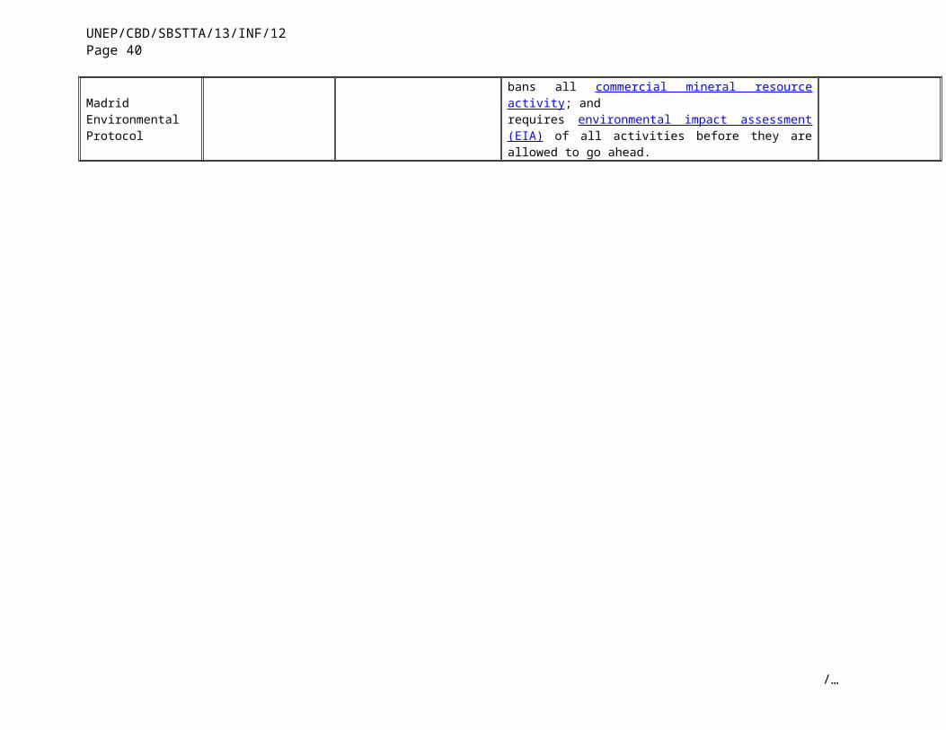
UNEP/CBD/SBSTTA/13/INF/12Page 40
NW, #800 Washington, DC 20036 Tel.: 202-332-0063Fax: 202-332-9751 Email: [email protected]
OBIS SEAMAP
Dr. Andy ReadDUML BRL 104Duke University Marine Laboratory135 Duke Marine Lab RoadBeaufort NC 28516Tel.: 202 504 7590Fax: 252 504 [email protected]
As part of the Ocean Biogeographic Information System (OBIS), a group of investigators, led by Andrew Read of Duke University, will create a digital database of marine mammal, seabird, and sea turtle distribution and abundance. Partners with Duke include UC San Diego, University of Washington, College of the Atlantic, St. Andrews University, British Antarctic Survey, SAHFOS, NMFS Southeast Fisheries Center, and several industries. The web-based system will allow the interactive display, query, and analysis of Digital Archive in conjunction with environmental data. Goals include:
facilitating study of potential impacts on threatened species enhancing the ability to test hypothesis about biogeographic and biodiversity
models supporting modelling efforts to predict distribution changes in response to
environmental change. developing a strong public outreach component
http://obismap.env.duke.edu/data/
Sea Around UsFisheries Centre, University British Columbia, Vancouver (British Columbia, Canada).
A global database on marine fisheries and ecosystems. www.seaaroundus.org
International Cooperation in Ridge Studies
Developed a database regarding known and suspected ocean basin vents as well as taxonomic, ecological, biological, and distribution information about species associated with deep-water chemosynthetic ecosystems
www.interridge.org
FishBase R. Froese, and D. Paulywww.fishbase.org
Global information database of nearly all fishes. FishBase was developed at the WorldFish Center in collaboration with the Food and Agriculture Organization of the United Nations (FAO) and many other partners, and with support from the European Commission (EC). Since 2001 FishBase has been supported by a consortium of seven research institutions.
www.fishbase.org/home
Sealifebase 2006 UBC Fisheries Centre and WorldFish Center.
Information system for all aquatic living organisms (marine and freshwater) for each species included, providing the biological information necessary to conduct biodiversity and ecosystem studies, taking advantage of lists of species already available on paper and electronically
www.sealifebase.org
-----
/…