DNR PARCELS CURRENTLY PROPOSED FOR SEALED · PDF fileDNR PARCELS CURRENTLY PROPOSED FOR SEALED...
48
DNR PARCELS CURRENTLY PROPOSED FOR SEALED BID AUCTION December 12, 2017 TO January 10, 2018 Parcels may be added or removed from this list at any time Contact: Mike Michalek at (517) 284-5950 or by email [email protected] 1 There are 81 surplus parcels available for sealed bid auction from the Department of Natural Resources; in Alpena, Arenac, Barry, Bay, Cheboygan, Dickinson, Gladwin, Iron, Kalkaska, Lake, Menominee, Midland, Montmorency, Muskegon, Newaygo, Oakland, Oscoda and Roscommon Counties. RESERVATIONS AA - A property right in aboriginal antiquities including mounds, earthworks, forts, burial and village sites, mines, or other relics and also reserving the right to explore and excavate for the same as provided under Article III, part 761 of PA 451 of 1994 as amended. MIN - All mineral, coal, oil and gas lying on, within or under the sale properties except sand, gravel, clay or other non-metallic minerals along with associated rights as provided under Article 1, Part 5 of PA 451 of 1994 as amended. PRICE The price column represents the minimum asking price for the property. In order to submit a successful bid your offer must be at or above this amount. SURROUNDED BY PRIVATE LANDOWNERS A parcel that has the “surrounded by private landowners” tag and can only be accessed via the ground if you obtain a private road easement from an adjacent landowner. The DNR does not assist with third-party easement agreements. Since there is no legal access, you cannot walk the property before the auction without permission from a surrounding landowner to pass. Surrounding landowners are not required to provide access to these parcels. DISCLAIMER These properties are subject to applicable state, county or local zoning or building ordinances. - The State of Michigan does not guarantee the usability or access to any of these lands. - It is the responsibility of prospective purchasers to do their own research as to the use of the land for their intended purpose and to make a personal inspection of the property to determine if it will be suitable for the purposes for which it is being purchased. Purchasers are advised to consult the local zoning administrator if necessary. - The State of Michigan makes no representations or claims as to fitness for purpose, ingress/egress, conditions, covenants, or restrictions. - The properties are sold by their LEGAL DESCRIPTION ONLY. (Subdivision name and Lot number, or measured Metes and Bounds, or standard fractions of a Section, or Government Land Office Survey description). - While effort is made to ensure that the addresses, maps, and/or photos on the website are accurate, you are relying on your own investigation and information when purchasing this property. PLEASE DO YOUR RESEARCH THOROUGHLY AND CAREFULLY. - All parcels are sold as is where is and there are NO REFUNDS.
-
Upload
nguyenquynh -
Category
Documents
-
view
224 -
download
0
Transcript of DNR PARCELS CURRENTLY PROPOSED FOR SEALED · PDF fileDNR PARCELS CURRENTLY PROPOSED FOR SEALED...

DNR PARCELS CURRENTLY PROPOSED FOR SEALED BID AUCTION December 12, 2017 TO January 10, 2018 Parcels may be added or removed from this list at any time
Contact: Mike Michalek at (517) 284-5950 or by email [email protected]
1
There are 81 surplus parcels available for sealed bid auction from the Department of Natural
Resources; in Alpena, Arenac, Barry, Bay, Cheboygan, Dickinson, Gladwin, Iron, Kalkaska, Lake,
Menominee, Midland, Montmorency, Muskegon, Newaygo, Oakland, Oscoda and Roscommon
Counties.
RESERVATIONS
AA - A property right in aboriginal antiquities including mounds, earthworks, forts, burial and village sites, mines,
or other relics and also reserving the right to explore and excavate for the same as provided under Article III, part
761 of PA 451 of 1994 as amended.
MIN - All mineral, coal, oil and gas lying on, within or under the sale properties except sand, gravel, clay or other
non-metallic minerals along with associated rights as provided under Article 1, Part 5 of PA 451 of 1994 as
amended.
PRICE The price column represents the minimum asking price for the property. In order to submit a successful bid your
offer must be at or above this amount.
SURROUNDED BY PRIVATE LANDOWNERS A parcel that has the “surrounded by private landowners” tag and can only be accessed via the ground if you
obtain a private road easement from an adjacent landowner. The DNR does not assist with third-party easement
agreements. Since there is no legal access, you cannot walk the property before the auction without permission
from a surrounding landowner to pass. Surrounding landowners are not required to provide access to these
parcels.
DISCLAIMER These properties are subject to applicable state, county or local zoning or building ordinances. - The State of
Michigan does not guarantee the usability or access to any of these lands. - It is the responsibility of prospective
purchasers to do their own research as to the use of the land for their intended purpose and to make a personal
inspection of the property to determine if it will be suitable for the purposes for which it is being purchased.
Purchasers are advised to consult the local zoning administrator if necessary. - The State of Michigan makes no
representations or claims as to fitness for purpose, ingress/egress, conditions, covenants, or restrictions. - The
properties are sold by their LEGAL DESCRIPTION ONLY. (Subdivision name and Lot number, or measured Metes and
Bounds, or standard fractions of a Section, or Government Land Office Survey description). - While effort is made
to ensure that the addresses, maps, and/or photos on the website are accurate, you are relying on your own
investigation and information when purchasing this property. PLEASE DO YOUR RESEARCH THOROUGHLY AND
CAREFULLY. - All parcels are sold as is where is and there are NO REFUNDS.

DNR PARCELS CURRENTLY PROPOSED FOR SEALED BID AUCTION December 12, 2017 TO January 10, 2018
Parcels may be added or removed from this list at any time Contact: Mike Michalek at (517) 284-5950 or by email [email protected]
2
DNR Parcel # County Tax ID # Co./Twp. Property Description Acres Reserv. Price Comments
57626, 57627 011-DNR-010-276-00 Alpena, Alpena (T30N, R08E) S10 - E 79 ft of the E 210 ft of Govt Lot 3 N of Partridge Point Road, exc the S'ly 17 ft N of road; ALSO W 131 ft of E 210 ft of Govt Lot 3, N of Co. Rd., exc S 17 ft
2.4 AA $3,220.00 Road frontage at N Partridge Point Rd; Partially Forested
59151 032-027-000-030-00 Alpena, Long Rapids
(T32N, R06E) S27 - SE 1/4 of NE 1/4 40 AA $18,750.00 Surrounded by private landowners; Forested; closest roads are Graham Rd and Reynolds Rd
58551 084-029-000-770-00 Alpena, Wilson (T31N, R07E) S29 - NW 1/4 of SE 1/4 40 AA $18,750.00 Surrounded by private landowners: Forested; near Witt Road

DNR PARCELS CURRENTLY PROPOSED FOR SEALED BID AUCTION December 12, 2017 TO January 10, 2018
Parcels may be added or removed from this list at any time Contact: Mike Michalek at (517) 284-5950 or by email [email protected]
3
DNR Parcel # County Tax ID # Co./Twp. Property Description Acres Reserv. Price Comments
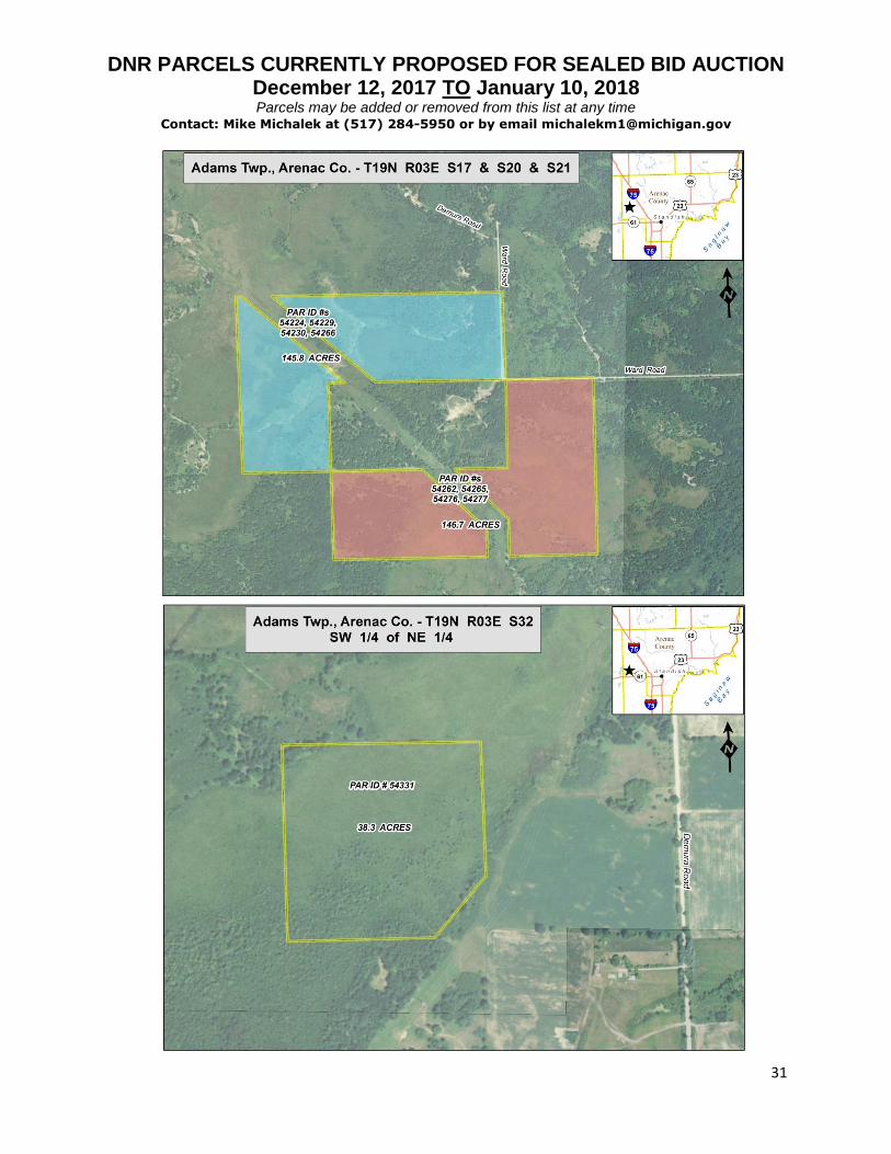
54224, 54229, 54230, 54266
001-0-017-300-005-00; 001-0-017-400-005-01; 001-0-020-100-020-00
Arenac, Adams (T19N, R03E) S17 - S 1/2 of SE 1/4 except beg at S1/4 corner of said sec. N 89d25'10" E along S line of sec. 471.20 ft, N 47d16'20" W 628 ft to N/S 1/4 line, S along said N/S 1/4line to pob, AND SE 1/4 of SW 1/4 except beginning at S 1/4 corner of said sec. th S 89d25'10" W along S sec. line 9.90 ft, N 47d16'20" W 1829.80 ft to W 1/8 line, N 01d29'17.5" W along W 1/8 line 66 ft to S 1/8 line, E along said 1/8 line 412.50 ft, S 47d16'20" E 1343.98 ft to N/S 1/4 line, S along N/S 1/4 line 429 ft to pob, AND S20 NE 1/4 of NW 1/4. Along with an easement ingress and egress over the South 25 feet of the East 340 feet of the NE 1/4 of the SE 1/4 of Section 17, (T19N,R03E). Also, subject to an easement for ingress and egress over the North 25 feet of the East 340 feet of the SE 1/4 of the SE 1/4 of Section 17, (T19N, R03E), benefiting the (T19N, R03E) S17, N 1/2 of SE 1/4 except the North 600 feet, AND NE 1/4 SW 1/4 except commencing at S 1/4 corner of said sec. th S 89d25'10" W along S sec. line 9.90 ft, N 47d16'20" W 1829.80 ft to W 1/8 line, N 01d29'17.5" W along W 1/8 line 66 ft to pob, N 01d29'17.5" W 394.44 ft, S 47d16'20" E 529 ft to S 1/8 line, W along said S 1/8 line to pob.
145.8 AA, MIN
$114,750.00 Road frontage at Ward Road; Partly forested; note the shared easement on the northern property line
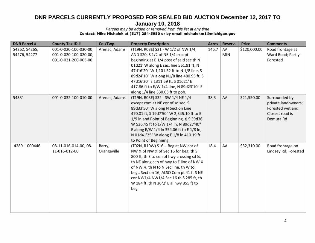
DNR PARCELS CURRENTLY PROPOSED FOR SEALED BID AUCTION December 12, 2017 TO January 10, 2018
Parcels may be added or removed from this list at any time Contact: Mike Michalek at (517) 284-5950 or by email [email protected]
4
DNR Parcel # County Tax ID # Co./Twp. Property Description Acres Reserv. Price Comments
54262, 54265, 54276, 54277
001-0-020-100-030-00; 001-0-020-100-020-00; 001-0-021-200-005-00
Arenac, Adams (T19N, R03E) S21 - W 1/2 of NW 1/4, AND S20, S 1/2 of NE 1/4 except beginning at E 1/4 post of said sec th N 01d21' W along E sec. line 561.91 ft, N 47d16'20" W 1,101.52 ft to N 1/8 line, S 89d24'10" W along N1/8 line 480.95 ft, S 47d16'20" E 1311.59 ft, S 01d21' E 417.86 ft to E/W 1/4 line, N 89d23'10" E along 1/4 line 330.03 ft to pob.
146.7 AA, MIN
$120,000.00 Road frontage at Ward Road; Partly Forested
54331 001-0-032-100-010-00 Arenac, Adams (T19N, R03E) S32 - SW 1/4 NE 1/4 except com at NE cor of sd sec. S 89d33'50" W along N Section Line 470.01 ft, S 19d7'50" W 2,345.10 ft to E 1/9 ln and Point of Beginning, tj S 39d36' W 536.45 ft to E/W 1/4 ln, N 89d27'40" E along E/W 1/4 ln 354.06 ft to E 1/8 ln, N 01d41'25" W along E 1/8 ln 410.19 ft to Point of Beginning
38.3 AA $21,550.00 Surrounded by private landowners; Forested wetland; Closest road is Demura Rd
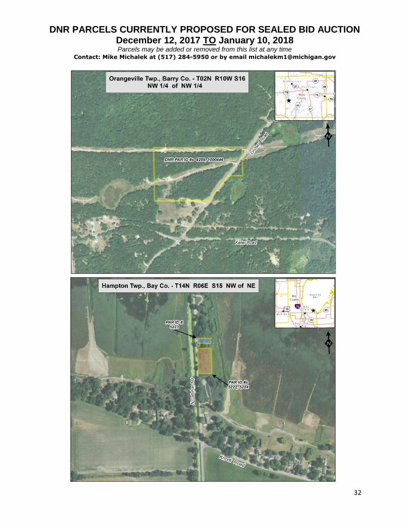
4289, 1000446 08-11-016-014-00; 08-11-016-012-00
Barry, Orangeville
(T02N, R10W) S16 - Beg at NW cor of NW ¼ of NW ¼ of Sec 16 for beg, th S 800 ft, th E to cen of hwy crossing sd ¼, th NE along cen of hwy to E line of NW ¼ of NW ¼, th N to N Sec line, th W to beg., Section 16; ALSO Com pt 41 ft S NE cor NW1/4 NW1/4 Sec 16 th S 285 ft, th W 184 ft, th N 36°2' E al hwy 355 ft to beg
18.4 AA $32,310.00 Road frontage on Lindsey Rd; Forested

DNR PARCELS CURRENTLY PROPOSED FOR SEALED BID AUCTION December 12, 2017 TO January 10, 2018
Parcels may be added or removed from this list at any time Contact: Mike Michalek at (517) 284-5950 or by email [email protected]
5
DNR Parcel # County Tax ID # Co./Twp. Property Description Acres Reserv. Price Comments
5222, 5224 070-045-200-205-00; 070-045-200-200-00
Bay, Hampton (T14N, R06E) S15 - Com on N & S1/4 li 2298.15 ft N of cen of sec th N 150 ft th E 133 ft th S 150 ft th W 133 ft to beg; ALSO N 100 ft of S 2548.15 ft of W 133 ft of land bded S by E & W1/4 li & W by N & S1/4 li if extd Nly relicted land Nly of Lot 2
0.7 AA, MIN
$1,000.00 Road frontage at N Callahan Rd; Forested
5223 070-045-200-215-00 Bay, Hampton (T14N, R06E) S15 - N 50 ft of S 2648.15 ft of W 133 ft of par bbd S by E & W 1/4 li & W by N & S 1/4 li if extd relicted land Nly of Lot 2
0.1 AA, MIN
$1,000.00 Road frontage at N Callahan Rd; Forested
239166 030-002-100-001-00 Cheboygan, Hebron
(T38N, R03W) S02 - N1/2 of N1/2 of NE1/4 of SE1/4
10 AA $11,950.00 Road frontage on N Old Mackinaw Road; Forested; Property may consist of wetlands
370435 052-316-001-00 Dickinson, Breitung
Second Addition to Kingsford Heights, Block 16, Lots 1-4
0.6 AA $1,000.00 Road access & intersected by Maplewood Ct; Partially forested
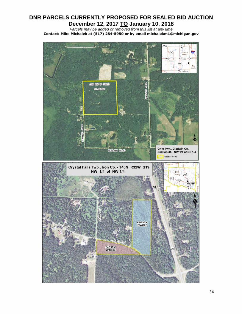
119103 090-035-400-005-00 Gladwin, Grim (T18N, R02E) S35 - NW 1/4 of SE 1/4 40 AA $58,900.00 Road frontage at Schaard Rd; Forested
2046622 36-002-069-013-10 Iron, Crystal Falls
(T43N, R32W) S19 - East 450 ft of NW1/4 of the NW1/4 lying north of the centerline of Lind Road, subject to an easement therefor.
12.6 AA $11,340.00 Road frontage at Lind Rd; Forested; 0% mineral ownership
2046623 36-002-069-013-10 Iron, Crystal Falls
(T43N, R32W) S19 - All that part of the NW1/4 of the NW1/4 lying south of the centerline of Lind Road, subject to an easement therefor.
5.5 AA $4,950.00 Road frontage at Lind Rd; Forested; 0% mineral ownership

DNR PARCELS CURRENTLY PROPOSED FOR SEALED BID AUCTION December 12, 2017 TO January 10, 2018
Parcels may be added or removed from this list at any time Contact: Mike Michalek at (517) 284-5950 or by email [email protected]
6
DNR Parcel # County Tax ID # Co./Twp. Property Description Acres Reserv. Price Comments
49782 001-010-004-00 Kalkaska, Bear Lake
(T26N, R05W) S10 - Part of SE1/4 SW1/4 commencing at the 1/4 post between Secs 10 and 15; th W 266.8 ft; th N 36d31' E 329 ft to thread of Manistee River; th upstream along thread of said river to N and S 1/4 line of said Sec 10; th S along said 1/4 line to beginning
1 AA, MIN
$1,600.00 Surrounded by private landowners; Forested; Water frontage on Manistee River; Closest road is Yellow Trees Rd
53038, 1106984 005-001-002-00 Kalkaska, Cold Springs
(T28N, R06W) S01 - E1/2 of E1/2 of NE1/4 of SW1/4; Also W'ly 66 ft of NW1/4 of SE1/4
12 AA, MIN
$11,400.00 Surrounded by private landowners (does not reach Starvation Lake Rd on N property line); Potential of road trespass on NE corner of property; Forested; SAVING AND EXCEPTING OUT OF THIS CONVEYANCE all underground gas storage rights.

DNR PARCELS CURRENTLY PROPOSED FOR SEALED BID AUCTION December 12, 2017 TO January 10, 2018
Parcels may be added or removed from this list at any time Contact: Mike Michalek at (517) 284-5950 or by email [email protected]
7
DNR Parcel # County Tax ID # Co./Twp. Property Description Acres Reserv. Price Comments
426325, 426326, 2035709, 2035710, 2035711, 2035712, 2035714, 2035715, 2035716; 1048678; 426327, 426328, 2035720, 2035721, 2035722, 2035723, 2035724; 1100716; 1117542; 426329, 426330, 426331, 2035725, 2035726, 2035727, 2035728, 2035729, 2035730, 2035731
43-10-634-001-00; 43-10-634-016-00; 43-10-635-001-00; 43-10-635-016-00; 43-10-635-043-00; 43-10-636-001-00
Lake, Cherry Valley
Thompson's Villa: Block 4, Lots 1-13 & 16-50; Block 5, Lots 1-50; Block 6, Lots 1-50
8.3 AA $14,110.00 Parcel 5 on auction map; Road frontage at S Spruce Rd & E 40th St; Forested
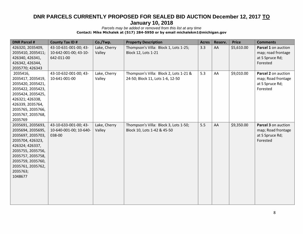
DNR PARCELS CURRENTLY PROPOSED FOR SEALED BID AUCTION December 12, 2017 TO January 10, 2018
Parcels may be added or removed from this list at any time Contact: Mike Michalek at (517) 284-5950 or by email [email protected]
8
DNR Parcel # County Tax ID # Co./Twp. Property Description Acres Reserv. Price Comments
426320, 2035409, 2035410, 2035411; 426340, 426341, 426342, 426344, 2035770; 426343
43-10-631-001-00; 43-10-642-001-00; 43-10-642-011-00
Lake, Cherry Valley
Thompson's Villa: Block 1, Lots 1-25; Block 12, Lots 1-21
3.3 AA $5,610.00 Parcel 1 on auction map; road frontage at S Spruce Rd; Forested
2035416, 2035417, 2035419, 2035420, 2035421, 2035422, 2035423, 2035424, 2035425, 426321; 426338, 426339, 2035764, 2035765, 2035766, 2035767, 2035768, 2035769
43-10-632-001-00; 43-10-641-001-00
Lake, Cherry Valley
Thompson's Villa: Block 2, Lots 1-21 & 24-50; Block 11, Lots 1-6, 12-50
5.3 AA $9,010.00 Parcel 2 on auction map; Road frontage at S Spruce Rd; Forested
2035691, 2035693, 2035694, 2035695, 2035697, 2035703, 2035704, 426323, 426324; 426337, 2035755, 2035756, 2035757, 2035758, 2035759, 2035760, 2035761, 2035762, 2035763; 1048677
43-10-633-001-00; 43-10-640-001-00; 10-640-038-00
Lake, Cherry Valley
Thompson's Villa: Block 3, Lots 1-50; Block 10, Lots 1-42 & 45-50
5.5 AA $9,350.00 Parcel 3 on auction map; Road frontage at S Spruce Rd; Forested
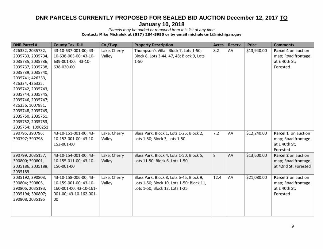
DNR PARCELS CURRENTLY PROPOSED FOR SEALED BID AUCTION December 12, 2017 TO January 10, 2018
Parcels may be added or removed from this list at any time Contact: Mike Michalek at (517) 284-5950 or by email [email protected]
9
DNR Parcel # County Tax ID # Co./Twp. Property Description Acres Reserv. Price Comments
426332, 2035732, 2035733, 2035734, 2035735, 2035736, 2035737, 2035738, 2035739, 2035740, 2035741; 426333, 426334, 426335, 2035742, 2035743, 2035744, 2035745, 2035746, 2035747; 426336, 1007881, 2035748, 2035749, 2035750, 2035751, 2035752, 2035753, 2035754; 1090251
43-10-637-001-00; 43-10-638-003-00; 43-10-639-001-00; 43-10-638-020-00
Lake, Cherry Valley
Thompson's Villa: Block 7, Lots 1-50; Block 8, Lots 3-44, 47, 48; Block 9, Lots 1-50
8.2 AA $13,940.00 Parcel 4 on auction map; Road frontage at E 40th St; Forested
390795, 390796; 390797; 390798
43-10-151-001-00; 43-10-152-001-00; 43-10-153-001-00
Lake, Cherry Valley
Blass Park: Block 1, Lots 1-25; Block 2, Lots 1-50; Block 3, Lots 1-50
7.2 AA $12,240.00 Parcel 1 on auction map; Road frontage at E 40th St; Forested
390799, 2035157; 390800; 390801, 2035186, 2035188, 2035189
43-10-154-001-00; 43-10-155-011-00; 43-10-156-001-00
Lake, Cherry Valley
Blass Park: Block 4, Lots 1-50; Block 5, Lots 11-50; Block 6, Lots 1-50
8 AA $13,600.00 Parcel 2 on auction map; Road frontage at 42nd St; Forested
2035192, 390803; 390804; 390805, 390806, 2035193, 2035194; 390807; 390808, 2035195
43-10-158-006-00; 43-10-159-001-00; 43-10-160-001-00; 43-10-161-001-00; 43-10-162-001-00
Lake, Cherry Valley
Blass Park: Block 8, Lots 6-45; Block 9, Lots 1-50; Block 10, Lots 1-50; Block 11, Lots 1-50; Block 12, Lots 1-25
12.4 AA $21,080.00 Parcel 3 on auction map; Road frontage at E 40th St; Forested

DNR PARCELS CURRENTLY PROPOSED FOR SEALED BID AUCTION December 12, 2017 TO January 10, 2018
Parcels may be added or removed from this list at any time Contact: Mike Michalek at (517) 284-5950 or by email [email protected]
10
DNR Parcel # County Tax ID # Co./Twp. Property Description Acres Reserv. Price Comments
390827 43-10-174-001-00 Lake, Cherry Valley
Blass Park: Block 24, Lots 1-25 1.5 AA $2,550.00 Parcel 11 on auction map; Road frontage at E 40th St; Forested
390823, 390825, 2035204, 2035205
43-10-173-001-00 Lake, Cherry Valley
Blass Park: Block 23, Lots 1-50 2.8 AA $4,760.00 Parcel 10 on auction map; Road frontage on Sandridge Ave.; Forested
390822, 2033861, 2033862
43-10-172-001-00 Lake, Cherry Valley
Blass Park: Block 22, Lots 1-50 2.8 AA $4,760.00 Parcel 9 on auction map; Road frontage on Sandridge Ave.; Forested
390821, 2033857, 2033858, 2033859, 2033860
43-10-171-001-00 Lake, Cherry Valley
Blass Park: Block 21, Lots 1-50 2.8 AA $4,760.00 Parcel 8 on auction map; Road frontage on Sandridge Ave.; Forested
390819, 2035202, 2035203; 390820
43-10-170-001-00; 43-10-170-026-00
Lake, Cherry Valley
Blass Park: Block 20, Lots 1-50 2.8 AA $4,760.00 Parcel 7 on auction map; Road frontage on Sandridge Ave.; Forested
390817, 2035201 43-10-169-001-00 Lake, Cherry Valley
Blass Park: Block 19, Lots 1-18, 33-50 2 AA $3,400.00 Parcel 6 on auction map; Road frontage on 42nd St; Forested

DNR PARCELS CURRENTLY PROPOSED FOR SEALED BID AUCTION December 12, 2017 TO January 10, 2018
Parcels may be added or removed from this list at any time Contact: Mike Michalek at (517) 284-5950 or by email [email protected]
11
DNR Parcel # County Tax ID # Co./Twp. Property Description Acres Reserv. Price Comments
390814, 2035199; 390816, 2035200
43-10-167-001-00; 43-10-168-001-00
Lake, Cherry Valley
Blass Park: Block 17, Lots 1-10, 13-38, 41-50; Block 18, Lots 1-10, 13-16, 19-50
5.2 AA $10,000.00 Parcel 5 on auction map; Road frontage at 42nd St; Forested; Potential trespass on Block 17, Lots 2-5
390810, 2035196; 390811; 390812, 2035197; 390813, 2035198
43-10-163-001-00; 43-10-164-001-00; 43-10-165-001-00; 43-10-166-001-00
Lake, Cherry Valley
Blass Park: Block 13, Lots 1-25; Block 14, Lots 1-50; Block 15, Lots 1-50; Block 16, Lots 1-50
10.1 AA $17,170.00 Parcel 4 on auction map; Road frontage at E 40th St; Forested
426082, 2033888, 2033889, 2033890; 1123662; 426083, 2033891, 2033892, 2033893, 2033894, 2033895, 2033896, 2033897, 2033898, 2033899; 426084, 2033900, 2033901, 2033902, 2033903, 2033904, 2033905; 420686; 426085, 2033906, 2033907, 2033908, 2033909, 2033910, 2033911, 2033912, 2033913; 426087, 2035354,
43-10-611-001-00; 43-10-612-015-00; 43-10-612-001-00; 43-10-613-004-00; 43-10-614-009-00; 43-10-614-001-00; 43-10-615-006-00; 43-10-616-001-00
Lake, Cherry Valley
Thompson's Heights: Block 1, Lots 1-25; Block 2, Lots 1-50; Block 3, Lots 4-50; Block 4, Lots 1-50; Block 5, Lots 1-50; Block 6, Lots 1-50
15.9
AA
$27,030.00
Parcel 2 on auction map; Road frontage at E 40th St; Forested

DNR PARCELS CURRENTLY PROPOSED FOR SEALED BID AUCTION December 12, 2017 TO January 10, 2018
Parcels may be added or removed from this list at any time Contact: Mike Michalek at (517) 284-5950 or by email [email protected]
12
2035355, 2035356, 2035357; 426088, 426089, 2035358, 2035359, 2035360, 2035361, 2035362, 2035363, 2035364
Continued…
Continued…
Continued…
… … Continued… Continued…

DNR PARCELS CURRENTLY PROPOSED FOR SEALED BID AUCTION December 12, 2017 TO January 10, 2018
Parcels may be added or removed from this list at any time Contact: Mike Michalek at (517) 284-5950 or by email [email protected]
13
DNR Parcel # County Tax ID # Co./Twp. Property Description Acres Reserv. Price Comments
426090, 426091, 2035365, 2035366, 2035367, 2035368, 2035369; 426092, 2035370, 2035371, 2035372, 2035373; 426095; 426093, 426094, 1007880, 2035376, 2035377, 2035378, 2035379, 2035380, 2035381; 426096, 2035385, 2035386, 2035387, 2035388, 2035390; 426097, 426098, 2035402, 2035403, 2035404, 2035405, 2035406, 2035407; 426099, 2035408
43-10-617-001-00; 43-10-618-001-00; 43-10-619-036-00; 43-10-619-001-00; 43-10-620-001-00; 43-10-621-001-00; 43-10-622-001-00
Lake, Cherry Valley
Thompson's Heights: Block 7, Lots 1-50; Block 8, Lots 1-50; Block 9, Lots 1-25, 30-50; Block 10, Lots 1-50; Block 11, Lots 1-50; Block 12, Lots 1-19
15.4 AA $26,180.00 Parcel 1 on auction map; Road frontage at E 40th St; Forested
261434, 261432 43-10-033-109-40; 43-10-033-109-30
Lake, Cherry Valley
(T18N, R12W) S33 - SW1/4 of SE1/4 - Beg 661.08 feet E and 215 feet N of S1/4 corner, thence N 283.50 feet, thence E 165.33 feet, thence S 283.40 feet, thence W 165.33 feet to POB; ALSO Beg 661.08 feet E & 498.50 feet N S1/4 corner, thence N 100 feet, thence E 165.33 feet, thence S 100 feet, thence W 165.33 feet to POB
1.4 AA $2,610.00 Surrounded by private landowners; Property is NW of the US 10 and S Cv Branch Road intersection
426955, 426956 06-348-014-00; 06-348-015-00
Lake, Peacock Wolf Lake Subdivision #1: Block 18, Lots 14 & 15
0.1 AA $1,000.00 Forested; Closest road is Park Place Dr
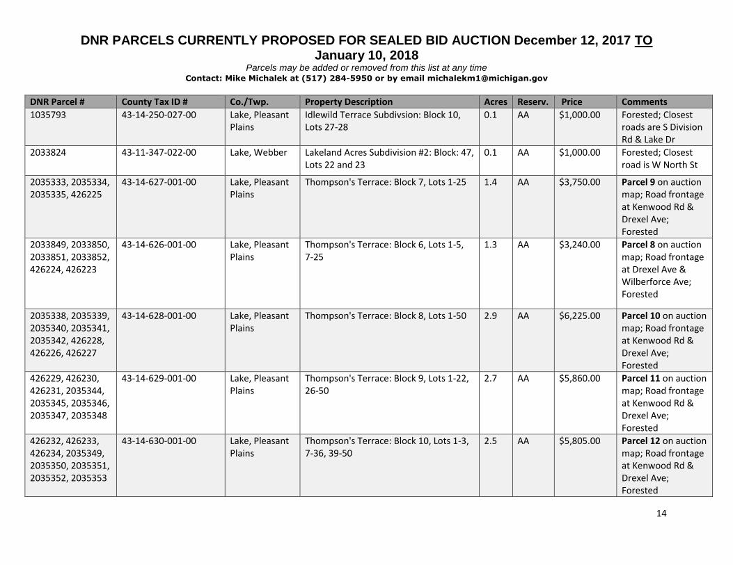
DNR PARCELS CURRENTLY PROPOSED FOR SEALED BID AUCTION December 12, 2017 TO January 10, 2018
Parcels may be added or removed from this list at any time Contact: Mike Michalek at (517) 284-5950 or by email [email protected]
14
DNR Parcel # County Tax ID # Co./Twp. Property Description Acres Reserv. Price Comments
1035793 43-14-250-027-00 Lake, Pleasant Plains
Idlewild Terrace Subdivsion: Block 10, Lots 27-28
0.1 AA $1,000.00 Forested; Closest roads are S Division Rd & Lake Dr
2033824 43-11-347-022-00 Lake, Webber Lakeland Acres Subdivision #2: Block: 47, Lots 22 and 23
0.1 AA $1,000.00 Forested; Closest road is W North St
2035333, 2035334, 2035335, 426225
43-14-627-001-00 Lake, Pleasant Plains
Thompson's Terrace: Block 7, Lots 1-25 1.4 AA $3,750.00 Parcel 9 on auction map; Road frontage at Kenwood Rd & Drexel Ave; Forested
2033849, 2033850, 2033851, 2033852, 426224, 426223
43-14-626-001-00 Lake, Pleasant Plains
Thompson's Terrace: Block 6, Lots 1-5, 7-25
1.3 AA $3,240.00 Parcel 8 on auction map; Road frontage at Drexel Ave & Wilberforce Ave; Forested
2035338, 2035339, 2035340, 2035341, 2035342, 426228, 426226, 426227
43-14-628-001-00 Lake, Pleasant Plains
Thompson's Terrace: Block 8, Lots 1-50 2.9 AA $6,225.00 Parcel 10 on auction map; Road frontage at Kenwood Rd & Drexel Ave; Forested
426229, 426230, 426231, 2035344, 2035345, 2035346, 2035347, 2035348
43-14-629-001-00 Lake, Pleasant Plains
Thompson's Terrace: Block 9, Lots 1-22, 26-50
2.7 AA $5,860.00 Parcel 11 on auction map; Road frontage at Kenwood Rd & Drexel Ave; Forested
426232, 426233, 426234, 2035349, 2035350, 2035351, 2035352, 2035353
43-14-630-001-00 Lake, Pleasant Plains
Thompson's Terrace: Block 10, Lots 1-3, 7-36, 39-50
2.5 AA $5,805.00 Parcel 12 on auction map; Road frontage at Kenwood Rd & Drexel Ave; Forested

DNR PARCELS CURRENTLY PROPOSED FOR SEALED BID AUCTION December 12, 2017 TO January 10, 2018
Parcels may be added or removed from this list at any time Contact: Mike Michalek at (517) 284-5950 or by email [email protected]
15
DNR Parcel # County Tax ID # Co./Twp. Property Description Acres Reserv. Price Comments
426241, 426242, 426243, 426257, 426258, 426259
43-14-632-009-00 Lake, Pleasant Plains
Thompson's Terrace: Block 12, Lots 9-12, 40-42
0.4 AA $1,840.00 Parcel 13 on auction map; Road frontage at W Baldwin Rd; Forested
426189, 426195 43-14-621-010-00 Lake, Pleasant Plains
Thompson's Terrace: Block 1, Lots 10-15, 34-41
0.8 AA $2,370.00 Parcel 1 on auction map; Road frontage at W Baldwin Rd; Forested
426198, 426213 43-14-622-001-00 Lake, Pleasant Plains
Thompson's Terrace: Block 2, Lots 1-3, 48-50
0.3 AA $1,000.00 Parcel 2 on auction map; Road frontage at Drexel Ave; Forested
426200, 426201, 426202, 426205, 426207, 426208, 426209, 426210, 1123756
43-14-622-001-00; 43-14-622-043-00
Lake, Pleasant Plains
Thompson's Terrace: Block 2, Lots 9-25, 27, 28, 30-44
1.9 AA $5,100.00 Parcel 3 on auction map; Road frontage at Wilberforce Ave; Forested
2046624, 426215, 426219, 2035321, 2035322
43-14-623-001-00 Lake, Pleasant Plains
Thompson's Terrace: Block 3, Lots 1-12, 42-50
1.1 AA $2,700.00 Parcel 4 on auction map; Road frontage at Drexel Ave; Forested
2035323, 2046625 43-14-623-001-00 Lake, Pleasant Plains
Thompson's Terrace: Block 3, Lots 15-17, 20-37
1.1 AA $2,625.00 Parcel 5 on auction map; Road frontage at Wilberforce Ave; Forested
2035327, 2035328, 2035329, 2035330, 2035331, 426216, 426217
43-14-624-001-00 Lake, Pleasant Plains
Thompson's Terrace: Block 4, Lots 1-24, 26-42, 48-50
2.5 AA $5,400.00 Parcel 6 on auction map; Road frontage at Drexel Ave & Wilberforce Ave; Forested

DNR PARCELS CURRENTLY PROPOSED FOR SEALED BID AUCTION December 12, 2017 TO January 10, 2018
Parcels may be added or removed from this list at any time Contact: Mike Michalek at (517) 284-5950 or by email [email protected]
16
DNR Parcel # County Tax ID # Co./Twp. Property Description Acres Reserv. Price Comments
426220, 426222, 2035128, 2035129, 2035130, 2035131, 2035332
43-14-625-001-00 Lake, Pleasant Plains
Thompson's Terrace: Block 5, Lots 1-22, 26-42, 46-50
2.5 AA $6,450.00 Parcel 7 on auction map; Road frontage at Drexel Ave & Wilberforce Ave; Forested
423311 43-14-321-013-00 Lake, Pleasant Plains
Idlewild Terrace No. 3: Block 91, Lots 13, 14, 34, 35, 36
0.2 AA $1,000.00 Road frontage on Craig Street; Forested
423300 43-14-318-033-00 Lake, Pleasant Plains
Idlewild Terrace No. 3: Block 88, Lots 33-38
0.3 AA $1,000.00 Road Frontage on Creek Street (subdivision road not constructed); Forested
423324 43-14-323-020-00 Lake, Pleasant Plains
Idlewild Terrace No. 3: Block 93, Lots 20-23
0.2 AA $1,000.00 Road frontage on Craig Street; Forested
423204, 423205 43-14-304-001-00 Lake, Pleasant Plains
Idlewild Terrace No. 3: Block 74, Lots 27-35
0.5 AA $1,215.00 Road Frontage on S Hughes Street (subdivision road not constructed); Forested
423197, 423208 43-14-304-001-00 Lake, Pleasant Plains
Idlewild Terrace No. 3: Block 74, Lots 1-4, 45-48
0.4 AA $1,100.00 Road Frontage on S Jackson Street; Forested

DNR PARCELS CURRENTLY PROPOSED FOR SEALED BID AUCTION December 12, 2017 TO January 10, 2018
Parcels may be added or removed from this list at any time Contact: Mike Michalek at (517) 284-5950 or by email [email protected]
17
DNR Parcel # County Tax ID # Co./Twp. Property Description Acres Reserv. Price Comments
99506, 99509, 99512
004-015-012-50 Menominee, Gourley
(T37N, R25W) S15 - A parcel of land in SE 1/4 NW 1/4 100 ft. wide being parallel with and adjacent to the E'ly bank of Crooked Creek; also a strip of land 100 ft. wide being parallel with and adjacent to the W'ly bank of Crooked Creek AND A parcel in SW1/4 SE1/4 lying South and West of a line drawn parallel to and 100 ft. North and East of the North bank of Crooked Creek AND A parcel of land in NE1/4 SW1/4 100 ft. wide being parallel with and adjacent to the E'ly bank of Crooked Creek; also a strip of land 100 ft. wide being parallel with and adjacent to the W'ly bank of Crooked Creek
12 AA $9,600.00 Surrounded by private landowners; Forested wetland; Intersected by Crooked Creek. NOTE: There is a 1 acre portion to this listing that is not adjacent to the larger 11 acre portion on the property listed.
99521 Per County Equalization no local parcel number assigned to exception until sold as separate parcel.
Menominee, Gourley
(37N, R25W) S16 - A parcel of land in the NE1/4 SE1/4 lying N'ly of a line drawn 100 ft. S'ly of, parallel with and adjacent to the S'ly bank of Crooked Creek.
11 AA $7,700.00 Surrounded by private landowners; Forested wetland; Intersected by Crooked Creek

DNR PARCELS CURRENTLY PROPOSED FOR SEALED BID AUCTION December 12, 2017 TO January 10, 2018
Parcels may be added or removed from this list at any time Contact: Mike Michalek at (517) 284-5950 or by email [email protected]
18
DNR Parcel # County Tax ID # Co./Twp. Property Description Acres Reserv. Price Comments
100824, 2034870 005-132-006-00; 005-131-001-10
Menominee, Harris
(T39N, R25W) S31 - NE 1/4 of NE 1/4 except the N 1/4 thereof AND S32, NW 1/4 of NW 1/4
70 AA $36,750.00 Surrounded by private landowners; Forested; Closest roads are County Rd 400 & N County Rd 557
100825 005-132-011-00 Menominee, Harris
(T39N, R25W) S32 - SW 1/4 of SW 1/4 40 AA $14,000.00 Surrounded by private landowners; Forested; Water frontage on Arnold Lake; Closest road is N County Rd 557
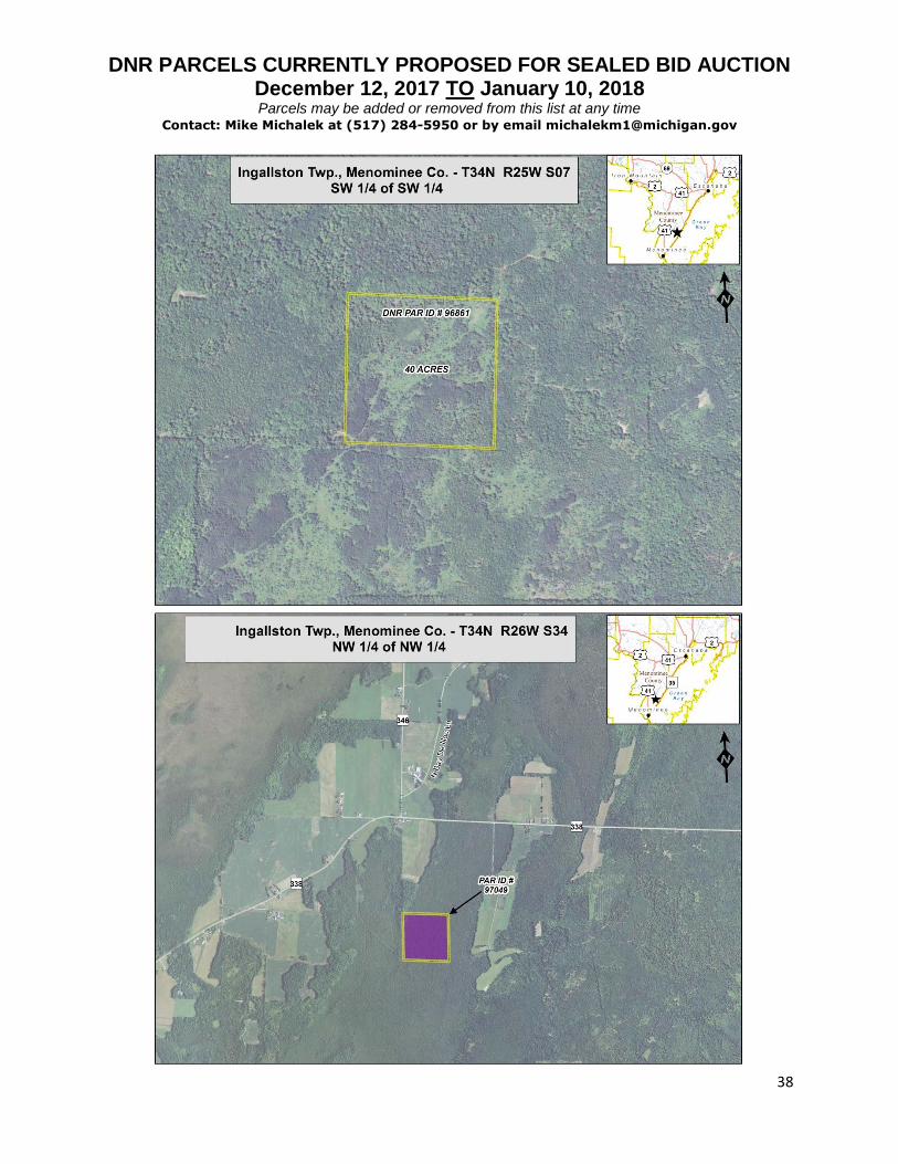
97049 007-434-006-00 Menominee, Ingallston
(T34N, R26W) S34 - NW 1/4 NW 1/4 40 AA $22,000.00 Surrounded by private landowners; Forested; Closest road is 338
96861 007-007-003-00 Menominee, Ingallston
(T34N, R25W) S07 - SW 1/4 of SW 1/4 40 AA $21,000.00 Surrounded by private landowners; Forested; Closest roads are Jim Town Rd and Hayward Lake Rd Number 17; If sold, private owners would need to comply with Federal guidelines regarding nesting Bald Eagles.
DNR PARCELS CURRENTLY PROPOSED FOR SEALED BID AUCTION December 12, 2017 TO January 10, 2018
Parcels may be added or removed from this list at any time Contact: Mike Michalek at (517) 284-5950 or by email [email protected]
19
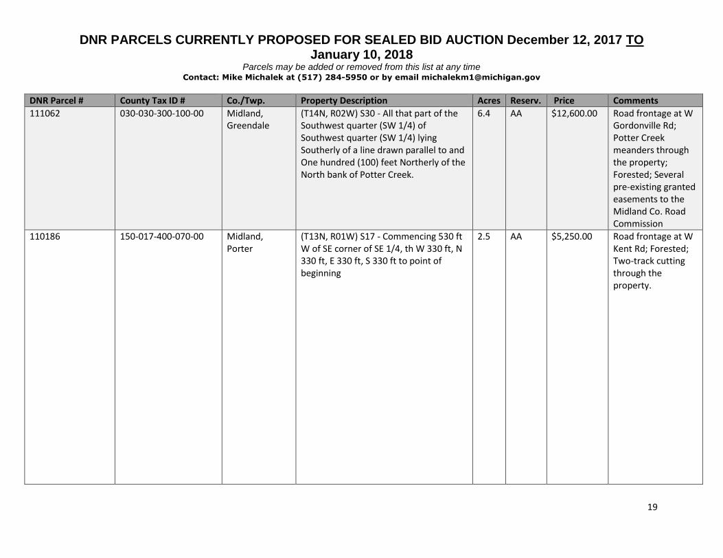
DNR Parcel # County Tax ID # Co./Twp. Property Description Acres Reserv. Price Comments
111062 030-030-300-100-00 Midland, Greendale
(T14N, R02W) S30 - All that part of the Southwest quarter (SW 1/4) of Southwest quarter (SW 1/4) lying Southerly of a line drawn parallel to and One hundred (100) feet Northerly of the North bank of Potter Creek.
6.4 AA $12,600.00 Road frontage at W Gordonville Rd; Potter Creek meanders through the property; Forested; Several pre-existing granted easements to the Midland Co. Road Commission
110186 150-017-400-070-00 Midland, Porter
(T13N, R01W) S17 - Commencing 530 ft W of SE corner of SE 1/4, th W 330 ft, N 330 ft, E 330 ft, S 330 ft to point of beginning
2.5 AA $5,250.00 Road frontage at W Kent Rd; Forested; Two-track cutting through the property.
DNR PARCELS CURRENTLY PROPOSED FOR SEALED BID AUCTION December 12, 2017 TO January 10, 2018
Parcels may be added or removed from this list at any time Contact: Mike Michalek at (517) 284-5950 or by email [email protected]
20
DNR Parcel # County Tax ID # Co./Twp. Property Description Acres Reserv. Price Comments
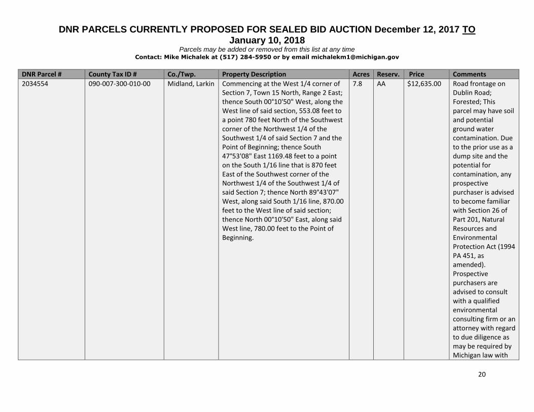
2034554
090-007-300-010-00
Midland, Larkin
Commencing at the West 1/4 corner of Section 7, Town 15 North, Range 2 East; thence South 00°10'50" West, along the West line of said section, 553.08 feet to a point 780 feet North of the Southwest corner of the Northwest 1/4 of the Southwest 1/4 of said Section 7 and the Point of Beginning; thence South 47°53'08" East 1169.48 feet to a point on the South 1/16 line that is 870 feet East of the Southwest corner of the Northwest 1/4 of the Southwest 1/4 of said Section 7; thence North 89°43'07" West, along said South 1/16 line, 870.00 feet to the West line of said section; thence North 00°10'50" East, along said West line, 780.00 feet to the Point of Beginning.
7.8
AA
$12,635.00
Road frontage on Dublin Road; Forested; This parcel may have soil and potential ground water contamination. Due to the prior use as a dump site and the potential for contamination, any prospective purchaser is advised to become familiar with Section 26 of Part 201, Natural Resources and Environmental Protection Act (1994 PA 451, as amended). Prospective purchasers are advised to consult with a qualified environmental consulting firm or an attorney with regard to due diligence as may be required by Michigan law with

DNR PARCELS CURRENTLY PROPOSED FOR SEALED BID AUCTION December 12, 2017 TO January 10, 2018
Parcels may be added or removed from this list at any time Contact: Mike Michalek at (517) 284-5950 or by email [email protected]
21
Continued…
Continued…
Continued…
Continued…
… … Continued…
respect to buying potentially contaminated property. To obtain specific information on this site from the Michigan Department of Environmental Quality, you may contact Michael Jury at (989) 894-6255.

DNR PARCELS CURRENTLY PROPOSED FOR SEALED BID AUCTION December 12, 2017 TO January 10, 2018
Parcels may be added or removed from this list at any time Contact: Mike Michalek at (517) 284-5950 or by email [email protected]
22
DNR Parcel # County Tax ID # Co./Twp. Property Description Acres Reserv. Price Comments
228109 002-002-000-050-00 Montmorency, Avery
(T30N, R03E) S02 - SW 1/4 NW of 1/4 40 AA, MIN
$14,000.00 Surrounded by private landowners; Forested; Closest roads are Hall Rd and County Rd 487
228154 002-006-000-100-00 Montmorency, Avery
(T30N, R03E) S06 - NW 1/4 of SE 1/4 40 AA, MIN
$14,000.00 Surrounded by private landowners; Forested; Closest road is Hungry 5 Rd; Easement granted to Petroleum Development Corp.
231521 006-214-000-030-00 Montmorency, Montmorency
(T32N, R03E) S14 - SE 1/4 of NE 1/4 40 AA $14,000.00 Surrounded by private landowners; Frontage on Whitetail Trail (Private); Forested

DNR PARCELS CURRENTLY PROPOSED FOR SEALED BID AUCTION December 12, 2017 TO January 10, 2018
Parcels may be added or removed from this list at any time Contact: Mike Michalek at (517) 284-5950 or by email [email protected]
23
DNR Parcel # County Tax ID # Co./Twp. Property Description Acres Reserv. Price Comments
74683, 74685
61-04-002-100-0004-00; 61-04-002-100-0003-00
Muskegon, Blue Lake
(T12N, R16W) S02 - All that part of N 197.12 ft of E1/2 NW1/4 lying E'ly of the curve of Nichols * Skeels Rds exc the E 500 ft thereof and exc portions reserved for road purposes; ALSO E½ of NW frl¼ exc N. 20 Acres of South 30 acres of E½ of NW frl¼ also exc. S 5 acres of E ½ of NW frl¼ also exc North 12.5 acres of S. 52.5 acres of E½ of NW frl¼ also exc all that part of N 197.12 ft of E½ of NW¼ lying Ely of curve of Nichols & Skeels Roads exc E. 500 ft thereof. Also exc com. at NW cor. of NE¼ of NW¼ thence South on West line of sd NE¼ of NW¼, 265.29 ft for pl. of beg. thence East 33 feet thence NEly on a curve tangent to last desc. line on a 553.9 foot radius 330.79 feet par to & 33 feet S. of N line of NE¼ of NW¼ thence West to NW cor of NE¼ of NW¼ thence S to pl of beg. exc W. 33 feet for Hwy. Also exc. N. 5 acres of S. 40 acres of E½ of NW¼. Also exc N½ of N. 5 acres of S 55 acres of E½ of NW¼ Sec. 2, T. 12N, R 16W, also exc the E½ of the fol. premises; Com at NE cor of E½ of NW¼ Sec. 2 T 12N R 16 W. for pl of beg. th. W. 500 feet thence S. 527.12 feet thence East 500 feet thence North to pl of beg. N. 33 feet for road purposes, Sec. 2, T 12 N R 16 W. also exc. N. 5 acres of S. 65 acres of E½ of
5.8
AA
$11,220.00
Road frontage at E Skeels Rd; Forested

DNR PARCELS CURRENTLY PROPOSED FOR SEALED BID AUCTION December 12, 2017 TO January 10, 2018
Parcels may be added or removed from this list at any time Contact: Mike Michalek at (517) 284-5950 or by email [email protected]
24
Continued…
Continued…
Continued…
NW ¼ Sec. 2 T 12N R 16W reserving the West 33 feet for roadway & exc. the East 500 feet thereof; also exc the North 5 acres of South 60 acres of E½ of NW¼ Sec. 2, T.12N R 16W. reserving the West 33 feet for roadway; also exc the North 5 acres of South 70 acres of E½ of NW ¼ Sec. 2,T12N R 16W reserving the West 33 feet for roadway & exc the E 500 feet thereof.
… … Continued…
Continued…
DNR PARCELS CURRENTLY PROPOSED FOR SEALED BID AUCTION December 12, 2017 TO January 10, 2018
Parcels may be added or removed from this list at any time Contact: Mike Michalek at (517) 284-5950 or by email [email protected]
25
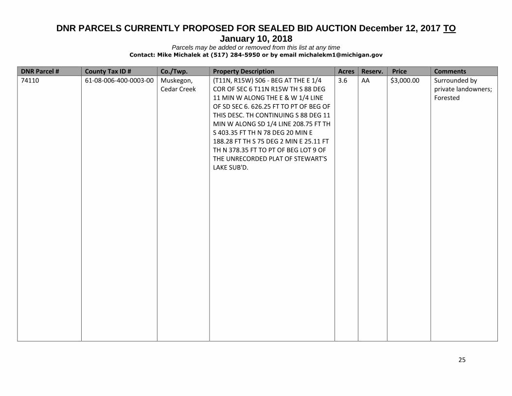
DNR Parcel # County Tax ID # Co./Twp. Property Description Acres Reserv. Price Comments
74110 61-08-006-400-0003-00 Muskegon, Cedar Creek
(T11N, R15W) S06 - BEG AT THE E 1/4 COR OF SEC 6 T11N R15W TH S 88 DEG 11 MIN W ALONG THE E & W 1/4 LINE OF SD SEC 6. 626.25 FT TO PT OF BEG OF THIS DESC. TH CONTINUING S 88 DEG 11 MIN W ALONG SD 1/4 LINE 208.75 FT TH S 403.35 FT TH N 78 DEG 20 MIN E 188.28 FT TH S 75 DEG 2 MIN E 25.11 FT TH N 378.35 FT TO PT OF BEG LOT 9 OF THE UNRECORDED PLAT OF STEWART'S LAKE SUB'D.
3.6 AA $3,000.00 Surrounded by private landowners; Forested
DNR PARCELS CURRENTLY PROPOSED FOR SEALED BID AUCTION December 12, 2017 TO January 10, 2018
Parcels may be added or removed from this list at any time Contact: Mike Michalek at (517) 284-5950 or by email [email protected]
26
DNR Parcel # County Tax ID # Co./Twp. Property Description Acres Reserv. Price Comments
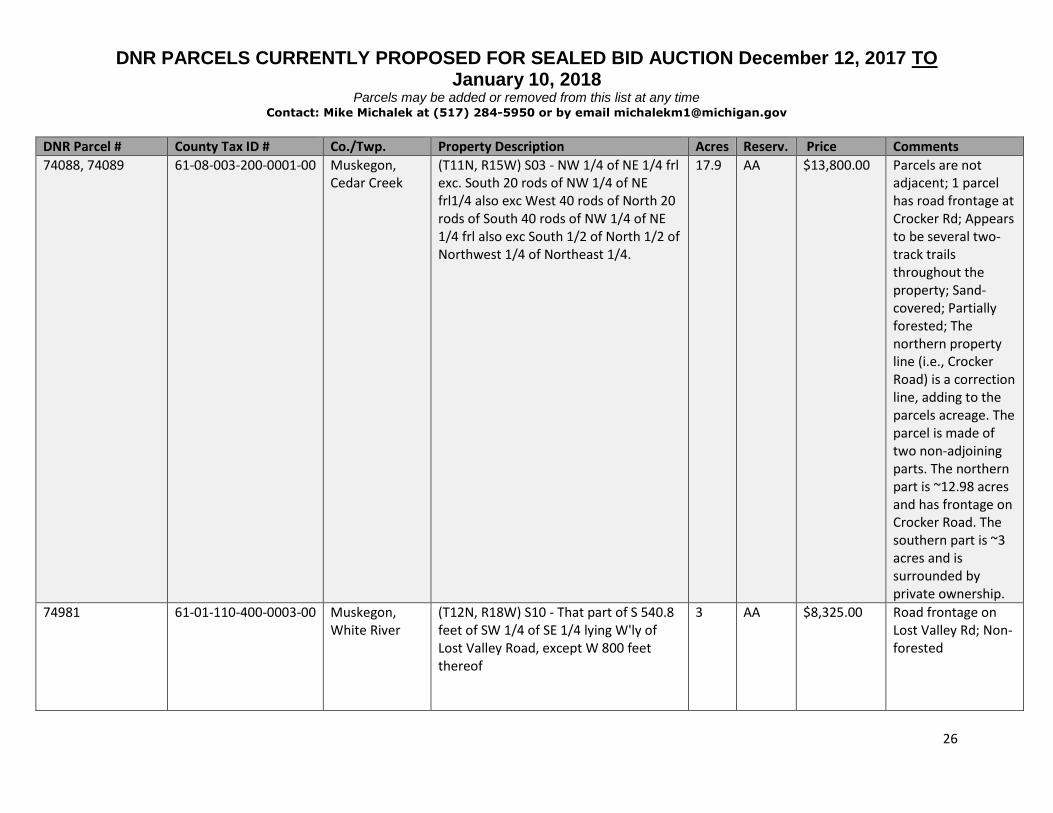
74088, 74089 61-08-003-200-0001-00 Muskegon, Cedar Creek
(T11N, R15W) S03 - NW 1/4 of NE 1/4 frl exc. South 20 rods of NW 1/4 of NE frl1/4 also exc West 40 rods of North 20 rods of South 40 rods of NW 1/4 of NE 1/4 frl also exc South 1/2 of North 1/2 of Northwest 1/4 of Northeast 1/4.
17.9 AA $13,800.00 Parcels are not adjacent; 1 parcel has road frontage at Crocker Rd; Appears to be several two-track trails throughout the property; Sand-covered; Partially forested; The northern property line (i.e., Crocker Road) is a correction line, adding to the parcels acreage. The parcel is made of two non-adjoining parts. The northern part is ~12.98 acres and has frontage on Crocker Road. The southern part is ~3 acres and is surrounded by private ownership.
74981 61-01-110-400-0003-00 Muskegon, White River
(T12N, R18W) S10 - That part of S 540.8 feet of SW 1/4 of SE 1/4 lying W'ly of Lost Valley Road, except W 800 feet thereof
3 AA $8,325.00 Road frontage on Lost Valley Rd; Non-forested

DNR PARCELS CURRENTLY PROPOSED FOR SEALED BID AUCTION December 12, 2017 TO January 10, 2018
Parcels may be added or removed from this list at any time Contact: Mike Michalek at (517) 284-5950 or by email [email protected]
27
DNR Parcel # County Tax ID # Co./Twp. Property Description Acres Reserv. Price Comments
2042415 62-22-19-376-044 Newaygo, Ashland
Melwood Forest Subdivision: Lots 15, 16 0.3 AA $48,000.00 Road frontage on Sand Beach Road; Water frontage on Sand Lake; Forested
2042304 62-06-10-401-006 Newaygo, Merrill
Woodland Park Subdivision #2: Block 325: Lots 1 to 9; Lots 35 to 40; Lots 46 to 60
1.6 AA $2,220.00 Intersected by W Lakeshore Dr & N Perch Lake Dr; Forested
1041521 62-11-17-260-012 Newaygo, Wilcox
John Branam Subdivision: Lot 227 0.1 AA $1,000.00 Road frontage on Sixth Street; Forested
1086126 13-21-252-001 Oakland, Waterford
Holiday Farms Subdivision # 3: Lot 161 0.3 AA $2,870.00 Road frontage on Edgeorge St; Water frontage on Clinton River
75299, 75300, 75302, 75303
03-008-021-01 Osceola, Evart (T17N, R08W) S8 - SE1/4 of SW1/4 and S1/2 of NE1/4 of SW1/4 and SW1/4 of SE1/4 and NW1/4 of SE1/4
140 AA $157,500.00 Surrounded by private landowners; Closest roads are River Rd and 4 Mile Rd; Forested

DNR PARCELS CURRENTLY PROPOSED FOR SEALED BID AUCTION December 12, 2017 TO January 10, 2018
Parcels may be added or removed from this list at any time Contact: Mike Michalek at (517) 284-5950 or by email [email protected]
28
DNR Parcel # County Tax ID # Co./Twp. Property Description Acres Reserv. Price Comments
2046635 68-004-029-012-00; Elmer Twp. creating new tax-id
Oscoda, Elmer (T27N, R02E) S29 - Part of the South ½ of the Southeast ¼ of Section 29, T27N, R02E, Elmer Township, Oscoda County described as: Beginning N89°36’21”W along the South section line, 1592.51 feet from the Southeast corner of Section 29, thence continuing N89°36’21”W 396 feet along said South section line; thence N00°09’32”W 432.77 feet to the centerline of Kittle Road; thence N89°24’37”E along the centerline of Kittle Road 396 feet m/l; thence S00°09’32”E 439.57 feet to point of beginning.
3.9 AA $3,125.00 Road access on Kittle Road; Forested; Several driveway trespasses

DNR PARCELS CURRENTLY PROPOSED FOR SEALED BID AUCTION December 12, 2017 TO January 10, 2018
Parcels may be added or removed from this list at any time Contact: Mike Michalek at (517) 284-5950 or by email [email protected]
29
DNR Parcel # County Tax ID # Co./Twp. Property Description Acres Reserv. Price Comments
2046633 68-004-029-012-00; Elmer Twp. creating new tax-id
Oscoda, Elmer (T27N, R02E) S29 - Part of the South ½ of the Southeast ¼ of Section 29, T27N, R2E, Elmer Township, Oscoda County described as: Beginning at the Southeast corner of said Section 29, thence N89°36’22"W along South section line 528.00 feet for point of beginning; thence continuing N89°36’21"W 796.25 feet along said South section line; thence N00°09’32"W 444.16 feet to centerline of Kittle Road; thence 364.97 feet, along the centerline of said Kittle Road on a 2066.91 foot radius curve to the right with a long chord of S85°18’33"E 364.50 feet; thence continuing along the centerline , S80°15’02"E 439.58 feet; thence S00°09’32"E 345.39 feet back to point of beginning.
7.3 AA $5,870.00 Road access on Kittle Road; Forested; Several driveway trespasses
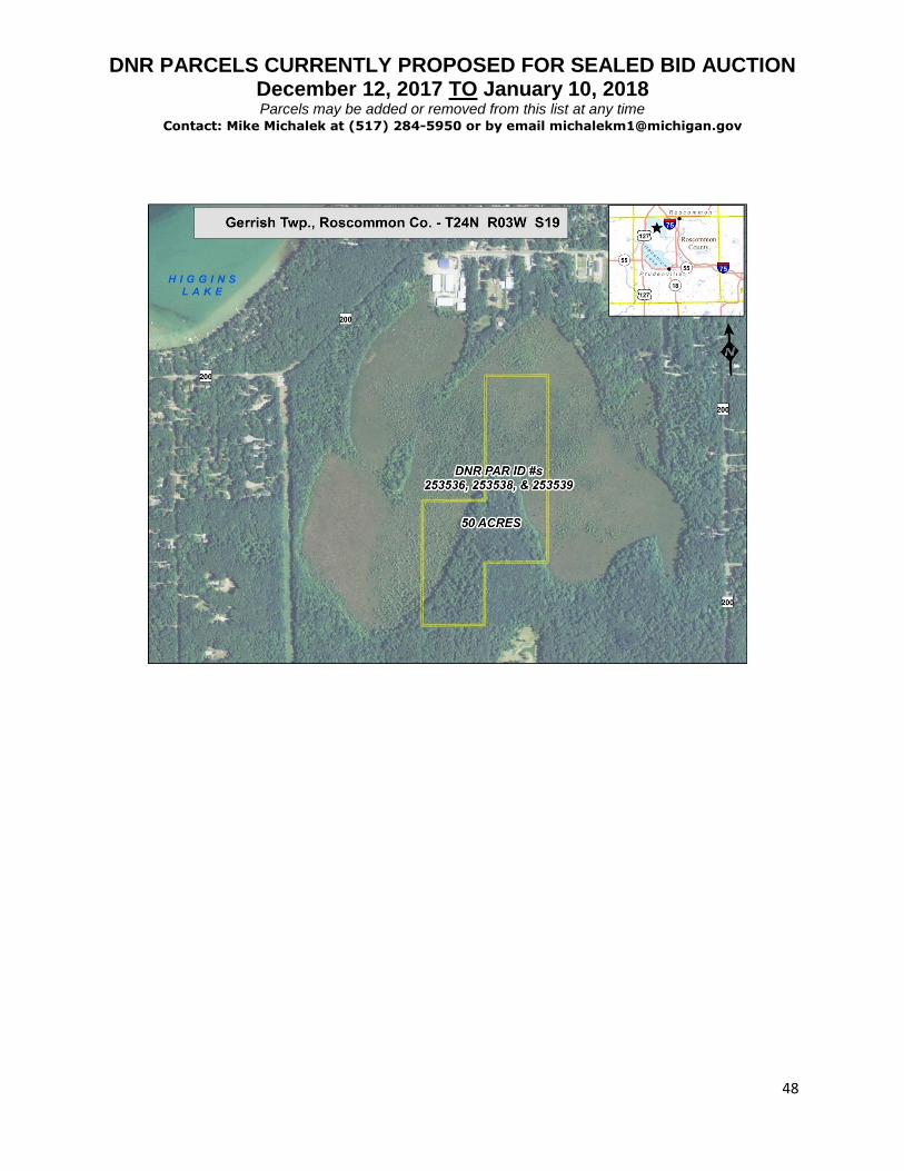
253536, 253538, 253539
004-019-002-0020 Roscommon, Gerrish
(T24N, R03W) S19 - SW 1/4 of NE 1/4 excluding the SE 1/4 of SW 1/4 of NE 1/4, E 1/2 of NW 1/4 of NE 1/4
50 AA, MIN
$54,940.00 Surrounded by private landowners; near W Higgins Lake Drive; Mostly forested swampland
250478 010-326-001-0021 Roscommon, Richfield
(T23N, R01W) S26 - NE1/4 NW1/4 SW1/4 except N 80 feet thereof
8.7 AA $9,800.00 Surrounded by private landowners; Closest roads are Pinewood Rd & N St Helen Rd; Forested

DNR PARCELS CURRENTLY PROPOSED FOR SEALED BID AUCTION December 12, 2017 TO January 10, 2018 Parcels may be added or removed from this list at any time
Contact: Mike Michalek at (517) 284-5950 or by email [email protected]
30
DNR PARCELS CURRENTLY PROPOSED FOR SEALED BID AUCTION December 12, 2017 TO January 10, 2018 Parcels may be added or removed from this list at any time
Contact: Mike Michalek at (517) 284-5950 or by email [email protected]
31
DNR PARCELS CURRENTLY PROPOSED FOR SEALED BID AUCTION December 12, 2017 TO January 10, 2018 Parcels may be added or removed from this list at any time
Contact: Mike Michalek at (517) 284-5950 or by email [email protected]
32

DNR PARCELS CURRENTLY PROPOSED FOR SEALED BID AUCTION December 12, 2017 TO January 10, 2018 Parcels may be added or removed from this list at any time
Contact: Mike Michalek at (517) 284-5950 or by email [email protected]
33
DNR PARCELS CURRENTLY PROPOSED FOR SEALED BID AUCTION December 12, 2017 TO January 10, 2018 Parcels may be added or removed from this list at any time
Contact: Mike Michalek at (517) 284-5950 or by email [email protected]
34

DNR PARCELS CURRENTLY PROPOSED FOR SEALED BID AUCTION December 12, 2017 TO January 10, 2018 Parcels may be added or removed from this list at any time
Contact: Mike Michalek at (517) 284-5950 or by email [email protected]
35

DNR PARCELS CURRENTLY PROPOSED FOR SEALED BID AUCTION December 12, 2017 TO January 10, 2018 Parcels may be added or removed from this list at any time
Contact: Mike Michalek at (517) 284-5950 or by email [email protected]
36

DNR PARCELS CURRENTLY PROPOSED FOR SEALED BID AUCTION December 12, 2017 TO January 10, 2018 Parcels may be added or removed from this list at any time
Contact: Mike Michalek at (517) 284-5950 or by email [email protected]
37
DNR PARCELS CURRENTLY PROPOSED FOR SEALED BID AUCTION December 12, 2017 TO January 10, 2018 Parcels may be added or removed from this list at any time
Contact: Mike Michalek at (517) 284-5950 or by email [email protected]
38

DNR PARCELS CURRENTLY PROPOSED FOR SEALED BID AUCTION December 12, 2017 TO January 10, 2018 Parcels may be added or removed from this list at any time
Contact: Mike Michalek at (517) 284-5950 or by email [email protected]
39

DNR PARCELS CURRENTLY PROPOSED FOR SEALED BID AUCTION December 12, 2017 TO January 10, 2018 Parcels may be added or removed from this list at any time
Contact: Mike Michalek at (517) 284-5950 or by email [email protected]
40

DNR PARCELS CURRENTLY PROPOSED FOR SEALED BID AUCTION December 12, 2017 TO January 10, 2018 Parcels may be added or removed from this list at any time
Contact: Mike Michalek at (517) 284-5950 or by email [email protected]
41

DNR PARCELS CURRENTLY PROPOSED FOR SEALED BID AUCTION December 12, 2017 TO January 10, 2018 Parcels may be added or removed from this list at any time
Contact: Mike Michalek at (517) 284-5950 or by email [email protected]
42

DNR PARCELS CURRENTLY PROPOSED FOR SEALED BID AUCTION December 12, 2017 TO January 10, 2018 Parcels may be added or removed from this list at any time
Contact: Mike Michalek at (517) 284-5950 or by email [email protected]
43

DNR PARCELS CURRENTLY PROPOSED FOR SEALED BID AUCTION December 12, 2017 TO January 10, 2018 Parcels may be added or removed from this list at any time
Contact: Mike Michalek at (517) 284-5950 or by email [email protected]
44

DNR PARCELS CURRENTLY PROPOSED FOR SEALED BID AUCTION December 12, 2017 TO January 10, 2018 Parcels may be added or removed from this list at any time
Contact: Mike Michalek at (517) 284-5950 or by email [email protected]
45

DNR PARCELS CURRENTLY PROPOSED FOR SEALED BID AUCTION December 12, 2017 TO January 10, 2018 Parcels may be added or removed from this list at any time
Contact: Mike Michalek at (517) 284-5950 or by email [email protected]
46

DNR PARCELS CURRENTLY PROPOSED FOR SEALED BID AUCTION December 12, 2017 TO January 10, 2018 Parcels may be added or removed from this list at any time
Contact: Mike Michalek at (517) 284-5950 or by email [email protected]
47
DNR PARCELS CURRENTLY PROPOSED FOR SEALED BID AUCTION December 12, 2017 TO January 10, 2018 Parcels may be added or removed from this list at any time
Contact: Mike Michalek at (517) 284-5950 or by email [email protected]
48