
DM_finl.pdf
22
A Project report on Determination of hazard specific disaster risk factors of MAJULI- a multi hazard prone area Submitted by: JUHI MONI SAIKIA (BAM14002) SAMUJJWAL MOHAN DEV SARMA (BAM14003) MANASH JYOTI PATHAK (BAM14004) HIMANGSHU PHUKAN (BAM14006) NAJLINA BEGUM (BAM14018) Under the guidance of Dr. DIPAK NATH CENTRE FOR DISASTER MANAGEMENT TEZPUR UNIVERSITY
Transcript of DM_finl.pdf

A Project report
on
Determination of hazard specific disaster risk factors of
MAJULI- a multi hazard prone area
Submitted by:
JUHI MONI SAIKIA (BAM14002)
SAMUJJWAL MOHAN DEV SARMA (BAM14003)
MANASH JYOTI PATHAK (BAM14004)
HIMANGSHU PHUKAN (BAM14006)
NAJLINA BEGUM (BAM14018)
Under the guidance of
Dr. DIPAK NATH
CENTRE FOR DISASTER MANAGEMENT
TEZPUR UNIVERSITY
i
STUDENTS’ DECLARATION
We hereby declare that the work being presented in this report entitled “Determination of
hazard specific disaster risk factors of a multi-hazard prone area” is an authentic record of the
study carried out on Majuli under the supervision of Dr. Dipak Nath.
Date: Juhi Moni Saikia (BAM14002)
Samujjwal Mohan Dev Sarma (BAM14003)
Manash Jyoti Pathak (BAM14004)
Himangshu Phukan (BAM14006)
Najlina Begum (BAM14018)
This is to certify that the above statement made by the students is correct to the best of my
knowledge.
Dr. Dipak Nath,
Assistant Professor& Head i/c,
Centre for Disaster Management
Tezpur University

ii
PREFACE
The purpose of this assignment report is to study the hazard risk factors of a multi-hazard
prone area to calculate the disaster risk to that area. The study is aimed at having knowledge
of the parameters of disaster risk & method to be followed for determination of risk including
selection of scales for different parameters. For this purpose we have selected Majuli, situated
in the heart of the River Brahmaputra & one of the severely affected places of Assam due to
prospect of multiple hazards and presence of unsafe conditions as the chosen place for study.
i i
i

iii
ACKNOWLEDGEMENT
We would like to express our sincere thanks to Dr. Dipak Nath , Assistant Professor & Head
i/c, Centre for Disaster Management, Tezpur University for giving us an opportunity to
prepare a report on the subject of study “Determination of hazard specific disaster risk factors
of Majuli- a multi hazard prone area.
Date: Juhi Moni Saikia (BAM14002)
Samujjwal Mohan Dev Sarma (BAM14003)
Manash Jyoti Pathak (BAM14004)
Himangshu Phukan (BAM14006)
Najlina Begum (BAM14018)

iv
CONTENTS
CHAPTER PAGE No.
1 Introduction 1
1.1 Area specification and its profile 1
1.2 Soil 2
1.3 Livelihood and Culture 2
1.4 Satras 3
1.5 Climatic conditions 5
2 Selection of the area 6
3 Methodology 7
3.1 Risk 7
3.2 Parameters of hazard 7
3.3 Methods to be followed for determination of risk 8
3.4 Impact and probability rating matrix 9
4 Assessment of different parameters based on secondary data 11
4.1 Response time 11
4.2 Length of forewarning 11
4.3 Frequency 11
4.4 Time of exposure 12
5 Determination of hazard specific disaster risk factors 13
6 Conclusion 16
Reference 17

1
CHAPTER 1
INTRODUCTION
1.1 AREA SPECIFICATION AND ITS PROFILE:
Majuli is one of the largest river islands in the world (26⁰45’N – 27⁰12’N and 93⁰39’E –
94⁰35’E, altitude of 60 – 95m above msl). The original land mass of Majuli was 1250 Sq. km
(1950) which has significantly reduced to 521.52 Sq. km (2001) due to erosion (As envisaged
from the IRS-P6 (LISS III) imagery of 2010). The island is bounded by the river
Brahmaputra on the South, the river Subansiri on the North-West and Kherkutia Suti in
Northeast. Geomorphologically the island is alluvial. Large number of wetlands and rivulets
constitute excellent breeding ground for numerous indigenous fishes. Every year whether
there is flood in Assam or not, the Majuli Sub- Division is always affected by floods, forcing
people to take shelter in roads and higher land.
The landmass Majuli is now a civil sub-division with its headquarter at Garmur and is a part
of the Jorhat district in Assam. This civil sub-division of the Jorhat district is comprised of
Fig..1Locational Map of Majuli

2
two development blocks – Namoni Majuli Development Block and Uzani Majuli
Development Block and three Tehsils (Mauza) viz. Ahatguri, Kamalabari and Salmora. Of
these three tehsils, the Ahatguri mauza has already been completely engulfed by the river
Brahmaputra leaving many families homeless. According to the 2011 census, the population
of Majuli is 1.68 lakhs of which 70% belongs to the tribal communities (Board, 2012).
1.2 SOIL:
Bank materials of the river Brahmaputra are mostly composed of varying proportions of fine
sand and silt, with only occasional presence of minor amounts of clay (generally less than
5%) (Goswami, 1985). According to the sub-soil investigations carried out by the River
Research Station at different locations of Majuli extending up to a depth of 30 m indicate that
the area is mostly underlain by grey coloured, fine to medium sized, poorly graded sand
covered by light grey coloured silt mixed with clay and/or fine sand of varying thickness
ranging from 1.5 to about 12 m. However, there are few pockets like Salmora, Dakhinpat and
Bessamora, located on the south-western part of Majuli bordering Brahmaputra river, where
the soil is rich in inorganic clay content and the depth of clay rich horizon extends even
beyond 15 m from the ground (Goswami, 2001; Singh &Goswami, 2011).
1.3 LIVELIHOOD AND CULTURE:
As per the year 2011 Majuli consists of a total of 248 villages with a total population of
153400. Out of this Majuli Developmental Block consists of 91,757 persons and Ujani Majuli
Development Block consists of 61,643 persons.
Being endowed with naturally fertile soil and plenty of water, agriculture plays the
dominating role in the livelihood of the people of Majuli. Farmers grow more than hundred
varieties of rice and many other crops like maize, black gram and various types of cereals,
vegetables, fruits, sugarcane, cotton, jute, castor etc. The extraordinary pottery craft of Majuli
is not only an age-old profession of the people but also an invaluable ingredient of its cultural
life having immense archaeological significance. The facts that this craft has flourished
through ages without using the potter’s wheel and is traded through a traditional barter
system make it a heritage of mankind that needs to be studied and preserved. Archaeologists
have found in this form of pottery of Majuli a missing link between the Mohenjo-Daro and
Harappa civilizations. Other occupations of the people include pisciculture, sericulture,

3
horticulture, cattle farming, dairy, handloom, handicrafts (e.g. - cane works, bamboo crafts)
and boat making (Fig. 2).
Majuli, characterized by the meeting and branching of numerous channels around alluvial
sandbars, is a meeting ground of diverse cultural streams with an assortment of ethnic
communities such as Mishings, Deoris, Kacharis, Koch Rajbangshis and sundry castes and
creeds living peacefully and cohesively for hundreds of years. In the community lives of the
people of Majuli, one can see a distinct mark of assimilation and synthesis of varied ethnic
and cultural traditions fused with the dominant Satra culture. The famous ‘Ras’ festival of
Majuli that is celebrated in the month of November attracts thousands of people and tourists
every year (Goswami, 2001).
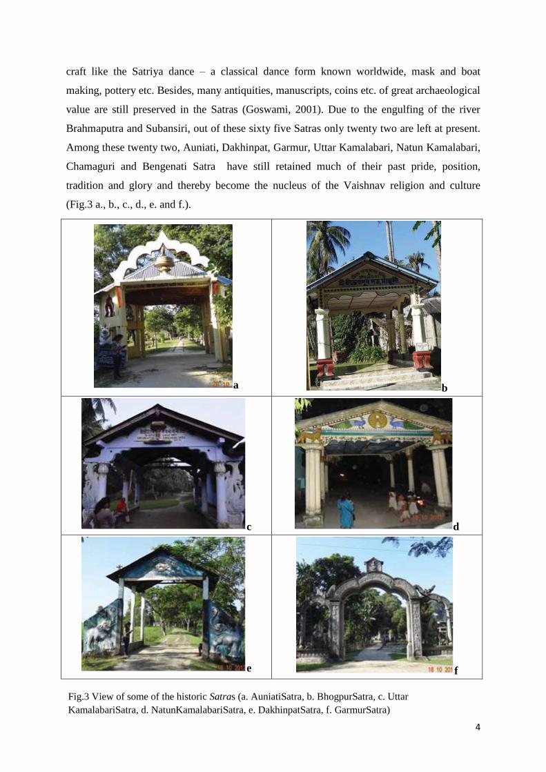
1.4 SATRAS:
One of the unique and important features of this riverine landmass is the presence of the
‘Vaishnavite’ monasteries, popularly known as the Satras. The Satras were founded by the
great saint, poet litterateur and religious reformer Srimanta Sankardeva in the fifteenth
century A.D. In Assam, around the unique system of these ‘Vaishnavite’ monasteries, the
Neo-Vaishnavite culture has evolved over the last five hundred years. Earlier, as many as
sixty five such Satra s flourished with lakhs of ‘Bhakats’ (disciples) in Majuli and thousands
of followers all over the state. These Satras not only have an impact on the religious and
spiritual lives of the people but also have nurtured and preserved a rich tradition of art and
Fig.2 Livelihoods of Majuli (a.Fishing, b.Handicrafts, c.Agriculture, d.Boat making, e.Pottery making)
4
craft like the Satriya dance – a classical dance form known worldwide, mask and boat
making, pottery etc. Besides, many antiquities, manuscripts, coins etc. of great archaeological
value are still preserved in the Satras (Goswami, 2001). Due to the engulfing of the river
Brahmaputra and Subansiri, out of these sixty five Satras only twenty two are left at present.
Among these twenty two, Auniati, Dakhinpat, Garmur, Uttar Kamalabari, Natun Kamalabari,
Chamaguri and Bengenati Satra have still retained much of their past pride, position,
tradition and glory and thereby become the nucleus of the Vaishnav religion and culture
(Fig.3 a., b., c., d., e. and f.).
a b
c d
e f
Fig.3 View of some of the historic Satras (a. AuniatiSatra, b. BhogpurSatra, c. Uttar
KamalabariSatra, d. NatunKamalabariSatra, e. DakhinpatSatra, f. GarmurSatra)

5
1.5 CLIMATIC CONDITIONS:
Majuli being a part of north east India enjoys a sub-tropical climate and the average rainfall is
about 215cm. The temperature of Majuli, varies from 28⁰-33⁰c and relative humidity varies
from 54% to 86%. The summer is followed by monsoon and winter during which the area
faces a variety of natural hazards.

6
CHAPTER 2
SELECTION OF THE AREA
With a catchment area of over 580,000km2 and an average width of 1km, the river
Brahmaputra flows through the seismically unstable valley in Assam and occupies about one
tenth of the valley. Being one of the active seismic regions of the world, the area witnessed
two great earthquakes both of magnitude 8.7 in the years 1897 and 1950 which are among the
most severe ones in the recorded earthquake history. Earthquakes of such magnitude not only
resulted in devastation in the region but also have impacted the hydrologic design of the
same. Due to such a large extent and complex geo-tectonic setting of this alluvial river
system, the river Brahmaputra is associated with the problems of erosion-deposition of
sediments, rapid bed aggradations, drainage congestions, and flooding.
The Majuli Island is one of the most dynamic landforms in the Brahmaputra valley of Assam
and has attracted a lot of attention for a number of reasons. Apart from a serious threat to
very special Vaishnavite spiritual centres due to severe erosion of the island in recent years,
the Majuli Island represents a geomorphic high sitting on ‘high basement’ topography. This is
confirmed from seismic sections around the Majuli and correlation of geophysical and
topographic data.
Majuli is an important cultural heritage site of Assam and is home to the ‘Vaisnavite’
monasteries, popularly known as ‘Satras’. The area is situated at the bosom of the three river
system viz. the Subansiri, the Kherkutiasuti (a spill channel of the river Brahmaputra which
has been blocked few years back to stop the erosion problem) and the main Brahmaputra
river. Geomorphologically, Majuli forms a part of the floodplains of Brahmaputra river and
thereby continuously facing serious problems of flood hazards (due to influence of SW
monsoon) and river bank erosion which has posed a threat to its rich cultural heritage and its
existence as well. Different research works done at different periods so that the annual rate of
erosion has been increasing at an alarming rate. This study attempts to assess the flood and
erosion hazard of the area and vulnerability of the element at risk i.e. agricultural lands and
the Satras due to the flood and river bank erosion and thus to protect the area and its rich
cultural heritage.

7
CHAPTER 3
METHODOLOGY
3.1 RISK:
The word risk implies the probability of damage, loss and other negative consequences in a
system under the influence of a triggering force.
When a system is at high risk, we can expect maximum damage and disruption in the system,
if a hazard strikes the system.
Risk implies the probability of disaster or expected loss and damage under the impact of any
external force. Risk means, we have some visible or hidden threats, which may harm our life
and property. If there is significant loss and damage to our life and property, we call it a
disaster. If our risk is more, probability of loss and damage is also more. That means, if risk is
high, expected magnitude of disaster is also high. Therefore, there is a strong bonding
between risk and probability of disaster in a system.
If we minimize our risk by taking appropriate measures, magnitude of loss and damage to our
life and property will be reduced accordingly. In other word, the probability of disaster will
also be reduced proportionately. If we can make our risk zero, we will never face a disaster.
But, in practice it is not possible. Every system or individual has some sorts of risk i.e., no
system or individual is free from external threats absolutely.
3.2 PARAMETERS OF DISASTER RISK:
Hazard-
When a system is exposed to a specific hazard like flood or earthquake, it induces some sort
of risk. If the system is prone to more hazards and magnitudes of hazards are high, the risk of
the system goes further in higher side.
Therefore, the Risk of a system is directly proportional to frequency and magnitude and other
characteristics of the hazards, to which the system is exposed.

8
If there is no possible hazard or threat to a system, the risk of the system will certainly be
zero. In practice, it is not possible make the risk of a system zero by eliminating its threats or
hazards completely.
Vulnerability of the system-
More unsafe conditions of a system result more damage and disruption to the system under
the influence of hazards. So, the risk of a system is also directly proportional to numbers of
unsafe conditions or vulnerability factors of the system.
The combined impact of Hazard and Vulnerability to a system is called Specific Risk. Both
the parameters are primarily responsible for enhancing the disaster risk of our systems. In
absence of one parameter i.e., “Hazard or Vulnerability”, the Disaster Risk of a system
becomes zero. In reality, it is not possible.
Elements at risk-
If there is no resource or element in a system, there is no possibility of loss and damage, even
in presence of external hazards.
If a system has valuable physical and living elements but these are less susceptible to
hazards; then also the risk of the system will be in lower side. In that case, probability of loss
and damage to the system under the influence of external hazards will be low.
When the physical and living elements of a system are at high risk of damage under the
impact of hazards, then disaster risk of the system will be very high.
In Majuli, the elements at risk are the Satras and the agricultural lands of the area.
3.3 METHOD TO BE FOLLOWED FOR DETERMINATION OF RISK:
The disaster risk of any system depends on probable hazards to which the system is exposed;
vulnerability of the system, and elements in the system which are at risk.
DISASTER RISK =
Elements at Risk Hazard Vulnerability
Capacity

9
The diagrammatic representation of disaster risk of a system is presented below:
Disaster risk could be redefined by considering probable impact of specific hazard as Impact
Rating and susceptibility of exposures to that hazard as Probability Rating.
Disaster Risk = Impact Rating x Probability Rating
Impact rating depicts on impacts of hazards on the system and largely related to
characteristics of the hazards. Probability rating implies probability of occurrence of disaster
in the system, which depends on vulnerability of the system and their susceptibility to
hazards.
3.4 IMPACT AND PROBABILITY RATING MATRIX:
With slight modification, if we consider a scale ranging from 0 to 4 for Impact rating and
Probability Rating, then the scale for Disaster Risk will be 0 to 16. The Impact and
HAZARD VULNERABLE
ENVIRONMENT DISASTER
HAZARD LESS
VULNERABLE
HAZARD CAPACITY
HIGH
STABLE
SYSTEM
DISTURBED SECONDARY
AFFECT
LIFE ECONOMY INFRASTRUCTURE COMMUNICATION
HEALTH EDUCATION LIVELIHOOD PRODUCTION EXCHANGE
DISTURBED
STABLE
SYSTEM
Disruption

10
Probability rating Matrix defines the level of disaster risk pertaining to the Impact and
Probability ratings.
Impact Rating
Nil
(0)
Low
(1)
Medium
(2)
High
(3)
Very High
(4)
Pro
bab
ilit
y R
ati
ng
Nil
(0) 0 0 0 0 0
Low
(1) 0 1 2 3 4
Medium
(2) 0 2 4 6 8
High
(3) 0 3 6 9 12
Very High
(4) 0 4 8 12 16
This indicates, in absence of hazard the probability of disaster in a vulnerable system is nil.
On the other hand, whatever be the level of impact of hazards, probability of disaster depends
on status of susceptibility of exposures to the hazards.

11
CHAPTER 4
ASSESSMENT OF DIFFERENT PARAMETERS BASED ON SECONDARY DATA
The impact of hazards to the exposures depends on some parameters and these parameters are
the determinant factors of magnitude of probable loss and damage to a system under the
impact of a particular hazard. A brief note on those parameters are discussed below-
4.1 RESPONSE TIME:
Response time is the period, within which the vulnerable community has to respond to a
hazard to save their life and property.
People cannot decide or take action for saving their life and property within short response
time. If the hazard is unpredictable and response time is very short, people gets absolutely no
time to save their life and property. In this case, amount of loss and damage depends on
magnitude of hazard. The best example is earthquake.
But, if the hazard is predictable and the response time is short, people can take advance
measure to avoid loss and damage to their life and property. Best example is lightning.
4.2 LENGTH OF FOREWARNING:
The time scale for forecasting a hazard before it strikes a system.
For some natural hazards, we get considerably long time for their forecasting. In this case,
magnitude of loss and damage could be minimized by taking immediate action, before the
occurrence of disaster. Example is seasonal flood.
For some hazards, forewarning time is either very short or zero. In this case, probability of
loss and damage is very high. We need long term plans for sustainable development to
minimize loss and damage. Example is earthquake.
4.3 FREQUENCY:
The number of times a particular hazard strikes a particular place within a specific period of
time.
The nature and frequency of hazards should be well defined in a hazard and location specify
disaster risk reduction plan.
12
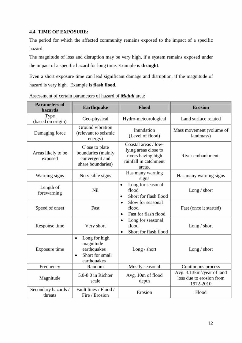
4.4 TIME OF EXPOSURE:
The period for which the affected community remains exposed to the impact of a specific
hazard.
The magnitude of loss and disruption may be very high, if a system remains exposed under
the impact of a specific hazard for long time. Example is drought.
Even a short exposure time can lead significant damage and disruption, if the magnitude of
hazard is very high. Example is flash flood.
Assessment of certain parameters of hazard of Majuli area:
Parameters of
hazards Earthquake Flood Erosion
Type
(based on origin) Geo-physical Hydro-meteorological Land surface related
Damaging force
Ground vibration
(relevant to seismic
energy)
Inundation
(Level of flood)
Mass movement (volume of
landmass)
Areas likely to be
exposed
Close to plate
boundaries (mainly
convergent and
share boundaries)
Coastal areas / low-
lying areas close to
rivers having high
rainfall in catchment
areas.
River embankments
Warning signs No visible signs Has many warning
signs Has many warning signs
Length of
forewarning Nil
Long for seasonal
flood
Short for flash flood
Long / short
Speed of onset Fast
Slow for seasonal
flood
Fast for flash flood
Fast (once it started)
Response time Very short
Long for seasonal
flood
Short for flash flood
Long / short
Exposure time
Long for high
magnitude
earthquakes
Short for small
earthquakes
Long / short Long / short
Frequency Random Mostly seasonal Continuous process
Magnitude 5.0-8.0 in Richter
scale
Avg. 10m of flood
depth
Avg. 3.13km2/year of land
loss due to erosion from
1972-2010
Secondary hazards /
threats
Fault lines / Flood /
Fire / Erosion Erosion Flood

13
CHAPTER 4
DETERMINATION OF HAZARD SPECIFIC DISASTER RISK FACTORS
Assessment of disaster risk gives us idea about hazard prone areas, characteristics and
impacts of individual hazards, factors responsible for damage and disruption under the impact
of a specific hazard etc. Disaster Risk Assessment is integral part of planning for Disaster
Risk Mitigation.
Hazard specific Disaster Risk Factor could be estimated by assuming the formula
Disaster Risk = Impact factor x Probability factor
Scale for estimation of Disaster Risk:
If we consider a scale ranging 0 to 4 for both impact and probability factors,
Then, scale for Disaster Risk Factor will be 0 to 16.
We consider following general formats for estimation of Impact factor (of hazards) and
Probability factors (of vulnerability)
Numerical Scale:
0- Very Low/ Nil
1- Low
2- Medium
3- High
4- Very High
Parameters of Hazard Impact of hazards
Earthquake Flood Erosion
Areas likely to be
exposed 4 (entire area) 3 (70%) 1 (20%)
Warning signs 0 3 2
Length of forewarning 0 3 3
Speed of onset 4 2 3
Response time 1 3 3
Exposure time 3 3 3
Frequency 2 3 2
Magnitude 3 3 2
Secondary hazards /
threats 3 3 3
Impact factor 20/9 = 2.2 (medium) 26/9 = 2.9 (very high) 22/9 = 2.4 (high)

14
Probability factor
Probability factor denotes probability of damage and disruption in a system under the impact
of a specific hazard due to vulnerability of the system.
For this, we can assume a numerical scale (preferably 0 to 4) –
very low/nil=(0);
low=(1);
medium=(2);
high=(3); and
very high=(4)
Taking average value of all the parameters, we can determine hazard specific probability
factors.
Vulnerability Rating on susceptibility
Earthquake Flood Erosion
Loca
l u
nsa
fe c
on
dit
ion
s
Area is surrounded by river from all
sides.
30% area is exposed to moving
water.
Lower Majuli is located at the
confluence zone of river
Brahmaputra and Subansiri.
High sediment load of the river
30% houses are not earthquake
resistant and 60% population living
in these houses
40% population living in flood prone
areas and houses are not flood proof
High monsoonal rains
Possibility of breaching of
embankment
Poor preparedness level
River bank not protected
70% crop area is flood prone
Low carrying capacity of the river
1
-
1
-
3
-
-
1
-
-
-
-
4
3
4
3
-
3
3
3
3
3
3
4
4
4
3
3
-
3
3
4
3
4
2
2
Dyn
am
ic
pre
ssu
res
Poor economy of the vulnerable
community
Misuse of money in implementing
schemes
Poor awareness
Lack of motivation
3
2
2
2
3
3
2
2
3
3
2
2

15
Root
cau
ses
Ineffectiveness of the structural
measures such as dams
Lack of fund for hazard resistance
devices and relocation
Lack of risk reduction plan
Ignorance of government
-
4
3
2
3
4
3
4
3
4
3
4
PR
OB
AB
ILIT
Y
FA
CT
OR
24/80=0.3
60/80=0.75 59/80=0.73
Therefore, the Disaster Risk Factors for the three hazards are as follows:
Earthquake
Disaster Risk Factor = Impact factor X Probability factor
= 2.2 x 0.3
= 0.66
Flood
Disaster Risk Factor = Impact factor X Probability factor
= 2.9 x 0.75
= 2.175
Erosion
Disaster Risk Factor = Impact factor X Probability factor
= 2.4 x 0.73
= 1.752

16
CHAPTER 6
CONCLUSION
The Brahmaputra basin in India frequently suffers from different types of water induced
hazards like flood, flash flood, river-bank erosion and sand casting (deposition of high
amounts of sand by flood water) (Das et al. , 2009). Being located on the floodplains of
Brahmaputra, Majuli too is not an exception. After thorough analysis of the results, it can be
concluded that the problem of flood and riverbank erosion in the area is of serious concern.
The area has experienced several large flood events in the years 1962, 1983, 1984, 1988,
1998, 2004, 2008 and 2012 among which 1998 and 2012 are the largest. Though there is no
any loss of lives reported due to flooding in the area, a huge loss of livestock and agricultural
production are associated with each flood event. Along with the problem of flooding, the area
is also facing some other subsequent problems like embankment breach, road breach and
sand casting. It has been revealed that in most of the places flooding due to river overflow is
not of much concern as river water normally goes down within 2-3 days. But when the
flooding is caused due to embankment breach or road breach, the problem is more acute as
the flood water remains stagnant at a place for long time. The flood water entering the
villages due to breach in the embankments also has a great force and thereby causes large-
scale damages to houses and properties.
It is observed that there is a continuous change in the area of Majuli due to active processes
of erosion and deposition. The total area of Majuli in 1972 was 685.29 km2, in 2001 510.51
km2, in 2004 525.92 km
2, in 2008 511.88 km
2 and in 2010 521.52 km
2. However, the
deposition is not a permanent process and gets eroded during high flood events. The erosion
problem is more acute after the flood events in most of the places, the main cause being over-
steepening of the bank materials due to the deposition of high amounts of sediments during
the flood.
The study findings therefore emphasize on an urgent need to develop an effective spatial plan
considering all the aspects of flood and riverbank erosion to protect this heritage site from
further engulfing by the two river systems.

17
REFERENCES:
1. Goswami, D.C., 1985. Brahmaputra River, Assam, India: Physiography, basin
denundation and channel aggradation. Water Resour. Res. 21, 959–978.
2. www.google.com
3. www.wikipedia.com
4. Dipima Sarma, 2013, Rural Risk Assessment due to Flooding and Riverbank
Erosion in Majuli, Assam, India


