DJI Presentation at European Commission "RPAS for Civil Protection Experts", Brussels, January...
31
UAV Solutions to Disaster Management
-
Upload
visual-aerials -
Category
Education
-
view
731 -
download
0
Transcript of DJI Presentation at European Commission "RPAS for Civil Protection Experts", Brussels, January...
UAV Solutions to Disaster Management

1
2
3
4 CASE STUDIES Examples of UAV technology deployment in the humanitarian space
NEXT STEPS Open discussion and questions
5 DJI UAVs Introduction to the Phantom, the Inspire, the Matrice and the SDK
ABOUT DJI Background Information about the company
UAVs IN EMERGENCY SITUATIONS Fundamental technologies, capabilities, use cases

ROMEO DURSCHER Director of Education
Twitter: @RomeoCH
CAROLINE BRIGGERT Associate Director of Communications
Twitter: @cbriggert


Ease of Use
Affordability Accessibility
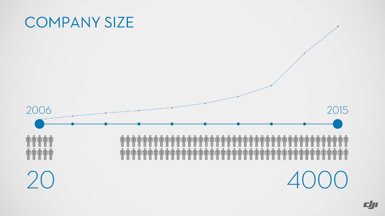
LEADER IN HARDWARE TECHNOLOGY

WHAT ARE UAVs? • DJI manufacturers consumer,
prosumer and commercial units between 35cm to 1m+, a medium category
• DJI manufactures quad (4), hexa (6) & octo (8) platforms
• Powered by (LiPo) lithium ion batteries
• Standard payloads include: - High resolution camera capable of live video streaming to the remote control - Visual Sensing Systems

Control system

Phantom series

Inspire X3, X5, XT

M100 Matrice Developer Platform

ZENMUSE XT
• Captures IR radiation • MP4 video & image • Digital Detail Enhancement • Active Contrast Enhancement

SAFETY FEATURES
• DJI GEO • Guidance • Easy to control
• Automatic return to home • Automatic take-off • Automatic landing • Home lock / course lock
• Propeller guards

DEVELOPER CHALLENGE

Monitor and control aircraft flight behavior with the Onboard API functions, while utilizing the built-in Intelligent Navigation Modes to create autonomous flight paths and maneuvers.
TAKE CONTROL
Create customized mobile applications or communicate with the DJI flight controller over a direct serial connection. Advanced programs can analyze images to create 3D models and measure distances with a very high degree of accuracy.
MOBILE OR ONBOARD SDK
Empower your applications with artificial intelligence and analyze data in real time with DJI’s powerful onboard computer.
ONBOARD COMPUTER
1
2
3
BENEFITS OF THE SDK

UAVs IN EMERGENCY RESPONSE SITUATIONS

BENEFIT OF UAVs
• Time is of essence • Quick deployment & live view • Identify safe / dangerous zones • Detailed, more accurate mapping • Identify missing people • Overall damage assessment
• Access to real time data • Cost Effectiveness • Delivery Platforms
• Defillibrators, Mediations • Life Saving Devices

BENEFIT OF UAVs
• Areas mapped regularly show changes in the environment • Visual • Atmospheric • Radiological
• Intelligent features for autonomous flying
• Limitless number of applications • Spot illegally parked cars • Precision farming • Fire monitoring

CASE STUDIES

1
2
3
4
6
Radiologic data
Multispectral images
5 Infrared images
Visual images (2D & 3D)
Atmospheric data
Topographic data

Access to information is a major challenge in Nepal after the earthquake in 2015. As communities rebuild, they need new maps to in order to inform reconstruction efforts and identify gaps in services
SITUATION
COMMUNITY MAPPING IN NEPAL
A multidisciplinary team, led by UAViators.org, hosted by Kathmandu University flew over 60 sorties over the village of Panga to create high resolution maps. The week long mission not only involved UAV flights, but also training of local teams and technology transfer.
MISSION
The resulting maps were used to engage the community in both mapping – they classified facilities on the map with tags – and the wider reconstruction planning. UAVs enabled the democratization of information and a more participatory development model
IMPACT

LINK TO VIDEO ABOUT COMMUNITY MAPPING IN NEPAL
http://tinyurl.com/DJINepal

In 2014, first responders in China used drones to determine the hardest-hit areas following a massive earthquake that killed more than 600 people.
SITUATION
YUNNAN EARTHQUAKE
UAVs provided first responders with a detailed overview of the situation and allowed them to optimize logistics.
DJI sent a team of pilots to assist the China Association for Disaster and Emergency Response Medicine (CADERM) following the earthquake. This was the first time China used UAVs in its relief efforts.
MISSION
Aerial images were used by workers in the epicenter area of Longtoushan, where most of the buildings in the area collapsed. The dense rubble and vegetation made ground surveying difficult and the aerial overview helped relief teams find survivors.
IMPACT

SITUATION
LIFEGUARDS ON THE GREEK COASTLINE
Using a DJI Inspire 1, Radley Angelo from Spark Aerial was able to spot downed boats in the water and coordinate this information with first responders in the water, truly maximizing limited resources.
MISSION
Lifeguards were able to efficiently spot and aid victims in the water that would otherwise go unnoticed. The DJI Inspire 1 provided Mission Critical and time sensitive data when it was needed most, and filled a vital role in the information pipeline for the operation.
IMPACT
The refugee crisis from political unrest has resulted in almost 1,500 asylum seekers making the treacherous crossing from Turkey to Greece each day. Improper life jackets and boats that disintegrate along the way create an immediate emergency need for lifeguards monitoring the passage

SITUATION
SEARCH AND RESCUE
MISSION
IMPACT
Donegal Mountain Search and Rescue in Ireland have struggled to find people in need within an acceptable time. Before using UAVs, it took 120 minutes for a five-man team to find a casualty in a 1 km2 area.
A special S&R app was developed by Matthew Kelley which enables the drone operator to share images and GPS location of objects found with the search team, emergency services and coast guard helicopter. The app allows delivery of 1 kg of medical supplies/radio equipment from drone to casualty and enables “beacon mode”.
Finding a casualty with a DJI Phantom 3 together with the S&R app takes 20 minutes which cut down the search time with 80 percent, while adding additional benefits such as delivery of mission-critical equipment.

SITUATION
FORENSIC ANALYSIS
MISSION
IMPACT
Three people were killed in a heavy fog near Fresno, California when three trucks and two cars collided. Questions arose as to what actually occurred.
San Jose-based Visual Law used UAVs to precisely document the physical evidence at the scene and to build a 3D computer model of the scene that was presented during the courtroom trial in Oakland, CA.
Photogrammetric mapping using UAV-borne cameras provides far more accurate detail than has been available using conventional ground-based surveys. As a forensic tool, UAVs are unmatched in terms of cost and quality.

A large blaze in a stone quarry caused a serious risk as it was burning in close proximity to over hundreds of pounds of explosives. The local Fire Department Chief didn’t want to risk the lives of a rescue team and was therefore hesitant to send a crew.
SITUATION
BLAZE BURNING CLOSE TO EXPLOSIVES
A volunteer firefighter, Peter Sachs, used a DJI Phantom to get an overall aerial assessment of the situation.
MISSION
The Fire Department could make a risk assessment and could optimize the mission response for the specific situation.
IMPACT

During the heavy flooding in Johnson County, Texas in 2015, lives, property and infrastructure were at risk.
SITUATION
TEXAS FLOODING
UAVs were deployed to capture imagery which was used to assess the situation and look for missing people. When people were found in areas difficult to reach, lifelines and life vests were delivered to people in danger.
MISSION
Aerial imaging and photogrammetry techniques enabled responders to assess and respond to the situation. People who were left adrift could wait for rescue teams in safety.
IMPACT

NEXT STEPS

INCLUSION OF UAVs IN EMERGENCY RESPONSE
• DJI partnership with EENA • Educate responsible ER teams • Work towards UAV hardware and
software for emergency response programs
• Joint preparation of workflow protocols for fast and efficient action
• local authorities • government agencies • UN bodies • private sector