
Diurnal variability of the Atmospheric Boundary Layer height over a ...
1 MAY 2002 983S O R O O S H I A N E T A L .
q 2002 American Meteorological Society
Diurnal Variability of Tropical Rainfall Retrieved from Combined GOES and TRMMSatellite Information
S. SOROOSHIAN, X. GAO, K. HSU, R. A. MADDOX, Y. HONG, H. V. GUPTA, AND B. IMAM
Department of Hydrology and Water Resources, University of Arizona, Tucson, Arizona
(Manuscript received 5 April 2001, in final form 29 October 2001)
ABSTRACT
Recent progress in satellite remote-sensing techniques for precipitation estimation, along with more accuratetropical rainfall measurements from the Tropical Rainfall Measuring Mission (TRMM) Microwave Imager (TMI)and precipitation radar (PR) instruments, have made it possible to monitor tropical rainfall diurnal patterns andtheir intensities from satellite information. One year (August 1998–July 1999) of tropical rainfall estimates fromthe Precipitation Estimation from Remotely Sensed Information using Artificial Neural Networks (PERSIANN)system were used to produce monthly means of rainfall diurnal cycles at hourly and 18 3 18 scales over adomain (308S–308N, 808E–108W) from the Americas across the Pacific Ocean to Australia and eastern Asia.
The results demonstrate pronounced diurnal variability of tropical rainfall intensity at synoptic and regionalscales. Seasonal signals of diurnal rainfall are presented over the large domain of the tropical Pacific Ocean,especially over the ITCZ and South Pacific convergence zone (SPCZ) and neighboring continents. The regionalpatterns of tropical rainfall diurnal cycles are specified in the Amazon, Mexico, the Caribbean Sea, Calcutta,Bay of Bengal, Malaysia, and northern Australia. Limited validations for the results include comparisons of 1)the PERSIANN-derived diurnal cycle of rainfall at Rondonia, Brazil, with that derived from the Tropical OceanGlobal Atmosphere Coupled Ocean–Atmosphere Response Experiment (TOGA COARE) radar data; 2) thePERSIANN diurnal cycle of rainfall over the western Pacific Ocean with that derived from the data of the opticalrain gauges mounted on the TOGA-moored buoys; and 3) the monthly accumulations of rainfall samples fromthe orbital TMI and PR surface rainfall with the accumulations of concurrent PERSIANN estimates. Thesecomparisons indicate that the PERSIANN-derived diurnal patterns at the selected resolutions produce estimatesthat are similar in magnitude and phase.
1. Introduction
Diurnal variability of rainfall is an important aspectof regional climates to fully understand the climate sys-tems. When precipitation occurs regularly during par-ticular time periods of the day the atmospheric systemusually is characterized by conditions and physical pro-cesses that suggest strong convection during the favoredperiods. Such processes include intense surface heating,the advance of a sea breeze front, the convergence ofsea–land breezes, mountain and valley winds, interac-tions of local circulations with synoptic flows, and per-haps nighttime cooling of cloud tops to promote at-mospheric instability. Many previous studies have de-scribed and analyzed diurnal cycles of rainfall andcloudiness over specific regions. However, the lack ofaccurate precipitation data measured at the required timescales and space scales has limited and continues tohinder further progress. The recent advances in the tech-nology of satellite precipitation estimation make it pos-
Corresponding author address: Dr. S. Sorooshian, Department ofHydrology and Water Resources, University of Arizona, P.O. Box210011, Tucson, AZ 85721-0011.E-mail: [email protected]
sible to study diurnal variations of global precipitationin much improved detail.
With limited local meteorological observations, earlystudies related precipitation variability to diurnal andsemidiurnal atmospheric tides of temperature, pressure,and winds (Riehl 1947; Brier 1965). For example, Brierand Simpson (1969) analyzed the pressure and weatherdata over Batavia and Wake Island in the tropical PacificOcean. They found that the semidiurnal solar atmo-spheric tide enhanced rainfall and cloudiness near sun-rise and sunset and suppressed them shortly after middayand midnight through time-varying convergence fields.When systematic data collected from weather stationson land, atolls, and weather ships, especially soundingdata and satellite photos from the Global AtmosphericResearch Programme (GARP) Atlantic Tropical Exper-iment (GATE), were available, many studies character-ized the diurnal variability of rainfall over land andwater. For example, using ship data, Kraus (1963) foundthat the frequency of nighttime [2100–0600 Local SunTime (LST)] storms over the Atlantic and PacificOceans was twice that in the daytime (0900–1800 LST).He postulated that, during the day, solar heating reducesliquid water contents in the atmosphere; at night, on the
984 VOLUME 15J O U R N A L O F C L I M A T E
other hand, radiative cooling is stronger at cloud topsthan at the cloud bases, which could increase instabilityand produce deeper convection and rainfall. Gray andJacobson (1977) found that heavy rainfall in the westPacific and west Atlantic Oceans is 2–3 times greaterin the morning than in the late afternoon/evening. Theyattributed the difference to the day versus night varia-tions in tropospheric radiative cooling between convec-tive weather systems and the surrounding cloud-free re-gions. Wallace (1975) addressed the geographical pat-terns of precipitation diurnal frequency in the UnitedStates based on long-term hourly precipitation stationdata. He interpreted the patterns with three physical pro-cesses: 1) land–sea breezes, 2) the diurnal heating cyclein mountainous terrain, and 3) changes in frictional dragassociated with the diurnal variation in static stabilitywithin the boundary layer. Recently, Dai (2001) used15 000 stations around the world to document the di-urnal variations of global precipitation and thunderstormfrequency.
Satellite multispectral images of clouds provide a newopportunity to study global rainfall and cloudiness andcan give much broader spatial documentation of thediurnal cycle of convective precipitation. Using cloudinfrared imagery from geostationary satellites, Meisnerand Arkin (1987) reported that the summertime diurnalcycle over tropical continents is much stronger than thatover tropical oceans. They also found that the oceanicdiurnal cycle was evident only in the ITCZ and SouthPacific convergence zone (SPCZ) with near-noontimemaximums. Shin et al. (1990) analyzed 3-hourly his-tograms of the Geostationary Operational Environmen-tal Satellite (GOES) infrared brightness temperature(Tb) and found that the 24-h harmonic of oceanic rainfallhas peaks in the early and late afternoon over the centralPacific Ocean. However, in certain regions, such as theSPCZ and ITCZ, the 12-h harmonic with peaks at 0600and 1800 LST was also significant. Sharma et al. (1991)and Chang et al. (1995) used Special Sensor MicrowaveImager (SSM/I) microwave rainfall data to estimate thatthe ratio of morning to afternoon rainfall over oceanswas around 1.2, instead of 2–3 as reported by Gray andJacobson (1977). Mapes and Houze (1993) found thatthe development of very cold clouds (Tb , 208 K) isa sun-synchronous process, which peaks at dawn anddecreases throughout the morning. The development oflarge moderately cold clouds (Tb , 2388C), on the otherhand, peaks in the afternoon, while small moderatelycold clouds showed little diurnal variability. Janowiaket al. (1994) used the spatial fractional coverage of coldcloudiness at 2.58 3 2.58 grid resolution determinedfrom satellite infrared imagery as a proxy for tropicalconvective precipitation and found that cold clouds aremost frequently observed over land between 1800 and2100 LST and that the peak cold cloud (,215 K) oc-currence over the Pacific Ocean is between 0300 and0600 LST. In comparison with the previous work ofNegri et al. (1994) using microwave rainfall data, Gar-
reaud and Wallace (1997) described the climatologicaldiurnal variability of convective cloudiness over thetropical and subtropical Americas at 3-hourly and 0.583 0.58 resolutions, based on the temporal fractional coldcloud (Tb , 2388C) coverage of GOES infrared images.The highest frequency of cloudiness was found parallelto the coastlines of northeastern South America and themain topographic barriers of the Andes Mountains andSierra Madre Occidental. Over the flat central part ofSouth America, a conspicuously banded pattern of areasof maximum afternoon/evening convective cloudinessindicated a possible remote response to convectivelygenerated gravity waves. Offshore, near-coastal regionswere observed to have marked diurnal variabilitystrongly influenced by land–sea breezes, in contrast tothe much weaker diurnal feature over the open oceanin the ITCZ. Recently, Negri et al. (2000) also describedthe rainfall diurnal features in Amazon when they an-alyzed 10-yr climatology of Amazonian rainfall usingsatellite microwave data.
Observed features of precipitation diurnal cycles havebeen used to examine physical processes in atmosphericmodels and to diagnose model deficiencies. Randall etal. (1991) used the University of California at Los An-geles/Colorado State University general circulationmodel (GCM) to investigate causes of the diurnal cycleof precipitation over the oceans. They found that theoceanic diurnal cycle of the morning maximum occurseven in the absence of neighboring continents, but ismuch weaker when the radiative effects of clouds areomitted. They indicated that using diurnal features totest GCMs has the advantage of obtaining meaningfulresults with relatively short simulations. Dai et al.(1999) analyzed the diurnal patterns of precipitationsimulated from the National Center for AtmosphericResearch (NCAR) regional climate model (RegCM) andfound substantial weaknesses in modeling diurnal pat-terns of precipitation (in comparison with the hourlyrain gauge data over the United States) using all threeavailable cumulus convection schemes (Grell, Kuo,CCM3). The model deficiencies in predicting precipi-tation diurnal variability were related to problems in theconvective parameterization and were also traced backto problems in the cloud microphysics scheme that tendsto overestimate cloud liquid water. Dai et al. (1999)recommended that more attention be devoted to the sim-ulation of the diurnal cycle of precipitation in modelevaluation.
With progress in the satellite remote-sensing tech-niques of precipitation estimation, especially the avail-ability of superior quality TMI and PR surface rainfalldata, large-scale patterns of rainfall can be monitoredusing rainfall estimates at improved accuracy and spa-tial/temporal resolutions, rather than using cold cloud-iness as a proxy. The uncertainties and difficulties as-sociated with satellite rainfall estimation are wellknown. In general, rainfall estimation algorithms basedon infrared images from geostationary satellites benefit
1 MAY 2002 985S O R O O S H I A N E T A L .
from the high frequency of monitoring, while, at thesame time, use only information on cloud-top temper-ature to determine surface rainfall. On the other hand,microwave sensors, which are commonly installed onlow-orbiting satellites, obtain measurements that reflectthe distribution of hydrometeors within the cloud.Therefore, rainfall estimates based on microwave im-agery explain instantaneous rainfall more realistically,yet only twice a day for any location. Many recent stud-ies in the literature (Adler et al. 1993, 1994; Hsu et al.1997; Xu et al. 1999, 2000; Anagnostou et al. 1999;Negri et al. 2002, etc.) have suggested that a combi-nation of multiple sources of satellite data could im-prove both the accuracy and resolution of rain estima-tion.
In this paper, we describe the diurnal variability ofrainfall from August 1998 through July 1999 over alarge tropical and subtropical region (308S–308N, 808E–108W) extending from the Americas across the PacificOcean to Australia and eastern Asia. The diurnal cyclesof tropical convective precipitation in the region arecalculated as monthly means of hourly rainfall intensity(in LST) at 18 3 18 spatial resolution. The annual var-iability of diurnal cycles in space and time are alsoillustrated at selected representative sites. The data ofsatellite rainfall estimates were produced by an algo-rithm, the Precipitation Estimation from RemotelySensed Information using Artificial Neural Networks(PERSIANN) system (Sorooshian et al. 2000; Hsu etal. 1997; Hsu et al. 2001, manuscript submitted to WaterResour. Res.), which utilizes the high sampling fre-quency of geostationary satellites [GOES and the Geo-stationary Meteorological Satellite (GMS)] infraredcloud images and the superior quality of the low-orbit-ing Tropical Rainfall Measuring Mission (TRMM) mi-crowave data. To evaluate the quality of the diurnalpatterns described in the paper, limited validations weremade: 1) the PERSIANN-derived diurnal cycle of rain-fall at Rondonia, Brazil, was compared with that derivedby Negri et al. (2001) and Anagnostou and Morales(2001) using the Tropical Ocean Global AtmosphereCoupled Ocean–Atmosphere Response Experiment(TOGA COARE) radar data; 2) the PERSIANN-deriveddiurnal cycle of rainfall over the western Pacific Oceanwas compared with that derived by Janowiak et al.(1994) using rainfall data from optical rain gaugesmounted on the TOGA-moored buoys; and 3) monthlyaccumulations of rainfall samples at 18 3 18 grid res-olution from the orbital TRMM Microwave Imager(TMI) and precipitation radar (PR) surface rainfall prod-ucts (2A12 and 2A25) were compared with concurrentPERSIANN rainfall.
2. Data processing
The elemental data used in this work are 1 year (Au-gust 1998–July 1999) of half-hourly, 0.258 3 0.258 trop-ical rain rates (mm h21) produced by the PERSIANN
system. The coverage region of the data is the tropicalarea of 308S–308N and 808E–108W, which is well sam-pled by three geostationary satellites (GOES-9, GOES-10, and GMS-5), as well as the TRMM low-orbitingsatellite. The PERSIANN system uses the infraredbrightness temperature of clouds and its spatial varia-tions from the geostationary satellites as the basic inputinformation to retrieve the surface rain rates. There arethree specific features designed in PERSIANN to im-prove rainfall estimation. First, because the cloud–rain-fall relationship over land is different from that overocean, the underlying surface type (land or water) fora cloud pixel is used as an additional input variable.Second, through the training (or calibration) procedure,the PERSIANN system classifies the input features intoa number of clusters and sets up different submodels(relationships) for these clusters to improve the accuracyof rain-rate estimation. Third, PERSIANN possesses thefunction of adaptability, that is, the submodel (relation-ship) can make self-adjustments according to the feed-back from its rainfall estimation errors and continuouslyimprove the performance during operation. Currently,the estimation domain is divided into 60 rectangularareas (158 3 708 latitude–longitude, with overlap on theedges) for parallel computation. In each area, PER-SIANN creates 225 input clusters and sets up 225 cloud–rainfall relationships to estimate surface rain rates. Theinitial submodel calibrations use 12 months (1998) ofradar data over Florida; afterward, the submodels relyon the adaptability function to trace the variations ofrainfall. The orbital instantaneous rain rates from TMI(product 2A12) are considered as superior measure-ments of surface rainfall and are used to determine es-timation errors of PERSIANN. In the operational PER-SIANN (with two days’ delay to obtain the satellite data,published online at http://hydis.hwr.Arizona.edu/precip/index.html), when the TMI rain (or no rain) rates arereceived, they are compared with the concurrent PER-SIANN estimate at the same grids and the error infor-mation feedback into the responsible submodels to makemodel adjustments to reduce the errors. This continu-ously correcting procedure allows the model to followthe seasonal and regional variability of rainfall. Moredetailed information about the PERSIANN system andthe dataset can be found in Sorooshian et al. (2000),Hsu et al. (1997), and Hsu et al. (2001, manuscriptsubmitted to Water Resour. Res.).
To obtain the diurnal variability, the elemental (hourly0.258 3 0.258) rain rates from PERSIANN (in UTC)are first remapped to the LST according to the geo-graphical location of each grid box (hereafter, all thetime is in LST and the abbreviation is omitted). Themonthly mean of rain rate (mm h21) for a grid box ina time interval of n hours is calculated from the availableelemental PERSIANN data during the days of themonth:
986 VOLUME 15J O U R N A L O F C L I M A T E
pm n1r 5 r , (1)O O O i, j,kmnp j51 i51 k51
where ri,j,k 5 elemental (0.5 h, 0.258 3 0.258) rain rate(mm h21) estimated by PERSIANN, m 5 total numberof 0.258 3 0.258 elements included in the grid box, n5 total number of half hours for the time interval, andp 5 total number of days in the month.
In the ideal case without missing data, a 18 3 18 gridbox in a 3-h interval for a month of 30 days has 2880(i.e., 4 3 4 3 6 3 30) elemental rainfall samples tocalculate the monthly average. For the purpose of qual-ity control, only a grid box with more than 60% of themaximum possible rainfall samples will be processed;otherwise, the grid box is given a flag of ‘‘missing data.’’
3. Limited validations
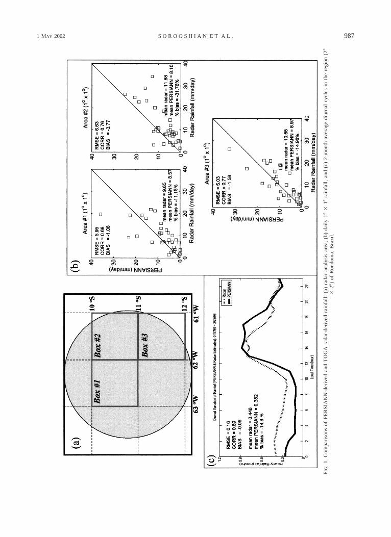
Because of the lack of independent observations oftropical rainfall data over such a large region, only lim-ited validation data are available to check the quality ofthe diurnal variations derived from the PERSIANN data.The high-resolution (approximately 15 min and 2 km)rainfall estimates at Rondonia, Brazil, from the TOGAradar during 7 January–28 February 1999, were usedto evaluate the PERSIANN daily rainfall and PER-SIANN-derived diurnal cycle. According to the previ-ous studies of Negri et al. (2002) and Anagnostou andMorales (2002), the radar data provide reliable hourlyrainfall estimates for three 18 3 18 boxes, as shown inFig. 1a. In Fig. 1b, the correlation (CORR) between thetwo datasets for the three boxes ranges from 0.68 to0.77, with root-mean-square error (rmse) around 5.0–6.6 mm day21 and bias from 23.7 to 21.07 mm day21
(underestimated).In Fig. 1c, the 2-month mean diurnal cycles over the
3 boxes derived from the radar and PERSIANN rainfalldata are plotted. In general, the PERSIANN estimate(similar to Fig. 10 of Anagnostou et al. 1999) capturesthe shape of the diurnal variability, but the maximumrainfall exhibits a delay of 1 h and a 2-h extension ofhigh rainfall duration probably due to contamination byvery cold anvil cirrus clouds. In comparison to the radarestimates, PERSIANN rainfall also exhibits about 0.2mm h21 underestimation of rainfall intensity during thelate night and morning (0200–1100) and about 0.3 mmh21 overestimation during the afternoon and nighttime(1400–1900). Again, the afternoon overestimate is like-ly due to contamination by anvil cirrus clouds, and theunderestimates during the late night and morning areprobably due to weak and warmer-topped convectivetowers producing rainfall. Negri et al. (2002) presentedsomewhat similar results for their comparison of theestimates from the convective-stratiform technique(CST)/TMI satellite technique (Adler and Negri 1988;Negri et al. 2002). The CST/TMI data better capture thediurnal peak of rainfall over the Amazon region, but
performance statistics for CST/TMI and PERSIANN fordaily rain rate are very similar.
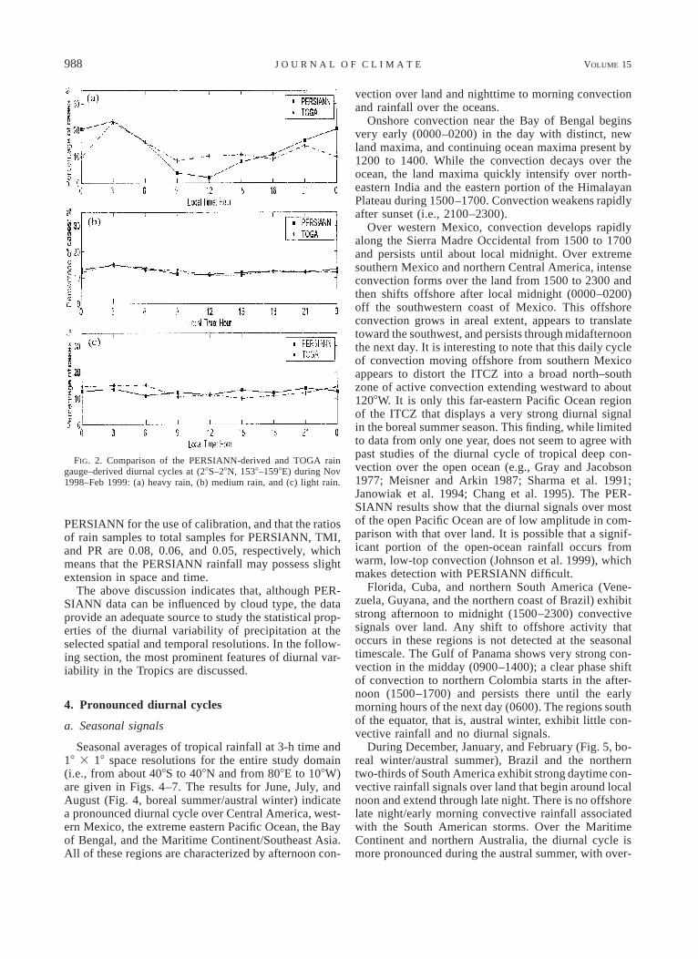
Janowiak et al. (1994) derived diurnal cycles of trop-ical rainfall using data from optical rain gauges mountedon the TOGA-moored buoys over the western PacificOcean. The rainfall data from five optical rain gaugesduring November 1992–February 1993 were dividedinto three categories according to the rain amounts inthe 3-h intervals (light: 1–3 mm, medium: 4–44 mm,and heavy .44 mm) and plotted accordingly as threediurnal cycles (see Figs. 2 and 10 in their paper for thegauge locations and the diurnal cycles). In Fig. 2 (thispaper), similar diurnal cycles of tropical rainfall are de-rived from the PERSIANN estimates during the samemonths (but for a different year) over the same sites(28S–28N, 1538–1598E). The diurnal curves from PER-SIANN and TOGA gauge data show the same peakrainfall at 0300 and low rainfall occurrence at 0900–1200 for heavy and medium rainfall. However, the PER-SIANN value at 0000 is larger than the TOGA gaugevalue, and the values at 0900–1200 are smaller. Al-though rainfall in different years may cause the differ-ence, Janowiak et al. (1994) also noted that the absoluterainfall amounts from the optical gauges might includesignificant errors. In general, Fig. 2 indicates that thephases of the diurnal cycle over the open ocean derivedfrom PERSIANN and Janowiak et al. (1994) match well.
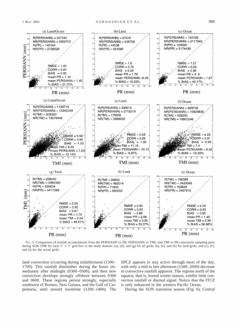
In this study, the diurnal patterns of tropical rainfallare presented with monthly (or seasonal) means of hour-ly (or 3 hourly) rain rates at 18 3 18 grid resolution. Toevaluate the quality of these rain rates, the monthly (orseasonal) accumulations of TMI and PR rain rates (2A12and 2A25) at each grid are compared with the accu-mulation of concurrent PERSIANN 30-min, 0.258 30.258 rainfall estimates. The scatterplots of PERSIANNversus PR, PERSIANN versus TMI, and PR versus TMIrain accumulations during September, October, and No-vember (SON) of 1998 for all grids, for land grids, andfor ocean grids are plotted in Fig. 3. In the figure, thedata statistics—mean, rmse, correlation, and bias—arepresented on the lower-right corner of each panel, andthe numbers for the concurrent Rain (R) and No-Rain(NR) samples at half-hourly and 0.258 3 0.258 reso-lutions are presented on the upper-left corner. The scat-terplots for other months are very similar and are notshown. In Fig. 3, the statistics indicate 1) the three rain-fall datasets (PERSIANN, TMI, and PR) are highly cor-related to each other, and because PERSIANN is trainedby TMI, its correlation to TMI (0.90) is higher than toPR (0.81); 2) in comparing the rain rates of these data,TMI overestimates PERSIANN, and PERSIANN over-estimates PR (with positive bias); and 3) the mean rainrate over ocean is less than that over land; therefore,the relative bias of rainfall over ocean is larger thanover land, but the corrections of the ocean rainfall be-tween the datasets are consistently greater than the cor-rections over land. The sample data show that TMI canprovide concurrent data, five times as many as PR, to
1 MAY 2002 987S O R O O S H I A N E T A L .
FIG
.1.
Com
pari
sons
ofP
ER
SIA
NN
-der
ived
and
TO
GA
rada
r-de
rive
dra
infa
ll:
(a)
rada
ran
alys
isar
ea,
(b)
dail
y18
318
rain
fall
,an
d(c
)2-
mon
thav
erag
edi
urna
lcy
cles
inth
ere
gion
(28
328
)of
Ron
doni
a,B
razi
l.
988 VOLUME 15J O U R N A L O F C L I M A T E
FIG. 2. Comparison of the PERSIANN-derived and TOGA raingauge–derived diurnal cycles at (28S–28N, 1538–1598E) during Nov1998–Feb 1999: (a) heavy rain, (b) medium rain, and (c) light rain.
PERSIANN for the use of calibration, and that the ratiosof rain samples to total samples for PERSIANN, TMI,and PR are 0.08, 0.06, and 0.05, respectively, whichmeans that the PERSIANN rainfall may possess slightextension in space and time.
The above discussion indicates that, although PER-SIANN data can be influenced by cloud type, the dataprovide an adequate source to study the statistical prop-erties of the diurnal variability of precipitation at theselected spatial and temporal resolutions. In the follow-ing section, the most prominent features of diurnal var-iability in the Tropics are discussed.
4. Pronounced diurnal cycles
a. Seasonal signals
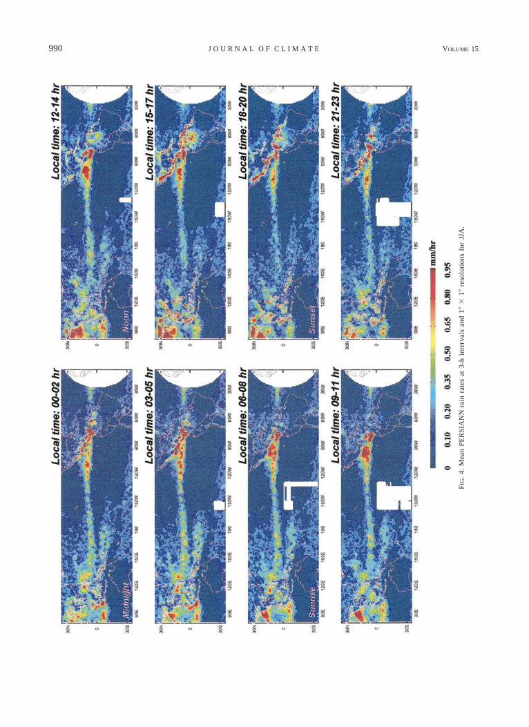
Seasonal averages of tropical rainfall at 3-h time and18 3 18 space resolutions for the entire study domain(i.e., from about 408S to 408N and from 808E to 108W)are given in Figs. 4–7. The results for June, July, andAugust (Fig. 4, boreal summer/austral winter) indicatea pronounced diurnal cycle over Central America, west-ern Mexico, the extreme eastern Pacific Ocean, the Bayof Bengal, and the Maritime Continent/Southeast Asia.All of these regions are characterized by afternoon con-
vection over land and nighttime to morning convectionand rainfall over the oceans.
Onshore convection near the Bay of Bengal beginsvery early (0000–0200) in the day with distinct, newland maxima, and continuing ocean maxima present by1200 to 1400. While the convection decays over theocean, the land maxima quickly intensify over north-eastern India and the eastern portion of the HimalayanPlateau during 1500–1700. Convection weakens rapidlyafter sunset (i.e., 2100–2300).
Over western Mexico, convection develops rapidlyalong the Sierra Madre Occidental from 1500 to 1700and persists until about local midnight. Over extremesouthern Mexico and northern Central America, intenseconvection forms over the land from 1500 to 2300 andthen shifts offshore after local midnight (0000–0200)off the southwestern coast of Mexico. This offshoreconvection grows in areal extent, appears to translatetoward the southwest, and persists through midafternoonthe next day. It is interesting to note that this daily cycleof convection moving offshore from southern Mexicoappears to distort the ITCZ into a broad north–southzone of active convection extending westward to about1208W. It is only this far-eastern Pacific Ocean regionof the ITCZ that displays a very strong diurnal signalin the boreal summer season. This finding, while limitedto data from only one year, does not seem to agree withpast studies of the diurnal cycle of tropical deep con-vection over the open ocean (e.g., Gray and Jacobson1977; Meisner and Arkin 1987; Sharma et al. 1991;Janowiak et al. 1994; Chang et al. 1995). The PER-SIANN results show that the diurnal signals over mostof the open Pacific Ocean are of low amplitude in com-parison with that over land. It is possible that a signif-icant portion of the open-ocean rainfall occurs fromwarm, low-top convection (Johnson et al. 1999), whichmakes detection with PERSIANN difficult.
Florida, Cuba, and northern South America (Vene-zuela, Guyana, and the northern coast of Brazil) exhibitstrong afternoon to midnight (1500–2300) convectivesignals over land. Any shift to offshore activity thatoccurs in these regions is not detected at the seasonaltimescale. The Gulf of Panama shows very strong con-vection in the midday (0900–1400); a clear phase shiftof convection to northern Colombia starts in the after-noon (1500–1700) and persists there until the earlymorning hours of the next day (0600). The regions southof the equator, that is, austral winter, exhibit little con-vective rainfall and no diurnal signals.
During December, January, and February (Fig. 5, bo-real winter/austral summer), Brazil and the northerntwo-thirds of South America exhibit strong daytime con-vective rainfall signals over land that begin around localnoon and extend through late night. There is no offshorelate night/early morning convective rainfall associatedwith the South American storms. Over the MaritimeContinent and northern Australia, the diurnal cycle ismore pronounced during the austral summer, with over-
1 MAY 2002 989S O R O O S H I A N E T A L .
FIG. 3. Comparison of rainfall accumulations from the PERSIANN vs PR, PERSIANN vs TMI, and TMI vs PR concurrent sampling pairsduring SON 1998 for each 18 3 18 grid box in the study domain: (a), (d), and (g) for all grids; (b), (e), and (h) for land grids; and (c), (f ),and (i) for the ocean grids.
land convection occurring during midafternoon (1500–1700). This rainfall diminishes during the hours im-mediately after midnight (0300–0500), and then newconvection develops strongly offshore between 0300and 0600. These regions persist strongly, especiallysouthwest of Borneo, New Guinea, and the Gulf of Car-pentaria, until around noontime (1200–1400). The
SPCZ appears to stay active through most of the day,with only a mid to late afternoon (1500–2000) decreasein convective rainfall apparent. The regions north of theequator, that is, boreal winter season, exhibit little con-vective rainfall or diurnal signal. Notice that the ITCZis only enhanced in the western Pacific Ocean.
During the SON transition season (Fig. 6), Central
990 VOLUME 15J O U R N A L O F C L I M A T E
FIG
.4.
Mea
nP
ER
SIA
NN
rain
rate
sat
3-h
inte
rval
san
d18
318
reso
luti
ons
for
JJA
.
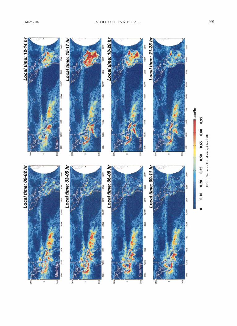
1 MAY 2002 991S O R O O S H I A N E T A L .
FIG
.5.
Sam
eas
Fig
.4
exce
ptfo
rD
JF.
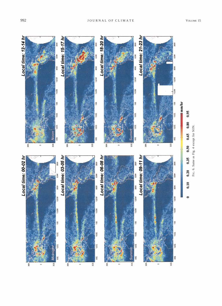
992 VOLUME 15J O U R N A L O F C L I M A T E
FIG
.6.
Sam
eas
Fig
.4
exce
ptfo
rS
ON
.
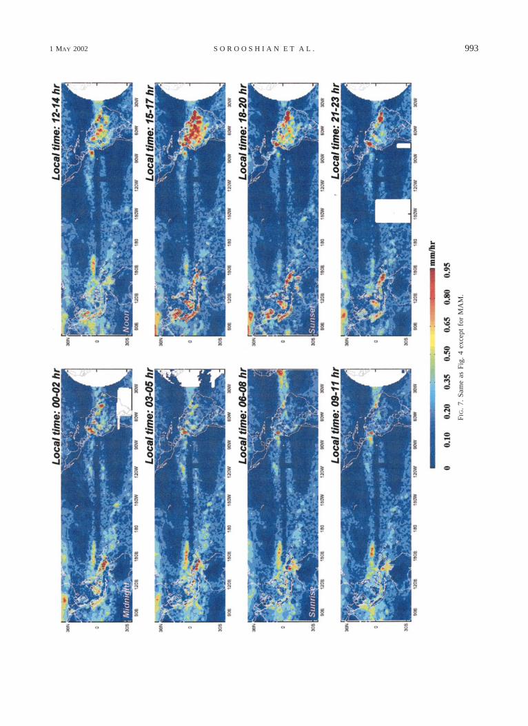
1 MAY 2002 993S O R O O S H I A N E T A L .
FIG
.7.
Sam
eas
Fig
.4
exce
ptfo
rM
AM
.
994 VOLUME 15J O U R N A L O F C L I M A T E
America, northern South America, and the MaritimeContinent exhibit weaker but similar diurnal cycles ofconvective rainfall when compared to their summer sea-sons. The Pacific ITCZ, from 1508W to 1808, appearsto experience enhanced convective rainfall during mostof the day, but with an afternoon period of minimumactivity from about 1500 to 2000. This characteristic ofconvective rainfall in a portion of the ITCZ is quitesimilar to the austral summer character of rainfall withinthe SPCZ.
During the March, April, and May transition season(Fig. 7), the diurnal cycle remains quite pronouncedaround the equator, with midafternoon to near-midnightmaxima occurring over the northern third of SouthAmerica. The overland, afternoon–evening componentof convection remains active over the Maritime Con-tinent, but the early morning shift to oceanic convectionis most distinct southwest of New Guinea and the Gulfof Carpentaria of Australia. There is also an indicationof a very localized nocturnal maximum from midnightto about 0800 over the Strait of Malacca between Ma-laysia and Sumatra. Convective rainfall appears to or-ganize routinely over Venezuela and northern Columbiaduring midafternoon to near midnight (0000–0200), andit translates toward the west, shifting offshore into theocean during midmorning the next day and remainingdistinct over the ocean until late afternoon (1500–1700).Interestingly, there is a distinct region of late-afternoonand nighttime convective rainfall apparent over Chinanortheast of the Himalaya, which weakens after 0300LST. There is a very distinct double ITCZ stretchingacross the entire tropical Pacific Ocean through this sea-son. The northern ITCZ, from 1408 to 1708E, stays quiteactive through most of the day, but with a distinct min-imum occurring from 1800 to local midnight, somewhatsimilar to the behavior observed over the central PacificITCZ during the other transition season.
b. Regional analyses
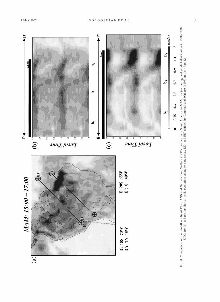
1) AMAZON
To compare with the study of Garreaud and Wallace(1997), a PERSIANN rainfall map for the period 1500–1700 LST over Amazon during MAM is shown in Fig.8a. As the patterns described in Garreaud and Wallace(1997), several parallel convection bands oriented fromnorthwest to southeast are apparent in the figure. Thefour bands defined from the Andes Mountains (b1) tothe northeastern coast of the Atlantic Ocean (b4) occurat the same locations and lengths as shown in Garreaudand Wallace (see their Fig. 3). The diurnal evolution ofconvection during MAM along two transects (DD9 andEE9) are presented in Figs. 8b–c. The patterns in timeand space along the transects are very similar to Fig.12 of Garreaud and Wallace (1997), which indicate that
1) over the western Atlantic Ocean, weak convectionsoccurred during much of the day (Fig. 8b);
2) just inland from the Atlantic coast, a strong convec-tive band (b4) occurs in the afternoon with a max-imum at 1700. This band appears to propagate to thesouthwest (Fig. 8b); and
3) convective bands b2 and b3 (Figs. 8b–c) are stronglylinked to afternoon heating, maximizing from 1600to 1800.
2) MEXICO
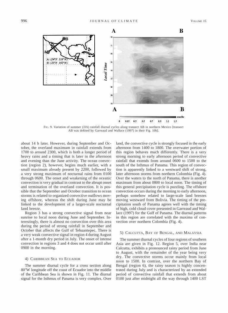
The diurnal cycle of PERSIANN-retrieved summerconvective rainfall is presented in Fig. 9 as a local timecross section from west-southwest of Baja California tothe western portion of the U.S. southern plains (see Fig.10b of Garreaud and Wallace 1997). The diurnal ac-cumulations were computed for 18 3 18 boxes and hour-ly, giving much improved time and space resolutionrelative to the large-area seasonal plots discussed above.Over Sonora, Mexico, the area of active convection dur-ing the summer months is quite distinct, with little rain-fall to the northeast (B) and almost none to the southwest(A). This illustrates the very focused character of theMexican monsoon (Adams and Comrie 1997; Douglaset al. 1993; Negri et al. 1993). The diurnal signal forthis region is very strong, with the vast majority ofconvective rainfall occurring from 1400 to 2200 duringthe afternoon and evening. There is no convective rain-fall detected over the nearby eastern Pacific Ocean. Ac-cording to Fig. 4, the only offshore shift of diurnalconvection into the open Pacific Ocean occurs along thecoasts of extreme southern Mexico and northern CentralAmerica.
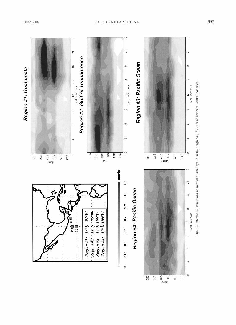
3) NORTHERN CENTRAL AMERICA
Plots of the overland and offshore diurnal cycles dur-ing the year are shown in Fig. 10 for northern CentralAmerica, that is, Guatemala (region 1), the Gulf of Te-huantepec (region 2), and over the Pacific Ocean southof Mexico (regions 3 and 4). Hourly average regionalprecipitation data (the regions’ extents are 18 3 18) foreach month of the year are displayed in this figure. Theseregional plots also have higher time resolution than thelarge-area seasonal analyses (i.e., Figs. 4–7). Over Gua-temala (region 1), the onset of the summer rainy seasonis very abrupt, with almost no precipitation occurringduring May and very heavy afternoon and evening rainsoccurring during June. The well-known dry period ofJuly and August (e.g., Hastenrath 1967) is well repre-sented in the PERSIANN analyses, followed by the re-newed heavy rains of September and October. The con-vective rains shift offshore into region 2 during bothrainy periods. However, the time lags between maxi-mum convection over land versus maximum convectionover ocean are considerably different. During June, theoverland maximum occurs from 1700 to 1800, but themaximum rainfall over ocean does not occur until 0800,
1 MAY 2002 995S O R O O S H I A N E T A L .
FIG
.8.
Com
pari
son
ofth
era
infa
llre
sult
sof
PE
RS
IAN
Nan
dG
arre
aud
and
Wal
lace
(199
7)ov
erno
rthe
rnS
outh
Am
eric
ain
MA
M,
for
(a)
the
regi
onal
rain
fall
dist
ribu
tion
in15
00–1
700
UT
C,
for
(b)
and
(c)
the
diur
nal
cycl
eev
olut
ions
alon
gtw
otr
anse
cts,
DD
9an
dE
E9
defi
ned
byG
arre
aud
and
Wal
lace
(199
7)in
thei
rF
ig.
12.
996 VOLUME 15J O U R N A L O F C L I M A T E
FIG. 9. Variation of summer (JJA) rainfall diurnal cycles along transect AB in northern Mexico [transectAB was defined by Garreaud and Wallace (1997) in their Fig. 10b].
about 14 h later. However, during September and Oc-tober, the overland maximum in rainfall extends from1700 to around 2300, which is both a longer period ofheavy rains and a timing that is later in the afternoonand evening than the June activity. The ocean convec-tion (region 2), however, begins much earlier, with asmall maximum already present by 2200, followed bya very strong maximum of nocturnal rains from 0100through 0600. The onset and weakening of the oceanicconvection is very gradual in contrast to the abrupt onsetand termination of the overland convection. It is pos-sible that the September and October transition to oceanstorms is related to organized convective outflows mov-ing offshore, whereas the shift during June may belinked to the development of a larger-scale nocturnalland breeze.
Region 3 has a strong convective signal from nearsunrise to local noon during June and September. In-terestingly, there is almost no convection over this areaduring the period of strong rainfall in September andOctober that affects the Gulf of Tehuantepec. There isa very weak convective signal in region 4 during Augustafter a 1-month dry period in July. The onset of intenseconvection in regions 3 and 4 does not occur until after0900 in the morning.
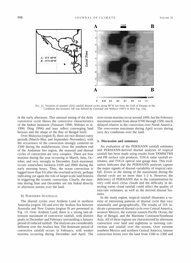
4) CARIBBEAN SEA TO ECUADOR
The summer diurnal cycle for a cross section along808W longitude off the coast of Ecuador into the middleof the Caribbean Sea is shown in Fig. 11. The diurnalsignal for the Isthmus of Panama is very complex. Over
land, the convective cycle is strongly focused in the earlyafternoon from 1400 to 1800. The overwater portion ofthis region behaves much differently. There is a verystrong morning to early afternoon period of convectiverainfall that extends from around 0600 to 1500 to thesouth of the Isthmus of Panama. This region of convec-tion is apparently linked to a westward shift of strong,later afternoon storms from northern Colombia (Fig. 4).Over the waters to the north of Panama, there is anothermaximum from about 0800 to local noon. The timing ofthis general precipitation cycle is puzzling. The offshoreconvection occurs during the morning to early afternoon,perhaps somehow related to large-scale land breezesmoving westward from Bolivia. The timing of the pre-cipitation south of Panama agrees well with the timingof high, cold cloud cover presented in Garreaud and Wal-lace (1997) for the Gulf of Panama. The diurnal patternsin this region are correlated with the maxima of con-vection over northern Colombia (Fig. 4).
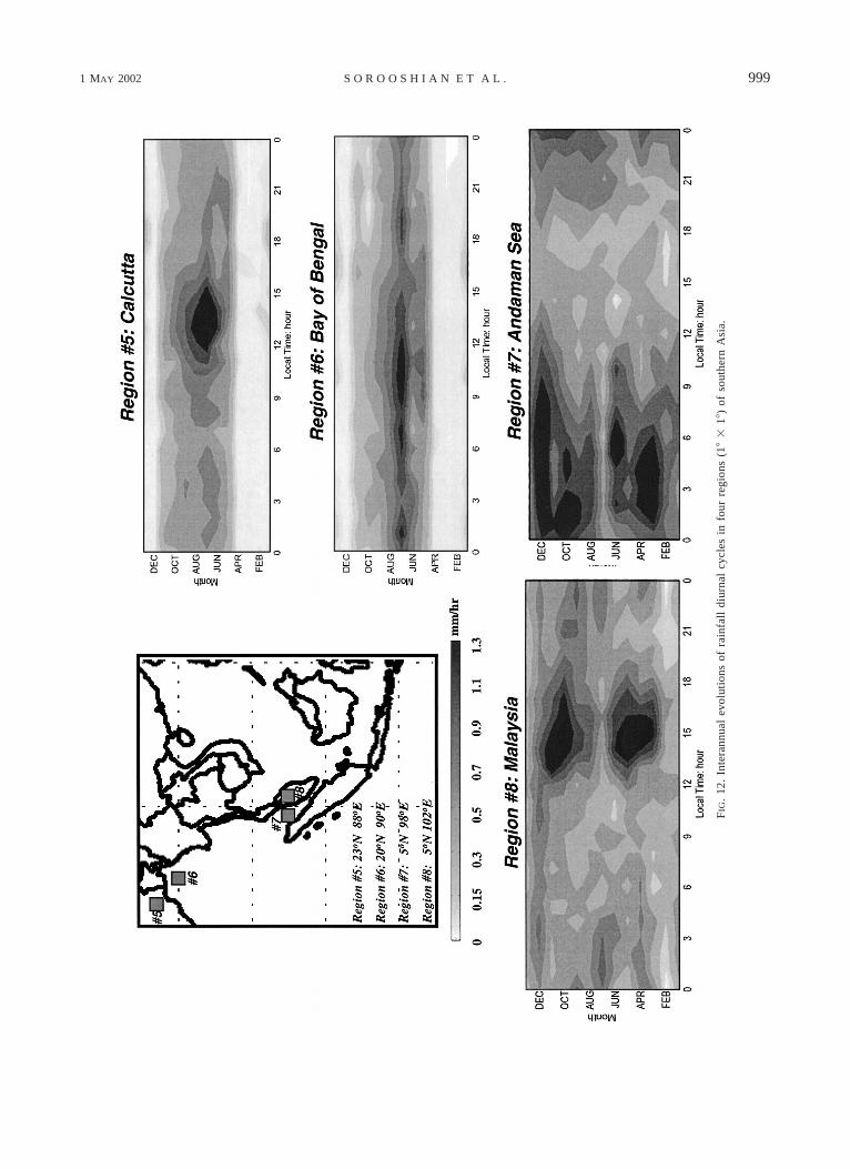
5) CALCUTTA, BAY OF BENGAL, AND MALAYSIA
The summer diurnal cycles of four regions of southernAsia are given in Fig. 12. Region 5, over India nearCalcutta, exhibits a pronounced rainy period from Juneto August, with the remainder of the year being verydry. The convective storms occur mainly from localnoon to 1500. In contrast, over the northern Bay ofBengal (region 6), the rainy season is highly concen-trated during July and is characterized by an extendedperiod of convective rainfall that extends from about0100 just after midnight all the way through 1400 LST
1 MAY 2002 997S O R O O S H I A N E T A L .
FIG
.10
.In
tera
nnua
lev
olut
ions
ofra
infa
lldi
urna
lcy
cles
info
urre
gion
s(1
83
18)
ofno
rthe
rnC
entr
alA
mer
ica.
998 VOLUME 15J O U R N A L O F C L I M A T E
FIG. 11. Variation of summer (JJA) rainfall diurnal cycles along 808W lon from the Gulf of Panama to theCaribbean Sea [transect AB was defined by Garreaud and Wallace (1997) in their Fig. 13a].
in the early afternoon. This unusual timing of the dailyconvective cycle shows the convective characteristicsof the Indian monsoon (Yasunari 1990; Webster et al.1996; Ding 1994) and may reflect converging landbreezes and the shape of the Bay of Bengal itself.
Over Malaysia (region 8), there are two distinct rainyperiods (March–May and September–November), withthe occurrence of the convection strongly centered on1500 during the midafternoon. Over the southern endof the Andaman Sea region, the seasonal and diurnalcycles of convection are very complex. There are fourmaxima during the year occurring in March, June, Oc-tober, and very strongly in December. Each maximumoccurs somewhere between 0100 and 0900 during theearly morning hours. Thus, the ocean convection islagged more than 9 h after the overland activity, perhapsindicating yet again the role of larger-scale land breezesin triggering the oceanic convection. Clearly, the max-ima during June and December are not linked directlyto afternoon storms over the land.
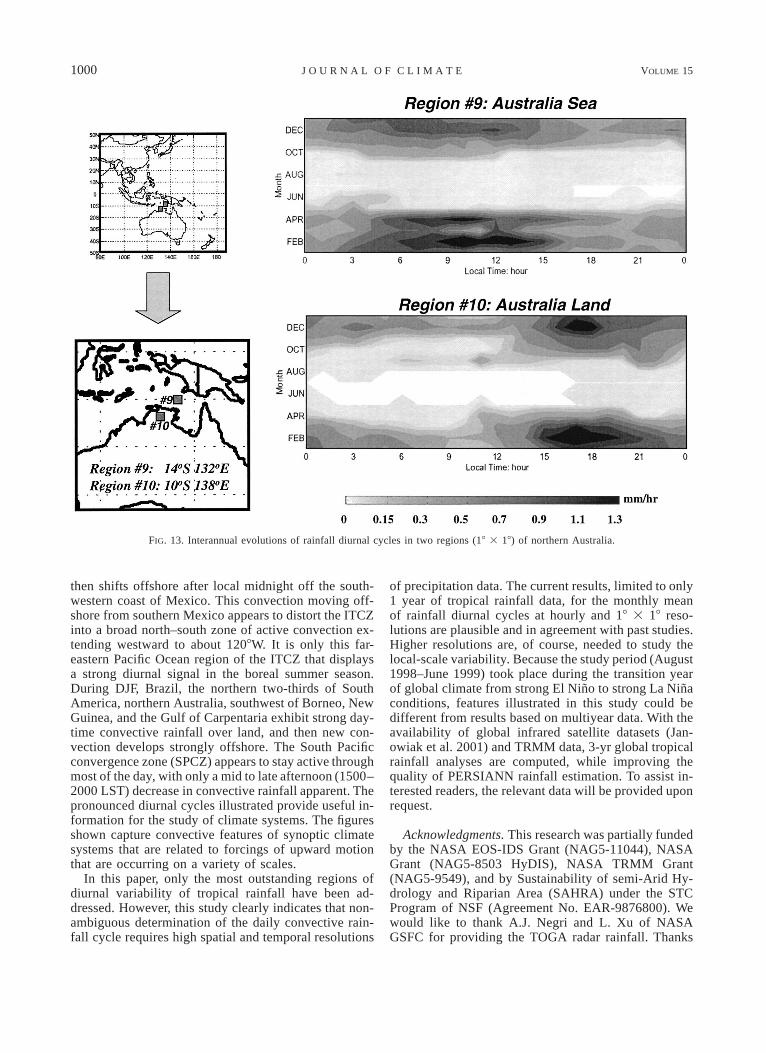
6) NORTHERN AUSTRALIA
The diurnal cycles over Arnhem Land in northernAustralia (region 10) and over the Arafura Sea betweenAustralia and New Guinea (region 9) are presented inFig. 13. Over Arnhem Land, there is a strong late-af-ternoon maximum of convective rainfall, with distinctpeaks in December and February surrounding a Januaryperiod of reduced rainfall. The analyses are considerablydifferent over the Arafura Sea. The dominant period ofconvective rainfall occurs in February, with weakermaxima occurring during December and April. The
over-ocean maxima occur around 1000, but the Februarymaximum extends from about 0700 through 1500, muchdelayed relative to the convection over North America.The over-ocean maximum during April occurs duringvery dry conditions over the land.
5. Discussion and summary
An evaluation of the PERSIANN rainfall estimatesand PERSIANN-derived diurnal analyses of tropicalrainfall has been made using results from TRMM/TMIand PR surface rain products, TOGA radar rainfall es-timates, and TOGA optical rain gauge data. This eval-uation indicates that the PERSIANN analyses capturethe major signals of diurnal variability of tropical rain-fall. Errors in the timing of the maximums during thediurnal cycle are no more than 1–2 h. However, thedeficiency of PERSIANN due to the contamination byvery cold anvil cirrus clouds and the difficulty in de-tecting warm cloud rainfall could affect the quality ofrain-rate estimates, as well as the derived diurnal fea-tures.
In the study region, tropical rainfall illustrates a va-riety of interesting patterns of diurnal cycle that varyseasonally and geographically. The results of JJA in-dicate a pronounced diurnal cycle over Central America,western Mexico, the extreme eastern Pacific Ocean, theBay of Bengal, and the Maritime Continent/SoutheastAsia. All of these regions are characterized by afternoonconvection over land and nighttime to morning con-vection and rainfall over the oceans. Over extremesouthern Mexico and northern Central America, intenseconvection forms over the land from 1500 to 2300 and
1 MAY 2002 999S O R O O S H I A N E T A L .
FIG
.12
.In
tera
nnua
lev
olut
ions
ofra
infa
lldi
urna
lcy
cles
info
urre
gion
s(1
83
18)
ofso
uthe
rnA
sia.
1000 VOLUME 15J O U R N A L O F C L I M A T E
FIG. 13. Interannual evolutions of rainfall diurnal cycles in two regions (18 3 18) of northern Australia.
then shifts offshore after local midnight off the south-western coast of Mexico. This convection moving off-shore from southern Mexico appears to distort the ITCZinto a broad north–south zone of active convection ex-tending westward to about 1208W. It is only this far-eastern Pacific Ocean region of the ITCZ that displaysa strong diurnal signal in the boreal summer season.During DJF, Brazil, the northern two-thirds of SouthAmerica, northern Australia, southwest of Borneo, NewGuinea, and the Gulf of Carpentaria exhibit strong day-time convective rainfall over land, and then new con-vection develops strongly offshore. The South Pacificconvergence zone (SPCZ) appears to stay active throughmost of the day, with only a mid to late afternoon (1500–2000 LST) decrease in convective rainfall apparent. Thepronounced diurnal cycles illustrated provide useful in-formation for the study of climate systems. The figuresshown capture convective features of synoptic climatesystems that are related to forcings of upward motionthat are occurring on a variety of scales.
In this paper, only the most outstanding regions ofdiurnal variability of tropical rainfall have been ad-dressed. However, this study clearly indicates that non-ambiguous determination of the daily convective rain-fall cycle requires high spatial and temporal resolutions
of precipitation data. The current results, limited to only1 year of tropical rainfall data, for the monthly meanof rainfall diurnal cycles at hourly and 18 3 18 reso-lutions are plausible and in agreement with past studies.Higher resolutions are, of course, needed to study thelocal-scale variability. Because the study period (August1998–June 1999) took place during the transition yearof global climate from strong El Nino to strong La Ninaconditions, features illustrated in this study could bedifferent from results based on multiyear data. With theavailability of global infrared satellite datasets (Jan-owiak et al. 2001) and TRMM data, 3-yr global tropicalrainfall analyses are computed, while improving thequality of PERSIANN rainfall estimation. To assist in-terested readers, the relevant data will be provided uponrequest.
Acknowledgments. This research was partially fundedby the NASA EOS-IDS Grant (NAG5-11044), NASAGrant (NAG5-8503 HyDIS), NASA TRMM Grant(NAG5-9549), and by Sustainability of semi-Arid Hy-drology and Riparian Area (SAHRA) under the STCProgram of NSF (Agreement No. EAR-9876800). Wewould like to thank A.J. Negri and L. Xu of NASAGSFC for providing the TOGA radar rainfall. Thanks
1 MAY 2002 1001S O R O O S H I A N E T A L .
are also extended to Ms. Corrie Thies for her carefulreading and editing of the manuscript.
REFERENCES
Adams, D. K., and A. C. Comrie, 1997: The North American mon-soon. Bull. Amer. Meteor. Soc., 78, 2197–2213.
Adler, R. F., and A. J. Negri, 1988: A satellite infrared technique toestimate tropical convective and stratiform rainfall. J. Appl. Me-teor., 27, 30–51.
——, ——, P. R. Keehn, and I. M. Hakkarinen, 1993: Estimation ofmonthly rainfall over Japan and surrounding waters from a com-bination of low-orbit microwave and geosynchronous IR data.J. Appl. Meteor., 32, 335–356.
——, G. J. Huffman, and P. R. Keehn, 1994: Global rain estimatesfrom microwave adjusted geosynchronous IR data. Remote Sens.Rev., 11, 125–152.
Anagnostou, E. N., and C. Morales, 2002: Rainfall estimation fromTOGA radar observations during TRMM-LBA field campaign.J. Geophys. Res., in press.
——, A. J. Negri, and R. F. Adler, 1999: A satellite infrared techniquefor diurnal rainfall variability studies. J. Geophys. Res., 104(D24), 31 477–31 488.
Brier, G. W., 1965: Diurnal and semi-diurnal atmospheric tide inrelation to precipitation variations. Mon. Wea. Rev., 93, 93–100.
——, and J. Simpson, 1969: Tropical cloudiness and rainfall relatedto pressure and tidal variations. Quart. J. Roy. Meteor. Soc., 95,120–147.
Chang, A. T. C., L. S. Chiu, and G. Yang, 1995: Diurnal cycle ofoceanic precipitation from SSM/I data. Mon. Wea. Rev., 123,3371–3380.
Dai, A., 2001: Global precipitation and thunderstorm frequency. PartII: Diurnal variations. J. Climate, 14, 1112–1128.
——, F. Giorgi, and K. E. Trenberth, 1999: Observed and model-simulated diurnal cycles of precipitation over the contiguousUnited States. J. Geophys. Res., 104, (D6), 6377–6402.
Ding, Y., 1994: Monsoon over China. Kluwer Academic, 419 pp.Douglas, M. W., R. Maddox, K. Howard, and S. Reyes, 1993: The
Mexican monsoon. J. Climate, 6, 1665–1677.Garreaud, R. D., and J. M. Wallace, 1997: The diurnal march of
convective cloudiness over the Americas. Mon. Wea. Rev., 125,3157–3171.
Gray, W. M., and R. W. Jacobson, 1977: Diurnal variation of deepcumulus convection. Mon. Wea. Rev., 105, 104–188.
Hastenrath, S. L., 1967: Rainfall distribution and regime in CentralAmerica. Arch. Meteor. Geophys. Bioklimatol. Ser. B, 15, 201–241.
Hsu, K., X. Gao, S. Sorooshian, and H. V. Gupta, 1997: Precipitationestimation from remotely sensed information using artificial neu-ral networks. J. Appl. Meteor., 36, 1176–1190.
Janowiak, J. E., P. A. Arkin, and M. Morrissey, 1994: An examinationof the diurnal cycle in oceanic tropical rainfall using satelliteand in situ data. Mon. Wea. Rev., 122, 2296–2311.
——, R. J. Joyce, and Y. Yarosh, 2001: A real-time global half-hourly
pixel-resolution infrared dataset and its applications. Bull. Amer.Meteor. Soc., 82, 205–217.
Johnson, R. H., T. M. Rickenbach, S. A. Rutledge, P. E. Ciesielski,and W. H. Schubert, 1999: Trimodal characteristics of tropicalconvection. J. Climate, 12, 2397–2418.
Kraus, E. B., 1963: The diurnal precipitation change over the sea. J.Atmos. Sci., 20, 546–551.
Mapes, B. E., and R. A. Houze Jr., 1993: Cloud clusters and super-clusters over the oceanic warm pool. Mon. Wea. Rev., 121, 1398–1415.
Meisner, B., and P. Arkin, 1987: Spatial and annual variations in thediurnal cycle of large-scale tropical convective cloudiness andprecipitation. Mon. Wea. Rev., 115, 2009–2032.
Negri, A. J., R. F. Adler, R. A. Maddox, K. W. Howard, and P. R.Keehn, 1993: A regional rainfall climatology over Mexico andthe southwest United States derived from passive microwaveand geosynchronous infrared data. J. Climate, 6, 2144–2161.
——, ——, E. Nelkin, and G. Huffman, 1994: Regional rainfall cli-matologies derived from Special Sensor Microwave Imager(SSM/I) data. Bull. Amer. Meteor. Soc., 75, 1165–1182.
——, E. N. Anagnostou, and R. F. Adler, 2000: A 10-year climatologyof Amazonian rainfall derived from passive microve satelliteobservations. J. Appl. Meteor., 39, 42–56.
——, L. Xu, and R. F. Adler, 2002: A TRMM-calibrated infraredrainfall algorithm applied over Brazil. J. Geophys. Res., in press.
Randall, D. A., Harshvardhan, and D. A. Dazlich, 1991: Diurnalvariability of the hydrologic cycle in a general circulation model.J. Atmos. Sci., 48, 40–62.
Riehl, H., 1947: Diurnal variation of cloudiness over the subtropicalAtlantic Ocean. Bull. Amer. Meteor. Soc., 28, 37–40.
Sharma, A. K., A. T. C. Chang, and T. T. Wilheit, 1991: Estimationof the diurnal cycle of oceanic precipitation from SSM/I data.Mon. Wea. Rev., 119, 2168–2175.
Shin, K. S., G. R. North, Y. S. Ahn, and P. A. Arkin, 1990: Timescales and variability of area-average tropical oceanic rainfall.Mon. Wea. Rev., 118, 1507–1516.
Sorooshian, S., K. Hsu, X. Gao, H. V. Gupta, B. Imam, and D. Braith-waite, 2000: Evaluation of PERSIANN system satellite-basedestimates of tropical rainfall. Bull. Amer. Meteor. Soc., 81, 2035–2046.
Wallace, J. M., 1975: Diurnal variations in precipitation and thun-derstorm frequency over the conterminous United States. Mon.Wea. Rev., 103, 585–598.
Webster, P. J., C. A. Clayson, and J. A. Curry, 1996: Clouds, radiation,and the diurnal cycle of sea surface temperature in the tropicalwestern Pacific. J. Climate, 9, 1712–1730.
Xu, L., X. Gao, S. Sorooshian, P. A. Arkin, and B. Imam, 1999: Amicrowave infrared threshold technique to improve the GOESprecipitation index. J. Appl. Meteor., 38, 569–579.
——, ——, ——, and B. Imam, 2000: Parameter estimation of GOESprecipitation index at different calibration time scales. J. Geo-phys. Res., 105, 20 131–20 143.
Yasunari, T., 1990: The impact of the Indian monsoon on the coupledatmosphere/ocean system in the tropical Pacific. Meteor. Atmos.Phys., 44, 29–41.