DISTRICT PARK PLAN OF MANAGEMENT FINAL SEPTEMBER 2015 I · DISTRICT PARK PLAN OF MANAGEMENT –...
72
DISTRICT PARK PLAN OF MANAGEMENT – FINAL – SEPTEMBER 2015 I
Transcript of DISTRICT PARK PLAN OF MANAGEMENT FINAL SEPTEMBER 2015 I · DISTRICT PARK PLAN OF MANAGEMENT –...

DISTRICT PARK PLAN OF MANAGEMENT – FINAL – SEPTEMBER 2015 I

DISTRICT PARK PLAN OF MANAGEMENT – FINAL – SEPTEMBER 2015 II
1 INTRODUCTION ...................................................................1
1.1 What is a Plan of Management? ............................................................................... 1 1.2 About District Park .................................................................................................... 1 1.3 Background to preparation of this Plan of Management ............................................ 4 1.4 Changes to District Park since 2002 ......................................................................... 4 1.5 Objectives of this Plan of Management ..................................................................... 5 1.6 Process of preparing this Plan of Management ......................................................... 6 1.7 Contents of this Plan of Management ....................................................................... 6
2 DESCRIPTION OF DISTRICT PARK ...................................7
2.1 History of District Park .............................................................................................. 7 2.2 District Park today .................................................................................................... 8
3 BASIS FOR MANAGEMENT ...............................................13
3.1 Introduction ..............................................................................................................13 3.2 Trends in open space provision, planning, use and management ............................13 3.3 Planning context ......................................................................................................13 3.4 Values and roles of District Park ..............................................................................15 3.5 Vision for District Park .............................................................................................16
4 ACTION PLAN .....................................................................17
4.1 Landscape Concept Plan .........................................................................................17 4.2 Action Plan ..............................................................................................................18
5 IMPLEMENTATION .............................................................35
5.1 Governance .............................................................................................................35 5.2 Future uses and developments ................................................................................35 5.3 Use agreements ......................................................................................................38 5.4 Monitoring ................................................................................................................43 5.5 Reporting .................................................................................................................44 5.6 Review .....................................................................................................................44
6 REFERENCES ....................................................................45
Figures
FIGURE 1 LOCATION OF DISTRICT PARK ........................................................................................ 2 FIGURE 2 DISTRICT PARK ................................................................................................................. 3 FIGURE 3 MAP OF MANLY-WARRINGAH DISTRICT PARK 1936 .................................................... 7 FIGURE 4 OWNERSHIP OF LAND IN DISTRICT PARK ..................................................................... 9 FIGURE 5 PLANNING CONTEXT OF DISTRICT PARK ................................................................... 14 FIGURE 6 LANDSCAPE CONCEPT PLAN FOR DISTRICT PARK................................................... 19 FIGURE 7 LEASED/LICENSED AREAS IN DISTRICT PARK ........................................................... 39 FIGURE 8 CATEGORISATION OF DISTRICT PARK ........................................................................ 59

DISTRICT PARK PLAN OF MANAGEMENT – FINAL – SEPTEMBER 2015 III
Tables
TABLE 1 IMPROVEMENTS TO DISTRICT PARK 2002-2015............................................................... 4 TABLE 2 STRUCTURE OF THIS PLAN OF MANAGEMENT ................................................................ 6 TABLE 3 VALUES AND ROLES OF DISTRICT PARK ........................................................................ 15 TABLE 4 EXISTING USE AGREEMENTS ........................................................................................... 40 TABLE 5 AUTHORISED LEASES, LICENCES AND OTHER ESTATES ............................................ 41 TABLE 6 AUTHORISED USES FOR SHORT TERM CASUAL HIRE OF DISTRICT PARK ............... 43
Appendices
A LAND INCLUDED IN THIS PLAN OF MANAGEMENT ................................................................ 47 B PROCESS OF PREPARING THIS PLAN OF MANAGEMENT .................................................... 50 C HISTORY OF DISTRICT PARK .................................................................................................... 52 D CONDITION OF BUILDINGS IN DISTRICT PARK ....................................................................... 54 E TRENDS IN SPORT AND RECREATION .................................................................................... 56 F PLANNING CONTEXT .................................................................................................................. 58 G USE AGREEMENTS ..................................................................................................................... 66

DISTRICT PARK PLAN OF MANAGEMENT – FINAL – SEPTEMBER 2015 1
1 INTRODUCTION
1.1 What is a Plan of Management?
A Plan of Management provides the framework for managing public land. It sets out how public land is intended to be used, managed, maintained and improved.
A Plan of Management for a public open space is usually accompanied by a landscape plan which shows proposed spatial changes.
1.2 About District Park
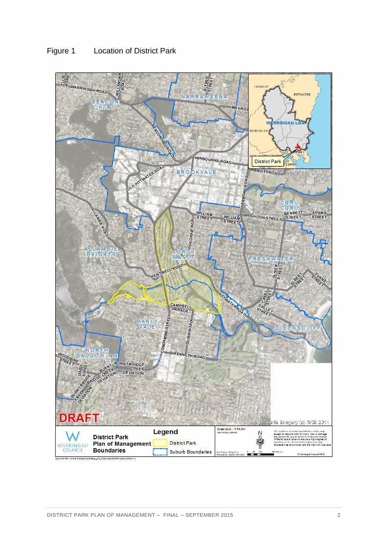
District Park is one of Warringah’s most significant open spaces. It is of regional significance because of its size, environmental values of natural bushland and creeks, and the diversity of sporting and other recreational opportunities it offers to the community.
District Park comprises approximately 62 hectares of public open space in Manly Vale and North Manly. The land parcels included in District Park are listed in Appendix A.
The majority of District Park is community land owned by Warringah Council, with the watercourses being Crown land.
District Park includes extensive areas of open space which are divided by heavily trafficked roads including Condamine Street and Pittwater Road. Key features of District Park include:
Four sportsgrounds (David Thomas Reserve, Miller Reserve, Passmore Reserve and
Nolan Reserve) with support facilities such as club buildings amenities buildings, flood
lighting and car parks.
Warringah Golf Course (18 holes)
Warringah Recreation Centre (tennis, squash, futsal courts)
Manly Small Bore Rifle Club rifle range
Christian Brothers Junior Rugby League Football Club building
North Manly Bowling and Recreation Club and bowling greens
Manly Vale Calabria Bowling Sports and Social Club, futsal courts and bowling greens
Childcare centre (120 places)
Playground and picnic/barbecue facilities
Skate park
Manly Creek and Brookvale Creek
Remnants of natural bushland.
The Park is well used by the Warringah community and visitors for a variety of sporting, recreational and social activities.
More detail about District Park is in Section 2.
DISTRICT PARK PLAN OF MANAGEMENT – FINAL – SEPTEMBER 2015 2
Location of District Park Figure 1

DISTRICT PARK PLAN OF MANAGEMENT – FINAL – SEPTEMBER 2015 3
District Park Figure 2

DISTRICT PARK PLAN OF MANAGEMENT – FINAL – SEPTEMBER 2015 4
1.3 Background to preparation of this Plan of Management
Plans of Management for District Park were adopted by Warringah Council in November 1995 and April 2002. As the current Plan of Management was more than 10 years old, and as several leases of land and facilities in the Park had or were about to expire, Warringah Council took the opportunity to review and update the 2002 District Park Plan of Management. Council resolved, in part, on 11 December 2012 to:
Give priority to commencing the review of the District Park Plan of Management (as listed in the 2012 Strategic Community Plan), and ensure it is brought back to Council for adoption no later than December 2015.
This is the third Plan of Management which has been prepared for District Park.
A Plan of Management is required to be prepared for land classified as community land under the Local Government Act 1993. As District Park also includes Crown land, this Plan also satisfies the requirements of the Crown Lands Act 1989.
1.4 Changes to District Park since 2002
Numerous capital and operational improvements have been made to District Park since 2002.
Table 1 Improvements to District Park 2002-2015
Outcome1 Location Improvement
Vibrant Community
David Thomas Reserve
- New childcare centre established on the site of the former Mackellar Womens Bowling Club
Lifestyle and Recreation
David Thomas Reserve
- New amenities building - New sportsfield lighting - New irrigation
Miller Reserve - Skate park facility - Graffiti wall - New sportsfield lighting - New accessible amenities
Nolan Reserve - New sports field lighting
Passmore Reserve - New playground public toilets - Renewed sportsfield public amenities - Graffiti wall
Small-bore rifle range - Continuation of lease to Manly Small-Bore Rifle Club
Warringah Golf Course - Continuation of lease to Warringah Golf Club
Warringah Recreation Centre
- Warringah Council assumed management in 2012 - Replacement of some tennis courts with futsal courts - Various improvements to buildings and structures
Manly Vale Calabria Bowling Sports and Social Club
- Improvements to clubhouse - Replacement of some bowling greens with futsal courts

DISTRICT PARK PLAN OF MANAGEMENT – FINAL – SEPTEMBER 2015 5
Outcome1 Location Improvement
Healthy Environment
Whole park - Rationalisation of application of fertiliser, herbicide and pesticide use
- Event organisers required to submit a waste management plan with event application as required
Creeks - Rehabilitation works for Brookvale Creek - Implemented actions of Manly Lagoon Estuary - Management Plan 1998 - Sediment/gross pollutant racks monitored and
maintained every three months and following heavy rain events
- Reduction in weeds along creeks
Remnant bushland - Protection of biodiversity and improvements in bushland condition through on-going bush regeneration works
- Promotion of community weed disposal practices /dumping of garden refuse
- Community involvement in bush regeneration - Management of bush fire hazards in accordance with
the Warringah Pittwater Bush Fire Risk Management Plan 2010
Connected Transport
David Thomas Reserve
- New parking spaces for people with disabilities
Nolan Reserve - Shared walking/cycling path on southern and western sides
- Path between Nolan Reserve and Riverview Parade
1 Outcomes defined in the Warringah Community Strategic Plan 2023
1.5 Objectives of this Plan of Management
The objectives of this Plan of Management are to:
present a clear, concise, practical and performance-oriented framework for the
management of District Park to Council, park users and the community.
set out how District Park will be used, improved, maintained and managed into the
future.
establish a balanced and values-based approach to the management of the Park.
provide a flexible framework within which Council can respond to current needs and
opportunities, as well as to future directions and pressures as demands on the Park
change.
reflect the values and expectations of the Warringah and wider community and people
who will use and enjoy the Park.
meet all relevant legislative requirements, particularly the Local Government Act 1993
and Crown Lands Act 1989.
address the recommendations of State, metropolitan, regional and local strategic plans
and studies on needs and demands for sporting, recreation and community facilities.
be consistent with Warringah’s Community Strategic Plan and other strategies, plans
and policies.
present a landscape concept plan (LCP) which illustrates the actions required to
implement proposed physical changes and improvements to the Park.
DISTRICT PARK PLAN OF MANAGEMENT – FINAL – SEPTEMBER 2015 6
allow for entering into commercial and community use agreements which are consistent
with the objectives and principles of the Local Government Act 1993 and Crown Lands
Act 1989.
1.6 Process of preparing this Plan of Management
The process of preparing this Plan of Management was based on comprehensive community and stakeholder engagement to:
ensure the plan reflects the vision, values, desired uses and concerns of interested
people. Feedback from the community and stakeholders has been carefully considered
and has formed the actions recommended in this Plan.
satisfy the community engagement requirements of relevant legislation.
The process and outputs of preparing this Plan of Management are listed in Appendix B.
1.7 Contents of this Plan of Management This Plan of Management is divided into the following sections, as outlined in Table 2.
Table 2 Structure of this Plan of Management
Section What does it include?
1 Introduction Background to the Plan of Management
2 Description of District Park
History, ownership and management, facilities, uses, physical description, maintenance, financial management
3 Planning context State government planning legislation, regional and local planning context
4 Basis for Management
Values of the community and users, vision, roles, management objectives
5 Action Plan Landscape concept plan, discussion of current issues and options, strategies and actions to resolve issues consistent with values.
6 Implementation and review
Management, permitted future uses and developments, leases and licences, funding, reporting, review

DISTRICT PARK PLAN OF MANAGEMENT – FINAL – SEPTEMBER 2015 7
2 DESCRIPTION OF DISTRICT PARK
2.1 History of District Park
The origin of District Park can be traced back nearly 100 years, as outlined in Appendix C.
The development of District Park is characterised by:
co-operation between Manly and Warringah Councils, both of which contributed
financially to support the development of the park
extensive reclamation, levelling, earthworks, grassing and vegetation plantings since a
strategic plan was prepared for the park in 1936 (refer to Figure 3)
provision for diverse sporting activities and uses
use of community skills in establishing and managing the park.
Map of Manly-Warringah District Park 1936 Figure 3

DISTRICT PARK PLAN OF MANAGEMENT – FINAL – SEPTEMBER 2015 8
2.2 District Park today
2.2.1 Ownership of District Park
Figure 4 and Appendix A show the land parcels included in District Park. Most of District Park is comprised of community land owned by Warringah Council. The original beds of Brookvale and Manly Creeks are Crown land which forms part of Reserve 56146 which is reserved from sale or lease.
A road reserve forms part of Nolan Reserve.
Part of David Thomas Reserve (71/8 Lot 2 DP 819059) does not show any Trusts or Covenants.

DISTRICT PARK PLAN OF MANAGEMENT – FINAL – SEPTEMBER 2015 9
Ownership of land in District Park Figure 4

DISTRICT PARK PLAN OF MANAGEMENT – FINAL – SEPTEMBER 2015 10
2.2.2 District Park at a glance
Feature Details
Location Manly Vale and North Manly
Bounded by Pittwater Road (partially), Campbell Parade, Condamine Street (partially), and dissected by both Kentwell Road and Sloane Crescent.
Adjacent land uses
Warringah Mall, Brookvale Industrial Area, and residential to the north
Manly Lagoon and residential to the east
Manly Warringah War Memorial Park (Manly Dam) to the west
Light industrial estates, Mackellar Girls High School, residential apartments and detached dwellings to the south
Area (ha) 62 hectares
Ownership Warringah Council (99%)
Crown (1%) – beds of Manly and Brookvale Creeks
Watercourses through the park may be either Council-owned or Crown land because the watercourses have moved in relation to lot boundaries over time.
Manager Warringah Council
Community land categorisation
Sportsground, Park, Natural Area – Bushland, Natural Area – Watercourse, General Community Use
Zoning RE1 Public Recreation
Catchment Regional, district, local depending on use / activity
Physical characteristics
Topography: Level to gently undulating, comprising creek beds, riparian corridors and reclaimed land. Remnant bushland on the steeper slopes on the western and north-western edges of the Park.
Geology and soils: North of Manly Creek (Warringah Golf Course north, Nolan Reserve): Warriewood soil landscape – Holocene silty to peaty quartz sand. South of Manly Creek (Passmore, Miller, Warringah Golf Course south and David Thomas Reserve): Lambert soil landscape – Hawkesbury Sandstone consisting mainly of medium to coarse-grained quartz sandstone, with sandy (clay) loam soils (Chapman and Murphy, 1989).
Drainage: Manly Creek flows from Manly Dam to the west. Brookvale Creek flows in a pipe under the Brookvale Industrial Area and Warringah Mall to the north, through Warringah Golf Couse and into Manly Lagoon. Both creeks join at a sidebay at the junction of Warringah Golf Course, Passmore Reserve and Nolan Reserve. Nolan Reserve has been substantially modified by extensive reclamation and drainage works. All of District Park is subject to flooding.
Flora and fauna
Vegetation: various native and introduced plant species exist in the park due to the historical land uses and associated disturbance factors. The historic modification of playing fields, vegetation and watercourses has resulted in only small pockets of remnant vegetation remaining in Miller Reserve and David Thomas Reserve.
David Thomas Reserve includes the most intact remnant vegetation including Sydney Coastal Dry Sclerophyll Forest - Peppermint-Angophora Forest.
Parts of Passmore and Nolan Reserves include tow Endangered Ecological Communities (EEC) as listed in the Schedule of EEC of the NSW Threatened Species Conservation Act 1995. The EECs in District Park are Swamp Sclerophyll Forest on Coastal Floodplains (Reedlands) and regrowth Swamp Oak Floodplain Forest.
Fauna: Fauna surveys undertaken within and adjoining District Park have included surveys of wetland birds, bats and fish.
One threatened bird species - the Black Bittern (Ixobychus flavicolis) - has been recorded in District Park. Local and migratory bird species including Latham’s Snipe (Gallinago hardwickii), Striated or Mangrove Heron (Butorides striata), Australasian Grebe (Tachybaptus novaehollandiae), Nankeen Night Heron (Nycticorax caledonicus),
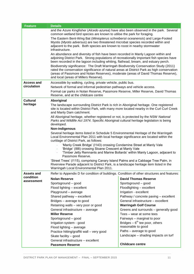
DISTRICT PARK PLAN OF MANAGEMENT – FINAL – SEPTEMBER 2015 11
Feature Details
and the Azure Kingfisher (Alcedo azurea) have also been observed in the park. Several common wetland bird species are known to utilise the park for foraging.
The Eastern Bent-Wing Bat (Miniopterus schreibersii oceanensis) and Large-Footed Myotis (Myotis adversus) are two threatened microbat species recorded within and adjacent to the park. Both species are known to roost in nearby stormwater infrastructure.
An abundance and diversity of fish have been recorded in Manly Lagoon within and adjoining District Park. Strong populations of recreationally important fish species have been recorded in the lagoon including whiting, flathead, bream, and estuary perch.
Biodiversity significance: The Draft Warringah Biodiversity Conservation Study (2011) rated the conservation significance of natural areas at District Park as high conservation (areas of Passmore and Nolan Reserves), moderate (areas of David Thomas Reserve), and local (areas of Millers Reserve).
Access and circulation
Accessible by walking, cycling, private vehicle, public bus.
Network of formal and informal pedestrian pathways and vehicle access.
Formal car parks in Nolan Reserve, Passmore Reserve, Miller Reserve, David Thomas Reserve, and at the childcare centre
Cultural heritage
Aboriginal
The landscape surrounding District Park is rich in Aboriginal heritage. One registered site is located within District Park, with many more located nearby in the Curl Curl Creek and Manly Dam catchment.
All Aboriginal heritage, whether registered or not, is protected by the NSW National Parks and Wildlife Act 1974. Specific Aboriginal cultural heritage legislation is being developed.
Non-indigenous
Several heritage items listed in Schedule 5 Environmental Heritage of the Warringah Local Environmental Plan 2011 with local heritage significance are located within the curtilage of District Park, as follows:
- ‘Manly Creek Bridge’ (I143) crossing Condamine Street at Manly Vale - ‘Bridge’ (I88) crossing Sloane Crescent at Manly Vale - ‘Timber Jetty Remnants and Marine Bollards’ within Manly Lagoon, adjacent to
Passmore Reserve.
‘Street Trees’ (I115), comprising Canary Island Palms and a Cabbage Tree Palm, in Riverview Parade adjacent to District Park, is a landscape heritage item listed in the Warringah Local Environmental Plan 2011.
Assets and condition assessment
Refer to Appendix D for condition of buildings. Condition of other structures and features:
Nolan Reserve
Sportsground – good
Flood lighting – excellent
Playground – average
Shared pathway – excellent
Bridges – average to good
Retaining walls – very poor or good
General infrastructure – average
Miller Reserve
Sportsground – good
Irrigation system - good
Flood lighting – average
Practice hitting/graffiti wall – very good
Skate facility – good
General infrastructure – excellent
Passmore Reserve
David Thomas Reserve
Sportsground – good
Floodlighting – excellent
Irrigation - excellent
Pathway / concrete paving – excellent
General infrastructure – excellent
Warringah Golf Course
Greens and surrounds – generally good
Tees – wear at some tees
Fairways – marginal to poor
Bridges – 6th tee poor, others
reasonable to good
Paths – average to good
Landscape – shading impacts on turf
Childcare centre

DISTRICT PARK PLAN OF MANAGEMENT – FINAL – SEPTEMBER 2015 12
Feature Details
Sportsground – good
Children’s playground – average
Synthetic turf in playground – excellent
Barbecues – poor to good
Timber feature wall – good
Pathway – excellent
Paving – average to excellent
Retaining walls – excellent
General infrastructure – excellent
Rooms – very good
Outdoor play areas – good
Uses and activities
Organised sport: including golf, tennis, squash, futsal, lawn bowls, cricket, soccer, rugby union, rugby league, touch football, running training, small-bore rifle shooting. School sport on weekdays.
Informal recreation: include walking, cycling, rollerblading, skateboarding, riding scooters, kite flying, dog exercise, picnics and barbecues, children’s play, feeding birds
Environmental: volunteer bush regeneration by Warringah Council’s Friends of the Bush groups at Mermaid Pool and Nolan Reserve, Warringah Golf Course, and Passmore Reserve. Creek restoration by Warringah Golf Club Creek Care Volunteer Group. Contract bush regeneration works in remnant bushland area along Manly Creek, around David Thomas Reserve, Brookvale Creek and Manly Lagoon.
User groups / stakeholders
Groups: include sporting clubs, schools, regional and state sporting bodies
Visitor characteristics: A Park User Survey (2013) found the average distance users travel to the park is 5.2 kilometres, which took an average of 12 minutes. More than one-third of park users visit at least weekly.
Leases/ licenses/ bookings
Leased areas: Warringah Golf Course, part of David Thomas Reserve (G8 Childcare Centre), part of Nolan Reserve (North Manly Bowling and Recreation Club, Christian Bros Junior Rugby League Football Club), part of Passmore Reserve (Manly Vale Calabria Bowling Sports and Social Club, Manly Small Bore Rifle Club)
Licenced areas: Warringah Recreation Centre
Booking agreement: futsal courts at Warringah Recreation Centre
Sportsground hire
Easements There are several easements for services upon District Park
Maintenance Two maintenance depot/maintenance facilities are located in the park: on Warringah Golf Course which is managed by Warringah Golf Club, and a Council depot in Nolan Reserve.
Maintenance by Council staff and contractors (non-leased areas) and lessees (leased areas)
Sports fields: mowing of sports fields and surrounds, seasonal changeover of goalposts, inspections, maintenance (e.g. divoting, minor topdressing), returfing, aeration, fertilising, line marking, cricket wicket resurfacing, lighting audit and maintenance, infrastructure maintenance, general maintenance
Buildings: Conditions contained within the leases/licences detail responsibility for maintenance.
Playgrounds: inspections and general maintenance
Gardens: maintenance
Natural areas: professional bush regeneration contractors and Friends of the Bush volunteers.
Income and expenditure
Income: fees from use agreements (leases, licences, booking agreements, and sportsground hire), grants, use of floodlights
Expenditure: Maintenance, renovation, capital improvements.
DISTRICT PARK PLAN OF MANAGEMENT – FINAL – SEPTEMBER 2015 13
3 BASIS FOR MANAGEMENT
3.1 Introduction This section describes the wider societal trends, legislative and policy framework applying to District Park. Full versions of the legislation referred to below are on-line at www.legislation.nsw.gov.au and www.austlii.edu.au. Warringah Council’s website is www.warringah.nsw.gov.au.
3.2 Trends in open space provision, planning, use and management
Factors which influence the provision, planning, use and management of open space in Australia and overseas in the wider context, and within the visitor catchment of District Park, are set out in Appendix E.
These trends includean aging population, informal recreation activities are more popular than spoirting activities and increased popularity of ‘extreme’ sports.
3.3 Planning context
Figure 5 outlines the national, state, metropolitan Sydney, regional and local planning context which influences the use, development and management of District Park. Refer to Appendix F for more information about the planning context of District Park.

DISTRICT PARK PLAN OF MANAGEMENT – FINAL – SEPTEMBER 2015 14
Planning context of District Park Figure 5
COMMONWEALTH
Legislation
Disability Discrimination Act 1992
Environment Protection and Biodiversity Conservation Act 1999
Work Health and Safety Act 2011
Building Code of Australia
Australian Standards: access, playgrounds
National physical activity participation data
NSW
Legislation
Local Government Act 1993
Crown Lands Act 1989
Environmental Planning & Assessment Act 1979
State Environmental Planning Policies:
(Bushland in Urban Areas, Infrastructure, Coastal Protection)
Bushfire Environmental Assessment Code for NSW 2006
Catchment Management Authorities Act 2006
Water Management Act 2000
Protection of the Environment Operations Act 1997
Rural Fires Act 1997
Plans
NSW
2021
Recreation planning guidelines and data
Recreation and Open Space Planning Guidelines for Local Government
Physical activity participation data
Threatened Species Conservation Act 1995
Waste Minimisation Act 1995
Fisheries Management Act 1994
Noxious Weeds Act 1993
Roads Act 1993
Coastal Protection Act 1979
National Parks and Wildlife Act 1974
SYDNEY A Plan for Growing Sydney
REGIONAL Draft North Subregional Strategy SHOROC Shaping Our Future
WARRINGAH
Corporate Warringah Community Strategic Plan 2023
Delivery Program, Operational Plan, Resourcing Strategy
Strategic /
specific
need
Land use
Warringah Local Environmental Plan 2011
Warringah Development Control Plan 2011
Section 94A Development Contributions Plan 2011
Warringah Local Planning Strategy 2012-13
Draft Housing Strategy
Community
Living Well Warringah: Aging Strategy
Creative Warringah
Social Plan 2010
Children’s and Family Services Strategy 2006
Youth Strategy 2013
Economic
Warringah Economic Development Plan 2011
Graffiti Management Plan
Cultural Plan
Companion Animals Management Plan
Asset management
Warringah Asset Management Strategy 2013-2023
Buildings Asset Management Plan
Parks Reserves Foreshores Asset Management Plan
Natural Areas Asset Management Plan
Open Space and Recreation
Recreation Strategy 2009
Playground Strategy 2007
Sports in Warringah 2004
Regional Multiple Use Trail Strategy
Transport
Sustainable Transport Strategy
Bike Plan 2010-2015
Pedestrian Access and Mobility Plan
Natural Environment
Biodiversity Conservation and Restoration Plan
Flood Program 2008-2018
Local Habitat Strategy 2007
Planning for Bushfire Protection 2006
Creek Management Study 2004
Natural Area Survey
Manly Lagoon Flood Study 2013
Draft Biodiversity Conservation Study 2013
Environmental Sustainability Strategy 2012
Bush Fire Risk Management Plan 2010, including Warringah Bush Fire Prone Land Map 2010
Implementation Plans of Management Policies Capital works
programs District Park Plan of Management
Supporting studies and
papers
Sports Club Feasibility Study
Northern Beaches Regional Golf Strategy
District Park Strategic Directions Paper Submissions Report
District Park Strategic Directions Paper
District Park Discussion Paper Submissions Report
District Park Discussion Paper

DISTRICT PARK PLAN OF MANAGEMENT – FINAL – SEPTEMBER 2015 15
3.4 Values and roles of District Park
Warringah Council takes a values-based approach to the planning and management of District Park. Values may be described as what is important or special about a place. The values and associated roles of District Park are set out below consistent with the outcomes of the Warringah Community Strategic Plan.
Table 3 Values and roles of District Park
Outcome Values of District Park Signif-icance
Roles of District Park
Vibrant Community
The Warringah community has a strong sense of ownership of District Park as a place which is available to all of the community to come together for a variety of activities.
District Venue for social clubs, and for community activities
Creative space and place
Lifestyle and Recreation
District Park is highly valued by the local community and a wider regional catchment to enjoy a wide range of sporting and informal recreational activities which contribute to a healthy lifestyle and quality of life.
District Park is the largest concentration of sporting fields in the region. As District Park incorporates numerous adjoining sporting fields, the Park is valued as a place in Manly-Warringah and in northern Sydney where school and other field sporting competitions involving large numbers of players can be held at the one location.
Regional Multi-purpose settings for a diverse range of competitive and informal sporting activities, and for informal recreation
Healthy Environment
District Park is a large, green open space with a mix of trees, bush and grass with creeks flowing through it. The natural and green landscape of District Park is valued by park users and people passing by. It is also a visual contrast to nearby industrial and commercial land uses.
Park users and neighbours delight in seeing fish, reptiles, birds and mammals in the Park throughout the year.
Warringah Council community research in 2012 shows the management of waterways and lagoons, and caring for bushland areas, are of very high importance to the Warringah community.
The conservation significance of areas of the natural areas in District Park has been assessed as high (areas of Passmore and Nolan Reserve), moderate (areas of David Thomas Reserve), and local (areas of Miller Reserve).
State Wildlife habitat and corridors
Containment of environmental events such as flooding and bushfire.
Connected Transport
District Park is highly accessible in a central location, being connected to surrounding areas by intersecting main roads, public transport routes, and bicycle routes and walking paths.
District Part of bicycle route network

DISTRICT PARK PLAN OF MANAGEMENT – FINAL – SEPTEMBER 2015 16
3.5 Vision for District Park
The vision for District Park is:
District Park will enhance its status as an accessible, multi-purpose and high quality regional
sporting, recreation and community precinct in a significant natural setting.
The vision for District Park is reflected in the Action Plan in Section 4.

DISTRICT PARK PLAN OF MANAGEMENT – FINAL – SEPTEMBER 2015 17
4 ACTION PLAN
4.1 Landscape Concept Plan The Landscape Concept Plan for District Park is in Figure 6. The Landscape Concept Plan shows the location of the spatial works and actions in the following Action Plan which are proposed to be implemented to achieve the objectives and desired outcomes for District Park. More detailed Landscape Masterplans will be prepared for specific areas as required.
Key proposed actions and changes to District Park include:
constructing a combined sports, recreation and community facility in Nolan Reserve
demolishing the middle and south amenities buildings in Nolan Reserve and assess and
design new amenities to cater for the needs of users at the southern end of the Reserve.
investigating the provision of upgraded and additional sports courts at Warringah
Recreation Centre
investigating the provision of an indoor/outdoor action sports facility
investigating a location for a dirt jump bike track
investigating the provision of outdoor table tennis
upgrading the children’s playground at Passmore Reserve
providing outdoor fitness equipment for all ages, including parkour facilities
continuing to maintain and enhance riparian vegetation and bushland
implementing new walking and cycling tracks around District Park, and links to existing
pathways and adjoining areas.
improving signage and way finding around the park
All proposed works in District Park are dependent on the availability of funding. Council has limited funds, and as such may rely on external grants and other sources of funding. It is envisaged that this Plan of Management will be implemented progressively over a ten-year period as funds become available.
Funding for management of and improvements to District Park will be sought from a range of government, Council, corporate and community sources on an ongoing basis.
The benefits of the proposed works include to:
provide opportunities for social connection for all users in the park.
support the range of recreational opportunities for the general community.
provide an ongoing source of income to support the recreational opportunities in the
park.
improve activation and use of the park.

DISTRICT PARK PLAN OF MANAGEMENT – FINAL – SEPTEMBER 2015 18
4.2 Action Plan
4.2.1 Introduction The management actions to resolve the management issues (consistent with the community’s values) from Section 3 and to implement the Landscape Concept Plan over the next 10 years are presented in the following tables. Headings are explained as follows:
Outcome (Community Strategic Plan)
Performance targets Means of assessment
The desired outcome in implementing and achieving the action
How the achievement of the performance target can be measured and assessed.
Opportunity Background Objective Actions
Topic heading relating to an opportunity or benefit to the park and the community
Explanatory information about the opportunity
Reflects the strategic direction for District Park, and provides direction for the actions.
A specific task required to realise an opportunity or resolve an issue, consistent with the strategic direction and objective.

DISTRICT PARK PLAN OF MANAGEMENT – FINAL – SEPTEMBER 2015 19
Landscape Concept Plan for District Park Figure 6

DISTRICT PARK PLAN OF MANAGEMENT – FINAL – SEPTEMBER 2015 20
4.2.2 Vibrant community
Objective:
To provide opportunities for social interactions, community support, cultural heritage protection and creative expression in a safe environment
Performance targets Means of assessment
Increased use of buildings and spaces by a wider range of groups
Bookings
Increased opportunities for public art and creative expression
Observations, bookings, calendar of events
Increased opportunities for community support Use agreements
Preservation and interpretation of cultural heritage Condition assessments, visitor surveys
Increased actual and perceived safety Crime reports, visitor survey
Opportunity Background Strategies Actions
Health and wellbeing
Combined sports, recreation and community club buildings
Several sporting clubs and activities are located in close proximity in District Park. Warringah Golf Club wants to re-locate their off-site clubhouse on to District Park closer to the golf course. Some club buildings in the park are aging, and require repair and updating to encourage use. Some clubs based in the park are struggling financially. A feasibility study to investigate options for a combined sports, recreation and community club building in District Park was commissioned in 2014. The study included possible arrangements between existing clubs, viability of services, management models, and cost-benefit analysis. The final report indicated that the viability of the Warringah Golf Club and North Manly Bowling Club may be enhanced through merging of their operations and facilities in a multi-purpose centre, including with the operations of the Warringah Recreation Centre and a range of other sporting clubs and groups that use District Park. The feasibility study explored a centrally located facility in District Park on the site of the current North Manly Bowling Club. Depending on final design, the building may include café and lounge/bistro, multi-purpose rooms, bowling facilities, outdoor terrace for passive recreation, amenities, and car and bike parking.
Facilitate a multi-purpose, modern sporting and community facility in District Park which consolidates existing clubhouses Facilitate a better connection between the golf course and the new sport community club building
Investigate and develop a sports and community club facility in the zone of the current North Manly Bowling and Recreation Club in Nolan Reserve. Consider the optimal building alignment with the golf course and the optimal number of bowling greens. Make changes to the golf course configuration if required to accommodate the new sports and community club facility.

DISTRICT PARK PLAN OF MANAGEMENT – FINAL – SEPTEMBER 2015 21
Opportunity Background Strategies Actions
Shared buildings and spaces
Leases of several community buildings and spaces in District Park have expired, or are on a month-to-month basis, or are due to expire in 2016-17. Current lease agreements for community buildings in the park limit access by other groups to the buildings for a range of activities. There is increasing demand for indoor health and leisure activities in Warringah, such as senior’s activities, creative/cultural activities, dance schools, yoga and Pilates, youth activities and entertainment, and children’s playgroups/parties.
Maximise use of community buildings and spaces for a range of shared uses
Review lease and licence agreements to allow shared use of buildings in the park.
Extend the term of expired leases and licences following review of these agreements.
Investigate options for use of buildings for which use agreements are not renewed or extended.
Refurbish and adapt community buildings in District Park to a standard which is attractive for health and leisure activities for which there is demand.
Public art Graffiti walls are situated in Miller Reserve and Passmore Reserve. Warringah Council’s Creative Warringah proposes several goals including creating environments which are welcoming, surprising and good for people; and to integrate public art and creative expressions into places, projects and programs.
Integrate public art and creative expression into spaces and activities in District Park.
Implement public art in suitable locations in District Park.
Consider the goals of Creative Warringah in future projects and programs in District Park.
Safety
Visitor safety
Visitors in District Park feel safe during the day, but only one-third of visitors say they would feel safe to visit the park at night (Park User Survey, 2013)
Reflect Safety by Design principles in landscaping and park management
Place suitable external lighting at amenities buildings, pathways and car parks.
Support and connection
Childcare A private 120-place childcare centre for aged 0 to 5 years operates in the park. The lease expired in 2015, with options to extend the lease until 2025.
Retain the current childcare centre as required
Renew the lease for the childcare centre.
Heritage and cultural diversity
Cultural heritage items
Several heritage items listed in Schedule 5 Environmental Heritage of the Warringah Local Environmental Plan 2011 are located within the curtilage of District Park, as follows: - Manly Creek Bridge crossing
Condamine Street at Manly Vale - Bridge crossing Sloane Crescent at
Manly Vale - Timber Jetty Remnants and Marine
Bollards in Manly Lagoon, adjacent to Passmore Reserve.
Other valued items in the park include the Bicentennial Avenue of Trees in Nolan Reserve, the sandstone wall on the golf course boundary, and the large Port Jackson fig at the southern boundary of the golf course.
Preserve cultural heritage items
Investigate the significance of heritage items which are not listed in WLEP 2011.
Add significant heritage items to WLEP 2011.
Maintain cultural heritage items.
Provide on-site interpretive information about cultural heritage items

DISTRICT PARK PLAN OF MANAGEMENT – FINAL – SEPTEMBER 2015 22
4.2.3 Recreation and lifestyle
Objective:
To provide safe and fit for purpose facilities, settings and spaces for a diverse range of traditional and emerging sporting, recreation and leisure activities which encourage a healthy lifestyle
Performance targets Means of assessment
Diverse sporting facilities and spaces which meet the needs of users
Engagement with user groups
Increased use for sport and recreation activities Bookings, visitor counts
Additional opportunities for a range of unstructured recreation activities
Visitor surveys, increase in unstructured recreation facilities
Opportunity Background Strategies Actions
Diverse facilities
Sport
18-hole golf course
Warringah Golf Course was established in the 1930s. The Regional Golf Course Study and Warringah Golf Club Ltd members supported retaining the 18 hole golf course. The lease of the golf course expires in January 2016. Council intends to extend the lease until 2017.
Facilitate a financially viable golf club and multi-purpose 18-hole golf course Provide for safe community access to and use of the golf course
Review the lease of Warringah Golf Course including: - extending the lease
period until this Plan of Management has been adopted and the future of the proposed sports club determined
- revising the lease area to accommodate safe walking tracks and crossing points
- appropriate environ-mental management practices
Integrate the golf club use and operations with the proposed sports community club Relocate and/or upgrade golf practice facilities
Consider the operational requirements of the golf course and lawn bowling facilities in the concept.
Assess opportunities to upgrade warm-up nets to a fully enclosed “Birdie Cage” design, and possible relocation closer to existing practice facilities and pro shop.
Sports field configuration
Sporting fields in District Park are used for sports including cricket, touch football, soccer, and rugby league. Changing preferences for participation in sport mean that some emerging sports may require space to play which could be accommodated at District Park.
Facilitate use of sporting fields for existing and emerging sports
Review configuration of sporting fields in consultation with existing and potential user groups.
Amenities / facilities at
Amenities are located at Nolan Reserve, Passmore Reserve, Miller Reserve and
Ensure amenities
Liaise with Manly Vale Football Club and other

DISTRICT PARK PLAN OF MANAGEMENT – FINAL – SEPTEMBER 2015 23
Opportunity Background Strategies Actions
sporting fields
David Thomas Reserve. Sports amenities buildings (middle and south) in Nolan Reserve are in poor condition and have a remaining useful life of 2 years. Development and maintenance of amenities and facilities at District Park is carried out consistent with Council’s Asset Management and other relevant plans.
meet the needs of sporting and other park users.
key stakeholder groups regarding proposed first-floor addition to the building at David Thomas Reserve.
Demolish the middle and south amenities buildings in Nolan Reserve.
Design and construct new amenities at the southern end of Nolan Reserve to cater for the needs of users of Nolan Reserve.
Lighting of sporting fields
Floodlighting of sporting fields in Miller Reserve and David Thomas Reserve was recently upgraded to 100 lux to meet the Australian Standard for match practice and competition football. Lighting in Nolan Reserve is 50 lux training standard. Consideration of any new or upgraded sports field lighting is to include compre-hensive community engagement, particularly with nearby residents.
Provide lighting of sporting fields which allows safe use of fields, and provides flexibility in use with minimal impact on surrounding land uses
Upgrade lighting in Nolan Reserve to 100 lux to enable football competition.
Optimise sports field lighting to required sport standards and current best practice.
Shade / shelter at sporting fields
Shade for spectators at sporting fields is provided by trees. However, shade for spectators is limited at Nolan Reserve.
Provide shade options at sports fields which don’t impede sport or recreation activity.
Support shade options at sporting fields, including trees and built structures.
Multi-purpose sports training facilities
Cricket users require new practice facilities, which could be combined with practice facilities for other sports.
Provide multi-purpose sport practice facilities
Include new practice facilities for cricket and other sports in the masterplan for Nolan Reserve.
Additional futsal courts
Futsal courts are located at the Calabria Club and at Warringah Recreation Centre. The Calabria Club propose to convert another bowling green to futsal courts. Council is considering preparing a Warringah-wide futsal demand study.
Cater for demand for futsal/multi-use synthetic courts
Support provision of additional futsal/multi-use synthetic courts at locations which could include Warringah Recreation Centre and the Calabria Club.
Sports courts Six tennis courts and three squash courts are located at the Warringah Recreation Centre, which is managed by Warringah Council.
Provide high quality sports courts in District Park
Investigate upgrading tennis and squash courts at Warringah Recreation Centre.
Identify suitable locations for multi-purpose sports courts catering for informal netball, basketball and other court sports at locations which could include Warringah Recreation Centre and Nolan Reserve.
Investigate the feasibility of additional squash courts.
DISTRICT PARK PLAN OF MANAGEMENT – FINAL – SEPTEMBER 2015 24
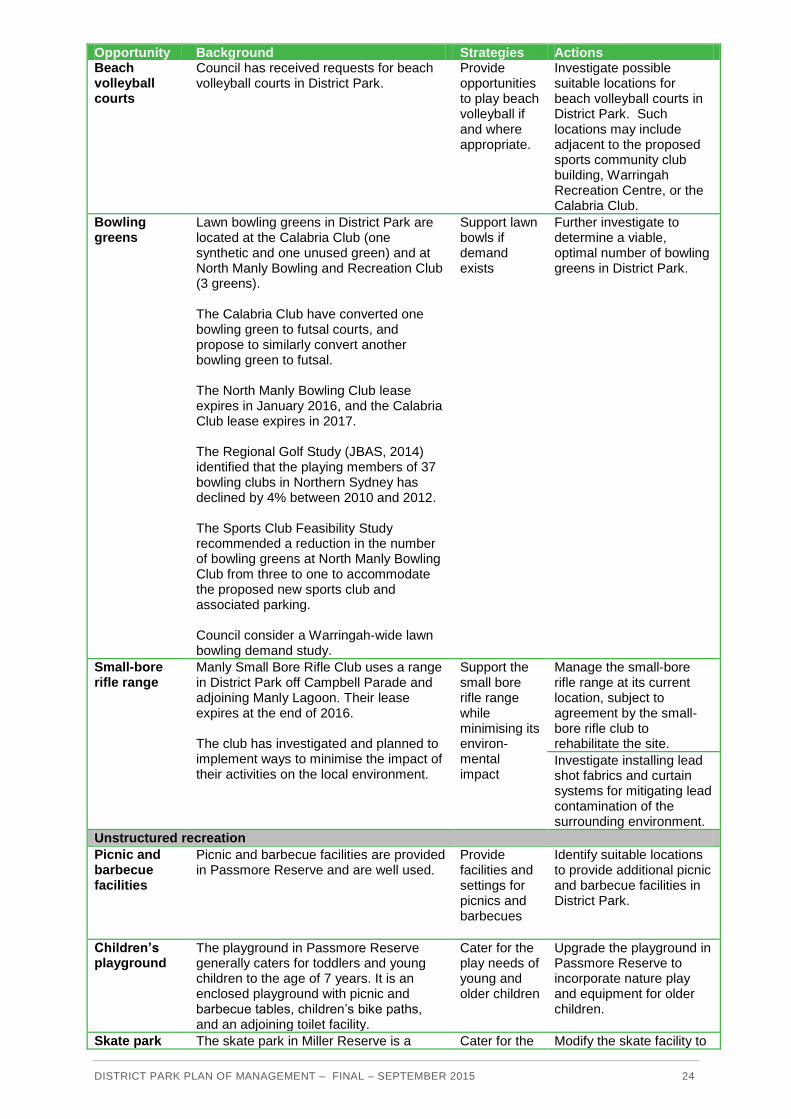
Opportunity Background Strategies Actions Beach volleyball courts
Council has received requests for beach volleyball courts in District Park.
Provide opportunities to play beach volleyball if and where appropriate.
Investigate possible suitable locations for beach volleyball courts in District Park. Such locations may include adjacent to the proposed sports community club building, Warringah Recreation Centre, or the Calabria Club.
Bowling greens
Lawn bowling greens in District Park are located at the Calabria Club (one synthetic and one unused green) and at North Manly Bowling and Recreation Club (3 greens). The Calabria Club have converted one bowling green to futsal courts, and propose to similarly convert another bowling green to futsal. The North Manly Bowling Club lease expires in January 2016, and the Calabria Club lease expires in 2017. The Regional Golf Study (JBAS, 2014) identified that the playing members of 37 bowling clubs in Northern Sydney has declined by 4% between 2010 and 2012. The Sports Club Feasibility Study recommended a reduction in the number of bowling greens at North Manly Bowling Club from three to one to accommodate the proposed new sports club and associated parking. Council consider a Warringah-wide lawn bowling demand study.
Support lawn bowls if demand exists
Further investigate to determine a viable, optimal number of bowling greens in District Park.
Small-bore rifle range
Manly Small Bore Rifle Club uses a range in District Park off Campbell Parade and adjoining Manly Lagoon. Their lease expires at the end of 2016. The club has investigated and planned to implement ways to minimise the impact of their activities on the local environment.
Support the small bore rifle range while minimising its environ-mental impact
Manage the small-bore rifle range at its current location, subject to agreement by the small-bore rifle club to rehabilitate the site.
Investigate installing lead shot fabrics and curtain systems for mitigating lead contamination of the surrounding environment.
Unstructured recreation
Picnic and barbecue facilities
Picnic and barbecue facilities are provided in Passmore Reserve and are well used.
Provide facilities and settings for picnics and barbecues
Identify suitable locations to provide additional picnic and barbecue facilities in District Park.
Children’s playground
The playground in Passmore Reserve generally caters for toddlers and young children to the age of 7 years. It is an enclosed playground with picnic and barbecue tables, children’s bike paths, and an adjoining toilet facility.
Cater for the play needs of young and older children
Upgrade the playground in Passmore Reserve to incorporate nature play and equipment for older children.
Skate park The skate park in Miller Reserve is a Cater for the Modify the skate facility to

DISTRICT PARK PLAN OF MANAGEMENT – FINAL – SEPTEMBER 2015 25
Opportunity Background Strategies Actions
concrete skate bowl which caters for skaters, scooters and BMX riders of a fairly high ability.
range of abilities of users of skate parks Encourage use of the skate park by non-skaters
cater for a range of skill levels.
Upgrade the skate park and its surrounds in Miller Reserve, which may include: - more shade for
spectators - more seating for
spectators and riders - removing graffiti - providing a water
refill station - painting a mural
inside the bowl
Bike dirt jump track
Children and young people in Warringah have expressed a need for places to ride bikes. In 2011 Warringah Council demolished the “Freedom” dirt bike jumps in Manly Vale for safety reasons, and proposed to replace them with another dirt bike jump track nearby. Potential sites for a bike dirt jump track, including Miller Reserve and David Thomas Reserve, were assessed. Miller Reserve was considered more suitable by the concept proponent; however a more suitable location may become available.
Provide opportunities for bike activities
Engage with the community about the provision and location for a bicycle dirt jump facility in District Park.
Indoor/ outdoor action sports facility
Council recently received a public private partnership concept for an indoor/outdoor action sports facility for youth in Miller Reserve, District Park.
Provide opportunities for action sports
Engage with the community about developing an indoor/ outdoor action sports facility for youth in District Park.
Outdoor fitness equipment
Outdoor fitness equipment is popular with and may be used by children and young people through to seniors. Community members showed support for a parkour facility in District Park through the community engagement process. Parkour and free-running are new and emerging sport and recreation activities. They cater for all ages and abilities, and the equipment is suitable for active and informal uses.
Provide opportunities to increase the physical fitness of people of all ages and abilities in District Park Integrate facilities and settings for outdoor fitness, parkour, free-running and similar activities in District Park
Provide outdoor fitness equipment for all ages including parkour facilities adjacent to pathways and walking/running/cycling tracks.
Outdoor table tennis
Playing table tennis at outdoor tables is becoming increasingly popular in public open space.
Provide opportunities for informal recreation activities, such as table tennis
Investigate provision of outdoor table tennis table/s in District Park.
Support services and facilities

DISTRICT PARK PLAN OF MANAGEMENT – FINAL – SEPTEMBER 2015 26
Opportunity Background Strategies Actions Mobile food and beverage services
Mobile food and beverage vans offer a valuable service to park users if sport canteens are not operating.
Encourage mobile food/ beverage operations to serve park users.
Investigate infrastructure and accessibility requirements to support mobile food and beverage outlets at peak times in District Park.
Design, maintenance, waste management
Some park users discard plastic drink bottles which are transported to Brookvale and Manly Creeks.
Encourage use of reusable water bottles by users of District Park
Educate hirers about impacts of discarded plastic drink bottles in the creeks.
Provide water refill stations in District Park.

DISTRICT PARK PLAN OF MANAGEMENT – FINAL – SEPTEMBER 2015 27
4.2.4 Healthy Environment
Objective:
To protect, preserve and enhance the natural environment (land and water) in District Park
Performance targets Means of assessment
Strengthened integrity of wildlife corridors Canopy cover, aerial photos, vegetation surveys
Enhanced riparian corridors Aerial photos, vegetation surveys
Easier fish passage in creeks Fish surveys
Improved water quality Water testing and monitoring
Decline in abundance of aquatic weeds Surveys
Reduction in use of non-renewable energy and potable water
Baseline and future water and energy audits
Reduction in use of chemicals Water and soil testing
Increase locally native vegetation in bushland Vegetation surveys
Increase in educational activities Bookings, participant courts
Opportunity Background Strategies Actions
Natural areas
Fauna habitat / wildlife corridors
A wildlife corridor extends between Manly Warringah War Memorial Park and the lower reaches of Manly Creek to Manly Lagoon.
Enhance the wildlife corridor between Manly Dam/ Manly Warringah War Memorial Park, Manly Creek and Manly Lagoon.
Recognise the east-west habitat corridor from Manly Dam along Manly Creek to Manly Lagoon in the next review of the Warringah Local Habitat Strategy.
Undertake bush regeneration in selected bushland areas in accordance with current best practice and relevant regional and local strategies and priorities.
Riparian zones
The Endangered Ecological Communities (EECs) of Swamp Sclerophyll Forest on Coastal Floodplains and Swamp Oak Floodplain Forest which comprise the waterway and wetland areas of Passmore and Nolan Reserves are listed in the Schedule of Endangered Ecological Communities (EEC) of the NSW Threatened Species Conservation Act 1995. Friends of the Bush volunteer groups, Council staff, contractors and participants in community tree planting events are revegetating turfed or degraded riparian land in Passmore, Nolan and Miller Reserves.
Protect riparian Endangered Ecological Communities in District Park Undertake maintenance of riparian zones taking into account the impact on riparian vegetation and floodplain management
Maintain and enhance riparian corridors through establishing appropriate riparian buffers, bush regeneration, weed control and improved operational activities such as turf maintenance regimes.
Continue to implement riparian zone management activities in accordance with relevant Council policies and strategies.

DISTRICT PARK PLAN OF MANAGEMENT – FINAL – SEPTEMBER 2015 28
Opportunity Background Strategies Actions Large sections of Brookvale and Manly Creek are contained in areas leased to sporting groups, particularly Warringah Golf Club. Lessees are responsible for maintaining the riparian zones in their leased area.
Continue restoration works within habitat corridors and riparian zones with consideration of potential impact to floodplain management
Undertake identified creek and riparian restoration works in accordance with current best practice and relevant regional and local strategies and priorities.
Restore piped sections of Manly Creek to natural waterway where possible Facilitate fish passage in Manly and Brookvale Creeks.
Investigate the feasibility of restoring the piped section of Manly Creek on Warringah Golf Course to an open creek with riparian vegetation and satisfactory fish passage.
In consultation with the lessee, investigate removal or modification of the dam on Manly Creek downstream of Condamine Street.
Water quality
Poor water quality from stormwater and other sources limits recreational use of Brookvale and Manly Creeks. Manly Lagoon often does not meet ANZECC 2000 standards for both primary (e.g. swimming) and secondary (e.g. canoeing) contact recreation, and so is closed for various recreational uses. Five Stormwater Quality Improvement Devices (SQIDs) in the District Park area reduce pollutants entering the waterways. These devices are monitored and maintained approximately every three months and following heavy rain events. Warringah Council is monitoring Phytoplankton, Zooplankton and chlorophyll in Manly Lagoon off Nolan Reserve to assess eutrophication and other ecological conditions.
Improve the quality of water in creeks and waterways. Improve water quality in Brookvale and Manly Creeks suitable for secondary contact recreation. Control pollutants from upstream areas
Continue to monitor and maintain Stormwater Quality Improvement Devices (SQIDs) every three months and following heavy rain events.
Continue water quality monitoring and project partnerships with Sydney Water and other stakeholders.
Investigate the feasibility of installing additional SQIDs in key locations in the Manly and Brookvale Creeks catchment.
Aquatic weeds
High priority noxious weeds are being removed from Brookvale Creek.
Manage high priority aquatic weeds in riparian areas
Continue strategic control of high priority aquatic weeds in Brookvale and Manly Creeks.
Contam-ination
There is potential for contamination of land in District Park due to unknown landfill material and historic uses.
Minimise the impacts of contamination on the natural environment and use of District Park
Manage contamination issues appropriately as they arise.

DISTRICT PARK PLAN OF MANAGEMENT – FINAL – SEPTEMBER 2015 29
Opportunity Background Strategies Actions Bushland
Bush regener-ation
Bush regeneration is carried out in District Park by Warringah Council’s Friends of the Bush groups at Mermaid Pool, Warringah Golf Course, Nolan and Passmore Reserves. Contract bush regeneration works are taking place in remnant bushland along Manly Creek, around David Thomas Reserve, Brookvale Creek and Manly Lagoon.
Restore areas of remnant bushland to enhance wildlife habitat Provide support for re-establishing locally native vegetation
Continue strategic bush regeneration activities in District Park. Continue to plan bush regeberation in District Park in the context of Council’s overall bush regeneration programs and priorities.
Fauna
Threatened species
Threatened microbat species are known to forage within District Park, and roost within nearby stormwater infrastructure. Waterways and riparian vegetation within the park are known foraging habitat for threatened and migratory birds including the Black Bittern. Any developments and activities in District Park which have the potential to modify foraging and roosting habitat must account for potential impacts on threatened bird and bat species.
Protect and enhance threatened species habitat
Maintain and enhance existing natural areas within District Park.
Ensure future management actions are undertaken in accordance with the requirements of the Threatened Species Conservation Act 1995 and Environmental Planning and Assessment Act 1979.
Sustainability
Energy and water
Council has installed automated and remotely controlled lighting and irrigation systems which have reduced use of energy and water through unauthorised access to playing fields and amenities in District Park. This system has the added advantage of detecting, automatically shutting down and alerting staff to water leaks in the irrigation system, potentially saving thousands of litres of water. Changed maintenance practices have reduced the use of mains water for playing fields in District Park. These changed maintenance practices include increasing use of aeration and of wetting agents to reduce hydrophobic water sheeting and to improve water penetration and retention in the soil; and improving bore water management which has reduced the need for mains water. Warringah Golf Club has a licence from the Office of Water for harvesting water from the dam to water the golf course.
Minimise use of water and energy in District Park
Include requirements in lease agreements for lessees to prepare environmental management plans which address the use and management of water and energy as required.
Incorporate Water Sensitive Urban Design (WSUD) into the design of all future facilities, landscaping and vehicle parking areas.
Chemical use
Dangerous chemicals and poisons can leach into the surface or groundwater, and can affect soil, plants and water for a long time. Considering that District Park is highly vegetated, and noting that Manly and Brookvale Creeks traverse the area, and flow immediately into Manly Lagoon, appropriate care should be taken to protect bushland and sensitive receiving water bodies.
Minimise use of chemicals in District Park
Include requirements in lease agreements for lessees to prepare environmental manage-ment plans which address use and management of pesticides, fertilisers and other chemicals.

DISTRICT PARK PLAN OF MANAGEMENT – FINAL – SEPTEMBER 2015 30
Opportunity Background Strategies Actions
Waste manage-ment
Waste management plans are required to be prepared to accompany applications to hold major events in District Park.
Minimise waste generated from use of District Park
Review waste management requirements in future use agreements.
Natural hazards and climate change
Bushfire Residential properties and Council assets adjoining David Thomas Reserve have been rated in the Warringah Pittwater Bush Fire Risk Management Plan (2010) as a “high” risk asset. Hazard reduction burning works were conducted in David Thomas Reserve in 2012, which alleviated the bush fire risk.
Manage the impacts of bushfire in District Park
Continue to co-ordinate bushfire risk management activities in accordance with the Warringah Pittwater Bushfire Risk Management Plan 2010.
Flooding All reserves in District Park are flood-prone. The entrance to Manly Lagoon, which is jointly managed by Warringah and Manly Councils, is occasionally mechanically opened to reduce the risk of flooding. Manly and Brookvale Creeks, which flow into Manly Lagoon, periodically flood. The two Councils have prepared a Project Agreement for the Joint Management of Routine Maintenance Operations on Manly Lagoon (2012). This agreement aims to ensure that the Councils work together to reduce flood risk while protecting the health of the lagoon, and maintaining infrastructure such as low flow pipes and litter traps. The Manly Lagoon Flood Study (2013) identified the existing and future flood behaviour in the Manly Lagoon catchment. The revision of the Manly Lagoon Floodplain Risk Management Study and Plan will evaluate and recommend options to manage flooding within the catchment.
Manage flood risks appropriately
Implement actions identified in the revision of the Manly Lagoon Floodplain Risk Management Plan.
Education and interpretation
Education activities
Environmental activities such as Friends of the Bush, tree planting days, and school excursions to learn about the environment are provided in natural areas of District Park. The Warringah Cultural Plan recommended introducing environmental walks in bushland in Warringah.
Encourage the community to learn about the natural environment in District Park
Facilitate environmental education and community activities in District Park where appropriate.
Investigate opportunities to expand community volunteer groups to monitor water quality, biodiversity and to restore riparian and bushland areas.
Bird hides and viewing platforms
The natural areas in District Park provide excellent opportunities to watch local and migratory bird species.
Improve opportunities to watch birds and other wildlife in District Park
Investigate environmental interpretation structures (such as bird hides and viewing platforms) where appropriate and which are sympathetic with the environment and other park uses.
DISTRICT PARK PLAN OF MANAGEMENT – FINAL – SEPTEMBER 2015 31
Opportunity Background Strategies Actions
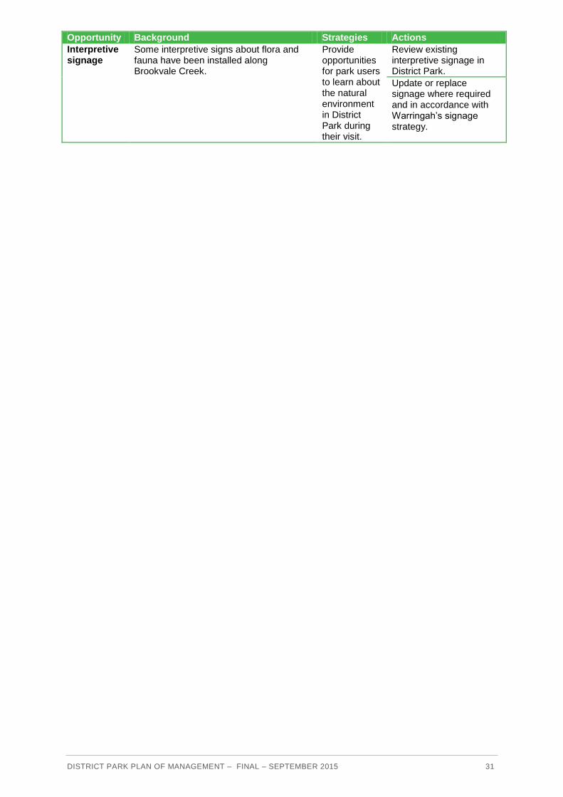
Interpretive signage
Some interpretive signs about flora and fauna have been installed along Brookvale Creek.
Provide opportunities for park users to learn about the natural environment in District Park during their visit.
Review existing interpretive signage in District Park.
Update or replace signage where required and in accordance with Warringah’s signage strategy.

DISTRICT PARK PLAN OF MANAGEMENT – FINAL – SEPTEMBER 2015 32
4.2.5 Connected transport
Objective:
To improve access to District Park by public transport and active transport, and access within the park for walking, cycling and universal access
Performance targets Means of assessment
Increase in users accessing District Park by public transport, walking and cycling
Observations, visitor surveys
Decrease in parking conflicts in local streets Observations, complaints to Council
Increase in walking and cycling links within the park and to adjoining areas
Length of paths and tracks
Opportunity Background Strategies Actions
Public transport
Public transport
5% of users of District Park travel to the park by public transport. Numerous bus routes connect District Park with the City and northern beaches along Condamine Street, Manly along Pittwater Road, and Frenchs Forest via Allambie Road.
Include opportunities to support access to public transport in any future development options for District Park.
Provide accessible links between bus stops, amenities buildings and other destinations in the park.
Produce an information brochure about District Park including modes of transport to the park, location of bus stops and other relevant information.
Provide information about public transport options to and from the park to Sydney Buses, Roads and Maritime, and include on the Warringah
Include public transport options on the Warringah bike map.
Roads and parking
Vehicle access
77% of park users travel to the park by private motor vehicle. Condamine Street and Pittwater Road are busy roads which are congested in peak hours. The secondary roads of Kentwell Road, Sloane Crescent and Campbell Parade separate areas within the park or adjoin the park. Speed humps control the speed of traffic on Campbell Parade and Sloane Crescent.
Improve opportunities to access District Park by vehicle.
Provide accessible pathways between car parks and buildings in the Park.
Review use of car parking areas in District Park.
Vehicle parking areas
Numerous off-road vehicle parking areas are provided in the park at each sporting complex (David Thomas, Miller, Passmore, and Nolan Reserves) at the child-care centre, the small-bore rifle club, North Manly Bowling Club, Warringah Recreation Centre, and
Improve opportunities to park vehicles in District Park while minimising encroachment of parking areas on the park and
Investigate opportunities to upgrade and reconfigure vehicle parking throughout District Park where demand warrants.
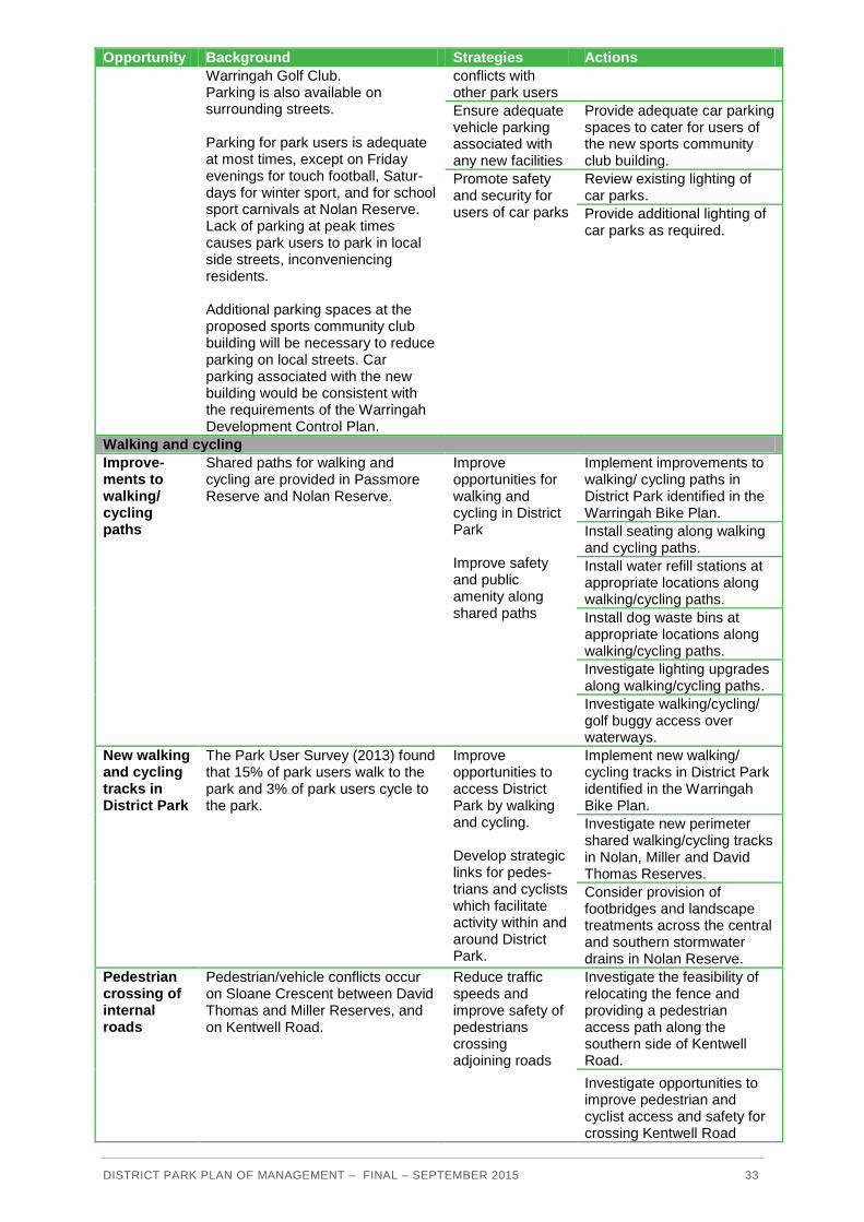
DISTRICT PARK PLAN OF MANAGEMENT – FINAL – SEPTEMBER 2015 33
Opportunity Background Strategies Actions
Warringah Golf Club. Parking is also available on surrounding streets. Parking for park users is adequate at most times, except on Friday evenings for touch football, Satur-days for winter sport, and for school sport carnivals at Nolan Reserve. Lack of parking at peak times causes park users to park in local side streets, inconveniencing residents. Additional parking spaces at the proposed sports community club building will be necessary to reduce parking on local streets. Car parking associated with the new building would be consistent with the requirements of the Warringah Development Control Plan.
conflicts with other park users
Ensure adequate vehicle parking associated with any new facilities
Provide adequate car parking spaces to cater for users of the new sports community club building.
Promote safety and security for users of car parks
Review existing lighting of car parks.
Provide additional lighting of car parks as required.
Walking and cycling
Improve-ments to walking/ cycling paths
Shared paths for walking and cycling are provided in Passmore Reserve and Nolan Reserve.
Improve opportunities for walking and cycling in District Park Improve safety and public amenity along shared paths
Implement improvements to walking/ cycling paths in District Park identified in the Warringah Bike Plan.
Install seating along walking and cycling paths.
Install water refill stations at appropriate locations along walking/cycling paths.
Install dog waste bins at appropriate locations along walking/cycling paths.
Investigate lighting upgrades along walking/cycling paths.
Investigate walking/cycling/ golf buggy access over waterways.
New walking and cycling tracks in District Park
The Park User Survey (2013) found that 15% of park users walk to the park and 3% of park users cycle to the park.
Improve opportunities to access District Park by walking and cycling. Develop strategic links for pedes-trians and cyclists which facilitate activity within and around District Park.
Implement new walking/ cycling tracks in District Park identified in the Warringah Bike Plan.
Investigate new perimeter shared walking/cycling tracks in Nolan, Miller and David Thomas Reserves.
Consider provision of footbridges and landscape treatments across the central and southern stormwater drains in Nolan Reserve.
Pedestrian crossing of internal roads
Pedestrian/vehicle conflicts occur on Sloane Crescent between David Thomas and Miller Reserves, and on Kentwell Road.
Reduce traffic speeds and improve safety of pedestrians crossing adjoining roads
Investigate the feasibility of relocating the fence and providing a pedestrian access path along the southern side of Kentwell Road.
Investigate opportunities to improve pedestrian and cyclist access and safety for crossing Kentwell Road

DISTRICT PARK PLAN OF MANAGEMENT – FINAL – SEPTEMBER 2015 34
Opportunity Background Strategies Actions through provision of traffic calming measures.
Promote walking and cycling links between reserves within District Park
Consider shared path link under Condamine Street between Miller Reserve and Warringah Golf Course.
Walking / cycling links to adjoining areas
The community has identified that links from District Park to adjoining natural areas such as Manly Dam and Manly Lagoon are desirable.
Link District Park with adjoining areas
Implement other walking / cycling links between District Park and adjoining areas identified in the revised Warringah Bike and Pedestrian and Mobility Plans.
Bike parking There are currently no existing or planned bike parking facilities in District Park (in the Warringah Bike Plan). However, a review of this Bike Plan will commence shortly.
Encourage park users to ride bikes to District Park
Provide bike parking facilities at the Passmore Reserve playground, Warringah Recreation Centre, and community and amenities buildings.
Access for all
Access for all
Access for everyone in District Park has improved in recent years, with accessible parking spaces, pathways and a footbridge being provided.
Ensure universal access to and use of spaces and facilities in District Park.
Conduct an access audit of District Park.
Address any issues raised in the Access Audit.
Wayfinding
Directional signage
The lack of directional signage in the park was identified as an issue in the visitor survey.
Ensure easy movement around and through District Park.
Implement Council’s signage strategy.

DISTRICT PARK PLAN OF MANAGEMENT – FINAL – SEPTEMBER 2015 35
5 IMPLEMENTATION
5.1 Governance
At present Warringah Council manages District Park. District Park will continue to be managed by Warringah Council.
Council’s management of the sporting fields in District Park and the Warringah Recreation Centre will ensure equitable access to facilitate uses which align with community needs. Management of the sporting fields will be consistent with the Sportsground Plan of Management and relevant policies.
Sports fields will be managed with consideration of local amenity, sporting needs, and Council policies and practices.
Council will have oversight of all use agreements. Day-to-day management of leased and licensed areas will be the responsibility of the leaseholder according to the terms of the lease or licence agreement.
5.2 Future uses and developments
5.2.1 Permitted uses and developments
Introduction
It is not possible to forecast every activity, development or structure that may occur in District Park in the future. New activities, developments and structures may be proposed in response to an application for use of the Park, or because funding or another opportunity becomes available, or to address a need or management issue that may not be evident when preparing this Plan of Management.
Principles
District Park is generally intended to be used for active sport, informal and passive recreation, social and cultural events, and preservation of natural areas.
Any use or development that would encroach on the Park’s open space should be minimised, unless it can be shown that the proposed use or development is more efficient use of the space and is consistent with the objectives of this Plan of Management.
Legislative requirements
Permissible uses and developments in District Park must be in accordance with relevant legislation in force, particularly:
categorisation of community land under the Local Government Act 1993 and the Local
Government (General) Regulation 2005.
uses for which leases, licences and other estates may be granted on community land
under the Local Government Act 1993.

DISTRICT PARK PLAN OF MANAGEMENT – FINAL – SEPTEMBER 2015 36
the principles of Crown land management under the Crown Lands Act 1989.
zoning under the Warringah Local Environmental Plan 2011.
State Environmental Planning Policy (Infrastructure) 2007.
Commonwealth legislation.
Refer to Appendix F for more information.
Other considerations In addition to the legislative considerations outlined above, assessment criteria for proposals for new activities and/or developments should address:
the objectives of this Plan of Management (Section 1).
the objectives for management of District Park (Sections 3 and 4).
community values of the Park (Section 3)
community objectives for the Park (Section 3)
the future roles of the Park (Section 3)
Council plans and policies.
Specific activities
Sporting activities Seasonal sporting activities would be conducted according to the Sportsground Plan of Management and Conditions of Hire.
Performances and events
Warringah Council will encourage performances and events which are aligned with the objectives of this Plan of Management, and other Council plans and policies. The suitability of performances and events in District Park will be assessed on a case-by-case basis.
Sale and consumption of alcohol Sale and consumption of alcohol at District Park would be according to the conditions of any current licence issued by the Office of Liquor, Gaming and Racing, and Council processes and requirements.
5.2.2 Scale and intensity of use and development
Introduction The scale and intensity of future uses and development in District Park is dependent on the:
nature of the approved future uses.
Landscape Concept Plan (Section 4.1) and subsequent detailed Masterplans.
impact on the condition of the park and assets.
impact on adjoining residents.

DISTRICT PARK PLAN OF MANAGEMENT – FINAL – SEPTEMBER 2015 37
Any proposal to use buildings, structures and spaces in District Park will be considered on
merit and balanced against the need to maintain the amenity of adjoining residents and land
uses.
Buildings and structures
Express authorisation
This Plan of Management expressly authorises development of new buildings and redevelopment of existing buildings consistent with the scale and intensity of buildings and structures as shown on the Landscape Concept Plan and subsequent detailed Masterplans.
Design considerations
Building envelopes
District Park is zoned as RE1 Public Recreation. Therefore no height or building envelope controls relate to the site under WLEP 2011.
Access
Incorporate any relevant standards to new developments and refurbishment within the Park as per Australian Standard 1428 (Parts 1 – 4) Design for Access and Mobility.
Seating for people with disabilities should comply with the Disability Discrimination Act and the Building Code of Australia.
Sustainable development
All facilities, infrastructure (new and renewed), and maintenance in District Park will integrate sustainability in terms of energy use, life cycle costs, source material impacts, and Water Sensitive Urban Design (WSUD).
All new buildings and/or refurbishments in District Park are to be developed consistent with Council’s Operational Management Standard ‘Environmentally Sustainable Design and Management of Council Built Assets’.
Parkland
Intensity of use of the parkland must be monitored in terms of its impact on the condition of the land and built assets. Corrective action, such as fencing off worn grassed areas, may be implemented if the condition of the park is impacted upon.
Traffic and parking
The impact of traffic and parking associated with organised sport or events on local residents and businesses will be managed on a case-by-case basis.
Planting
Species selected for planting in riparian areas in District Park will be endemic to the area or to Australia where possible. Elsewhere in District Park plant species which are appropriate for a highly modified and used park will be used.
Planting will be undertaken on a site-specific basis as required.

DISTRICT PARK PLAN OF MANAGEMENT – FINAL – SEPTEMBER 2015 38
Activities
It is envisaged that activities at District Park which may attract high numbers of people are sporting competitions, and special events. Applications for such activities will be assessed on a case-by-case basis.
5.2.3 Assessment and approval of permissible uses and developments
Community land Warringah Council must expressly authorise proposed developments on community land under the Local Government Act 1993. This authorisation in a Plan of Management gives ‘in principle’ support for certain activities to proceed to the development assessment stage. However, this Plan does not in itself imply or grant consent for these activities. Any proposed developments which are consistent with this Plan are still subject to development consent processes.
Crown land Clause 49 of the Environmental Planning and Assessment Regulation 2000 provides for the making of development applications by the owner of the land to which the development application applies, or by any other person with the written consent of the owner of the land. A development application made by a lessee of Crown land may only be made with written consent given by or on behalf of the Crown.
Evaluation and approval All proposed uses, development and building works in this Plan of Management will be assessed if required through a Development and Building Application process consistent with the Environment Planning and Assessment Act 1979. This Plan of Management would be an important supporting document for the required development and building applications for the proposed works. After a Plan of Management is adopted Council may only assess applications for small-scale activities or developments at District Park as it is the land owner. The Warringah Development Assessment Panel will assess any significant development applications which are authorised by this Plan. Any Development Applications, proposed works and major management issues would be advertised widely for information and to invite comment. Lot 2748 DP 752038 in David Thomas Reserve is included on the Bush Fire Prone Land Map. Any Development Application (DA) on that lot must be accompanied by a Bush Fire Hazard Assessment Report.
5.3 Use agreements
Areas in District Park which are leased or licensed are shown in Figure 7. Use agreements which apply to District Park are set out in Table 4.

DISTRICT PARK PLAN OF MANAGEMENT – FINAL – SEPTEMBER 2015 39
Leased/licensed areas in District Park Figure 7

DISTRICT PARK PLAN OF MANAGEMENT – FINAL – SEPTEMBER 2015 40
Table 4 Existing use agreements
Area of District Park
Use agreement
Lessee/
licensee
Permitted activity Term Expiry date
Warringah Golf Course
Lease Warringah Golf Club
Golf course and other recreation activities which includes retail sales
1 year and 7 months
31 January 2016
Part of David Thomas Reserve
Lease G8 Childcare Centre
Childcare centre 5 years 6 October 2019, plus a 5 year option
Part of Nolan Reserve
Lease North Manly Bowling and Recreation Club
Bowling and Recreation Club which includes retail sales
4 years and 10 months
31 January 2016
Part of Nolan Reserve
Lease Christian Bros Junior Rugby League Football Club
Clubhouse and recreation activities which includes retail sales
Expired lease
N/A
Part of Passmore Reserve
Lease Manly Vale Calabria Bowling Sports and Social Club
Bowling, sports and social club
10 years
31 March 2017
Part of Passmore Reserve
Lease Manly Small Bore Rifle Club
Small bore rifle range and club house
5 years 31 December 2016
Warringah Recreation Centre
Licence Luik Holdings Pty Ltd
Squash and other recreation activities
2 years and 10 months
31 August 2016
Warringah Recreation Centre
Licence Voyager Tennis Pty Ltd
Tennis and other recreation activities which includes retail sales
2 years and 10 months
31 August 2016
Warringah Recreation Centre
Booking agreement
Northern Beaches Futsal Association Inc.
Futsal and other recreation activities
3 years 31 August 2016
This Plan of Management authorises the current leases and licences until the end of their current terms. Prior to the expiry date, each lease or licence agreement will be reviewed, and renewed if appropriate.
5.3.3 Authorisation of future leases, licences and other estates
Introduction The Local Government Act 1993 requires that any lease or licence of community land is authorised by a Plan of Management. Leases, licences and other estates for the use of District Park are permissible under:
Sections 46 and 47 of the Local Government Act 1993.
the core objectives for the relevant category of community land.
Crown Lands Act 1989.

DISTRICT PARK PLAN OF MANAGEMENT – FINAL – SEPTEMBER 2015 41
the Warringah Local Environmental Plan, and pursuant to development consent if
required.
this Plan of Management.
Leases will entered into where use of all or part of an area is required due to scale of investment or security or an area is required with terms in accordance with Sections 46 and 47 of the Local Government Act 1993.
Licences are of shorter duration and are for control of all or part of an area.
All permissible uses of community land under lease, licence or another estate listed in Section 46 of the Local Government Act 1993 are expressly authorised by this Plan.
This Plan of Management particularly authorises the following leases, licences and commercial uses for District Park:
leases and licences applying to District Park must provide a multi-user approach to community assets.
licences must allow for a broad range of uses. licences for commercial activities would be in keeping with the core objectives for the
land and must not reasonably alienate the land.
Leasing, licensing and commercial uses in District Park will be in accordance with the objectives and principles of Council’s Community Strategic Plan. Depending on the nature of the proposed lease, licence and commercial use, Council would develop specific objectives and requirements tailored to the proposal. . All proposed activities under lease or licence would be subject to Council’s conditions, approval processes and booking fees.
Uses Under Section 46 of the Local Government Act 1993, Council may lease or licence community land in a Plan of Management for purposes consistent with the categorisation and zoning of the land.
The following leases, licences and other estates are authorised within this Plan of Management and are therefore permissible in District Park.
Table 5 Authorised leases, licences and other estates
Proposed use
Land to which authorisation applies
Express authorisation of lease, licence or other estate for:
Sports-ground Use
All spaces, buildings and facilities in District Park which may be categorised as Sportsground or General Community Use.
Sports and related purposes such as events, which may be defined as any sporting, recreational, cultural, educational, promotional, commercial, musical event and/or activities which the park can cater for, providing the core objectives of the Sportsground and General Community Use categories are met.
Catering Catering facilities within land categorised as Sportsground and General Community Use. This includes the area used to prepare food and the temporary canteens on the grounds.
Food and beverage facilities may serve prepared snacks, packaged and prepared foods, with alcoholic and non-alcoholic beverages to take away.
The food and beverage facilities are to be supportive of the function of District Park.

DISTRICT PARK PLAN OF MANAGEMENT – FINAL – SEPTEMBER 2015 42
Proposed use
Land to which authorisation applies
Express authorisation of lease, licence or other estate for:
Combined sports community club building
Land categorised as Sportsground for the use of the new combined sports club
Distribution of alcoholic beverages, restaurant food and entertainment, along with the sale and hire of sports equipment associated with use of the park. Any other activities for which a registered club would be licensed.
Advertising Land categorised as Sportsground and General Community Use.
Internal advertising, where it is supportive of the use of the land and not visible from the exterior.
Placing advertising material on the ground and buildings providing it is consistent with State Environmental Planning Policy No. 64 – Advertising and Signage (SEPP 64).
New signage would be subject to assessment under the provisions of SEPP 64, Warringah Local Environment Plan 2011, and Warringah Development Control Plan.
Commercial uses
Land categorised as Sportsground, Park and General Community Use.
Small-scale commercial uses which support the use of District Park for sport, passive recreation, and cultural and social activities, such as bicycle hire and mobile food/beverage vans. Large-scale commercial uses which offer a community benefit and generate income.
Other estates This Plan of Management authorises Council to grant “an estate” over community land for the provision of public utilities and works associated with or ancillary to public utilities in accordance with the Local Government Act 1993.
Easements
This Plan of Management expressly authorises the granting of easements over land in District Park to provide pipes, conduits or other connections under the ground surface. This is limited to easements which connect premises adjoining community land to an existing water, sewer, drainage or electricity facility of Council or another public utility provider that is situated on community land. Such easements must minimise impacts on the condition and use of the park.
Granting of easements above, on or under the surface of community land or to land that is not community land is not within the authority of this Plan of Management. These easements include, but are not limited to piping to a natural watercourse, piping from a facility on community land to a facility on private land, and private vehicular or pedestrian access.
Short-term casual hire / temporary licences
All short-term casual hire will be in accordance with the Local Government (General) Regulation 2005. To be considered as casual hire, the use or occupation must not:
involve the erection of any building or structure of a permanent nature.
continue for more than three consecutive days (in the case of any use or occupation that
occurs only once).
continue to recur for a period of more than 12 months in the case of uses occurring more
than once. Each occurrence must be no more than 3 consecutive days, not including
Saturday and Sunday.

DISTRICT PARK PLAN OF MANAGEMENT – FINAL – SEPTEMBER 2015 43
Authorisation is granted for short-term casual hire in District Park for the following uses.
Table 6 Authorised uses for short term casual hire of District Park
Proposed use
Land to which authorisation applies
Express authorisation of lease, licence or other estate for:
Sport and events
Land categorised as Sportsground, Park, General Community Use
Occasional sporting, recreational, social or educational events. This would include activities such as one-off sporting events and events such as fetes, fairs and cultural, musical or entertainment events.
Other short-term uses of community land
Land categorised as Sportsground, Park, General Community Use
Short term/temporary uses set out in the Local Government Act 1993 and the Local Government (General) Regulation 2005
including:
wedding ceremonies and functions.
playing of a musical instrument or singing for fee or reward.
delivering a public address or speech
markets and / or temporary stalls including food stalls.
commercial filming and photography.
corporate functions.
birthday parties and family gatherings.
other special events/ promotions provided they are on a scale appropriate to the use of a regional park, or to the benefit and enjoyment of the local community.
emergency purposes, including training, when the need arises.
All short-term temporary and casual uses would be subject to council’s standard conditions for hire, approval processes, and booking fees. A temporary licence would be issued by council as part of the approval process prior to the park being used for these activities. Organisers of the activity are subject to conditions of hire.
Fees for short term, casual bookings will be in accordance with the fees and charges as published in Warringah Council’s Operating Plan and Budget.
Subleases
Where a lease arrangement has been entered into with council for community land, subleasing of the land must be in accordance with the requirements of Section 47C of the Local Government Act 1993.
Under Clause 119 of the Local Government (General) Regulation 2005, community land leased by a sporting club may be sub-leased for refreshment kiosks, dances and private parties. Under the same clause, a bowling club may be sub-let to a croquet club.
5.4 Monitoring
Implementation of actions in this Plan of Management according to their assigned priorities will be monitored annually through the preparation of annual performance reports, budgets, and capital works programs. It should be recognised however that commencement and completion of the recommended actions in this Plan of Management depends on available Council resources, funding, and Council’s priorities in its annual works program. The priority of each action should be reassessed annually to determine if the stated priority is still relevant.
DISTRICT PARK PLAN OF MANAGEMENT – FINAL – SEPTEMBER 2015 44
5.5 Reporting
Achievement of actions listed in this Plan of Management will be reported using Council’s Integrated Planning and Reporting Framework. Achievement of major actions will be reported in Warringah Council’s Annual Report.
Income, expenditure and achieved actions regarding District Park will be reported to Council after each financial year.
5.6 Review
This Plan of Management is intended to be reviewed and updated when required. It should be updated to reflect changing community and council priorities and issues, to take into account changes in grants and funding, legislation or government directions, and to recognise completed actions. Review of this Plan of Management should also take into account the outcomes of periodic reviews of council’s strategic and operational plans.
The Action Plan tables have a shorter life and therefore require more frequent reviews and updating. The Action Plan tables should be reviewed and revised when required in accordance with council’s budgets, capital works program and changing priorities.
DISTRICT PARK PLAN OF MANAGEMENT – FINAL – SEPTEMBER 2015 45
6 REFERENCES
Chapman, G.A. and Murphy, C.L. (1989) Soil Landscapes of the Sydney Region.
ERM (2001a) Proposed Categorisation of Land at District Park: Report on Public Hearing. Prepared for Warringah Council, March.
ERM (2001b) Proposed Categorisation of Land at District Park: Report on Public Hearing (2). Prepared for Warringah Council, July.
Golf Business Advisory Services (2015) District Park Clubhouse Feasibility Study.
Hajkowicz, S.A., Cook, H., Wilhelmseder, L., Boughen, N. (2013) The Future of Australian Sport: Megatrends shaping the sports sector over coming decades.
Integrated Open Space Services (2013) Benchmark Park User Satisfaction Survey.
JBAS (2014) Northern Beaches Regional Golf Study. Prepared for Warringah Council, April.
NSW Government (2014) A Plan for Growing Sydney. December.
SGL Consulting (2008) Recreation Needs Study. Prepared for Warringah Council, February.
SGL Consulting (2008) Recreation Needs Study: Key Findings, Strategic Directions and Recommendations. Prepared for Warringah Council.
SGL Consulting (2009) Recreation Needs Study: Open Space and Facilities Provision Review – Technical Paper One. Prepared for Warringah Council.
Warringah Council and Integrated Site Design Pty Ltd (1995) District Park Plan of Management: A significant area plan of management. Adopted November 1995.
Warringah Council (2002) District Park Plan of Management. Adopted 23 April 2002.
Warringah Council (2006) Children and Family Services Strategy.
Warringah Council (2007) Cultural Plan.
Warringah Council (2007) Playground Strategy.
Warringah Council (2007) Sportsgrounds Plan of Management.
Warringah Council (2009) Recreation Strategy 2009.
Warringah Council (2011) Warringah Section 94A Development Contributions Plan.
Warringah Council (2011) Draft Warringah Biodiversity Conservation Study.
Warringah Council (2013) Warringah Council’s Youth Strategy 2013-2023.
Warringah Council (2014) Creative Warringah: Warringah Council’s strategy for a creative and connected community for all 2014-2020.
Warringah Council (undated) Living Well Warringah: Warringah Council’s Ageing Strategy.
Warringah Shire Council (1991) A Brief History of Manly-Warringah District Parks.

DISTRICT PARK PLAN OF MANAGEMENT – FINAL – SEPTEMBER 2015 46
APPENDICES

DISTRICT PARK PLAN OF MANAGEMENT – FINAL – SEPTEMBER 2015 47
A LAND INCLUDED IN THIS PLAN OF MANAGEMENT
Register Number
Lot Section Deposited Plan
Address Category
69I/1A 2741 752038 Lot 2741/9999 Condamine Street MANLY VALE NSW 2093
General Community Use, Natural Area Watercourse
69I/1B 2740 752038 Lot 752038/9999 Condamine Street MANLY VALE NSW 2093
General Community Use
69I/1C 2747 752038 Lot 5747/9999 Condamine Street MANLY VALE NSW 2093
General Community Use
71/1 2742 752038 Lot 2742/9999 Condamine Street MANLY VALE NSW 2093
Natural Area Watercourse, Sportsground
71/2 3 3 5875 Lot 3/ Sloane Crescent ALLAMBIE HEIGHTS NSW 2100
Park
71/3A 1 449244 Nolan Reserve Pittwater Road NORTH MANLY NSW 2100
Sportsground
71/3B 25 664878 Pittwater Road NORTH MANLY NSW 2100
Sportsground
71/5A 2 1125336 Nolan Reserve Pittwater Road NORTH MANLY NSW 2100
Natural Area Watercourse, Sportsground
71/5B 3 1125336 Nolan Reserve Pittwater Road NORTH MANLY NSW 2100
Natural Area Watercourse, Sportsground
71/5C 4 1125336 Nolan Reserve Pittwater Road NORTH MANLY NSW 2100
Natural Area Watercourse, Sportsground
71/5D 5 1125336 Nolan Reserve Pittwater Road NORTH MANLY NSW 2100
Natural Area Watercourse, Sportsground
71/5E 6 1125336 Nolan Reserve Pittwater Road NORTH MANLY NSW 2100
Natural Area Watercourse, Sportsground
71/5F 7 1125336 Nolan Reserve Pittwater Road NORTH MANLY NSW 2100
Natural Area Watercourse, Sportsground
71/5G 8 1125336 Nolan Reserve Pittwater Road NORTH MANLY NSW 2100
Natural Area Watercourse, Sportsground
71/5H 9 1125336 Nolan Reserve Pittwater Road NORTH MANLY NSW 2100
Natural Area Watercourse, Sportsground
71/5I 10 1125336 Nolan Reserve Pittwater Road NORTH MANLY NSW 2100
Natural Area Watercourse, Sportsground
71/5J 11 1125336 Nolan Reserve Pittwater Road NORTH MANLY NSW 2100
Natural Area Watercourse, Sportsground
71/5K 12 1125336 Nolan Reserve Pittwater Road NORTH MANLY NSW 2100
Natural Area Watercourse, Sportsground

DISTRICT PARK PLAN OF MANAGEMENT – FINAL – SEPTEMBER 2015 48
Register Number
Lot Section Deposited Plan
Address Category
71/5L 13 1125336 Nolan Reserve Pittwater Road NORTH MANLY NSW 2100
Natural Area Watercourse, Sportsground
71/5M 14 1125336 Nolan Reserve Pittwater Road NORTH MANLY NSW 2100
Natural Area Watercourse, Sportsground
71/5N 15 1125336 Nolan Reserve Pittwater Road NORTH MANLY NSW 2100
Natural Area Watercourse, Sportsground
71/5O 28 A 5857 Nolan Reserve Pittwater Road NORTH MANLY NSW 2100
Sportsground
71/5P 27 A 5857 Nolan Reserve Pittwater Road NORTH MANLY NSW 2100
Sportsground
71/5Q 26 A 5857 Nolan Reserve Pittwater Road NORTH MANLY NSW 2100
Sportsground
71/5R 24 A 5857 Nolan Reserve Pittwater Road NORTH MANLY NSW 2100
Sportsground
71/5S 23 A 5857 Nolan Reserve Pittwater Road NORTH MANLY NSW 2100
Sportsground
71/5T 22 A 5857 Nolan Reserve Pittwater Road NORTH MANLY NSW 2100
Sportsground
71/5W 21 A 5857 Nolan Reserve Pittwater Road NORTH MANLY NSW 2100
Sportsground
71/5X 20 A 5857 Nolan Reserve Pittwater Road NORTH MANLY NSW 2100
Sportsground
71/5Y 19 A 5857 Nolan Reserve Pittwater Road NORTH MANLY NSW 2100
Sportsground
71/5Z 18 A 5857 Nolan Reserve Pittwater Road NORTH MANLY NSW 2100
Sportsground
71/6 12 A 5857 Nolan Reserve Pittwater Road NORTH MANLY NSW 2100
Natural Area Watercourse, Sportsground
71/8 2 819059 Lot 2/ Cornwell Road ALLAMBIE HEIGHTS NSW 2100
Park
71/9A 17 A 5857 Nolan Reserve Pittwater Road NORTH MANLY NSW 2100
Sportsground
71/9B 16 A 5857 Nolan Reserve Pittwater Road NORTH MANLY NSW 2100
Sportsground
71/9C 15 A 5857 Nolan Reserve Pittwater Road NORTH MANLY NSW 2100
Sportsground
71/9D 14 A 5857 Nolan Reserve Pittwater Road NORTH MANLY NSW 2100
Sportsground
71/9E 13 A 5857 Nolan Reserve Pittwater Road NORTH MANLY NSW 2100
Sportsground
71/9F 1 723586 Pittwater Road NORTH MANLY NSW 2100
Natural Area Watercourse, Sportsground
71/9G 1 1125336 Nolan Reserve Pittwater Road NORTH MANLY NSW 2100
Natural Area Watercourse, Sportsground

DISTRICT PARK PLAN OF MANAGEMENT – FINAL – SEPTEMBER 2015 49
Register Number
Lot Section Deposited Plan
Address Category
71/9H 16 1125336 Nolan Reserve Pittwater Road NORTH MANLY NSW 2100
Natural Area Watercourse, Sportsground
72/6A 87 12578 Lot 87/9996 Riverview Parade NORTH MANLY NSW 2100
General Community Use
72/6B 88 12578 Lot 87/9996 Riverview Parade NORTH MANLY NSW 2100
General Community Use
72/7 2762 752038 Lot 3/ Campbell Parade MANLY VALE NSW 2093
Natural Area Watercourse, Sportsground
76/1 2748 752038 David Thomas Reserve Campbell Parade MANLY VALE NSW 2093
General Community Use, Natural Area Bushland, Natural Area Watercourse, Park, Sportsground
76/2 10 27009 Lot 10/9999 Campbell Parade MANLY VALE NSW 2093
Natural Area Bushland
77/1 2744 752038 Lot 2744/9999 Condamine Street MANLY VALE NSW 2093
Natural Area Watercourse, Park, Sportsground
77/1A 2743 752038 Campbell Parade MANLY VALE NSW 2093
Natural Area Watercourse, Park, Sportsground

DISTRICT PARK PLAN OF MANAGEMENT – FINAL – SEPTEMBER 2015 50
B PROCESS OF PREPARING THIS PLAN OF MANAGE-MENT
Dates Stage Engagement Outputs
Dec 2012 Council resolves to review current Plan of Manage-ment for District Park and to prepare a new Plan of Manage-ment by December 2015
- Report to Council. Council resolution on 11 December 2012
Feb-May 2013
Research background information, issues and opportunities
Park User Survey council staff
Benchmark Park User Satisfaction Survey (Integrated Open Space Services, 2013)
May – Nov 13
Prepare Discussion Paper
Council staff Recreation and Open Space Strategic Reference Group
District Park Discussion Paper Nov 2013
Nov 13 Council endorses the process for review of District Park Plan of Management 2002
Council meeting Report to Council Council resolution to approve public exhibition on 26 November 2013
Nov 13 –Mar 14
Community and stakeholder engagement on Discussion Paper
Signage installed in the park Letterbox drop of local residents and businesses Council website: Your Say Warringah project page, online feedback form, interactive map Advertisements in the Manly Daily Media release Posters and hard copies at Warringah Golf Club, North Manly Bowling Club, Boronia Hall Childcare Centre, Manly Vale Calabria Club, and Warringah Recreation Centre Community drop-in sessions at North Manly Bowling Club 22 Feb 2014, Calabria Club 26 Feb 2014, Boronia Hall Childcare Centre 8 Mar 2014, Warringah Golf Club 10 Mar 2014 One-on-one meetings with key external stakeholders including current lessees
Community attendance at drop-in sessions 251 written submissions, 75 online submissions District Park Discussion Paper Submissions Report June 2014
to April 14
Prepare Regional Golf Study
Warringah Golf Club Other golf clubs in Warringah and adjoining LGAs Golf NSW, Golf Australia
Regional Golf Study, (JBAS, April 2014)
Mar – Jun 14
Prepare District Park Draft Strategic Directions Paper
- District Park Draft Strategic Directions Paper June 2014
Jun 14 Report to Council to place Draft Strategic
Council meeting Council resolution to approve public exhibition 24 June

DISTRICT PARK PLAN OF MANAGEMENT – FINAL – SEPTEMBER 2015 51
Dates Stage Engagement Outputs
Directions Paper on public exhibition
2014
July – Nov 14
Community and stakeholder engagement on Strategic Directions Paper
110 people attended community drop-in sessions at Calabria Club (16 Jul), North Manly Bowling Club (26 Jul), Warringah Golf Club (28 Jul) Council website: Your Say Warringah project page, online feedback form Email, mail
30 written submissions District Park Strategic Directions Paper: Submissions Report, November 2014
Nov 14 – March 15
Prepare sports club feasibility study
Working Group comprising key external stakeholders and current lessees
District Park Feasibility Study (Golf Business Advisory Services, March 2015)
Nov 14 – April 15
Prepare Draft Plan of Management for District Park
Feedback from council staff Draft Plan of Management for District Park
March-April 15
Prepare Landscape Concept Plan
Consultation meeting with key external stakeholders including current lessees and major hirers
Landscape Concept Plan for District Park
May 15 Strategic Reference Groups
Inform the Open Space and Recreation and Environmental Conservation and Overall Sustainability Strategic Reference Groups
Feedback
May 15 Council resolve to place Draft Plan of Management on public exhibition
Council meeting Report to Council Council resolution to approve public exhibition 26 May
May-July 15
Community and stakeholder engagement on Draft Plan of Management
Public notice in local newspapers Community drop-in sessions at locations in or adjacent to the park Council website: Your Say Warringah project page, online feedback form Email, mail
Submissions Report
July 15 Consider submissions and prepare final Plan of Management
- Plan of Management for District Park 2015
August 15
Adoption of Plan of Management by Warringah Council
Council meeting
Council resolution to adopt Plan of Management 25 August

DISTRICT PARK PLAN OF MANAGEMENT – FINAL – SEPTEMBER 2015 52
C HISTORY OF DISTRICT PARK
Year Event
1919 The Brookvale Progress Association first proposed the concept of a district park to Manly Municipal Council, Warringah Shire Council, and the Lands Department.
1922 Warringah Council prepared a report suggesting the resumption of 170 acres of land to establish the District Parks. Warringah and Manly Councils could not afford the £25,000 cost, and the Department of Lands refused a request for funding.
1925 The Manly Warringah District Parks Joint Committee was established. In 1 December Warringah and Manly Councils decided to enter into a formal agreement to apply for the resumption and share the costs equally.
1920s The original area of the District Parks was used for Chinese market gardens, Keating’s Dairy in the present Miller Reserve, and private estates. District Park was planned as a regional recreation space.
1928 Land for District Park was resumed at a cost of approximately £19,000 which was shared between Warringah Shire and Manly Municipal Councils. The Department of Lands agreed to resume the land on 25 October. The project was controversial in the community due to the expense of draining and filling the area, and that its location meant that Manly ratepayers would benefit most.
1930 The North Manly Progress Association proposed to the Manly and Warringah District Parks Trust Joint Committee that a temporary 9-hole golf course be constructed on the northern section of the park. The committee called for designs for a layout of the park to cater for golf, cricket, football and other sports and for the general beautification of the area.
1933 An offer was made to lease the northern section of District Parks for a golf course. The Department of Lands objected as the land had been resumed for public recreation purposes, and the project fell through.
1934 The Department of Lands appointed a public trust comprising 3 Warringah councillors and 3 Manly aldermen on 8 June. Warringah Shire Council approved a lease over 71 acres to permit building an 18-hole golf course in two stages.
1935 The first stage of Warringah Golf Course, comprising 9 holes north of Kentwell Road, was opened in December.
1936 The Manly Warringah District Golf Club was established. James Emery showed elements of a vision for District Park on a pictorial map of Manly Warringah District Park, which was presented to the Hon. E.S. Spooner MLA, Minister for Works. Refer to Figure 3. Emery’s map showed a cricket oval with grandstands and ornamental gardens on the now Miller Reserve, a green forest in the centre of the golf course, a band rotunda with formal gardens, duck ponds and a lake for sailing boats, a picnic ground with shelter sheds and kiosk, baseball and hockey fields, and a children’s playground in Nolan Reserve. Elements of the vision which were realised in later years are a public golf course, tennis courts, and North Manly Bowling Club.
1938 Funding was obtained from a State government grant and a Joint Council Development Loan for extensive development of the parks, including initial drainage, reclamation, grading, grassing and earthworks for the North Manly Bowling Club. A little later the tennis courts and clubhouse/ residence at the corner of Kentwell and Pittwater Roads were constructed. Warringah Golf Club bought land on Condamine Street at North Manly for £88 for a clubhouse.
1939 Warringah Golf Course was completed to 18-holes and the clubhouse was opened in June. A dairy was located near the 10
th green of the golf course. Chinese market gardens were
situated south of the creek, and golfers had to play around fences between the market gardens and the golf course.
1940 The clubhouse on the current Warringah Recreation Centre site was built.
1941 The Manly Small Bore Rifle Club was established on the present site.
1947 Approval was granted to lease the North Manly bowling green site at £1 per year for 20 years for a public bowling green and club premises.
1951 15.5 acres of land west of Sloane Crescent comprising the late Dr David Thomas’ estate was purchased by the Lands Department, Warringah Council and Manly Council for £1,200 and

DISTRICT PARK PLAN OF MANAGEMENT – FINAL – SEPTEMBER 2015 53
Year Event
added to the parks.
1953 On 1 September Manly and Warringah Councils formalised an agreement for control of District Parks which included War Memorial Park at Manly Dam, Warringah Golf Course, and Nolan, Miller, Passmore and David Thomas Reserves. The latter reserves were named after people who played prominent roles in establishing District Park.
1954 Warringah Golf Club took over the lease of the golf course.
1956 Mackellar Womens Bowling Club established its premises in Miller Reserve.
1956-7 Manly Vale Bowling Club was constructed.
1960 After local residents opposed use of parklands for private use, a concrete court formerly used for basketball was leased to a private individual for construction of a roller rink.
1964 Warringah Shire Council attempted to serve notices to Asian lessees to quit their market gardens which formed part of the District Parks. The Manly Warringah Sporting Union was formed to control the fair distribution of grounds and lights on behalf of the District Parks Joint Committee.
1965 Sports amenities were constructed at Miller Reserve and Nolan Reserve.
1966 The Minister for Local Government determined that Passmore Reserve be developed for playing fields on the former market gardens.
1968 A night practice range was established on the golf course.
1977 The night golf practice range closed because it was unprofitable.
1988 Port Jackson fig trees were planted in Nolan and Passmore Reserves to mark the Australian Bicentennial celebrations and to enhance the parklands for future generations.
1990 A substantial drainage program in Nolan Reserve was completed.
1991 The Manly Warringah District Parks Joint Committee was dissolved on 1 January. Both Councils agreed in May that Manly Council would relinquish claims to any lands in the District Park.
1994 Sports amenities were constructed at north Nolan Reserve.
1995 The first Plan of Management for District Park was prepared.
1998 Warringah Council resolved to rezone and sell the former Mackellar Womens Bowling Club for eight housing blocks.
2000 The playground in Passmore Reserve was constructed.
2002 The second Plan of Management for District Park was adopted by Warringah Council on 23 April.
2005 A childcare centre was opened on the site of the former Mackellar Womens Bowling Club.
2011 Amenities were constructed at Passmore Reserve.
2012 Warringah Recreation Centre was established.
Source: Warringah Shire Council (1991)

DISTRICT PARK PLAN OF MANAGEMENT – FINAL – SEPTEMBER 2015 54
D CONDITION OF BUILDINGS IN DISTRICT PARK
Building Year
constructed
Condition 1
Remaining useful life
(years)
David Thomas Reserve
BUI00011- Sports amenities 2009 1 83
Manly Small Bore Rifle Club
BUI00160 - Building 1941 1 47
Manly Vale Bowling Club
BUI00156 - Manly Vale Bowling Club and futsal courts
1956 2 27
BUI00157 – Storage Shed 1956 2 23
Miller Reserve
BUI00127 – Miller Reserve Sports amenities 1965 2 34
Nolan Reserve
BUI00139 - Works storage shed 1960 1 61
BUI00140 - Sports amenities (north) 1994 1 61
BUI00153 - Sports amenities (middle) 1965 4 2
BUI00167 - Sports amenities (south) 1965 4 2
North Manly Bowling Club
BUI00137 - Main building 1957 2 34
BUI00138 – Storage shed 1957 1 61
Passmore Reserve
BUI00323 - Playground amenities North 2011 1 52
BUI00098 - Sport amenities 2011 1 83
Sloane Crescent Long Day Care Centre
BUI00124 - Garage 2005 1 61
Warringah Golf Club
BUI00132 - Vehicle shelter 1977 2 25
BUI00134 - Greenkeepers shed 1970 2 24
BUI00128 - Pro shop 1988 1 61
Warringah Recreation Centre
BUI00136 - Main clubhouse 1940 2 49
BUI00304 – Squash Courts 1975 2 50
Source: Warringah Council

DISTRICT PARK PLAN OF MANAGEMENT – FINAL – SEPTEMBER 2015 55
1 Asset condition is measured using the International Infrastructure Management Manual (IIMM)). 1 – 5 rating system below.
Condition Assessment Rating
Level Condition Description
1 Excellent No work required (normal maintenance)
2 Good Only minor maintenance work required
3 Average Maintenance work required
4 Poor Renewal required
5 Very Poor Urgent renewal / upgrading required / Disposal

DISTRICT PARK PLAN OF MANAGEMENT – FINAL – SEPTEMBER 2015 56
E TRENDS IN SPORT AND RECREATION
Trend Implications
Social change
Population increase
Increasing life expectancy and aging population
Reduced leisure time due to work/study
Shift towards apartment living
Concern about safety in public spaces
Concern about sun exposure
Increasing awareness of the health benefits of physical activity
Increased demand for:
- public open space and recreation opportunities
- activities and facilities for older people
- longer and flexible opening times
- shade and shelter
- range of recreational activities including casual use for bootcamps and personal trainers
Sport and recreation activity participation changes
Informal recreation activities are more popular than sporting activities (national participation surveys)
Greater diversity of sporting codes.
Increasing popularity and participation in shorter and faster versions of sports – Twenty-20 cricket, FAST4 tennis.
Modified playing surfaces and sports for children – In2Cricket, Hot Shots tennis, small-sided football, Jack Attack lawn bowls.
Shift from competitive team sport to individual fitness and social sport.
Growth in indoor sports and recreation.
Culturally diverse preferences for recreation activities, such as outdoor table tennis.
Increasing popularity of “extreme” sports such as skateboarding, BMX riding and rollerblading.
Increasing takeup of digital technology and doing ‘work’ in public spaces
Provision of informal recreation facilities and settings Adaptable sporting facilities Multi-purpose sporting facilities Changes in sport scheduling Line marking and surfaces for children’s sport Provision for indoor sport and recreation activities, new/emerging activities, and extreme sports. “Pay as You Play” Increasing demand for access to Wi-Fi for internet access and fitness tracking
Changes in frequency of participation in sport and recreation activities
Decline in participation in sport in general by young women (national participation surveys)
Increasing participation by women and girls in traditional male sport such as football, rugby league and union, and AFL (national surveys)
Decrease in involvement of children, adolescents and young adults in physical activity (national participation surveys)
Higher participation in seniors and masters sports, such as tennis, swimming (national participation surveys)
Increase in people with disabilities participating in sport.
Casual use (personal fitness trainers, boot camps)
Concerns about obesity
Physical education and participation programs

DISTRICT PARK PLAN OF MANAGEMENT – FINAL – SEPTEMBER 2015 57
The “megatrends” in sport in Australia (Hajkowicz, et. al. 2013) which also influences participation in sport and delivery of sporting facilities in Warringah are:
Megatrend Description
A Perfect Fit Individualised sport and fitness activities are on the rise.
People are fitting sport into their increasingly busy and time-fragmented lifestyles to achieve personal health objectives.
Participation rates in aerobics, running, walking, and gym membership have risen sharply in the past decade, while participation rates in many organised team sports has held constant or declined.
People are increasingly opting to go for a run with headphones and a music player when the opportunity arises, rather than commit to a regular organised sporting competition.
Australians are becoming more health conscious.
We are increasingly playing sport to get fit, rather than getting fit to play sport.
From extreme to mainstream
Rise of lifestyle, adventure and alternative sports which are particularly popular with younger generations. These sports typically involve complex, advanced skills and have some element of inherent danger and/or thrill seeking. They are also characterised by a strong lifestyle element and participants often obtain cultural self-identity and self-expression through these sports. These sports are likely to attract participants through generational change and greater awareness through online content and social media.
Sports such as BMX cycling have recently been added to the Olympic Games program. International associations for skateboarding and rock climbing are pushing for these sports to be included in the Olympics.
More than sport
Sport can help achieve the objectives of:
- mental and physical health – reduction in rising rates of obesity and chronic illness in children and adults.
- reduction in crime. - social development and inclusion of marginalised groups. - international co-operation through building bridges to other countries, and
achieving overseas aid, peace, development and foreign policy objectives.
These broader benefits of sport are being increasingly recognised by governments, business and communities.
Everybody’s Game
Australia faces an aging population, which will change the types of sports we play and how we play them. Australians are embracing sports into their old age. Sports of the future will need to cater for seniors to retain strong participation rates.
Sports will also have to cater for the changing cultural makeup of Australia. Our society has, and will continue to, become highly multicultural. Different cultures have different sporting preferences and recreation habits. Sporting organisations will be challenged with capturing the interest and involvement of diverse cultures.
New Wealth, New Talent
Growth in population and income throughout Asia will create tougher competition and new opportunities for Australia on the sports field and in sports business. Asian countries are investing heavily in sports capabilities, and especially in China, have rapidly improved their recent performance at the Olympic Games. As disposable incomes grow, the populations of Asian countries are becoming more interested in sport. This may create new markets for sports television, tourism, equipment, services and events.
Tracksuits to Business Suits
Market forces are likely to exert greater pressure on sport in the future. In some sports elite athletes have had considerable pay rises and large sponsorship deals. Sports with higher salaries may draw athletes away from sports with lower salaries.
Loosely organised community sport associations are likely to be replaced by organisations with corporate structures and more formal governance systems due to market pressures.
The cost of participating in sport is also rising, which is a participation barrier to many people.

DISTRICT PARK PLAN OF MANAGEMENT – FINAL – SEPTEMBER 2015 58
F PLANNING CONTEXT
F.1 Commonwealth legislation
Telecommunications Act 1997
The Commonwealth Telecommunications Act 1997 provides for telecommunication carriers to install ‘low-impact’ telecommunications structures without seeking local government planning approval.
F.2 State government legislation
The Local Government Act 1993, Crown Lands Act 1989, Environmental Planning and Assessment Act 1979 and Warringah Local Environmental Plan 2011 influence the use and management of District Park.
Local Government Act 1993
Contents
Requirements of the Local Government Act 1993 for the contents of a Plan of Management, and where they can be found in this Plan, are listed below.
Requirement of the Local Government Act How this plan satisfies the Act
A description of the condition of the land, and of any buildings or other improvements on the land as at the date of adoption of the Plan of Management
Section 2
A description of the use of the land and any such buildings or improvements as at the date of adoption of the Plan of Management.
Section 2
Categorisation of community land Appendix F
Core objectives for management of the land Appendix F
The purposes for which the land, and any such buildings or improvements, will be permitted to be used.
Sections 3, 5
The purposes for which any further development of the land will be permitted, whether under lease or licence or otherwise.
Sections 3, 5
A description of the scale and intensity of any such permitted use or development. Section 5
Authorisation of leases, licences or other estates over community land. Section 5
Performance targets. Section 4
A means for assessing achievement of objectives and performance targets. Section 4
Categorisation of and core objectives for community land
The Local Government Act 1993 requires that a Plan of Management is prepared for Council-owned land which is classified as community land under the Act.
The categorisation of District Park as shown below is consistent with the guidelines and core objectives of each category outlined in the Act.

DISTRICT PARK PLAN OF MANAGEMENT – FINAL – SEPTEMBER 2015 59
Categorisation of District Park Figure 8
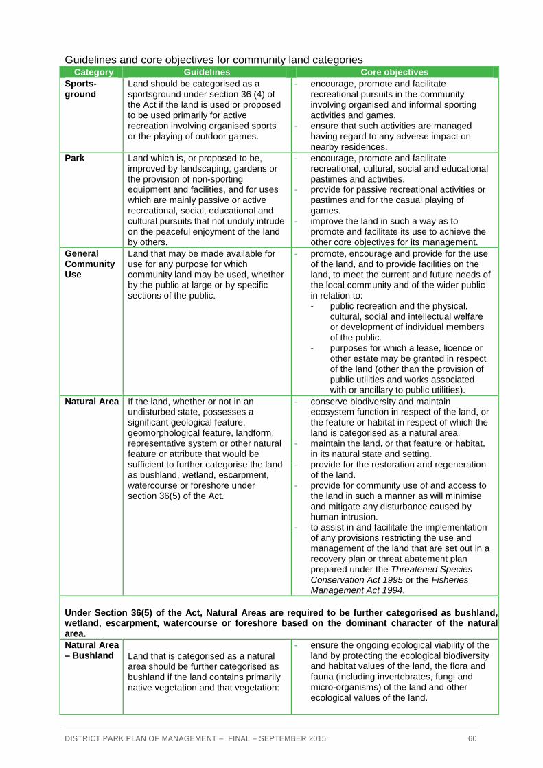
DISTRICT PARK PLAN OF MANAGEMENT – FINAL – SEPTEMBER 2015 60
Guidelines and core objectives for community land categories Category Guidelines Core objectives
Sports-ground
Land should be categorised as a sportsground under section 36 (4) of the Act if the land is used or proposed to be used primarily for active recreation involving organised sports or the playing of outdoor games.
- encourage, promote and facilitate recreational pursuits in the community involving organised and informal sporting activities and games.
- ensure that such activities are managed having regard to any adverse impact on nearby residences.
Park Land which is, or proposed to be, improved by landscaping, gardens or the provision of non-sporting equipment and facilities, and for uses which are mainly passive or active recreational, social, educational and cultural pursuits that not unduly intrude on the peaceful enjoyment of the land by others.
- encourage, promote and facilitate recreational, cultural, social and educational pastimes and activities.
- provide for passive recreational activities or pastimes and for the casual playing of games.
- improve the land in such a way as to promote and facilitate its use to achieve the other core objectives for its management.
General Community Use
Land that may be made available for use for any purpose for which community land may be used, whether by the public at large or by specific sections of the public.
- promote, encourage and provide for the use of the land, and to provide facilities on the land, to meet the current and future needs of the local community and of the wider public in relation to: - public recreation and the physical,
cultural, social and intellectual welfare or development of individual members of the public.
- purposes for which a lease, licence or other estate may be granted in respect of the land (other than the provision of public utilities and works associated with or ancillary to public utilities).
Natural Area If the land, whether or not in an undisturbed state, possesses a significant geological feature, geomorphological feature, landform, representative system or other natural feature or attribute that would be sufficient to further categorise the land as bushland, wetland, escarpment, watercourse or foreshore under section 36(5) of the Act.
- conserve biodiversity and maintain ecosystem function in respect of the land, or the feature or habitat in respect of which the land is categorised as a natural area.
- maintain the land, or that feature or habitat, in its natural state and setting.
- provide for the restoration and regeneration of the land.
- provide for community use of and access to the land in such a manner as will minimise and mitigate any disturbance caused by human intrusion.
- to assist in and facilitate the implementation of any provisions restricting the use and management of the land that are set out in a recovery plan or threat abatement plan prepared under the Threatened Species Conservation Act 1995 or the Fisheries Management Act 1994.
Under Section 36(5) of the Act, Natural Areas are required to be further categorised as bushland, wetland, escarpment, watercourse or foreshore based on the dominant character of the natural area.
Natural Area – Bushland Land that is categorised as a natural
area should be further categorised as bushland if the land contains primarily native vegetation and that vegetation:
- ensure the ongoing ecological viability of the land by protecting the ecological biodiversity and habitat values of the land, the flora and fauna (including invertebrates, fungi and micro-organisms) of the land and other ecological values of the land.

DISTRICT PARK PLAN OF MANAGEMENT – FINAL – SEPTEMBER 2015 61
Category Guidelines Core objectives
(a) is the natural vegetation or a remainder of the natural vegetation of the land, or
(b) although not the natural vegetation of the land, is still representative of the structure or floristics, or structure and floristics, of the natural vegetation in the locality.
- protect the aesthetic, heritage, recreational, educational and scientific values of the land.
- promote the management of the land in a manner that protects and enhances the values and quality of the land and facilitates public enjoyment of the land, and to implement measures directed to minimising or mitigating any disturbance caused by human intrusion.
- restore degraded bushland. - protect existing landforms such drainage
lines, watercourses and foreshores. - retain bushland in parcels of a size and
configuration that will enable the existing plant and animal communities to survive in the long term.
- protect bushland as a natural stabiliser of the soil surface.
Natural Area – Water-course
Land that is categorised as a natural area should be further categorised as a watercourse if the land includes:
(a) any stream of water, whether perennial or intermittent, flowing in a natural channel, or in a natural channel that has been artificially improved, or in an artificial channel that has changed the course of the stream of water, and any other stream of water into or from which the stream of water flows, and
(b) associated riparian land or vegetation, including land that is protected land for the purposes of the Rivers and Foreshores Improvement Act 1948 or State protected land identified in an order under section 7 of the Native Vegetation Conservation Act 1997.
- manage watercourses so as to protect the biodiversity and ecological values of the in stream environment, particularly in relation to water quality and water flows.
- manage watercourses so as to protect the riparian environment, particularly in relation to riparian vegetation and habitats and bank stability.
- restore degraded watercourses. - promote community education, and
community access to and use of the watercourse, without compromising the other core objectives of the category.
Permissible uses and developments Under the Local Government Act 1993 and the Local Government (General) Regulation 2005 uses and developments on land classified as community land must be consistent with the guidelines for categorisation and the core objectives of the relevant category. The guidelines and core objectives for the Natural Area-Bushland, Natural Area-Watercourse, Sportsground, Park, and General Community Use categories which apply to District Park are outlined in Appendix F.
All activities which are consistent with the guidelines for categorisation and which are consistent with the core objectives of categorisation are expressly authorised by this Plan.
Crown Lands Act 1989
Background
District Park includes the beds of Manly and Brookvale Creeks which are Crown land, so this Plan of Management also complies with the Crown Lands Act 1989.
DISTRICT PARK PLAN OF MANAGEMENT – FINAL – SEPTEMBER 2015 62
The objectives of the Crown Lands Act 1989 in Section 10 and the principles of Crown land management in Section 11 of the Act ensure that Crown land is managed for the benefit of the people of NSW. This Plan of Management has been prepared consistent with the requirements of Part 5 Division 6 – Plans of Management of the Crown Lands Act 1989.
The Crown Lands Division has advised Warringah Council that because the Crown land in District Park is managed by Council that the Plan of Management for District Park is to be prepared and adopted under the provisions of the Local Government Act 1993. The Plan of Management would have no statutory effect on the Crown land, but Crown Lands Division supports Council consulting with the local community and using the Local Government Act framework for preparing Plans of Management to guide management of the Crown land within its area of responsibility.
Crown Lands Division do not anticipate playing a role in preparing or implementing the Plan of Management for District Park unless any recommendations (financial or otherwise) are made which have implications for the Division and/or the Minister.
Objectives and principles for Crown land management The objectives for Crown land management directly relate to the objects of the Crown Lands Act 1989 (Section 10), and the principles of Crown land management listed in Section 11 of the Act.
The objects of the Crown Lands Act 1989 are essentially to ensure that Crown land is managed for the benefit of the people of New South Wales. The principles for Crown land management are to:
observe environmental protection principles in relation to the management and
administration of Crown land.
conserve the natural resources of Crown land (including water, soil, flora, fauna, and
scenic quality) wherever possible.
encourage public use and enjoyment of appropriate Crown land.
encourage multiple use of Crown land, where appropriate.
use and manage Crown land in such a way that both the land and its resources are
sustained in perpetuity, where appropriate
occupy, use, sell, lease, license, or otherwise deal with Crown land in the best interests
of the State, consistent with the above principles.
Permissible uses and developments The use and management of Crown land in District Park is determined or influenced by:
the objects of the Crown Lands Act (Section 10), particularly that Crown lands are
managed for the benefit of the people of NSW.
the principles of Crown land management (Section 11 of the Act).
case law relevant to Crown land.
any conditions and provisions in the applicable zoning in Council’s Local Environmental
Plan.
policies applying to Crown land.

DISTRICT PARK PLAN OF MANAGEMENT – FINAL – SEPTEMBER 2015 63
Environmental Planning and Assessment Act 1979 and Warringah Local Environmental Plan 2011
Objectives of the RE1 Public Recreation zone
District Park is zoned RE1 Public Recreation under the Warringah Local Environmental Plan 2011.
The objectives of the RE1 Public Recreation zone are to:
enable land to be used for public open space or recreational purposes.
provide a range of recreational settings and activities and compatible land uses.
protect and enhance the natural environment for recreational purposes.
protect, manage and restore public land that is of ecological, scientific, cultural or
aesthetic value.
prevent development that could destroy, damage or otherwise have an adverse impact
on those values.
Permitted uses and developments
The Warringah Local Environmental Plan 2011 sets out in general terms the activities, developments and structures which are permissible with or without development consent, and which are prohibited, within the RE1 Public Recreation zone. In addition to the permissible uses in the RE1 Public Recreation zone, registered clubs are permitted with consent at Manly Vale Bowling Club and North Manly Bowling Club if the registered club is incidental or ancillary to a recreation facility (indoor), recreation facility (major) or recreation facility (outdoor).
State Environmental Planning Policy (Infrastructure) 2007
Permissible uses and developments
Division 12 of the State Environmental Planning Policy (Infrastructure) 2007 provides for development on public reserves which is:
permitted without consent on a Crown reserve if the development is to implement an
adopted Plan of Management for the land (Clause 65 (2) (d)).
for certain purposes by or on behalf of Council without consent on a public reserve under
the control of or vested in Council (Clause 65 (3)).
exempt from planning consent if it is carried out by or on behalf of a public authority on a
Crown public reserve (Clause 66).
F.2 Local Planning
Vision for Warringah
Warringah’s Community Vision is:

DISTRICT PARK PLAN OF MANAGEMENT – FINAL – SEPTEMBER 2015 64
“A vibrant, caring community, thriving in a unique beach and bush environment, supporting a
balance of lifestyle, business and recreation.”
In addition, Warringah’s Recreation Vision is:
“A healthy and active Warringah community that has access to a wide range of appropriate,
suitable, sustainable and quality recreation opportunities, both now and in the future.”
Community outcomes and objectives
The Warringah Community Strategic Plan 2023 contains objectives for the outcomes of a vibrant community, lifestyle and recreation, healthy environment, and connected transport. The objectives for these outcomes, and how the objectives relate to the community’s values of District Park, are set out below.
Community outcomes and objectives for Warringah
Outcome Objectives
Vibrant Community
Our community is enhanced in its cultural life, connections and wellbeing – catering for all generations and needs.
We have the services to promote and deliver health and wellbeing.
We are safe and protected at home and in public, and we respect each other and the area.
We support and care for all our community members and provide opportunities to connect and belong.
We value our heritage and cultural diversity, celebrating together and fostering creativity.
Lifestyle and Recreation
Our lifestyle is enriched through sport, recreation and outdoor enjoyment in an attractive setting.
We have access to a diverse range of recreational facilities that meet the needs of the community and sporting groups.
We have access to attractive parks and natural areas that encourage and support a safe healthy lifestyle.
We have inviting public spaces that are clean, green and well designed.
Healthy Environment
Our natural environment is healthy and well-protected and we strive for a sustainable future
We value the health of our beaches, foreshores and waterways as natural habitats and for our enjoyment.
We protect and sustain our diverse bushland as valuable habitats, and provide for a variety of wildlife to thrive and migrate.
We strive to live and work more sustainably to reduce our environmental footprint.
We effectively plan for and respond to natural hazards and climate change in a sustainable way.
Connected Transport
Our transport connections effectively allow us to get around for living, working and learning within and outside Warringah
We have an interconnected public transport system that is safe, efficient and affordable.
We use a well-designed and functioning road network.
We can conveniently access parking near transport hubs and close to urban centres.
We can safely and conveniently walk or ride around Warringah.
Principles for community land management
Warringah Council recognises the need to plan ahead and provide management frameworks to meet the challenges of today and into the future. Council manages community land to create a safe and healthy living environment, thereby influencing the quality of life of residents and visitors to Warringah.

DISTRICT PARK PLAN OF MANAGEMENT – FINAL – SEPTEMBER 2015 65
The following principles have been developed to guide Council and the community in the management of community land, to:
ensure community consultation involves residents and local environmental groups and to
foster community stewardship in the planning and management of community land.
maintain and enhance a diverse range of recreational open space and increase
opportunities for sport and leisure, ensuring access for all groups and community through
an ongoing commitment to planned provision and improvement.
plan for a hierarchy of quality, multi-use sporting grounds and facilities to cater for all
groups in the community.
enhance the provision and quality of non-sporting recreation areas on community land to
cater for broader community needs.
conserve and enhance the natural environment (including water, soil, flora, fauna, and
scenic quality) and rehabilitate degraded areas of community land by basing decisions on
sound environmental best practice.
ensure the community land is managed, used and dealt with in the best interests of the
health and wellbeing of Warringah’s residents and visitors.
ensure access, equity and a high standard of risk management in the provision,
maintenance and management of community land in a cost-effective manner.
The above principles have been taken into account in the preparation of this Plan of Management.
Council policies
Warringah Council has numerous policies relevant to use and management of District Park. These policies are applied wherever relevant.
DISTRICT PARK PLAN OF MANAGEMENT – FINAL – SEPTEMBER 2015 66
G USE AGREEMENTS
What are use agreements?
A use agreement may be a lease, licence, other estate or easement.
A lease will be typically required where exclusive use or control of all or part of District Park is desirable for effective management. A lease may also be required due to the scale of investment in facilities, the necessity for security measures, or where the relationship between a major user and facilities in the park justifies such security of tenure.
Licences allow multiple and non-exclusive use of an area. A licence may be required where intermittent or short-term use or control of all or part of District Park is proposed. A number of licences for different users can apply to the same area at the same time, provided there is no conflict of interest.
Legislation applying to use agreements
Community land
The Local Government Act 1993 allows Council to grant leases, licences or other estates over all or part of community land. Leases and licences are a way of formalising the use of community land. Leases and licences may be held by groups such as sporting clubs and schools, or by private/commercial organisations or people providing facilities and/or services for public use.
In accordance with Section 46A of the Local Government Act 1993 a Plan of Management for community land is to specify and authorise any purpose for which a lease, licence or other estate may be granted over the land during the life of a Plan of Management. Under Section 46 of the Local Government Act, Council may lease or licence community land in a Plan of Management for purposes consistent with the categorisation and zoning of the land. The maximum period for leases and licences on community land allowable under the Local Government Act 1993 is 30 years (with the consent of the Minister for a period over 21 years) for purposes consistent with the categorisation and core objectives of the particular area of community land. Community land may only be leased or licensed for period of more than 5 years if public notice is given according to the requirements of Sections 47 and 47A of the Local Government Act 1993.
Crown land
The creek beds in District Park are Crown land, and are reserved from sale or lease.
Other leases or licences applying to areas adjoining the creek beds must minimise impacts on the creek beds.

DISTRICT PARK PLAN OF MANAGEMENT – FINAL – SEPTEMBER 2015 67
This page is left blank intentionally

DISTRICT PARK PLAN OF MANAGEMENT – FINAL – SEPTEMBER 2015 68
A separate volume of background documents is available including:
District Park Discussion Paper (2013) District Park Discussion Paper Submissions Report (2013) Northern Beaches Regional Golf Study (2014) District Park Strategic Directions Paper (2014) District Park Strategic Directions Paper Submissions Report (2014) District Park Clubhouse Feasibility Study (2015)

DISTRICT PARK PLAN OF MANAGEMENT – FINAL – SEPTEMBER 2015 69
This page is left blank intentionally