DISTRICT COURT, WATER DIVISION 1, COLORADO ... › Courts › Water › Resumes › Div1 › ...2...
31
1 DISTRICT COURT, WATER DIVISION 1, COLORADO FEBRUARY 2019 WATER RESUME PUBLICATION TO: ALL PERSONS INTERESTED IN WATER APPLICATIONS IN WATER DIV. 1 Pursuant to C.R.S. 37-92-302, you are notified that the following is a resume of all water right applications and certain amendments filed in the Office of the Water Clerk during the month of FEBRUARY 2019 for each County affected. 19CW8 STEPHANIE AND JOSEPH BUCHANAN, 3344 Timbergate Trl., Evergreen, CO 80439. 713-208-3857 or 281-216-7127. APPLICATION TO MAKE ABSOLUTE IN WHOLE OR IN PART IN JEFFERSON COUNTY. Date of original decree: 04-14-09 in case 08CW137, WD 1. Subsequent decree: 10-29-15 in case 15CW15, WD 1. Double “E” Ranch Well No. 4, permit 82554-F, located on Lot 3A of the Skerda Property Subdivision in the SW1/4, SW1/4, S34, T4S, R71W of the 6 th PM. UTM coordinates: Easting 472011.0; Northing 4389533.0; Zone 13. Source: Groundwater. Appropriation date: 6-30-08. Amount: 15 gpm. Depth: 1227 ft. Use: Fire protection, ordinary household purposes inside 1 single family dwelling, irrigation of not more than 500 sf of home gardens and lawns, watering of horses, not to exceed a total of 7 horses within the Skerda property. Date applied to beneficial use: September 2018. 19CW9 ROENFELDT FAMILY TRUST, DEN AND SHEILAH ROENFELDT,3364 Timbergate Trl., Evergreen, CO 80439. 214-535-7274. APPLICATION TO MAKE ABSOLUTE IN WHOLE OR IN PART IN JEFFERSON COUNTY. Date of original decree: 4-14-09 in case 08CW137, WD 1; Subsequent decree: 10-29-15 in case 15CW15, WD 1. Double “E” Ranch Well No 3, permit 80565-F, located on Lot 6A of the Skerda Property Subdivision in the SW1/4 SW14 S34 T4S R71W of the 6 th PM. UTM coordinates: Easting 472030.7; Northing 4389370.0; Zone 13. Source: Groundwater. Appropriation date: 6-30-08. Amount: 15 gpm. Depth: 750 ft. Use: Fire protection, ordinary household purposes inside 1 single family dwelling, irrigation of not more than 500 sf of home gardens and lawns, watering of horses, not to exceed a total of 7 horses within the Skerda property. Date applied to beneficial use: September 2018. 19CW10 KYLE AND PAM RADEMACHER, 37263 Quail Dr., Elizabeth, CO 80107. 303-808-2774. APPLICATION FOR UNDERGROUND WATER RIGHTS IN THE DENVER BASIN AQUIFERS UNDERLYING APPLICANT’S PROPERTY IN ELBERT COUNTY. Applicant seeks to adjudicate the well, permit 171970, and to adjudicate the non tributary and not nontributary Denver Basin groundwater underlying a 6.2 acre tract of land lying in the SW1/4 SW1/4 S25 T7S R65W of the 6 th PM, including the Dawson, Denver, Arapahoe and Laramie Fox Hills aquifers. 19CW11 JUSTIN AND WHITNEY HENWOOD, 574 Red Deer Road, Franktown, CO 80116. 720- 626-6889. APPLICATION FOR UNDERGROUND WATER RIGHTS IN THE DENVER BASIN AQUIFERS UNDERLYING APPLICANT’S PROPERTY IN DOUGLAS COUNTY. Applicant seeks to adjudicate the well, permit 217738, and to adjudicate the non tributary and not nontributary Denver Basin groundwater underlying a 5 acre tract of land lying in the SE1/4 NE1/4 S17 T8S R65W of the 6 th PM, including the Dawson, Denver, Arapahoe and Laramie Fox Hills aquifers. 19CW12 APPLICATION WAS ACCEPTED. HOWEVER, upon further review, the information needed clarification before a clear and accurate resume could be published. Look for this case in March’s resume. Applicant: Richard Lovelace, Jefferson County. 19CW3022 COMPLAINT FOR INJUNCTIVE RELIEF, CIVIL PENALTIES, AND COSTS. Plaintiffs: THE PEOPLE OF THE STATE OF COLORADO, ex rel. KEVIN G. REIN, State Engineer, and COREY DEANGELIS, Division Engineer for Water Division No. 1. Attorney’s: Christopher R. Stork and Ema I. B. Schultz, 1300 Broadway, 7 th Floor, Denver, CO 80203. 720-508-
Transcript of DISTRICT COURT, WATER DIVISION 1, COLORADO ... › Courts › Water › Resumes › Div1 › ...2...
1
DISTRICT COURT, WATER DIVISION 1, COLORADO FEBRUARY 2019 WATER RESUME PUBLICATION
TO: ALL PERSONS INTERESTED IN WATER APPLICATIONS IN WATER DIV. 1 Pursuant to C.R.S. 37-92-302, you are notified that the following is a resume of all water right applications and certain amendments filed in the Office of the Water Clerk during the month of FEBRUARY 2019 for each County affected.
19CW8 STEPHANIE AND JOSEPH BUCHANAN, 3344 Timbergate Trl., Evergreen, CO 80439. 713-208-3857 or 281-216-7127. APPLICATION TO MAKE ABSOLUTE IN WHOLE OR IN PART IN JEFFERSON COUNTY. Date of original decree: 04-14-09 in case 08CW137, WD 1. Subsequent decree: 10-29-15 in case 15CW15, WD 1. Double “E” Ranch Well No. 4, permit 82554-F, located on Lot 3A of the Skerda Property Subdivision in the SW1/4, SW1/4, S34, T4S, R71W of the 6th PM. UTM coordinates: Easting 472011.0; Northing 4389533.0; Zone 13. Source: Groundwater. Appropriation date: 6-30-08. Amount: 15 gpm. Depth: 1227 ft. Use: Fire protection, ordinary household purposes inside 1 single family dwelling, irrigation of not more than 500 sf of home gardens and lawns, watering of horses, not to exceed a total of 7 horses within the Skerda property. Date applied to beneficial use: September 2018. 19CW9 ROENFELDT FAMILY TRUST, DEN AND SHEILAH ROENFELDT,3364 Timbergate Trl., Evergreen, CO 80439. 214-535-7274. APPLICATION TO MAKE ABSOLUTE IN WHOLE OR IN PART IN JEFFERSON COUNTY. Date of original decree: 4-14-09 in case 08CW137, WD 1; Subsequent decree: 10-29-15 in case 15CW15, WD 1. Double “E” Ranch Well No 3, permit 80565-F, located on Lot 6A of the Skerda Property Subdivision in the SW1/4 SW14 S34 T4S R71W of the 6th PM. UTM coordinates: Easting 472030.7; Northing 4389370.0; Zone 13. Source: Groundwater. Appropriation date: 6-30-08. Amount: 15 gpm. Depth: 750 ft. Use: Fire protection, ordinary household purposes inside 1 single family dwelling, irrigation of not more than 500 sf of home gardens and lawns, watering of horses, not to exceed a total of 7 horses within the Skerda property. Date applied to beneficial use: September 2018. 19CW10 KYLE AND PAM RADEMACHER, 37263 Quail Dr., Elizabeth, CO 80107. 303-808-2774. APPLICATION FOR UNDERGROUND WATER RIGHTS IN THE DENVER BASIN AQUIFERS UNDERLYING APPLICANT’S PROPERTY IN ELBERT COUNTY. Applicant seeks to adjudicate the well, permit 171970, and to adjudicate the non tributary and not nontributary Denver Basin groundwater underlying a 6.2 acre tract of land lying in the SW1/4 SW1/4 S25 T7S R65W of the 6th PM, including the Dawson, Denver, Arapahoe and Laramie Fox Hills aquifers. 19CW11 JUSTIN AND WHITNEY HENWOOD, 574 Red Deer Road, Franktown, CO 80116. 720-626-6889. APPLICATION FOR UNDERGROUND WATER RIGHTS IN THE DENVER BASIN AQUIFERS UNDERLYING APPLICANT’S PROPERTY IN DOUGLAS COUNTY. Applicant seeks to adjudicate the well, permit 217738, and to adjudicate the non tributary and not nontributary Denver Basin groundwater underlying a 5 acre tract of land lying in the SE1/4 NE1/4 S17 T8S R65W of the 6th PM, including the Dawson, Denver, Arapahoe and Laramie Fox Hills aquifers. 19CW12 APPLICATION WAS ACCEPTED. HOWEVER, upon further review, the information needed clarification before a clear and accurate resume could be published. Look for this case in March’s resume. Applicant: Richard Lovelace, Jefferson County. 19CW3022 COMPLAINT FOR INJUNCTIVE RELIEF, CIVIL PENALTIES, AND COSTS. Plaintiffs: THE PEOPLE OF THE STATE OF COLORADO, ex rel. KEVIN G. REIN, State Engineer, and COREY DEANGELIS, Division Engineer for Water Division No. 1. Attorney’s: Christopher R. Stork and Ema I. B. Schultz, 1300 Broadway, 7th Floor, Denver, CO 80203. 720-508-

2
6311 (Stork) and 720-508-6307 (Schultz) v. Defendants: DAVID HUNT, an individual, and KAYLEEN HUNT, an individual, 14460 WCR 40, Platteville, CO 80651.
19CW3023 (03CW370) THE LACROIX LLC, c/o Dixie Water LLC, c/o Rod Guerrieri, 1221 Auraria Parkway, Suite 211, Denver, CO 80204. Copies of pleadings to: David S. Hayes, Petros & White, LLC, 1999 Broadway, Suite 3200, Denver, Colorado 80202. 303.825.1980. APPLICATION FOR FINDING OF REASONABLE DILIGENCE AND TO MAKE CONDITIONAL WATER RIGHT ABSOLUTE. IN MORGAN AND WASHINGTON COUNTIES, COLORADO. Name of conditional water right: Quint Recharge Well. Description of conditional water right: A. Original decree: The decree adjudicating a conditional water right for the Quint Recharge Well was entered on entered on February 25, 2013 in Case No. 03CW370, District Court, Water Division No. 1, Colorado. B. Location: The Quint Recharge Well is located in the NW1/4 of the SE1/4 of Section 13, Township 5 North, Range 55 West, 6th P.M., Morgan County, Colorado, at a point that is approximately 1,900 feet from the South line and 1,575 feet from the East line of said Section 13, UTM Coordinates 629672E, 4473174N, NAD83, Zone 13, as depicted on Exhibit A, attached to the application and available for inspection at the office of the Division 1 Water Court or via Colorado Courts E-filing. C. Source: Ground water tributary to the South Platte River. D. Appropriation date: January 7, 2003. E. Amount: 6.77 c.f.s. (3,040 g.p.m.), conditional, not to exceed 1,500 acre-feet of pumping in any year from April 1 to March 31. F. Use: Recharge and augmentation purposes in connection with the plan for augmentation decreed in Case No. 03CW370. G. Well permit: The Quint Recharge Well is permitted as No. 59271-F. Detailed outline of work done to complete project and apply water to beneficial use: During the applicable diligence period (February 2013 to present) for the conditional Quint Recharge Well, the Applicant (or its predecessor) has taken steps to diligently develop the conditional water right, including, without limitation, the activities listed in the application. The list is not intended to be all inclusive and may be supplemented by additional evidence at any hearing in this matter. The lit is available for inspection at the office of the Division 1 Water Court or via Colorado Courts E-filing. Claim to make absolute: On November 30, 2013 and December 11, 2015, Applicant diverted water from the Quint Recharge Well at the full decreed rate, and placed the water to beneficial use for recharge and augmentation purposes in connection with the plan for augmentation decreed in Case No. 03CW370. Based on the foregoing, Applicant claims the Quint Recharge Well conditional water right as having been made absolute in the amount of 6.77 c.f.s. (3,040 g.p.m.). Name(s) and address(es) of owner(s) or reputed owners of the land upon which any new diversion or storage structure, or modification to any existing diversion or storage structure is or will be constructed or upon which water is or will be stored, including any modification to the existing storage pool: Applicant. WHEREFORE, Applicant respectfully requests that this Court enter a decree: (1) finding that Applicant has been reasonably diligent in the development of the conditional Quint Recharge Well water right as described above; (2) making the Quint Recharge Well water right fully absolute in the amount of 6.77 c.f.s. (3,040 g.p.m.), or, if not made fully absolute, continuing any remaining conditional amount decreed to the Quint Recharge Well in full force and effect; and (3) granting such other relief as may be appropriate. 19CW3024 COMPLAINT FOR DECLARATORY JUDGMENT, ABANDONMENT, AND INJUNCTIVE RELIEF IN ADAMS AND WELD COUNTIES. PLAINTIFFS: ARAPAHOE COUNTY WATER AND WASTEWATER AUTHORITY, 13011 E. Caley Avenue, Centennial, CO 80111; EAST CHERRY CREEK VALLEY WATER AND SANITATION DISTRICT, 6201 S. Gun Club Road, Aurora, CO 80016, represented by attorneys Brian Nazarenus, Sheela Stack, William Wombacher and Stacy Brownhill, Ryley Carlock & Applewhite, 1700 Lincoln St., Ste. 3500, Denver, CO 80203. 303-863-7500. UNITED WATER AND SANITATION DITRICT, 8301 E. Prentice Avenue, #120, Greenwood Village, CO 80111, represented by Tod Smith, Law Office of Tod J. Smith, LLC, 2919 Valmont Road, Ste. 205, Boulder, CO 80301. 303-444-4203 and Ann Rhodes, Ann Rhodes, LLC, 610 Emporia Road, Boulder, CO 80305. 303-870-7887. v.

3
DEFENDANTS: FARMERS RESERVOIR AND IRRIGATION COMPANY, 80 S. 27th Avenue, Brighton, CO 80601. 19CW3025 (09CW271) THE CITY OF LONGMONT c/o Public Works and Natural Resources Department, 1100 South Sherman Street, Longmont, Colorado 80501 [email protected], c/o David S. Hayes, Petros & White, LLC, 1999 Broadway, Suite 3200, Denver, Colorado 80202, 303.825.1980. APPLICATION FOR FINDING OF REASONABLE DILIGENCE. IN BOULDER AND WELD COUNTIES. Name of conditional water rights: Project Reclamation Features, Coffin Davis-St. Vrain Creek Pump Station No. 1 Exchange, Coffin Davis-Union Reservoir Exchange, and Coffin Davis Ditch, Sherwood Enlargement (collectively, the “Subject Water Rights”). The Subject Water Rights are components of an integrated post-mining reclamation and augmentation plan for several parcels, collectively known as the Saint Vrain Integrated Reclamation Plan Project (“Project”), which is being reclaimed as an open space greenway for the City. Description of conditional water rights: A. Project Reclamation Features: The Project Reclamation Features consists of all new ponds, streams and other reclamation features within the mined and reclaimed area that cause new evaporative depletions and new consumptive use from wetlands established as the result of reclamation. i. Original decree: The decree adjudicating a conditional water right for the Project Reclamation Features was entered on February 20, 2013 in Case No. 09CW271, District Court, Water Division No. 1, Colorado. ii. Location: The Project Reclamation Features are located within the Mine Permit Area, consisting of approximately 712 acres located in Sections 7, 8, 9, 17, & 18, Township 2 North, Range 68 West, 6th P.M., Weld County, Colorado, as depicted on Exhibit A, attached to the application and available for inspection at the office of the Division 1 Water Court or via Colorado Courts E-filing. iii. Source: Water tributary to St. Vrain Creek and Dry Creek, a tributary of St. Vrain Creek. iv. Appropriation date: October 26, 2004. v. Amount: 2 c.f.s., conditional. vi. Use: Reclamation, recreation, fish and wildlife propagation, and wetland propagation. B. Coffin Davis-St. Vrain Creek Pump Station No. 1 Exchange: i. Original decree: The decree adjudicating a conditional water right for the Coffin Davis-St. Vrain Creek Pump Station No. 1 Exchange was entered on February 20, 2013 in Case No. 09CW271, District Court, Water Division No. 1, Colorado. ii. Upstream terminus: The upstream terminus of the Coffin Davis-St. Vrain Creek Pump Station No. 1 Exchange is the St. Vrain Creek Pump Station No. 1, with an inlet located at a point on the North bank of St. Vrain Creek approximately 1,680 feet south and 1,010 feet west of the NE corner of Section 10, Township 2 North, Range 69 West, 6th P.M., Boulder County, Colorado. iii. Downstream terminus: The downstream terminus of the Coffin Davis-St. Vrain Creek Pump Station No. 1 Exchange is at the confluence of Dry Creek and St. Vrain Creek, in the NW1/4 SE1/4 of Section 7, Township 2 North, Range 68 West, 6th P.M., Weld County, Colorado, approximately 2,490 feet west and 1,710 feet north of the southeast corner of Section 7. The exchange reach is depicted on Exhibit A. iv. Rate: 12 c.f.s., conditional. v. Source of replacement water: The Longmont Coffin Davis Right, as more fully described in and changed in the decree entered on February 20, 2013 in Case No. 09CW271, District Court, Water Division No. 1, Colorado. vi. Date of appropriation: December 22, 2009. vii. Use: The water diverted by exchange shall assume the decreed uses of the Longmont Coffin Davis Right, pursuant to the change of water right approved in the Decree entered in Case No. 09CW271. C. Coffin Davis-Union Reservoir Exchange: i. Original decree: The decree adjudicating a conditional water right for the Coffin Davis-Union Reservoir Exchange was entered on February 20, 2013 in Case No. 09CW271, District Court, Water Division No. 1, Colorado. ii. Upstream terminus: The upstream terminus of the Coffin Davis-Union Reservoir Exchange is Union Reservoir, the outlet of which is located at a point on Spring Gulch in the NW1/4 NE1/4 of Section 6, Township 2 North, Range 68 West, 6th P.M., Weld County, Colorado, approximately 660 ft south and 2230 ft west of the northeast corner of Section 6. iii. Downstream terminus: The downstream terminus of the Coffin Davis-Union Reservoir Exchange is at the confluence of Spring Gulch and St. Vrain Creek, in the NE1/4 SE1/4 of Section 7, Township 2 North, Range 68 West, 6th P.M., Weld County, Colorado, approximately 840 ft west and 1960 ft north of the southeast corner of Section 7. The exchange reach is depicted on Exhibit A. iv. Rate: 17.3 c.f.s., conditional. v. Source of replacement water: The Longmont Coffin Davis Right, as more fully described
4
in and changed in the decree entered on February 20, 2013 in Case No. 09CW271, District Court, Water Division No. 1, Colorado. vi. Date of appropriation: December 30, 2009. vii. Use: The water diverted by exchange shall assume the decreed uses of the Longmont Coffin Davis Right, pursuant to the change of water right approved in the Decree entered in Case No. 09CW271. D. Coffin Davis Ditch, Sherwood Enlargement: i. Original decree: The decree adjudicating a conditional water right for the Coffin Davis Ditch, Sherwood Enlargement was entered on February 20, 2013 in Case No. 09CW271, District Court, Water Division No. 1, Colorado. ii. Legal description: In the SW1/4 of Section 7, Township 2 North, Range 68 West, 6th P.M., Weld County, Colorado, at a point commencing at the SW corner of Section 7, whence the West one-quarter corner of said Section 7 bears North 00º00’00” East, thence North 88º03’49” East 999.07 feet to the point of diversion, as depicted on Exhibit A. iii. Source: Dry Creek, tributary to St. Vrain Creek. iv. Date of appropriation: December 22, 2009. v. Amount: 17.3 c.f.s., conditional. vi. Use: Recreation, fish and wildlife propagation, wetland propagation, and irrigation within the Project located in Sections 7, 8, 9, 17, & 18, Township 2 North, Range 68 West, Weld County, Colorado. vii. Other: Longmont may divert the Coffin Davis Ditch, Sherwood Enlargement at any time of the year, when available in priority. Detailed outline of work done to complete project and apply water to beneficial use: The conditional water rights originally decreed in Case No. 09CW271 for the Subject Water Rights are integral components of Longmont’s St. Vrain Integrated Reclamation Plan Project, which has been incorporated into Longmont’s post-2013 flood recovery efforts. During the applicable Diligence Period (February 2013 to the present), Longmont has taken steps to diligently develop the Subject Water Rights, including, without limitation, the activities listed below. This list is not intended to be all inclusive and may be supplemented by additional evidence at any hearing in this matter. A. Flood recovery and restoration: The September 2013 flood event on St. Vrain Creek had devastating impacts in Longmont, including to the St. Vrain Greenway and the area of the Project. The reclamation features constructed for the Project at the time of the flood event were generally destroyed by the flood, and the local stream channel morphology was significantly altered. In the aftermath of the flood, Longmont initiated a major improvement project on the Saint Vrain Creek, known as the Resilient Saint Vrain Project (“RSVP”), to protect City infrastructure, improve the flood conveyance capacity and the overall resiliency of the St. Vrain Creek, and restore the St. Vrain Greenway, including the “Sandstone Reach” of the Project area. Following design, construction within portions of the RSVP area, including the Sandstone Reach, commenced in 2016, and primary work within the Sandstone Reach was accepted by the City as complete in May of 2018. Costs associated with such efforts during the Diligence Period exceeded $8,295,000.00. B. Construction of Coffin Davis augmentation station: During the Diligence Period, Longmont constructed an augmentation station as part of the Project, consistent with the terms and conditions of the plan for augmentation and change of water rights approved in Case No. 09CW271. The cost to design and construct the augmentation station was approximately $161,655.12. C. Other: During the Diligence Period Longmont’s Water Department budget expenditures exceed $120,000,000. Name(s) and address(es) of owner(s) or reputed owners of the land upon which any new diversion or storage structure, or modification to any existing diversion or storage structure is or will be constructed or upon which water is or will be stored, including any modification to the existing storage pool: A. Applicant, City of Longmont. B. Mhari and Gary Peschel, 10220 County Road 1, Longmont, CO 80504. C. Aggregate Industries/Aggregate Industries-WCR, Inc./Camas Colorado, Inc., 1687 Cole Blvd., Ste. 300, Lakewood, CO 80401. D. Joseph, William, Richard & Frances Distel, 10102 Plateau Rd., Longmont, CO 80501. E. Bigelow Investments, LP, 2401 Ginny Way, Lafayette, CO 80026. F. County of Boulder, 5201 St. Vrain Rd., Bldg. 1, Longmont, CO 80503. WHEREFORE, Longmont respectfully requests that the Court enter an order finding reasonable diligence for and continuing in full force and effect the conditional Subject Water Rights described above. 19CW3026 W6, LLC, c/o Ted Watchorn, 9594 Road 58, Dalton, NE 69131. Please direct all correspondence concerning this Application to: Paul J. Zilis, Esq. and Andrea A. Kehrl, Esq., Vranesh and Raisch, LLP, 1720 14th Street, Suite 200, Boulder, CO 80302. APPLICATION FOR FINDING OF REASONABLE DILIGENCE IN SEGDWICK COUNTY. 2. Name of structure: New Reservoir.

5
The water right decreed to the New Reservoir is referred to below as the “Subject Conditional Water Right.” 3. Description of Subject Conditional Water Right: A. Date of original decree: Case No. 05CW310, District Court, Water Division No. 1, State of Colorado, entered on August 3, 2006. B. Subsequent decrees awarding findings of reasonable diligence: Case No. 12CW205, District Court, Water Division No. 1, State of Colorado, entered on February 21, 2013. C. Legal description of the structure: The New Reservoir is located in the E 1/2 of Section 15, Township 11 North, Range 45 West, 6th P.M., approximately 1,460 feet West of the East section line and 940 feet South of the North section line, as shown on the map attached hereto as Exhibit 1. D. Source of water: Natural springs tributary to the South Platte River. E. Date of appropriation and amount: April 30, 1999; 5 acre-feet, fill and re-fill CONDITIONAL. F. Uses: Storage for recreation, piscatorial, wetland and wildlife habitat, livestock watering and irrigation of 130 acres in the E 1/2 of Section 15 and the SE 1/4 of Section 10, Township 11 North, Range 45 West, 6th P.M. G. Depth: N/A. 4. Provide a detailed outline of what has been done toward completion or for completion of the appropriation and application of water to beneficial use as conditionally decreed, including expenditures, during the previous diligence period: A. Applicant has installed a measuring device on an agri-drain weir in the New Reservoir, at an approximate cost of $1,050.00. B. Applicant intends to accurately measure outflows from the New Reservoir, and Applicant has investigated potential options to do so at a cost of approximately $1,200.00 a year. C. The New Reservoir is a component of an integrated system, which includes additional water rights decreed in Case No. 05CW310. The water rights and structures are used for irrigation and wildlife habitat. Applicant has continued to develop and construct this system and made repairs to damage from the floods of September 2013, which included replacements of drains and pipes, reseeding and construction of additional drainage structures at a value of approximately $50,000.00 during the diligence period. D. Applicant has retained legal counsel to prepare and prosecute this Application, and has incurred legal fees in doing so. 5. If claim to make absolute in whole or in part: N/A. 6. Names and addresses of owners or reputed owners of the land upon which any new diversion or storage structure, or modification to any existing diversion or storage structure is or will be constructed or upon which water is or will be stored, including any modification to the existing storage pool: Applicant. 7. Remarks or other pertinent information: WHEREFORE, the Applicant requests the Court to enter a decree granting the Application herein and determining that Applicant has exercised reasonable diligence with respect to the Subject Conditional Water Right, in its entirety, and continuing the Subject Conditional Water Right in its full amount set forth in paragraph 3(E) above in full force and effect for another six years or until made absolute by reason of the completion of the appropriation. (6 pages) 19CW3027, James Sarich, 32220 County Road 17-21, Elizabeth, CO 80107 (James J. Petrock, Petrock Fendel Poznanovic, P.C., 700 17th Street, #1800, Denver, CO 80202), APPLICATION FOR UNDERGROUND WATER RIGHTS FROM NONTRIBUTARY AND NOT NONTRIBUTARY SOURCES AND FOR APPROVAL OF PLAN FOR AUGMENTATION, IN THE NONTRIBUTARY LOWER DAWSON, DENVER, ARAPAHOE AND LARAMIE-FOX HILLS AND THE NOT NONTRIBUTARY UPPER DAWSON AQUIFERS, ELBERT COUNTY. 40 acres being the SE1/4SE1/4 of Section 20, T8S, R64W of the 6th P.M., Elbert County, as shown on Attachment A hereto (Subject Property). Source of Water Rights: The Upper Dawson aquifer is not nontributary as described in Sections 37-90-103(10.7), C.R.S., and the Lower Dawson, Denver, Arapahoe and Laramie-Fox Hills aquifers are nontributary as described in Section 37-90-103(10.5), C.R.S. Estimated Amounts: Upper Dawson: 11 acre-feet, Lower Dawson: 8 acre-feet, Denver: 16 acre-feet, Arapahoe: 13 acre-feet, Laramie-Fox Hills: 13 acre-feet. Proposed Use: Domestic, commercial, irrigation, livestock watering, fire protection, and augmentation purposes, including storage, both on and off the Subject Property. Groundwater to be augmented: 2 acre-feet per year for 300 years of Upper Dawson aquifer groundwater requested herein. Water rights for augmentation: Return flows from the use of not nontributary and nontributary groundwater and direct discharge of nontributary ground water. Statement of plan for augmentation: The Upper Dawson aquifer groundwater will be used through two wells (1 acre-foot per well), including an existing well Permit No. 43705, for in house use (0.4 acre-feet), irrigation of 8500

6
square-feet of lawn, garden, and trees (0.5 acre-feet), and stockwatering of up to 8 large domestic animals (0.1 acre-feet). Applicant reserves the right to amend these amounts and values without amending the application or republishing the same. Sewage treatment for in house use will be provided by non-evaporative septic systems and return flow from in house and irrigation use will be approximately 90% and 15% of that use, respectively. During pumping Applicant will replace actual depletions to the affected stream system pursuant to Section 37-90-137(9)(c.5), C.R.S. Depletions occur to the Running Creek stream system and return flows accrue to the South Platte River via Running Creek and those return flows are sufficient to replace actual depletions while the subject groundwater is being pumped. Applicant will reserve an equal amount of nontributary groundwater underlying the Subject Property to meet post pumping augmentation requirements. Further, Applicant prays that this Court grant the application and for such other relief as seems proper in the premises.(5 pages). 19CW3028, James Forgath, 27400 County Road 5, Elizabeth, CO 80107 (James J. Petrock, Petrock Fendel Poznanovic, P.C., 700 17th Street, #1800, Denver, CO 80202), APPLICATION FOR UNDERGROUND WATER RIGHTS FROM NONTRIBUTARY AND NOT NONTRIBUTARY SOURCES AND FOR APPROVAL OF PLAN FOR AUGMENTATION, IN THE NONTRIBUTARY LOWER DAWSON, DENVER, ARAPAHOE AND LARAMIE-FOX HILLS AND THE NOT NONTRIBUTARY UPPER DAWSON AQUIFERS, ELBERT COUN TY. 40.5 acres located in the SW1/4SW1/4 and the NW1/4SW1/4 of Section 14, T9S, R65W of the 6th P.M., Elbert County, as described and shown on Attachment A hereto ("Subject Property"). 40.5 acres located in the SW1/4SW1/4 and the NW1/4SW1/4 of Section 14, T9S, R65W of the 6th P.M., Elbert County, as described and shown on Attachment A hereto ("Subject Property"). Source of Water Rights: The Upper Dawson aquifer is not nontributary as described in Sections 37-90-103(10.7), C.R.S., and the Lower Dawson, Denver, Arapahoe and Laramie-Fox Hills aquifers are nontributary as described in Section 37-90-103(10.5), C.R.S. Estimated Amounts: Upper Dawson: 14 acre-feet, Lower Dawson: 10 acre-feet, Denver: 16 acre-feet, Arapahoe: 15 acre-feet, Laramie-Fox Hills: 11 acre-feet. Proposed Use: Domestic, commercial, irrigation, livestock watering, fire protection, and augmentation purposes, including storage, both on and off the Subject Property. Groundwater to be augmented: 3 acre-feet per year for 300 years of Upper Dawson aquifer groundwater as requested herein. Water rights for augmentation: Return flows from the use of not nontributary and nontributary groundwater and direct discharge of nontributary ground water. Statement of plan for augmentation: The Upper Dawson aquifer water will be used through individual wells to serve up to 4 residential lots at rates of flow not to exceed 15 gpm, including existing well (Permit No. 152954). Each well will withdraw 0.75 acre-feet annually for inhouse use (0.4 acre-feet), irrigation of 5000 square-feet of lawn, garden, and trees (0.3 acre-feet), stockwatering of up to 4 large domestic animals (0.05 acre-feet). Applicant reserves the right to amend these amounts and values without amending the application or republishing the same. Sewage treatment for in house use will be provided by non-evaporative septic systems and return flow from in house and irrigation use will be approximately 90% and 15% of that use, respectively. During pumping Applicant will replace actual depletions to the affected stream system pursuant to Section 37-90-137(9)(c.5), C.R.S. Depletions occur to the Running Creek stream system. Return flows accrue to the South Platte River via Running Creek and those return flows are sufficient to replace actual depletions while the subject groundwater is being pumped. Applicant will reserve an equal amount of nontributary groundwater underlying the Subject Property to meet post pumping augmentation requirements. Further, Applicant prays that this Court grant the application and for such other relief as seems proper in the premises.(6 pages). 19CW3029 Harmony Springs, LLC (“Harmony Springs”) Spring44, LLC (“Spring44”), 505 West 66th Street, Loveland, Colorado 80538, Telephone: (970) 445-7109. APPLICATION FOR FINDINGS OF REASONABLE DILIGENCE AND CLAIM TO MAKE AMOUNT ABSOLUTE in LARIMER COUNTY. Please direct all correspondence or inquiries regarding this matter to counsel for the Applicant to: Brian M. Nazarenus, Esq., Sheela S. Stack, Esq., RYLEY CARLOCK & APPLEWHITE, 1700 Lincoln, Suite 3500, Denver, Colorado 80202, Telephone: (303) 863-7500. 2.0. Spring44 Cistern
7
No. 1. 2.1. Name of Structure. Spring44 Cistern No. 1. 2.2. Original Decree. The original decree was entered by this Court on February 7, 2013, in Case No. 11CW284. 2.3. Legal Description of Each Point of Diversion. The NE1/4 of the NE1/4 of Section 10, Township 7 North, Range 72 West of the 6th P.M., at a point approximately 100 feet from the Lindauer Well 270205, Larimer County, State of Colorado. Lindauer Well 2702051 (now known as the Lindauer Spring) diverts natural seeps and springs through a pipeline, and diverts such collections approximately 120 feet away from the point of diversion into Spring44 Cistern No. 1. 2.4. Source. Developed spring groundwater. 2.5. Appropriation Date. September 19, 2005. 2.6. Decreed Amount. 3500 gallons or .01 acre-feet, conditional, with the right to fill and refill 0.01 acre-feet conditional, for a total amount that can be stored in one water year of 24 acre-feet. (The water year is the period between November 1st of one year through October 31st of the following year.) 2.7. Uses. The water will be used for commercial uses, including distilling, processing and bottling in Applicant’s distillery. 2.8. Specifications. Spring44 Cistern No. 1 is comprised of two tanks; one 1000 gallon tank attached to a 2500 gallon tank buried 5 feet underground, for a total capacity of 3500 gallons. 3. Amount of Conditional Water Right Made Absolute. 3500 gallons or .01 acre-feet. State Engineer diversion records show that the water right was in priority and 3,500 gallons was diverted from March 1, 2018 to April 1, 2018 and used for commercial purposes at Applicants’ distillery. 4. Additional Diligence. 4.1. In addition to using the water right at the decreed rate for the decreed purposes, Applicants have made significant infrastructure improvements, such as replacing Spring44 Cistern No. 1, pumphouse, and pumps due to the High Park Fire in 2013; improving the Lindauer Spring box and installing a new generator in 2014; constructing a skirt on the pumphouse to protect Spring44 Cistern No. 1 in 2015; building a walkway to the Lindauer Spring box and upgrading the generator in 2016; replacing a section of the pipe, framing the springhouse, reinforcing the springbox with concrete, and clearing trees in 2017; improving electrical lines, updating plumbing at pumphouse, connecting solar power to pumphouse, and finishing improvements to springbox in 2018; and installing new pump in 2019. 4.2. Applicants have actively protected the subject water right from potential injury by performing monthly reviews of the Water Division 1 water court resume to determine whether the filing of statements of opposition was necessary to protect its water rights in Water Division 1, including this conditional water right. 5. Names and addresses of owners of the land upon which any new diversion or storage structure, or modification to any existing diversion or storage structure is or will be constructed or upon which water is or will be stored including any modification to the existing pool. Applicants. WHEREFORE, Applicants Harmony Springs and Spring44 that the Court enter a decree finding that reasonable diligence was performed during the diligence period in development of the conditional water right which is the subject of this application. The Applicant further requests that the Court enter a determination that 3500 gallons or 0.01 acre feet of the right has been made absolute. (4 pages). 19CW3030, (Case Nos. 2010CW245 and 86CW378/86CW379) TOWN OF CASTLE ROCK, Attn: Mark Marlowe, Utilities Director, 175 Kellogg Court, Castle Rock, CO 80109, (720)733-6002, [email protected]. Serve all pleadings on: Jeffrey J. Kahn and Madoline Wallace-Gross, Lyons Gaddis Kahn Hall Jeffers Dworak & Grant, P.C., P.O. Box 978, Longmont, CO 80502-0978, (303)776-9900, [email protected], [email protected]. APPLICATION FOR FINDING OF REASONABLE DILIGENCE AND TO MAKE A CONDITIONAL WATER RIGHT PARTIALLY ABSOLUTE in DOUGLAS AND JEFFERSON COUNTIES. 2. Original Decree for All Conditional Water Rights in This Application: Consol. Case No. 86CW378 and 86CW379, District Court, Water Division No. 1 entered January 18, 1995 (“Consolidated Decree”). 3. Subsequent Decree Awarding Findings of Diligence for All Conditional Water Rights in This Application: Case No. 10CW245, District Court, Water Division No. 1 entered February 28, 2013. 4. Request for Finding of Reasonable Diligence for Conditional Rights for Wells: 4.1. Names of Structures: CR 176 through CR 181, inclusive. 4.2. Legal Descriptions of Structures: 4.2.1. Castle Rock Well No. 176: NW1/4 NW1/4
1 Lindauer Well 270205 was redecreed as the Lindauer Spring, a surface water right, by the decree entered in Case N. 13CW3039, and the well permit associated with said well was therefore vacated.
8
Section 25, T. 7 S., R. 68 W., 6th P.M., Douglas County, Colorado, 450 feet from the west section line and 10 feet from the north section line. 4.2.2. Castle Rock Well No. 177: NW1/4 NW1/4 Section 25, T. 7 S., R. 68 W., 6th P.M., Douglas County, Colorado, 650 feet from the west section line and 450 feet from the north section line. 4.2.3. Castle Rock Well No. 178: NW1/4 NW1/4 Section 25, T. 7 S., R. 68 W., 6th P.M., Douglas County, Colorado, 950 feet from the west section line and 400 feet from the north section line. 4.2.4. Castle Rock Well No. 179: NW1/4 NW1/4 Section 25, T. 7 S., R. 68 W., 6th P.M., Douglas County, Colorado, 1000 feet from the west section line and 1000 feet from the north section line. 4.2.5. Castle Rock Well No. 180: SW1/4 NW1/4 Section 25, T. 7 S., R. 68 W., 6th P.M., Douglas County, Colorado, 1250 feet from the west section line and 2050 feet from the north section line. 4.2.6. Castle Rock Well No. 181: NE1/4 SW1/4 Section 25, T. 7 S., R. 68 W., 6th P.M., Douglas County, Colorado, 1450 feet from the west section line and 3050 feet from the north section line. 4.3. Sources of Water: Alluvium of West Plum Creek. 4.4. Appropriation Dates: March 3, 1992. 4.5. Amounts for Each Well: 350 gpm. 4.6. Uses for Each Well: All municipal uses. 4.7. Depth of Each Well: 50 feet. 4.8. Amount Claimed Absolute: Not applicable. 5. Request for Finding of Reasonable Diligence for Conditional Rights of Appropriative Exchange. 5.1. Exchange from Chatfield Reservoir to CR Well 181. 5.1.1. Downstream Terminus: Chatfield Reservoir, which is an existing reservoir formed by Chatfield Dam located on the mainstem of the South Platte River. The right abutment is located in Douglas County, in Sections 6 and 7, T. 6 S., R. 68 W. of the 6th P.M.; the left abutment is located in Jefferson County, in Section 1, T. 6 S., R. 69 W. of the 6th P.M. 5.1.2. Upstream Termini: CR 176 to CR 181, described in ¶ 4.2 above. 5.1.3. Source: Sewered and unsewered return flows from Denver Basin Aquifer groundwater. 5.1.4. Appropriation Date: March 3, 1992. 5.1.5. Amount: 4.7 cfs, cumulative among all termini. 5.1.6. Uses: All municipal and augmentation uses. 5.1.7. Amount Claimed Absolute: Not applicable. 5.2. Exchange from Chatfield Reservoir to Castle Rock Well 80 (exchange formerly referred to as Exchange from Chatfield Reservoir to Douglas Lane Pipeline). 5.2.1. Downstream Terminus: Chatfield Reservoir, described in ¶ 5.1.1. above. 5.2.2. Upstream Terminus: Castle Rock Well 80 (Heckendorf Well No. 3), in the NE1/4 SE1/4 Section 22, T. 8 S., R. 67 W., 6th P.M., 2300 feet from the south section line and 800 feet from the east section line of Section 22. 5.2.3. Source: Sewered and unsewered return flows from Denver Basin Aquifer groundwater. 5.2.4. Appropriation Date: December 31, 1986. 5.2.5. Amount: 50 cfs, cumulative among all termini. 5.2.6. Uses: All municipal and augmentation uses. 5.2.7. Amount Claimed Absolute: Not applicable. 5.2.8. Remarks: In Case No. 10CW245, Applicant abandoned this conditional exchange to the extent that it operates to Douglas Lane Pipeline, in the NE1/4 SE1/4 Section 22, T. 8 S., R. 67 W., 6th P.M., 2250 feet from the south section line and 800 feet from the east section line of Section 22. Following the abandonment, CR 80 became the most upstream terminus of the exchange. The exchange operates to the structures described in ¶ 29.A. to 29.C. of the Consolidated Decree. 5.3. Exchange from Confluence of East and West Plum Creeks to CR 181. 5.3.1. Downstream Terminus: Confluence of East and West Plum Creeks in the SW1/4 SE1/4 Section 23, T. 7 S., R. 68 W., 6th P.M. 5.3.2. Upstream Termini: CR 176 to CR 181, described in ¶ 4.2. above. 5.3.3. Source: Sewered and unsewered return flows from Denver Basin Aquifer groundwater. 5.3.4. Appropriation Date: March 3, 1992. 5.3.5. Amount: 4.7 cfs, cumulative among all termini. 5.3.6. Uses: All municipal and augmentation uses. 5.3.7. Amount Claimed Absolute: Not applicable. 5.4. Exchange from Plum Creek Regional Waste Water Treatment Plant Discharge to Castle Rock Well 80 (exchange formerly referred to as Exchange from Plum Creek Regional Waste Water Treatment Plant Discharge to Douglas Lane Pipeline). 5.4.1. Downstream Terminus: Plum Creek Regional Waste Water Treatment Plant point of discharge in the SW1/4 SW1/4 Section 21, T. 7 S., R. 67 W of the 6th P.M. 5.4.2. Upstream Terminus: Castle Rock Well 80, described in ¶ 5.2.2. above. 5.4.3. Source: Sewered and unsewered return flows from Denver Basin Aquifer groundwater. 5.4.4. Appropriation Date: December 31, 1986. 5.4.5. Amount: 23.5 cfs, cumulative among all termini. 5.4.6. Uses: All municipal and augmentation uses. 5.4.7. Amount Claimed Absolute: 1.37 cfs. 5.4.7.1. Date: August 1, 2013. 5.4.7.2. Uses. All municipal and augmentation uses. 5.4.8. Amount Remaining Conditional: 22.13 cfs. 5.4.9. Remarks: In Case No. 10CW245, Applicant abandoned this conditional exchange to the extent that it operates to Douglas Lane Pipeline legally described in ¶ 5.2.8. Following the abandonment, CR 80

9
became the most upstream terminus of the exchange. The exchange operates to the structures described in ¶ 29.A. to 29.C. of the Consolidated Decree. 6. Map of Structures: A map showing the location of the structures is attached hereto as EXHIBIT A. 7. Integrated Water Supply System. The conditional water rights are component parts of Applicant’s integrated water supply system, which consists of tributary water rights, augmentation plans, appropriative rights of exchange, conditional water rights and non-tributary groundwater rights. Pursuant to C.R.S. § 37-92-301(4)(B), work on one component of the system shall be considered in finding that reasonable diligence has been shown for all components of the system. 8. Work Done Toward Completion of the Appropriations from March 1, 2013 to February 28, 2019: During the most recent diligence period, Applicant has incurred more than $30 million to conduct the following work specific to these conditional water rights and on its integrated system. 8.1. Participated in the Chatfield Storage Reallocation Project (“Project”) at a cost of approximately $4.1 million by: 8.1.1. Obtaining Corps of Engineers (“Corps”) approval of the Project, which reallocated 20,600 acre-feet of storage space in Chatfield Reservoir and authorized the Colorado Department of Natural Resources (“DNR”) to use the storage space for various uses, including municipal use. 8.1.2. Obtaining a Water Storage Agreement between the Corps and the DNR to allow the DNR to utilize the reallocated storage space and to assign the space to other water providers. 8.1.3. Obtaining an assignment of 461 acre-feet of storage space in Chatfield Reservoir from DNR through a Water Provider Agreement. 8.1.4. Obtaining an option from the Colorado Water Conservation Board (“CWCB”) to purchase 1539 additional acre-feet of storage space in Chatfield Reservoir. 8.1.5. Creating the Chatfield Reservoir Mitigation Company to complete work necessary to operate the Project. 8.1.6. Defending against litigation filed by the Audubon Society related to the Project. 8.2. Investigated, designed and constructed Castle Rock Well Nos. AL-1, AL-2, AL-8, AL-9, AL-16, AL-18, and AL-20 in the Central (Meadows) Well Field, at a cost of approximately $970,000. 8.3. Designed and constructed horizontal lateral arms for Castle Rock Well Nos. AL-16, AL-18 and AL-20 at a cost of approximately $1,999,000. 8.4. Rehabilitated and upgraded the metering vault, controls and pumping equipment for Castle Rock Well Nos. AL-78, AL-79 and AL-80, at a cost of approximately $78,000. 8.5. Conducted water quality studies of the alluvial groundwater aquifer in the Central Well Field (also known as the Meadows Well Field), at a cost of approximately $21,000. 8.6. Studied water quality, studied alluvium characteristics, modified the vaults, replaced the flow meters and added variable frequency drives for Castle Rock Well No. 79 (Heckendorf Well No. 2) and Castle Rock Well No. 80 (Heckendorf Well No. 3), at a cost of approximately $86,000. 8.7. Rehabilitated Castle Rock Well No. 12R, including rebuilding the pump, installing a new flow meter, adding variable frequency drives, building a new control panel and programming the panel, at a cost of approximately $28,500. 8.8. Designed and constructed horizontal well replacements for Castle Rock Well Nos. 11R, 12R, 13R at a cost of approximately $1,221,600. 8.9. Rehabilitated and replaced alluvial well pumping equipment at a cost of approximately $123,500. 8.10. Designed and constructed Castle Rock Diversion 1 at a cost of approximately $750,000. 8.11. Completed the following work related to the Plum Creek Water Purification Facility: 8.11.1. Designed and constructed the Plum Creek Water Purification Facility with a treatment capacity of 4 MGD at a cost of approximately $2,941,000. 8.11.2. Purchased and installed an additional Pall membrane equipment rack with a treatment capacity of 2 MGD at a cost of approximately $1,006,000. 8.11.3. Conducted a Plum Creek Water Purification Facility Planning Study with jar testing at a cost of approximately $20,000. 8.11.4. Created a Basis of Design Report for the Plum Creek Water Purification Facility advanced treatment project (including biologically active carbon (BAC) filtration system) at a cost of approximately $87,000. 8.11.5. Hired consultants for negotiating and implementing contracts related to the advanced treatment project at a cost of approximately $25,000. 8.11.6. Completed pilot testing related to the advanced treatment project, including BAC filtration, as required by Colorado Department of Health and the Environment at a cost of approximately $200,000. 8.11.7. Began design of the Plum Creek Water Purification Facility’s advanced treatment with a treatment capacity of 12 MGD at a cost of approximately $1,300,000. 8.11.8. Relocated generator from PS Miller Water Treatment Plant to Plum Creek Water Purification Facility at a cost of approximately $120,000. 8.11.9. Conducted an aquifer storage and recovery pilot study associated with Plum Creek Water Purification Facility at a cost of

10
approximately $500,000. 8.12. Conducted studies, designed and constructed the expansion to Plum Creek Water Reclamation Authority’s wastewater treatment plant at a cost of approximately $3,000,000. 8.13. Purchased and designed upgrades to the Plum Creek Diversion and Castle Rock Reservoir Nos. 1 and 2 (also known as Sedalia Reservoir) at a cost of approximately $11,300,000. 8.14. Began and/or continued to adjudicate Water Court applications in Case Nos. 09CW166, 12CW296. 13CW3028, 16CW3178, 16CW3102, 17CW3044, 17CW3128, 17CW3161 and 17CW3211, at a cost of more than $376,700. 8.15. Opposed applications that could injure Applicant’s water rights, including this water right, in Case Nos. 04CW292, 04CW293, 05CW270, 09CW262, 09CW275, 09CW279, 10CW261, 10CW263, 11CW18, 11CW180, 11CW215, 12CW75, 14CW3045, 14CW3054, 15CW3016, 15CW3148, 15CW3181, 16CW3112, 16CW3138, 17CW3122, 17CW3176, 18CW3038, 18CW3039 and 18CW3066. 8.16. Conducted legal and engineering work to determine whether to acquire certain senior water rights for use in Applicant’s municipal water system. 9. Owners of land upon which the structures are or will be located: 9.1. Castle Rock Well Nos. 176 through 181 will be located on land owned by Double HH Ranch, LLC, 14787 W Cedar Ave, Golden CO 80401. 9.2. Chatfield Reservoir is located on land owned by U.S. Army Corps of Engineers, 9307 S. Wadsworth Blvd., Littleton, CO 80128. 9.3. Castle Rock Well 80 is located on land owned by Douglas County Board of Commissioners 100 Third Street, Castle Rock CO 80104. 9.4. Plum Creek Regional Waste Water Treatment Plant point of discharge is located on land owned by Plum Creek Wastewater Authority, 5880 Country Club Dr., Castle Rock CO 80108. WHEREFORE, Applicant respectfully requests the Court enter a decree finding that: A) Applicant has made the Exchange from Plum Creek Regional Waste Water Treatment Plant Discharge to Castle Rock Well 80 partially absolute; and B) Applicant has been reasonably diligent in perfecting the remaining conditional water rights described herein. 19CW3031 ORPHAN WELLS OF WIGGINS, LLC, PO Box 37, Wiggins, CO 80654. Attorneys: Matthew S. Poznanovic and Eric K. Trout, Petrock Fendel Poznanovic, P.C., 700 17th Street, Suite 1800, Denver, CO, 80202. Application to Add Augmentation Source to Plan for Augmentation, in MORGAN AND WELD COUNTIES. 1. Description of Augmentation Source to be Added to the Case No. 15CW3182 Augmentation Plan: Bijou Irrigation Company Recharge: Brenda Langford and Larry Hart (“Pondowners”) have a recharge pond included in the Bijou Irrigation Company decree entered in Case Nos. 04CW351, 01CW189, 02CW317, and 03CW406 (“Bijou Decree”). Pondowners’ portion of recharge credits from the recharge pond generated pursuant to the Bijou Decree will be used to replace depletions from wells included in the plan for augmentation decreed in Case No. 15CW3182, pursuant to an agreement between OWW and the Pondowners. OWW is entitled to augmentation water generated by recharge credits from the Hart/Langford recharge pond, WDID 0102102, (“Recharge Pond”) located in the NE1/4 NE1/4, Section 30, Township 4N, Range 61W of the 6th P.M., Weld County, which is included in the Bijou Decree. The Bijou Decree provides for a conditional water right with an appropriation date of December 7, 2004 to generate augmentation credits to replace out of priority depletions from wells identified in the Bijou Decree, which include certain wells augmented under the Case No. 15CW3182 augmentation plan. 2. Recharge credits from the Recharge Pond located at the property described above will enter the South Platte River. 3. The amount, timing, and location of the recharge credits allocated to the Recharge Pond will be determined in accordance with the terms of the Bijou Decree and water accounting prepared by Bijou and its consultants for the Bijou Decree. 4. The addition of the augmentation source to the Case No. 15CW3182 plan for augmentation will not cause any material injurious effect to the owner or user of any vested water rights or decreed conditional water rights. 5. OWW’s intent for filing this application is to add the augmentation source to the Case No. 15CW3182 augmentation plan and this application does not seek any other change to the Case No. 15CW3182 augmentation plan unrelated to adding the augmentation source. 6. Owners of land upon which any new structure is or will be located: Hart/Langford Recharge Pond: Larry Hart, 2212 Coventry Ct, Fort Collins, CO, 80526; Brenda Langford 42996 Highway 34, Orchard, CO 80649. 7. Applicant prays that this Court enter a decree granting the application requested herein and finding that the requested addition of the augmentation source to the Case No. 15CW3182 plan for augmentation will
11
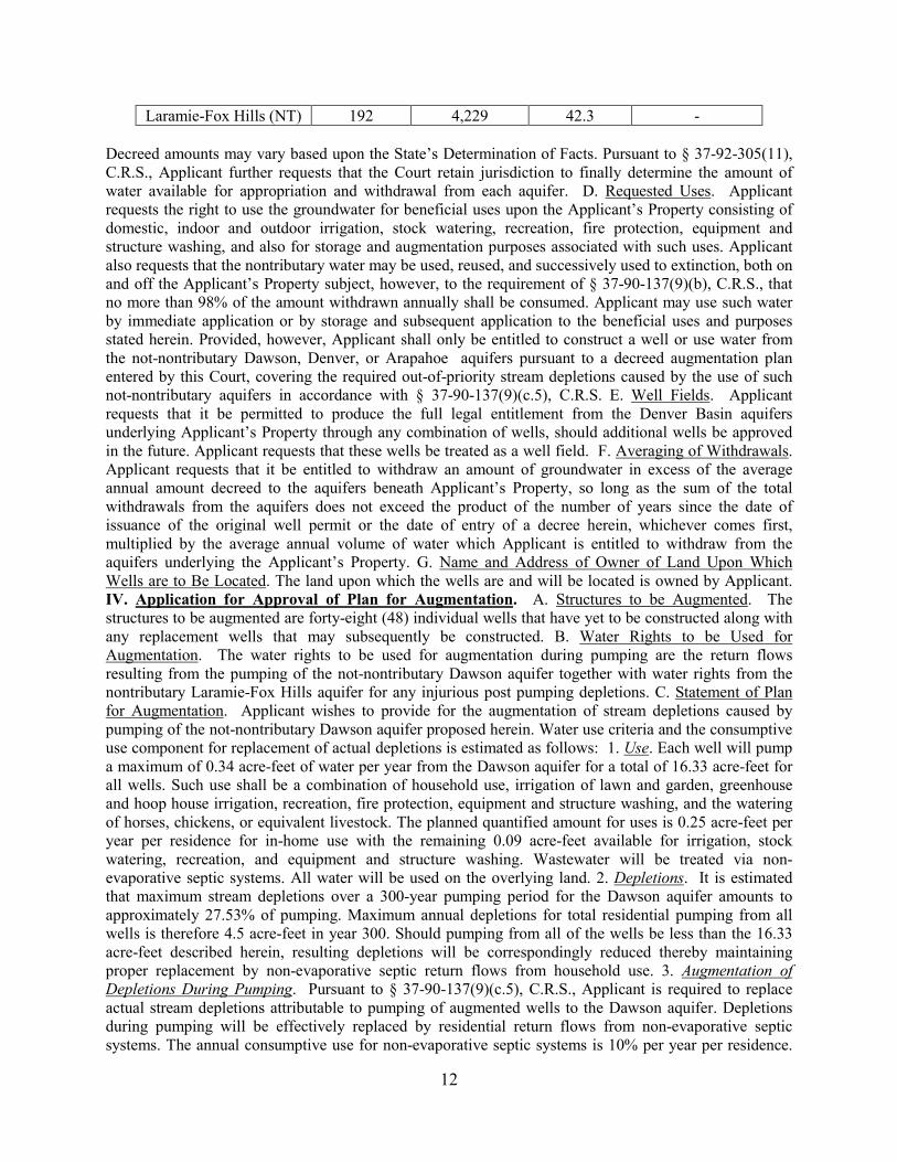
prevent injury to owners and users of vested and conditional water rights, and for such other and further relief as may be warranted. 4 Pages. 19CW3032 APPLICATION WITHDRAWN **Per Order – Water Division 2 to publish resume for both divisions** 19CW3033 – Division 2 case number 19CW3015 Grandwood Enterprises, LLC, 270 Lodge Pole Way, Monument, Colorado 80132, (719) 659-9759. Name, Address, and Phone Number of Attorneys. Ryan W. Farr, #39394, Emilie B. Polley, #51296, Monson, Cummins, & Shohet, LLC, 13511 Northgate Estates Drive, Suite 250, Colorado Springs, Colorado 80921, (719) 471-1212. Application for Adjudication of Denver Basin Groundwater and for Approval of Plan for Augmentation of Grandwood Enterprises, LLC, in EL PASO COUNTY. I. Name, Address, and Phone Number of Applicant. II. Summary of Application. Applicant is seeking to subdivide a 146.84-acre parcel into forty-eight (48) single family lots with each lot to be served by an individual well constructed in the Dawson aquifer. The wells will be used for water service to single-family dwellings to include domestic use, landscape and garden irrigation including greenhouse irrigation, recreation, stock watering, and equipment and structure washing. Applicant seeks to quantify the Denver Basin groundwater underlying the Applicant’s Property as described below, and for approval of a plan for augmentation. III. Application for Underground Water Right. A. Location of Property and Well. 1. Property Description. Applicant’s property is located in the S1/2 of the N1/2 of Section 19, Township 11 South, Range 66 West of the 6th P.M., El Paso County, Colorado as shown on the attached Exhibit A containing approximately 146.84 acres, more or less (“Applicant’s Property”). 2. Existing Wells. There are currently two permitted wells constructed in the Dawson aquifer on the Applicant’s Property permitted under Division of Water Resources Permit Nos. 2757 and 267286. Upon entry of a decree in this matter, these wells will be abandoned. 3. Wells To Be Constructed. Applicant or subsequent owners of the newly created subdivided lots will file permit applications for the construction of wells in the Dawson aquifer to serve each individual lot and to operate pursuant to this plan for augmentation. B. Water Source. 1. Not-Nontributary. The groundwater to be withdrawn from the Dawson, Denver, and Arapahoe aquifers of the Denver Basin underlying Applicant’s Property is not-nontributary. Pursuant to § 37-90-137(9)(c.5), C.R.S., the augmentation requirements for wells in the Dawson aquifer will require the replacement of actual stream depletions. 2. Nontributary. The groundwater that will be withdrawn from the Laramie-Fox Hills aquifer of the Denver Basin underlying the Applicant’s Property is nontributary. C. Estimated Rates of Withdrawal and Groundwater Available. 1. Estimated Rates of Withdrawal. Pumping from any well on Applicant’s Property will not exceed 15 g.p.m. The actual pumping rate for any well will vary according to aquifer conditions and well production capabilities. Applicant requests the right to withdraw groundwater at rates of flow necessary to withdraw the entire decreed amounts. The actual depth of each well to be constructed within the respective aquifers will be determined by topography and actual aquifer conditions. 2. Estimated Average Annual Amounts of Groundwater Available. Applicant requests a vested right for the withdrawal of all legally available groundwater in the Denver Basin aquifers underlying the Applicant’s Property. Applicant estimates that the following values and average annual amounts are representative of the Denver Basin aquifers underlying Applicant’s Property:
Denver Basin Aquifer Sand
Thickness (Feet)
Total Groundwater
Storage (Acre-Feet)
100-Year Annual Average
Withdrawal
300-Year Annual Average
Withdrawal
Dawson (NNT) 380 11,160 111.6 37.2 Denver (NNT) 510 12,731 127.3 -
Arapahoe (NNT) 266 6,640 66.4 -
12
Laramie-Fox Hills (NT) 192 4,229 42.3 - Decreed amounts may vary based upon the State’s Determination of Facts. Pursuant to § 37-92-305(11), C.R.S., Applicant further requests that the Court retain jurisdiction to finally determine the amount of water available for appropriation and withdrawal from each aquifer. D. Requested Uses. Applicant requests the right to use the groundwater for beneficial uses upon the Applicant’s Property consisting of domestic, indoor and outdoor irrigation, stock watering, recreation, fire protection, equipment and structure washing, and also for storage and augmentation purposes associated with such uses. Applicant also requests that the nontributary water may be used, reused, and successively used to extinction, both on and off the Applicant’s Property subject, however, to the requirement of § 37-90-137(9)(b), C.R.S., that no more than 98% of the amount withdrawn annually shall be consumed. Applicant may use such water by immediate application or by storage and subsequent application to the beneficial uses and purposes stated herein. Provided, however, Applicant shall only be entitled to construct a well or use water from the not-nontributary Dawson, Denver, or Arapahoe aquifers pursuant to a decreed augmentation plan entered by this Court, covering the required out-of-priority stream depletions caused by the use of such not-nontributary aquifers in accordance with § 37-90-137(9)(c.5), C.R.S. E. Well Fields. Applicant requests that it be permitted to produce the full legal entitlement from the Denver Basin aquifers underlying Applicant’s Property through any combination of wells, should additional wells be approved in the future. Applicant requests that these wells be treated as a well field. F. Averaging of Withdrawals. Applicant requests that it be entitled to withdraw an amount of groundwater in excess of the average annual amount decreed to the aquifers beneath Applicant’s Property, so long as the sum of the total withdrawals from the aquifers does not exceed the product of the number of years since the date of issuance of the original well permit or the date of entry of a decree herein, whichever comes first, multiplied by the average annual volume of water which Applicant is entitled to withdraw from the aquifers underlying the Applicant’s Property. G. Name and Address of Owner of Land Upon Which Wells are to Be Located. The land upon which the wells are and will be located is owned by Applicant. IV. Application for Approval of Plan for Augmentation. A. Structures to be Augmented. The structures to be augmented are forty-eight (48) individual wells that have yet to be constructed along with any replacement wells that may subsequently be constructed. B. Water Rights to be Used for Augmentation. The water rights to be used for augmentation during pumping are the return flows resulting from the pumping of the not-nontributary Dawson aquifer together with water rights from the nontributary Laramie-Fox Hills aquifer for any injurious post pumping depletions. C. Statement of Plan for Augmentation. Applicant wishes to provide for the augmentation of stream depletions caused by pumping of the not-nontributary Dawson aquifer proposed herein. Water use criteria and the consumptive use component for replacement of actual depletions is estimated as follows: 1. Use. Each well will pump a maximum of 0.34 acre-feet of water per year from the Dawson aquifer for a total of 16.33 acre-feet for all wells. Such use shall be a combination of household use, irrigation of lawn and garden, greenhouse and hoop house irrigation, recreation, fire protection, equipment and structure washing, and the watering of horses, chickens, or equivalent livestock. The planned quantified amount for uses is 0.25 acre-feet per year per residence for in-home use with the remaining 0.09 acre-feet available for irrigation, stock watering, recreation, and equipment and structure washing. Wastewater will be treated via non-evaporative septic systems. All water will be used on the overlying land. 2. Depletions. It is estimated that maximum stream depletions over a 300-year pumping period for the Dawson aquifer amounts to approximately 27.53% of pumping. Maximum annual depletions for total residential pumping from all wells is therefore 4.5 acre-feet in year 300. Should pumping from all of the wells be less than the 16.33 acre-feet described herein, resulting depletions will be correspondingly reduced thereby maintaining proper replacement by non-evaporative septic return flows from household use. 3. Augmentation of Depletions During Pumping. Pursuant to § 37-90-137(9)(c.5), C.R.S., Applicant is required to replace actual stream depletions attributable to pumping of augmented wells to the Dawson aquifer. Depletions during pumping will be effectively replaced by residential return flows from non-evaporative septic systems. The annual consumptive use for non-evaporative septic systems is 10% per year per residence.
13
At a household use rate of 0.25 acre-feet per residence per year, 0.225 acre-feet is replaced to the stream system per year per residence as the houses will utilize non-evaporative septic systems for a total annual return flow for all residences of 10.8 acre-feet. Thus, during pumping for 300 years at a total rate of 10.8 acre-feet per year, stream depletions will be adequately augmented by septic return flows. Therefore, stream depletions occurring during the life of the forty-eight (48) individual wells will be sufficiently replaced. 4. Augmentation for Post Pumping Depletions. The pumping of 16.33 acre-feet for 300 years results is a total of 4,899 acre-feet of pumping. Total replacement during pumping equals 756 acre-feet. Thus, total post-pumping depletions equal 4,143 acre-feet. For the replacement of any injurious post-pumping depletions which may be associated with the use of the forty-eight (48) individual wells, Applicant will reserve 4,144 acre-feet of water from the nontributary Laramie-Fox Hills aquifer in order to cover post-pumping depletions totaling 4,143 acre-feet. Applicant also reserves the right to substitute other legally available augmentation sources for such post pumping depletions upon further approval of the Court under its retained jurisdiction. Even though this reservation is made, under the Court’s retained jurisdiction, Applicant reserves the right in the future to prove that post pumping depletions will be noninjurious. Upon entry of a decree in this case, Applicant will be entitled to apply for and receive well permits for the forty-eight (48) individual wells for the uses in accordance with this Application and otherwise in compliance with § 37-90-137, C.R.S. V. Remarks. A. This Application was filed in both Water Divisions 1 and 2 because depletions from the pumping of the Dawson aquifer may occur in both the South Platte and the Arkansas River systems. The return flows set forth herein will accrue to tributaries of the Arkansas River system where the majority of such depletions will occur, and it is Applicant’s intent to consolidate the instant matter with the pending Division 2 application in Water Division 2 upon completion of publication. Applicant requests that the total amount of depletions to both the South Platte River and the Arkansas River systems be replaced to the Arkansas River as set forth herein, and for a finding that those replacements are sufficient. B. Applicant requests a finding that they have complied with § 37-90-137(4), C.R.S., and that the groundwater requested herein is legally available for withdrawal by the requested not-nontributary Dawson aquifer wells upon the entry of a decree approving an augmentation plan pursuant to § 37-90-137(9)(c.5), C.R.S. C. The term of this augmentation plan is for 300 years, however the length of the plan for a particular well may be extended beyond such time provided the total plan pumping allocated thereto is not exceeded. Post pumping stream depletions accrue to a particular well or wells only to the extent related to that well’s actual pumping. D. The Court will retain jurisdiction over this matter to provide for the adjustment of the annual amount of groundwater withdrawals to be allowed in order to conform to actual local aquifer characteristics from adequate information obtained from well drilling or test holes. E. Applicant requests a finding that vested water rights of others will not be materially injured by the withdrawals of groundwater and the proposed plan for augmentation. F. All wells shall be installed and metered as reasonably required by the State Engineer. Any well must be equipped with a totalizing flow meter and Applicant or other subsequent operating entity shall submit diversion records to the Division Engineer on an annual basis or as otherwise requested by the Division Engineer. Applicant shall also provide accountings to the Division Engineer and Water Commissioner as required by them to demonstrate compliance under this plan of augmentation. G. Applicant intends to waive the 600-foot well spacing requirement for any wells to be located upon the Applicant’s Property. H. Applicants will comply with any lienholder notice provisions set forth in § 37-92-302(2)(b), C.R.S., and such notice will be sent within fourteen (14) days of the filing of this application.
19CW3034 Bar Star Land, LLC (hereafter “Bar Star”), 1501 Washington Avenue, Unit C-1, Golden, Colorado 80401, 720-799-5461. Attorney: Adam C. Davenport, 1501 Washington Avenue, Unit C-1, Golden, Colorado 80401, phone (720) 627-6151, fax (720) 216-2055, [email protected]. APPLICATION TO REMOVE WELLS FROM AUGMENTATION PLAN IN PARK COUNTY. 2. Augmentation Plan. Bar Star owns and operates the augmentation plan decreed by this Court in case number W-7389 (the “W-7389 Plan”) which has historically served as a blanket augmentation plan for the Indian Mountain Subdivision (the
14
“Subdivision”) located in Township 9 and 10 South, Range 75 West of the 6th P.M., Park County, Colorado. In case number 15CA1055, the Colorado Court of Appeals held that as the owner of the W-7389 Plan, Bar Star is entitled to assess a fee for operation of the W-7389 Plan from 2012 onward and that well owners in the Subdivision could have their wells augmented under a different plan if they so choose (the “2016 Opinion”). Since the entry of the 2016 Opinion, certain wells in the Subdivision have been added to the augmentation plans operated by Headwater Authority of the South Platte and decreed by this Court in cases 02CW389 and 12CW50 (the “HASP Decrees”). By this Application Bar Star seeks a ruling and decree from the Court removing the wells added to the HASP Decrees from the W-7389 Plan (hereafter the “Removed Wells”). Bar Star reserves the right to seek payment for use of the W-7389 Plan by the owners of the Removed Wells from 2012 to the date of entry of any decree in one or more separate proceedings. 3. Wells to be Removed. a. The well permit numbers, owner’s name and address, and well location data for the Removed Wells are provided in Exhibit A. 4. Proposed Terms and Conditions. Any decree entered in this case shall contain the following protective terms and conditions: a. On and after the date of any decree entered in this matter, the Removed Wells shall not be allowed to operate unless covered by an augmentation plan approved by this Court and capable of replacing the out of priority depletions from such well, so as to prevent injury to vested senior water rights. b. On and after the date of any decree entered in this matter, the State Engineer shall, pursuant to C.R.S. § 37-92-305(8), curtail all out-of-priority diversions, the depletions from which are not so replaced as to prevent injury to vested senior water rights. c. After entry of any decree in this matter, Bar Star may seek to remove additional wells added to the HASP Decrees via motion and order of the Court in the above captioned case. d. No Removed Well shall be added back into the W-7389 Plan unless and until Bar Star files a separate application to do so with this Court. e. Any Removed Well with a decreed groundwater right, the decree for which references the W-7389 Plan, shall either be changed or abandoned by the owner thereof. f. Bar Star may not make any additional or different uses with that portion of the W-7389 Plan attributable to the Removed Wells unless and until Bar Star files a separate application to do so with this Court. g. Other than deleting the Removed Wells from the W-7389 Plan, no other terms or conditions of the W-7389 Plan decree will be changed in this case. 5. Prayer for Relief. a. Applicant respectfully requests this Court grant a decree deleting the Removed Wells from the W-7389 Plan and for such other relief as the Court deems necessary. Application contains 4 pages and Exhibit A consisting of 11 pages. 19CW3035 (12CW277) (06CW115) (95CW247). Lake George Company, c/o Everett L. Johnson, President, 720 S. Colorado Blvd., Suite 462-S, Denver, Colorado 80246, Phone: (303) 753-9281; E-mail: [email protected]. Attorneys for Applicant: Richard A. Johnson, David F. Bower, Michael S. Davidson, JOHNSON & REPUCCI LLP, 850 W. South Boulder Road, Suite 100, Louisville, Colorado 80027; Phone: 303-442-1900. Application To Make Water Storage Right Absolute in PARK COUNTY, Colorado. Name and Description of Conditional Water Right. Name of Structure. Lake George (a/k/a Lidderdale Reservoir). Original and Subsequent Decrees. Lake George was originally decreed a storage right for 734 acre-feet, absolute, for domestic and ice cutting uses, in Case No. 1636, by the District Court in and for Park County, Colorado. In that case, Lake George was awarded Reservoir Priority No. 6, with an adjudication date of May 22, 1913 (original adjudication) and an appropriation date of August 31, 1890. Lake George was subsequently decreed a conditional storage right for 156.5 acre-feet absolute for recreational and piscatorial purposes and conditional for augmentation and exchange purposes, with an additional 577.5 acre-feet conditional for recreational, piscatorial, augmentation, and exchange purposes, in Case No. 95CW247, Water Division 1. The 577.5 acre-feet represented capacity which historically existed in the reservoir but which had been the subject of silting. The conditional rights decreed in Case No. 95CW247 were continued in full pursuant to the decrees entered in Case Nos. 06CW115 and 12CW277, Water Division 1. Legal Description of Structure. Lake George is located in Sections 29 and 30, Township 12 South, Range 71 West of the 6th P.M., in Park County, Colorado. The spillway is located in the SE1/4 of the NE1/4 of Section 30, Township 12 South, Range 71 West of the 6th P.M., where the midpoint of the spillway crest is at a point approximately 1,420 feet south of the north section line and 1,100 feet west of the east section line of said Section 30. A map
15
showing the general location of Lake George is attached as Exhibit A. Decreed Source. The south fork of the South Platte River, tributary to the South Platte River. Decreed Amounts and Uses. The conditional water right that is the subject of this application is the 156.5 acre-feet for augmentation and exchange purposes, and the additional 577.5 acre-feet conditional for recreational, piscatorial, augmentation, and exchange purposes. Date of Appropriation. December 21, 1994. Claim to Make Absolute. Since the decree was entered in Case No. 95CW247, Applicant has diverted, possessed and controlled, a total of 166.6 acre-feet in Lake George, including from a portion of the reservoir which had previously been silted in but was dredged to reclaim storage capacity. The accounting form for Lake George from February 2017, showing that the reservoir was filled to 166.6 acre-feet, is attached hereto as Exhibit B. Accordingly, pursuant to C.R.S. §§ 37-92-103(4)(a) and 37-92-301(4)(e), Lake George has been made absolute for a total of 156.5 acre-feet for augmentation and exchange purposes, and an additional 10.1 acre-feet for recreational, piscatorial, augmentation, and exchange purposes. Name of Landowner upon which any New or Modified Diversion Structure is Located. Lake George is on land owned by Applicant. 6 pages 19CW3036 City of Brighton, 500 South 4th Avenue, Brighton, Colorado 80601 Attn: Philip Rodriguez, City Manager (303) 655-8747. Please send all future correspondence and pleadings to Donald E. Frick, Esq. and Brent A. Bartlett, Esq., Fischer, Brown, Bartlett & Gunn, P.C., 1319 E. Prospect Road, Fort Collins, Colorado 80525. APPLICATION FOR A FINDING OF REASONABLE DILIGENCE IN ADAMS, DENVER AND WELD COUNTIES. 2. Application: With this Application, the City of Brighton (hereinafter “Brighton” or “Applicant”) seeks findings of reasonable diligence of the conditional appropriative rights of exchange decreed in Case No. 04CW174, District Court, Water Division 1 (“Original Decree”). 3. Conditional Appropriative Rights of Exchange. 3.1. Date of Original Decree: February 27, 2013, District Court, Case No. 04CW174, District Court, Water Division 1, State of Colorado. 3.2. “Exchange From” Locations. The exchange from points are the points listed below: 3.2.1. Point A: The confluence of Brighton’s North Storm Drain Outfall and the South Platte River, located in the SE1/4 of the SW1/4 of the SW1/4 of Section 31, Township 1 North, Range 66 West, 6th P.M. This is the most downstream point of the exchange reach. 3.2.2. Point B: The confluence of Brighton’s South Storm Drain Outfall and the South Platte River located in the SE1/4 of the NW1/4 of the NE1/4 of Section 12, Township 1 South, Range 67 West, 6th P.M. 3.2.3. Point C: The outfall of Ken Mitchell Lake, which is located near the point where the South Platte River crosses the west line of Section 12, Township 1 South, Range 67 West, 6th P.M. 3.2.4. Point H: The outfall of Brighton’s South Platte WWTP, which is presently located in the NW1/4 of the NW1/4 of the SW1/4 of Section 6, Township 1 South, Range 66 West, 6th P.M. 3.2.5. Point J: 124th Avenue Reservoir Outfall, located in the NW1/4 of the SE1/4 of Section 35, Township 1 South, Range 67 West, 6th P.M. 3.3. “Exchange To” Locations. The exchange to points are the points listed below: 3.3.1. Point D-1: Ken Mitchell Reservoir Pump Station Inlet Pipe, located on the east bank of the South Platte River, in the SE1/4 of Section 11, Township 1 South, Range 67, at a point whence the Southwest Corner of said Section 11 bears approximately South 86° West, approximately 4,160 feet. 3.2.2. Point D-2: Ken Mitchell Reservoir Pump Station Inlet Pipe, located on the east bank of the South Platte River, in the NW1/4 of the SE1/4 of Section 14, Township 1 South, Range 67, at a point whence the Southwest Corner of said Section 14 bears approximately South 69° West, approximately 4,000 feet. 3.3.3. Point E: Ken Mitchell Reservoir Inlet, located on the east bank of the South Platte River, in the SE1/4 of Section 14, Township 1 South, Range 67, 6th P.M. at a point whence the Southwest Corner of said Section 14 bears approximately South 88° 30’ West, approximately 3,190 feet. 3.3.4. Point F: The point where the South Platte River crosses the South line of Section 23, Township 1 South, Range 67, Adams County. This is an approximation of the upstream limit of the reach of the South Platte River that is depleted by pumping of the City of Brighton’s South Platte Alluvial Wells. 3.3.5. Point G: The headgate of the Fulton Ditch, located in the NE1/4 of the NE1/4 of the SE1/4 of Section 17, Township 2 South, Range 67, 6th P.M. 3.3.6. Point I: United Water and Sanitation District’s United Diversion Facility No. 3, which is located on the East Bank of the South Platte River, in the SW1/4 of Section 26, Township 1 South, Range 67 West, of the 6th P.M. 3.3.7. Point M: The Burlington

16
Canal Headgate, located at a point on the east bank of the South Platte River in the NE1/4 of the SW1/4 of Section 14, Township 3 South, Range 68 West, 6th P.M., City and County of Denver, Colorado. The headgate is located at approximately latitude 039° 47’ 24.69” N, longitude 104° 58’ 9.97” W. The UTM coordinates are approximately NAD 1983 UTM Zone 13S 502616.89 mE 4404471.42 mN. This is the most upstream point of the exchange reach. 3.4. Exchange Rate. The exchanges described herein will operate at a maximum rate as follows: 3.4.1. For the exchanges shown in Table 1 of Exhibit A: 4.5 cfs (CONDITIONAL). This rate is in addition to the rate of the exchanges decreed in Case No. 2000CW202. 3.4.2. For the exchanges shown in Table 2 of Exhibit A: 38.0 cfs (CONDITIONAL). This rate is in addition to the rate of the exchanges decreed in Case No. 2000CW202. 3.5. Appropriation Dates. The appropriation dates for the exchanges are as follows: 3.5.1. For the exchanges shown in Table 1 of Exhibit A: July 16, 2004. 3.5.2. For the exchanges shown in Table 2 of Exhibit A: October 19, 2009. 3.6. Source. The appropriative rights of exchange will operate by utilizing exchange potential created by the native flow of the South Platte River and its tributaries. The source of substitute supply will be water made available by operation of Applicant’s plan for augmentation decreed in Case No. 00CW202, water available pursuant to the change of water rights decreed in Case No. 09CW144 to the extent lawfully available for such use, and water made available pursuant to the change of water rights decreed in Case No. 04CW174. 3.7. Use. The decreed place of use and use for water diverted pursuant to the above exchanges is set forth in Paragraphs 7.4.1. and 7.4.2. respectively of the Original Decree. 4.Claim to Findings of Reasonable Diligence. The conditional appropriative rights of exchange that are the subject of this case are part of Applicant’s raw water supply system, an integrated system as defined by §37-92-301(4). During the diligence period Applicant has expended in excess of $14,500,00.00 on engineering design and construction of its integrated water system on the South Platte River related to the structures necessary to implement the operation of the conditional appropriative rights of exchange. Of that amount over $4,000,000.00 was related solely to engineering design and construction associated with Ken Mitchell Reservoir in order to implement Applicant’s exchanges. During the diligence period Applicant has participated in numerous water court proceedings in an effort to protect its conditional appropriative rights of exchange. Additionally, Applicant has developed and utilized accounting forms in order to implement the conditional appropriative rights of exchange. 5. Right to Supplement. Applicant reserves the right to supplement this Application with additional information on Applicant’s work and expenses related to its continued diligence toward making absolute the conditional rights described herein. 6. Notice Requirement, Section 37-92-302(2)(b). Names(s) and address(es) of owner(s) or reputed owners of the land upon which any new diversion or storage structure, or modification to any existing diversion or storage structure is or will be constructed or upon which water is or will be stored, including any modification to the existing storage pool. 1. Burlington Ditch and Reservoir and Land Company, 80 South 27th Avenue, Brighton, Colorado 80601. 2. Fulton Irrigating Ditch Company, 13698 East 136th Avenue, Brighton, Colorado 80601. 3. United Water and Sanitation District, 8301 E. Prentice Avenue, Suite 120, Greenwood Village, Colorado 80111. WHEREFORE, Brighton respectfully requests a ruling and decree finding that Brighton has exercised due and reasonable diligence during the six years following entry of the decree in Case No. 04CW174, toward completion of the appropriation and application of the exchanges therein decreed, in the amounts and flow rates set forth herein and for the beneficial uses conditionally decreed, also as set forth herein. Brighton further prays that this Court continue in full force and effect all such conditional water rights for an additional six-year period, and for such other relief as the Court may deem proper. 6 Pages.
19CW3037 (12CW67, 88CW206, W-152) COORS BREWING COMPANY, 1801 California Street, Suite 4600, Denver, Colorado 80202. Stephen H. Leonhardt, Esq., Bernard F. Gehris, Esq.; BURNS, FIGA & WILL, P.C., 6400 South Fiddlers Green Circle, Suite 1000, Greenwood Village, CO 80111; (303) 796-2626. APPLICATION FOR FINDING OF REASONABLE DILIGENCE AND TO MAKE ABSOLUTE CONDITIONAL WATER RIGHTS in JEFFERSON, CLEAR CREEK and ADAMS COUNTIES. 2. Name of Structures: Jefferson Storage System, comprised of the following structures: Clinton Reservoir; Crawford Reservoir; Wanemaker (Wannamaker) Reservoir; Hawley

17
Reservoir; Lee Reservoir; Frost Reservoir; Waldorf Reservoir; Summers Reservoir; Eskins Reservoir; Pearson Reservoir No. 1 (also known as Lake B-5); Pearson Reservoir No. 1 Enlargement; B-4 Lake; B-5 East Lake; B-7 Lake; B-9 Lake; West Lake; Bass Lake; Tabor Lake; Prospect Park Lake; and West Gravel Lakes. 3. Description of conditional water rights: A. Date of Original Decree: July 23, 1971; Case No.: W-152; Court: District Court for Water Division No. 1; Change Decree: Case No. 88CW206 (December 30, 1993). B. Locations: The locations of the various components of the Jefferson Storage System, as described in the original decree therefor in Case No. W-152, were changed (for some components) by the decree in Case No. 88CW206. As noted below, an application for further changes of some component locations is pending in Case No. 18CW3225. The currently decreed locations are as follows: 1. Clinton Reservoir. (From W-152) Said reservoir is located in the SE1/4 of the SW1/4 of Sec. 24 and in the NE1/4 of the NW1/4 of Sec. 25, T3S, R70W of the 6th P.M., in Jefferson County, Colorado. Water for said reservoir will be diverted from the right bank of Clear Creek at a point whence the SW Corner of Sec. 24, T3S, R70W of the 6th P.M. bears South 0° East, 700 feet. Amount: 1100 acre-feet (conditional) Source: Clear Creek. Appropriation Date: October 1965. 2. Crawford Reservoir. (From W-152). Said reservoir is located in the SW1/4 of the SW1/4 of Sec. 24 and in the NW1/4 of the NW1/4 of Sec. 25, T3S, R70W of the 6th P.M., in Jefferson County, Colorado. Water for said reservoir will be diverted from the right bank of Clear Creek at a point whence the SW Corner of said Sec. 24, T3S, R70W of the 6th P.M. bears South 0° West, 700 feet. Amount: 1000 acre-feet (conditional). Source: Clear Creek. Appropriation Date: October 1965. 3. Wanamaker (Wannamaker) Reservoir. (From W-152). Said reservoir is located in the SE1/4 of the SE1/4 of Sec. 23 and in the NE1/4 of the NE1/4 of Sec. 26, T3S, R70W of the 6th P.M., in Jefferson County, Colorado. Water for said reservoir will be diverted from the right bank of Clear Creek at a point whence the SE Corner of said Sec. 23, T3S, R70W of the 6th P.M. bears North 90° East, 1,300 feet. Amount: 530 acre-feet (conditional). Source: Clear Creek. Appropriation Date: October 1965. 4. Hawley Reservoir. (From W-152)* Said reservoir is located in the E1/2 of the NW1/4 of Sec. 30, T3S, R69W of the 6th P.M., in Jefferson County, Colorado. Water for said reservoir will be diverted from the right bank of Clear Creek at a point whence the SW Corner of said Sec. 19, T3S, R69W of the 6th P.M. bears South 0° West, 1,100 feet. Amount: 570 acre-feet (conditional). Source: Clear Creek. Appropriation Date: May 27, 1966. 5. Lee Reservoir. (From W-152)* Said reservoir is located in the W½ of the NE1/4 of Sec. 30, T3S, R69W of the 6th P.M., in Jefferson County, Colorado. Water for said reservoir will be diverted from the right bank of Clear Creek at a point whence the SW Corner of said Sec. 19, T3S, R69W of the 6th P.M. bears South 0° West, 1,100 feet. Amount: 310 acre-feet (conditional). Source: Clear Creek. Appropriation Date: May 27, 1966. 6. Frost Reservoir. (From W-152). Said reservoir is located in Sections 10 and 15 of T5S, R75W of the 6th P.M., in Clear Creek County, Colorado. The height of the dam is 44 feet. The dam axis bears South 87°26' West, 646 feet from a point whence the NW Corner of Sec. 1, T5S, R75W of the 6th P.M. bears North 29°24' East, 11,200 feet. Amount: 400 acre-feet (conditional). Source: Clear Creek. Appropriation Date: October 28, 1965. 7. Waldorf Reservoir. (From W-152). Said reservoir is located in the SW1/4 of the NE1/4 of Sec. 2, T5S, R75W of the 6th P.M., in Clear Creek County, Colorado. The height of the dam is 60 feet. The dam axis bears South 56°57' East, 922 feet from a point whence the NW Corner of Sec. 1, T5S, R75W of the 6th P.M. bears North 40°17' East, 2,582 feet. Amount: 400 acre-feet (conditional). Source: Clear Creek. Appropriation Date: October 28, 1965. 8. Summers Reservoir. (From W-152) * Said reservoir is located in the SE1/4 of the SW1/4 of Sec. 19, and in the NE1/4 of the NW1/4 of Sec. 30, T3S, R69W of the 6th P.M., in Jefferson County, Colorado. Water for said reservoir will be diverted from the right bank of Clear Creek at a point whence the SW Corner of said Sec. 19, T3S, R69W of the 6th P.M. bears South 0° West, 1,100 feet. Amount: 700 acre-feet (conditional) Source: Clear Creek. Appropriation Date: October 1965. 9. Eskins Reservoir. (From W-152) * Said reservoir is located in the SW1/4 of the SE1/4 of Sec. 19, and in the NW1/4 of the NE1/4 of Sec. 30, T3S, R69W of the 6th P.M., in Jefferson County, Colorado. Water for said reservoir will be diverted from the right bank of Clear Creek at a point whence the S1/4 Corner of said Sec. 19, T3S, R69W of the 6th P.M. bears South 0° East, 1,300 feet. Amount: 1500 acre-feet (conditional). Source: Clear Creek. Appropriation Date: October 1965. 10. Pearson Reservoir No. 1 (also known as Lake B-5). (From W-152). Said reservoir is located in the NE1/4 of the NE1/4 of Sec. 30

18
and in the SE1/4 of the SE1/4 of Sec. 19, T3S, R69W of the 6th P.M., in Jefferson County, Colorado. Water for said reservoir will be diverted from the Pearson Ditch at a point whence the corner common to Sections 19, 20, 29 and 30, T3S, R69W of the 6th P.M. bears North 77° East, 1,310 feet, in the amount of 101 acre-feet with an appropriation date of October 1, 1965. Amount: 39.3 acre-feet (absolute). 61.7 acre-feet (conditional). Source: Clear Creek. Appropriation Date: October 1, 1965. 11. Pearson Reservoir No. 1 Enlargement. (From W-152). Said reservoir is located in the SE1/4 of the SE1/4 of Sec. 19, and in the NE1/4 of the NE1/4 of Sec. 30, and in the NW1/4 of the NW1/4 of Sec. 29, T3S, R69W of the 6th P.M., in Jefferson County, Colorado. Water for said reservoir will be diverted from the right bank of Clear Creek at a point whence the SW Corner of said Sec. 19, T3S, R69W of the 6th P.M. bears South 64° West, 2,800 feet. Amount: 700 acre-feet (conditional). Source: Clear Creek. Appropriation Date: January 16, 1968. 12. B-4 Lake. (From 88CW206) Located on a parcel of land in the NE1/4 of Sec. 25, and in the SE1/4 of Sec. 24, T3S, R70W of the 6th P.M., in Jefferson County, Colorado, and more particularly described as follows: Commencing at the NE corner of said Sec. 25 which point is also the Point of Beginning; thence S 00°09'02" W along the East line of said Sec. 25 for a distance of 2294.00 feet; thence N 87°57'37" W for a distance of 2618.35 feet to the Easterly right-of-way of McIntyre Street; thence N 00°01'20" E along said right-of-way for a distance of 2,065.10 feet; thence S 89°43'46" E for a distance of 920.81 feet; thence N 56°12'36" E for a distance of 1379.95 feet; thence N 79°51'11" E for a distance of 563.94 feet to the East line of the SE1/4 of said Sec. 24; thence S 00°04'01" W along said line for a distance of 726.75 feet to the Point of Beginning, containing 147.26 acres more or less. Points of diversion: 1. On the right bank of Clear Creek at a point whence the South ¼ Corner of Sec. 24, T3S, R70W of the 6th P.M. bears S 0° E, 900 feet. 2. On the right bank of Clear Creek at a point whence the SE Corner of Sec. 24, T3S, R70W of the 6th P.M. bears S 60° E, 1900 feet. 3. On the south side of Clear Creek which is on the south side of the diversion dam common to the Croke Canal and the Rocky Mountain Ditch in the NE¼ NE¼ NW¼ of Sec. 26, T3S, R70W of the 6th P.M. and which bears South 18°12'25" West a distance of 401.11 feet from the North ¼ corner of said Sec. 26. 4. On the Miles and Eskins Drainage, Seepage and Waste Water Ditch at a point whence the NW Corner of Sec. 30, T3S, R69W bears North 18° 46' W, 1,621 feet. Source: Clear Creek. Amounts Appropriation Dates From 250 acre-feet October 1965 (absolute) (Thuet-Mauz) 840 acre-feet October 1965 (absolute) (Killian-Mauz) 938 acre-feet March 22, 1968 (absolute) (Blue Lake Enl.) 68 acre-feet March 22, 1968 (conditional) (Blue Lake Enl.) 1200 acre-feet March 22, 1968 (conditional) (Lewis) 720 acre-feet March 22, 1968 (conditional) (Sanderson)
13. B-5 East Lake. (From 88CW206) * Located on a parcel of land in the SW1/4 of Sec. 20, and in the NW1/4 of Sec. 29, and in the NE1/4 of Sec. 30, and in the SE1/4 of Sec. 19, T3S., R69W, of the 6th P.M., Jefferson County, State of Colorado, and more particularly described as follows: Beginning at the Northeast corner of said parcel from whence the Southwest corner of said Sec. bears S 44º54'15" W for a distance of 1411.34 feet; thence S 00º29'44" E along the Westerly right-of-way of Colorado Interstate 70 for a distance of 1587.97 feet; thence S 41º42'18" W to a point on the Northeasterly right-of-way of the Denver Water Board for a distance of 354.31 feet; thence N 48º17'42" W along the Northeasterly right-of-way for a distance of 2671.15 feet; thence S 89º53'13" E for a distance of 333.32 feet; thence N 65º11'47" E for a distance of 177.70 feet; thence S 89º26'41" E to the East line of the Southeast 1/4 of the Southeast 1/4 of said Sec. 19 for a distance of 731.27 feet; thence N 89º31'56" E for a distance of 990.00 feet to the Point of Beginning, containing 52.28 acres more or less. Points of diversions of the structure used to fill the Reservoir: 1. On the right bank of Clear Creek at a point whence the SW Corner of Sec. 19, T3S, R69W., of the 6th P.M., Jefferson County, State of Colorado, bears S 64° W., 2800 feet. 2. On the Pearson Ditch at a point whence the corner common to Sections 19, 20, 29, and 30, T3S., R69W., of the 6th P.M., Jefferson County, State of Colorado, bears N 77°E, 1310 feet. Source: Clear Creek.
19
Amounts Appropriation Dates From 105 acre-feet October 1, 1965 (conditional) Pearson No. 2 530 acre-feet January 16, 1968 (conditional) Pearson No. 2 Enl. 420 acre-feet January 1, 1968 (conditional) Pearson No. 3 200 acre-feet May 27, 1966 (conditional) Hawley
14. B-7 Lake. (From 88CW206) Located on a parcel of land in the SW1/4 of Sec. 24 and in the SE1/4 of Sec. 23, T3S, R70W, of the 6th P.M., Jefferson County, State of Colorado, and more particularly described as follows: Beginning at the Northwesterly corner of said parcel which is on the Southerly right-of-way of 44th Avenue, from whence the Southeast corner of said Sec. 23 bears S 14º28'29" E a distance of 1418.70 feet; thence S 28º21'00" E for a distance of 225.71 feet to a point on the Northerly right-of-way of the Croke Canal to a point of curve to the right which curve has a central angle of 05º17'53" a radius of 974.12 feet and an arc length of 90.08 feet to a point of reverse curve to the left which curve has a central angle of 06º15'17" a radius of 1392.30 feet and an-arc length of 147.94 feet to a point on the East line of said Sec. 23; thence N 02º51'17" W for a distance of 10.00 feet to a point of curve to the left which curve has a central angle of 03º54'43" a radius of 1382.37 feet and an arc length of 94.38 feet to a point of compound curve to the left which curve has a central angle of 15º45'00" a radius of 768.45 feet and an arc length of 211.24 feet to a point of reverse curve; thence continuing along said Canal right-of-way on said reverse curve to the right which curve has a central angle of 11º40'00" a radius of 909.42 feet and an arc length of 185.18 feet to a point of tangent; thence continuing on said Canal right-of-way N 79º09'00" E for a distance of 545.77 feet to a point of curve to the left which curve has a central angle of 46º30'24" a radius of 514.36 feet and an arc length of 417.50 feet to a point of tangent; thence N 32º38'36" E for a distance of 718.13 to a point on the Southerly right-of-way of West 44th Avenue; thence along said 44th Avenue right-of-way S 69º45'00" W for a distance of 772.28 feet; thence continuing on said right-of-way N 20º15'00" W for a distance of 20.00 feet; thence S 69º45'00" W for a distance of 355.03 feet to the Easterly property line of Public Service Company property; thence along said property S 20º15'00" E for a distance of 259.72 feet; thence continuing along said property S 69º45'00" W for a distance of 294.26 feet; thence continuing along said property N 27º25'00" W for a distance of 261.76 feet to the Southerly right-of-way of West 44th Avenue; thence along said right-of-way S 69º45'00" W for a distance of 308.56 feet; thence continuing along said right-of-way S 38º14'36" E for a distance of 27.46 feet to a point of curve to the left which curve has a central angle of 04º58'00" a radius of 1919.57 feet and an arc length of 166.41 feet to a point of tangent; thence continuing along said right-of-way S 59º44'00" W for a distance of 344.28 feet to the Point of Beginning, containing 18.25 acres more or less. Point of diversion of the structure used to fill the Reservoir: Through the Wannamaker Ditch at a point on the North bank of Clear Creek in the NE1/4 of Sec. 27, T3S, R70W, of the 6th P.M., Jefferson County, State of Colorado, whence the NE Corner of said Sec. 27, bears N. 38°17.5' East, 2099.64 feet. Source: Clear Creek. Amount: 280 acre-feet (absolute). 220 acre-feet (conditional). Appropriation Date: October, 1965 (Summers Reservoir) 15. B-9 Lake. Alternate place of storage for the Frost and Waldorf Rights. (From 88CW206) Location: Located on a parcel in the N1/2 SE1/4 of Sec. 19, T3S, R69W, of the 6th P.M., Jefferson County, State of Colorado, lying South of Highway 58; East of the Denver Water Board R.O.W.; and North of Clear Creek. Points of Diversions of the structure used to fill the Reservoir: 1. On the North side of Clear Creek in the NW1/4 SE1/4 of Sec. 19, T3S, R69W, of the 6th P.M., Jefferson County, State of Colorado, at a point which is approximately 1700 feet from the East Sec. line and 1400 feet from the South Sec. line of said Sec. 19. 2. Through the Slough Ditch at a point on the North bank of Clear Creek in the NW1/4 SE1/4 of Sec. 19, T3S, R69W, of 6th P.M., Jefferson County, State of Colorado, at a point which is approximately 2400 feet from the East Sec. line and 1320 feet from the South Sec. line of said Sec. 19. 3. Through the Reno and Juchem Ditch at a point on the North bank of Clear Creek in the SE1/4 SW1/4 of Sec. 19, T3S, R69W, of the 6th P.M., Jefferson County, State of Colorado, at a point approximately 1320 feet from the West Sec. line and 1250 feet from the South Sec. line of said Sec. 19. Source: Clear Creek. Amount: Up to 400 acre-feet each from the Frost Reservoir and Waldorf Reservoir rights as an alternate place of storage under Case No. 88CW206 (conditional).

20
Appropriation Date: October 28, 1965. 16. West Lake. (From 88CW206) Located on a parcel of land in the South 1/2 of Sec. 20 and the North 1/2 of Sec. 30, T3S, R69W, of the 6th P.M., County of Jefferson, State of Colorado, and more particularly described as follows: Beginning at a point whence the South quarter corner of said Sec. 20 bears S 66º33'50" E for a distance of 269.53 feet; thence S 64º29'14" W for a distance of 616.53 feet to a point on the Wheat Ridge Greenbelt Lease Line; thence N 00º51'09" W along said Lease Line for a distance of 1741.97 feet; thence N 77º15'36" E for a distance of 48.75 feet; thence N 64º33'16" E for a distance of 75.03 feet; thence N 61º42'11"E for a distance of 231.53 feet; thence N 66º11'47" E for a distance of 170.34 feet; thence N 68º16'03" E for a distance of 81.95 feet; thence N 75º41'01" E for a distance of 106.98 feet; thence N 81º43'17"E for a distance of 133.28 feet; thence N 89º17'40" E for a distance of 121.73 feet; thence S 81º21'39"E for a distance of 238.19 feet; thence along a curve to the right which curve has a central angle of 75º10'02", a radius of 193.61 feet and an arc length of 254.00 feet to a point of tangent; thence S 01º22'40"W for a distance of 47.08 feet; thence N 85º19'46"E for a distance of 286.64 feet; thence S 71º20'44" E for a distance of 32.45 feet; thence S 87º08'26" E for a distance of 34.66 feet; thence N 89º01'29"E for a distance of 131.24 feet; thence N 83º04'26" E for a distance of 84.59 feet; thence S 85º03'23" E for a distance of 105.15 feet; thence S 76º32'17" E for a distance of 147.73 feet; thence S 70º37'40"E for a distance of 27.85 feet; thence S 48º02'50"E for a distance of 22.33 feet; thence S 27º44'13" E for a distance of 43.26 feet to the East line of the West 1/2 of the Southeast 1/4 of said Sec. 20; thence S 00º07'43"E along said Sec. line for a distance of 611.14 feet; thence S 84º54'43"W for a distance of 35.00 feet to a point on the Wheat Ridge Greenbelt Lease Line; thence S 43º29'10"W along said Lease Line for a distance of 358.76 feet; thence S 86º27'46" W for a distance of 558.63 feet; thence S 68º07'07" W for a distance of 618.11 feet; thence S 68º07'06" W for a distance of 87.22 feet; thence S 58º51'52" W for a distance of 193.77 feet; thence S 00º04'29"W for a distance of 180.00 feet to the Point of Beginning, containing 64.06 acres more or less. Point of diversion: At a point on the South side of Clear Creek in the SW1/4 of Sec. 20, T3S, R69W, of the 6th P.M., Jefferson County, State of Colorado, whence the South quarter corner of said Sec. 20, bears S. 1° E., 1920 feet. Source: Clear Creek. Amount: 400 acre-feet (conditional) Appropriation Date: January 16, 1968 (from Pearson Res. No. 1 Enlargement as originally decreed) 17. Bass Lake. (From 88CW206) Located on a parcel of land in the South 1/2 of Sec. 20 and the North 1/2 of Sec. 30, T3S, R69W, of the 6th P.M., County of Jefferson, State of Colorado, and more particularly described as follows: Beginning at a point whence the South quarter corner of said Sec. 20 bears S 66º33'50" E for a distance of 269.53 feet; thence S 64º29'14" W for a distance of 616.53 feet to a point on the Wheat Ridge Greenbelt Lease Line; thence N 00º51'09" W along said Lease Line for a distance of 1741.97 feet; thence N 77º15'36" E for a distance of 48.75 feet; thence N 64º33'16" E for a distance of 75.03 feet; thence N 61º42'11"E for a distance of 231.53 feet; thence N 66º11'47" E for a distance of 170.34 feet; thence N 68º16'03" E for a distance of 81.95 feet; thence N 75º41'01" E for a distance of 106.98 feet; thence N 81º43'17"E for a distance of 133.28 feet; thence N 89º17'40" E for a distance of 121.73 feet; thence S 81º21'39"E for a distance of 238.19 feet; thence along a curve to the right which curve has a central angle of 75º10'02", a radius of 193.61 feet and an arc length of 254.00 feet to a point of tangent; thence S 01º22'40"W for a distance of 47.08 feet; thence N 85º19'46"E for a distance of 286.64 feet; thence S 71º20'44" E for a distance of 32.45 feet; thence S 87º08'26" E for a distance of 34.66 feet; thence N 89º01'29"E for a distance of 131.24 feet; thence N 83º04'26" E for a distance of 84.59 feet; thence S 85º03'23" E for a distance of 105.15 feet; thence S 76º32'17" E for a distance of 147.73 feet; thence S 70º37'40"E for a distance of 27.85 feet; thence S 48º02'50"E for a distance of 22.33 feet; thence S 27º44'13" E for a distance of 43.26 feet to the East line of the West 1/2 of the Southeast 1/4 of said Sec. 20; thence S 00º07'43"E along said Sec. line for a distance of 611.14 feet; thence S 84º54'43"W for a distance of 35.00 feet to a point on the Wheat Ridge Greenbelt Lease Line; thence S 43º29'10"W along said Lease Line for a distance of 358.76 feet; thence S 86º27'46" W for a distance of 558.63 feet; thence S 68º07'07" W for a distance of 618.11 feet; thence S 68º07'06" W for a distance of 87.22 feet; thence S 58º51'52" W for a distance of 193.77 feet; thence S 00°04'29"W for a distance of 180.00 feet to the Point of Beginning, containing 64.06 acres more or less. Point of diversion: At a point on the South side of Clear Creek in the SE1/4 of Sec. 20, T3S, R69W, of the 6th P.M., Jefferson County, State of Colorado,

21
whence the South quarter corner of said Sec. 20, bears S. 30°W., 1880 feet. Source: Clear Creek. Amount: 100 acre-feet (conditional) Appropriation Date: May 27, 1966 (from Lee Reservoir as originally decreed) 18. Tabor Lake. (From 88CW206). Located on a parcel of land in the East 1/2 of Sec. 20, T3S, R69W, of the 6th P.M., County of Jefferson, State of Colorado, and more particularly described as follows: Beginning at a point on the East-West Center Line of said Sec. 20 from whence the East quarter corner of said Sec. 20 bears N 89º37'13" E for a distance of 836.84 feet; thence S 00º10'30" E for a distance of 132.00 feet; thence N 89º21'26"E for a distance of 165.00 feet; thence S 00º01'30"E for a distance of 803.67 feet; thence N 84º49'19" W for a distance of 1432.87 feet; thence N 00º02'08" W for a distance of 790.37 feet; thence N 89º21'26" E for a distance of 306.90 feet; thence N 00º02'40" W for a distance of 238.36 feet; thence N 89º38'20" E for a distance of 325.18 feet; thence N 00º06'13" W for a distance of 58.89 feet; thence N 89º21'26"E for a distance of 469.74 feet; thence S 00º09'28" E for a distance of 295.65 feet; thence N 89º21'25" E for a distance of 157.38 feet to the Point of Beginning, containing 26 acres more or less. Point of diversion: Through the Slough ditch at a point on the North side of Clear Creek in the NW1/4 SE1/4 of Sec. 19, T3S, R69W, of the 6th P.M., Jefferson County, State of Colorado, at a point which is approximately 2400 feet from the East Sec. line and 1320 feet from the South Sec. line of said Sec. 19. Source: Clear Creek. Amount: 500 acre-feet (conditional). Appropriation Date: October, 1965 (from Eskins Reservoir as originally decreed). 19. Prospect Park Lake. (From 88CW206). Located on a parcel of land in the West 1/2 of Sec. 21, T3S, R69W, of the 6th P.M., Jefferson County, State of Colorado and more particularly described as follows: Beginning at the Southwest corner of said parcel which point is on the West Line of the Southwest 1/4 of said Sec. 21 from whence the West quarter corner of said Sec. bears N 00º13'17" W for a distance of 666.42 feet; thence continuing along said West line of the Northwest 1/4 of said Sec. 21 for a distance of 213.93 feet; thence N 89º19'08" E for a distance of 821.7 feet; thence S 00º20'57" E for a distance of 881.80 feet; thence S 89º25'14" W for a distance of 823.61 feet to the Point of Beginning, containing 10 acres more or less. Point of diversion of the structure used to fill the Reservoir: Through the Slough ditch at a point on the North side of Clear Creek in the NW1/4 SE1/4 of Sec. 19, T3S, R69W, of the 6th P.M., Jefferson County, State of Colorado, at a point which is approximately 2,400 feet from the East Sec. line and 1,320 feet from the South Sec. line of said Sec. 19. Source: Clear Creek. Amount: 100 acre-feet (conditional). Appropriation Date: October, 1965 (from Summers Reservoir as originally decreed). 20. West Gravel Lakes. Alternate places for storage for the Frost and Waldorf rights. (From 88CW206). These facilities are owned by City of Thornton. Coors may not store water in these facilities from the Frost Reservoir and Waldorf Reservoir conditional water storage rights without Thornton's prior approval. Location: Located just West of the South Platte River about 1/2 mile East of the intersection of East 80th Avenue and North York Street in Thornton, Colorado; in Sections 25 and 36, T2S, R68W, of the 6th P.M., Adams County, Colorado. Point of diversion of the structure used to fill the Reservoir: Lower Clear Creek Ditch, which point of diversion is located on the North bank of Clear Creek at a point 1,400 feet West and 1,200 feet North of the SE corner of Sec. 4, T3S, R68W, of the 6th P. M., Adams County, Colorado. Source: Clear Creek. Amount: Up to 400 acre-feet each from the Frost Reservoir and Waldorf Reservoir rights as changed to alternate places of storage in Case No. 88CW206 (conditional) Appropriation Date: October 28, 1965 C. Use for all of the above rights: Irrigation, domestic, mechanical, manufacturing, generation of power, power generally, fire protection, sewage treatment, street sprinkling, watering of parks, trees, lawns and grounds, recreation, golf club, storage reserves, replacement, adjustments and regulation of the Jefferson Storage System with other uses, and ground water storage and recharge, and water exchange. Since the original conditional decree was entered in Case No. W-152, this Court has found Applicant to have been diligent in the development of the above-described conditional water rights, the most recent finding having been made in Case No. 12CW67, entered on February 27, 2013. In addition, in Case No. 88CW206, this Court approved changes and transfers of a portion of the conditional water rights to conform to the actual as-built and/or planned configuration of Applicant’s Jefferson Storage System. *Coors has filed an application to change the location and/or points of diversions for part or all of the indicated conditional storage rights in Case No. 18CW3225. 4. In support of this Application for Finding of Reasonable Diligence, it is stated that during this diligence period, in continuing the development of the conditional
22
water rights for this system, Applicant has been engaged in use, construction and completion of some of the diversion and storage facilities and water rights involved. In addition, Applicant has been engaged in the legal defense and protection of said water rights, and has continued in the planning, designing, and exploration of the physical and business arrangements associated with the construction and use of the diversion and storage facilities and water rights involved. An outline of work done during the diligence period toward completion, or for completion, of the appropriation and application of water to a beneficial use as conditionally decreed, includes the following activities: A. Diligence activities directly related to the Jefferson Storage System during the diligence period for the following activities in furtherance of the development and use of these water storage rights: 1. Storage of water in the Jefferson Storage System, including 3,735 acre-feet stored in B-4 Lake and applied to decreed beneficial uses for storage and other decreed purposes pursuant to the decreed conditional and absolute storage rights for B-4 Lake. 2. Coors undertook new engineering studies of these remaining conditional storage rights and alternative water storage locations. These studies and associated analysis of the remaining conditional rights cost Coors in excess of $150,000. 3. Coors filed an application on December 28, 2018, in Case No. 18CW3225, seeking approval of changes of the conditional storage locations to reflect a realignment of structures for future construction, and an alternate point of diversion, for parts or all of the conditional water storage rights decreed for Hawley Reservoir, Lee Reservoir, Summers Reservoir, Eskins Reservoir and B-5 East Lake, which are all part of the Jefferson Storage System, as decreed in Case No. W-152, July 23, 1971, and changed in Case No. 88CW206, December 30, 1993; and as decreed for diversion, storage, and use in the augmentation plans and exchange decrees cited above. These changes will maintain the feasibility of future development and use of those conditional rights. These expenditures were incurred directly by Coors and its corporate affiliates, including Molson Coors Brewing Company and MillerCoors LLC, for the benefit of the Jefferson Storage System and Coors water supply system. B. Unified System Activities. The Jefferson Storage System components, as decreed in Case Nos. 88CW206 and W-152, are integral features in Coors’ unified water system developed by Coors for beverage and food production, malting, irrigation, domestic and other commercial and industrial uses, as the Water Court found in Case Nos. 98CW222 and 05CW186. Other components of the unified water system include the Straight Creek Tunnel Drainage and Effluent System (Case Nos. W-1665 in Water Division No. 5 and W-7097 in Water Division No. 1), Coors Golden Milling Right (Civil Action No. B-9675, Jefferson County District Court), Coors’ Underground Springs (Case Nos. W-7809-74, 90CW064 and 95CW081); Augmentation Plan Springs (Case No. 81CW110), Idaho Springs Reservoir (Case No. 84CW671), the nontributary wells which are the subject of Case No. 85CW051, Coors Industries Ditch (Case Nos. W-224 and W-7585), the Coors Augmentation Plans I, II, and III decreed in Case Nos. W-8036(75), W-8256(76), 88CW271, 89CW234, 99CW236, Coors Augmentation Plan IV (application pending in Case No. 17CW3177), the Cosmic Decree (Case No. 88CW271), and related exchanges decreed in Case Nos. 88CW268, 88CW272, and 96CW1117 (all cases are decrees entered in Water Division No. 1, except where otherwise noted), as well as a complete water treatment, cooling and distribution system at the plant site in Golden, Colorado. As described below, Coors and its affiliated entities, including Molson Coors Brewing Company, MillerCoors LLC, and Rocky Mountain Water Company, have expended substantial effort in the development of Coors’ overall unified system of which the rights identified in this Application are integral components. During this diligence period, Coors has continued the development of the unified water supply system of which the storage structures which are the subject of this Application are an integral part. This Court has determined that continued development and maintenance of Coors’ unified water system constitutes diligence for the individual water rights associated with that system. See, e.g., Decree in Case No. 05CW186 at pages 17-18, ¶10.B (March 28, 2006) (Water Division 1). Coors has also been engaged in the legal defense and protection of said water rights, and has continued in the planning, design and exploration of the physical and business problems associated with the construction and use of the diversion facilities and water rights involved. During this diligence period, Coors and its affiliates have undertaken the following activities and expended at least $2,000,000 for the development and maintenance of Coors’ unified water supply system: 1. Engineering costs in excess of $200,000.00 relating to Coors’ water rights and water supply system; 2. Expenditures in excess of $540,000.00 for
23
ditch companies supporting Coors’ unified water system; 3. Expenditures of approximately $750,000.00 for pump installation and replacement, operation, maintenance and repairs to Coors’ underground springs; 4. Expenditures in excess of $314,000 for contractual obligations under the Cosmic Agreement, operation of deliveries and exchanges of water pursuant to Case No. 96CW1117, and related agreements. 5. Expenditures in excess of $1,600,000 on other capital projects in support of Coors’ unified water system; and 6. Expenditures in excess of $56,000 to participate in the South Platte Water Related Activities Program (SPWRAP). Such participation will facilitate future federal permitting that may be necessary in connection with improvements or enlargement of storage structures in Coors’s unified water system, and will facilitate future storage and releases pursuant to the subject conditional exchanges. Operation of deliveries and exchanges of water pursuant to Case No. 96CW1117 (including both the Coors/Farmers’ High Line Canal Exchange and the Coors/Croke-Standley Exchange) to the extent water has been available for such deliveries and exchanges; C. During the diligence period Coors has also participated in a number of water cases adjudicating matters required for the production of water used in Coors’ unified water system, including but not limited to following cases: 1. Case No. 13CW3094 (diligence on Augmentation III Plan exchanges); 2. Case No. 13CW3112 (diligence on Augmentation II Plan exchange); 3. Case No. 13CW3111 (diligence on Coors’ Underground Springs); 4. Case No. 15CW3177 and appeal (application to amend Coors’ Augmentation Plans); 5. Case No. 17CW3177 (change of Miles and Eskins Ditch for Coors Augmentation Plan IV); and 6. Case No. 18CW3225 (Jefferson Storage System realignment). 7. Coors has also filed statements of opposition to a number of water court applications to prevent injury to Coors’ water rights, including those which are the subject of this Application. Coors’ legal expenses to continue and protect the unified system water rights, including these applications and statements of opposition, exceeded $1,300,000 during the diligence period. 5. Claim to make absolute; application to beneficial use. During the diligence period, the following amounts of water were stored under the structure’s decreed priority at times when there were no senior downstream calls, or when senior downstream calls were fully satisfied pursuant to Coors Augmentation Plans I, II, and III as decreed in Case Nos. W-8036(75), W-8256(76), 89CW234, and 99CW236. A. B-4 Lake. During the water year from November 1, 2013 through October 31, 2014, Coors diverted 3,735 acre-feet of water from Clear Creek into storage in B-4 Lake, including 1,707 acre-feet of water that was diverted from Clear Creek and stored in B-4 Lake under the conditional priorities decreed thereto (with appropriation date March 22, 1968), and pursuant to Coors’s above-described augmentation plans that allow storage in B-4 Lake by replacement of out-of-priority depletions, and was applied to beneficial use for storage and its other decreed purposes. WHEREFORE, Applicant prays that this Court enter a Decree: i. Making absolute 1,707 acre-feet of the water rights conditionally decreed in Case No. W-152 and changed in Case No.88CW206 to B-4 Lake, for all decreed purposes; with 281 acre-feet remaining conditional in B-4 Lake; ii. Finding that Applicant has exercised reasonable diligence in the development of all of the conditional water rights and portions thereof which are the subject of this Application; and iii. For such other and further relief as this Court deems just and proper in the premises. Number of pages of Application: 20.
19CW3038 Castle Pines North Metropolitan District, 7404 Yorkshire Drive, Castle Rock, CO 80108 (303.242.3262) through counsel Austin Hamre and Anthony J. Basile, Hamre, Rodriguez, Ostrander & Dingess, P.C., 3600 South Yosemite Street, Suite 500, Denver, CO 80237 (303.779.0200). APPLICATION FOR FINDING OF REASONABLE DILIGENCE in WELD, ADAMS, JEFFERSON, ARAPAHOE, AND DOUGLAS COUNTIES, AND THE CITY AND COUNTY OF DENVER. 2. Name of Structures: CPNMD Reservoir #1, Stagecoach Reservoir, Chatfield Reservoir, and numerous other exchange points related to CPNMD South Platte Exchanges. 3. Description of Conditional Water Rights (collectively hereinafter, the “Subject Water Rights”): a. CPNMD South Platte River Exchanges. i. Date of original decree: February 7, 2013, Case No. 09CW279, Water Division 1. ii. Exchange-From Points: A. Meadow Island Ditch No.1 Return Facility: Located in the NW1/4 NW1/4, Section 24, Township 3 North, Range 67 West, 6th P.M., approximately 861 feet from the north section line and 458 feet from the west section line. B. Confluence of Little Dry Creek and South Platte River: Located in

24
the SE1/4 NE1/4, Section 12, Township 2 North, Range 67 West, 6th P.M., 1880 feet from the north section line and 1310 feet from the east section line. C. Joint Heit / Koenig Outlet: Located in the NW1/4 SW1/4, Section 18, Township 2 North, Range 66 West, 6th P.M., at a point approximately 3,800 feet from the north section line and 1320 feet from the west section line. D. Thornton NCCI Pit Outlet: Located in the NE1/4 SW1/4 Section 19, Township 2 North, Range 66 West, 6th P.M., approximately 998 feet from the south section line and 2,368 feet from the west section line. E. CPNMD Reservoir No. 1 Outlet: Located in the NW1/4 SE1/4, Section 19, Township 2 North, Range 66 West, 6th P.M., 2460 feet from the east section line and 2440 feet from the south section line. F. Platteville Ditch Return: Located in the SW1/4 SE1/4, Section 19, Township 2 North, Range 66 West, 6th P.M., 660 feet from the south section line and 2630 feet from the east section line. G. CCWCD Augmentation Return: Located in the SW1/4 SE1/4, Section 19, Township 2 North, Range 66 West, 6th P.M., 660 feet from the south section line and 2630 feet from the east section line. H. Fulton Ditch Combined Aug Return II: Located in the SW1/4 SE1/4, Section 19, Township 2 North, Range 66 West, 6th P.M., 660 feet from the south section line and 2630 feet from the east section line. I. Aurora Everist Complex Outlet: Located the SW1/4 NE1/4, Section 30, Township 2 North, Range 66 West 6th P.M., 1400 feet from the east section line and 1450 feet from the north section line. J. Walker Reservoir Outlet: Located on the quarter section line between the SW1/4 NW1/4 and the NW1/4 SW1/4, Section 31, Township 1 North, Range 66 West, 6th P.M., 2640 feet from the south section line and 1200 feet from the west section line. K. Tucson South Reservoir Outlet: Located in the NE1/4 SE1/4, Section 1, Township 1 South, Range 67 West, 6th P.M., 2200 feet from the south section line and 40 feet from the east section line. L. Worthing Pit Outlet: Located in the NE1/4 NW1/4, Section 26, Township 1 South, Range 67 West, 6th P.M., 1100 feet from the north section line and 1520 feet from the west section line. M. Stagecoach Reservoir Outlet: Located in the NE1/4 NE1/4, Section 34, Township 1 South, Range 67 West, 6th P.M., 600 feet from the north section line and 150 feet from the east section line. N. Fulton Ditch Combined Aug Return I: Located in the SE1/4 NE1/4, of Section 17, Township 2 South, Range 67 West, 6th P.M. 2170 feet from the North section line and 10 feet from the east section line. iii. Exchange-To Points: A. Koenig / Heit Pump Station: (1) Location: In the NW1/4 SW1/4, Section 18, Township 2 North, Range 66 West, 6th P.M., 3800 feet from the north section line and 500 feet from the west section line. (2) Maximum rate of exchange: 10 cfs. (1) For storage in Heit and Koenig Pits. B. Meadow Island No. 1 Ditch Headgate: (1) PLSS Location: In the NE1/4 SW1/4, of Section 19, Township 2 North, Range 66 West, 6th P.M., 2060 feet from the south section line and 2275 feet from the west section line. (2) Maximum rate of exchange: 50 cfs. (3) For storage in Heit and Koenig Pits. C. Platteville Ditch Headgate: (1) PLSS Location: In the NW1/4 SE1/4, Section 31, Township 2 North, Range 66 West, 6th P.M., 2600 feet from the south section line and 2320 feet from the east section line. (2) Maximum rate of exchange: 50 cfs. (3) For storage in CPNMD Reservoir No. 1. D. Lupton Bottom Ditch Headgate: (1) PLSS Location: In the NW1/4 SW1/4, Section 19, Township 1 North, Range 66 West, 6th P.M., 2110 feet from the south section line and 60 feet from the west section line. (2) Maximum rate of exchange: 50 cfs. (3) For storage in Heit, Koenig, Thornton NCCI Pits, and Aurora Everist Complex. E. Walker Reservoir Pump Station: (1) Location: In the SW1/4 NW1/4, Section 31, Township 1 North, Range 66 West, 6th P.M., 2400 feet from the north line and 1300 feet from the west line. (2) Maximum rate of exchange: 50 cfs. (3) For storage in Walker Reservoir. F. Brighton Ditch Headgate: (1) Location: In the SE1/4 SE1/4, Section 11, Township 1 South, Range 67 West, 6th P.M., 650 feet from the south line and 1260 feet from the east line. (2) Maximum rate of exchange: 44.78 cfs. (3) For storage in Walker Reservoir and ARR-B / Tucson South Pit. G. United Water and Sanitation District Diversion No. 3: (1) Location: In the NE1/4 SW1/4, Section 26, Township 1 South, Range 67 West, 6th P.M., 1480 feet from the south section line and 1860 feet from the west section line. (2) Maximum rate of exchange: 50 cfs. (3) For storage in United Reservoir No. 3 and Stagecoach Pit. H. Fulton Ditch Headgate: (1) Location: In the NE1/4 SE1/4, Section 17, Township 2 South, Range 67 West, 6th P.M., 2450 feet from the south section line and 175 feet from the east section line. (2) Maximum rate of exchange: 50 cfs. (3) For storage in Worthing Pit, Stagecoach Reservoir and CPNMD Reservoir No. 1. I. Chatfield Reservoir: (1) Location: The right abutment of the dam is located in Douglas County, Colorado, in Sections 6 and 7,
25
Township 6 South, Range 68 West, 6th P.M., and the left abutment is located in Jefferson County, Colorado, in Section 1, Township 6 South, Range 69 West, 6th P.M. The center of the dam is located in the NE1/4 SE1/4, Section 1, Township 6 South, Range 69 West, 6th P.M., 1000 feet from the east section line and 2200 feet from the south section line. (2) Maximum rate of exchange: 50 cfs iv. Locations of storage following exchange: A. Heit Pit: An off-channel reservoir located in the NW1/4 SE1/4, the NE1/4 SE1/4, the SW1/4 NE1/4, and the SE1/4 NE1/4, Section 13, Township 2 North, Range 67 West, 6th P.M., the centroid being approximately 2300 feet from the south section line and 920 feet from the east section line. B. Koenig Pit: An off-channel reservoir located in the SW1/4 SE1/4, and the SE1/4 SE1/4, Section 13, Township 2 North, Range 67 West, 6th P.M., the centroid being approximately 660 feet from the east section line and 660 feet from the south section line. C. Thornton NCCI Pit: An off-channel reservoir located in the NW1/4 SE1/4, the NE1/4 SE1/4, the SE1/4 SE1/4, SW1/4 SE1/4, SW1/4 NE1/4, the NW1/4 NE1/4, and the SE1/4 NE1/4, Section 24, Township 2 North, Range 67 West, 6th P.M., the centroid being approximately 750 feet from the east section line and 660 feet from the south section line. D. CPNMD Reservoir No. 1: An off-channel reservoir located in the SW1/4 SE1/4, the SE1/4 SE1/4, the NW1/4 SE1/4, the NE1/4 SE1/4, the SE1/4 SW1/4, and the NE1/4 SW1/4, Section 19, Township 2 North, Range 66 West, 6th PM, the centroid being approximately 1330 feet from the south section line and 1160 feet from the east section line. E. Aurora Everist Reservoir Complex No. 1: A group of interconnected, off-channel reservoirs located in the NE1/4 NE1/4, the SE1/4 NE1/4, the NW1/4 NE1/4, and the SW1/4 NE1/4, Section 25, Township 2 North, Range 67 West, and the NE1/4 NW1/4, the SE1/4 NW1/4, the NW1/4 NW1/4, the SW1/4 NW1/4, the NW1/4 NE1/4, and the SW1/4 NE1/4, Section 30, Township 2 North, Range 66 West 6th P.M., the centroid being approximately 1600 feet from the north line and 2000 feet from the west line. F. Walker Reservoir: A pair of off-channel reservoirs, Walker North being located in the SW1/4 NE1/4, and the SE1/4 NE1/4, of Section 36, Township 1 North, Range 67 West, 6th P.M., the centroid being approximately 2,181 feet from the north section line and 836 feet from the east section line, and Walker South being located in the NW1/4 SE1/4, NE1/4 SE1/4, SW1/4 SE1/4, and the SE1/4 SE1/4 Section 36, Township 1 North, Range 67 West, 6th P.M., the centroid being approximately 1,800 feet from the south section line and 900 feet from the east section line. G. ARR-B / Tucson South Reservoir: An off-channel reservoir to be located in the NE1/4 SW1/4, the NW1/4 SE1/4, the NE1/4 SE1/4, the SE1/4 SW1/4, the NW1/4 SW1/4, the SW1/4 SW1/4, and the SW1/4 SE1/4, all in Section 1, Township 1 South, Range 67 West, 6th P.M., the centroid being approximately 1320 feet from the south section line and 2200 feet from the east section line. H. Worthing Pit: An off-channel reservoir located in the NE1/4 NW1/4, the SW1/4 NE1/4, the NW1/4 NE1/4, the NE1/4 NE1/4, the NE1/4 SW1/4, the SE1/4 NW1/4, and the NW1/4 SE1/4, Section 26, Township 1 South, Range 67 West, 6th P.M., the centroid being approximately 2350 feet from the west section line and 1400 feet from the north section line. I. Stagecoach Reservoir: An off-channel reservoir located in the NW1/4 NW1/4, the SW1/4 NW1/4, and the NE1/4 NW1/4, Section 35, Township 1 South, Range 67 West, 6th P.M., the centroid of the reservoir being approximately 660 feet from the west section line and 900 feet from the north section line. J. Chatfield Reservoir: As stated in Paragraph 3.a.iii.I.(1)., above. v. Source: The source of the water diverted by exchange is the South Platte River and its tributaries upstream of the applicable point of diversion. The sources of substitute supply for these appropriative rights of exchange are the following water rights: A. The water rights represented by 105 shares of the capital stock of the Fulton Irrigating Ditch Company (changed in 09CW279); B. The water rights represented by 1/2 share of the capital stock of the PIMC (changed in 09CW279); C. Water stored pursuant to the conditional water storage right for Stagecoach Reservoir Pit (decreed in in 09CW279); D. Water stored pursuant to the water storage right in CPNMD Reservoir No. 1 pursuant to the conditional water storage right (decreed in 09CW279); E. The water rights represented by 2.25 shares of the capital stock of the Lupton Bottom Ditch Company (the subject of the change in 18CW3038, currently pending); and F. The water rights represented by 7 shares of capital stock in the Meadow Island Irrigation Company (the subject of the change in 18CW3038, currently pending). vi. Appropriation date of all exchanges: December 30, 2009. vii. Amount: The exchanges are subject to various flow rate and volumetric limitations as set forth in the original decree. b. CPNMD Reservoir No. 1: i. Date of original decree: February 7, 2013,
26
Case No. 09CW279, Water Division 1. ii. Legal description: As stated in Paragraph 3.a.iv.D., above. iii. Point of Diversion: Fulton Ditch Headgate and Platteville Ditch Headgate, as described above. iv. Maximum Rates of Diversion: 11 cfs through the Anders Platteville Ditch farm headgate, and 8 cfs through the Anders Fulton Ditch farm headgate. v. Source: South Platte River. vi. Appropriation date: December 31, 2009. vii. Amount: 5,500 acre-feet, conditional, with right to fill and refill. c. Stagecoach Reservoir. i. Date of original decree: February 7, 2013, Case No. 09CW279, Water Division 1. ii. Legal description: As stated in Paragraph 3.a.iv.J. above. iii. Point of Diversion: Fulton Ditch Headgate, described above. iv. Maximum Rate of Diversion: 32 cfs. v. Amount: 500 acre-feet, conditional, with one refill. vi. Source: South Platte River and its tributaries upstream of the point of diversion. vii. Appropriation date: December 31, 2009. d. Decreed Uses for all water rights identified above: All municipal purposes within the District’s service area as it now exists and as it may exist in the future, including but not limited to recreation, fish and wildlife habitat, and aesthetic purposes while stored in reservoir, and augmentation replacement and exchange, and such water may be reused, successively used, and fully consumed, in connection with such uses. 4. Outline of Work Done Toward Completion: During this diligence period, CPNMD took the following actions toward completion of the Subject Water Rights: a. CPNMD completed the acquisition of 1,006 acre feet of water storage capacity in Chatfield Reservoir through the Chatfield Reallocation Project. During this diligence period, CPNMD incurred debt and made out-of-pocket cash payments totaling in excess of $8,350,000 to acquire this asset. In addition, CPNMD spent approximately $75,000 on activities related to obtaining U.S. Army Corps of Engineers’ (“CoE”) approval of the Reallocation, including participating in the negotiation of the Reallocation Agreement between the CoE and Colorado Departments of Natural Resources (“CDNR”), participating in the negotiation and drafting of the Water Provider Agreements between Colorado DNR and the Water Providers who acquired reallocated storage space, participating in the development of the Chatfield Reallocation Mitigation Company (“CRMC”) and the drafting of its organic documents, and participating in the negotiation of other documents necessary for the Chatfield Reallocation participants to complete their purchases, assisting with the development and implementation of the SWSP required in connection with CRMC mitigation efforts, and participation on the Chatfield Operations Accounting Committee. In addition, CPNMD holds a seat on the board of CRMC, the organization that oversees and pays for the implementation and completion of all mitigation required by the CoE and CDNR pursuant to the agreements referenced above. b. CPNMD spent approximately $1,800,000 during this diligence period completing the construction of its Centennial Interconnect by which CPNMD’s water in Chatfield Reservoir is treated and wheeled through the Centennial Water & Sanitation District potable water system to a delivery point from which the Interconnect conveys the water to CPNMD’s potable water distribution system. c. CPNMD is a member of the South Platte Water Related Activities Program, Inc. (“SPWRAP”), a nonprofit corporation created to partner with the State of Colorado to ensure that the State’s obligations arising under the Platte River Recovery and Implementation Plan Cooperative Agreement, between the States of Nebraska, Wyoming and Colorado and the U.S. Department of Interior are met. Membership in SPWRAP is a requirement for Chatfield Reallocation participants, and is a means of ESA compliance for federally listed species in the “Big Bend” reach of the Platte River in Nebraska for other water infrastructure activities in Colorado that require federal authorization. CPNMD has paid approximately $19,000 in SPWRAP assessments during the diligence period through 2018. d. CPNMD began a water court proceeding to change the place and type of use of its shares in the Lupton Bottom Ditch Company and Meadow Island Irrigation Company. Those shares provide a portion of the substitute supply used in the CPNMD South Platte River Exchanges described in paragraph 3.a. CPNMD has spent approximately $155,000 on engineering and legal fees related to that case through January 2019. e. CPNMD has spent approximately $223,000 on actions required to comply with the change of use portion of its decree in 09CW279, legal and engineering fees related to leasing and management of its ditch company shares and farmland located between Ft. Lupton and Platteville to maintain the water rights in preparation for their incorporation into the District’s potable system, and in connection with investigation and evaluation of opportunities for development of gravel pit storage to be used in connection with the water rights involved in this application. f. CPNMD spent

27
approximately $473,000 in legal and engineering fees participating in numerous water court cases to protect its own water rights. g. CPNMD operates an integrated water system, of which the water rights that are the subject of this application will be a part. In the development of its integrated system, CPNMD: i. Spent approximately $9,000 in legal and engineering fees for the development of the application and prosecution of Case No. 14CW3039, in which it and its co-owner / co-applicant Castle Pines Metropolitan District obtained a finding of reasonable diligence on the tributary groundwater rights originally decreed in Case No. 85CW479. ii. Spent approximately $1,950,000 on maintenance and repair of Denver Basin Wells and potable water distribution system. iii. In 2018 CPNMD paid cash and incurred debt in the amount of approximately $4,900,000 to fund its 13.68% share of the 3.0 MGD expansion of Plum Creek Wastewater Reclamation Authority’s WWTP. 5. Amount claimed absolute: None. CPNMD is seeking a finding of reasonable diligence only as to all of the water rights described in paragraph 3. 6. Names and addresses of owners or reputed owners of the land upon which diversion and storage structures are located or are to be constructed: a. Points of Diversion: i. Koenig / Heit Pump Station: Central Colorado Water Conservancy District, Ground Water Management Subdistrict, 3209 W 28th St., Greeley, CO 80634. ii. Meadow Island No. 1 Ditch Headgate: Darrell & Nelva Bearson, 9208 County Road 25, Fort Lupton, CO 80621. iii. Platteville Ditch Headgate: South Platte Valley Historical Society, P.O. Box 663, Fort Lupton, CO 80621. iv. Lupton Bottom Ditch Headgate: City of Aurora, 15151 E. Alameda Parkway, Ste. 3600 Aurora, CO 80012-1555. v. Walker Reservoir Pump Station: Carl F. Eiberger, 303 S. Broadway, Unit B-200, Denver, CO 80209. vi. Brighton Ditch Headgate: Brighton Ditch Company, 3286 Weld County Road 23, Ft. Lupton, CO 80621. vii. United Water and Sanitation District Diversion No. 3: Henderson Aggregate Ltd., 7321 E. 88th Ave. Ste. 100, Henderson, CO 80640. viii. Fulton Ditch Headgate: Fulton Irrigating Ditch Co., 13698 E. 136TH Ave., Brighton, CO 80601. b. Reservoirs: i. Heit Pit: City Of Broomfield, 1 DesCombes Dr., Broomfield, CO 80020. ii. Koenig Pit: Central Colorado Water Conservancy District, Ground Water Management Subdistrict, 3209 W 28th St., Greeley, CO 80634. iii. Thornton NCCI Pit: City Of Thornton, 9500 Civic Center Dr., Thornton, CO 80229. iv. CPNMD Reservoir No. 1: [1] Applicant, and [2] Kimberly F. Case, 12877 County Road 18, Fort Lupton, CO 80621. v. Aurora Everist Reservoir Complex No. 1, Walker Reservoir and ARR-B / Tucson South Reservoir: City of Aurora, 15151 E. Alameda Parkway, Ste. 3600 Aurora, CO 80012-1555. vi. Worthing Pit and Stagecoach Reservoir: Henderson Aggregate Ltd., 7321 E. 88th Ave. Ste. 100, Henderson, CO 80640. vii. Chatfield Reservoir: U.S. Army Engineer, Omaha District, 1616 Capitol Avenue, Suite 9000, Omaha, Nebraska 68102-9000. 17 pages including exhibits. 19CW3039. Town of Castle Rock (“Applicant”) Attn: Mark Marlowe, Water Utilities Director, 175 Kellogg Court, Castle Rock, Colorado 80109; (303) 660-1015; [email protected]; Serve all pleadings on: Jeffrey J. Kahn, Madoline Wallace-Gross, Kara N. Godbehere, Lyons Gaddis, P.O. Box 978, Longmont, CO 80502-0978; (303) 776-9900; [email protected]; [email protected]; [email protected]. APPLICATION TO ADD NONTRIBUTARY AND NOT NONTRIBUTARY GROUNDWATER TO EXISTING WELL FIELDS IN THE NONTRIBUTARY AND NOT NONTRIBUTARY DAWSON, DENVER, ARAPAHOE AND LARAMIE-FOX HILLS AQUIFERS PURSUANT TO C.R.S. § 37-90-137(4) AND 2 C.C.R. 402 -7 RULE 4(A)(13) AND RULE 14 in DOUGLAS COUNTY. 2. Summary of Application. Applicant has existing well fields as such are defined in 2 C.C.R. 402-7 Rule 4(A)(13) and Rule 14 in the nontributary and not nontributary Dawson, Denver, Arapahoe and Laramie-Fox Hills aquifers (“Well Fields”) decreed in Case No. 97CW168, District Court, Water Division No. 1, entered August 5, 2000 (“Existing Decree”). The Existing Decree authorizes Applicant to withdraw groundwater adjudicated in the decrees listed in ¶ 3 (“Original Groundwater”) from the Well Fields completed in each aquifer. Since the Court entered the Existing Decree, Applicant has acquired or obtained the consent to withdraw additional groundwater adjudicated in the decrees listed in ¶ 4 (“New Groundwater”). Applicant seeks to add the New Groundwater to the Well Fields such that Applicant can withdraw Applicant’s interest in the total annual volume of the Original Groundwater and New Groundwater from any combination of the wells in the Well Fields completed in each aquifer. 3. Original Groundwater in Well Fields. The Existing Decree

28
authorizes Applicant to withdraw from the Well Fields the volume of the Original Groundwater Applicant owns or has the consent to withdraw (now or in the future) adjudicated in the following decrees: 97CW168 (Castle Rock WWTP Parcel, Castle Plaza, Implied Consent Area, Memmen Park); 94CW011 (Castle Oaks-Douglas County); 79CW365 (Castle Oaks-Tanager Investments); 85CW468, 85CW469, 85CW470, 85CW471 (Castle Pines-Town Portion); 85CW472, 85CW473, 85CW474, 85CW475, 85CW476 (Castle Pines Commercial); 96CW198 (Castle Ridge); 06CW157 (Castle Rock); 83CW252(A), 83CW252(B) (Ditmars-Crystal Valley); 85CW197, 85CW367, 85CW388 (EDI-Plum Creek); 79CW364, 85CW271, 85CW272 (Enderud-Founders Village); 82CW304, 82CW306, 84CW281, (Fletcher-Birney- Oaks); 85CW260, 85CW261, 86CW29 (Glen Scott-Woodlands); 96CW162 (Graham); 84CW194, 84CW195, 84CW196, 84CW197 (Lincoln Meadows -Wolfensberger); 84CW109, 84CW110, 84CW113, 84CW114 (Maher Ranch-Diamond Ridge); 85CW266, 85CW267 (Memmen-Young-Homestead Village); 85CW274, 85CW275, 86CW28 (Metzler Ranch -Milestone/DCJC); 80CW284 (Mikelson-Founders Village); 95CW182 (Mikelson-Founders Village); 86CW072 (MSP-Westfield Trade Center); 86CW047 (Rampart Ventures-Castle Highlands); 86CW377 (Rangeview Ranch-Heritage Farm); 94CW275, 95CW16 (U.S. Homes-Red Hawk); and 85CW262, 85CW263 (Weaver-Founders/Castle Oaks). The legal descriptions of the overlying land associated with the Original Groundwater (as adjudicated) are attached hereto as EXHIBIT A. 4. Addition of New Groundwater to Well Fields. Applicant seeks to withdraw from the Well Fields the New Groundwater, which Applicant currently owns or has the consent to withdraw, adjudicated in the following decrees: 04CW124 (Archer); 96CW123 (Brookwood); 04CW133 (Burchett); 01CW152 (Burt); 03CW21 (Cambridge Heights); 81CW417, 84CW386(A) (Canyons South); 06CW157 (Castle Rock-EDI-Plum Creek); 03CW20 (Castle Rock Investments); 99CW23 (Castle Rock Land Company, Lincoln Meadows-Wolfensberger); 99CW10 (Cedar Hill Cemetery-Douglas County); 95CW287 (Church of the Rock); 95CW34 (Colorado Department of Transportation); 06CW210 (Covenant); 06CW094 (Demis); 99CW39 (Diamond Ridge Estates); 00CW146 (Douglas Lane-Lanterns); 07CW27 (Epiphany); 94CW21 (Foust-Bella Mesa); 03CW116 (Hier, Seidensticker); 01CW72 (Home Depot-Cooper Hook); 84CW252 (Lanterns); 99CW111 (Lenz-Crystal Valley-Douglas County); 79CW271, 79CW272 (Lincoln Meadows-Wolfensberger); 99CW146, 99CW195 (Maher Ranch); 01CW58 (Main Place); 00CW156 (MBE - Crystal Valley); 04CW42 (Plum Ridge Creek); 96CW147 (Rice), 10CW113 (Schaap); 98CW375 (Scott); 98CW298 (Sellers Creek, Maple Grove); 98CW370 (Sir Thomas - Hazen Moore); 10CW114 (Steyn); and 01CW21 (Zemp/Clingman). The legal descriptions of the overlying land associated with the New Groundwater (as adjudicated) are attached hereto as EXHIBIT B. Applicant believes it owns or has the consent to withdraw following volumes of New Groundwater: Lower Dawson: Non-Trib: 835.9 a.f. annually; Lower Dawson: Not Non-Trib: 154.6 a.f. annually; Upper Dawson: Not Non-Trib: 22.4 a.f. annually; Denver: Non-Trib: 1596.9 a.f. annually; Denver: Not Non-Trib: 563.3 a.f. annually; Arapahoe Non-Trib: 3114.2 a.f. annually; Laramie Fox Hills Non-Trib: 1459.2 a.f. annually. 5. Overlying Land for the Well Field: The overlying land for the Well Field is and will be generally located in: Sections 20-22 and 27-33, Township 7 South, Range 66 West; Sections 21-29 and 32-36, Township 7 South, Range 67 West; Sections 4-9, 17-19 and 30, Township 8 South, Range 66 West; Sections 1-5, 9-15, 22-27 and 35-36, Township 8 South, Range 67 West; and Section 1, Township 9 South, Range 67 West; all in the 6th P.M.; all in Douglas County. The overlying land for the Well Field is more specifically described in EXHIBITS A and B and depicted in EXHIBIT C. A. Applicant has constructed and operates the wells legally described in EXHIBIT D and depicted in EXHIBIT E (“Existing Wells”). The Existing Wells constitute the Well Fields in each aquifer. B. Pursuant to C.R.S. §37-90-137(10), Rule 4(A)(1) and Rule 12, Applicant seeks to add wells to the Well Fields in the nontributary and not nontributary Dawson, Denver, Arapahoe and Laramie-Fox Hills aquifers to withdraw that portion of groundwater that Applicant owns or has the consent to withdraw adjudicated in the decrees listed in ¶ 3 and 4. C. Rule 4(A)(13) defines a “well field” as “ two or more wells … producing ground water from the same aquifer on a contiguous parcel of land or on non-contiguous parcels of land that are permitted together under Rule 11.B.” Rule 14 states “[a] permittee having a well field may withdraw the total allowed annual amount of withdrawal for the wells in the well field … from any combination of the wells in the well field….” C.R.S. §31-12-104(1)(a) provides, in the

29
context of annexations of land by municipalities, that contiguity is not affected by the presence of a platted street or alley, a public or private right-of-way, or a public or private transportation right-of-way or area. Applicant requests that the Court interpret Rule 4(A)(6) to mean that parcels of land separated only by the above items are contiguous. To the extent Applicant requests that the Well Field include wells producing groundwater from non-contiguous parcels, Applicant requests a determination as specified in Rule 11(B). D. Applicant shall only withdrawal that portion of the not nontributary groundwater that Applicant owns or has the consent to withdraw from the Well Fields completed in the not nontributary aquifers, pursuant to a plan for augmentation decreed by District Court, Water Division No. 1. 6. Flow Rate and Volumetric Limits. Applicant seeks to withdraw the Original Groundwater and the New Groundwater from any wells constructed in the Well Fields at a rate of up to 1000 g.p.m. and 1620 a.f. per year. 7. Owners of Land Upon Which Structures Are or Will be Located. Applicant has no requirement to identify or notify the owners of land upon which certain structures are or will be located pursuant to C.R.S. § 37-92-302(2)(c). Applicant is a municipality that has obtained consent to withdraw groundwater pursuant to C.R.S. § 37-90-137(8), by deed or by other written document and the overlying land is within Applicant’s water service area. As to the Existing Wells, Applicant either owns an easement or the land on which the Existing Wells are located. WHEREFORE, Applicant respectfully requests the Court enter a decree allowing Applicant to withdrawal the Original Groundwater and the New Groundwater from the Well Fields in each aquifer. Pages in Application: 4. AMENDMENTS 17CW3043. Applicant: Front Range Feedlots, LLC, P.O. Box 517, Eaton, CO 80615. Please send correspondence and pleadings to: David P. Jones and Wesley S. Knoll, Lawrence Jones Custer Grasmick LLP, 5245 Ronald Reagan Blvd., Suite 1, Johnstown, CO 80534. Phone: (970) 622-8181; [email protected] ; [email protected]. CONCERNING THE AMENDED APPLICATION FOR WATER RIGHTS OF FRONT RANGE FEEDLOTS, LLC, in LARIMER COUNTY. 2. Purpose of Amendment. The Original Application seeks inter alia a Plan for Augmentation to augment Horton Well Nos. 1 and 2. With this Amendment, Applicant clarifies that the Plan for Augmentation will be used to replace return flows from sources used for augmentation and replacement, to the extent those return flows have not been otherwise replaced. Additionally, the Original Application identified 9 Shares in the Ogilvy Irrigating and Land Company previously changed to substitution and replacement uses in Case No. 06CW114, Water Division 1 as water rights to be used for augmentation under the Plan for Augmentation applied for herein. To the extent the 06CW114 Decree restricts substitution and replacement uses to use in the plan for augmentation decreed in Case No. 06CW114, Applicant seeks to amend the 06CW114 Decree to allow substitution and replacement uses in the Plan for Augmentation applied for in this case, and in any other plan for augmentation adjudicated in the South Platte River Basin, subject to approval by the Water Court in a subsequently decreed plan for augmentation, or in compliance with decreed procedures for adding additional or alternative sources of replacement water under C.R.S. § 37-92-305(8)(c) in previously decreed plans for augmentation. To the extent a change of water rights is required for said 9 Shares of the Ogilvy Irrigating and Land Company to allow such use, Applicant pleads such a change of water rights and proposes the same terms and conditions, consumptive use allocation and return flow requirements as previously decreed in Case No. 06CW114 for said 9 Shares. The Original Application, as amended, is restated herein. 3. Names of Underground Water Rights: 3.1. Horton Well No. 1; Well Permit No. 80568-F 3.1.1. Legal Description of the Well: The well is located in the NW1/4 of the NW1/4 of Section 26, Township 9 North, Range 68 West of the 6th P.M. at a point 115 feet from the North section line and 1150 feet from the West section line. 3.1.2. Source: Groundwater, tributary to the Cache la Poudre River 3.1.3. Appropriation Date: January 13, 2017 (date of well permit application). 3.1.4. How appropriation was initiated: By diversion of water and application to beneficial use. 3.1.5. Amount: 600 g.p.m., of which 250 g.p.m. is absolute 3.1.6. Use: Commercial and agricultural uses in connection with livestock feeding operations. 3.1.7. Remarks. This well is an existing structure originally decreed for irrigation in Case W-2505 and permitted under Well Permit 19430-R-R.

30
3.2. Horton Well No. 2; Well Permit No. 80569-F 3.2.1. Legal Description of the Well: The well is located in the NW1/4 of the NW1/4 of Section 26, Township 9 North, Range 68 West of the 6th P.M. at a point 565 feet from the North section line and 1215 feet from the West section line. 3.2.2. Source: Groundwater, tributary to the Cache la Poudre River 3.2.3. Appropriation Date: January 13, 2017 (date of well permit application) 3.2.4. How appropriation was initiated: By diversion of water and application to beneficial use. 3.2.5. Amount: 600 g.p.m., of which 200 g.p.m. is absolute 3.2.6. Use: Commercial and agricultural uses in connection with livestock feeding operations. 3.2.7. Remarks. This well is an existing structure originally decreed for irrigation in Case W-2505 and permitted under Well Permit 19430-S-R. 4. Plan for Augmentation 4.1. Structures to be augmented: Horton Wells Nos 1 and 2 and any replacement, or supplemental well. Return flows from water rights listed in paragraph 4.2 below or added to any decree entered herein under procedures for adding additional or alternative sources pursuant to C.R.S. § 37-92-305(8)(c). 4.2. Water Rights to be Used for Augmentation: 4.2.1. Excess augmentation credits from Case No. 06CW114, including those derived from the following water rights: 4.2.1.1. Nine (9) shares of the Ogilvy Irrigating and Land Company previously changed for augmentation use in 06CW114; 4.2.1.2. Recharge accretions from the Swanson Recharge Pond decreed in 06CW114; 4.2.1.3. Augmentation credit including recharge accretions from the decree in 04CW25/06CW295 dated 1/21/2014, and water rights described therein; 4.2.1.4. Thirty-three shares in the New Cache la Poudre Irrigating Company being changed for augmentation use in 08CW178; 4.2.1.5. Thirty-eight shares in the Cache la Poudre Reservoir Company being changed for augmentation use in 08CW178. 4.2.2. Fully consumable and/or non-tributary water leased from Wellington Water Works, LLC, including water rights decreed in Case No. 05CW343. 4.2.3. Applicant may lease, purchase, or otherwise acquire and use additional replacement and augmentation supplies in this plan, and claims the right to do so without amending or republishing this application if such additional supplies are decreed by the water court or approved by the Sate Engineer’s Office for augmentation, or are otherwise lawfully available for such use. 4.3. Statement of Plan for Augmentation: Applicant and Three T Investments own and operate adjacent feedyards located in Section 11 of Township 9 North, Range 68 West of the 6th P.M. Horton Wells Nos. 1 and 2 are used to provide drinking water and dust suppression and other commercial uses associated with the feedyards’ operations for up to a total of approximately 15,000 head of cattle. Diversions from the Wells cause depletions to Box Elder Creek, a tributary of the Cache la Poudre River. To the extent that the depletions and any return flows from sources used for augmentation under this Plan are out of priority, the plan will replace such out of priority depletions and return flows as necessary to prevent injury to vested water rights. 4.3.1. Operation. Daily diversions by the Wells will be measured with totalizing flow meters, and recorded and submitted as required by the Division Engineer. The delayed depletive effect will be determined and accounted for and Applicant will use the water rights described in Paragraph 4.2 above to replace out of priority depletions in time, location and amount. 5. Amendment to Case No. 06CW114, or in the Alternative, Claim for Change of Water Rights: 5.1. Applicant seeks to amend the Corrected Findings of Fact, Conclusions of Law and Decree of the Water Court in Case No 06CW114, dated March 30, 2010 as described in paragraph 2, above. 5.2. Description of Water Rights if Change is Required: 5.2.1. Ogilvy Canal 5.2.2. Date of Original Decree. April 22, 1922, in CA 2031. 5.2.3. Legal Description of Point of Diversion. East bank of the Cache la Poudre River at a point 10 chains west and 5 chains north of the quarter corner on the South line of Section 4, Township 5 North, Range 65 West of the 6th P. M., Weld County, Colorado. 5.2.4. Source. Cache la Poudre River 5.2.5. Appropriation Date. July 1, 1881. 5.2.6. Amount. 91.06 c.f.s. 5.2.7. Decreed Use. Irrigation. 5.3. Proposed Change. The historical use of the 9 Shares is described in Paragraph 6 of the 06CW114 Decree. To the extent necessary, and as determined by the Water Court, Applicant seeks to change the 9 Shares as described in paragraph 2, above. The original format of this amended application is six pages in length. WATER RIGHTS CLAIMED OR HERETOFORE ADJUDICATED THE WATER RIGHTS CLAIMED BY THESE APPLICATIONS MAY AFFECT IN PRIORITY ANY WITHIN THIS DIVISION AND OWNERS OF AFFECTED RIGHTS MUST APPEAR TO OBJECT WITHIN THE TIME PROVIDED BY STATUTE OR BE FOREVER BARRED.
31
YOU ARE HEREBY NOTIFIED that any party who wishes to oppose an application, or an amended application, may file with the Water Clerk, P. O. Box 2038, Greeley, CO 80632, a verified Statement of Opposition, setting forth facts as to why the application should not be granted, or why it should be granted only in part or on certain conditions. Such Statement of Opposition must be filed by the last day of APRIL 2019 (forms available on www.courts.state.co.us or in the Clerk’s office) and must be filed as an Original and include $192.00 filing fee. A copy of each Statement of Opposition must also be served upon the Applicant or Applicant’s Attorney and an affidavit or certificate of such service of mailing shall be filed with the Water Clerk.