topographies of anti-nuclear art in late cold war los angeles
Upload
key-portilla-kawamuraCategory
view
224download
2description

displaced topographies or how hills can move
1
displaced topographies or how hills can move a thesis by Key Portilla-Kawamura AA Diploma course kindly monitored by Sandra Morris landslide occurred in March 2003

displaced topographies or how hills can move
2
To my Japanese grandparents
who once reprimanded me for
digging a hole in their garden

displaced topographies or how hills can move
3
Contents Excerpts from “navigation manual” 4 Shifted contour lines
The primitive mound 5 On artificial topographies 5
Landscape design and the new operative topography 7
Topographical anima 8 Meta-topographies 10 when faith moves mountains 12
Silbury Hill and the Ginkakuji Kogetsudai 15
Survival topographies 20 The Mississippi levees 22
Diverting the lava, the Heimaey hoses and Sicilian barriers 28
Infrastructural topographies 33 Slag heaps in Asturias 35 Landslide 41 Foreword 47 Notes 49 Bibliography 56 List of illustrations 60 Acknowledgements 62
displaced topographies or how hills can move
4
December 23rd 1999 Today I was taken by my parents to the site of their future home. We went to the top of a small hill overlooking the location. “Where is the plot of land?” I asked. “It’s still not here” they replied, pointing towards the steepest side of the hill. (Over the course of the following three years thousands of lorry movements –an estimate of 24,500- softened the gradient of the steep north side with soil brought from the south part of the hill where the topography was being terraced to make ground for a suburban housing development 1. In effect, the whole hill moved northwards... and my parents finally had the site for their house.)
December 31st 1999 As a groundbreaking celebration we dig a hole. The hole is 2 meters in diameter, half a meter deep. It reveals subsequent layers of soil. The soil had been trucked in. We pile it next to the hole, inverting the order of the strata. The pile is 2 meters in diameter, half a meter tall. Nothing was added, nothing was removed. Pure process. Excerpts from “Navigation manual” by kpk

displaced topographies or how hills can move
5
Shifted contour lines The primitive mound The tradition of shaping and moving the land in man-made configurations can be considered as timeless as that of the primitive hut 2. Remains of prehistoric ritual-oriented earth formations such as altars or burial mounds are ubiquitous around the world, a paradigm that sprung in civilisations as far apart as Japan and the British Isles, with no apparent cultural communication at the time. Artificial topographies endow the surrounding landscape with a certain sense of transcendence and elevation. It seems logical that such an existential enterprise as that of rearranging contour lines has been justified by reasons going
beyond the purely figurative as a mere landscape ornament. However displaced topographies will not just centre on ground operations governed by faith or belief. I also aim at understanding the methods and ambitions behind other types of more operative or pragmatic man-made topographies where the natural processes (erosive, sedimentation, geological, orogenic, climatic...) have been accelerated, deformed or inverted in order to exploit or control particular landscape features 3. On artificial topographies In 1678, Bussy-Rabutin, a French aristocrat during the reign of Louis XIV, described in a letter to his cousin Madame de Sevigné the groundwork operations taking place in the gardens of Versailles, praising the novelty of the engineers and landscapers “who are giving to the earth a new form, different
from its natural one” 4. Almost 300 years later, the main character of Kobo Abe’s Woman in the Dune (Niki Jumpei, who remains unnamed throughout most of the novel), facing a steep sand cliff, convinces himself that “It would have been difficult to work against nature, but his only ambition was to soften the steep gradient. There was no reason to go back now.” 5 In the light of such assertions I find it necessary to clarify more specifically my conception of the terms natural and artificial in relation to a topographical order. Through a series of conversations with the young British photographer Dan Holdsworth during the summer of 2002, we developed a relative (relational as opposed to ad hoc) understanding of nature, or for that matter of the artificial. I conceive these terms, not as a logic of opposites, but as the extreme poles of a
displaced topographies or how hills can move
6
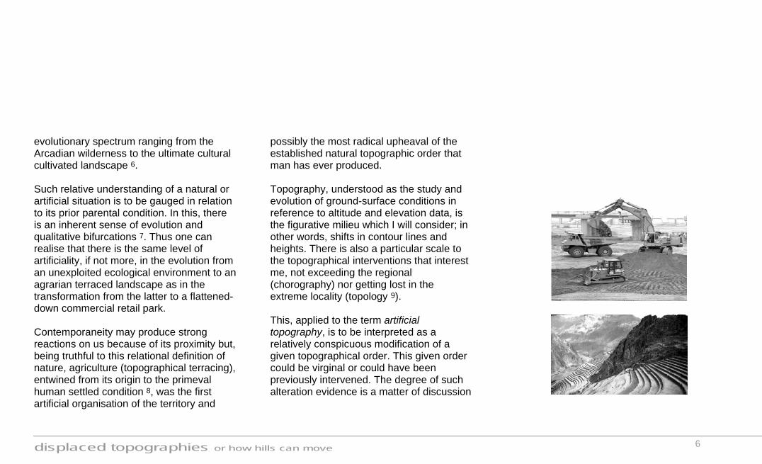
evolutionary spectrum ranging from the Arcadian wilderness to the ultimate cultural cultivated landscape 6. Such relative understanding of a natural or artificial situation is to be gauged in relation to its prior parental condition. In this, there is an inherent sense of evolution and qualitative bifurcations 7. Thus one can realise that there is the same level of artificiality, if not more, in the evolution from an unexploited ecological environment to an agrarian terraced landscape as in the transformation from the latter to a flattened-down commercial retail park. Contemporaneity may produce strong reactions on us because of its proximity but, being truthful to this relational definition of nature, agriculture (topographical terracing), entwined from its origin to the primeval human settled condition 8, was the first artificial organisation of the territory and
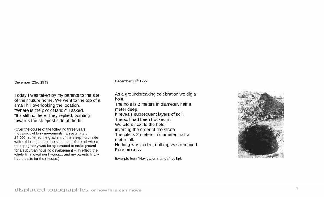
possibly the most radical upheaval of the established natural topographic order that man has ever produced. Topography, understood as the study and evolution of ground-surface conditions in reference to altitude and elevation data, is the figurative milieu which I will consider; in other words, shifts in contour lines and heights. There is also a particular scale to the topographical interventions that interest me, not exceeding the regional (chorography) nor getting lost in the extreme locality (topology 9). This, applied to the term artificial topography, is to be interpreted as a relatively conspicuous modification of a given topographical order. This given order could be virginal or could have been previously intervened. The degree of such alteration evidence is a matter of discussion
displaced topographies or how hills can move
7
in this thesis. Thus, my interest gravitates around situations where the traditional distinction between “guest” object (artificial) and “host” landscape (nature) has been excelled; giving way to a less deterministic understanding by which the landscape can be considered simultaneously a host (receptacle, original topographical order) and a guest (artificial modification), a double identity of sorts. Landscape design and the new operative topography It is worth mentioning that displaced topographies is not strictly an essay about landscape design, understood, in this case, as a discipline often dealing in a passive way with the formal expression of the environment as an aesthetic ameliorant and not concerned actively with its operative-productive capacity. Instead, my emphasis
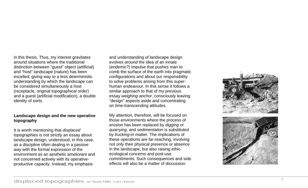
and understanding of landscape design evolves around the idea of an innate (endemic?) impulse that pushes man to comb the surface of the earth into pragmatic configurations and about our responsibility to solve problems arising from this super-human endeavour. In this sense it follows a similar approach to that of my previous essay weighing anchor, consciously leaving “design” aspects aside and concentrating on time-transcending attitudes. My attention, therefore, will be focused on those environments where the process of erosion has been replaced by digging or quarrying, and sedimentation is substituted by trucking-in matter. The implications of these operations are far-reaching, involving not only their physical presence or absence in the landscape, but also raising ethic-ecological concerns and post-use commitments. Such consequences and side effects will also be a matter of discussion.
displaced topographies or how hills can move
8
“Perhaps only God can create a tree, but only this bulldozer, Big Muskie, can make a hole like this one.” Anonymous American miner (Big Muskie is a gigantic crane bulldozer, with a simultaneous digging capacity of 150 m3) The cultural position of the 1960´s American land artists, specially Robert Smithson and Robert Morris, comes very close to the approach of displaced topographies in the sense that they brought to light a critical awareness in relation to megalomaniac land operations, namely mining, with arguments and earth-works reminiscent of a very primeval stage of human development 10. Looked at from the point of view of scale, the topic seems to involve an unavoidable element of drama and tension. The landscapes that attract my critical attention are those working on the verge of total
collapse, where production and destruction walk almost hand in hand. These were the locations where the land artists often conceived their prophetic earth-works (see for example Robert Smithson, Spiral Jetty or Michael Heizer, Effigy Tumuli), and these are the environments where the real issue of landscape design should apply but has hardly ever done so. The only other alternative to the embellishing side of the discipline of landscape design is to surrender, realistically there is not much it can do within its present field of operations to change our blasted world in a substantial manner. Topographical anima One of the pioneers of landscape studies, J.B. Jackson, presented us with three types of human landscapes. Their given names were as simple as One, Two and Three.
Landscape One is that of European medieval settlers; people living in a miraculous nature described through tribal affinities and superstition (the mythical). Landscape Two refers to the Renaissance and Neoclassical interpretations of an anthropocentric world, where Reason could theoretically govern the elements (the rational). Finally, Landscape Three describes the contemporary mobile condition of exploitation (the productive). I agree with the criteria used by Jackson to define each type of landscape but I would not go as far as categorising them into chronological periods since there is nothing that prevents them from coexisting simultaneously. Not to fall into typological cul-de sacs, I will purposely avoid a chronological (historical) or figurative (physical appearance) articulation of the study. Given that my understanding of the issue of artificial topographical interventions is one of

displaced topographies or how hills can move
9
existential continuity throughout time and across cultures, it seems more appropriate to follow a logic governed by and structured around the diverse human attitudes, energies and anima put into the action of shaping the ground. This initial ambition often informs the ethic-ecological position and the consequences and impacts of a particular human enterprise to interfere in the natural flow of a topographical ecosystem. The diverse human attitudes put to work when reshaping the land take on a variety of expressions and intensities. Although the end result of two topographical actions may look very similar (the prehistoric mound of Silbury Hill and a grassed slag heap, for instance), the processes and ambitions that created them are essentially different. Through a series of texts and case studies I will explore these different topographical
anima. The sheer accumulation of situations and cases will start revealing hidden cross links between them, some explicit and some implicit. The list of artificial topographical examples could be never-ending, however my interest does not rest in the detailed analysis of particular locations but in extracting general approaches and operative principles from them; thus I have defined three fields of investigation which I believe encompass a large range of existing interventions: meta-topographies, survival topographies and infrastructural topographies. The ultimate aim is to build up a library of scenarios with their approaches, connotations, figurative tactics, impacts, durability... and try to marry these concerns back to the discipline of landscape design. In doing so the tools, capabilities and limits of the profession might need to be redefined. I would like to speculate on the
possibility of landscape design becoming closer to the productive, not in an aesthetic/mimetic way but in an operative one and find a common field of dialogue or collaboration between design and those other powerful forces that drive man-made interventions in the topographical realm.

displaced topographies or how hills can move
10
Meta-topographies
The Foolish Old Man Removes the Mountains
The Taihang and Wangwu Mountains, which had a periphery of seven hundred li (1) and were a hundred thousand feet high, originally lay south of Jizhou and north of Heyang.
The Foolish Old Man of the North Mountain, nearly ninety years of age, lived behind these mountains. He was unhappy about the fact that the mountains blocked his way to the south and he had to walk round them whenever he went out or came back, so he called the whole family together to talk about the matter. " What would you say," he said to them, "if I suggest that all of us work hard to level the two mountains, so as to open a way to places south of Yu Prefecture and the Han River?" Many voices said they agreed to the idea.
But his wife had her doubts. "With your strength," she said, "you could hardly remove a small hill like Kuifu. What could you do with the Taihang and Wangwu
Mountains? Besides, where could you deposit the earth and rocks?"
"Carry them to the shores of the Bohai Sea and north of Yin." said several people.
The old man, helped by his son and grandson who could carry things, began to break rocks and dig earth, which they carried in baskets and dustbins to the shores of the Bohai Sea. The seven-year-old son of a widow named Jingcheng, one of the old man's neighbours, came running up to offer his help. One trip to the sea took them a long time: they left in winter and came back in summer.
The Wise Old Man at the River Bend stopped the old man. He laughed and said, "How unwise you are! At your age, old and feeble as you are, you cannot even remove one hair on the mountain, let alone so much earth and so many rocks!"
The Foolish Old Man of the North Mountain heaved a long sign and said, "You are so conceited that you are blind to reason. Even a widow and a child know better than you. When I die, there will be my sons, who will have their sons and grandsons. Those grandsons will have their sons and grandsons, and so on to infinity.
But the mountains will not grow. Why is it impossible to level them?" The Wise Old Man at the River Bend could not answer him.
The Old Man's words were heard by a god with snakes in his hands. He was afraid that the old man would really level the two mountains, and reported the whole thing to the Heavenly God. Moved by the old man's determination, the Heavenly God ordered the two sons of Kua'ershi to carry the two mountains on their backs and put one east of Shuo and the other south of Yong. After this, there were no more mountains between Jizhou and the Han River.
from Lie zi (Writings of Lie Yu Kou)
li: Chinese unit of length.
displaced topographies or how hills can move
11
The Chinese story of a foolish man’s determination to move two mountains reminds us that some of the largest human artefacts ever created have been conceived through Divine interventions of a sort, whether positively as inspiration and command or negatively in the form of fear and pretension (the Babel Tower). The sense of a larger reality, invisible to the naked eye, and sometimes identified with a metaphysical force overlooking our achievements and conceptions, is the guiding line of meta-topographies, or topographies from beyond. meta- or met- pref. [Greek, from meta, beside, after. See me-2 in Indo-European Roots.] a. Beyond; transcending; more comprehensive: metalinguistics. b. At a higher state of development: metazoan.
This section could be narrowed down to a study of religious/ritualistic or burial mounds, which is only one way of interpreting the sense of beyond-ness; yet I believe it would be more interesting to understand the prefix meta in a broader sense. Meta-topographies relate us not only to a vital and religious beyond but also put us in a direct dialogue with our larger context, whether social “so he called the whole family together to talk about the matter. " What would you say," he said to them, "if I suggest that all of us work hard to level the two mountains”… Many voices said they agreed to the idea.” or that of a geographical territory “He (the Foolish Old Man) was unhappy about the fact that the mountains blocked his way to the south and he had to walk round them whenever he went out or came back… After this, there were no more mountains between Jizhou and the Han River.”
, thus becoming scale catalysts, mediating between the scale of humans and that of the landscape. “He (the Wise Old Man at the River Bend ) laughed and said, "How unwise you are! At your age, old and feeble as you are, you cannot even remove one hair on the mountain, let alone so much earth and so many rocks!" The topographical examples that follow express in very succinct and concise ways the fact that creating or shifting contour lines can enact a self-awareness of our belonging to a greater continuum. By working in contrast with their surroundings they require as much contemplative observation as reflexive analysis. I will explore the sense of scale and the reflexive nature of meta-topographies through two particular case studies:

displaced topographies or how hills can move
12
when faith moves mountains_ topography and social scale On April 11th 2002 Francis Alÿs, a Belgium-born Mexican artist, congregated 500 people in order to create a human line that displaced, with the help of spades, a sand dune 400 metres in diameter on the outskirts of Lima (Peru) as they walked across it. It was, we could say, a moving Nazca line, imperceptible from ground level, only visible as a whole from God’s perspective, or for that matter, from the helicopter that photographed the performance. The project had come about when Alÿs was invited to participate in the Lima Biennale by curator Cuauhtémoc Medina. At the time of the invitation (year 2000) the city was submerged in a state of chaos and revolt against the corrupted regime of president Alberto Fujimori.
What is the role of art under these extreme circumstances? In the artist’s own words: “Desperate situations, ask for absurd responses”. Alÿs devised an action that worked both, metaphorically as a collective fight against an unmovable mass (the established political oligarchy / a dune), and operatively as a social cohesive event (the Peruvian society / a line of 500 volunteers). Under these premises, the event materialised in the form of a never-ending geological nomadism, but this orogenic incident remains an excuse of a second order. How far the dune was displaced is not a crucial piece of information; one could confidently say that the hill was moved the right distance, a couple of centimetres, maybe. The fact that a maximum effort was put into play and a minimum result was achieved

displaced topographies or how hills can move
13
(quite symptomatic, by the way, of the Latin American fatalistic idiosyncrasy) did not matter to any of the participants, organisers, curators nor to the artist himself; the exercise was less one of landscape transformation and more one of faith in a collective unity and enterprise and of belonging to a body with a bigger scale than that of the individual 11. Once the line of people was aligned in front of the dune with their shovels, the miracle had already happened; if, on top of that, the hill actually moved, it could be considered a superlative achievement falling into the category of the unaccountable. It is nevertheless paradoxical that most of the volunteers that took part in the action were civil engineering university students, possibly because it felt easier to convince them, rather than artists, of the absurdity of the enterprise. Alÿs understood clearly that if faith was to be used as a medium to create social
cohesion, a collective challenge needed to be put forward. A topographical incident, a barren sand dune in one of the poorest slums of Lima, proved to be the ideal obstacle to face. Unlike the Ancient Greek flat agora or choros 12, the action in Lima used the uneven nature of the ground as key catalyst; the former performing as a passive receptacle to political events in the polis, the latter behaving as an active element generating social struggle, therefore cohesion. Taking advantage of an unanimous fatalistic solidarity, or rather, empathy, the anonymous volunteers undertook the task with stoic heroism and stubborn conviction. Not to disappoint each other, none of the 500 performers deserted their topographic venture, thus Alÿs helped define a crowd identity through a profane mechanism of faith, hope and withheld satisfaction. Such negativist definition of communal

displaced topographies or how hills can move
14
identity brings to mind Kobo Abe’s Woman in the Dune. This is another story about humans’ stubborn determination to shape the unshapable, although in Abe’s case the human effort is loaded with a deep sense of pessimism, quite opposed to the fresh hope of Lima’s volunteers: “Is it not that because of one’s stubborn anchoring to a particular condition, that miserable competition arises amongst men? If one was to abandon that fixed position and let go with the movement of the sand, competition would certainly disappear… And nothing exists that can confront that formless destructive force… Precisely, the very same fact that it does not have a form, Would that not be the maximum manifestation of its force?… While he was drawing in his mind the flowing effect of the sand, he began to have hallucinations and felt that he had started to flow himself.” 13
Alÿs’s action in the dune grasps the symbolic value of a topographical landmark and simultaneously abstracts it as a microcosmic metaphor of a whole continent’s struggling history. What is more, When faith moves mountains excels the detachment from society and the romanticism of land-artists’ quasi-metaphysical dialogue with an absent divinity by re-socialising the enterprise of landscape transformation. As the artist puts it : “This is land-art for the landless” 14.
displaced topographies or how hills can move
15
Silbury Hill and the Ginkakuji Kogetsudai_ topography and figurative scale Francis Alÿs understood the dune in the outskirts of Lima as a social-historical-political metaphor. I would now like to look at two topographical examples that relate to their larger figurative context, their physical appearance being informed by phenomena happening at a bigger territorial scale. My interest is not to discern the links they may have held/hold with a transcendental realm since, in order to do that, one would need to understand very thoroughly the prevalent beliefs and deities of the period; and that is clearly not the aim of this thesis; instead, the observations, comments and a posteriori interpretations are intended to focus on the immanent presence in the landscape of these topographical creations and to speculate on possible factors that informed the way they came about.
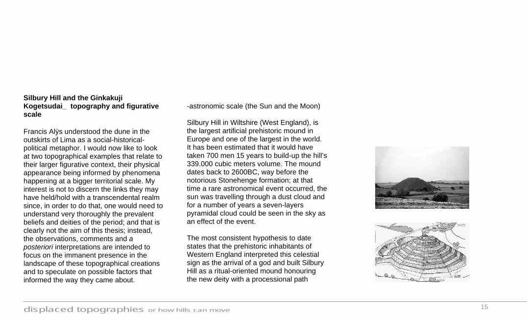
-astronomic scale (the Sun and the Moon) Silbury Hill in Wiltshire (West England), is the largest artificial prehistoric mound in Europe and one of the largest in the world. It has been estimated that it would have taken 700 men 15 years to build-up the hill’s 339.000 cubic meters volume. The mound dates back to 2600BC, way before the notorious Stonehenge formation; at that time a rare astronomical event occurred, the sun was travelling through a dust cloud and for a number of years a seven-layers pyramidal cloud could be seen in the sky as an effect of the event. The most consistent hypothesis to date states that the prehistoric inhabitants of Western England interpreted this celestial sign as the arrival of a god and built Silbury Hill as a ritual-oriented mound honouring the new deity with a processional path
displaced topographies or how hills can move
16
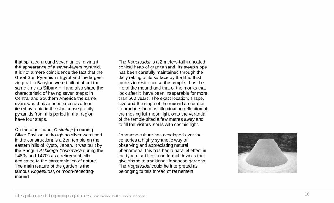
that spiraled around seven times, giving it the appearance of a seven-layers pyramid. It is not a mere coincidence the fact that the Great Sun Pyramid in Egypt and the largest ziggurat in Babylon were built at about the same time as Silbury Hill and also share the characteristic of having seven steps; in Central and Southern America the same event would have been seen as a four-tiered pyramid in the sky, consequently pyramids from this period in that region have four steps. On the other hand, Ginkakuji (meaning Silver Pavilion, although no silver was used in the construction) is a Zen temple on the eastern hills of Kyoto, Japan. It was built by the Shogun Ashikaga Yoshimasa during the 1460s and 1470s as a retirement villa dedicated to the contemplation of nature. The main feature of the garden is the famous Kogetsudai, or moon-reflecting-mound.
The Kogetsudai is a 2 meters-tall truncated conical heap of granite sand. Its steep slope has been carefully maintained through the daily raking of its surface by the Buddhist monks in residence at the temple, thus the life of the mound and that of the monks that look after it have been inseparable for more than 500 years. The exact location, shape, size and the slope of the mound are crafted to produce the most illuminating reflection of the moving full moon light onto the veranda of the temple sited a few metres away and to fill the visitors’ souls with cosmic light. Japanese culture has developed over the centuries a highly synthetic way of observing and appreciating natural phenomena; this has had a parallel effect in the type of artifices and formal devices that give shape to traditional Japanese gardens. The Kogetsudai could be interpreted as belonging to this thread of refinement.
displaced topographies or how hills can move
17
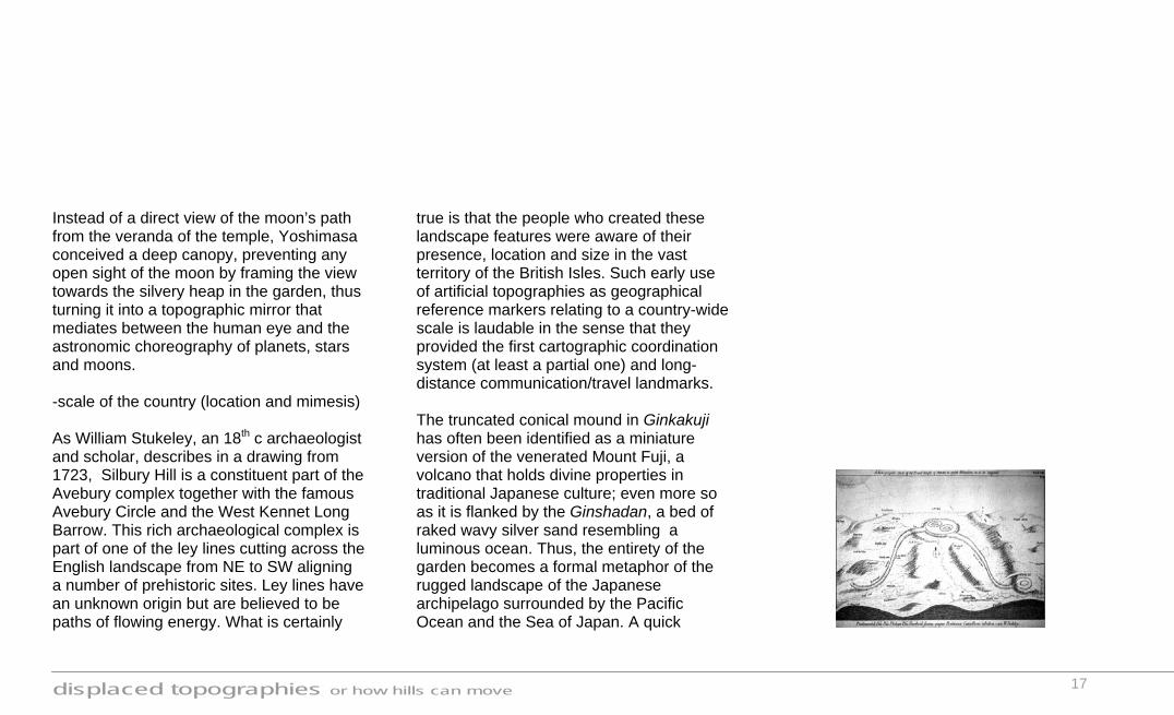
Instead of a direct view of the moon’s path from the veranda of the temple, Yoshimasa conceived a deep canopy, preventing any open sight of the moon by framing the view towards the silvery heap in the garden, thus turning it into a topographic mirror that mediates between the human eye and the astronomic choreography of planets, stars and moons. -scale of the country (location and mimesis) As William Stukeley, an 18th c archaeologist and scholar, describes in a drawing from 1723, Silbury Hill is a constituent part of the Avebury complex together with the famous Avebury Circle and the West Kennet Long Barrow. This rich archaeological complex is part of one of the ley lines cutting across the English landscape from NE to SW aligning a number of prehistoric sites. Ley lines have an unknown origin but are believed to be paths of flowing energy. What is certainly
true is that the people who created these landscape features were aware of their presence, location and size in the vast territory of the British Isles. Such early use of artificial topographies as geographical reference markers relating to a country-wide scale is laudable in the sense that they provided the first cartographic coordination system (at least a partial one) and long-distance communication/travel landmarks. The truncated conical mound in Ginkakuji has often been identified as a miniature version of the venerated Mount Fuji, a volcano that holds divine properties in traditional Japanese culture; even more so as it is flanked by the Ginshadan, a bed of raked wavy silver sand resembling a luminous ocean. Thus, the entirety of the garden becomes a formal metaphor of the rugged landscape of the Japanese archipelago surrounded by the Pacific Ocean and the Sea of Japan. A quick

displaced topographies or how hills can move
18
glance at the famous Red Fuji ukiyoe (wood-cut print) by Hiroshige, reveals the formal similarities between the real and the miniature at Ginkakuji. Such level of formal abstraction and synthesis was not achieved in Western European culture until, arguably, the beginning of the 20th. c. Scaling down the natural landscape, including iconic features such as mount Fuji, has been commonplace in Japanese gardens, but it is the mastery and early date of the Ginkakuji mound that make it a unique prototype of its kind. Here again, I interpret the mimetic quality of the garden to the larger context of the nation as a geographic tool, not so much in an operative way (cartographically, like in Silbury Hill) but in an abstracted reflexive manner.
-scale of the region (horizon and geology) Silbury Hill sits on a low-lying location within the Kennet river valley and its summit is a flat terrace 30 meters in diameter standing 40 meters above the surrounding land. The diameter of the mound at the base is 167 metres. The height of the mound was chosen deliberately as it coincides with the maximum height of the natural hills defining the valley. In fact, as one enters the Kennet river’s subtle depression the top of Silbury Hill seems to have been cut very precisely to match the distant horizon of the hills defining the other side of the valley. By internalising some of the natural aspects of the regional surroundings the builders of this mound endowed it with a sense of belonging and rooting in the landscape. One can only imagine the awe inspiring approach that Neolithic dwellers must have had to Silbury Hill when a ceremony was taking place at the top, the lit-up ritual

displaced topographies or how hills can move
19
platform lined-up with the scale-less distant horizon as the sun was setting behind it. As Paul Shepheard argues in an analogous example at the London Basin (Parliament Hill, the North Downs and the apex of St Paul’s Dome), it is this kind of well balanced artificiality that confers a timeless quality to man made topographical creations. However transcendent their inspiration might be, Silbury Hill as well as other artificial ritual mounds take into account aspects of locality and human perception, in other words, they are scaled to fit their recipient landscapes. Horizon datum, approach rhythm, ascending gradient… refer to an immanent experience of the landscape; on the other hand elevation, platform, procession… are elements with an inherent ritualistic nature. Both worlds meet in an intertwine of perception and devotion, thus confirming the hypothesis that meta-topographies are tectonic intermediaries
between our tangible world and the invisible realm of myths and belief. At another scale of observation, it is noteworthy that both Silbury Hill and Kogetsudai are formally very simple rearrangements of local abundant material. Next to Silbury Hill, surrounding the mound towards the east and north, a 7 metre deep ditch/moat can be found; this is precisely the origin of the chalk needed to build up the hypothetically terraced construction. In an early example of material opportunism the blinding white quality of the West-Country’s plentiful chalk subsoil must have been put to perform in sheer contrast with the green coloration of the then-yet-not-agrarian landscape surrounding the hill. Similarly, the eastern hills of Kyoto are primarily geological outcrops of granite, covered by and large with topsoil vegetation and bamboo forests; however, at particular
locations due to rain and wind erosive processes the granite rock is not only exposed but even transformed into mineral dust. A few streams carrying this shiny sediment converge at the pond where Yoshimasa established his Ginkakuji temple. Not knowing what to do with the granite sand, he agreed that the great gardener Soami could use it to create a karesansui (dry garden), thus the Kogetsudai (moon reflecting mound) and the Ginshadan (silver ocean) are the material result, once again, of regional geological phenomena.

displaced topographies or how hills can move
20
Survival topographies Sicilian emergency as Etna erupts Rory Carroll in Rome Saturday July 21, 2001 The Guardian
Sicilians gathered on the slopes of Mount Etna to pray last night as a river of orange-black lava oozed towards the mounds of earth protecting a tourist resort.
A new fissure in the volcano opened earlier as emergency crews, blackened and sweating, battled to reinforce the mounds and divert lava away from Rifugio Sapienza. Mount Etna is Europe's most active volcano and stands at 10,860ft (3,310m).
The archbishop of Catania, Luigi Bommarito, held a mass on the slopes to ask for God's protection against an eruption that has wrongfooted vulcanologists and threatened the town of Nicolosi further down the slope.
An emergency was declared and roads were closed off as the molten rock flowed at 10 cubic metres a second towards the village of Nicolosi, in eastern Sicily.
Workers built walls of mud and asphalt to divert the lava and assured villagers that their homes would be safe, despite a new fissure cracking open on the southern slope. But a small resort with two restaurants will almost certainly be destroyed, said Enrico Galeani, a civil protection official. A few weeks later: The barriers prevented lateral spreading of the flow field into developed areas. It has been estimated that damage caused by the flows if the barriers had not been built would be $5-25 million. Total cost of the diversion was $3 million. It was one of the first times that earthen barriers successfully diverted lava. It also demonstrated that vulcanologists could actively direct intervention in volcanic processes.

displaced topographies or how hills can move
21
History repeats itself and at the outset of the 21st c. we find ourselves again praying atop artificial earth mounds. The laudable efforts undertaken in Sicily to build emergency lava flow barriers exemplify, in landscape terms, the Darwinist theory of fitness, denoting a set of aptitudes and adaptive traits necessary for survival. The first of such type of topographical enterprises were intended to protect humans from beasts, namely fortification walls. Medieval fortresses belong to this tradition of earth shaping as protection from external flows (rival armies). In one of his Architecture Treaties, Alberti mentions that “…if a site were not raised up enemies would be a constant source of trouble if they had the opportunity to attack from higher ground…” although he surprisingly follows: “Much better would be a fight on equal footing. Just as uneven advantage made
both fighting and victory unjust, level standing equalized or balanced combat”. 15 However interesting medieval fortresses may be, bellicose confrontations are not exactly the type of situations I would like to pay attention to; In this section I will explore the stubborn human determination to reshape the surface of the earth in order to preserve our own habitat and outlive natural menaces and catastrophes. This sparks off a fundamental debate about our attitude towards intervening in ecosystems working prior to our being on earth. Opposed to the logic followed by animal species, human adaptive traits often (and more and more so) involve shaping the environment to fit our habitat needs, rather than adapting our habitat to the given natural conditions. Looked at from this anthropocentric point of view survival topographies entail the most developed
degree of artificiality, maybe not formally but certainly ethically. Two examples are of interest to me in order to understand the dramatic, often heroic, topographical collective enterprises put in motion as tamers of natural flows (of water and lava respectively) through the construction of ramparts. It is worth clarifying at this point the typological difference between walls and ramparts; The former being additions with a higher degree of artificiality from their roots to their tops; The latter being natural-looking barriers, although just as artificial as walls in their conception and operation, resulting from combing the surface of the earth and are subject to certain limitations such as slope gradient, erosion… I will try as much as possible to differentiate the two terms where appropriate, although in some cases I might also use wall in a generic way implying both.
displaced topographies or how hills can move
22
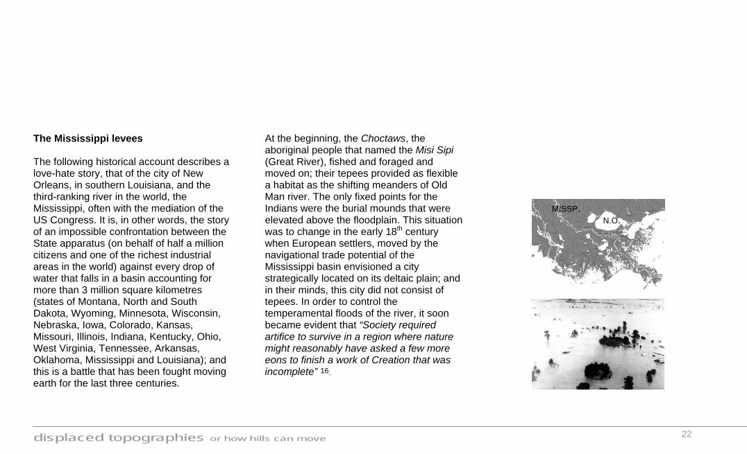
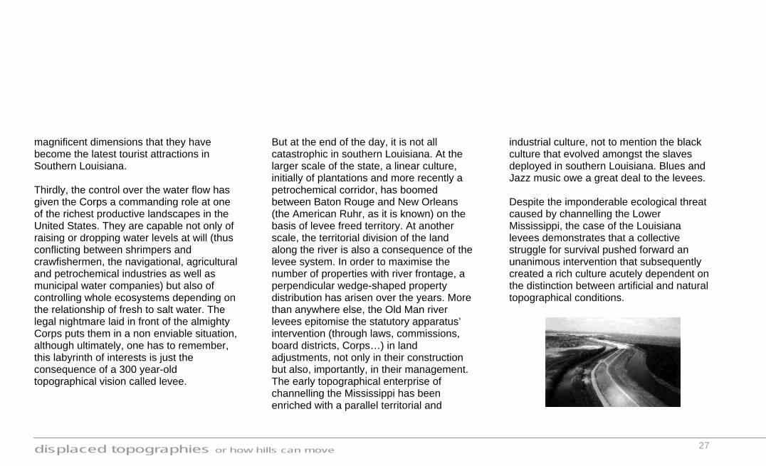
The Mississippi levees The following historical account describes a love-hate story, that of the city of New Orleans, in southern Louisiana, and the third-ranking river in the world, the Mississippi, often with the mediation of the US Congress. It is, in other words, the story of an impossible confrontation between the State apparatus (on behalf of half a million citizens and one of the richest industrial areas in the world) against every drop of water that falls in a basin accounting for more than 3 million square kilometres (states of Montana, North and South Dakota, Wyoming, Minnesota, Wisconsin, Nebraska, Iowa, Colorado, Kansas, Missouri, Illinois, Indiana, Kentucky, Ohio, West Virginia, Tennessee, Arkansas, Oklahoma, Mississippi and Louisiana); and this is a battle that has been fought moving earth for the last three centuries.
At the beginning, the Choctaws, the aboriginal people that named the Misi Sipi (Great River), fished and foraged and moved on; their tepees provided as flexible a habitat as the shifting meanders of Old Man river. The only fixed points for the Indians were the burial mounds that were elevated above the floodplain. This situation was to change in the early 18th century when European settlers, moved by the navigational trade potential of the Mississippi basin envisioned a city strategically located on its deltaic plain; and in their minds, this city did not consist of tepees. In order to control the temperamental floods of the river, it soon became evident that “Society required artifice to survive in a region where nature might reasonably have asked a few more eons to finish a work of Creation that was incomplete” 16.
MISSP. N.O.
displaced topographies or how hills can move
23
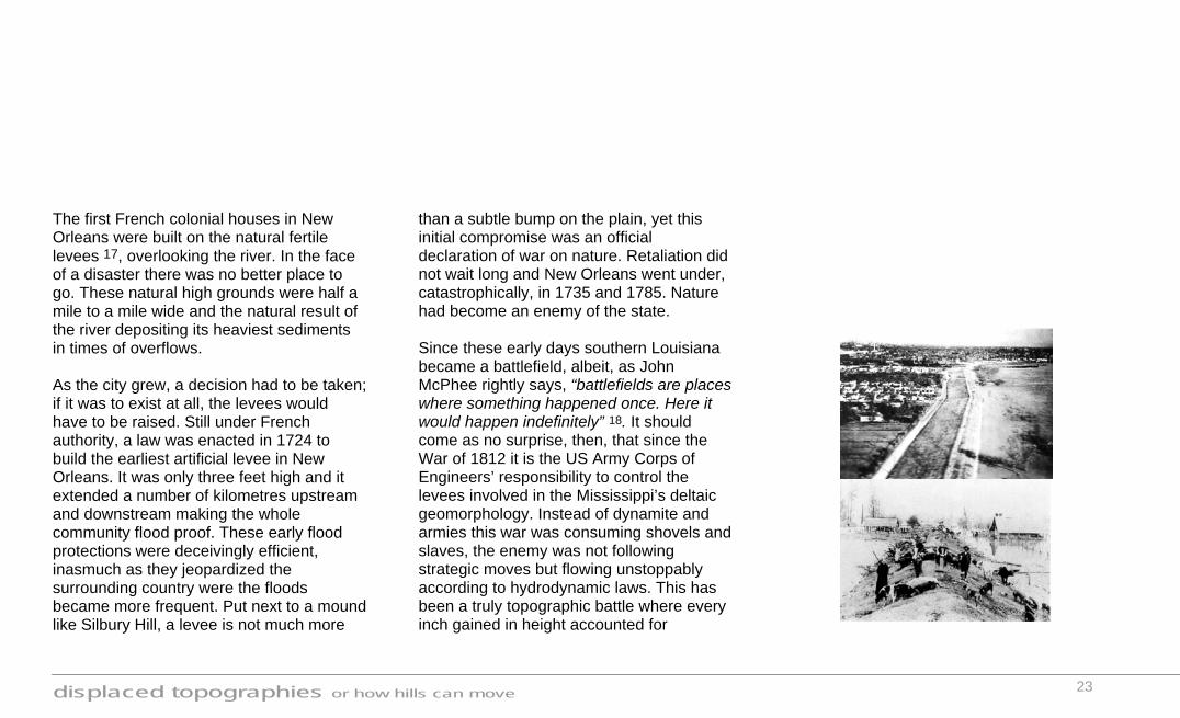
The first French colonial houses in New Orleans were built on the natural fertile levees 17, overlooking the river. In the face of a disaster there was no better place to go. These natural high grounds were half a mile to a mile wide and the natural result of the river depositing its heaviest sediments in times of overflows. As the city grew, a decision had to be taken; if it was to exist at all, the levees would have to be raised. Still under French authority, a law was enacted in 1724 to build the earliest artificial levee in New Orleans. It was only three feet high and it extended a number of kilometres upstream and downstream making the whole community flood proof. These early flood protections were deceivingly efficient, inasmuch as they jeopardized the surrounding country were the floods became more frequent. Put next to a mound like Silbury Hill, a levee is not much more
than a subtle bump on the plain, yet this initial compromise was an official declaration of war on nature. Retaliation did not wait long and New Orleans went under, catastrophically, in 1735 and 1785. Nature had become an enemy of the state. Since these early days southern Louisiana became a battlefield, albeit, as John McPhee rightly says, “battlefields are places where something happened once. Here it would happen indefinitely” 18. It should come as no surprise, then, that since the War of 1812 it is the US Army Corps of Engineers’ responsibility to control the levees involved in the Mississippi’s deltaic geomorphology. Instead of dynamite and armies this war was consuming shovels and slaves, the enemy was not following strategic moves but flowing unstoppably according to hydrodynamic laws. This has been a truly topographic battle where every inch gained in height accounted for

displaced topographies or how hills can move
24
millions of displaced cubic metres of water and hundreds of acres of drained plantation land. Undertaking the earthworks necessary to control the river has conceded the Corps the almighty role of God. By 1820 the levees in southern Louisiana were already continuous for 350 kilometres, and the Mississippi had been artificially confined with no possible distributaries easing the pressure in the very possible scenario of a flood. Just in case the levees should fail along their length (these fatal locations were known as crevasses), some plantation houses were built, ironically enough, on top of Choctaw burial mounds. The first half of the 19th century witnessed the institutionalisation of the levees enterprise. Levee Districts were established and levee inspectors had the power to call out male slaves within a seven miles radius of trouble in order to reinforce the
protections. Soon the costs for the parishes escalated so, once again, the United States Congress intervened and wrote in 1850 the Swamp and Overflow Land Act. Nearly 30 million acres of river swamps and marshes were given to the levee districts; but, instead of being used as a system of sacrificial floodways, they were drained and leveed as well. Following a simple principle of hydrodynamics, the more the levees confined the river, the more destructive it became when a crevasse appeared. Yet the 1879 Mississippi River Commission (another creation of the US Congress) remained committed that tributary dams upstream and spillways downstream would create more problems. “Hold by the levees” was the Corps one and only policy for half a century 19. Fifteen hundred miles of earthen walls –enlarged subsequently from six to nine,
displaced topographies or how hills can move
25
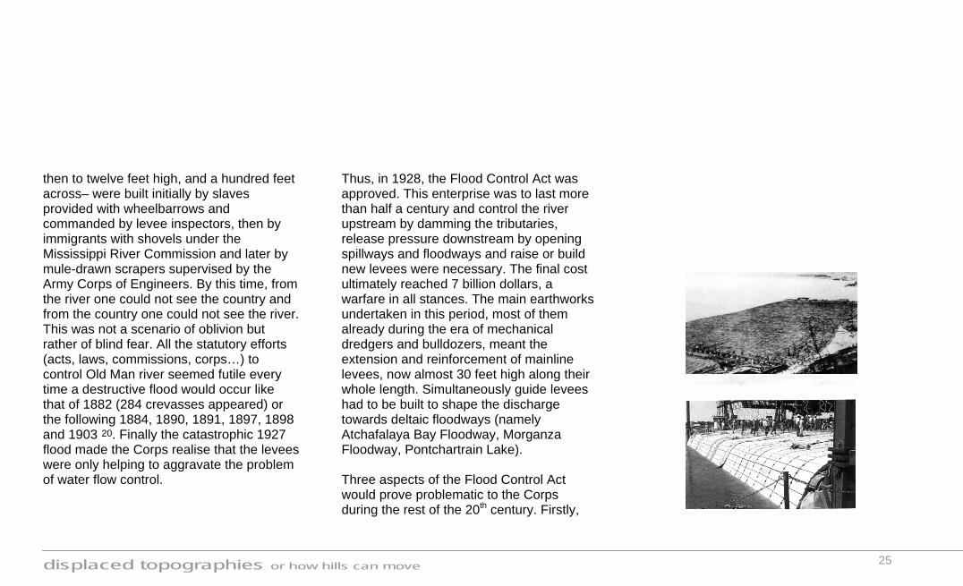
then to twelve feet high, and a hundred feet across– were built initially by slaves provided with wheelbarrows and commanded by levee inspectors, then by immigrants with shovels under the Mississippi River Commission and later by mule-drawn scrapers supervised by the Army Corps of Engineers. By this time, from the river one could not see the country and from the country one could not see the river. This was not a scenario of oblivion but rather of blind fear. All the statutory efforts (acts, laws, commissions, corps…) to control Old Man river seemed futile every time a destructive flood would occur like that of 1882 (284 crevasses appeared) or the following 1884, 1890, 1891, 1897, 1898 and 1903 20. Finally the catastrophic 1927 flood made the Corps realise that the levees were only helping to aggravate the problem of water flow control.
Thus, in 1928, the Flood Control Act was approved. This enterprise was to last more than half a century and control the river upstream by damming the tributaries, release pressure downstream by opening spillways and floodways and raise or build new levees were necessary. The final cost ultimately reached 7 billion dollars, a warfare in all stances. The main earthworks undertaken in this period, most of them already during the era of mechanical dredgers and bulldozers, meant the extension and reinforcement of mainline levees, now almost 30 feet high along their whole length. Simultaneously guide levees had to be built to shape the discharge towards deltaic floodways (namely Atchafalaya Bay Floodway, Morganza Floodway, Pontchartrain Lake). Three aspects of the Flood Control Act would prove problematic to the Corps during the rest of the 20th century. Firstly,

displaced topographies or how hills can move
26
the sediments of half the United States’ territory carried by the Mississippi waters would need to get through the floodways, specially the Atchafalaya Basin, and reach the ocean without clogging the mediating wetland. This could only be done if channels were artificially dredged by the Corps; once again this called for a collective topographical enterprise, albeit a subtractive one, that in two decades displaced nearly 140 million cubic metres of silt and closed a number of bayous (swamp canals) with the collected matter. It is common knowledge in southern Louisiana that the safest place to be in time of flood is now the sedimented floodway as it is the highest land around. Secondly, the water coming out of the main river’s spillways would enter new systems of levees guiding the flow through floodways to the Gulf of Mexico; however, during the previous 200 years people had exploited
and settled on the edge of these deltaic basins. That was, for instance, the situation at Morgan City and New Orleans. The solution was strict to say the least. They became walled medieval citadels of sorts, surrounded by ring levees making them resemble islands during floods although 15 feet below sea level. Today the 40 feet high levees are highly engineered products. Their surfaces are grassed over on the outside and paved with concrete on the inside to protect them against the waves of boat traffic. Below the waterline they are lined by revetments that protect the bank from the tumbling effect of the current. Once made of willow mattresses (like Dutch polders), revetments are nowadays slabs of reinforced concrete blocks tied together with heavy stainless steel wire to form mats anchored to the river bank. The citizens of Morgan City and New Orleans are grateful for the walls, the levees are of such
displaced topographies or how hills can move
27
magnificent dimensions that they have become the latest tourist attractions in Southern Louisiana. Thirdly, the control over the water flow has given the Corps a commanding role at one of the richest productive landscapes in the United States. They are capable not only of raising or dropping water levels at will (thus conflicting between shrimpers and crawfishermen, the navigational, agricultural and petrochemical industries as well as municipal water companies) but also of controlling whole ecosystems depending on the relationship of fresh to salt water. The legal nightmare laid in front of the almighty Corps puts them in a non enviable situation, although ultimately, one has to remember, this labyrinth of interests is just the consequence of a 300 year-old topographical vision called levee.
But at the end of the day, it is not all catastrophic in southern Louisiana. At the larger scale of the state, a linear culture, initially of plantations and more recently a petrochemical corridor, has boomed between Baton Rouge and New Orleans (the American Ruhr, as it is known) on the basis of levee freed territory. At another scale, the territorial division of the land along the river is also a consequence of the levee system. In order to maximise the number of properties with river frontage, a perpendicular wedge-shaped property distribution has arisen over the years. More than anywhere else, the Old Man river levees epitomise the statutory apparatus’ intervention (through laws, commissions, board districts, Corps…) in land adjustments, not only in their construction but also, importantly, in their management. The early topographical enterprise of channelling the Mississippi has been enriched with a parallel territorial and
industrial culture, not to mention the black culture that evolved amongst the slaves deployed in southern Louisiana. Blues and Jazz music owe a great deal to the levees. Despite the imponderable ecological threat caused by channelling the Lower Mississippi, the case of the Louisiana levees demonstrates that a collective struggle for survival pushed forward an unanimous intervention that subsequently created a rich culture acutely dependent on the distinction between artificial and natural topographical conditions.
displaced topographies or how hills can move
28
Diverting the lava Civilizations throughout the centuries have learnt to live under the shadow of volcanoes, not dissuaded by the constant presence of disaster in spite of their overwhelming presence when active, and their silent menace when dormant. Thus it is less likely to hear of cases such as that of the Heimaey island eruption (off the coast of Iceland) in 1973, where all 5300 inhabitants were evacuated within hours of the initial explosion, than that of the 30 villages surrounding the Popocatepetl volcano in Mexico where the population refused to be evacuated in the year 2000 claiming that confronting the volcano would be less of a risk than leaving their homes unattended. In the light of such reactions, the seemingly absurd idea of diverting the lava (just as absurd as moving a mountain with 500 shovels) has become rather ingenious and
ultimately viable. To introduce artifice in the most spectacular of natural scenarios sounds like a rather obscene idea 21, yet human ambition has put it to practice. “You don't stop rain, you don't stop lava, but you can divert them." 22 says volcano tamer John P. Lockwood, former U.S. Geological Survey member. Three methods have been tested so far to do so. These are, ranging from the most “brutal” to the most sophisticated: detonating explosives at a large scale on the path of the lava flow, spraying monstrous volumes of water to cool the advancing lava and constructing emergency earthen ramparts at strategic enclaves. I will illustrate the last two through the experiences of Heimaey in Iceland and the Etna in Sicily. -The Heimaey hoses Vestmannaeyjar is a archipelago of volcanic origin that emanated from the central crest
of the Atlantic Ocean (just south of Iceland). In fact the most recent of its constituent islands, Surtsey, named after the Norse god of fire, did not exist before the 1960s. So for the volcano on Heimaey island to abruptly erupt in the early hours of the 23rd January 1973 was absolutely natural, but in the interval since its last major eruption the fishing harbour of the minute island, located a mile to the north of the volcano crater, had become one of Iceland’s main sources of income. The country simply could not afford the event to destroy the vital port infrastructure. Southern Louisiana had the auspices of the US Congress and Vestmannaeyjar had the inventiveness of vulcanologist Thorbjorn Sigurgeirsson (1917-1988). He had observed during the emergence of Surtsey island that lava cooled by the sea would form walls and successive flows of lava would run along the cooled

displaced topographies or how hills can move
29
wall. He wondered if anything similar could be done by man. The physical principle was very similar to that of the levees, the method of construction was rather different. Within ten days of the Heimaey eruption Sigurgeirsson had coordinated with the Civil Defence Council a troop of fire hoses to cool down the lava front very near its fissure using water pumped from the ocean. What they were doing was, in every sense of the word, sculpting the fluid surface of earth like clay artisans but with a great deal of added heroism. The aim was not to cool all the lava coming out from the earth but to congeal enough matter to create a solid barrier that would divert the subsequent flow directly east to the Atlantic Ocean and not to the town and the harbour. After the first attempts the crew learnt that 1 cubic metre of water could solidify 0,7 cubic metres of flowing lava, reducing its
temperature from 1975º F to about a tenth of that. It was soon apparent that bulldozers (omnipresent machines) were required on the battlefront to flatten the crusty ash ground surface, to make roads for the pumping crews, to move the 35 kilometres of pipes, to manoeuvre the 43 giant pumps borrowed from the American troops deployed in mainland Iceland and to sculpt the tephra fall (volcanic ash) into long barriers shaped like earth fill dams to serve as platforms from which the pumping crews could improve their trajectories. Once again the analogy to a battlefield is unavoidable, the similarities being explicit between trenches and earth walls, flame-throwing tanks and hoses, projectiles and volcanic debris. Yet more logistics had to be called in. Sandey, a commercial ship with a powerful
displaced topographies or how hills can move
30
pumping system arrived in Heimaey harbour in the third month of the eruption. Together with a local boat they quintupled the quantity of water being thrown at the lava front. The flow of water amounted to as much as 23 million gallons per day and it was shot 150 metres into the air. After five months of operations, 7 million cubic metres of hosed water, 200.000 tons of sea salt and 5 million cubic metres of cooled lava, the eruption of the volcano was pronounced dead. The cost of cooling the lava was 1,5 million dollars, the benefits on the other hand meant 30 million dollars worth of natural heating for the town, free paving material for streets and for the new airport runway and a retained harbour. On top of that no tourist leaves Iceland without having visited the epic site of the Vestmannaeyjar archipelago.
The Heimaey experiment was the first in a saga that demonstrated that in something as tectonic, orogenic and untamed as a volcanic eruption the artificial component of human interference could enter the topographic narrative and, in complex, unpredictable and often unassessable ways alter the shape of succeeding events. A quote from a local summarises, with a rather Icelandic laconic twist, the survival instinct that drove the greatest effort ever attempted to control lava flows during the course of an eruption: “I am convinced that because we were pumping and this part of the lava was cooled most of the new flow went east and out to sea. If we hadn’t done something, I very much doubt that we would be here (Heimaey) now. Of course, we can’t do anything if the natural force is strong, but I am convinced that this really helped. We tried, anyway.” 23
-Sicilian barriers The earliest recorded predecessor of the Heimaey spirit took place in Sicily in the spring of 1669 when the lava of the notorious Etna started to flow towards the harbour city of Catania, 3320 metres below the crater. A group of citizens, armed with picks and axes, opened a breach in the lava channel, causing it to divert towards another town (Paterno). The outcry of the people from Paterno was sound to say the least, so the lava had to return to its natural flow, eventually reaching Catania where an emergency perimetral barrier saved the city. Since that day, a royal decree prohibited any interference on the path of the lava. The decree was strictly observed until the spring of 1983 when the Italian Army thought it was reasonable to invalidate this anachronic law and bend the flow that was threatening part of the island’s

displaced topographies or how hills can move
31
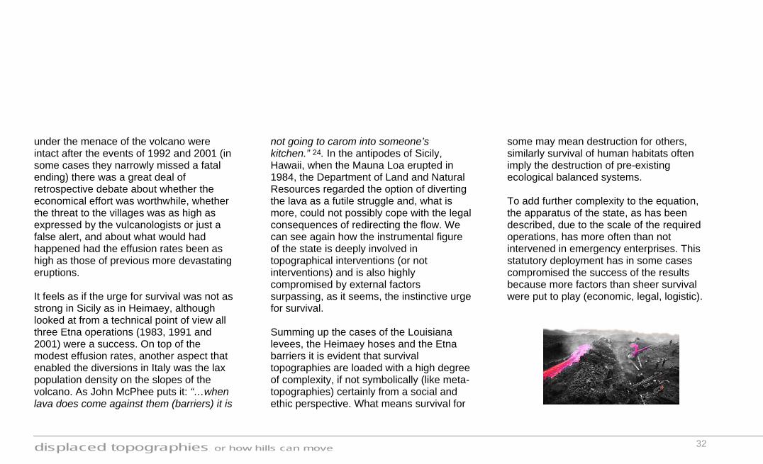
population, by now much larger than that of the 17th c., and the valuable Rifugio Sapienza, the Astronomical Observatory and the Grand'Albergo dell'Etna. It was decided that earthen barriers would be built parallel to the lava vector in order to prevent the lateral spreading of the flow. It was necessary three of such constructions to control the lava. They were located at decreasing altitudes (the 2.200 metres barrier, the Sapienza barrier at about 1.900 metres and the Monte Vetore barrier at an approximate height of 1.700 metres) and on both sides of the lava margin, the first one being on the west side, the second on the east fringe and the last one again on the west side of a lava flow due south. The Monte Vetore barrier was located the furthest from the source vent, therefore the flow it was meant to contain was larger and more destructive. 200 men worked day and night for three weeks in order to build two
barriers, each measuring 10 metres in height, 30 metres in width and 400 metres in length. The first one was overtopped by the lava even though it was doubled in size in a last minute effort, but the second barrier, located 100 metres to the west held the spread of the flow. The sense of victory achieved in 1983 inspired further enterprises to control mount Etna’s lava by locating barriers at specific points on its trajectory. These occurred in the summer of 1992 and again in the summer of 2001. In both cases earthen ramparts were built perpendicularly to the direction of the flow, their aim not being to stop the flow nor to redirect it but to be sacrificial structures that would slow down the lava to allow time for erecting more barriers and excavating channels further down where the valuable settlements were located. Even though the villages of Zafferana and Nicolosi and the structures
displaced topographies or how hills can move
32
under the menace of the volcano were intact after the events of 1992 and 2001 (in some cases they narrowly missed a fatal ending) there was a great deal of retrospective debate about whether the economical effort was worthwhile, whether the threat to the villages was as high as expressed by the vulcanologists or just a false alert, and about what would had happened had the effusion rates been as high as those of previous more devastating eruptions. It feels as if the urge for survival was not as strong in Sicily as in Heimaey, although looked at from a technical point of view all three Etna operations (1983, 1991 and 2001) were a success. On top of the modest effusion rates, another aspect that enabled the diversions in Italy was the lax population density on the slopes of the volcano. As John McPhee puts it: “…when lava does come against them (barriers) it is
not going to carom into someone’s kitchen.” 24. In the antipodes of Sicily, Hawaii, when the Mauna Loa erupted in 1984, the Department of Land and Natural Resources regarded the option of diverting the lava as a futile struggle and, what is more, could not possibly cope with the legal consequences of redirecting the flow. We can see again how the instrumental figure of the state is deeply involved in topographical interventions (or not interventions) and is also highly compromised by external factors surpassing, as it seems, the instinctive urge for survival. Summing up the cases of the Louisiana levees, the Heimaey hoses and the Etna barriers it is evident that survival topographies are loaded with a high degree of complexity, if not symbolically (like meta-topographies) certainly from a social and ethic perspective. What means survival for
some may mean destruction for others, similarly survival of human habitats often imply the destruction of pre-existing ecological balanced systems. To add further complexity to the equation, the apparatus of the state, as has been described, due to the scale of the required operations, has more often than not intervened in emergency enterprises. This statutory deployment has in some cases compromised the success of the results because more factors than sheer survival were put to play (economic, legal, logistic).
displaced topographies or how hills can move
33
Infrastructural topographies
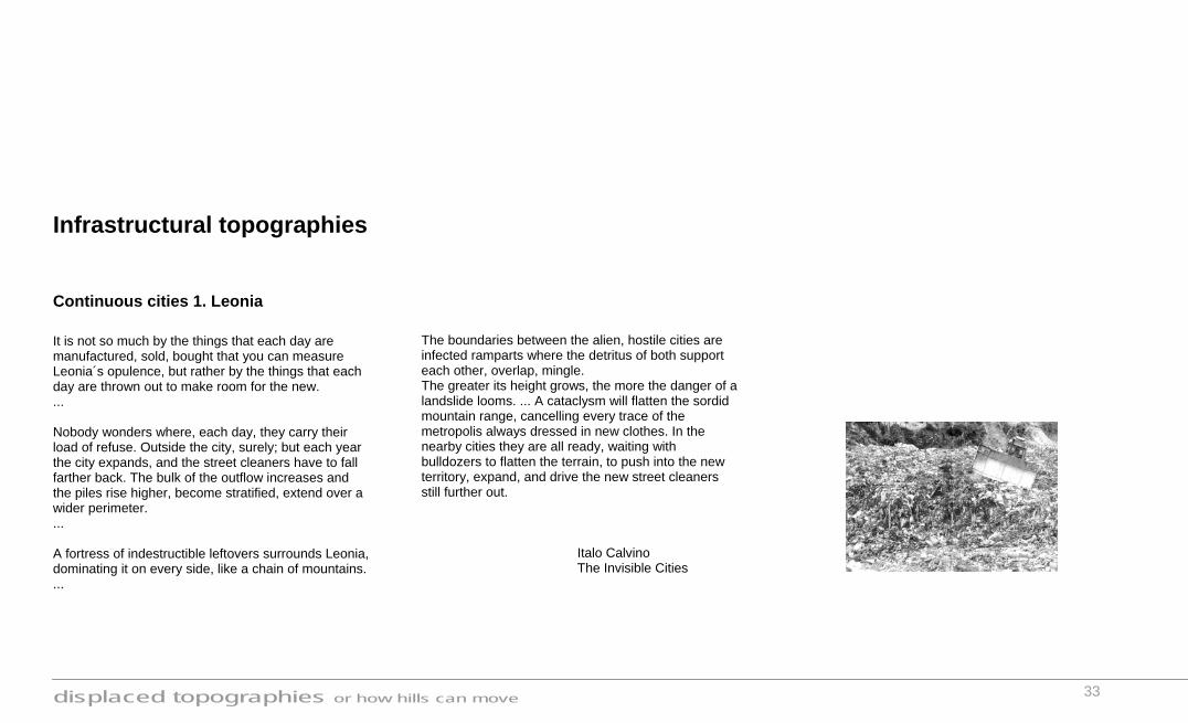
Continuous cities 1. Leonia It is not so much by the things that each day are manufactured, sold, bought that you can measure Leonia´s opulence, but rather by the things that each day are thrown out to make room for the new. ... Nobody wonders where, each day, they carry their load of refuse. Outside the city, surely; but each year the city expands, and the street cleaners have to fall farther back. The bulk of the outflow increases and the piles rise higher, become stratified, extend over a wider perimeter. ... A fortress of indestructible leftovers surrounds Leonia, dominating it on every side, like a chain of mountains. ...
The boundaries between the alien, hostile cities are infected ramparts where the detritus of both support each other, overlap, mingle. The greater its height grows, the more the danger of a landslide looms. ... A cataclysm will flatten the sordid mountain range, cancelling every trace of the metropolis always dressed in new clothes. In the nearby cities they are all ready, waiting with bulldozers to flatten the terrain, to push into the new territory, expand, and drive the new street cleaners still further out.
Italo Calvino The Invisible Cities
displaced topographies or how hills can move
34
Leonia’s history, oblivious to its own by-product, its refuse, is paradigmatic of the way contemporary landscape exploitation operates, in such way that its existence inexorably implies its self-destruction under the silent menace of its own landfill mounds. During the second half of the 20th century and specially in the last decade (Rio summit, Kyoto protocol) we learnt that the contradictory human pragmatic usage of natural resources generates more troubles in the long run than it actually solves. Western suburban industrial landscapes are by and large characterised by a mixture of factory-productive compounds and residual heaps of rejected matter. Abandoned quarries, coal slag heaps, earth mounds of piled-up soil from road construction… these infrastructural topographies reflect, whether in their presence or in their absence, the
consequence of productive saturation. They are the unplanned and unaccounted for appendixes of operative environments. The case studies of meta-topographies and survival topographies refer to situations where the land adjustments were means to achieve different goals. On the other hand infrastructural topographies are neither means nor ends, but collateral effects, consequently attention has never been put to what their danger and potential might be. Could this scenario change? What is more, unlike other explored case studies, infrastructural topographies are not scaled to fit their recipient landscapes, whether the scaling factor be the height of the surrounding hills or the amount of lava or water to be controlled. The volume of a slag heap or a landfill site is proportional to external economic factors (a financial landscape) and only in a minor degree to its geomorphologic context.
Another problematic aspect of these locations is that, because of their often toxic materiality, they tend to break the evolutionary pattern of the site in all possible ways (fauna, flora, hydrology…), obliterating the chances of future life. In this sense they behave like genetic cul-de-sac mutations. The programmatic uncertainty (what to do with these locations?) and ecological un-sustainability (often rich in pollutants) of these post-industrial landscapes are unresolved aspects that I would like to touch upon through the following case study.
displaced topographies or how hills can move
35
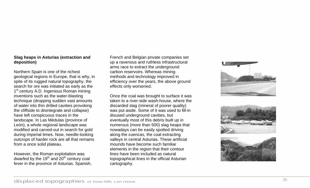
Slag heaps in Asturias (extraction and deposition) Northern Spain is one of the richest geological regions in Europe, that is why, in spite of its rugged natural topography, the search for ore was initiated as early as the 1st century A.D. Ingenious Roman mining inventions such as the water-blasting technique (dropping sudden vast amounts of water into thin drilled cavities provoking the cliffside to disintegrate and collapse) have left conspicuous traces in the landscape. In Las Médulas (province of León), a whole regional landscape was modified and carved-out in search for gold during imperial times. Now, needle-looking outcrops of harder rock are all that remains from a once solid plateau. However, the Roman exploitation was dwarfed by the 19th and 20th century coal fever in the province of Asturias. Spanish,
French and Belgian private companies set up a ravenous and ruthless infrastructural arms race to extract the underground carbon reservoirs. Whereas mining methods and technology improved in efficiency over the years, the above ground effects only worsened. Once the coal was brought to surface it was taken to a river-side wash-house, where the discarded slag (mineral of poorer quality) was put aside. Some of it was used to fill-in disused underground cavities, but eventually most of this debris built up in numerous (more than 500) slag heaps that nowadays can be easily spotted driving along the cuencas, the coal extracting valleys in central Asturias. These artificial mounds have become such familiar elements in the region that their contour lines have been included as natural topographical lines in the official Asturian cartography.
displaced topographies or how hills can move
36
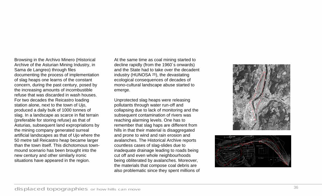
Browsing in the Archivo Minero (Historical Archive of the Asturian Mining Industry, in Sama de Langreo) through files documenting the process of implementation of slag heaps one learns of the constant concern, during the past century, posed by the increasing amounts of incombustible refuse that was discarded in wash houses. For two decades the Reicastro loading station alone, next to the town of Ujo, produced a daily bulk of 1000 tonnes of slag. In a landscape as scarce in flat terrain (preferable for storing refuse) as that of Asturias, subsequent land expropriations by the mining company generated surreal artificial landscapes as that of Ujo where the 50 metre tall Reicastro heap became larger than the town itself. This dichotomous town-mound scenario has been brought into the new century and other similarly ironic situations have appeared in the region.
At the same time as coal mining started to decline rapidly (from the 1960´s onwards) and the State had to take over the decadent industry (HUNOSA 25), the devastating ecological consequences of decades of mono-cultural landscape abuse started to emerge. Unprotected slag heaps were releasing pollutants through water run-off and collapsing due to lack of monitoring and the subsequent contamination of rivers was reaching alarming levels. One has to remember that slag haps are different from hills in that their material is disaggregated and prone to wind and rain erosion and avalanches. The Historical Archive reports countless cases of slag-slides due to inadequate drainage leading to roads being cut off and even whole neighbourhoods being obliterated by avalanches. Moreover, the materials that compose coal debris are also problematic since they spent millions of

displaced topographies or how hills can move
37
years in an anaerobic, metamorphosing environment under the influence of enormous pressures (of geological scale) and when exposed to an oxygenated environment and light atmospheric pressures they become highly susceptible to chemical alterations and release pollutants that affect fauna, flora, air and water. In other words, when earth is being moved attention has to be paid to where from and where to it is displaced. This was the daunting scenario during the 1970’s and 1980’s in Asturias, economic depression (up to 30% unemployment in some towns) and ecological catastrophe in the shadow of menacing heaps of discarded coal. The entry of Spain into the EU has brought, since the 1990’s (and will continue until 2004, the date of entry of poorer Eastern European countries), an influx of funds that HUNOSA has deployed, only partially, in solving the problems posed by
the artificial coal mountains that adorn the Asturian landscape. It is arguable that such economic and ecological crisis has been commonplace across the continent, particularly in the heavily industrialised central European region, but the response given to such situations has varied greatly from country to country. One of the flagship initiatives in the field of post-industrial landscape recovery is that of the IBA Emscher Park for the Ruhr valley in Germany, a regional 10-year master plan covering an area of 800 sq km. This project, launched in 1988 by the Federal Government of Nordrhein-Westfalen is an excellent example of an integral operation implemented at multiple scales and with specialists from numerous fields (recovery of ecosystems, urban regeneration,

displaced topographies or how hills can move
38
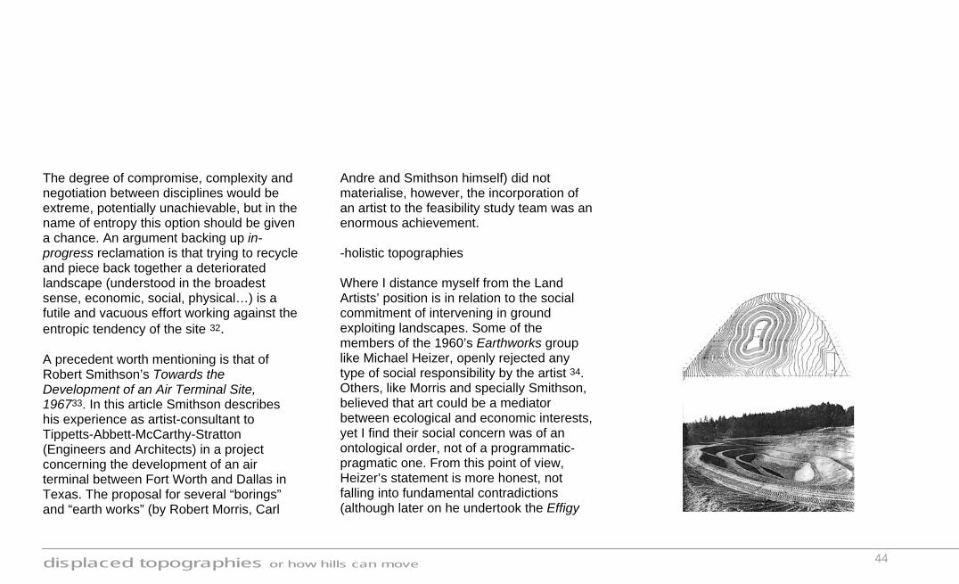
economic and technological catalysis…). The Emscher Park is formed by more than 120 projects, a great number of them can be termed topographical interventions. In 1998 the Nordstern Park (Essen) board commissioned the American sculptor Richard Serra to intervene in a gigantic coal slag heap (see illustration previous page) which he reinterpreted as a plinth, albeit of landscape dimensions, for the monumental steel sculpture Bramme (14 metres tall, 67 tonnes of weight). Even more interesting than the steel slab itself is Serra’s adjustment of the enormous ellipsoid plateau of the mound. Standing 50 metres above the surrounding plain, the top of the heap was transformed into a subtly concave space, creating an enclosed perception isolated from the hyper-urban vicinity. Bramme is at the same time conspicuously aware of its post-industrial legacy and conspicuously distant from the suburban
chaos, a fragile balance achieved topographically through a slight intervention on the curvature of the plateau. Many people in the Ruhr questioned whether the money invested in artistic interventions atop slag heaps might not have been better spent for housing or other social needs. However, the art has helped to signal the forward-looking nature of the initiative and to provide a system of new landmarks through an otherwise anodyne impenetrable landscape. Unlike the IBA project, HUNOSA in Asturias lacks a general policy or plan of action not only in regards to slag heaps but also to abandoned collieries, wash houses, loading stations… The interventions in Asturias, when they have happened, have been fragmentary and lacking coordination, in part, because some sections of the mining network are still in operation and may

displaced topographies or how hills can move
39
eventually need the support of disused infrastructures. The difficult access to many sites and the fact that numerous slag heaps are unaccounted for (the oldest ones have already been covered by wild vegetation) has made the restoration process all the more tedious and slow. In general terms the restoration process of a slag heap includes an initial stage of gradient fixing, softening the slopes (in accordance to the diameter of the slag granules) to prevent landslides and to minimise the erosive effect of water run-off. Secondly the risky mineral debris is insulated with subsequent layers of geotextile, clay and soil that is quickly seeded expecting a fast consolidation of vegetation (shrubs and herbaceous plants) that will reinforce the consistency of the slope with its roots. Recent research by the
University of Oviedo (Asturias) has demonstrated with several 1:1 experiments that a number of specialised micro fungi (Scleroderma, Hebeloma and Laccaria families), acting as pioneers help to consolidate new vegetation on the slopes of slag heaps. Thirdly a water channelling system is implemented to guide the surface run-off along predetermined paths. Finally, many restorations undertaken so far have used the opportunity to improve the civic facilities of the towns that were affected in the first place, taking advantage of the flat top plateaus and the primal locations that slag heaps often have (very near the town centres). Thus, driving through the cuencas one can now start spotting sports facilities, swimming pools, parks, community halls… situated on the prominent plateaus of once hated black piles of debris. Is this light at the end of the tunnel?

displaced topographies or how hills can move
40
10 years was considered the critical period to evaluate the implementation of the IBA project in the Ruhr, may be it is still too early to make a fair judgement of the HUNOSA plan for Asturias, specially if we take into account that a number of collieries are still active. One of the advantages of the IBA plan was the participation of private sector investments that foresaw the potential of a cultural-technological park located in the heartland of Europe, this is an asset that Asturias, due to its peripheral situation, lacks, therefore turning any private investment into a risky enterprise. HUNOSA will require a great deal of ingenious creativity to regenerate the activity of its post-industrial legacy, the iconic presence of slag heaps could be used in this challenging future.
displaced topographies or how hills can move
41
Landslide I could summarise this thesis in one conclusive and categorical way, as a great colophon or finale. I could pretend that the issue of artificial topographies has been reviewed to its ultimate consequences and that what I have done here is a fully comprehensive historical concluded compendium. Or I could just finish at this point and leave the rest to the reader’s own synthesis. However, I will not do any of the things above; the continuous doubts and varied interpretations that have crossed my mind while producing displaced topographies would not allow me to do so. Instead, a bit like a person who is trying to speculate and reconstruct a situation out of the traces left by an obliterating landslide, I would like to offer a few ways forward, all of
them as valid as each other. In other words, I will conclude the thesis with a series of open hypotheses. In this, there is certainly a risk of being misinterpreted or of my position being considered all too open and relative but I do not find it a conflict to have an ambiguous point of view. I hope that these final observations are to a reasonable extent revealing and can guide the reader to broader horizons, that is, of course, broader shifting artificial horizons. -light feet mountains During the 20th century humans have developed almighty tools and ambitions. These have led to a more flexible notion of the relatively slow processes governing the natural phenomena that constrict or influence our habitats (climate control systems, hydrologic enterprises, tidal control…). It could be said that the landscape 26 (not wilderness) has become
lighter, relieved of its unbearable weight on us. In Six Memos for the New Millennium Italo Calvino explores his non-pretentious prophesy of lightness for the new millennium through a series of examples drawn from European literature where considers lightness a value rather than a defect 27.In an analogous way, I believe that some of the topographical case studies prove that mountains are now, through artificial interventions, able to un-root themselves and have been endowed with light feet to move freely. I would not subject this observation to a categorical judgement since I do not always consider this freedom a positive value (nor always a negative aspect). All that I would like to transmit here is simply that I foresee the 21st century as the period when the topographical landscape will

displaced topographies or how hills can move
42
lose its weight and will start to be freely arranged like a Zen raked sand pit. The “Dutch Mountain” project by architects S333 helps illustrate the sense of lightness I am referring to. The proposal consists of a municipal public space in the form of a dune-like topography capping an existing waste dump with 43.000 cubic metres of semi-polluted earth removed from an adjacent building site. The idea would not call too much attention had it not taken place in Zaanstad (the Netherlands), one of the flattest landscapes in Europe. The “Dutch Mountain” does not bring to my mind images of heaviness (as it should; after all, it is a mountain) but rather renders lightness. To be more precise it talks of a process of heaviness (waste matter) transformed into lightness by the simple fact of being moved 28, reshaped and turned into a public park; moreover it succeeds in touching upon issues discussed earlier in
the thesis: ecological awareness (sealing a polluted site and opening it for public use), statutory intervention (S333 were commissioned by the City Council of Zaanstad) and symbolism (not surprisingly, the dune has become an icon in the region). -post-productive / in-progress topographies A visionary suggestion that I hereby put forward, in many ways, turns upside down the discipline of landscape design as it is conceived at present. Stemming from Robert Morris’ tradition 10, I do not see the future of landscape art or design solely as one of acting on industrially blasted sites and turning them into idyllic, even rejuvenated, places; this would only redeem the initial polluter and encourage further destruction under the premise that an after-use reclamation operation would suffice.

displaced topographies or how hills can move
43
However this seems to be what many official mineral extraction policies suggest as a sustainable way of exploiting the landscape. Let us take as an example the case of Jefferson County in the state of Colorado, the main points of their mineral extraction policy state that “The final reclamation of the mine site should return the land to a form and productivity that is in conformance with the established land use plan for the area and that will be toward a balanced ecological state that does not substantially contribute to environmental deterioration. To this end natural and replanted vegetation and natural and artificial topography should be used.” 29 We have learnt from the Land Artists that mining reclamation policies back in the 1960’s were even more incongruous, intending, as a general rule, to put open cast pits back to their original state before they were mined 30. Reclamation policies
have moved forward from that static standpoint accepting the inexorable topographical change involved in the mining process, yet they still have not acknowledged the potential of simultaneous action: design as you extract. Instead of regarding landscape design as an after-work intervention, as guideline-policies such as this one (Jefferson County) seem to encourage, one could speculate on how quarries, mines and other operative landscapes would look, if not only geologists and engineers but also topographic designers were involved in their method of exploitation. Rather than dealing a posteriori with the remains of a topographic banquet, landscape design would work with real-time productive operations. This new way forward could be termed in-progress reclamation 31.
displaced topographies or how hills can move
44
The degree of compromise, complexity and negotiation between disciplines would be extreme, potentially unachievable, but in the name of entropy this option should be given a chance. An argument backing up in-progress reclamation is that trying to recycle and piece back together a deteriorated landscape (understood in the broadest sense, economic, social, physical…) is a futile and vacuous effort working against the entropic tendency of the site 32. A precedent worth mentioning is that of Robert Smithson’s Towards the Development of an Air Terminal Site, 196733. In this article Smithson describes his experience as artist-consultant to Tippetts-Abbett-McCarthy-Stratton (Engineers and Architects) in a project concerning the development of an air terminal between Fort Worth and Dallas in Texas. The proposal for several “borings” and “earth works” (by Robert Morris, Carl
Andre and Smithson himself) did not materialise, however, the incorporation of an artist to the feasibility study team was an enormous achievement. -holistic topographies Where I distance myself from the Land Artists’ position is in relation to the social commitment of intervening in ground exploiting landscapes. Some of the members of the 1960’s Earthworks group like Michael Heizer, openly rejected any type of social responsibility by the artist 34. Others, like Morris and specially Smithson, believed that art could be a mediator between ecological and economic interests, yet I find their social concern was of an ontological order, not of a programmatic-pragmatic one. From this point of view, Heizer’s statement is more honest, not falling into fundamental contradictions (although later on he undertook the Effigy

displaced topographies or how hills can move
45
Tumuli project in a former site of the Anaconda Mineral Company). As has been mentioned earlier, Land Art found a niche for itself in a romanticist isolation from civil society, both in terms of physical distance and of detachment from the real issue of capitalist land abuse. What I am trying to describe here is a new field of action for landscape design, ultimately producing figuratively conspicuous as well as socially pragmatic scenarios; conceptually this territory would fall somewhere between the high art, visual, material and metaphysical realm of Land Art and the low art, immaterial, social and ephemeral territory of Francis Alÿs’ when faith moves mountains (but, and this is important, nowhere near a retro-ecological conservationist position). Where the Land Artists proposed a contemplative “evolution” of the blasted site
(in effect negating any kind of evolution and freezing time from the point of view of life and inhabitation) we, in the outset of the 21st century, should see an opportunity for further activity and entropic evolution. Thus we could end up seeing former quarries, that during their exploitation, magically reveal topographical theatres or plateaus for future housing, or strip mining operations undertaken in such a way that their traces in the landscape are subsequently apt for new rural activities 35. A very innovative example can be found in the state of Minas Gerais in Brazil. The basin of the river Doce serves as a 1000 kilometre long corridor for a region that is very rich in minerals. The company CVDR (Companhia Vale do Rio Doce, the largest extractor of iron in the world), a collaboration between Japanese and Brazilian private enterprises, has involved an art consultant (Artecidade, based in

displaced topographies or how hills can move
46
Sao Paolo) in their team of operations, not as a way of foreseeing the post exploited aesthetic potential of the area but as an active agent who negotiates in real time, with engineers, developers, geologists and environmental analysts the way the landscape should be exploited and consequently transformed. This pilot scheme is still a drop in the ocean but, if successful, can provide a breakthrough in the way we conceive operative landscapes. This suggested new framework for the topographic design discipline is characterised by working in parallel with processes of “conflicting” interests (maximum productivity, minimum expenditure, sustainable future uses, social consciousness, ecological balance…) and by providing not only physical results but also new social scenarios. This approach asks for a holistic coordination of tools and specialities; a challenge that must be faced,
in the light of previous contour line shifts, if we intend to continue combing the skin of our planet : Ladies and gentlemen, let’s call in the engineer, the designer and the sociologist before the next bulldozer moves an inch of earth. 10

displaced topographies or how hills can move
47
Afterword As I finish this thesis many more possible case studies come to my mind, all of them loaded with great interest: Where has the Eurotunnel soil gone?, Can the travertine quarries along via Tiburtina (Rome) be inhabited?, How profitable are the “mountain cropping” operations in the suburbia of Los Angeles?, What can be done with the numerous landfill sites around Lima?… However, I believe they would all fall back, to a certain extent, into the three explored topographical anima categories. I hope the examples I have used have been appropriate and interesting to know about and described in enough detail to transmit and justify the open hypothesis suggested in the final landslide.
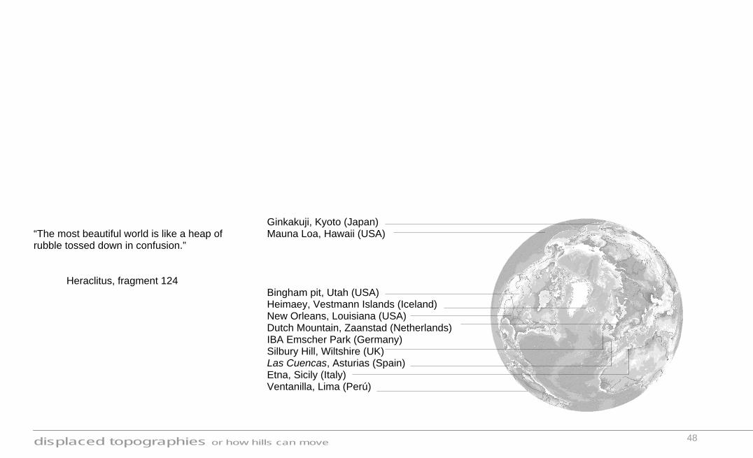
displaced topographies or how hills can move
48
“The most beautiful world is like a heap of rubble tossed down in confusion.” Heraclitus, fragment 124
Ginkakuji, Kyoto (Japan) Mauna Loa, Hawaii (USA) Bingham pit, Utah (USA) Heimaey, Vestmann Islands (Iceland) New Orleans, Louisiana (USA) Dutch Mountain, Zaanstad (Netherlands) IBA Emscher Park (Germany) Silbury Hill, Wiltshire (UK) Las Cuencas, Asturias (Spain) Etna, Sicily (Italy) Ventanilla, Lima (Perú)
displaced topographies or how hills can move
49
Notes 1. “…the classic intrusions of plainsmen’s housing into foot-hill ecology depend on a fundamentally different way of making the building surface flat –scraping away the mountain until you have enough horizontal surface, not to create merely a levelled terrace in front of a house but to create a street-sized terrace to carry a dozen or more houses, or a plateau big enough to carry a whole tract. But mountain cropping is not concerned with creating monuments of the earth-mover’s art; just using earth-moving techniques to create an environment where current tract-house building technology can operate by its normal flatland habits.” Reyner Banham, “Ecology II, Foothills” in Los Angeles, The Architecture of Four
Ecologies (London: The Penguin Press, 1971). 2. “This garden the Creator had Himself planted with every tree that is pleasant to the sight and good for food. Eden was no forest growing wild. A garden which man was to tend, to dress and keep, presupposes an ordered disposition of plants in beds and terraces.” Joseph Rykwert, On Adam’s House in Paradise, the idea of the primitive hut in architectural history (New York: The Museum of Modern Art Press, 1972). 3. “A landscape is a space deliberately created to speed up or slow down the process of nature. As Eliade expresses it, it represents man taking upon himself the role of time.” JB Jackson in James Corner, Recovering Landscape (New York: Princeton Architectural Press, 1999).
4. Letter to Madame de Sevigné, 1st October 1678, in Leonardo Benevolo, The capture of infinity (Madrid: Celeste Ediciones, 1994). 5. Kobo Abe, The Woman in the Dune (Madrid: Siruela Editores, 1989). 6. “Whenever the cultivation of wilderness comes up when I’m around, stories of religion and warfare start to migrate toward it… it’s because these are subjects embroiled in the human struggle with the wilderness: how to explain it and how to own it.” Paul Shepherd, The Cultivated Wilderness or, What is Landscape? (Cambridge, Mass.: MIT Press, 1997). It might be worth expressing here as well that ‘nature’ (wilderness) has long ago disappeared, at least in Europe. The mere act of building a viewing platform in

displaced topographies or how hills can move
50
front of the Matterhorn in the Swiss Alps turns it into a cultural spectacle. “Man has ‘urbanised’ the territory for centuries by means of agriculture, creating systems of irrigation and forming plantations according to geometrical laws. He has denatured natural spaces by means of the planting of natural elements. In mountainous terrain the slopes have been converted into finite elements through the building of terraces… The landscape is urbanised. The spectacle of nature and that of the city are now comparable”. Vicente Gaullart, “The City of a 1000 geographies” in Land Arch (Barcelona: Quaderns magazine, no 217, 1997). 7. “It should come as no surprise, then, that the current penetration of science by historical concerns has been the result of advances in these two disciplines. If one allows an intense flow of energy in and out of a system (that is, if one pushes it far from
equilibrium), the number and type of possible historical outcomes greatly increases. Instead of a unique and simple form of stability, we now have multiple coexisting forms of varying complexity (static, periodic, and chaotic attractors). Moreover, when a system switches from one stable state to another (at a critical point called a bifurcation), minor fluctuations may play a crucial role in deciding the outcome. Thus, when we study a given physical system, we need to know the specific nature of fluctuations that have been present at each of its bifurcations; in other words, we need to know its history to understand its current dynamic state.” Manuel de Landa, A thousand years of nonlinear history (New York: Swerve Editions, 2000). 8. “It could be that the cultural incapacity to judge nature as a product is reaching an end, in parallel with the progressive naturalization of the artificial. The opposition
between rational, artificial, linear geometry and picturesque reproduction of nature through less determined geometry that structures the history of landscape has also characterized the history of several disciplines, from philosophy to urbanism. The first attempts to manipulate and artificially organize the land arose either from the need to physically and culturally exploit the land or to appropriate it. Both the utilitarian patterns of farming, irrigation and land ownership, and the more cultural and symbolic patterns appearing in monuments and gardens bear extraordinary similarities across the globe.” “FOA code remix 2000” in 2G review (Barcelona: Editorial Gustavo Gili, 2000). 9. Contemporary Architecture, starting in the 1960s with the Brazilians Mendes da Rocha and Oscar Niemeyer and the French Claude Parent and Paul Virilio,

displaced topographies or how hills can move
51
has exploited the synthetic potential of topological conditions. “…Already during that time, I was exploring in a number of experimental designs the possibility of a topological or at least non-orthogonal architecture… The idea of using the earth’s gravity as a motor for movement inspired a very Galilean utilization of the inclined plane…” Paul Virilio, “Architecture Principe” in The Function of the Oblique, the Architecture of Claude Parent and Paul Virilio 1963-1969 (London: AA publications, 1997). 10. “The issue of a potential involvement of art into land reclamation can only be approached from a historical perspective, the conflicts and confusions associated to an unanimously wide range of topics related to the deterioration of the earth: technology, mining, politics and governmental legislation, ecological problems and public opinion...
But it would perhaps be a misguided assumption to suppose that artists hired to work in industrially blasted landscapes would necessarily and invariably choose to convert such sites into idyllic and reassuring places, thereby socially redeeming those who wasted the landscape in the first place. … Each open cast pit should have an artist in residence. Flattened mountains tops await an aesthetic touch. Acres of toxic residues demand a sculptural form that will redeem them. Deep industrial trenches are waiting to be refilled or excavated in a creative manner. There must be crowds out there, impatiently sitting on the cockpits of their Caterpillars D-8, waiting for a confident artist to come in and give orders: Ladies and gentlemen, start the engines and let us conclude definitely the 20th century.” Robert Morris, Earth-works: Land Reclamation as Sculpture symposium in
King County Arts Commission (Washington, 31st July 1979).
11. There is an Inca traditional form of community work called minga (in the indigenous quechua language) which still persists in large parts of Ecuador and Peru. 12. The Agora or Choros means dancing platform or deck, an epitome of Classical levelled urban social space. 13. Abe Kobo, op. cit. 14. Francis Alÿs, “A thousand words” in Artforum International (New York: Artforum magazine, no 10, summer 2002). 15. Leon Battista Alberti, “Book 3, Chapter 16” in On the Art of Building in Ten Books (Cambrige, Mass.: MIT Press, 1988).

displaced topographies or how hills can move
52
16. Albert Cowdrey, Land’s End (New Orleans: Louisiana State University Press, 1992). 17. Levees, from the French levée, meaning raised or elevated, are elongated earthen mounds forming the banks of a river. 18. John McPhee, “Atchafalaya” in The control of Nature (New York: The Noonday Press, 1989). 19. “The commission is distinctly committed to the idea of closing all outlets… It has consistently opposed the fallacy known as the Outlet System.” The Mississippi River Commission (1885) in John McPhee, op. cit. 20. In reference to the Mississippi River Commission engineers: “Four years at West Point, and plenty of books and schooling,
will learn a man a good deal, I reckon, but it won’t learn him the river… One who knows the Mississippi will promptly aver than ten thousand River Commissions, with the mines of the world at their back, cannot tame that lawless stream, cannot curb it or confine it, cannot say to it, Go here, or Go there, and make it obey; can not save a shore which it has sentenced; cannot bar its path with an obstruction which it will not tear down, dance over, and laugh at.” Mark Twain, Life on the Mississippi (London: Penguin Classics, 1991). 21. “To me the idea of putting explosives on the upper reaches of a volcano –of putting artificial things into a natural environment– is abhorrent.” Thomas L. Wright, Scientist-in-Charge at US Geological Survey Hawaiian Volcano Observatory in “Cooling the lava” in John McPhee, op. cit.
22. Lockwood, J.P., and Romano, Romolo, Diversion of lava during the 1983 eruption of Mount Etna (Earthquake Information Bulletin, 1985, v. 17, no. 4, p. 124–133). 23. Gudmundur Karlsson in John McPhee, op. cit. 24. John McPhee, op. cit. 25. HUNOSA, Northern Spain State Mining Company founded in 1967 as an umbrella subsidiary agency enveloping 18 small private mining companies that were nearing bankruptcy. It is now the largest mining company in Spain amounting 40% of the national mineral extraction. 26. Note that the term landscape is not equivalent to nature or wilderness. Here, landscape is conceived as a product of human intervention.
displaced topographies or how hills can move
53
27. “Were I to choose an auspicious image for the new millennium, I would choose that one (Cavalcanti described by Boccaccio in Decameron VI.9): the sudden agile leap of the poet-philosopher who raises himself above the weight of the world, showing that with all his gravity he has the secret of lightness, and that what many consider to be the vitality of the times –noisy, aggressive, revving and roaring– belongs to the realm of death, like a cemetery for rusty old cars.” Italo Calvino, “Lightness” in Six Memos for the New Millennium (London: Vintage Classics, 1996). 28. “Mass by itself, however, is not enough to characterize an architectural object; an emphasis on mass can also evoke, to the contrary, an unarchitectural object, a disorganization of the forces that contribute to its elevation, freeing it from the loss of gravity.”
Michael Heizer, “Interview, Julia Brown and Michael Heizer”, in Sculpture in Reverse, Julia Brown ed. (Los Angeles: The Museum of Contemporary Art, 1984). 29. GOAL 14: Return the land to a form and productivity that is beneficial to the community. Final Reclamation Policy 14.8 Final reclamation will commence no more than six months after the mining ceases and will be completed no more than two years after the mining ceases. Policy 14.9 The final reclamation of the mine site should return the land to a form and productivity that is in conformance with the established land use plan for the area and that will be toward a balanced ecological state that does not substantially contribute to environmental deterioration. To this end natural and replanted vegetation and natural and artificial topography should be used. Policy 14.10 The final reclamation effort should utilize existing topsoil and/or other topsoil materials consistent with the replanting program. Policy 14.11
The final reclamation effort should utilize indigenous and/or other types of vegetation consistent with the replanting program and any after-use plans. Policy 14.12 The abandoned mine site should be safe. To this end, some method of fencing, warning signs, barricades or other means should be used to warn and protect people from hazardous conditions. Policy 14.13 The operator will maintain the abandoned mine site until it has been stabilized and until replanted vegetation takes hold. After Use Policy 14.14 Any proposed after use of the mine site should be in conformance with the established future land use policy plan and should be beneficial and complementary to the surrounding neighbourhood. Jefferson County (Colorado, USA), Mineral Extraction Policy Plan, Section B: Goals and Policies (Golden, Colorado: 2000). 30. “You can imagine the result when they try to deal with the Bingham pit in Utah which is a pit one mile deep and

displaced topographies or how hills can move
54
three miles across… One person at Kennecott Mining Company told me that they were supposed to fill that pit in; now of course one would wonder where they were going to get the material to fill that pit in… they said it would take something like 30 years and they’d have to get the dirt from another mountain… It’s an attempt to recover a frontier or a wilderness that no longer exists. Here we have to accept the entropic situation and more or less learn how to reincorporate these things that seem ugly.” Robert Smithson, “Entropy made visible” (interview with Alison Sky, 1973) in Robert Smithson, The collected writings, Jack Flam ed. (Los Angeles: University of California Press, 1996). 31. The term “in-progress reclamation” exists in an ill-defined way in some mining reclamation policies but it simply refers to a
very ambiguous set of standards to be achieved during extraction (noise pollution, air contamination, visual impact, vegetation screens…). 32. “This is what the promoters of entropy bootlegging fail to understand. To be sure, one can cite numberless scrap campaigns aimed at saving low entropy (low entropy in his definition is raw materials before they are processed into refined materials. In other words raw ore would be low entropy and high entropy would be the refined material such as steel)… by sorting waste. …, to sort out the scrap molecules scattered all over the land and at the bottom of the sea, would require such a long time that the entire low entropy of our environment would not suffice to keep alive the numberless generations of Maxwell’s demons needed for the completed project.”
Nicholas Georgescu-Roegen, The Entropy Law and the Economic Process (Harvard, Mass.: Harvard University Press, 1971). 33. Robert Smithson, “Towards the Development of an Air Terminal Site, 1967” in Robert Smithson, The collected writings, Jak Flam ed. (Los Angeles: University of California Press, 1996). 34. Michael Heizer in Douglas C. McGill, Effigy Tumuli (New York: N. Abrahams Inc. Publishers, 1990). 35. From this point of view I find the topographical history of Lakeside Retail Park in Essex very revealing. The wilderness around Thurrock was tamed and transformed into primitive agricultural terraces during Norman times. In the 19th and 20th century the site was turned into a chalk quarry. When the bottom of the pit was deeper

displaced topographies or how hills can move
55
than the neighbouring river Thames it became too expensive to pump the water out and the company abandoned the site. A few decades later Lakeside Retail Park was founded. The entrepreneur conceived the flooded part of the quarry as a lake, hence the name. The flat platforms left behind by the extraction operations were used as car parks and sites for the different compounds of the retail park.

displaced topographies or how hills can move
56
Bibliography Kobo Abe, La Mujer de la Arena (The Woman in the Dune, Spanish version) (Madrid: Siruela Editores, 1989). Francis Alÿs, “A thousand words” in Artforum International (New York: Artforum magazine, no 10, summer 2002). Reyner Banham, Los Angeles, The Architecture of Four Ecologies (London: The Penguin Press, 1971). Breathing cities –the architecture of movement–, Nick Barley ed. (London: August/Birkhäuser Press, 2000). Leonardo Benevolo, The capture of infinity (Madrid: Celeste Ediciones, 1994).
Brenda J. Brown, “Reconstructing the Ruhrgebiet” in Landscape Architecture (London: Landscape Architecture magazine, no 66, April 2001). Sculpture in Reverse, Julia Brown ed. (Los Angeles: The Museum of Contemporary Art, 1984). Italo Calvino, The Invisible Cities (London: Vintage Classics, 1996). Italo Calvino, Six Memos for the New Millennium (London: Vintage Classics, 1996). Rory Carroll, Sicilian emergency as Etna erupts, July 21, 2001, The Guardian newspapers. Keneth Clark, El Arte del Paisaje (Landscape into Art, Spanish version) (Barcelona: Museo Seix Barral, 1971).
James Corner, Recovering Landscape (New York: Princeton Architectural Press, 1999). Albert Cowdrey, Land’s End (New Orleans: Louisiana State University Press, 1992). Desvigne + Dalnoky (New York: Whitney library of design, Watson-Guptill Publications, 1997). Robert Smithson, The collected writings, Jak Flam ed. (Los Angeles: University of California Press, 1996). José Angel Fernández Valcarce, Depuracion de vertidos a cauces públicos de los lavaderos de carbón de HUNOSA (Oviedo, Spain: HUNOSA, 1992).

displaced topographies or how hills can move
57
Foreign Office Architects (Barcelona: 2G International Architecture Review, Editorial Gustavo Gili, issue 16, 2000). Nicholas Georgescu-Roegen, The Entropy Law and the Economic Process (Harvard, Mass.: Harvard University Press, 1971). Vicente Guallart, “The City of a 1000 geographies” in Land Arch (Barcelona: Quaderns magazine, no. 217, 1997). Francisco Guitián Ojea, Recuperación de las Escombreras de la Mina de Lignitos de Meirama (A Coruña) (Santiago de Compostela: Universidade de Santiago de Compostela, 1995). The Artificial Landscape, Contemporary Architecture, Urbanism and Landscape Architecture in the Netherlands, Hans Ibelings ed. (Rotterdam: Nai publishers, 2000).
Jefferson County (Colorado, USA), Mineral Extraction Policy Plan, Section B: Goals and Policies (Golden, Colorado: 2000). Manuel de Landa, A thousand years of nonlinear history (New York: Swerve Editions, 2000). Lockwood, J.P., and Romano, Romolo, Diversion of lava during the 1983 eruption of Mount Etna (Earthquake Information Bulletin, 1985, v. 17, no. 4, p. 124–133). Anuradha Mathur and Dilip da Cunha, Mississippi Floods, designing a shifting landscape (New Haven: Yale University Press, 2001). Douglas C. McGill, Effigy Tumuli (New York: N. Abrahams Inc. Publishers, 1990). Fiorenzo Marino, Terra incognita (Cosenza, Italy: Elga Editrice, 1999).
Ian L. McHarg, Design with Nature (New York: Doubleday and Natural History Press, 1971). John McPhee, The Control of Nature (New York: The Noonday Press, 1989). Robert Morris, “Notes on Art as/and land rReclamation” in The writings of Robert Morris (Cambridge, Mass.: The MIT Press, 1993). The function of the oblique, the Architecture of Claude Parent and Paul Virilio, 1963-69 (London: AA Publications, 1997). Albert Pole, Ladders (New York: Princeton Architectural Press, 1996). Key Portilla-Kawamura, Weighing Anchor, (4th year essay, Water landscape seminar, tutor: Sandra Morris, Architectual Association, London, 2002).
displaced topographies or how hills can move
58
Key Portilla-Kawamura, The Ark and the Wall, building (on) wetlands (BSc in Architecture, final dissertation, tutor: James Heesom, University of East London, 1999-2000). Joseph Rykwert, Adam´s House in Paradise (the idea of the primitive hut in architectural history) (New York: The Museum of Modern Art Press, 1972). Dominik Schleipen, “IBA Emscher Park” in The Scales of Sustainability (Barcelona: Quaderns Magazine, no 225, 2000). Several authors, Wasteland, Landscape from now on (Rotterdam: 010 Press, 2000). Several authors, Used land (Barcelona: Quaderns magazine, no. 233, 2001).
Several authors, Naturalezas (una travesía por el arte contemporáneo) (Barcelona: MACBA, 2000). Paul Shepheard, The cultivated wilderness, or what is landscape? (Cambridge, Mass.: The MIT Press, 1997). Yorgos Simeoforidis, “New Topos” in Operative Topographies (Barcelona: Quaderns, no. 220, 1997). Robert Smithson, Slideworks (Milano: Carlo Fura Press, 1997). Gilles A. Tiberghien, Land Art (Paris: Editions Carré, 1995). Mark Twain, Life on the Mississippi (London: Penguin Classics, 1991). University of Oviedo (Faculty of Biology), Selección de hongos micorrícicos para su
empleo en revegetación de zonas degradadas por la actividad minera (Oviedo, Spain: 2nd Regional Research plan, 2000). Udo Weilacher, Between Landscape Architecture and Land Art (Berlin: Birkhauser Press, 1996). Richard S. Williams Jr. and James G. Moore, Man against Volcano: the eruption on Heimaey, Vestmann islands, Iceland (Washington DC, US Geological Survey, 1983). Tom Wright and Katsuhiko Mizuno, Zen Gardens (Kyoto´s nature enclosed) (Kyoto: Suiko Books, 1990).

displaced topographies or how hills can move
59
-Archives, filmography and interviews. Archivo Histórico de Hunosa “Pozu Fondón” (Historical Archive of Northern Spain State Mining Company), Sama de Langreo, Spain. Flashing into the Shadows: The Artist’s Film in America 1966-76, film series curated by Chrissie Iles + Eric de Bruyn (London: Tate Modern, November 2002). Interview with Cuauhtémoc Medina, curator of Lima Biennale 2002 (Madrid: 17th February 2003).

displaced topographies or how hills can move
60
List of illustrations Page 4 Groundbreaking ritual at Piedramuelle. Page 6 Groundwork operations at the British end of the Channel Tunnel. Agricultural terraces in the Andes. Page 7 Robert Smithson, Partially Buried Woodshed, Kent State University, Ohio, 1968. Robert Smithson, Asphalt Rundown, Rome, 1969. Page 9 Illustration from 18th c. manual for construction of levees. Page 10 Oriental woodcut print of mountainscape.
Pages 12-14 Francis Alÿs, When faith moves mountains, Lima, 2002. Page 15 Silbury Hill at present. Original stepped Silbury Hill. Page 16 Kogetsudai mound at Kinkakuji, Kyoto. Page 17 William Stuckley illustration of the Avebury Complex, 18th c. Page 18 Kogetsudai mound and Ginshadan bed at Kinkakuji, Kyoto, 16th c. Hiroshige, The Red Fuji, ukiyoe woodcut print, 19th c. Page 20 Lava front near Sapienza, Sicily. Page 22
Map of Southern Louisiana. Choctaw burial mounds during a Mississippi flood. Page 23 Land, levee, river. 19th c. levee construction. Page 24 Crevasse (levee split). Repairs of crevasse after the flood. Page 25 Huge willow mattress for protection of river banks. 20th c. mechanised levee construction. Concrete block mats for the protection of river banks. Page 26 Illustrations of revetments on river banks. Page 27 Guide levee in Atchafalaya Basin.

displaced topographies or how hills can move
61
Page 29 Illustration showing in pink the extent of the town, in red the extent of the cooled lava and in grey the 2 new sq kilometres of Heimaey island after the eruption of 1973. View of Heimaey at the height of the cooling operations. Pages 31 Map showing the Etna lava flow path and the location of the three barriers, 1982. Etna Lava flow control barrier, Sicily. Page 32 Lava flow control barrier, Sicily. Page 33 Landfill site, Quito, Ecuador. Page 35 Top 2 images, driving along the cuencas, conspicuous slag heaps can be found. Bottom image, atop Reicastro slag heap in Ujo.
Page 36 Aerial photo and plan of Reicastro slag heap next to Ujo. Page 37 Richard Serra, Bramme, Essen, 1998. Plan of Bramme site. Page 38 Sections of Reicastro slag heap. Archivo Historico de la Mineria, 1950’s. Page 39 Aerial image of Turon valley showing an urbanised slag heap. Slag heap on sloping terrain near Mieres. Page 40 Discarded slag from strip mining. Page 42 S333, Dutch Mountain project, Zaanstad (Netherands).
Page 43 Sketches of open cast mining operations in Meirama (Coruña, Spain) and after use image. Page 44 Robert Morris, Untitled (Johnson Pit, no 30, King County open cast mine restoration project, Washington), 1979. Page 45 Map of River Doce (Brasil). CVDC infrastructures (Companhia Vale do Rio Doce), Minas Gerais (Brasil). Page 46 Crane bulldozer at Meirama (Coruña, Spain).
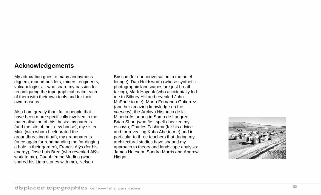
displaced topographies or how hills can move
62
Acknowledgements My admiration goes to many anonymous diggers, mound builders, miners, engineers, vulcanologists… who share my passion for reconfiguring the topographical realm each of them with their own tools and for their own reasons. Also I am greatly thankful to people that have been more specifically involved in the materialisation of this thesis: my parents (and the site of their new house), my sister Maki (with whom I celebrated the groundbreaking ritual), my grandparents (once again for reprimanding me for digging a hole in their garden), Francis Alÿs (for his energy), Jose Luis Brea (who revealed Alÿs’ work to me), Cuauhtémoc Medina (who shared his Lima stories with me), Nelson
Brissac (for our conversation in the hotel lounge), Dan Holdsworth (whose synthetic photographic landscapes are just breath-taking), Mark Hayduk (who accidentally led me to Silbury Hill and revealed John McPhee to me), María Fernanda Gutierrez (and her amazing knowledge on the cuencas), the Archivo Historico de la Mineria Asturiana in Sama de Langreo, Brian Short (who first spell-checked my essays), Charles Tashima (for his advice and for revealing Kobo Abe to me) and in particular to three teachers that during my architectural studies have shaped my approach to theory and landscape analysis: James Heesom, Sandra Morris and Andrew Higgot.

displaced topographies or how hills can move
63