Discovery Report - commerce.alaska.gov
21
Discovery Report FEMA Region X Ketchikan Gateway Borough, Alaska *(Watershed Name, HUC-8 Code): Bradfield Canal, HUC 19010104; Burroughs Bay, HUC 19010105; Headwaters Portland Canal, HUC 19010106; Icy Strait-Chatham Strait, HUC 19010500; Ketchikan, HUC 19010102; Lower Iskut, HUC 19010205 and Outlet Portland Canal, HUC 19010107 Prepared by
Transcript of Discovery Report - commerce.alaska.gov

Discovery Report FEMA Region X
Ketchikan Gateway Borough, Alaska *(Watershed Name, HUC-8 Code): Bradfield Canal, HUC 19010104; Burroughs Bay, HUC 19010105; Headwaters Portland Canal, HUC 19010106; Icy Strait-Chatham Strait, HUC 19010500; Ketchikan, HUC 19010102; Lower Iskut, HUC 19010205 and Outlet Portland Canal, HUC 19010107
Prepared by

KETCHIKAN GATEWAY BOROUGH DISCOVERY REPORT – MARCH 2014 2
TABLE OF CONTENTS
I. Discovery and Risk Map 3
II. Borough Description 3-4
III. Project Description and Methodology 5-9
IV. Risk MAP Needs 10
i. Current Studies and Plans 10-11
ii. Hazard Events 11-15
iii. Mitigation Projects and Other Relevant Data 15-17
V. Compliance 17-18
VI. Communications 19
VII. Close 19-20
VIII. Appendix – Discovery Files 20-21
TABLES 1. Community Participation List 4 2. Data Sources for Region X Discovery 5 3. Hazard Mitigation Plans Obtained in Ketchikan Gateway Borough 10 4. Effective FIRM dates for communities in Ketchikan Gateway Borough 10 5. Ketchikan Gateway Borough Wildfire Risk 11 6. Ketchikan Gateway Borough Earthquake Risk 11-12 7. Ketchikan Gateway Borough Landslide Risk 12-13 8. Ketchikan Gateway Borough Flood Risk 13 9. Ketchikan Gateway Borough Tsunami Risk 14 10. Ketchikan Gateway Borough Severe Storm Risk 15 11. Listing of Various Mitigation Projects in Ketchikan Gateway Borough 15-16 12. Complete List of Identified Areas of Concern 16 13. Scoped LiDAR and Aerial Imagery data 17 14. Flood Studies or Mapping Funded in FY13 19 15. Non-Regulatory Products Funded in FY13 20 16. Outreach Meetings Funded in FY13 20
FIGURES 1. Reference Map 4 2. Example of Community Fact Sheet 6 3. Example of Reference Map Used at the Discovery In-Person Meetings 8 4. Image of Ketchikan Gateway Borough Final Discovery Map 9 5. Earthquake Data 12 6. Floodplain Data for Ketchikan Gateway Borough 14 7. Location of LiDAR data in Ketchikan Gateway Borough 17

KETCHIKAN GATEWAY BOROUGH DISCOVERY REPORT – MARCH 2014 3
I. Discovery and Risk Map The FEMA Risk Mapping, Assessment, and Planning, or Risk MAP program helps communities identify, assess, and reduce natural hazard risks. Through Risk MAP, FEMA provides information to enhance local mitigation plans, improve community outreach, and increase local resilience to hazards.
During Discovery, FEMA
gathers information about local hazards and hazard risks;
reviews mitigation plans to understand local mitigation capabilities, hazard risk assessments, and current or futures mitigation activities;
supports communities within the watershed or Borough to develop a vision for its future;
collects information from communities about their hazard history, development plans, daily operations, and hazard management activities; and
uses all information gathered to determine which areas of the watershed require mapping, risk assessment, or mitigation planning assistance through a Risk MAP project.
II. Borough Description
Ketchikan Gateway Borough Ketchikan Gateway Borough is a 2nd Class Borough, incorporated in 1963. Within the Borough are two jurisdictions: Ketchikan and Saxman. The City of Ketchikan is a Home Rule City incorporated in 1900. The City of Saxman is a 2nd Class City incorporated in 1929. The Greater Ketchikan Area, which includes the Borough, and within it, the cities, is located near the southernmost boundary of Alaska, in the Southeast Panhandle. It lies at approximately 55.333330° north latitude and -131.63330° west longitude. The borough encompasses 6,900 square miles of land and 520.8 square miles of water. The area is located in the Ketchikan Recording District. The Borough consists of Revillagigedo Island, Gravina and Pennock Islands, along with numerous smaller islands. Much of Ketchikan Gateway Borough’s interior is home to the Tongass National Forest. It is bordered by Prince of Wales Island on the west, Annette Island to the south, and shares a border with British Columbia, Canada to the east. As of 2010, the borough had a population of 13,477 people. Approximately one half of Ketchikan Gateway Borough’s residents live in Ketchikan, the borough’s most populous city and the borough seat, or areas along the coast. The most prominent industries in the borough are educational services, health care, and social assistance. Approximately nineteen percent of the total work labor force in Ketchikan Gateway Borough works in these industries. The only jurisdiction in Ketchikan Gateway Borough to participate in the National Flood Insurance Program (NFIP) is the borough itself. The participating jurisdiction has regular participation status in the NFIP. The City of Ketchikan and the City of Saxman are currently participating in the NFIP under the jurisdiction of Ketchikan Gateway Borough.

KETCHIKAN GATEWAY BOROUGH DISCOVERY REPORT – MARCH 2014 4
Table 1. Community Participation List
Community (CID, where
available) Borough Watershed
NFIP Status
CRS Class
Discovery Process Participation
Ketchikan Gateway Borough (020003)
Ketchikan Gateway
Bradfield Canal, Burroughs Bay, Headwaters Portland Canal, Icy Strait-Chatham Strait, Ketchikan, Lower Iskut and Outlet Portland Canal
Participating 9 Participating
Ketchikan, City of (No CID)
Ketchikan Gateway
Ketchikan
Participating (under Ketchikan Gateway Borough)
n/a Participating
Saxman, City of (No CID)
Ketchikan Gateway
Ketchikan
Participating (under Ketchikan Gateway Borough)
n/a Not Participating
Figure 1. Reference Map (Full Size in Appendix D)

KETCHIKAN GATEWAY BOROUGH DISCOVERY REPORT – MARCH 2014 5
III. Project Description and Methodology Discovery is the process of data collection, including information exchange between all governmental levels of stakeholders, spatial data presentation, and cooperative discussion with stakeholders to better understand the area, decide whether a flood risk project is appropriate, and if so, to collaborate on the project planning in detail. The Discovery process and requirements are defined in Appendix I – Discovery (June 2012), and Operating Guidance No. 04-11, Risk MAP Meetings Guidance (July 2011). Region X initiated this Discovery effort in the summer of 2013, with data collection, community interviews, a meeting with stakeholders in the watershed, and development of recommendations based on an analysis of data and information gathered throughout the process. Collected data sources are shown in Table 2. Table 2. Data Sources for Region X Discovery (project-specific data sources in Appendix D)
Alaska Earthquake Information
Center
Alaska Department of Natural Resources
Alaska Interagency Coordination
Center
Alaska State Geo-Spatial Data Clearinghouse
ESRI
Federal Emergency Management
Agency (FEMA)
FEMA - Community Information
System
FEMA - Community Needs Management Strategy (CNMS)
FEMA Regional Office
Ketchikan Gateway Borough GIS
Department
Strategic Alliance for Risk Reduction (STARR)
United States Geologic Survey
The Region X Discovery data collection entailed a massive collection of tabular and spatial data for all communities from Federal and State sources, as well as information collected through interviews with each community. Data was used primarily in two ways – tabular data was documented on a Community Fact Sheet, and spatial data was included in the Discovery Geodatabase, and is displayed on the Discovery maps, where appropriate. Full-sized Discovery maps are included in the Appendix C and D. The second phase of the Region X Discovery effort involved a review of the collected data with community officials through a phone interview, and a request for additional information. Prior to the interview, community officials received information about the Discovery process. The phone interview included a webinar during which a map of the community was shared “on-screen” with participants. Communities were asked to identify “Areas of Concern” (AOC) based on their local knowledge and analysis of the data shown on the map. The webinar included functionality that allowed participants to draw graphics and/or text on-screen to share the AOCs specific geographic location and any related details. The Areas and Points of Concern (mapping needs, desired mitigation projects, etc.) were documented in the Discovery Geodatabase. Discussing the

KETCHIKAN GATEWAY BOROUGH DISCOVERY REPORT – MARCH 2014 6
AOCs during the phone interview allowed the Discovery team to narrow the focus of the upcoming in-person field visit and Discovery meeting to just those areas of local interest and/or concern, as explained in the third phase. Figure 2. Example of a Community Fact Sheet (All Community Factsheets are located in Appendix B)
KETCHIKAN GATEWAY BOROUGH DISCOVERY REPORT – MARCH 2014 7
The third phase in the Discovery effort was to hold a community-specific Discovery Meeting to facilitate discussion and analysis of study needs, mitigation project needs, desired compliance and training support, and local flood risk awareness efforts. During the Discovery Meeting, FEMA, the State of Alaska, and STARR, FEMA’s contractor, collaborated with each of the communities that are participating in this effort. The purpose of the meeting was to meet the community officials involved in the Discovery effort, continue the discussions that were started during the community interview, and collect additional community data that could aid in the Discovery effort. Conducting the local Discovery meeting added an opportunity for additional stakeholders to participate in the Discovery process that may not have been available for the initial phone interview. The local Discovery meeting allowed for the Discovery team to confirm or build upon the information recorded during the phone interview. In conjunction with the community-specific Discovery meeting, a local field tour was conducted during which a local official took FEMA, the State of Alaska, and STARR to visit some areas of concern mentioned during the Discovery phone interview. Physically visiting the sites allowed the Discovery team to collect additional notes and/or pictures regarding the communities’ concerns and gain a geographic understanding and deeper appreciation of these areas of concern.
KETCHIKAN GATEWAY BOROUGH DISCOVERY REPORT – MARCH 2014 8
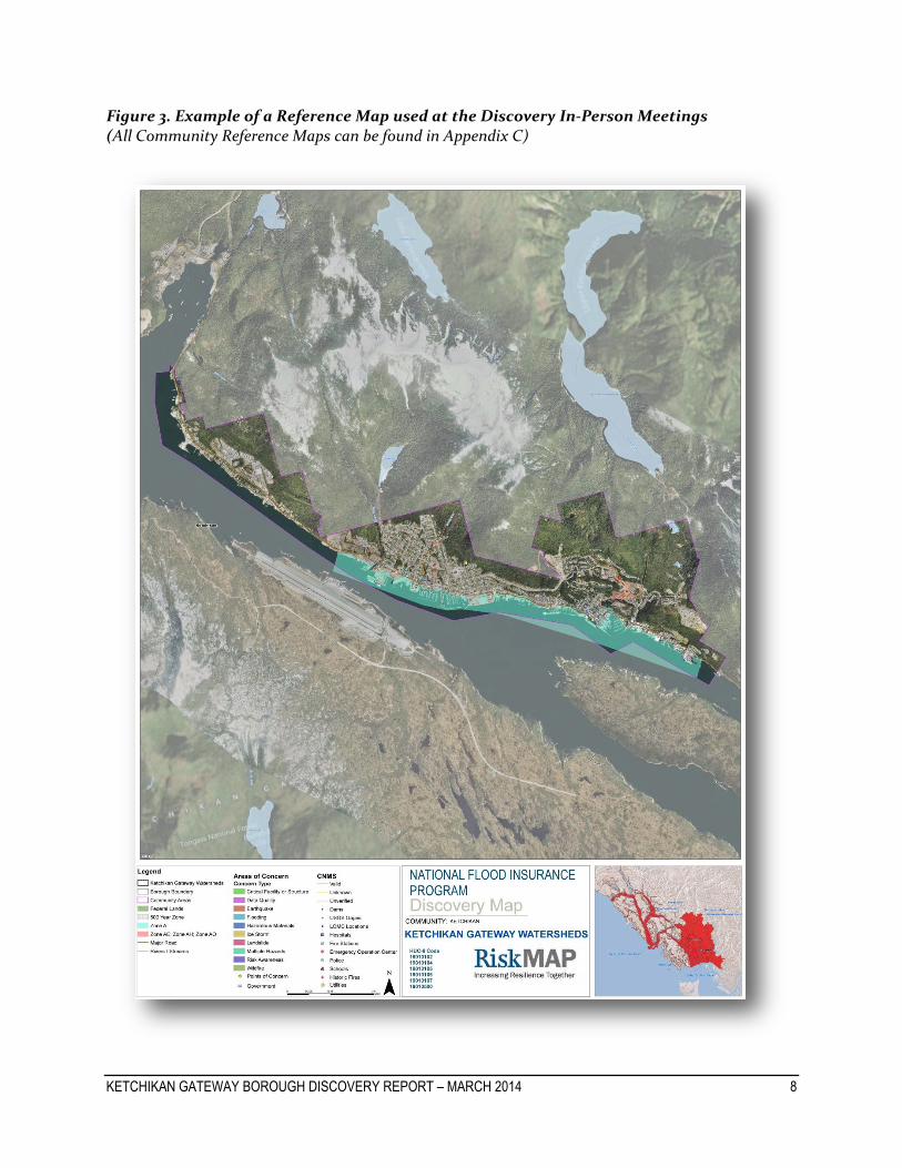
Figure 3. Example of a Reference Map used at the Discovery In-Person Meetings (All Community Reference Maps can be found in Appendix C)

KETCHIKAN GATEWAY BOROUGH DISCOVERY REPORT – MARCH 2014 9
The fourth phase of the Discovery effort involves an analysis of the data and information collected during the interview and subsequent community visit and also may include recommendations as to the future relationship and activities between FEMA and the communities. The Final Discovery Map indicates desired study areas and mitigation project locations, and the Discovery Report documents the results of data collection process. Discovery will be concluded with the finalization of a project scope and signed Partnership Agreement, which indicate that all affected stakeholders understand the terms of a funded project, including communication and data responsibilities. Figure 4. Image of Ketchikan Gateway Borough Final Discovery Map (Final Discovery Map is also located in Appendix D)

KETCHIKAN GATEWAY BOROUGH DISCOVERY REPORT –MARCH 2014 10
IV. Risk MAP Needs The results of the data collection and interviews were thoroughly discussed at the Discovery Meetings. The following sections include issues and conditions that exist in Ketchikan Gateway Borough that can be considered Risk MAP needs, and could be addressed with future Risk MAP projects. Details and background on all issues can be found in the interview notes, meeting notes, Hazard Mitigation Plans (HMPs), and other files included in Appendix B and C.
i. Current Studies and Plans
Hazard Mitigation The Disaster Mitigation Act of 2000 (P.L. 106-300; 42 USC 5131 ff.) and the Federal Emergency Management Agency’s subsequent Interim Final Rule, 44 CFR Part 201, requires all states and communities to develop natural hazard mitigation plans in order to be eligible for federal Pre-Disaster Mitigation Grant funds and/or post-disaster Hazard Mitigation Grant Program funds. Hazard mitigation plans obtained through Discovery are identified in the table below: Table 3. Hazard Mitigation Plans Obtained in Ketchikan Gateway Borough
Community Borough Plan Name Date Adopted Notes
Ketchikan Gateway Borough
Ketchikan Gateway
Greater Ketchikan Area Multi-Jurisdictional Hazard Mitigation Plan
9/20/2009 Expires five (5) years after the adoption date – 9/20/2014.
Floodplain Studies The current status for effective flood maps within the City and Borough of Ketchikan can be found in the table below. Table 4. Effective FIRM dates for communities in Ketchikan Gateway Borough
Community (CID)
Effective FIRM
Study Type
Ketchikan Gateway Borough
(020003)
04/16/1990
Riverine Study
Ketchikan, City of
(No CID) 04/16/1990
Riverine Study
Saxman, City of
(No CID) No Data
No Data
Effective FIRMs and FIS within Ketchikan Gateway Borough are over twenty-three years old. Ketchikan Gateway Borough’s study went effective on April 16, 1990. FEMA’s Coordinated Needs Management Strategy (CNMS) database was created in 2011 for Region X to coordinate the management of future floodplain mapping needs. This database tracks and identifies the status and needs of existing floodplain studies based on change

KETCHIKAN GATEWAY BOROUGH DISCOVERY REPORT – MARCH 2014 11
indicators that may have occurred since the date of the analysis to help prioritize future floodplain study needs. Currently, validations for streams in the Ketchikan Gateway Borough are “unknown”. CNMS data can be viewed on the FINAL Discovery Maps. The “unknown” streams were prioritized for re-study in the new Risk MAP project. After the FY13 Risk MAP project is completed, the CNMS database will be updated to reflect the new flood study categorizations as valid.
ii. Hazard Events
Wildfires Wildfire risk within the communities is very rare and considered fairly minor.
Table 5. Ketchikan Gateway Borough Wildfire Risk
Community Borough Notes
Ketchikan Gateway Borough
Ketchikan Gateway • N/A
Ketchikan, City of
Ketchikan Gateway • N/A
Saxman, City of
Ketchikan Gateway • N/A
Earthquakes The Ketchikan Gateway Borough has experienced historic earthquakes and has several known fault lines. Information on fault lines, earthquake events, and specific details on earthquake awareness was collected from the community and is shown in the table below. A much larger area of earthquake risk is created by the Queen Charlotte Triple Junction which is formed by the Cascadia Subduction Zone, the Explorer Ridge and the Queen Charlotte Fault. The Queen Charlotte-Fairweather Fault presents the greatest earthquake hazard to residents of southeast Alaska.
Table 6. Ketchikan Gateway Borough Earthquake Risk
Community Borough Notes
Ketchikan Gateway Borough
Ketchikan Gateway
• Seismic design category ‘B’. • No epicenters. • Queen Charlotte Fault – off of Prince of Wales Island. • Last two earthquakes around 7.7 along Queen Charlotte Fault line.
• Lots of shaking, dams and bridges needed inspection but no damage occurred.
Ketchikan, City of
Ketchikan Gateway
• Same as the Borough

KETCHIKAN GATEWAY BOROUGH DISCOVERY REPORT – MARCH 2014 12
Community Borough Notes
Saxman, City of Ketchikan Gateway
• N/A
Figure 5. Earthquake Data
Landslides Landslides can include a wide range of ground movements and can occur in many parts of the Ketchikan Gateway Borough. The communities expressed concern about the potential damage that landslides could have on residential communities and roads. The table below summarizes the specific incident that the communities experienced and the locations of where landslides have occurred. Table 7. Ketchikan Gateway Borough Landslide Risk
Community Borough Notes
Ketchikan Gateway Borough
Ketchikan Gateway
• Recent rockslide destroyed part of North Tongass Highway
Ketchikan, City of
Ketchikan Gateway
• Same as the Borough

KETCHIKAN GATEWAY BOROUGH DISCOVERY REPORT – MARCH 2014 13
Community Borough Notes
Saxman, City of Ketchikan Gateway
• N/A
Flooding Several issues were addressed that concerned flooding. They included inaccuracies of floodplain representation on effective FIRMs and areas where flooding could damage public and private property. Table 8 identifies flooding concerns as they pertain to each individual community. There have been a total of two (2) flood insurance claims made in Ketchikan Gateway Borough since 1978. A total of zero (0) repetitive losses have been identified in Ketchikan Gateway Borough. A total of seven (7) Letters of Map Change (LOMC) issued across the Borough with the majority near the coastline and along Hoadley Creek. Locations of LOMCs in each county can be found on the Final Discovery Maps. Table 8. Ketchikan Gateway Borough Flood Risk
Community Borough Notes
Ketchikan Gateway Borough
Ketchikan Gateway
• Hoadley Creek floodplain limit does not extend far enough upstream into development.
• Ketchikan Creek floodplain boundaries and limits need to be updated.
• Schoenbar Creek needs revisions – more development along this reach and floodplain could be too wide for the size of the creek.
• Harbor construction has taken place but the effective maps show original floodplain boundary line and do not reflect changes.
• North of Ketchikan – Whipple Creek area has had a study done but is not shown on the FIRM.
Ketchikan, City of
Ketchikan Gateway
• Additions made to the hospital included some work on the outskirts of the Hoadley Creek floodplain, culvert installed in ’94 but FIRM was not updated and floodplain does not reflect this change.
• Upper portion of Hoadley Creek drainage area has increased development.
• Schoenbar Creek has had increased development along reach.
Saxman, City of Ketchikan Gateway
• N/A

KETCHIKAN GATEWAY BOROUGH DISCOVERY REPORT – MARCH 2014 14
Figure 6. Floodplain Data for Ketchikan Gateway Borough
Tsunami Tsunamis in the Southeast Alaska region typically occur when a large volume of a body of water, such as the ocean, is displaced due to earthquakes, volcanic eruptions or landslides. Ketchikan Gateway Borough (KGB) has experienced a number of tsunamis in the past. Most recently, KGB experienced a tsunami in 2012 resulting in little to minor damage. The table below summarizes the specific incident that the communities experienced and the locations of where landslides have occurred. Table 9. Ketchikan Gateway Borough Tsunami Risk
Community Borough Notes
Ketchikan Gateway Borough
Ketchikan Gateway
• Minor tsunami (2 inch) • Event occurred in January of 2013
Ketchikan, City of
Ketchikan Gateway
• Heavy tides and currents in the harbors • Event occurred in January of 2013
Saxman, City of
Ketchikan Gateway
• N/A

KETCHIKAN GATEWAY BOROUGH DISCOVERY REPORT – MARCH 2014 15
Severe Storms This type of hazard can occur during any part of the year given the right weather pattern. A severe storm can result from severe wind or severe winter conditions. The community has experienced damage from these types of events and they continue to work towards mitigating the loss of life and property by communicating to the residents when impending severe weather is imminent. Table 10 identifies severe storm concerns as they pertain to these communities. Table 10. Ketchikan Gateway Borough Severe Storm Risk
Community Borough Notes
Ketchikan Gateway Borough
Ketchikan Gateway
• Roofs torn off • Siding damaged • Trees blown down
Ketchikan, City of
Ketchikan Gateway
• Established 120mph winds in exposed properties along narrows. • 110mph winds in protected areas. • Power outages • Mobile homes need to be evacuated • Heavy rains create rock slides
Saxman, City of
Ketchikan Gateway
• N/A
iii. Mitigation Projects and Other Relevant Data
Mitigation Projects There were several potential, desired, and in progress mitigation projects that were identified throughout the Discovery process. Most of these projects were identified through researching Hazard Mitigation Plans or speaking to community officials. Several of these projects are identified in Table 11 below. More information of mitigation projects can be found in Appendix B of this report. Table 11. Listing of Various Mitigation Projects in Ketchikan Gateway Borough
Ketchikan Gateway Borough Flood/Erosion (FLD)
FLD-1. Identify drainage patterns and develop a comprehensive drainage system FLD-2. Structure elevation and/or relocation FLD-3. Updated FIRM Greater Ketchikan Area (GKA) Maps FLD-4. Public education FLD-5. Pursue obtaining a lower CRS rating to lower flood insurance rates FLD-6. Continue to obtain flood insurance for all Borough structures, and continue compliance with NFIP FLD-7. Require that all new structures be constructed according to NFIP requirements and set back from the shoreline to lessen future erosion concerns and costs
Earthquake (E) E-1. Identify buildings and facilities that must be able to remain operable during and following an earthquake event E-2. Contract a structural engineer firm to assess the identified buildings and facilities
KETCHIKAN GATEWAY BOROUGH DISCOVERY REPORT – MARCH 2014 16
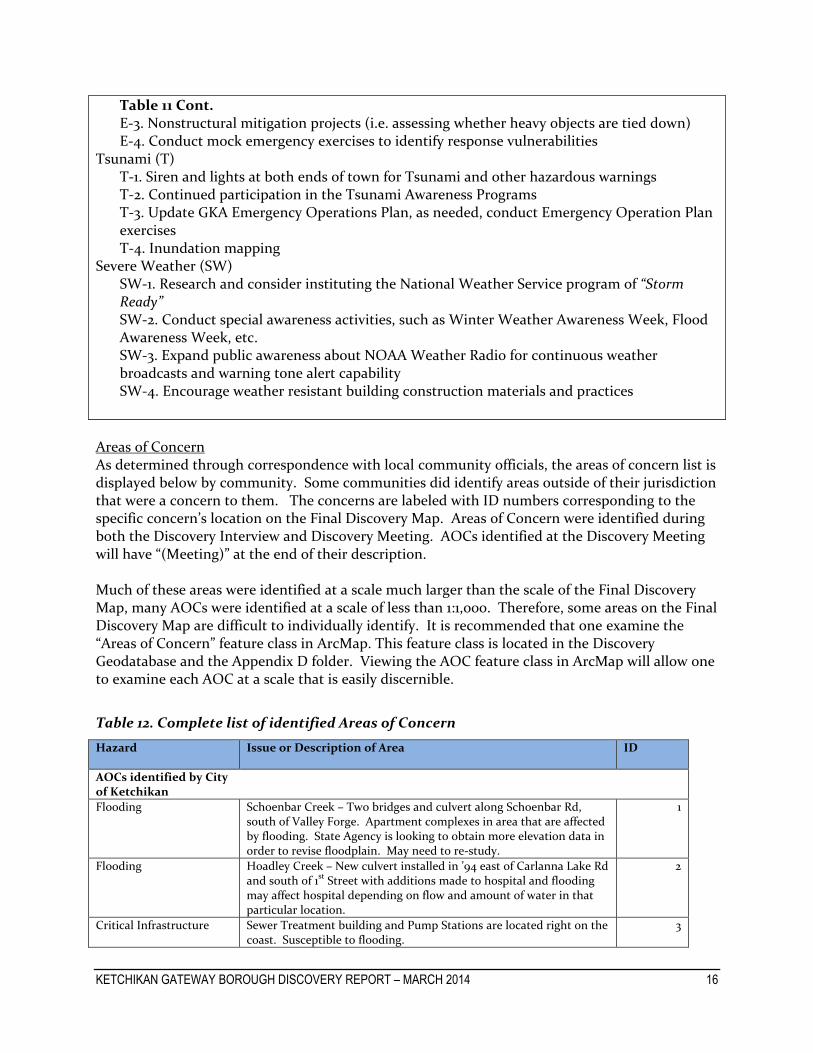
Table 11 Cont. E-3. Nonstructural mitigation projects (i.e. assessing whether heavy objects are tied down) E-4. Conduct mock emergency exercises to identify response vulnerabilities
Tsunami (T) T-1. Siren and lights at both ends of town for Tsunami and other hazardous warnings T-2. Continued participation in the Tsunami Awareness Programs T-3. Update GKA Emergency Operations Plan, as needed, conduct Emergency Operation Plan exercises T-4. Inundation mapping
Severe Weather (SW) SW-1. Research and consider instituting the National Weather Service program of “Storm Ready” SW-2. Conduct special awareness activities, such as Winter Weather Awareness Week, Flood Awareness Week, etc. SW-3. Expand public awareness about NOAA Weather Radio for continuous weather broadcasts and warning tone alert capability SW-4. Encourage weather resistant building construction materials and practices
Areas of Concern As determined through correspondence with local community officials, the areas of concern list is displayed below by community. Some communities did identify areas outside of their jurisdiction that were a concern to them. The concerns are labeled with ID numbers corresponding to the specific concern’s location on the Final Discovery Map. Areas of Concern were identified during both the Discovery Interview and Discovery Meeting. AOCs identified at the Discovery Meeting will have “(Meeting)” at the end of their description. Much of these areas were identified at a scale much larger than the scale of the Final Discovery Map, many AOCs were identified at a scale of less than 1:1,000. Therefore, some areas on the Final Discovery Map are difficult to individually identify. It is recommended that one examine the “Areas of Concern” feature class in ArcMap. This feature class is located in the Discovery Geodatabase and the Appendix D folder. Viewing the AOC feature class in ArcMap will allow one to examine each AOC at a scale that is easily discernible.
Table 12. Complete list of identified Areas of Concern
Hazard Issue or Description of Area ID
AOCs identified by City of Ketchikan
Flooding Schoenbar Creek – Two bridges and culvert along Schoenbar Rd, south of Valley Forge. Apartment complexes in area that are affected by flooding. State Agency is looking to obtain more elevation data in order to revise floodplain. May need to re-study.
1
Flooding Hoadley Creek – New culvert installed in ’94 east of Carlanna Lake Rd and south of 1st Street with additions made to hospital and flooding may affect hospital depending on flow and amount of water in that particular location.
2
Critical Infrastructure Sewer Treatment building and Pump Stations are located right on the coast. Susceptible to flooding.
3

KETCHIKAN GATEWAY BOROUGH DISCOVERY REPORT – MARCH 2014 17
LiDAR Data It was determined during Discovery that Ketchikan Gateway Borough needed updated, detailed elevation and aerial imagery data, and that local officials would be interested in FEMA funding the collection of local Light Detection and Ranging System (LiDAR) and orthophotography data. LiDAR and Imagery data is being acquired for much of the Discovery project area through a partnership between FEMA and the Oregon Department of Geology and Mineral Industries (DOGAMI). DOGAMI specializes in supervising and coordinating the collection of large swaths of high resolution, high accuracy LiDAR data in the Pacific Northwest since 2006. LiDAR data is very useful in producing accurate, high-quality regulatory and non-regulatory NFIP projects. The map and table below provides some details about the LiDAR data being acquired for this Risk MAP project.
Table 13. Scoped LiDAR and Aerial Imagery data
Name Date Collection Scheduled Resolution
Ketchikan Coastal LiDAR Spring/Summer 2014 2 feet
Ketchikan Coastal Aerial Imagery Spring/Summer 2014 3 inch pixel
Figure 7. Location of LiDAR data in Ketchikan Gateway Borough
V. Compliance Data collected from CIS indicated that none of the communities in the Ketchikan Gateway Borough had any variances to their floodplain management ordinances, so it may be assumed that the communities are regulating to at least the minimum criteria required by the NFIP. Ketchikan Gateway Borough currently participates in the National Flood Insurance Program’s (NFIP) Community Rating System (CRS). The CRS is the NFIP’s voluntary incentive program that recognizes and encourages community floodplain management activities that exceed the minimum NFIP requirements. The Discovery and Risk MAP study processes are excellent
KETCHIKAN GATEWAY BOROUGH DISCOVERY REPORT – MARCH 2014 18
opportunities for communities to increase their involvement in CRS. Below are some ideas that could help improve Ketchikan’s CRS rating thus potentially further reducing flood insurance rates for property owners within the community.
Flood Study o Credit for adopting and implementing new maps o Credit for mapping and regulating beyond Special Flood Hazard Areas o Cooperating Technical Partner Credit o Data in digital/GIS Form
Will be a deliverable of the upcoming Risk MAP project
Risk Assessment Products o Provide flood depth data, potential to make it available online
Flood depth and analysis grids will be deliverable of the upcoming Risk MAP project
o Incorporate FIRM into community’s GIS, make it available online As noted earlier, digital FIRM data will be delivered as part of the
upcoming Risk MAP project o Mapping and managing areas of coastal erosion o Repetitive loss area maps o Map all drainage ways and identify components o Map all storage basins o Number of buildings in area covered by warning program o Identify areas of permanent open space o Identify areas of natural shoreline (riverine and coastal)
Risk Assessment Products for Mitigation Planning o Assess the problem – Estimated Flood Loss Information o Assess the problem – Areas of Mitigation Interest (AoMIs)
Product of this Discovery process o Assess the problem – At-Risk Essential Facilities o Assess the problem – Past Claims Hotspots o Assess the problem – Key Emergency Routes Overtopped o Assess the problem – Claims and disaster assistance data o Assess the problem – Areas of Significant Land Use Change o Assess the problem – Areas of Significant Riverine or Coastal Erosion o Assess the hazard – Stream Flow Constriction o Review possible activities – Types of Mitigation Actions o Draft an action plan – Identifying Specific Actions for your Community o Draft an action plan – Mitigation Programs and Assistance
Mitigation Technical Assistance o Involve the Public – Assistance on Planning Outreach
Training and Outreach o Use public meetings as outreach projects – Coordinate with Risk MAP staff

KETCHIKAN GATEWAY BOROUGH DISCOVERY REPORT – MARCH 2014 19
VI. Communications During Discovery Interviews and Discovery Meetings, communities indicated that they were interested in learning more about Risk MAP’s communications support, and were open to a future meeting with FEMA to learn about how they can improve their flood risk communications program. Varying forms of communication strategies are currently in use throughout the Borough for the purpose of reaching out to citizens in cases of emergency. These forms of communication include but are not limited to:
Reverse 911 – all landlines and cell phones (if signed up)
Emergency Alert System – TV and Radio
NOAA Weather Radio
Weather Forecast Service
Flash Alert System – text messages and emails
All compiled information on communication forms that communities use can be found in the Meeting Minutes in Appendix B of this report. To help communities improve their abilities in effectively communicating risks to the public, FEMA has offered to assist communities with this process through a variety of means such as providing HAZUS training and other information relating to HAZUS and providing outreach materials and regional newsletters on current FEMA activities.
VII. Close Local officials in the communities were interested in the Risk MAP Discovery process and are open to learning more about how they can begin to develop resilience to all hazard events. Natural hazards cannot be avoided fully. Through Discovery and the Risk MAP process, communities can begin to develop resilience by increasing the desire to promote action to reduce the impacts of hazards and facilitate recovery. Several desired areas of FIRM updates were identified during Discovery. Tables 14, 15, and 16 below list the flood studies, mapping and non-regulatory products that FEMA was able to fund as part of the FY13 Ketchikan Gateway Borough, AK Risk MAP project. The flood studies and mapping listed in table 16 are funded under the FY13 contract through draft workmap status. This means the preliminary release and finalization of regulatory products will need to be funded with future fiscal year funding. Table 14. Flood Studies or Mapping Funded in FY13 Flooding Source Study Length Study Type (Hydraulic Model Type, if applicable)
Hoadley Creek 1 mile Detailed (Enhanced Level, HEC-RAS) Ketchikan Creek 1.2 miles Detailed (Enhanced Level, HEC-RAS) Schoenbar Creek 1 mile Detailed (Enhanced Level, HEC-RAS) Carlanna Creek 0.10 mile Redelineation of Detailed Studies Tongass Narrows / Gulf of Alaska
34 miles Detailed Coastal/Wave Hazard Analysis (12 proposed transects)

KETCHIKAN GATEWAY BOROUGH DISCOVERY REPORT – MARCH 2014 20
Table 15. Non-Regulatory Products Funded in FY13 Non-Regulatory Product and/or Dataset
Flood Risk Database - Changes Since Last FIRM (CSLF) Dataset Flood Risk Database - Water Surface Elevation Grids Flood Risk Database - Flood Depth Grids for the 10%, 4%, 2%, 1%, and 0.2% frequency events (for Riverine studies) and Flood Depth Grids for the 1% frequency event (for coastal studies) Flood Risk Database - Areas of Mitigation Interest (AoMI) Dataset Non-Regulatory Product and/or Dataset
Flood Risk Map Flood Risk Report Table 16. Outreach Meetings Funded in FY13 Outreach Meeting
Flood Engineering Review Meeting Resilience Meeting
VIII. Appendix – Discovery Files Communications (Appendix A)
Contacts o Stakeholders o Notification Dates
Notifications/Invitations o A National Notification o B Regional Notification o C State Legislator Notification o D Congressional Notification o E Community Notification o F Floodplain Administrator Interview Request o Meeting Notes Distribution o Meeting Reminder
Community Interviews (Appendix B)
Fact Sheet
Interview Notes
Locally-Provided Documents (i.e. Hazard Mitigation Plan(s)) Discovery Meeting (Appendix C)
Agenda
Presentation
Sign-In Sheet
Discovery Meeting Map

KETCHIKAN GATEWAY BOROUGH DISCOVERY REPORT – MARCH 2014 21
Meeting Notes
Partnership Agreement Report (Appendix D)
Discovery Report
Project Area Map
Final Discovery Map
Additional Resources
Geodatabase
Database Updates