DISCOVER - East Devon and About... · from the old English word ‘Beare’, meaning wood or grove....
2
Pecorama family attraction South Down Farm South Down Commons Beer Head Under Hooken Branscombe Mouth Beer 1:6 Beer Head Famous site of a Napoleonic gun emplacement and a Romano-British farmstead. Prehistoric field systems This has been a farmed landscape since before the Bronze Age. Modern sonar has been used to map out the ancient field systems of Beer’s earliest settlers. The landscape continues to be cared for by today’s farmers. Under Hooken Created by a massive landslip in 1790. Look out for the ruins of an old limekiln. Beer The name has nothing to do with smuggling liquor! Beer originated from the old English word ‘Beare’, meaning wood or grove. Also see how the village architecture is very much entwined with the underlying geology – Beer freestone and flint. Visit the Fine Foundation Centre on Beer beach to find out more. 1 kilometre Walk in the footsteps of Jack Rattenbury, the 19th century Beer smuggler known as Rob Roy of the West! The striking chalk outcrop of Beer Head has many a story to tell and offers breathtaking coastal views. This walk takes 1 to 3 hours c e b PuB BreAtHtAKInG VIeWS • GreAt WALKS WILD DAyS Out • AWArD WInnInG LOCAL FOOD Pushchair Mobility scooter Bike Wheelchair Historic feature Cafe Parking Pub Toilets Livestock Seating Traffic Slope Viewpoint Accessibility at heart By providing you with information on path condition or barriers, this guide allows you to decide on which parts of the following five adventure trails best meets your needs and how long you want your adventure to last. The below symbols indicate that an an area is accessible for: PuB • For all Rights of Way information visit devon.gov.uk/prow, or to report a path problem call Devon County Council 0845 1551004. • For full map coverage use O.S. Maps Explorer 115 Exmouth and Sidmouth or Explorer 116 Lyme Regis and Bridport. • Join us on board for the best views. For public transport information visit transportdirect.gov.uk or call Traveline 0871 200 2233. • If you come by car, please drive carefully in our villages and our narrow rural roads. • Eat the view! Buying local products and services helps support those businesses that keep the landscape special. Looking for fun and healthy outdoor activities? ► Plan ahead and follow any signs ► Leave gates and property as you find them ► Protect plants and animals, please take your litter home ► Keep dogs under close control and on a lead around livestock ► Be considerate of other people using Rights of Way and those working the land ► Guard against all risks of fire, especially on heathland sites Our guide offers you a taster of how to make the best of our great outdoors, for all ages and for all abilities. WC Level flat surface with resting places No stiles, up to five steps in a flight with a hand rail Natural surface, varying gradients, gate on route Natural surface, kissing gates, no steps/stiles More difficult terrain a c e b d DISCOVER East Devon Area of Outstanding Natural Beauty East Devon AONB is funded by: The East Devon Area of Outstanding Natural Beauty (AONB) is a special landscape, protected to conserve and enhance its natural beauty since 1963 and covering nearly 270km2 of Devon’s finest countryside. Naturally beautiful, nationally important For more information on our work, grants and contact details, visit our website: eastdevonaonb.org.uk Follow East Devon AONB on Twitter @eastdevonAONB It is part of the same family of nationally important landscapes that also includes National Parks. There are 34 AONBs covering nearly 15% of England’s best bits! The East Devon AONB Partnership which represents a wide range of organisations, land owners and businesses, works together to conserve and enhance the special landscape qualities, whilst encouraging a vibrant rural economy. The woodland and heath plateau or ridge you walk across here is typical of one of the main landscape types of East Devon AONB. Much of this woodland is a crop and so is periodically harvested by such bodies as the Forestry Commission. Trinity Hill Local Nature Reserve This reserve is looked after by the East Devon District Council Countryside Service. It is a haven for heather, with three different types present – bell, ling and cross-leaved. Woodland management Note how heathland returns after woodland management, where the soils are infertile and thin. Heathland was historically a lot more common in this landscape, used as a fuel source, bedding and for grazing. Trinity Beacon Trinity Hill Local Nature Reserve Trinity Hill 1 kilometre To A3052 To Axminster This walk takes an hour c a The level path from the village hall to Branscombe Mouth winds a delightful path through this series of interconnected combes. The facilities at the village hall are provided by the community, please donate to their upkeep. Owned by Clinton Devon Estates Heathland requires management, such as the removal of scrub and trees, to maintain its importance as a habitat for the abundant wildlife. In the summer, snakes or lizards maybe spotted basking in the sun whilst nightjars ‘chirr’ loudly in the evenings, as they come out to hunt moths. Steven Stones There is believed to be a former Bronze Age stone circle on the moor. It forms part of the story of early prehistoric settlements in this area, which includes the finding of ancient tools, ritual tumuli and Iron Age hill-forts, as described by Sidmouth antiquarian Peter Orlando Hutchinson. National Trust The National Trust manage the coastal woodland at Peak Hill. Crops in the cliffs Landslides along the cliffline have created many small, extra areas of land. Even up to the 20 th century these undercliffs were used as small plots, called ‘plats’, for growing crops such as potatoes or daffodils, as the soil was fertile and was sheltered from the elements. Weston Plats, further west, have been opened up by the National Trust for you to walk around and can be accessed via the Donkey Sanctuary. Golf Course Branscombe Mouth Mill Great Seaside Village Hall Otterton Mutter’s Moor Branscombe To Sidmouth To Beer Ladram Bay (via High Peak) To Sidmouth PuB Old Bakery, forge and Manor Mill These National Trust properties promote the heritage of Branscombe. Branscombe Mouth Now a popular seaside destination. This was once a coal yard, receiving coal from South Wales, to fire the numerous limekilns burning the cliff-top chalk. The stream also powered a gypsum mill too. Today the ‘Branoc’ micro-brewery provides ale to the local hostelries. 0.5 kilometre 1 kilometre The tracks and paths around the heathland provide good level access for offroad bikes and walking, best enjoyed in summer for the vibrant colours and birdsong. Join the South West Coast Path at Peak Hill for stunning coastal views, although bike riding is prohibited on footpaths. c c e e a b This walk takes 1 to 2 hours This walk takes 1 to 2 hours There is a wealth of wildlife, history and culture to be discovered along the River Otter, so keep your eyes open. If you wish to cycle, the NCN route 2 links Otterton to Budleigh and then onto Exmouth along the old railway, but remember no cycling on footpaths. Otter Estuary. This was once a busy trading point in the 15 th century, called Bodelie Haven, until the pebble ridge blocked the river entrance. Now saltmarsh, mudflats and grazing marsh attract a wide variety of bird to this nature reserve, managed by the Pebblebed Heath Conservation Trust. Otterton. Look out for the characteristic architecture of Mark Rolle, signed with his initials. Note the rounded edges of brickwork to farm entrances that prevent livestock getting injured. Ladram Bay. 225 million year old sandstone, laid down when Devon was more like a desert and near the equator! Early rhynchosaur dinosaurs have been found in these rocks! Wonderful stack features are formed by the wave erosion eating away at weaknesses in the stone. Budleigh Salterton WW2 Lookout: Brandy Head East Budleigh Otterton Ladram Bay 1:5 1:10 1:9 1:8 PuB PuB PuB PuB 1 kilometre c b b This walk takes 1 to 4 hours a d
Transcript of DISCOVER - East Devon and About... · from the old English word ‘Beare’, meaning wood or grove....

1 BEER HEAD
Pecorama family attraction
South Down Farm
South Down Commons
Beer Head
Under Hooken
Branscombe Mouth
Beer
1:6
East Devon AONB is funded by:
Beer Head Famous site of a Napoleonic gun emplacement and a Romano-British farmstead.
Prehistoric fi eld systems This has been a farmed landscape since before the Bronze Age. Modern sonar has been used to map out the ancient fi eld systems of Beer’s earliest settlers. The landscape continues to be cared for by today’s farmers.
Under Hooken Created by a massive landslip in 1790. Look out for the ruins of an old limekiln.
Beer The name has nothing to do with smuggling liquor! Beer originated from the old English word ‘Beare’, meaning wood or grove. Also see how the village architecture is very much entwined with the underlying geology – Beer freestone and fl int. Visit the Fine Foundation Centre on Beer beach to fi nd out more.
The East Devon Area of Outstanding Natural Beauty (AONB) is a special landscape, protected to conserve and enhance its natural beauty since 1963 and covering nearly 270km2 of Devon’s fi nest countryside.
Naturally beautiful, nationally important
For more information on our work, grants and contact details, visit our website: eastdevonaonb.org.uk
Follow East Devon AONB on Twitter @eastdevonAONB
1 kilometre
DISCOVER
It is part of the same family of nationally important landscapes that also includes National Parks. There are 34 AONBs covering nearly 15% of England’s best bits! The East Devon AONB Partnership which represents a
wide range of organisations, land owners and businesses, works together to conserve and enhance the special landscape qualities, whilst encouraging a vibrant rural economy.
Walk in the footsteps of Jack Rattenbury, the 19th century Beer smuggler known as Rob Roy of the West! The striking chalk outcrop of Beer Head has many a story to tell and off ers breathtaking coastal views.
BreAtHtAKInG VIeWS • GreAt WALKS WILD DAyS Out • AWArD WInnInG LOCAL FOOD
This walk takes 1 to 3 hours
c
e
b
PuB
Pushchair
Mobility scooter
Bike
Wheelchair
Historic feature
CafeParking
PubToilets
Livestock
Seating
Traffi c
Slope
Viewpoint
Accessibility at heart By providing you with information on path condition or barriers, this guide allows you to decide on which parts of the following fi ve adventure trails best meets your needs and how long you want your adventure to last. The below symbols indicate that an an area is accessible for:
PuB
• For all Rights of Way information visit devon.gov.uk/prow, or to report a path problem call Devon County Council 0845 1551004.
• For full map coverage use O.S. Maps Explorer 115 Exmouth and Sidmouth or Explorer 116 Lyme Regis and Bridport.
• Join us on board for the best views. For public transport information visit transportdirect.gov.uk or call Traveline 0871 200 2233.
• If you come by car, please drive carefully in our villages and our narrow rural roads.
• Eat the view! Buying local products and services helps support those businesses that keep the landscape special.
Looking forfun and healthy outdoor activities? ► Plan ahead and follow
any signs► Leave gates and property
as you fi nd them► Protect plants and animals,
please take your litter home ► Keep dogs under close control
and on a lead around livestock► Be considerate of other people
using Rights of Way and those working the land
► Guard against all risks of fi re, especially on heathland sites
Our guide off ers you a taster of how to make the best of our great outdoors, for all ages and for all abilities.
WC
Level fl at surface with resting places
No stiles, up to fi ve steps in a fl ight with a hand rail
Natural surface, varying gradients, gate on route
Natural surface, kissing gates, no steps/stiles
More diffi cult terrain
a
c
e
b
d
DISCOVER East Devon Area of Outstanding Natural Beauty
Pecorama family attraction
South Down Farm
South Down Commons
Beer Head
Under Hooken
Branscombe Mouth
Beer
1:6
East Devon AONB is funded by:
Beer Head Famous site of a Napoleonic gun emplacement and a Romano-British farmstead.
Prehistoric fi eld systems This has been a farmed landscape since before the Bronze Age. Modern sonar has been used to map out the ancient fi eld systems of Beer’s earliest settlers. The landscape continues to be cared for by today’s farmers.
Under Hooken Created by a massive landslip in 1790. Look out for the ruins of an old limekiln.
Beer The name has nothing to do with smuggling liquor! Beer originated from the old English word ‘Beare’, meaning wood or grove. Also see how the village architecture is very much entwined with the underlying geology – Beer freestone and fl int. Visit the Fine Foundation Centre on Beer beach to fi nd out more.
The East Devon Area of Outstanding Natural Beauty (AONB) is a special landscape, protected to conserve and enhance its natural beauty since 1963 and covering nearly 270km2 of Devon’s fi nest countryside.
Naturally beautiful, nationally important
For more information on our work, grants and contact details, visit our website: eastdevonaonb.org.uk
Follow East Devon AONB on Twitter @eastdevonAONB
1 kilometre
DISCOVER
It is part of the same family of nationally important landscapes that also includes National Parks. There are 34 AONBs covering nearly 15% of England’s best bits! The East Devon AONB Partnership which represents a
wide range of organisations, land owners and businesses, works together to conserve and enhance the special landscape qualities, whilst encouraging a vibrant rural economy.
Walk in the footsteps of Jack Rattenbury, the 19th century Beer smuggler known as Rob Roy of the West! The striking chalk outcrop of Beer Head has many a story to tell and off ers breathtaking coastal views.
BreAtHtAKInG VIeWS • GreAt WALKS WILD DAyS Out • AWArD WInnInG LOCAL FOOD
This walk takes 1 to 3 hours
c
e
b
PuB
Pushchair
Mobility scooter
Bike
Wheelchair
Historic feature
CafeParking
PubToilets
Livestock
Seating
Traffi c
Slope
Viewpoint
Accessibility at heart By providing you with information on path condition or barriers, this guide allows you to decide on which parts of the following fi ve adventure trails best meets your needs and how long you want your adventure to last. The below symbols indicate that an an area is accessible for:
PuB
• For all Rights of Way information visit devon.gov.uk/prow, or to report a path problem call Devon County Council 0845 1551004.
• For full map coverage use O.S. Maps Explorer 115 Exmouth and Sidmouth or Explorer 116 Lyme Regis and Bridport.
• Join us on board for the best views. For public transport information visit transportdirect.gov.uk or call Traveline 0871 200 2233.
• If you come by car, please drive carefully in our villages and our narrow rural roads.
• Eat the view! Buying local products and services helps support those businesses that keep the landscape special.
Looking forfun and healthy outdoor activities? ► Plan ahead and follow
any signs► Leave gates and property
as you fi nd them► Protect plants and animals,
please take your litter home ► Keep dogs under close control
and on a lead around livestock► Be considerate of other people
using Rights of Way and those working the land
► Guard against all risks of fi re, especially on heathland sites
Our guide off ers you a taster of how to make the best of our great outdoors, for all ages and for all abilities.
WC
Level fl at surface with resting places
No stiles, up to fi ve steps in a fl ight with a hand rail
Natural surface, varying gradients, gate on route
Natural surface, kissing gates, no steps/stiles
More diffi cult terrain
a
c
e
b
d
TIPS FOR A GREAT, AND SAFE DAY OUT
DISCOVER East Devon Area of Outstanding Natural Beauty
USEFUL INFORMATION
Pecorama family attraction
South Down Farm
South Down Commons
Beer Head
Under Hooken
Branscombe Mouth
Beer
1:6
East Devon AONB is funded by:
Beer Head Famous site of a Napoleonic gun emplacement and a Romano-British farmstead.
Prehistoric fi eld systems This has been a farmed landscape since before the Bronze Age. Modern sonar has been used to map out the ancient fi eld systems of Beer’s earliest settlers. The landscape continues to be cared for by today’s farmers.
Under Hooken Created by a massive landslip in 1790. Look out for the ruins of an old limekiln.
Beer The name has nothing to do with smuggling liquor! Beer originated from the old English word ‘Beare’, meaning wood or grove. Also see how the village architecture is very much entwined with the underlying geology – Beer freestone and fl int. Visit the Fine Foundation Centre on Beer beach to fi nd out more.
The East Devon Area of Outstanding Natural Beauty (AONB) is a special landscape, protected to conserve and enhance its natural beauty since 1963 and covering nearly 270km2 of Devon’s fi nest countryside.
Naturally beautiful, nationally important
For more information on our work, grants and contact details, visit our website: eastdevonaonb.org.uk
Follow East Devon AONB on Twitter @eastdevonAONB
1 kilometre
DISCOVER
It is part of the same family of nationally important landscapes that also includes National Parks. There are 34 AONBs covering nearly 15% of England’s best bits! The East Devon AONB Partnership which represents a
wide range of organisations, land owners and businesses, works together to conserve and enhance the special landscape qualities, whilst encouraging a vibrant rural economy.
Walk in the footsteps of Jack Rattenbury, the 19th century Beer smuggler known as Rob Roy of the West! The striking chalk outcrop of Beer Head has many a story to tell and off ers breathtaking coastal views.
BreAtHtAKInG VIeWS • GreAt WALKS WILD DAyS Out • AWArD WInnInG LOCAL FOOD
This walk takes 1 to 3 hours
c
e
b
PuB
Pushchair
Mobility scooter
Bike
Wheelchair
Historic feature
CafeParking
PubToilets
Livestock
Seating
Traffi c
Slope
Viewpoint
Accessibility at heart By providing you with information on path condition or barriers, this guide allows you to decide on which parts of the following fi ve adventure trails best meets your needs and how long you want your adventure to last. The below symbols indicate that an an area is accessible for:
PuB
• For all Rights of Way information visit devon.gov.uk/prow, or to report a path problem call Devon County Council 0845 1551004.
• For full map coverage use O.S. Maps Explorer 115 Exmouth and Sidmouth or Explorer 116 Lyme Regis and Bridport.
• Join us on board for the best views. For public transport information visit transportdirect.gov.uk or call Traveline 0871 200 2233.
• If you come by car, please drive carefully in our villages and our narrow rural roads.
• Eat the view! Buying local products and services helps support those businesses that keep the landscape special.
Looking forfun and healthy outdoor activities? ► Plan ahead and follow
any signs► Leave gates and property
as you fi nd them► Protect plants and animals,
please take your litter home ► Keep dogs under close control
and on a lead around livestock► Be considerate of other people
using Rights of Way and those working the land
► Guard against all risks of fi re, especially on heathland sites
Our guide off ers you a taster of how to make the best of our great outdoors, for all ages and for all abilities.
WC
Level fl at surface with resting places
No stiles, up to fi ve steps in a fl ight with a hand rail
Natural surface, varying gradients, gate on route
Natural surface, kissing gates, no steps/stiles
More diffi cult terrain
a
c
e
b
d
DISCOVER East Devon Area of Outstanding Natural Beauty
The woodland and heath plateau or ridge you walk across here is typical of one of the main landscape types of East Devon AONB. Much of this woodland is a crop and so is periodically harvested by such bodies as the Forestry Commission.
Trinity Hill Local Nature Reserve This reserve is looked after by the East Devon District Council Countryside Service. It is a haven for heather, with three different types present – bell, ling and cross-leaved.
Woodland management Note how heathland returns after woodland management, where the soils are infertile and thin. Heathland was historically a lot more common in this landscape, used as a fuel source, bedding and for grazing.
5 TRINITY HILL, AXMINSTER
Trinity Beacon
Trinity Hill Local Nature Reserve
Trinity Hill
1 kilometreTo A3052
To Axminster
This walk takes an hour
c
a
The level path from the village hall to Branscombe Mouth winds a delightful path through this series of interconnected combes. The facilities at the village hall are provided by the community, please donate to their upkeep.4BRANSCOMBE
There is a wealth of wildlife, history and culture to be discovered along the River Otter, so keep your eyes open. If you wish to cycle, the NCN route 2 links Otterton to Budleigh and then onto Exmouth along the old railway, but remember no cycling on footpaths.
Otter Estuary. This was once a busy trading point in the 15th century, called Bodelie Haven, until the pebble ridge blocked the river entrance. Now saltmarsh, mudfl ats and grazing marsh attract a wide variety of bird to this nature reserve, managed by the Pebblebed Heath Conservation Trust.
Owned by Clinton Devon Estates Heathland requires management, such as the removal of scrub and trees, to maintain its importance as a habitat for the abundant wildlife. In the summer, snakes or lizards maybe spotted basking in the sun whilst nightjars ‘chirr’ loudly in the evenings, as they come out to hunt moths.
Steven Stones There is believed to be a former Bronze Age stone circle on the moor. It forms part of the story of early prehistoric settlements in this area, which includes the fi nding of ancient tools, ritual tumuli and Iron Age hill-forts, as described by Sidmouth antiquarian Peter Orlando Hutchinson.
National Trust The National Trust manage the coastal woodland at Peak Hill.
Otterton. Look out for the characteristic architecture of Mark Rolle, signed with his initials. Note the rounded edges of brickwork to farm entrances that prevent livestock getting injured.
Ladram Bay. 225 million year old sandstone, laid down when Devon was more like a desert and near the equator! Early rhynchosaur dinosaurs have been found in these rocks! Wonderful stack features are formed by the wave erosion eating away at weaknesses in the stone.
Crops in the cliffs Landslides along the cliffline have created many small, extra areas of land. Even up to the 20th century these undercliffs were used as small plots, called ‘plats’, for growing crops such as potatoes or daffodils, as the soil was fertile and was sheltered from the elements. Weston Plats, further west, have been opened up by the National Trust for you to walk around and can be accessed via the Donkey Sanctuary.
Budleigh Salterton
WW2 Lookout: Brandy Head
Golf Course
Branscombe Mouth
Mill Great Seaside
Village Hall
East Budleigh
Otterton
Otterton
Mutter’s Moor
Branscombe
To Sidmouth
To Beer
Ladram Bay (via High Peak)
To Sidmouth
Ladram Bay
1:5
1:10
1:9
1:8
PuB
PuB
PuB
PuB
PuB
Old Bakery, forge and Manor Mill These National Trust properties promote the heritage of Branscombe.
Branscombe Mouth Now a popular seaside destination. This was once a coal yard, receiving coal from South Wales, to fi�re the numerous limekilns burning the cliff-top chalk. The stream also powered a gypsum mill too. Today the ‘Branoc’ micro-brewery provides ale to the local hostelries.
1 kilometre
0.5 kilometre
1 kilometre
The tracks and paths around the heathland provide good level access for off road bikes and walking, best enjoyed in summer for the vibrant colours and birdsong. Join the South West Coast Path at Peak Hill for stunning coastal views, although bike riding is prohibited on footpaths.
c
c
c
e
e
a
b
b
b
This walk takes 1 to 4 hours
This walk takes 1 to 2 hours
This walk takes 1 to 2 hours
a
d
3 MUTTERS MOOR, SIDMOUTH
The woodland and heath plateau or ridge you walk across here is typical of one of the main landscape types of East Devon AONB. Much of this woodland is a crop and so is periodically harvested by such bodies as the Forestry Commission.
Trinity Hill Local Nature Reserve This reserve is looked after by the East Devon District Council Countryside Service. It is a haven for heather, with three different types present – bell, ling and cross-leaved.
Woodland management Note how heathland returns after woodland management, where the soils are infertile and thin. Heathland was historically a lot more common in this landscape, used as a fuel source, bedding and for grazing.
Trinity Beacon
Trinity Hill Local Nature Reserve
Trinity Hill
1 kilometreTo A3052
To Axminster
This walk takes an hour
c
a
The level path from the village hall to Branscombe Mouth winds a delightful path through this series of interconnected combes. The facilities at the village hall are provided by the community, please donate to their upkeep.
There is a wealth of wildlife, history and culture to be discovered along the River Otter, so keep your eyes open. If you wish to cycle, the NCN route 2 links Otterton to Budleigh and then onto Exmouth along the old railway, but remember no cycling on footpaths.
Otter Estuary. This was once a busy trading point in the 15th century, called Bodelie Haven, until the pebble ridge blocked the river entrance. Now saltmarsh, mudfl ats and grazing marsh attract a wide variety of bird to this nature reserve, managed by the Pebblebed Heath Conservation Trust.
Owned by Clinton Devon Estates Heathland requires management, such as the removal of scrub and trees, to maintain its importance as a habitat for the abundant wildlife. In the summer, snakes or lizards maybe spotted basking in the sun whilst nightjars ‘chirr’ loudly in the evenings, as they come out to hunt moths.
Steven Stones There is believed to be a former Bronze Age stone circle on the moor. It forms part of the story of early prehistoric settlements in this area, which includes the fi nding of ancient tools, ritual tumuli and Iron Age hill-forts, as described by Sidmouth antiquarian Peter Orlando Hutchinson.
National Trust The National Trust manage the coastal woodland at Peak Hill.
Otterton. Look out for the characteristic architecture of Mark Rolle, signed with his initials. Note the rounded edges of brickwork to farm entrances that prevent livestock getting injured.
Ladram Bay. 225 million year old sandstone, laid down when Devon was more like a desert and near the equator! Early rhynchosaur dinosaurs have been found in these rocks! Wonderful stack features are formed by the wave erosion eating away at weaknesses in the stone.
Crops in the cliffs Landslides along the cliffline have created many small, extra areas of land. Even up to the 20th century these undercliffs were used as small plots, called ‘plats’, for growing crops such as potatoes or daffodils, as the soil was fertile and was sheltered from the elements. Weston Plats, further west, have been opened up by the National Trust for you to walk around and can be accessed via the Donkey Sanctuary.
Budleigh Salterton
WW2 Lookout: Brandy Head
Golf Course
Branscombe Mouth
Mill Great Seaside
Village Hall
East Budleigh
Otterton
Otterton
Mutter’s Moor
Branscombe
To Sidmouth
To Beer
Ladram Bay (via High Peak)
To Sidmouth
Ladram Bay
1:5
1:10
1:9
1:8
PuB
PuB
PuB
PuB
PuB
Old Bakery, forge and Manor Mill These National Trust properties promote the heritage of Branscombe.
Branscombe Mouth Now a popular seaside destination. This was once a coal yard, receiving coal from South Wales, to fi�re the numerous limekilns burning the cliff-top chalk. The stream also powered a gypsum mill too. Today the ‘Branoc’ micro-brewery provides ale to the local hostelries.
1 kilometre
0.5 kilometre
1 kilometre
The tracks and paths around the heathland provide good level access for off road bikes and walking, best enjoyed in summer for the vibrant colours and birdsong. Join the South West Coast Path at Peak Hill for stunning coastal views, although bike riding is prohibited on footpaths.
c
c
c
e
e
a
b
b
b
This walk takes 1 to 4 hours
This walk takes 1 to 2 hours
This walk takes 1 to 2 hours
a
d
2 LADRAM BAY AND RIVER OTTER
A35
Seaton
Lyme Regis
Rousdon
Uplyme
AxminsterKilmingtonShute
OffwellHoniton
Musbury
Musbury Castle
Undercliffs
Seaton Wetlands
Holyford Woods
Blackbury Camp
Offwell Woodland
Beer Quarry Caves
Beer Head
Norman Lockyer ObservatoryMutter’s
Moor
Aylesbeare Common
Harpford Woods
Otter Estuary
to Exeter
Exe Estuary Cycle Trail
Orcombe Point
Lower Otter Valley
Woodbury Castle
The Commons
Bystock Pools
Salcombe Hill
Trinity Hill
to London Waterlooto Taunton
to Exeter
Whitford
Colyford
Colyton
Northleigh
Southleigh
Sidbury
Salcombe Regis
East Budleigh
Otterton
Colaton Raleigh
Newton Poppleford
Tipton St John
Ottery St Mary
Farway
Axmouth
Beer
Branscombe
Sidmouth
Budleigh Salterton
Exmouth
Ladram Bay
High Peak
East Hill Strips
Gittisham Common
Church Green
Knapp Copse
Fire Beacon Hill
A3052
A3052
A376B3179
A35
A375
A30
A358
A358
to Dorchester
Venn Ottery
Exmouth to Budleigh Cycle Trail
The Maer
Exmouth
Rive
r Ott
er
White Cross
Rive
r Sid
Rive
r Axe
River Coly
River Lim
The Ju
rass
ic Coast
The Jurassic Coast
The Jurassic Coast
Towns/villages
Jurassic Coast towns
Jurassic Coast
Nature reserves
South West Coast Path
East Devon Way
Cycleway
View point
Tourist information
Walks / attractions
Gittisham
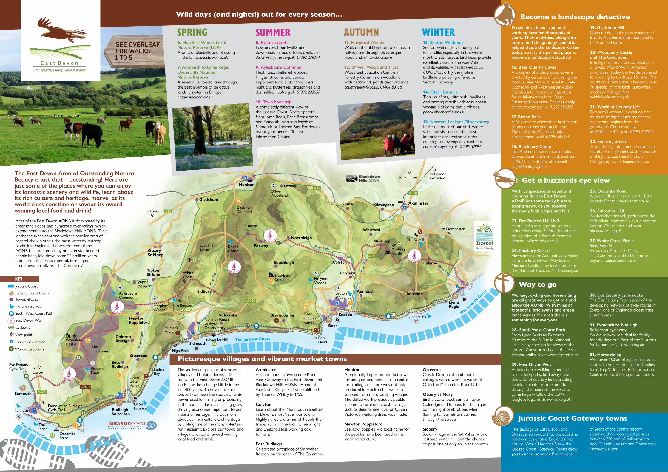
The settlement pattern of scattered villages and isolated farms, still seen today in the East Devon AONB landscape, has changed little in the last 400 years. The rivers of East Devon have been the source of water power used for milling or processing in the textile industries, helping grow thriving economies important to our industrial heritage. Find out more about our rich culture and heritage by visiting one of the many volunteer run museums. Explore our towns and villages to discover award winning local food and drink.
HonitonA regionally important market town for antiques and famous as a centre for trading lace. Lace was not only produced in Honiton but was also sourced from many outlying villages. The skilled work provided valuable income to rural and coastal villages, such as Beer, where lace for Queen Victoria's wedding dress was made.
Newton PopplefordSee how ‘popples’ – a local name for the pebbles have been used in the local architecture.
People have been living and working here for thousands of years. Their activities, along with nature and the geology beneath, helped shape the landscape we see today, so it is the perfect place to become a landscape detective!
16. Beer Quarry Caves A complex of underground caverns created by centuries of quarrying the famous Beer Stone, as used in Exeter Cathedral and Westminster Abbey. It is also internationally important for its hibernating bats. Open Easter to November. Charges apply. beerquarrycaves.co.uk, 01297 680282
17. Bicton Park A 64 acre site celebrating horticulture, champion trees and much more. Open all year. Charges apply. bictongardens.co.uk, 01395 568465
18. Blackbury Camp Iron Age encampment surrounded by woodland and farmland, best seen in May for its display of bluebells. englishheritage.gov.uk
19. Gittisham Hill Open access land rich in evidence of Bronze Age burial sites, managed by the Combe Estate.
20. Woodbury Castle and The Commons Iron Age hill fort and also once part of a vast World War II American army base. Today the heaths are used for training by the Royal Marines. The world class heathland is home to over 70 species of rare birds, butterflies, moths and dragonflies. pebblebedheaths.org.uk
21. World of Country Life Exmouth’s seasonal exhibition and museum of agricultural machinery and steam engines from the yesteryear. Charges apply. worldofcountrylife.co.uk, 01395 274533
22. Seaton Jurassic Travel through time and discover the secrets of our planet’s past. Hundreds of things to see, touch and do. Charges apply. seatonjurassic.co.uk
With its spectacular coast and countryside, the East Devon AONB has some really breath-taking views, as you explore the many high ridges and hills.
23. Fire Beacon Hill LNRHeathland site in a prime vantage point overlooking Sidmouth and once the location of a Spanish Armada beacon. wildeastdevon.co.uk
24. Musbury CastleViews across the Axe and Coly Valleys from the East Devon Way below Musbury Castle, now looked after by the National Trust. nationaltrust.org.uk
25. Orcombe PointA geoneedle marks the start of the Jurassic Coast. nationaltrust.org.uk
26. Salcombe HillA wheelchair friendly path out to the cliffs offers impressive views along the Jurassic Coast, east and west.nationaltrust.org.uk
27. White Cross Picnic Site, East HillViews over Ottery St Mary, The Commons and to Dartmoor beyond. wildeastdevon.co.uk
Walking, cycling and horse riding are all great ways to get out and enjoy the AONB. With miles of footpaths, bridleways and green lanes across the area there’s something for everyone.
28. South West Coast PathFrom Lyme Regis to Exmouth, 30 miles of the 630 mile National Trail. Enjoy spectacular views of the Jurassic Coast or a choice of bite size circular walks. southwestcoastpath.com
29. East Devon WayA memorable walking experience linking footpaths, bridleways and stretches of country lanes creating an inland route from Exmouth, through the heart of the aonb to Lyme Regis – follow the EDW foxglove logo. eastdevonway.org.uk
30. Exe Estuary cycle routeThe Exe Estuary Trail is part of the developing network of cycle routes in Exeter, one of England’s oldest cities. sustrans.org.uk
31. Exmouth to Budleigh Salterton cyclewayAn old railway line ideal for family friendly days out. Part of the Sustrans NCN number 2. sustrans.org.uk
32. Horse ridingWith over 160km of legally accessible routes, there are great opportunities for riding. Visit a Tourist Information Centre for local riding school details.
Most of the East Devon AONB is dominated by its greensand ridges and numerous river valleys, which extend north into the Blackdown Hills AONB. These landscape types contrast with the smaller area of coastal chalk plateau, the most westerly outcrop of chalk in England. The western end of the AONB is characterised by an extensive band of pebble beds, laid down some 240 million years ago during the Triassic period, forming an area known locally as ‘The Commons’.
6. Holyford Woods Local Nature Reserve (LNR) Aroma of bluebells and birdsong fill the air. wildeastdevon.co.uk
7. Axmouth to Lyme Regis Undercliffs National Nature Reserve A seven mile coastal trek through the best example of an active landslip system in Europe. naturalengland.org.uk
11. Harpford Woods Walk on the old Feniton to Sidmouth railway line through picturesque woodland. clintondevon.com
12. Offwell Woodland Trust Woodland Education Centre in Forestry Commission woodland with heathland, ponds and wetlands. countrysideinfo.co.uk, 01404 831881
13. Seaton WetlandsSeaton Wetlands is a honey pot for birdlife, especially in the winter months. Easy access bird hides provide excellent views of the Axe Vale and its wildlife. wildeastdevon.co.uk, 01395 517557. Try the mobile birdhide trips being offered by Seaton Tramway.
14. Otter EstuaryTidal mudflats, saltmarsh, reedbeds and grazing marsh with easy access viewing platforms and birdhides. pebbledbedheaths.org.uk
15. Norman Lockyer ObservatoryMake the most of our dark winter skies and visit one of the most important observatories in the country, run by expert volunteers. normanlockyer.org.uk, 01395 579941
Way to go
The geology of East Devon and Dorset is so special that the coastline has been designated England’s first natural World Heritage Site – the Jurassic Coast. Gateway Towns allow you to immerse yourself in millions
AxminsterAncient market town on the River Axe. Gateway to the East Devon and Blackdown Hills AONBs. Home of Axminster Carpets, first established by Thomas Whitty in 1755.
ColytonLearn about the ‘Monmouth rebellion’ in Devon’s most ‘rebellious town’. Highly skilled craftsmen still apply their trades such as the local wheelwright and England’s last working oak tannery.
East BudleighCelebrated birthplace of Sir Walter Raleigh, on the edge of The Commons.
of years of the Earth’s history, spanning three geological periods between 250 and 65 million years ago; Triassic, Jurassic and Cretaceous. jurassiccoast.com
OttertonClassic Devon cob and thatch cottages with a working watermill, Otterton Mill, on the River Otter.
Ottery St MaryBirthplace of poet Samuel Taylor Coleridge and famous for its unique bonfire night celebrations when flaming tar barrels are carried through the streets.
SidburySaxon village in the Sid Valley, with a restored water mill and the church crypt is one of only six in the country.
Become a landscape detective
Jurassic Coast Gateway towns
The East Devon Area of Outstanding Natural Beauty is just that – outstanding! Here are just some of the places where you can enjoy its fantastic scenery and wildlife, learn about its rich culture and heritage, marvel at its world class coastline or savour its award winning local food and drink!
SPRING Summer Autumn WINTER
Get a buzzards eye view
Picturesque villages and vibrant market towns
20
21
1622
17
24
25
26
27
6
13
14
15 7
8
10
10
10
10
9
11
12
4
3
2
5
1
19
18
2328
29
Key
30
31
Wild days (and nights!) out for every season…
SEE OVERLEAF FOR WALKS1 TO 5
28
28
32
1
8. Bystock pools Easy access boardwalks and downloadable audio tours available. devonwildlifetrust.org.uk, 01392 279244
9. Aylesbeare Common Heathland, sheltered wooded fringes, streams and ponds. Important for Dartford warblers, nightjars, butterflies, dragonflies and damselflies. rspb.org.uk, 01392 233655
10. Try a boat trip A completely different view of the Jurassic Coast. Boats operate from Lyme Regis, Beer, Branscombe and Exmouth, or hire a kayak at Sidmouth or Ladram Bay. For details ask at your nearest Tourist Information Centre.