Disaster Risks Research and Assessment to Promote Risk...
49
-
Upload
truongkhue -
Category
Documents
-
view
215 -
download
0
Transcript of Disaster Risks Research and Assessment to Promote Risk...


Disaster Risks Research and Assessment to Promote Risk Reduction and Management
Authors:
Irasema Alcántara-Ayala (Mexico), Orhan Altan (Turkey), Daniel Baker (USA), Sálvano Briceño (France/Venezuela), Susan Cutter (USA), Harsh Gupta (India), Ailsa Holloway (South
Africa), Alik Ismail-Zadeh (Germany/Russia), Virginia Jiménez Díaz (Venezuela), David Johnston (New Zealand), Gordon McBean (Canada), Yujiro Ogawa (Japan), Douglas Paton (Australia), Emma Porio (Philippines), Rainer Silbereisen (Germany), Kuniyoshi Takeuchi
(Japan), Giovanni Valsecchi (Italy), Coleen Vogel (South Africa), Guoxiong Wu (China), and Panmao Zhai (China)
Reviewers: David Alexander (UK), Reid Basher (New Zealand), Bronwyn Hayward (New Zealand), Ilan Kelman (UK), Allan Lavell (Costa Rica), Alberto Martinelli (Italy), Omar Perez (Venezuela),
Roger Pulwarty (USA), and Ester Sztein (USA)
Editors: Alik Ismail-Zadeh (Germany/Russia) and Susan Cutter (USA)
MARCH 12, 2015
ICSU‐ISSC AD‐HOC GROUP ON DISASTER RISK ASSESSMENT

Page 1 of 47 Disaster Risks Research and Assessment
TABLE OF CONTENT
Summary for Policymakers 2 Preface 8 1. Introduction 8 2. Natural Hazards and Associated Disasters 9 2.1. Geological hazards/disasters 10 2.2. Hydro-meteorological and climatological hazards/disasters 12 2.3. Extreme space weather 14 2.4. Hazards due to impacts of near-Earth asteroids and comets 15 3. Vulnerability and Exposure 16 4. Disaster Impact and Recovery 19 5. Disaster Risk Knowledge and Management: Experience with the Disasters of
the XXI century 21
5.1. Africa 22 5.2. Asia and the Pacific 24 5.3. Europe 25 5.4. Latin America and the Caribbean 27 5.5. North America 29 6. Future Extreme Events, Disaster Risks, Impact and Losses 30 6.1. Africa 30 6.2. Asia and the Pacific 31 6.3. Europe 32 6.4. Latin America and the Caribbean 33 6.5. North America 34 7. Science-driven Disaster Risk Reduction and Implications for Sustainable
Development 35
8. Conclusion 38 References 39
Suggested citation of the Report:
Ismail-Zadeh, A. and Cutter, S., Eds. (2015). Disaster Risks Research and Assessment to Promote Risk Reduction and Management. ICSU-ISSC, Paris.
Photos credits: The Streetwise Courier (upper left panel), South Florida Times (upper right panel), and the National Geographic Society (lower panel).

SUMMARY FOR POLICYMAKERS Disasters related to natural events continue to grow in number, intensity, and impact. In many regions, natural hazards are becoming direct threats to national security because their impacts are amplified by rapid growth and unsustainable development practices, both of which increase exposure and vulnerabilities of communities and capital assets. Reducing disaster risk then becomes a foundation for sustainable development. Science-driven approaches to disaster risk reduction (DRR) and disaster risk management (DRM) can help communities and governments become more resilient and reduce the human and economic impacts of disasters. Science plays a significant role in all stages of disaster risk and its management often providing rapid scientific assessment of and usable knowledge to decision-makers (e.g., Ghafory-Ashtiani and Hosseini 2008; Machlis and McNutt 2010; Kumar et al. 2014). Scientists can do more to co-produce and deliver scientific knowledge on disasters and disaster risks for policy makers and society by providing robust, evidence-based frameworks and a variety of knowledge products (e.g., concepts, tools, technology, data, advices, training) for social policy engagement, development, and implementation. Growing results related to integrated research on disaster risks should be systematically reviewed through periodic assessments at local, national, regional, and global levels. Following earlier proposals on periodic assessments of disaster risks (Burton 2001; UK Natural Hazards Working Group 2005; ENHANS 2011; UNISDR 2013; ICSU 2014),
we call for significant improvements of existing assessment processes by scientific advice on disaster risks to support and catalyze disaster policy development and management across governments. Comprehensive periodic assessments of disaster risks at local to global levels should be undertaken by a high-level, trans-disciplinary body of experts appointed by national governments together with international and inter-governmental scientific organizations dealing with disaster risks.
Through a participatory process of working with civil society and relevant stakeholders, this international body will produce a clear and unambiguous scientific view on the current state of knowledge in disaster risk, the potential socio-economic impacts of natural hazards, and the ways to reduce (if not prevent) significant human and economic losses. The development of assessment process will facilitate the inclusion of cultural and cross-cultural perspectives. It will also produce the robust unambiguous evidence of economic, operational, and strategic benefits of using scientific knowledge and information, to address hazard prevention, mitigation, and response actions. Potential disasters triggered by natural hazard events will be evaluated in the light of the political, economical, social, and cultural barriers to suggest the ways for applications and implementations of remedies.
The United Nations Office for Disaster Risk Reduction (UNISDR) produces Global Assessment Reports on Disaster Risk Reduction (GARs) providing global overviews and more thematically-based assessments of disaster risk (e.g., UNISDR 2013), but not an explicit assessment of the state of scientific knowledge. We believe that the proposed body would strengthen existing UN structures by periodic assessment of disaster risks and could enhance the scientific input (e.g., peer-reviewed science) into the existing assessment process to elevate its impact (e.g., Tokyo Statement and Action Agenda 2015).
Page 2 of 47 Disaster Risks Research and Assessment
We presently lack a comprehensive assessment of disaster risk, so we can only briefly summarize here the current understanding of disaster risk research, practice, and experience. In doing so, we provide the initial evidentiary basis for anticipated future impacts of disasters from the perspective of integrated disaster research – the engagement of multiple disciplines and researchers, scales (local to global), methodological approaches, and stakeholders in the co-production of problem-focused, policy relevant research related to disaster risk. Assuming that a natural hazard event happened, exposure and vulnerability are the key determinants of disaster risk and the main drivers of disaster loss. The dynamic variability in exposure and vulnerability is well documented in the research literature (e.g., Wisner et al. 2004) as is the understanding of differences – geographically between and within regions but also among sectors and social groups (e.g., Birkmann 2014). However, despite this, few countries have developed multi-hazard impact data bases to support research and policy formation. Hazards: Origins, Monitoring, and Experiences Geological and hydro-meteorological hazards account for most disaster events. Much is known about the physical processes and forcing mechanisms of geohazards including the role of anthropogenic activities (Gupta 2011; Bobrowsky 2013; Alcántara-Ayala 2014). In some places, extreme events are occurring more frequently causing an increase in floods, landslides, debris flows, and storm surges. For example, in Jeddah, Saudi Arabia, precipitation averages a few cm a year, but in November 2009 heavy rains (in total, about 9 cm for four hours) produced severe flash flooding. Extra-large super cyclones such as Typhoon Haiyan in 2013 are increasing due to continuous energy supply from the warmer sea sub-surface temperature (Pun et al., 2013). Prolonged or decadal droughts are appearing more frequently as well, often related to El Niño cycles (van Dijk et al. 2013). Heat waves and cold waves are increasing in many regions (e.g. Europe, India, and China).
Extreme solar storms pose a threat to all forms of high technology (e.g. communication, information, power systems) and could have globally catastrophic effects (Baker et al. 2014). Although relatively rare when compared to other hazards, near-Earth asteroids and comets have potentially catastrophic impacts (Valsecchi and Milani Comparetti 2007). Communicable disease outbreaks (cholera and measles) including hemorrhagic fevers (such as Marburg and Ebola) are recurrent biological disaster risks, especially in Africa. The trans-boundary character of Africa’s epidemic risk profile along with greater climate variability, advancing urban population growth, increased mobility, increased social vulnerability, and greater regional and global connectivity severely degrades the region’s DRM capacity, which requires strengthening (Holloway et al. 2013; Tall et al. 2013).
An accurate prediction of earthquakes (space, time, and the magnitude) is not yet possible; however it is possible to estimate the potential vulnerability of locales to earthquake hazards (Ismail-Zadeh 2014). Earthquake scenarios have been found to be effective tools for preparedness, response, and mitigation. Also earthquake early warning alert systems have shown success, especially in Japan with its rapid detection of earthquakes (Allen 2011) and timely warnings of severe shaking (Okada et al. 2004). The prediction of volcanic eruptions is advanced due to continuous instrumentation and observations around the world’s volcanoes (Sparks 2003), but still is not sufficiently precise. Although tsunami warning systems are well advanced and operational in many regions of the world, there is still a long way to accurate warning in terms of locations, run-up heights, false alarms, etc. Also tsunami modeling still needs improvement.
Page 3 of 47 Disaster Risks Research and Assessment

Landslide monitoring has been promoted through regional and global cooperative initiatives (Sassa 2009). Systems for detection and monitoring are already in place for near-Earth asteroids and comets with improved capabilities underway (Farnocchia et al. 2012).
Our knowledge of extreme weather forecasting and real-time public warnings have significantly improved due to the existing high level of scientific and technological capability coupled to effective communication and response capabilities, which substantially reduces losses in most countries. For effective operations of early warning systems, there is a need for the technical information to be properly communicated to all who need it and for recipients to be prepared for, and able to take appropriate responses (Basher 2006). For example, the increased accuracy of forecasting cyclonic storm tracks and timing in the Atlantic, Pacific, and Indian Ocean basins has led to more timely evacuations from coastal areas, thus saving lives. Similarly, the Famine Early Warning System monitors weather patterns, rainfall estimates, water availability, and agro-climatological data to anticipate drought and food insecurity risks, especially in Africa. Research on the weather-climate nexus has also advanced our understanding of the global oceanic forcing of drought and flood conditions across continents. Public health surveillance systems and disease outbreak detection have been revolutionized with the use of the Internet and social media such as Twitter, providing real or near-real time health surveillance (Brownstein et al. 2009; Chunara et al. 2013). Despite the great success in understanding of the physical processes behind natural hazards, there are still many challenges related to hazards science, and particularly, in the reduction of uncertainties in forecasting of hazard events, local resolution of models, and prediction lead time, among others. Human Consequences Despite advances in hazard monitoring, losses continue to escalate and the impacts are becoming more burdensome as national and global economic growth has slowed, constraining nations in their abilities to shoulder the losses without external assistance. Increasingly, it does not take an extreme event to cause extreme impacts and damages, especially with geographically large trans-boundary events such as heat waves (the Russian heat wave in 2010; Europe in 2003), flooding (Europe 2013; West Africa 2010; Thailand’s Chao Phraya 2011), or tropical cyclones. Similarly, the cascading impacts of locally-generated disasters assuming global significance because of disruptions of supply chains (e.g. the Great East Japan earthquake or the Bangkok flooding) or airline traffic (the 2010 Eyjafjallajökull volcanic eruption) highlight the interconnectedness of global society, even when considering that all disasters have local origins. Understanding the dynamic interaction of hazard exposure and vulnerability is critical. Improvements in the science of vulnerability assessments have been made, but there is no consistent (or preferred) methodology for conducting them, making comparisons difficult between places, or from local to global scales. Latin America and the Caribbean have been leaders in the development of holistic, multi-sectoral approaches to DRM (Carreño et al. 2007), but even these have not been fully deployed throughout the region, and their application to complex, cascading risks such as drought remain limited. Hazard and disaster risk data are lacking in many regions, and this is especially true for measurements of vulnerability and exposure. Good quality demographic data is particularly difficult to obtain in many regions. While there are a few national and/or sub-national disaster loss and damage databases, they are not comparable at present. The role of the IRDR DATA project in reconciling hazard peril definitions across databases is a positive step in utilizing science in support of DRM policy and
Page 4 of 47 Disaster Risks Research and Assessment
practice (IRDR 2014). Community-based and other social learning approaches for monitoring and assessing resilience are equally important. Recovery after disasters is emerging as a major theme in integrated research on disaster risks. Improvements in the conceptualization of recovery – psychological, social, business, infrastructure – and the role of resilience (enhancing and building community capacity pre-and post-event) is examined in a number of places, e.g. New Zealand and Australia (Miller and Rivera 2011; Paton and McClure 2013). Understanding how people interpret risks and choose actions based on their interpretations is vital to any strategy for disaster reduction (Eiser et al. 2013). Affected communities have both resilient and vulnerable groups, and it is the interaction of these two that provides the relative balance of strengths and vulnerabilities which govern the timing and nature of social recovery. Business continuity planning provides the foundation for business and livelihood survival in disaster-affected regions. Quality and types of infrastructure and access to essential services (food, water, sanitation, shelter, and power) often differentiate the length of the recovery period which can be further set back by the occurrence of other events before full recovery. Managing Future Disaster Risk Many nations face challenges in assessing, understanding, and responding to the time-dependent nature of disaster risk, and this is where integrated disaster risk research plays a critical role. Changes in the intensity of occurrences of events coupled with changes in vulnerability and exposure will alter the impacts of natural hazards on society in mostly negative ways. Projections of future geological hazards are possible, on the one hand, but extremely difficult (e.g., Keilis-Borok et al. 2001). On the other hand, it is possible to develop projections of future hydro-meteorological events based on climate modeling but these are also of varying reliability depending on models employed and spatial and temporal scales used in the forecast. The macro and micro-scale social processes producing vulnerability (unsustainable development, increasing urbanization, social inequalities, and wealth/livelihood disparities) are accelerating and in many world regions amplify the impacts of natural hazards. Managing current disaster risk is the key for addressing future risk (Lavell and Maskrey 2013) and building disaster resilience. To what extent can analysis and control of hazards reduce disasters? In Africa, disaster risk conditions may be exacerbated by the interactions between climate variability including temperature and rainfall, and the persistent conditions of vulnerability which combine to heighten disaster risk. Food and food security, aggravated health vulnerabilities caused by lack of sanitation, and access to safe water coupled with disease epidemics create a complex risk profile for the continent (Boyd et al. 2013; Niang et al. 2014). Asia’s economic prosperity and rising inequality (UN-Habitat 2013) is increasing its vulnerability due to inadequate access to housing and services (water, energy, transport, sanitation) especially in the megacities in the region. In poorer parts of the region, droughts, flooding, food insecurity, and internal political conflicts are displacing people from their homes and livelihood bases, compromising the economic gains. Current investments in DRR are not on par with the increasing physical and social vulnerability of the region (World Bank 2012). Extreme events are likely to have their greatest effect on infrastructure and some climate-dependent sectors such as agriculture and water resources. One of the main drivers for likely increased losses is exposure (other drivers include power relations and politics meaning that vulnerability is not reduced) – more assets at risk, especially those in coastal and riverine
Page 5 of 47 Disaster Risks Research and Assessment

environments, and wild land-urban areas (e.g., Australia, Portugal, Spain). From an adaptation standpoint, many social and economic systems employ buffers to respond to slow onset hazards (e.g. storage, water transfers, purchase of grain) but lack response capabilities as drought intensifies and buffers are depleted (Pulwarty and Verdin 2013). Seismic risks remain in the Americas, in southern Europe, in many earthquake-prone regions of Asia and the Pacific, and in New Zealand. The implementation of modern seismic building codes will significantly reduce earthquake losses. In North America, it is the built infrastructure that is most susceptible to future damage from natural hazard events, although the cascading effects of such events can cause significant societal disruptions in transportation, commerce, power and water supplies, and other critical technologies. For example, an extreme space weather event can severely disrupt the bulk power system on a continental scale. The effects of disruptions are disproportionate as they concern people with higher and lesser means; this is true in poor countries as well as in poorer places of richer countries. Intensification of land resources due to population growth, increasing development of human settlements in high risk areas, and urbanization in Latin America highlight the need to link territorial planning to DRM in the region. For Latin America and Africa, the impact of extreme events is more reflective of societal vulnerability that amplifies the potential aftermath and longer term recovery. Within the region, it is the accumulation of smaller and medium scale events (reflecting the exposure and vulnerability) that contribute to loss profile and increasing importance of managing disaster risk. Recognition of the growing risk natural hazards pose to societies has led to a concomitant emphasis in mitigation (reduction) and warning systems and community preparedness (readiness) programs being included in DRR strategies. Facilitating sustained preparedness is essential to reducing risk from event that occur with little or no warning (e.g. earthquakes, locally-generated tsunami) and to ensuring people can act on warnings in timely and appropriate ways. Facilitating preparedness involves not only making sound scientific and practical information and resources available to people but also developing the psychological and social capital and capacity required to interpret and use information and resources in ways that accommodate diverse and unique local needs and expectations. Managing future risk will increasingly require community engagement strategies that increase the capacity of civil agencies and communities to have shared responsibility in DRM. The Role of Science Disaster events will continue to grow, if vulnerability is not reduced, and the economic impact will far exceed the cost of mitigation and preparedness by orders of magnitude. Large sums are expended on international emergency assistance after disasters that effectively transfer the risk (and responsibility) from the affected local area to the global community. Such international aid becomes a de facto risk transfer mechanism. More timely interventions and sustained multi-year efforts to support DRM including research, management and resilience building can enhance sustainable development efforts (Ismail-Zadeh and Takeuchi 2007; Venton 2012). Greater efforts are needed to communicate science-based disaster risk assessments, socio-economic impacts, evaluations of mechanisms for risk reduction, and prescriptive options for translating scientific findings to practice. Periodic scientific assessments of disaster risks can contribute to the significant enhancement of knowledge on specific risks at global, regional, national, and local levels. Our proposal is that a baseline assessment should be undertaken by a high-level, trans-disciplinary
Page 6 of 47 Disaster Risks Research and Assessment

body of experts appointed by national governments together with international and inter-governmental scientific organizations dealing with disaster risks and also include, where relevant and appropriate, inputs and engagement with various sectors and civil society (ICSU 2014). Although this mechanism could provide the baseline for evaluating the effectiveness of future risk reduction measures, including those proposed under the post-Hyogo Framework for Action and Sustainable Development Goals, the emphasis will be given to local and national efforts in disaster risk assessment, social learning, and civil engagement that involves detailed local information (e.g. on hazards, land cover, infrastructure, human activities, etc.) Linking DRM to broader sustainable development goals can be achieved through proactive and community based resilience efforts (Cutter 2014). However, this is only possible with the knowledge transfer generated through integrated research on and periodic assessments of disaster risks that are effectively communicated to society and governments.
Page 7 of 47 Disaster Risks Research and Assessment

PREFACE Natural hazard events lead to disasters when the events interact with exposed and vulnerable physical and social systems. Despite significant progress in scientific understanding of physical phenomena leading to natural hazards as well as of vulnerability and exposure, disaster losses due to natural events do not show a tendency to decrease. This tendency is associated with many factors including increase in populations and assets at risk as well as in frequency and/or magnitude of natural events, especially those related to hydro-meteorological and climatic hazards. But essentially disaster losses increase because some of the elements of the multi-dimensional dynamic disaster risk system are not accounted for risk assessments. A comprehensive integrated system analysis and periodic assessment of disaster risks at any scale, from local to global, based on knowledge and data/information accumulated so far, are essential scientific tools that can assist in recognition and reduction of disaster risks. This paper reviews and synthesizes the knowledge of natural hazards, vulnerabilities, and disaster risks and aims to highlight potential contributions of science to disaster risk reduction (DRR) in order to provide policy-makers with the knowledge necessary to assist disaster risk mitigation and disaster risk management (DRM). 1. INTRODUCTION A sustainable society is one which progresses in its development while equitably meeting its present needs and not compromising the ability of future generations to develop and meet their own needs (UNGA 1987). The challenges posed by disasters, technological changes and other challenges can result in negative impacts for development. Disasters can be complexly exacerbated by global poverty and can have very detrimental impacts on development and on efforts to eradicate poverty. Effective and comprehensive knowledge on disaster risks can enable greater resilience to such stresses and enable development opportunities (McBean 2014). There is need for focus on the “intrinsic relationship between disaster reduction, sustainable development and poverty eradication” (UNISDR 2005; p. 2). This is the grand challenge of integrated research on disaster risk.
Since the 1980s the impacts of disasters have risen rapidly, affecting developed and developing countries and almost all sectors of economy at local, national, and regional levels. Several hundred million people are affected annually, and losses reached over USD 400 billion in 2011 (Munich Re 2014). National governments attending the World Conference on Disaster Reduction in 2005 in Kobe, Japan, agreed on a series of priorities for action embodied within the Hyogo Framework for Action (HFA), including actions related to the understanding of disaster risk and the enhancement of early warning systems and the roles of knowledge, innovation and education for the building of a culture of safety and resilience. The HFA was the first framework to explain, describe and detail the work that is required from all different sectors and actors to reduce disaster losses. It was developed and agreed on with the many partners needed to reduce disaster risk - governments, international agencies, disaster experts and many others - bringing them into a common system of coordination. The HFA outlined five priorities for action, and offered guiding principles and practical means for achieving disaster resilience. Its goal was, and is, to substantially reduce disaster losses by 2015 by building the resilience of nations and communities to disasters. This means reducing loss of lives and social, economic and environmental assets when hazards strike.
Page 8 of 47 Disaster Risks Research and Assessment

Discussions have been underway to build on the HFA for the next stage, 2015 onwards. How can disaster risk research, including understanding of natural hazards, exposure and vulnerability as well as disasters as such, be leveraged to support the HFA from 2015 and beyond? Although science is well-recognized in the priorities of the Hyogo Framework for Action, the UNISDR can better promote and coordinate science and technology for DRR (Basher 2013). There is a need to develop the scientific basis for the policy agenda and to assess empirically progress towards achieving it.
Established in 2008 by the International Council for Science (ICSU), the International Social Science Council (ISSC), and the United Nations International Strategy for Disaster Reduction (UNISDR) the Integrated Research on Disaster Risk (IRDR) Programme addresses the challenge of natural and human-induced environmental hazards over a ten-year period. IRDR is now running several component disaster risk projects: to uncover the root causes of disasters; to analyze how people make decisions in the face of risks; to study issues related to the collection, storage and dissemination of disaster loss data; and to assess the integrated research on disaster risk. Later it was recognized that for effective reduction of disaster risks comprehensive holistic inter- and trans-disciplinary approaches to disaster risk research should be complemented by periodic risk assessments based on already available knowledge, information and data (ENHANS 2011; ICSU 2014b). Despite major advances in specialized knowledge on different aspects of disaster risk and disaster contexts, particularly, successes in early warning and evacuation systems, building safety, community education, etc., yet we are not seeing a concomitant decline in disaster impacts and losses. While disaster costs are increasing, death rates (per unit of population) are generally decreasing. The major factors in growing losses are increasing population and the exposure of increased wealth to natural hazards.
This paper presents a review of disaster risk research, past experience and future challenges in tackling natural hazards and disaster risks, their impact and losses. The paper is focused on those stakeholders taking part in events immediately leading up to the World Conference on Disaster Risk Reduction (WCDRR, Sendai, Japan, 14-18 March 2015) as well as the Conference itself, and those who will implement the Conference’s decisions on risk reduction in future. It will set out cogent arguments in favor of an authoritative mechanism for providing, on a regular basis, the scientific assessment and synthesis of the policy-relevant results of peer-reviewed published research and important consultancy work. 2 NATURAL HAZARDS AND ASSOCIATED DISASTERS By natural hazards we refer to potentially damaging physical events and phenomena, which may cause the loss of life, injury or human life disruption, property damage, social, economic, and political disruption, or environmental degradation. Natural hazards can be divided into different groups: geological, hydro-meteorological, climatological, outer space, and biological1 hazards. Natural hazards can be single, multiple, or concatenated in time and local, regional and global in space. Each natural hazard is characterized by its location, intensity and probability.
1 Biological hazards are referred here to those, which are caused by viruses (e.g., AIDS or Ebola), bacteria, fungal prion, pathogens, parasites, eutrophy/hypoxia etc. We do not discuss biological hazards in this paper in detail and concentrate basically on geological, hydro-meteorological, climatological, and outer space hazards because of different ways of impact of biological hazards compared to other hazards mentioned. However, we recognize a high impact of biological hazard on society in specific regions of the world (e.g. in Africa).
Page 9 of 47 Disaster Risks Research and Assessment

A disaster can be referred to a serious disruption of the normal functioning of a community or a society causing widespread human, material, economic or environmental losses which exceed the ability of the affected community/society to cope using its own resources. A disaster is a function of the risk process, and results from the combination of hazards, conditions of vulnerability and insufficient capacity or measures or even interest to reduce the potential negative consequences of risk, and exposure. For the last 35 years the frequency of the disasters associated with natural hazard events has been steadily increasing (Fig. 1). An average number of 405 events per year was registered by Munich Re in 1980-1989, 650 events in the 1990s, 780 events for the period of 2000-2009, and more than 800 events in the 2010s (Wirtz et al. 2014). Figure 1 shows that the number of geological disasters has not been much changed for the last 30 years compared to the number of hydro-meteorological and climatological events.
1 2 3 4
Figure 1. Annual number of disasters associated with natural events from 1980 to 2013 1: red color marks
geological events; 2: green meteorological events; 3: blue hydrological events; and 4: orange climatological events (source: NatCatSERVICE, Munich Re, 2014).
2.1 Geological hazards/disasters Earthquakes, volcano eruptions, tsunamis, and landslides belong to geological (sometimes referred to as geophysical) hazards. According to the global risk analysis carried out by the World Bank (Dilley et al. 2005), an area of about 10 million km2, the equivalent of 7.5% of the total area of the planet, is estimated to have a 10% probability of peak ground acceleration (intensity of ground shaking) of at least 2 m s-2 in a 50-year period. This area is inhabited by approximately 1.2 billion people, in other words, 20% of the world population. Volcanic activity is concentrated on about 0.4 million km2 with a 93 million population potentially affected, particularly in countries such as Iceland, Japan, the Philippines, Indonesia, the United States, Mexico, Central America, Colombia, Ecuador, and Chile. Additionally, 3.7 million km2 of land are susceptible to sliding, while the population exposed is in the order of 300 million. Areas of high risk of landslides are inhabited by 66 million of inhabitants, occupying a land surface of
1,000
800
600
400
200
0
1980 1985 1990 1995 2000 2005 2010
Page 10 of 47 Disaster Risks Research and Assessment

820,000 km2 (Dilley et al. 2005). Also at global scale, 14 million of people are exposed to tsunamis and the major potentially affected areas are located along the coasts of countries facing the oceans and seas (UNISDR 2009).
In the known history, millions of human lives are lost due to earthquakes and volcano eruptions, and property damage has exceeded hundreds of billions USD. As of now, it has not been possible to make reliable earthquake forecast, although there exist a few success stories (e.g., Ismail-Zadeh 2013). However, it has been possible to estimate the vulnerability of locales to the possible earthquake hazard and ways and means are available to develop earthquake resilient societies. ‘Earthquake early warning’ is the rapid detection of earthquake in progress and alerting people of the ground shaking that could be hazardous. Application of this technique has demonstrated its usefulness. Developing earthquake scenarios, as what would happen if an earthquake repeats, where it had occurred in the past, is also found to be very effective in developing earthquake resilient societies.
Societal impacts of volcanic eruptions (e.g., damages, disruptions, severe health problems) are associated with ash fall, lava flows, gases, hot ash clouds, lahars and related hazard to aviation. Predicting of a volcanic eruption is an interdisciplinary science where continuous observation of a number of parameters such as volcanic earthquakes (volcano seismology), changes in ground conditions (geodesy, magnetic studies), ground water (hydrology) etc. provide a clue of the forthcoming eruption.
While the earthquakes, volcanoes or landslides take place on specific areas, the effects of tsunamis are widely distributed in space and time, and consequences can be global, as it was the case of the 2004 Sumatra earthquake-induced tsunami, which affected a number of countries around the Indian Ocean, and – although not clearly understood at that time – also the 1960 Chile earthquake-induced tsunami that affected the NE coast of Japan in 23 hours. A global tsunami warning system was set up to tackle with the challenging problems of tsunami disasters. In addition, local and regional warning systems generate accurate scientific-based information to be communicated to the exposed communities. Scientific modeling and tsunami forecasting are still to be improved so that the time available between warning and action can be used in the best possible way. Landslides take place in different parts of the world. Even if the attention given to landslides is not as focused as that given to other natural hazards, such as earthquakes, volcanoes and hurricanes, the social impact of landslide disasters is nonetheless significant and it may indeed continue to increase in the future due to the expansion of human settlements in areas of risk. Their impact, however, usually is underestimated as landslides are triggered to a great extent by rainfall and earthquakes, and thus, specific accountability of consequences is difficult to achieve. Landslides due to heavy and prolonged rains occur in mountainous areas. For example, a 296.5 cm precipitation event due to Typhoon Morakot in 2009, the deadliest typhoon to impact Taiwan in recorded history, resulted in deep-seated landslides in Taiwan’s Shiaolin. Other cases of recent deep-seated landslides include those happened in 2011 in Kii Peninsula, Japan (mentioned above), and in 2013 in Uttarakhand, India.
From a human induced perspective, landscape modifications, such as changes in slope geometry due to construction of infrastructure, terracing, slope excavations, loading, and mining, in addition to disturbances to the equilibrium of slopes produced by vibrations, water linkage, land-use changes, deforestation, are also significant factors determining slope instability. Besides human and economic losses, landslides also have a considerable impact on the environment, either as main drivers of landscape dynamics and evolution, or in terms of degradation, as
Page 11 of 47 Disaster Risks Research and Assessment

vegetation cover and natural habitats can be seriously modified. Development of human settlements in mountainous areas, urbanization processes, and particularly lack of adequate territorial planning and management, when combined with earthquakes and/or significant rainfall events generate optimal scenarios for landslide disasters to occur (Alcántara-Ayala 2014). Historical cases of landslide disasters have shown their future potential impact given that patterns of population growth continue to rise dramatically in highly unstable areas, vulnerability of population is increasing, and there is still a lack of landslide DRM. In mountainous areas, lake-outburst floods can also occur due to a geological event or a technological failure. One of the serious concerns related to such floods is the Lake Sarez in Pamir Mountain (Tajikistan) formed as a natural dam due to the 1911 earthquake-triggered rockslide, which blocked the Murgab River; the maximum depth of the lake is 550 m, and its volume is about 17 km3 (Schuster and Alford 2004). In the case of dam failure (e.g., due to seismic shaking or overtopping caused by a landslide or other natural processes), over a million of people downstream along the Amu Daria river would be exposed to severe flooding (Stone 2009). 2.2 Hydro-meteorological and climatological hazards/disasters Hydro-meteorological and climatological hazards are the most frequent causes of the disaster events among all natural hazards (Fig. 1). The most common meteorological hazards are heavy rains, storms/hurricanes, droughts, tropical cyclones, rainstorm floods, heat waves and low temperature disasters. Moreover, meteorological hazards include lightning, tornadoes, dust storms, hail, frost, fog, and haze. Some hazards, such as drought span the weather to climate continuum extending for seasons and even decades
Atmospheric circulation patterns can generate prolonged weather changes, namely, due to the irregular stagnation of the polar front jet-stream (Rossby waves) in the mid-latitudes of the northern hemisphere, the frontal zone between the cold polar air and the warm tropical air stays long at the same place and cause protracted snow storms, heavy rains, sudden droughts, extreme temperature and other severe weather events (Screen and Simmonds 2014). They become serious hazards in many parts of the world including Asia, Africa, Europe, and North America. Heavy rains, for example, with the total precipitation of 37.22 cm during two months (December 2013-January 2014) took place in southeastern and central southern England. The rainy season was marked as the wettest two-month period since 19102, and resulted in flooding. In North America, snow falls in New York, droughts in California, and severe tornados in Oklahoma also occur as a result of certain atmospheric circulation patterns and can be attributed to the phenomenon described above. A precipitation due to prolonged frontal rains occurred in Kyushu, Kii Peninsula, and some other neighboring regions of Japan were more than 100 cm a day (with many cases of more than 10 cm an hour). These prolonged rains caused serious landslides and debris flows.
Heavy rains occurring every year since 2011 in many parts of Japan caused devastating floods, landslides and debris flows. In 2011, for example, Typhoon 1112 resulted in severe floods, landslides and debris flows in the Kii Peninsula with dead and missing about 100 people (JSCE 20011; KRDB 2014). Similar concatenated events (heavy rains, severe flooding, landslides etc.) occurred in northern Kyushu in 2012 killing about 30 people (JSCE 2013) and in Hiroshima in 2014 killing 74 people (MLIT Sabo Division 2014).
2 Source: The Guardian, 12 February 2014
Page 12 of 47 Disaster Risks Research and Assessment

Due to heavy rains, flash floods are increasing in many parts of the world especially in urban areas. For example, Jeddah, Saudi Arabia, experienced over 9 cm precipitation for 4 hours on 25 November 2009 and flash floods, while its recent 30-year average annual precipitation was 5.61 cm a year (Al-Bassam et al. 2014). Similar events occurred in Brisbane (Australia), Sao Paulo (Brazil), and in South Africa in early 2013. Due to the sub-surface water temperature increase in the sea, cyclones tend to grow beyond ordinary limits as energy supply from the warm oceans continues (Pun et al. 2013). Typhoon Haiyan in 2013 grew to a super typhoon and hit Micronesia, Philippines, South China, and Vietnam; very high and extra-large scale storm surge, similar to tsunami waves, hit the Leyte Island, Philippines, and killed over 6,000 people (and more than 1000 people were missing). Storm surges caused by the super cyclonic storm Bhola in 1970 killed at least 300,000 people in Bangladesh, and the New Orleans city was almost submerged owing to storm surges caused by Hurricane Katrina in 2005. Typhoon Morakot produced torrential rains in Taiwan and made the Xiaolin village buried by mudslide in 2009. Coastal floods become increasingly serious threats as sea level rises. Many small islands experience more frequent storm surges and high tides, such as Kiribati (in the central tropical Pacific Ocean) and Mauritius (in the Indian Ocean). Rainstorm floods are the flood disasters which appear in specific areas due to short-time torrential rains or several continuous torrential rain processes. For example, the 1998 summer torrential rain processes over the Yangtze River in China and the 2010 summer torrential rain processes in Pakistan caused great losses. Droughts are usually referred to as creeping hazards owing to slow onset of decreasing rainfall and land surface feedbacks over time coupled with higher temperatures. Droughts can be divided into meteorological, agricultural, hydrological, and socio-economic droughts (Wilhite and Glantz 1985). Although meteorological drought is increasingly well characterized, the measurement of agricultural, hydrological, and socio-economic drought remains a challenge (UNISDR 2011). In addition, areas of severe droughts are mainly distributed in the subtropical regions of the world, although some estimates of the economic losses during the 2012 U.S. drought range as high as USD 100 billion (Munich Re 2013). Droughts can occur across a range of time scales; for example, from seasonal and multi-year droughts, decadal droughts, and severe or extended droughts like those occurring in Australia between 2001 and 2009. In some cases such drought hazards can be influenced by El Niño – Southern Oscillation conditions in the tropical Pacific conditions (van Dijk et al. 2013). Heat waves are another physical hazard characterizing by a prolonged period of high temperatures (the thresholds of definitions may be different in different regions) that may cause disasters. The 2003 summer heat wave, for example, killed at least 35,000 people in Europe. India is one of regions most seriously influenced by heat waves. Low temperature hazards include snowstorms, chilling, freezing damage, and ice storm and refer to the weathers caused by abnormal activities of cold air. Such hazards can also escalate into disasters as, for example, in 2008 ice storm over southern China led to a high-impact disaster. Although extreme weather and climate events occur infrequently, they impose great impacts on environment including socio-economic impacts and livelihood impacts. Adverse impacts from weather and climate extremes can be considered meteorological disasters when they produce widespread damage and cause severe alterations in the normal functioning of communities or societies. The severity of meteorological disasters depends not only on the extremes themselves but also on exposure and vulnerability. For instance, drought risks are only partly associated with deficient or erratic rainfall. Instead, they are primarily constructed by a
Page 13 of 47 Disaster Risks Research and Assessment

range of drivers that include: poverty and rural vulnerability; increasing water demand due to urbanization, industrialization and the growth of agro‐business; poor water and soil management; weak or ineffective governance; and climate change (UNISDR 2011). Weather and climate extremes, exposure, and vulnerability can be influenced by natural weather and climate variability, anthropogenic climate change, and socioeconomic development. Disaster risk normally can be deemed as the likelihood over a specified time period of adverse impacts due to extreme weather and climate events interacting with vulnerable social conditions (IPCC 2012). 2.3 Extreme space weather Extreme solar storms pose a threat to all forms of high technology. They begin with an explosion - a “solar flare” - in the magnetic canopy of a localized solar magnetic active region. X-rays and extreme UV radiation from the flare reach Earth at light speed, ionizing the upper layers of our atmosphere; side effects of this solar electromagnetic pulse include radio blackouts and satellite navigation errors. Minutes to hours later, the solar energetic particles arrive. Moving only slightly slower than light itself, electrons and protons accelerated by the solar blast can charge satellites and damage their electronics. This is followed by coronal mass ejections (CMEs), billion-ton clouds of magnetized plasma that may take less than a day to sweep across the Sun-Earth divide. Space weather scientists realize that a direct hit by an extreme CME such as the one that narrowly missed Earth in July 2012 could cause widespread power blackouts, disabling everything that uses electricity. Most people would not even have water because urban water supplies largely rely on electric pumps as do gasoline pumps, communication systems, and myriad other modern human technologies. Before July 2012, when researchers talked about extreme solar storms their touchstone was the iconic Carrington Event of Sept. 1859, named after English astronomer Richard Carrington who actually saw the instigating solar flare with his own eyes. In the days that followed his observation, a series of powerful CMEs hit Earth head-on with a potency not felt before or since. Intense geomagnetic storms ignited auroral displays as far south as Cuba and caused global telegraph lines to spark, setting fire to some telegraph offices and thus disabling the “Victorian Internet”. A similar storm today would have a catastrophic effect. According to a study by the U. S. National Academies (published in 2009), the total economic impact could exceed USD 2 trillion or 20 times greater than the costs of a Hurricane Katrina. Multi-ton power grid transformers disabled by such a storm could take years to repair. The severe space weather associated with extreme solar storms would affect humans on vast spatial scales (e.g., Baker et al. 2014). Impacts on the power grid would quickly spread to be of continental scale size. Moreover, such storms have the real possibility of knocking out dozens to perhaps hundreds of spacecraft on which society depends. Loss of communication satellites, weather observing spacecraft, and the Global Positioning System (GPS) network of navigation and timing platforms could have severe and rapidly propagating impacts throughout society. Under the worst of scenarios, policy makers, emergency preparedness workers, and health practitioners could be left powerless and cut off from much of the key societal infrastructure for extended periods of time. Being without food, water, fuel, and information for days, weeks, or months makes the risk of widespread space weather outages a hazard of extreme concern. What are possible mitigation strategies for severe space weather events? We must (i) have continuous real-time monitoring of the connected Sun-Earth system; (ii) endeavor to convert the rather “organically” grown science observing network of satellites and related ground
Page 14 of 47 Disaster Risks Research and Assessment

facilities into an efficient, effective operational real-time space weather observing system; (iii) support and supplement the observing network with the data analysis and modeling tools to ingest information about the space environment and convert this into actionable alerts and warnings; and (iv) convert information into knowledge, and knowledge into wisdom, as remarked by Arthur C. Clarke. Overall, the impact of space weather on critical infrastructure is an evolving, multifaceted policy issue, involving many stakeholders and governing entities. Going forward, key steps for policymakers should focus on both emergency response planning and on mitigation measures, including the identification of a design basis event and development of reliability and engineering standards to prepare the aging electricity infrastructure for such an event, through assessment and modeling (Baker et al. 2014). 2.4 Hazards due to impacts of near-Earth asteroids and comets While orbiting the Sun, the Earth is constantly hit by bodies of all sizes; in fact, were it not for the presence of the atmosphere, that effectively screens the terrestrial surface from the smallest bodies, the Earth surface would be subject to the same continuous bombardment testified by the surface of the Moon, that is cratered even at small scales. The frequency of impacts of extraterrestrial projectiles is usually described in terms of the energy of individual events. Data coming from various types of sensors and observational techniques indicate that impact events with an associated energy comparable to that of the Hiroshima atomic bomb (10-15 KT, generated by a car-sized impactor) take place roughly once per year, while events in which larger amounts of energy are liberated are rarer; for instance, events in the range of about 0.5 MT, like the one that took place on 15 February 2013 in Chelyabinsk, caused by a bus-sized impactor, are thought to happen over time scales of several decades, and those in the range of about 3 to 5 MT, like the Tunguska event of 30 June 1908, should take place over time scales of a few centuries (Brown et al. 2013). The events described can cause a local damage; however, rarer events can be much more dangerous. It is thought that impactors whose diameter is around 150 m or larger would be capable, in case of fall into an ocean (something more probable that the fall on land, due to the large fraction of the Earth covered by water), of generating an ocean-wide tsunami, whose damaging effects, both for human lives and property, could be devastating, and would critically depend on the actual coastlines affected (Chesley and Ward 2006). The energy associated to such an event would be of the order of 100 MT or more, and its frequency could be estimated to be in the range of once per many thousand years. Needless to say, over even longer time scales, of millions of years or more, even larger events become possible, whose global, devastating consequences could in principle endanger the survival of the human species, as exemplified by the Chicxulub event of around 65 million years ago, which is reputed to have contributed to the extinction of the dinosaurs (Grieve and Kring 2007), even though the event is considered only to trigger a state shift of ecosystems already under near-critical stress (Renne et al. 2013). What sets the hazard due to impacts of extraterrestrial bodies apart from many other natural hazards is its potential predictability, especially in the cases of the largest impactors. To avoid being caught by surprise by an impactor capable of global destruction, it is necessary (i) to set up detectors to discover and track the objects (asteroids and comets) that can pass close to the Earth; (ii) to precisely characterize their orbits; (iii) to determine whether they can, at some future epoch, impact the Earth with a significant probability; (iv) to further refine the knowledge of their orbits with additional tracking, in order to exclude (as it happens in most cases) or
Page 15 of 47 Disaster Risks Research and Assessment

confirm the possibility of an Earth impact; and (v) to develop the means of deflecting a large impactor, in case the previous steps have led to the conclusion that it is certainly going to impact our planet, with consequences that cannot be mitigated by the simple evacuation of the affected area (Valsecchi and Milani Comparetti 2007). The first four steps described above are currently implemented with the USA contributing most of the effort and other international partners ramping up their participation; the overall system is steadily increasing its capabilities (Farnocchia et al. 2012; Vereš et al. 2014). The fifth step is technologically feasible, and various ways of implementing it are currently under study in various parts of the world. 3 VULNERABILITY AND EXPOSURE Assuming that a natural hazard event happened, exposure and vulnerability are the key determinants of disaster risk (IPCC 2012) and the main drivers of disaster losses. Changes in any of these alter the risk calculus by increasing or reducing the impacts of disaster risk on affected communities, regions, or countries. Exposure is the location of people, assets, and infrastructure in hazard-prone areas that could be affected, while vulnerability is the degree of susceptibility or sensitivity of people, assets, and infrastructure to suffer damages (UNISDR 2013). There is temporal and spatial variability in exposure and vulnerability patterns from local to global scales. These geographic patterns are unevenly distributed across the globe and lead to the disproportionate impacts of disasters, especially in disadvantaged communities, regions, or countries. Also vulnerability depends on an individual’s susceptibility; namely, populations may be less vulnerable or more resilient in the face of disasters because of former exposure to disasters that helped to gain strength, or cultural traditions that improve collective action. In a situation, where half the world’s population is now under 24 and 9 out of 10 live in developing countries – the very real practical effect of this is the large number of young people moving into urban situations, and lack of knowledge, skills, resources (while it is not all deficit obviously) – there are distinctive and very serious problems about facing a disaster when the median population is under the age of 18 or even younger (UNICEF 2011). Such disparities are at the heart of vulnerability and exposure research. The conceptual and theoretically understanding of disaster exposure and vulnerability including the drivers and their dynamic variability is well established (Adger 2006; Blaikie et al. 1994; Cutter 2006; Wisner et al. 2004). Exposure to disaster risk is increasing from local to global scales due to ongoing growth in populations and assets at risk. The driving factors are complex and reflect micro to macro level social, political, and economic processes that fuel population growth, urbanization, and the movements of people, goods, and services. Population movements are the result of shifting patterns of economic development fueled by globalization that in turn leads to increased occupation of more marginalized land, often in high risk areas such as floodplains, steep slopes, or coastal margins. The human transformations in settlement including urban expansion are taking place concurrent (sometimes at an accelerating rate) with natural variability in physical processes and event cycles. When coupled with macro-level anthropogenic environmental changes (climate change, wetland destruction, or deforestation) the periodicity and magnitude of impacts of disasters is being altered (Pelling and Blackburn 2013). There is increasing frequency of so-called billion dollar weather events; more events now reach this threshold than they did thirty years ago, even when adjusted for inflation (NOAA 2014). It is largely the increasing exposure of assets that has led to escalations in disaster losses
Page 16 of 47 Disaster Risks Research and Assessment
(Bouwer 2011; Gall et al. 2011; Neumayer and Barthel 2011), but not exclusively. When controlling for wealth and population an upward loss trends is still apparent suggesting that other factors are contributing to loss calculus such as increasing vulnerability, decreasing resilience, or changes in frequency and intensity of natural hazard events due to climatic change. Losses are occurring in periods of slower economic growth3 – nationally and globally – which constrain the ability of governments to shoulder their financial and social burdens of loss, which in turn reduces resilience to disasters (Cutter 2014). It does not take an extreme event to cause extreme impacts and damages (IPCC 2012) as evidenced by a number of recent disaster events (e.g., Hurricane Katrina, Superstorm Sandy, or the Eyjafjallajökull volcanic eruption). While the absolute monetary impact on wealthy countries has been escalating, impoverished nations still experience the impacts of disaster risk more acutely as they have no economic safety nets to buffer the losses. Disasters, whether derived from extreme events or extreme impacts continue to undermine development gains and threaten the stability of communities, regions, and countries. In the absence of local solutions, communities and nations rely on external aid and support, fostering a new form of disaster capitalism (Klein 2007) and dependency, despite efforts to mainstream DRR into development strategies. With increased economic pressure from rising losses, the need for improved understanding of the spatial distribution and drivers of vulnerability and exposure emerged (UNISDR 2013). As a result of improvements in modeling, and a suite of geo-referenced tools and spatial information about hazards (Birkmann 2014; Emrich et al. 2011), the systematic assessment of exposure and vulnerability has moved from descriptive narratives and generalized overviews to more robust empirically and evidence-based analyses. Delineating and mapping areas at risk have improved with better spatial information on hazards and risk derived from modeled (DEM) and observational data (satellite imagery) and computational and methodological advances. However, many disasters are local and so are the assessments of their impacts and drivers of vulnerability. A multitude of conceptual frameworks exist that recognize the place-dependent constitution of vulnerability and exposure (Birkmann et al. 2013; Cutter et al. 2008). Operationalizing and implementing these frameworks is challenging since existing methodologies lack scalability and transferability (Fekete et al. 2010). Consequently, there is no consistent or standardized methodology and/or approach for conducting vulnerability assessments (Birkmann 2014). Instead, each researcher, organization or governmental authority develops their own method for conducting such assessments based on local interpretations of vulnerability and exposure. A further complication is that oftentimes assessments are restricted by data availability and privacy issues. The result is a wealth of highly localized case studies assessing vulnerabilities but comparative research extracting commonalities and testing scalability across these case studies in order to develop broader standards or methods is missing. To complicate the landscape even more, vulnerability and exposure assessments are often hazard specific (landslides, tsunami, floods), sector specific (infrastructure, business), or target specific (social, ecosystem, physical and mental health). There are relatively few assessments that adequately include elements of both exposure and vulnerability (Carreño et al. 2007; Leichenko and O’Brien 2008; Peduzzi et al. 2009). Where they exist, data on the natural processes is fairly well integrated with the social analyses of vulnerability and exposure (often using GIS), as place-based models suggest (Tate et al. 2010; Dilley et al. 2005). While the
3 Periods of high economic growth based on extraction of material resources maybe exacerbating the long term vulnerability and scale of disaster (Jackson 2009).
Page 17 of 47 Disaster Risks Research and Assessment

intersection of the physical and the social processes produces the hazard profile at a particular community, region, or country, the inclusion of environmental and public health components are often lacking in these models and decision making tools. For example, the valuation of community assets including ecosystem services is rarely part of vulnerability or exposure assessments. The inclusion of secondary or tertiary effects such as decline health services resulting in increased medical and psychological vulnerability is generally absent as well. Research beyond vulnerability assessments that evaluates the synergistic as well as antagonistic effects between development, exposure, vulnerability, and resilience strategies is missing. The multitude of vulnerability and exposure assessments are static, one-time views, despite our understanding that these processes are dynamic and both vulnerability and exposure vary not only spatially but temporally (Cutter and Finch 2008; Zhou et al. 2014). While monitoring hazards and their physical parameters (e.g., rainfall, temperature, etc.) is quite advanced and done with daily, weekly, or monthly observations, monitoring of vulnerability and exposure often relies on demographic data which is normally collected in decennial censuses. This limits the effectiveness and usefulness of vulnerability assessment for planning and policy-making purposes during non-census time periods. Disaster risk data on vulnerability and exposure remains a major research and policy issue. This applies to hazard data, but more significantly to vulnerability and exposure data. Census data is of low quality or accuracy in many countries, and data on assets such as the built environment and critical infrastructure may be missing altogether. Data on intangible assets such as social and human capital is only available for case studies, if it is available at all and generally absent at larger scales hereby limiting the scalability and transferability of assessments that include it. Even the most basic baseline data - disaster loss data - remains problematic. There are inconsistent estimates of losses (monetary losses, deaths, injuries, affected populations) (Rose 2004; Gall et al. 2009; Kron et al. 2012; Wirtz et al. 2014) especially among the global disaster loss databases. Inconsistencies in what is counted, how losses are measured etc. reduce the ability to compare results across databases, but more fundamentally, prohibit the evidentiary basis for measuring progress toward risk reduction. Efforts are underway to address this deficiency starting with the adoption of a peril classification system for loss attribution (IRDR 2014). However, the fundamental basis for quantifying who and what is at risk requires the documentation of disaster deaths, injuries, endangered physical and mental health, property losses, and impacts on economic activity from local to global scales. At present, there few national disaster loss databases from which such comparisons can be drawn (UNDP 2013). In sum, the production of vulnerable populations is not solely driven by poverty – but rather the intersection of race/ethnicity, class, gender, and life stages4. Such intersections help to explain why social vulnerability varies across space and over time. Social vulnerability is both dynamic and multi-dimensional, which explains why a single tool such as poverty alleviation will not completely reduce social vulnerability, but could merely transform or displace it to
4 There are four major stages in the human life, which create high or low vulnerability to natural hazards: (i) childhood and adolescence (especially early childhood), (ii) adulthood, (iii) the third age (still active olds; this is the period of life during that people became optimized in terms of health by the recent changes in lifestyles, etc.), and (iv) the fourth age (or old-olds meaning that period (often 80+) where most people have no longer circumscribed reduction/loss of functioning, but suffer from a broader range of restrictions health-wise and in psychological functioning). Although normally the most vulnerable are those at the first and fourth stages of their life, there is no linear relationship between chronological age and vulnerability under disasters. The distinction in life stages has tremendous consequences for measure to be taken - prevention/intervention for early childhood could be different from those aiming at old-olds.
Page 18 of 47 Disaster Risks Research and Assessment

another area and/or social group. Furthermore, estimations of vulnerable populations are compromised by lack of demographic data. There are a number of empirically models for assessing vulnerability, but these are often place and context specific and predicated on good quality demographic data. At present, there is a critical need for consistent measurements of vulnerability and exposure across scales as the basis for monitoring the effectiveness of DRM policies and programs. Such measurements begin with establishing the patterns of loss at local to global scales, and finally allow assessing disaster risk at the same scales. 4 DISASTER IMPACT AND RECOVERY Disasters impact on people and communities, interrupt normal societal functions, render essential infrastructure temporarily unusable, and disrupt business activity and employment for periods of months to years. Displacements of families and individuals following a disaster influence their mental health as they need to cope with the challenges in everyday life, leading to strains within the family, resulting in less supervision for the kids and in problem behavior, etc. Strategies developed to facilitate recovery tend to address the associated psychological, social, economic and infrastructure issues separately. However, analyses of events such as the 2011 Christchurch (New Zealand) earthquake have identified a need for a more comprehensive approach to conceptualizing disaster recovery (Paton et al. 2014). For example, psychological and social recovery strategies facilitate people’s active involvement in both physical recovery and rebuilding efforts and assisting business and economic recovery (as employees and customers). Business recovery facilitates employment and economic sustainability. Social and business recovery ensures the availability of the workforce required to repair services and infrastructure. Thus psychological, social and community, business and infrastructure recovery play interdependent roles in comprehensive disaster recovery. Psychological well-being. Only a minority (10-15%) of disaster survivors experience serious mental health difficulties (e.g., post-traumatic stress disorder (PTSD)), particularly among those with pre-existing psychological issues (Dass-Brailsford 2010; Hobfoll and de Vries 2010). For the great majority normal reactions to extreme strain and loss of relatives are prevalent, such as grief, depression, anxiety, and behavioral problems, and here culturally appropriate, agency-supported psychosocial support activities can help individuals and families to make sense of their experience and adapt to the changes encountered in recovery contexts over time (Cherry 2009). For the latter, psychological first aid has been proposed as a means of people alleviate problems or render them more manageable. However, while some literature reviews (Fox et al. 2012) identified psychological first aid as an evidence-informed intervention (although the effectiveness was not demonstrated by Randomized Control Trials), meta-analyses have called this view into question and identified it as inappropriate and potentially harmful (Roberts et al. 2010). Instead there is evidence for the effectiveness of age-appropriate early interventions for those at risk if the intervention includes psycho-education, promotes individual coping skills, and involves some kind of trauma exposure (Kramer and Landolt 2011). A recent meta-analysis revealed that children and adolescents receiving psychological intervention fared better than controls with regard to PTSD symptoms (Newman et al. 2014). An important element of post-disaster psychological intervention is being prepared for issues that can arise over the course of a recovery that may persist for years. The effectiveness of these activities can be enhanced by integrating psychological recovery initiatives with support strategies organized and provided via individual-, family-, and community-level activities that
Page 19 of 47 Disaster Risks Research and Assessment

directly address the psychological issues that commonly arise in those impacted by disaster, and those about whom they may be concerned (e.g. children or more vulnerable community members). This approach allows psychological recovery strategies to dovetail with those designed to facilitate social and community recovery. In the aftermath of hurricane Katrina and the 9/11 terrorist attack, psychologists have systematically analyzed the conditions for early, mid-term and late interventions for children, adults, and families, including how to develop scientists’ national capacity for response to disaster (Masten 2014; Watson et al. 2011). Nevertheless, one should not underestimate the human capacity to thrive even after catastrophic events (Bonanno 2004). Community responses. Given the prolonged nature of disaster recovery, and the diverse issues (e.g., confronting hazard effects, coping with relocation, dealing with insurance companies etc.), people face, the effectiveness of community recovery initiatives can be enhanced using a strengths-based and capabilities approach (e.g. Sen 2005) to facilitate the development of enduring self-help capabilities. Recovery agencies often provide for community needs. However, their doing so and being present for only a small proportion of the recovery period (immediate impact and response phase) can circumvent people’s ability to develop competencies required to confront diverse physical, social and environmental demands for months or years to come. An alternative approach focuses on co-engagement approaches (e.g. Jasanoff 2010) in co-identifying and co-mobilizing, (or, if required, developing) existing community competencies and processes and assisting people to apply them in the challenging circumstances of the recovery environment (Dass-Brailsford 2010; Nakagawa and Shaw 2004). The objective is to both learn from and together with people enhance people’s ability to make sense of their experience and reframe it in meaningful ways using a grass-roots approach based upon community engagement, participation, empowerment and trust to enable self-help and recovery. Efforts have focused on enhancing people’s capacity to become more involved in mapping, understanding and managing their own risks in various co-engaged processes including community based risk assessments (see, for example, several humanitarian efforts in this field e.g. CARE5, OXFAM6, Save the Children7, PERI-PERI-U8). Locally driven and sustainable interventions are sought by co-engaging communities in joint risk assessment and reduction efforts (e.g., Vogel et al. 2007; Holloway 2009; Jasanoff 2010). This approach acknowledges that affected communities comprise both resilient and vulnerable groups.
Strengths of such engaged and empathetic approaches include spiritual and cultural practices, collective efficacy, and community competence (Paton and McClure 2013; Miller and Rivera 2011). Vulnerability factors encompass, for example, learned helplessness and community fragmentation. In rural communities, vulnerability is also influenced by lower levels resourcing, economic activity more susceptible to disaster-related losses (e.g., agriculture, fishing), and loss of support systems if entire communities are affected.
Co-existing vulnerability factors should, however, be accommodated in planning and used to help project differential rates of recovery. Focusing on local inherent community and local strengths helps people to confront issues in ways that promote natural recovery, with social support being a pivotal component in this strategy. Social support provides a community-based
5 http://www.careclimatechange.org/ 6 http://www.oxfam.org/ 7 http://www.savethechildren.org 8 http://www.riskreductionafrica.org/
Page 20 of 47 Disaster Risks Research and Assessment

resource to assist coping with emotional (e.g. grief, anxiety), practical (e.g., child care, financial help) and informational (e.g., about recovery, assistance programs) needs.
Strengths-based disaster recovery strategies increase community members’ availability to return to work and to provide the customer base and demand for products and services that underpin economic recovery. Their ability to do so is, however, a function of the extent to which businesses have developed a capacity for disaster business continuity (Paton 2014). Business and infrastructure. Business continuity planning provides the foundation for business survival, safeguarding people’s livelihoods, and sustaining the social and economic vitality of disaster-affected regions. Businesses that sustain their activity or are able to recover quickly can assist employee (e.g., social support) and community (e.g., provide cash donations or loans, donate technical expertise, equipment) recovery. A community's infrastructure, such as roads, electricity supplies, water and waste water, provides essential services, utilities and linkages which support day-to-day community activities and represent mechanisms used to respond to and recover from disasters. Many of these functions are vulnerable to disruption and/or damage from a disaster. As these systems are often large, complex and interdependent, failure of one part of the system causes impacts in other parts, further increasing a community's vulnerability. Pre-event recovery planning is essential for making systems resilient. 5 DISASTER RISK KNOWLEDGE AND MANAGEMENT: EXPERIENCE WITH THE DISASTERS OF THE XXI CENTURY The vulnerability of human civilizations to natural hazards is growing due to the proliferation of high-risk objects, clustering of populations, and destabilization of large cities. Experience with extreme natural events in the past contributes to our understanding of effective DRM (including risk assessment, disaster prevention/mitigation and preparedness). Based on the experience and lessons from the past disasters, it is evident that the severity of the impacts of natural events depends significantly on the magnitude of the natural events, the level of vulnerability and exposure to the hazards. A lack of recovery capabilities will magnify the impacts. Economically developed countries can withstand natural hazard events of moderate magnitude because of low vulnerability with respect to these events and high resilience of society, although highest exposure, but not those of high magnitude (as evidenced by the 2002 floods in Europe, the 2005 Hurricane Katrina in USA or the 2011 Great East Japan earthquake). Meanwhile in less developed countries even smaller magnitude events can generate a large disaster (like an earthquake tragedy in Haiti in 2010 or drought events in African countries). As natural hazards cannot be reduced (e.g., earthquakes, volcanoes, hurricanes, flash floods cannot be stopped) and exposure increases with economic development, a major element in DRM is the reduction of vulnerability. High vulnerability is associated with environmental degradation, rapid and unplanned urbanization in hazardous areas, failures of governance to reduce vulnerability, and the scarcity of livelihood options for the poor. Countries more effectively manage disaster risk if they include considerations of disaster risk in national development and sector plans, translating these plans into actions targeting vulnerable areas and groups (IPCC 2012). Data related to physical and social vulnerability, disaster losses and risk reduction at the local, national and regional levels are not always available to undertake essential improvements in vulnerability reduction. Periodic assessments of rapidly growing data on vulnerability are necessary to analyze developments of vulnerability and exposure to natural hazards integrating
Page 21 of 47 Disaster Risks Research and Assessment
knowledge and uncertainties in the changes into risk assessment. Socio-economic and demographic inequalities, health-related (medical and psychological) differences, differences in governance, access to livelihoods, entitlements, and other factors as well as inequalities across countries (developed versus underdeveloped countries) influence significantly the actions related to adoption of measures to effectively respond to projected changes in vulnerability, exposure and extreme natural events (IPCC 2012). Many countries and governments face challenges in assessing, understanding, and responding to time-depending nature of disaster risk. That is the place where science can play a significant role providing the governments with periodic comprehensive assessments of the changes in the risk components: vulnerability, exposure and hazards.
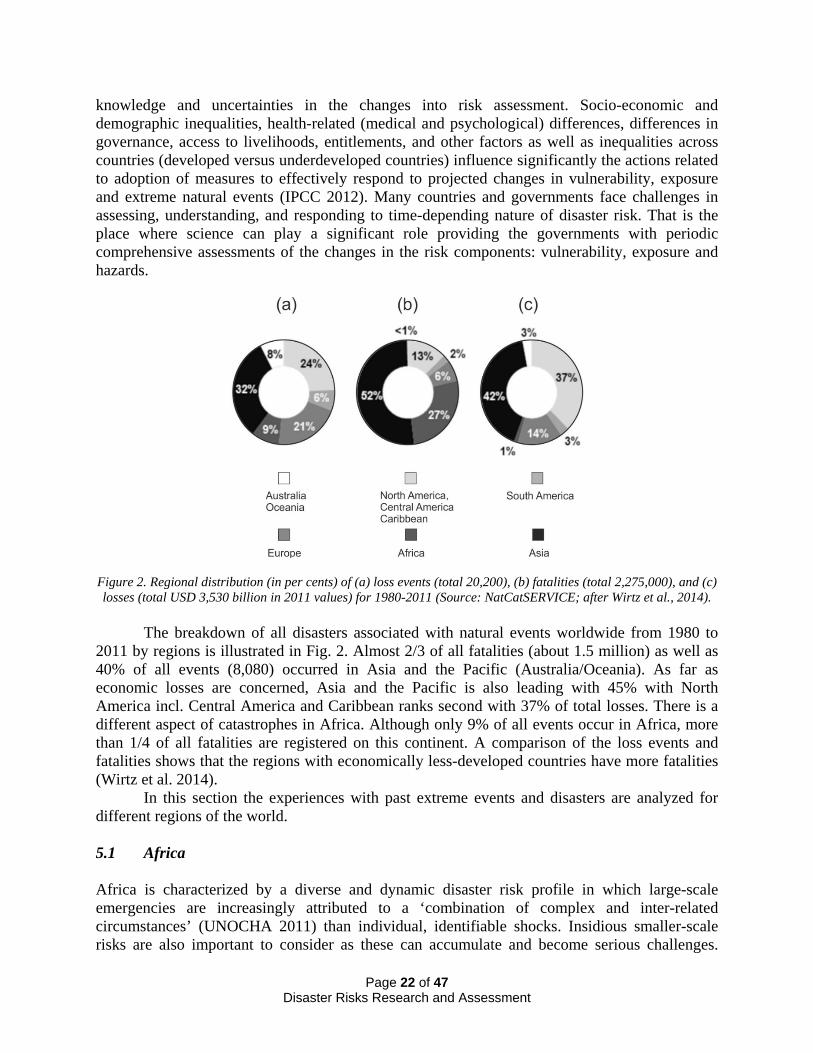
Figure 2. Regional distribution (in per cents) of (a) loss events (total 20,200), (b) fatalities (total 2,275,000), and (c) losses (total USD 3,530 billion in 2011 values) for 1980-2011 (Source: NatCatSERVICE; after Wirtz et al., 2014).
The breakdown of all disasters associated with natural events worldwide from 1980 to 2011 by regions is illustrated in Fig. 2. Almost 2/3 of all fatalities (about 1.5 million) as well as 40% of all events (8,080) occurred in Asia and the Pacific (Australia/Oceania). As far as economic losses are concerned, Asia and the Pacific is also leading with 45% with North America incl. Central America and Caribbean ranks second with 37% of total losses. There is a different aspect of catastrophes in Africa. Although only 9% of all events occur in Africa, more than 1/4 of all fatalities are registered on this continent. A comparison of the loss events and fatalities shows that the regions with economically less-developed countries have more fatalities (Wirtz et al. 2014). In this section the experiences with past extreme events and disasters are analyzed for different regions of the world. 5.1 Africa Africa is characterized by a diverse and dynamic disaster risk profile in which large-scale emergencies are increasingly attributed to a ‘combination of complex and inter-related circumstances’ (UNOCHA 2011) than individual, identifiable shocks. Insidious smaller-scale risks are also important to consider as these can accumulate and become serious challenges.
Page 22 of 47 Disaster Risks Research and Assessment

Smaller-scale and larger-scale risks occur across multiple scales, from highly localized landslides (Uganda 2012)9 to complex, protracted, trans-boundary processes - underlined by the 2011-2012 Horn of Africa emergency10 and its effects on 13 million people as well as the 2012 Sahel food and nutrition crisis with an estimated 18.7 million people at-risk11. Across the continent, hydro-meteorological events are key factors in triggering intensive disasters and crisis across all scales - illustrated by powerful weather systems like Cyclone Eline that traversed 2,000 km across southern Africa, adversely affecting five million people in seven countries (Reason and Keibel 2004, Holloway et al. 2013). It is also underlined by the 2010 West/Central Africa flood emergency that extended across 17 countries, including Liberia, Sierra Leone, Senegal, Cameroon and Chad12. Such wide area events are juxtaposed against highly localized and often unreported instances of realized extensive risks, such as drought (Namibia 2013)13, severe storms (Rwanda, 2011)14, wildfires (Benin, 2013)15, earthquakes (Malawi, 2009)16 or locust infestations (Madagascar, 2013)17. Diverging from the experience of other continents, Africa also faces significant and recurrent risks of escalating communicable disease outbreaks, particularly cholera and measles, but also including viral hemorrhagic fevers (such as Marburg and Ebola). The trans-boundary character of the region’s epidemic risk profile is illustrated by the scale of the 2008-2009 southern Africa cholera outbreak – which resulted in 156,000 cases and 4,686 deaths (UNOCHA 2009), and Africa Ebola outbreak – which results in 14,408 cases and 5176 deaths (according to WHO on 14 November 2014)18. With greater climate variability, advancing urban population growth, rising continental mobility and increasing global interconnectedness, many African countries now find themselves facing new risk configurations with poorly developed national and sub-national DRM capacity (Holloway et al. 2013; Tall et al. 2013). In this context, access to relevant and robust disaster risk knowledge (Boyd et al. 2013; Jacks and Davidson 2010) represents an acknowledged precondition for strengthening national, sub-national and trans-boundary risk management capability. This priority is now explicitly reflected in efforts to strengthen resilience to food insecurity in the Greater Horn of Africa (Frankenberger et al. 2012) as well as in Sahelian countries currently facing multiple and complex pressures (UNOCHA 2014). Access to accurate climate information also constitutes a core element for the AU’s African Risk Capacity (ARC) initiative, introduced in 2012, that aims to strengthen Member State food security through improved management of climate variability and extremes19. Other strategic interventions to simultaneously advance disaster risk knowledge as well build skilled disaster risk science/management capacity include the purposive expansion and mobilization of African higher education academic programs in the field. Not only does this grow contextually relevant risk knowledge for improved planning and DRM – it also offers a
9 http://reliefweb.int/disaster/ls-2012-000105-uga (retrieved on 12.10.2014) 10 http://reliefweb.int/disaster/dr-2011-000029-ken (retrieved on 12.10.2014) 11 http://www.acdi-cida.gc.ca/acdi-cida/acdi-cida.nsf/eng/car-72514253-p6u (retrieved on 12.10.2014) 12 http://reliefweb.int/disaster/fl-2010-000118-gha (retrieved on 12.10.2014) 13 http://reliefweb.int/disaster/dr-2013-000062-nam (retrieved on 12.10.2014) 14 http://reliefweb.int/disaster/fl-2011-000051-rwa (retrieved on 12.10.2014) 15 http://reliefweb.int/disaster/fr-2013-000007-ben (retrieved on 12.10.2014) 16 http://reliefweb.int/disaster/eq-2009-000257-mwi (retrieved on 12.10.2014) 17 http://reliefweb.int/disaster/2013-000034-mdg (retrieved on 12.10.2014) 18 http://apps.who.int/iris/bitstream/10665/143216/1/roadmapsitrep_14Nov2014_eng.pdf?ua=1 (retrieved on 12.10.2014) 19 http://www.africanriskcapacity.org/home (retrieved on 12.10.2014)
Page 23 of 47 Disaster Risks Research and Assessment

springboard for enhancing human capability for risk science and risk management practice. A 2013 survey indicated at least 17 disaster risk-related academic programs on offer across the continent (Holloway 2014), with (from 2011-2013) as many as 160 undergraduate students registered alone at Bahir Dar University, Ethiopia, and 80 postgraduate students at Madagascar’s University of Antananarivo (Holloway et al. 2014). While these developments are encouraging however, they should not detract from the urgency to address a much wider range of skilled human resource shortfalls in the applied disaster risk sciences, including those in the agricultural, climate, engineering and health domains. This imperative to accelerate the development of African risk knowledge capabilities was underlined during the 5th African Regional Platform, with the Summary Statement (UNISDR 2014) calling for improved sub-regional climate information and multi-hazard early warning systems. Similarly, the continent’s higher education institutions were acknowledged to be crucial resources for advancing risk knowledge, research and skilled capacity in managing current and future risks. 5.2 Asia and the Pacific Asia and the Pacific region has suffered more losses from disasters compared to other regions in the world (UNDP 2013). In 2013 alone, 19 million of the 22 million people displaced by floods, typhoons, and earthquakes came from Asia. Typhoon Haiyan displaced 4.1 million, a million more than in Africa, the Americas, Europe and Oceania combined (Onita 2014). This trend is expected to continue for the next decades with demographic growth and socio-economic expansion in the region. Out of ten worst disasters of the 21st century, caused by natural events, seven occurred in Asia and the Pacific region (human lives lost are given in the parentheses): (1) the Indian Ocean earthquake and tsunami, 26 December 2004 (~230,000); (2) Cyclone Nargis, 2 May 2008 (~146,000); (3) the Kashmir earthquake, 8 October 2005 (~80,000); (4) the Sichuan (China) earthquake, 12 May 2008 (69,197); (5) the Bam (Iran) earthquake, 26 December 2003 (~43,000); (6) the Great East Japan earthquake and tsunami, 11 March 2011 (~18,400); (7) the Bhuj (India) earthquake, 26 January 2001 (19,727). The Russian heat wave in 2010 (~56,000) had also claimed human lives in Japan, Mongolia and Kazakhstan. The financial losses due to the Great east Japan earthquake and the resultant tsunami are estimated to be between USD 200 and 300 billion making it to be the most expensive disaster ever occurred.
The ICSU Regional Office for Asia and Pacific (ROAP) had set up a Science Planning Group on Hazards and Disasters in 2006 (Gupta 2010). The Group developed Science Plan on Hazards and Disasters related to earthquakes, floods, and landslides20 and special vulnerability of islands21. These documents deal in depth with the identification and genesis of hazards and possible solutions. There are many success stories of managing the disasters in Asia and Pacific in the 21st century, here, three examples of good practices in the region are provided.
Indian Tsunami Early Warning System (ITEWS). Soon after the 2004 tsunami, India took up establishing of a modern tsunami warning center and ITEWS was commissioned by August 2007, and has been operating un-interrupted since then (Gupta and Gahalaut 2013). A special
20 http://www.icsu.org/asia-pacific/publications/science-planning-reports/science-plan-on-hazards-and-disasters/ (retrieved on 15.10.2014) 21 http://www.icsu.org/asia-pacific/publications/science-planning-reports/science-plan-hazards-islands/ (retrieved on 15.10.2014)
Page 24 of 47 Disaster Risks Research and Assessment

feature of ITEWS is placing ocean bottom pressure recorders in the immediate vicinity of the seismic zones causing tsunamis, extending from Sumatra to Andaman Nicobar in the Bay of Bengal and off Makaran coast in the Arabian Sea. It is capable of giving accurate tsunami advisories within 10 minutes of the occurrence of an undersea earthquake of M 6.5 or larger anywhere in the Indian Ocean. Occurrence of an undersea earthquake is a necessary but not sufficient condition for a tsunami to occur. However, whether an earthquake has generated a tsunami or not, can be assessed, by locating suitable ocean bottom pressure recorders and nearby tide gauges. These are now in position. This has enabled ITEWS to provide true advisories. For example, a magnitude M=8.5 earthquake occurred on 11 April 2012 in the Indian Ocean close to the epicenter of the 2004 Aceh-Sumatera M=9.3 earthquake. The ITEWS detected this earthquake within about 4 min of its occurrence and issued the necessary first advisory (no threat of a tsunami) within 8 minutes from the origin of the earthquake. Timely advisories avoided unnecessary panic and evacuation.
Earthquake Early Warning (Japan). Earthquake early warning is the rapid detection of an earthquake underway and estimation of sever shaking and issuance of warning in the area likely to experience damaging shaking (Allen, 2011). Started by the Japan Railways in early 1960s, a sophisticated fully operational system was established following the 1995 Kobe earthquake (Okada et al. 2004). It keeps on getting upgraded and operates all over Japan. It was extremely successful during the 2011 Tohoku earthquake (Sinha 2011), and timely warning of the forthcoming severe shaking saved numerous human lives.
Real Time Cyclone Warnings. In 1977 about 20,000 lives were lost on the east coast of India during a super cyclone. Subsequently, the entire coast of India was covered by radars and suitable arrangements were made to communicate the warning/advisories to the public. As a result, the lives lost were reduced to about 1000 and 27 when super cyclones similar to the 1977 hit the east coast of India in 1996 and 2005 respectively. The more recent is the handling of the Phailin Cyclone of 12 October 2013, where timely accurate warning, evacuation of more than a million people ensured that almost no human lives were lost22.
In the above a few examples of the efforts in Asia and the Pacific region to deal with disasters are presented. But these laudable initiatives to reduce disaster losses have been eroded by the unintended effects of fast economic growth and development in the region. There is increasing evidence of the strong linkage between disaster and particular development patterns. Disaster impacts are likely to increase due to increases in population, rapid and unplanned urbanization, climate variability and extremes, food price fluctuations, financial shocks, and weak governance systems. During the past two decades, the national and regional economies in Asia and the Pacific region invariably has experienced or articulated a combination of these social and political forces along with the increasing intensity of natural hazards. 5.3 Europe Hydro-meteorological, climatological, and geological extreme hazard events have significant impact on the European life, economy and environment. Overall losses for the period of 1980-2012 is about USD 500 billion (in 2012 values), and fatalities count to more 140,000 (Munich Re 2013). Snow, ice and debris avalanches in the Alpine region, the Pyrenees, the Carpathians and some other mountain area affect skiing, hiking, and winter sport tourism (Schmidt-Thomé 2006). Drought impacts on the industry and service sector are harmful to the European economy
22 http://www.imd.gov.in/section/nhac/dynamic/phailin.pdf (retrieved on 15.10.2014)
Page 25 of 47 Disaster Risks Research and Assessment

accounting for almost one third of total economic losses in 2003 (Munich Re 2004). Extreme cold leads to a stronger use and damage of heating systems, which can then lead to a shortage of energy and even power cuts. The example of the 2003 heatwave in Europe showed that the factors affecting exposure and vulnerability include age of people, pre-existing health status, level of outdoor activity, socioeconomic factors including poverty and social isolation, access to and use of cooling, physiological and behavioral adaptation of the population, and urban infrastructure. Although forest fires can cause considerable damage to environment and causing human casualties, natural causes of forest fires in the Mediterranean basin are relatively low (about 1-5% depending on the country) compared to the fires caused by human activities (Goldammer and Mutch 2001).
Extreme flood events happen in Europe irregularly; for example the Rhine-Mosel catchment areas were hit by 100-year return period floods at the end of 1993 and in the beginning of 1995. Heavy summer rainfalls can also lead to floods, as happened for example in 1997 in the Oder and 2002 in the Elbe basins. The highest amount of large flood events between 1987 and 2002 are concentrated in northwestern Romania, southeastern France, central and southern Germany, and eastern England (Schmidt-Thomé 2006). Although the 2002 Elbe flood was one of the worst flood catastrophes in central Europe since the Middle Ages, there was massive flooding in many other regions of Europe including many parts of the Danube catchment, Russian Black Sea coast, southern France, and northern Italy (Munich Re 2003). Floods have become an increasing problem for the built up environment in Europe since human beings have started to change and to relocate river beds, and also by settling in low lying areas close to rivers, often in natural flood-prone areas. Severe flooding in Germany and central Europe became the most expensive disaster in 2013 (Munich Re 2014).
Storm surge can cause severe flooding in coastal areas in northern Europe as many coastal areas lie just above or even below the mean sea level. Due to the high winter storm probability, some parts of the North Sea and Baltic Sea shorelines are especially vulnerable to this hazard (e.g., the devastating surges hit the Netherlands in 1953 killing 2100 people, and the German North Sea coast and Hamburg in 1962 killing over 300 people). Better coastal management and the erection of stronger sea walls have since protected the coastal areas from such catastrophes (Junge 2005). Despite the large extent of the landslide hazard in European regions, the total amount of losses due to landslides in Europe is not economically very significant (Munich Re 2004).
The highest earthquake hazard is concentrated in southeastern areas of Europe, such as Greece, Italy, Romania, and Turkey, although past extreme seismic events (e.g., the 1356 Basel, the great 1755 Lisbon, 1999 Izmit and the 2009 L’Aquila earthquakes), which significantly damaged or destroyed the cities and resulted in ten thousands casualties, should remind us about significant physical and social vulnerabilities to earthquakes (Ismail-Zadeh 2014). The 1999 Izmit magnitude 7.6 earthquake struck near Istanbul, Turkey, killing more than 17,000 people around the region and causing an estimated USD 5 billion worth of damage to the Turkish economy (nearly 2.5% of the country’s GNP). After the earthquake, the Turkish government seized the opportunity to begin implementing a series of steps to ensure that an earthquake disaster of this magnitude did not happen again. According to the World Bank information, following more than USD 1.5 billion of investment for 15 years from the government, the World Bank, and other international financial institutions, Istanbul has emerged as one of the most proactive cities in the world in terms of safeguarding against seismic risks and now serves as a model for DRM (World Bank 2013). Mental distress after earthquake disasters and any other
Page 26 of 47 Disaster Risks Research and Assessment

disasters from extreme natural events is a serious psychological problem: disaster-produced strains affect human development through various pathways, including deficits in parent-child interaction that change the expression of genes relevant for the development of competent cognition and adequate social behavior, often with rather lasting effects for a victim’s life (Silbereisen et al. 2013).
The damages that volcanic eruption causes are ash fall, lava flows, gases, hot ash clouds, lahars and related hazard to aviation. The highest volcanic eruption hazard is concentrated in Iceland, Italy, and Greece. Significant volcanic eruptions can cause tsunamis and even climate change (if the ash reaches and cools the Earth’s upper atmosphere). Volcanic ash propagation and tsunamis are capable of causing damage over a relatively large area, while other effects usually only threaten areas that are close to the volcano. The relatively small Eyjafjallajökull volcanic eruptions in Iceland in 2010 caused enormous disruption to air travel across Europe over a week affecting about 10 million travelers and caused USD 1.7 billion loss (IATA 2010). The further scientific assessment of the losses (based only on 9 European flag careers) resulted in the figure of about EUR 3.3 billion over one month (Mazzocchi et al. 2010).
Tsunamis in Europe can occur in the Mediterranean Sea and the Black Sea; the most devastating historical tsunamis in Europe occurred in Sicily (1693), Lisbon (1755), Calabria (1783), and Messina (1908), each killing more than 50 000 people, not mentioning the recent events (as they did not cause fatalities and significant economic losses). 5.4 Latin America and the Caribbean The first decade of the 21st century was marked by one of the largest disasters that have occurred in the Latin-American and Caribbean (LAC) region. A shallow earthquake of magnitude Mw7.0 took place in Haiti on 12 January 2010, 17 km to the south-west of Port-au-Prince, the capital of Haiti. The aftermath involved 222,570 deaths, 3,700,000 of total affected people, and USD 8 billion in damage23. Geoscientists expected a strong earthquake to occur in this part of Haiti as significant elastic strain has been accumulated in the lithosphere since the last major earthquake (Manaker et al. 2008; Calais et al. 2010). Regardless of the low frequency of seismic activity in that particular region of Haiti, social conditions determined the magnitude of the disaster. The high vulnerability of population related to extreme poverty and deficiencies in basic health care and education, land degradation, deterioration of the environment, and high rates of deforestation, in addition to elevated levels of corruption, irresponsibility, inequity, and inequality, and lack of earthquake-resistant design in buildings and coordinated disaster response played a significant role in shaping the disaster. A few weeks later, on 27 February 2010 a Mw8.8 earthquake occurred in Chile, which consequences left more than 500 death and around 2000 affected. Although it was an event of much bigger magnitude, the losses in both cases reflected the cities development process behind them. Even though socio-economic conditions in other countries of the LAC region are not as extreme as those of Haiti, factors determining vulnerability of population are quite similar; root causes of disasters share analogous process of vulnerability construction, being patterns of governance and institutional structures quite significant to this regard.
Notwithstanding the devastating immediate consequences of several disasters, historical experiences, including the Nevados Huascaran avalanches of 1962 and 1970, the earthquakes of Guatemala and Mexico City in 1972 and 1985, respectively, the eruption of Nevado del Ruiz
23 Source: EM-DAT-Database, http://www.emdat.be/database (retrieved on 12.10.2014)
Page 27 of 47 Disaster Risks Research and Assessment

volcano in Colombia in 1985, and hurricane Mitch in Central America in 1998, have generated positive initiatives towards shedding a light on disaster risk reduction.
Moreover, according to the report on the impact of disasters in Latin America and the Caribbean during the period 1990‐2011 (UNISDR-OSSO 2013), there is an increase of losses from destroyed and damaged homes and also of the number of people affected by disasters, both at regional and country levels due to extensive phenomena, in other words, as a result of more recurrent events that take place at smaller scale. This is evidently linked to population growth, urbanization processes, pressure on land and resources, increasing development of human settlements in areas at risk, environmental degradation, unplanned territorial management and the different spheres of vulnerability of social, economic, political, cultural, and institutional nature.
Regional institutional efforts include the establishment of regional offices or networks, such as the Coordination Centre for Natural Disaster Prevention in Central America (CEPREDENAC), the Caribbean Disaster Emergency Management Agency (CDEMA), the Andean Committee for Disaster Prevention and Response (CAPRADE), the Regional Inter-Agency Coordination Task Force for Risk, Emergency and Disasters (REDLAC), among others. While these regional offices coordinate and undertake relevant actions with an emphasis on preparedness for response and relief, and occasionally promote disaster risk reduction, real substantive work is still pending on the side of development actors with a view to avoiding constructing risk and reducing it widely. It is essential to understand the underlying causes that create risk conditions when increasing exposure of population and infrastructure in hazard prone areas.
Latin America and the Caribbean is perhaps the region where many of the most significant and pioneering investigations concerning the understanding of risk construction have been undertaken24. Colombia, for example, is with no doubt a leader in the development of policy and legal frameworks that facilitate a holistic, multi-sectoral approach to DRR and DRM, although such novel advance has not been fully implemented in practice yet throughout the region (Carreño et al. 2007).
Despite such contributions, the Latin American and Caribbean countries have advanced non-trivial endeavors to accomplish as the spatial distribution of natural hazards in the region involve areas such as the Circum-Pacific volcanic belt, the interaction of very active seismo-tectonic plates, the presence of tropical cyclone basins where hurricanes are generated, in addition to contrasting climate conditions on which the occurrence of the ENSO phenomenon and droughts are not uncommon. According to the Natural Disaster Hotspot study by the World Bank (Dilley et al. 2005), 17 out of 33 top (based on GDP) countries at relatively high economic risk from three or more hazards in the world belong to the LAC region.
In spite of improvements on disaster response capacities in most of the region, the commitment of governments to implement effective and efficient DRR and DRM strategies is still uneven in the region. What is more, scientific integrated research has not been systematically incorporated into decision and policy-making, and networking among all disaster reduction actors is largely fragmented. Consequently, the challenges ahead in the LAC region for the forthcoming years of the 21st Century include the definite transit from a response-reconstruction-post-disaster approach towards the implementation of a reliable DRR inclusive framework built through the establishment of coordinated, integrated and scientifically based
24 LA RED, Network of Social Studies in the Prevention of Disasters in Latin America, http://www.desenredando.org/lared/presentacion.html (retrieved on 15.10.2014)
Page 28 of 47 Disaster Risks Research and Assessment

DRM, on which actions taken by authorities, politicians and decision makers can be subjected to legal liability. In terms of research, risk conditions need to be assessed, mainly at local level. The underlying factors need to be identified, and this requires not only involving the scientific community, but also practitioners, decision makers, and those affected by risk. 5.5 North America North America is a study in contrasts in the frequency and impacts of natural hazards. Given its latitude, size, and population, Canada has seen far fewer disaster events than its southern neighbor. Since 2000, for example, there have been six major natural hazard events. The most significant, and also the most costly in Canadian history, were the 2013 Alberta floods (USD 1.7 billion in insured losses; USD 5.7 billion overall)25, surpassing the 1998 ice storm in dollar damages, but not in the number of people affected. Other significant natural hazard events include two tornadoes – one in Alberta near Pine Lake in 2000 (USD 13 million in damages, 12 fatalities), the other in western Ontario, the Goderich tornado in 2011 which caused USD 130 million in damages, but only one fatality). The Maritimes experienced two hurricane events causing roughly USD 200 million in damages. Hurricane Juan (2003) affected Nova Scotia and Prince Edward Island, while Hurricane Igor in 2010 damaged Newfoundland and Saint Pierre and Miquelon (CAD 16 million). A year later, Hurricane Irene caused an estimated CAD 137 million in damages in Quebec, Newfoundland and Labrador, New Brunswick, Nova Scotia, and Prince Edward Island. Lastly, in 2011 Slave Lake and surrounding towns in Alberta suffered more than CAD 700 million in insured losses, as the result of a wildfire that destroyed nearly half of the town26. Canadian research on disasters is mainly focused on the geophysical processes that produce the hazards. In addition to the basic science on earthquakes, marine geological hazards, floods, landslides, and forest fires, the research also include monitoring of these geophysical processes as well as the provision of information to the public and decision makers such as susceptibility maps through Natural Resources Canada. Integrated disaster risk research is primarily focused on climate change and adaptation, and disaster resilience in cities and in rural remote communities, although some important research on vulnerability in Canada has been done. Since 2000, there have been 95 individual weather-related events that caused more than USD 1 billion each in losses in the US (NOAA 2014). The majority of these were severe storms (including tornadoes) with 46 events (resulting in a total of USD 109 billion), but the most costly were hurricanes and tropical storms that resulted in USD 408 billion in losses. This includes the most costly events in US history, Hurricanes Katrina (USD 125 billion) and Superstorm Sandy (USD 68.5 billion). Other significant losses are associated with flooding events (Colorado flooding in 2013, Mississippi and Missouri river flooding in 2011), and drought in the Great Plains and California (2011-present), and in the Colorado Basin and northern Mexico (since 2000). Insured losses for severe thunderstorms are higher than a decade ago, with hail causing
25 NatCatSERVICE, http://www.munichre.com/site/corporate/get/documents_E113504877/mr/assetpool.shared/ Documents/0_Corporate%20Website/6_Media%20Relations/Press%20Releases/2014/2014_01_07_munich_re_natural-catastrophes-2013-overview_en.pdf (retrieved on 15.10.2014) 26 Canadian Disaster Database: http://www.publicsafety.gc.ca/cnt/rsrcs/cndn-dsstr-dtbs/index-eng.aspx (retrieved on 15.10.2014)
Page 29 of 47 Disaster Risks Research and Assessment
the most damage (Munich Re 2014). However, the evidence of increasing trends in severe thunderstorms has not been proven (Kunkel et al. 2013). Large disaster events prompt extensive case study research. In the aftermath of Hurricane Katrina, for example, there was a significant increase in research publications across all disciplines, each putting their own perspective on the event and its impact ranging from engineering to the public health consequences of the disaster. In addition to case studies and the physicality of natural hazards, the U.S. research community has been focused on vulnerability and inequality in impacts, risk communication and perception, hazard detection including early warning systems, disaster recovery, and preparedness and self-protective behaviors, flood insurance, and more recently on disaster resilience. Within these contexts there is increased attention to monitoring and measurement, the development and use of advanced modeling techniques, enhanced spatial information, and the mining of big data and social media for volunteered geographic information. However, much of the research portfolio in the U.S. remains disciplinary or multi-disciplinary but not integrated research. 6 FUTURE EXTREME EVENTS, DISASTER RISKS, IMPACT AND LOSSES Future changes in natural hazard intensity of occurrences (especially related to climatic extremes), vulnerability, and exposure (basically due to enhanced socio-economic development) will alter the impacts of natural and human-induced environmental hazards on society. A projection of the number of extreme geological events into the future can be based on the statistics of these events in the past and on the dynamics of geological and geomorphological processes. The frequency of earthquakes, volcanoes, landslides, tsunamis in many regions of the world has been well studied in comparison to the magnitude of the events. Large geological events are infrequent in general, but their impact is huge. As extreme geohazard events are key manifestations of the Earth’s lithosphere dynamics, model projections of extreme events to the future as well as precise forecasting of the big events are possible but very difficult (e.g., Keilis-Borok et al. 2001; Sparks 2003). Meanwhile, based on climate models, it is possible to develop projections related to future hydro-meteorological extremes. This section analyzes future extremes and associated with them disaster risks, and the potential impacts and losses due to the extreme natural events and extreme vulnerability. 6.1 Africa In Africa, future concerns focus particularly on the upward trend in hydro-meteorological disasters (Tall et al. 2013, UNISDR 2014). Moreover, the continent is known to be vulnerable to the impacts of climate change both because of high vulnerability, low adaptive capacity and exposure to climate risks (IPCC 2007; Niang et al. 2014). Although projections on extreme climate events are mixed, overall projections for climate trends are improving. More recent assessments (e.g., Niang et al. 2014), for example, show that there has been an increased warming trend over land areas in the continent over the last 50 to 100 years. Most regions within Africa, that have data available, have recorded an increase in extreme temperature (Seneviratne et al. 2012). During the 21st century, temperatures for Africa are also expected to rise faster than the global average.
Page 30 of 47 Disaster Risks Research and Assessment

Projections for rainfall are less certain than those for temperature but indications are that a reduction in rainfall is very likely over northern North Africa (according to some global climate model projections) by the end of the 21st century. Over East Africa projections show that there “… will be a wetter climate with more intense wet seasons and less severe droughts” during some months (see Niang et al., 2014, p. 1210). Projections for southern Africa (e.g. CMIP3 GCM) show a drying signal in the annual mean over parts of the dry south west (Niang et al. 2014). Potential risks associated with changes in both temperature and rainfall can be examined for a number of sectors including agriculture, water, and energy. The burden of a range of health outcomes created by enhanced or aggravated existing health vulnerabilities, e.g. sanitation and access to safe water, can slow down development gains (Niang et al. 2014).
In Africa, disaster risk conditions also escalate due to highly variable climate factors under persisting conditions of vulnerability. This is underlined by the complex risk profile of the West African Sahel, which under difficult socio-political conditions, was exposed in 2011 to a ‘patchy’ West African monsoon (Cornforth 2012) and a year later, to destructive flash-flooding – but which, two years later still faces humanitarian crisis (Boyd 2013). The West African experience resonates with the El Niño-triggered 1992-93 drought in southern Africa that compounded a range of chronic vulnerabilities. It reduced the regional maize harvest by more than 50% and had livelihood impacts for more than 20 million people in eleven countries (Holloway 2000). Yet, in 2000, the entire region sustained severe flood impacts, due to Cyclone Eline’s path from Madagascar to Namibia. While Mozambique bore the brunt of the resulting floods (more than 700 deaths and 250,000 people internally displaced), 290,000 people were displaced in neighboring countries and Madagascar (Brouwer and Nhassengo 2006). Sequential and synchronous disasters, where either different hazards occur at the time or closely follow each other, can exert significant impacts on livelihoods and economies at various scales (Holloway et al. 2013).
In the past decade, measures taken within southern Africa have improved the management of hydro-meteorological risks. This is indicated by a recent continent-wide assessment of national climate disaster management policies, which ranked Mozambique, Madagascar and South Africa among the four highest countries in Africa for their disaster management policies and institutional architectures (Tall et al. 2013). It further illustrates how, even developmentally disadvantaged African countries that are exposed to severe, recurrent climate threats can improve their risk management outcomes. 6.2 Asia and the Pacific Globally, extreme events are increasing, and their impact in the Asia – Pacific region would be unusually high due to rapid population growth and urbanization. As of today, 6 of the 10 largest cities in the world are located in Asia27. From a meager 17% urban population in Asia in 1950, it rose to 46% by 2012 and is projected to be 55% by the year 202028.The urbanization, in many
27 Source: http://www.mapsofworld.com/world-top-ten/world-top-ten-largest-cities-map.html (retrieved on 15.10.2014) 28 Source http://data.worldbank.org/indicator/ (retrieved on 15.10.2014)
Page 31 of 47 Disaster Risks Research and Assessment
countries, is not well planned and consequently increases the vulnerability of the citizens to extreme events. To estimate the impact of future extreme events, it is very useful to create scenarios: what would be the impact if one of the earlier extreme events repeats today? Take the case of earthquakes. The Kanto earthquake of 1923 in Japan claimed an estimated 142,000 human lives unprecedented financial losses. Fires in Yokohama and Tokyo continued for several weeks (Hammer 2006). If this earthquake repeats today, it would cost USD 1.0 to 1.6 trillion in losses to the built environment; an equivalent amount of loss due to interruption in business; and an unquantifiable additional loss worldwide to trade and financial market (Oliveria et al. 2006). Let us take the case of the Himalayan seismic belt located in the north of India. Here, four earthquakes with the magnitude about 8 occurred within a short span of 53 years: the 1897 Shillong, 1905 Kangra, 1934 Bihar Nepal, and the 1950 Assam earthquakes. No such earthquake has occurred since 1950, and non-occurrence of such an earthquake has created a false sense of security. Scenarios have been generated for the repeat of the 1905 Kangra and the 1897 Shillong earthquakes. Several fold increase in the population density, single story wooden houses being replaced by multistory buildings not following the building codes has made the region very vulnerable. If these earthquakes occur in the middle of night, they could claim about a million human lives (Gupta and Gahalaut 2014). The above disaster impacts have been further complicated by rapid socio-economic changes in the region. While the Asia-Pacific region has experienced the highest economic growth rates during the past two decades, it is also home to 60 percent (600 million) of the world’s one billion slum population. Thus, the region’s economic prosperity and rising inequality seem to be intertwined (UN-Habitat 2013). This population does not have adequate access to housing and services (water, energy, transport and sanitation), heightening their vulnerability to disaster impacts. Meanwhile, in poorer parts of the region, droughts, flooding, food insecurity and internal political conflicts are displacing people from their homes and livelihood bases, in the process, compromising the economic gains and resilience-building initiatives in the region. More importantly, the current investments in DRR are not at par with the increasing physical and social vulnerability of the region (World Bank 2012). 6.3 Europe The number of extreme precipitation events and maximum daily temperature in Europe will increase with time according to the SREX report (IPCC 2012). Namely, projected return periods for a daily precipitation event and for the maximum daily temperature that was exceeded in the late 20th century on average once during a 20-year period (1981-2000) will decrease to 10-15-year (precipitation) and 5-6 year (maximum temperature) in the northern Europe, to 12-15-year and 3-5-year in the central Europe, and to 16-18-year and 2-3-year in the southern Europe and Mediterranean during 2046-2065, respectively, as projected by several global climate models. It is expected that droughts will intensify in the 21st century during some seasons in the southern and central Europe and the Mediterranean region. More frequent, longer, and/or more intense heat waves or warm spells are likely to occur in Europe in the future. Meanwhile there are no strong evidences for upward trends in the occurrence of extreme floods in Europe (e.g., Mudelsee et al. 2003) or for increased frequency of North Atlantic polar lows associated with future climate warming (e.g., Zahn and von Storch 2010).
Page 32 of 47 Disaster Risks Research and Assessment

According to the SREX report, it is very likely that mean sea level rise will contribute to upward trends in extreme coastal high water levels in the future, and this will affect European coasts as well. Meanwhile extreme sea levels at European coasts show pronounced short-term and long-term variability partly associated with seasonal and nodal tidal cycles. Long-term trends are mostly associated with corresponding mean sea level changes while changes in wave and storm surge climate mostly contribute to inter-annual and decadal variability, but do not show substantial long-term trends (Weisse et al. 2014).
Flood exposure is increasing in coastal cities owing to growing populations and assets, the changing climate, and subsidence. With climate change and subsidence, present protection will need to be upgraded to avoid unacceptable significant losses (Hallegate et al. 2013). Rising sea level together with regionally increased storm activity increases the risk of storm surges significantly. The major task for regional and local stakeholders will be to prepare for appropriate adaptation. In most cases, possible strategies include intensification of coastal defense measures and adaptation to intermittent flooding. In case of Hamburg, the tidal Elbe river estuary engineering constructions can be used to reduce the expected future increases of local surge heights and hence to mitigate storm surge risks (von Storch et al. 2008).
Sea-level rise and extreme events have the potential to significantly impact coastal energy infrastructure through flooding and erosion. For example, on a European scale, there is limited information about energy facilities and their strategic plans for adapting to climate change, e.g., more than 150 major hydrocarbon tanker terminals and more than 25 operating nuclear reactors located in the European coastal zone (Brown et al. 2014). Climate model projections indicated that changes in heat waves, glacial retreat, and/or permafrost degradation will affect high mountain phenomena such as slope instabilities, movements of mass, and glacial lake outburst floods. Changes in heavy precipitation will affect landslides in some regions (IPCC 2012).
Large earthquakes will continue to shake the European cities especially in earthquake-prone regions as Greece, Italy, and Romania. Particularly, a ground shaking of deep-focused Vrancea (Romania) earthquakes and the associated damage and losses are observed not only in Bucharest, the capital of Romania, but also in the much wider area of Central and Eastern Europe. The implementation of modern building codes based on comprehensive seismic hazard assessments is essential, especially in the medieval European towns located in seismic active regions. Volcanoes and landslides in Italy, Greece, Iceland and other European countries could impact significantly the life and health of the European population and lead to big economic losses.
Extreme natural events in Europe are likely to have greater impacts on infrastructure and many economic sectors, such as forestry, health including mental, and tourism. In many European regions, the main drivers of future increases in economic losses are an increase in capital at risk and an increase of the intensity of climatic hazards in a less extent. Comprehensive periodic scientific assessments of disaster risks in Europe can help government and society to reduce the number of disasters, to mitigate disasters (if happened), and to make society more resilient. 6.4 Latin America and the Caribbean Latin America and the Caribbean (LAC) region faces very important challenges for DRR and DRM in the forthcoming years. Intensification of the use of resources, particularly of land, due to population growth, increasing development of human settlements in areas at risk, and
Page 33 of 47 Disaster Risks Research and Assessment

urbanization processes lacking proper planning, reveal the urgent need of linking the understanding and adequate management of territories with DRM. According to the report “Economic impact of disasters: Evidence from DALA assessments by ECLAC in Latin America and the Caribbean”, disasters involve about USD 7 billion in economic losses a year, with an average 4.5 million people affected by the consequences (Zapata and Madrigal 2009).
As quite a number of natural hazards, including earthquakes, volcanic activity, tsunamis, tropical storms and hurricanes, El Niño-Southern Oscillation (ENSO), landslides, forest fires, floods and droughts, take place in the region, investigations concerning future extreme events would be of great significance for development purposes. Accordingly, estimations by the IPCC (2013) suggest that the ENSO will continue as the governing mode of inter-annual variability in the tropical Pacific, with global effects in the 21st century; owing to the rise in moisture availability, related precipitation variability of El Niño on regional scales will likely intensify.
When referring to extreme weather events resulting from the change of frequency and intensity owed to climate change, the spatial distribution of climatic related disasters in the LAC region at national and sub-national levels is closely related with population distribution, which in the region is mostly located on coastal and mountainous areas (Garlati 2013). Therefore, urban and land use planning policies, including DRM must be considered as a cardinal component for sustainable development.
Despite the climate change and climate variation scenarios depicted by the IPCC for this region, the reproduction of different dimensions of vulnerability is certainly evident in all societies; social, economic, political, cultural and institutional aspects of vulnerability and their underlying causes, have played and will continue playing a key role in building societies at risk. Therefore, and bearing in mind that future extreme events although linked to climate change in terms of the intensity or magnitude of the natural hazard, will have a greater or lesser impact on nations and communities depending on their degree of vulnerability, it is essential that integrated science helps develop comprehensive approaches to understanding and communicating that disaster impact and extremeness of events are mainly a consequence of societal vulnerability rather than by purely natural factors. Vulnerability conditions of exposed population to hazards, regardless of intensity, amplify the potential aftermath of disasters. Moreover, although extreme natural events are among those to catch media attention, it is important to acknowledge and count also the smaller and medium-scale disasters that due to exposure and vulnerability, impact in an accumulative manner with huge losses in local communities and severely erosion development gains.
The challenge in the region remains to identify the real and root causes of disasters, built during development processes by authorities’ decision-making and to provide public authorities and private sector with evidence-based scientific guidance for them to develop appropriate risk governance mechanisms. This can be achieved through integrated policy-oriented research with participation of practitioners working in team with the scientific community. On the institutional side, it is imperative to integrate risk management in all development sectors (education, agriculture, health, transport, energy, tourism, etc.) and to strengthen the capacity at the highest levels of authority to monitor risk formation throughout public policies, guiding and facilitating vulnerability reduction as a priority, in addition to improving climate and hazard monitoring as well as preparedness to respond and recover effectively. As a recent report states, “managing current disaster risk better will probably be the best way to address future risk” (Lavell and Maskrey 2013).
Page 34 of 47 Disaster Risks Research and Assessment

6.5 North America The built infrastructure in North America is highly susceptible to future damage and catastrophic loss. This infrastructure includes cities, roads, bridges, and powers systems. The latter investment in spacecraft is estimated to be several hundred billion dollars in civilian spacecraft alone. Recent experience with earthquake damage (Zoback 2014), hurricane damage and related flooding from Superstorm Sandy (Rice and Dastagir 2013), massive forest fires (Mersereau 2013) and severe sustained drought in the western U.S. (Pulwarty and Verdin 2013), and flash flooding from extreme rain events in Colorado (Isidone 2013) all suggest that North America is increasingly vulnerable to extreme natural hazards. Superstorm Sandy, in particular, illustrates the fact that one type of natural hazard can trigger other, cascading sequences of societal disruptions that can end up costing tens of billions of dollars and that can have impacts lasting months or even years after the initiating event. For example, the consequent economic impact of a catastrophic solar storm was placed by the NRC (2008) study at as much as USD 1-2 trillion. As noted, continental-scale events due to tropospheric weather events or due to earthquakes along the New Madrid fault region of the central U.S. (Page and Hough 2014) also hold the potential for such extensive, long-lasting effects throughout much of North America.
7 SCIENCE-DRIVEN DISASTER RISK REDUCTION AND IMPLICATIONS FOR SUSTAINABLE DEVELOPMENT Rising disaster risk and losses are a threat to communities across the world and underscore the need for action to avoid the creation of future risk, reduce existing levels of risk and strengthen social, environmental and economic resilience (UNGA 2014). The beginning of the 21st century has been marked by a significant number of disasters that have resulted in tragic loss of life, property, and one nuclear emergency. Natural hazards are becoming a direct threat to civilization because of the rapid increase of physical and social vulnerability to hazards at local, regional and global levels. The reality is that the economic impact of disasters usually far exceeds the cost of mitigation and preparedness by orders of magnitude. However, all DRR (prevention, mitigation and preparedness) including warning systems, requires long-term planning. To undertake that planning, a dependable, science-driven approach can assist in understanding and assessment of disaster risks at all levels. The risk assessments should provide a clear and unambiguous scientific view on the current state of knowledge in disaster risk, the potential socio-economic impacts of natural hazards, and the ways to reduce (if not prevent) significant human and economic losses. Such a scientific view should present various knowledge inputs including local knowledge, business and various other group inputs.
Periodic disaster risk assessments would cover: (i) understanding natural hazards, exposure and the vulnerability associated with disasters; (ii) the capability of integrated monitoring and predictive systems to disseminate timely and accurate information needed for policy and decision making; (iii) methodologies and approaches for reducing vulnerability and increasing resilience of societies; and (iv) by working with actors at various levels a better understanding of the societal risk reduction (through the prevention, mitigation and preparations for the increasing impact of natural events). Such scientific assessments would contribute to the significant enhancement of our knowledge of disaster risk at global, regional, and local levels and the awareness of those living with risk.
Page 35 of 47 Disaster Risks Research and Assessment

The assessment should be undertaken by a high-level, trans-disciplinary body of experts appointed by national governments together with international and inter-governmental scientific organizations dealing with disaster risks. Such a broad-based and credible process can provide support to the international science advisory mechanism for DRR (ICSU 2014a).
Awareness and preparedness can be regarded as the essential and simplest non-structural measures to reduce exposure and vulnerability to hazards. As such, considering technological and scientific advances and progress in disaster risk research as a baseline for risk communication, environmental consciousness at local, national, regional and global scale can be achieved. Perception of risk plays a major role not only in terms of behavior, but as an essential ingredient for enhancing awareness and preparedness. Therefore, analysis of risk perception of vulnerable communities should be systematically carried out and taken into account for the identification and instrumentation of optimal strategies for DRR and DRM.
The production and use of science should also be enhanced in all areas related to DRR and DRM, including scientific and community engaged assessments; local understandings of risks as well as modeling of disaster impact, forecasting triggered hazards and risk, medical and psychological prevention and intervention of affected population. Science of this type would comprise a variety of methods and approaches, e.g. enhanced understanding of the physical processes led to this extreme event; vulnerabilities; regional hazard assessments (e.g. engineers offering new science to produce new materials and technologies to make safer houses and infrastructure). At the stage of disaster risk mitigation new scientific methods and approaches can enhance understanding of natural extreme events and co-produced vulnerabilities assessments at all levels including the gathering of a wide range of measures for increasing the resilience of society to extremes (e.g. policy interventions and regulations). Notwithstanding the value of such approaches the overwhelming need is for integrated research on disaster risks that can enable understanding of the roots of potential disasters. Enhanced forecasting and early warning systems can aid in comprehensive disaster risk assessment. Science education should be improved by introducing trans-disciplinary approach to disaster risks; training and education within science that can through co-engaged and co-produced knowledge enhance our understanding of vulnerable regions and populations.
To mitigate and adapt to large-scale disasters, the community should be involved in extensive campaigns of knowledge exchange and communication. Risk evaluation must rely heavily, but not exclusively, on modeling and visualization of physical, biological and social processes and their implications. The results need to be easily grasped by emergency planners, the insurance industry, policy makers, and the public. Scientists and the networks and institutions in which they operate should be mindful of public concerns and the risk perceptions that underlie them. In many cases the interaction between science, risk, and society takes place within the legal system. Ongoing communication between the various groups and stakeholders needs to integrate the human dimensions. Scientific knowledge and initiatives can be useful as a basis for public policy when they are acceptable to society from moral and ethical points of view. The science must interface coherently with public policy and social expectations, again illustrating the need for more carefully planned communication and consultation (Beer and Ismail-Zadeh 2003).
According to the Budapest Manifesto29, scientists can contribute to decision-making through a risk management framework with which to examine technical and social issues related to sustainability that consists of the following:
29 http://www.iugg.org/publications/reports/budapest.pdf (retrieved on 15.10.2014)
Page 36 of 47 Disaster Risks Research and Assessment

- Anticipating disaster risks caused by natural events through wide-spread consultation. - Determining concerns by using risk assessment techniques for various scenarios. - Identifying the consequences by systematically cataloguing hazards. - Undertaking calculations with appropriate models. - Evaluating the certainties, uncertainties, and the probabilities involved in the calculations
of the vulnerability and of the exposure. - Comparing with criteria to assess the need for further action. - Determining and acting on options to control, mitigate and adapt to the risk. - Communicating the results to those who need to know. - Promoting and guiding monitoring systems to collect, assimilate and archive data
relevant to the determination of sustainability and risk, now and in the future. - Integrating the knowledge and understanding from all relevant disciplines to provide
society with the tools to review the sustainability and the risks of proposed policies and plans.
Though rational scientific methods hold the promise of an improved science of risk and sustainability, it must be remembered that the priorities for analyses are likely to be heavily influenced by the public and political agenda of the day. This means that implementation of risk management to achieve sustainability can be achieved only through an interaction of theory and praxis.
Science can and should help society by improving awareness about extreme events, enhancing risk communication with policy makers, media and society, and assisting DRM authorities in organization of local and regional training and exercises. Knowledge transfer from science to professionals and decision-makers in DRM is a major challenge in view of the global upward trend in major disasters. DRM decision-makers should be provided with evidences of economic, operational, and strategic benefits of using scientific knowledge and information, which address prevention, mitigation, and response actions (e.g., Altan et al. 2010, 2013).
Disaster risk reduction is essential in achieving Sustainable Development Goals and in building resilience to extreme natural hazards. This is because sustainability and disaster risk are complementary to the extent that policies and plans are sought to increase sustainability and reduce risk. The recent analysis of the disaster risk factors affecting sustainable development was conducted by IRDR (2013) and briefly summarized here. Scientific research and practitioner experience have revealed that - disaster events undermine poverty eradication. The livelihoods, productive economic activity
and public capacities that keep poverty at bay are compromised when the underpinning assets and resources of households and countries are destroyed in disasters (Shepherd et al. 2013).
- disasters link to unsustainable growth. In 1998, Central America suffered massive losses associated with Hurricane Mitch. The impacts were particularly severe where the development model sought agricultural diversification and export-led growth but at the expense of floodplain exploitation, deforestation and soil degradation and reduced opportunities for small farmers (Ensor 2009).
- disasters have magnified impacts for small developing countries. The greatest absolute losses occur in larger and richer countries, but the greatest relative losses occur in small countries and particularly small island countries.
- disasters impact significantly sustainability of cities. Large cities exposed to cyclones, earthquakes, volcanoes will more than double their population by 2050. The resulting growth in exposure will need to be matched by substantial reductions in urban vulnerability if
Page 37 of 47 Disaster Risks Research and Assessment

disaster losses are to be restrained in these cities as they grow. Cities struck by major hazards can take years to recover (DuPont and Noy 2012; Hallegate et al. 2013).
- disaster events become quite often concatenated. Globalized systems involving highly interactive and optimized production give rise to large-scale vulnerabilities. A bright example of the concatenated event is the 2011 Tohoku earthquake and tsunami, which led to a cascade of power outages, radioactive pollution, closure of nuclear plants, reactivation of fossil fuel plants, and disruption of global industrial supply chains.
- disasters (on average) disproportionately affect women, children, old people and disabled. While disasters can thus amplify social exclusion, economic inequality and poverty, they also provide an opportunity, through risk reduction action and post-disaster recovery, to address such issues as part of the promotion of resilience and sustainable development (Enarson 2012; Guha-Sapir et al. 2006).
- disaster impacts extend widely. Disasters bring a range of indirect and secondary impacts in addition to the direct losses. Individuals may suffer long-term disability, psychological harm, degraded living circumstances, interrupted education, increased disease occurrence, loss of employment and relocation, reduced nutrition and stunting. Businesses and investment may fail and sectors may not reach their production targets and development targets. Government finances are often severely disrupted.
Large monetary sums are expended on international emergency assistance after disasters.
This is in effect a risk transfer mechanism, as it helps in smoothing the economic impacts on the affected communities, albeit at a very basic level. However, more timely interventions and sustained multi-year support to risk research, management and resilience building can pay handsomely (Ismail-Zadeh and Takeuchi 2007; Venton 2012; Ismail-Zadeh 2014). 8 CONCLUSION Disaster impacts are growing, amplified by rapid growth and unsustainable development practices that increase the exposure and vulnerabilities of communities and capital assets. Governments increasingly recognize that the reduction of disaster risks is a foundation for successful sustainable development, and that disaster risk is a crosscutting issue, requiring action across multiple sectors.
Disaster risk reduction should be based on firm scientific knowledge, vast information/data, and the systematic development and application of policies, strategies and practices to minimize vulnerabilities and disaster risks throughout a society. This will result in avoiding (prevention) or in limiting (mitigation and preparedness) adverse impact of hazards, within the broad context of sustainable development.
Greater efforts and different skills are still needed to ensure that integrated (co-engaged, produced and managed) science is better understood and communicated and to ensure maximum benefit towards the post Hyogo Framework for Action and Sustainable Development Goals. Science-driven approach to DRR through research and periodic assessments can begin engagements for greater action towards effective DRR and help the governments and society in mitigating and finally preventing disasters.
Page 38 of 47 Disaster Risks Research and Assessment

REFERENCES Adger, W. N. (2006). Vulnerability. Global Environ. Change 16(3), 268-281. Al-Bassam, A. M., Zaidi, F. K., and Hussein, M. T. (2014). Natural hazards in Saudi Arabia. In Extreme
Natural Events, Disaster Risks and Societal Implications, ed. by A. Ismail-Zadeh, J. Fucugauchi, A. Kijko et al. Cambridge Univ. Press, Cambridge, pp. 243-251.
Alcántara-Ayala, I. (2014). The special-temporal dimensions of landslide disasters. In: Extreme Natural Events, Disaster Risks and Societal Implications, ed. by A. Ismail-Zadeh, J. Fucugauchi, A. Kijko et al. Cambridge Univ. Press, Cambridge, pp. 113-125.
Allen, R. M. (2011). Earthquakes, early and strong motion warning. In: Encyclopedia of Solid Earth Geophysics, ed. by H. Gupta. Springer, Berlin, pp. 226-233.
Altan, O., Backhaus R., Boccardo, P., and Zlatanova S. (eds.) (2010). Geoinformation for Disaster and Risk Management: Examples and Best Practices. Joint Board of Geospatial Information Societies (JB GIS) and United Nations Office for Outer Space Affairs (OOSA), Copenhagen. Available at: http://www.preventionweb.net/files/14634_ GeoinformationforDisasterandRiskMan.pdf (retrieved on 03.11.2014).
Altan, O., Backhaus, R., Boccardo, P., Tonolo, F. G., Trinder, J., van Manen, N., and Zlatanova, S. (eds.) (2013). The Value of Geoinformation for Disaster and Risk Management (VALID): Benefit Analysis and Stakeholder Assessment. Published by the Joint Board of Geospatial Information Societies (JB GIS), Copenhagen. Available at: http://www.un-spider.org/sites/default/files/VALIDPublication.pdf (retrieved on 03.11.2014).
Baker, D. N., Jackson, J. M., and Thompson, L. K. (2014). Predicting and mitigating socio-economic impacts of extreme space weather: benefits of improved forecasts. In: Extreme Natural Events, Disaster Risks and Societal Implications, ed. by A. Ismail-Zadeh, J. Fucugauchi, A. Kijko et al. Cambridge Univ. Press, Cambridge, pp. 113-125.
Basher, R. (2006). Global early warning systems for natural hazards: systematic and people-centred. Philosophical Transactions of the Royal Society A 364(1845), 2167-2182.
Basher, R. (2013). Science and Technology for Disaster Risk Reduction: A review of application and coordination. Available at: http://www.preventionweb.net/posthfa/documents/Science-and-Technology-for-Disaster-Risk-Reduction.pdf (retrieved on 01.03.2015).
Beer, T., and Ismail-Zadeh, A. (eds.) (2003). Risk Science and Sustainability, Kluwer Academic Publishers, Dordrecht.
Birkmann, J. (ed.) (2014). Measuring Vulnerability to Natural Hazards: Towards Disaster Resilient Societies. United Nations University Press, Tokyo.
Birkmann, J., Cardona, O. C., Carreño, M. L., Barbat, A. H., Pelling, M., Schneiderbauer, S., Kienberger, S., Keiler, M., Alexander, D., Zeil, P., and Welle, T. (2013). Framing vulnerabiilty, risk and societal responses: the MOVE framework. Natural Hazards 67,193-211.
Blaikie, P. M., Cannon, T., Davis, I., and Wisner, B. (1994). At Risk: Natural Hazards, People's Vulnerability and Disasters. Routledge, London.
Bobrowsky, P. (ed.) (2013). Encyclopaedia of Natural Hazards. Springer, Heidelberg. Bonanno, G. A. (2004). Loss, trauma, and human resilience: Have we underestimated the human capacity
to thrive after extremely aversive events? American Psychologist 59, 20-28. Bouwer, L. M. (2011). Have disaster losses increased due to anthropogenic climate change? Bull. Amer.
Meteor. Soc. 92, 39-46. Boyd, E., Cornforth, R., Lamb, P., Tarhule, A. Issa Lélé, and Brouder, A. (2013). Building resilience to
face recurring environmental crisis in African Sahel. Nature Climate Change 3, 631-637. Brouwer, R., and Nhassengo, J. (2006). About bridges and bonds. Disasters 30(2), 234-255. Brown, P. G., Assink, J. D., Astiz, L. et al. (2013). A 500-kiloton airburst over Chelyabinsk and an
enhanced hazard from small impactors. Nature 503, 238-241.
Page 39 of 47 Disaster Risks Research and Assessment

Brown, S., et al., 2014. Implications of sea-level rise and extreme events around Europe: a review of coastal energy infrastructure. Climatic Change 122, 81-95.
Brownstein, J. S., Freifield, C. C., and Madoff, L. C. (2009). Digital disease detection – Harnessing the web for public health surveillance. New England Journal of Medicine 360(21), 2153-2157.
Burton, I. (2001). The intergovernmental panel on natural disasters (IPND). Environmental Hazards 3(3), 139-141.
Calais, E., Freed, A., Mattioli, G. et al. (2010). Transpressional rupture of an unmapped fault during the 2010 Haiti earthquake. Nature Geosciences 3, 794-799.
Carlati, A. (2013). Climate Change and Extreme Weather Events in Latin America: An Exposure Index. Inter-American Development Bank Technical Note IDB-TN-490, 42 pp., Washington, DC, USA.
Carreño, M., Cardona, O., and Barbat, A. (2007). Urban seismic risk evaluation: a holistic approach. Natural Hazards 40(1), 137-172.
Cherry, K. E. (2009). Lifespan Perspectives on Natural Disasters: Coping with Katrina, Rita, and Other Storms. New York: Springer.
Chesley, S. R. and Ward, S. N. (2006). A Quantitative assessment of the human and economic hazard from impact-generated tsunami”. Natural Hazards 38, 355-374.
Chunara, R., Smolinski, M. S., and Brownstein, J. S. (2013). Why we need crowd sources data in infectious disease surveillance. Current Infectious Disease Reports 15, 316-319.
Cornforth, R. (2012). Overview of the West African monsoon 2011. Weather 67, 59-65. Cutter, S. L. (2006). Hazards, Vulnerability, and Environmental Justice. London and Sterling, VA:
Earthscan. Cutter, S. L. (2014). Building disaster resilience: steps toward sustainability. Challenges in Sustainability
1(2), 72-79. Cutter, S. L. and C. Finch (2008). Temporal and spatial changes in social vulnerability to natural hazards.
Proc. Natl. Acad. Sc. 105(7), 2301-2306. Cutter, S. L., Barnes, L., Berry, M., Burton, C., Evans, E., Tate, E., and Webb, J. (2008). A place-based
model for understanding community resilience to natural disasters. Global Environmental Change 18(4), 598-606.
Dass-Brailsford, P. (2010). Crisis and Disaster Counseling. Thousand Oaks, CA: Sage. Dilley, M., Chen, R. S., Deichmann, W., Lerner-Lam, A. L., and Arnold, M. (2005). Natural Disaster
Hotspots: A Global Risk Analysis. Washington D.C.: The World Bank. DuPont, W., and Noy, I. (2012). What happened to Kobe? A reassessment of the impact of the 1995
earthquake in Japan. University of Hawaii Working Paper. Available at: https://ideas.repec.org/p/hai/ wpaper/201204.html (retrieved on 01.02.2015)
Eiser, J. R., Bostrom, A., Burton, I., Johnston, D. M., McClure, J., Paton, D; van der Pligt, J., White, M. P. (2012). Risk Interpretation and Action: A Conceptual Framework for Responses to Natural Hazards. International Journal of Disaster Risk Reduction 1, 5-16.
Emrich, C. T., Cutter, S. L., and Weschler, P. J. (2011). GIS and emergency management. In: The SAGE Handbook of GIS and Society, ed. by T. Nyerges, H. Couclelis, and R. B. McMaster. SAGE Publications, London and Thousand Oaks, CA, pp. 321-343.
Enarson, E. (2012). Women Confronting Natural Disaster: From Vulnerability to Resilience. Lynne Rienner Publishers, Boulder.
ENHANS (2011). Declaration on Disaster Risk Reduction through Research and Assessments. Available at: http://www.enhans.org/about/Declaration.pdf (retrieved on 28.09.2014).
Ensor, M. J. (ed.) (2009). The Legacy of Mitch: Lessons from Post-Disaster Reconstruction in Honduras. University of Arizona Press, Tucson.
Farnocchia, D., Bernardi, F., and Valsecchi, G. B. (2012). Efficiency of a wide-area survey in achieving short- and long-term warning for small impactors. Icarus 219, 41-47.
Fekete, A., Damm, M., and Birkmann, J. (2010). Scales as a challenge for vulnerability assessment. Natural Hazards 55, 729-747.
Page 40 of 47 Disaster Risks Research and Assessment

Fox, J. H., Burkle, F. M., Bass, J., Pia, F. A., Esptein, J. L., and Markenson, D. (2012). The effectiveness of psychological first aid as a disaster intervention tool: Research and analysis of peer-reviewed literature from 1990-2010. Disaster Medicine and Public Health Preparedness 6(3), 247-252.
Frankenberger, T., Nelson, S., and Langworthy, M. (2012). Enhancing Resilience to Food Insecurity amid Protracted Crisis. TANGO International Inc. Available at: http://www.fao.org/fileadmin/ templates/cfs_high_level_forum/documents/Enhancing_Resilience_FoodInsecurity-TANGO.pdf (retrieved on 16.10.2014).
Gall, M., Borden, K., and Cutter, S. L. (2009). When do losses count? Six fallacies of natural hazards loss data. Bull. Amer. Met. Society 90(6), 799-809.
Gall, M., Borden, K. A., Emrich, C. T., and Cutter, S. L. (2011). The unsustainable trend of natural hazard losses in the United States. Sustainability 3(11), 2157-2181.
Ghafory-Ashtiani, M., and Hosseini, M. (2008). Post Bam recovery and reconstruction. Natural Hazards 44, 229-241.
Goldammer, J. G., and Mutch, R. W. (2001). Global Forest Fire Assessment 1990–2000. FAO, Forestry Department, Forest Resources Assessment – Working Paper 55. Available at: http://www.fire.uni-freiburg.de/programmes/un/fao/Wp55_eng.pdf (retrieved on 04.10.2014).
Grieve, R. A. F., and Kring, D. A. (2007). The geologic record of destructive impact events on Earth. In: Comet/Asteroid Impacts and Human Society - An Interdisciplinary Approach, ed. by P. T. Bobrowsky and H. Rickman, Springer-Verlag, Berlin Heidelberg, pp. 3-24.
Guha-Sapir, D. et al. (2006). Risk factors for mortality and injury: post-tsunami epidemiological findings from Tamil Nadu. Centre for Research on the Epidemiology of Disasters, Université catholique de Louvain, Brussels.
Gupta, H. K. (2010). Co-operation plan on hazards & disasters risk reduction in Asia and the Pacific. In Geophysical Hazards. Minimizing Risk, Maximizing Awareness, ed. by T. Beer. Springer, Berlin, pp. 83-101.
Gupta, H. K. (2011). Artificial water reservoir triggered earthquakes. In: Encyclopedia of Solid Earth Geophysics, Springer, Heidelberg, pp. 15-24.
Gupta, H. K. and Gahalaut, V. K (2013) Three great tsunamis: Lisbon (1755), Sumatra-Andaman (2004) and Japan (2011). SpringerBriefs in Earth Sciences, Springer: Heidelberg, ISBN: 978-94-007-6575-7, IX, 89p.
Gupta, H. and Gahalaut, V. K. (2014). Seismotectonics and large earthquake generation in the Himalayan region. Gondwana Research 25 (1), 204-213.
Hallegate, S. et al. (2013). Future flood losses in major coastal cities. Nature Climate Change 3, 802–806. Hammer, J. (2006). Yokohama Burning. Free Press, New York. Hobfoll, S. E, and de Vries, M. W. (2010). Extreme Stress and Communities: Impact and Intervention.
Dordrecht, Netherlands: Kluwer Academic Publishers. Holloway, A. (2000). Drought emergency, yes … drought disaster, no: southern Africa 1991-93.
Cambridge Review of International Affairs 15(1), 254-276. Holloway, A. (2009). Crafting a disaster risk science: environmental and geographical science sans
frontiers. Gateways. International Journal of Community Research and Engagement 2, 98-118. Holloway, A. (2014). Strategic Mobilisation of Higher Education Institutions in Disaster Risk Reduction
Capacity Building: The experience of Periperi U. Input Paper Prepared for the Global Assessment Report on Disaster Risk Reduction 2015. RADAR, Stellenbosch.
Holloway, A., Chasi, V., Francioli, A., and Fortune, G. (2014). Periperi U Internal Interim Evaluation, July 2011 - June 2014: USAID Grant Number AID-OFDA-G-11-00215. RADAR, Stellenbosch.
Holloway, A., Chasi, V., de Waal, J., Drimie, S., Fortune, G., Mafuleka, G., Morojele, M., Penicela Nhambiu, B., Randrianalijaona, M., Vogel, C., and Zweig, P. (2013). Humanitarian Trends in Southern Africa: Challenges and Opportunities. Regional Interagency Standing Committee, Southern Africa. Rome, FAO. Available at: http://reliefweb.int/ sites/reliefweb.int/files/resources/Final_ RIASCO_22July2013.pdf (retrieved on 1610.2014).
Page 41 of 47 Disaster Risks Research and Assessment
IATA (2010). IATA Economics Briefing: The Impact of Eyjafjallajokull’s Volcanic Ash Plume. Available at: http://www.iata.org/whatwedo/Documents/economics/Volcanic-Ash-Plume-May2010.pdf (retrieved on 04.10.2014).
ICSU (2014a). Statement on establishing an international science advisory mechanism for disaster risk reduction to strengthen resilience. Available at the webpage: http://www.icsu.org/science-for-policy/disaster-risk/statement-on-establishing-an-international-science-advisory-mechanism-for-disaster-risk-reduction-to-strengthen-resilience (retrieved 15.10.2014)
ICSU (2014b). Decisions of the 31st General Assembly of the International Council for Science (ICSU), 31 August-3 September 2014, Auckland, New Zealand.
IPCC (2007). Climate Change 2007: Impacts, Adaptation and Vulnerability. Contribution of Working Group II to the Fourth Assessment Report of the Intergovernmental Panel on Climate Change. Parry, M. L., Canziani, O. F., Palutikof, J. P., van der Linden, P. J. and Hanson, C. E. (eds.) Cambridge, UK: Cambridge University Press.
IPCC (2012). Managing the Risks of Extreme Events and Disasters to Advance Climate Change Adaptation. A Special Report of Working Groups I and II of the Intergovernmental Panel on Climate Change [Field, C.B., V. Barros, T.F. Stocker, D. Qin, D.J. Dokken, K.L. Ebi, M.D. Mastrandrea, K.J. Mach, G.-K. Plattner, S.K. Allen, M. Tignor, and P.M. Midgley (eds.)]. Cambridge University Press, Cambridge, UK, and New York, NY, USA, 582 pp.
IPCC (2013). Summary for Policymakers. In Climate Change 2013: The Physical Science Basis. Contribution of Working Group I to the Fifth Assessment Report of the IPCC [Stocker, T.F., D. Qin, G.-K. Plattner, M. Tignor, S.K. Allen, J. Boschung, A. Nauels, Y. Xia, V. Bex and P.M. Midgley (eds.)]. Cambridge University Press, Cambridge, United Kingdom and New York, NY, USA.
IRDR (2013). Issue Brief: Disaster Risk Reduction and Sustainable Development. Integrated Research on Disaster Risk, Beijing. Available at: http://www.irdrinternational.org/ wp-content/uploads/ 2013/12/IRDR-ICSU-Brief-DRR-SD.pdf (retrieved on 1610.2014).
IRDR (2014). Peril Classification and Hazard Glossary. DATA Project Report No. 1, Beijing: Integrated Research on Disaster Risk. Available at: http://www.irdrinternational.org/2014/03/28/irdr-peril-classification-and-hazard-glossary (retrieved on 16.10.2014).
Isidone, C. (2013). Colorado floods: Costly and often uninsured. CNN Money, 19 September 2013. Available at: http://money.cnn.com/2013/09/19/news/economy/colorado-flood-damage/ (retrieved on 18.10.2014).
Ismail-Zadeh, A. (2013). Earthquake prediction and forecasting. In: Encyclopaedia of Natural Hazards, ed. by P. T. Bobrowsky, Springer, Dordrecht, pp. 225-231.
Ismail-Zadeh, A. (2014). Extreme seismic events: from basic science to disaster risk mitigation. In: Extreme Natural Events, Disaster Risks and Societal Implications, eds. A. Ismail-Zadeh, J. Fucugauchi, A. Kijko et al. Cambridge Univ. Press, Cambridge, pp. 47-60.
Ismail-Zadeh, A. and Takeuchi, K. (2007). Preventive disaster management of extreme natural events, Natural Hazards 42, 459-467.
Jacks, E., and Davidson, H. (2010). Guidelines on Early Warning Systems and Application of Nowcasting and Warning Operations. WMO/TD No. 1559. WMO, Geneva. Available at: http://www.wmo.int/ pages/prog/amp/pwsp/documents/PWS-21.pdf (retrieved on 16.10.2014).
Jackson, T. (2009). Prosperity without Growth: Economics for a Finite Planet. Earthscan, London. Jasanoff, S. (2010). Beyond calculation: A democratic response to risk. In: Disaster and the Politics of
Intervention, ed. by A. Lakoff. A Columbia SSRC Book Privatization of Risk Series, Columbia University Press, New York, pp. 14-40.
JSCE (2011). JSCE Investigation Report on landslide and debris flow disasters of Typhoon 1112 of 2011 (Heisei23). JSCE Typhoon 1112 of Heisei 23 landslide and debris flow disasters local investigation team, Japan Society of Civil Engineers.
JSCE (2013). Northern Kyushu heavy rains disaster of July 2012 investigation report. JSCE Northern Kyushu Heavy Rains Disaster Investigation Team.
Page 42 of 47 Disaster Risks Research and Assessment
Junge, W. (2005). Sturmflut. In: Schleswig-Holstein von A bis Z. Gesellschaft für Schleswig-Holsteinische Geschichte. Available at: http://www.geschichte-s-h.de/vonabisz/sturmflut.htm (retrieved on 04.10.2014).
Keilis-Borok, V. I., Ismail-Zadeh, A. T., Kossobokov, V. G. and Shebalin, P. N. (2001). Non-linear dynamics of the lithosphere and intermediate-term earthquake prediction. Tectonophysics 338, 247-259.
Klein, N. (2007). The Shock Doctrine: The Rise of Disaster Capitalism. New York: Picador. Kramer, D. N., and Landolt, M. (2011). Characterisitcs and efficacy of early psychological interventions
in children and adolescents after single trauma: A meta-analysis. European Journal of Psychotraumatology 2, 1-24.
Kron, W., Steuer, M., Löw, P., and Wirtz, A. (2012). How to deal properly with a natural catastrophe database – analysis of flood losses, Nat. Haz. Earth Syst. Sci 12, 535-550.
KRDB (2014). Kii Peninsula Great Water Disaster 2011 – records of disaster response. Office of Records of the Kii Peninsula Great Water Disaster, Kinki Regional Development Bureau, MLIT, first published in 2013, revised in 2014.
Kumar, T. S., Nayak, S., and Gupta, H. K. (2014). India’s tsunami warning system. In: Extreme Natural Events, Disaster Risks and Societal Implications, ed. by A. Ismail-Zadeh, J. Fucugauchi, A. Kijko et al. Cambridge Univ. Press, Cambridge, pp. 322-330.
Kunkel, K. E., Karl, T. R., Brooks, H. et al. (2013). Monitoring and understanding trends in extreme storms: State of Knowledge. Bull. Amer. Meteo. Soc. 94(4), 499-514.
Lavell, A., and Maskrey, A. (2013). The Future of Disaster Risk Management: An On-going Discussion. Available at: http://www.unisdr.org/files/35715_thefutureofdisasterriskmanage ment.pdf (retrieved on 18.01.2015)
Leichenko, R. M., and O’Brien, K. L. (2008). Environmental Change and Globalization: Double Exposures. Oxford University Press, Oxford.
Machlis, G. E., and McNutt, M. K. (2010). Scenario-building for the Deepwater Horizon oil Spill. Science 329, 1018-1019.
Manaker, D. M., Calais, E., Freed, A. M., et al. (2008). Interseismic plate coupling and strain partitioning in the Northeastern Caribbean. Geophys. J. Int. 174, 889-903.
Masten, A. S. (2014). Ordinary Magic – Resilience in Development. The Guilford Press, New York. Mazzocchi, M., Hansstein F., and Ragona, M. (2010). The 2010 volcanic ash cloud and its financial
impact on the European airline industry. CESifo Forum 2, 92-100. McBean, G. (2014). The grand challenges of integrated research on disaster risk. In Extreme Natural
Events, Disaster Risks and Societal Implications, ed. by Ismail-Zadeh, A., Fucugauchi, J., Kijko, A. et al. Cambridge Univ. Press, Cambridge, pp. 15-25.
Miller, D., and Rivera, J. (2011). Community Disaster Recovery and Resiliency: Exploring Global Opportunities and Challenges. Taylor & Francis, London.
MLIT Sabo Division (2014). Response to landslides and debris flows caused by heavy rains in August 2014. Available at: http://www.mlit.go.jp/river/sabo/H26_hiroshima/141009_hiroshimadosekiryu.pdf (retrieved on 18.10.2014, in Japanese).
Mudelsee, M., Börngen, M., Tetzlaff, G., and Grünewald, U. (2003). No upward trends in the occurrence of extreme floods in central Europe. Nature 425, 166-169.
Munich Re (2003). Topics - Annual review: Natural catastrophes in 2002. Available for download at the webpage: http://ipcc-wg2.gov/njlite_download.php?id=6219 (retrieved on 04.10.2014).
Munich Re (2004). Topics Geo - Annual review: Natural catastrophes in 2003. Available at the webpage: http://www.preventionweb.net/files/1528_30204321en.pdf (retrieved on 04.10.2014).
Munich Re (2013). Topics Geo - Annual review of natural catastrophes 2012. Available at the webpage: http://reliefweb.int/sites/reliefweb.int/files/resources/302-08121_en.pdf (retrieved 04.10.2014).
Munich Re (2014). Topics Geo - Annual review of natural catastrophes 2013. Analyses, assessments, positions. Available at: http://www.munichre.com/site/corporate/get/documents_E1043212252/mr/ assetpool.shared/Documents/5_Touch/_Publications/302-08121_en.pdf (retrieved on 04.10.2014).
Page 43 of 47 Disaster Risks Research and Assessment

Nakagawa, Y., and Shaw, R. (2004). Social capital: A missing link to disaster recovery International Journal of Mass Emergencies and Disasters, 22, 5-34.
Neumayer, E., and Barthel, F. (2011). Normalizing economic loss from natural disasters: a global analysis. Global Environ. Change 21(1), 13-24.
Newman, E., Pfefferbaum, B., Kirlic, N., Tett, R., Nelson, S., and Liles, B. (2014). Meta-analytic review of psychological interventions for children survivors of natural and man-made disasters. Current Psychiatry Reports 16(9), 462-472.
Niang, I., Ruppel, O. C., Abdrabo, M. A., Essel, A., Lennard, C., Padgham, J., and Urquhart, P. (2014). Africa. In Climate Change 2014: Impacts, Adaptation, and Vulnerability. Part B: Regional Aspects. Contribution of Working Group II to the Fifth Assessment Report of the Intergovernmental Panel on Climate Change [Barros, V.R., C.B. Field, D.J. Dokken, M.D. Mastrandrea, K.J. Mach, T.E. Bilir, M. Chatterjee, K.L. Ebi, Y.O. Estrada, R.C. Genova, B. Girma, E.S. Kissel, A.N. Levy, S. MacCracken, P.R. Mastrandrea, and L.L. White (eds.)] Cambridge University Press, Cambridge, United Kingdom and New York, NY, USA, pp. 1199-1265.
NOAA (2014). Billion-Dollar Weather/Climate Disasters: Overview. Avaialble at: http://www.ncdc.noaa.gov/ billions (retrieved on 9 October 2014).
NRC (2008). Severe Space Weather Events – Understanding Societal and Economic Impacts. A workshop report, National Research Council, Space Studies Board. National Academies Press, Washington, D.C.
Okada, Y., Kasahara, K., Hori, S., Obara, K., Sekiguchi, S., Fujiwara, H., and Yamamoto, A. (2004). Recent progress of seismic observation networks in Japan – Hi-net, F-net, K-NET, KiK-net. Earth, Planets and Space 56, xv–xxviii.
Oliveria, C. S., Rocca, A., and Goula, X. (eds.) (2006). Assessing and Managing Earthquake Risk. Springer, Berlin.
Onita, L. (2014). Floods, Storms and Quakes Uproot 22 Million in 2013, Numbers to Rise. Available at: http://uk.reuters.com/article/2014/09/16/uk-foundation-disasters-displaced-idUKKBN0HB2PC20140916 (retrieved on 20.10.2014).
Page, M. T. and Hough, S. E. (2014) The New Madrid seismic zone: Not dead yet. Science 343, 762-764. Paton, D. (2014). Disaster ready communities: A social-cognitive perspective. Continuity, Q3-2014, 13-
15. Paton, D., and McClure, J. (2013). Preparing for Disaster: Building household and community capacity.
Springfield, Ill., Charles C. Thomas. Paton, D., Johnston, D., Mamula-Seadon, L., and Kenney, C. M. (2014). Recovery and development:
Perspectives from New Zealand and Australia. In: Disaster & Development: Examining Global Issues and Cases, ed. by N. Kapucu, and K. T. Liou. Springer, New York, NY, pp. 255-272.
Peduzzi, P., Dao, H., Herold, C., and Mouton, F. (2009). Assessing global exposure and vulnerability towards natural hazards: the Disaster Risk Index, Nat. Haz. Earth Syst. Sci. 9(4), 1149–1159.
Pelling, M., and Blackburn, S. (eds.) (2013). Megacities and the Coast: Risk, Resilience and Transformation. Earthscan, London.
Pulwarty, R., and Verdin, J. (2013). Crafting early warning information systems: the case of drought. In: Measuring Vulnerability to Natural Hazards: Towards Disaster Resilient Societies, ed. by J. Birkmann. United Nations University Press, Tokyo, pp. 124–147.
Pun, I.-F., Lin, I.-I., and Lo, M.-H. (2013). Recent increase in high tropical cyclone heat potential area in the Western North Pacific Ocean. Geophys. Res. Lett. 40(17), 4680-4684.
Reason, C. J. C., and Keibel, A. (2004). Tropical cyclone Eline and its unusual penetration and impacts over the southern Africa mainland. Weather and Forecasting 12, 789-805.
Renne, P. R., Deino, A. L., Hilgen, F. J., Kuiper, K. F., Mark, D. F., Mitchell, W. S., Morgan, L. E., Mundil, R. M., and Smit, J. (2013). Time scales of critical events around the Cretaceous-Paleogene boundary. Science 339, 684-687.
Page 44 of 47 Disaster Risks Research and Assessment
Rice, D., and Dastagir, A. E. (2013). One year after Sandy, 9 devastating facts. USA Today, 29 October 2013. Available at: http://archive.floridatoday.com/print/ usatodayarticle/3305985 (retrieved on 18.10.2014)
Roberts, N. P., Kitchiner, N. J., Kenardy, J., and Bisson, J. I. (2012). Multiple session early psychological interventions for the prevention of post-traumatic stress disorder (Review). The Cochrane Library 4.
Rose, A. (2004). Economic principles, issues, and research priorities in hazard loss estimation. In: Modeling Spatial and Economic Impacts of Disasters, ed. by Y. Okuyama, and S. E. Chang, Springer, New York, pp. 13-36.
Sassa, K. (2009). Progress of the International Programme on Landslides (IPL) – Objectives of the IPL and the World Landslide Forum. In: Landslides Disaster Risk Reduction, ed. by K. Sassa and P. Canuti. Springer-Verlag, Berlin-Heidelberg, pp. 3-14.
Sen, A. (2005). Human rights and capabilities. Journal of Human Development 6(2), 151-166. Schipper, E. L. F., and Pelling, M. (2006). Disaster risk, climate change and international development:
scope for, and challenges to, integration. Disasters 30, 19-38. Schmidt-Thomé, P. (ed.) (2006). The Spatial Effects and Management of Natural and Technological
Hazards in Europe - ESPON 1.3.1. Executive Summary. ISBN: 951-690-918-3. Available at: http://www.espon.eu/export/sites/default/Documents/Projects/ ESPON2006Projects/ThematicProjects/NaturalHazards/fr-1.3.1_revised-full.pdf (retrieved on 04.10.2014).
Schuster, R. L., and Alford, D. (2004). Usoi landslide dam and lake Sarez, Pamir Mountains, Tajikistan. Environmental & Engineering Geoscience 10, 151-168.
Screen, J. A., and Simmonds, I. (2014). Amplified mid-latitude planetary waves favour particular regional weather extremes. Nat. Clim. Change 4, 704-709.
Seneviratne, S.I., N. Nicholls, D. Easterling, et al. (2012) Changes in climate extremes and their impacts on the natural physical environment. In Managing the Risks of Extreme Events and Disasters to Advance Climate Change Adaptation. A Special Report of Working Groups I and II of the Intergovernmental Panel on Climate Change [Field, C.B., V. Barros, T.F. Stocker, D. Qin, D.J. Dokken, K.L. Ebi, M.D. Mastrandrea, K.J. Mach, G.-K. Plattner, S.K. Allen, M. Tignor, and P.M. Midgley (eds.)]. Cambridge University Press, Cambridge, UK and New York, NY, USA, pp. 109-230.
Shepherd, A. et al., 2013. The Geography of Poverty, Disasters and Climate Extremes in 2030. ODI, London. Available at: http://www.odi.org/sites/odi.org.uk/files/odi-assets/publications-opinion-files/8633.pdf
Silbereisen, R. K., van Ijzendoorn, M., and Zhang, K. (2013). Vulnerable and resilient children after disasters and gene–environment interplay. In: World Social Science Report 2013: Changing Global Environments. ISSC, UNESCO, pp. 257-260.
Sinha, A. (2011). Early warning system saved Japan worst of tsunami wrath. Available at the webpage: http://archive.indianexpress.com/news/early-warning-sytem-saved-japan-worst-of%20tsunami-wrath/761448 (retrieved on 16.10.2014).
Sparks, R. S. J. (2003). Forecasting volcanic eruptions. Earth and Planetary Science Letters 210, 1-15. Stone, R. (2009). Peril in the Pamirs. Science 326, 1614-1617. Tall, A., Patt, A., and Fritz, S. (2013). Reducing vulnerability to hydro-meteorological extremes in Africa.
A qualitative assessment of national climate disaster management policies: Accounting for heterogeneity. Weather and Climate Extremes 1, 4-16.
Tate, E., Cutter, S. L., and Berry, M. (2010). Integrated multihazard mapping, Env. and Planning B: Planning and Design 37, 646-663.
Tokyo Statement and Action Agenda (2015). Towards a new science and technology to consolidate disaster risk reduction and sustainable development. Available at: http://monsoon.t.u-tokyo.ac.jp/AWCI/TokyoConf/en/pdf/Tokyo.Statement_Action.Agenda.pdf (retrieved on 15.02.2015).
UK Natural Hazards Working Group (2005). The Role of Science in Physical Natural Hazard Assessment – Report to the UK Government. Available at: http://nora.nerc.ac.uk/11525 (retrieved on 01.03.2015).
Page 45 of 47 Disaster Risks Research and Assessment

UN-Habitat (2013). State of the World Cities Report 2012-2013: Prosperity of Cities. United Nations Human Settlements Programme (UN-Habitat), Routledge, New York, 184 p. Available at: http://mirror.unhabitat.org/pmss/listItemDetails.aspx?publicationID=3387& AspxAutoDetectCookieSupport=1 (retrieved on 20.10.2014).
UNDP (2013). A Comparative Review of Country-Level and Regional Disaster Loss and Damage Data Bases. United Nations Development Programme, Bureau for Crisis Prevention and Recovery. 51 p. Available at: http://www.undp.org/content/dam/undp/library/crisis%20prevention/disaster/asia_pacific/lossanddamagedatabase.pdf (retrieved on 20.10.2014).
UNGA (1987). United Nations General Assembly Report of the World Commission on Environment and Development: Our Common Future. Available at: http://www.un-documents.net/wced-ocf.htm (retrieved on 10.01.2015).
UNGA (2014). Implementation of the International Strategy for Disaster Reduction. Available at: http://www.unisdr.org/files/resolutions/N1452549.pdf (retrieved on 15.11.2014).
UNICEF (2011). The State of the World's Children Report 2011. Available at: http://www.unicef.org/adolescence/files/SOWC_2011_Main_Report_EN_02092011.pdf
UNISDR (2005). Hyogo Framework for Action 2005–2015: Building the Resilience of Nations and Communities to Disasters. World Conference on Disaster Reduction. Available at: http://www.unisdr.org/2005/wcdr/intergover/official-doc/L-docs/Hyogo-declaration-english.pdf (retrieved on 15.10.2014).
UNISDR (2009). Global assessment report on disaster risk reduction (GAR). Available at: http://www.preventionweb.net/gar09 (retrieved on 15.10.2014).
UNISDR (2011). The Global Assessment Report on Disaster Risk reduction: Revealing Risk, Redefining Development. Available at: www.preventionweb.net/gar11 (retrieved on 01.03.2015).
UNISDR (2013). The Global Assessment Report on Disaster Risk Reduction. Geneva: UN Office for Disaster Risk Reduction (UNISDR). Available at: http://www.preventionweb.net/english/ hyogo/gar/2013/en/home/GAR_2013/GAR_2013_2.html (retrieved on 16.10.2014).
UNISDR (2014). Summary Statement: Africa’s Contribution to the Post-2015 Framework for Disaster Risk Reduction. 5th Africa Regional Platform and 3rd Ministerial Meeting for Disaster Risk Reduction, Abuja (Nigeria) 13-16 May, 2014. Available at: http://www.preventionweb.net/files/ 37530_5afrpsummarystatementen16mayfinal.pdf (retrieved on 16.10.2014).
UNISDR-OSSO (2013). Impacto de los desastres en América Latina y el Caribe, 1990-2011. Available at: http://eird.org/americas/noticias/Impacto_de_los_desastres_en_las_Americas.pdf (retrieved on 20.10.2014).
UNOCHA (2009). Cholera/Acute Watery Diarrhoea Outbreaks in Southern Africa 2008/9. Regional update No. 9.17 April, 2009. Available at: http://reliefweb.int/sites/reliefweb.int/ files/resources/9682613841CCE2ECC125758D00345A42-map.pdf (retrieved on 16.10.2014).
UNOCHA (2011). OCHA and Slow-Onset Emergencies. OCHA Occasional Policy Briefing Series. No. 6. Available at: http://reliefweb.int/sites/reliefweb.int/files/ resources/report_36.pdf (retrieved on 16.10.2014).
UNOCHA (2014). 2014-2016 Strategic Response Plan: Sahel Region. Available at: http://www.unocha.org/cap/appeals/sahel-humanitarian-response-plan-2014-2016 (retrieved on 19.10.2014)
Valsecchi, G. B., and Milani Comparetti, A. (2007). Evaluating the risk of impacts and the efficiency of risk reduction. In: Comet/Asteroid Impacts and Human Society - An Interdisciplinary Approach, ed. By P. T. Bobrowsky and H. Rickman. Springer-Verlag, Berlin Heidelberg, pp. 203-210.
van Dijk, A. I. J. M., Beck, H. E., Crosbie, R. S., de Jeu, R. A. M., Liu, Y. Y., Podger, G. M., Timbal, B., and Viney, N. R. (2013). The Millennium drought in southeast Australia (2001–2009): Natural and human causes and implications for water resources, ecosystems, economy, and society. Water Resources Research 49(2), 1040-1057.
Page 46 of 47 Disaster Risks Research and Assessment

Venton, C. (2012). The Economics of Early Response and Disaster Resilience: Lessons from Kenya and Ethiopia. Available at: https://www.gov.uk/government/uploads/system/uploads/attachment_data /file/67330/Econ-Ear-Rec-Res-Full-Report_20.pdf (retrieved on 18.01.2015)
Vereš, P., D. Farnocchia, R. Jedicke, and F. Spoto (2014). The effect of parallax and cadence on asteroid impact probabilities and warning times. Publications of the Astronomical Society of the Pacific 126, 433-444.
Vogel, C., Moser, S., Kasperson, R., and Daebelko, G. (2007). Linking vulnerability, adaptation and resilience science to practice: pathways, players and partnerships. Global Environmental Change 17, 349-364.
von Storch, H., Gönnert, G., and Meine, M., 2008. Storm surges – an option for Hamburg, Germany, to mitigate expected future aggravation of risk, Environmental Science & Policy 11, 735-742.
Watson, P. J., Brymer, M. J., and Bonanno, G. A. (2011). Postdisaster psychological intervention since 9/11. American Psychologist 66(6), 482-494.
Weisse, R. et al. (2014). Changing extreme sea levels along European coasts. Coastal Engineering 87, 4-14.
Wilhite, D. A.; and Glantz, M. H. (1985). Understanding the drought phenomenon: the role of definitions. Water International 10(3), 111-120.
Wirtz, A., Kron, W., Löw, P., and Steuer, M. (2014). The need for data: natural disasters and the challenges of database management. Natural Hazards 70, 135-157.
Wirtz, A., Löw, P., Mahl, T., and Yildrim, S. (2014). Hitting the poor: public-privite partnership as an option. In Extreme Natural Events, Disaster Risks and Societal Implications, ed. by A. Ismail-Zadeh, J. Fucugauchi, A. Kijko et al. Cambridge Univ. Press, Cambridge, pp. 386-398.
Wisner, B, P. Blaikie, T. Cannon, and I. Davis (2004). At Risk: Natural Hazards, People’s Vulnerability and Disasters, 2nd ed. Routledge, New York.
World Bank (2012). ASEAN Advancing Disaster Risk Financing and Insurance in ASEAN Member States: Framework and Options for Implementation (Vol. 1), 127 p. Available at: http://documents.worldbank.org/curated/en/2012/04/16541960/advancing-disaster-risk-financing-insurance-asean-member-states-framework-options-implementation-vol-1-2-main-report (retrieved on 20.10.2014).
World Bank (2013). Preparing for the Big One: Learning from Disaster in Turkey. Available at: http://www.worldbank.org/en/news/feature/2013/10/07/preparing-for-big-one-learning-from-disaster-in-turkey (retrieved on 04.10.2014).
Zahn, M., and von Storch, H. (2010). Decreased frequency of North Atlantic polar lows associated with future climate warming. Nature 467, 309-312.
Zapata, R., and Madrigal, B. (2009). Economic Impact of Disasters: Evidence from DALA Assessments by ECLAC in Latin America and the Caribbean, United Nations Economic Commission for Latin America and the Caribbean. Available at: http://www.cepal.org/publicaciones/xml/1/38101/2009-s117eyp-mex-l941.pdf_parte_1.pdf (retrieved on 20.10.2014).
Zhou, Y., Li, N., Wu, W., Wu, J., and Shi, P. (2014). Local spatial and temporal factors influencing population and societal vulnerability to natural disasters. Risk Analysis 34(4), 614-639.
Zoback, M. L. (2014). “Epicenters” of resilience (Editorial). Science 346, 283.
Page 47 of 47 Disaster Risks Research and Assessment


![8 - Toward a Sustainable and Resilient Future · [8.6.3, 8.7] An iterative process of monitoring, research, evaluation, learning, and innovation can reduce disaster risks and promote](https://static.fdocuments.in/doc/165x107/5ebe6f024f95cd43a3106889/8-toward-a-sustainable-and-resilient-future-863-87-an-iterative-process.jpg)