Diploma(civil) sem i boce_unit 2_ elementary surveying a
59
Diploma 1 st Sem. CIVIL
-
Upload
rai-university -
Category
Education
-
view
193 -
download
1
Transcript of Diploma(civil) sem i boce_unit 2_ elementary surveying a

Diploma 1st Sem.
CIVIL

Elementary Surveying:
UNIT-2

SURVEYING
• Surveying the art of determining the relative positions of points on ,
above or beneath the surface of earth.
• The relative positions are determined by:-
measuring horizontal distances
vertical distances
horizontal angles
vertical angles
It is the technique, profession, and science of accurately determining the
terrestrial or three-dimensional position of points and the distances and
angles between them.

LEVELLING:-
determination of relative heights of the point on the surface of earth in
a vertical plane.
SURVEYING:- measurement of horizontal plane.
LEVELLING :- measurement of vertical plane.
PURPOSES OF SURVEYING :-
determine the relative position of the points , area and volume
,prepare a map or plan ,fix the boundaries of districts, states and
countries , mark the position of the object s on the surface of the
earth.

USE OF SURVEYING
• TROPOGRAFICAL MAP -river ,stream ,lakes , hills.
• CADASTRAL MAP – shows the boundaries of plots.
• CONTOUR MAP – area to find out the best possible site for dam ,
canals , buildings .
• Route survey –railway, highway , tunnel , electrical tower line.
• Find out level difference between various point on the ground surface.
• Military survey
• Mine survey
• City survey

PLAN MAP
• Graphical representation to
some scale of the features
on near or below the surface
of the earth as projected on
a horizontal plane.
• A plan is drawn one a large
scale
• Scale 1cm =10 m or < 10 m
• On a plan- Horizontal
distance and direction .
• Draw for small area –house,
bridge
• If the scale of the graphical
representation on a
horizontal plane is small.
The plan is called a map.
• Small scale
• Scale 1cm =100m or >100
m
• On a topographic map ,
vertical distance .
• Draw for large area –gujarat
,india

Principles of surveying
• 1. to work form whole to part.

• to fix positions of new points by at least two independent processes
A B
Measured angle Measured angle

PLANE SURVEYING GEODATIC SURVEYING
• Surface of earth is
considered as a plane and
the spherical shape is
neglected.
• All survey line and triangles
are considered as plane and
straight.
• Small area .>250m²
• Accuracy is low
• spherical shape of earth
taken into account.
• Lines are considered curved
and all triangles are
considered as spherical
triangles.
• Large area
• Accuracy is high

Classification of surveying
• CLASSIFICATION BASED ON NATURE OF FIELD OF SURVEY.
1. Land survey
2. Marine ,navigational and hydrographic survey
3. Astronomical survey
• CLASSIFICATION BASED ON OBJECT OF SURVEY
1. Geotechnical survey 6. Cadastral survey
2. Mine survey 7.route survey
3. Military survey 8.engineering survey
4. Control survey 9.construction survey.
5. Topographic survey

CLASSIFICATION BASED ON INSTRUMENT USED
1. Chain survey 6. EDM survey
2. Compass survey 7.remote sensing survey
3. Plane table survey
4. Theodolite survey
5. Tacheometric survey
CLASSIFICATION BASED ON METHOD EMPLOYED
1. Triangulation surveys
2. Traverse survey

SCALE:
the scale of a map or drawing is the ratio of distance on the map or
drawing to the corresponding distance on the ground .
scale = distance on gap
distance on ground
REPRESENTATION OF SCALE :
1. ENGINEER’S SCALE
1cm=10m
It means that 1 cm on paper represents 10 m on the ground.

2. Representative fraction :-
R.F= distance between two points on the group
distance between two points on the ground
example : if the scale is 1 cm=50 m
R.F= 1cm
50m
1m=100cm
1 cm
50x100cm
1
5000

• LINER MEASURMENT
linear measurements are carried out for finding out measurement in
horizontal plane.
1. Direct method -chain ,tape
2. Optical method – (observation taken through telescope)
3 electronic method – (E.D.M) electromagnetic distance measuring.
electrotape
mekometer
tellurometer
METHODS OF CHAINING
• TRIANGULATION SURVEYS
the area covered with a network of triangles and details are collected.
• TRAVERSE SURVEY
the area covered by a series of survey lines forming traverse and
details are collected.

CHAINING
• no angular measurements are made by chain survey.
• chain surveying is also known as Triangulation.
• Chain survey is the simplest method of surveying. In this survey only
measurements are taken in the field, and the rest work, such as
plotting calculation.

Suitable cases
• Area to be surveyed is
comparatively small.
• Ground is fairly level.
• Area is open.
• Details to be filled up are
simple and less.
Non-Suitable cases
Area to be surveyed is large.
Ground is quite uneven.
Area is crowded.
Details to be shown are too
many.

Instruments for chaining
• Chain
• Pegs
• offsets rods
• Laths
• Tape
• Ranging rods plumb bob
• Arrow
• Ranging poles
• whites

Chain• A chain is a unit of length; it measures 66 feet or 22 yards or
100 links.
• The ends of the chain are provided with handles for dragging
the chain on the ground, each wire with a swivel joint so that
the chain can be turned without twisting.
• The length of the chain is measured from the outside of one
handle to the outside of another handle.
• Following are the various types of chain in common use:
Metric Chains
Gunter’s Chains
Engineers Chains Etc.

METRIC CHAINS
• Metric chains are made in lengths 20m and 30m. Tallies are
fixed at every five-meter length and brass rings are provided at
every meter length except where tallies are attached.

GUNTER’S CHAIN
– One of the first chains used in the U.S. was the Gunter’s chain.
– The Gunter’s chain was a series of links attached to a handle which
included an adjustment for wear.
– The chain was 22 yards (66 ft) long.

MEASURING TAPE
A tape are used accurate
measurement of length.
ribbon of cloth, plastic, fiber
glass, or metal strip with linear-
measurement markings.
It is a common measuring tool.

Depending upon the materials used .tape are classified…
• Cloth tape
• Metallic tape
• Steel tape
• Invar tape
Among the above, metallic tapes are widely used in
surveying. A metallic tape is made of varnished strip of
waterproof line interwoven with small brass, copper or
bronze wires. These are light in weight and flexible and are
made 2m, 5m 10m, 20m, 30m, and 50m.
• Invar tapes are used measurements of a very high degree of
precision .
• The invar tape is made of alloy of nickel (36%) 6mm (wide)
AND length 30m and 100 m

RANGING ROD
• Ranging rods are used to range some intermediate points in the survey
line .
• The length of the ranging rod is either 2m or 3m.
• They are shod at bottom with a heavy iron point.
• Ranging rods are divided into equal parts 0.2m long and they are
painted alternately black and white or red and white or red, white and
black.

ARROWS• Arrows are made of good quality hardened steel wire of 4
mm diameter.
• The arrows are made 400 mm in length, are pointed at one
and the other end is bent into a loop or circle

OFFSET RODS
• The offset rod is used for measuring
the off set of short lengths.
• It is similar to a ranging rod
and is usually of 3m lengths.

PEGS
• These are rods made from
hard timber and tapered at
one end, generally 25mm or
30mm square and 150mm
long wooden pegs are used
to mark the position of the
station on.
PLUMB BOB
While chaining along sloping
Ground , a plumb bob is required
to transfer the points to
the ground.

Ranging out survey lines
• The process of establishing intermediate points on a straight
line between two survey station in field is known as ranging.
• Direct ranging.
• Indirect ranging.
Direct ranging
• Direct ranging is done when the two when the two ends of the
survey lines are intervisible.
Indirect ranging or reciprocal ranging
• It involves methods such as tachometry, electromagnetic
distance measurement, and trigonometric leveling.
• Tachometry uses a theodolite fitted with a stadia diaphragm or
a tachometer to compute distances from intercepts of cross
hairs on a staff or stadia rod.

Chaining of plain ground
• The following operation are involved chaining.
1. Fixing station
2. Unfolding the chain
3. Measuring of distance
4. Folding the chain.
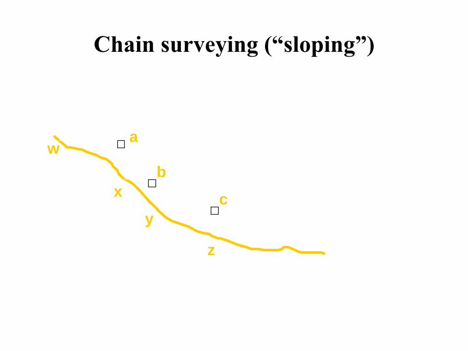
Chain surveying (“sloping”)
w
x
y
z
c
b
a

Basic levelling in chain surveys
ah
h
correction factor = xy - yz
= xy(1 - cosa)
a
y

Errors in chaining • Compensating errors – the errors which may occur in either
direction and tends to compensate are called compensating
errors.
do not effect of the results .
• Cumulative errors – the errors which may occur in the same
direction and tends to accumulate are called cumulative errors.
these error serious effect on the accuracy of survey works .

error in chaining are regarded as positive or negative according
as they make the results too great or too small.
Error may arise from
1. Incorrect length of chain or tape
2. Bad ranging
3. Careless holding and marking
4. Bad straightening
5. Non horizontality
6. Sag in chain

• Personal mistakes1. Displacement of arrows .
2. Reading of chain in wrong way
3. Misreading
4. Noting the reading in wrong way
5. Miscounting by loss of arrows
6. Incorrect counting of number of chains

TAPE CORRECTION
since the tape is used in the field under standard condition of
temperature .
1. Correction for absolute length
the absolute length of a tape is expressed as its standard length
plus or minus a correction.
Ca = L x c
l
Ca = the correction for absolute length
L = the measured length of a line.
l = standard length of a tape, c=tape correction

2. Correction for temperature .
Ct= ∞(tm - ts )L ∞ =thermal coefficient
tm = tem. During measurement
ts =standard temp. L = measured length .
3 . Correction for pull
Cp = (Pa-Ps)L pa= applied pull , ps = standard pull
A.E E = modulus of elasticity. A = area
.

4. correction for sag.
C sag =l₁(w l₁²)
24pa²
C sag = the correction for sag in ‘m’.
l₁ =weight of the tape in kg or N. per m
Pa = the pull applied in kg or N.

TRIANGULATION SURVEY
when the area to be surveyed is relatively small and flat .chain
triangulation or chain survey is carried out .
TRAVERSE SURVEYING
these type of survey in which a number of connected survey
lines from the framework and the direction and lengths of the
survey line are measured with help of an angle measuring
instrument .and tape
1.Close traverse 2.open traverse
Compass survey

Magnetic compass
• the main type of magnetic compass
1. Prismatic compass
2. Surveyor’s compass
3. Transit compass
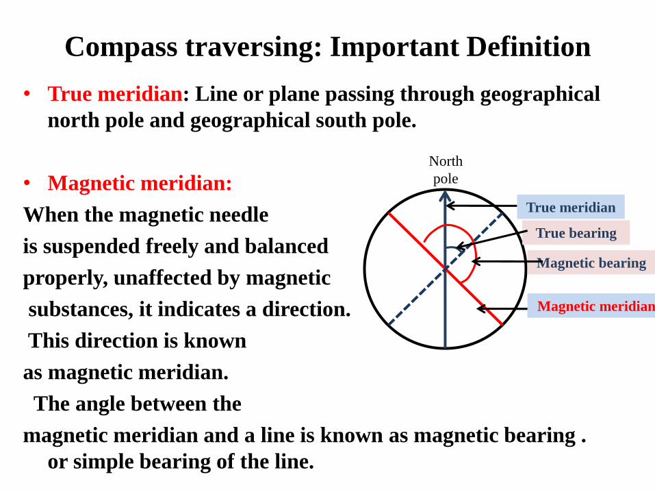
Compass traversing: Important Definition
• True meridian: Line or plane passing through geographical
north pole and geographical south pole.
• Magnetic meridian:
When the magnetic needle
is suspended freely and balanced
properly, unaffected by magnetic
substances, it indicates a direction.
This direction is known
as magnetic meridian.
The angle between the
magnetic meridian and a line is known as magnetic bearing .
or simple bearing of the line.
North
pole
True meridian
Magnetic meridian
True bearing
Magnetic bearing

• Arbitrary meridian: Convenient direction is assumed as a
meridian.
• Grid meridian: Sometimes for preparing a map some state
agencies assume several lines parallel to the true meridian for a
particular zone these lines are termed as grid meridian.
Magnetic declination: The horizontal angle between the magnetic meridian and true meridian is known as magnetic declination.
Dip of the magnetic needle: If the needle is perfectly balanced before magnetisation, it does not remain in the balanced position after it is magnetised. This is due to the magnetic influence of the earth. The needle is found to be inclined towards the pole. This inclination of the needle with the horizontal is known as dip of the magnetic needle.

• Quadrantal Bearing: The magnetic bearing of a line measured clockwise or anticlockwise from NP or SP (whichever is nearer to the line) towards the east or west is known as QB. This system consists of 4-quadrants NE, SE, NW, SW. The values lie between 0-90°
– QB of OA = N a E
• Reduced Bearing: When the whole circle bearing of a line is converted to quadrantal bearing it is termed as reduced bearing.
Whole circle bearing (WCB) Quadrantal bearing (QB)
•WCB: The magnetic bearing of a line measured clockwise from the
North Pole towards the line is known as WCB. Varies 0-360°

• Beck bearing and fore bearing
In WCB the difference between FB and BB should be exactly 180°BB=FB+/-180°Use the +ve sign when FB<180°Use the –ve sign when FB> 180°

Introduction
• Theodolite is used to measure the horizontal and vertical
angles.
• Theodolite is more precise than magnetic compass.
• Magnetic compass measures the angle up to as accuracy of
30’. However a vernier theodolite measures the angles up
to and accuracy of 10’’, 20”.
• There are variety of theodolite vernier, optic, electronic etc.

Important Definition
Changing face
Revolving the telescope by 180° in vertical
plane about horizontal axis
Again revolving the telescope in horizontal
plane about vertical axis.

Adjustment of the theodolite• Temporary Adjustment
• Setting up the theodolite


Measurement of horizontal angle• Measurement of Angle ABC
– The instrument is set over B.
– The lower clamp is kept fixed and upper clamp is
loosened.
– Turn the telescope clockwise set vernier A to 0° and
vernier B to approximately 180°.
– Upper clamp is tightened and using the upper tangent
screw the vernier A and B are exactly set to 0° and 180°.
– Upper clamp is tightly fixed, lower one is loosened and
telescope is directed towards A and bisect the ranging rod
at A.
– Tightened the lower clamp and turn the lower tangent
screw to perfectly bisect ranging rod at A.
– Loose the upper clamp and turn the telescope clockwise
to bisect the ranging rod at C tightened the upper clamp
and do the fine adjustment with upper tangent screw.
– The reading on vernier A and B are noted. Vernier A
gives the angle directly and vernier B gives the reading
by subtracting the initial reading (180°) from final
reading

• Read these two method– Repetition method
– Reiteration method

Vertical angle measurement-2

Measurements of Deflection angle magnetic
bearing
A
B
C
P
A
BN

– Anging and extending a line
• Method of traversing
– Included angle method
– Deflection angle method
– Fast angle (or magnetic bearing method)

Computation of latitude and departure• Latitude of a line is the distances measured parallel to the
north south of the North-South direction
• Departure of the line is the distance measured parallel to the
east-west direction

• Reference Books:
1) Elements of civil engineering by Rakesh Ranjan
2) Elements of civil engineering by B.C.Punamia
3) Basic Civil Engineering by L.G.Kulkarni


![Final_1]2_ phd](https://static.fdocuments.in/doc/165x107/5534d303550346c3558b4c68/final12-phd.jpg)