Digital NOTAM – Event Specification. Content Introduction General requirements AIXM Event Schema...
31
Digital NOTAM – Event Specification
-
Upload
lorena-ward -
Category
Documents
-
view
225 -
download
3
Transcript of Digital NOTAM – Event Specification. Content Introduction General requirements AIXM Event Schema...

Digital NOTAM – Event Specification

ContentIntroductionGeneral requirementsAIXM Event SchemaEvent ScenariosData encoding rulesDigital NOTAM ServicesAnnex 1 - EBNF sourcesAnnex 2 - XML Examples
Version 1.0• Released June 2011
Developed by Focus Group• NOTAM operators• NOTAM users (airlines, ATC, service provider, etc.)• Eurocontrol & FAA
Digital NOTAM Event Specification

Restricted area North of Sjaellands OddeTEMPORARY RESTRICTED AREA IS ESTABLISHED daily from 08:00-17:00 between 07 NOV and 17 NOVAS FOLLOWS NORTH OF SJAELLANDS ODDE:560028N 0111656E - 560643N 0111026E - 561500N 0112400E - 561500N 0113600E -560112N 0114736E - 555730N 0113830E - 560028N 0111656E. between SFC and 60000 FT AMSLRELEVANT ATS UNITS REF. AIP DENMARK ENR 5.1 ITEM 3:AARHUS APP/TWR, ACC KOEBENHAVN
NavaidComponent
collocationGroup : NoSequenceTypemarkerPosition : CodePositionInILSTypeprovidesNavigableLocation : CodeYesNoType
<<object>>
RunwayDirection(from Runway)
<<feature>>
TouchDownLiftOff(from Helicopter Surfaces)...)
<<feature>>
AirportHeliport(from Airport/Heliport)
<<feature>>
ElevatedPoint(from Geometry)
<<object>>
Navaid
type : CodeNavaidServiceTypedesignator : CodeNavaidDesignatorTypename : TextNameTypeflightChecked : CodeYesNoTypepurpose : CodeNavaidPurposeTypesignalPerformance : CodeSignalPerformanceILSType...courseQuality : CodeCourseQualityILSTypeintegrityLevel : CodeIntegrityLevelILSType
<<feature>>
0..*
0..*
+runwayDirection0..*
0..*
isInstalledAt
0..1 +location0..1
isNavigableBy 0..*
0..*
+touchDownLiftOff0..*
0..*isInstalledAt
0..*
0..*
+servedAirport0..*
0..*usedForHomingAt
NavaidOperationalStatus
operationalStatus : CodeStatusNavaidTypesignalType : CodeRadioSignalType
<<object>>
0..*+availability
0..*
worksBy
NavaidEquipment
designator : CodeNavaidDesignatorTypename : TextNameTypeemissionClass : CodeRadioEmissionTypemobile : CodeYesNoTypemagneticVariation : ValMagneticVariationTypemagneticVariationAccuracy : ValAngleTypedateMagneticVariation : DateYearTypeflightChecked : CodeYesNoType
<<feature>>
0..1+location
0..1
isPlacedAt0..*
0..*
+navaidEquipment0..*
0..*
isComposedOf
0..* +availability0..*
worksBy
Data encoding rules
Data validation rules
Digital NOTAMAIXM 5.1 encoded data output
(Snnnn/yy NOTAMN
Q) EKDK/QRRCA/IV/BO /W /000/600/5606N01130E012
A) EKDK B) 0711010800 C) 0711011100
E) TEMPORARY RESTRICTED AREA ESTABLISHED
AS FOLLOWS (NORTH OF SJAELLANDS ODDE):
560028N 0111656E - 560643N 0111026E - 561500N 0112400E -
561500N 0113600E -560112N 0114736E - 555730N 0113830E -
560028N 0111656E.
RELEVANT ATS UNITS REF. AIP DENMARK ENR 5.1 ITEM 3:
AARHUS APP/TWR, ACC KOEBENHAVN.
DANGER AREA WITHIN THE PORTION OF AIRSPACE OVER THE HIGH SEA.
F) SFC G) 60000FT AMSL)
NOTAM production rules
Event data
Text NOTAMICAO Format
RulesRules
Rules
Target: application developers !
Digital NOTAM Event Specification - Purpose

Scenario definition - example

Examples
• Restricted area North of Sjaellands OddeTEMPORARY RESTRICTED AREA IS ESTABLISHED daily from 08:00-17:00 between 07 NOV and 17 NOVAS FOLLOWS NORTH OF SJAELLANDS ODDE:560028N 0111656E - 560643N 0111026E - 561500N 0112400E - 561500N 0113600E -560112N 0114736E - 555730N 0113830E - 560028N 0111656E. between SFC and 60000 FT AMSLRELEVANT ATS UNITS REF. AIP DENMARK ENR 5.1 ITEM 3:AARHUS APP/TWR, ACC KOEBENHAVN
• Aerobatics at Pferdsfeld AEROBATICS VMC on 07 OCT from 1330 till 1430 2NM AROUND 4952N 00737E PFERDSFELD 10NM E KIRN VOR KIR between GND and 6000FT AMSL

Event data
possibly
possibly possibly, more
End
possibly
possibly
possibly possibly

excluded airspace (optional)
typeRestricted Area
schedule (optional)Daily 08:00-17:00
controlling unit note (optional)Relevant ATS units ref. AIP Denmark
ENR 5.1 ITEM 3: AARHUS APP/TWR, ACC KOEBENHAVN
upper limit6000 FT AMSL
lower limitSFC
horizontal limits560028N 0111656E - 560643N 0111026E – 561500N 0112400E - 561500N 0113600E – 560112N 0114736E - 555730N 0113830E –
560028N 0111656E
start time07 NOV 08:00
activity (optional)name (optional)
end time (optional)17 NOV 17:00
designator (optional)
TEMPORARY RESTRICTED AREA IS ESTABLISHED daily from 08:00-17:00 between 07 NOV and 17 NOVAS FOLLOWS NORTH OF SJAELLANDS ODDE:560028N 0111656E - 560643N 0111026E - 561500N 0112400E - 561500N 0113600E -560112N 0114736E - 555730N
0113830E - 560028N 0111656E. between SFC and 60000 FT AMSLRELEVANT ATS UNITS REF. AIP DENMARK ENR 5.1 ITEM 3: AARHUS APP/TWR, ACC KOEBENHAVN.
location note (optional)North of Sjaellands Odde
excluded airspace (optional)
excluded airspace (optional)
note (optional)
Event data – mapped with example

AirspaceGeometryComponent
operation : CodeAirspaceAggregationTypeoperationSequence : NoSequenceType
<<object>>
AirspaceVolumeDependency
dependency : CodeAirspaceDependencyType
<<object>>
Surface(from Geometry)
<<object>>
AirspaceVolume
upperLimit : ValDistanceVerticalTypeupperLimitReference : CodeVerticalReferenceTypemaximumLimit : ValDistanceVerticalTypemaximumLimitReference : CodeVerticalReferenceTypelowerLimit : ValDistanceVerticalTypelowerLimitReference : CodeVerticalReferenceTypeminimumLimit : ValDistanceVerticalTypeminimumLimitReference : CodeVerticalReferenceTypewidth : ValDistanceType
<<object>>
0..1
1
+horizontalProjection 0..1
1
hasBoundary
Airspace
type : CodeAirspaceTypedesignator : CodeAirspaceDesignatorTypelocalType : TextNameTypename : TextNameTypedesignatorICAO : CodeYesNoTypecontrolType : CodeMilitaryOperationsTypeupperLowerSeparation : ValFLType
<<feature>>
0..1
0..*
+contributorAirspace
0..1
0..*
dependsOn
0..*+geometryComponent 0..*
hasGeometry
PropertiesWithSchedule(from Schedules)
<<object>>
AirspaceLayer
upperLimit : ValDistanceVerticalTypeupperLimitReference : CodeVerticalReferenceTypelowerLimit : ValDistanceVerticalTypelowerLimitReference : CodeVerticalReferenceTypealtitudeInterpretation : CodeAltitudeUseType
(from Airspace Layer)
<<object>>
AirspaceActivation
activity : CodeAirspaceActivityTypestatus : CodeStatusAirspaceType
<<object>>
0..*+activation 0..*
isActive
0..*+levels
0..*
concerns
AIXM Mapping
FLOOR - CEILLING
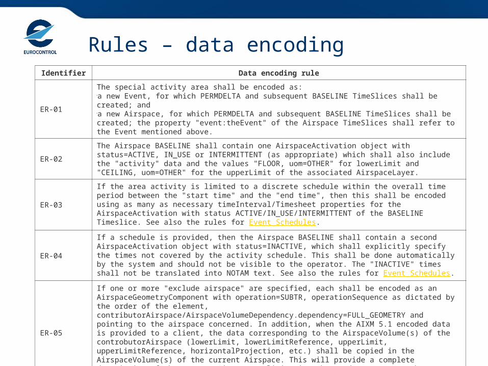
Rules – data encodingIdentifier Data encoding rule
ER-01
The special activity area shall be encoded as:a new Event, for which PERMDELTA and subsequent BASELINE TimeSlices shall be created; anda new Airspace, for which PERMDELTA and subsequent BASELINE TimeSlices shall be created; the property "event:theEvent" of the Airspace TimeSlices shall refer to the Event mentioned above.
ER-02The Airspace BASELINE shall contain one AirspaceActivation object with status=ACTIVE, IN_USE or INTERMITTENT (as appropriate) which shall also include the "activity" data and the values "FLOOR, uom=OTHER" for lowerLimit and "CEILING, uom=OTHER" for the upperLimit of the associated AirspaceLayer.
ER-03
If the area activity is limited to a discrete schedule within the overall time period between the "start time" and the "end time", then this shall be encoded using as many as necessary timeInterval/Timesheet properties for the AirspaceActivation with status ACTIVE/IN_USE/INTERMITTENT of the BASELINE Timeslice. See also the rules for Event Schedules.
ER-04
If a schedule is provided, then the Airspace BASELINE shall contain a second AirspaceActivation object with status=INACTIVE, which shall explicitly specify the times not covered by the activity schedule. This shall be done automatically by the system and should not be visible to the operator. The "INACTIVE" times shall not be translated into NOTAM text. See also the rules for Event Schedules.
ER-05
If one or more "exclude airspace" are specified, each shall be encoded as an AirspaceGeometryComponent with operation=SUBTR, operationSequence as dictated by the order of the element, contributorAirspace/AirspaceVolumeDependency.dependency=FULL_GEOMETRY and pointing to the airspace concerned. In addition, when the AIXM 5.1 encoded data is provided to a client, the data corresponding to the AirspaceVolume(s) of the controbutorAirspace (lowerLimit, lowerLimitReference, upperLimit, upperLimitReference, horizontalProjection, etc.) shall be copied in the AirspaceVolume(s) of the current Airspace. This will provide a complete description of the current Airspace, eliminating the need to traverse the xlink:href in order to get the full geometrical information.
ER-06
The activity types that do not match a pre-defined value in the CodeAirspaceActivityType shall be encoded as follows:captive balloon -> activity=OTHER:CAPTIVE_BALLOONkite activities -> activity=OTHER:KITEdemolition using explosive devices -> activity=OTHER:DEMOLITIONmass movement of aircraft ->activity=OTHER:ACFT_MASS_MOVEMENTflying in formation -> activity=OTHER:ACFT_FORMATIONaerial survey/photogrammetric flights -> activity=OTHER:AERIAL_SURVEYmodel flying -> OTHER:MODELairborne spread of diseases -> activity=OTHER:BIO_HAZARDindustrial action -> activity=OTHER:STRIKE volcanic activity, possibly indication imminent eruption -> activity=OTHER:VOLCANO_ACTIVEconfirmed volcanic eruption -> activity=OTHER:VOLCANO_ERUPTION volcanic ash area of high contamination -> activity=OTHER:ASH_HIGHvolcanic ash area of medium contamination -> activity=OTHER:ASH_MEDIUMvolcanic ash area of low contamination -> activity=OTHER:ASH_LOWunspecified hazard -> activity=OTHER

Rules – event schedules encoding

11Copyright 2005 EUROCONTROL
• If the first period of activity starts on 062300 and ends on 070500 and a series of subsequent 2300-0500 periods starts on 102300 and ends on 150500:
D) 06 AND 10-14 2300-0500
• If the activity times in the series differ and the first period (2300-0500) starts on 062300 and ends on 100500 and the final period (2200-0600) starts on 102200 and ends on 110600:
D) 06-09 2300-0500 AND 10 2200-0600
NAV32517.4.3938
OPADD - Item D

Rules – data encoding
The composition rule is derived from the ICAO Annex 15 rules for P, D, R area designators: CCLnnnn-yy, where:
• CC is the Country Code; this could be expanded into a full FIR identifier if necessary to have a finer granularity of the airspace reference;
• L is a letter that corresponds to the area type;
• nnnn is a number, unduplicated during the same year, within the State or territory concerned; this could also be the NOTAM number;
• yy are the last two digits of the year date when the area becomes effective
ER-08It is recommended that an alphanumeric designator is allocated to a temporary area, in order to facilitate it's identification on graphical representations (such as airspace activity maps) and verbal communication.

Digital NOTAM – AIXM 5.1 encoding

NOTAM production – Q code

NOTAM production – E field

16Copyright 2005 EUROCONTROL
• Abbreviate Months as: JAN FEB MAR APR MAY JUN
JUL AUG SEP OCT NOV DEC
• and Days as: MON TUE WED THU FRI SAT SUN
• Use ‘AND’ before last date: D) APR 04 06 08 AND 11
• or before last times: D) MAR 04 0600-0800 AND 1000-1200
• Use -- not //: D) 0700-1000
• and link continuous period: D) WED 1900-FRI 0600
• or when using SR & SS: D) SR MINUS30-SS PLUS30
• If activity spans ‘midnight’ UTC, use the following format ….. /
NAV32517.4.3938
NOTAM production – item D

(Snnnn/yy NOTAMN
Q) EKDK/QRRCA/IV/BO /W /000/600/5606N01130E012
A) EKDK B) 0711010800 C) 0711011100
D) DAILY 0800 -1700
E) TEMPORARY RESTRICTED AREA ESTABLISHED
(NORTH OF SJAELLANDS ODDE) AS FOLLOWS :
560028N 0111656E - 560643N 0111026E - 561500N 0112400E -
561500N 0113600E -560112N 0114736E - 555730N 0113830E -
560028N 0111656E.
RELEVANT ATS UNITS REF. AIP DENMARK ENR 5.1 ITEM 3:
AARHUS APP/TWR, ACC KOEBENHAVN.
F) SFC G) 60000FT AMSL)
Resulting NOTAM

Obstacles

Scenario definition
• “establishment of a new temporary or permanent obstacle”
• Includes• Obstacles defined by point / line / polygon • Mobile obstacles• Group of similar objects located closely• Airport and en-route obstacles
• Not covered in this scenario• Obstacles composed of multiple parts• Obstacles with variable elevations
Only one elevation value can be provided

Examples
• Temporary crane at the airportConstruction crane at ETAR From 01 OCT 2007 05:31 till 30 OCT 2007 18:26.PSN 492623N 0073604E (500 FT South of Control Tower).Maximum height 858 FT MSL / 85 FT GND. Night marked.
• Crane with schedule in FIRHigh crane erected within EDGG FIRFrom 01 OCT 2007 04:30 till 09 OCT 2007 14:29, daily 04:30-14:29.Position: 513759N 0072024E with elevation 675FT/483FT GND. ICAO marked.
• Mobile obstacleMobile obstacle: BoatFrom 01 AUG 2007 20:00 till 15 AUG 2007 04:00 as follows: daily 20:00 till next day 04:00.Floating south of AD between 200m to 1,5NM from Mike Helistop.height: 42M. Night marked.

End
Event data
possibly
alternativespossibly
possibly
possibly, more
alternatives

ElevatedCurve(from Geometry)
<<object>>ElevatedSurface(from Geometry)
<<object>>
ElevatedPoint(from Geometry)
<<object>>
VerticalStructurePartGeometry<<choice>>
0..1+linearExtent 0..1
hasCurveShape
0..1
+surfaceExtent
0..1
hasSurfaceShape
0..1
+location
0..1
hasPointShape
VerticalStructure
name : TextNameTypetype : CodeVerticalStructureTypelighted : CodeYesNoTypemarkingICAOStandard : CodeYesNoTypegroup : CodeYesNoTypelength : ValDistanceTypewidth : ValDistanceTyperadius : ValDistanceTypelightingICAOStandard : CodeYesNoTypesynchronisedLighting : CodeYesNoType
<<feature>>
VerticalStructurePart
verticalExtent : ValDistanceTypeverticalExtentAccuracy : ValDistanceTypetype : CodeVerticalStructureTypeconstructionStatus : CodeStatusConstructionTypemarkingPattern : CodeVerticalStructureMarkingTypemarkingFirstColour : CodeColourTypemarkingSecondColour : CodeColourTypemobile : CodeYesNoTypefrangible : CodeYesNoTypevisibleMaterial : CodeVerticalStructureMaterialTypedesignator : TextDesignatorType
<<object>>
+horizontalProjection
isRepresentedAs
0..*+part 0..*
isMadeOf
AIXM Mapping

AIXM Mapping

Prerequisites:assumptions for baseline (static) data
• It is assumed that the Area 2 is available as BASELINE data for all airports that have an ICAO location designator and which are situated in the area of responsibility of the data provider

Rules – data encoding

Rules – automatic validation

ElevatedCurve(from Geometry)
<<object>>ElevatedSurface(from Geometry)
<<object>>
ElevatedPoint(from Geometry)
<<object>>
VerticalStructurePartGeometry<<choice>>
0..1+linearExtent 0..1
hasCurveShape
0..1
+surfaceExtent
0..1
hasSurfaceShape
0..1
+location
0..1
hasPointShape
VerticalStructure
name : TextNameTypetype : CodeVerticalStructureTypelighted : CodeYesNoTypemarkingICAOStandard : CodeYesNoTypegroup : CodeYesNoTypelength : ValDistanceTypewidth : ValDistanceTyperadius : ValDistanceTypelightingICAOStandard : CodeYesNoTypesynchronisedLighting : CodeYesNoType
<<feature>>
VerticalStructurePart
verticalExtent : ValDistanceTypeverticalExtentAccuracy : ValDistanceTypetype : CodeVerticalStructureTypeconstructionStatus : CodeStatusConstructionTypemarkingPattern : CodeVerticalStructureMarkingTypemarkingFirstColour : CodeColourTypemarkingSecondColour : CodeColourTypemobile : CodeYesNoTypefrangible : CodeYesNoTypevisibleMaterial : CodeVerticalStructureMaterialTypedesignator : TextDesignatorType
<<object>>
+horizontalProjection
isRepresentedAs
0..*+part 0..*
isMadeOf
Automatic NOTAM creationTemporary crane at the airportConstruction crane at ETAR From 01 OCT 2007 05:31 till 30 OCT 2007 18:26PSN 492623N 0073604E (500 FT South of Control Tower)Maximum height 858 FT MSL / 85 FT GND. Night marked
(P4246/07 NOTAMR P2786/07
Q) EDGG/QOBCE/IV/M /A /000/999/4926N00736E005
A) ETAR B) 0710010531 C) 0710301826
E) CONSTRUCTION CRANE 500 FT SOUTH OF CONTROL TOWER AT PSN
492623N0073604E. MAX HEIGHT 858 FT MSL / 85 FT GND. NIGHT MARKED.)
Automatic NOTAM Generation

NOTAM production rules – E field

Resulting NOTAM
(Snnnn/yy NOTAMN
Q) EDGG/QOBCE/IV/M /A /000/999/4926N00736E005
A) ETAR B) 0710010531 C) 0710301826
E) TEMPORARY CRANE
AT ETAR
492623N 0073604E ELEVATION 858 FT MSL (HEIGHT 85 FT GND)
500 FT SOUTH OF CONTROL TOWER.
LIGHTED.
THE HEIGHT IS A MAXIMUM VALUE.
LIGHTED ONLY AT NIGHT.)

Event Specification - summary
• Identify categories of events • temporary obstacle at the airport• ad-hoc restricted area• etc.
• For each type of event, specify: • the data usually provided• the data encoding rules
• including AIXM mapping• the data validation rules• the conversion rules into text NOTAM (ICAO format)• Examples

Questions?Questions?