
Digital maps / Digitale Landkartenregiograph.ch/con/cms/upload/02_LANDKARTEN/pdf/gis_software... ·...
65
Digitale Landkarten / Digital maps Amerika / America
Transcript of Digital maps / Digitale Landkartenregiograph.ch/con/cms/upload/02_LANDKARTEN/pdf/gis_software... ·...

Digitale Landkarten / Digital maps Amerika / America

Quality features of GfK GeoMarketing’s digital maps: • Gap- and overlap-free digitalization • Vector-based with infinite zoom capability • Perfect fit with all worldwide maps provided by GfK GeoMarketing • Regular updates and additions • Based on geographic coordinates (WGS84) • Inclusion of English, international or local attributions • Cross-checked with the latest satellite imagery • Perfect fit with GfK GeoMarketing’s market and purchasing power data
Digitale Landkarten von GfK GeoMarketing Die Landkartenedition Amerika gehört zu einem der umfangreichsten Landkartenarchive mit der weltweit größten Sammlung an digitalen postalischen und administrativen Landkarten. Es bietet Karten für mehr als 240 Länder weltweit, fertig einsatzbereit für GeoMarketing-Softwares, Geografische Informationssysteme (GIS), Internet- und Intranetapplikationen oder Data Warehouse und CRM-Systeme.
Alle Karten werden von Kartographen und Geoinformatikern mit langjähriger Erfahrung in der Kartenproduktion bei uns im Haus manuell digitalisiert. Das hat den Vorteil, dass alle Länder unseren Qualitätskriterien entsprechen, d.h. alle Karten sind lagegenau und geometrisch 100% fehlerfrei, aneinander grenzende Geometrien zeigen weder Überlappungen noch Lücken. Dies gilt nicht nur für die administrativen und postalischen Gebiete, sondern auch für die topografischen Kartenebenen wie z.B. Straßen und Gewässer. Zudem sind die Tabellenspalten der Karten für alle Länder so angelegt, dass beliebig viele Länder direkt zu einer Karte kombiniert werden können.
Die Bezeichnungen der Gebiete sind für viele Länder sowohl in der Landessprache mit den ländertypischen Schriftzeichen als auch in internationaler Schreibweise (ASCII) enthalten.
Digital maps from GfK GeoMarketing The America Map Edition is part of the world’s most comprehensive digital postal and administrative map collection. GfK GeoMarketing provides maps for more than 240 countries, all of which are ready for incorporation into geomarketing software applications, geographic information systems (GIS), internet applications, data warehouses and CRM systems.
All maps are manually digitized by experienced cartographers and geoinformatics specialists. The resulting high-quality maps are accurate and geometrically 100% error-free, all adjacent geographic areas are free of both gaps and overlaps. This is true not only of the administrative and postcode areas, but also of the topographic map layers, such as those featuring streets and bodies of water. Additionally, the data columns for all of our maps are optimally arranged, allowing you to combine maps from multiple countries within your active workspace.
For many countries, place-name attributions are provided in both the native language (and script) as well as the international format (ASCII).

Salto de Pirapora
Votorantim
Ibiúna
Piedade
São Lourenço da Serra
Itapecerica da Serra
Embu-Guaçu
Cubatão
São Bernardo do Campo
São Paulo
Diadema
Santo André
Mauá
São Caetano do Sul
Taboão da Serra
Embu
Cotia
Vargem Grande Paulista
São RoqueItapevi
Araçariguama
Santana de Parnaíba
Barueri
Jandira
Carapicuíba Osasco
Guarulhos
Caieiras
Franco da Rocha Mairiporã
Francisco Morato
Campo Limpo PaulistaVárzea Paulista
Cajamar
Pirapora do Bom Jesus
CabreúvaItu
Alumínio
Mairinque
Sorocaba
a Serra
Iperó
Porto Feliz
Rafard
Salto
Indaiatuba
Elias Fausto
Monte Mor
Hortolândia
Capivari
Mombuca
Rio das Pedras
IracemápolisLimeira
Artur Nogueira
Cosmópolis
Paulínia
Americana
Santa Bárbara d'Oeste
Sumaré
Nova Odessa
Pedreira
AmparoJaguariúna
Santo Antônio de Posse
Holambra
Serra Negra
Lindóia
Socorro
Monte Alegre do Sul
Tuiuti
PinhalzinhoPedra Bela
Vargem
Bragança Paulista
Morungaba
Campinas
Valinhos
Itatiba
Louveira
Vinhedo
Itupeva
Jundiaí
Jarinu
Atibaia
Bom Jesus dos Perdões
Piracaia
Igaratá
Caçapava
São José dos Campos
Monteiro LobatoJoanópolis
Extrema
Camanducaia
ItapevaToledo
Munhoz
Senador Amaral
Córrego do Bom Jesus
Cambuí
Consolação
Paraisópolis
Gonçalves
Sapucaí-Mirim
Santo Antônio do Pinhal
Campos do Jordão
São Bento do Sapucaí
Piranguçu Wenceslau Braz
Potim
Roseira
Pindamonhangaba
Tremembé
Taubaté
São Lu
Natividade da Serra
Paraibuna
Redenção da Serra
Jambeiro
Jacareí
Nazaré Paulista
Santa Isabel
Guararema
Arujá
Itaquaquecetuba
Poá
Santa Branca
Salesópolis
Biritiba-Mirim
Mogi das Cruzes
Ferraz de Vasconcelos
Suzano
Ribeirão Pires
Rio Grande da Serra
Santos
BertiogaSão Sebastião
Caraguatatuba
Ilhabela
Guarujá
São Vicente
Mongaguá
Praia Grande
Itanhaém
Juquitiba
aí
BrasópolisBueno BrandãoEngenheiro Coelho
Cordeirópolis
Paruru
Canguera
Cipó-Guaçu
Riacho Grande
Aldeia de Carapicuíba
Caucaia do Alto
Mailasqui
São João Novo
Polvilho
AldeiaJardim Belval
Vila Dirce
Jardim Presidente Dutra
Botujuru
Jordanésia
Bom Fim do Bom Jesus
Jacaré
etava
Cardeal
Nova Aparecida
Mombuca
Rafard
Saltinho
Tupi
esinha de Piracicaba
ndia
Assistência
Guamium
Nova VenezaBarão de Geraldo
Arcadas
Holambra
Martim Francisco Lindóia
Mostardas
Monte Alegre do Sul
Três Pontes
Tuiuti
Pedra Bela
VargemJoaquim EgídioSouzas
Batatuba
Eugênio de Melo
Monteiro Lobato
São Francisco Xavier
Monte Verde
Itapeva
Toledo
Munhoz
Ponte Segura
Senador Amaral
Costas
Córrego do Bom Jesus
Consolação
Gonçalves
Sapucaí-Mirim
São Mateus de Minas
Santo Antônio do Pinhal
Luminosa
Piranguçu
Wenceslau Braz
Itererê
Roseira
Moreira César
Quiririm
Bairro Alto
Natividade da Serra
Redenção da Serra
Jambeiro
São Silvestre de Jacareí
Parque Meia Lua
Igaratá
Boa Vista Paulista
Cidade KemelSanta Margarida Paulista
Brás Cubas
Cezar de Souza
Sabaúna
Nossa Senhora do Remédio
Biritiba-Ussu
Palmeiras de São Paulo
Ouro Fino Paulista
Jardim Santa Luzia
Taiaçupeba
Paranapiacaba
Cambaquara
São Francisco da Praia
Maresias
Porto Novo
Paranabi
Vicente de Carvalho
Solemar
Tapiraí
São Lourenço da Serra
Araçariguama
Pirapora do Bom Jesus
Alumínio
Elias Fausto
Iracemápolis
Santo Antônio de Posse
Pinhalzinho
Morungaba
Bom Jesus dos Perdões
Nazaré Paulista
Joanópolis
Camanducaia
Paraisópolis
São Bento do Sapucaí
São Luís do Paraitinga
ParaibunaSanta Branca
Salesópolis
Engenheiro Coelho
25 km
Brazil administrative units

Newton
Whalley
SappertonQueens Park
Queensborough
Connaught Heights
Glenbrooke NorthKelvinMiddlegateSouth SlopeSuncrestKillarney
North Delta
Strawberry Hilleston
Seafair
Thompson
Broadmoor
Southarm
Brighouse Richmond
Victoria-FraserviewSunset
Marpole
Kerrisdale
Burkeville
Canyon HeightsDelbrook
North Lonsdale
Keith-LynnNorgate
Cedardale
Pemberton Heights
Capilano HighlandsBritish Properties
HollyburnDundarave
Arbutus RidgeDunbar-Southlands
Point Grey Kitsilano Fairview Mount Pleasant
West End Grandview-WoodlandsStrathcona
Kensington-Cedar CottageSouth CambieShaughnessy Riley Park
Oakridge
Renfrew-Collingwood Cascade Heights
Garden Village
MetrotownEastburn
Buckingham Heights Brunette Creek
Sullivan Heights Cariboo
Burnaby
Westridge
Burquitlam
Barnet
Brentwood Park
Capitol HillBurnaby Heights
Willingdon Heights
Hastings-Sunrise
Lynnmour Windsor Park
Seymour Heights
Blueridge
Lynn Valley
Upper Lynn
Woodlands
Deep Cove
Coombe
BelcarraDollarton Woodhaven Anmore
Ioco
Pleasantside
Harbour Chines
Austin Heights Laure
Fraser Mills
3 km
Canada postal units

94
95
94924
94965
94970
9490494914
94957
94939
94976
94942
94941
94920
94925
94974
94801
94802
94808
94966
9412994123
94109 94120
94133
94130
9410294103 94158
94122 94146
94117
94143
9411894115
94121
94583
94605
94619
94613
94606
9460194501
94615
94608 94609
94649 94610
94602
9451694611
94620
94618
94563
9470594701
94709
947029471294710
94850
94706
9470894707
9453094804
94805
94803
94549
9452394518
9459894597
94596
94595
94556
94526
94528
94507
94521
94517
94531
94551
94506
94582
94535
94585
94512
94509
94565
94510
945299452494520
9451994553
9456994525
94572
94547
94564
9482094806
94590
94591
94589
94592
94503
94534
94533
94559
94581
94558
95688
95687
95625
95696
95620
95694
94574
94576
94508
95471
95446 95492
95403
95439
95401
95444
95436
95486
95465
95419
94922
95472
9547395407
94928
94927
9492694953
95442
95405
95402
95404
95409
95452
94573
94562
94599
95431
95487
95476
95433
95416
94999
94954
94955
94912
94913
94979
9497894960
94930
94933 94963 94973
9494694949
94945
9494894947
94956
94938
94950
94937
94940
94952
94972
9497194929
Woodville
Tamalpais Valley
Muir Beach
Stinson Beach
Bolinas
Kent Woodlands
Ross
Green Brae
Escalle
Baltimore Park
Corte Madera
Alto
Almonte
Tamalpais Valley Junction Harbor Point
Strawberry Manor
Hilarita
El Campo
Paradise Cay
Reed
Chapman
Meadowsweet
San Quentin
North Richmond
Point Richmond
Fort McDowell
T iburonWaldo
Sausalito
Fort Winfield ScottMarina District
Chinatown
North Beach
Little Osaka
Mission District Potrero District
Sunset District
Richmond District
Western Addition
Brookshire
Emeryville
West Oakland
Chinatown
Canyon
Eastport
Kensington
Stege
East Richmond Heights
Rollingwood
Orinda Village
Waldon
Bancroft
Hookston
Four Corners
Sunny Acres Trailer Park
Meinert
Sacanap
Saranap
Walnut Heights
Rheem ValleyGlorietta
Valle Vista
Diablo
Blackhawk
Tassajara
Rock City
Alamo Oaks
Cowell
Nortonville Somersville
Stewartville
Marsh Creek Springs
West Hartley
Dozier
Vale
Olcott
Cannon
Cordero Junction
Vacaville Junction
Travis Field
Creed
Rio Vista Junction
Denverton
Bridgehead
Newlove
Diamond Cornwall
Los Medanos
West Pittsburg
Chipps
McAvoyNichols
Spoonbill
Dutton Collinsville
Montezuma
Birds Landing
Molena
Meins Landing
Pierce
Bahia
Monsanto
Avon
Maltby
Clyde
Pacheco
Vine HillMountain View
Muir
Glen Frazer
Ozol Mococo
Port Costa
EckleyCrolona Heights
Tormey
Oleum
Luzon
Christie
Herpoco
Montalvin ManorTara Hills
Gateley
Rodeo
Bayo Vista
Selby
Carquinez Heights
Glencove
South Vallejo
Harry Floyd Terrace
Flosden Acres
Guadalcanal Village
American Canyon
Brazos
Buchli
Cuttings Wharf
Ratto Landing
Middleton
Squab
Lombard
Creston
Napa Junction
Collins
Chabot Terrace
Cygnus
Teal
Jacksnipe
Subeet
Thomasson
Cordelia
Cordelia Junction
Green Valley
ChadbourneRockville Willota
Danielson Russell
Clima
Tolenas
Mankas Corner
Rocktram
Thompson
Stanley Suscol
Imola
Napa Abajo
Union
Salvador
Oak Knoll
Vichy Springs
Napa Soda Springs
Atlas
Bucktown
Elmira
Leisure Town
Batavia
Binghamton
Sucro
Allendale
Hartley
El Rio Villa
Winters
Berryessa Highlands
Steel Canyon Resort
Spanish FlatDeer Park
Saint Helena
Krug
Barro
Bale
Sanitarium
AngwinVeteran Heights
Howell MountainCalistoga
Larkmead
Rio Nido
Hale Place
Monte Rosa
Guernewood Park
Guerneville
El Bonita
Korbel
Santa Nella
Odd Fellows Park
Summerhome Park
Hollydale
HaciendaMount Jackson
Rio Dell
Wilson Grove
Shiloh
East Windsor
Mark West Springs
Fulton
Monroe
RoselandRiccas Corner
Llano
Molino
Hurlbut
Barlow
Graton
Sousa Corners
WoolseyTrenton
Mirabel Heights
Forestville
Ross
Noel Heights
Northwood Lodge
Edendale
Guernewood
Vacation Beach
Monte Rio
Villa Grande
Alliance Redwood
Tyrone
Camp Meeker
Freestone
Occidental
Bodega
Knowles Corner
SebastopolGravenstein
Alten
Fredericks
South Santa Rosa
Bellevue
Wilfred
Cunningham
Cadwell
Hessel
Woodworth
Turner
Orchard
Roblar
Cotati
Glen EllenWaldrue Heights
Montgomery Village
Bak Melita
Oakmont
Lawndale
Los Guilicos
Kenwood
Thoman
Zinfandel
Rutherford
Oakville
Yountville
Lokoya
Enchanted Hills
Eldridge
Agua Caliente
Shellville Colony
Vineburg
Four Corners
Schellville
Embarcadero
Big Bend
Temelec
El Verano
Bonilla
Batto
Buena VistaSonoma
Verano
Mission HighlandsFetters Hot Springs
Boyes Hot Springs
Sonoma Vista
Diamond A Ranch Estates
Penngrove
Crown
Leisure Lake Mobile Home Park
East Petaluma
Lakeville
McNear
Haystack
Burdell
San Antonio
Sears Point
Fairville
McGill
Wingo
Ramal
Merazo
Black Point
Bel Marin Keys
Sobrante
Nitro
Giant
Rheem
McNears Beach
Marinwood
Lucas ValleySaint Vincent
GallinasLas Gallinas
Terra Lindo
Terra Linda
Los Ranchitos
Santa Venetia
Cerro
Fairfax
Manor
Sleepy Hollow
Forest KnollsSan Geronimo Woodacre
DewittRafael Village
Old Town
Seahaven
Inverness
Millerton
Bivalve
Inverness Park
Point Reyes Station
Nicasio
Tocaloma
Jewell
Lagunitas
Shafter
Five Brooks
Olema
Marconi
Blakes Landing
Nicks Cove
Hamlet
Vincent Landing
Ocean Roar
McDonald
Sacramento Landing
Lairds Landing
Cypress Grove
Marshall
Reynolds
Two Rock
Liberty
Washoe
Stony Point
Bloomfield
Valley Ford
Fallon
Tomales
Dillon Beach
Larkspur
Mill Valley
Piedmont
Orinda
Albany
Alamo
Moraga
Clayton
Pinole
El Sobrante
Hercules
Dixon
San Anselmo
10 km
United States postal units

Layer‐/Filename Object type* Type No. of objects Off. code** Nat. lang.***
Digital maps of Anguilla
Anguilla districts 2010 admin (level 1) polygon 14
Anguilla cities topogr point 17
Anguilla airports topogr point 1
Anguilla hydro areas topogr polygon 10
Anguilla roads topogr line 25
Available for all formats (RegioGraph, ESRI/shape, MapInfo/tab): 5 layers

Layer‐/Filename Object type* Type No. of objects Off. code** Nat. lang.***
Digital maps of Antigua and Barbuda
Antigua and Barbuda parishes 2010 admin (level 1) polygon 8
Antigua and Barbuda cities topogr point 19
Antigua and Barbuda airports topogr point 1
Antigua and Barbuda roads topogr line 23
Available for all formats (RegioGraph, ESRI/shape, MapInfo/tab): 4 layers

Layer‐/Filename Object type* Type No. of objects Off. code** Nat. lang.***
Digital maps of Argentina
Argentina provinces 2010 admin (level 1) polygon 24
Argentina departments 2010 admin (level 2) polygon 531
Argentina 2‐digit postcode areas 2010 postal (2‐digit) polygon 70
Argentina cities over 100,000 topogr point 59
Argentina cities 50,‐100,000 topogr point 53
Available for all formats (RegioGraph, ESRI/shape, MapInfo/tab): 13 layers
Argentina cities 20,‐50,000 topogr point 119
Argentina cities 10,‐20,000 topogr point 153
Argentina cities under 10,000 topogr point 4884
Argentina airports topogr point 122
Argentina hydro lines topogr line 174
Argentina hydro areas topogr polygon 503
Argentina highways topogr line 18Argentina highways topogr line 18
Argentina roads topogr line 176

Layer‐/Filename Object type* Type No. of objects Off. code** Nat. lang.***
Digital maps of Aruba
Aruba regions 2010 admin (level 1) polygon 8
Aruba cities topogr point 5
Aruba airports topogr point 1
Aruba roads topogr line 3
Available for all formats (RegioGraph, ESRI/shape, MapInfo/tab): 4 layers

Layer‐/Filename Object type* Type No. of objects Off. code** Nat. lang.***
Digital maps of Bahamas
Bahamas districts 2010 admin (level 1) polygon 32
Bahamas cities topogr point 27
Bahamas airports topogr point 25
Bahamas hydro areas topogr polygon 143
Bahamas roads topogr line 57
Available for all formats (RegioGraph, ESRI/shape, MapInfo/tab): 5 layers

Layer‐/Filename Object type* Type No. of objects Off. code** Nat. lang.***
Digital maps of Barbados
Barbados parishes 2010 admin (level 1) polygon 11
Barbados cities topogr point 22
Barbados airports topogr point 1
Barbados roads topogr line 20
Available for all formats (RegioGraph, ESRI/shape, MapInfo/tab): 4 layers

Layer‐/Filename Object type* Type No. of objects Off. code** Nat. lang.***
Digital maps of Belize
Belize districts 2010 admin (level 1) polygon 6
Belize constituencies 2010 admin (level 2) polygon 31
Belize cities 50,‐100,000 topogr point 1
Belize cities 10,‐20,000 topogr point 3
Belize cities under 10,000 topogr point 29
Available for all formats (RegioGraph, ESRI/shape, MapInfo/tab): 10 layers
Belize airports topogr point 1
Belize hydro lines topogr line 13
Belize hydro areas topogr polygon 35
Belize major roads topogr line 6
Belize minor roads topogr line 9

Layer‐/Filename Object type* Type No. of objects Off. code** Nat. lang.***
Digital maps of Bermuda
Bermuda parishes 2010 admin (level 1) polygon 11
Bermuda 2‐digit postcode areas 2010 postal (2‐digit) polygon 12
Bermuda cities topogr point 5
Bermuda airports topogr point 1
Bermuda roads topogr line 14
Available for all formats (RegioGraph, ESRI/shape, MapInfo/tab): 5 layers

Layer‐/Filename Object type* Type No. of objects Off. code** Nat. lang.***
Digital maps of Bolivia
Bolivia departments 2010 admin (level 1) polygon 9
Bolivia provinces 2010 admin (level 2) polygon 112
Bolivia municipalities 2010 admin (level 3) polygon 337
Bolivia cities over 100,000 topogr point 10
Bolivia cities 50,‐100,000 topogr point 4
Available for all formats (RegioGraph, ESRI/shape, MapInfo/tab): 13 layers
Bolivia cities 20,‐50,000 topogr point 17
Bolivia cities 10,‐20,000 topogr point 26
Bolivia cities under 10,000 topogr point 9290
Bolivia airports topogr point 23
Bolivia hydro lines topogr line 61
Bolivia hydro areas topogr polygon 227
Bolivia major roads topogr line 49Bolivia major roads topogr line 49
Bolivia minor roads topogr line 53

Layer‐/Filename Object type* Type No. of objects Off. code** Nat. lang.***
Digital maps of Brazil
Brazil states 2010 admin (level 1) polygon 27
Brazil mesorregions 2010 admin (level 2) polygon 137
Brazil microregions 2010 admin (level 3) polygon 558
Brazil municipalities 2010 admin (level 4) polygon 5565
Brazil 2‐digit postcode areas 2010 postal (2‐digit) polygon 98
Available for all formats (RegioGraph, ESRI/shape, MapInfo/tab): 15 layers
Brazil cities over 100,000 topogr point 226
Brazil cities 50,‐100,000 topogr point 217
Brazil cities 20,‐50,000 topogr point 1114
Brazil cities 10,‐20,000 topogr point 1403
Brazil cities under 10,000 topogr point 6398
Brazil airports topogr point 415
Brazil hydro lines topogr line 127Brazil hydro lines topogr line 127
Brazil hydro areas topogr polygon 337
Brazil highways topogr line 222
Brazil roads topogr line 1263

Layer‐/Filename Object type* Type No. of objects Off. code** Nat. lang.***
Digital maps of British Virgin Islands
British Virgin Islands districts 2010 admin (level 1) polygon 5
British Virgin Islands cities topogr point 4
British Virgin Islands airports topogr point 1
British Virgin Islands hydro areas topogr polygon 4
British Virgin Islands roads topogr line 30
Available for all formats (RegioGraph, ESRI/shape, MapInfo/tab): 5 layers

Layer‐/Filename Object type* Type No. of objects Off. code** Nat. lang.***
census divisions Canada 2011 admin (level 2) Gebiete 293
provinces Canada 2011 admin (level 1) Gebiete 13
3‐digit postcode areas Canada 2011 postal (3‐digit) Gebiete 1635
airports Canada topogr Punkte 392
cities 10,‐20,000 Canada topogr Punkte 80
cities 20,‐50,000 Canada topogr Punkte 50
cities 50,‐100,000 Canada topogr Punkte 23
cities 5,‐10,000 Canada topogr Punkte 135
cities over 100,000 Canada topogr Punkte 29
cities under 5,000 Canada topogr Punkte 24011
freeways Canada topogr Linien 1079
highways Canada topogr Linien 5446
hydro areas Canada topogr Flächen 1800
hydro lines Canada topogr Linien 357
major roads Canada topogr Linien 16675
Digital maps of Canada
Available for all formats (RegioGraph, ESRI/shape, MapInfo/tab): 15 layers

Layer‐/Filename Object type* Type No. of objects Off. code** Nat. lang.***
Digital maps of Cayman Islands
Cayman Islands districts 2010 admin (level 1) polygon 6
Cayman Islands 1‐digit postcode areas 2010 postal (1‐digit) polygon 3
Cayman Islands cities topogr point 12
Cayman Islands airports topogr point 2
Cayman Islands roads topogr line 9
Available for all formats (RegioGraph, ESRI/shape, MapInfo/tab): 5 layers

Layer‐/Filename Object type* Type No. of objects Off. code** Nat. lang.***
Digital maps of Chile
Chile regions 2010 admin (level 1) polygon 15
Chile provinces 2010 admin (level 2) polygon 53
Chile municipalities 2010 admin (level 3) polygon 345
Chile 1‐digit postcode areas 2010 postal (1‐digit) polygon 9
Chile 3‐digit postcode areas 2010 postal (3‐digit) polygon 345
Available for all formats (RegioGraph, ESRI/shape, MapInfo/tab): 15 layers
Chile cities over 100,000 topogr point 27
Chile cities 50,‐100,000 topogr point 19
Chile cities 20,‐50,000 topogr point 47
Chile cities 10,‐20,000 topogr point 56
Chile cities under 10,000 topogr point 2934
Chile airports topogr point 40
Chile hydro lines topogr line 128Chile hydro lines topogr line 128
Chile hydro areas topogr polygon 187
Chile highways topogr line 18
Chile roads topogr line 201

Layer‐/Filename Object type* Type No. of objects Off. code** Nat. lang.***
Digital maps of Colombia
Colombia departments 2010 admin (level 1) polygon 33
Colombia municipalities 2010 admin (level 2) polygon 1122
Colombia 2‐digit postcode areas 2010 postal (2‐digit) polygon 33
Colombia cities over 100,000 topogr point 41
Colombia cities 50,‐100,000 topogr point 41
Available for all formats (RegioGraph, ESRI/shape, MapInfo/tab): 13 layers
Colombia cities 20,‐50,000 topogr point 87
Colombia cities 10,‐20,000 topogr point 87
Colombia cities under 10,000 topogr point 3157
Colombia airports topogr point 80
Colombia hydro lines topogr line 78
Colombia hydro areas topogr polygon 270
Colombia major roads topogr line 23Colombia major roads topogr line 23
Colombia minor roads topogr line 45

Layer‐/Filename Object type* Type No. of objects Off. code** Nat. lang.***
Digital maps of Costa Rica
Costa Rica provinces 2010 admin (level 1) polygon 7
Costa Rica cantons 2010 admin (level 2) polygon 81
Costa Rica districts 2010 admin (level 3) polygon 473
Costa Rica 3‐digit postcode areas 2010 postal (3‐digit) polygon 81
Costa Rica 5‐digit postcode areas 2010 postal (5‐digit) polygon 473
Available for all formats (RegioGraph, ESRI/shape, MapInfo/tab): 15 layers
Costa Rica cities 50,‐100,000 topogr point 3
Costa Rica cities 20,‐50,000 topogr point 33
Costa Rica cities 10,‐20,000 topogr point 32
Costa Rica cities under 10,000 topogr point 71
Costa Rica cities over 100,000 topogr point 1
Costa Rica airports topogr point 18
Costa Rica hydro lines topogr line 30Costa Rica hydro lines topogr line 30
Costa Rica hydro areas topogr polygon 2
Costa Rica major roads topogr line 7
Costa Rica minor roads topogr line 22

Layer‐/Filename Object type* Type No. of objects Off. code** Nat. lang.***
Digital maps of Cuba
Cuba provinces 2010 admin (level 1) polygon 15
Cuba municipalities 2010 admin (level 2) polygon 169
Cuba 3‐digit postcode areas 2010 postal (3‐digit) polygon 155
Cuba cities 50,‐100,000 topogr point 26
Cuba cities 20,‐50,000 topogr point 29
Available for all formats (RegioGraph, ESRI/shape, MapInfo/tab): 14 layers
Cuba cities 10,‐20,000 topogr point 46
Cuba cities under 10,000 topogr point 2213
Cuba cities over 100,000 topogr point 15
Cuba airports topogr point 35
Cuba hydro lines topogr line 19
Cuba hydro areas topogr polygon 100
Cuba highways topogr line 20Cuba highways topogr line 20
Cuba major roads topogr line 28
Cuba minor roads topogr line 104

Layer‐/Filename Object type* Type No. of objects Off. code** Nat. lang.***
Digital maps of Dominica
Dominica parishes 2010 admin (level 1) polygon 10
Dominica cities topogr point 24
Dominica airports topogr point 1
Dominica hydro lines topogr line 5
Dominica roads topogr line 24
Available for all formats (RegioGraph, ESRI/shape, MapInfo/tab): 5 layers

Layer‐/Filename Object type* Type No. of objects Off. code** Nat. lang.***
Digital maps of Dominican Republic
Dominican Republic provinces 2010 admin (level 1) polygon 32
Dominican Republic municipalities 2010 admin (level 2) polygon 154
Dominican Republic 2‐digit postcode areas 2010 postal (2‐digit) polygon 32
Dominican Republic cities 50,‐100,000 topogr point 9
Dominican Republic cities 20,‐50,000 topogr point 16
Available for all formats (RegioGraph, ESRI/shape, MapInfo/tab): 14 layers
Dominican Republic cities 10,‐20,000 topogr point 30
Dominican Republic cities under 10,000 topogr point 2130
Dominican Republic cities over 100,000 topogr point 9
Dominican Republic airports topogr point 11
Dominican Republic hydro lines topogr line 15
Dominican Republic hydro areas topogr polygon 15
Dominican Republic highways topogr line 13Dominican Republic highways topogr line 13
Dominican Republic major roads topogr line 27
Dominican Republic minor roads topogr line 24

Layer‐/Filename Object type* Type No. of objects Off. code** Nat. lang.***
Digital maps of Ecuador
Ecuador provinces 2010 admin (level 1) polygon 25
Ecuador cantons 2010 admin (level 2) polygon 224
Ecuador 2‐digit postcode areas 2010 postal (2‐digit) polygon 25
Ecuador 4‐digit postcode areas 2010 postal (4‐digit) polygon 224
Ecuador cities over 100,000 topogr point 12
Available for all formats (RegioGraph, ESRI/shape, MapInfo/tab): 14 layers
Ecuador cities 50,‐100,000 topogr point 12
Ecuador cities 20,‐50,000 topogr point 27
Ecuador cities 10,‐20,000 topogr point 29
Ecuador cities under 10,000 topogr point 1173
Ecuador airports topogr point 27
Ecuador hydro lines topogr line 55
Ecuador hydro areas topogr polygon 18Ecuador hydro areas topogr polygon 18
Ecuador major roads topogr line 5
Ecuador minor roads topogr line 32

Layer‐/Filename Object type* Type No. of objects Off. code** Nat. lang.***
Digital maps of El Salvador
El Salvador departments 2010 admin (level 1) polygon 14
El Salvador municipalities 2010 admin (level 2) polygon 262
El Salvador cities 50,‐100,000 topogr point 7
El Salvador cities 20,‐50,000 topogr point 17
El Salvador cities 10,‐20,000 topogr point 26
Available for all formats (RegioGraph, ESRI/shape, MapInfo/tab): 13 layers
El Salvador cities under 10,000 topogr point 1767
El Salvador cities over 100,000 topogr point 10
El Salvador airports topogr point 4
El Salvador hydro lines topogr line 12
El Salvador hydro areas topogr polygon 7
El Salvador highways topogr line 1
El Salvador major roads topogr line 10El Salvador major roads topogr line 10
El Salvador minor roads topogr line 4

Layer‐/Filename Object type* Type No. of objects Off. code** Nat. lang.***
Digital maps of Falkland Islands
Falkland Islands country 2010 admin (level 0) polygon 1
Falkland Islands cities topogr point 66
Falkland Islands airports topogr point 13
Falkland Islands roads topogr line 27
Falkland Islands 7‐digit postcode areas 2010 polygon 1
Available for all formats (RegioGraph, ESRI/shape, MapInfo/tab): 5 layers

Layer‐/Filename Object type* Type No. of objects Off. code** Nat. lang.***
Digital maps of French Guiana
French Guiana districts 2010 admin (level 1) polygon 2
French Guiana cantons 2010 admin (level 2) polygon 14
French Guiana municipalities 2010 admin (level 3) polygon 22
French Guiana 5‐digit postcode areas 2010 postal (5‐digit) polygon 25
French Guiana cities 50,‐100,000 topogr point 1
Available for all formats (RegioGraph, ESRI/shape, MapInfo/tab): 13 layers
French Guiana cities 20,‐50,000 topogr point 3
French Guiana cities 10,‐20,000 topogr point 1
French Guiana cities under 10,000 topogr point 39
French Guiana airports topogr point 3
French Guiana hydro lines topogr line 10
French Guiana hydro areas topogr polygon 6
French Guiana major roads topogr line 6French Guiana major roads topogr line 6
French Guiana minor roads topogr line 15

Layer‐/Filename Object type* Type No. of objects Off. code** Nat. lang.***
Digital maps of Grenada
Grenada parishes 2010 admin (level 1) polygon 7
Grenada cities topogr point 12
Grenada airports topogr point 1
Grenada hydro lines topogr line 9
Grenada roads topogr line 15
Available for all formats (RegioGraph, ESRI/shape, MapInfo/tab): 5 layers

Layer‐/Filename Object type* Type No. of objects Off. code** Nat. lang.***
Digital maps of Guadeloupe
Guadeloupe districts 2010 admin (level 1) polygon 2
Guadeloupe cantons 2010 admin (level 2) polygon 28
Guadeloupe municipalities 2010 admin (level 3) polygon 32
Guadeloupe 5‐digit postcode areas 2010 postal (5‐digit) polygon 34
Guadeloupe cities 50,‐100,000 topogr point 1
Available for all formats (RegioGraph, ESRI/shape, MapInfo/tab): 12 layers
Guadeloupe cities 20,‐50,000 topogr point 5
Guadeloupe cities 10,‐20,000 topogr point 8
Guadeloupe cities under 10,000 topogr point 18
Guadeloupe airports topogr point 2
Guadeloupe major hydro lines topogr line 4
Guadeloupe major roads topogr line 14
Guadeloupe minor roads topogr line 8Guadeloupe minor roads topogr line 8

Layer‐/Filename Object type* Type No. of objects Off. code** Nat. lang.***
Digital maps of Guatemala
Guatemala departments 2010 admin (level 1) polygon 22
Guatemala municipalities 2010 admin (level 2) polygon 330
Guatemala 2‐digit postcode areas 2010 postal (2‐digit) polygon 22
Guatemala cities 50,‐100,000 topogr point 11
Guatemala cities 20,‐50,000 topogr point 30
Available for all formats (RegioGraph, ESRI/shape, MapInfo/tab): 14 layers
Guatemala cities 10,‐20,000 topogr point 66
Guatemala cities under 10,000 topogr point 189
Guatemala cities over 100,000 topogr point 4
Guatemala airports topogr point 9
Guatemala hydro lines topogr line 49
Guatemala hydro areas topogr polygon 101
Guatemala highways topogr line 4Guatemala highways topogr line 4
Guatemala major roads topogr line 40
Guatemala minor roads topogr line 24

Layer‐/Filename Object type* Type No. of objects Off. code** Nat. lang.***
Digital maps of Guyana
Guyana regions 2010 admin (level 1) polygon 10
Guyana neighbourhood democratic councils 2010 admin (level 2) polygon 117
Guyana cities over 100,000 topogr point 1
Guyana cities 20,‐50,000 topogr point 2
Guyana cities 10,‐20,000 topogr point 2
Available for all formats (RegioGraph, ESRI/shape, MapInfo/tab): 11 layers
Guyana cities 10, 20,000 topogr point 2
Guyana cities under 10,000 topogr point 350
Guyana airports topogr point 4
Guyana hydro lines topogr line 15
Guyana hydro areas topogr polygon 14
Guyana major roads topogr line 5
Guyana minor roads topogr line 1

Layer‐/Filename Object type* Type No. of objects Off. code** Nat. lang.***
Digital maps of Haiti
Haiti departments 2010 admin (level 1) polygon 10
Haiti districts 2010 admin (level 2) polygon 42
Haiti 2‐digit postcode areas 2010 postal (2‐digit) polygon 41
Haiti cities 50,‐100,000 topogr point 3
Haiti cities 20,‐50,000 topogr point 8
Available for all formats (RegioGraph, ESRI/shape, MapInfo/tab): 14 layers
Haiti cities 10,‐20,000 topogr point 11
Haiti cities under 10,000 topogr point 88
Haiti cities over 100,000 topogr point 6
Haiti airports topogr point 2
Haiti hydro lines topogr line 11
Haiti hydro areas topogr polygon 10
Haiti highways topogr line 3Haiti highways topogr line 3
Haiti major roads topogr line 12
Haiti minor roads topogr line 23

Layer‐/Filename Object type* Type No. of objects Off. code** Nat. lang.***
Digital maps of Honduras
Honduras departments 2010 admin (level 1) polygon 18
Honduras municipalities 2010 admin (level 2) polygon 298
Honduras cities over 100,000 topogr point 5
Honduras cities 50,‐100,000 topogr point 6
Honduras cities 20,‐50,000 topogr point 12
Available for all formats (RegioGraph, ESRI/shape, MapInfo/tab): 12 layers
Honduras cities 10,‐20,000 topogr point 20
Honduras cities under 10,000 topogr point 223
Honduras airports topogr point 13
Honduras hydro lines topogr line 27
Honduras hydro areas topogr polygon 16
Honduras major roads topogr line 9
Honduras minor roads topogr line 8Honduras minor roads topogr line 8

Layer‐/Filename Object type* Type No. of objects Off. code** Nat. lang.***
Digital maps of Jamaica
Jamaica parishes 2010 admin (level 1) polygon 14
Jamaica constituencies 2010 admin (level 2) polygon 60
Jamaica 1‐digit postcode areas 2010 postal (1‐digit) polygon 4
Jamaica 3‐digit postcode areas 2010 postal (3‐digit) polygon 14
Jamaica cities over 100,000 topogr point 3
Available for all formats (RegioGraph, ESRI/shape, MapInfo/tab): 14 layers
Jamaica cities 50,‐100,000 topogr point 1
Jamaica cities 20,‐50,000 topogr point 4
Jamaica cities 10,‐20,000 topogr point 8
Jamaica cities under 10,000 topogr point 87
Jamaica airports topogr point 5
Jamaica hydro lines topogr line 3
Jamaica highways topogr line 1Jamaica highways topogr line 1
Jamaica major roads topogr line 7
Jamaica minor roads topogr line 26

Layer‐/Filename Object type* Type No. of objects Off. code** Nat. lang.***
Digital maps of Martinique
Martinique districts 2010 admin (level 1) polygon 4
Martinique cantons 2010 admin (level 2) polygon 30
Martinique municipalities 2010 admin (level 3) polygon 34
Martinique 5‐digit postcode areas 2010 postal (5‐digit) polygon 30
Martinique cities 50,‐100,000 topogr point 1
Available for all formats (RegioGraph, ESRI/shape, MapInfo/tab): 12 layers
Martinique cities 20,‐50,000 topogr point 3
Martinique cities 10,‐20,000 topogr point 8
Martinique cities under 10,000 topogr point 40
Martinique airports topogr point 1
Martinique hydro lines topogr line 3
Martinique major roads topogr line 16
Martinique minor roads topogr line 28Martinique minor roads topogr line 28
Layer‐/Filename Object type* Type No. of objects Off. code** Nat. lang.***
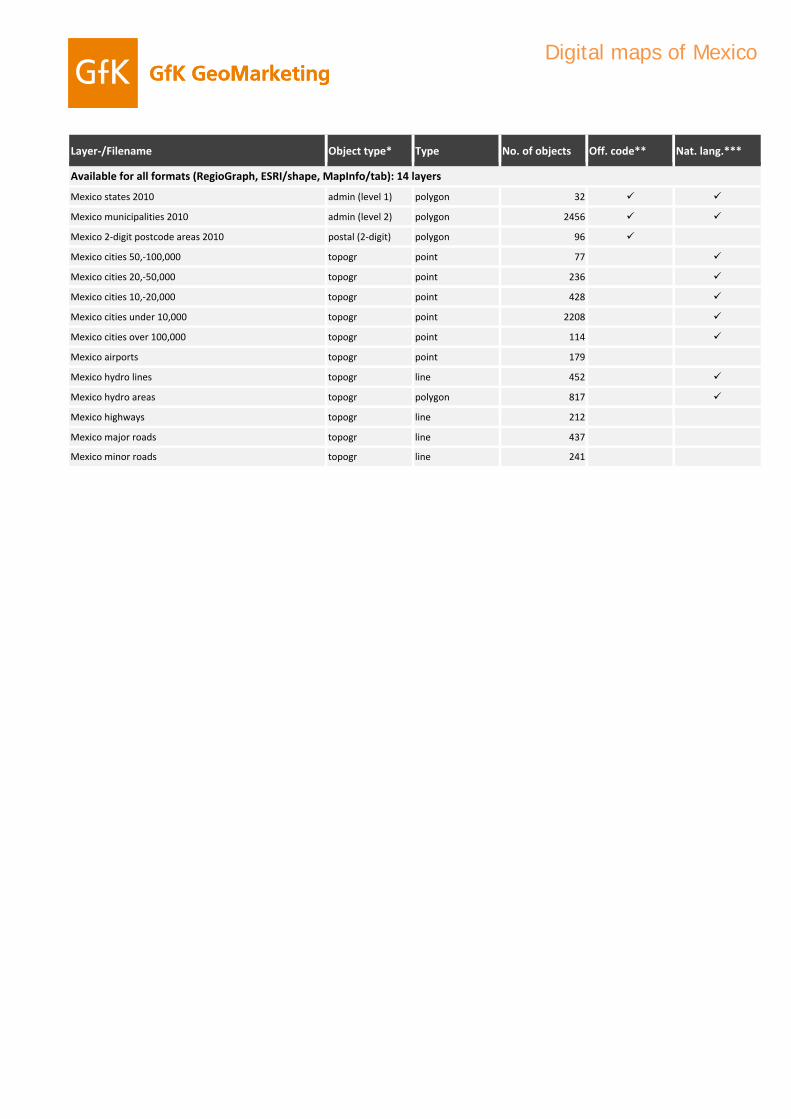
Digital maps of Mexico
Mexico states 2010 admin (level 1) polygon 32
Mexico municipalities 2010 admin (level 2) polygon 2456
Mexico 2‐digit postcode areas 2010 postal (2‐digit) polygon 96
Mexico cities 50,‐100,000 topogr point 77
Mexico cities 20,‐50,000 topogr point 236
Available for all formats (RegioGraph, ESRI/shape, MapInfo/tab): 14 layers
Mexico cities 10,‐20,000 topogr point 428
Mexico cities under 10,000 topogr point 2208
Mexico cities over 100,000 topogr point 114
Mexico airports topogr point 179
Mexico hydro lines topogr line 452
Mexico hydro areas topogr polygon 817
Mexico highways topogr line 212Mexico highways topogr line 212
Mexico major roads topogr line 437
Mexico minor roads topogr line 241
Layer‐/Filename Object type* Type No. of objects Off. code** Nat. lang.***
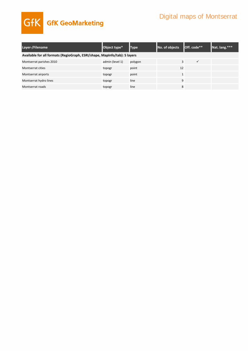
Digital maps of Montserrat
Montserrat parishes 2010 admin (level 1) polygon 3
Montserrat cities topogr point 12
Montserrat airports topogr point 1
Montserrat hydro lines topogr line 9
Montserrat roads topogr line 8
Available for all formats (RegioGraph, ESRI/shape, MapInfo/tab): 5 layers

Layer‐/Filename Object type* Type No. of objects Off. code** Nat. lang.***
Digital maps of Netherlands Antilles
Netherlands Antilles islands 2010 admin (level 1) polygon 5
Netherlands Antilles cities topogr point 22
Netherlands Antilles airports topogr point 4
Netherlands Antilles hydro areas topogr polygon 9
Netherlands Antilles roads topogr line 19
Available for all formats (RegioGraph, ESRI/shape, MapInfo/tab): 5 layers

Layer‐/Filename Object type* Type No. of objects Off. code** Nat. lang.***
Digital maps of Nicaragua
Nicaragua departments 2010 admin (level 1) polygon 17
Nicaragua municipalities 2010 admin (level 2) polygon 153
Nicaragua cities 50,‐100,000 topogr point 7
Nicaragua cities 20,‐50,000 topogr point 18
Nicaragua cities 10,‐20,000 topogr point 21
Available for all formats (RegioGraph, ESRI/shape, MapInfo/tab): 12 layers
Nicaragua cities under 10,000 topogr point 105
Nicaragua cities over 100,000 topogr point 2
Nicaragua airports topogr point 8
Nicaragua hydro lines topogr line 33
Nicaragua hydro areas topogr polygon 12
Nicaragua major roads topogr line 13
Nicaragua minor roads topogr line 11Nicaragua minor roads topogr line 11

Layer‐/Filename Object type* Type No. of objects Off. code** Nat. lang.***
Digital maps of Panama
Panama provinces 2010 admin (level 1) polygon 12
Panama districts 2010 admin (level 2) polygon 75
Panama cities 50,‐100,000 topogr point 7
Panama cities 20,‐50,000 topogr point 8
Panama cities 10,‐20,000 topogr point 15
Available for all formats (RegioGraph, ESRI/shape, MapInfo/tab): 12 layers
Panama cities under 10,000 topogr point 202
Panama cities over 100,000 topogr point 4
Panama airports topogr point 19
Panama hydro lines topogr line 26
Panama hydro areas topogr polygon 5
Panama major roads topogr line 13
Panama minor roads topogr line 32Panama minor roads topogr line 32

Layer‐/Filename Object type* Type No. of objects Off. code** Nat. lang.***
Digital maps of Paraguay
Paraguay departments 2010 admin (level 1) polygon 18
Paraguay districts 2010 admin (level 2) polygon 237
Paraguay 2‐digit postcode areas 2010 postal (2‐digit) polygon 85
Paraguay cities over 100,000 topogr point 10
Paraguay cities 50,‐100,000 topogr point 11
Available for all formats (RegioGraph, ESRI/shape, MapInfo/tab): 14 layers
Paraguay cities 20,‐50,000 topogr point 6
Paraguay cities 10,‐20,000 topogr point 21
Paraguay cities under 10,000 topogr point 187
Paraguay airports topogr point 8
Paraguay hydro lines topogr line 19
Paraguay hydro areas topogr polygon 12
Paraguay highways topogr line 3Paraguay highways topogr line 3
Paraguay major roads topogr line 6
Paraguay minor roads topogr line 18

Layer‐/Filename Object type* Type No. of objects Off. code** Nat. lang.***
Digital maps of Peru
Peru departments 2010 admin (level 1) polygon 25
Peru provinces 2010 admin (level 2) polygon 195
Peru cities over 100,000 topogr point 23
Peru cities 50,‐100,000 topogr point 17
Peru cities 20,‐50,000 topogr point 42
Available for all formats (RegioGraph, ESRI/shape, MapInfo/tab): 13 layers
Peru cities 10,‐20,000 topogr point 213
Peru cities under 10,000 topogr point 978
Peru airports topogr point 37
Peru hydro lines topogr line 30
Peru hydro areas topogr polygon 36
Peru highways topogr line 2
Peru major roads topogr line 12Peru major roads topogr line 12
Peru minor roads topogr line 38

Layer‐/Filename Object type* Type No. of objects Off. code** Nat. lang.***
Digital maps of Puerto Rico
Puerto Rico municipalities 2010 admin (level 1) polygon 78
Puerto Rico submunicipalities 2010 admin (level 2) polygon 901
Puerto Rico 3‐digit postcode areas 2010 postal (3‐digit) polygon 3
Puerto Rico 5‐digit postcode areas 2010 postal (5‐digit) polygon 176
Puerto Rico cities 50,‐100,000 topogr point 3
Available for all formats (RegioGraph, ESRI/shape, MapInfo/tab): 17 layers
Puerto Rico cities 20,‐50,000 topogr point 9
Puerto Rico cities 10,‐20,000 topogr point 14
Puerto Rico cities under 10,000 topogr point 195
Puerto Rico cities over 100,000 topogr point 4
Puerto Rico airports topogr point 12
Puerto Rico major hydro lines topogr line 38
Puerto Rico minor hydro lines topogr line 72Puerto Rico minor hydro lines topogr line 72
Puerto Rico major hydro areas topogr polygon 37
Puerto Rico minor hydro areas topogr polygon 29
Puerto Rico highways topogr line 40
Puerto Rico major roads topogr line 99
Puerto Rico minor roads topogr line 214

Layer‐/Filename Object type* Type No. of objects Off. code** Nat. lang.***
Digital maps of Saint Barthelemy
Saint Barthelemy municipalities 2010 admin (level 1) polygon 1
Saint Barthelemy 5‐digit postcode areas 2010 postal (5‐digit) polygon 1
Saint Barthelemy cities topogr point 20
Saint Barthelemy airports topogr point 1
Saint Barthelemy roads topogr line 9
Available for all formats (RegioGraph, ESRI/shape, MapInfo/tab): 5 layers

Layer‐/Filename Object type* Type No. of objects Off. code** Nat. lang.***
Digital maps of Saint Kitts and Nevis
Saint Kitts and Nevis parishes 2010 admin (level 1) polygon 14
Saint Kitts and Nevis cities topogr point 13
Saint Kitts and Nevis airports topogr point 1
Saint Kitts and Nevis roads topogr line 4
Available for all formats (RegioGraph, ESRI/shape, MapInfo/tab): 4 layers

Layer‐/Filename Object type* Type No. of objects Off. code** Nat. lang.***
Digital maps of Saint Lucia
Saint Lucia districts 2010 admin (level 1) polygon 10
Saint Lucia cities topogr point 11
Saint Lucia airports topogr point 2
Saint Lucia hydro lines topogr line 4
Saint Lucia roads topogr line 7
Available for all formats (RegioGraph, ESRI/shape, MapInfo/tab): 5 layers

Layer‐/Filename Object type* Type No. of objects Off. code** Nat. lang.***
Digital maps of Saint Martin
Saint Martin municipalities 2010 admin (level 1) polygon 1
Saint Martin 5‐digit postcode areas 2010 postal (5‐digit) polygon 1
Saint Martin cities topogr point 6
Saint Martin airports topogr point 1
Saint Martin roads topogr line 2
Available for all formats (RegioGraph, ESRI/shape, MapInfo/tab): 5 layers
Layer‐/Filename Object type* Type No. of objects Off. code** Nat. lang.***
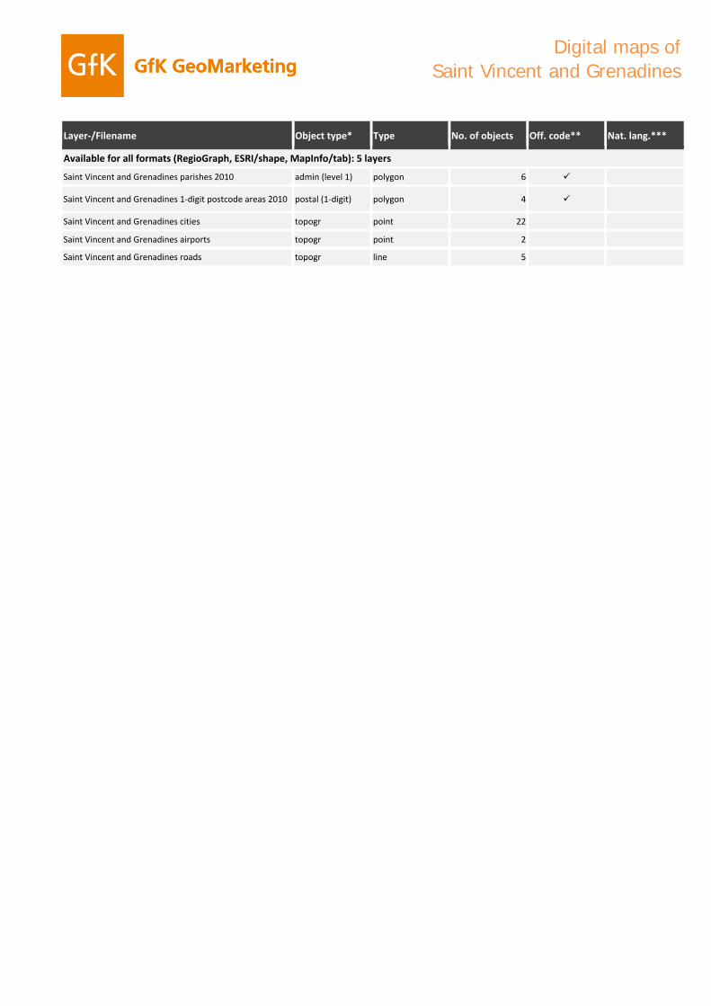
Digital maps of Saint Vincent and Grenadines
Saint Vincent and Grenadines parishes 2010 admin (level 1) polygon 6
Saint Vincent and Grenadines 1‐digit postcode areas 2010 postal (1‐digit) polygon 4
Saint Vincent and Grenadines cities topogr point 22
Saint Vincent and Grenadines airports topogr point 2
Saint Vincent and Grenadines roads topogr line 5
Available for all formats (RegioGraph, ESRI/shape, MapInfo/tab): 5 layers
Saint Vincent and Grenadines roads topogr line 5

Layer‐/Filename Object type* Type No. of objects Off. code** Nat. lang.***
Digital maps of South Georgia
South Georgia islands 2010 admin (level 1) polygon 2
South Georgia 7‐digit postcode areas 2010 postal (7‐digit) polygon 1
South Georgia cities topogr point 11
Available for all formats (RegioGraph, ESRI/shape, MapInfo/tab): 3 layers

Layer‐/Filename Object type* Type No. of objects Off. code** Nat. lang.***
Digital maps of Suriname
Suriname districts 2010 admin (level 1) polygon 10
Suriname resorts 2010 admin (level 2) polygon 62
Suriname cities over 100,000 topogr point 1
Suriname cities 10,‐20,000 topogr point 2
Suriname cities under 10,000 topogr point 324
Available for all formats (RegioGraph, ESRI/shape, MapInfo/tab): 10 layers
Suriname airports topogr point 1
Suriname hydro lines topogr line 15
Suriname hydro areas topogr polygon 15
Suriname major roads topogr line 3
Suriname minor roads topogr line 2

Layer‐/Filename Object type* Type No. of objects Off. code** Nat. lang.***
Digital maps of Trinidad and Tobago
Trinidad and Tobago municipalities 2010 admin (level 1) polygon 21
Trinidad and Tobago cities 50,‐100,000 topogr point 4
Trinidad and Tobago cities 20,‐50,000 topogr point 2
Trinidad and Tobago cities 10,‐20,000 topogr point 7
Trinidad and Tobago cities under 10,000 topogr point 26
Available for all formats (RegioGraph, ESRI/shape, MapInfo/tab): 11 layers
Trinidad and Tobago airports topogr point 2
Trinidad and Tobago hydro lines topogr line 10
Trinidad and Tobago hydro areas topogr polygon 4
Trinidad and Tobago highways topogr line 8
Trinidad and Tobago major roads topogr line 28
Trinidad and Tobago minor roads topogr line 26
Layer‐/Filename Object type* Type No. of objects Off. code** Nat. lang.***
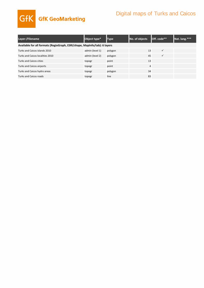
Digital maps of Turks and Caicos
Turks and Caicos islands 2010 admin (level 1) polygon 13
Turks and Caicos localities 2010 admin (level 2) polygon 45
Turks and Caicos cities topogr point 13
Turks and Caicos airports topogr point 4
Turks and Caicos hydro areas topogr polygon 34
Available for all formats (RegioGraph, ESRI/shape, MapInfo/tab): 6 layers
Turks and Caicos roads topogr line 83

Layer‐/Filename Object type* Type No. of objects Off. code** Nat. lang.***
Digital maps of Uruguay
Uruguay departments 2010 admin (level 1) polygon 19
Uruguay census areas 2010 admin (level 2) polygon 231
Uruguay 2‐digit postcode areas 2010 postal (2‐digit) polygon 24
Uruguay cities over 100,000 topogr point 3
Uruguay cities 50,‐100,000 topogr point 6
Available for all formats (RegioGraph, ESRI/shape, MapInfo/tab): 13 layers
Uruguay cities 20,‐50,000 topogr point 15
Uruguay cities 10,‐20,000 topogr point 19
Uruguay cities under 10,000 topogr point 694
Uruguay airports topogr point 14
Uruguay hydro lines topogr line 8
Uruguay hydro areas topogr polygon 29
Uruguay highways topogr line 7Uruguay highways topogr line 7
Uruguay roads topogr line 18

Layer‐/Filename Object type* Type No. of objects Off. code** Nat. lang.***
counties United States 2011 admin (level 2) Gebiete 3143
states United States 2011 admin (level 1) Gebiete 51
2‐digit postcode areas United States 2011 postal (2‐digit) Gebiete 99
5‐digit postcode areas United States 2011 postal (5‐digit) Gebiete 41138
airports United States topogr Punkte 854
cities 10,‐20,000 United States topogr Punkte 1567
cities 20,‐50,000 United States topogr Punkte 1234
cities 50,‐100,000 United States topogr Punkte 416
cities over 100,000 United States topogr Punkte 243
cities under 10,000 United States topogr Punkte 150272
city areas United States topogr Flächen 3598
hydro areas United States topogr Flächen 8911
hydro lines United States topogr Linien 3363
roads United States topogr Linien 36114
Digital maps of United States
Available for all formats (RegioGraph, ESRI/shape, MapInfo/tab): 14 layers

Layer‐/Filename Object type* Type No. of objects Off. code** Nat. lang.***
Digital maps of US Virgin Islands
US Virgin Islands districts 2010 admin (level 1) polygon 3
US Virgin Islands subdistricts 2010 admin (level 2) polygon 20
US Virgin Islands 5‐digit postcode areas 2010 postal (5‐digit) polygon 5
US Virgin Islands cities topogr point 9
US Virgin Islands airports topogr point 2
Available for all formats (RegioGraph, ESRI/shape, MapInfo/tab): 7 layers
US Virgin Islands hydro areas topogr polygon 3
US Virgin Islands roads topogr line 77

Layer‐/Filename Object type* Type No. of objects Off. code** Nat. lang.***
Digital maps of Venezuela
Venezuela states 2010 admin (level 1) polygon 25
Venezuela municipalities 2010 admin (level 2) polygon 336
Venezuela 2‐digit postcode areas 2010 postal (2‐digit) polygon 25
Venezuela cities over 100,000 topogr point 45
Venezuela cities 50,‐100,000 topogr point 26
Available for all formats (RegioGraph, ESRI/shape, MapInfo/tab): 14 layers
Venezuela cities 20,‐50,000 topogr point 57
Venezuela cities 10,‐20,000 topogr point 62
Venezuela cities under 10,000 topogr point 17699
Venezuela airports topogr point 105
Venezuela hydro lines topogr line 56
Venezuela hydro areas topogr polygon 76
Venezuela highways topogr line 25Venezuela highways topogr line 25
Venezuela major roads topogr line 71
Venezuela minor roads topogr line 34

Explanation of terms
Object type*:
admin (level 0-5)This layer depicts the administrative and political boundaries of the country in question. Level “0” corresponds to the country as a whole, with an increasing level of detail for each successive level (e.g., 2, 3 and so on).
postal (1-5 digits)This layer depicts the postcode divisions of the country in question. “1” refers to one-digit postcodes, “2” to two-digit postcodes, and so on. The higher the number, the more detailed the depiction of the postcode areas.
topogrThis layer depicts topographic features, such as streets, rail networks, waterbodies, elevation levels, forests, areas of occupation, industrial regions, etc.
TAThis layer is based on Tele Atlas cartography.
Off. Code**:
This layer contains labels featuring official regional codes - for example, the official designators of postcodes used by the national postal organization.
Nat. lang.*** :
In addition to ASCII-based labels, this layer contains labels in the language (and associated special characters) of the country in question. For some countries local labels are not properly shown In MapInfo, unless the appropriate font is installed or the system's regional settings have been changed to the country in question.
References
Australian dataset is partially based on ABS data which is used with permission from the Australian Bureau of Statistics <www.abs.gov.au>.
Brazilian dataset is partially based on IBGE data which is used with permission from the Instituto Brasileiro de Geografia e Estatística.Estonian dataset is partially based on Estonian Land Board data.Portuguese dataset is partially based on Instituto Geográfico Português data <www.igeo.pt>.Portuguese dataset is partially based on Instituto Geográfico Português data <www.igeo.pt>.

Digitale Landkarten für mehr als 240 Länder weltweit
Entdecken Sie das Landkartenangebot von GfK GeoMarketing
Digital maps for more than 240 countries worldwide
Discover GfK GeoMarketing’s collection of digital postcode
and administrative maps

0 1 2 3 4 5 odes
odes
odes
odes
odes
odes
on y
1
EuropeA
dm
in. l
evel
0A
dm
in. l
evel
1A
dm
in. l
evel
2A
dm
in. l
evel
3A
dm
in. l
evel
4A
dm
in. l
evel
51-
digi
t po
stco
2-di
git
post
co3-
digi
t po
stco
4-di
git
post
co5-
digi
t po
stco
6-di
git
post
coTr
ansp
ort
atio
Hyd
rog
rap
hyCi
ty p
oin
tsEl
evat
ion
Albania
Austria
Belarus
Belgiumg
Bosnia-Herzegovina
Bulgaria
Croatia
Cyprus
Czech RepublicDenmark 2
Estonia
FinlandFinland
France
Germany
Greece
Hungary
Iceland
Ireland
Italy
KosovoKosovo
Latvia
Lithuania
Luxembourg
Macedonia
Malta
Moldova
Montenegro
N th l dNetherlands
Norway
Poland
Portugal
Romania1
Serbia
Slovakia
Slovenia
Spain
Sweden
Switzerland
Turkey
Ukraine
United Kingdom1
Europe
City points are categorized by number of inhabitants.y p g y1 Romania: for larger cities 4-digit postcode areas ; United Kingdom: postcode sectors3 Denmark includes Faroe Islands and Greenland.
1

0 1 2 3 4 5 odes
odes
odes
odes
odes
odes
on y
2
AsiaA
dm
in. l
evel
0A
dm
in. l
evel
1A
dm
in. l
evel
2A
dm
in. l
evel
3A
dm
in. l
evel
4A
dm
in. l
evel
51-
digi
t po
stco
2-di
git
post
co3-
digi
t po
stco
4-di
git
post
co5-
digi
t po
stco
6-di
git
post
coTr
ansp
ort
atio
Hyd
rog
rap
hyCi
ty p
oin
tsEl
evat
ion
Afghanistan
Armenia
Azerbaijan
Bahrain
Bangladesh
Bhutan
Brunei-Darussalam
Cambodia
China
Georgia
India
IndonesiaIndonesia
Iran
Iraq
Israel
Japan
Jordan
Kazakhstan
Korea North
Korea SouthKorea South
Kuwait
Kyrgyzstan
Laos
Lebanon
Malaysia
Maledives
Mongolia
MMyanmar
Nepal
Oman
Pakistan
Papua New Guinea
Philippines
Qatar
Russian Federation
Saudi Arabia
Singapore
Sri Lanka
Syria
Taiwan
Tajikistan
Thailand
Timor-Leste
Turkmenistan
United Arab Emirates
Uzbekistan
Viet Nam
Yemen
City points are categorized by number of inhabitants.
2

0 1 2 3 4 5 odes
odes
odes
odes
odes
odes
on y
3
AfricaA
dm
in. l
evel
0A
dm
in. l
evel
1A
dm
in. l
evel
2A
dm
in. l
evel
3A
dm
in. l
evel
4A
dm
in. l
evel
51-
digi
t po
stco
2-di
git
post
co3-
digi
t po
stco
4-di
git
post
co5-
digi
t po
stco
6-di
git
post
coTr
ansp
ort
atio
Hyd
rog
rap
hyCi
ty p
oin
tsEl
evat
ion
AlgeriaAngolaBeninBotswanaBurkina FasoBurkina FasoBurundiCameroonCape VerdeCentral African Rep.ChadComorosCongoDemocratic Rep. of CongoDjiboutiDjiboutiEgyptEquatorial-GuineaEritreaEthiopiaGabonGambiaGhanaGuineaGuinea-BissauGuinea-BissauIvory CoastKenyaLesothoLiberiaLibyaMadagascarMalawiMaliMauritaniaMauritaniaMauritiusMayotteMoroccoMozambiqueNamibiaNigerNigeriaReunionRwandaRwandaSao Tome and PrincipeSenegalSeychellesSierra LeoneSomaliaSouth AfricaSudanSwazilandTanzania
City points are categorized by number ofTanzania
TogoTunisiaUgandaWestern SaharaZambiaZimbabwe
number of inhabitants
3

0 1 2 3 4 5 odes
odes
odes
odes
odes
odes
on y
4
AmericaA
dm
in. l
evel
0A
dm
in. l
evel
1A
dm
in. l
evel
2A
dm
in. l
evel
3A
dm
in. l
evel
4A
dm
in. l
evel
51-
digi
t po
stco
2-di
git
post
co3-
digi
t po
stco
4-di
git
post
co5-
digi
t po
stco
6-di
git
post
coTr
ansp
ort
atio
Hyd
rog
rap
hyCi
ty p
oin
tsEl
evat
ion
Anguilla Antigua and Barbuda ArgentinaAruba Bahamas Barbados Belize BermudaBoliviaBrazilBritish Virgin Islands CanadaCayman IslandsCayman Islands Chile Colombia Costa Rica Cuba Dominica Dominican Republic Ecuador El Salvador El Salvador Falkland Islands
1
French Guiana Grenada Guadeloupe Guatemala Guyana Haiti Honduras Jamaica Martinique Mexico Montserrat Netherlands Antilles Nicaragua Panama ParaguayPeruPeru Puerto Rico Saint Barthelemy Saint Kitts and Nevis Saint Lucia Saint Martin St.Vincent & Grenadines South Georgia
1
Suriname
1 Falklands & South Georgia: 7digit postcode
Suriname Trinidad and Tobago Turks and Caicos UruguayUSAVenezuela US Virgin Islands
City points are categorized by number of inhabitants
4

0 1 2 3 4 5 odes
odes
odes
odes
odes
odes
on y
5
AustraliaA
dm
in. l
evel
0A
dm
in. l
evel
1A
dm
in. l
evel
2A
dm
in. l
evel
3A
dm
in. l
evel
4A
dm
in. l
evel
51-
digi
t po
stco
2-di
git
post
co3-
digi
t po
stco
4-di
git
post
co5-
digi
t po
stco
6-di
git
post
coTr
ansp
ort
atio
Hyd
rog
rap
hyCi
ty p
oin
tsEl
evat
ion
Australia
New Zealand
City points are categorized by number of inhabitantsCity points are categorized by number of inhabitants
5

MapMart, GeoMarketing Consulting Herbrigstrasse 21 CH-9011 St. Gallen
Tel. +41 (0)71 223 69 70 www.mapmart.ch [email protected]
Bitte faxen an / Please fax to:
+41 (0)71 223 69 72
Bestellformular / Order form: Land / Country Dateiformat /
Data format
Einzelpreis / Original price
Anzahl / Quantity
Gesamtpreis / Total price
_________________________________ Produktname / Product name
RegioGraph (*.lay)
MapInfo (*.tab) ESRI (*.shp)
Oracle
CHF _______
_____
_______
_________________________________Produktname / Product name
RegioGraph (*.lay)
MapInfo (*.tab) ESRI (*.shp)
Oracle
CHF _______
_____
_______
_________________________________Produktname / Product name
RegioGraph (*.lay) MapInfo (*.tab)
ESRI (*.shp) Oracle
CHF _______
_____
_______
Landkarten-Abonnement / Map subscription
Bitte liefern Sie uns in den kommenden Jahren unaufgefordert das bestellte Produkt. Als Dankeschön erhalten wir auf unsere Bestellung einen Rabatt von 50% auf den Vollpreis bzw. bezahlen lediglich den Updatepreis. Die Rechnung für die abonnierten Produkte wird bei Auslieferung zum Updatepreis der zu diesem Zeitpunkt gültigen
Preisliste von MapMart gestellt. Das Abonnement hat eine Mindestlaufzeit von 36 Monaten. Es gilt eine Kündigungsfrist von drei Monaten zum Jahresende. Please automatically send us new versions of the maps as they become available. As a thank-you for subscribing, we will only be charged 50% of the full price of the maps
we order. Each subsequent update will also be charged at 50% of the full price that applies at the time. Payment will be due at the time of delivery. The contract has a minimum duration of 36 months. After this, it can be terminated at the end of any calendar year, provided that three months’ notice is given.
Alle Preise gelten für Einzelbenutzer-(Inhouse-) Lizenzen. Es gelten die Lizenzbedingungen und AGB von GfK GeoMarketing. Diese können Sie im Internet unter www.gfk-geomarketing.com/lizenzen einsehen. Die Die Preise verstehen sich zuzüglich gesetzlicher Mehrwertsteuer und Versand. Stand Mai 2012.
All prices are for single-user, in-house licenses. The general terms and conditions and licensing regulations of GfK GeoMarketing apply. These are detailed at www.gfk-geomarketing.com/licenses. All prices exclude VAT and shipping. For delivery in Switzerland, VAT will be added. For delivery in the EU, please quote your VAT number. Valid as of May 2012.
Bitte liefern Sie an / Please deliver to:
Firma / Company Abteilung / Department
Vorname / First name Name / Surname
Strasse / Street PLZ, Ort, Land / Postcode, City, Country
Telefon / Phone FAX / Fax
E-Mail / E-mail
Datum / Date Unterschrift / Signature