DIAS/CEOS Water Portal User’s Guidewaterportal.ceos.org/CEOS_Water_Portal_UsersGuide.pdfDIAS/CEOS...
29
DIAS/CEOS Water Portal User’s Guide http://waterportal.diasjp.net/ Version 1.0 March 2016 Edition
Transcript of DIAS/CEOS Water Portal User’s Guidewaterportal.ceos.org/CEOS_Water_Portal_UsersGuide.pdfDIAS/CEOS...

DIAS/CEOS Water Portal User’s Guide
http://waterportal.diasjp.net/
Version 1.0
March 2016 Edition

i
Contents Overview ................................................................................................................................. 1
Concept ............................................................................................................................... 1
Services .............................................................................................................................. 2
Data Partners ...................................................................................................................... 2
Available Data List .............................................................................................................. 3
Account Management ............................................................................................................. 5
Dataset Discovery .................................................................................................................. 6
Category Search ................................................................................................................. 7
Spatial Search (Option) ................................................................................................... 8
Temporal Search (Option) ............................................................................................... 9
View Data set information .............................................................................................. 11
Granule Discovery ......................................................................................................... 13
Map Search ....................................................................................................................... 14
View Data set information ............................................................................................. 16
Granule Discovery ......................................................................................................... 18
View Time line ................................................................................................................... 19
View/Shared your use case .................................................................................................. 23
View use cases ................................................................................................................. 23
Shared your use case ....................................................................................................... 26

1
Overview Concept
CEOS Water Portal is ;
A distributed data system component of DIAS (Data Integrated Analysis
System)-Program
To provide “Easy to Access
To provide access to a whole variety of hydrological data and water relevant data
scattered over the world
” service to users
To connect the existing components like data centers, scientists and wide users
Multiple types of data are available such as;
.
In-situ data
Satellite data
Model output data
l

2
Services
Dataset Search
Category Search/Map Search
Connecting to 11 data centers + 2 catalog service
Dataset Access
Data Subset (time, variables)
Data Download
Sharing Use Case
Use Case registration/browsing
Data Partners

3
Available Data List
Data Partners Data Types Variables Server Locations
CEOP Satellite PR, TMI, AMSR, AMSR-E, MODIS,GLI, SSMI, VISSR University of Tokyo (Japan)
Model (MOLTS) surface pressure, skin temperature, precipitation amount in hour, brightness temperature surface,
specific humidity, u-component of wind, v-component of wind, etc
MPI (Germany)
Model(Gridded) Air pressure, surface air pressure, air temperature, precipitation rate, snowfall amount, etc MPI (Germany)
In-situ Surface Meteorological and Radiation Data Set
Flux Data Set
Soil Temperature and Soil Moisture Data Set
Meteorological Tower Data Set
NCAR (USA)
AWCI Model(MOLTS) surface pressure, skin temperature, precipitation amount in hour, brightness temperature surface,
specific humidity, u-component of wind, v-component of wind, etc
MPI (Germany)
In-situ Precipitation amount, River discharge, River water level, etc University of Tokyo (Japan)
NASA Satellite Airs level 3 data NASA (GSFC)
NOAA (GPCC) In-situ Precipitation data NOAA (USA)
NASA Satellite GRACE Level 3 data NASA/JPL(PO.DACC)
FLUXNET In-situ FLUX data
Fluxes of carbon dioxide, water vapor, and energy exchange, etc
NASA (ORNL DAAC)
GEMS/Water In-situ Instantaneous Discharge , Dissolved Oxygen , Temperature, etc GEMS/Water (CANADA)

4
GLOWASIS Satellite
Model(Gridded)
Precipitation, Air temperature Deltares
(Netherland)
NASA CMR In-situ
Satellite
Model
Various types of data via ECHO broker NASA(GSFC)
CUAHSI In-situ precipitation, humidity, discharge, oxygen, etc CUAHSI
(USA)
GEO DAB In-situ River Discharge via GEO DAB GEO
NOAA/NCEI In-situ
Satellite
Air temperature, Precipitation, Air Pressure NOAA/NCEI

5
Account Management You can feely use the search function. However, you should register your account on DIAS
account service if you want to download the data via the CEOS water portal.
DIAS account service at:
http://dias-dss.tkl.iis.u-tokyo.ac.jp/account/public/guest/
You should fill out the account form and send it.
You need an authentication when you download the any data via CEOS water portal.
You should enter your username and password into above form.

6
Dataset Discovery http://waterportal.diasjp.net/ CEOS Water portal provides two features of dataset search. One is the category search,
and the other is the Map Search.
Category Search Map Search

7
Category Search
User can choose the search criteria according to ECV category or GCMD keyword. Or use
can enter the any keyword.

8
Spatial Search (Option)
User can enter the rectangle boundary on the map as a spatial search condition.
(a) Click the map button
(b) Click the map to set a rectangle boundary
(a)
(b)

9
Temporal Search (Option)
Date and Time ranges can be entered to refine your search. Dates can be entered into the
text field manually in yyyy/mm/dd format or by selecting from the calendar provided.
10
After all search conditions are entered, click the search button to start the category search.

11
View Data set information
The data set search results are displayed on the Dataset tag.
(a) User can confirm the explanation of selected data by clicking the “detail”.
(b) Granule search will be started by clicking the “Search”.
(a) Click
(b) Click

12
Detail data info

13
Granule Discovery
Granule Search results are displayed.
If you want to get the data, click the [GET DATA] and save the file in your computer.
It will be link to the download site at the data center.
User can do a subset and download the data.

14
Map Search
All data points are displayed on the map. User can figure out the data type (Satellite data
and In-situ data, Model output Data) by seeing the legend at the right side of window.
Legend

15
Data points are not displayed by unchecking the checkbox at the legend.
User will find out the detail location by Zooming in.
If user find the preferable location, click the point on the map.
Dataset search will be started.
click

16
View Data set information
The data set search results are displayed on the Dataset tag.
(a) User can confirm the explanation of selected data by clicking the “detail”.
(b) Granule search will be started by clicking the “Search”.
(a) Click
(b) Click
Detail data info

17
In the granule search, temporal condition window will be displayed for reducing the search
results.
Enter the time range and click the “Search” button.

18
Granule Discovery
Granule Search results are displayed.
If you want to get the data, click the [GET DATA] and save the file in your computer.

19
View Time line
CEOS water portal connects to the GEOSS Data Access Broker (GEO-DAB) system.
GEO-DAB provides the River Discharge data. It is a long time observation in-situ data.
User can easily refine the temporal search by graphical method.
Select the “Terrestrial” -> “River Discharge”. Then, click the “Search” button, dataset search
will be started.

20
Dataset search results are displayed at the last paragraph, “GEO-DAB”.
Click the “Timeline view” button.

21
User can find out the existing dataset during the overall observation time range.
Move the time range bar

22
User clicks any element of bar graph, contents of dataset list is displayed at the search
result table and child window.
Next process of dataset search is same way of another dataset.
Clink the line

23
View/Shared your use case CEOS water portal provides a communication tool between scientists and decision makers.
Scientists can register their research results in this site. And decision makers can see it.
View use cases
Click the “Use Cases” tab at the right top side.

24
Each titles of all use case are displayed. It was registered by scientists.
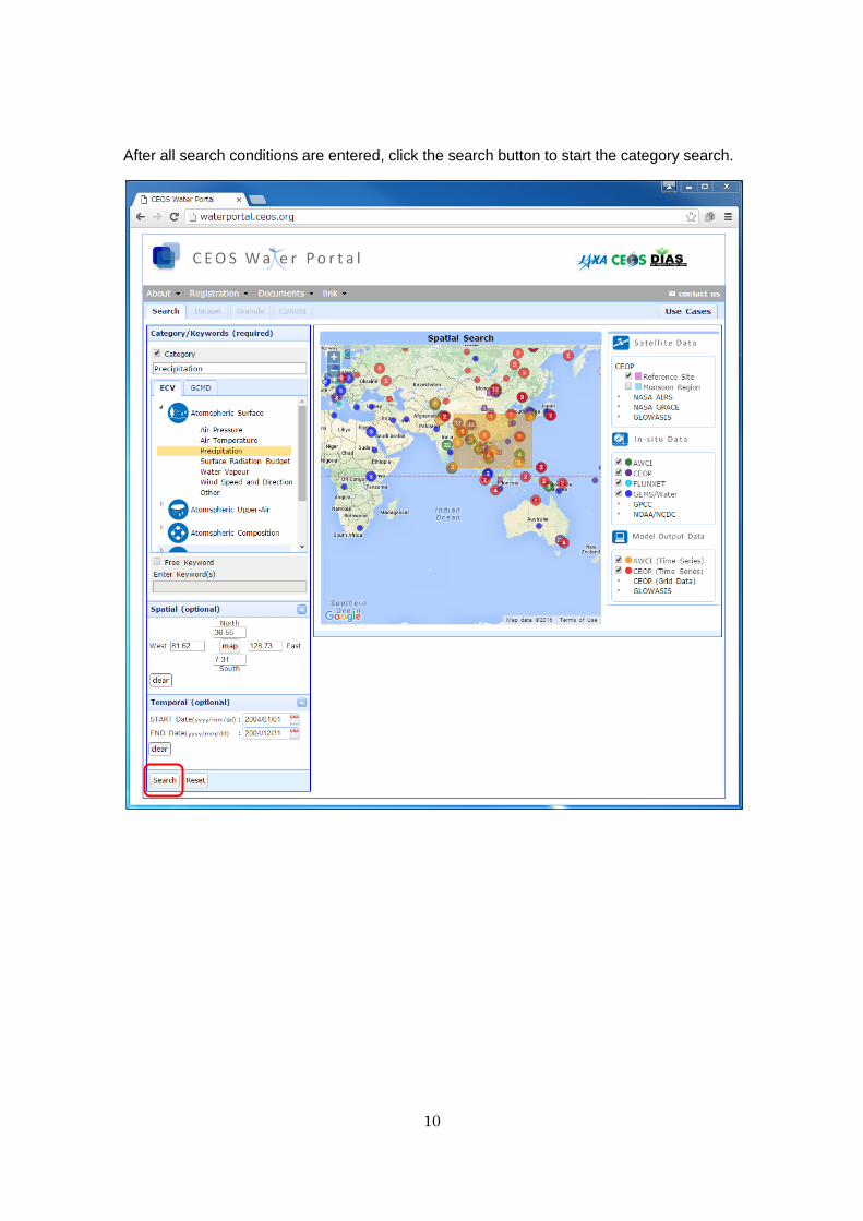
Click the “detail”, you can see the detail information of research content.
25
For example, user can see the detail information of research content as below.
26
Shared your use case
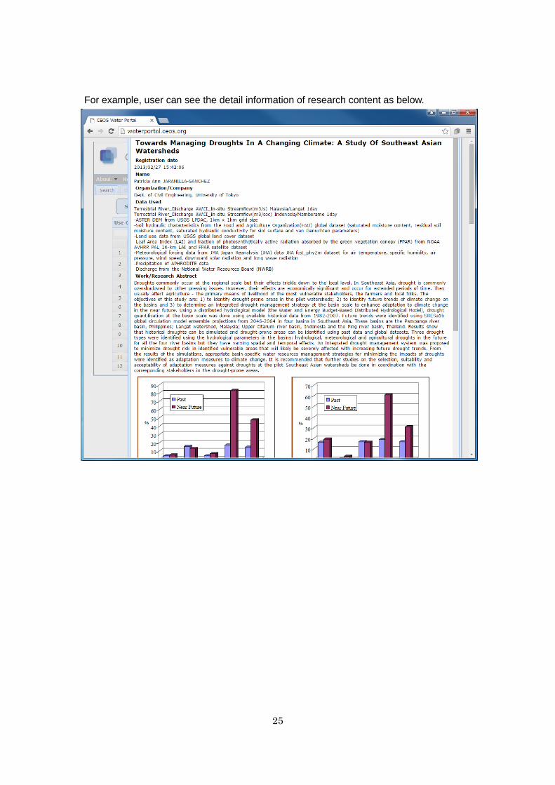
If you want to register about your research, click the “Share my user case”.

27
Fill out the registration form and click “Post“ button.
After passing the check process, your content is registered.