Dewatering Systems for Underground and Surface …Dewatering Systems for Underground and Surface...
12
Dewatering Systems for Underground and Surface Mines in the Kreka Coal Basin By IJuban l:EKIC 1 and Esad ORUl: 2 1 RGF - TUZLA, School of Mines and Geology 75000 Tuzla, Yugoslavia 2 RI - TUZLA, Mining Institute, Department of Geology and Geotechnic 75000 Tuzla, Yugoslavia ABSTRACT The authors present an overwiev of the hydrogeological conditions in the Kreka coal basin and the general characteristics of the dewatering systems applied. As an example of the adopted principles, the dewatering systems of and brod open pits are presented and discussed more in detail. INTRODUCTION The Kreka lignite basin is located in a wider area of the city of Tuzla, covering an area of 200 km2, and that is why it has always attracted an attention of a number of researchers. Lignite mining in the Kreka coal basin began way back in 1085 and therefore, shallower coal deposits have been almost completely mined out in the area. In deeper deposits, mining - geologic conditions are worse and mining itself is more difficult and complex. Surface mining has not reached big depths yet, since it has been performed only in the last 20 years. Total annual production in the basin is ranging from 5 to 6 million tones and is being accomplished both by surface and underground mining. GEOWGIC STRUCTURE IN mE KREKA UGNITE BASIN In Lower Pliocene, at the southern rim of the Panonian Sea, in conditions of moderate and fairly humid climate, luxuriant vegetation occurred. The Kreka lignite basin dates from that period. Thickness of productive coal series is about 900 m. These thick series of sediments occur concordantly over Upper Miocene sediments, and are partly covered by Quaternary sediments in rivers' valleys, especially in the and Jala valleys. In the area of this economically significant and tectonically interesting coal basin, several lithostratigraphic units have been determined, and each of them has certain lithologic and paleontologic features. 4 1 h International Mineral Water Association Con ress, L 'ubi' ana (Siovenia)-Piirtschach (Austria), Se tember 1.991 29 © International Mine Water Association 2012 | www.IMWA.info Reproduced from best available copy
Transcript of Dewatering Systems for Underground and Surface …Dewatering Systems for Underground and Surface...

Dewatering Systems for Underground and Surface Mines in the Kreka Coal Basin By IJuban l:EKIC1 and Esad ORUl:2
1RGF - TUZLA, School of Mines and Geology 75000 Tuzla, Yugoslavia
2RI - TUZLA, Mining Institute, Department of Geology and Geotechnic 75000 Tuzla, Yugoslavia
ABSTRACT
The authors present an overwiev of the hydrogeological conditions in the Kreka coal basin and the general characteristics of the dewatering systems applied. As an example of the adopted principles, the dewatering systems of ~ikulje and ~ifki brod open pits are presented and discussed more in detail.
INTRODUCTION
The Kreka lignite basin is located in a wider area of the city of Tuzla, covering an area of 200 km2, and that is why it has always attracted an attention of a number of researchers.
Lignite mining in the Kreka coal basin began way back in 1085 and therefore, shallower coal deposits have been almost completely mined out in the area. In deeper deposits, mining - geologic conditions are worse and mining itself is more difficult and complex. Surface mining has not reached big depths yet, since it has been performed only in the last 20 years. Total annual production in the basin is ranging from 5 to 6 million tones and is being accomplished both by surface and underground mining.
GEOWGIC STRUCTURE IN mE KREKA UGNITE BASIN
In Lower Pliocene, at the southern rim of the Panonian Sea, in conditions of moderate and fairly humid climate, luxuriant vegetation occurred. The Kreka lignite basin dates from that period. Thickness of productive coal series is about 900 m. These thick series of sediments occur concordantly over Upper Miocene sediments, and are partly covered by Quaternary sediments in rivers' valleys, especially in the Spre~ and Jala valleys. In the area of this economically significant and tectonically interesting coal basin, several lithostratigraphic units have been determined, and each of them has certain lithologic and paleontologic features.
41h International Mineral Water Association Con ress, L 'ubi' ana (Siovenia)-Piirtschach (Austria), Se tember 1.991
29
© International Mine Water Association 2012 | www.IMWA.info
Reproduced from best available copy
30 (~ckic & Oruc- Dewatering Systems in the Kreka Coal Basin
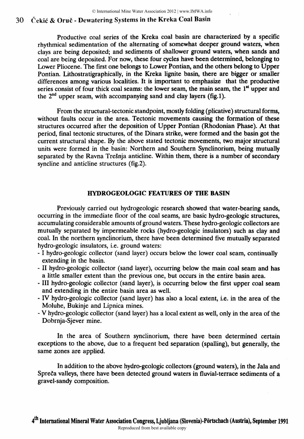
Productive coal series of the Kreka coal basin are characterized by a specific rhythmical sedimentation of the alternating of somewhat deeper ground waters, when clays are being deposited; and sediments of shallower ground waters, when sands and coal are being deposited. For now, these four cycles have been determined, belonging to Lower Pliocene. The first one belongs to Lower Pontian, and the others belong to Upper Pontian. Lithostratigraphically, in the Kreka lignite basin, there are bigger or smaller differences among various localities. It is important to emphasize that the productive series consist of four thick coal seams: the lower seam, the main seam, the 11
' upper and the 2nd upper seam, with accompanying sand and clay layers (fig.l).
From the structural-tectonic standpoint, mostly folding (plicative) structural forms, without faults occur in the area. Tectonic movements causing the formation of these structures occurred after the deposition of Upper Pontian (Rhodonian Phase). At that period, final tectonic structures, of the Dinara strike, were formed and the basin got the current structural shape. By the above stated tectonic movements, two major structural units were formed in the basin: Northern and Southern Synclinorium, being mutually separated by the Ravna Tre~nja anticline. Within them, there is a number of secondary syncline and anticline structures (fig.2).
HYDROGEOLOGIC FEATURES OF mE BASIN
Previously carried out hydrogeologic research showed that water-bearing sands, occurring in the immediate floor of the coal seams, are basic hydro-geologic structures, accumulating considerable amounts of ground waters. These hydro-geologic collectors are mutually separated by impermeable rocks (hydro-geologic insulators) such as clay and coal. In the northern synclinorium, there have been determined five mutually separated hydro-geologic insulators, i.e. ground waters: - I hydro-geologic collector (sand layer) occurs below the lower coal seam, continually
extending in the basin. - II hydro-geologic collector (sand layer), occurring below the main coal seam and has
a little smaller extent than the previous one, but occurs in the entire basin area. - III hydro-geologic collector (sand layer), is occurring below the first upper coal seam
and extending in the entire basin area as well. - IV hydro-geologic collector (sand layer) has also a local extent, i.e. in the area of the
Moluhe, Bukinje and Lipnica mines. - V hydro-geologic co1Iector (sand layer) has a local extent as well, only in the area of the
Dobrnja-Sjever mine.
In the area of Southern synclinorium, there have been determined certain exceptions to the above, due to a frequent bed separation (spalling), but generally, the same zones are applied.
In addition to the above hydro-geologic collectors (ground waters), in the Jala and Spreta valleys, there have been detected ground waters in fluvial-terrace sediments of a gravel-sandy composition.
4th International Mineral Water Association Congress, Ljubljana (Slovenia)-Portschach (Austria), September 1991
© International Mine Water Association 2012 | www.IMWA.info
Reproduced from best available copy

v
Cekic & Oro~ .. Dewatering Systems in the Kreka Coal Basin 31
! I I -I • f
I I ~----
I 5 w • .,
5%3 :;:ctJ • -t~CIC
c._~w
cal: I
"" ;:) u ~z~ ~-"' ~--- c!! .J2:U..
?c ~!i!~ I _, ........ ~ '""
z 0 • -t-u ..... .., • II) •
II) 0 a: u
u c:J 0 • ...J • 0 l&J '-:J
Figure 1: Geologic Cross-section of Kreka Coal Basin
4th International Mineral Water Association Congress, Ljubljana (Slovenia)-Portschach (Austria), September 1991
© International Mine Water Association 2012 | www.IMWA.info
Reproduced from best available copy

32 Cekic & Oruc .. Dewatering Systems in the Kreka Coal Basin
R 1: 150 000
KEY CD cool seam outcrcp
r~t---n sond s.~diments
~ surface waterflow
~clay
Figure 2: Northern and Southern Synclinorium of the Kreka Coal Basin
The most significant ground water accumulations have been determined in the following synclines: Kreka, Lukavac, Husino, Dubrave, Kova~evici and Tojsini. The syncline structures affected the formation of ground waters under the pressure, and of sub-artesian and artesian character.
The most significant hydro-geologic collectors are the above sands in the floor. Their thickness varies, and ranges from several to 100 meters. The major feature of these sands is that the base is made of quartz sands, where there is 78 % or even more of Si02, and the grain-size characteristics are different in a plan and vertical section. Generally, the immediate floor is made of gravel and sands, and with depth, the grain size is decreasing from gravel-size to a silt.
An extensive hydro-geologic research has been carried out up to now, especially in those parts of the basin with an active exploitation. Spatial, hydro-geologic, filtering and hydrodynamic features of water-bearing layers have been investigated as a basis for designing dewatering methods and systems. There have also been done field, laboratory, modelling and other research for designing purposes. For the illustration of filtering characteristics, we gave a review of mean values of certain hydro·geologic parameters in table 1.
4th International Mineral Water Association Con ress, L'ubl"ana (Siovenia)-Portschach (Austria), September 1991
© International Mine Water Association 2012 | www.IMWA.info
Reproduced from best available copy

Cekic & Orne - Dewatering Systems in the Kreka Coal Basin
Table 1: Mean Values of Some Hydro ... Geologic Parameters in the Kreka Coal Basin
SYNCLINE HYDRO-GEOLOGIC K T a• COllECTOR (m/s) (m2/s) (m2/s)
I 1.7 10-S 1.110'"3 1.2 KREKA n 1.7 10'"5 1.110'"2 - 3.6
lll 1.5 10'"5 9.0 104 2.2
n 1.6 10·5 55 104 1.3 LUKAVAC III 4.9 10-S 92 10-4 1.7
IV 2 .. 2 10-4 1.9 10'"3 0.68-0.92
I 1.7 10-S 1.8 10-4 1.S HUSINO n 4..3 10-4 29 ro-t 2.4
m 2.4 10-S 2.3 10-4 1.9
I 2 .. 4 .. to-s 4.7 10-4 1.0 n 6 .. 6 10-6 1.4 10-4 0.2
DUB RAVE m 8.2 10-6 1.7 10-4 ' 0.3 IV 7.7 10-S 13 10'"3 2.9 v 9.0 10-s t..s to·3 2.4 -
SYSTEM FOR UNDERGROUND MINES DEWATERING
Generally, water presence in the floor sandy partings is one of limiting factors in the mining process, due to hydrostatic pressure as well as high prices of water withdrawal.
From the aspect of dewatering and safety at work, each locality or technology has its own specific features and requests. Therefore, the selection of methods and dewatering systems are being done through the analyses of the following relevant factors: - general geologic conditions in the deposit, - hydrogeologic conditions, - mining-technologic requests, -technologic-technical conditions of dewatering structures construction, - rationality and profitability of selected solutions.
Dewatering and safety systems are mostly one-line well groups, consisting of the following: - deep wells (basic system structures), - underground floor filters (auxiliary structures), ... underground roof filters, -underground pumping station with water collectors,
4th International Mineral Water Association Congress, Ljubljana (Slovenia)-Portschach (Austria), September 1991
33 © International Mine Water Association 2012 | www.IMWA.info
Reproduced from best available copy

34 Cekic & Oruc eo Dewatering- Systems in the Kreka Coal Basin
This paper is giving a brief description of dewatering system in underground mines and, separately, in open pits. ·
In the Kreka syncline, where underground mining is being done, dewatering of water-bearing sand is being done by one-line system of drilled vertical wells and inspiring filters, being located alorig the deepest mine entries.
The first borehole is being drilled in the protective pillar, where inclines for horizon or shaft opening occur. Further drilling is progressing in a direction where faces have been designed. Since the mining in the Kreka lignite basin advances in two wings, the wells are being drilled on both sides of the protective pillars. The wells line position and distance between the wells is determined for certain location by means of appropriate estimations of effects of ground water level lowering, depending on filtration characteristics and hydro-dynamic conditions. A usual borehole distance in one line range is from 250 to 350 m, and rarely over 350 to 500 m. A distance between the borehole line and the entry, below which it is necessary to lower ground water level ranges from 20 to 400 m. In addition to weather effects, it depends also on montan-geologic and hydrogeologic conditions, mining method, synchronization of mining, terrain configuration and lasting of water wells. Especially important element is roof caving during mining operations. Wells are always located in a way that they are not in caving zones.
Constructional and expoitational features of we11s are given in other report which is presented on the Congress. The scheme of a wel1s vs. situation of active mine levels is given in fig. 3.
---.
XIII • I
~
..
. ·f
-- -- - Statit gro\lnc!w;;ter fevrl
o,. nc.m ic 9 round.··"' c; ter le ~e I
- · - ·- · - O)nCI\ ic ground- "-G tcr l ~~cl
UUu!ff/ll{llll/l#ff&t/ Mining area
o...l::--- The low~s~ entry
FiKure 3: Scheme of underground mine dewatering system
4th International Mineral Water Association Congress, Ljubljana (Siovenia)-Portscbach (Austria), September 1991
© International Mine Water Association 2012 | www.IMWA.info
Reproduced from best available copy

Cekic & Oruc - Dewatering Systems in the Kreka Coal Basin
OPEN PITS DEWATERING SYSTEMS
In some parts of the basin where the coal is being mined by surface mining, the occurrence of water-bearing layers made it necessary to do a previous dewatering and protection of pits from ground waters. Generally, open pit dewatering is more complex, both related to a kind and number of structures as well as their functional connection and dependence on mining works. In these systems, the wells utilization is also the basic dewatering method, but in actual conditions, it can be complemented with other structures of passive of active dewatering, being in a function of dewatering system and protection of open pits from ground and surface waters. In the following text, we will present basic features and effects of the system in major open pits in the Kreka coal basin.
THE "~ICKI BROD" OPEN PIT
This is the first open pit in the basin where system of previous dewatering has been applied. In a period of 1970-1989, the annual output ranged from 1,000,000 to 1,250,000 tones of coal, and now it is being closed.
The main coal seam was being mined, with a maximum thickness of 10 m and was located in an extremely synclinal structure. There were 3 mutually separated waterbearing layers: - I water-bearing layer - send in the roof of the main coal seam; ground water with free
level; it was necessary to perform dewatering completely; - II water-bearing layer- sand in the floor of the main coal seam; ground water under
pressure; it was necessary to lower ground water level down to the lowest point of the floor in the mining zone;
- III water-bearing layer- sand in the floor of the lower coal seam; ground water under pressure; it was necessary to lower the level under the critical pressure for fracture of the pit floor.
For a given hydro-geological situation and determined level of ground water occurrence, there had been designed a line-well system along the syncline axis, with a mutual distance of 2a = 250m, with accompanying, complementary structures of a local function at operating benches (vacuum filters, horizontal drainage wells, infiltration wells).
During exploitation dewatering, a problem on parallel existence of dewatering structures and mining operations in the area arose, because, due to uncontinuous work and destruction of wells, there were no necessary effects of ground water level lowering. The problem was solved by means of the construction of special underground drainage entries in the main coal seam, in front of the face. Previously drilled wells were connected with the underground entries by underground cuts, and from them, there were drilled additional drainage wells into the floor and roof water-bearing layer. Therefore, all drained amounts of ground water were concentrated into the underground entries, and were pumped out off the pit through a pumping station. Therefore, the dewatering system became functionally complete and independent on mine works at the surface, and an intensification of dewatering could begin (1975-1977). This dewatering system included the following structures:
4th International Mineral Water Association Congress, Ljubljana (Siovenia)-Portschach (Austria), September 1991
35 © International Mine Water Association 2012 | www.IMWA.info
Reproduced from best available copy

36 CekiC & oruC - Dewatering Systems in the Kreka Coal Basin
f-:1 ~
~ g)
en ("'oo 0 C"' .;:o -ell
--~0 al )(
""O ~
-al
en
0 io «D
~ -"'al • Ul r'O
~ ""
.... :· .... -• r'
_; .. . --: :# ~
:z: 0
II) c: ·c, -..... t..)
..,o
uJ ~
"'
...... : ... ... . . -~ -.. . . ~ . . . ~
tJ1
~· "' 0 ~ u
... -· ... · . . ·~ al ~ ~ ~· ... .... ,... r_.--! .... ... t .... ... --;.:·': ...J . • •• .t ...f., ~
C) . ...J 4: -t--% -
·: . ~ . . . : .. . a: . ,. .. · . '
"' . . . . . , . . .. . ; • .t« . ..
t,/'t'
0-~1
~ ::> 0
<(
' -.1
uJ ~
.... ~0
• ~ ~ co ••• ; : ! . . . .. . . . . ~.:.:
~ ..• . _,. -~ ~·
e ' ..
• I
0 "S ~ g <4 4
UJ ~ 0 "' 0
..:> ("'\
a % 'Z -~
"' .ct ~
0 0:· c(
0 4 uJ N uJ cD
CD • • ~
0 0
« uJ - w t-
~ <(
0 ~ 3: . . - .--figureA: Dewatering system of the "~iil~ki brod" Open Pit
\ 4th International Mineral Water Association Congress, Ljubljana (S\ovenia)-POrtscbach (Austria), September 1991
© International Mine Water Association 2012 | www.IMWA.info
Reproduced from best available copy

.., Cekic & Orne - Dewatering Systems in the Kreka Coal Basin
- one-degree and two-degree wells ........... 26 wells, - underground drainage entries .............. 1800 meters, - floor spiring filters ..................... 18 filters, - pumping station with water-collector (2*4000 1/min.) 1 station, - additional structures of local action ..... as needed.
Dewatering system disposition and the open pit is given in figure 4. Well basic parameters:
Well capacity 1/s
Q = 5-10
Dynamic lowering
(m)
S=30-130
Specific capacity (1/s/m)
Sum ca~acity (m /s)
q=0.25-0.37 Qsum=O.l00-0.18 -----------------------------------------------·---------·-----------------------
This system effects were applicable during the exploitation, depending on a number of structures in operation and pit development phase, and generally, they are presented in the following table (absolute elevation mark G WL ):
----·----------------~------------------·---------------------------·--·----------------------------Waterbearing layer
Stat. GWL 1969 1972
Dynamic GWL 1976 1978 1988
Necessary max. lowering
------------···-------------------------------------------------------------------------------------II 220-230 195-250 210-216 175-180 180 -------------------------------------------------·-----------------------------------------·--------III 215-220 205 205 200 200 200
----------------------------------------------------------------------------------------------------
THE "~IKUUE" OPEN PIT
This is one of the two open pits in the coal basin, being under the research. With a designed annual output of 3,000,000 t for a 30-year period, it is a perspective open pit. Two shallower coal seams are being mined (I and II upper coal seams) and the two deeper ones (main and lower coal seam) are not exploitable.
Related to pit dewatering and protection from waters, the deposit is complex, due to several water-bearing layers and surface waters in the deposit area as well as their complex hydraulic connection.
The following water-bearing layers occur in the area: - I Water-bearing layer- sand in the floor of the lower coal seam; ground water under
pressure: lowering of G WL is necessary below the pressure level critical for floor fracture,
- II water-bearing layer- sand in the floor of the lower coal seam; ground water under the pressure; lowering of G WL is necessary below the pressure level critical for floor
4th International Mineral Water Association Congress, Ljubljana (Slovenia)-Portschach (Austria), September 1991
37 © International Mine Water Association 2012 | www.IMWA.info
Reproduced from best available copy

38 Cekic & Oruc- Dewatering Systems in the Kreka Coal Basin
fracture, - III water-bearing layer - fluvial deposits of the Sprefa river; ground water with free
level; necessary a complete drainage in the mining area,
For the pit protection from ground and surface waters, the following system of dewatering structures has been designed: - one-degree drilled wells (for I, II and III water-bearing layer), - horizontal drainages (for IV water-bearing layer), - drainage cuts for the pit opening, - anti-filtration screens (diaphragm), -relocation and regulation of the Spre~ and S.Rijeka rivers, - pumping station with water collector in the pit.
Dewatering of the III water-bearing layer, as an immediate floor of the mined coal seam is of an extreme significance. It has been designed to use 71 wens in an area-frontal arrangement at the entire pit and water-bearing layer area. At the same time, 20 to 25 wells are operating in front of the face, arranged in 4-5 lines with a mutual distance of approximately 200m, and a distance between wells of approximately of 250m.
With the face advance, certain well lines stop operating and the next line is being activated. Within the mining area, the weUs are being maintained by a temporal cutting and activating on working bench, and if it is necessary, additional weUs are being drilled in order to provide a water level below the lowest point on the face.
The first and second water-bearing layer dewatering is solved by means of fewer weUs, regarding the request to partly de~rease the pressure in the pit floor.
A special role in the dewatering system is being played by anti-filtration screens, made based on the South-West pit contour, for prevention of ground water inflow from the Spreca area. There has been dug 6510 m of anti-filtration ditch, in total, with a depth of up to 25 m, by means of making thin-walled screens with clay-bentonite filling.
The Spreca and Sikuljacka Rijeka rivers were relocated out of the pit contour, and their river beds were made with impermeable coating, in order to prevent infiltration from the rivers into the water-bearing layers. This system disposition and the open pit is given in fig. 5.
The dewatering system has not come to a fu11 size and has not given the best effect yet because of an initial phase of the pit development, but the results of the previous lowering of ground water levels are as follows:
-----------------------·------~-----------------------------------------------------------------Water bea- Initial GWP ring seam 1983
III II I
175-200 180·210 200-230
Dynamic GWP 1985 1987 1989
170-185 150-170 140-170 180-190 140-160 120-140 200-230 180-230 180-230
Necessary max.Iower.
60 120 145
------------------·-----------------------------------------·----·----------------------·-------
4th International Mineral Water Association Congress, Ljubljana (Slovenia)-Portschach (Austria), September 1991
© International Mine Water Association 2012 | www.IMWA.info
Reproduced from best available copy

.., Cekic & Orne - Dewatering Systems in the Kreka Coal Basin
THE "DUBRA VE" OPEN PIT
The dewatering of four water-bearing seams in an extremely synclinal structure of the pit site was predicted to be done by means of the system of vertical, drill multidegree wells capturing several water-bearing seams, simultaneously. For the first development phase, it has been predicted 27 wells, in an area-frontal arrangement. The well lines are parallel with the overburden removal face, but, in the first phase, the open pit development is to be fan-like, so, most wells are located within the pit layout, representing and additional problem in the process of dewatering and its control. The distance between well lines is 200m, and in a line, there are 3-6 wells, with an inter· distance, ranging from 150 to 200m. The well capacity is predicted to be from 5 to 10 I/ sec, and the total one to range from 100 to 150 ]/sec.
A very important structure in the dewatering system is a main drainage station with the pump, located in the highest spot of the pit and with a drainage capacity of 2 x 5.0 m3/min.
The other structures re of minor importance (rim trenches, smaller regulations etc.).
This dewatering system is in the development and because of that it will not be treated in detail in this report.
REFERENCES
1. Cekic Lj. et. al. Projekti odvodnjavanja podinskih pijeskova rudnika Moluhe, Bukinje, Lukavac, Dobrnja, Lipnica, podru~ja Krekanske sinklinale. Fond stru~ne
dokumentacije Rudarsko-geolo~kog fakulteta i DP Rudarski Institut Tuzla, (1966·1982). 2. Cekic Lj. Odvodnjavanje vodonosnih i teku~ih pijeskova lignitskog bazena Kreka,
Tehnika. No.3 (1970). 3. Cekic Lj. et. al. Glavni projekti odvodnjavanja PK Dubrave i PK Sikulje. Fond stru~ne dokumentacije Rudarsko-geolo~kog fakulteta i DP Rudarski lnstitut Tuzla, (1983, 1984) 4. Pavlovic S. Studija mineralnih sirovina BIH. Krekanski ugljeni hazen. Fond stru~ne
dokumentacije Rudarsko-geolo~kog fakulteta i DP Rudarski Institut Tuzla, (1971 ).
4th International Mineral Water Association Congress, Ljubljana (Siovenia)-Portschach (Austria), September 1991
39 © International Mine Water Association 2012 | www.IMWA.info
Reproduced from best available copy

40 Cekic & Oruc - Dewatering Systems in the Kreka Coal Basin
-....., z
1 0
z .... 0
c( 0:: .... w
01( L a: 0 1&1 LL L 0 0 .... ~
::::» 0
>., "' "'.J ...J !IIC....I _,
..... w ! ~ ~ I 3-
I
• 0 • w
""" ~ :» :!o 0 • • • 0 • .., "' -
• X 0 L 0 0 0 • •
\ ' • • • • • 0
• • • • • 0
• 0 0 0 0 0
0 • 0 0 • 0
• • • • • • • • • • • •
• • • • • • • • • •
. ..... • -z
0 .... 0 w
cr "' "' "" 0 0:: u
D.. z :E 0 ::::» 0 ....
I .... u w LLJ .... "" "" "" ..: 0 ~ 0::
u
Figure 5: Dewatering System of the "Sikulje" Open Pit
4th International Mineral Water Association Congress, Ljubljana (Slovenia)-Portschach (Austria), September 1991
© International Mine Water Association 2012 | www.IMWA.info
Reproduced from best available copy