Development Options and Site Assessment Technical Report ...
100
Development Options and Site Assessment Technical Report September 2021
Transcript of Development Options and Site Assessment Technical Report ...

Development Options and Site Assessment
Technical Report September 2021
1. Introduction 1.1 The Council is consulting on a new Regulation 19 Proposed Submission
Version Local Plan (PSVLP). This report explains the reasons for preparing a new version of the plan and the options assessment and technical evidence base work that underpins it.
1.2 This report sets out the process the Council has followed in respect of:
• establishing Warrington’s future development needs; • the options it has assessed in confirming the Plan’s spatial strategy for the
distribution of new homes and employment land; • the methodology the Council has used in confirming specific site
allocations for housing and employment land; • confirming the Plan’s housing trajectory; • confirming the Council’s approach to development needs beyond the Plan
period; and • the Council’s assessment of the total affordable housing need in the
context of its likely delivery as a proportion of mixed market and affordable housing developments.
1.3 This report includes summaries and conclusions of more detailed evidence
base work that has been undertaken by the Council. Hyperlinks are provided to source evidence base documents where relevant.
1.4 A flow chart summarising how the Council has undertaken the review of its
development needs, land supply requirements and options for the Local Plan spatial strategy is provided at Appendix 1.

2. Housing Requirement and High Level Spatial Distribution Options
Establishing the Plan’s Housing Requirement 2.1 The Council previously assessed three options for the Local Plan’s housing
requirement:
(A) Minimum Requirement under the Government’s Standard Housing Methodology – 909 homes per annum: This was the minimum level of housing that the Council needed to Plan for in accordance with the Government’s standard housing methodology using 2017 as the base date.
(B) Housing Requirement to match economic growth – 945 homes per annum: This reflected the Council’s growth aspirations and its commitment to address the increasing problem of affordability of housing.
(C) Minimum Requirement under the Government’s Standard Housing Methodology (using 2016 based household projections) – 735 homes per annum: This was the minimum requirement using the standard methodology using 2017 as the base date but using the 2016 based household projections rather than the 2014 based projections.
2.2 The Proposed Submission Version Local Plan was based on option (B)
setting an annual Local Plan target of 945 homes per annum. 2.3 In the period since the publication of the previous PSVLP (2019), a number of
factors have combined to result in the Council seeking to re-establish its housing requirement. • Economic Impacts of Covid 19 and Brexit – the Council recognises that its
growth aspirations need to be re-considered following the onset of the pandemic and the UK’s withdrawal from the European Union.
• Government’s review of the standard Housing Methodology – although the review concluded that the 2014 household projections should remain as the basis for the calculation, a number of Local Plan Examinations have clarified that the base date for the calculation should be the date at the point of submission of the Plan, requiring Warrington’s minimum requirement to be re-calculated.
• Response to previous Regulation 19 Consultation – the Council has considered the large number of representations raising concern about the scale of development being proposed, the ability of the Council to deliver the infrastructure to support that growth and the impact on the Green Belt and the Borough’s built and natural environment.
• Realism of level of housing delivery – the Council acknowledges there is considerable uncertainty as to whether the Borough can sustain a level of housing development significantly in excess of that which has been achieved over the last 20 years.
2.4 The Council has therefore updated its Local Housing Needs Assessment as
the basis to review the Plan’s Housing requirement. In parallel the Council has

also updated its Economic Development Needs Assessment to ensure that the Plan’s housing and employment requirements are balanced.
2.5 The up to date minimum annual housing need for Warrington under the
Government’s standard method is 816 homes per annum. This represents the minimum number of homes that Warrington is expected to plan for, in a way which addresses projected household growth and historic under-supply.
2.6 This figure is lower than that calculated for the previous PSVLP (2019) due to
the decrease in household projections over time and improving affordability of housing in Warrington when average wages are considered against average house prices.
2.7 The previous Plan target included an uplift to ensure the number of homes
being planned matched the number of jobs anticipated to be created through the Council’s economic aspirations, as reflected in the Local Enterprise Partnerships Strategic Economic Plan. Through the update of the EDNA, the Council no longer considers this scale of jobs growth to be realistic. The Council has therefore reviewed the latest set of employment forecasts form Oxford Economics and Cambridge Econometrics and considers that a mid-point between these two forecasts represents a more realistic position.
2.8 The Local Housing Needs Assessment models the increased working age
population that would result from a housing requirement of 816 homes per annum up to 2038 (15 years post the estimated adoption of the Plan). This increase in working age population is considered to be sufficient to support the number of additional jobs that are likely to be created in Warrington, taking into account the latest jobs forecasts for the Borough.
2.9 Setting the housing requirement of the Plan to the minimum requirement
under the Government’s methodology therefore has the potential to meet Warrington’s future housing needs and support its continued economic growth, whilst minimising the impact on the Borough’s Green Belt compared to the previous proposed target.
Establishing the Housing Land Requirement
2.10 The land requirement calculation for a Local Plan housing target of 816
homes per annum is set out in the Table 1 below. Table 1 – Housing Land Requirement
Annual requirement 816 2021 to 2038 (18 years inclusive) 14,688 Flexibility @ 10% 1,469 Total Requirement 16,157 Urban Capacity 11,785 Green Belt Requirement 4,372

Plan Period
2.11 Given the Council is re-establishing its housing requirement and is re-running its Regulation 19 consultation, the Council is rebasing its Plan period to run from 2021 to 2038, inclusive. This provides a total plan period of 18 years.
2.12 This will ensure the Plan extends 15 years from the date of adoption as
required by the NPPF. This is based on the assumption that the revised Plan will be submitted by February 2022 with adoption therefore likely to be no earlier than mid-2023.
2.13 The PPG states that for councils using the standard methodology to define
their minimum housing requirement, there is no need to consider historical backlog as this is accounted for in the affordability uplift (PPG Housing and economic needs assessment, para 11).
Flexibility of land supply
2.14 It is necessary to include provision for flexibility on top of the overall land supply to allow for market choice and in the event that specific sites do not come forward. The Council has used a benchmark of 10% which it considers provides an appropriate level of flexibility in the context of the Plan’s proposed housing land supply. A figure of 10% equates to a similar size to one of the Plan’s large allocation sites.
2.15 As is set out in the options assessment process in section 4, in considering
options for the spatial strategy, the Council has considered options within a range of 5% above and below the benchmark threshold.
Maximising capacity of existing urban area
2.16 In identifying land to meet the housing requirement, the Council has sought to maximise the capacity of the existing urban area to accommodate new development, in order to demonstrate that all reasonable options have been identified for meeting Warrington’s development requirements before releasing Green Belt.
2.17 The Council has carried out a comprehensive review of its SHLAA and
incorporated the town centre masterplaning work that was previously presented as a separate evidence base. This ensures the Council has a single robust assessment of the capacity of the existing urban area, including brownfield sites within the Borough’s outlying settlements and a small number brownfield sites within the Green Belt where the principle of development is established.
2.18 It should be noted that the Borough’s urban capacity has reduced from that
reported in the previous PSVLP. This is primarily due to the number of homes which have been completed between 2017 and 2021 and therefore cannot be included within the rebased Plan Period.

2.19 The urban capacity includes around 1,200 homes at the Peel Hall site and 1,300 homes at Arpley Meadows (Warrington Waterfront). These are large green-field sites and are the largest sites within the existing urban area. Given the scale of these sites, the need for on-site infrastructure and the potential impacts on the local and strategic road network, the draft Local Plan contains specific allocations for these sites. The allocation policies will ensure appropriate control over the form of development and ensure that the required supporting infrastructure can be delivered in a timely manner to support the development itself and mitigate impacts on existing infrastructure in the surrounding area.
High Level Spatial Distribution Options for Housing
2.20 The Council has then assessed three options for the distribution of the land
requirement to support a housing target of 816 home per annum. The options are the same as those which were considered in preparing the previous PSVLP.
2.21 In each option the development capacity of the existing urban area is
maximised and constant. The options therefore relate to the distribution of housing from Green Belt release:
(1) All Green Belt Release accommodated adjacent to main urban area
(2) Majority of Green Belt Release accommodated adjacent to main urban area with ‘incremental growth’ in outlying settlements
(3) Green Belt release adjacent to main urban area complemented by a sustainable extension to one or more outlying settlements and incremental growth to remaining settlements
2.22 Under Option 2, the Council has used the approximate capacity of 1,000
homes to be allocated to the outlying settlements. This is based on a benchmark of 10% growth in each settlement, which the Council considers can be accommodated by existing infrastructure (with expansion of existing infrastructure if necessary) and which will not impact on the overall character of the settlement.
2.23 Under Option 3, the Council has assumed that one settlement will be
expanded to provide an additional 1,400 homes with the other settlements subject to ‘incremental growth’. This will broadly account for half of the required Green Belt release.
2.24 Given the number of sites submitted to the Council for consideration through
the Local Plan process, it would be possible to define an option with a much higher level of development being allocated to the outlying settlements. Previous iterations of the Sustainability Appraisal / Strategic Environmental Assessment (SA/SEA) at the Preferred Development Option (PDO) and previous PSVLP stage assessed higher levels of growth in the settlements. The conclusions from these assessments were that the environmental

impacts would be more significant than other options and could be difficult to mitigate. Further, the Council considers that such an option would not accord with the Plan’s Objectives and could undermine the regeneration of the main Warrington urban area. The Council therefore considers that such an option would be unreasonable.
Options Assessment Process
2.25 The Housing Growth and High Level Spatial Options Assessment is set out in the table provided at Appendix 2.The conclusions of the SA/SEA assessment are summarised in the assessment table. The full SA/SEA is provided as a separate evidence base document.
2.26 The Options Assessment take into account all relevant evidence base that has been prepared in support of the Local Plan, including a number of evidence base documents which have been updated following the 2019 consultation. This includes outputs from the Council’s Multi-modal Transport Model, Strategic Flood Risk Assessment, Air Quality Assessment, Minerals Resource Assessment and up to date information about the capacity of existing infrastructure across the Borough.
2.27 Unlike the SA/SEA, the spatial options process provides a qualitative rather than quantitative assessment of each option. This is because there are advantages and disadvantages in each of the options which require judgement and do not necessarily result in a single option which can be measured as quantifiably better than another.
2.28 The Council considers this is consistent with paragraph 35 of the NPPF (2021) which requires the Local Plan to provide an appropriate strategy, taking into account the reasonable alternatives, and based on proportionate evidence.
Confirmation of Housing Requirement and Spatial Option for Local Plan
2.29 The evidence base work undertaken by the Council has demonstrated that a housing target of 816 homes per annum, in line with the minimum number that Warrington is expected to Plan for under the Government’s standard methodology, will enable the Borough to meet its housing needs in a manner which provides balance with future employment growth. In doing so it will also reduce the level of Green Belt release compared to the target of 945 homes per annum, as proposed in the previous PSVLP.
2.30 In terms of the spatial options assessment, it is considered that Option (2) performs best against the Plan objectives and in terms of SA/SEA. Focusing the majority of Green Belt release adjacent to the main urban area is considered to provide the best development option to ensure the sustainability of Warrington’s growth as a whole, whilst enabling incremental growth to the outlying settlements that will contribute to their long term vitality.

2.31 Option (1) does not provide the same benefits for the settlements, whilst Option (3) results in greater character impacts in the settlements and provides a weaker contribution to supporting the sustainable growth of the main urban area.
2.32 It is not possible for the Council to deliver the minimum number of homes expected to be planned for under the Government’s standard housing method without the release of Green Belt land.
2.33 Further, the Council does not consider the two exemptions to meeting this need, as set out under paragraph 11(i) and 11(ii) of the NPPF, are relevant to Warrington’s emerging Local Plan: • Through the options assessment process, taking into account the more
detailed evidence base that has been prepared, the Council does notconsider that the loss of Green Belt provides a strong reason for restrictingthe overall scale, type or distribution of development in the plan.
• The Council does not consider that any adverse impacts significantly anddemonstrably outweigh the benefits, when assessed against the policies ofthe NPPF taken as a whole.
2.34 The Council also considers that it can demonstrate Exceptional Circumstances for Green Belt release in accordance with the requirements of the NPPF, for all the proposed Local Plan allocation sites.
2.35 The starting point for Warrington’s Exceptional Circumstances is the requirement to ensure that sufficient land is provided to meet Warrington’s development needs. The Plan’s proposed housing requirement will ensure that issues of affordability are addressed and that sufficient homes are provided to support the planned level of economic growth.
2.36 The Exceptional Circumstances are further justified through the spatial strategy of the Plan. The Plan will enable the creation of new sustainable patterns of development, in a manner which will support the delivery of strategic infrastructure required to address existing issues of congestion and unlock major development sites with significant brownfield capacity.
2.37 It is therefore proposed that the Local Plan’s minimum housing target will be 816 homes per annum. The spatial strategy for accommodating this growth will be based on maximising the capacity of the existing urban area, with the majority of required Green Belt release accommodated adjacent to the main urban area, complemented by ‘incremental growth’ in the outlying settlements.
3. Allocation of sites in the Outlying Settlements 3.1 A large number of sites in proximity of the outlying settlements were submitted
as part of the Local Plan ‘call for sites’ and during the PDO consultation. The submitted sites had many times the capacity of the number of homes required to support the Plan’s proposed spatial development strategy of ‘incremental growth’ in the outlying settlements. The Council therefore adopted a site selection methodology to confirm the sites proposed to be allocated in the previous Proposed Submission Draft Local Plan.
3.2 The Council discounted sites making a strong contribution to the Green Belt.
This was to ensure that the impact on Warrington’s Green Belt was minimised. Sites within Flood Zone 3b were also removed at this stage, based on the Strategic Flood Risk Assessment, which was undertaken for all sites considered as part of the Local Plan process.
3.3 Having removed sites making a strong contribution to the Green Belt and at
high risk of flooding, the Council was confident that there were sufficient remaining sites to meet the required level of development for the proposed spatial option of ‘incremental growth’ in the outlying settlements.
3.4 The remaining sites were then assessed in detail against a consistent set of
criteria relating to performance against the Plan’s Objectives and SA/SEA site assessment criteria to establish that the sites were ‘suitable’. Additional criteria were included to assess whether the sites were ‘available’ and development was ‘achievable’. The assessment was based on a ‘traffic light’ assessment against key criteria with more detailed consideration given to potential site access arrangements.
3.5 The Council also undertook a more detailed review of the potential impact of
sites on identified Minerals Safeguarding Areas. 3.6 Having undertaken the assessments, contender sites were identified and then
compared for each settlement, taking into account their relative performance against the assessment criteria. This enabled confirmation of the final site(s) to be allocated for each settlement.
3.7 Following consultation on the previous PSVLP, the Council has considered
relevant representations and reviewed the evidence base underpinning the assessment process. In particular, the Environment Agency have updated their Flood Zone plans for the Borough, which has had implications for some of the sites submitted in Lymm and Hollins Green.
3.8 The Council has also liaised with relevant service providers to ensure the
conclusions regarding the capacity of local highways, schools, health facilities and other community facilities remain up to date.
3.9 The updated conclusions of the individual site assessments for all contender
sites - including the justification for the sites proposed to be allocated - are provided in Appendix 3. The detailed site proformas for all sites that have
been assessed will be published as part of the updated Local Plan Proposed Submission Version consultation.
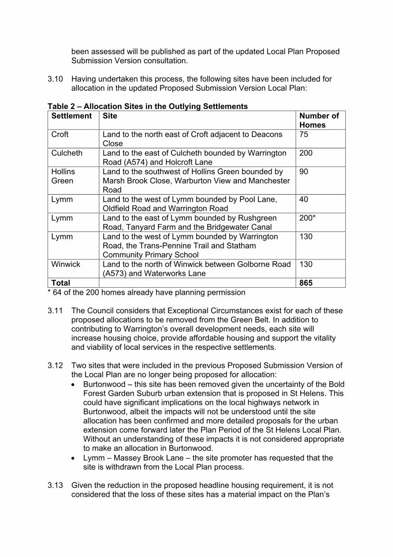
3.10 Having undertaken this process, the following sites have been included for
allocation in the updated Proposed Submission Version Local Plan: Table 2 – Allocation Sites in the Outlying Settlements Settlement Site Number of
Homes Croft Land to the north east of Croft adjacent to Deacons
Close 75
Culcheth Land to the east of Culcheth bounded by Warrington Road (A574) and Holcroft Lane
200
Hollins Green
Land to the southwest of Hollins Green bounded by Marsh Brook Close, Warburton View and Manchester Road
90
Lymm Land to the west of Lymm bounded by Pool Lane, Oldfield Road and Warrington Road
40
Lymm Land to the east of Lymm bounded by Rushgreen Road, Tanyard Farm and the Bridgewater Canal
200*
Lymm Land to the west of Lymm bounded by Warrington Road, the Trans-Pennine Trail and Statham Community Primary School
130
Winwick Land to the north of Winwick between Golborne Road (A573) and Waterworks Lane
130
Total 865 * 64 of the 200 homes already have planning permission 3.11 The Council considers that Exceptional Circumstances exist for each of these
proposed allocations to be removed from the Green Belt. In addition to contributing to Warrington’s overall development needs, each site will increase housing choice, provide affordable housing and support the vitality and viability of local services in the respective settlements.
3.12 Two sites that were included in the previous Proposed Submission Version of
the Local Plan are no longer being proposed for allocation: • Burtonwood – this site has been removed given the uncertainty of the Bold
Forest Garden Suburb urban extension that is proposed in St Helens. This could have significant implications on the local highways network in Burtonwood, albeit the impacts will not be understood until the site allocation has been confirmed and more detailed proposals for the urban extension come forward later the Plan Period of the St Helens Local Plan. Without an understanding of these impacts it is not considered appropriate to make an allocation in Burtonwood.
• Lymm – Massey Brook Lane – the site promoter has requested that the site is withdrawn from the Local Plan process.
3.13 Given the reduction in the proposed headline housing requirement, it is not
considered that the loss of these sites has a material impact on the Plan’s

spatial strategy. It is therefore not proposed to allocate any additional sites in the outlying settlements.
3.14 No sites were identified for Glazebury given that sites here were strongly performing in Green Belt terms and they did not perform sufficiently well against the assessment criteria. Given the small number of homes that would have been allocated to Glazebury, the Council concluded it was not necessary to re-allocate any additional homes to the other settlements.
3.15 Each of the proposed allocations has been subject to viability assessment, taking into account policy and planning obligations requirements, to demonstrate the respective allocations are capable of being delivered.
3.16 A Heritage Impact Assessment has also been prepared for each of the allocations, in liaison with Historic England, which has informed the individual allocation policies.

4. Development options adjacent to the Main Urban Area 4.1 Having confirmed the capacity of the existing urban area and identified the
allocation sites in the outlying settlements, the balance of Green Belt release needs to be accommodated adjacent to the main urban area in accordance with the Plan’s proposed spatial strategy.
4.2 In considering potential options for Green Belt release, the Council has
assessed options that are within a range of 5% above and 5% below the 10% flexibility benchmark. With 801 homes of the Green Belt requirement met within the outlying settlements, this results in an options assessment range of between 2,836 and 4,305 homes.
4.3 This enables a range of options to be assessed, ensuring sufficient flexibility
is provided within the land supply, but without resulting in the loss of excess amounts of Green Belt.
Defining the components for options
4.4 Having reviewed the site assessment process that informed the previous
Proposed Submission Version Local Plan, responses to the previous PSVLP consultation and updated evidence base work, the Council has re-confirmed the component development proposals from which the options for assessment can then be defined.
4.5 In particular the Council has given detailed consideration to build rates and
lead in times relating to the proposed urban extensions, given concerns raised during the previous PSVLP consultation relating to deliverability.
4.6 The table below confirms the build rates that the Council has used in
assessing options. The rates have been defined based on a review of the Council’s housing monitoring data and engagement with developers promoting sites. Given the number of representations to the previous PSVLP consultation which criticised the Council for using unrealistic build rates, the Council has also compared the rates to the Lichfields’ ‘Start to Finish’ report to ensure they are not unduly optimistic.
Table 3 – Assumed Build Rates
Development Size Average annual build rate (dwellings)
Up to 500 55 500 to 1,000 70 1,000 to 2,000 120 2,000+ 180
4.7 The lead in time for each component has been considered based on site
specific circumstance and likely timescales for delivery of enabling infrastructure.

Garden Suburb 4.8 The Council accepts the allocation in the previous PSVLP was overly
optimistic in terms of the average build rate of 300 homes per annum and that it was not possible to demonstrate that the substantial infrastructure required to support the allocation could be delivered in a timely manner, coordinated across all landowners.
4.9 Having reviewed the overall allocation, the Council considers there are 4 reasonable options within the original Garden Suburb allocation area for a smaller South East Warrington Urban Extension allocation, which could deliver around 2,400 homes in the Plan period and between 800 and 1,800 homes beyond the Plan period.
4.10 Given the number of options within the original proposed allocation, these were subject to a separate stage of assessment. The options and a summary of the assessment is set out in the section below.
South West Urban Extension 4.11 Having reviewed representations to the previous PSVLP consultation, the
Council considers that this remains a reasonable option, providing a residential led sustainable urban extension supported by a local centre and new primary school. The Council recognises that the developers promoting the site consider the site could accommodate more homes than the 1,600 proposed in the previous PSVLP and for the purposes of options assessment the Council has used a capacity of 1,700.
Fiddlers Ferry 4.12 Scottish Southern Electric (SSE) confirmed the closure of Fiddlers Ferry
Power Station in 2019, with electricity production ending in 2020. The decommissioning process has started with demolition due to commence in 2022.
4.13 Although the substantive operational area of the power station is being promoted for employment uses, SSE are seeking the release of Green Belt land for housing on agricultural land under their ownership adjacent to the east of the power station site, in order to cross subsidise the remediation of the power station. Over the longer term, there is also the potential for residential development to the south of the railway line on land currently within the Green Belt which has been used for fly ash deposits, as part of a wider development opportunity which would retain and enhance the existing lagoons as a recreational and ecological resource.
4.14 The proposed residential site to the east of the power station could accommodate around 860 homes together with a primary school and small local centre. The southern site is proposed to come forward as a future phase of development with a potential for 450 homes in the Plan Period and a further 450 homes beyond the Plan Period.
4.15 The site is in proximity to western part of the main urban area of Warrington. Although it does not physically adjoin the main urban area of Warrington, it adjoins an existing employment location in Widnes, within the borough of Halton. As such, its characteristics are in keeping with an urban allocation, as opposed to sites being promoted in the outlying settlements. The site has therefore been assessed as a development ‘opportunity site’ for consideration with the other Main Urban area options.
Additional weak performing Green Belt sites 4.16 The Council received a number of representations to the previous PSVLP
consultation stating that additional sites were required in the early years of the Plan Period to offset the longer lead in times and potential risks associated with larger urban extensions.
4.17 In response to these representations, the Council has undertaken a review of all sites immediately adjacent to the main urban area judged to be weak in terms of Green Belt performance. The Council then reconsidered these sites in terms of highways access, whether existing social infrastructure in the vicinity of the sites could accommodate the development and broader sustainability factors as set out in the Council’s SA/SEA and site assessment process.
4.18 Having undertaken this process, the Council identified the potential development of 310 homes at Thelwall Heys and around 40 additional homes at two other smaller sites, which would logically be removed from the Green Belt if Thelwall Heys was to be allocated.
Alternative Site Options 4.19 The Council has previously assessed urban extensions in north and west
Warrington. Given issues around Green Belt performance and infrastructure delivery, the Council does not consider that these options perform well enough to merit inclusion in a further options assessment process.
4.20 Similarly, the Council considered a dispersed option focussing on the poorest performing Green Belt sites. This option raised issues in terms of ability to deliver infrastructure to support growth and again the Council does not consider that this option performs well enough to merit inclusion in a further options assessment process, albeit the Council has now included the smaller site at Thelwall Heys as a component of the spatial options.
4.21 The Council has received further representations from St Modwin who are promoting employment and residential development in east Warrington. An urban extension in this location was previously ruled out as unreasonable to due ecological, flood risk and infrastructure constraints as well as the Green Belt in this location being assessed as ‘strongly performing’.
4.22 The Council acknowledges that the Environment Agency have in 2021 updated their flood risk maps and this site is no longer within flood zone 3. However, the residential element of the proposals are predominantly located in an area of peat reserves and the Council questions the ability of the site to
accommodate a sufficient number of homes to support a new primary school, which is considered essential if a sustainable urban extension is to be accommodated in this location. Together with the strongly performing Green Belt status of this area, the residential element of the proposal is still not considered a reasonable option by the Council. The employment element is not impacted to the same extent in respect of peat reserves and has been separately assessed as detailed in Section 6 below.
South East Warrington Urban Extension Assessment
Confirmation of Options 4.23 The Council has previously undertaken extensive engagement with the
developers promoting the wider allocation as defined in the previous PSVLP. Having concluded that the original allocation was not now capable of being delivered the Council met with each individual developer to explain the rationale for the Council’s decision not to proceed with the wider allocation and provide them with the opportunity to put forward their ideas for a smaller, deliverable allocation.
4.24 Having reviewed the previous evidence base work undertaken, the consultation responses to the previous PSVLP and reflected on the engagement with individual developers, the Council defined four options for assessment from within the original proposed allocation boundary. Each option was capable of delivering around 2,400 homes in the Plan period with between 800 to 1800 homes beyond the Plan period. Each option was considered to have the potential to deliver the extensive range of highways, environmental and social infrastructure required to ensure development will be genuinely sustainable in this part of Warrington. A plan showing boundaries of the options is provided with the options assessment table in Appendix 4.
Option 1 – Land extending from Grappenhall Heys in the north to the south as far as Stretton Lane. This land is the legacy land from the New Town Commission which is being promoted by Homes England. It would effectively extend the existing Homes England developments on non-Green Belt land that are already under construction at Grappenhall Heys, Appleton Cross and Pewterspear. This land could deliver 2,400 homes in the Plan period and around 1,200 beyond the plan period.
Option 2 – Similar to option 1 but extending further south to the M56. This includes land being promoted by a private developer in addition to that being promoted by Homes England. The option would still deliver 2,400 homes in the Plan period but provide for around 1,800 beyond the Plan period.
Option 3 – This option includes the Homes England land around Grappenhall Heys but extends to the south east to include land being promoted by private developers, up to the boundary of Broad Lane in the east. This includes the area of land where the neighbourhood centre was envisaged to be located in the original development concept contained in the previous PSVLP. This
option could deliver 2,400 homes in the Plan Period and between around 800 to 1,000 homes beyond the Plan Period.
Option 4 – This option includes the eastern element of the original allocation, extending southwards parallel to the A50 to the potential proposed employment location and westwards to include the land where there neighbourhood centre was envisaged to be located. This land is being promoted by a number of private sector developers. This option could also deliver 2,400 homes in the Plan Period and between around 800 to 1,000 homes beyond the Plan Period.
4.24 The Council did consider smaller options which could be built out in their entirety within the Plan Period. However, the Council did not consider that these would be reasonable options given the level of infrastructure required to support a sustainable urban extension in this location. In particular, the existing highways infrastructure is heavily constrained requiring junction improvements and new distributor road. Similarly the development needs to be of a sufficient scale to support a new secondary school, given the capacity constraints within existing schools.
4.25 The Council also considered an option that would extend from Grappenhall Heys in the north, extending eastwards to the A50 but concluded that this option was also unreasonable. In considering likely revised Green Belt boundaries for this option, the Council concluded it would result in excessive land being removed from the Green Belt and raise deliverability issues given the number of landownerships this would include. It could also impact on Grappenhall Village, a washed over Green Belt settlement containing a Conservation Area and a number of heritage assets. A consequence of this option is that Grappenhall Village would be removed from the Green Belt and would become part of the main urban area of Warrington.
Options assessment process 4.26 The options assessment tables for the South East Warrington Urban
Extension Options are provided in Appendix 4. The conclusions of the SA/SEA assessment are summarised in the assessment table. The full SA/SEA is provided as a separate evidence base document.
4.27 As with the high level spatial distribution options assessment, the Council has taken into account all relevant supporting evidence base documents. In addition, the Council has undertaken a separate exercise assessing the impact on the Green Belt of the options, which the Council has published as part of its overall Green Belt assessment evidence.
4.28 The options process for the South East Urban Extension again provides a qualitative rather than quantitative assessment of each option. This is because there are advantages and disadvantages in each of the options which require judgement and do not necessarily result in a single option which can be measured as quantifiably better than another.

4.29 The Council considers this is consistent with paragraph 35 of the NPPF (2021) which requires the Local Plan to provide an appropriate strategy, taking into account the reasonable alternatives, and based on proportionate evidence.
Confirmation of preferred option 4.30 Through the Options Assessment process, taking into account the SA/SEA,
the Council concluded that Option 2 is its preferred option.
4.31 Although none of the options are considered to have a significant impact on the strategic function of Warrington’s Green Belt, Options 1 to 3 include the weakest performing areas of Green Belt around Grappenhall Heys. Options 1, 3 and 4 would result in the minimal amount of Green Belt land release, but Option 2 provides would make the strongest contribution to ensuring the permanence of the revised Green Belt boundaries in the long term, without the loss of any strongly performing Green Belt parcels.
4.32 Although all options have sufficient land to enable the required on-site social infrastructure, Options 1 and 2 perform best in terms of contributing to the sustainable growth of the main urban area of Warrington as a whole. They would enable better integration within communities, facilities and public transport services in Stockton Heath, Appleton and Stretton, although Options 3 and 4 did provide the benefit of better linkages through to the proposed employment location at the Junction of the M6 and M56, subject to its confirmation as an allocated in the updated draft Plan. As such, Options 1 and 2 performed strongly against a number of Plan Objectives and in terms of SA/SEA.
4.33 Compared to Option 1 however, Option 2 is likely to require the least amount of off-site highways works necessitating third party land, which is a positive factor in terms of deliverability.
Main Urban Area Options Assessment
Confirmation of Options 4.34 Having considered combinations of the components set out above, including
the preferred option for the South East Warrington Urban Extension, the Council has confirmed five options for assessment that could provide the number of homes within the required range identified at para 4.2 above.
Option 1 - An urban extensions to the south east of Warrington of around 2,400 homes and an urban extension to the south west of around 1,700 homes.
Option 2 - An urban extension to the south east of Warrington of around 2,400 homes and development of Fiddlers Ferry opportunity site for 1,300 homes.

Option 3 - An urban extensions to the south east of Warrington of around 2,400 homes, development of Fiddlers Ferry opportunity site for 1,300 homes & development at Thelwall Heys of 310 homes.
Option 4 – Urban extension to the south west of around 1,700 homes, development of Fiddlers Ferry opportunity site for 1,300 homes and development at Thelwall Heys of 310 homes.
Option 5 - Urban extension to the south west of around 1,700 homes & development of Fiddlers Ferry opportunity site for 1,300 homes
Options Assessment Process 4.35 The Main Urban Area Options Assessment is set out in the table provided at
Appendix 5. The conclusions of the SA/SEA assessment are summarised in the assessment table. The full SA/SEA is provided as a separate evidence base document.
4.36 As with the high level options assessment and the South East Urban Extension options assessment, the Council has taken into account all relevant supporting evidence base documents
4.37 Similarly, the options process for the Main Urban Area provides a qualitative rather than quantitative assessment of each option. This is because there are advantages and disadvantages in each of the options which require judgement and do not necessarily result in a single option which can be measured as quantifiably better than another.
4.38 The Council considers this is consistent with paragraph 35 of the NPPF (2021) which requires the Local Plan to provide an appropriate strategy, taking into account the reasonable alternatives, and based on proportionate evidence.
Confirmation of preferred locations adjacent to the Main Urban Area 4.39 Through the Options Assessment process, taking into account the SA/SEA,
the Council concluded that Option 3 is its preferred option.
4.40 This Option performs strongly across the majority of Local Plan Objectives. It is capable of meeting development needs and delivering the infrastructure needed to support the development itself and also contributing to the wider sustainable development of Warrington as a whole. It enables the regeneration of Fiddlers Ferry power station, the largest available brownfield site in the Borough. Green Belt release can be facilitated without comprising the strategic importance of Warrington’s Green Belt as a whole, with revised boundaries likely to be robust and durable beyond the Plan period.
4.41 The Council considers the above provides the Exceptional Circumstances required for Green Belt release in accordance with the requirements of the NPPF.

4.42 Further, the NPPF at para 73 recognises that the supply of large numbers of new homes can often be best achieved through planning for larger scale development, including significant extensions to existing towns, provided they are well located and designed, and supported by the necessary infrastructure and facilities.
4.43 This option could have an impact on the Green Belt separating Warrington
and Widnes. The Fiddlers Ferry allocation will therefore need to ensure that development provides a robust and durable Green Belt boundary in this location.
4.44 There will be impacts on the character of surrounding areas but the size of the
allocations enables some of these impacts to be offset. Similarly impacts on important ecological and heritage assets can be mitigated.
4.45 Option 1, without the wider Fiddlers Ferry opportunity area, would not enable
the regeneration of the power station site. This is a major weakness of this option. The Council also has concerns about the potential impact of the South West Urban Extension on the Western Link.
4.46 Options 4 and 5 would generate a level of development that could not be
supported by existing secondary schools in south Warrington. These options would also impact on the Green Belt separating Warrington and Halton in two locations – between the main urban area of Warrington and Widnes and between the main urban area of Warrington and Runcorn. Further, these options may not support the long term permanence of the revised Green Belt boundaries given their limited potential to support development beyond the plan period. As such it is likely that the Council would need to identify additional safeguarded land.
4.47 Option 2 performed strongly, but inclusion of the Thelwall Heys site in Option
3 has the benefit of increasing housing delivery in the early part of the Plan period, complementing the larger development sites without having a material impact on the functioning of Warrington’s Green Belt.
Additional work to confirm the South East Warrington Urban Extension Allocation
4.48 The Council has engaged with the developers promoting land in the proposed
allocation and with infrastructure providers to confirm the required infrastructure to support the allocation and to demonstrate that the allocation as a whole is viable and can be delivered. This is demonstrated in the ‘Deliverable Proposition’ document prepared by the developers in liaison with the Council and in the Council’s updated Local Plan Viability Assessment.
4.49 The Council has engaged with Highways England to ensure that appropriate
improvements can be made to the strategic road network to support the allocation. The Council also engaged with Natural England and the Environment Agency to address ecological and environmental issues.

4.50 A Heritage Impact Assessment has been prepared for the allocation, in liaison with Historic England, which has informed the Local Plan allocation policy.
Additional work to confirm the Fiddlers Ferry Allocation
4.51 The Council has engaged with SSE and with infrastructure providers to
confirm the required infrastructure to support the allocation and to demonstrate that the allocation as a whole is viable and can be delivered. This is demonstrated in the ‘Regeneration Vision’ document prepared by SSE in liaison with the Council and in the Council’s updated Local Plan Viability Assessment.
4.52 The Council has met with Halton Borough Council under the Duty to
Cooperate, given the allocation site borders Halton’s boundary. These discussions have considered the proposed type and amount of development and potential infrastructure impacts and requirements. The discussions with Halton have informed the allocation policy.
4.53 Halton have also confirmed that they are able to meet their housing needs in
full and as such have agreed that the full extent of housing on the allocation site will contribute towards meeting Warrington’s needs.
4.54 Warrington will continue to work with Halton Borough Council under the Duty
to Cooperate as the Local Plan progress through to Examination and throughout the period of the development of the Fiddlers Ferry opportunity area allocation.
4.55 The Council has engaged with Highways England to ensure that appropriate
improvements can be made to the strategic road network to support the development.
4.56 The Council also engaged with Natural England and the Environment Agency
to address ecological and environmental issues. 4.57 A Heritage Impact Assessment has been prepared for the Fiddlers Ferry
allocation, in liaison with Historic England, which has informed the Local Plan allocation policy.
Additional work to confirm Thelwall Heys Allocation
4.58 The Council has engaged with the site promoter to demonstrate that the
allocation is viable and can be delivered. This is demonstrated in the Council’s updated Local Plan Viability Assessment.
4.59 A Heritage Impact Assessment has been prepared for the allocation, in liaison
with Historic England, which has informed the Local Plan allocation policy.
5. Housing Land Supply
Local Plan Housing Trajectory
5.1 The NPPF (paragraph 73) requires local planning authorities to illustrate the expected rate of housing delivery over the plan period through a ‘housing trajectory’.
5.2 The NPPF also requires local planning authorities to identify and update
annually a supply of specific deliverable sites sufficient to provide a minimum of five years’ worth of housing against their housing requirement. This should include a buffer moved forward from later in the Plan Period.
5.3 In Warrington’s case the buffer should be 20% given past performance
against the Government’s Housing Delivery Test. 5.4 The Plan’s housing trajectory is shown in Appendix 1 of the draft Local Plan.
The trajectory confirms that the Plan provides for a sufficient land supply to deliver the housing requirement for the Borough over the Plan Period as a whole. However, the need to release Green Belt land and the lead in times for the infrastructure required to support the larger allocation sites means that there will be a relatively lower level of housing delivery in the early years of the Plan Period, with housing delivery increasing over time.
5.5 The Council is therefore proposing a Stepped Housing Trajectory. The
housing requirement over the first 5 years will be 678 per dwellings annum. This will match deliverable supply over this period when the 20% buffer is added. The requirement over the remaining 13 years of the Plan, will increase to 870 per annum. This will ensure the overall requirement of 14,688 is met.
5.6 The Government’s planning guidance recognises that such an approach is
appropriate where strategic sites such as those being proposed by the Council will have a phased delivery or are likely to be delivered later in the plan period (PPG Housing and Economic Land Availability Assessment para 34).
5.7 The Council’s Annual Monitoring Report (AMR) will update the housing
trajectory each year, helping to ensure a five year supply is maintained throughout the Plan period and signalling any need for intervention and/or Plan review.
Housing Land Supply beyond the Plan Period
5.8 The Council recognises that consideration must be given to housing land
supply beyond the Plan period if it is to demonstrate the permanence of the revised Green Belt boundaries in accordance with the NPPF.
5.9 Given the Council is promoting major urban extensions as part of its spatial
strategy, the Council has given consideration to an overall timescale of 30 years in accordance with paragraph 22 of the NPPF which requires Council’s

to provide a longer term vision when promoting such forms of development. Given the inherent uncertainties in looking this far into the future, the Council has used a set of notional assumptions covering the 12 years beyond the 18 year Plan Period. This is intended as a sense check, rather than a detailed assessment process.
5.10 The rate of increase in households in Warrington decreases over the last 10
year period of the Plan. Over the period 2028 to 2038 household growth will reduce to an annual average of 605 homes per annum (2014 based household projections).
5.11 In providing a positive plan for growth and based on the principles
underpinning the Government’s standard housing method, the Council considers that by the end of the Plan period, house price affordability will no longer be a significant issue in Warrington. In considering the period beyond the end of the Plan, the Council has therefore assumed that no further affordability uplift will be required.
5.12 Given the rate of job growth is also forecast to decrease over time, the
Council considers that in providing for the needs of household growth there will be sufficient new homes to provide a balance with future jobs growth.
5.13 The Local Plan is already providing for an additional 1,948 homes through the
flexibility factor in its land requirement calculation. The proposed South East Warrington Urban Extension allocation in the draft Local Plan will provide for around 1,800 homes beyond the Plan period, Fiddlers Ferry will provide around 450 homes and the Waterfront 265 homes. .
5.14 The Council acknowledges that the availability of brownfield development
sites is likely to decrease over time. Nevertheless, given likely advances in technology and development trends over the next 18 years, the Council considers it is likely there will still be additional brownfield development sites within the existing urban that will come forward beyond the Plan Period but which cannot be accounted for at present. The Council has therefore identified the average level of brownfield development in the final 5 years of the Plan period and has projected this forward to account for potential brownfield capacity.
5.15 The table below compares the indicative scale of development needs in the
12 year period following the end of the Plan Period against the indicative land supply.

Table 4 – Comparison of development needs and land supply post plan period
Indicative Housing Requirement 2037 to 2047 Annual household growth 2028-38* 605 Projected forward 2039/40 to 2050/51 (12 yrs) 7,260 Number of homes required 2039/40 to 2050/51** 7,406 Indicative Housing Supply 2037 to 2047 Additional supply within Plan from flexibility 1,948 Garden Suburb delivery post 2038 1,800 Fiddlers Ferry delivery post 2038 450 Waterfront delivery post 2038 265 Assumed brown field development 3,024 Total indicative supply 7,487
* 2014 based household projections * * Based on calculation used in LHNA
5.16 It can be seen that the indicative requirement is broadly in line with the
indicative supply over this period. 5.17 The Council is therefore confident that in respect of future housing needs, the
amended Green Belt boundaries are capable of enduring well beyond the end of the Plan period in accordance with paragraph 136 of the NPPF. As such, the Council considers there is no need for any safeguarding of land to meet future housing needs.
Consideration of Affordable Housing Supply
5.18 In accordance with the Government’s Planning Practice Guidance, the
Council has considered the total affordable housing need in the context of its likely delivery as a proportion of mixed market and affordable housing developments, taking into account the probable percentage of affordable housing to be delivered by eligible market housing led developments.
5.19 The guidance states that an increase in the total housing figures included in
the plan may need to be considered where it could help deliver the required number of affordable homes. (NPPG Housing need assessment: Para 027)
5.20 In undertaking this consideration, the Council is assuming that its affordable
housing policy will deliver around 25% of housing completions as affordable from eligible market housing led developments. This takes into account the target of 20% in Inner Warrington and 30% in the remainder of the existing urban area, Main Development Areas and allocation sites in the outlying settlements. It also takes into account that affordable housing is not required on developments of less than ten homes and that some sites in the existing urban area may benefit from the Vacant Building Credit. The Local Plan Viability Assessment demonstrates that the policy is seeking the maximum reasonable proportion of affordable housing.
5.21 This means that the proposed Local Plan Housing target of 816 homes per
annum is likely to delivery around 204 affordable homes per annum from

eligible market housing led developments. This is below the identified need of 433 affordable homes per annum as established in the Local Housing Need Assessment.
5.22 The Council therefore needs to consider whether it should increase its
housing target above 816 in order to increase the supply of affordable housing.
5.23 It is considered totally unreasonable for the Council to deliver the full
affordable housing requirement through its affordable housing policy applied to eligible market housing led developments. This would require the housing target to more than double and from the SA/SEA process and previous consultations it is apparent that this would result in unacceptable environmental harm and would be unrealistic in terms of delivery.
5.24 The Council has considered whether it should apply a smaller uplift to the
headline housing target. For example, the previous PSVLP target of 945 dpa could result in a further 32 affordable homes a year.
5.25 However, as set out in Section 2 above, in reviewing the Plan’s housing
requirement, the Council has concerns about the realism of sustaining such a level of housing growth over the Plan period and the additional Green Belt land which would need to be released. Further, a higher housing target could result in issues of market saturation and / or result in a higher level of out-commuting given the increase in working age population would be proportional higher to the number of jobs forecast to be created over the Plan period.
5.26 The PPG recognises that the need for particular groups, including those in
need of affordable housing, may well exceed, or be proportionally high in relation to, the overall housing need figure calculated using the standard method. This is because the needs of particular groups will often be calculated having consideration to the whole population of an area as a baseline as opposed to the projected new households which form the baseline for the standard method.
5.27 From the LHNA it can be seen that the net affordable requirement excluding
existing households is 109 dwellings per annum. Further, it is apparent from the LHNA that the reason for the increase in affordable housing need over time is primarily due to the reduction in re-lets from available properties, rather than an increase in gross affordable need.
5.28 The Council notes that the Government’s standard method already includes
an uplift above basic demographic need to address issues of affordability. 5.29 By providing a flexibility in land supply which equates to 13.5%, and a longer
term supply of homes beyond the Plan Period, there is also the potential for further delivery should the housing market be able to deliver at a higher rate.

5.30 There are also other sources of affordable housing supply, including developments by Registered Providers and the Council’s Housing Company which are likely to deliver a much higher proportion of affordable housing.
5.31 The Council is therefore not proposing a further uplift to its proposed housing
target of 816. 5.32 The Council will however keep overall housing delivery and affordable
housing delivery under review.
6. Allocation of Employment Sites
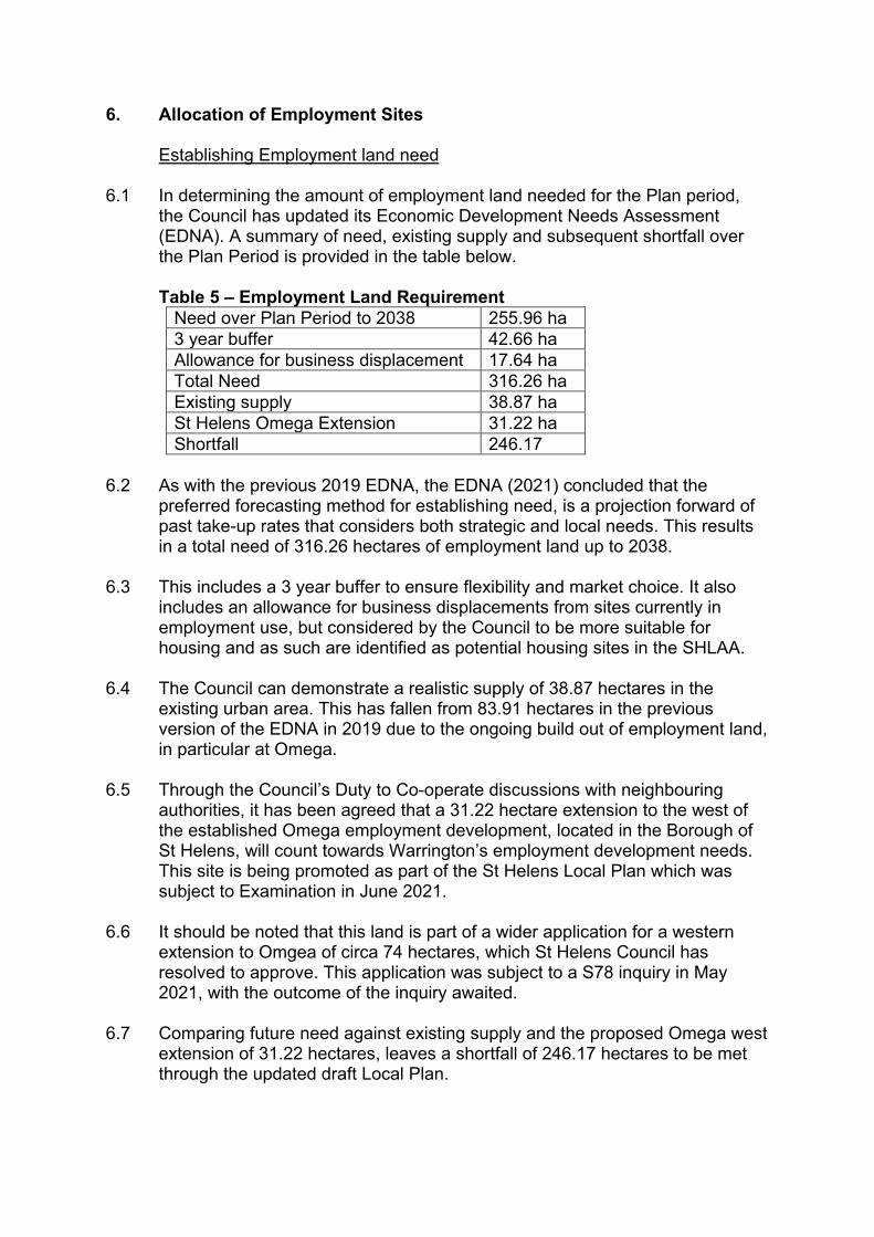
Establishing Employment land need 6.1 In determining the amount of employment land needed for the Plan period,
the Council has updated its Economic Development Needs Assessment (EDNA). A summary of need, existing supply and subsequent shortfall over the Plan Period is provided in the table below.
Table 5 – Employment Land Requirement
Need over Plan Period to 2038 255.96 ha 3 year buffer 42.66 ha Allowance for business displacement 17.64 ha Total Need 316.26 ha Existing supply 38.87 ha St Helens Omega Extension 31.22 ha Shortfall 246.17
6.2 As with the previous 2019 EDNA, the EDNA (2021) concluded that the
preferred forecasting method for establishing need, is a projection forward of past take-up rates that considers both strategic and local needs. This results in a total need of 316.26 hectares of employment land up to 2038.
6.3 This includes a 3 year buffer to ensure flexibility and market choice. It also
includes an allowance for business displacements from sites currently in employment use, but considered by the Council to be more suitable for housing and as such are identified as potential housing sites in the SHLAA.
6.4 The Council can demonstrate a realistic supply of 38.87 hectares in the
existing urban area. This has fallen from 83.91 hectares in the previous version of the EDNA in 2019 due to the ongoing build out of employment land, in particular at Omega.
6.5 Through the Council’s Duty to Co-operate discussions with neighbouring
authorities, it has been agreed that a 31.22 hectare extension to the west of the established Omega employment development, located in the Borough of St Helens, will count towards Warrington’s employment development needs. This site is being promoted as part of the St Helens Local Plan which was subject to Examination in June 2021.
6.6 It should be noted that this land is part of a wider application for a western
extension to Omgea of circa 74 hectares, which St Helens Council has resolved to approve. This application was subject to a S78 inquiry in May 2021, with the outcome of the inquiry awaited.
6.7 Comparing future need against existing supply and the proposed Omega west
extension of 31.22 hectares, leaves a shortfall of 246.17 hectares to be met through the updated draft Local Plan.

Options Assessment Process
6.8 The Council has re-assessed all of the potential employment sites submitted
for consideration as part of the Local Plan process to take into account the most up to date evidence and market considerations. This includes assessment as part of the updated EDNA and then assessment in accordance with the Council’s site selection process, taking into account the Plan’s objectives, and SA/SEA.
6.9 The Council has assessed the redevelopment of Fiddlers Ferry as a potential
new employment site. It should be noted that although the operational area of the former power station is a brownfield site, the remediation of the site is dependent on enabling residential development on adjacent land which is currently within the Green Belt.
6.10 In updating the EDNA assessment, sites are graded A to E with ‘A’ sites
judged to be the best performing to meet strategic employment needs and ‘B’ sites the best performing to meet local employment needs. The sites are also given a ‘+’ where there are no significant constraints to the site coming forward, discounting Green Belt status, or a ‘-‘ where there is a potential significant constraint(s) on the site coming forward, although the constraint(s) could potentially be overcome with investment.
6.11 The results of the EDNA site assessment exercise are published as part of
the updated EDNA (20201). The overall site assessment conclusions for each Grade ‘A’ and ‘B’ sites, including the justification for the sites proposed to be allocated, are included in Appendix 6. The site proformas containing the full appraisals for every submitted site will be published as part of the updated Proposed Submission Version Local Plan consultation.
Confirmation of Proposed Sites for allocation
6.12 The ENDA recommends the Council gives detailed consideration to the
identified A and B graded sites which provide the potential to meet the identified shortfall of employment land. The sites are summarised in the table below.
Table 6 - A and B Graded Employment Sites Site Name Size, ha Grading Land at Bradley Hall Farm, Cliff Road - Six56 (Phase I)
92.00 (gross).
A+
Land around Barleycastle Lane, Barleycastle (Six sites)
44.92 (gross)
A+/B+
Six56 Phase II 70.00 (gross)
A- / B-
Fiddlers Ferry 101.00 (gross)
A- / B-
Port Warrington 60.00 A- / B- St Modwen – Rixton Scheme 47.00 A- / B-
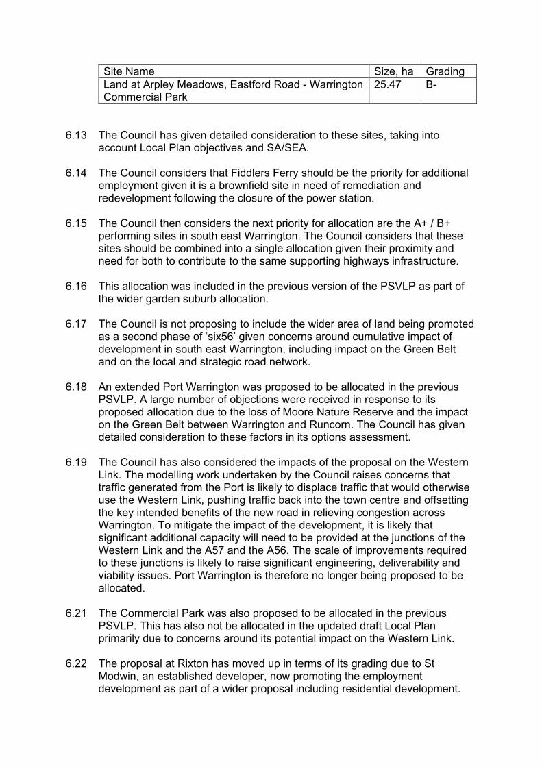
Site Name Size, ha Grading Land at Arpley Meadows, Eastford Road - Warrington Commercial Park
25.47 B-
6.13 The Council has given detailed consideration to these sites, taking into
account Local Plan objectives and SA/SEA. 6.14 The Council considers that Fiddlers Ferry should be the priority for additional
employment given it is a brownfield site in need of remediation and redevelopment following the closure of the power station.
6.15 The Council then considers the next priority for allocation are the A+ / B+
performing sites in south east Warrington. The Council considers that these sites should be combined into a single allocation given their proximity and need for both to contribute to the same supporting highways infrastructure.
6.16 This allocation was included in the previous version of the PSVLP as part of
the wider garden suburb allocation. 6.17 The Council is not proposing to include the wider area of land being promoted
as a second phase of ‘six56’ given concerns around cumulative impact of development in south east Warrington, including impact on the Green Belt and on the local and strategic road network.
6.18 An extended Port Warrington was proposed to be allocated in the previous
PSVLP. A large number of objections were received in response to its proposed allocation due to the loss of Moore Nature Reserve and the impact on the Green Belt between Warrington and Runcorn. The Council has given detailed consideration to these factors in its options assessment.
6.19 The Council has also considered the impacts of the proposal on the Western
Link. The modelling work undertaken by the Council raises concerns that traffic generated from the Port is likely to displace traffic that would otherwise use the Western Link, pushing traffic back into the town centre and offsetting the key intended benefits of the new road in relieving congestion across Warrington. To mitigate the impact of the development, it is likely that significant additional capacity will need to be provided at the junctions of the Western Link and the A57 and the A56. The scale of improvements required to these junctions is likely to raise significant engineering, deliverability and viability issues. Port Warrington is therefore no longer being proposed to be allocated.
6.21 The Commercial Park was also proposed to be allocated in the previous
PSVLP. This has also not be allocated in the updated draft Local Plan primarily due to concerns around its potential impact on the Western Link.
6.22 The proposal at Rixton has moved up in terms of its grading due to St
Modwin, an established developer, now promoting the employment development as part of a wider proposal including residential development.

Further, the Environment Agency’s revised Flood Risk Zone boundaries have confirmed that the site is no longer within Flood Zone 3.
6.23 The Council does not consider the residential element of the proposals to be a
reasonable option for consideration for the reasons set out in para 4.21 above. The Council considers that the employment element of the proposals is a reasonable option, given the EDNA grading and that the area proposed for employment is not impacted to the same extent in respect of peat resources.
6.24 Nevertheless, the Council does not consider this site performs as well as
Fiddlers Ferry and the South East Warrington Employment area, given its strong Green Belt performance and concerns regarding intervening landownership which could place limitations on the scale and location of employment that could be developed on the site.
6.25 The Council has previously given consideration to a site at Joy Lane which
could provide a modest extension to Omgea north and has been graded as a ‘B -‘ site’ in the EDNA. The site was not allocated in the previous PSVLP due to concerns around concerns the ability of the site to deliver the required infrastructure improvements to the local and strategic road networks. The Council does not consider there has been any change in circumstance to change its previous conclusions in respect of this site.
6.26 The proposed sites at Fiddlers Ferry and South East Warrington provide a
total of approximately 237.92 ha, which is marginally below the required need by around 8 ha.
6.27 The Council considers that there is a strong likelihood the balance of
employment land need will be met from windfall sites in locations such as Appleton Thorn, Warrington Town Centre and the wider urban area, meeting some ongoing needs during, and after the Plan period, and compensating for some losses of employment land to other uses.
6.28 Should the western extension of Omega by approved following the Section 78
inquiry, then this could make a further contribution to meeting Warrington’s employment land needs over and above the 31.22ha already agreed through the ‘Duty to Cooperate’.
6.29 The Council acknowledges that if through its annual monitoring process, a
shortfall becomes apparent then this will signal the need for possible intervention and/or a formal review of the Plan.
Additional Work to confirm allocations
Review of allocations in context of wider Plan Strategy
6.30 The Council has reviewed the site allocations in the context of the wider Local Plan spatial strategy.

6.31 The employment allocation at Fiddlers Ferry is integral to the wider Fiddlers Ferry development opportunity as set out in Section 4 of this report.
6.32 The South East Warrington Employment Location will no longer form part of
what was the wider Garden Suburb allocation and will be separated from the South East Warrington Urban Extension. This has been taken into account in the assessment of both the residential and employment allocations.
South East Warrington Employment Location
6.33 The Council has engaged with the developers promoting the allocation and infrastructure providers to confirm the required infrastructure to support the allocation and to demonstrate that the allocation as a whole is viable and can be delivered. This is demonstrated in the Council’s updated Local Plan Viability Assessment.
6.34 The Council has engaged with Highways England to ensure that appropriate
improvements can be made to the strategic road network to support the development. The Council also engaged with Natural England and the Environment Agency to address ecological and environmental issues.
6.35 A Heritage Impact Assessment has been prepared for the allocation, in liaison
with Historic England, which has informed the Local Plan allocation policies.
Additional work to confirm the Fiddlers Ferry Allocation 6.36 The Council has engaged with SSE and with infrastructure providers to
confirm the required infrastructure to support the allocation and to demonstrate that the allocation as a whole is viable and can be delivered. This is demonstrated in the ‘Regeneration Vision’ document prepared by the developers in liaison with the Council and in the Council’s updated Local Plan Viability Assessment.
6.37 The Council has met with Halton Borough Council under the Duty to
Cooperate given the allocation site borders Halton’s boundary. These discussions have considered the proposed nature and level of development and infrastructure impacts and requirements. The discussions with Halton are reflected in the allocation policy.
6.38 Halton Borough Council has also confirmed that they are able to meet their
identified employment land needs in full and have agreed that the full extent of employment land at Fiddlers Ferry will contribute to meeting Warrington’s needs.
6.39 Warrington will continue to work with Halton Borough Council under the Duty
to Cooperate as the Local Plan progress through to Examination and throughout the period of the development of the Fiddlers Ferry opportunity area allocation.
6.40 The Council has engaged with Highways England to ensure that appropriate
improvements can be made to the strategic road network to support the development.

6.41 The Council also engaged with Natural England and the Environment Agency
to address ecological and environmental issues. 6.42 A Heritage Impact Assessment has been prepared for Fiddlers Ferry, in
liaison with Historic England, which has informed the Local Plan allocation policy.
Alternative Options for Level of Employment Growth
6.43 The Council has previously assessed a lower level of employment land
growth through the SA/SEA process. This is based on only meeting local needs. This scenario does not meet Warrington’s full development needs in accordance with paragraph 11 of the NPPF.
6.44 Further, the Council does not consider the two exemptions to meeting this
need, as set out under paragraph 11(i) and 11(ii), are relevant to Warrington’s emerging Local Plan: • through the options assessment process, taking into account the more
detailed evidence base that has been prepared, the Council does not consider that the loss of a higher level of Green Belt required to meet its full employment land needs provides a strong reason for restricting the overall scale, type or distribution of employment in the plan.
• the Council does not consider that any adverse impacts of meeting its full employment land need significantly and demonstrably outweighs the benefits, when assessed against the policies of the NPPF taken as a whole.
6.45 The Council also considers that it can demonstrate Exceptional
Circumstances for Green Belt release in accordance with the requirements of the NPPF.
6.46 The release of employment sites will ensure that sufficient land is provided to
meet Warrington’s development needs. The proposed employment land allocations will contribute to Plan’s overall spatial strategy and provide a wide range of economic benefits as confirmed through the site assessment process and summarised above.
Small scale office development in Lymm
6.47 In addition to the identified supply of land to meet local needs, the Council’s
Economic Development Needs Assessment (EDNA 20201), identified a need for small scale local office development in the Outlying Settlement of Lymm, to support the local economy. The EDNA findings have therefore been reflected in Policy DEV4-Economic Growth & Development of the Proposed Submission Version Local Plan.
Employment Land Supply beyond the Plan Period

6.48 As shown in the table under para 6.12 above, the Council has considered a number of other ‘A’ and ‘B’ grade employment sites, but at present these have a range of potentially significant constraints.
6.49 Given these constraints, the Council is not proposing to make any further
allocations to come forward later in the Plan Period or to provide safeguarded sites. The Council is however committed to undertaking a review into Warrington’s employment land needs before the end of the Plan period to ensure the long term supply of employment land. By this stage, it is likely that key infrastructure improvements, including the Western Link and motorway junction improvements, will have been delivered and the impacts of any further required employment allocations can be fully appraised.
APPENDICES
Appendix 1 – Updated Proposed Submission Version Local Plan Process Appendix 2 – High level growth options assessment table Appendix 3 – Contender Sites in Settlements – Site Assessment Conclusions Appendix 4 – South East Warrington Urban Extension options assessment table Appendix 5 – Main Urban Area options assessment table Appendix 6 – Grade ‘A’ /’B’ Employment Sites - Site Assessment Conclusions

Appendix 1 - Updated Proposed Submission Version Local Plan Process
1
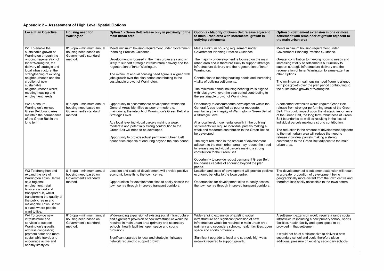
Appendix 2 – Assessment of High Level Spatial Options Local Plan Objective
Housing need for Warrington
Option 1 - Green Belt release only in proximity to the main urban area
Option 2 - Majority of Green Belt release adjacent to main urban area with incremental growth in outlying settlements
Option 3 - Settlement extension in one or more settlement with remainder of growth adjacent to the main urban area
W1 To enable the sustainable growth of Warrington through the ongoing regeneration of Inner Warrington, the delivery of strategic and local infrastructure, the strengthening of existing neighbourhoods and the creation of new sustainable neighbourhoods whilst meeting housing and employment needs.
816 dpa – minimum annual housing need based on Government’s standard method.
Meets minimum housing requirement under Government Planning Practice Guidance. Development is focused in the main urban area and is likely to support strategic infrastructure delivery and the regeneration of Inner Warrington. The minimum annual housing need figure is aligned with jobs growth over the plan period contributing to the sustainable growth of Warrington.
Meets minimum housing requirement under Government Planning Practice Guidance. The majority of development is focused on the main urban area and is therefore likely to support strategic infrastructure delivery and the regeneration of Inner Warrington. Contribution to meeting housing needs and increasing vitality of outlying settlements. The minimum annual housing need figure is aligned with jobs growth over the plan period contributing to the sustainable growth of Warrington.
Meets minimum housing requirement under Government Planning Practice Guidance. Greater contribution to meeting housing needs and increasing vitality of settlements but unlikely to support strategic infrastructure delivery and the regeneration of Inner Warrington to same extent as other Options. The minimum annual housing need figure is aligned with jobs growth over the plan period contributing to the sustainable growth of Warrington.
W2 To ensure Warrington’s revised Green Belt boundaries maintain the permanence of the Green Belt in the long term.
816 dpa – minimum annual housing need based on Government’s standard method.
Opportunity to accommodate development within the General Areas identified as poor or moderate, maintaining the integrity of Warrington’s Green Belt at a Strategic Level. At a local level individual parcels making a weak, moderate and potentially strong contribution to the Green Belt will need to be developed. Opportunity to provide robust permanent Green Belt boundaries capable of enduring beyond the plan period.
Opportunity to accommodate development within the General Areas identified as poor or moderate, maintaining the integrity of Warrington’s Green Belt at a Strategic Level. At a local level, incremental growth in the outlying settlements will require individual parcels making a weak and moderate contribution to the Green Belt to be developed. The slight reduction in the amount of development adjacent to the main urban area may reduce the need to release any individual parcels making a strong contribution to the Green Belt. Opportunity to provide robust permanent Green Belt boundaries capable of enduring beyond the plan period.
A settlement extension would require Green Belt release from stronger performing areas of the Green Belt. This could impact upon the strategic importance of the Green Belt, the long term robustness of Green Belt boundaries as well as resulting in the loss of individual parcels making a strong contribution. The reduction in the amount of development adjacent to the main urban area will reduce the need to release individual parcels making a strong contribution to the Green Belt adjacent to the main urban area.
W3 To strengthen and expand the role of Warrington Town Centre as a regional employment, retail, leisure, cultural and transport hub, whilst transforming the quality of the public realm and making the Town Centre a place where people want to live.
816 dpa – minimum annual housing need based on Government’s standard method.
Location and scale of development will provide positive economic benefits to the town centre. Opportunities for development sites to easily access the town centre through improved transport corridors.
Location and scale of development will provide positive economic benefits to the town centre. Opportunities for development sites to easily access the town centre through improved transport corridors.
The development of a settlement extension will result in a greater proportion of development being geographically more distant from the town centre and therefore less easily accessible to the town centre.
W4 To provide new infrastructure and services to support Warrington’s growth; address congestion; promote safer and more sustainable travel; and encourage active and healthy lifestyles.
816 dpa – minimum annual housing need based on Government’s standard method.
Wide-ranging expansion of existing social infrastructure and significant provision of new infrastructure would be required in main urban area (primary and secondary schools, health facilities, open space and sports provision). Significant upgrade to local and strategic highways network required to support growth.
Wide-ranging expansion of existing social infrastructure and significant provision of new infrastructure would be required in main urban area (primary and secondary schools, health facilities, open space and sports provision). Significant upgrade to local and strategic highways network required to support growth.
A settlement extension would require a range social infrastructure including a new primary school, sports facilities, health facility and open space to be provided in that settlement. It would not be of sufficient size to deliver a new secondary school and could therefore place additional pressure on existing secondary schools.
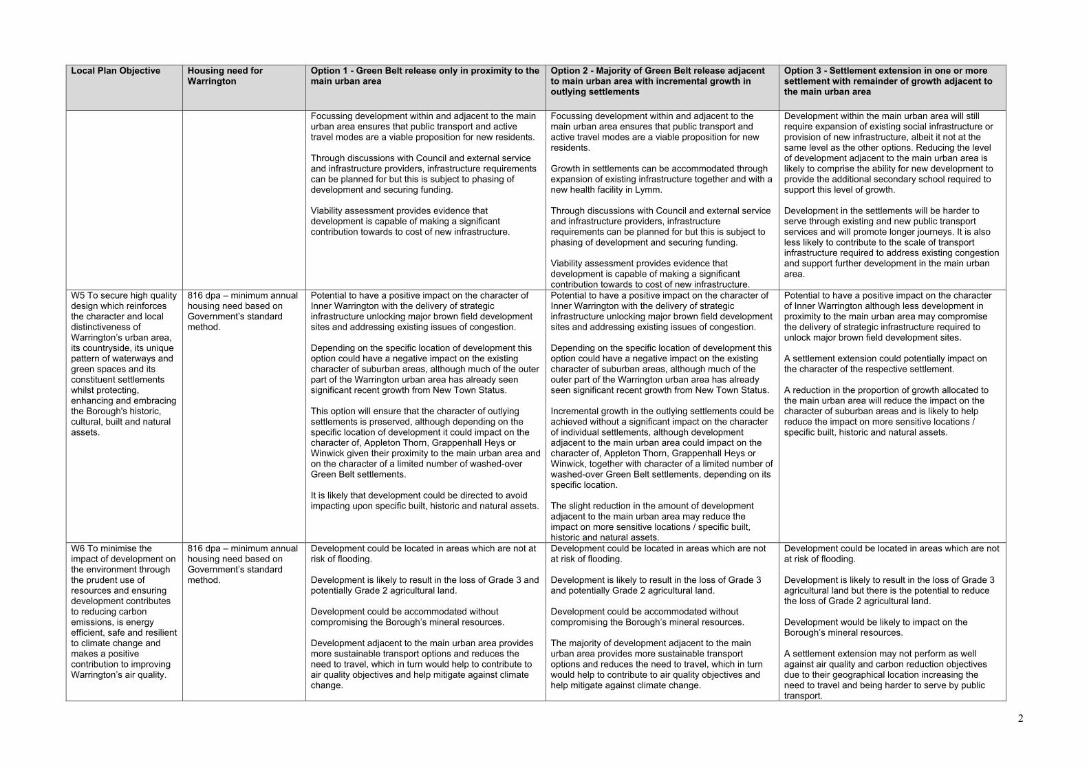
2
Local Plan Objective
Housing need for Warrington
Option 1 - Green Belt release only in proximity to the main urban area
Option 2 - Majority of Green Belt release adjacent to main urban area with incremental growth in outlying settlements
Option 3 - Settlement extension in one or more settlement with remainder of growth adjacent to the main urban area
Focussing development within and adjacent to the main urban area ensures that public transport and active travel modes are a viable proposition for new residents. Through discussions with Council and external service and infrastructure providers, infrastructure requirements can be planned for but this is subject to phasing of development and securing funding. Viability assessment provides evidence that development is capable of making a significant contribution towards to cost of new infrastructure.
Focussing development within and adjacent to the main urban area ensures that public transport and active travel modes are a viable proposition for new residents. Growth in settlements can be accommodated through expansion of existing infrastructure together and with a new health facility in Lymm. Through discussions with Council and external service and infrastructure providers, infrastructure requirements can be planned for but this is subject to phasing of development and securing funding. Viability assessment provides evidence that development is capable of making a significant contribution towards to cost of new infrastructure.
Development within the main urban area will still require expansion of existing social infrastructure or provision of new infrastructure, albeit it not at the same level as the other options. Reducing the level of development adjacent to the main urban area is likely to comprise the ability for new development to provide the additional secondary school required to support this level of growth. Development in the settlements will be harder to serve through existing and new public transport services and will promote longer journeys. It is also less likely to contribute to the scale of transport infrastructure required to address existing congestion and support further development in the main urban area.
W5 To secure high quality design which reinforces the character and local distinctiveness of Warrington’s urban area, its countryside, its unique pattern of waterways and green spaces and its constituent settlements whilst protecting, enhancing and embracing the Borough's historic, cultural, built and natural assets.
816 dpa – minimum annual housing need based on Government’s standard method.
Potential to have a positive impact on the character of Inner Warrington with the delivery of strategic infrastructure unlocking major brown field development sites and addressing existing issues of congestion. Depending on the specific location of development this option could have a negative impact on the existing character of suburban areas, although much of the outer part of the Warrington urban area has already seen significant recent growth from New Town Status. This option will ensure that the character of outlying settlements is preserved, although depending on the specific location of development it could impact on the character of, Appleton Thorn, Grappenhall Heys or Winwick given their proximity to the main urban area and on the character of a limited number of washed-over Green Belt settlements. It is likely that development could be directed to avoid impacting upon specific built, historic and natural assets.
Potential to have a positive impact on the character of Inner Warrington with the delivery of strategic infrastructure unlocking major brown field development sites and addressing existing issues of congestion. Depending on the specific location of development this option could have a negative impact on the existing character of suburban areas, although much of the outer part of the Warrington urban area has already seen significant recent growth from New Town Status. Incremental growth in the outlying settlements could be achieved without a significant impact on the character of individual settlements, although development adjacent to the main urban area could impact on the character of, Appleton Thorn, Grappenhall Heys or Winwick, together with character of a limited number of washed-over Green Belt settlements, depending on its specific location. The slight reduction in the amount of development adjacent to the main urban area may reduce the impact on more sensitive locations / specific built, historic and natural assets.
Potential to have a positive impact on the character of Inner Warrington although less development in proximity to the main urban area may compromise the delivery of strategic infrastructure required to unlock major brown field development sites. A settlement extension could potentially impact on the character of the respective settlement. A reduction in the proportion of growth allocated to the main urban area will reduce the impact on the character of suburban areas and is likely to help reduce the impact on more sensitive locations / specific built, historic and natural assets.
W6 To minimise the impact of development on the environment through the prudent use of resources and ensuring development contributes to reducing carbon emissions, is energy efficient, safe and resilient to climate change and makes a positive contribution to improving Warrington’s air quality.
816 dpa – minimum annual housing need based on Government’s standard method.
Development could be located in areas which are not at risk of flooding. Development is likely to result in the loss of Grade 3 and potentially Grade 2 agricultural land. Development could be accommodated without compromising the Borough’s mineral resources. Development adjacent to the main urban area provides more sustainable transport options and reduces the need to travel, which in turn would help to contribute to air quality objectives and help mitigate against climate change.
Development could be located in areas which are not at risk of flooding. Development is likely to result in the loss of Grade 3 and potentially Grade 2 agricultural land. Development could be accommodated without compromising the Borough’s mineral resources. The majority of development adjacent to the main urban area provides more sustainable transport options and reduces the need to travel, which in turn would help to contribute to air quality objectives and help mitigate against climate change.
Development could be located in areas which are not at risk of flooding. Development is likely to result in the loss of Grade 3 agricultural land but there is the potential to reduce the loss of Grade 2 agricultural land. Development would be likely to impact on the Borough’s mineral resources. A settlement extension may not perform as well against air quality and carbon reduction objectives due to their geographical location increasing the need to travel and being harder to serve by public transport.

3
Local Plan Objective Housing need for Warrington
Option 1 - Green Belt release only in proximity to the main urban area
Option 2 - Majority of Green Belt release adjacent to main urban area with incremental growth in outlying settlements
Option 3 - Settlement extension in one or more settlement with remainder of growth adjacent to the main urban area
The scale and mix of development provides the opportunity to promote energy efficient development schemes, including decentralised energy networks, which would contribute positively to the reduction in climate change.
The scale and mix of development provides the opportunity to promote energy efficient development schemes, including decentralised energy networks, which would contribute positively to the reduction in climate change.
A settlement extension could in principle support a decentralised energy network although it may not provide a sufficiently diverse mix of uses to establish the required base load.
Deliverability Conclusions
816 dpa – minimum annual housing need based on Government’s standard method.
Choice of suitable, available and deliverable / developable sites for option.
This option is likely to require a major urban extension which will have lead in times for infrastructure delivery.
Viability Appraisal indicates it is likely that development will make a significant contribution to delivery of required supporting infrastructure.
Choice of suitable, available and deliverable / developable sites for option.
This option is likely to require a major urban extension which will have lead in times for infrastructure delivery.
Incremental development in settlements will make a positive contribution to deliverable sites.
Viability Appraisal indicates likely that development will make a significant contribution to delivery of required supporting infrastructure.
Choice of suitable, available and deliverable / developable sites for option.
This option will require a settlement extension and potentially an urban extension which will have lead in times for infrastructure delivery.
Development in remainder of settlements will make a positive contribution to deliverable sites.
Viability Appraisal indicates likely that development will make a significant contribution to delivery of required supporting infrastructure.
SA/SEA Conclusions
For the historic environment, landscape and biodiversity a more dispersed approach (Option 3) generates the most negative effects. In fact, the dispersal approach performs either the same or less positively / more negatively when compared to incremental growth (Option 2) across all of the sustainability factors. A focus on the urban area (Option 1) performs better than a dispersed approach in the main, but when compared to incremental growth (Option 2), performs slightly less well in terms of housing and employment growth, health and wellbeing, air quality and biodiversity. The incremental approach (Option 2) does not perform as strongly with regards to built heritage and landscape compared to the urban focus, but these effects are only slightly different.
Compared to higher growth options assessed for the previous PSVLP (2019), the positive socio-economic effects recorded for the options are slightly lower. However, the effects are still significant. Conversely, the negative effects in terms of several sustainability factors would be reduced. In particular, there would only be minor negatives for soil, and the potential for effects on air quality, landscape, the built environment and biodiversity would be lower.
Overall Conclusions 816 dpa – minimum annual housing need based on Government’s standard method.
Depending on the specific locations for development, it could provide a sustainable, viable and deliverable option for meeting Warrington’s minimum development needs. It will result in the loss of Green Belt but provides the opportunity to maintain the permanence of revised Green Belt boundaries over the long term. It will contribute to delivering infrastructure required to support the regeneration of Inner Warrington and the growth of the Borough as a whole.
The option is likely to impact on the character of suburban areas but environmental impacts can be minimised.
This option excludes any growth within the outlying settlements and could therefore be said to restrict a suitable and sustainable level of growth in these areas.
The proposed level of development aligns with the level of jobs growth over the plan period.
Depending on the specific locations for development, it could provide a sustainable, viable and deliverable option for meeting Warrington’s minimum development needs, including needs within outlying settlements. It will result in the loss of Green Belt but provides the opportunity to maintain the permanence of revised Green Belt boundaries over the long term. It will contribute to delivering infrastructure required to support the regeneration of Inner Warrington and the growth of the Borough as a whole.
The option is likely to impact on the character of suburban areas, and to a lesser extent the character of the settlements, but significant environmental impacts can be minimised.
The proposed level of development aligns with the level of jobs growth over the plan period.
This could provide a deliverable option for meeting Warrington’s minimum development needs, including needs in the outlying settlements. It will result in the loss of Green Belt and potentially boundaries which could be vulnerable to further change. It is also less likely to contribute to delivering infrastructure required to support the regeneration of Inner Warrington and the growth of the Borough as a whole.
The option will have an impact on the character of the settlement which is to be extended but it will have less impact on the character of suburban areas. Significant environmental impacts can be minimised.
The proposed level of development aligns with the level of jobs growth over the plan period.

Appendix 3 Site Assessment Conclusions for Allocated Settlement Sites
Settlement Ref / Site Number of Homes
Croft SHLAA Ref: 3155 / Site Ref: R18/095 / Site Ref: R18/P2/056 Land to the north east of Croft adjacent to Deacons Close
75
Overall Site Conclusions based on Suitability, Availability, Achievability
The site is considered suitable-unlikely to have a major impact on trends. There are suitability issues surrounding proximity to AQMAs and train stations however the site has good accessibility to primary and secondary schools, formal play space and bus services. The site is achievable as it is in an area of moderate viability and there are no known abnormal development costs. The site is considered to be available as it was promoted by the owner however part of the site is in active use.
Workshop Comments The site is adjacent to the settlement of Croft being located to the east of Deacons Close and Croft Primary School. The site is considered to be in a sustainable location and is free from ownership issues, having been promoted by the site owner. There are no known abnormal development costs and the site is in a location of moderate viability. The site is considered to be suitable – unlikely to have a major impact on trends. The Council’s highways officer states that an appropriate access can be provided. As such, the site would be in accordance with the objectives set out in the draft Warrington Local Plan including objective W1 to strengthen existing neighbourhoods, W2 to facilitate the sensitive release of Green Belt, W4 to promote sustainable modes of transport, and W6 to minimise the impact of development on the environment.
CONCLUSION: SELECTED SITE (78 dwellings)
Settlement Ref / Site Number of Homes
Croft SHLAA Ref: 15231 / Site Ref: R18/127 / Site Ref: R18/P2/96A Land off Lady Lane
330
Overall Site Conclusions based on Suitability, Availability, Achievability
The site is considered to be suitable-unlikely to have major impact on trends. There are suitability issues surrounding the Local Wildlife Site located in the south western section of the site and the potentially contaminated land in the south eastern section. The site has good accessibility to formal play space and primary and secondary schools. The site may be achievable as it is in an area of moderate viability, there is no known demand however there may be abnormal development costs due to the potentially contaminated land. The site is available as it was promoted by the owner and it is not in active use.

Workshop Comments The site is adjacent to the settlement of Croft being located to the east of Lady Lane. The site is considered to be in a sustainable location and is free from ownership issues, having been promoted by the site owner. There are known abnormal development costs due to the potentially contaminated land in the south eastern section of the site. This will either require remediation or development could avoid this part of the site. Development would need to avoid the Local Wildlife Site located in the south western section of the site. Due to the large scale of the site both of these constraints could be avoided and the north western section of the site could be developed. This area of the site would be physically closer to Croft. However the Council’s highways officer states that an appropriate access cannot be provided into this part of the site unless third party land was included. As such, development of the site would not be in accordance with draft Warrington Local Plan objective W4, to provide new infrastructure to support Warrington’s growth, reduce congestion and promote sustainable transport options. CONCLUSION: EXCLUDE SITE FROM PROCESS
Settlement Ref / Site Number of Homes
Croft SHLAA Ref: 1588 Heath House
21
Overall Site Conclusions based on Suitability, Availability, Achievability The site is considered to be suitable-unlikely to have major impact on trends. There are suitability issues surrounding Groundwater Source Protection Zones, mineral safeguarding and poor proximity to bus services. The site is considered to be achievable and is in an area of moderate viability and there is known demand and no known abnormal development costs. The site may not be available as it was not known if it was promoted by the owner and it is in active use. Workshop Comments The site is not adjacent to the nearest settlements of either Croft or Culcheth and therefore the site would feel isolated from the existing settlements and would not provide a sustainable location for future development. Therefore, development of the site would not be in accordance with the draft Warrington Local Plan objectives including objective W1to strengthen existing neighbourhoods, W2 to facilitate the sensitive release of Green Belt, W4 to promote sustainable modes of transport and W6 to minimise the impact of development on the environment. CONCLUSION: EXCLUDE SITE FROM PROCESS
Settlement Ref / Site Number of Homes

Croft SHLAA Ref: 1635 Former Planting Site
25
Overall Site Conclusions based on Suitability, Availability, Achievability The site is considered to be suitable-unlikely to have a major impact on trends. The site has suitability issues surrounding proximity to AQMAs due to its proximity to the M62 and also the poor proximity to bus services. The site is considered to be achievable as it is in an area of moderate viability, however there is no known demand and there are no known abnormal development costs. The site may not be available as it is unknown if it was promoted by the owner however it is not in active use and could be developed now. Workshop Comments The site is not adjacent to the nearest settlement of Croft, and therefore the site would feel isolated from the existing settlement and not provide a sustainable location for future development. Therefore, development of the site would not be in accordance with the draft Warrington Local Plan objectives including objective W1 to strengthen existing neighbourhoods, W2 to facilitate the sensitive release of Green Belt, W4 to promote sustainable modes of transport and W6 to minimise the impact of development on the environment. CONCLUSION: EXCLUDE SITE FROM PROCESS
Settlement Ref / Site Number of Homes
Croft SHLAA Ref: 3132 Land at rear of Smithy Brow
26
Overall Site Conclusions based on Suitability, Availability, Achievability The site is considered to be suitable- unlikely to have a major impact on trends however access into the site would be difficult to achieve as it would require land from outside of the site boundary and it is not known if this would be feasible. There are suitability issues in relation to proximity to AQMAs, natural greenspaces and train stations. The site is considered to be achievable and is in an area of moderate viability there is no known demand and no known abnormal development costs. It is unclear whether the site is available as it is unknown whether it was promoted by the owner. Workshop Comments The site is adjacent to the settlement of Croft however the ownership of the site is unknown. The site is in an area of moderate viability with no known abnormal development costs. On the whole the site is considered to be suitable however access into the site would be difficult to achieve. A two-way access could not be achieved without additional land from outside the site boundary. This would need to extend around the existing residential properties on Smithy Brow and could result in visibility issues on Smithy Brow. Furthermore, development in this location would be highly visible on the approach to Smithy Brow. Therefore, the site would not be achievable on its own and would not conform to the draft Warrington Local

Plan including objective W2, to facilitate the sensitive release of Green Belt and W4, to provide new infrastructure to support Warrington’s growth, reduce congestion and promote sustainable transport options, and W6 to minimise the impact of development on the environment. CONCLUSION: EXCLUDE SITE FROM PROCESS
Settlement Ref / Site Number of Homes
Croft SHLAA Ref: 2155 Land to the North and East of Croft Primary School
143
Overall Site Conclusions based on Suitability, Availability, Achievability The site is considered to be suitable- unlikely to have a major impact on trends. There are suitability issues surrounding AQMA, proximity to services and mineral safeguarding. The site is considered to be achievable and is in an area of moderate viability and there is known demand with no known abnormal development costs. The site may not be available as it is not known if it was promoted by the owner but it is not in active use and could be developed now. Workshop Comments The site is adjacent to the settlement of Croft, however due to the shape and layout of the site, much of the site is not connected to the existing road network and it is not well related to the settlement thus the entire site would not provide a sustainable location for future development. In addition, the site is located in an area of mineral safeguarding and may not be suitable. Therefore, development of the site would not be in accordance with the draft Warrington Local Plan objectives including objective W2 which seeks to facilitate the sensitive release of Green Belt, W4 to provide new infrastructure to support Warrington’s growth, reduce congestion and promote sustainable transport options, and W6, to minimise the impact of development on the environment. CONCLUSION: EXCLUDE SITE FROM PROCESS
Settlement Ref / Site Number of Homes
Croft SHLAA Ref: 3159 / Site Ref: R18/P2/014 Land off Smithy Brow, Croft
87
Overall Site Conclusions based on Suitability, Availability, Achievability The site is considered to be suitable- unlikely to have major impact on trends. The site has minor suitability issues surrounding proximity to train station and AQMAs however the site has good accessibility to primary and secondary schools, formal play space and bus services. The site is considered to be achievable and is in an area of moderate viability, there is a known developer interest and known demand.

The site has no known abnormal development costs. The site is considered to be available as it was promoted by the owner. Workshop Comments The site is adjacent to the settlement of Croft being located on Smithy Brow. The site was promoted by the owner. It is in an area of moderate viability with no known abnormal development costs. On the whole the site is suitable, the only suitability issues relate to proximity to a train station and an AQMA. The site has good accessibility to primary and secondary schools, formal play space and bus services. However the site is particularly open and development of the site would impact on the character of Croft as it would be highly visible on the approach to Croft, and would not be in accordance with objective W5 of the draft Warrington Local Plan to secure high quality design which reinforces character and local distinctiveness. CONCLUSION: EXCLUDE FROM PROCESS
Settlement Ref / Site Number of Homes
Croft Site Ref: R18/115 / Site Ref: R18/P2/091 Land North of Eaves Brow Road
68
Overall Site Conclusions based on Suitability, Availability, Achievability The site is not considered to be suitable-mitigation likely to be required/unavoidable impacts due to the Local Wildlife Site designation which covers the entire site. The site is considered to be achievable and is within an area of moderate viability, there is developer interest and demand and there are no known abnormal development costs although there is an area of potentially contaminated land adjacent to the site. The site is considered to be available as it was promoted by its owner and is not in active use. Workshop Comments The site is adjacent to the settlement of Croft being located to the east of Betsyfield Drive. The site was promoted by the landowner and is considered to be available. The site is in an area of moderate viability and has no known abnormal development costs. However, the entire site is designated as a Local Wildlife Site and is therefore not considered to be a suitable site for development. Development of the site would therefore not be in accordance with draft Warrington Local Plan objective W6, to minimise the impact of development on the environment. CONCLUSION: EXCLUDE SITE FROM PROCESS
Settlement Ref / Site Number of Homes
Croft Site Ref: R18/P2/006 / Site Ref: R18/P2/121 Land at Heath Lane
8
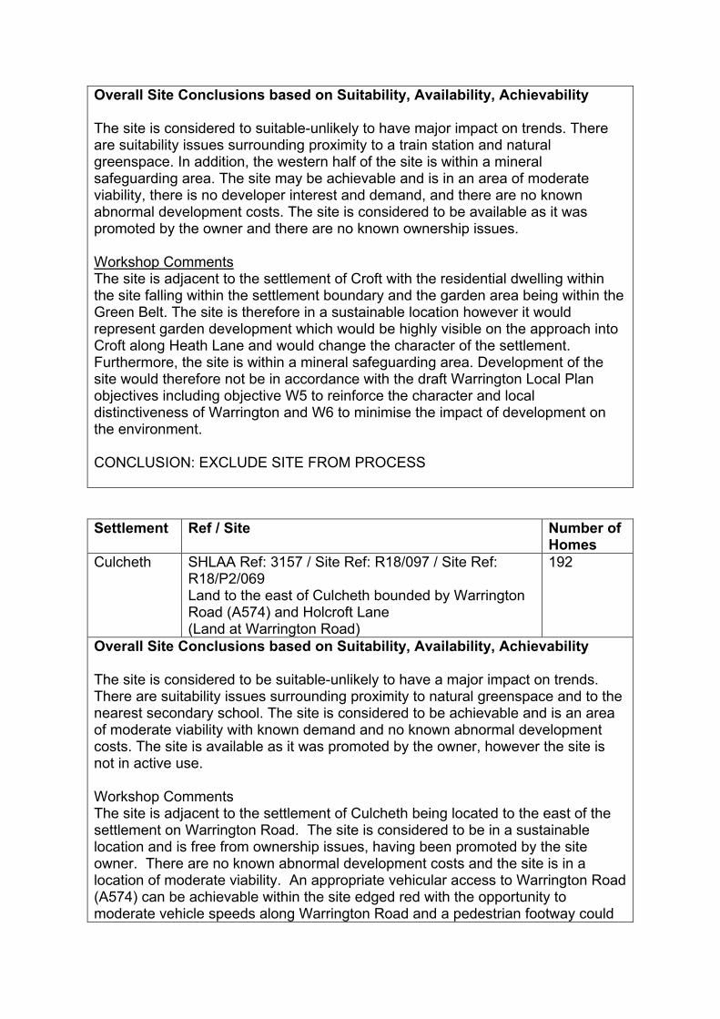
Overall Site Conclusions based on Suitability, Availability, Achievability The site is considered to suitable-unlikely to have major impact on trends. There are suitability issues surrounding proximity to a train station and natural greenspace. In addition, the western half of the site is within a mineral safeguarding area. The site may be achievable and is in an area of moderate viability, there is no developer interest and demand, and there are no known abnormal development costs. The site is considered to be available as it was promoted by the owner and there are no known ownership issues. Workshop Comments The site is adjacent to the settlement of Croft with the residential dwelling within the site falling within the settlement boundary and the garden area being within the Green Belt. The site is therefore in a sustainable location however it would represent garden development which would be highly visible on the approach into Croft along Heath Lane and would change the character of the settlement. Furthermore, the site is within a mineral safeguarding area. Development of the site would therefore not be in accordance with the draft Warrington Local Plan objectives including objective W5 to reinforce the character and local distinctiveness of Warrington and W6 to minimise the impact of development on the environment. CONCLUSION: EXCLUDE SITE FROM PROCESS
Settlement Ref / Site Number of Homes
Culcheth SHLAA Ref: 3157 / Site Ref: R18/097 / Site Ref: R18/P2/069 Land to the east of Culcheth bounded by Warrington Road (A574) and Holcroft Lane (Land at Warrington Road)
192
Overall Site Conclusions based on Suitability, Availability, Achievability The site is considered to be suitable-unlikely to have a major impact on trends. There are suitability issues surrounding proximity to natural greenspace and to the nearest secondary school. The site is considered to be achievable and is an area of moderate viability with known demand and no known abnormal development costs. The site is available as it was promoted by the owner, however the site is not in active use. Workshop Comments The site is adjacent to the settlement of Culcheth being located to the east of the settlement on Warrington Road. The site is considered to be in a sustainable location and is free from ownership issues, having been promoted by the site owner. There are no known abnormal development costs and the site is in a location of moderate viability. An appropriate vehicular access to Warrington Road (A574) can be achievable within the site edged red with the opportunity to moderate vehicle speeds along Warrington Road and a pedestrian footway could
be provided along the site frontage to link into the existing footway network, to improve pedestrian linkage to the local centre. As such, the site would be in accordance with the objectives set out in the draft Warrington Local Plan including objective W1 to strengthen existing neighbourhoods, W2 to facilitate the sensitive release of Green Belt, W4 to promote sustainable modes of transport, and W6 to minimise the impact of development on the environment. It is recommended that the site is brought forward in conjunction with Site Ref: R18/P2/064 and a durable Green Belt boundary would need to be created. CONCLUSION: SELECTED SITE (192 dwellings) – To be brought forward in conjunction with the adjacent site SHLAA Ref: 3337 / Site Ref: R18/P2/064
Settlement Site Number of Homes
Culcheth SHLAA Ref: 3337 / Site Ref: R18/P2/064 Land to the east of Culcheth bounded by Warrington Road (A574) and Holcroft Lane (Land at Lion’s Den)
11
Overall Site Conclusions based on Suitability, Availability, Achievability The site is considered to be suitable-unlikely to have a major impact on trends. The only suitability issues are the distance to a train station (3-5km) and the distance to natural greenspace (not within 300m) however this could be overcome. The site is considered to be achievable, it is within an area of moderate viability and there are no known abnormal development costs. The site is considered to be available as it was promoted by the owner and is not in active use. Workshop Comments Whilst the site is not directly adjacent to the settlement of Culcheth, it is adjacent to existing development in the Green Belt which is adjacent to the settlement. The site should be considered alongside SHLAA Ref: 3157 / Site Ref: R18/P2/069. Considering both sites together, the site is considered to be in a sustainable location and is free from ownership issues, having been promoted by the site owner. There are no known abnormal development costs and the site is in a location of moderate viability. As such, the site would be in accordance with the objectives set out in the draft Warrington Local Plan including objective W1 to strengthen existing neighbourhoods, W2 to facilitate the sensitive release of Green Belt, W4 to promote sustainable modes of transport, and W6 to minimise the impact of development on the environment. It is recommended that the site is brought forward in conjunction with SHLAA Ref: 3157 / Site Ref: R18/P2/069 and a durable Green Belt boundary would need to be created. CONCLUSION: SELECTED SITE (11 dwellings) – To be brought forward in conjunction with the adjacent site SHLAA Ref: 3157 / Site Ref: R18/097 / R18/P2/069
Settlement Ref / Site Number of Homes
Culcheth SHLAA Ref: 1519 Howards Transport Limited, Robins Lane
12
Overall Site Conclusions based on Suitability, Availability, Achievability The site is considered to be suitable- unlikely to have major impact on trends. The only issue in relation to suitability is concerning proximity to train and bus stations. The site is not considered currently available as it is in active use as Howards Transport Limited. The site is considered to be achievable as it is an area of moderate viability and there are no known abnormal development costs. Workshop Comments The site is not adjacent to the settlement of Culcheth, being situated to the south west of the settlement off Robins Lane, which is separated from the settlement by the Linear Park. As such, the site would feel isolated from the settlement and would not provide a sustainable location for future development. In addition, the site is in active employment use and it is not known if it was promoted by the owner. Therefore, it would not be in accordance with the draft Warrington Local Plan objectives including objective W1 to strengthen existing neighbourhoods, W2 to facilitate the sensitive release of Green Belt, W4 to promote sustainable modes of transport and W6 to minimise the impact of development on the environment. CONCLUSION: EXCLUDE SITE FROM PROCESS
Settlement Ref / Site Number of Homes
Culcheth SHLAA Ref: 1522 / Site Ref: R18/041 / Site Ref: R18/P2/020 Land at Kirknall Farm
517
Overall Site Conclusions based on Suitability, Availability, Achievability The site is considered to be suitable-unlikely to have a major impact on trends. The only suitability issues are the distance to a train station (3-5km) and the Local Wildlife Site which is located to the north west of the site however this could be avoided. The site has accessibility to formal play space, primary and secondary schools and GP surgery’s. The site is considered to be achievable, it is within an area of moderate viability and there are no known abnormal development costs. The site is considered to be available as it was promoted by the owner and is not in active use. Workshop Comments The site is adjacent to the settlement of Culcheth being located to the south west of the settlement. The site is considered to be in a sustainable location and is free from ownership issues, having been promoted by the site owner. There are no known abnormal development costs and the site is in a location of moderate viability. There is a Local Wildlife Site within the site located at the north west end however this could be avoided. The HS2 Phase 2b safeguarded area is located

close to the south of the site along part of the Culcheth Linear Park however the site is significantly larger than the area required to bring forward Culcheth’s housing requirement, so any constrained parts of the site could be avoided. The Council’s highways officer has advised that a reduced capacity of up to 300 dwellings could be served off Swinhoe Place, provided it was via a loop road arrangement and emergency vehicle access points were also provided. As such, development of the site would be in accordance with draft Warrington Local Plan objectives: W1 to strengthen existing neighbourhoods; W2 to facilitate the sensitive release of Green Belt; W4 to provide new infrastructure to support Warrington’s growth and W6 to minimise the impact of development on the environment. However, when compared to the other two contender sites off Warrington Road (SHLAA Ref: 3157/ Site Ref: R18/P2/069) and (SHLAA Ref: 3337/ Site Ref: R18/P2/064) the site performs better (moderately as opposed to weak) in terms of its contribution to the functioning of the Green Belt and there is only a footway on one side of Wigshaw Lane for significant parts of is length with no opportunity for improvement. Therefore, when compared to the other two sites off Warrington Road development of this site would perform the same in respect of objectives W1 (to strengthen existing neighbourhoods) and W6 (to minimise the impact of development on the environment) of the draft Warrington Local Plan but would perform less well in respect of objective W2 (to facilitate the sensitive release of Green Belt) and W4 (to promote sustainable modes of transport). CONCLUSION: EXCLUDE SITE FROM PROCESS
Settlement Ref / Site Number of Homes
Culcheth SHLAA Ref: 1567 Land at Warrington Road / Hawthorne Avenue
9
Overall Site Conclusions based on Suitability, Availability, Achievability The site is considered to be suitable-unlikely to have a major impact on trends. There are suitability issues surrounding proximity to services, mineral safeguarding and lack of natural greenspace. The site is considered to be achievable and is in an area of moderate viability. There is known demand and no known abnormal development costs. The site may not be available as it is not known if it was promoted by the owner however it is not in active use. Workshop Comments The site is located in between the settlements of Glazebury and Culcheth and it is not adjacent to either settlement. As such, the site would feel isolated from the settlement and would not provide a sustainable location for future development. Therefore, it would not be in accordance with the draft Warrington Local Plan objectives including objective W1to strengthen existing neighbourhoods, W2 to

facilitate the sensitive release of Green Belt, W4 to promote sustainable modes of transport, and W6 to minimise the impact of development on the environment. CONCLUSION: EXCLUDE SITE FROM PROCESS
Settlement Ref / Site Number of Homes
Culcheth SHLAA Ref: 2157 Land between Glaziers Lane and Warrington Road
108
Overall Site Conclusions based on Suitability, Availability, Achievability The site is considered to be suitable-unlikely to have a major impact on trends. There are suitability issues surrounding heritage, potential contamination of adjacent land, and access to natural green space. The site is considered to be achievable and is in an area of moderate viability and there is known demand. It is unclear whether the site is available as it is not known whether it was promoted by the owner however it is not in active use. Workshop Comments The site is separated from the settlement of Culcheth by the Linear Park which retains a defining boundary to the settlement. As such, development of the site would alter this existing boundary and would change the character of the settlement. In addition, the south of the site is within the HS2 Phase 2b safeguarded area. Therefore, development of the site would not be in accordance with the draft Warrington Local Plan objectives including objective W1 to strengthen existing neighbourhoods, W2 to facilitate the sensitive release of Green Belt, and W5 to reinforce the character and local distinctiveness of Warrington. CONCLUSION: EXCLUDE SITE FROM PROCESS
Settlement Ref / Site Number of Homes
Culcheth SHLAA Ref: 2588 Taylor Business Park
291
Overall Site Conclusions based on Suitability, Availability, Achievability The site is considered to be suitable- unlikely to have a major impact on trends. There are suitability issues surrounding natural greenspace, proximity to train services and partial contamination (50%) of the site. The site may be achievable as it is in an area of moderate viability and 50% of the site consists of potentially contaminated land which may require remediation. The site may not be available as it is unclear if the site has been promoted by the owner and the site is in active use. Workshop Comments

The site is separated from the settlement of Culcheth by the Linear Park which retains a defining boundary to the settlement. As such, development of the site would alter this existing boundary and would change the character of the settlement. In addition, the site is in active employment use. The southern edge of the site falls within the HS2 Phase 2b safeguarded area. Therefore, development of the site would not be in accordance with the draft Warrington Local Plan objectives including objective W1 to strengthen existing neighbourhoods, W2 to facilitate the sensitive release of Green Belt, and W5 to reinforce the character and local distinctiveness of Warrington. CONCLUSION: EXCLUDE SITE FROM PROCESS
Settlement Ref / Site Number of Homes
Culcheth SHLAA Ref: 2593 Land South of Newhall Lane (Plot 1)
40
Overall Site Conclusions based on Suitability, Availability, Achievability The site is considered to be suitable- unlikely to have a major impact on trends. There are suitability issues surrounding neighbouring uses, potentially contaminated land, and access to natural greenspace and train stations. The site may be achievable as it is in an area of moderate viability, there is known demand however there is potentially contaminated land on the site. The site may be available however it is unclear if the site has been promoted by the owner but it is not in active use and could be developed now. Workshop Comments The site is not adjacent to the settlement of Culcheth and is separated by the Linear Park which retains a defining boundary to the settlement. As such, development of the site would alter this existing boundary and would change the character of the settlement. The northern edge of the site falls within the HS2 Phase 2b safeguarded area. Therefore, development of the site would not be in accordance with the draft Warrington Local Plan objectives including objective W1 to strengthen existing neighbourhoods, W2 to facilitate the sensitive release of Green Belt, and W5 to reinforce the character and local distinctiveness of Warrington. CONCLUSION: EXCLUDE SITE FROM PROCESS
Settlement Ref / Site Number of Homes
Culcheth SHLAA Ref: 2595 Land at Junction Warrington Road / Glaziers Lane (Plot 3)
24
Overall Site Conclusions based on Suitability, Availability, Achievability

The site is considered to be suitable-unlikely to have a major impact on trends. There are suitability issues in relation to poor proximity to train stations and proximity to natural green spaces. The site is considered to be achievable and is an area of moderate viability, there is known demand and no known abnormal development costs. The site may not be available as it is unknown if it was promoted by the owner and it is in active agricultural use. Workshop Comments The site is not adjacent to the settlement of Culcheth and is separated by the Linear Park which retains a defining boundary to the settlement. As such, development of the site would alter this existing boundary and would change the character of the Culcheth settlement. Furthermore, a large proportion of the site falls within the HS2 Phase 2b safeguarded area. Therefore, development of the site would not be in accordance with the draft Warrington Local Plan objectives including objective W1 to strengthen existing neighbourhoods, W2 to facilitate the sensitive release of Green Belt, and W5 to reinforce the character and local distinctiveness of Warrington. CONCLUSION: EXCLUDE SITE FROM PROCESS
Settlement Ref / Site Number of Homes
Culcheth SHLAA Ref: 2596 Land East of Warrington Road (Plot 4)
14
Overall Site Conclusions based on Suitability, Availability, Achievability The site is considered as suitable-unlikely to have a major impact on trends. There are suitability issues surrounding AQMAs, proximity to greenspaces and AQMAs. Local Wildlife Sites and BAPs are identified within close proximity. The site is considered to be achievable and is in an area of moderate viability, there is known demand and no known abnormal development costs. The site may not be available as it does not appear to have been promoted by the owner and it is in active agricultural use. Workshop Comments The site is not adjacent to the settlement of Culcheth and is separated by the Linear Park which retains a defining boundary to the settlement. As such, development of the site would alter this existing boundary and would change the character of the settlement. Therefore, development of the site would not be in accordance with the draft Warrington Local Plan objectives including objective W1 to strengthen existing neighbourhoods, W2 to facilitate the sensitive release of Green Belt,and W5 to reinforce the character and local distinctiveness of Warrington. CONCLUSION: EXCLUDE SITE FROM PROCESS
Settlement Ref / Site Number of Homes
Culcheth SHLAA Ref: 2597 Land south of disused railway line (Plot 5)
21
Overall Site Conclusions based on Suitability, Availability, Achievability The site is considered to be suitable- unlikely to have a major impact on trends. There are suitability issues surrounding potential contamination, proximity to natural greenspace and train stations. The site is considered to be achievable and is an area of moderate viability with known demand and there are abnormal development costs relating to potential contamination. It is unclear whether the site is available as it was not promoted by the owner, however the site is in active agricultural use. Workshop Comments The site is separated from the settlement of Culcheth by the Linear Park which retains a defining boundary to the settlement. As such, development of the site would alter this existing boundary and would change the character of the settlement. Therefore, development of the site would not be in accordance with the draft Warrington Local Plan objectives including objective W1 to strengthen existing neighbourhoods, W2 to facilitate the sensitive release of Green Belt and W5 to reinforce the character and local distinctiveness of Warrington. CONCLUSION: EXCLUDE SITE FROM PROCESS
Settlement Ref / Site Number of Homes
Culcheth SHLAA Ref: 2598 Land at NW corner of Taylor Business Park (Plot 6)
26
Overall Site Conclusions based on Suitability, Availability, Achievability The site is considered to suitable- unlikely to have a major impact on trends. There are suitability issues surrounding access to greenspaces and train stations, proximity to Groundwater Source Protection Zones and proximity to heritage assets. The site is considered to be achievable and is an area of moderate viability, there is known demand and no known abnormal development costs. The site may not be available as it was unknown if it was promoted by the owner however it is not in active use. Workshop Comments The site is separated from the settlement of Culcheth by the Linear Park which retains a defining boundary to the settlement. As such, development of the site would alter this existing boundary and would change the character of the settlement. Therefore, development of the site would not be in accordance with the draft Warrington Local Plan objectives including objective W1 to strengthen existing neighbourhoods, W2 to facilitate the sensitive release of Green Belt and W5 to reinforce the character and local distinctiveness of Warrington.

CONCLUSION: EXCLUDE SITE FROM PROCESS
Settlement Ref / Site Number of Homes
Culcheth SHLAA Ref: 2656 Land adj Petersfield Gardens
94
Overall Site Conclusions based on Suitability, Availability, Achievability This site is considered to be suitable – unlikely to have a major impact on trends. The site is considered to be achievable as it is in an area of moderate viability and there is no known demand and no known abnormal development costs. The site may not be available as it is unknown if it was promoted by the owner however it is not in active use and could be developed now. Workshop Comments The site is adjacent to the settlement of Culcheth, to the north of the existing residential area adjacent to Twiss Green Primary School. The site is considered to be in a sustainable location. The site is considered to be available although it is unknown if it was promoted by the owner however it is not in active use and could be developed now. The site is achievable as there are no known abnormal development costs and the site is in a location of moderate viability. The site is considered to be suitable – unlikely to have a major impact on trends however the Council’s highways officer states that an appropriate access cannot be provided without utilising third party land. As such, development of the site would not be in accordance with draft Warrington Local Plan objective W4, to provide new infrastructure to support Warrington’s growth, reduce congestion and promote sustainable transport options. SITE CONCLUSION: EXCLUDE SITE FROM PROCESS
Settlement Ref / Site Number of Homes
Culcheth SHLAA Ref: 3151 Glazebury Depot
453
Overall Site Conclusions based on Suitability, Availability, Achievability The site may be suitable however mitigation may be required/ some unavoidable impacts. There are suitability issues relating to the site falling within the hazardous installation buffer zone (site falls within Class B), mineral safeguarding, poor proximity to train, bus, natural greenspaces, secondary schools and community services. The site falls within groundwater protection zone and flood zone 2/3 and contains large amounts of high quality agricultural land. Entire site consists of potentially contaminated land. The site may not be achievable as it is in an area of moderate viability and there are abnormal development costs due to potential contamination over the entire site. The site is available as it was promoted by the owner.

Workshop Comments The site is not adjacent to the settlement of Culcheth, being situated to the north of the settlement off Broseley Lane, which is separated from the settlement by a railway track. As such, the site would feel isolated from the settlement and would not provide a sustainable location for future development. In addition, the site is within a hazardous installation buffer zone, in a mineral safeguarding area and has potentially contaminated land. Therefore, it would not be in accordance with several objective from the draft Warrington Local Plan including objectives W1 to strengthen existing neighbourhoods, W2 to facilitate the sensitive release of Green Belt, W4 to promote sustainable modes of transport and W6 to minimise the impact of development on the environment. CONCLUSION: EXCLUDE SITE FROM PROCESS
Settlement Ref / Site Number of Homes
Culcheth Site Ref: R18/P2/033 Kenyon Railway Junction
Employment 2.78ha
Overall Site Conclusions based on Suitability, Availability, Achievability The site is considered to be suitable- unlikely to have major impact on trends. There are suitability issues surrounding potentially contaminated land and the hazardous installation zone buffer. The site is considered to be achievable and is in an area of moderate viability, there is developer interest and known demand. However, there are some abnormal development costs. The site is available as it was promoted by the owner however is in active use. Workshop Comments The site is not adjacent to the settlement of Culcheth being situated to the north west of the settlement off Wilton Lane, which is separated from the settlement by a railway track. As such, the site would feel isolated from the settlement and would not provide a sustainable location for future development. In addition, the site is within a hazardous installation buffer zone and has potentially contaminated land. Therefore, development of the site would not be in accordance with the draft Warrington Local Plan objectives including objective W1 to strengthen existing neighbourhoods, W2 to facilitate the sensitive release of Green Belt, W4 to promote sustainable modes of transport, and W6 to minimise the impact of development on the environment. CONCLUSION: EXCLUDE SITE FROM PROCESS
Settlement Ref / Site Number of Homes
Culcheth Site Ref: R18/P2/071 Land at Warrington Road (Parcel 2)
117

Overall Site Conclusions based on Suitability, Availability, Achievability The site is considered to be suitable – unlikely to have a major impact on trends. There are suitability issues surrounding the distance to a train station and distance to natural greenspace however there is accessible to primary and secondary schools, formal play space and GP services. The site is considered to be available as it has been promoted by the owner and there are no known ownership or tenancy issues. The site may be achievable in an area of moderate viability, with developer interest and demand and no known abnormal development costs. Workshop Comments The site is adjacent to the settlement of Culcheth being located to the east of the settlement to the south of Warrington Road. The site is considered to be in a sustainable location and is free from ownership issues, having been promoted by the site owner. There are no known abnormal development costs and the site is in a location of moderate viability. However the eastern boundary of the site is not defined by any identifiable features on the ground and it is therefore considered that development of the site would not be in accordance with objective W2 of the draft Warrington Local Plan, to facilitate the sensitive release of Green Belt land, whilst ensuring the revised Green Belt boundaries maintain permanence of Warrington’s Green Belt in the long term. SITE CONCLUSION: EXCLUDE SITE FROM PROCESS
Settlement Site Number of Homes
Hollins Green
Site Ref: R18/056 / Site Ref: R18/P2/146C Land to the southwest of Hollins Green bounded by Marsh Brook Close, Warburton View and Manchester Road (Land off Marsh Brook Close, Rixton)
10
Overall Site Conclusions based on Suitability, Availability, Achievability The site is considered to be suitable-unlikely to have a major impact on trends. There are suitability issues surrounding proximity to natural greenspace and the nearest GP surgery however the site does have accessibility to primary and secondary schools. The site may be achievable as it is in an area of moderate viability with developer interest and known demand however there are known abnormal development costs as the site is entirely within an area of potentially contaminated land. The site is available as it was promoted by the owner and could be developed now. Workshop Comments Whilst this site is below the site size threshold of 0.25ha it has been considered alongside the adjacent site of R18/P2/151. The comments from the Council’s highways officer state that access to the site would only be achievable if it was developed alongside the adjacent site.
The site is adjacent to the settlement of Hollins Green and is considered to be in a sustainable location. It is considered to be suitable for development. It is free from ownership issues, having been promoted by the site owner. There are known abnormal development costs due to potentially contaminated land covering the entire site which may require remediation. Development of the site would be in accordance with the objectives set out in the draft Warrington Local Plan including objective W1 to strengthen existing neighbourhoods, W2 to facilitate the sensitive release of Green Belt, W4 to promote sustainable modes of transport, and W6 to minimise the impact of development on the environment. CONCLUSION: SELECTED SITE (10 dwellings) – To be brought forward in conjunction with Site Ref: R18/P2/151
Settlement Site Number of Homes
Hollins Green
Site Ref: R18/P2/151 Land to the southwest of Hollins Green bounded by Marsh Brook Close, Warburton View and Manchester Road (Land north of A57, Hollins Green)
80
Overall Site Conclusions based on Suitability, Availability, Achievability The site is considered to be suitable-unlikely to have major impact on trends. There are some suitability issues surrounding; proximity to GP surgeries; mineral safeguarding areas and the adjacent area of potentially contaminated land to the north west. The site is considered to be achievable and is within an area of moderate viability, there is developer interest and demand and no known abnormal development costs. The site is considered to be available as it has been promoted by the owner and is not in active use. Workshop Comments The site is adjacent to the settlement of Hollins Green and is considered to be in a sustainable location. It is considered to be suitable for development. The site is considered to be available as it is free from ownership issues, having been promoted by the site owner. The site is considered to be achievable as it is in a location of moderate viability and there is developer interest/demand and no known abnormal development costs. Development of the site would be in accordance with the objectives set out in the draft Warrington Local Plan including objective W1 to strengthen existing neighbourhoods, W2 to facilitate the sensitive release of Green Belt land, W4 to promote sustainable modes of transport, and W6 to minimise the impact of development on the environment. SITE CONCLUSION: SELECTED SITE (80 dwellings)
Settlement Ref / Site Number of Homes
Hollins Green
SHLAA Ref: 1514 Land off A57 Manchester Road
171

Overall Site Conclusions based on Suitability, Availability, Achievability The site is considered to be suitable- unlikely to have a major impact on trends. There are suitability issues surrounding; proximity to GP surgeries; potentially contaminated land, the historic landfill site buffer zone, and the presence of a locally important site of wildlife or geodiversity and a mineral safeguarding area / areas of importance. The site may be achievable as it is in an area of moderate viability, there is known demand however there are known abnormal development costs due to potentially contaminated land on the site and the historic landfill site buffer zone. The site may be available however it is unclear if the site has been promoted by the owner but it is not in active use and could be developed now. Workshop Comments The site is adjacent to the settlement of Hollins Green however there is a dual carriageway (the A57) that separates the site from the settlement and which retains a defining boundary to the settlement. As such, development of the site would alter this existing boundary and would change the character of the settlement. The site is located in an area of potentially contaminated land, mineral safeguarding area, historic landfill site buffer zone, and contains a locally important site of wildlife or geodiversity. The HS2 Phase 2b safeguarded area bisects the middle of the site with HS2 proposed to run on a viaduct in this location. Allocation of the site would therefore be in conflict with the safeguarding direction. Development of the site would not be in accordance with several objectives from the draft Warrington Local Plan including objective W1 to strengthen existing neighbourhoods, W5 to reinforce the character and local distinctiveness of Warrington, and W6 to minimise the impact of development on the environment. SITE CONCLUSIONS: EXCLUDE SITE FROM PROCESS
Settlement Ref / Site Number of Homes
Hollins Green
SHLAA Ref: 2171 / Site Ref: R18/126 / Site Ref: R18/P2/096B Land south of Hollins Green
281
Overall Site Conclusions based on Suitability, Availability, Achievability The site is considered to be suitable-unlikely to have major impact on trends. There are some suitability issues surrounding; proximity to GP surgeries; mineral safeguarding areas and parts of the site being within the historic landfill site buffer zones. The site is not in an area at risk from flooding. The site may be achievable as it is within an area of moderate viability, there is developer interest and demand however there may be some abnormal development costs due to the historic landfill site buffer zones. The site is considered to be available as it has been promoted by the owner and is not in active use. Workshop Comments The site is adjacent to the settlement of Hollins Green however there is a dual carriageway (the A57) that separates the site from the settlement and which

retains a defining boundary to the settlement. As such, development of the site would alter this existing boundary and would change the character of the settlement. The site is located in a mineral safeguarding area and parts of the site are within a historic landfill site buffer zone. Development of the site would not be in accordance with several objectives from the draft Warrington Local Plan including objective W1 to strengthen existing neighbourhoods, W5 to reinforce the character and local distinctiveness of Warrington, and W6 to minimise the impact of development on the environment. SITE CONCLUSION: EXCLUDE SITE FROM PROCESS
Settlement Site Number of Homes
Lymm SHLAA Ref: 3124 / Site Ref: R18/036 Land to the west of Lymm bounded by Massey Brook Lane, Camsley House Farm and footpath no.6
60
Overall Site Conclusions based on Suitability, Availability, Achievability The Massey Brook Lane allocation site has been removed from the updated PSVLP as the site is no longer available for development, having been withdrawn from the Local Plan process by the owners.
Settlement Site Number of Homes
Lymm SHLAA Ref: 1622 Land to the west of Lymm bounded by Pool Lane, Oldfield Road and Warrington Road
40
Overall Site Conclusions based on Suitability, Availability, Achievability This site is considered to be suitable – unlikely to have a major impact on trends. There are some suitability issues as the site is adjacent to an area of potentially contaminated land to the east (however it does not contain any potentially contaminated land); and GP services in Lymm have no available capacity. The majority of the site is not in an area at risk from flooding. The site has good accessibility to formal play space, primary and secondary schools, GP services and bus services. The site is located adjacent to Statham Lodge which hosts a number of conferences / weddings. The site appears to be available, considering that it was promoted by the owner and is not in active use. The site is considered to be achievable as it is in an area of high viability and there are no known abnormal development costs. Workshop Comments The site is adjacent to the settlement of Lymm, located to the west of the settlement off of Warrington Road. The site is considered to be in a sustainable location and is available being free from ownership issues and having been promoted by the site owner. The site is considered to be achievable as there are no known abnormal development costs and the site is in a location of high viability.

In addition, it has been judged to be suitable - unlikely to have a major impact on trends. As such, the site would be in accordance with the objectives set out in the draft Warrington Local Plan including objective W1 to strengthen existing neighbourhoods, W2 to facilitate the sensitive release of Green Belt, W4 to promote sustainable modes of transport, and W6 to minimise the impact of development on the environment. CONCLUSIONS: SELECTED SITE (39 dwellings)
Settlement Site Number of Homes
Lymm Site Ref: R18/P2/085 Land to the east of Lymm bounded by Rushgreen Road, Tanyard Farm and the Bridgewater Canal (Land at Tanyard Farm, Lymm)
177
Overall Site Conclusions based on Suitability, Availability, Achievability This site is considered to be suitable – unlikely to have a major impact on trends. There are suitability issues due to the eastern half of the site being potentially contaminated land; and GP services in Lymm have no available capacity. The site appears to be available, considering that it was promoted by the owner and there is a planning application for residential development on the eastern half of the site currently under appeal (Ref: 2017/31816). The site may be considered to be achievable in that it is in an area of high viability however there are known abnormal development costs because the site is potentially contaminated land, which could be overcome. Workshop Comments The site is adjacent to the settlement of Lymm, located to the east of the settlement close to Rush Green Road. The site is considered to be in a sustainable location and is available having been promoted by the site owner and with a planning application currently on appeal on part of the site. The site may be achievable as there is developer interest and known demand however there are known abnormal development costs due to the potentially contaminated land on the eastern half of the site. The site has been judged to be suitable - unlikely to have a major impact on trends. As such, the site would be in accordance with the objectives set out in the draft Warrington Local Plan including objective W1 to strengthen existing neighbourhoods, W2 to facilitate the sensitive release of Green Belt, W4 to promote sustainable modes of transport, and W6 to minimise the impact of development on the environment. CONCLUSIONS: SELECTED SITE (177 dwellings) [this forms part of the wider site SHLAA Ref: 1545]
Settlement Site Number of Homes

Lymm SHLAA Ref: 1504 / Site Ref: R18/018 / Site Ref: R18/P2/055 Land to the east of Lymm bounded by Rushgreen Road, Tanyard Farm and the Bridgewater Canal (Land off Thirlmere Drive)
15
Overall Site Conclusions based on Suitability, Availability, Achievability This site is considered to be suitable – unlikely to have a major impact on trends. There are some suitability issues surrounding the distance to natural greenspace and a train station; and GP services in Lymm have no available capacity. The site is considered to be available as it was promoted by the owner and it is not in active use. The site is considered to be achievable as it is in an area of high viability and there are no known abnormal development costs. Workshop Comments The site is adjacent to the settlement of Lymm, located to the east of the settlement close to Rush Green Road (A6144). The site is considered to be in a sustainable location and is available being free from ownership issues and having been promoted by the site owner. The site is considered to be achievable as there are no known abnormal development costs and the site is in a location of high viability. In addition, it has been judged to be suitable - unlikely to have a major impact on trends. As such, the site would be in accordance with the objectives set out in the draft Warrington Local Plan including objective W1 to strengthen existing neighbourhoods, W2 to facilitate the sensitive release of Green Belt, W4 to promote sustainable modes of transport, and W6 to minimise the impact of development on the environment. CONCLUSION: SELECTED SITE (15 dwellings) [this forms part of the wider site SHLAA Ref: 1545]
Settlement Site Number of Homes
Lymm SHLAA Ref: 1528 / Site Ref: R18/162 Land to the west of Lymm bounded by Warrington Road, the Trans-Pennine Trail and Statham Community Primary School
131
Overall Site Conclusions based on Suitability, Availability, Achievability This site is considered to be suitable – unlikely to have a major impact on trends. There are some suitability issues as the site contains a locally important site not suitable for biodiversity offsetting (however this is not a Local Wildlife Site); it is adjacent to an area of potentially contaminated land to the north east (however it does not contain any potentially contaminated land); and GP services in Lymm have no available capacity. The site is not in an area at risk from flooding. The site has good accessibility to formal play space, primary and secondary schools, GP services and bus services. The site appears to be available, considering that it was promoted by the owner however a small section is in use as allotments. The

site is considered to be achievable as it is in an area of high viability and there are no known abnormal development costs. Workshop Comments The site is adjacent to the settlement of Lymm, located to the west of the settlement off of Warrington Road. The site is considered to be in a sustainable location and is available being free from ownership issues and having been promoted by the site owner. The site is considered to be achievable as there are no known abnormal development costs and the site is in a location of high viability. In addition, it has been judged to be suitable - unlikely to have a major impact on trends. As such, the site would be in accordance with the objectives set out in the draft Warrington Local Plan including objective W1 to strengthen existing neighbourhoods, W2 to facilitate the sensitive release of Green Belt, W4 to promote sustainable modes of transport, and W6 to minimise the impact of development on the environment. CONCLUSIONS: SELECTED SITE (152 dwellings)
Settlement Ref / Site Number of Homes
Lymm SHLAA Ref: 1545 Rushgreen Road
508
Overall Site Conclusions based on Suitability, Availability, Achievability This site is considered to be suitable – unlikely to have a major impact on trends. There are some suitability issues given that the site contains more than 20 hectares of agricultural land Class 1-2 and GP services in Lymm have no available capacity. The site is considered to be available, considering that it was promoted by the owner and a planning application is currently under appeal on part of the site (Ref 2017/31816). The site may be achievable as it is in an area of high viability and there is developer interest and known demand however there are known abnormal development costs due to a large area of potentially contaminated land in the centre of the site. Workshop Comments The site is adjacent to the settlement of Lymm, located to the east of the settlement close to Rush Green Road. The site is considered to be in a sustainable location and is available having been promoted by the site owner and with a planning application currently on appeal on part of the site. The site may be achievable as there is developer interest and known demand however there are known abnormal development costs due to a large area of potentially contaminated land in the centre of the site. The site has been judged to be suitable - unlikely to have a major impact on trends. As such, the site would be in accordance with the objectives set out in the draft Warrington Local Plan including objective W1 to strengthen existing neighbourhoods, W2 to facilitate the sensitive release of Green Belt, W4 to promote sustainable modes of transport, and W6 to minimise the impact of development on the environment.

Taking into account the Council’s highways officer’s comments, the site potential has been reduced down to 300 dwellings due to the limitations on the number of access points. However, when compared to the other contender sites off Rushgreen Road (Site Ref: R18/P2/085 and SHLAA Ref: 1504 / Site Ref: R18/018 / Site Ref: R18/P2/055); Warrington Road (SHLAA Ref: 1528 /Site Ref: R18/162 and SHLAA Ref: 1622); and Massey Brook Lane (SHLAA Ref: 3124 / Site Ref: R18/036 and SHLAA Ref: 3316 / Site Ref: R18/P2/029) the development of the whole site in this location would have a greater impact on the character of the settlement and the early deliverability of housing. In addition, the eastern portion of the site is in separate ownership and there is no evidence that there is any agreement with the owners of the western portion of the site to allow access from their site. Consequently, there is concern about the deliverability of the eastern portion of the site. As such the sites towards the eastern end of Rushgreen Road (Site Ref: R18/P2/085 and SHLAA Ref: 1504 / Site Ref: R18/018 / Site Ref: R18/P2/055) and those off Warrington Road (SHLAA Refs: 1528 and 1622) and Massey Brook Lane (SHLAA Ref: 3124/3316) are considered more appropriate sites to accommodate Lymm’s housing requirement. CONCLUSION: EXCLUDE SITE FROM PROCESS
Settlement Ref / Site Number of Homes
Lymm Site Ref: R18/132 / Site Ref: R18/P2/096D Land at Rushgreen Road, Lymm
400
Overall Site Conclusions based on Suitability, Availability, Achievability The site is considered to be suitable – unlikely to have a major impact on trends. There are suitability issues as the site contains more than 20 hectares of Class 1-2 agricultural land; there is an area of potentially contaminated land in the middle of the site; and GP services in Lymm have no available capacity. The site appears to be available, considering that it was promoted by the owner and there is a planning application for residential development under appeal on part of the site (Ref: 2017/31816). The site may be achievable in that it is in an area of high viability however there are known abnormal development costs due to a section of potentially contaminated land which could be overcome. Workshop Comments The site is adjacent to the settlement of Lymm, located to the east of the settlement close to Rush Green Road. The site is considered to be in a sustainable location and is available having been promoted by the site owner and with a planning application currently on appeal on part of the site. The site may be achievable as there is developer interest and known demand however there are known abnormal development costs due to a large area of potentially contaminated land in the centre of the site. The site has been judged to be suitable - unlikely to have a major impact on trends. As such, the site would be in accordance with the objectives set out in the draft Warrington Local Plan including
objective W1 to strengthen existing neighbourhoods, W2 to facilitate the sensitive release of Green Belt, W4 to promote sustainable modes of transport, and W6 to minimise the impact of development on the environment. Taking into account the Council’s highways officer’s comments, the site potential has been reduced down to 300 dwellings due to the limitations on the number of access points. However, when compared to the other contender sites off Rushgreen Road (Site Ref: R18/P2/085 and SHLAA Ref: 1504 / Site Ref: R18/018 / Site Ref: R18/P2/055); Warrington Road (SHLAA Ref: 1528 /Site Ref: R18/162 and SHLAA Ref: 1622); and Massey Brook Lane (SHLAA Ref: 3124 / Site Ref: R18/036 and SHLAA Ref: 3316 / Site Ref: R18/P2/029) the development of the whole site in this location would have a greater impact on the character of the settlement and the early deliverability of housing. In addition, the eastern portion of the site is in separate ownership and there is no evidence that there is any agreement with the owners of the western portion of the site to allow access from their site. Consequently, there is concern about the deliverability of the eastern portion of the site. As such the sites towards the eastern end of Rushgreen Road (Site Ref: R18/P2/085 and SHLAA Ref: 1504 / Site Ref: R18/018 / Site Ref: R18/P2/055) and those off Warrington Road (SHLAA Refs: 1528 and 1622) and Massey Brook Lane (SHLAA Ref: 3124/3316) are considered more appropriate sites to accommodate Lymm’s housing requirement. CONCLUSION: See above conclusions for SHLAA Ref: 1545 which includes the same extent of Green Belt as this site.
Settlement Ref / Site Number of Homes
Lymm Site Ref: R18/117 / Site Ref: R18/P2/053 Land south of Rushgreen Road (East Site)
99
Overall Site Conclusions based on Suitability, Availability, Achievability This site is considered to be suitable – unlikely to have a major impact on trends. There are suitability issues due to the entire site being potentially contaminated land and GP services in Lymm have no available capacity. The site appears to be available, considering that it was promoted by the owner and there is a planning application for residential development on the site currently under appeal (Ref: 2017/31816). The site may be achievable in that it is in an area of high viability and there are known abnormal development costs because the site is potentially contaminated land, which could be overcome. Workshop Comments The site is adjacent to the settlement of Lymm, located to the east of the settlement close to Rushgreen Road. The site is considered to be in a sustainable location and is available having been promoted by the site owner and with a
planning application currently on appeal on the site. The site may be achievable as there is developer interest and known demand however there are known abnormal development costs due to the entire site consisting of potentially contaminated land. The site has been judged to be suitable - unlikely to have a major impact on trends. As such, the site would be in accordance with the objectives set out in the draft Warrington Local Plan including objective W1 to strengthen existing neighbourhoods, W2 to facilitate the sensitive release of Green Belt, W4 to promote sustainable modes of transport, and W6 to minimise the impact of development on the environment. CONCLUSION: SELECTED SITE (99 dwellings) [this forms part of the larger site Ref: R18/P2/085]
Settlement Ref / Site Number of Homes
Lymm Site Ref: R18/118 / Site Ref: R18/P2/054 / R18/P2/133 Land south of Rushgreen Road (West Site)
100
Overall Site Conclusions based on Suitability, Availability, Achievability This site is considered to be suitable – unlikely to have a major impact on trends. The only suitability issues consist of proximity to a train station; proximity to natural greenspace and GP services in Lymm have no available capacity. The site appears to be available, considering that it was promoted by the owner and could be developed now. The site is considered to be achievable in that it is in an area of high viability and there are no known abnormal development costs. Workshop Comments The site is adjacent to the settlement of Lymm, located to the east of the settlement close to Rush Green Road. The site is considered to be in a sustainable location and is available having been promoted by the site owner and being free from ownership issues. The site may be achievable as there is developer interest and known demand and no known abnormal development costs. The site has been judged to be suitable - unlikely to have a major impact on trends. As such, the site would be in accordance with the objectives set out in the draft Warrington Local Plan including objective W1 to strengthen existing neighbourhoods, W2 to facilitate the sensitive release of Green Belt, W4 to promote sustainable modes of transport, and W6 to minimise the impact of development on the environment. CONCLUSIONS: SELECTED SITE (100 dwellings and Integrated Medical Centre of 2000sqm) [this forms part of the larger site Ref: R18/P2/085]
Settlement Ref / Site Number of Homes
Lymm SHLAA Ref: 1531 / Site Ref: R18/163 39

Statham Lodge Hotel Overall Site Conclusions based on Suitability, Availability, Achievability The site is not considered to be suitable-mitigation likely to be required/unavoidable impacts due to the Grade II listed building (Statham Lodge) occupying the site and the entire site falling within Flood Zone 2. There are also suitability issues with respect to GP services in Lymm which have no available capacity. The majority of the site is not in an area at risk from flooding. The site appears to be available, considering that it was promoted by the owner however the site is in active use as a hotel and conference centre. The site is considered to be achievable in that it is in an area of high viability and there is developer interest and known demand. There are also no known abnormal development costs. Workshop Comments The site is not directly adjacent to the settlement of Lymm however it is located within a cluster of sites to the west of the settlement off of Warrington Road. The site would be considered to be in a sustainable location only if the adjacent sites to the east are proposed to be developed. The site is not considered to be suitable for development as it contains a Grade II listed building (Statham Lodge). There are further suitability issues surrounding the site as it contains a locally important site not suitable for biodiversity offsetting. In addition, it has been judged to be unsuitable - likely to have unavoidable impacts. Development of the site would therefore not be in accordance with the objectives of the draft Warrington Local Plan, particularly objectives W5 which seeks to reinforce character and local distinctiveness whilst protecting, enhancing and embracing the borough’s built and natural assets (including heritage assets). SITE CONCLUSION: EXCLUDE SITE FROM PROCESS
Settlement Ref / Site Number of Homes
Lymm Site Ref: R18/P2/001 Land at Statham
720
Overall Site Conclusions based on Suitability, Availability, Achievability This site may be suitable however mitigation may be required / there are unavoidable impacts. There are some suitability issues as the site contains the Grade II listed Statham Lodge Hotel; it also contains a locally important site not suitable for biodiversity offsetting (however this is not a Local Wildlife Site); it is adjacent to an area of potentially contaminated land to the north east and GP services in Lymm have no available capacity. However it does not contain any potentially contaminated land. The site has good accessibility to formal play space, primary and secondary schools and bus services. The site appears to be available, considering that it was promoted by the owner however part of the site is in active use as a hotel. The site is considered to be achievable as it is in an area of high viability and there are no known abnormal development costs. Workshop Comments

The site is adjacent to the settlement of Lymm, located to the west of the settlement off of Warrington Road and Camsley Lane. The site is considered to be in a sustainable location and is available being free from ownership issues and having been promoted by the site owner however part of the site is in active use as a hotel. The site is considered to be achievable as there are no known abnormal development costs and the site is in a location of high viability. There are some suitability constraints with the site due to the Grade II listed Statham Lodge Hotel being located to the north of the site and a risk of flooding in the northern portion of the site but given the scale of the site, development could avoid impacting on the Grade II listed building. However given the site size, development of the whole site would impact upon the character of the settlement. As such, development would not be in accordance with objective W5 of the draft Warrington Local Plan which seeks to reinforce character and local distinctiveness. It is considered that some of the smaller sites which form part of this larger site represent more appropriate sites for development (SHLAA Ref: 1528 / R18/162 and SHLAA Ref: 1622). CONCLUSION: EXCLUDE SITE FROM PROCESS
Settlement Ref / Site Number of Homes
Lymm SHLAA Ref: 1891 / Site Ref: R18/154 / R18/190 Land fronting Pool Lane
36
Overall Site Conclusions based on Suitability, Availability, Achievability This site is considered to be suitable – unlikely to have a major impact on trends. There are suitability issues as the majority of the site is within Flood Zone 2/3; half of the site is within a historic landfill site 250m buffer zone; the site is adjacent to a Local Wildlife (Statham Ox-Bow) located to the north east and GP services in Lymm have no available capacity. The site has good accessibility to primary and secondary schools, formal play space and bus services. The site is considered to be available as it was promoted by the owner however part of the site is in office use as a marketing agency and therefore could not be developed now. The site may be achievable in that it is in an area of high viability, there is developer interest/demand however there are known abnormal development costs due to the section within the historic landfill buffer zone. Workshop Comments The site is adjacent to the settlement of Lymm being located to the north east of the settlement on Pool Lane. The site is considered to be in a sustainable location and is available having been promoted by the site owner however it is partially developed. The site may be achievable as there is developer interest and known demand however part of the site is within a historic landfill site 250m buffer zone. The site has been judged to be suitable - unlikely to have a major impact on trends. However the Council’s highways officer states that Pool Lane would be unsuitable for an increase in vehicle movement without improvements along its length which would require third party land. As such, development of the site would not be in accordance with draft Warrington Local Plan objective W4, to provide
new infrastructure to support Warrington’s growth, reduce congestion and promote sustainable transport options. CONCLUSION: EXCLUDE SITE FROM PROCESS
Settlement Ref / Site Number of Homes
Lymm SHLAA Ref: 1621 / Site Ref: R18/004 / Site Ref: R18/173 Land immediately surrounding Pool Farm
9
Overall Site Conclusions based on Suitability, Availability, Achievability This site is considered to be suitable – unlikely to have a major impact on trends. There are some suitability issues as the site is mainly within Flood Zone 2 and GP services in Lymm have no available capacity. The site is located adjacent to Statham Lodge which hosts a number of conferences / weddings, The site is considered to be available as it was promoted by the owner. The site is considered to be achievable in that it is in an area of high viability and there is developer interest and known demand. There are also no known abnormal development costs. Workshop Comments The site is not directly adjacent to the settlement of Lymm however it is located within a cluster of sites to the west of the settlement off of Warrington Road. The site would be considered to be in a sustainable location only if the adjacent sites are proposed to be developed. The site is considered to be available having been promoted by the site owner. The site is considered to be achievable as there is developer interest and known demand and no known abnormal development costs. The site has been judged to be suitable - unlikely to have a major impact on trends. However the Council’s highways officer states that Pool Lane would be unsuitable for an increase in vehicle movement without improvements along its length which would require third party land. As such, development of the site would not be in accordance with draft Warrington Local Plan objective W4, to provide new infrastructure to support Warrington’s growth, reduce congestion and promote sustainable transport options. CONCLUSION: EXCLUDE SITE FROM PROCESS
Settlement Ref / Site Number of Homes
Lymm SHLAA Ref: 1565 / Site Ref: R18/014 / Site Ref: R18/P2/118 Land west of Reddish Crescent
57
Overall Site Conclusions based on Suitability, Availability, Achievability

This site is considered to be suitable – unlikely to have a major impact on trends. There are some suitability issues given the proximity to a Grade II listed building (Tanyard Farmhouse); the adjacent areas of potentially contaminated land to the north and south east and the GP services in Lymm have no available capacity. However the site has good accessibility to formal play space, primary schools and bus services. The site appears to be available, considering that it was promoted by the owner. The site is considered to be achievable as it is in an area of high viability, there is developer interest and known demand and there are no known abnormal development costs. Workshop Comments The site is adjacent to the settlement of Lymm, located to the north east of the settlement off of Rush Green Road. The site is considered to be in a sustainable location and is available having been promoted by the site owner. The site is considered to be achievable as there is developer interest and known demand and no known abnormal development costs. The site has been judged to be suitable - unlikely to have a major impact on trends. However the Council’s highways officer states that due to visibility constraints, third party land is required to provide junction improvements. In addition the highways officer states that the site would need to be developed in tandem with Site Ref: 3178 / R18/082 / R18/P2/072 and Site Ref: 3109 / R18/016 / R18/P2/027. Site Ref: 3178 was assessed as strong contribution for Green Belt and therefore it has not been considered for site selection at this stage. The site would not be appropriate in highways terms if brought forward on its own. Development of the site would therefore not be in accordance with draft Warrington Local Plan objective W4, to provide new infrastructure to support Warrington’s growth, reduce congestion and promote sustainable transport options. CONCLUSION: EXCLUDE SITE FROM PROCESS
Settlement Ref / Site Number of Homes
Lymm SHLAA Ref: 3109 / Site Ref: R18/016 / Site Ref: R18/P2/027 Holly House
24
Overall Site Conclusions based on Suitability, Availability, Achievability This site is considered to be suitable – unlikely to have a major impact on trends. There are some suitability issues given the nearest GP service has no available capacity. The site appears to be available, considering that it was promoted by the owner and could be developed now. The site is considered to be achievable in that it is in an area of high viability and there are also no known abnormal development costs. Workshop Comments The site is adjacent to the settlement of Lymm, located to the north east of the settlement off of Rush Green Road. The site is considered to be in a sustainable location and is available having been promoted by the site owner. The site is

considered to be achievable as there is developer interest and known demand and no known abnormal development costs. The site has been judged to be suitable - unlikely to have a major impact on trends. However the Council’s highways officer states that the site would need to be developed in tandem with Site Ref: 3178 / R18/082 / R18/P2/072 in order to achieve appropriate pedestrian connectivity, however Site Ref: 3178 / R18/082 / R18/P2/072 was assessed as strong contribution for Green Belt and therefore it has not been considered for site selection at this stage. As such appropriate pedestrian connectivity could not be achieved if the site was brought forward on its own. Development of the site would therefore not be in accordance with draft Warrington Local Plan objective W4, to provide new infrastructure to support Warrington’s growth, reduce congestion and promote sustainable transport options. CONCLUSION: EXCLUDE SITE FROM PROCESS
Settlement Ref / Site Number of Homes
Lymm SHLAA Ref: 1560 Greenscene
5
Overall Site Conclusions based on Suitability, Availability, Achievability The site is considered available as it was promoted by the owner and is free from ownership/tenancy issues. There is no active use on the site. The site is achievable as it is in an area of high viability with developer interest and demand. The site is considered to be suitable for development – unlikely to have a major impact on trends. There are some suitability issues in terms of accessibility to primary schools and capacity of GP services. There are also TPOs on site, however there is potential to avoid this through the location of development on the site. Workshop Comments The site is not adjacent to the settlement of Lymm, being situated within the washed over village of Broomedge to the south east of Lymm. As such, the site would feel isolated from Lymm and would not provide a sustainable location for future development. Therefore, it would not be in accordance with the objectives set out in the draft Warrington Local Plan including objective W1 to strengthen existing neighbourhoods, W2 to facilitate the sensitive release of Green Belt, W4 to promote sustainable modes of transport and W6 to minimise the impact of development on the environment. CONCLUSION: EXCLUDE SITE FROM PROCESS
Settlement Ref / Site Number of Homes
Lymm SHLAA Ref: 2408 Oak Lawn
9

Overall Site Conclusions based on Suitability, Availability, Achievability The site is considered to be suitable for development – unlikely to have a major impact on trends. There are some suitability issues in terms of accessibility to primary schools, GP services, bus services, a train station and natural greenspace. The site is considered available as it was promoted by the owner although there is an existing residential property on site. The site is considered to be achievable as it is in an area of high viability, there is developer interest and demand and no known abnormal development costs. Workshop Comments The site is not adjacent to the settlement of Lymm, being situated off Crouchley Lane to the south of Lymm. As such, the site would feel isolated from the settlement and would not provide a sustainable location for future development. Therefore, it would not be in accordance with several objectives from the draft Warrington Local Plan including W1 to strengthen existing neighbourhoods, W2 to facilitate the sensitive release of Green Belt, W4 to promote sustainable modes of transport and W6 to minimise the impact of development on the environment. CONCLUSION: EXCLUDE SITE FROM PROCESS
Settlement Ref / Site Number of Homes
Lymm SHLAA Ref: 2704 Land at Boarded Barn Farm
27
Overall Site Conclusions based on Suitability, Availability, Achievability This site is considered to be suitable – unlikely to have a major impact on trends. There are some suitability issues given the GP services in Lymm have no available capacity. The site does not appear to be available, considering that ownership is unknown and the site is in active use and could not be developed now. The site may be achievable as the site is in a location of high viability however the entire site consists of potentially contaminated land and the site is entirely within a historic landfill site 250m buffer zone. Workshop Comments The site is located on the edge of settlement of Lymm being situated within the hamlet of Heatley to the north east of Lymm. adjacent to the settlement of Lymm being located to the north east of the settlement close to Birch Brook Road. As such, the site would feel isolated from the settlement and would not provide a sustainable location for future development. The site is not available as the ownership is unknown and the site is in active use as a motorbike repair shop and could therefore not be developed now. Therefore, it would not be in accordance with the objectives set out in the draft Warrington Local Plan including objective W1 to strengthen existing neighbourhoods, W2 to facilitate the sensitive release of Green Belt, and W4 to promote sustainable modes of transport. CONCLUSION: EXCLUDE SITE FROM PROCESS

Settlement Ref / Site Number of Homes
Lymm SHLAA Ref: 3316 / Site Ref: R18/P2/029 Land of Massey Brook Lane
50
Overall Site Conclusions based on Suitability, Availability, Achievability The Massey Brook Lane allocation site has been removed from the updated PSVLP as the site is no longer available for development, having been withdrawn from the Local Plan process by the owners.
Settlement Ref / Site Number of Homes
Lymm SHLAA Ref: 3139 / Site Ref: R18/065 / Site Ref: R18/P2/043 / Site Ref: R18/P2/136 Land adjacent to Lymm Rugby Club
187
Overall Site Conclusions based on Suitability, Availability, Achievability The site may be considered to be suitable however mitigation may be required/there are unavoidable impacts. The site has good accessibility to employment sites, formal play space and bus services however the site has some suitability constraints; as it contains the Beechwood Hall Estate TPOs; is adjacent to and includes a very small section of the Lymm Dam Complex Local Wildlife Site; is adjacent to Lymm Conservation Are and the GP services in Lymm have no available capacity. There is potential to mitigate against these constraints or avoid the constraints through the location of development on the site. The site is considered to be available as it was promoted by the owner with no active uses or ownership issues. The site is considered to be achievable as it is in an area of high viability with active developer interest and no known abnormal development costs. Workshop Comments The site is adjacent to the settlement of Lymm, being located to the south off Crouchley Lane. The site is considered to be in a sustainable location and is free from ownership issues, having been promoted by the site owner. The site is considered to be available as it was promoted by the owner and is not in active use. The site is considered to be achievable as it is in an area of high viability and there are no known abnormal development costs. The site has some suitability constraints as it contains 12 TPOs (the Beechwood Hall Estate), it is adjacent to Lymm Conservation Area and it is adjacent to the Lymm Dam Complex Local Wildlife Site with a very small section of this being within the site. Given the scale of the site these constraints can be avoided through the location of development on the site (although this will be dependent upon achieving appropriate access points) and therefore the site can be considered to be suitable. As such, development of the site would be in accordance with the objectives set out in the draft Warrington Local Plan including W1 to strengthen existing neighbourhoods, W2 to facilitate the sensitive release of Green Belt, W4 to promote sustainable

modes of transport, and W6 to minimise the impact of development on the environment. Following further consideration of all of the suitable, available, achievable sites in Lymm, this site has been excluded from the process given the suitability constraints of the TPOs and the proximity to the Conservation Area and the Local Wildlife Site. CONCLUSION: EXCLUDE SITE FROM PROCESS
Settlement Ref / Site Number of Homes
Lymm SHLAA Ref: 3170 / Site Ref: R18/144 / Site Ref: R18/P2/023 Land off 35 High Legh Road, Broomedge
19
Overall Site Conclusions based on Suitability, Availability, Achievability The site is considered to be suitable – unlikely to have a major impact on trends. There are some suitability constraints surrounding the capacity of the nearest primary school, the distance to the train station, and capacity of GPs in Lymm. The site is considered to be available as it was promoted by the owner and is not in active use. The site is considered to be achievable as it is in an area of high viability and demand with no known abnormal development costs. Workshop Comments The site is not adjacent to the settlement of Lymm, being situated within the washed over village of Broomedge to the south east of Lymm. As such, the site would feel isolated from the settlement and would not provide a sustainable location for future development. Therefore, it would not be in accordance with several objectives from the draft Warrington Local Plan including objective W1 to strengthen existing neighbourhoods, W2 to facilitate the sensitive release of Green Belt, W4 to promote sustainable modes of transport, and W6 to minimise the impact of development on the environment. CONCLUSION: EXCLUDE SITE FROM PROCESS
Settlement Ref / Site Number of Homes
Lymm SHLAA Ref: 3171 / Site Ref: R18/145 Cotebrook Nursing Home
12
Overall Site Conclusions based on Suitability, Availability, Achievability The site is considered to be suitable - unlikely to have a major impact on trends. There are suitability issues surrounding the distance to train stations, capacity of the nearest primary school and capacity of GP services within Lymm. There are also 19 TPOs (Cotebrook House TPO) scattered throughout the site however development could be located to avoid these. The site is considered available as

it was promoted by the owner and there is an extant planning permission for 6 residential dwellings which is currently under construction on the site. The site is achievable as it is in an area of high viability and has developer interest, with no known abnormal development costs. Workshop Comments The site is already being brought forwards for housing development with an extant planning permission for 6 dwellings and construction visible on site. The site is adjacent to the settlement of Lymm, being located to the south off Crouchley Lane. The site is considered to be in a sustainable location and is free from ownership issues, having been promoted by the site owner. The site is considered to be available as it was promoted by the owner and is not in active use. The site is considered to be achievable as it is in an area of high viability and there are no known abnormal development costs. The site has some suitability constraints as it contains 12 TPOs (the Beechwood Hall Estate), it is adjacent to the Grade II listed building Grammar School and it is adjacent to the Lymm Dam Complex Local Wildlife Site with a very small section of this being within the site. Given the scale of the site these constraints can be avoided through the location of development on the site and therefore the site can be considered to be suitable. As such, development of the site would be in accordance with the objectives set out in the draft Warrington Local Plan including W1 to strengthen existing neighbourhoods, W2 to facilitate the sensitive release of Green Belt, W4 to promote sustainable modes of transport, and W6 to minimise CONCLUSION: EXCLUDE SITE FROM PROCESS
Settlement Ref / Site Number of Homes
Lymm SHLAA Ref: 3105 / Site Ref: R18/011 / Site Ref: R18/P2/018 Field off Stage Lane
15
Overall Site Conclusions based on Suitability, Availability, Achievability This site is considered to be suitable – unlikely to have a major impact on trends. There are suitability issues due to proximity to bus services and a train station and the site is adjacent to Burford Lane Aquaduct which is Grade II listed. The site appears to be available considering that it was promoted by the owner. The site is considered to be achievable in that it is in an area of high viability, there is developer interest/demand and there are no known abnormal development costs. Workshop Comments The site is not adjacent to the settlement of Lymm being located to the east of Lymm off Stage Lane. As such, the site would feel isolated from Lymm and would not provide a sustainable location for future development. Therefore, it would not be in accordance with the objectives set out in the draft Warrington Local Plan including objective W1 to strengthen existing neighbourhoods, W2 to facilitate the

sensitive release of Green Belt, and W4 to promote sustainable modes of transport and W6 to minimise the impact of development on the environment. CONCLUSION: EXCLUDE SITE FROM PROCESS
Settlement Ref / Site Number of Homes
Lymm SHLAA Ref: 3162 / Site Ref: R18/107 / Site Ref: R18/P2/088 Land at Mill Lane / Stage Lane
471
Overall Site Conclusions based on Suitability, Availability, Achievability This site may be suitable however mitigation may be required/there are unavoidable impacts. There are suitability issues given that there is a small area of potentially contaminated land in the north of the site; the site contains more than 20 hectares of agricultural land Class 1-2; the site is within a mineral safeguarding area and the GP services in Lymm has no available capacity. The site appears to be available, considering that it was promoted by the owner and could be developed now. The site may be achievable in that it is in an area of high viability however there are known abnormal development costs due to a small area of potentially contaminated land in the north of the site which could be overcome. Workshop Comments The site is adjacent to the settlement of Lymm, being situation to the east of Lymm off Stage Lane and Mill Lane. However, a third of the site is within the mineral safeguarding area and the remaining section of the site is within the mineral safeguarding buffer. There is a small area of potentially contaminated land in the north of the site and the site contains more than 20 hectares of class 1-2 agricultural land. As such, development of the site would not be in accordance with objective W6 from the draft Warrington Local Plan which aims to minimise the impact of development on the environment. CONCLUSION: EXCLUDE SITE FROM PROCESS
Settlement Ref / Site Number of Homes
Lymm Site Ref: R18/P2/050 Land off Birchbrook Road (No.19)
10
Overall Site Conclusions based on Suitability, Availability, Achievability This site is considered to be suitable – unlikely to have a major impact on trends. There are suitability issues due to proximity to a train station; formal play space and greenspace; the entire site falls within a historic landfill site 250m buffer zone and the capacity of GP services in Lymm. The site does not appear to be available as it is unknown if it was promoted by the owner and the site is in active

use and could not be developed now. The site may be achievable as it is in an area of high viability however there are abnormal development costs which could be overcome. Workshop Comments The site is not adjacent to the settlement of Lymm being located within the hamlet of Heatley to the north east of Lymm. As such, the site would feel isolated from Lymm and would not provide a sustainable location for future development. Therefore, it would not be in accordance with the objectives set out in the draft Warrington Local Plan including objective W1 to strengthen existing neighbourhoods, W2 to facilitate the sensitive release of Green Belt, and W4 to promote sustainable modes of transport and W6 to minimise the impact of development on the environment. CONCLUSION: EXCLUDE SITE FROM PROCESS
Settlement Ref / Site Number of Homes
Lymm Site Ref: R18/P2/048 Top Farm, Broomedge
412
Overall Site Conclusions based on Suitability, Availability, Achievability The site is considered to be suitable for development – unlikely to have a major impact on trends. There are some suitability issues surrounding the distance to the closest primary school, the proximity to the Local Wildlife Site to the north west and the capacity of GP services in Lymm. The site is considered available as it was promoted by the owner and is free from ownership/tenancy issues. The site is achievable as it is in an area of high viability with developer interest and demand. Workshop Comments The site is not adjacent to the settlement of Lymm, being situated within the washed over village of Broomedge to the south east of Lymm. As such, the site would feel isolated from Lymm and would not provide a sustainable location for future development. Therefore, it would not be in accordance with several objectives from the draft Warrington Local Plan including objective W1 to strengthen existing neighbourhoods, W2 to facilitate the sensitive release of Green Belt and W4 to promote sustainable modes of transport. CONCLUSION: EXCLUDE SITE FROM PROCESS
Settlement Site Number of Homes
Winwick SHLAA Ref: 2670 / Site Ref: R18/040 Land to the north of Winwick between Golborne Road (A573) and Waterworks Lane
130
Overall Site Conclusions based on Suitability, Availability, Achievability

This site is considered to be suitable – unlikely to have a major impact on trends. There are some suitability issues due to the distance to GP services and local natural greenspace however the site has good accessibility to formal play space, and primary and secondary schools. The site also falls within zone 1 (inner protection zone) of the Environment Agency’s Groundwater Source Protection Zone, it contains a small area of potentially contaminated land and is within a historic landfill site 250m buffer zone. The site appears to be available, as it is not in active use and it was promoted by the owner. The site may be achievable as it is in an area of moderate viability and there is developer interest and known demand. However, there is a small section of potentially contaminated land in the north eastern corner and a section of historic landfill site buffer zone in the south western corner, and therefore, there are known abnormal development costs. Workshop Comments The site adjacent to the settlement of Winwick, located to the immediate north of the settlement. The site is considered to be in a sustainable location and it is available being free from ownership issues, having been promoted by the site owner. The site may be achievable although there are known abnormal development costs with a small area of potentially contaminated land in the north-eastern corner and a section of historic landfill site 250m buffer zone in the south-western corner of the site, however it is possible that these areas could be avoided. There are also pylons running across the site however these could be avoided given that the site exceeds the housing requirement for Winwick. In addition, it has been judged to be unlikely to have a major impact on trends and be a suitable site. As such, development of the site would be in accordance with the objectives as set out in the draft Warrington Local Plan, particularly W1 to strengthen existing neighbourhoods, W2 which seeks to facilitate the sensitive release of Green Belt land, W4 to promote sustainable modes of transport, and W6 to minimise the impact of development on the environment. There is potential that the site could accommodate some employment development and although the existing boundary is less durable, a more durable Green Belt boundary could be established. CONCLUSION: SELECTED SITE (132 dwellings) – the site capacity would be lower than this given that development will need to avoid the pylons running across the site however the site capacity currently exceeds the housing requirement for Winwick anyway.
Settlement Ref / Site Number of
Homes Winwick SHLAA Ref: 3334 / Site Ref: R18/P2/061 / Site Ref:
R18/P2/128 Waterworks Lane
198
Overall Site Conclusions based on Suitability, Availability, Achievability This site is considered to be suitable – unlikely to have a major impact on trends. There are some suitability issues due to the distance to GP services and local
natural greenspace however the site has good accessibility to formal play space, primary and secondary schools and bus services. The site also falls within zone 1 (inner protection zone) of the Environment Agency’s Groundwater Source Protection Zone and the edge of the historic landfill site 250m buffer zone falls just within the western-most corner of the site. The site appears to be available, as it was promoted by the owner. The site is considered to be achievable as it is in an area of moderate viability and there is developer interest and known demand and no known abnormal development costs, with the exception of the edge of the historic landfill site buffer zone. Workshop Comments The site is adjacent to the settlement of Winwick being located to the immediate north east of the settlement. The site is considered to be in a sustainable location and it is available being free from ownership issues, having been promoted by the site owner. The site is considered to be achievable as it is an area of moderate viability with no known abnormal development costs (with the exception of the edge of the historic landfill site 250m buffer zone). Overall the site is considered to be suitable – unlikely to have a major impact on trends. As such, development of the site would be in accordance with the objectives as set out in the draft Warrington Local Plan, particularly W1 to strengthen existing neighbourhoods, W2 which seeks to facilitate the sensitive release of Green Belt land, W4 to promote sustainable modes of transport, and W6 to minimise the impact of development on the environment. After further consideration of the Council’s highways officer’s comments it is considered that the lack of a secondary access point would not be an issue given that the site capacity far exceeds the housing requirement for Winwick. However there are no potential boundaries which could be used to divide the site into a smaller site which would better accommodate the requirement. As such SHLAA Ref: 2670 / Site Ref: R18/040 is considered a more appropriate site to accommodate Winwick’s housing requirement. CONCLUSION: EXCLUDE SITE FROM PROCESS
Settlement Ref / Site Number of
Homes Winwick SHLAA Ref: 3104 / Site Ref: R18/007
35
Overall Site Conclusions based on Suitability, Availability, Achievability The site is not considered to be suitable-mitigation likely to be required/unavoidable impacts due to the historic battlefield designation which the site falls within. The site is considered to be available as it has been promoted by the owner and is not in active use. The site may be achievable as it is in an area of moderate viability with known demand and interest. There are known abnormal development costs due to half of the site being within a historic landfill site 250m buffer zone.

Workshop Comments The site is adjacent to the settlement of Winwick being located to the immediate north west of the settlement. The site was promoted by the landowner and is considered to be available. The site may be achievable as it is in an area of moderate viability although half of the site falls within a historic landfill site 250m buffer zone. The site is not considered to be suitable for development as it falls within a historic battlefield designation (Battle of Winwick). Development of the site would therefore not be in accordance with the objectives of the draft Warrington Local Plan, particularly objectives W5 which seeks to reinforce character and local distinctiveness whilst protecting, enhancing and embracing the borough’s built and natural assets (including heritage assets). CONCLUSION: EXCLUDE SITE FROM PROCESS
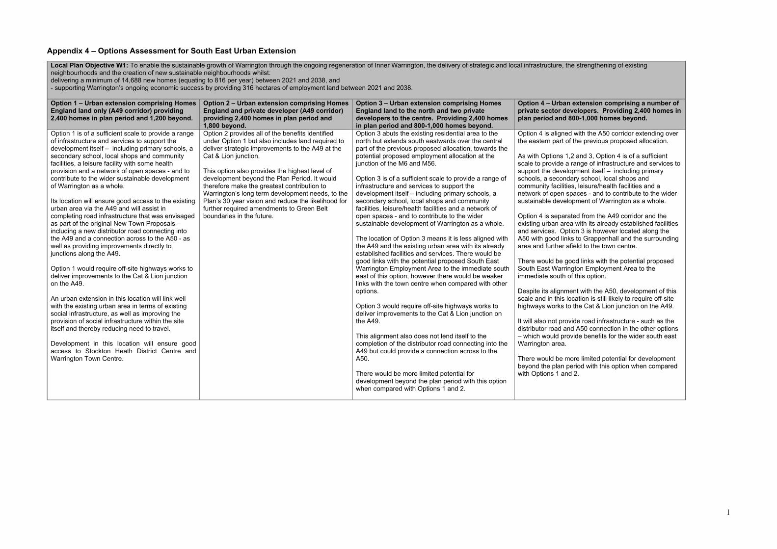
1
Appendix 4 – Options Assessment for South East Urban Extension
Local Plan Objective W1: To enable the sustainable growth of Warrington through the ongoing regeneration of Inner Warrington, the delivery of strategic and local infrastructure, the strengthening of existing neighbourhoods and the creation of new sustainable neighbourhoods whilst: delivering a minimum of 14,688 new homes (equating to 816 per year) between 2021 and 2038, and - supporting Warrington’s ongoing economic success by providing 316 hectares of employment land between 2021 and 2038. Option 1 – Urban extension comprising Homes England land only (A49 corridor) providing 2,400 homes in plan period and 1,200 beyond.
Option 2 – Urban extension comprising Homes England and private developer (A49 corridor) providing 2,400 homes in plan period and 1,800 beyond.
Option 3 – Urban extension comprising Homes England land to the north and two private developers to the centre. Providing 2,400 homes in plan period and 800-1,000 homes beyond.
Option 4 – Urban extension comprising a number of private sector developers. Providing 2,400 homes in plan period and 800-1,000 homes beyond.
Option 1 is of a sufficient scale to provide a range of infrastructure and services to support the development itself – including primary schools, a secondary school, local shops and community facilities, a leisure facility with some health provision and a network of open spaces - and to contribute to the wider sustainable development of Warrington as a whole. Its location will ensure good access to the existing urban area via the A49 and will assist in completing road infrastructure that was envisaged as part of the original New Town Proposals – including a new distributor road connecting into the A49 and a connection across to the A50 - as well as providing improvements directly to junctions along the A49. Option 1 would require off-site highways works to deliver improvements to the Cat & Lion junction on the A49. An urban extension in this location will link well with the existing urban area in terms of existing social infrastructure, as well as improving the provision of social infrastructure within the site itself and thereby reducing need to travel. Development in this location will ensure good access to Stockton Heath District Centre and Warrington Town Centre.
Option 2 provides all of the benefits identified under Option 1 but also includes land required to deliver strategic improvements to the A49 at the Cat & Lion junction. This option also provides the highest level of development beyond the Plan Period. It would therefore make the greatest contribution to Warrington’s long term development needs, to the Plan’s 30 year vision and reduce the likelihood for further required amendments to Green Belt boundaries in the future.
Option 3 abuts the existing residential area to the north but extends south eastwards over the central part of the previous proposed allocation, towards the potential proposed employment allocation at the junction of the M6 and M56. Option 3 is of a sufficient scale to provide a range of infrastructure and services to support the development itself – including primary schools, a secondary school, local shops and community facilities, leisure/health facilities and a network of open spaces - and to contribute to the wider sustainable development of Warrington as a whole. The location of Option 3 means it is less aligned with the A49 and the existing urban area with its already established facilities and services. There would be good links with the potential proposed South East Warrington Employment Area to the immediate south east of this option, however there would be weaker links with the town centre when compared with other options. Option 3 would require off-site highways works to deliver improvements to the Cat & Lion junction on the A49. This alignment also does not lend itself to the completion of the distributor road connecting into the A49 but could provide a connection across to the A50. There would be more limited potential for development beyond the plan period with this option when compared with Options 1 and 2.
Option 4 is aligned with the A50 corridor extending over the eastern part of the previous proposed allocation. As with Options 1,2 and 3, Option 4 is of a sufficient scale to provide a range of infrastructure and services to support the development itself – including primary schools, a secondary school, local shops and community facilities, leisure/health facilities and a network of open spaces - and to contribute to the wider sustainable development of Warrington as a whole. Option 4 is separated from the A49 corridor and the existing urban area with its already established facilities and services. Option 3 is however located along the A50 with good links to Grappenhall and the surrounding area and further afield to the town centre. There would be good links with the potential proposed South East Warrington Employment Area to the immediate south of this option. Despite its alignment with the A50, development of this scale and in this location is still likely to require off-site highways works to the Cat & Lion junction on the A49. It will also not provide road infrastructure - such as the distributor road and A50 connection in the other options – which would provide benefits for the wider south east Warrington area. There would be more limited potential for development beyond the plan period with this option when compared with Options 1 and 2.
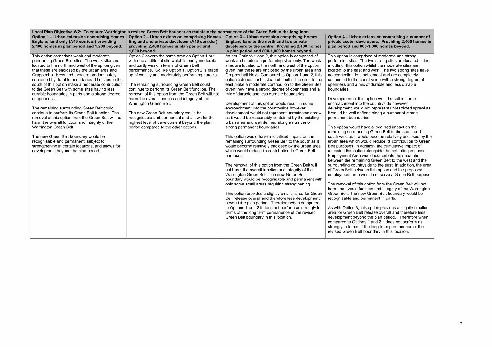
2
Local Plan Objective W2: To ensure Warrington’s revised Green Belt boundaries maintain the permanence of the Green Belt in the long term. Option 1 – Urban extension comprising Homes England land only (A49 corridor) providing 2,400 homes in plan period and 1,200 beyond.
Option 2 – Urban extension comprising Homes England and private developer (A49 corridor) providing 2,400 homes in plan period and 1,800 beyond.
Option 3 – Urban extension comprising Homes England land to the north and two private developers to the centre. Providing 2,400 homes in plan period and 800-1,000 homes beyond.
Option 4 – Urban extension comprising a number of private sector developers. Providing 2,400 homes in plan period and 800-1,000 homes beyond.
This option comprises weak and moderate performing Green Belt sites. The weak sites are located to the north and west of the option given that these are enclosed by the urban area and Grappenhall Heys and they are predominately contained by durable boundaries. The sites to the south of this option make a moderate contribution to the Green Belt with some sites having less durable boundaries in parts and a strong degree of openness. The remaining surrounding Green Belt could continue to perform its Green Belt function. The removal of this option from the Green Belt will not harm the overall function and integrity of the Warrington Green Belt. The new Green Belt boundary would be recognisable and permanent, subject to strengthening in certain locations, and allows for development beyond the plan period.
Option 2 covers the same area as Option 1 but with one additional site which is partly moderate and partly weak in terms of Green Belt performance. So like Option 1, Option 2 is made up of weakly and moderately performing parcels. The remaining surrounding Green Belt could continue to perform its Green Belt function. The removal of this option from the Green Belt will not harm the overall function and integrity of the Warrington Green Belt. The new Green Belt boundary would be recognisable and permanent and allows for the highest level of development beyond the plan period compared to the other options.
As per Options 1 and 2, this option is comprised of weak and moderate performing sites only. The weak sites are located to the north and west of the option given that these are enclosed by the urban area and Grappenhall Heys. Compared to Option 1 and 2, this option extends east instead of south. The sites to the east make a moderate contribution to the Green Belt given they have a strong degree of openness and a mix of durable and less durable boundaries. Development of this option would result in some encroachment into the countryside however development would not represent unrestricted sprawl as it would be reasonably contained by the existing urban area and well defined along a number of strong permanent boundaries. This option would have a localised impact on the remaining surrounding Green Belt to the south as it would become relatively enclosed by the urban area which would reduce its contribution to Green Belt purposes. The removal of this option from the Green Belt will not harm the overall function and integrity of the Warrington Green Belt. The new Green Belt boundary would be recognisable and permanent with only some small areas requiring strengthening. This option provides a slightly smaller area for Green Belt release overall and therefore less development beyond the plan period. Therefore when compared to Options 1 and 2 it does not perform as strongly in terms of the long term permanence of the revised Green Belt boundary in this location.
This option is comprised of moderate and strong performing sites. The two strong sites are located in the middle of this option whilst the moderate sites are located to the east and west. The two strong sites have no connection to a settlement and are completely connected to the countryside with a strong degree of openness and a mix of durable and less durable boundaries. Development of this option would result in some encroachment into the countryside however development would not represent unrestricted sprawl as it would be well defined along a number of strong permanent boundaries. This option would have a localised impact on the remaining surrounding Green Belt to the south and south west as it would become relatively enclosed by the urban area which would reduce its contribution to Green Belt purposes. In addition, the cumulative impact of releasing this option alongside the potential proposed Employment Area would exacerbate the separation between the remaining Green Belt to the west and the surrounding countryside to the east. In addition, the area of Green Belt between this option and the proposed employment area would not serve a Green Belt purpose. The removal of this option from the Green Belt will not harm the overall function and integrity of the Warrington Green Belt. The new Green Belt boundary would be recognisable and permanent in parts. As with Option 3, this option provides a slightly smaller area for Green Belt release overall and therefore less development beyond the plan period. Therefore when compared to Options 1 and 2 it does not perform as strongly in terms of the long term permanence of the revised Green Belt boundary in this location.
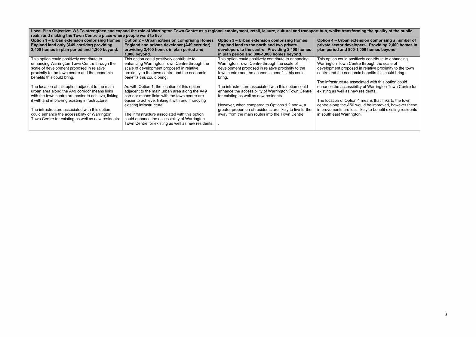
3
Local Plan Objective: W3 To strengthen and expand the role of Warrington Town Centre as a regional employment, retail, leisure, cultural and transport hub, whilst transforming the quality of the public realm and making the Town Centre a place where people want to live Option 1 – Urban extension comprising Homes England land only (A49 corridor) providing 2,400 homes in plan period and 1,200 beyond.
Option 2 – Urban extension comprising Homes England and private developer (A49 corridor) providing 2,400 homes in plan period and 1,800 beyond.
Option 3 – Urban extension comprising Homes England land to the north and two private developers to the centre. Providing 2,400 homes in plan period and 800-1,000 homes beyond.
Option 4 – Urban extension comprising a number of private sector developers. Providing 2,400 homes in plan period and 800-1,000 homes beyond.
This option could positively contribute to enhancing Warrington Town Centre through the scale of development proposed in relative proximity to the town centre and the economic benefits this could bring. The location of this option adjacent to the main urban area along the A49 corridor means links with the town centre are easier to achieve, linking it with and improving existing infrastructure. The infrastructure associated with this option could enhance the accessibility of Warrington Town Centre for existing as well as new residents.
This option could positively contribute to enhancing Warrington Town Centre through the scale of development proposed in relative proximity to the town centre and the economic benefits this could bring. As with Option 1, the location of this option adjacent to the main urban area along the A49 corridor means links with the town centre are easier to achieve, linking it with and improving existing infrastructure. The infrastructure associated with this option could enhance the accessibility of Warrington Town Centre for existing as well as new residents.
This option could positively contribute to enhancing Warrington Town Centre through the scale of development proposed in relative proximity to the town centre and the economic benefits this could bring. The infrastructure associated with this option could enhance the accessibility of Warrington Town Centre for existing as well as new residents. However, when compared to Options 1,2 and 4, a greater proportion of residents are likely to live further away from the main routes into the Town Centre. .
This option could positively contribute to enhancing Warrington Town Centre through the scale of development proposed in relative proximity to the town centre and the economic benefits this could bring. The infrastructure associated with this option could enhance the accessibility of Warrington Town Centre for existing as well as new residents. The location of Option 4 means that links to the town centre along the A50 would be improved, however these improvements are less likely to benefit existing residents in south east Warrington.
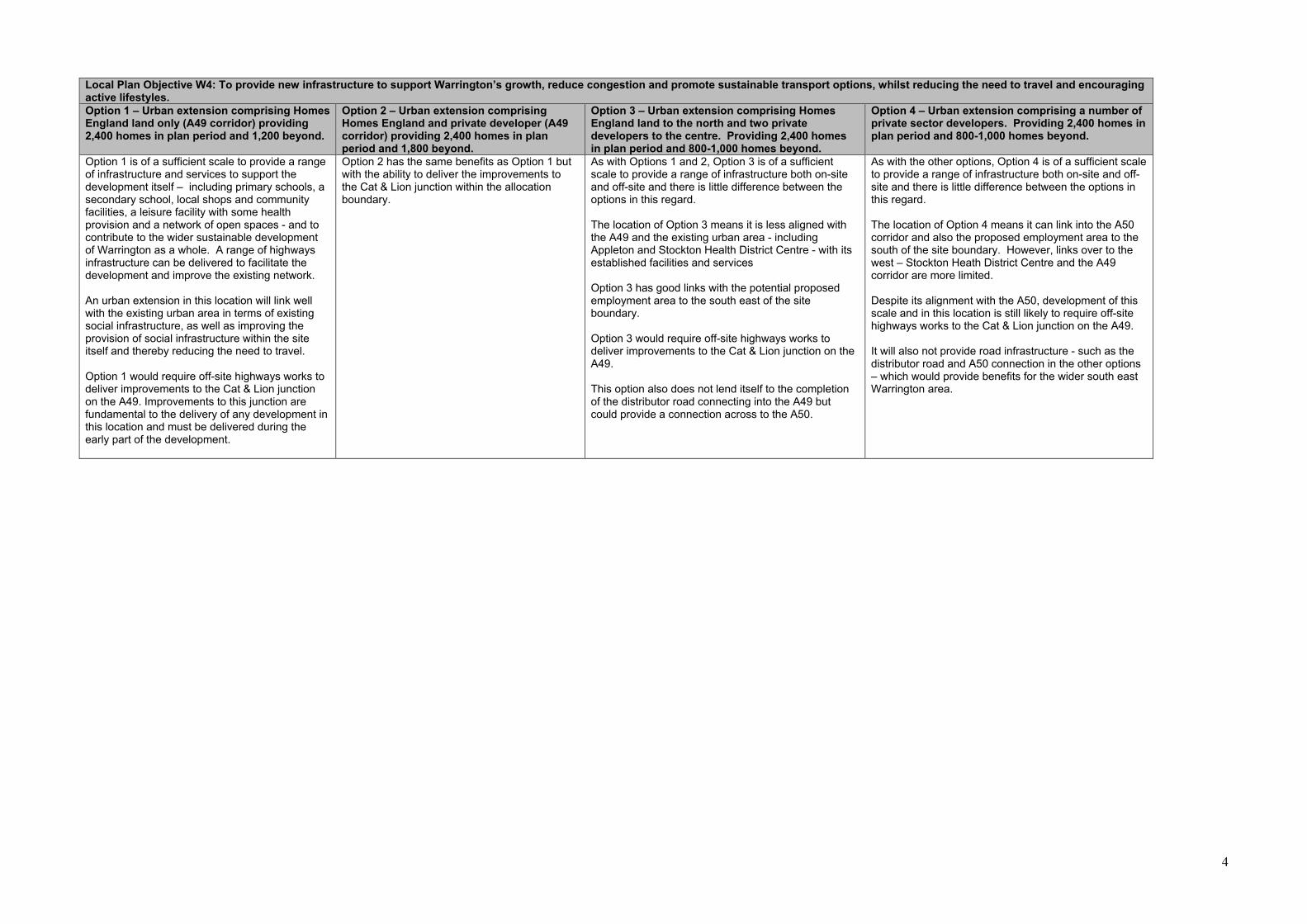
4
Local Plan Objective W4: To provide new infrastructure to support Warrington’s growth, reduce congestion and promote sustainable transport options, whilst reducing the need to travel and encouraging active lifestyles. Option 1 – Urban extension comprising Homes England land only (A49 corridor) providing 2,400 homes in plan period and 1,200 beyond.
Option 2 – Urban extension comprising Homes England and private developer (A49 corridor) providing 2,400 homes in plan period and 1,800 beyond.
Option 3 – Urban extension comprising Homes England land to the north and two private developers to the centre. Providing 2,400 homes in plan period and 800-1,000 homes beyond.
Option 4 – Urban extension comprising a number of private sector developers. Providing 2,400 homes in plan period and 800-1,000 homes beyond.
Option 1 is of a sufficient scale to provide a range of infrastructure and services to support the development itself – including primary schools, a secondary school, local shops and community facilities, a leisure facility with some health provision and a network of open spaces - and to contribute to the wider sustainable development of Warrington as a whole. A range of highways infrastructure can be delivered to facilitate the development and improve the existing network. An urban extension in this location will link well with the existing urban area in terms of existing social infrastructure, as well as improving the provision of social infrastructure within the site itself and thereby reducing the need to travel. Option 1 would require off-site highways works to deliver improvements to the Cat & Lion junction on the A49. Improvements to this junction are fundamental to the delivery of any development in this location and must be delivered during the early part of the development.
Option 2 has the same benefits as Option 1 but with the ability to deliver the improvements to the Cat & Lion junction within the allocation boundary.
As with Options 1 and 2, Option 3 is of a sufficient scale to provide a range of infrastructure both on-site and off-site and there is little difference between the options in this regard. The location of Option 3 means it is less aligned with the A49 and the existing urban area - including Appleton and Stockton Health District Centre - with its established facilities and services Option 3 has good links with the potential proposed employment area to the south east of the site boundary. Option 3 would require off-site highways works to deliver improvements to the Cat & Lion junction on the A49. This option also does not lend itself to the completion of the distributor road connecting into the A49 but could provide a connection across to the A50.
As with the other options, Option 4 is of a sufficient scale to provide a range of infrastructure both on-site and off-site and there is little difference between the options in this regard. The location of Option 4 means it can link into the A50 corridor and also the proposed employment area to the south of the site boundary. However, links over to the west – Stockton Heath District Centre and the A49 corridor are more limited. Despite its alignment with the A50, development of this scale and in this location is still likely to require off-site highways works to the Cat & Lion junction on the A49. It will also not provide road infrastructure - such as the distributor road and A50 connection in the other options – which would provide benefits for the wider south east Warrington area.
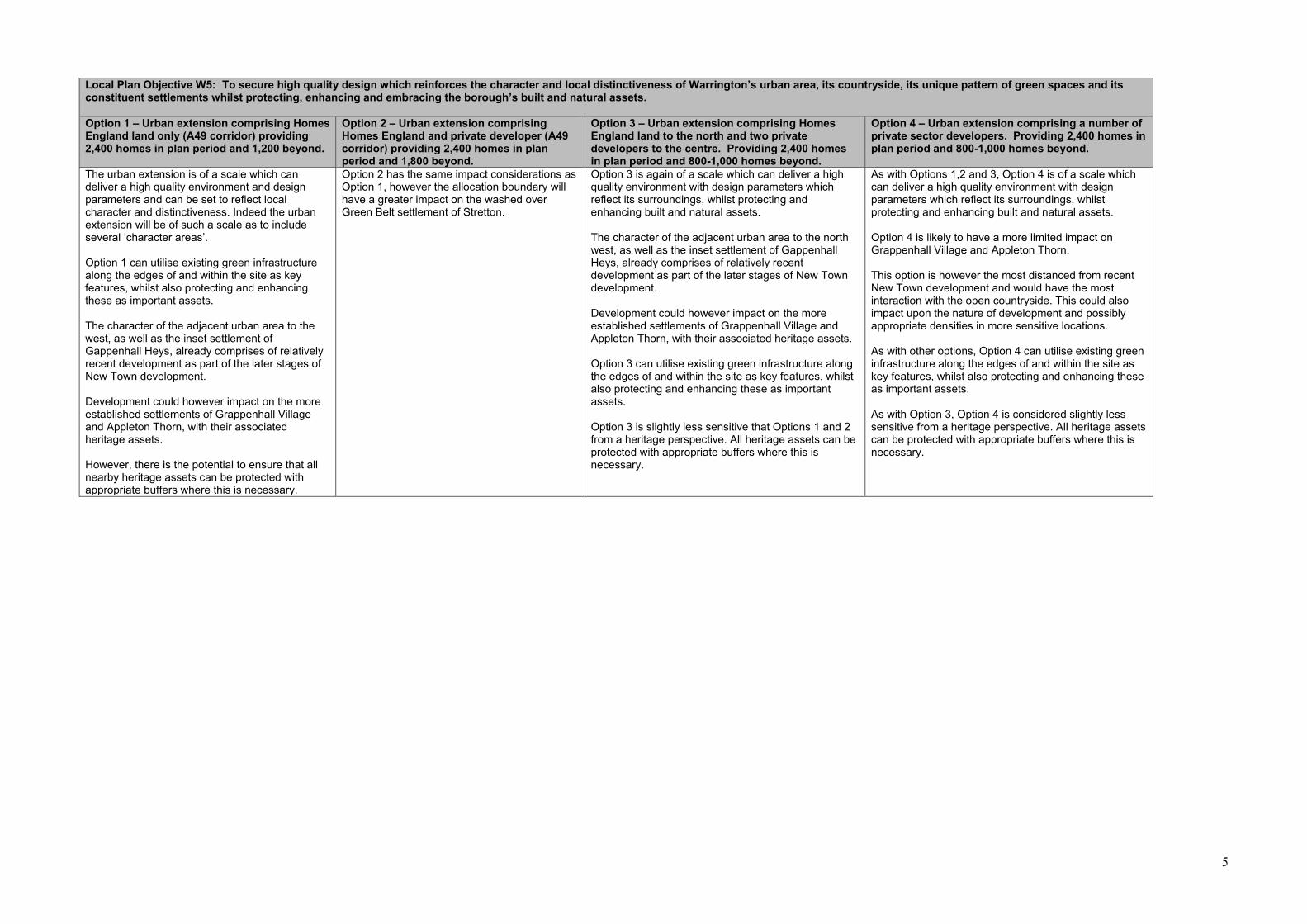
5
Local Plan Objective W5: To secure high quality design which reinforces the character and local distinctiveness of Warrington’s urban area, its countryside, its unique pattern of green spaces and its constituent settlements whilst protecting, enhancing and embracing the borough’s built and natural assets. Option 1 – Urban extension comprising Homes England land only (A49 corridor) providing 2,400 homes in plan period and 1,200 beyond.
Option 2 – Urban extension comprising Homes England and private developer (A49 corridor) providing 2,400 homes in plan period and 1,800 beyond.
Option 3 – Urban extension comprising Homes England land to the north and two private developers to the centre. Providing 2,400 homes in plan period and 800-1,000 homes beyond.
Option 4 – Urban extension comprising a number of private sector developers. Providing 2,400 homes in plan period and 800-1,000 homes beyond.
The urban extension is of a scale which can deliver a high quality environment and design parameters and can be set to reflect local character and distinctiveness. Indeed the urban extension will be of such a scale as to include several ‘character areas’. Option 1 can utilise existing green infrastructure along the edges of and within the site as key features, whilst also protecting and enhancing these as important assets. The character of the adjacent urban area to the west, as well as the inset settlement of Gappenhall Heys, already comprises of relatively recent development as part of the later stages of New Town development. Development could however impact on the more established settlements of Grappenhall Village and Appleton Thorn, with their associated heritage assets. However, there is the potential to ensure that all nearby heritage assets can be protected with appropriate buffers where this is necessary.
Option 2 has the same impact considerations as Option 1, however the allocation boundary will have a greater impact on the washed over Green Belt settlement of Stretton.
Option 3 is again of a scale which can deliver a high quality environment with design parameters which reflect its surroundings, whilst protecting and enhancing built and natural assets. The character of the adjacent urban area to the north west, as well as the inset settlement of Gappenhall Heys, already comprises of relatively recent development as part of the later stages of New Town development. Development could however impact on the more established settlements of Grappenhall Village and Appleton Thorn, with their associated heritage assets. Option 3 can utilise existing green infrastructure along the edges of and within the site as key features, whilst also protecting and enhancing these as important assets. Option 3 is slightly less sensitive that Options 1 and 2 from a heritage perspective. All heritage assets can be protected with appropriate buffers where this is necessary.
As with Options 1,2 and 3, Option 4 is of a scale which can deliver a high quality environment with design parameters which reflect its surroundings, whilst protecting and enhancing built and natural assets. Option 4 is likely to have a more limited impact on Grappenhall Village and Appleton Thorn. This option is however the most distanced from recent New Town development and would have the most interaction with the open countryside. This could also impact upon the nature of development and possibly appropriate densities in more sensitive locations. As with other options, Option 4 can utilise existing green infrastructure along the edges of and within the site as key features, whilst also protecting and enhancing these as important assets. As with Option 3, Option 4 is considered slightly less sensitive from a heritage perspective. All heritage assets can be protected with appropriate buffers where this is necessary.
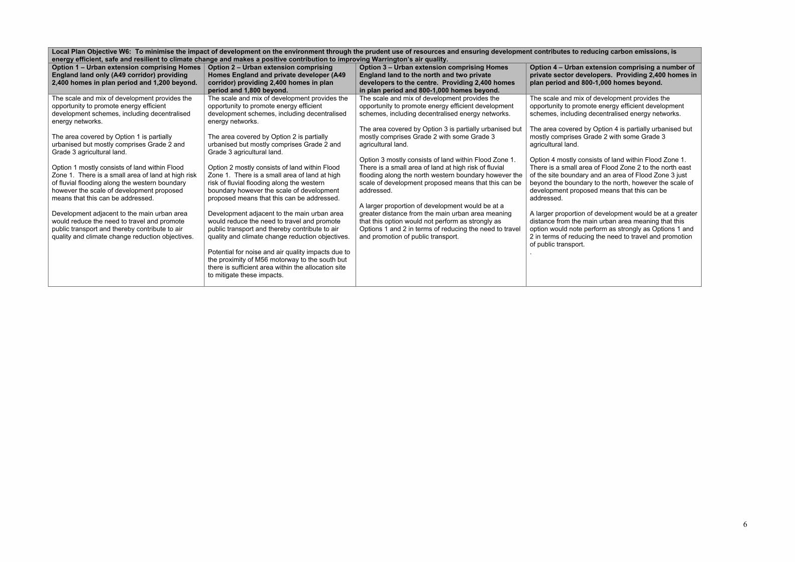
6
Local Plan Objective W6: To minimise the impact of development on the environment through the prudent use of resources and ensuring development contributes to reducing carbon emissions, is energy efficient, safe and resilient to climate change and makes a positive contribution to improving Warrington’s air quality. Option 1 – Urban extension comprising Homes England land only (A49 corridor) providing 2,400 homes in plan period and 1,200 beyond.
Option 2 – Urban extension comprising Homes England and private developer (A49 corridor) providing 2,400 homes in plan period and 1,800 beyond.
Option 3 – Urban extension comprising Homes England land to the north and two private developers to the centre. Providing 2,400 homes in plan period and 800-1,000 homes beyond.
Option 4 – Urban extension comprising a number of private sector developers. Providing 2,400 homes in plan period and 800-1,000 homes beyond.
The scale and mix of development provides the opportunity to promote energy efficient development schemes, including decentralised energy networks. The area covered by Option 1 is partially urbanised but mostly comprises Grade 2 and Grade 3 agricultural land. Option 1 mostly consists of land within Flood Zone 1. There is a small area of land at high risk of fluvial flooding along the western boundary however the scale of development proposed means that this can be addressed. Development adjacent to the main urban area would reduce the need to travel and promote public transport and thereby contribute to air quality and climate change reduction objectives.
The scale and mix of development provides the opportunity to promote energy efficient development schemes, including decentralised energy networks. The area covered by Option 2 is partially urbanised but mostly comprises Grade 2 and Grade 3 agricultural land. Option 2 mostly consists of land within Flood Zone 1. There is a small area of land at high risk of fluvial flooding along the western boundary however the scale of development proposed means that this can be addressed. Development adjacent to the main urban area would reduce the need to travel and promote public transport and thereby contribute to air quality and climate change reduction objectives. Potential for noise and air quality impacts due to the proximity of M56 motorway to the south but there is sufficient area within the allocation site to mitigate these impacts.
The scale and mix of development provides the opportunity to promote energy efficient development schemes, including decentralised energy networks. The area covered by Option 3 is partially urbanised but mostly comprises Grade 2 with some Grade 3 agricultural land. Option 3 mostly consists of land within Flood Zone 1. There is a small area of land at high risk of fluvial flooding along the north western boundary however the scale of development proposed means that this can be addressed. A larger proportion of development would be at a greater distance from the main urban area meaning that this option would not perform as strongly as Options 1 and 2 in terms of reducing the need to travel and promotion of public transport.
The scale and mix of development provides the opportunity to promote energy efficient development schemes, including decentralised energy networks. The area covered by Option 4 is partially urbanised but mostly comprises Grade 2 with some Grade 3 agricultural land. Option 4 mostly consists of land within Flood Zone 1. There is a small area of Flood Zone 2 to the north east of the site boundary and an area of Flood Zone 3 just beyond the boundary to the north, however the scale of development proposed means that this can be addressed. A larger proportion of development would be at a greater distance from the main urban area meaning that this option would note perform as strongly as Options 1 and 2 in terms of reducing the need to travel and promotion of public transport. .

7
Deliverability Conclusions Option 1 – Urban extension comprising Homes England land only (A49 corridor) providing 2,400 homes in plan period and 1,200 beyond.
Option 2 – Urban extension comprising Homes England and private developer (A49 corridor) providing 2,400 homes in plan period and 1,800 beyond.
Option 3 – Urban extension comprising Homes England land to the north and two private developers to the centre. Providing 2,400 homes in plan period and 800-1,000 homes beyond.
Option 4 – Urban extension comprising a number of private sector developers. Providing 2,400 homes in plan period and 800-1,000 homes beyond.
The land included in Option 1 is suitable and available and landowners have demonstrated their commitment to delivering the urban extension. The scale of development proposed means that an appropriate level of social infrastructure and services can be provided to support the urban extension. Improvements to the Cat & Lion junction are fundamental to the delivery of any development in this location and must be delivered during the early part of the development. Option 1 does not include land required to deliver improvements to the Cat & Lion junction on the A49. A Compulsory Purchase Order (CPO) may therefore be required in order to deliver the necessary improvements to facilitate this Option.
The land included in Option 2 is suitable and available and landowners have demonstrated their commitment to delivering the urban extension. The scale of development proposed means that an appropriate level of social infrastructure and services can be provided to support the urban extension. Option 2 also includes land required to deliver strategic improvements to the A49 at the Cat & Lion junction, thereby avoiding the need for CPO.
The land included in Option 3 is suitable and available and landowners have demonstrated their commitment to delivering the urban extension. The scale of development proposed means that an appropriate level of social infrastructure and services can be provided to support the urban extension. Option 3, as per Option 1, does not include land required to deliver improvements to the Cat & Lion junction on the A49. This may require a Compulsory Purchase Order (CPO) to deliver this fundamental highway improvement which is required during the early part of the development.
The land included in Option 4 is suitable and available and landowners have demonstrated their commitment to delivering the urban extension. This option does however involve the highest number of landowners potentially raising issues of equalisation and deliverability. The scale of development proposed means that an appropriate level of social infrastructure and services can be provided to support the urban extension. Option 4, as with Options 1 and 3, does not include land required to deliver improvements to the Cat & Lion junction on the A49. This may require a Compulsory Purchase Order (CPO) to deliver this fundamental highway improvement which is required during the early part of the development.
SA/SEA/ Conclusions Each of the options perform relatively similar, which is to be expected given that they are all in the same broad location. Some common effects are as follows:
• Major positive effects are likely to arise in relation to housing regardless of option. • Major negative effects are likely to arise with regards to soil resources regardless of option. • The effects with regards to flooding and water quality are the same regardless of option (neutral and minor positive).
There are some differences that have been noted in the SA though: • Options 3 and 4 could potentially have a greater negative effect upon landscape character compared to options 1 and 2. • The effects on health and wellbeing are more likely to be of major significance (positively) for Options 1, 2 and 3, which build on existing communities and services. This is also reflected in the accessibility
performance of the options, which is least positive for Option 4. • Option 4 performs slightly better than the other 3 options with regards to biodiversity impacts, but there is a degree of uncertainty. • Options 1 and 2 perform less well compared to Options 3 and 4 with regards to built heritage. However, effects are predicted to be of minor significance.

8
Overall Conclusions Option 1 – Urban extension comprising Homes England land only (A49 corridor) providing 2,400 homes in plan period and 1,300 beyond.
Option 2 – Urban extension comprising Homes England and Wallace land (A49 corridor) providing 2,400 homes in plan period and 1,800 beyond.
Option 3 – Urban extension comprising Homes England land to the north and Taylor Wimpey land to the centre. Providing 2,400 homes in plan period and 800-1,000 homes beyond.
Option 4 – Urban extension comprising land owned by Taylor Wimpey, Langtree, Lone Star, HSL and Moseley Bros (A50 corridor). Providing 2,400 homes in plan period and 800-1,000 homes beyond.
Option 1 performs strongly against the majority of local plan objectives. It relates well to the existing urban area along the A49 corridor, benefiting from proximity to existing services, reducing the need to travel and promoting public transport. This Option includes the use of the weakest performing Green Belt parcels and will create strong Green Belt boundaries that are defensible over the long term. Development may impact on the character of Appleton Thorn and Grappenhall Village but all important heritage and natural assets can be protected with appropriate buffers where this is necessary. The urban extension can deliver the required social infrastructure and services to support the level of development proposed. It will assist in completing road infrastructure that was envisaged as part of the original New Town Proposals – including a new distributor road connecting into the A49 and a connection across to the A50 - as well as providing improvements directly to junctions along the A49. Option 1 does not however include land required to deliver improvements to the Cat & Lion junction on the A49. A Compulsory Purchase Order (CPO) may therefore be required in order to deliver the necessary improvements to facilitate this option.
Option 2 performs strongly against the majority of local plan objectives. It relates well to the existing urban area along the A49 corridor, benefiting from proximity to existing services, reducing the need to travel and promoting public transport. This Option includes the use of the weakest performing Green Belt parcels and will create strong Green Belt boundaries. In facilitating the largest amount of development, this option provides the greatest contribution to Warrington’s long term development needs, to the Plan’s 30 year vision and reduces the likelihood for further required amendments to Green Belt boundaries in the future. Development may impact on the character of Appleton Thorn, Stretton and Grappenhall Village but all important heritage and natural assets can be protected with appropriate buffers where this is necessary. The urban extension can deliver the required social infrastructure and services to support the level of development proposed. It will assist in completing road infrastructure that was envisaged as part of the original New Town Proposals – including a new distributor road connecting into the A49 and a connection across to the A50 - as well as providing improvements directly to junctions along the A49 Option 2 also includes land required to deliver strategic improvements to the A49 at the Cat & Lion junction, thereby avoiding the need for CPO.
Option 3 performs reasonably well against local plan objectives. It is less well aligned to the existing urban area, particularly in the southern part of the site. Option 3 includes the use of the weakest performing Green Belt parcels and will create strong and defensible boundaries. This option will however have a localised impact on the remaining Green Belt between the site boundary and the urban area to the east, potentially reducing its contribution to Green Belt purposes in this location. It also does not provide as much development beyond the plan period compared to Options 1 and 2 and therefore does not perform as strongly in terms of the long term permanence of the revised Green Belt boundaries. Development may impact on the character of Appleton Thorn and Grappenhall Village but all important heritage and natural assets can be protected with appropriate buffers where this is necessary. The urban extension can deliver the required social infrastructure and services to support the level of development proposed. This alignment also does not lend itself to the completion of the distributor road connecting into the A49 but could provide a connection across to the A50. Option 3 does not however include land required to deliver improvements to the Cat & Lion junction on the A49. A Compulsory Purchase Order (CPO) may therefore be required in order to deliver the necessary improvements to facilitate this Option.
Option 4 performs less well against local plan objectives. It is separated from the A49 corridor and the existing urban area with its established facilities and services. It is however located along the A50 with good links to Grappenhall and the surrounding area and further afield to the town centre. Option 4 does not make use of the weakest performing Green Belt parcels though it is possible to create strong and defensible boundaries. This option would have a localised impact on the remaining surrounding Green Belt to the south and south west as it would become relatively enclosed by the urban area which would reduce its contribution to Green Belt purposes. In addition, the cumulative impact of releasing this option alongside the potential Employment Area would exacerbate the separation between the remaining Green Belt to the west and the surrounding countryside to the east. It also does not provide as much development beyond the plan period compared to Options 1 and 2 and therefore does not perform as strongly in terms of the long term permanence of the revised Green Belt boundaries. This option is the most distanced from recent New Town development and would have the most interaction with the open countryside. Important heritage and natural assets can however be protected with appropriate buffers where this is necessary. The urban extension can deliver the required social infrastructure and services to support the level of development proposed. It will not however provide road infrastructure - such as the distributor road and A50 connection in the other options – which would provide benefits for the wider south east Warrington area. Despite its alignment with the A50, development of this scale and in this location is still likely to require off-site highways works to the Cat & Lion junction on the A49, which might necessitate a CPO. There may also be deliverability challenges given the number of private landowners promoting this option.

1
Appendix 5 – Options Assessment of Main Development Locations
Local Plan Objective W1: To enable the sustainable growth of Warrington through the ongoing regeneration of Inner Warrington, the delivery of strategic and local infrastructure, the strengthening of existing neighbourhoods and the creation of new sustainable neighbourhoods whilst: - delivering a minimum of 14,688 new homes (equating to 816 per year) between 2021 and 2038, and - supporting Warrington’s ongoing economic success by providing 316 hectares of employment land between 2021 and 2038. Option 1 – Urban extension to the south east of Warrington of around 2,400 homes & an urban extension to the south west of around 1,700 homes.
Option 2 - Urban extension to the south east of Warrington of around 2,400 homes & redevelopment of Fiddlers Ferry opportunity site for 1,300 homes.
Option 3 - Urban extension to the south east of Warrington of around 2,400 homes, redevelopment of Fiddlers Ferry opportunity site for 1,300 homes and development at Thelwall Heys of 310 homes.
Option 4 – Urban extension to the south west of around 1,700 homes, redevelopment of Fiddlers Ferry opportunity site for 1,300 homes and development at Thelwall Heys of 310 homes.
Option 5 - Urban extension to the south west of around 1,700 homes, redevelopment of Fiddlers Ferry opportunity site for 1,300 homes
The South East Urban Extension is of a sufficient scale to provide a range of infrastructure and services to support the development itself – including two primary schools, a secondary school, local shops and community facilities, a leisure facility with some health provision and a network of open spaces - and to contribute to the wider sustainable development of Warrington as a whole. Its location will ensure good access to the surrounding urban area and Warrington Town centre. These benefits are further increased when combined with the potential proposed employment site at the junction of the M6/M56. The South West Urban Extension is of a sufficient scale to provide a range of services to support a new residential community including a local centre, primary school, health facility and a network of open spaces. Its location will ensure good access to Stockton Heath District Centre and, subject to the future delivery of the Western Link, Warrington Town Centre. There are however concerns about the potential impact of the South West Urban Extension on the Western Link. This option provides the highest amount of development within the Plan period, which is positive in terms of flexibility of land supply, but it will result in higher levels of development on former Green Belt land. Given the lead in times for infrastructure to support the urban extensions, this option provides only limited opportunity for new homes early in the plan period. The South East Urban Extension will help ensure Warrington’s development needs continue to be met well beyond the end of the Plan period and will contribute to the Plan’s 30 year vision.
The South East Urban Extension assessment is the same as in option 1. The residential element of the Fiddlers Ferry opportunity requires the release of Green Belt but its development will allow for the remediation and re-use of a major brownfield site. The site can deliver a sustainable community of approximately 1,300 homes in the plan period along with approximately 100ha of employment land. A range of services to support the new community can be provided as part of the development, including a primary school, a local centre potentially including a local health facility and a network of open spaces, along with ecological and recreation provision in the longer term. The location of the Fiddlers Ferry site provides good access to west Warrington and beyond this to the town centre, as well as to Widnes to the west. In addition, the Trans Pennine Trail provides a recreational route both east and westwards. This option will help ensure Warrington’s development needs continue to be met well beyond the end of the Plan period and will contribute to the Plan’s 30 year vision. This is mainly from the South East Urban Extension, but Fiddlers Ferry will make a longer term contribution as well.
The South East Urban Extension assessment is the same as in option 1. The Fiddlers Ferry opportunity site assessment is the same as in option 2. The development of land at Thelwall Heys could be accommodated as a small extension to the existing urban area and there is capacity within existing services and infrastructure to support this level of development in this location. Land at Thelwall Heys could be delivered early in the plan period as it is not dependent on the wider delivery of large scale infrastructure in comparison to that required to support larger urban extensions. The site has good links to Warrington Town Centre and the existing urban area. This option provides the same benefits for meeting Warrington’s longer term development needs as per Option 2.
The South West Urban Extension assessment is the same as in option 1. The Fiddlers Ferry opportunity site assessment is the same as in option 2. The Thelwall Heys site assessment is the same as in option 3. Given the size of these sites, they are unlikely to be able to provide for a new secondary school or leisure hub. There is insufficient capacity within secondary schools in south Warrington to support this option. Similarly, south Warrington has limited existing built leisure provision and this will be exacerbated by this option. This option only provides limited development potential beyond the plan period and there may be the need for safeguarding of additional sites to ensure the long term permanence of revised Green Belt boundaries and to contribute to the Plan’s 30 year vision.
The South West Urban Extension assessment is the same as in option 1. The Fiddlers Ferry opportunity site assessment is the same as in option 2. This option provides the lowest number of homes in the Plan Period which reduces flexibility of land supply. Conversely it will result in fewer homes being built on former Green Belt land. With reliance upon remediation of Fiddlers Ferry and the delivery of the Western Link to facilitate development of South West Urban Extension there would be limited opportunity for the delivery of new homes early in the plan period. As with Option 4, there are likely to be pressures on existing infrastructure in south Warrington, in particular in respect of secondary school provision and leisure facilities. This option only provides limited development potential beyond plan period and there may be the need for safeguarding of additional sites to ensure the long term permanence of revised Green belt boundaries and to contribute to the Plan’s 30 year vision.

2
Local Plan Objective W2: To ensure Warrington’s revised Green Belt boundaries maintain the permanence of the Green Belt in the long term. Option 1 – Urban extension to the south east of Warrington of around 2,400 homes & an urban extension to the south west of around 1,700 homes.
Option 2 - Urban extension to the south east of Warrington of around 2,400 homes & redevelopment of Fiddlers Ferry opportunity site for 1,300 homes.
Option 3 - Urban extension to the south east of Warrington of around 2,400 homes, redevelopment of Fiddlers Ferry opportunity site for 1,300 homes and development at Thelwall Heys of 310 homes.
Option 4 – Urban extension to the south west of around 1,700 homes, redevelopment of Fiddlers Ferry opportunity site for 1,300 homes and development at Thelwall Heys of 310 homes.
Option 5 - Urban extension to the south west of around 1,700 homes, redevelopment of Fiddlers Ferry opportunity site for 1,300 homes
The South East Urban Extension provides the opportunity to amend the existing Green Belt boundary and to make use of the weakest Green Belt parcels in this location, together with the loss of some moderately performing parcels. The urban extension lends itself to the use of defensible existing features as robust boundaries, or where this is not possible, there is the opportunity to strengthen existing boundaries to ensure the permanence of the revised Green Belt boundary in the long term. The amended Green Belt boundary will allow for a further 1,800 dwellings to be delivered beyond the plan period, further ensuring the permanence of revised boundaries. Green Belt release for the South West Urban Extension will involve moderate performing Green Belt sites. Revised boundaries would be likely to ensure permanence in the long term (consisting predominantly of A roads and the canal). It is essential that a robust boundary is provided to support the strategic function of the Green Belt in this location in ensuring separation between Warrington and Runcorn. This needs to be considered with the potential proposed employment sites within the Waterfront and in the context of Halton proposing to remove Moore Village from the Green Belt through their Local Plan review. This option will not however enable the regeneration of Fiddlers Ferry Power station for employment uses. The power station is the largest brownfield site in the Borough and sits outside of the Green Belt. If this site is not brought forward for development it will increase the need to release Green Belt elsewhere in the Borough for employment uses.
Green Belt release for the South East Urban Extension will be the same as per Option 1. Development at Fiddlers Ferry will include releasing parcels making a strong and moderate contribution to the Green Belt in this location. Release of Green Belt for residential development will however enable the wider redevelopment of Fiddlers Ferry Power station for employment uses. The power station itself is not within the Green Belt and is the largest brownfield site in the Borough. Its redevelopment will reduce the need for Green Belt release elsewhere in the Borough for employment uses. There are also robust boundaries to define the amended Green Belt boundary in the long term, including A562 (Widnes Road) to the north and the River Mersey to the south (albeit that a new recognisable and permanent boundary would need to be created at the southern tip of the site). The St Helens Canal and the railway line also offer robust boundaries. The eastern boundary of the site currently consists of Marsh Lane which would require some strengthening. It is essential that a robust boundary is provided to support the strategic function of the Green Belt in this location in ensuring separation between Warrington and Widnes. The scale of the Fiddlers Ferry site will allow for additional longer term development beyond the plan period (approximately 450 dwellings). The one-off nature of this site and its surroundings means that revised Green Belt boundaries would be likely to ensure permanence in the long term.
Green Belt release for the South East Urban Extension will be the same as per Option 1. Green Belt release for Fiddlers Ferry will be the same as per Option 2. Land at Thelwall Heys performs weakly in Green Belt terms due to its location immediately adjacent to the existing urban area and the defensible boundaries that surround it. The Trans Pennine Trail and A56 define the extent of the site to the north and indeed here the land effectively abuts the existing urban area of Thelwall / Grappenhall. To the west the site is largely defined by the A50 and beyond this the urban area of Grappenhall. The Bridgewater Canal runs along much of the southern boundary of the site providing some permanence for any revised Green Belt boundary in this location. To the east the site is defined by an unnamed lane which incorporates Pickering’s Bridge – the land has existing heavy tree coverage along this boundary. In this option the cumulative impact of releasing Green Belt at the South East Urban Extension, Thelwall Heys and also the potential proposed employment site in south east Warrington is an important consideration. Collectively development will result in more incursion into the countryside in this location and robust boundaries will be required to ensure that there is no harm to the overall function and integrity of the Warrington Green Belt. This Option and Option 2 providee the most flexibility in terms of potential for development beyond the plan period and therefore protects amended Green Belt boundaries from further change in future.
Green Belt release for the South West Urban Extension will be the same as in Option 1. Green Belt release for Fiddlers Ferry will be the same as per Option 2. Green Belt release at Thelwall Heys is as set out in Option 3. This option includes the release of Green Belt in the direction of neighbouring Halton in both the north towards Widnes and south towards Runcorn. The cumulative impact of this and the impact on separation between the towns in the two boroughs is an important consideration for this option. This option provides for less development in the longer term beyond the plan period and therefore may pose more risk for the integrity of Warrington’s Green Belt. Whilst the Fiddlers Ferry site provides for some development beyond the plan period, this is of a relatively small scale (approximately 450 units). Green Belt release at the South West Urban Extension and at Thelwall Heys do not offer any flexibility for beyond the plan period. There may therefore be the need for safeguarding of additional sites to ensure the long term permanence of revised Green belt boundaries.
Green Belt release for the South West Urban Extension will be the same as in Option 1. Green Belt release for Fiddlers Ferry will be the same as per Option 2. As with Option 4, this option includes the release of Green Belt in the direction of neighbouring Halton in both the north towards Widnes and south towards Runcorn. The cumulative impact of this and the impact on separation between the towns in the two boroughs is an important consideration for this option. As with Option 4, this option provides for less development in the longer term beyond the plan period and therefore may pose more risk for the integrity of Warrington’s Green Belt. There may therefore be the need for safeguarding of additional sites to ensure the long term permanence of revised Green Belt boundaries. .

3
Local Plan Objective: W3 To strengthen and expand the role of Warrington Town Centre as a regional employment, retail, leisure, cultural and transport hub, whilst transforming the quality of the public realm and making the Town Centre a place where people want to live Option 1 – Urban extension to the south east of Warrington of around 2,400 homes & an urban extension to the south west of around 1,700 homes.
Option 2 - Urban extension to the south east of Warrington of around 2,400 homes & redevelopment of Fiddlers Ferry opportunity site for 1,300 homes.
Option 3 - Urban extension to the south east of Warrington of around 2,400 homes, redevelopment of Fiddlers Ferry opportunity site for 1,300 homes and development at Thelwall Heys of 310 homes.
Option 4 – Urban extension to the south west of around 1,700 homes, redevelopment of Fiddlers Ferry opportunity site for 1,300 homes and development at Thelwall Heys of 310 homes.
Option 5 - Urban extension to the south west of around 1,700 homes, redevelopment of Fiddlers Ferry opportunity site for 1,300 homes
This option could positively contribute to enhancing Warrington Town Centre through the scale of development proposed in relative proximity to the town centre and the economic benefits this could bring. The infrastructure associated with this option could enhance the accessibility of Warrington Town Centre for existing as well as new residents. There are however concerns about the potential impact of the South West Urban Extension on the Western Link. Trips generated from this development are likely to push traffic back into the town centre and inner Warrington, offsetting one of the key intended benefits of the Western Link in reducing congestion in these areas and freeing up substantial brownfield development capacity
This option could positively contribute to enhancing Warrington Town Centre through the scale of development proposed in relative proximity to the town centre and the economic benefits this could bring. The infrastructure associated with this option could enhance the accessibility of Warrington Town Centre for existing as well as new residents. Proximity of the Fiddlers Ferry site to Widnes is a factor for consideration with this option – some of the economic benefits associated with development here could be felt in Widnes Town Centre rather than Warrington Town Centre. Similarly the provision of infrastructure improvements will likely enhance accessibility to both town centres.
This option could positively contribute to enhancing Warrington Town Centre through the scale of development proposed in relative proximity to the town centre and the economic benefits this could bring. The infrastructure associated with this option could enhance the accessibility of Warrington Town Centre for existing as well as new residents. As in option 2, the proximity of the Fiddlers Ferry site to Widnes Town Centre is an important consideration with this option.
This option could positively contribute to enhancing Warrington Town Centre through the scale of development proposed in relative proximity to the town centre and the economic benefits this could bring. The infrastructure associated with this option could enhance the accessibility of Warrington Town Centre for existing as well as new residents. As in options 2 and 3, the proximity of the Fiddlers Ferry site to Widnes Town Centre is an important consideration with this option. As with option 1, there are concerns with the potential impact of the South West Extension on the Western Link.
This option could positively contribute to enhancing Warrington Town Centre through the scale of development proposed in relative proximity to the town centre and the economic benefits this could bring. The infrastructure associated with this option could enhance the accessibility of Warrington Town Centre for existing as well as new residents. As with other options which include Fiddlers Ferry, the proximity of the site to Widnes Town Centre is an important consideration with this option. As with other options which include the South West Urban Extension, there are concerns with the potential impact on the Western Link. A further consideration with this option is that it offers the lowest level of development of all the options and therefore the economic benefits would also be lower than other options.

4
Local Plan Objective W4: To provide new infrastructure to support Warrington’s growth, reduce congestion and promote sustainable transport options, whilst reducing the need to travel and encouraging active lifestyles. Option 1 – Urban extension to the south east of Warrington of around 2,400 homes & an urban extension to the south west of around 1,700 homes.
Option 2 - Urban extension to the south east of Warrington of around 2,400 homes & redevelopment of Fiddlers Ferry opportunity site for 1,300 homes.
Option 3 - Urban extension to the south east of Warrington of around 2,400 homes, redevelopment of Fiddlers Ferry opportunity site for 1,300 homes and development at Thelwall Heys of 310 homes.
Option 4 – Urban extension to the south west of around 1,700 homes, redevelopment of Fiddlers Ferry opportunity site for 1,300 homes and development at Thelwall Heys of 310 homes.
Option 5 - Urban extension to the south west of around 1,700 homes, redevelopment of Fiddlers Ferry opportunity site for 1,300 homes
The South East Urban Extension is of a scale that will require significant new social infrastructure – including two primary schools, a secondary school, local shops and community facilities, a leisure facility with some health provision and a network of parks and open spaces. This will ensure that the need to travel is reduced as many services and facilities will be provided within the site itself. In addition, the South East Urban Extension is in close proximity to the existing urban area and therefore to existing facilities in the locality. Similarly, existing residents will benefit from some of the new facilities provided by the urban extension. For example the urban extension has the capacity to deliver a modern sports facility to serve the south of the borough. The South East Urban Extension will require significant upgrades to the local highway network, public transport network and motorway junctions. Again, development in this location is of a scale which can deliver these significant changes. The south west extension will require a new primary school, heath facility, local centre and extensive areas of open space and, in a similar manner to the south east extension, can provide the level of facilities required on site. Through discussions with Council services, external service and infrastructure providers and developers promoting land within the urban extensions, the majority of infrastructure requirements can be planned for subject to phasing of development and securing funding. There is however a concern that the development could have a significant impact on the Western Link. This impact could be exacerbated by potential
The impact of the South East Urban Extension component is the same as assessed under Option 1. The Fiddlers Ferry development site will require a new primary school, a new health facility, local shops and open space and recreational facilities. In terms of secondary school provision, there is existing capacity at Penketh High school to accommodate the level of development proposed although further investment as a result of the development would be required to expand provision at the school. In relation to sports and leisure provision, there are existing facilities with capacity in west Warrington such as the Great Sankey Hub. There are further facilities in need of investment such as playing pitches at Doe Green, Stocks Lane, Thornton Road (Eagle Sports), Penketh High, Crosfields Rugby Club and parish council owned pitches adjacent to Great Sankey Hub. Given the location of the development, consideration will need to be given to any required mitigation measures in the borough of Halton. The location of the Fiddlers Ferry site close to the existing urban areas of both Warrington and Widnes will help in promoting active transport and in supporting public transport services. It may however increase pressure on some local roads in Penketh and Great Sankey and on Junction 8 of the M62. However, the scale of development proposed at the site means that these issues can be addressed through planning obligations from the development. The provision of a mix of residential, and employment uses, combined with supporting social infrastructure and services will contribute to reducing the need to travel.
The impact of the South East Urban Extension component is the same as assessed under Option 1. The impact of development at Fiddlers Ferry is as assessed under Option 2. The Thelwall Heys site provides an opportunity to locate a small proportion of new development in the Thelwall / Grappenhall area immediately adjacent to the existing urban area. The proposed development is of a scale which will allow the utilisation and enhancement of existing infrastructure as a direct result of the development. Given its proximity to the existing urban area and the scale of development proposed, development at Thelwall Heys is not dependent upon large scale infrastructure for its delivery. It provides an opportunity to bring forward delivery of new homes early in the plan period. Through discussions with Council services, external service and infrastructure providers and developers promoting land proposed for allocation within this option, infrastructure requirements can be planned for subject to phasing of development and securing funding.
The impact of the South West Urban Extension component is the same as assessed under Option 1. The impact of development at Fiddlers Ferry is as assessed under Option 2. The impact of Thelwall Heys is as assessed under Option 3. New infrastructure will be required to support both the South West Urban Extension and the Fiddlers Ferry site. The development of land at Thelwall Heys will require investment in existing infrastructure to accommodate the level of growth proposed here. Focussing the majority of development around the main urban area will assist in promoting active transport and will support public transport services. Through discussions with Council services, external service and infrastructure providers and developers promoting land proposed for allocation within this option, some of the infrastructure requirements can be planned for subject to phasing of development and securing funding. However, given the size of these sites, they are unlikely to be able to provide for a new secondary school or leisure hub. There is insufficient capacity within secondary schools in south Warrington to support this option. Similarly, south Warrington has limited existing built leisure provision and this will be exacerbated by this option. This option would raise the same concerns relating to the potential impact on the Western Link as Option 1.
The impact of the South West Urban Extension component is the same as assessed under Option 1. The impact of development at Fiddlers Ferry is as assessed under Option 2. Through discussions with Council services, external service and infrastructure providers and developers promoting land proposed for allocation within this option, some of the infrastructure requirements can be planned for subject to phasing of development and securing funding. However, given the size of these sites, they are unlikely to be able to provide for a new secondary school or leisure hub. There is insufficient capacity within secondary schools in south Warrington to support this option. Similarly, south Warrington has limited existing built leisure provision and this will be exacerbated by this option. This option would raise the same concerns relating to the potential impact on the Western Link as Option 1.
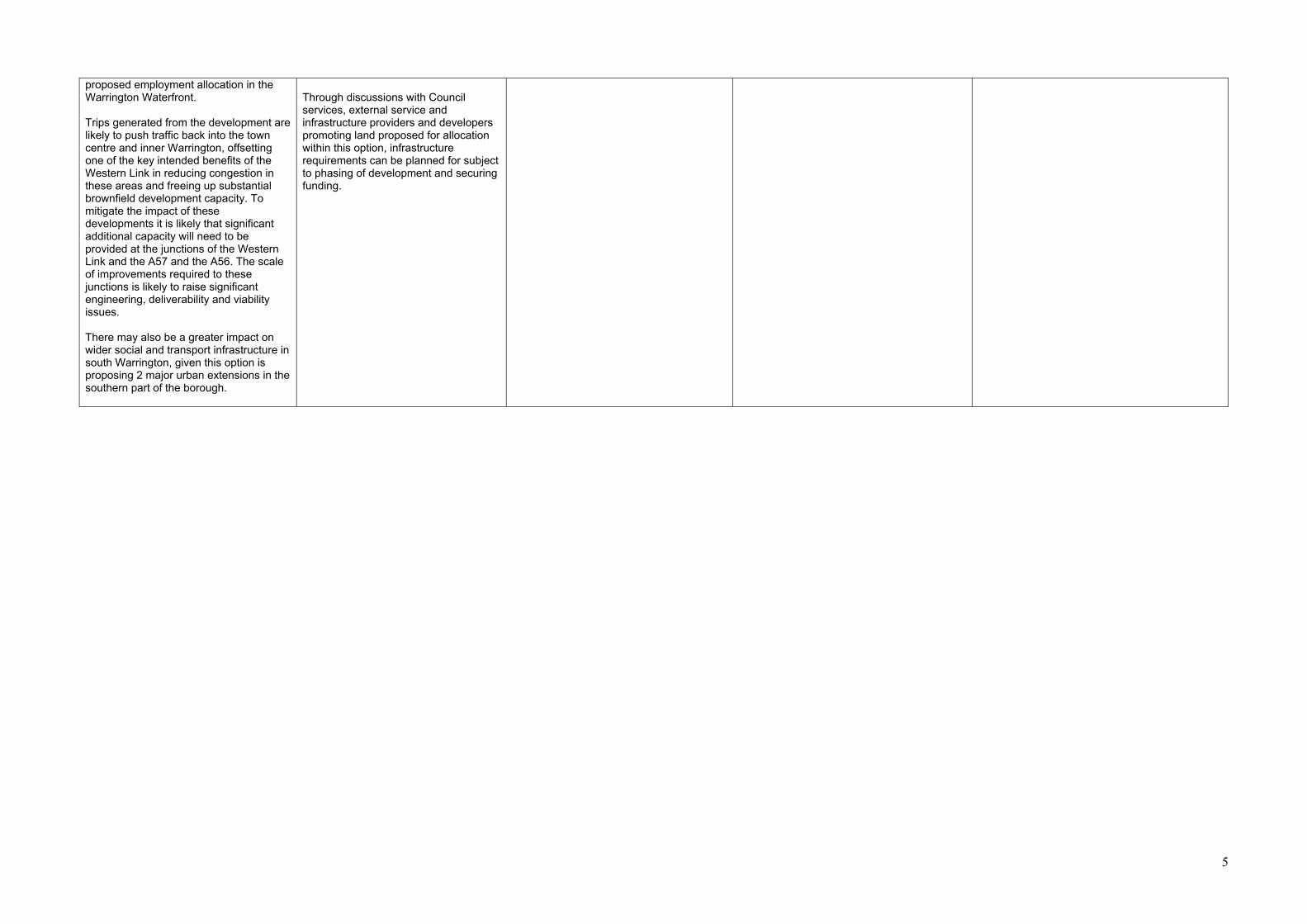
5
proposed employment allocation in the Warrington Waterfront. Trips generated from the development are likely to push traffic back into the town centre and inner Warrington, offsetting one of the key intended benefits of the Western Link in reducing congestion in these areas and freeing up substantial brownfield development capacity. To mitigate the impact of these developments it is likely that significant additional capacity will need to be provided at the junctions of the Western Link and the A57 and the A56. The scale of improvements required to these junctions is likely to raise significant engineering, deliverability and viability issues. There may also be a greater impact on wider social and transport infrastructure in south Warrington, given this option is proposing 2 major urban extensions in the southern part of the borough.
Through discussions with Council services, external service and infrastructure providers and developers promoting land proposed for allocation within this option, infrastructure requirements can be planned for subject to phasing of development and securing funding.

6
Local Plan Objective W5: To secure high quality design which reinforces the character and local distinctiveness of Warrington’s urban area, its countryside, its unique pattern of green spaces and its constituent settlements whilst protecting, enhancing and embracing the borough’s built and natural assets. Option 1 – Urban extension to the south east of Warrington of around 2,400 homes & an urban extension to the south west of around 1,700 homes.
Option 2 - Urban extension to the south east of Warrington of around 2,400 homes & redevelopment of Fiddlers Ferry opportunity site for 1,300 homes.
Option 3 - Urban extension to the south east of Warrington of around 2,400 homes, redevelopment of Fiddlers Ferry opportunity site for 1,300 homes and development at Thelwall Heys of 310 homes.
Option 4 – Urban extension to the south west of around 1,700 homes, redevelopment of Fiddlers Ferry opportunity site for 1,300 homes and development at Thelwall Heys of 310 homes.
Option 5 - Urban extension to the south west of around 1,700 homes, redevelopment of Fiddlers Ferry opportunity site for 1,300 homes
Development of this scale in the South East Urban Extension could have the potential to have significant impact on the character of the area, particularly on the settlements of Stretton, Appleton Thorn and Grappenhall Heys and the Conservation Areas in Grappenhall. Development would need to ensure that these impacts are mitigated wherever possible. Similarly it will need to be demonstrated that development could avoid environmental assets including Local Wildlife Sites, wetland habitat and ancient woodland. Development of the South West Urban Extension will have the potential to have a significant impact on the character of the area. Development will need to avoid impacts on Walton Conservation Area to the south, the character and setting of the Bridgewater Canal and the character of Moore Village in Halton. It will also need to consider the nearby Mersey Estuary SPA. However, the physical extent of both extensions provides scope to: preserve ecological and heritage assets; provide extensive additional open space for recreational and ecological value as part of Warrington’s wider green infrastructure network; and to provide landscape buffers between new development and existing natural / built / heritage assets. Urban extensions of this scale also provide the opportunity to incorporate high design standards from the outset. This option will not however ensure the regeneration of Fiddlers Ferry Power station, which is the largest brownfield site in the Borough.
The impact of the South East Urban Extension component is the same as assessed under Option 1. The Fiddlers Ferry development site provides an opportunity to make use of a brownfield site, along with the release of some Green Belt land, for the creation of a sustainable mixed-use community. Whilst this involves the demolition of a large power station which has been part of the Borough’s industrial heritage for a number of decades, redevelopment of the site provides an opportunity to secure high quality design in this location and to enhance the character of this part of the Borough. The redevelopment proposals also involve preserving several lagoons associated with the function of the power station and which have over time developed ecological and amenity value. There is also the opportunity to provide more substantial additions to the borough’s green infrastructure network and enhancement to the Trans Pennine Trail as a recreational route. Development of the Fiddlers Ferry site will need to have regard to heritage assets in the vicinity of the site, including those in the borough of Halton.
The impact of the South East Urban Extension component is the same as assessed under Option 1. The impact of Fiddlers Ferry is as assessed under Option 2. The incorporation of the Thelwall Heys site into this option allows small scale development which will need to reflect the character and local distinctiveness of this area, in particular the listed building which will be surrounded by the site. There may be opportunities for links between the South East Urban Extension and Thelwall Heys in terms of improvements to green infrastructure corridors.
The impact of the South West Urban Extension component is the same as assessed under Option 1. The impact of Fiddlers Ferry is as assessed under Option 2. Thelwall Heys is assessed in Option 3. The combination of these three sites provides a more dispersed option of development across the Borough offering the ability for each site to reflect the character of its surroundings and build upon local distinctiveness. The more dispersed nature of the larger site allocations in the south west and north western parts of the Borough will however limit opportunities for linked green infrastructure corridors etc.
This option is as per option 4, but the removal of development at Thelwall Heys would mean any issues in terms of heritage and character in that particular location would not arise. The dispersed nature of site allocations in the south west and north western parts of the Borough will limit opportunities for linked green infrastructure corridors etc.

7
Local Plan Objective W6: To minimise the impact of development on the environment through the prudent use of resources and ensuring development is energy efficient, safe and resilient to climate change and makes a positive contribution to improving Warrington’s air quality. Option 1 – Urban extension to the south east of Warrington of around 2,400 homes & an urban extension to the south west of around 1,700 homes.
Option 2 - Urban extension to the south east of Warrington of around 2,400 homes & redevelopment of Fiddlers Ferry opportunity site for 1,300 homes.
Option 3 - Urban extension to the south east of Warrington of around 2,400 homes, redevelopment of Fiddlers Ferry opportunity site for 1,300 homes and development at Thelwall Heys of 310 homes.
Option 4 – Urban extension to the south west of around 1,700 homes, redevelopment of Fiddlers Ferry opportunity site for 1,300 homes and development at Thelwall Heys of 310 homes.
Option 5 - Urban extension to the south west of around 1,700 homes, redevelopment of Fiddlers Ferry opportunity site for 1,300 homes
Development in the South East Urban Extension can be located in areas which are not at risk of flooding. There will be a loss of Grade 2 and 3 Agricultural Land. Development on some sites in the South East Urban Extension may have noise and air quality impacts due to the proximity of M56 motorway but there is sufficient area within the allocation site to mitigate these impacts. Development of the South West Urban Extension will need to avoid the small part of the area which falls within Flood Zone 3 and the COMAH zone. There will be a loss of Grade 2 and 3 Agricultural Land. Development on both sites can be achieved without impacting on the Borough’s minerals resources. Development adjacent to the main urban area would reduce the need to travel and promote public transport and thereby contribute to air quality and climate change reduction objectives. The scale and mix of development provides the opportunity to promote energy efficient development schemes, including decentralised energy networks.
The impact of the South East Urban Extension component is the same as assessed under Option 1. The Fiddlers Ferry site provides the opportunity to re-use brownfield land for employment uses, as part of a wider mixed-use scheme. This reduces the need for Green Belt release elsewhere in the Borough thereby minimising impact on the environment. Development at Fiddlers Ferry can be accommodated whilst avoiding the small parts of the site which fall into Flood Zone 2 and Flood Zone 3. There would be a loss of Agricultural Land with part of the land to be released from the Green Belt for residential development. Development on both sites can be achieved without impacting on the Borough’s minerals resources. Development adjacent / accessible to the main urban area would reduce the need to travel and promote public transport and thereby contribute to air quality and climate change reduction objectives. The scale and mix of development provides the opportunity to promote energy efficient development schemes, including decentralised energy networks.
The impact of the South East Urban Extension component is the same as assessed under Option 1. The impact of the Fiddlers Ferry component is as per Option 2. Development at Thelwall Heys involves land which is not at risk of flooding. There will be a loss of Grade 2 and 3 Agricultural Land. Development here will not impact upon the Borough’s mineral resources. Development adjacent / accessible to the main urban area would reduce the need to travel and promote public transport and thereby contribute to air quality and climate change reduction objectives. The scale and mix of development provides the opportunity on larger allocations to promote energy efficient development schemes, including decentralised energy networks.
The impact of the South West Urban Extension component is the same as assessed under Option 1. The impact of the Fiddlers Ferry component is as per Option 2. Development adjacent / accessible to the main urban area would reduce the need to travel and promote public transport and thereby contribute to air quality and climate change reduction objectives The scale and mix of development provides the opportunity on the larger allocations to promote energy efficient development schemes, including decentralised energy networks.
The impact of the South West Extension component is the same as assessed under Option 1. The impact of the Fiddlers Ferry component is as per Option 2. Development adjacent / accessible to the main urban area would reduce the need to travel and promote public transport and thereby contribute to air quality and climate change reduction objectives. The scale and mix of development provides the opportunity to promote energy efficient development schemes, including decentralised energy networks.

8
Deliverability Conclusions Option 1 – Urban extension to the south east of Warrington of around 2,400 homes & an urban extension to the south west of around 1,700 homes.
Option 2 - Urban extension to the south east of Warrington of around 2,400 homes & redevelopment of Fiddlers Ferry opportunity site for 1,300 homes.
Option 3 - Urban extension to the south east of Warrington of around 2,400 homes, redevelopment of Fiddlers Ferry opportunity site for 1,300 homes and development at Thelwall Heys of 310 homes.
Option 4 – Urban extension to the south west of around 1,700 homes, redevelopment of Fiddlers Ferry opportunity site for 1,300 homes and development at Thelwall Heys of 310 homes.
Option 5 - Urban extension to the south west of around 1,700 homes, redevelopment of Fiddlers Ferry opportunity site for 1,300 homes
There are sufficient suitable, available and deliverable / developable sites for this option. Landowners have demonstrated their commitment to delivering the urban extensions. The urban extensions provide the opportunity to ensure delivery of the social infrastructure and services needed to support new residential communities. Both the South West Urban Extension and the South East Urban Extension are dependent upon significant highway and public transport improvements for delivery. Local Plan viability work provides evidence that development is capable of making a significant contribution towards the cost of new and improved infrastructure. There is a concern that the South West Urban Extension could have a significant impact on the Western Link. Trips generated from the development are likely to push traffic back into the town centre and inner Warrington, offsetting one of the key intended benefits of the Western Link in reducing congestion in these areas and freeing up substantial brownfield development capacity. To mitigate the impact of these developments it is likely that significant additional capacity will need to be provided at the junctions of the Western Link and the A57 and the A56. The scale of improvements required to these junctions is likely to raise significant engineering, deliverability and viability issues. Given the lead in times for infrastructure to support the urban extensions, this option provides only limited opportunity for new homes early in the plan period.
There are sufficient suitable, available and deliverable / developable sites for this option. Landowners have demonstrated their commitment to delivering the allocation sites. The development provide the opportunity to ensure delivery of the social infrastructure and services needed to support new residential communities. The developments will require significant upgrades to the local and strategic highway network and public transport network. Local Plan viability work provides evidence that development is capable of making a significant contribution towards the cost of new infrastructure. The demolition of remediation of Fiddlers Ferry Power station is dependent on the enabling residential development requiring Green Belt release. Given the lead in times for infrastructure to support the developments and the need for demolition and remediation of the Fiddlers Ferry Site, this option provides only limited opportunity for new homes early in the plan period.
The deliverability conclusions for the South East Urban Extension and Fiddlers Ferry are the same as in Option 2. The inclusion of the Thelwall Heys site, being smaller in nature and thereby not being dependent on the delivery of significant new infrastructure, provides an opportunity for early delivery of housing in a sustainable location.
The deliverability conclusions for the South West Urban Extension and Fiddlers Ferry are the same as in Option 1 and 2 respectively. As with Option 3, the inclusion of the Thelwall Heys site, being smaller in nature and thereby not being dependent on the delivery of significant new infrastructure, provides an opportunity for early delivery of housing in a sustainable location.
The deliverability conclusions for the South West Urban Extension and Fiddlers Ferry are the same as in Option 1 and 2 respectively. Local Plan viability work provides evidence that development is capable of making a significant contribution towards the cost of new infrastructure Given the lead in times for infrastructure to support the developments and the need for demolition and remediation of the Fiddlers Ferry Site, this option provides only limited opportunity for new homes early in the plan period. This option includes the least number of homes to be delivered over the plan period and therefore flexibility is limited should there be unforeseen delays or issues on these or any other housing sites across the Borough.
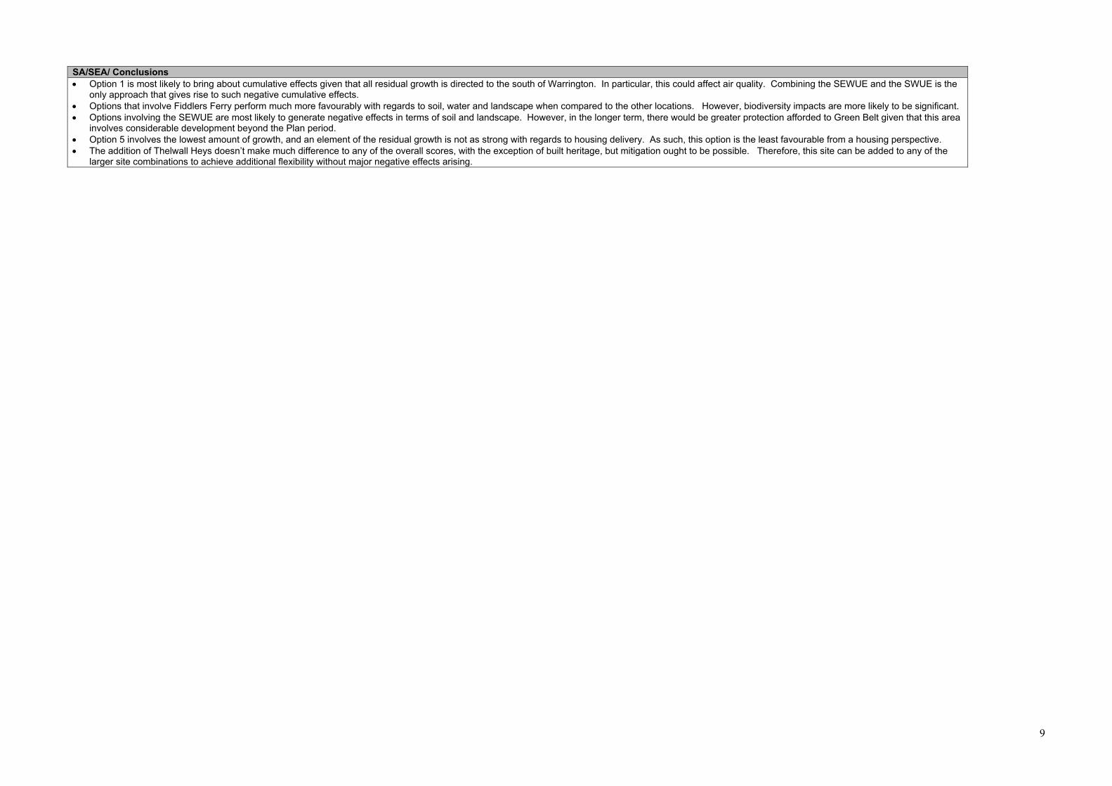
9
SA/SEA/ Conclusions • Option 1 is most likely to bring about cumulative effects given that all residual growth is directed to the south of Warrington. In particular, this could affect air quality. Combining the SEWUE and the SWUE is the
only approach that gives rise to such negative cumulative effects. • Options that involve Fiddlers Ferry perform much more favourably with regards to soil, water and landscape when compared to the other locations. However, biodiversity impacts are more likely to be significant. • Options involving the SEWUE are most likely to generate negative effects in terms of soil and landscape. However, in the longer term, there would be greater protection afforded to Green Belt given that this area
involves considerable development beyond the Plan period. • Option 5 involves the lowest amount of growth, and an element of the residual growth is not as strong with regards to housing delivery. As such, this option is the least favourable from a housing perspective. • The addition of Thelwall Heys doesn’t make much difference to any of the overall scores, with the exception of built heritage, but mitigation ought to be possible. Therefore, this site can be added to any of the
larger site combinations to achieve additional flexibility without major negative effects arising.

10
Overall Conclusions Option 1 – Urban extension to the south east of Warrington of around 2,400 homes & an urban extension to the south west of around 1,700 homes.
Option 2 - Urban extension to the south east of Warrington of around 2,400 homes & redevelopment of Fiddlers Ferry opportunity site for 1,300 homes.
Option 3 - Urban extension to the south east of Warrington of around 2,400 homes, redevelopment of Fiddlers Ferry opportunity site for 1,300 homes and development at Thelwall Heys of 310 homes.
Option 4 – Urban extension to the south west of around 1,700 homes, redevelopment of Fiddlers Ferry opportunity site for 1,300 homes and development at Thelwall Heys of 310 homes.
Option 5 - Urban extension to the south west of around 1,700 homes, redevelopment of Fiddlers Ferry opportunity site for 1,300 homes
Overall this Option performs moderately against the Local Plan objectives. The urban extensions are capable of providing a wide range of social infrastructure and local services to support new and existing residential communities. The South East Urban Extension will help ensure Warrington’s development needs continue to be met well beyond the end of the Plan period and will contribute to the Plan’s 30 year vision. In themselves, the urban extensions can address potential impacts in terms of the built and natural environment although given they are located in relative proximity in south Warrington, this option is most likely to result in cumulative impacts. The urban extensions can each be developed without a significant impact on the strategic function of Warrington’s Green Belt. However, this option will not support the regeneration of Fiddlers Ferry Power station, the largest brownfield site in the Borough, which will increase the pressure to release Green Belt land elsewhere for employment uses. Whilst the urban extensions will be able to make a significant contribution to social and transport infrastructure improvements, there is a concern around the potential impact of the South West Extension on the Western Link. Given the lead in times for infrastructure to support the urban extensions, this option provides only limited opportunity for new homes early in the plan period.
Overall this option performs strongly against the majority of Local Plan objectives. The urban extensions are capable of providing a wide range of social infrastructure and local services to support new and existing residential communities. This option will help ensure Warrington’s development needs continue to be met well beyond the end of the Plan period and will contribute to the Plan’s 30 year vision. Positive impacts on the town centre may be more limited due to the proximity of Fiddlers Ferry to Widnes and some leakage of regeneration benefits to the west into Halton Borough. However this must be balanced against the re-use of a brownfield site and the enabling development associated with it. Green Belt release can be facilitated without comprising the strategic importance of Warrington’s Green Belt as a whole, with revised boundaries likely to be robust and durable beyond the Plan period. Loss of strong Green Belt parcel at Fiddlers Ferry would require mitigation to ensure the revised boundary is robust. Impacts on the character of the surrounding area and any impact on ecological and heritage assets can be mitigated. The developments will be able to make a significant contribution to social and transport infrastructure improvements. Given the lead in times for infrastructure to support the developments and the need for demolition and remediation of the Fiddlers Ferry Site, this option provides only limited opportunity for new homes early in the plan period.
This Option is very similar in performance to Option 2. The inclusion of the Thelwall Heys site, being smaller in nature and thereby not being dependent on the delivery of significant new infrastructure, provides an opportunity for early delivery of housing in a sustainable location.
Overall this Option performs moderately against the Local Plan objectives. As in Option 1 the South West Urban Extension provides benefits in terms of social infrastructure provision but raises issues in respect of its potential impact on the Western Link. As in Option 2 there are major benefits associated with Green Belt release to facilitate the regeneration of Fiddlers Ferry Power station, albeit it, some of these benefits will extend into Halton, However, given the size of the sites under this option, they are unlikely to be able to provide for a new secondary school or leisure hub. There is insufficient capacity within secondary schools in south Warrington to support this option. Similarly, south Warrington has limited existing built leisure provision and this will be exacerbated by this option. This option has a greater impact in terms of loss of strategic Green Belt towards Halton Borough in two separate locations – in the north and south of the Borough. This option only provides limited development potential beyond the plan period and there may be the need for safeguarding of additional sites to ensure the long term permanence of revised Green belt boundaries and to contribute to the Plan’s 30 year vision. The inclusion of the Thelwall Heys site, being smaller in nature and thereby not being dependent on the delivery of significant new infrastructure, provides an opportunity for early delivery of housing in a sustainable location.
This Option is very similar in performance to Option 4. By not including Thelwall Heys however, this this option provides only limited opportunity for new homes early in the plan period.

Appendix 6 - Grade ‘A’ /’B’ Employment Sites - Site Assessment Conclusions
South East Warrington Employment Area Proforma Conclusions
South East Warrington Employment Area (137 ha-Gross) Overall Site Conclusions based on Suitability, Availability, Achievability The overall combined site is graded ‘A+/B+’ in the context of the Council’s updated EDNA (2021) and therefore performs strongly in terms of its contribution to meeting Warrington’s strategic and local employment land needs. The site benefits from its location at the junction of the M6 and M56 and provides the potential to meet a large proportion of the Borough’s identified employment land requirement. There are a number of issues which would need to be mitigated to ensure that the overall site could be considered ‘Suitable’, in particular: • The development of the overall site could not be supported by current highways access arrangements. Development is therefore dependent on infrastructure improvements to the local and strategic road networks. • There is a Scheduled Ancient Monument within the site. Development will need to ensure that the setting of the heritage asset is preserved and enhanced. • Development will result in the loss of Grade 3 and Grade 2 Agricultural Land and a combination of weak, moderate and strongly performing Green Belt parcels. The overall site is available and is being actively promoted by site owners through the Local Plan process. Development of the site is considered achievable given the EDNA ‘A+/B+’ category and the Local Plan viability assessment. Development can only come forward however with infrastructure improvements to the local and strategic highways networks. The site performs strongly against Local Plan Objectives and the proposed Local Plan Spatial Strategy. It benefits from proximity to the South East Warrington Urban Extension and provides the opportunity to ensure a comprehensive approach to the required improvements to road infrastructure and public transport improvements in the wider area. As such, the Council is confident that the issues affecting the suitability of the site can be addressed. SITE CONCLUSION: SELECTED SITE (137 ha-Gross) – subject to ensuring appropriate infrastructure improvements to the local and strategic road networks are delivered.
Fiddlers Ferry Employment Proforma Conclusions
Fiddlers Ferry Employment Area (101 ha-Gross) Overall Site Conclusions based on Suitability, Availability, Achievability The site is a brownfield site and graded A-/B- in the context of the Council’s updated EDNA (2021) and therefore performs strongly in terms of its contribution to meeting Warrington’s strategic and local employment land needs, but there are potentially significant constraints in being able to bring the site forward for development. The site benefits from its location and existing access arrangements off the A562, is in close proximity to junction 7 of the M62 and, provides the potential to meet a significant proportion of the Borough’s identified employment land requirement. There are however a number of significant issues which would need to be mitigated before the site could be considered ‘Suitable’:
• Extensive clearance and remediation of the former Power Station and infrastructure;
• The requirement for enabling housing development on Green Belt land to the east and south of the site, including parcels that are ‘strongly performing’;
• Small north western area of site within HSE COMAH Zone; • The development of the overall site could not be supported by current highways
arrangements. Development is therefore dependent on infrastructure improvements to the local and strategic road networks.
The site is available and is being actively promoted by site owners through the Local Plan process for development. In terms of achievability, the site promoter has provided extensive evidence to demonstrate that the demolition and remediation of the power station is technical achievable and viable, subject to the enabling residential development, and that this would enable the employment site to be developed in full within the Plan Period and provide wider contributions to required transport and social infrastructure. The Council has confirmed the viability of the development through the Local Plan Viability Assessment. The site performs strongly against Local Plan Objectives and the proposed Local Plan Spatial Strategy when considered as an employment site on its own and as part of a wider development opportunity including the enabling residential development. It provides the potential to remediate a major brownfield site and the opportunity to ensure a comprehensive approach is taken to delivering the required improvements to road infrastructure and public transport improvements. As such, the Council is confident that the issues affecting the suitability of the site can be addressed.

Fiddlers Ferry Employment Area (101 ha-Gross) SITE CONCLUSION: SELECTED SITE – subject to ensuring appropriate infrastructure improvements to the local and strategic road networks are delivered.
Port Warrington Employment Proforma Conclusions (Technical Options Report)
Port Warrington (65ha – in additional to existing facility) Overall Site Conclusions based on Suitability, Availability, Achievability The site is graded ‘A-/B-’ in the context of the Council’s updated EDNA (2021) and therefore performs strongly in terms of its contribution to meeting Warrington’s strategic and local employment land needs, but there are potentially significant constraints in being able to bring the site forward for development. The site benefits from a unique location, providing an existing port facility on the Manchester Ship Canal and having the potential to provide a connection to the strategic rail network. The site promoter has provided evidence to demonstrate the specific need for port related development and how the site forms a key component of the wider plans for the Atlantic Gateway. The site is currently identified as CS11-Strategic Opportunity (Port Warrington) in the adopted Warrington Local Plan Core Strategy (2014); identified as a multi modal Port facility utilising the Ship Canal with an opportunity for rail freight (although a rail connection has yet to be made and utilised). There are however a number of significant issues which would need to be mitigated before the site could be considered ‘Suitable’: • Development of the site would result in the loss of part of a Local Wildlife Site. The site promoter has submitted information to demonstrate how mitigation could be provided. • The development of the site could not be supported by current highways access arrangements. Development is therefore dependent on the proposed Western Link, a new access road to connect the site to the Western Link and associated public transport improvements. • The development could however have a significant impact on the Western Link. Trips generated from the development are likely to push traffic back into the town centre and inner Warrington, offsetting one of the key intended benefits of the Western Link in reducing congestion in these areas and freeing up substantial brownfield development capacity. • The site is located with Flood zones 2 & 3. It has been assessed through the Council’s Level 1 and Level 2 Strategic Flood Risk Assessment (SFRA) and will require mitigation measures as part of the development process. • The residential amenity of residents to the south of the Manchester Ship Canal at Promenade Park will need to be protected.

Port Warrington (65ha – in additional to existing facility) Given the issues on suitability the site does not perform well against all the Local Plan’s Objectives and Spatial Strategy. The site is available and is being promoted by the owner through the Local Plan Process. In terms of achievability, viability information has been submitted by the site promoter to demonstrate the viability of the development. There are concerns however about whether the issues to address the suitability of the site can be addressed. In particular, to mitigate the impact on the Western Link it is likely that significant additional capacity will need to be provided at the junctions of the Western Link and the A57 and the A56. The scale of improvements required to these junctions is likely to raise significant engineering, deliverability and viability issues. SITE CONCLUSION: SITE NOT SELECTED – The site is not selected for inclusion in the Local Plan. The Council is committed to undertaking a review into Warrington’s employment land needs before the end of the Plan period to ensure the long term supply of employment land. By this stage, it is likely that key infrastructure improvements, including the Western Link and motorway junction improvements, will have been delivered and the impacts of any further required employment allocations can be fully appraised.
Arpley Meadows Employment Proforma Conclusions
Arpley Meadows, Waterfront (25.47 ha) Overall Site Conclusions based on Suitability, Availability, Achievability The site is graded ‘B-’ in the context of the Council’s updated EDNA (2021) and therefore performs strongly in terms of its contribution to meeting Warrington’s local employment land needs, but there are potentially significant constraints in being able to bring the site forward for development The site is part of the Wider Warrington Waterfront area and is proposed as a ‘Business Hub’ to support Port related activities at Port Warrington. It is also close to Warrington Town Centre and Bank Quay Station and so would be able to fulfil a broader role in meeting Warrington’s business needs. There are however a number of significant issues which would need to be mitigated before the site could be considered ‘Suitable’: • The development of the site could not be supported by current highways access arrangements. Development is therefore dependent on the proposed Western Link, a new access road to connect the site to the Western Link and associated public transport improvements. • The development could however have a significant impact on the Western Link. Trips generated from the development are likely to push traffic back into the town centre and

Arpley Meadows, Waterfront (25.47 ha) inner Warrington, offsetting one of the key intended benefits of the Western Link in reducing congestion in these areas and freeing up substantial brownfield development capacity. • The site is located with Flood zones 2 & 3. It has been assessed through the Council’s Level 1 and Level 2 Strategic Flood Risk Assessment (SFRA) and will require mitigation measures as part of the development process. Given the issues on suitability the site does not perform well against all the Local Plan’s Objectives and Spatial Strategy. The site is available and is being promoted by the owner through the Local Plan Process. In terms of achievability, viability information has been submitted by the site promoter to demonstrate the viability of the development. There are concerns however about whether the issues to address the suitability of the site can be addressed. In particular, to mitigate the impact on the Western Link it is likely that significant additional capacity will need to be provided at the junctions of the Western Link and the A57 and the A56. The scale of improvements required to these junctions is likely to raise significant engineering, deliverability and viability issues. SITE CONCLUSION: SITE NOT SELECTED– The site is not selected for inclusion in the Local Plan. The Council is committed to undertaking a review into Warrington’s employment land needs before the end of the Plan period to ensure the long term supply of employment land. By this stage, it is likely that key infrastructure improvements, including the Western Link and motorway junction improvements, will have been delivered and the impacts of any further required employment allocations can be fully appraised.
656 Phase Two Employment Area Proforma Conclusions
656 Phase Two Employment Area (70 ha Gross) Overall Site Conclusions based on Suitability, Availability, Achievability The site is graded ‘A-’ in the context of the Council’s updated EDNA (2021) and therefore performs strongly in terms of its contribution to meeting Warrington’s strategic employment land needs, but there are potentially significant constraints in being able to bring the site forward for development. The site benefits from its location at the junction of the M6 and M56 and provides the potential to meet a proportion of the Borough’s identified employment land requirement. It would represent an extension to the proposed employment site to the south of Grappenhall Lane. There are however a number of significant issues which would need to be mitigated before the site could be considered ‘Suitable’:

656 Phase Two Employment Area (70 ha Gross)
• The development of the site could not be supported by current highways access arrangements and would require supporting infrastructure to mitigate the impacts on the local and strategic road network.
• concerns around cumulative impact of development in south east Warrington, including impact on the Green Belt and on the local and strategic road network
• Transco pipe line cross the site from east to west, and so reducing the amount of potentially developable land.
• Impact on residential properties on Cartridge Lane • Development will result in the loss of Grade 2 and 3 Agricultural Land and strong
performing Green Belt parcels. The site is available and is being actively promoted through the Local Plan process. Given the issues on suitability the site does not perform well against all the Local Plan’s Objectives and Spatial Strategy. In terms of achievability, there is a concern around the complex ownership across the site. Although the developer appears to have options on a majority of the land, the duration of these options is unknown and they may need to be renegotiated by the time the option is brought forward, particularly if they relate to housing development, as envisaged in the previous PSVLP, not employment. SITE CONCLUSION: SITE NOT SELECTED - The site is not selected for inclusion in the Local Plan. The Council is committed to undertaking a review into Warrington’s employment land needs before the end of the Plan period to ensure the long term supply of employment land. By this stage, it is likely that key infrastructure improvements, including the Western Link and motorway junction improvements, will have been delivered and the impacts of any further required employment allocations can be fully appraised.
Land to the East of M6 and South of Birchwood Proforma Conclusions
Land to the East of M6 and South of Birchwood (47 ha) Overall Site Conclusions based on Suitability, Availability, Achievability The overall combined site is graded ‘A-/B’ in the context of the Council’s updated EDNA (2021) and therefore performs strongly in terms of its contribution to meeting Warrington’s strategic and local employment land needs, but there are potentially significant constraints in being able to bring the site forward for development. The site benefits from its location at the junction of the M6 and provides the potential to meet a proportion of the Borough’s identified employment land requirement.

Land to the East of M6 and South of Birchwood (47 ha) There are however a number of significant issues which would need to be mitigated to before the site could be considered ‘Suitable’:
• The development of the site could not be supported by current highways access arrangements and would require supporting infrastructure to mitigate the impacts on the local and strategic road network.
• Development will result in the loss of Grade 1 and 2 Agricultural Land and strong performing Green Belt parcels.
The site is available and is being promoted by the owner through the Local Plan Process. Given the issues on suitability the site does not perform well against all the Local Plan’s Objectives and Spatial Strategy. In terms of achievability, intervening land ownership will make a comprehensive development difficult, and there are also concerns about the site being of sufficient scale to deliver the required supporting infrastructure improvements to the local and strategic highways networks. SITE CONCLUSION: SITE NOT SELECTED - The site is not selected for inclusion in the Local Plan. The Council is committed to undertaking a review into Warrington’s employment land needs before the end of the Plan period to ensure the long term supply of employment land. By this stage, it is likely that key infrastructure improvements, including the Western Link and motorway junction improvements, will have been delivered and the impacts of any further required employment allocations can be fully appraised.