
Development and Use of UASs by the National Marine ... · included researchers from all six ......
48
Marine Mammal Commission Development and Use of UASs by the National Marine Fisheries Service for Surveying Marine Mammals December 2016 An independent agency of the U.S. Government Prepared by the Marine Mammal Commission with input from the National Marine Fisheries Service
Transcript of Development and Use of UASs by the National Marine ... · included researchers from all six ......

Marine Mammal Commission
Development and Use of UASs by the National Marine Fisheries Service
for Surveying Marine Mammals
December 2016
An independent agency of the U.S. Government
Prepared by the Marine Mammal Commission with input from the National Marine Fisheries Service

Development and Use of UASs for Surveying Marine Mammals i
EXECUTIVE SUMMARY
The National Marine Fisheries Service (NMFS)1 is responsible for gathering the information needed to support the stock assessments of most marine mammal species found in U.S. waters. Data on the distribution, abundance and status of each stock, which are core to those assessments, are traditionally gathered by conducting shipboard, land-based, and/or aerial surveys. However, with level or declining budgets for marine mammal conservation, management and research, the agency is experiencing difficulty in gathering those and other stock-assessment data that are necessary to fulfill its obligations under the Marine Mammal Protection and Endangered Species Acts (MMPA and ESA). Several research teams across NMFS are investigating and making use of unoccupied aircraft systems (UASs)2 to supplement the stock assessment data gathered by traditional means. UASs consist of an unoccupied aerial vehicle (UAV; the aircraft), sensors (primarily cameras), and navigation/control systems. These researchers are discovering that in some situations UASs can collect higher quality data or data that traditional methods cannot obtain, and, as such, have the ability to augment traditional stock assessments and provide key context for interpreting trends.
In October 2014, the Marine Mammal Commission (MMC) and NMFS sponsored a joint workshop to assess the development and use of UASs within NMFS. Workshop participants included researchers from all six NMFS Science Centers (SCs), representatives of NMFS’s Offices of Science & Technology and Protected Resources, experts from the National Oceanic and Atmospheric Administration (NOAA) and other federal agencies, experts from academic institutions, and leaders of UAS or related programs from other federal agencies (Appendix A). The workshop followed a symposium on the use of UASs in conservation science,3 organized by Robyn Angliss of the Alaska Fisheries Science Center (AFSC), at which 20 wildlife biologists shared their experiences with using UASs. This report is based on information gathered at that workshop, augmented with information gathered from UAS researchers since then, especially including at a symposium for UAS users sponsored by NOAA at its Southwest Fisheries Science Center (SWFSC) in October 2016 (NOAA 2016).
Research teams and industry around the world are developing new vehicles, sensors and software, but it is not always clear which configuration is optimal for each research situation. In the last few years, the use of UASs for research has been increasing rapidly, and there have been advancements in the types, cost, and availability of retail, off-the-shelf UASs. So far, 1 Also known as NOAA Fisheries. 2 Historically the ‘U’ in UAV and UAS has stood for ‘unmanned.’ However, in this report, we have chosen to replace
the term ‘unmanned’ with the gender-neutral term ‘unoccupied.’ 3 “Using Unmanned Aerial Systems to Study Wildlife Populations and Their Habitat.” Symposium at the Wildlife
Society Annual Conference, October 25 – 30, 2014, Pittsburgh, PA.

Development and Use of UASs for Surveying Marine Mammals ii
however, NMFS has found that commercial or custom-built UASs are more cost-effective, being both more capable and reliable. Progress on the development of UASs varies among the SCs, and each center is evaluating the best way to move forward in this arena. Some SCs have several years of experience (e.g., Southwest, Alaska) and others have yet to make use of the new technology (e.g., Southeast).
UASs are being used by NMFS to collect still photographs or video used for a variety of purposes. Participants at the 2014 workshop noted that different research objectives required different UAS configurations, which together define ‘Mission Profiles.’ The four Mission Profiles that were identified fell into the following two categories—
1. ‘Individual’ profiles involve obtaining images of particular individuals for various purposes. a. The Health and Condition Mission Profile uses images to document the size, shape
and skin condition of cetaceans and pinnipeds to assess body condition and health. b. The Mark-Recapture Mission Profile uses images to detect known (marked) and
unknown individuals over time to estimate population size and vital rates. 2. ‘Count’ profiles involve systematic surveys that count individuals and estimate
population size. a. The Aggregation Counts Mission Profile uses photographs to count aggregations of
pinnipeds on their rookeries and/or haul-outs. b. The Aerial Line-Transect Mission Profile uses images to survey pinnipeds or
cetaceans along pre-determined tracklines at sea.
The two categories of Mission Profiles are associated with different technology profiles. To date, the Health and Condition, Mark-Recapture and Aggregation Counts Mission Profiles have made use of small, vertical takeoff and landing (VTOL), multi-rotor aircraft). VTOL UASs are flown for short periods (usually less than 30 min) within sight of the operator and below 400 feet, to meet Federal Aviation Administration (FAA) regulations and NOAA requirements,4 and may be operated by researchers certified as Pilots in Command. VTOL UASs typically carry a digital camera that takes high-resolution photographs of individual animals, from which condition and markings can be determined, or groups of pinnipeds on land, from which counts can be obtained. The same camera can transmit analog, standard-definition video back to a ground station, which is used by the operators in real time to direct the vehicle to its target and to time the capture of high-resolution still photographs. Video can also be captured for research purposes, such as for analyzing behavior. Within NMFS, the preferred platform for
4 Specified in a Certificate of Authorization issued to NOAA by the FAA.

Development and Use of UASs for Surveying Marine Mammals iii
these purposes is the custom-made, hexacopter (six-rotor copter) known as the APH-22, which was developed by Aerial Imaging Solutions.
The Aerial Line-Transect Mission Profile makes use of a medium-sized, fixed-wing aircraft. Fixed-wing aircraft typically are technologically capable of flying out of sight of the operator, at higher altitudes, and for much longer periods. Because of these characteristics, aerial vehicles such as these are not permitted to fly within the U.S. national airspace (NAS) without a waiver or Certificate of Authorization from the FAA. So far, the only places where they have been deployed are in very remote locations (Alaska and Northwestern Hawaiian Islands). These planes can carry multiple cameras, including high-resolution still and video, infrared (IR), and motion-compensated cameras. While NMFS is not favoring a single vehicle for the Aerial Line-Transect Profile at this stage, the ScanEagle by Insitu of Boeing, which is being used by several research teams around the world, has seen more use by NMFS than other platforms of similar size.
UASs technology has tremendous potential to augment, enhance, and in some cases replace traditional methods. Improvements in research capabilities and results are already being realized, and advancements in equipment and methods are continuing. Since the 2014 workshop the Southwest Fisheries Science Center, in collaboration with the Woods Hole Oceanographic Institution (WHOI 2015, 2016), has implemented the sampling of whale blows (exhaled breath condensate; EBC) to assess metabolic condition and disease, which previously had been accomplished only once (Acevedo-Whitehouse et al. 2010). The same researchers have begun to use UASs to examine Humpback and North Atlantic right whales for evidence of
Humpback whale off Washington State showing evidence of past entanglement; see white band wound on thorax (Photograph taken from APH-22 hexacopter at >100ft altitdue by J. Durban, H. Fearnbach, SWFSC, in collaboration with L. Barrett-Lennard, Vancouver Aquarium; NMFS Permit # 16163)

Development and Use of UASs for Surveying Marine Mammals iv
entanglement and ship strikes, and a SWFSC team studying killer whales in the Pacific Northwest has demonstrated the potential for using UASs for surveillance of entangled whales and assessing their condition post disentanglement. NMFS is beginning to investigate the use of UASs to estimate the number of animals seen in groups along transect lines being surveyed by ship.
Nonetheless, challenges to the efficient and cost-effective use of UASs remain. VTOL UASs have proven to be superior platforms compared to occupied fixed-wing or rotary-wing aircraft for many purposes—
• The APH-22 hexacopter has been demonstrated to be affordable, highly capable, and extremely reliable. NMFS is investigating the acquisition/development of one or two other VTOL UASs to complement the capabilities of the APH-22. One would be an inexpensive (potentially expendable), small, salt-water resistant VTOL UAS that could be used by entanglement and other emergency response teams.
• Small fixed-wing (or VTOL) UASs have the potential to provide an excellent platform for habitat mapping (e.g., pinniped rookery habitat), and the AFSC has extensively trialed a mid-sized, fixed-wing UAS, the ScanEagle, in the Arctic as an alternative or complement to occupied aircraft used to survey marine mammals over the open ocean. However, because of the cost of transporting the platform, its ground station and crew to remote locations, and the fact that the UAS surveys a much smaller area per hour of flight, they are finding occupied aircraft to be a more cost-effective sampling platform at this time.
• NMFS is working to find the right balance between an efficient, centralized system for the acquisition, maintenance, training and operation of UASs, and a highly adaptable, project- specific approach that largely distributes these functions to the science centers. At this time, UASs that cost more than $200,000 are being acquired, maintained and operated by NOAA’s Office of Marine and Aviation Operations (OMAO), and small types are being acquired, maintained and operated by the SCs, with the support of OMAO.
• With a new technology to harness, NMFS researchers have been understandably focused mostly on ensuring that platform and sensor capabilities, training, and UAS operations meet their research requirements. However, some of the researchers most experienced with photogrammetry5 and UASs have noted that most UASs are just flying cameras, and have suggested that researchers should be putting even more effort into gaining in-depth knowledge of photography or photogrammetry.
• Most researchers using UASs to capture images of marine mammals for later analysis highlight the urgent need for sophisticated image-analysis software. UASs can capture
5 Photogrammetry is the science of making measurements from photographs.

Development and Use of UASs for Surveying Marine Mammals v
large numbers of photographs that have to be scanned for images of marine mammals, after which the images have to be identified and analyzed, a process that can be more time consuming and expensive than collecting the images. Software that could automatically find, identify and measure images of marine mammals would contribute significantly to the capability and cost-effectiveness of UASs for surveying marine mammals.
• To minimize the disturbance caused by occupied aircraft, they are flown relatively high, which compromises the resolution and quality of the imagery that they can capture. Because UASs, VTOLs especially, are so much quieter, they can be flown much lower and hence capture higher quality images. To date, there is little evidence that they disturb large whales, but they can cause extreme reactions by pinnipeds on land if flown too low; however, little or no reaction has been observed at the altitudes flown for most research missions. Researchers using UASs are beginning to assess the altitudes at, and conditions under, which UASs can be operated without causing disturbance, which will be important to gaining support for the use of UASs.
Cover Photo:
Photogrammetry image of a North Atlantic right whale in Cape Cod Bay, taken from an APH-22 hexacopter at an altitude >100ft (J. Durban, H. Fearnbach, SWFSC, in collaboration with M. Moore, Woods Hole Oceanographic Institution; NMFS Permit # 17355).
Recommended citation:
Marine Mammal Commission. 2016. Development and Use of UASs by the National Marine Fisheries Service for Surveying Marine Mammals. Marine Mammal Commission, Bethesda, MD.
Report written, with input from K. Sweeney and E. Moreland (AFSC), by:
Dennis Heinemann, Director of Science, Marine Mammal Commission
Disclaimer Any mention of, or reference to, trade names or commercial products does not constitute
endorsement by the Marine Mammal Commission or the National Marine Fisheries Service.

Development and Use of UASs for Surveying Marine Mammals vi
TABLE OF CONTENTS Executive Summary .......................................................................................................................... i Introduction and Background ......................................................................................................... 1
Science Center UAS Profiles ............................................................................................................ 3
Northeast ..................................................................................................................................... 4
Southeast ..................................................................................................................................... 4
Southwest .................................................................................................................................... 5
Northwest .................................................................................................................................... 6
Alaska .......................................................................................................................................... 6
Pacific Islands .............................................................................................................................. 7
Research Mission Profiles ............................................................................................................... 7
Imagery of Individuals ................................................................................................................. 7
Health and Condition Mission Profile...................................................................................... 7
Marked Individuals Mission Profile ....................................................................................... 10
Other Research Uses ............................................................................................................. 11
Counts of Individuals ................................................................................................................. 13
Aggregation Counts Mission Profile ...................................................................................... 13
Aerial Line-Transect Mission Profile ...................................................................................... 14
Technology Profiles ....................................................................................................................... 15
Platforms ................................................................................................................................... 15
Vertical Takeoff and Landing Aircraft .................................................................................... 16
Small/Medium Fixed-winged UAVs ....................................................................................... 19
Sensors (cameras) ..................................................................................................................... 21
Key Issues ...................................................................................................................................... 24
Cost, Capability and Reliability .................................................................................................. 24
Operations ................................................................................................................................. 26
Training and Data Processing .................................................................................................... 27
Disturbance ............................................................................................................................... 28
Acknowledgements ....................................................................................................................... 29
Acronyms ...................................................................................................................................... 30
References .................................................................................................................................... 31
Appendix A – 2014 Workshop Participants .................................................................................. 37
Appendix B – UAS Projects by Science Center .............................................................................. 38

Development and Use of UASs for Surveying Marine Mammals 1
INTRODUCTION AND BACKGROUND
NMFS is responsible for gathering the information needed to support the stock assessments of most marine mammal species. Data on the distribution, abundance or status of each stock, which are core to those assessments, are traditionally gathered by conducting shipboard and/or aerial surveys. Population estimates can be derived from counts of animals at rookeries, or from transect or mark-recapture data.6 However, with level or declining appropriations for marine mammal conservation, management and research, the agency is experiencing difficulty in gathering those and other stock assessment data that are necessary to fulfill its obligations under the Marine Mammal Protection and Endangered Species Acts.
Several research teams across NMFS have been investigating and making use of advanced survey techniques to fill this gap or to supplement traditional survey data. One very promising technology is the use of aerial drones – UAVs/UASs.7 UAVs can be fixed-wing aircraft that are capable of operating autonomously over long distances away from the operator, or remote-controlled, fixed- or rotary-wing (i.e., multirotor VTOL) aircraft that operate within the operator’s line of sight. Typically, VTOL UAVs have four, six or eight rotors, and are called quad, hexa, or octo-copters, respectively. Besides offering the promise of obtaining data needed for stock assessments, these systems provide other benefits, compared to occupied aircraft, that make them additionally attractive to researchers, such as the fact that in some circumstances UASs can—
1) Go where occupied survey aircraft cannot (Koski et al. 2009); 2) Operate with greater flexibility (e.g., on short notice, or below cloud decks that ground
occupied aircraft); 3) Collect data that occupied aircraft cannot collect (Durban et al. 2015, 2016); 4) Collect photographs of higher resolution and quality (Koski et al. 2010, 2015); 5) Associate image data with more precise location data;
6 The mark-recapture method involves the repeated ‘detection’ of individuals. In the first ‘detection,’ individuals
are ‘captured’ and ‘marked.’ ‘Capture’ can be the physical capture of the individual or the taking of a photograph of the individual. ‘Marking’ can be the physical marking of the individual (e.g., tagging or branding) or the identification, in the photograph, of unique, ‘naturally’ occurring marks on the individual. Subsequent, random ‘(re)captures’ (physically or in photographs) of individuals, some of whom will have been previously ‘captured’ and others not, are used to estimate population vital rates and size. Although, what occurs with the use of UASs is ‘mark-resight’ or ‘sight-resight,’ we will refer to the process with the widely used label for the method – mark-recapture.
7 An unoccupied aircraft system is composed of an unoccupied aerial vehicle (UAV); its flight control, navigation and communications equipment; its sensor and data storage package; the ground station control and communications equipment; and the team that flies the UAV and operates the sensor package.

Development and Use of UASs for Surveying Marine Mammals 2
6) Create much less disturbance of the target animals (e.g., Patenaude et al. 2002, Koski et al 2015, Sweeney et al. 2015);
7) Be acquired and deployed, in some cases, for a fraction of what occupied aerial and oceanic aircraft cost (Hodgson et al. 2013, Christie et al. 2016; however, see Angliss et al. 2016);
8) Be operated with a much smaller environmental/energy footprint (Koski et al. 2015); 9) Greatly reduce the risk of injury or death to field researchers conducting survey work
(Sasse 2003, Wiegmann and Taneja 2003, Koski et al. 2010, Koh and Wich 2012, Ogden 2013); and
10) Be operated in some cases by trained biologists.
UAVs that are large enough to carry cameras and other sensors used to gather data on marine mammals, but small enough not to disturb them, are becoming popular research tools. NMFS researchers are increasing their use of UASs to count pinnipeds on beaches and ice, survey cetaceans at sea, collect mark-recapture observations, assess the condition and health of individual cetaceans and pinnipeds, and map pinniped habitats. This wave of technological development and implementation of new survey techniques is part of a much larger push to develop and make use of UASs by wildlife biologists in several fields (e.g., Chabot and Bird 2015, Linchant et al. 2015, Christie et al. 2016, Hodgson et al. 2016).
Because developments in this new and burgeoning area are moving fast, MMC and NMFS convened a workshop on the topic in 2014. Research teams and industry around the world are developing new vehicles, sensors and software, but it is not clear for each research situation which approach is optimal. Progress on the development and use of UASs varies among the SCs. Some have a few years of experience (e.g., Alaska and the Southwest) but others have yet to make use of the new technology (e.g., the Southeast). The workshop addressed the breadth and depth of UAS development and use across the SCs in the context of developments and uses in ecology and environmental science (see the “Science Center UAS Profiles” section below and Appendix B). Workshop participants included researchers from all six SCs, representatives of NMFS’s Offices of Science & Technology and Protected Resources, experts from NOAA and other federal agencies, experts from academic institutions, and leaders of UAS or related programs from other federal agencies (Appendix A).
Hand-catching APH-22 hexacopter on small boat (J. Durban, H. Fearnbach, SWFSC)

Development and Use of UASs for Surveying Marine Mammals 3
The goal of the workshop was to build a synoptic view of the development and use of UASs within NMFS. Information on planned, developing and implemented projects was gathered from each of the NMFS science centers prior to the workshop. That information was assessed during the workshop with respect to NMFS’s research mission profiles, technology profiles, performance of the technology, rules governing UAS operations, and the potential of the technology to meet the needs of other or novel, research mission profiles. The workshop focused first on the following four Mission Profiles—
1) Assessment of the condition and health of individual animals; 2) Collection of mark-recapture data; 3) Surveying dense aggregations of animals at known locations; and 4) Line-/strip-transect surveys of dispersed animals over broad areas.
Second, the workshop focused on ‘technology profiles’ – the aircraft, sensor and control systems that make up UASs. The UAVs in use by NMFS fall into two types: small, multi-rotor VTOLs (microcopters) and small- to medium-sized fixed-wing aircraft. For each platform, several technological/operational elements were considered, such as—
1) Mission sensor packages (e.g., still, IR, multispectral and video cameras); 2) Control modules (e.g., accelerometers, GPS, autopilots); 3) Operational environment (e.g., line of sight or not, altitude, within or outside National
Airspace, launched from land or vessel); and 4) Data-stream handling (e.g., recording, storing, transmitting, processing, and archiving
data).
In October 2016, NOAA convened a symposium of NOAA UAS users to share experiences and identify areas for further development (NOAA 2016). This report provides an overview of the topics covered by the 2014 workshop and the opinions of its participants, supplemented with information from the published literature and the 2016 UAS Users Symposium. This report has been reviewed by several of the 2014 workshop participants, most of whom also attended the 2016 symposium, but primarily represents the assessment of the Marine Mammal Commission.
SCIENCE CENTER UAS PROFILES
Research teams and industry around the world are testing and developing new vehicles, sensors and software, but, for each research situation, it is not clear which approach best matches NMFS needs. Progress on the selection and development of UASs varies among the SCs. The SWFSC has been using UASs for several years in Antarctica and now in the U.S., and is expanding their use to several other research areas. The AFSC used a fixed-wing for the first

Development and Use of UASs for Surveying Marine Mammals 4
time in 2009, and a VTOL UAS for the first time in 2014. The Pacific Islands Fisheries Science Center (PIFSC) used UASs for the first time in fiscal year 2014. The Northeast Fisheries Science Center (NEFSC) used UASs for the first time in fiscal year 2015. At the time of the workshop, the remaining two SCs were still at the planning stage. In every case, however, the use of UASs is likely to increase rapidly in the next few years.
Northeast At the time of the 2014 workshop, the NEFSC Protected Species Branch (PSB) was in the early stages of integrating UAS platforms within its marine mammal research programs. The PSB staff is now collaborating with scientists from WHOI and the SWFSC on a project to collect imagery for photogrammetric measurements of North Atlantic right whales, particularly female-calf pairs. This imagery will be compared with imagery from congeneric southern right whales, to inform understanding of why the North Atlantic right whale’s calving rate is currently so low. EBC samples to assess microbiome status of baleen whales are also being collected as part of this project, and as a wider program in collaboration with WHOI. The right whale work is supported by the PSB's internal funding and a grant to WHOI from the NOAA-supported Cooperative Institute for the Northeast Region. The PSB expects that UASs will provide an aerial survey tool superior to existing, occupied, fixed-wing aerial platforms by achieving much finer-scale photometric sampling without eliciting behavioral responses from animals. The NEFSC is using UASs in its pinniped research projects – monitoring gray seal pupping colonies, assisting in molt-staging counts, evaluating harbor and gray seal mixing proportions at major southern New England haul-out sites, and estimating fishing-gear entanglement rates. PSB staff members are also collaborating on a NEFSC project using a hexacopter in a small-scale survey of menhaden and juvenile Atlantic bluefin tuna (Jech et al. 2016).
Southeast The Southeast Fisheries Science Center (SEFSC) does not have an operational UAS program. The SEFSC anticipates using UASs in a diverse suite of projects where it expects that UASs will provide additional sampling capability for research projects beyond what is provided by traditional vessel or occupied-aircraft systems. The center expects to use small hexacopters to enhance data collection during large-vessel marine mammal surveys. The primary data collection under this effort is to include: 1) using overhead imagery to verify species identification and improve assessment of group size, 2) conducting close approaches to large whale species to collect photogrammetric data and biological samples, and using a UAS as a ‘forward platform’ to estimate detection probabilities on the trackline. A key consideration is the capability for rapid deployment and recovery during operations and piloting by trained science staff. It is anticipated that these research and development efforts will be relatively inexpensive. The factors potentially limiting the development are 1) the ready availability of

Development and Use of UASs for Surveying Marine Mammals 5
platforms with appropriate capabilities, 2) restrictions on the operations of UAS systems in controlled or special use airspace, and 3) resources to conduct a well-designed research and development program.
Southwest The SWFSC has concluded that the development of UAS capacity is important because in many environments occupied platforms are either unavailable, too expensive, or create risks to scientists and study animals that it had judged to be unacceptable in the long term. Consequently, the SWFSC’s UAS program has been striving to develop or find a small, affordable, reliable UAS system that can be safely operated by scientists in the field and that will provide high-resolution photographs for monitoring the abundance and condition of marine mammal populations. The SWFSC selected small, multi-motor, battery-powered VTOLs for its UAS program because their flight characteristics and flexibility make them suitable for a wide range of projects, and because they can collect photographs that are free of the blur associated with the forward motion of fixed-wing aircraft. In 2014, the SWFSC UAS program had four hexacopters and five trained pilots; the program now has 13 APH-22 hexacopters. The Science Center has active, collaborative UAS relationships with the AFSC, Vancouver Aquarium (e.g., Durban et al. 2015), and Woods Hole Oceanographic Institution (e.g., Durban et al. 2016). Because of limitations associated with operating UASs within the NAS, the SWFSC’s UAS program was initially focused on work in Antarctica (penguins and leopard seals; e.g. Goebel et al. 2015), Canadian Air Space (killer whales; NMFS 2014; Durban et al. 2015), the Bahamas (beaked whales), Chile (blue whales; Durban et al. 2016), and New Zealand (sperm whales). In addition, since the workshop, SWFSC researchers have flown hexacopters extensively in the NAS under a NOAA Certificate of Authorization from the FAA. In total, the UAS Program at the SWFSC has flown over 1,000 whale photogrammetry missions with the APH-22 since 2014. There were 190 flights to study the growth and condition of gray whale cow-calf units as they migrate
Photogrammetry image of Northern Resident killer whales taken off Vancouver Island from an APH-22 hexacopter at >100ft altitude (J. Durban, H. Fearnbach, SWFSC; in collaboration with L. Barrett-Lennard, Vancouver Aquarium; DFO License #2015_18)
Development and Use of UASs for Surveying Marine Mammals 6
northwards off the coast of California (NMFS 2105a), 170 to monitor the condition and health of Southern Resident killer whales off Washington state (NMFS 2015b), and 125 to collect both photogrammetric data and EBC samples to assess the health of humpback and right whales off Massachusetts (WHOI 2015). The SWFSC UAS program is also developing the capability to use hexacopters to augment the data collected by ship-based surveys (e.g., estimating group size), and possibly to tag species that are not tolerant of the close boat approaches that are necessary for tagging by conventional means.
Northwest The Northwest Fisheries Science Center (NWFSC) has been planning to use UASs to mitigate the effects of close approaches to endangered Southern Resident killer whales when collecting data such as photographs and EBC samples, which are used to better inform individual health assessments. UASs are expected to be used to collect data that are complementary to health-assessment data obtained from biopsies (contaminants) and fecal samples (disease vectors, and hormone analysis). The NWFSC has been consulting with the SWFSC on the development of EBC sampling of Southern Resident killer whales, and, since the workshop, has developed a project focused on assessing the restoration of juvenile salmon habitat.
Alaska The AFSC is interested in using UASs to supplement marine mammal research, especially for use in remote areas that are challenging to access using occupied aircraft. The AFSC first tested the ability of UASs to meet research needs in 2009 by using a fixed-wing UAS to acquire aerial imagery of Bering Sea ice-associated seals. In 2012, the AFSC investigated the ability of UASs to collect data on Steller sea lions, and based on that trial conducted its first survey of western Steller sea lion rookeries two years later in the western Aleutian Islands using an AFSC-owned VTOL UAS piloted by AFSC scientists. This UAS survey of selected rookeries supplemented traditional occupied aerial survey methods, and the paired combined approach resulted in the most complete survey of Steller sea lions since the 1970s. In 2015, the AFSC conducted a field experiment in the Arctic to assess the ability of small fixed-wing UAS to conduct strip-transect surveys for cetaceans. The data collected by that UAS is to be analyzed and compared to analogous values obtained using data collected with traditional occupied aerial survey methods, which will allow the AFSC to make recommendations on the use of UASs for certain cetacean study objectives. Funds for UAS projects have largely been provided by NOAA, other agencies such as the Bureau of Ocean Energy Management and the Office of Naval Research (ONR), and through research collaborations. At the time of this report, the AFSC owned two VTOL UASs that were routinely operated by AFSC staff to sight branded Steller sea lions, and to collect data on pinniped abundance, morphometrics, and rookery space use.

Development and Use of UASs for Surveying Marine Mammals 7
Pacific Islands The PIFSC’s Cetacean Research Program has tested two UAS platforms (APH-22 and Puma) for research. Questions had arisen about image quality, flight restrictions, and other hurdles that could prevent or limit exploration. The PIFSC expects that UASs will have great utility to supplement the population assessment/monitoring and habitat assessment of Hawaiian monk seals when used outside the regular field season. UASs are also expected to be a particularly useful tool to assist in surveying difficult to reach coastlines or for emergency response activities. In 2015, in collaboration with the SWFSC and AFSC, the PIFSC used the APH-22 at several locations in the Northwestern Hawaiian Islands to assess disturbance and to map monk seal habitat (Sweeney et al. 2016b).
RESEARCH MISSION PROFILES
UASs are being used by NMFS to collect a variety of data types. Each data type requires a combination of specific equipment and approaches, which are referred to herein as Mission Profiles. The workshop considered the following four Mission Profiles of two types: those focused on imagery of individuals and those focused on counts of animals from images.
Imagery of Individuals The Health-and-Condition and Mark-Recapture Mission Profiles use UASs to capture high-resolution images of individual animals. Those images can be used to assess the condition of those individuals, from which their health state can be inferred. In many cases, those animals can be uniquely identified, which gives researchers the ability to use the data in mark-recapture analyses, or to track the condition and health of known individuals over time.
Health and Condition Mission Profile
Marine mammals are exposed to a range of anthropogenic and natural stressors (e.g., pollutants, toxins, disturbance, entanglement, climate change, shifts in prey abundance) that can affect the condition and health of individuals. Because the methods and resources necessary to regularly assess the status of marine mammal populations are often unavailable, assessing the condition and health of individuals provides critical information that can be used to detect problems that have the potential for population-level consequences (Hunt et al. 2013). In addition, condition and health data can provide important contextual information to stock assessments, even when survey data are available. These data can provide insights into the reasons for status changes and the impacts of sub-lethal anthropogenic stressors. Finally, condition and health data can foretell status changes that would not be detected through population surveys for years. Examples of NMFS’s projects in this area include—

Development and Use of UASs for Surveying Marine Mammals 8
● Sightings of gray and harbor seals identified by natural markings used to assess entanglement rates and body condition (NEFSC);
● Assessment of sperm whale body condition in New Zealand (SWFSC);
● Assessment of the condition of Antarctic predators, Northern and Southern Resident killer whales, eastern North Pacific gray whales, and beaked whales associated with Navy sonar operations areas in the Bahamas (SWFSC);
● Assessment of the health of large whales, notably North Atlantic right and humpback whales, through the use of images and photogrammetric data to assess condition, and EBC sampling to detect respiratory pathogens (SWFSC, in collaboration with the NEFSC and the Woods Hole Oceanographic Institution);
● Using Steller sea lion morphometrics to assess population demographics (AFSC); and
● Monk seal health assessment (PIFSC).
For decades, researchers have used the analysis of tissue samples to assess the health of individual marine mammals (e.g., Lockyer et al. 1985) and to infer population-level impacts of pollutants, toxins and diseases from statistical samples of such data. The collection of such data is time consuming, expensive and can be dangerous. In the 1990s, researchers began to use photogrammetric analysis of images obtained from ships and aircraft to assess the condition of animals (e.g., Perryman and Lynn 2002, Pettis et al. 2004, Bradford et al. 2012, Miller et al. 2012, Schick et al. 2014, Sweeney et al. 2015). High-resolution photographs have enabled researchers to record the dimensions and shape profiles of animals, and to assess their skin and body condition (e.g., emaciated, pregnant, injured), from which they have been able to infer their nutritional and reproductive state (Hunt et al. 2013, NMFS 2014, NMFS 2015b, Durban et al. 2016). Pinniped researchers are also using measurements taken from high-resolution images captured by VTOL UASs to estimate body mass more efficiently and without loss of accuracy (Goebel et al 2015, Krause et al. 2016). In addition, if the same individuals are photographed over a series of years, then growth rates and trends in
Nothern Resident killer whale with likely boat-strike injury; taken off Vancouver Island from an APH-22 hexacopter at >100ft altitude (J. Durban, H. Fearnbach, SWFSC; in collaboration with L. Barrett-Lennard, Vancouver Aquarium; DFO License #2015_18)

Development and Use of UASs for Surveying Marine Mammals 9
condition can be estimated (e.g., Pitman et al. 2007, Fearnbach et al. 2011; Bradford et al. 2012).
As with the collection of tissue samples, obtaining photographs from ships and aircraft can be expensive, impractical in remote locations, and dangerous (Sasse 2003). Researchers have been injured or killed operating in small vessels and aircraft, and getting close enough to some marine mammals (e.g., leopard seals) can be hazardous for researchers and their subjects. The recent availability of UASs has enabled researchers to obtain vertical or oblique photographs of marine mammals at sea or on land, often at lower cost and much less risk. Because VTOL UAVs (e.g., quad- and hexa-copters) can hover and are relatively quiet, photographs can be taken at close range without disturbing the animals or altering their behavior (Goebel et al. 2015; Durban et al. 2016). However, Pomeroy et al. 2015 found that reaction depended on the vertical and lateral distances to the VTOL UAV and that in some cases gray and harbour seals reacted strongly to a VTOL UAV. Because VTOL UAVs can often operate at close range, and because they provide a stationary platform, the photographs can be of much higher quality (higher resolution – 1.0-1.5 cm-per-pixel – and no pixel blurring due to motion; Durban et al. 2015, 2016). The recent addition of powered gimbals that hold the camera has provided even greater stability, especially in windy condition. VTOL UASs offer the ability to collect data that could not be collected before for logistical or technical reasons. Researchers are finding that they can detect subtle marks indicating past entanglement or slight contact with a boat’s propeller, which previously had been difficult to detect (Fearnbach et al. 2016). Because of the quality of the images, they can assess and track the stage and degree of healing. In addition, they are finding that they can see fine-scale or hidden features (e.g., missing baleen, or whale lice around the blowholes).
Photogrammetry image of leopard seal in Antarctica (D. Krause, SWFSC)

Development and Use of UASs for Surveying Marine Mammals 10
Marked Individuals Mission Profile
The ability to identify individuals greatly increases the value of sightings of marine mammals and the data collected from them (e.g., imagery, scat or tissue samples). Individuals may be marked with tags, brands, shearing, or bleaching by researchers or may have ‘naturally’ occurring marks (e.g., pigmentation patterns or scars). In the near future, animals may be tagged with ‘smart tags’ that use radio-frequency identification. Data from multiple sightings of
marked/tagged individuals over time provides information that can be used to estimate population size and vital rates (mark-recapture methodology), or to assess changes in body condition. Examples of NMFS projects in this area include—
● Sightings of branded Steller sea lions and California sea lions and of tagged northern fur seals used to parameterize vital rates models and to identify trends in condition (AFSC);
● Northern fur seal pups marked and resighted to estimate pup production at St. Paul and St. George Island (AFSC);
● Sightings of gray and harbor seals identified by natural markings used to assess entanglement rates and body condition (NEFSC);
● Tag and brand reading of sea lions and fur seals in the California Channel Islands used as part of a mark-recapture study (SWFSC);
● Steller sea lion sightings used to generate data used in mark-recapture analyses (AFSC); ● Natural markings, bleach marks or tags on Hawaiian monk seals used to identify
individuals and assess their condition and population trends over time (PIFSC); and ● Markings used to identify individual killer whales to monitor changes in condition
(SWFSC; Durban et al. 2015; NMFS 2015b).
Traditionally, these kinds of data have been collected from shore, ships or occupied aircraft, modes that all have important drawbacks primarily related to getting close enough to the animals to make reliable sightings or to obtain high-resolution images. Often the time and platform costs are prohibitive, and the disturbance of the animals can be an important concern to their wellbeing, as well as to the reliability of the data collected.
Branded Steller sea lions; NMFS ESA/MMPA Permit #18528 (NOAA Fisheries)

Development and Use of UASs for Surveying Marine Mammals 11
The sighting or photographing of individuals from land has been limited to a few species (e.g., pinnipeds with accessible rookeries or haul-outs). The use of occupied aircraft to identify individual marine mammals has rarely been used, with the exception of aerial surveys of large whales (e.g., Southern right whales, Best 1990, Groch et al. 2005; North Atlantic right whales, Kenney et al. 1995, Kraus et al. 2001; bowhead whales, Schweder et al. 2010; killer whales, Fearnbach et al. 2011). UASs have the potential to obtain identification photographs or video at much higher resolution than was previously possible, with less disturbance, less risk, and often at lower cost (Durban et al. 2015, Christie et al. 2016). Researchers have found that aerial photographs suitable for mark-recapture studies should have a resolution of 1.0 cm-per-pixel or better, which is obtainable from small VTOL UASs hovering at low altitude. The flight characteristics of such VTOLs and the capabilities of readily available, relatively inexpensive cameras result in extremely sharp (little pixel blur), high-resolution photos, beyond what can be obtained from occupied platforms (NMFS 2015a). The experience of most researchers using small VTOL UASs has been that the target individuals show little or no response to the UASs at distances that are sufficient for obtaining images of the required resolution (Smith et al. 2016).
Other Research Uses
In recent years several research groups have conducted feasibility studies to determine if a non-invasive sampling technique – collecting fluid containing hormones, DNA and contaminants in cetacean EBC – can be used to assess the health of individual cetaceans (e.g., Hogg et al. 2009, Frère et al. 2010, Schroeder et al. 2010, Cumeras et al. 2014). In 2005, Karina Acevedo-Whitehouse and colleagues successfully used an off-the-shelf VTOL (Raptor 30 V2 by Thunder Tiger Group) to collect EBC samples from whales in the Gulf of California (Acevedo-Whitehouse et al. 2010). At least two other groups are developing or modifying small VTOLs for this purpose. The Olin College of Engineering and Ocean Alliance have been developing a multirotor VTOL UAV, the SnotBot developed by the Ocean Alliance and Olin College of Engineering (Bennett et al. 2015). In addition, scientists from the SWFSC, WHOI and New England Aquarium collaborated in 2015 and 2016 to collect EBC samples from humpback and North Atlantic right whales in Cape Cod Bay (WHOI 2015).
APH-22 hexacopter maneuvering to collect an EBC sample from a humpback whale off Cape Cod. (J. Durban, H. Fearnbach, SWFSC; in collaboration with M. Moore, Woods Hole Oceanographic Institution; NMFS Permit # 17355).

Development and Use of UASs for Surveying Marine Mammals 12
The team is analyzing the EBC samples for their microbiome constituents (viruses, bacteria and fungi) to look for correlates with the condition of the whales.
Ship-based sightings of marine mammals during transect-based surveys can be compromised when animals cannot be identified to species because of distance or conditions, and when the number of animals seen together (group size) cannot be accurately estimated from the ship. Estimating group size is a notoriously difficult problem that can lead to substantial uncertainty in abundance estimates (e.g., Barlow 1995, Barlow and Taylor 2005, Barlow 2015). Further, some marine mammals are known to avoid ships, while others are attracted to ships (e.g., Barlow et al., 2006; Würsig et al. 1998), movements that can introduce bias into line-transect density estimates. Small UAVs have the potential to be launched at short notice from survey vessels to determine species identification, estimate group size or observe the movements of individual animals relative to the ship, and then retrieved without the survey ship stopping. The SWFSC and PIFSC are collaborating to test VTOL UASs launched from transect vessels for these purposes.
In 2014, a team of researchers from the SWFSC and Vancouver Aquarium, using the APH-22 to study the condition of Resident killer whales, were alerted by fishermen to the presence of a killer whale entangled in their gill net. The researchers were opportunistically able to demonstrate that a VTOL UAS could be used for entanglement response, and to assess its condition following disentanglement (Fearnbach et al. 2016). Multiple NMFS research teams have described the use of UASs to better detect and assess whales and or other marine mammals for evidence (e.g. scarring) of entanglements and ship strikes. In addition, participants at the 2014 workshop recognized the potential for the use of UASs by
Humpback whale lunge-feeding on schooling fish off Vancouver Island, taken from an APH-22 hexacopter at >100ft altitude (J. Durban, H. Fearnbach, SWFSC; in collaboration with L. Barrett-Lennard, Vancouver Aquarium; DFO License #2016_18).

Development and Use of UASs for Surveying Marine Mammals 13
entanglement response teams for reconnaissance to gather information on the type and nature of entanglements to help plan the optimal disentanglement strategy. NMFS is looking for a UAS ideally suited to this task, working on securing the permits needed for this application, and preparing to train and deploy entanglement response teams with UASs (J. Smith, NMFS, National Entanglement Response Program, pers. comm.).
The AFSC is considering the use of smart tags on pinnipeds that would incorporate radio frequency identification or similar technology. Detection of the tags by a sensor onboard a VTOL UAV could provide data used in mark-recapture analyses. In addition, imagery could be captured of the animals, enhancing the value of the recaptures. While close approach may be necessary to detect the tags, which would favor the use of VTOL UAVs, fixed wing UAVs may be better suited as the wings would allow for the use of larger, more sensitive antennas.
Studying and documenting marine mammal behavior in the wild is typically done by researchers observing from ships, aircraft, or land. Each perspective has its drawbacks (e.g., oblique viewing angle, disturbance, distance). VTOL UASs offer the possibility of quietly, hovering low over individuals or groups of marine mammals to capture high-quality photographs or video of their behaviors (Hawaiian Islands Humpback National Marine Sanctuary 2016). Further, VTOL UASs can collect high quality images that can be used to study the interactions of marine mammals with other species such as prey (Fearnbach et al. 2016).
Tagging cetaceans at sea is hazardous, potentially very stressful for the target individuals, and time consuming. Participants at the 2014 workshop considered the possibility of using a VTOL UAS to attach small tags on cetaceans, potentially with much less stress to the animals and no risk to the researchers, but the idea has not yet been realized
Counts of Individuals The Aggregation Counts and Aerial Line-Transect Mission Profiles use UASs to capture imagery of animals in aggregations or along transect lines that can be used to count numbers of animals.
Aggregation Counts Mission Profile
Aggregations of pinnipeds are routinely counted from occupied aircraft, from land or from boats (e.g., Thompson and Harwood 1990, Lowry 1999, Matthiopoulos et al. 2004). The counts may be made in real time by the observers, or from high-resolution photographs taken from those platforms. Because pinnipeds can occur in very dense aggregations, pups are much smaller than adults, and small animals can be difficult to pick out from complex backgrounds with little contrast (e.g., boulder beaches), images need to be of high quality. While traditional methods are likely to remain the standard, remote and inaccessible locations can be more

Development and Use of UASs for Surveying Marine Mammals 14
amenable to surveying with UASs, which can be flown from small boats or rough terrain. Further, VTOL UASs may be more effective when animals are difficult to detect (e.g., cryptic pups in complex habitats). Using UASs from small boats or shore can enable researchers to count inaccessible pinniped rookeries or haul-out sites much more accurately than was possible previously (Sweeney et al. 2015, 2016). In addition, UAS surveys of rookeries can be conducted with less expense, reduced risk to personnel, and without disturbing the pinnipeds. NMFS researchers have used the APH-22 VTOL UAS to survey and count individuals in fur seal rookeries in Antarctica (Goebel et al. 2015) and in remote, inaccessible Steller sea lion rookeries in the Aleutian Islands (Sweeney et al. 2015, 2016a). The APH-22’s electric motors are preferred over combustion engines of some other VTOLs and most fixed-wing UAVs, because the latter are too loud. Goebel et al. 2015 found that the noise produced by the APH-22 was indistinguishable from background noise at heights as low as 30m above a penguin colony. From published data, Christie et al. 2016 reported that five occupied airplanes and helicopters produce sound levels at 100m from roughly 75-95 dBA, whereas comparable sound levels for fixed-wing and rotary-wing UASs were generally much lower (approximately 50-85 dBA).
Aerial Line-Transect Mission Profile
Marine mammal stock assessments require the estimation of abundance and population trends. In the marine environment, marine mammals often are widely distributed at low densities, and abundance estimates are derived from counts of animals collected along transects. Traditionally, observers on ships or aircraft count target marine mammals seen along a transect and estimate their distance from the transect, or count every animal seen within a strip of specified width.
Examples of ship-board, line-transect surveys conducted by NMFS include the SWFSC’s California Current Cetacean and Ecosystem Assessment Survey, the NEFSC’s Atlantic Marine Assessment Program for Protected Species (AMAPPS), and the NWFSC’s Pacific Orca Distribution Survey. NMFS aerial surveys include the AFSC’s Aerial Surveys of Arctic Marine Mammals and Bering-Okhotsk Seal Surveys, and, again, the NEFSC’s AMAPPS surveys.
Steller sea lion rookery photograhed from an APH-22 hexacopter; NMFS ESA/MMPA Permit #18528 (NOAA Fisheries)

Development and Use of UASs for Surveying Marine Mammals 15
In the spring of 2009, the AFSC conducted a trial aerial strip-transect survey for seals on pack ice in the Bering Sea using the ScanEagle (Moreland et al. 2016). Launched from and retrieved by a NOAA research vessel, the McArthur II, the ScanEagle flew transect lines up to 5 km from the vessel. The pilot study was designed to assess the suitability of the ScanEagle for conducting large-scale systematic surveys in the Arctic. Using digital, single-lens reflex cameras, the study detected seals in 110 of the more than 27,000 photographs collected over 10 flights. The photographs revealed what appeared to be significantly reduced disturbance of the seals, compared to low-altitude, occupied, helicopter transect surveys conducted for the same purpose. The researchers concluded that large-scale Arctic surveys for seals would be possible with improvements in technology and operation costs, and the development of de-icing and anti-icing capabilities. In the long run, such improvement may make it possible for fixed-wing UASs to replace or supplement occupied aircraft as the platform used for large-scale aerial transect surveys for marine mammals in the Arctic. While this approach has been very successful in the marine realm in the remote Arctic, obtaining approval for beyond-line-of-sight UAS surveys elsewhere in the NAS is very challenging.
However, it is not clear that this technology will be effective for the detection of cetaceans in the open ocean with the currently available resolution, because of the difficulty of detecting individual animals in rough weather when they have to be digitally distinguished from waves and white caps.
Other fixed-wing UASs in the same class as the ScanEagle that could be considered for use as part of this Mission Profile are the Flexrotor (Aerovel Corporation), Aerosonde (Textron Systems Corporation), T-20 (Arcturus UAV), FoldBat (Martin UAV), and TD-100 (Brican Flight Systems, Inc.). A major shortcoming of UASs is that they have limited capability to operate in icing conditions, which precludes use in very high-latitude environments, although at least one research group has made important modifications to improve high-latitude operability of the Aerosonde (Curry et al. 2004). ONR is testing a sensor that can detect icing conditions and alert the operator to the hazard. Other mitigation approaches being tested by different researchers in the Arctic include carburetor heaters, fuel injection, electric motors, and anti-icing paint. The TD-100 has been used to survey bowhead whales in the Canadian Arctic (Koski et al. 2015), and the FoldBat to survey Florida manatees and other wildlife (Jones et al. 2006).
TECHNOLOGY PROFILES
Platforms Unoccupied aircraft give researchers the capability of capturing high-resolution photographs with greatly reduced risk, and often with less expense. Currently, wildlife researchers are

Development and Use of UASs for Surveying Marine Mammals 16
making use of two types of UASs: small, multi-rotor, VTOLs and small to medium-sized, fixed-wing airplanes. Because they have distinct differences in important features such as flight range and duration, and payload capacity (Anderson and Gaston 2013), they differ in their suitability for different research uses (Mission Profiles).
Vertical Takeoff and Landing Aircraft
VTOL UASs provide a stable and highly maneuverable platform that can carry still and/or video cameras. They are small, easily carried in the field, can take off and land almost anywhere, can be launched and retrieved by hand, can move slowly and hover in place, are relatively quiet, can be operated safely at low altitudes, and can go places and capture images that occupied aircraft cannot. VTOLs can operate over water or ice, or over shoreline areas, where they can observe pinnipeds on rookeries or haul-out sites or polar bears on land.
Although they can be powered by gasoline or electric motors, the latter are preferred because they are much quieter, create less vibration, and are less likely to disturb the target animals. They have the endurance and stability, even in windy conditions, to obtain high-resolution photographs of a large number of animals in a short period of time. Importantly, because they are quiet they can approach wildlife much closer than conventional aircraft (typically 15-150m) without eliciting a discernible reaction from the animals that might indicate they had been disturbed (Christie et al. 2016, Smith et al. 2016). Researchers using these platforms, which can hover less that 3m over large whales to sample EBC, have been unable to detect a response by the whales (Acevedo-Whitehouse et al. 2010; J. Durban, SWFSC, and M. Moore, WHOI, pers. comm.; WHOI 2015). The closer approach, reduced engine vibration, and ability to hover mean they often can obtain higher resolution images than fixed-wing aircraft (occupied or unoccupied).
Researchers and operators with the SWFSC have found through testing and experience that quad-copters do not perform as well as hexa- or octo-copters (Goebel et al. 2015). Additional motors increase lift and provide improved stability with relatively little increase in weight. In addition, these copters can continue stable flight if one or two motors fail, which is not true of quad-copters. The aircraft, their remote-control units, and accessories are portable, which is important when remote sites need to be reached (e.g., pinniped rookeries on remote, uninhabited islands). Researchers can learn to fly VTOLs in a few days, but learning to pilot a UAS to operational standards takes longer. One workshop participant described UAVs as flying cameras to emphasize that the essential technology is the UAV’s sensors (cameras) and that the essential skill is not flying the UAV but rather operating the sensors and interpreting the images they capture.

Development and Use of UASs for Surveying Marine Mammals 17
Typically these aircraft stream video, system status (e.g., battery charge level), and telemetry (e.g., altitude, speed) to its ground station (e.g., a small computer). Altitude data are critical because measuring the absolute size of objects in the images requires information on scale, obtained from the focal length of the camera’s lens and the distance of the camera from the object (altitude). For vertical photography, this information can be acquired from a calibrated barometric sensor carried onboard the VTOL UAV (e.g. Durban et al. 2015, 2016), while oblique photography requires an onboard ranging laser. While the barometric method can produce estimated altitudes with less than a 1% error, they are subject to variation due to changes in barometric pressure
and/or temperature during a mission (J. Durban, SWFSC, pers. comm.). Therefore, several groups are interested in incorporating laser altimeters into their UASs.
Challenges
Operating in the marine environment offers special challenges for VTOL UASs. Ideally, these aircraft need to be able to perform well in high winds, and in the case of an uncontrolled landing in the water, they need to be able to float, and to withstand saltwater intrusion. Testing and experience by NMFS scientists has demonstrated that their preferred platform, the APH-22, is highly reliable and can operate effectively in winds up to 10 m/s (Goebel et al. 2015). Recently, a powered gimbal to hold the camera was added to the APH-22. The gimbal allows vertical photographs to be taken even when the hexacopter has to tilt to hold position in the wind. This has helped to reduce error in measurements of images and improve positioning of targets near the center of the camera’s field of view. Although it floats, it cannot withstand salt intrusion. Because the gimbal is powered, the improvement comes at a small cost – roughly a
Photogrammetry image of a humpback whale off Cape Cod, taken from an APH-22 hexapcopter at an altitude >100ft (J. Durban, H. Fearnbach, SWFSC, in collaboration with M. Moore, Woods Hole Oceanographic Institution; NMFS Permit # 17355)

Development and Use of UASs for Surveying Marine Mammals 18
15% reduction in flight duration (J. Durban, SWFSC, pers. comm.) Because small VTOL UASs such as the APH-22 are not capable of long-duration flights (most flights are less than 30 min) and because of FAA flight regulations, researchers operate them within line of sight of the operator. FAA regulations notwithstanding, improvements in battery technology and motors would extend flight duration and increase the range over which the aircraft could operate. Operating farther from the controller would be facilitated by the use of live streaming of video from a gimbaled, onboard, high-definition video camera. NMFS is evaluating other VTOL UASs to complement the capabilities of the APH-22 to allow for longer flight durations, greater ranges and larger payloads.
Other Research Uses
Some uses will also present special challenges. Estimating group size during a line-transect survey will require the rapid deployment of the VTOL with little notice ahead of time. The surveillance of entangled whales will require that small VTOL UASs are readily available to entanglement response teams, and that those teams have training, proficiency and prior authorization to operate, so that they can be deployed in the necessary timeframes. This application will also be useful generally for emergency response personnel (e.g., response to oil spills or strandings).
While the APH-22 is NMFS’s preferred research VTOL UAS to date, the workshop participants suggested that entanglement surveillance and EBC sampling would require smaller, cheaper, sturdier, more maneuverable VTOL UASs that are waterproof and capable of streaming high-resolution video to the control station. Subsequent experience has demonstrated that, although flying low over large cetaceans is challenging, the APH-22 provides the necessary maneuverability, reliability and stable flight characteristics (J. Durban, SWFSC, pers. comm.). The SWFSC is developing a waterproof configuration for the APH-22 for these applications.
Other factors identified by workshop participants or in the literature as important determinants of success are—
1. Affordability of the aircraft; 2. Safety (some multi-rotor VTOL UAVs are so powerful that they can pose a threat to the
marine mammals or operators in a crash, or operators during landings); 3. Ongoing support and availability of parts from the manufacturer; 4. Repairability in the field; and 5. Reliability/durability of the aircraft.

Development and Use of UASs for Surveying Marine Mammals 19
Small/Medium Fixed-winged UAVs
Unlike occupied aircraft, the size and weight of the equipment carried by the UAS is an important consideration. Fixed-wing UAVs come in a wide range of sizes. Some are as large as some occupied aircraft, while others are small enough to launch by hand. To date, NMFS has used small- to medium-sized, fixed-wing UAVs that weigh 1-20 kg and have wingspans of 1-3 m. The cameras, sensors, control and navigation equipment, and data storage components need to be compact and lightweight. Because fixed-wing UAVs typically fly slower than occupied fixed-wing aircraft, more flight time is required to cover the same ‘ground’ to obtain the same sample sizes. However, some fixed-wing UAVs are capable of longer flight duration than many occupied fixed-wing aircraft typically used for surveying, their small engines are much quieter and less likely to disturb or alter the behavior of marine mammals, and they can survey locations inaccessible to occupied fixed-wing aircraft. Moreland et al. 2016 found that spotted and ribbon seals showed no or little apparent response to a fixed-wing UAV passing ~120 m above them. In addition, in some circumstances fixed-wing UAVs may be able to fly when low-ceiling conditions would ground occupied fixed-wing aircraft. However, this depends on the flight altitude that is necessary to achieve the desired transect width. Flying fixed-wing UASs long-distances requires that they can be flown beyond line of sight of the operators. This requires that they are capable of radio or satellite communications and/or being controlled or operating autonomously (programmed) over long distances.
Most fixed-wing UAVs are much larger than VTOL UASs and require more ‘infrastructure,’ such as runways, launch catapults and recovery wires or nets, sophisticated command and control centers and transport vehicles. These factors make fixed-wing UASs less flexible and more difficult to operate in remote locations or from ships than VTOL UASs. However, the size and larger payload enables fixed-wing UAVs to carry autopilots, altimeters and computers, and therefore to fly predetermined routes at precise altitudes (transect surveys) out of sight of the ground station. Unlike VTOL UASs, which require constant real-time remote control by a pilot, fixed-wing UASs can operate largely autonomously. Although fixed-wing UAVs can carry much larger payloads than small VTOL UASs, the types being used by NMFS can carry only a small fraction of the payloads that can be carried by occupied aircraft.
Few NMFS projects have yet made use of fixed-wing UAVs. The AFSC has used the ScanEagle (Moreland et al. 2016). This aircraft is 1.55 m long, has a wing span of 3.1 m, a payload capacity of 3.4 kg, and cruises at 50-60 kts (~90- 110 km/h) for up to 24 h, during which it can cover up to 2,400 km, although it needs to stay within 100 km of its control station to maintain radio contact.8 Satellite communication is possible with some platforms, but at greater cost and
8 The use of a relay station can significantly extend this range.

Development and Use of UASs for Surveying Marine Mammals 20
weight. The Integrator, a larger version of the ScanEagle, is 2.5 m long with a wingspan of 4.8 m. It cruises at the same speed, but can carry up to 18 kg. Thus, because the Integrator can carry more weight, it has the potential to carry larger, more capable cameras or multiple cameras (e.g., visible and IR sensors), extending the strip-width surveyed and the type of data collected. While the ScanEagle can be launched and recovered from a large research vessel, the Integrator is too large for this mode of deployment. At least one NMFS research group has assessed the Puma (AeroVironment, Inc.) for surveying, but despite several attractive features found image resolution inadequate. Recently, the NEFSC tested the eBee (Sensefly) for mapping gray seal breeding habitat, and found that it produced images of comparable quality to those obtained from an occupied aircraft surveying the same area at the same time (Murray et al. 2016). In addition, they found that there were no statistical differences in the number of seals counted from the photographs obtained by each platform.
Control and navigation are critical issues for UASs that operate beyond line-of-site. Radio control is commonly used, but it limits how far the UAS can fly from the control station (100 km for the ScanEagle). Satellite communications can be used to extend that distance, but at a substantial increase in cost. Within radio range, real-time, standard-definition video streaming from the UAS to the control station is possible, which can be useful for fine scale modifications to the trackline and important for maintaining the operator’s situational awareness. However, this is not practical with satellite communications. High-definition video and imagery cannot be streamed by radio, and therefore must be stored onboard for recovery later.
The long-duration flight capabilities of these UASs mean that they can reach areas further offshore, and, of course, with less risk to humans than can be achieved with occupied aircraft. In addition, if deployed from a research vessel they can provide access to oceanic areas that previously could only be surveyed by ship.
Although researchers agree that small VTOL UASs are highly cost effective compared with manned helicopters, fixed-wing UASs may or may not be cost effective in comparison with occupied aircraft surveys. Angliss et al. 2016 found that the cost of transporting a ScanEagle, its ground station, and personnel to remote locations in Alaska far exceeded the cost of using occupied aircraft already in place.
Researchers can expect that the amount of data acquired during a typical flight will be considerable. Adequate on-board storage, hard-drive space, and potential coordination with information technology support to arrange for data storage may be required and should be planned well in advance of the field season. The time required to manually analyze data post-flight can be extensive, with as much as 30 hours of analysis per one hour of flight time required. In some situations, this process can be expedited with the use of automated image analysis software. Various groups are developing software to meet individual project

Development and Use of UASs for Surveying Marine Mammals 21
requirements. Development that focuses on open-source solutions and collaboration could be the most useful.
Other Research Uses
Participants of the 2014 workshop recognized the potential to use fixed-wing UASs for purposes other than line-transect surveying, such as—
• Pinniped habitat mapping (e.g., Murray et al. 2016); • Long-term (multiple hours) observation or monitoring of animal behavior (focal follows); • Uploading data from tags or acoustic moorings; • Counts of pinniped numbers along shorelines or cetaceans along ice leads; and • Reconnaissance and surveillance of entangled whales.
Sensors (cameras) Although the technical specifications of the UAS are important, experience suggests that researchers should identify their image resolution requirements, select the sensor and sampling design needed to meet project objectives and statistical sample requirements (e.g., spatial coverage), and then find an affordable UAS that can support those needs. In addition, operating limitations must be taken into account in selecting the right UAS configuration. Factors to be considered include wind speed at launch and retrieval, visibility, potential for icing conditions, distance from ground station, payload capacity, data streaming and storage, cruising speed, control and navigation capabilities, and communications options. The camera is the key component of a UAS, and has to be selected carefully. Small, mirrorless, digital cameras that take different lenses are ideally suited for this application because they provide high resolution with minimal payload weight. In addition, image sensors (cameras) that detect visible, IR, ultra-violet, and multiple/hyper spectra are used to collect other types of data (e.g., the AFSC uses IR sensors to detect seals on ice in the Arctic, and the NEFSC uses IR to detect gray seals under foliage).
Some UASs also transmit video output to the ground station. Since fixed-wing UASs often operate out of sight, video can provide the pilot with critical situational awareness of the aircraft’s surroundings and the conditions it is encountering. Using small VTOL UASs to obtain images of individual animals requires precision flying and hovering, which requires the streaming of video from the aircraft to the ground station. That real-time video provides the pilot/operator with situational awareness and the ability to frame target individuals precisely to

Development and Use of UASs for Surveying Marine Mammals 22
acquire still photographs.9 While standard definition video is sufficient for these purposes, high definition video could be useful in other circumstances (e.g., making behavioral observations, or reading flipper tags on pinnipeds). The streaming of high-definition video (or digital still photographs) is typically not feasible, so high-resolution video or photographs are stored onboard. In some cases, the aircraft carry separate video and imaging cameras (e.g., Moreland et al. 2015, Pomeroy et al. 2015), but in others a single camera performs both functions to save on weight (e.g., the APH-22; Durban et al. 2015, 2016). The camera on the APH- 22 is fixed in place, but other UASs have the camera(s) mounted on independently controllable gimbals (Pomeroy et al. 2015).
The numbers and types of cameras the platform carries are critical to determining the suitability of the platform. A video camera that streams standard definition video to the command station may be helpful for situational awareness, although the degree of situational awareness is significantly less dynamic than that achieved by onboard pilots and observers. One or more high-resolution still
cameras are usually required as well. As with high-definition video,
high-definition photographs cannot be easily transmitted to the ground station, and must therefore be stored onboard for download later. Photographs typically are stored in the camera’s flash memory on short-duration flights (e.g., small VTOL UAS missions), or on external hard disks on the long-duration flights made by fixed-wing UASs.
A key system design criterion is the required image resolution. For example, identifying the different ‘ice seal’ species requires a resolution of at least 2.0 cm-per-pixel because of some of the relatively minor differences in their pelage patterns. In contrast, detecting large whale mother-calve pairs can be done with a resolution as low as 7.0 cm-per-pixel. Goebel et al. 2015 found that with the APH-22 a resolution of 1.0 cm-per-pixel could be obtained at an altitude of 45 m with a 45-mm lens fitted to a 12-megapixel camera. Durban reported resolutions of <1.8 9 “UAV Reveals Killer Whales in Striking Detail.” Retrieved at:
http://www.fisheries.noaa.gov/podcasts/2015/10/uav_killer_whale.html
Retrieving APH-22 hexacopter after surveying an Aleutian Islands Steller sea lion rookery (NOAA Fisheries)

Development and Use of UASs for Surveying Marine Mammals 23
cm-per-pixel at 50 m altitude, and <1.4 cm-per-pixel at 35 m using the APH-22 equipped with a 25-mm lens on a 16-megapixel camera, which enables individual whales to be recognized and subtle changes in their shape to be detected. (Durban et al. 2015). Murray et al. 2016 reported that a 12-megapixel camera with a zoom lens (24-120 mm) on the Sensefly eBee fixed-wing UAS was capable of producing images with a resolution of 2.3 cm-per-pixel.
The nominal resolution of the images is determined mainly by the camera’s sensor (i.e., its size and pixel density), the focal length of the lens, and the height above the ground. However, the resolution achieved in practice (‘effective resolution’) may be considerable less than the nominal resolution due to a number of factors, including—
• shutter speed (faster is better, but requires more light); • lens and sensor quality (higher is better but increases cost); • ambient light level (higher is better but may be uncommon at high latitudes) • sun angle (less glare is better but cannot always be avoided); • altitude and air quality (little atmospheric distortion is best but cannot always be
avoided); • aircraft speed (no forward motion blur is best); • engine vibration (less is better); • presence and quality of internal image, lens or gimbal stabilization (image and lens
stabilization may reduce resolution, while gimbal stabilization may improve video resolution; using better stabilization technology increases cost);
• use of forward motion compensation (better but more expensive); and • wind speed / turbulence (more aircraft stability is better).
Resolution requirements can be met by flying lower, but that can come at a cost. Flying lower could mean a greater likelihood that target animals are disturbed, and when using fixed-wing UAVs to fly transects, it will mean more forward-motion blur and smaller ‘sample sizes.’ Because a camera lens’ field of view decreases as the focus point gets closer, the lower a fixed-wing UAS flies along a transect the narrower is the strip width that can be sampled, resulting in a lower target encounter rate. In turn, a lower target encounter rate requires covering more distance to meet targets for statistical precision goals. Flying lower might appear to be a way to increase image resolution, but, in this situation, it leads to increased pixel blur due to the forward motion of the camera, which degrades the effective resolution that can be obtained. Pixel blur can be ameliorated by flying more slowly, but that further exacerbates the sample-size problem. Technological improvements (e.g., using more sensitive sensors) can allow the survey to use a wider transect strip width (by flying higher), with the concomitant statistical benefits, and without sacrificing effective image resolution and quality, but likely at a higher

Development and Use of UASs for Surveying Marine Mammals 24
cost. In some circumstances, however, UASs may be constrained from flying higher by cloud conditions or FAA regulations.
Because high-resolution photographs and video clips are large, long-range flights by fixed-wing UAS’s require that the payload can accommodate relatively heavy, digital storage units (hard disks). The need to carry such units can become the primary factor determining payload weight and therefore flight range for fixed-wing UASs. This constraint can be addressed by using a UAS with larger payload capacity, pre-processing images with an automatic target detection algorithm, and/or including a control component that can be used to remotely activate and deactivate the sensors. For small VTOL UASs, payload capacity is a severe design constraint that usually precludes the use of external drives, and therefore limits mission duration.
KEY ISSUES Although substantial progress has been made in the development of UASs and their use within NMFS, challenges remain. UASs have opened numerous doors to research opportunities, and they are enabling researchers to collect higher quality data and data they could not collect previously. At the same time, they require considerable expertise and resources to operate.
Cost, Capability and Reliability VTOL UASs are proving to be cost-effective tools for wildlife, resource and environmental researchers in a number of fields. They cost significantly less to purchase and operate than occupied aircraft used for the same research and offer numerous advantages over ‘on the water’ methods (e.g., less risk, less disturbance, less time required), and can often deliver better data or data that could not be collected otherwise. Nonetheless, the cost of purchase, maintenance, training and operation can still be substantial. NMFS’s preferred VTOL UAS, the APH-22, has proven to be extremely effective and reliable. With its capabilities, and because it is relatively inexpensive (~$15K), it has proven to be a very cost-effective research platform for NMFS. As UASs have become popular with the public, more models with increased capability and reliability, at decreasing prices, are becoming available on the retail
APH-22 hexacopter with gimballed camera for photogrammetry being hand-launched (J. Durban, H. Fearnbach, SWFSC)

Development and Use of UASs for Surveying Marine Mammals 25
market. To date, most NMFS researchers have not found ‘off the shelf’ VTOL UASs to be nearly as capable or, most importantly, as reliable as the APH-22. Nonetheless, no platform can fit all mission profiles, and therefore NMFS is looking for VTOL UASs that can complement the APH-22. For example, the agency is considering the acquisition or development of VTOL UASs that are less expensive, especially for applications that are risky for the UAV (e.g., entanglement response). Disentangling whales from fishing gear is hazardous. Video streamed from a UAS would provide response teams with invaluable real-time information on the manner of entanglement, which they could use to more effectively and safely assess the condition of the animal and proceed with disentanglement. A small, inexpensive (potentially expendable), salt-water resistant VTOL UAS would be a valuable addition to the tools available to entanglement or emergency response teams. As the uses of the APH-22 expand (e.g., habitat mapping, group-size estimation, surveying gray whales from shore), NMFS is recognizing the need for the development of a VTOL UAS with a longer duration/range. It both cases, NMFS requires that the new platforms do not significantly compromise capability and reliability.
Fixed-wing UASs are larger and typically more complex to operate than VTOLs. While they offer many advantages over occupied aircraft, they are not always the preferred platform. Recent research in New England has found that the small, relatively inexpensive Sensfly eBee may be a superior platform for habitat mapping and counting seals (Murray et al. 2016). However, years of experience in the Arctic with the ScanEagle has shown that in many cases occupied aircraft can collect more information at substantially lower costs (Angliss et al. 2016). Although, the acquisition cost of the ScanEagle is less that most occupied aircraft that be operated safely in that environment, reducing risk to personnel is a strong incentive for using UASs. However, the cost of operating the ScanEagle has been estimated in one study to be roughly ten times that of occupied aircraft (Angliss et al. 2016). A lot of the cost difference is due to the need to transport the ScanEagle, its ground station, and personnel to remote locations. It is not yet obvious that medium-sized, fixed-wing UASs are viable alternatives or supplements to occupied aerial aircraft for transect surveying of marine mammals along coasts or over the open ocean. An important drawback to using fixed-wing UASs or occupied aircraft to carry cameras that are used to capture images along strip-transects, is that the strip width is very narrow compared to the effective strip width sampled by observers in occupied aircraft. This means that achieving a desired ‘sample size’ requires a UAS to fly much farther than an occupied aircraft carrying observers, which contributes to the greater cost of operating UASs for this purpose. Further, Angliss et al. 2016 reported that post-field processing of the data was roughly 23 times greater for ‘camera-surveys’ because the images have to be examined individually by a technician, and that it required approximately seven hours for each hour of surveying to examine every third photograph.

Development and Use of UASs for Surveying Marine Mammals 26
Operations Researchers can be trained to pilot the APH-22 quickly and relatively inexpensively. The SWFSC has established a four-day program for training APH-22 pilots. Pilots for several research teams from different SCs have been trained to date. The intimate knowledge of UASs achieved through pilot training enables researchers to get the maximum benefit from using this technology and to better identify new applications for VTOL UASs. Researcher-pilots operate entirely within the guidelines and rules established by OMAO and the FAA, and all operations have to be approved by OMAO. Unlike other platforms, such as NOAA vessels and aircraft, many UASs are purchased, maintained and operated by the SCs using them in their research. While the SCs that have not yet acquired UASs might benefit from having a centralized fleet of UASs maintained by OMAO’s Aircraft Operations Center (AOC), that system, which works well for occupied aircraft, could impose unproductive limitations on researchers who require a high degree of flexibility in the field. On the other hand, medium-sized fixed-wing UASs, such as the ScanEagle, require considerably more experience and expertise to operate than VTOLs. Because these UAVs operate beyond line of sight, pilots have to be far more familiar with
general aviation rules and safe piloting requirements when operating in controlled airspace. To date, researchers using these platforms have relied on personnel from OMAO/AOC to operate the UASs in the field. Other fixed-wing UASs, such as the Puma or the eBee, are much smaller and can be managed by the researchers, similar to the VTOL UASs.
NMFS is seeking the right balance between investment in a limited number of UAS platforms to achieve efficiencies of scale, matching platforms to research requirements, and the acquisition and testing of new platforms. UAS development, maintenance, training and operations can require considerable expertise and experience. By identifying a small number of UAV platforms that can address NMFS’ research needs, the service can avoid dissipating its resources on rarely used UAVs. With just a few aircraft types, NMFS can efficiently centralize UAV/S acquisition, maintenance and training through the AOC, in collaboration with the SCs. Sharing equipment, parts and training across the SCs will improve the availability of the technology to all the SCs. In addition, depending on the aircraft, researchers can take advantage of AOC operations support,
Recovering APH-22 hexacopter from small boat (J. Durban, SWFSC)

Development and Use of UASs for Surveying Marine Mammals 27
freeing them to concentrate on sensor development, testing and deployment, as well as obtaining the data they require from the UAS. Nonetheless, NMFS is also striving to be attentive to research requirements. Experience has shown that platforms should be matched to research needs, rather than the other way around. Similarly, NMFS is finding that the operation of some UASs is best managed by the researchers, with others being managed by OMAO/AOC.
Training and Data Processing NOAA has considered whether it can best meet the needs of the researchers by providing standardized, centralized training in the operation of UASs, such as the APH-22, or devolving that function to the individual SCs or regions. Currently, APH-22 pilot training is taking place at the SWFSC under the direction of experienced researcher-pilots, with some support from OMAO. Researchers attending the UAS Users Symposium were unanimous that this is the best model for UAS training. To provide researchers with the flexibility they need to meet their research objectives, and the ability to adapt to their individual needs, NMFS is considering a model in which OMAO/AOC provides support for decentralized training.
During the 2014 workshop, and the 2016 symposium, much of the discussion of the technology focused on the capabilities of the platforms and sensors. However, the usefulness and quality of the data, digital images, obtained with the use of UASs depends on: 1) the photographic and photogrammetric skills of the researchers, and 2) their ability to process large numbers of photographs and images of marine mammals efficiently.
The quality of the images and photogrammetric data obtained from UASs is dependent more on the sensors and the operators’ understanding of photography and photogrammetry, and the influence of sensor characteristics and environmental conditions, than it is on the characteristics of the aircraft or its piloting. NMFS researchers are understandably primarily focused on making sure platform and sensor capabilities, training, and UAS operations meet their research requirements. At the 2014 workshop, some of the researchers most experienced with photogrammetry and UASs, cautioned however that researchers should be putting even more effort into gaining in-depth knowledge of photography or photogrammetry.
Currently, UASs are used by NMFS primarily to collect imagery used for real-time or later analysis. In most cases, individual animals have to be identified in the photographs to be counted or measured. Because UASs can be easily deployed repeatedly and/or for long periods, they can gather long video records and/or large numbers of still photographs. Searching through those media for what often are widely scattered images of the target species can be excessively time consuming and expensive (Angliss et al. 2016). Therefore, the development of automated image-analysis software that can be used to reliably locate and

Development and Use of UASs for Surveying Marine Mammals 28
even identify marine mammals in digital photographs, would greatly streamline the analytical process. Such software, however, requires advanced expertise and computing facilities that are not readily available to all SCs. Some experts have characterized the need for automated image analysis software as the largest technological challenge facing researchers making use of UASs for collection of digital images for surveying and assessing marine mammal populations. While numerous research groups are working on image analysis for a wide variety of resource and wildlife applications, NMFS researchers generally see the need for a greater institutional emphasis on this problem.
Disturbance An outstanding question regarding the use of UASs for marine mammal surveying and research is to what extent or under what circumstances they may disturb the animals they are observing. Most researchers report that, at the altitudes they fly above marine mammals, there is little if any discernible response by the animals (e.g., Acevedo-Whitehouse et al. 2010, Goebel et al. 2015, Koski et al. 2015, Moreland et al. 2015). John Durban (SWFSC), Michael Moore (WHOI) and colleagues have flown over a thousand VTOL UAS missions in the last few years to photograph humpback, North Atlantic right, killer, gray, sperm and blue whales, and have found no evidence of a behavioral response to the UAV (J. Durban, SWFSC, and M. Moore, WHOI, pers. comm.). Researchers from the SWFSC and Vancouver Aquarium conducted a behavioral-response experiment in which they found no apparent reaction by Northern Resident killer whales to an APH-22 hovering over them as low as 30 ft (J. Durban, H. Fearnbach and L. Barrett-Lennard, unpublished data). Further, these researchers from the SWFSC and WHOI have approached large whales (humpback, North Atlantic right, and blue) to within 3 m to sample EBC, again without any apparent behavioral reaction. In addition, dive profiles for blue and North Atlantic right whales have shown no change to over-flight by UAVs (Moore et al. in prep). Nonetheless, most studies have not reported data on disturbance rates, and there have been few attempts to systematically assess the factors affecting disturbance (e.g., vertical and lateral distance, UAV type, engine type, sound levels, speed), as recommended in Smith et al. 2016. In one published study of disturbance, Pomeroy et al. 2015 found that reaction of gray and harbour seals depended on the vertical and lateral distances to the VTOL UAV. In some cases in that study, and as reported anecdotally by other pinniped researchers, close approach by a UAV can produce strong reactions, up to and including fleeing. Recently, Sweeney et al. 2016 have begun systematic studies of pinnipeds to assess their behavioral response to the APH-22 at different altitudes and under different conditions, such as site type (haul-out or rookery) and topography, season, weather, ambient noise, and the presence of birds. Habituation would also affect the threshold at which the sound or proximity of the UAS creates disturbance.

Development and Use of UASs for Surveying Marine Mammals 29
ACKNOWLEDGEMENTS
The 2014 workshop was a success because of the participants who gave freely of their time and expertise. Several individuals contributed their time and effort during the planning and implementation stages to make the workshop a success. Richard Merrick (NMFS, Scientific Programs Director and Chief Science Advisor) was instrumental to the inception of the workshop. Without the kind support and efforts Richard Merrick, Robyn Angliss, Jason Gedamke (NMFS, Ocean Acoustics Program Director), David Detlor, and NOAA’s Unmanned Aircraft Systems Program the workshop would not have been funded. Robyn Angliss, Wayne Perryman, Peter Corkeron, Courtney Smith and Michael Gallagher lent their advice and wisdom on the planning committee. Robyn Angliss, John Durban, Lance Garrison, Phil Hall, Brad Hanson, Todd Jacobs, Charles Littnan, Erin Moreland, Paul Pace, Wayne Perryman, Kathryn, and Gordon Waring prepared documents for or made presentations at the workshop. In implementing the plans for and running the workshop, Robyn Angliss, Courtney Smith, and Van Helker provided invaluable assistance. During the workshop, Courtney and Van graciously took notes throughout every session. Several workshop participants (Robyn Angliss, John Durban, Tom Gelatt, Phillip Hall, Brad Hanson, Leanne Hanson, Amanda Hodgson, Todd Jacobs, William Koski, Charles Littnan, Michael Moore, Erin Moreland, Wayne Perryman, Patrick Pomeroy, Courtney Smith, and Kathryn Sweeney), as well as several individuals with the Marine Mammal Commission, provided very useful comments on this report. John Durban, Holly Fearnbach, Kathryn Sweeney, and Douglas Krause kindly contributed photographs for use in the report.

Development and Use of UASs for Surveying Marine Mammals 30
ACRONYMS
AFSC Alaska Fisheries Science Center (NMFS)
AMAPPS Atlantic Marine Assessment Program for Protected Species (NEFSC)
AOC Aircraft Operations Center (OMAO)
EBC Exhaled Breath Condensate
FAA Federal Aviation Administration
IR Infrared
MMC Marine Mammal Commission
NAS National Airspace
NEFSC Northeast Fisheries Science Center (NMFS)
NMFS National Marine Fisheries Service (NOAA) (also known as NOAA Fisheries)
NOAA National Oceanic and Atmospheric Administration
NWFSC Northwest Fisheries Science Center (NMFS)
OMAO Office of Marine and Aviation Operations (NOAA)
ONR Office of Naval Research
PIFSC Pacific Islands Fisheries Science Center (NMFS)
PSB Protected Species Branch (NEFSC)
SC Science Center (NMFS)
SEFSC Southeast Fisheries Science Center (NMFS)
SWFSC Southwest Fisheries Science Center (NMFS)
UAS Unoccupied (Unmanned) Aircraft System
UAV Unoccupied (Unmanned) Aerial Vehicle
VTOL Vertical Takeoff and Landing
WHOI Woods Hole Oceanographic Institution

Development and Use of UASs for Surveying Marine Mammals 31
REFERENCES
Acevedo-Whitehouse, K, A Rocha-Gosselin, and D Gendron. 2010. A novel non-invasive tool for disease surveillance of free-ranging whales and its relevance to conservation programs. Animal Conservation 13:217-225. http://dx.doi.org/10.1111/j.1469-1795.2009.00326.x
Anderson, K, and KJ Gaston. 2013. Lightweight unmanned aerial vehicles will revolutionize spatial ecology. Frontiers in Ecology and the Environment 11(3):138-146. http://dx.doi.org/10.1890/120150
Angliss, R, M Ferguson, and A Kennedy. 2016. Manned vs unmanned aerial surveys of cetaceans in the Arctic: operations and preliminary results. Presentation at the NOAA UAS Users Symposium, October 25-27, 2016, La Jolla, California. Retrieved from: https://swfsc.noaa.gov/UASsymposium/.
Barlow, J. 1995. The abundance of cetaceans in California waters. Part I: Ship surveys in summer and fall of 1991. Fishery Bulletin, U.S. 93:1-14. Retrieved from: http://fishbull.noaa.gov/fcontent.htm
Barlow, J, and BL Taylor. 2005. Estimates of sperm whale abundance in the northeastern temperate Pacific from a combined acoustic and visual survey. Marine Mammal Science 21(3):429-445. http://dx.doi.org/10.1111/j.1748-7692.2005.tb01242.x
Barlow, J, MC Ferguson, WF Perrin, L Ballance, T Gerrodette, G Joyce, CD MacLeod, K Mullin, DL Palka, and G Waring. 2006. Abundance and densities of beaked and bottlenose whales (family Ziphiidae). Journal of Cetacean Research and Management 7(3):263–70. Retrieved from: https://iwc.int/jcrm
Barlow, J. 2015. Inferring trackline detection probabilities, g (0), for cetaceans from apparent densities in different survey conditions. Marine Mammal Science 31(3):923-943. http://dx.doi.org/10.1111/mms.12205
Bradford, AL, DW Weller, AE Punt, YV Ivashchenko, AM Burdin, GR VanBlaricom, and RL Brownell, Jr. 2012. Leaner leviathans: body condition variation in a critically endangered whale population. Journal of Mammalogy 93(1):251-266. http://dx.doi.org/10.1644/11-mamm-a-091.1
Bennett, A, V Preston, J Woo, S Chandra, D Diggins, R Chapman, Z Wang, M Rush, L Lye, M Tieu, S Hughes, I Kerr, and A Wee. 2015. Autonomous vehicles for remote sample collection in difficult conditions: Enabling remote sample collection by marine biologists. 2015 IEEE International Conference on Technologies for Practical Robot Applications (TePRA). http://ieeexplore.ieee.org/document/7219660/
Best, P. 1990. Trends in the inshore right whale population off South Africa, 1969–1987. Marine Mammal Science 6(2):93-108. http://dx.doi.org/10.1111/j.1748-7692.1990.tb00232.x
Chabot, D, and DM Bird. 2015. Wildlife research and management methods in the 21st century: Where do unmanned aircraft fit in? Journal of Unmanned Vehicle Systems 3(4):137-155. http://dx.doi.org/10.1139/juvs-2015-0021

Development and Use of UASs for Surveying Marine Mammals 32
Christie, KS, SL Gilbert, CL Brown, M Hatfield, and L Hanson. 2016. Unmanned aircraft systems in wildlife research: current and future applications of a transformative technology. Frontiers in Ecology and the Environment 14(5):241-251. http://dx.doi.org/10.1002/fee.1281
Cumeras, R, WH Cheung, F Gulland, D Goley, and CE Davis. 2014. Chemical analysis of whale breath volatiles: a case study for non-invasive field health diagnostics of marine mammals. Metabolites 4(3):790-806. https://doi.org/10.3390/metabo4030790
Curry, JA, J Maslanik, G Holland, and J Pinto. 2004. Applications of Aerosondes in the Arctic. Bulletin of the American Meteorological Society 85(12):1855–1861. http://dx.doi.org/10.1175/bams-85-12-1855
Durban, JW, H Fearnbach, LG Barrett-Lennard, WL Perryman, and DJ Leroi. 2015. Photogrammetry of killer whales using a small hexacopter launched at sea. Journal of Unmanned Vehicle Systems 3:131-135. http://dx.doi.org/10.1139/juvs-2015-0020
Durban, JW, MJ Moore, G Chiang, LS Hickmott, A Bocconcelli, G Howes, PA Bahamonde, WL Perryman, and DJ LeRoi. 2016. Photogrammetry of blue whales with an unmanned hexacopter. Marine Mammal Science (published online). http://dx.doi.org/10.1111/mms.12328
Fearnbach, H, JW Durban, DK Ellifrit, and KC Balcomb III. 2011. Size and long-term growth trends of endangered fish-eating killer whales. Endangered Species Research 13:173-180. http://dx.doi.org/10.3354/esr00330
Fearnbach, H, J Durban, M Moore, L Barrett-Lennard, A Apprill, C Miller, D LeRoi, and W Perryman. 2016. Remote health assessment of whales using small rotary UAS: inference from case photographs and breath sampling. Presentation at the NOAA UAS Users Symposium, October 25-27, 2016, La Jolla, California. Retrieved from: https://swfsc.noaa.gov/UASsymposium/.
Frère, CH, E Krzyszczyk, EM Patterson, S Hunter, A Ginsburg, and J Mann. 2010. Thar she blows! A novel method for DNA collection from cetacean blow. PLoS One 2010 5:e12299. http://dx.doi.org/10.1371/journal.pone.0012299
Gramlin, C. 2016. Drones Give Whales a Breathalyzer Test. Retrieved at: http://news.sciencemag.org/plants-animals/2015/08/drones-give-whales-breathalyzer-test.
Goebel, ME, WL Perryman, JT Hinke, DJ Krause, NA Hann, S Gardner and DJ LeRoi. 2015. A small unmanned aerial system for estimating abundance and size of Antarctic predators. Polar Biology 38(5):619-630. http://dx.doi.org/10.1007/s00300-014-1625-4
Groch, KR, JT Palazzo, Jr., PAC Flores, FR Adler, and ME Fabian. 2005. Recent rapid increases in the right whale (Eubalaena australis) population off southern Brazil. Latin American Journal of Aquatic Mammals 4(1):41-47. http://dx.doi.org/10.5597/lajam00068

Development and Use of UASs for Surveying Marine Mammals 33
Hawaiian Islands Humpback National Marine Sanctuary. 2016. “NOAA unmanned technologies center captures video of rare whale behavior.” Retrieved at: http://hawaiihumpbackwhale.noaa.gov/news/whale-sailing.html
Hodgson, A, N Kelly, and D Peel. 2013. Unmanned aerial vehicles (UAVs) for surveying marine fauna: a dugong case study. PloS one 8(11):e79556. http://dx.doi.org/10.1371/journal.pone.0079556
Hodgson, JC, and LP Koh. 2016. Best practice for minimising unmanned aerial vehicle disturbance to wildlife in biological field research. Current Biology 26(10):R404-R405. http://dx.doi.org/10.1016/j.cub.2016.04.001
Hodgson, JC, SM Baylis, R Mott, A Herrod, and RH Clarke. 2016. Precision wildlife monitoring using unmanned aerial vehicles. Scientific reports 6. http://dx.doi.org/10.1038/srep22574
Hogg, CJ, TL Rogers, A Shorter, K Barton, PJO Miller, and D Nowacek. 2009. Determination of steroid hormones in whale blow: It is possible. Marine Mammal Science 25:605–618. http://dx.doi.org/10.1111/j.1748-7692.2008.00277.x
Hunt, KE, MJ Moore, RM Rolland, NM Kellar, AJ Hall, J Kershaw, SA Raverty, CE Davis, LC Yeates, DA Fauquier, TK Rowles, and SD Kraus. 2013. Overcoming the challenges of studying conservation physiology in large whales: A review of available methods. Conservation Physiology 1(1): 1–24. doi: 10.1093/conphys/cot006. http://dx.doi.org/10.1093/conphys/cot006
Jech, JM, M Lutcavage, J Johnson, ASM Vanderlaan, Y Rzhanov, T Weber, S Sakinan, R Mroch, and D LeRoi. Analysis of Bluefin Tuna and Menhaden Schools From Images Collected From Small UAS. Presentation at the NOAA UAS Users Symposium, October 25-27, 2016, La Jolla, California. Retrieved from: https://swfsc.noaa.gov/UASsymposium/
Jones, GP IV, LG Pearlstine, and HF Percival. 2006. An Assessment of Small Unmanned Aerial Vehicles for Wildlife Research. Wildlife Society Bulletin 34(3):750-758. http://dx.doi.org/10.2193/0091-7648(2006)34[750:aaosua]2.0.co;2
Kenney, RD, HE Winn, and MC Macaulay. 1995. Cetaceans in the Great South Channel, 1979–1989: right whale (Eubalaena glacialis). Continental Shelf Research 15(4-5):385-414. http://dx.doi.org/10.1016/0278-4343(94)00053-p
Koh, LP, and SA Wich. 2012. Dawn of drone ecology: low-cost autonomous aerial vehicles for conservation. Tropical Conservation Science 5(2):121–132. Retrieved from: www.tropicalconservationscience.org.
Koski, WR, T Allen, D Ireland, G Buck, PR Smith, AM Macrander, MA Halick, C Rushing, DJ Sliwa, and TL McDonald. 2009. Evaluation of an unmanned airborne system for monitoring marine mammals. Aquatic Mammals 35:347–57. http://dx.doi.org/10.1578/am.35.3.2009.347

Development and Use of UASs for Surveying Marine Mammals 34
Koski, WR, P Abgrall, and SB Yazvenko. 2010. An inventory and evaluation of unmanned aerial systems for offshore surveys of marine mammals. Journal of Cetacean Research and Management 11(3):239-247. Retrieved from: https://iwc.int/jcrm
Koski, WR, G Gamage, AR Davis, T Mathews, B LeBlanc, and SH Ferguson. 2015. Evaluation of UAS for photographic re-identification of bowhead whales, Balaena mysticetus. Journal of Unmanned Vehicle Systems. 3(1):22–29. http://dx.doi.org/10.1139/juvs-2014-0014
Kraus, SD, PK Hamilton, RD Kenney, AR Knowlton, and CK Slay. 2001. Reproductive parameters of the North Atlantic right whale. Journal of Cetacean Research and Management 2:231-236. Retrieved from: https://archive.iwc.int/pages/search.php?search=%21collection28&k
Krause, D, J Hinke, D LeRoi, M Goebel, and W Perryman. 2016. Leopard seals in focus: comparing the accuracy and precision of pinniped body size measurements between UAS photogrammetry and traditional ground-based methods. Presentation at the NOAA UAS Users Symposium, October 25-27, 2016, La Jolla, California. Retrieved from: https://swfsc.noaa.gov/UASsymposium/.
Linchant, J, J Lisein, J Semeki, P Lejeune, and C Vermeulen. 2015. Are unmanned aircraft systems (UAS) the future of wildlife monitoring? A review of accomplishments and challenges. Mammal Review 45: 239–252. http://dx.doi.org/10.1111/mam.12046
Lockyer, CH, LC McConnell, and TD Waters. 1985. Body condition in terms of anatomical and biochemical assessment of body fate in North Atlantic fin and sei whales. Canadian Journal of Zoology 63: 2328-2338. http://dx.doi.org/10.1139/z85-345
Lowry, MS. 1999. Counts of California sea lion (Zalophus californianus) pups from aerial color photographs and from the ground: a comparison of two methods. Marine Mammal Science 15:143–158. http://dx.doi.org/10.1111/j.1748-7692.1999.tb00786.x
Matthiopoulos, J, B McConnell, C Duck, and M Fedak. 2004. Using satellite telemetry and aerial counts to estimate space use by grey seals around the British Isles. Journal of Applied Ecology 41(3):476-491. http://dx.doi.org/10.1111/j.0021-8901.2004.00911.x
Miller, CA, PB Best, WL Perryman, MF Baumgartner, and MJ Moore. 2012. Body shape changes associated with reproductive status, nutritive condition and growth in right whales Eubalaena glacialis and E. australis. Marine Ecology Progress Series 459:135-156. http://dx.doi.org/10.3354/meps09675
Moreland, EE, MF Cameron, RP Angliss, and PL Boveng. 2016. Evaluation of a ship-based unoccupied aircraft system (UAS) for surveys of spotted and ribbon seals in the Bering Sea pack ice. Journal of Unmanned Aerial Systems 3(3): 114-122. http://dx.doi.org/10.1139/juvs-2015-0012
Murray, K, E Josephson, M Jech, and J Johnson. 2016. A Comparison of Manned and Unmanned Aircrafts for Surveying Wildlife Populations: A Case Study of the Gray Seal Population on Muskeget Island. Presentation at the NOAA UAS Users Symposium, October 25-27, 2016, La Jolla, California. Retrieved from: https://swfsc.noaa.gov/UASsymposium/.

Development and Use of UASs for Surveying Marine Mammals 35
NMFS. 2014. “Unmanned Aerial Vehicle Offers a New View of Killer Whales.” Podcast retrieved at: http://www.fisheries.noaa.gov/podcasts/2014/10/aerial_vehicle_killer_whale.html#.VtdAzTaskbY
NMFS. 2015a. “Scientists Use Unmanned Aerial Vehicle to Study Gray Whales from Above.” Retrieved at: http://www.nmfs.noaa.gov/stories/2015/05/studying_graywhales_fromabove.html
NMFS. 2015b. “UAV Reveals Killer Whales in Striking Detail.” Retrieved at: http://www.fisheries.noaa.gov/podcasts/2015/10/uav_killer_whale.html
NMFS. 2016. Guidelines for Preparing Stock Assessment Reports Pursuant to Section 117 of the Marine Mammal Protection Act. 23 pp. Retrieved at: http://www.nmfs.noaa.gov/pr/sars/pdf/gamms2016.pdf.
NOAA. 2016. NOAA UAS Users Symposium, October 25-27, 2016, Southwest Fisheries Science Center, La Jolla, CA. Web site with the symposium proceedings, abstracts and presentations. https://swfsc.noaa.gov/UASsymposium/.
Ogden, LE. 2013. Drone ecology. BioScience 63(9):776–776. http://dx.doi.org/10.1093/bioscience/63.9.776
Perryman, W, and M Lynn. 2002. Evaluation of nutritive condition and reproductive status of migrating gray whales (Eschrichtius robustus) based on analysis of photogrammetric data. Journal of Cetacean Research and Management 4:155–164. Retrieved from: https://archive.iwc.int/pages/search.php?search=%21collection15&k
Pettis, HM, RM Rolland, PK Hamilton, S Brault, AR Knowlton, and SD Kraus. 2004. Visual health assessment of North Atlantic right whales (Eubalaena glacialis) using photographs. Canadian Journal of Zoology 82(1): 8-19. http://dx.doi.org/10.1139/z03-207
Pitman, RL, WL Perryman, D LeRoi, and E Eilers. 2007. A dwarf form of killer whale in Antarctica. Journal of Mammalogy xx:43-48. http://dx.doi.org/10.1644/06-mamm-a-118R1.1
Pomeroy, P, L O’Connor, and P Davies. 2015. Assessing use of and reaction to unmanned aerial systems in gray and harbor seals during breeding and molt in the UK. Journal of Unmanned Vehicle Systems 3(3):102-113. http://dx.doi.org/10.1139/juvs-2015-0013http://dx.doi.org/10.1139/juvs-2015-0013
Patenaude, NJ, WJ Richardson, MA Smultea, WR Koski, GW Miller, B Wursig, and CR Greene. 2002. Aircraft sound and disturbance to bowhead and beluga whales during spring migration in the Alaskan Beaufort Sea. Marine Mammal Science 18(2):309–35. https://doi.org/10.1111/j.1748-7692.2002.tb01040.x
Sasse, DB. 2003. Job-related mortality of wildlife workers in the United States, 1937–2000. Wildlife Society Bulletin 31:1015–20. https://www.jstor.org/stable/3784446
Schick, R, B Hewiit, S Rodwell, P Anderson, P Pomeroy, E Hesse, and P Thompson. 2014. Estimating body condition in harbour seals in loch fleet with aerial photogrammetry: A proof of concept study. Retrieved at: http://www.masts.ac.uk/media/5114/schick_masts_asm_talk_schick_2014.pdf.

Development and Use of UASs for Surveying Marine Mammals 36
Schroeder, JP, S Raverty, E Zabek, CE Cameron, A Eshghi, D Bain, R Wood, L Rhodes, and B Hanson. 2010. Investigation into the microbial culture and molecular screening of exhaled breaths of endangered Southern Resident killer whales (SRKW) and pathogen screening of the sea surface microlayer (SML) in Puget Sound. Proceedings of the 2009 Puget Sound Georgia Basin Ecosystem Conference. Retrieved at: https://depts.washington.edu/uwconf/psgb/proceedings/papers/p4_schro.pdf
Smith, CE, ST Sykora-Bodie, B Bloodworth, SM Pack, TR Spradlin, and NR LeBoeuf. 2016. Assessment of known impacts of unmanned aerial systems (UAS) on marine mammals: data gaps and recommendations for researchers in the United States. Journal of Unmanned Vehicle Systems 4(1):31-44. http://dx.doi.org/10.1139/juvs-2015-0017
Sweeney, KL, KW Shertzer, LW Fritz, and AJ Read. 2015. A novel approach to compare pinniped populations across a broad geographic range. Canadian Journal of Fisheries and Aquatic Sciences 72(2):175-185. http://dx.doi.org/10.1139/cjfas-2014-0070
Sweeney, KL, VT Helker, WL Perryman, DJ LeRoi, LW Fritz, TS Gelatt, and RP Angliss. 2016a. Flying beneath the clouds at the edge of the world: using a hexacopter to supplement abundance surveys of Steller sea lions (Eumetopias jubatus) in Alaska. Journal of Unmanned Vehicle Systems 4(1):70-81. http://dx.doi.org/10.1139/juvs-2015-0010
Sweeney, K, D LeRoi, C Littnan, JL Bohlander, M Marino, and J Stocker. 2016b. Hawaiian monk seal population monitoring and habitat mapping in the Northwestern Hawaiian Islands using the APH-22 hexacopter. Poster presented at the NOAA UAS Users Symposium, October 25-27, 2016, La Jolla, California. Retrieved from: https://swfsc.noaa.gov/UASsymposium/.
Thompson, PM, and J Harwood. 1990. Methods for estimating the population size of common seals, Phoca vitulina. Journal of Applied Ecology 27:924-938. http://dx.doi.org/10.2307/2404387
WHOI. 2015. “Whale Research Takes Flight.” Press release retrieved from: http://www.whoi.edu/news-release/whalecopter
WHOI. 2016. “Endangered Whales Get a High-Tech Check-Up.” Magazine article retrieved at: http://www.whoi.edu/oceanus/feature/whales-and-drones
Wiegmann and Taneja 2003. Analysis of injuries among pilots involved in fatal general aviation airplane accident. Accident Analysis and Prevention 35(4):571-577. http://dx.doi.org/10.1016/s0001-4575(02)00037-4
Würsig, B, SK Lynn, TA Jefferson, and KD Mullin. 1998. Behaviour of cetaceans in the Northern Gulf of Mexico relative to survey ships and aircraft. Aquatic Mammals 24(1):41–50. Retrieved at: http://aquaticmammalsjournal.org/share/AquaticMammalsIssueArchives/1998/AquaticMammals_24-01/24-01_Wursig.pdf

Development and Use of UASs for Surveying Marine Mammals 37
APPENDIX A – 2014 WORKSHOP PARTICIPANTS10
Karina Acevedo-Whitehouse – Autonomous University of Queretaro, Mexico
Robyn Angliss – Marine Mammal Laboratory, Alaska Fisheries Science Center, NOAA Fisheries
Dana Belden – Office of Naval Research, Department of the Navy
David M. Bird – Department of Natural Resource Sciences, McGill University
Matthew Burgess – Unmanned Aircraft Systems Research Program, Department of Wildlife Ecology and Conservation, University of Florida; Florida Cooperative Fish and Wildlife Research Unit, US Geological Survey
Rachel Cassof – Duke University, Nicholas School of the Environment, Duke University Marine Lab
Donna M. Delparte – Department of Geosciences, Idaho State University
David Detlor – Office of Science and Technology, NOAA Fisheries
John Durban – Marine Mammal and Sea Turtle Division, Southwest Fisheries Science Center, NOAA Fisheries
Megan C. Ferguson – Marine Mammal Laboratory, Alaska Fisheries Science Center, NOAA Fisheries
Michael Gallagher – Office of Science and Technology, NOAA Fisheries
Lance Garrison, Protected Resources and Biodiversity Division, Southeast Fisheries Science Center, NOAA Fisheries
Tom Gelatt – Alaska Ecosystems Program, Marine Mammal Laboratory, Alaska Fisheries Science Center, NOAA Fisheries
Captain Philip Hall – Office of Marine and Aviation Operations, NOAA
Brad Hanson – Marine Mammal & Seabird Ecology Team, Northwest Fisheries Science Center, NOAA Fisheries
10 With affiliation at the time of the workshop
Leanne Hanson – Aquatic Systems Branch, Fort Collins Science Center, US Geological Survey
Dennis Heinemann – US Marine Mammal Commission
Van Helker – NOAA Commission Officer Corps
Amanda Hodgson – Cetacean Research Centre, Murdoch University, Australia
Todd Jacobs – Office of National Marine Sanctuaries, NOS, NOAA
William R. Koski – LGL Limited
Charles Littnan – Hawaiian Monk Seal Research Program, Pacific Island Fisheries Science Center, NOAA Fisheries
Michael Moore – Marine Mammal Center, Biology Department, WHOI
Erin Moreland –Polar Ecosystems Program, Marine Mammal Laboratory, Alaska Fisheries Science Center, NOAA Fisheries
Paul Pace – Defence Research and Development Canada, Carleton University, Canada
Wayne Perryman – Cetacean Health and Life History Program, Southwest Fisheries Science Center, NOAA Fisheries
Patrick Pomeroy – Sea Mammal Research Unit, University of St. Andrews, Scotland
Janet Rachlow – Department of Fish & Wildlife Ecology, University of Idaho
Courtney Smith – Permits and Conservation Division, Office of Protected Resources, NOAA Fisheries
Jamison Smith – Marine Mammal Health and Stranding Response Program, NOAA Fisheries
Kathryn Sweeney – Alaska Ecosystems Program, Marine Mammal Laboratory, Alaska Fisheries Science Center, NOAA Fisheries
Karen Trevino – Natural Sounds and Night Skies Division, US National Park Service,
Gordon Waring – Protected Species Branch, Northeast Fisheries Science Center, NOAA Fisheries
Dee Williams – Bureau of Ocean Energy Management, US Department of Interior

38
APPENDIX B – UAS PROJECTS BY SCIENCE CENTER Re
gion
Project Assessment goal (Mission Profile)
Project Title Principle Investigator
Year implemented
or planned
Aerial Line-
Transect
Aggregation Counts
Mark-Recapture
Condition / Health Other
Nor
thea
st
Monitoring harbor/gray seal shared haul-out sites Gordon Waring 2015
Monitoring gray seal pupping colonies in New England Gordon Waring 2015/2016
Developing capability for high resolution imagery to calibrate and integrate acoustic and aerial surveys for juvenile Atlantic bluefin tuna
Mike Jech 2015
Sout
heas
t
Enhancing visual line-transect surveys for marine mammals Lance Garrison TBD
Examining sperm whale body condition and size-structure Lance Garrison TBD
Enhancing oil spill assessment using multiple platforms around NOAA vessels John Quinlan Proposed
Characterizing zooplankton and physical oceanographic sampling space around NOAA vessels
John Quinlan Proposed
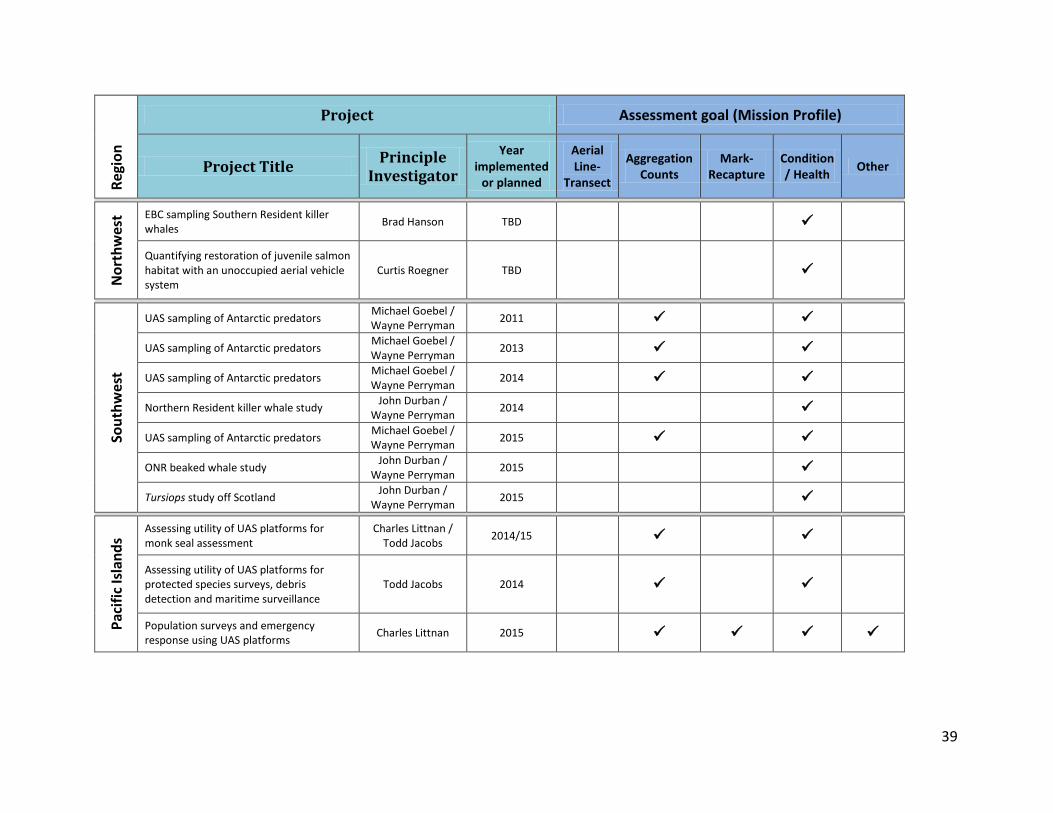
39
Regi
on
Project Assessment goal (Mission Profile)
Project Title Principle Investigator
Year implemented
or planned
Aerial Line-
Transect
Aggregation Counts
Mark-Recapture
Condition / Health Other
Nor
thw
est EBC sampling Southern Resident killer
whales Brad Hanson TBD
Quantifying restoration of juvenile salmon habitat with an unoccupied aerial vehicle system
Curtis Roegner TBD
Sout
hwes
t
UAS sampling of Antarctic predators Michael Goebel / Wayne Perryman 2011
UAS sampling of Antarctic predators Michael Goebel / Wayne Perryman 2013
UAS sampling of Antarctic predators Michael Goebel / Wayne Perryman 2014
Northern Resident killer whale study John Durban / Wayne Perryman 2014
UAS sampling of Antarctic predators Michael Goebel / Wayne Perryman 2015
ONR beaked whale study John Durban / Wayne Perryman 2015
Tursiops study off Scotland John Durban / Wayne Perryman 2015
Paci
fic Is
land
s
Assessing utility of UAS platforms for monk seal assessment
Charles Littnan / Todd Jacobs 2014/15
Assessing utility of UAS platforms for protected species surveys, debris detection and maritime surveillance
Todd Jacobs 2014
Population surveys and emergency response using UAS platforms Charles Littnan 2015

40
Re
gion
Project Assessment goal (Mission Profile)
Project Title Principle Investigator
Year implemented
or planned
Aerial Line-
Transect
Aggregation Counts
Mark-Recapture
Condition / Health Other
Alas
ka
Testing a ship-based UAS for photographic surveys of Bering Sea ice seals
Peter Boveng / Michael Cameron 2009
Steller sea lion abundance Kathryn Sweeney 2014
Steller sea lion morphometrics Kathryn Sweeney 2014
Steller sea lion brand sighting Kathryn Sweeney 2014
Northern fur seal rookery space use Kathryn Sweeney 2015
Comparing manned aerial surveys to UAS surveys for cetacean monitoring in the Arctic
Megan Ferguson 2015
Northern fur seal pup abundance Kathryn Sweeney 2016
Effects of UAS activities on Steller sea lion behavior Kathryn Sweeney 2016
Evaluate UAS imagery for tag and brand reading on California sea lions and northern furs seal in the California Channel Islands
Robert DeLong 2017
Surveys of ice seals in the Bering and Chukchi Seas Peter Boveng 2020
4340 East-West Highway | Room 700 | Bethesda, MD 20814
www.mmc.gov
Marine Mammal Commission An independent agency of the U.S. Government