Developer's Guide Traffic APIdocumentation.developer.here.com/pdf/traffic_nlp/6.0.24.3/Traffic...
55
Traffic API Developer's Guide Version 6.0.24.3
Transcript of Developer's Guide Traffic APIdocumentation.developer.here.com/pdf/traffic_nlp/6.0.24.3/Traffic...

Traffic APIDeveloper's Guide
Version 6.0.24.3

Traffic API Developer's Guide 2► Contents
Contents
Legal Notices..........................................................................................................................................................4
Document Information.................................................................................................................................... 5
Chapter 1: Overview................................................................................................................................. 6What is the Traffic API?................................................................................................................................ 7
Why use the Traffic API?.............................................................................................................................. 7
Chapter 2: Quick Start........................................................................................................................... 8Requesting Traffic Incident Data................................................................................................................9
Chapter 3: User Guide......................................................................................................................... 11Acquiring Credentials...................................................................................................................................12
Constructing a Request.............................................................................................................................. 12
Request Format................................................................................................................................13
Customer Integration Testing.......................................................................................................14
Key Concepts.................................................................................................................................................15
Mercator Projection and Map Tiles..............................................................................................15
Quadkeys............................................................................................................................................17
Traffic Coverage...............................................................................................................................18
Limitations......................................................................................................................................... 18
Services...........................................................................................................................................................21
Traffic Incident Data....................................................................................................................... 21
Traffic Tiles........................................................................................................................................23
Examples.........................................................................................................................................................24
Traffic Tiles........................................................................................................................................24
Traffic Incident Data....................................................................................................................... 33
Service Support............................................................................................................................................ 36
Traffic API Developer's Guide 3► Contents
Chapter 4: API Reference................................................................................................................. 37Tile Parameters.............................................................................................................................................38
Traffic Incident Data Parameters.............................................................................................................40
Additional Request Parameters................................................................................................................ 44
Data Types.....................................................................................................................................................45
Latitude...............................................................................................................................................45
Longitude........................................................................................................................................... 45
Functional Class................................................................................................................................46
TMC Code...........................................................................................................................................46
Language Code.................................................................................................................................50
Language Code Parameters.......................................................................................................... 50
Country Code.................................................................................................................................... 50
Built-in.................................................................................................................................................50
HTTP Status Codes......................................................................................................................................54

Traffic API Developer's Guide 4► Legal Notices
Legal Notices
© 2013 HERE. All rights reserved.
This material, including documentation and any related computer programs, is protected by
copyright controlled by HERE. All rights are reserved. Copying, including reproducing, storing,
adapting or translating, any or all of this material requires the prior written consent of HERE. This
material also contains confidential information, which may not be disclosed to others without the
prior written consent of HERE.
Trademark Acknowledgements
HERE and Nokia are trademarks or registered trademarks of Nokia Corporation in the United States
and other countries.
Other trade names are trademarks or registered trademarks of their owners.
Disclaimer
This content is provided "as-is" and without warranties of any kind, either express or implied,
including, but not limited to, the implied warranties of merchantability, fitness for a particular
purpose, satisfactory quality and non-infringement. Nokia does not warrant that the content is error
free and Nokia does not warrant or make any representations regarding the quality, correctness,
accuracy, or reliability of the content. you should therefore verify any information contained in the
content before acting on it.
To the furthest extent permitted by law, under no circumstances, including without limitation Nokia's
negligence, shall Nokia be liable for any damages, including, without limitation, direct, special,
indirect, punitive, consequential, exemplary and/ or incidental damages that result from the use or
application of this content, even if Nokia or an authorized representative has been advised of the
possibility of such damages.

Traffic API Developer's Guide 5► Document Information
Document Information
Product
Name: Traffic API
Version: Version 6.0.24.3
Document
Name: Traffic API Developer's Guide
Id: c5a44bd-1378407674
Status: FINAL
Date: 2013-Sep-05, 19:01 (GMT)

Traffic API Developer's Guide 6► Overview
Chapter
1Overview
Topics:
• What is the Traffic API?
• Why use the Traffic API?
The articles that follow introduce the Traffic API, describe common
use cases, and introduce essential concepts.

Traffic API Developer's Guide 7► Overview
What is the Traffic API?HERE Traffic API is a RESTful API that provides traffic flow information and traffic map tiles.
To obtain traffic data via the HERE Traffic API, it is necessary to formulate a request that combines
the URL and a set of parameters to specify the required response.
The HERE Traffic API encompasses services outlined below.
Traffic Incident Data
The API provides aggregated information about traffic incidents, in XML or JSON formats. The
request responses contain information such as the type and location of a traffic incident, whether it
is still active, its start and end time, and other relevant information.
Traffic Map Tile Overlays (Traffic Tiles)
The Traffic API delivers pre-rendered tile overlays to allow you to display traffic in mapping
applications. You can request tiles that display traffic trends (patterns) based on historical traffic
data for a specific area.
Why use the Traffic API?The Traffic API addresses these high-level use cases:
• get a traffic pattern tile overlay for a map image
• get traffic incident data in XML or JSON formats
◦ filter traffic incident data by TMC table or profile
◦ filter traffic incident data by attributes
Traffic API Developer's Guide 8► Quick Start
Chapter
2Quick Start
Topics:
• Requesting Traffic Incident Data
This article outlines a simple scenario that uses the HERE Traffic
API and shows corresponding API requests.
Note that each request to the API must include the authentication
parameters app_id and app_code to access the resources
of the API. All examples in this guide use demo values of these
parameters, but a real-life web site or application must substitute
its own unique authentication credentials. For further information,
please see Acquiring Credentials on page 12.

Traffic API Developer's Guide 9► Quick Start
Requesting Traffic Incident DataA basic scenario involving the use of the Traffic API is to obtain traffic incident data for a specific
area. The two request examples below provide a working illustration.
To obtain traffic indicent data, the requests address the incidents resource (endpoint) of the
API – all available resources and further examples are covered in the subsequent parts of this
documentation. The targeted area is around Frankfurt, Germany.
The request examples specify:
1. The base URL, the service ("traffic") and its version
2. The map tile in a grid of tiles covering the entire globe – this is the tile for which to obtain the
traffic flow data
The example requests differ in the way they identify the map tile (point 2 above) and in the response
(output) format. The first example uses the [Z]/[X]/[Y] addressing scheme to indicate the map tile
and thus provides the zoom level and the coordinates of the tile (see Mercator Projection and Map
Tiles on page 15 for details). It indicates that XML is the required otuput format. The second
example identifies the map tile via a quadkey (see also Quadkeys on page 17) and specifies JSON
as the output format.
Incident Reports Example – XML Output and [Z]/[X]/[Y] Tile Addressing
A request for traffic incident data to be delivered in XML, with the [Z]/[X]/[Y] addressing scheme
specifying the map tile, is formulated as follows:
http://traffic.cit.api.here.com/traffic/6.0/incidents/xml/8/134/86?app_id=DemoAppId01082013GAL&app_code=AJKnXv84fjrb0KIHawS0Tg
To specify the tile for which to obtain traffic incident data, the request indicates the zoom level as 8,
the tile column as 134, and row as 86.
The complete response is too long to include here. It consists of the top-level element
<trafficcml_incidents timestamp="09/02/2013 13:37:19 GMT" VERSION="5.0">
followed by <traffic_items>. <traffic_items includes any number of individual
<traffic_item> elements that contain the location, time, duration, severity, description and other
details of incidents.
Traffic API Developer's Guide 10► Quick Start
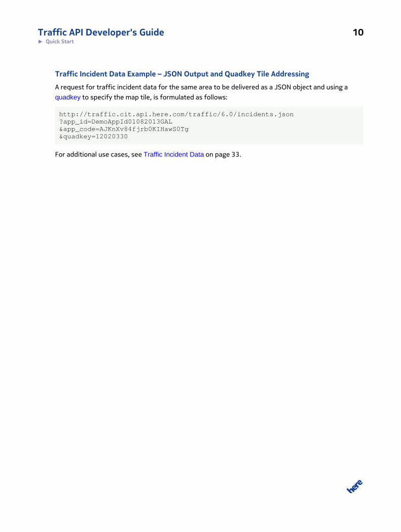
Traffic Incident Data Example – JSON Output and Quadkey Tile Addressing
A request for traffic incident data for the same area to be delivered as a JSON object and using a
quadkey to specify the map tile, is formulated as follows:
http://traffic.cit.api.here.com/traffic/6.0/incidents.json?app_id=DemoAppId01082013GAL&app_code=AJKnXv84fjrb0KIHawS0Tg&quadkey=12020330
For additional use cases, see Traffic Incident Data on page 33.
Traffic API Developer's Guide 11► User Guide
Chapter
3User Guide
Topics:
• Acquiring Credentials
• Constructing a Request
• Key Concepts
• Services
• Examples
• Service Support
This section examines aspects of the HERE Traffic API in detail,
covering:
• authentication credentials
• REST request formats and URL construction
• rendered traffic flow tiles
• incident data
The closing articles in this section offer examples that match
various use cases for the API. You can use and modify the
examples to explore the API and build your own applications,
provided that you replace the demo authentication parameters
values with your own authentication credentials.
Deprecation Notice
HERE has changed the way traffic tiles are served. Live traffic tileshave been removed from the Traffic API and are now deliveredby the Map Tile API infrastructure. Documentation relating to livetraffic tiles is part of the Map Tile API documentation.
This does not affect traffic pattern tiles, which continue to beserved by the Traffic API.

Traffic API Developer's Guide 12► User Guide
Acquiring CredentialsAll users of HERE APIs must obtain authentication and authorization credentials and provide them as
values for the parameters app_id and app_code. The credentials are assigned per application.
To obtain the credentials for an application, please visit http://developer.here.com/get-started for
more details.
Constructing a RequestA request to the Traffic API includes the basic elements shown in the following table and, in addition,
it may contain resource-specific parameters.
Table 1: Basic request elements
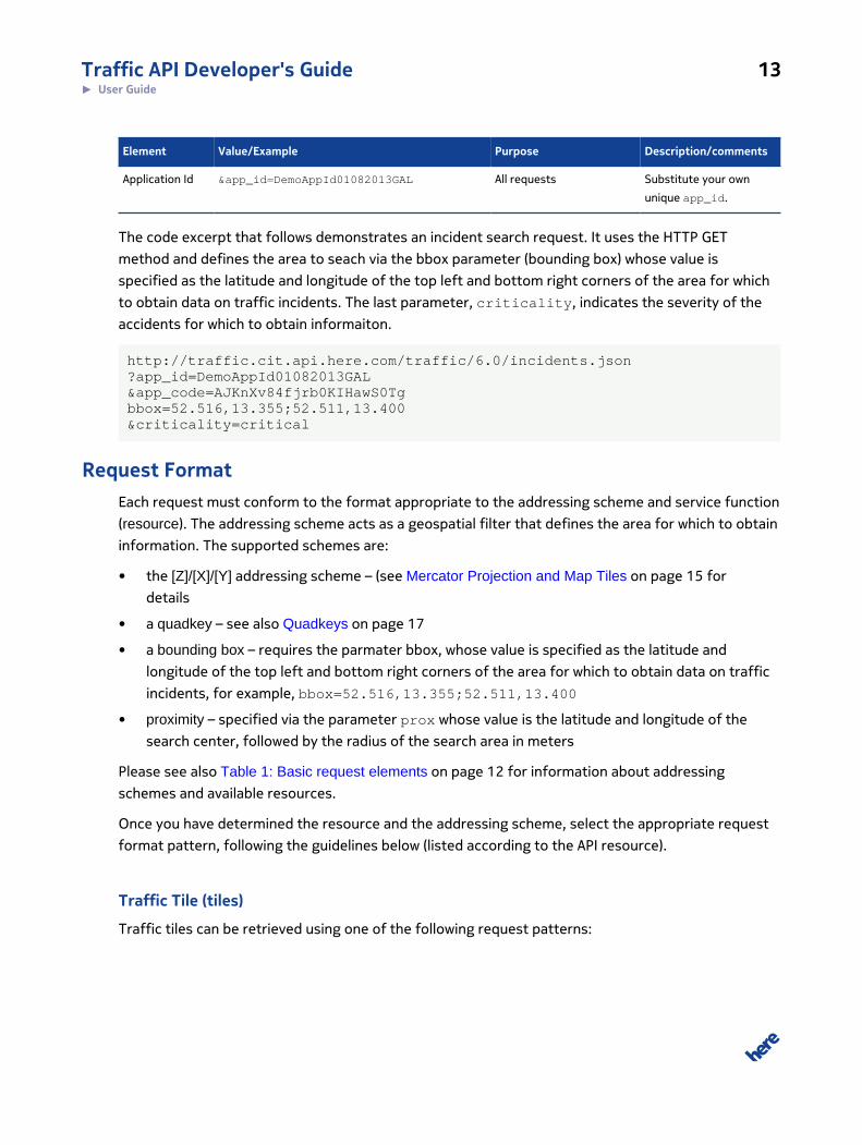
Element Value/Example Purpose Description/comments
Base URL http://maps.nlp.nokia.com
http://traffic.api.here.com
Tiles
Incidents
Production environment.
http://maps.st.nlp.nokia.com
http://traffic.cit.api.here.com
Tiles
Incidents
CIT environment: seeCustomer IntegrationTesting on page 14.
Path /traffic/6.0/
Resource tiles
incidents
Tiles
Traffic Incidents
Name of a resourcesupporting specificfunctionality.
Only the GET methodis supported. Specifyrequest details viaparameters. See alsoExamples on page 24.
Format png32, png8, or png
json or xml
Tiles
Traffic Incidents
Format for the response,options vary perfunction/resource.
Addressing
Scheme
Quadkey, [Z]/[X]/[Y]
Quadkey, [Z]/[X]/[Y], Bounding Box or Proximity
Traffic Tiles
Traffic Incidents
Geographic region forthe response, optionsvary by function/resource.
Application
Code
&app_code=AJKnXv84fjrb0KIHawS0Tg All requests Substitute your own
unique app_code.
Traffic API Developer's Guide 13► User Guide
Element Value/Example Purpose Description/comments
Application Id &app_id=DemoAppId01082013GAL All requests Substitute your own
unique app_id.
The code excerpt that follows demonstrates an incident search request. It uses the HTTP GET
method and defines the area to seach via the bbox parameter (bounding box) whose value is
specified as the latitude and longitude of the top left and bottom right corners of the area for which
to obtain data on traffic incidents. The last parameter, criticality, indicates the severity of the
accidents for which to obtain informaiton.
http://traffic.cit.api.here.com/traffic/6.0/incidents.json?app_id=DemoAppId01082013GAL&app_code=AJKnXv84fjrb0KIHawS0Tgbbox=52.516,13.355;52.511,13.400&criticality=critical
Request FormatEach request must conform to the format appropriate to the addressing scheme and service function
(resource). The addressing scheme acts as a geospatial filter that defines the area for which to obtain
information. The supported schemes are:
• the [Z]/[X]/[Y] addressing scheme – (see Mercator Projection and Map Tiles on page 15 for
details
• a quadkey – see also Quadkeys on page 17
• a bounding box – requires the parmater bbox, whose value is specified as the latitude and
longitude of the top left and bottom right corners of the area for which to obtain data on traffic
incidents, for example, bbox=52.516,13.355;52.511,13.400
• proximity – specified via the parameter prox whose value is the latitude and longitude of the
search center, followed by the radius of the search area in meters
Please see also Table 1: Basic request elements on page 12 for information about addressing
schemes and available resources.
Once you have determined the resource and the addressing scheme, select the appropriate request
format pattern, following the guidelines below (listed according to the API resource).
Traffic Tile (tiles)
Traffic tiles can be retrieved using one of the following request patterns:

Traffic API Developer's Guide 14► User Guide
Table 2: Traffic tile request formats
Addressing scheme URL pattern
Quadkey {tile-base-url}/{path}/{resource}/quadkeytraffic?quadkey={quadkey}
[Z]/[X]/[Y] {tile-base-url}/{path}/{resource}/{zoom}/{column}/{row}/{size}/
{format}?
Note that when using the [Z]/[X]/[Y] addressing scheme, you can specify tile size and color depth as
follows:
• {size}: tile size, can be one the following values 512, 256, or 128.
• {format}: color-depth, can be one of the following png, png8, or png32.
See also Setting the Tile Size or Color Depth on page 27
Traffic Incidents (incidents)
Traffic incident reports can be retrieved using one of the following request patterns:
Table 3: Traffic incident request formats
Addressing scheme URL pattern
Quadkey {base-url}/{path}/{resource}.{format}?quadkey={quadkey}
Bounding box {base-url}/{path}/{resource}.{format}?bbox={bounding box coordinates}
Proximity {base-url}/{path}/{resource}.{format}?prox={proximity coordinates}
[Z]/[X]/[Y] {base-url}/{path}/{resource}/{format}/{zoom}/{column}/{row}?
Customer Integration TestingHERE is committed to maintain the best possible production service to all our customers. Given
that the production environment is live and common to all API users, we request that you use the
alternative Customer Integration Testing (CIT) environment when evaluating our products, running
tests, making changes in your code and altering the way you access our APIs.
The CIT environment also allows you to test your software against a newer version of the service
before HERE brings that version into production. The purpose of CIT is to offer a fully functional
environment for customers to use for development and testing, it does not support high loads or
performance testing in general.
Note that the same application id can be used in both environments, but CIT may require a dedicated
application code. If this is the case, please contact us as described under Service Support on page
36.

Traffic API Developer's Guide 15► User Guide
The CIT environment is not intended for general production use.
Key ConceptsThis section defines key concepts that relate to the HERE Traffic API.
Mercator Projection and Map TilesThe Traffic API serves map tiles obtained by mapping points on the surface of a sphere (the globe) to
points on a plane, using the normalized Mercator projection.
The basic Mercator projection formula is this:
{λ, φ} -> x[-1, 1] y [-1, 1]
In this formula:
λ = longitude
φ= latitude
x = λ / π
y = ln(tan(π/4 + φ/2)) / π
The plane represents the globe as a square grid of map tiles. The size of the grid depends on the map
zoom level. At the lowest zoom level, the world is contained in one map tile. At the next higher zoom
level, the world is two tiles wide and two tiles high (2x2), at the next level above that, the grid is 4x4,
then 8x8, 16x16, and so on up to the maximum zoom for a particular region. In other words, at each
zoom level the tiles that make up the complete map of the world form a grid in which the number of
tiles is equal to the zoom level raised to the power of two (zoom2).
The relationship between tiles at two consecutive zoom levels can be expressed as follows:
col1,z+1 = (2*colz) + 1row1,z+1 = (2*rowz) + 1
In this formula:
col = column number in the tile grid
row = row number in the tile grid
z = zoom level
Traffic API Developer's Guide 16► User Guide
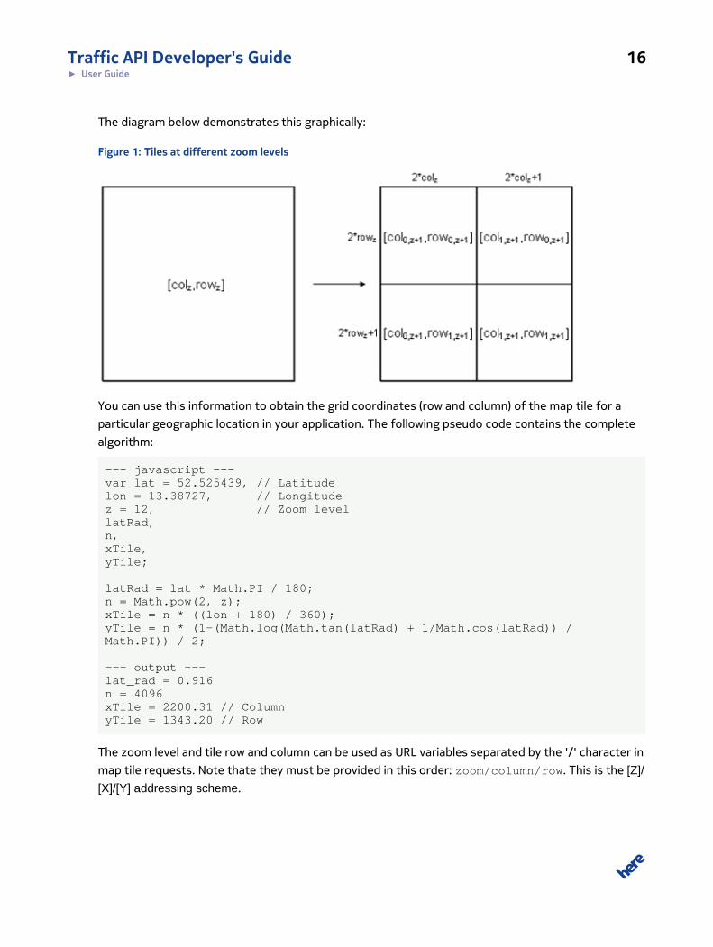
The diagram below demonstrates this graphically:
Figure 1: Tiles at different zoom levels
You can use this information to obtain the grid coordinates (row and column) of the map tile for a
particular geographic location in your application. The following pseudo code contains the complete
algorithm:
--- javascript ---var lat = 52.525439, // Latitudelon = 13.38727, // Longitudez = 12, // Zoom levellatRad,n,xTile,yTile;
latRad = lat * Math.PI / 180;n = Math.pow(2, z);xTile = n * ((lon + 180) / 360);yTile = n * (1-(Math.log(Math.tan(latRad) + 1/Math.cos(latRad)) /Math.PI)) / 2;
--- output ---lat_rad = 0.916n = 4096xTile = 2200.31 // ColumnyTile = 1343.20 // Row
The zoom level and tile row and column can be used as URL variables separated by the '/' character in
map tile requests. Note thate they must be provided in this order: zoom/column/row. This is the [Z]/
[X]/[Y] addressing scheme.
Traffic API Developer's Guide 17► User Guide
The map tile specification is typically preceded by other path variables and may be followed either by
further path variables and/or query parameters.
QuadkeysSpecifying the grid location of a map tile in terms of zoom level, column and row as described under
Mercator Projection and Map Tiles on page 15 is easy to understand and intuitive in practise.
However, the grid is a two-dimensional array and as such does not offer efficient storage and
retrieval. A better solution is a one-dimensional array, where each item is uniquely addressable by
a single value. This is made possible by quadkeys, which combine the zoom level, column and row
information for a tile in a one value.
In fact, a quadkey is a string containing a numeric value. The value is obtained by interleaving the
bits of the row and column coordinates of a tile in the grid at the given zoom level, then converting
the result to a base-4 number (the leading zeros are retained). The length of a quadkey string (the
number of digits/characters) equals the zoom level of the tile.
For example, we can obtain the quadkey for a map tile in column 3 and row 5 at zoom level 5 as
follows:
// Convert the column (x) and row (y) values // to their binary (b) equivalents:x = 3 -> 011b
y = 5 -> 101b
// Interleave the binary values (b), convert the // combined result to a base-4 (q) number and // finally convert that to a string:quadkey = 100111b -> 213q -> “213”
The code below shows a JavaScript implementation of the algorithm that calculates quadkeys. The
inputs are the coordinates of the a map tile and the zoom level. The return value is a string containing
the quadkey. The lower part of the code block shows the function called to calculate a quadkey for
zoom level 16, which is also the length of the output string shown on the last line.
--- input ---xTile: 35210 // ColumnyTile: 21493 // Rowz: 16 // Zoom Level
--- JavaScript ---function tileXYToQuadKey(xTile, yTile, z) { var quadKey = ""; for (var i = z; i > 0; i--) { var digit = "0", mask = 1 << (i - 1);

Traffic API Developer's Guide 18► User Guide
if ((xTile & mask) != 0) { digit++; } if ((yTile & mask) != 0) { digit = digit + 2; } quadKey += digit; } //for i return quadKey;
return quadKey;}quadKey = tileXYToQuadKey(35210, 21493, 16);
--- output ---quadKey = "1202102332221212"
Note that when using a quadkey address, you cannot specify the size or format of the map tile image.
The response always includes an image that measures 256 x 256 pixels and the format is png32.
Traffic CoverageThe HERE Traffic API offers traffic data for the regions described in Table 21: TMC Table IDs on page
47. Note that coverage may vary, depending on the customer profile.
For details about traffic coverage available for your customer profile, please contact your HERE
representative.
Traffic API LimitationsTo reduce the size and increase relevancy of traffic data, the service limits the area and detail of
traffic data that you can request for traffic tiles and incident data. You can request tiles or incident
reports only for zoom levels 8-22.
Traffic Flow Data Limitations
The HERE Traffic API restricts the maximum size of a geographical filter used to retrieve traffic flow
data. The limitation applies to requests that specify a bounding box and proximity filters. The width
and height of a bounding box must be no greater than 4 degrees of longitude and latitude, while the
maximum permitted proximity radius is 200km,.
Queries using larger spatial filters result in an error response.
The recommeded maximum size for a bounding box and quadkey (tile) is 1 degree of longitude and
latitude. The largest recommended radius in proximity-based queries is 50km. For these ranges, the
SLAs apply, which are documented seperately.
Traffic API Developer's Guide 19► User Guide
Traffic Tiles and Zoom Level
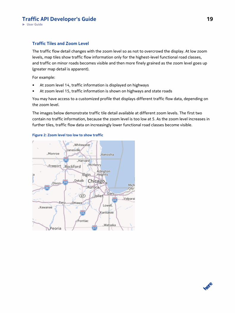
The traffic flow detail changes with the zoom level so as not to overcrowd the display. At low zoom
levels, map tiles show traffic flow information only for the highest-level functional road classes,
and traffic on minor roads becomes visible and then more finely grained as the zoom level goes up
(greater map detail is apparent).
For example:
• At zoom level 14, traffic information is displayed on highways
• At zoom level 15, traffic information is shown on highways and state roads
You may have access to a customized profile that displays different traffic flow data, depending on
the zoom level.
The images below demonstrate traffic tile detail available at different zoom levels. The first two
contain no traffic information, because the zoom level is too low at 5. As the zoom level increases in
further tiles, traffic flow data on increasingly lower functional road classes become visible.
Figure 2: Zoom level too low to show traffic

Traffic API Developer's Guide 20► User Guide
Some traffic flow information can be seen zoom level 8 in the follwoing image.
Figure 3: Zoom level 8 begins to show traffic flow overlay
The higher the zoom level, the more detailed the traffic flow display becomes:
Figure 4: Zoom level 14 shows more detailed traffic flow overlay

Traffic API Developer's Guide 21► User Guide
Traffic Incident and Zoom Level
Mirroring its handling of traffic flow data, the HERE Traffic API does not return traffic incident
information at zoom levels 0-7. A similar limitation applies to bounding box requests, with the
maximum bounding box width and height restricted to 30 degrees of longitude and latitude. Also,
the largest permitted size of the proximity radius is 100km. The effect of these limits is to prevent
unsustainably large response data transfers.
Queries that exceed the limits in terms of zoom level or proximity radius result in an error response.
ServicesThis section briefly defines the functional services offered by the HERE Traffic API. The services
correspond to the resources listed in Table 1: Basic request elements on page 12.
Traffic Incident DataThe HERE Traffic API supoprts requests for traffic incident data from a specific geographic area
(defined by a geospatial filter). The response includes data in XML or JSON format.
Geospatial Inclusion
Traffic incident items are included in the response based on their point of origin. This means that
an incident in the response may potentially contain a geolocation outside the area indicated by the
geospatial filter in the request. The figure below shows the GEOLOC/ORIGIN parameter used to
determine if an item falls within the requested response boundaries.
Figure 5: Geospatial Inclusion

Traffic API Developer's Guide 22► User Guide
Incident Types and Filtering
Incident filters allow you to tailor incident requests to specific requirements. The filters support
selection based on status, criticality, TMC table IDs, profiles, or start and end times.
In addition, traffic incidents are classified according to incident type:
• Accident
• Congestion
• Disabled vehicle
• Road hazard
• Construction
• Planned event
• Mass transit
• Other news
• Weather
• Miscellaneous
Localization Defaults
By default, incident reports returned in the response are localized to their geographic origin. That is,
the time values are shown in local time and format, and message strings are in the default language
for the country identfiied by the geospatial filter.
The table below shows the default languages for each supported country.
Table 4: Default Traffic Incident Reports Language
Country Default Incident Reports Language
Austria German (de)
Belgium Dutch (nl)
Canada English (en)
Denmark Danish (da)
Finland Finnish (fi)
France French (fr)
Germany German (de)
Greece Greek (el)
Ireland English (en)
Italy Italian (it)

Traffic API Developer's Guide 23► User Guide
Country Default Incident Reports Language
Luxembourg French (fr)
Mexico Spanish (es)
Netherlands Dutch (nl)
Norway Norwegian (no)
Poland Polish (pl)
Portugal Portuguese (pt)
South Africa English (en)
Sweden Swedish (sv)
Switzerland German (de)
Turkey Turkish (tr)
UK English (en)
USA English (en)
Supported Translation Languages
The supported languages for incident translation are:
• English (en)
• French (fr)
• German (de)
• Italian (it)
• Swedish (sv)
• Danish (da)
• Norwegian (no)
• Finnish (fi)
• Dutch (nl)
Traffic TilesThe Traffic API allows you to obtain a pre-rendered map tile reflecting traffic conditions. Each tile
is a PNG overlay that uses line and color to indicate how freely traffic flows in the corresponding
geographic area.

Traffic API Developer's Guide 24► User Guide
Deprecation Notice
HERE has changed the way traffic tiles are served. Live traffic tiles have been removed from theTraffic API and are now delivered by the Map Tile API infrastructure. Documentation relating to livetraffic tiles is part of the Map Tile API documentation.
This does not affect traffic pattern tiles, which continue to be served by the Traffic API.
Color Mapping
By default, the service uses specific color mappings that match a traffic scale measured in Jam
Factors, where 0 means "free flowing" and 10 means "completely obstructed". The following table
describes the overlay colors, which follows a standard configuration to map Jam Factors to color.
Table 5: Traffic Flow to Color Mapping
Color Description
Green Free flow of traffic: 0 <= JAM_FACTOR < 4
Yellow Sluggish flow of traffic: 4 <= JAM_FACTOR < 8
Red Slow flow of traffic: 8 <= JAM_FACTOR < 10
Black Traffic stopped flowing or road closed: JAM_FACTOR = 10
Note that customized profiles may be defined, where color mappings for traffic flow differ.
Caching
Traffic flow tiles can be cached for a limited period of time (up to 3 minutes), as the data must be
fresh adequately to represent current traffic conditions.
ExamplesThis section presents examples of common requests to the HERE Traffic API, as well as
corresponding responses.
Traffic TilesThis section offers examples of requests for traffic tile overlays from the Traffic API.
Note that the demo values of the authentication parameters app_id and a app_code are
appropriate for testing only – please see Acquiring Credentials on page 12 for more information.

Traffic API Developer's Guide 25► User Guide
Requesting Traffic Flow Tile OverlaysOne of the use cases for the HERE Traffic API is to obtain a traffic flow map tile overlay.
Deprecation Notice
HERE has changed the way traffic tiles are served. Live traffic tiles have been removed from theTraffic API and are now delivered by the Map Tile API infrastructure. Documentation relating to livetraffic tiles is part of the Map Tile API documentation.
This does not affect traffic pattern tiles, which continue to be served by the Traffic API.
Example: Quadkey Addressing
The same request for a tile overlay for an area near Frankfurt in Germany, but using a quadkey is
formulated as follows:
http://maps.st.nlp.nokia.com/traffic/6.0/tiles/quadkeytraffic?app_id=DemoAppId01082013GAL&app_code=AJKnXv84fjrb0KIHawS0Tg&quadkey=12020330
Response
The response to both versions of the request for a tile overlay for an area near Frankfurt in Germany
contains the following PNG traffic flow tile overlay image:
Figure 6: Traffic flow tile
Traffic API Developer's Guide 26► User Guide
This is a basic request to the API for a traffic flow tile and the response. For further examples, please
see Traffic Tiles on page 24.
Requesting a Traffic Pattern TileYou can request a tile overlay that shows the typical traffic pattern for a specific time point during
the week. The time point is specified as a number of seconds from 00:00 hours, Sunday, in local time.
The table below summarizes the request paramters to use.
Table 6: Request a Traffic Pattern Tile
Required Optional
• quadkey (used only in a quadkey address)
• pattern_time
• noContent
• profile
• tables
• res (quadkey address only)
• depth (quadkey address only)
Note that you can use the [Z]/[X]/[Y] addressing scheme instead of a quadkey, as shown in the first
request example below.
Example: [Z]/[X]/[Y] Addressing Scheme
The following example shows a traffic pattern tile request, with the pattern_time parameter set to
150000 (5:40 PM, Monday). The request uses the [Z]/[X]/[Y] addressing scheme:
http://maps.st.nlp.nokia.com/traffic/6.0/tiles/8/134/86/256/png32?app_id=DemoAppId01082013GAL&app_code=AJKnXv84fjrb0KIHawS0Tg&pattern_time=150000
Example: Quadkey Addressing
The same traffic tile request is shown below, but this time it uses the quadkey addressing scheme:
http://maps.st.nlp.nokia.com/traffic/6.0/tiles/quadkeytraffic?app_id=DemoAppId01082013GAL&app_code=AJKnXv84fjrb0KIHawS0Tg&quadkey=12020330&pattern_time=150000

Traffic API Developer's Guide 27► User Guide
Response
The response to both versions of the request for a traffic pattern tile delivers the following PNG
image:
Figure 7: Traffic pattern tile
Setting the Tile Size or Color DepthThe Traffic API allows requests to select different sizes and color depth of traffic tiles to suit your
application needs. Such requests follow the same general basic process and pattern, but require the
parameter res to select the tile size and/or depth to determine the required color depth.
Selecting Tile Size
The following table summarizes the parameters to use when specifying the response tile size:
Table 7: Set the Size of a Traffic Tile
Required Optional
• endpoint change (used only in a [Z]/[X]/[Y] address):
.../{zoom}/{column}/{row}/{size}/{format}?
• quadkey (used only in a quadkey address)
• res (used only in a quadkey address)
• depth (quadkey address only)
• noContent
• profile
• pattern_time
• tables
Traffic API Developer's Guide 28► User Guide
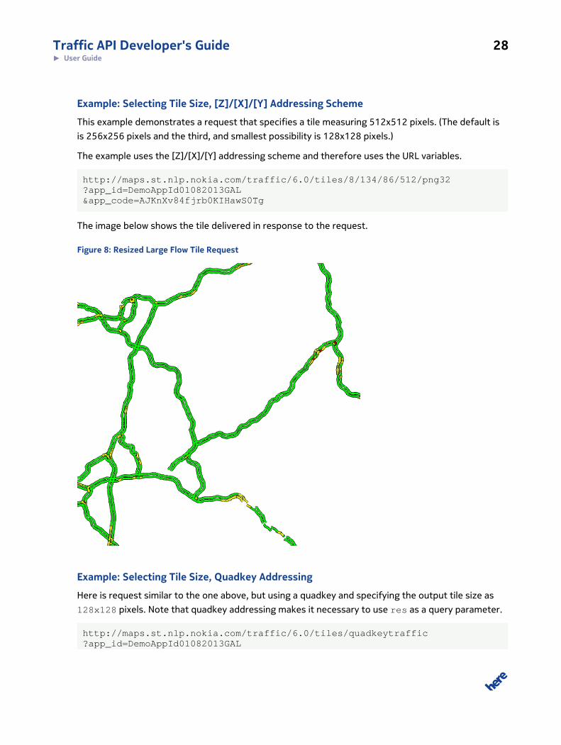
Example: Selecting Tile Size, [Z]/[X]/[Y] Addressing Scheme
This example demonstrates a request that specifies a tile measuring 512x512 pixels. (The default is
is 256x256 pixels and the third, and smallest possibility is 128x128 pixels.)
The example uses the [Z]/[X]/[Y] addressing scheme and therefore uses the URL variables.
http://maps.st.nlp.nokia.com/traffic/6.0/tiles/8/134/86/512/png32?app_id=DemoAppId01082013GAL&app_code=AJKnXv84fjrb0KIHawS0Tg
The image below shows the tile delivered in response to the request.
Figure 8: Resized Large Flow Tile Request
Example: Selecting Tile Size, Quadkey Addressing
Here is request similar to the one above, but using a quadkey and specifying the output tile size as
128x128 pixels. Note that quadkey addressing makes it necessary to use res as a query parameter.
http://maps.st.nlp.nokia.com/traffic/6.0/tiles/quadkeytraffic?app_id=DemoAppId01082013GAL

Traffic API Developer's Guide 29► User Guide
&app_code=AJKnXv84fjrb0KIHawS0Tg&quadkey=12020330&res=bitmap128
Here is the response image tile measuring 128x128 pixels:
Figure 9: Resized Small Flow Tile Request
Selecting Tile Color Depth
The table below offers a summary of parameters to use to determine the color depth of the
requested tiles.
Table 8: Set the Color Depth of a Traffic Tile
Required Optional
• endpoint change (used only in a [Z]/[X]/[Y] address):
.../{zoom}/{column}/{row}/{size}/{format}?
• quadkey (used only in a quadkey address)
• depth (used only in a quadkey address)
• noContent
• profile
• tables
• pattern_time
• res (quadkey address only)
Example: Changing the Color Depth, [Z]/[X]/[Y] Addressing Scheme
This example demonstrates a request that stipulates a color depth of 8 bits
To change the color-depth of the tile, add this line for a request using the [Z]/[X]/[Y] addressing
scheme:
http://maps.st.nlp.nokia.com/traffic/6.0/tiles/8/134/86/256/png8?app_code=AJKnXv84fjrb0KIHawS0Tg&app_id=DemoAppId01082013GAL

Traffic API Developer's Guide 30► User Guide
Example: Changing the Color Depth, Quadkey Addressing
The quadkey version of the previous example requires depth parameter to be used as a query
parameter, as shown below:
http://maps.st.nlp.nokia.com/traffic/6.0/tiles/quadkeytraffic?app_id=DemoAppId01082013GAL&app_code=AJKnXv84fjrb0KIHawS0Tg&quadkey=12020330&depth=8bit
Response: Changing Color Depth
The response to both the requests that stipulate tile color depth is the tile shown below.
Figure 10: Flow Tile Request as 8-bit
Filtering by TMC TablesA customer profile includes a set of TMC tables, which specify the traffic data that you can request
from the service. Requests that use TMC tables follow the same basic process and pattern, but differ
in terms of parameters.
You can include or exclude certain tables in your profile by including the tables parameter in the
request string, paired with the TMC code (see also TMCCodeType on page 46). Positive values for
the TMC code specify which tables are to be included, and negative values specify tables to exclude.
You cannot combine a positive and negative value in a request: such a request is not support an
results in an error.
The table below summarizes the relevant request parameters.

Traffic API Developer's Guide 31► User Guide
Table 9: Filter Tile Display by TMC Table
Required Optional
• quadkey (used only in a quadkey address)
• tables
• depth (quadkey address only)
• noContent
• profile
• pattern_time
• res (quadkey address only)
This example requests a tile near the Boston area, on the border of TMC table A0129.
Example: Including a TMC Table
The following examples shows a request using the [Z]/[X]/[Y] addressing scheme. The request
includes a TMC table.:
http://maps.st.nlp.nokia.com/traffic/6.0/tiles/11/613/759/256/png32?app_id=DemoAppId01082013GAL&app_code=AJKnXv84fjrb0KIHawS0Tg&tables=A0129
The same request, reformulated to use a quadkey is as follows:
http://maps.st.nlp.nokia.com/traffic/6.0/tiles/quadkeytraffic?app_id=DemoAppId01082013GAL&app_code=AJKnXv84fjrb0KIHawS0Tg&quadkey=03023320323&tables=A0129

Traffic API Developer's Guide 32► User Guide
The response to both versions of the request above return the following PNG traffic flow tile overlay:
Figure 11: Request Including Table 129
Example: Excluding a TMC Table
This example shows a request that excludes a TMC table.
http://maps.st.nlp.nokia.com/traffic/6.0/tiles/11/613/759/256/png32?app_id=DemoAppId01082013GAL&app_code=AJKnXv84fjrb0KIHawS0Tg&tables=-A0129
The code block below shows the same request, but with a quadkey instead of the [Z]/[X]/[Y]
addressing scheme.
http://maps.st.nlp.nokia.com/traffic/6.0/tiles/quadkeytraffic?app_id=DemoAppId01082013GAL&app_code=AJKnXv84fjrb0KIHawS0Tg&quadkey=03023320323&tables=-A0129

Traffic API Developer's Guide 33► User Guide
Both versions of the request above return this PNG traffic flow tile overlay:
Figure 12: Request Excluding Table 129
For a list of sample TMC codes, see Table 21: TMC Table IDs on page 47.
Traffic Incident DataThe basic incidents data request is described under Quick Start on page 8. The following list contains
links to examples that illustrate further common use cases for requesting traffic incident data from
the Traffic API.
• Requesting Incident Data on page 33
• Request a Subset of Incident Data on page 35
Note that the demo values of the authentication parameters app_id and a app_code are
appropriate for testing only – please see Acquiring Credentials on page 12 for more information.
Requesting Incident DataA request to the the HERE Traffic API can localize the response to a specific time zone, format, or
language, instead of relying on the defaults. Note, however, that localized incident descriptions
(translations) are available only for the supported languages – for the full list, please see Localization
Defaults on page 22.
Traffic API Developer's Guide 34► User Guide
The following table summarizes the parameters to use when requesting incident data:
Table 10: Request Traffic Incident Data Using Localization
Required Optional
• quadkey, prox, bbox (except with Z/X/Y address)
• c and lg as a pair or with i18n
• criticality
• endTime
• inc22
• jsoncallback
• localtime
• maxresults
• profile
• sort
• startTime
• status
• tables
• type
• verified
Example: [Z]/[X]/[Y] addressing scheme
The example below shows a request for traffic incident information for a tile at zoom level 8 near
Frankfurt, Germany. It localizes the response to the USA and translates the text to English (en). Note
that the default incident time zone, date format and language in the response are: timezone - UTC/
GMT, date format - DIN ISO 8601:2006-09, and language - German (de).
http://traffic.cit.api.here.com/traffic/6.0/incidents/xml/8/134/86?app_id=DemoAppId01082013GAL&app_code=AJKnXv84fjrb0KIHawS0Tg&c=US&lg=en&i18n=true&localtime=true
Example: Quadkey Addressing
A quadkey version of the same request for traffic incident data is shown below. Further possibilities
are to use proximity (prox), bounding box (bbox), or corridor (corridor) in place of the quadkey
string parameter-value pair.
http://traffic.cit.api.here.com/traffic/6.0/incidents.xml

Traffic API Developer's Guide 35► User Guide
?app_id=DemoAppId01082013GAL&app_code=AJKnXv84fjrb0KIHawS0Tg&quadkey=12020330&c=US&lg=en&i18n=true&localtime=true
Request a Subset of Incident DataRequests to the Traffic API for incident data can limit the response to a data subset.
Common subsets include:
• limiting the total number of responses
• limiting responses to a certain type, status, criticality, TMC table, profile or timeframe
• excluding certain geospatial areas
The following table summarizes the parameters to use when requesting a subset of incident data:
Table 11: Request a Subset of Traffic Incident Data
Required Optional
• quadkey, prox, bbox (except with Z/X/Y address)
• One or more of these filter parameters:
◦ criticality
◦ endTime
◦ maxresults
◦ profile
◦ startTime
◦ status
◦ tables
◦ type
◦ verified
• c and lg as a pair or with i18n
• inc22
• jsoncallback
• localtime
• sort
Example: [Z]/[X]/[Y] addressing scheme
The example below shows a request for traffic incident information that uses the parameters to limit
the response to 50 active incidents that fall within a level 8 tile near Frankfurt am Main, Germany, but
outside a defined bounding box area.

Traffic API Developer's Guide 36► User Guide
The following request uses the [Z]/[X]/[Y] addressing scheme. Note that status and maxresults
appear as query parameters:
http://traffic.cit.api.here.com/traffic/6.0/incidents/xml/8/134/86?app_id=DemoAppId01082013GAL&app_code=AJKnXv84fjrb0KIHawS0Tg&negbox=8.4375,49.8379;9.84375,50.7364;&status=active&maxresults=50
Example: Quadkey addressing
A quadkey version of the same request limiting the traffic incident data in the response is shown
below. Further possibilities are to use proximity (prox), bounding box (bbox), or corridor (corridor)
instead of the quadkey string parameter-value pair.
http://traffic.cit.api.here.com/traffic/6.0/incidents.xml?app_id=DemoAppId01082013GAL&app_code=AJKnXv84fjrb0KIHawS0Tg&quadkey=12020330&negbox=8.4375,49.8379;9.84375,50.7364;&status=active&maxresults=50
Service SupportIf you need assistance in using the API, contact your HERE representative or Technical Customer
Support via email at [email protected].

Traffic API Developer's Guide 37► API Reference
Chapter
4API Reference
Topics:
• Tile Parameters
• Traffic Incident Data Parameters
• Additional Request Parameters
• Data Types
• HTTP Status Codes
This section provides a comprehensive reference to the HERE
Traffic API.
Traffic API Developer's Guide 38► API Reference
Tile Parameters
Deprecation Notice
HERE has changed the way traffic tiles are served. Live traffic tiles have been removed from theTraffic API and are now delivered by the Map Tile API infrastructure. Documentation relating to livetraffic tiles is part of the Map Tile API documentation.
This does not affect traffic pattern tiles, which continue to be served by the Traffic API.
Parameter Combinations for Common Use Cases
Table 12: Request a Traffic Pattern Tile
Required Optional
• quadkey (used only in a quadkey address)
• pattern_time
• noContent
• profile
• tables
• res (quadkey address only)
• depth (quadkey address only)
Table 13: Set the Color Depth of a Traffic Tile
Required Optional
• endpoint change (used only in a [Z]/[X]/[Y] address):
.../{zoom}/{column}/{row}/{size}/{format}?
• quadkey (used only in a quadkey address)
• depth (used only in a quadkey address)
• noContent
• profile
• tables
• pattern_time
• res (quadkey address only)
Table 14: Set the Size of a Traffic Tile
Required Optional
• endpoint change (used only in a [Z]/[X]/[Y] address):
.../{zoom}/{column}/{row}/{size}/{format}?
• quadkey (used only in a quadkey address)
• res (used only in a quadkey address)
• depth (quadkey address only)
• noContent
• profile
• pattern_time

Traffic API Developer's Guide 39► API Reference
Required Optional
• tables
Table 15: Filter Tile Display by TMC Table
Required Optional
• quadkey (used only in a quadkey address)
• tables
• depth (quadkey address only)
• noContent
• profile
• pattern_time
• res (quadkey address only)
Resource Parameters
Table 16: Tile Request Parameters
Parameter Description
app_id xs:string
A 20 bytes Base64 URL-safe encoded string used for the authentication of the clientapplication.
You must include an app_id and app_code with every request. To get an app_id assignedto you, please see Acquiring Credentials on page 12.
app_code xs:string
A 20 bycotes Base64 URL-safe encoded string used for the authentication of the clientapplication.
You must include an app_id and app_code with every request. To get an app_idassignedto you, please see Acquiring Credentials on page 12.
depth xs:string
The depth parameter specifies the color depth of the response tile. Accepted values are8bit and 32bit. Used only with a quadkey tile address.
noContent xs:boolean
When this parameter is set to true, the response returns as HTTP 204 empty for unpopulatedtraffic tiles. Accepted values are:
• true or 1
• false or 0
pattern_time xs:int
Requests a traffic pattern tile for the specified time in the week. Define the time for thisparameter in the local time for the region, in seconds beginning at Sunday at 0:00. Acceptedvalues are numeric-only, from 0 to 604800.

Traffic API Developer's Guide 40► API Reference
Parameter Description
profile xs:string
Profile defines such attributes as geographic coverage (TMC tables available for use) andcustom color mapping for tile overlays.
quadkey QuadkeyType
Based on the mercator projection, quadkey specifies a map tile through a unique numberstring, from 0 to 22 digits long. Quadkey tiles are located at a zoom level equal to a numberof digits in the quadkey value. Use only with a quadkey addressing scheme endpoint.
res xs:string
Used only with a quadkey tile address. Res specifies the dimensions of a rendered tile inpixels. Accepted values are:
• bitmap128
• bitmap256
• bitmap512
tables TMCCodeType
Specifies table (or multiple tables, seperated by a comma) in the profile to include or excludefrom response. Positive values are included, and negative values are excluded.
Note: Combination of positive and negative values is not supported and will returnan error response.
The default behavior is to return all tables in the profile. See TMCCodeType on page 46 fora full list of TMC tables or your customer profile for a list of tables available to you.
Traffic Incident Data Parameters
Parameter Combinations for Common Use Cases
Table 17: Request Traffic Incident Data Using Localization
Required Optional
• quadkey, prox, bbox (except with Z/X/Y address)
• c and lg as a pair or with i18n
• criticality
• endTime
• inc22
• jsoncallback
• localtime
• maxresults
• profile
• sort

Traffic API Developer's Guide 41► API Reference
Required Optional
• startTime
• status
• tables
• type
• verified
Table 18: Request a Subset of Traffic Incident Data
Required Optional
• quadkey, prox, bbox (except with Z/X/Y address)
• One or more of these filter parameters:
◦ criticality
◦ endTime
◦ maxresults
◦ profile
◦ startTime
◦ status
◦ tables
◦ type
◦ verified
• c and lg as a pair or with i18n
• inc22
• jsoncallback
• localtime
• sort
Resource Parameters
Table 19: Incident Request Parameters
Parameter Description
app_code xs:string
A 20 bycotes Base64 URL-safe encoded string used for the authentication of the clientapplication.
You must include an app_id and app_code with every request. To get an app_idassignedto you, please see Acquiring Credentials on page 12.
app_id xs:string
A 20 bytes Base64 URL-safe encoded string used for the authentication of the clientapplication.
You must include an app_id and app_code with every request. To get an app_id assignedto you, please see Acquiring Credentials on page 12.
bbox GeoBoundingBoxType: lat,lon; lat,lon

Traffic API Developer's Guide 42► API Reference
Parameter Description
A type of SpatialFilter. A spatial filter limits the search for any other attributes on therequest. Bounding box requests return results within a bbox, specified by two latitude /longitude pairs; the first pair defines the top left corner of the bounding box, the second setthe lower right.
Note: The allowed size of the bounding box (width and height) is limited by a
configurable maximum (in degrees - default 30 degrres width and 30 degrees
height)
c xs:string
Use c to specify the country part of the locale for the incident response. Accepted valuesinclude certain ISO country codes (2 bytes, ISO 3166-1-alpha-2). Must be used in conjunctionwith the lg parameter. The default behavior is to return the time and format of the responsebased on the incident location.
criticality xs:string
Used to filter incident reports by their associated criticality, case insensitive. May containmultiple values, seperated by a comma. Accepted criticality values include:
• critical or 0
• major or 1
• minor or 2
• lowImpact or 3
The default behavior is to include all incident reports, regardless of criticality.
endTime xs:dateTime
Defines the maximum incident end time for it to be included in the results, in GMT format.
YYYY-MM-DDThh:mm:ss.s+zzzz
See xs:dateTime on page 51 for the format to use when filtering time values.
i18n xs:boolean
Specifies whether the incident messages should be translated to the language specified inthe lg parameter. Must be used in conjunction with the lg parameter.
inc22 xs:boolean
Specifies whether to format the response to match the incidents ver. 2.2 XSD. Acceptedvalues are:
• true or 1
• false or 0
jsoncallback xs:string
Specifies the name of a user-defined function used to wrap the json response.
lg xs:string
Use lg to specify the language part of the locale for the incident response. Must be used inconjunction with the c parameter. The default behavior is to return language of the responsebased on the incident location.
Traffic API Developer's Guide 43► API Reference
Parameter Description
See Supported Translation Languages on page 23 for allowed values.
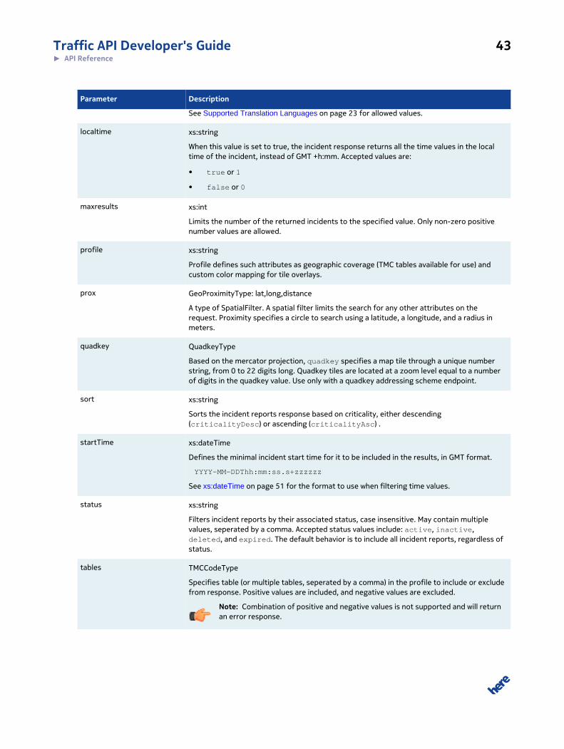
localtime xs:string
When this value is set to true, the incident response returns all the time values in the localtime of the incident, instead of GMT +h:mm. Accepted values are:
• true or 1
• false or 0
maxresults xs:int
Limits the number of the returned incidents to the specified value. Only non-zero positivenumber values are allowed.
profile xs:string
Profile defines such attributes as geographic coverage (TMC tables available for use) andcustom color mapping for tile overlays.
prox GeoProximityType: lat,long,distance
A type of SpatialFilter. A spatial filter limits the search for any other attributes on therequest. Proximity specifies a circle to search using a latitude, a longitude, and a radius inmeters.
quadkey QuadkeyType
Based on the mercator projection, quadkey specifies a map tile through a unique numberstring, from 0 to 22 digits long. Quadkey tiles are located at a zoom level equal to a numberof digits in the quadkey value. Use only with a quadkey addressing scheme endpoint.
sort xs:string
Sorts the incident reports response based on criticality, either descending(criticalityDesc) or ascending (criticalityAsc) .
startTime xs:dateTime
Defines the minimal incident start time for it to be included in the results, in GMT format.
YYYY-MM-DDThh:mm:ss.s+zzzzzz
See xs:dateTime on page 51 for the format to use when filtering time values.
status xs:string
Filters incident reports by their associated status, case insensitive. May contain multiplevalues, seperated by a comma. Accepted status values include: active, inactive,deleted, and expired. The default behavior is to include all incident reports, regardless ofstatus.
tables TMCCodeType
Specifies table (or multiple tables, seperated by a comma) in the profile to include or excludefrom response. Positive values are included, and negative values are excluded.
Note: Combination of positive and negative values is not supported and will returnan error response.

Traffic API Developer's Guide 44► API Reference
Parameter Description
The default behavior is to return all tables in the profile. See TMCCodeType on page 46 fora full list of TMC tables or your customer profile for a list of tables available to you.
type xs:string
Filters items by their associated type, case insensitive. May contain multiple values,seperated by a comma. Accepted status values include:
• Accident
• Congestion
• DisabledVehicle
• RoadHazard
• Construction
• PlannedEvent
• MassTransit
• OtherNews
• Weather
• Misc
The default behavior is to include all incident reports, regardless of type.
verified xs:boolean
Used to filter incident response to include or exclude incident reports that have beenconfirmed. Accepted values are:
• true or 1
• false or 0
The default behavior is to include all incident reports, regardless of type.
Additional Request ParametersThis section contains additional HERE Traffic API request parameters for service requests.
Table 20: Additional Request Parameters
Attribute Description Returned Value
version Returns the version information about HERE Traffic API,
including the components for making a Traffic Service.
Service: Traffic Service, Version:
6.0.24.3
exodus.html Does a self-test check on HERE Traffic API. If the service is
not ready to serve tiles, then a 404 error message is returned.
200 Ok
isalive Does a self-test check on HERE Traffic API. If the service is
not ready to serve tiles, then a 404 error message is returned.
200 Ok
Traffic API Developer's Guide 45► API Reference
Attribute Description Returned Value
http://
traffic.api.here.com/
traffic/6.0/xsd/
incident.xsd
Returns the XSD Schema used for the incidents resource. XSD
Data TypesArticles in this section provide a comprehensive reference to types used throughtout the Traffic API.
LatitudeTypeLocation of a place on Earth north or south of the equator.
LatitudeType is a xs:double type with the following restrictions:
• Must satisfy: -90 ≤ value ≤ 90
• Unit: decimal degrees
• Reference System: WGS 84
• Precision: 7 positions after decimal point, additional positions are ignored
Query Parameter Representation
Valid examples:
45.1234567-12.345678945.123 -12.3
LongitudeTypeLocation of a place on Earth east or west of the prime meridian.
LongitudeType is a xs:double type with the following restrictions:
• Must satisfy: -180 ≤ value ≤ 180
• Unit decimal degrees
• Reference System: WGS 84
• Precision: 7 positions after decimal point, additional positions are ignored

Traffic API Developer's Guide 46► API Reference
Query Parameter Representation
Valid examples:
90.1234567-120.345678990.123 -120.3
FunctionalClassTypeThe functional class is used to classify roads depending on the speed, importance and connectivity of
the road.
The value represents one of the five levels:
• 1: allowing for high volume, maximum speed traffic movement
• 2: allowing for high volume, high speed traffic movement
• 3: providing a high volume of traffic movement
• 4: providing for a high volume of traffic movement at moderate speeds between neighbourhoods
• 5: roads whose volume and traffic movement are below the level of any functional class
FunctionalClassType is a xs:byte type with the following restrictions:
• Must satisfy: 1 ≤ value ≤ 5
TMCCodeTypeTMCCodeType is a xs:string type with the following restrictions:
• Fixed length: 5 characters
• Format: ECC+CCD+Table, where the following rules apply:
ECC is the Extended Country Code.
CCD is the TMC country code.
Table is the defined TMC Table
Query Parameter Representation
To provide a value for the tables query parameter to filter based on TMC codes, you would
concatenate as shown below.
&tables=ECC+CCD+Table
Traffic API Developer's Guide 47► API Reference
So, for example, to filter for the New England region in the US, you would concatenate the US
extended country code (A0) with the TMC country code (1) and the New England region table ID (29),
and the resulting parameter/value pair would be:
&tables=A0129
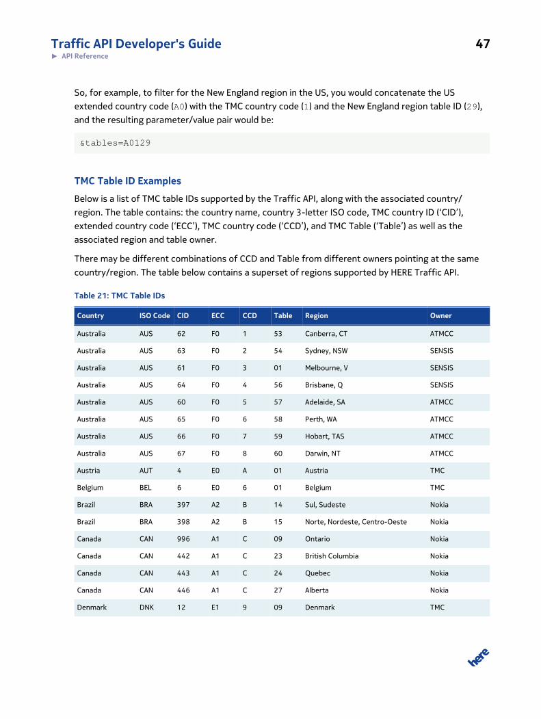
TMC Table ID Examples
Below is a list of TMC table IDs supported by the Traffic API, along with the associated country/
region. The table contains: the country name, country 3-letter ISO code, TMC country ID (‘CID’),
extended country code (‘ECC’), TMC country code (‘CCD’), and TMC Table (‘Table’) as well as the
associated region and table owner.
There may be different combinations of CCD and Table from different owners pointing at the same
country/region. The table below contains a superset of regions supported by HERE Traffic API.
Table 21: TMC Table IDs
Country ISO Code CID ECC CCD Table Region Owner
Australia AUS 62 F0 1 53 Canberra, CT ATMCC
Australia AUS 63 F0 2 54 Sydney, NSW SENSIS
Australia AUS 61 F0 3 01 Melbourne, V SENSIS
Australia AUS 64 F0 4 56 Brisbane, Q SENSIS
Australia AUS 60 F0 5 57 Adelaide, SA ATMCC
Australia AUS 65 F0 6 58 Perth, WA ATMCC
Australia AUS 66 F0 7 59 Hobart, TAS ATMCC
Australia AUS 67 F0 8 60 Darwin, NT ATMCC
Austria AUT 4 E0 A 01 Austria TMC
Belgium BEL 6 E0 6 01 Belgium TMC
Brazil BRA 397 A2 B 14 Sul, Sudeste Nokia
Brazil BRA 398 A2 B 15 Norte, Nordeste, Centro-Oeste Nokia
Canada CAN 996 A1 C 09 Ontario Nokia
Canada CAN 442 A1 C 23 British Columbia Nokia
Canada CAN 443 A1 C 24 Quebec Nokia
Canada CAN 446 A1 C 27 Alberta Nokia
Denmark DNK 12 E1 9 09 Denmark TMC

Traffic API Developer's Guide 48► API Reference
Country ISO Code CID ECC CCD Table Region Owner
Finland FIN 15 E1 6 17 Finland TMC
France FRA 16 E1 F 32 France TMC
Germany DEU 58 E0 D 01 Germany TMC
Greece GRC 19 E1 1 18 Greece BeMobile
India IND 858 F2 5 02 Central Nokia
India IND 859 F2 5 03 South Nokia
India IND 860 F2 5 04 North NATVEQ
Indonesia IDN 917 F2 C 21 Jakarta GEWI
Ireland IRL 23 E3 2 42 Ireland TrafficNav
Italy ITA 25 E0 5 01 Italy InfoBlu
Luxembourg LUX 32 E1 7 01 Luxembourg TMC
Mexico MEX 995 A5 F 36 Mexico Nokia
Netherlands NLD 39 E3 8 17 Netherlands TMC
Norway NOR 40 E2 F 49 Norway
Poland POL 41 E2 3 05 Poland
Portugal PRT 42 E4 8 42 Portugal
Russia RUS 629 E0 7 23 Moscow Nokia
Russia RUS 630 E0 7 24 St. Petersburg Nokia
Russia RUS 631 E0 7 25 Yekaterinburg Nokia
Russia RUS 632 E0 7 26 Nizny Novgorod Nokia
Russia RUS 633 E0 7 27 Krasnodar, Rostov-on-Don Nokia
Russia RUS 634 E0 7 28 Novosibirsk Nokia
Saudi Arabia SAU 685 F0 9 26 Saudi Arabia Nokia
South Africa ZAF 712 D0 A 17 South Africa Netstar
Spain ESP 49 E2 E 17 Spain
Sweden SWE 50 E3 E 33 Sweden
Switzerland CHE 51 E1 4 09 Switzerland
Thailand THA 227 F3 2 19 Thailand ITS Thailand
Turkey TUR 243 E3 3 36 Turkey (former BeMobile table) Nokia

Traffic API Developer's Guide 49► API Reference
Country ISO Code CID ECC CCD Table Region Owner
UAE ARE 1097 F2 D 19 United Arab Emirates (Dubai, Abu
Dhabi, Sharjah)
Nokia
UK GBR 55 E1 C 07 Great Britain TrafficMaster
UK GBR 55 E1 C 10 Great Britain ITIS
Ukraine UKR 56 E4 6 33 Ukraine Nokia
USA USA 999 A0 1 01 Alabama/Georgia Nokia
USA USA 266 A0 1 02 Florida Nokia
USA USA 267 A0 1 03 Eastern PA/Southern NJ/Delaware Nokia
USA USA 268 A0 1 04 Western PA/New York Nokia
USA USA 269 A0 1 05 Northern CA/Nevada Nokia
USA USA 270 A0 1 06 Southern CA & Las Vegas Nokia
USA USA 271 A0 1 07 Illinois/Indiana/Wisconsin Nokia
USA USA 272 A0 1 08 Michigan/Ohio Nokia
USA USA 274 A0 1 10 Virginia/Maryland/North Carolina Nokia
USA USA 275 A0 1 11 Northern Texas/Oklahoma Nokia
USA USA 276 A0 1 12 Southern Texas Nokia
USA USA 277 A0 1 13 AR/LA/MS/TN Nokia
USA USA 278 A0 1 14 Oregon/Washington Nokia
USA USA 279 A0 1 15 Arizona/New Mexico/Texas Nokia
USA USA 280 A0 1 16 Colorado/Utah Nokia
USA USA 281 A0 1 17 Idaho/Montana/Wyoming Nokia
USA USA 282 A0 1 18 North Central States Nokia
USA USA 283 A0 1 19 Kansas/Missouri/Southern Illinois Nokia
USA USA 284 A0 1 20 New York/Northern NJ/Connecticut Nokia
USA USA 285 A0 1 21 Kentucky/Tennessee/Indiana Nokia
USA USA 286 A0 1 22 Ohio/Maryland/West Virginia Nokia
USA USA 289 A0 1 25 North Carolina/South Carolina Nokia
USA USA 290 A0 1 26 Hawaii Nokia
USA USA 293 A0 1 29 New England Nokia
USA USA 297 A0 1 33 Alaska Nokia

Traffic API Developer's Guide 50► API Reference
LanguageCodeTypeThis type is used whenever a language of a value needs to be referenced.
LanguageCodeType is a xs:string type with the following restrictions:
• Format: Language code following RFC5646
Query Parameter Representation
Valid examples:
deen
LanguageCodeParameterTypeThis type is used whenever a language filter needs to be specified.
LanguageCodeparameterType is a xs:string type with the following restrictions:
• Format: Language code following RFC4647
Query Parameter Representation
Valid examples:
deen
CountryCodeTypeThis type is used whenever a country needs to be referenced for localization.
CountryCodeParameterType is a xs:string type with the following restrictions:
• Format: Country code according to ISO 3166-1-alpha-2
Query Parameter Representation
Valid examples:
FRDE
Built-in Resources Types

Traffic API Developer's Guide 51► API Reference
xs:dateTimeThe lexical representation of xs:dateTime consists of finite-length sequences of characters of the
following form:
YYYY + "-" + MM + "-" + DD + "T" + hh + ":"+ mm + ":" + ss + ("." + s)? + (zzzzzz)?
Syntax Description
YYYY is a four-or-more digit optionally negative-signed numeral that represents the year; if more than four digits,
leading zeros are prohibited, and '0000' is prohibited
MM is a two-digit numeral that represents the month
DD is a two-digit numeral that represents the day
hh is a two-digit numeral that represents the hour The value 24 is permitted if the minutes and seconds
represented are zero, and the dateTime value so represented is the first instant of the following day (the hour
property of a dateTime object in the value space cannot have a value greater than 23)
mm is a two-digit numeral that represents the minute
ss is a two-integer-digit numeral that represents the whole seconds
s represents the fractional seconds (optional)
zzzzzz represents the timezone
The timezone portion zzzzzz is represented as follows:
(("+" | "-") + hh + ":"+ mm) | "Z"
Syntax Description
"+"|"-" "+" indicates a non-negative duration,
"-" indicates a non-positive duration.
hh is a two-digit numeral (with leading zeros as required) that represents the hours
mm is a two-digit numeral that represents the minutes
"Z" "Z" represent the zero-length duration timezone, UTC "Z" is the canonical representation for UTC dateTime
values.

Traffic API Developer's Guide 52► API Reference
DateTime Example
2002-10-10T12:00:00-05:00 (noon on 10 October 2002, Central Daylight Savings Time as
well as Eastern Standard Time in the U.S.) is 2002-10-10T17:00:00Z, five hours later than
2002-10-10T12:00:00Z.
xs:listXML Schema provides a list type allowing more than one item within a single XML element. Items are
separated by space.
The following example defines a list element named "Foo" which contains string elements.
<xs:simpleType name="MyListType"> <xs:list itemType="xs:string"/></xs:simpleType><xs:element name="Foo" type="MyListType">
A valid instantiation of the "Foo" element would be
<Foo>ABC DEF GHI</Foo>
In this example, the "Foo" element contains the three items "ABC", "DEF", and "GHI".
In representation formats other than XML, the space as separator sometimes becomes unhandy.
Therefore, a standard representation format for list types is defined for each representation format
below.
Query Parameter Representation
In query strings, items of list types are separated by one of the following characters:
"," (comma) is used at top level
<Foo[0]> + "," + <Foo[1]> + "," + <Foo[2]> + "," + …
";" (semicolon) is used at second level, or if comma is already used in the representation of the list
items
<Foo[0]> + ";" + <Foo[1]> + ";" + <Foo[2]> + ";" + …
"!" (exclamation point) is used at third level, or if comma and semicolon are already used in the
representation of the list items
<Foo[0]> + "!" + <Foo[1]> + "!" + <Foo[2]> + "!" + …

Traffic API Developer's Guide 53► API Reference
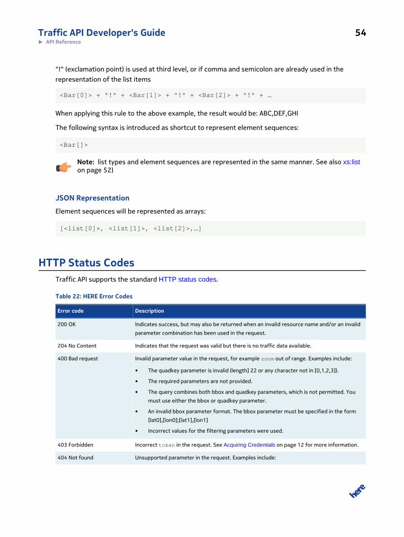
The following syntax is introduced as shortcut to represent list types:
<Foo[]>
Note: List types and element sequences are represented in the same manner (see alsoxs:sequence on page 53).
JSON Representation
List types are represented as arrays:
[<list[0]>, <list[1]>, <list[2]>, …]
xs:sequenceA schema can define elements which can appear more than once. The following example defines an
element named "Bar" which can be included n times.
<xs:element name="Bar" type="xs:string" maxOccurs="unbounded"/>
A valid instantiation of the "Bar" element would be
<Bar>ABC</Bar><Bar>DEF</Bar><Bar>GHI</Bar>
Element sequences are described in all API documentations with an "[]" as suffix like this:
Bar [] sequence of strings
In representation formats other than XML, listing the same element more than once is inconvenient,
so a standard representation format for sequences is defined for each representation format below.
Query Parameter Representation
In query strings, items of list types are separated by one of the following characters:
"," (comma) is used at top level
<Bar[0]> + "," + <Bar[1]> + "," + <Bar[2]> + "," + …
";" (semicolon) is used at second level, or if comma is already used in the representation of the list
items
<Bar[0]> + ";" + <Bar[1]> + ";" + <Bar[2]> + ";" + …
Traffic API Developer's Guide 54► API Reference
"!" (exclamation point) is used at third level, or if comma and semicolon are already used in the
representation of the list items
<Bar[0]> + "!" + <Bar[1]> + "!" + <Bar[2]> + "!" + …
When applying this rule to the above example, the result would be: ABC,DEF,GHI
The following syntax is introduced as shortcut to represent element sequences:
<Bar[]>
Note: list types and element sequences are represented in the same manner. See also xs:liston page 52)
JSON Representation
Element sequences will be represented as arrays:
[<list[0]>, <list[1]>, <list[2]>,…]
HTTP Status CodesTraffic API supports the standard HTTP status codes.
Table 22: HERE Error Codes
Error code Description
200 OK Indicates success, but may also be returned when an invalid resource name and/or an invalid
parameter combination has been used in the request.
204 No Content Indicates that the request was valid but there is no traffic data available.
400 Bad request Invalid parameter value in the request, for example zoom out of range. Examples include:
• The quadkey parameter is invalid (length] 22 or any character not in [0,1,2,3]).
• The required parameters are not provided.
• The query combines both bbox and quadkey parameters, which is not permitted. You
must use either the bbox or quadkey parameter.
• An invalid bbox parameter format. The bbox parameter must be specified in the form
[lat0],[lon0];[lat1],[lon1]
• Incorrect values for the filtering parameters were used.
403 Forbidden Incorrect token in the request. See Acquiring Credentials on page 12 for more information.
404 Not found Unsupported parameter in the request. Examples include:

Traffic API Developer's Guide 55► API Reference
Error code Description
• The domain-section of the URL does not point at a valid service environment.
• The path-section of the URL does not point at a quadkey service instance.
500 Internal error The service is not available or server configuration issue.
503 Service Unavailable Indicates that the services is temporarily unavailable due to system overload or maintenance
The API supports the standard authorization mechanism common to all HERE APIs. This mechanism
can return status codes detailed below.
Table 23: Authentication Responses
Scenario Response Code HTTP Response Message
app_id and app_code are both
missing
400 The request is missing the app_id and app_code parameters.
They must both be passed as query parameters. If you do not
have app_id and app_code, please obtain them see Acquiring
Credentials on page 12
app_id is there but the
app_code is missing
400 The request is missing the app_code. It must be passed as a query
parameter.
app_code is there but app_id
is missing
400 The request is missing the app_id. It must be passed as a query
parameter.
app_id and app_code are both
present in the request but the
validation fails.
401 This is not a valid app_id and app_code pair. Please verify that
the values are not swapped between the app_id and app_code.
See also Acquiring Credentials on page 12
No matching pattern in the
authentication mechanism
configuration for this requested
URL
404 The URL resource cannot be found.
If the requested URL does
exist but the HTTP verb is not
supported for that URL
405 The HTTP method is not supported for this URL.
If SSL is required, but the
request is not sent over SSL.
400 SSL/TLS is required for this URL; please retry the request using
SSL/TLS.
Unexpected authentication error 500 Server error - please retry again at a later time.