Determination of Suitable Landfill Site Using Geospatial ….pdf · · 2014-11-07Analysis: A Case...
6
International Journal of Science and Research (IJSR) ISSN (Online): 2319-7064 Impact Factor (2012): 3.358 Volume 3 Issue 11, November 2014 www.ijsr.net Licensed Under Creative Commons Attribution CC BY Determination of Suitable Landfill Site Using Geospatial Techniques and Multi-Criteria Decision Analysis: A Case Study of Nakuru Town, Kenya Fides K. Kirimi 1 , Edward H. Waithaka 2 1, 2 Department of Geomatic Engineering and Geospatial Information Systems (GEGIS), Jomo Kenyatta University of Agriculture and Technology Abstract: The current system of selecting waste disposal sites in Kenya is manual, costly and time consuming. Computerizing the site selection process using Geographical Information System (GIS) can function as a decision support tool for improved efficient and effective municipal solid waste management. This study’s aim was to develop landfill siting by employing GIS-based Multi-Criteria Decision Analysis (MCDA) such as Analytical Hierarchy Process (AHP) for evaluating the suitability for landfill site selection in Nakuru Town. The initial step of the methodology was GIS based operation and analysis that excluded all areas unsuitable for waste disposal facility. The selection of suitable criteria for landfill site selection were generated based on pre-existing information published on landfill criteria, existing environmental laws and regulatory requirements, as well as the prevailing local conditions. Seven suitability criteria are identified; geology, soil, land use, slope, surface waters, roads, and protected areas. Criteria were mapped using the GIS technique and spatial analytic tools, weights were determined by pairwise comparison matrix for the criterion maps and overlaid using GIS to create a landfill suitability map. Our results show that 62.8% of the area was unsuitable for landfill siting; out of the remaining area, 5.52 % of the area was most suitable 11.24% moderately suitable, 19.32% suitable and 0.76% poorly suitable. Keywords: Geographical Information System GIS, Remote Sensing, Landfill, Multi-Criteria Decision Analysis (MCDA), Analytical Hierarchy Process (AHP) 1. Introduction Effective solid waste management is a major challenge facing most African developing countries mainly due to lack of good governance, planning and inadequate technology. The challenge is more serious in Kenya’s urban centers where population growth and economic activities have led to an increase in solid waste generation rates. However, this increase has not been accompanied by an equivalent increase in the capacity of relevant authorities to deal with the problem. [1] Nakuru town is the fourth largest urban centre in Kenya with an estimated population growth rate of 13% per year [2] with waste generation rates of approximately 250 tons/day of which 45% is disposed off to at dumpsite, 19% of the total wastes is recycled or recovered by informal sectors and the remaining 36% is left unattended to and eventually deposited to the surrounding environment by storm water and wind. [3] The practice of solid waste management in Nakuru is mainly open dump system with only one designated site popularly known as Gioto. The disposal ground started off as a tipping site in 1975 site without provision of daily/frequent covering of disposed wastes [4]. The dumpsite exposes the public, especially those at close proximity to unacceptable levels of pollutants which have adverse effects on human health. The problem is exacerbated by the fact that the siting for the dump was not informed by any scientific analysis that took in to consideration the underlying soil structure, topography, surface water, proximity from protected areas, faults, road networks and settlement areas. The process of solid waste disposal management consists of collection, transportation and disposal. One way to dispose solid waste is to place it in properly designed, constructed, and managed landfills, where it is safely contained. Nevertheless, the selection of a suitable site for solid waste disposal is a daunting task, [5] complex spatial problem, involving multiple criteria which require the use of spatial analysis models. [6] The Geographical Information System (GIS) offers affordable tool since many aspects such as planning and operations are highly dependent on spatial data. [7] Not only does GIS reduce time and cost of the site selection but also provides digital database management system that is ideal for advanced site selection that can efficiently store, retrieve, analyze and display information according to user defined specifications. [8] Multiple criteria decision analysis (MCDA) is based on making actual decisions from a number of choices by evaluating them based on a set of measurable criteria. Siting a landfill is a multi-criterion decision-making process in which both GIS and multi-criteria methodology are used [9]. Analytic Hierarchy Process (AHP) is a multi-criteria decision technique that helps the decision maker to set priorities and make the best decision by reducing complex evaluations to a series of pairwise comparisons. [10] The higher the weight the more important the corresponding criterion. Similarly the higher the score assigned for a fixed criterion, the better the performance of the option based on that criterion. When combined with GIS, MCDA and AHP it offers a powerful tool in generation of suitability maps. In this study we have employed this approach. Paper ID: OCT14876 500
Transcript of Determination of Suitable Landfill Site Using Geospatial ….pdf · · 2014-11-07Analysis: A Case...

International Journal of Science and Research (IJSR) ISSN (Online): 2319-7064
Impact Factor (2012): 3.358
Volume 3 Issue 11, November 2014 www.ijsr.net
Licensed Under Creative Commons Attribution CC BY
Determination of Suitable Landfill Site Using Geospatial Techniques and Multi-Criteria Decision Analysis: A Case Study of Nakuru Town, Kenya
Fides K. Kirimi 1, Edward H. Waithaka2
1, 2Department of Geomatic Engineering and Geospatial Information Systems (GEGIS), Jomo Kenyatta
University of Agriculture and Technology
Abstract: The current system of selecting waste disposal sites in Kenya is manual, costly and time consuming. Computerizing the site selection process using Geographical Information System (GIS) can function as a decision support tool for improved efficient and effective municipal solid waste management. This study’s aim was to develop landfill siting by employing GIS-based Multi-Criteria Decision Analysis (MCDA) such as Analytical Hierarchy Process (AHP) for evaluating the suitability for landfill site selection in Nakuru Town. The initial step of the methodology was GIS based operation and analysis that excluded all areas unsuitable for waste disposal facility. The selection of suitable criteria for landfill site selection were generated based on pre-existing information published on landfill criteria, existing environmental laws and regulatory requirements, as well as the prevailing local conditions. Seven suitability criteria are identified; geology, soil, land use, slope, surface waters, roads, and protected areas. Criteria were mapped using the GIS technique and spatial analytic tools, weights were determined by pairwise comparison matrix for the criterion maps and overlaid using GIS to create a landfill suitability map. Our results show that 62.8% of the area was unsuitable for landfill siting; out of the remaining area, 5.52 % of the area was most suitable 11.24% moderately suitable, 19.32% suitable and 0.76% poorly suitable. Keywords: Geographical Information System GIS, Remote Sensing, Landfill, Multi-Criteria Decision Analysis (MCDA), Analytical Hierarchy Process (AHP) 1. Introduction Effective solid waste management is a major challenge facing most African developing countries mainly due to lack of good governance, planning and inadequate technology. The challenge is more serious in Kenya’s urban centers where population growth and economic activities have led to an increase in solid waste generation rates. However, this increase has not been accompanied by an equivalent increase in the capacity of relevant authorities to deal with the problem. [1] Nakuru town is the fourth largest urban centre in Kenya with an estimated population growth rate of 13% per year [2] with waste generation rates of approximately 250 tons/day of which 45% is disposed off to at dumpsite, 19% of the total wastes is recycled or recovered by informal sectors and the remaining 36% is left unattended to and eventually deposited to the surrounding environment by storm water and wind. [3] The practice of solid waste management in Nakuru is mainly open dump system with only one designated site popularly known as Gioto. The disposal ground started off as a tipping site in 1975 site without provision of daily/frequent covering of disposed wastes [4]. The dumpsite exposes the public, especially those at close proximity to unacceptable levels of pollutants which have adverse effects on human health. The problem is exacerbated by the fact that the siting for the dump was not informed by any scientific analysis that took in to consideration the underlying soil structure, topography, surface water, proximity from protected areas, faults, road networks and settlement areas.
The process of solid waste disposal management consists of collection, transportation and disposal. One way to dispose solid waste is to place it in properly designed, constructed, and managed landfills, where it is safely contained. Nevertheless, the selection of a suitable site for solid waste disposal is a daunting task, [5] complex spatial problem, involving multiple criteria which require the use of spatial analysis models. [6] The Geographical Information System (GIS) offers affordable tool since many aspects such as planning and operations are highly dependent on spatial data. [7] Not only does GIS reduce time and cost of the site selection but also provides digital database management system that is ideal for advanced site selection that can efficiently store, retrieve, analyze and display information according to user defined specifications. [8] Multiple criteria decision analysis (MCDA) is based on making actual decisions from a number of choices by evaluating them based on a set of measurable criteria. Siting a landfill is a multi-criterion decision-making process in which both GIS and multi-criteria methodology are used [9]. Analytic Hierarchy Process (AHP) is a multi-criteria decision technique that helps the decision maker to set priorities and make the best decision by reducing complex evaluations to a series of pairwise comparisons. [10] The higher the weight the more important the corresponding criterion. Similarly the higher the score assigned for a fixed criterion, the better the performance of the option based on that criterion. When combined with GIS, MCDA and AHP it offers a powerful tool in generation of suitability maps. In this study we have employed this approach.
Paper ID: OCT14876 500

International Journal of Science and Research (IJSR) ISSN (Online): 2319-7064
Impact Factor (2012): 3.358
Volume 3 Issue 11, November 2014 www.ijsr.net
Licensed Under Creative Commons Attribution CC BY
2. Materials and Methods 2.1 Study Area Nakuru town lies approximately 00 15’ and 00 31’South, and 360 00’ 36012’ East. Nakuru is at an altitude of 1859 meters
above sea level and covers an area of approximately 290Km2. The town is surrounded by geographical features; the Menengai crater to the north, the Bahati highlands to the North West, the Eburu hills and Lake Nakuru national park (LNNP) within the municipal boundary.
Figure 1: Study Area
2.2 Methodology The study relied on the existing soil data, geology/lithology data, road network data, hydrology data and city shape file. Some data was extracted from LANDSAT 8 ETM+ 28.5 (m) resolution image to determine land use/ land cover maps of the study area. All the above data were collected, manipulated and analyzed in GIS environment to be used for further analysis. Suitable criteria for landfill site selection in Nakuru were generated based on pre-existing information published on landfill criteria, existing environmental laws and regulatory requirements, as well as the prevailing local conditions. Seven important criteria were identified protected areas, distance to streams and water bodies, distance from transportation routes, underlying soil structure and geology and geological structures of the study area. Digital Elevation Model (DEM 30*30m resolution) was used to derive slope. These criteria were divided into constraint and factor criteria where the former represents unacceptable areas, latter represented the acceptable areas for landfill siting. GIS buffering was used to screen out unsuitable areas based on the defined criteria. All the
constraint criterion maps were overlaid to produce the final factor map. Acceptable areas were extracted from constraint maps and classified into classes of most suitable, suitable, unsuitable and moderately suitable for being used as site locations. This was done by weighting processes where each map layer was both internally weighted based on minimum and maximum distance to features (environmental judgment) and externally weighted using analytical hierarchy process (AHP) based on its relative importance to the waste disposal problem. Pair wise comparison was adopted for calculating weight for the criteria two criteria had to be considered at a time and for each comparison it was decided which of the two criteria was most important, and then assigned score was given to show how much more important it is. 2.3 Criteria used in the Analysis Soils: Figure 2 shows the soil suitability map of the study area. Soil should be of sufficiently low permeability to significantly slow the passage of leachate from the site. Soil characteristics such as texture and depth were considered. Clay textured soil was most preferred for landfill as it is impermeable to leachate. Thus, sites in clay-rich environments are most preferable. Moreover, areas with
Paper ID: OCT14876 501

International Journal of Science and Research (IJSR) ISSN (Online): 2319-7064
Impact Factor (2012): 3.358
Volume 3 Issue 11, November 2014 www.ijsr.net
Licensed Under Creative Commons Attribution CC BY
deep soil are preferred as it provides soil for lining and covering solid waste after each disposal day. The dominant soil type in the area is the allophone loamy soils which cover 57% of the high gradient areas followed by montmorillonitic and Kaolinitic clay soils which cover 43% of the area. Geological and lithologic units: Figure 3 shows a thematic map of the geology of the study area, characterized by different lava and pyroclastics rocks of Tertiary Quaternary age, basalt, eolian, consolidated rocks which have been affected by a series of faulting, and are overlain by recent sediments. It is also characterized by the occurrence of faults, joints and other structures within the different volcanic rocks. Most parts of the study area are covered by pyroclastics rock type of low permeability due to low degree of weathering and fracture. For this study we considered geology structure of very low permeability to minimize movement of leachate.
Figure 2: Soil suitability map showing different soils found
in the study area.
Figure 3: Geology and Lithologic suitability map of the
study area Distance from protected areas: A landfill must not be located in close proximity to sensitive areas or protected
areas and areas gazette for special protection. Figure 4 shows proximity map with buffering distances prepared to identify most preferable site for a landfill. Multiple Ring Buffers of 0-750, 750-1000, 1000-1500, 1500-2500 m was used to delineate exclusionary areas form the siting process. Areas further away from the protected areas were most preferred as opposed to those nearer these areas. A distance greater than 2500m was considered suitable for this study. Slope: slope is one of the key criteria in landfill siting because it can reduce or increase stability of landfills. DEM was generated and used to derive slope. Figure 5 shows the slope suitability indicating 20% of the study area as a steep/high slope >30%. A steep slope is neither recommended due to difficulty in construction and/or leveling. In general, steeper slopes have less soil development, high erosion rates, shallow depths, and courser texture. Therefore, areas of lower slope were best considered than the areas with higher slope. For this study a slope of less than 12% was most suitable.
Figure 4: Map showing exclusionary areas from Landfill
siting in the study area
Figure 5: Slope Map showing areas of high and low slope
gradient in the study area
Paper ID: OCT14876 502
International Journal of Science and Research (IJSR) ISSN (Online): 2319-7064
Impact Factor (2012): 3.358
Volume 3 Issue 11, November 2014 www.ijsr.net
Licensed Under Creative Commons Attribution CC BY
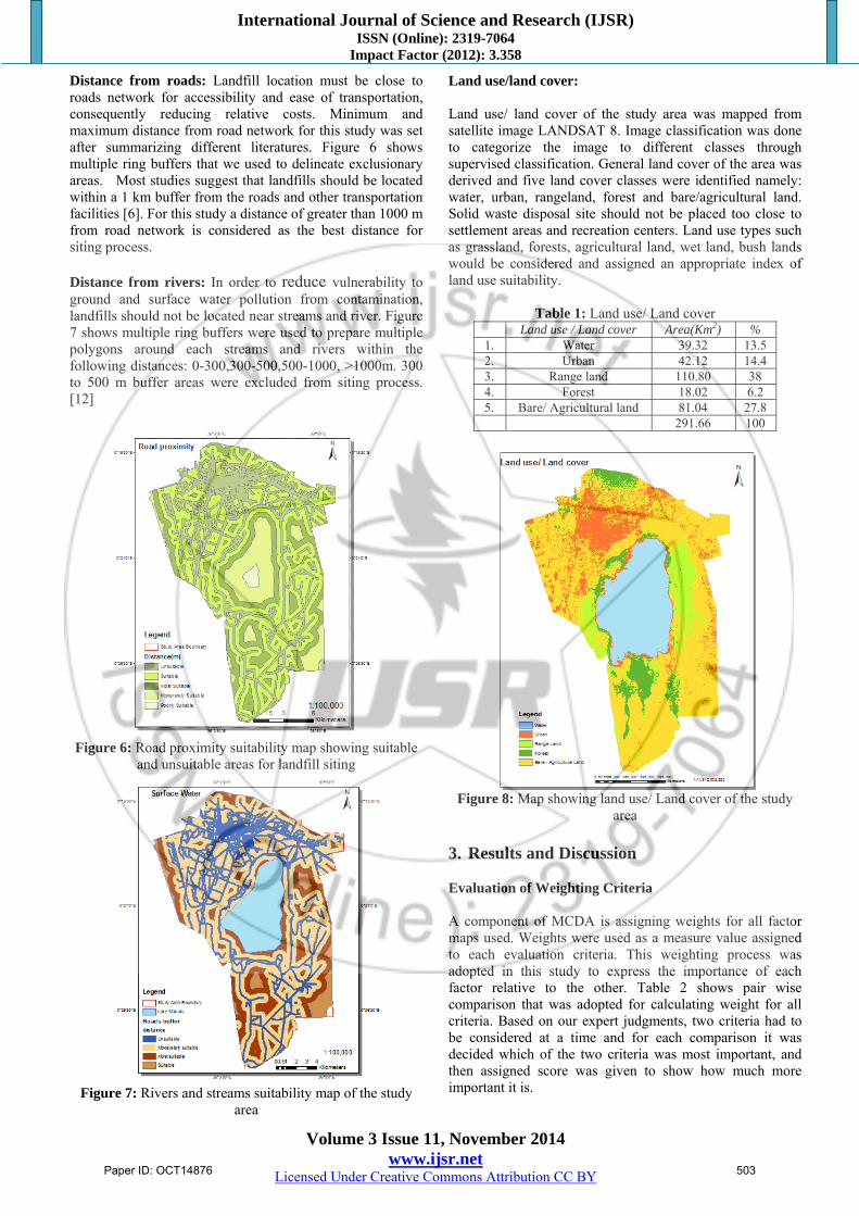
Distance from roads: Landfill location must be close to roads network for accessibility and ease of transportation, consequently reducing relative costs. Minimum and maximum distance from road network for this study was set after summarizing different literatures. Figure 6 shows multiple ring buffers that we used to delineate exclusionary areas. Most studies suggest that landfills should be located within a 1 km buffer from the roads and other transportation facilities [6]. For this study a distance of greater than 1000 m from road network is considered as the best distance for siting process. Distance from rivers: In order to reduce vulnerability to ground and surface water pollution from contamination, landfills should not be located near streams and river. Figure 7 shows multiple ring buffers were used to prepare multiple polygons around each streams and rivers within the following distances: 0-300,300-500,500-1000, >1000m. 300 to 500 m buffer areas were excluded from siting process. [12]
Figure 6: Road proximity suitability map showing suitable
and unsuitable areas for landfill siting
Figure 7: Rivers and streams suitability map of the study
area
Land use/land cover: Land use/ land cover of the study area was mapped from satellite image LANDSAT 8. Image classification was done to categorize the image to different classes through supervised classification. General land cover of the area was derived and five land cover classes were identified namely: water, urban, rangeland, forest and bare/agricultural land. Solid waste disposal site should not be placed too close to settlement areas and recreation centers. Land use types such as grassland, forests, agricultural land, wet land, bush lands would be considered and assigned an appropriate index of land use suitability.
Table 1: Land use/ Land cover Land use / Land cover Area(Km2) %
1. Water 39.32 13.5 2. Urban 42.12 14.4 3. Range land 110.80 38 4. Forest 18.02 6.2 5. Bare/ Agricultural land 81.04 27.8 291.66 100
Figure 8: Map showing land use/ Land cover of the study
area
3. Results and Discussion Evaluation of Weighting Criteria A component of MCDA is assigning weights for all factor maps used. Weights were used as a measure value assigned to each evaluation criteria. This weighting process was adopted in this study to express the importance of each factor relative to the other. Table 2 shows pair wise comparison that was adopted for calculating weight for all criteria. Based on our expert judgments, two criteria had to be considered at a time and for each comparison it was decided which of the two criteria was most important, and then assigned score was given to show how much more important it is.
Paper ID: OCT14876 503

International Journal of Science and Research (IJSR) ISSN (Online): 2319-7064
Impact Factor (2012): 3.358
Volume 3 Issue 11, November 2014 www.ijsr.net
Licensed Under Creative Commons Attribution CC BY
A comparison matrix among the criteria was developed, indicating the relative importance of the criterion in the columns compared to the criterion in the rows which was subsequently used to compute an Eigen vector, which ultimately represented the ranking of the criteria.
Table 2: A Pairwise Comparison matrix, λ max=7.1562, CI=0.026 CR = 0.04 ≥0.01
Eigen Vector Weight Percentage %LU 0.32 32 PPA 0.28 28 SL 0.16 16 S 0.11 11
G/L 0.07 7 PR 0.03 3 P.rd 0.03 3
Table 3: Derived weights and their percentage
LU PPA SL S G/L PR P.rd LU 1 2 2 3 4 9 7
PPA 0.5 1 3 3 4 9 7 SL 0.5 0.33 1 2 3 5 4 S 0.33 0.33 0.5 1 2 5 4
G/L 0.25 0.25 0.33 0.5 1 4 2 PR 0.11 0.11 0.2 0.2 0.25 1 2 P.rd 0.14 0.14 0.25 0.25 0.5 0.5 1
PR- Proximity to rivers, PPA- Proximity to protected areas, LU-land use/ Land cover, S- soil, G/L-geology, SL-slope, P.rd- proximity to roads
Figure 9: Landfill suitability Map
Landfill suitability analysis is based on different environmental and social factors. The seven factor maps were combined according to their importance, land use and land cover carried the most importance to the overall suitability map. The analysis of the weight assignment
shows that land use / land cover related factors; slope and soils are more influential than the other factors Protected areas had an overall percentage weight of 28%. Slope, soil, geology had 16%, 11% and 7% respectively. Both proximity from rivers and roads had equal importance. Accordingly, 11 candidate landfill sites each with an area greater than 0.5km2 were selected. The result of the final suitability map (Figure 9) showed that there are some discontinuous small area sites as suitable areas for landfill location. However, 62.8% of the area was unsuitable for landfill siting, 0.76% poorly suitable. Out of the remaining area, 5.52 % of the area was most suitable, these areas are preferable for landfill because of their minimum effect on environment, public health and cost effective than other parts of the study area. 11.24% was found to be moderately suitable, while 19.32% was suitable. Field verification exercise was carried out to determine the accuracy and suitability of the candidate sites. 4. Conclusion Gioto open dumping site has been posing negative impacts on the environment and public health like downstream water pollution, soil pollution and health problems to the surrounding community. The problems resulted due to not considering key factors necessary in landfill siting. The seven factor maps were combined according to their importance, land use and land cover carried the most importance to the overall suitability map. Protected areas had an overall percentage weight of 28%. Slope, soil, geology had 16%, 11% and 7% respectively. Both proximity from rivers and roads had equal importance. Final suitability map was created showing 11 candidate sites, Site A found on the north eastern part of Nakuru town being the most suitable, followed by sites Band C. The findings from this study can be a significant basis for replication in other towns as a step in to an efficient and effective practice of waste management and disposal. Integrating GIS and MCDA in the site selection process can greatly improve waste management sector in Nakuru town. This can be done by establishing a landfill facility to serve the town and its environs. 5. Acknowledgement Authors would like to thank Department of Environment and Nakuru Municipal Council for providing relevant information particularly Mr. Sammy Ngigi Kimani. References
[1] Global Environmental outlook report, (2010) [2] UN habitat, 2010 The UN- HABITAT water and
sanitation trust fund strategic plan. [3] MCN (2010) Municipal council of Nakuru, Strategic
Structure Plan for sustainable Urban Development, Municipal Council of, Nakuru, Kenya.
Paper ID: OCT14876 504
International Journal of Science and Research (IJSR) ISSN (Online): 2319-7064
Impact Factor (2012): 3.358
Volume 3 Issue 11, November 2014 www.ijsr.net
Licensed Under Creative Commons Attribution CC BY
[4] Kimani, N.S., (2010-2011). Sustainable Urban Water and Sanitation, Integrated Solid Waste Management, Solid Waste Sorting from the Source Change Project. Lund University, Sweden
[5] Biotto, G., Silvestri,S., Gobbo,L., Furlan, E.,Valenti, S. and Rosselli,R.(2009). GIS, Multi Criteria and Multi-Factor Spatial Analysis for the probability assessment of the existence of illegal landfills, International Journal of Geographic Information Science, 23: 10, 1233 -1244.
[6] Chang, N.B, Parvathinathan, G, Breeden, B.J. (2007). Combining GIS with fuzzy multi criteria decision-making for landfill siting in a fast growing urban region, Journal of Environmental Management, 1:11, 1-15.
[7] Nishanth,T., Prakash, M.N. and Vijith, H. (2010). Suitable site determination for urban solid waste disposal using GIS and Remote sensing techniques in Kottayam Municipality, India, International Journal of Geomatics and Geosciences, 1:2,197-209.
[8] Shamshiry, E., Nadi, B., Mokhtar, M.B., Komoo, I. and Hashim, H. S Urban solid waste management based on geoinformatics technology, 2011, journal of Public Health and E pidemiology Vol. 3(2), pp.54-60
[9] Moeinaddini, M., Khorasani,N., Ali,D.A., Darvishsefat, A., Zienalyan,M. (2010). Siting MSW landfill using weighted linear combination and analytical hierarchy process (AHP) methodology in GIS environment (case study: Karaj), Waste Management, 30:912-920.
[10] Casini, M., Mocenni, C., Paoletti, S. and Pranzo,M., (2006). A model-based, DSS application to the management and control of coastal lagoons, 45th IEEE conference on decision and control. Stockholm, Sweden, 26-28 September.
[11] Kabite,G., (2011)GIS and remote sensing based solid waste landfill site selection: a case of Addis Ababa city, Ethiopia
[12] Solid waste dumping site suitability analysis using geographic information system (GIS) and remote sensing for Bahir Dar Town, North Western Ethiopia Tirusew Ayisheshim Ebistu and Amare Sewnet Minale
Paper ID: OCT14876 505