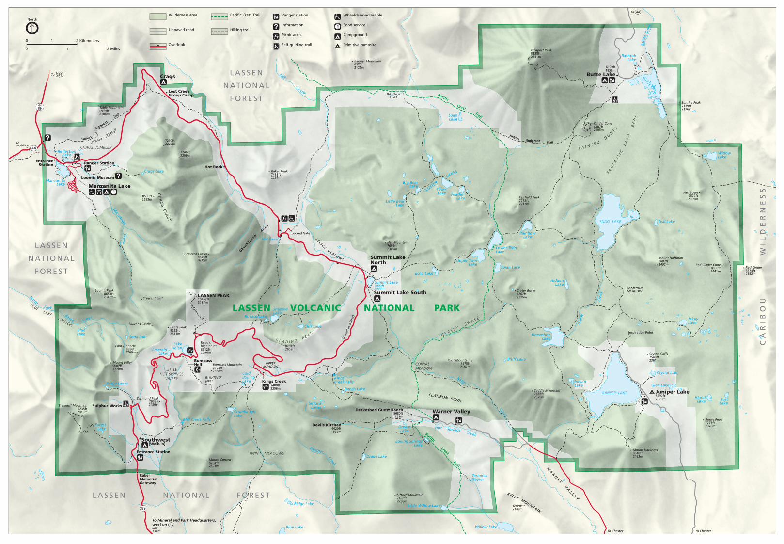
Detailed park map in PDF format - The American · PDF file2309m Red Cinder 8374ft 2552m Red...
1
36 89 299 44 44 44 89 LASSEN VOLCANIC NATIONAL PARK Trail Crest P acific Trail C r e s t P a c i fi c B U T TE L A K E JUNIPER LAKE SNAG LAKE Summit Lake 7000ft 2066m CLUSTER LA K ES Silver Lake Little Bear Lake Big Bear Lake Feather Lake Soap Lake Bathtub Lake Widow Lake Teal Lake Echo Lake Upper Twin Lake Lower Twin Lake Rainbow Lake Swan Lake Hidden Lake Jakey Lake Horseshoe Lake Bluff Lake Crystal Lake Glen Lake Island Lake East Lake Indian Lake Drake Lake Boiling Springs Lake Dream Lake Willow Lake Little Willow Lake Terminal Geyser Blue Lake Ridge Lake Crumbaugh Lake Cold Boiling Lake Forest Lake Mill Creek Falls Ridge Lakes Bench Lake Sifford Lakes Blue Lake Soda Lake Emerald Lake Lake Helen Reflection Lake Manzanita Lake Crags Lake Hat Lake Terrace Lake Shadow Lake Cliff Lake Kings Creek Falls Manzanit a C r e e k H a t Creek B u t t e Creek G r a s s y Creek Kin g s Cree k Panth e r Cre e k N o r t h F o rk B a il e y Cr e e k Hot Springs Creek Table Mountain 6919ft 2108m 7290ft 2222m 7246ft 2209m 8530ft 2592m Raker Peak 7483ft 2281m Badger Mountain 6973ft 2125m Prospect Peak 8338ft 2541m Cinder Cone 6907ft 2105m Sunrise Peak 7139ft 2176m Ash Butte 7577ft 2309m Red Cinder 8374ft 2552m Red Cinder Cone 8008ft 2441m Mount Hoffman 7883ft 2402m Crater Butte 7267ft 2215m Saddle Mountain 7638ft 2328m Pilot Mountain 7175ft 2187m Mount Harkness 8048ft 2452m Crystal Cliffs 7548ft 2361m Bonte Peak 7777ft 2370m 6919ft 2109m Hat Mountain 7695ft 2345m Sifford Mountain 7408ft 2258m Devils Kitchen 6020ft 1838m Drakesbad Guest Ranch 5680ft 1731m 8701ft 2652m 7400ft 2256m Bumpass Mountain 8753ft 2668m Road's high point 8512ft 2594m Mount Conard 8204ft 2501m Brokeoff Mountain 9235ft 2815m Mount Diller 9087ft 2770m Eagle Peak 9222ft 2811m Vulcans Castle Crescent Cliff Pilot Pinnacle 8886ft 2708m Diamond Peak 7968ft 2429m Loomis Peak 8658ft 2642m Crescent Crater 8645ft 2635m LASSEN PEAK 10457ft 3187m Fairfield Peak 7272ft 2217m Inspiration Point LASSEN NATIONAL FOREST LASSEN NATIONAL FOREST CARIBOU WILDERNESS LASSEN NATIONAL FOREST BUMPASS HELL LITTLE HOT SPRINGS VALLEY TWIN MEADOWS FLATI RON RI DGE CORRAL MEADOW G R A S S Y S W A L E K ELLY M O UNTAI N W A R N ER V A L L E Y CAMERON MEADOW R E A D I N G P E A K B L U E LAKE CANYON UPPER MEADOW D E R S C H M E A D O W S BADGER FLAT C H A O S C R A G S CHAOS JUMBLES D W A RF F O R E S T F A N T A S T I C L A V A B E D S P A I N T E D D U N E S Trail E m igra nt N obles Trail Emigrant Nobles (clo sed in winter) Information Self-guiding trail Food service Picnic area Campground Primitive campsite Ranger station Wheelchair-accessible Unpaved road Pacific Crest Trail Hiking trail Wilderness area Overlook To To To Chester To Chester To Mineral and Park Headquarters, west on 8mi 13km To Redding Summit Lake South Summit Lake North Warner Valley Juniper Lake 6792ft 2070m 6100ft 1859m Butte Lake Southwest Manzanita Lake Crags Kings Creek Bumpass Hell Entrance Station Sulphur Works Lost Creek Group Camp Entrance Station Ranger Station Loomis Museum Raker Memorial Gateway Hot Rock Locked Gate DEVASTATED AREA (Walk-in) North 0 1 0 1 2 Miles 2 Kilometers
Transcript of Detailed park map in PDF format - The American · PDF file2309m Red Cinder 8374ft 2552m Red...
36
89
299
44
44
4489
LASSEN VOLCANIC NATIONAL PARK
Trail
Crest
Pacific
Trail
Crest
Pacific
BUTTE LAKE
JUNIPER LAKE
SNAG LAKE
Summit Lake7000ft2066m
CLUSTER
LAKES
SilverLake
Little BearLake
Big BearLake
FeatherLake
SoapLake
BathtubLake
WidowLake
Teal Lake
Echo Lake
Upper TwinLake
Lower TwinLake
RainbowLake
Swan Lake
HiddenLake
JakeyLake
HorseshoeLake
Bluff Lake
Crystal Lake
Glen Lake
IslandLake East
Lake
IndianLake
Drake Lake
Boiling SpringsLake
DreamLake
Willow Lake
Little Willow Lake
TerminalGeyser
Blue Lake
Ridge Lake
CrumbaughLake
ColdBoilingLake
ForestLake
Mill Creek Falls
Ridge Lakes
Bench Lake
SiffordLakes
BlueLake
Soda Lake
EmeraldLake
LakeHelen
ReflectionLake
ManzanitaLake
Crags Lake
Hat Lake
Terrace Lake
ShadowLake
Cliff Lake
KingsCreek Falls
Manzanita
Creek
Hat
Creek
Bu
tte
Cre
ek
Gra
ssy
Cre
ek
Kings
Creek
Panther Creek
North Fork Bailey Creek
Hot Springs Creek
Table Mountain6919ft2108m
7290ft2222m
7246ft2209m
8530ft2592m
Raker Peak7483ft2281m
Badger Mountain6973ft2125m
Prospect Peak8338ft2541m
Cinder Cone6907ft2105m
Sunrise Peak7139ft2176m
Ash Butte7577ft2309m
Red Cinder8374ft2552m
Red Cinder Cone8008ft2441m
Mount Hoffman7883ft2402m
Crater Butte7267ft2215m
Saddle Mountain7638ft2328m
Pilot Mountain7175ft2187m
Mount Harkness8048ft2452m
Crystal Cliffs7548ft2361m
Bonte Peak7777ft2370m
6919ft2109m
Hat Mountain7695ft2345m
Sifford Mountain7408ft2258m
Devils Kitchen6020ft1838m
Drakesbad Guest Ranch5680ft1731m
8701ft2652m
7400ft2256m
Bumpass Mountain8753ft2668m
Road'shigh point8512ft2594m
Mount Conard8204ft2501m
Brokeoff Mountain9235ft2815m
Mount Diller9087ft2770m
Eagle Peak9222ft2811m
Vulcans Castle
Crescent Cliff
Pilot Pinnacle8886ft2708m
Diamond Peak7968ft2429m
Loomis Peak8658ft2642m
Crescent Crater8645ft2635m
LASSEN PEAK10457ft3187m
Fairfield Peak7272ft2217m
Inspiration Point
L A S S E N N AT I O N A L F O R E S T
L A S S E N
N AT I O N A L
F O R E S T
CA
RIB
OU
WIL
DE
RN
ES
S
L A S S E N
N AT I O N A L
F O R E S T
BUMPASSHELL
LITTLEHOT SPRINGS
VALLEY
TWIN MEADOWS
FLATIRON RIDGE
CORRALMEADOW
G R A S S Y S W A L E
KELLY MOUNTAIN
WA
RN
E R V
AL L E Y
CAMERONMEADOW
R E A D I N G P E AK
BLUE LAKE CANYON
UPPERMEADOW
DERSCH M
EADOWS
BADGERFLAT
CH
AO
S CR
AG
S
CHAOS JUMBLESDWARF F
OREST
F AN
TA
ST
I C
LA
VA
B
ED
S
P A I N T E D DU
N
ES
Trail
Emigrant
Nobles
Trail Emigrant
Nobles
(clo
sed
in w
inte
r)
Information
Self-guiding trail
Food service
Picnic area Campground
Primitive campsite
Ranger station Wheelchair-accessible
Unpaved road
Pacific Crest Trail
Hiking trail
Wilderness area
Overlook
To
To
To Chester To Chester
To Mineral and Park Headquarters,west on8mi13km
ToRedding
Summit Lake South
Summit LakeNorth
Warner Valley
Juniper Lake6792ft2070m
6100ft1859m
Butte Lake
Southwest
Manzanita Lake
Crags
Kings Creek
BumpassHell
Entrance Station
Sulphur Works
Lost CreekGroup Camp
EntranceStation Ranger Station
Loomis Museum
RakerMemorialGateway
Hot Rock
Locked Gate
DEVASTA
TED A
REA
(Walk-in)
North
0 1
0 1 2 Miles
2 Kilometers