Transfer Concept (Bahasa Version) “Tubigon Mariculture Project ...
Upload
truonglienCategory
view
214download
0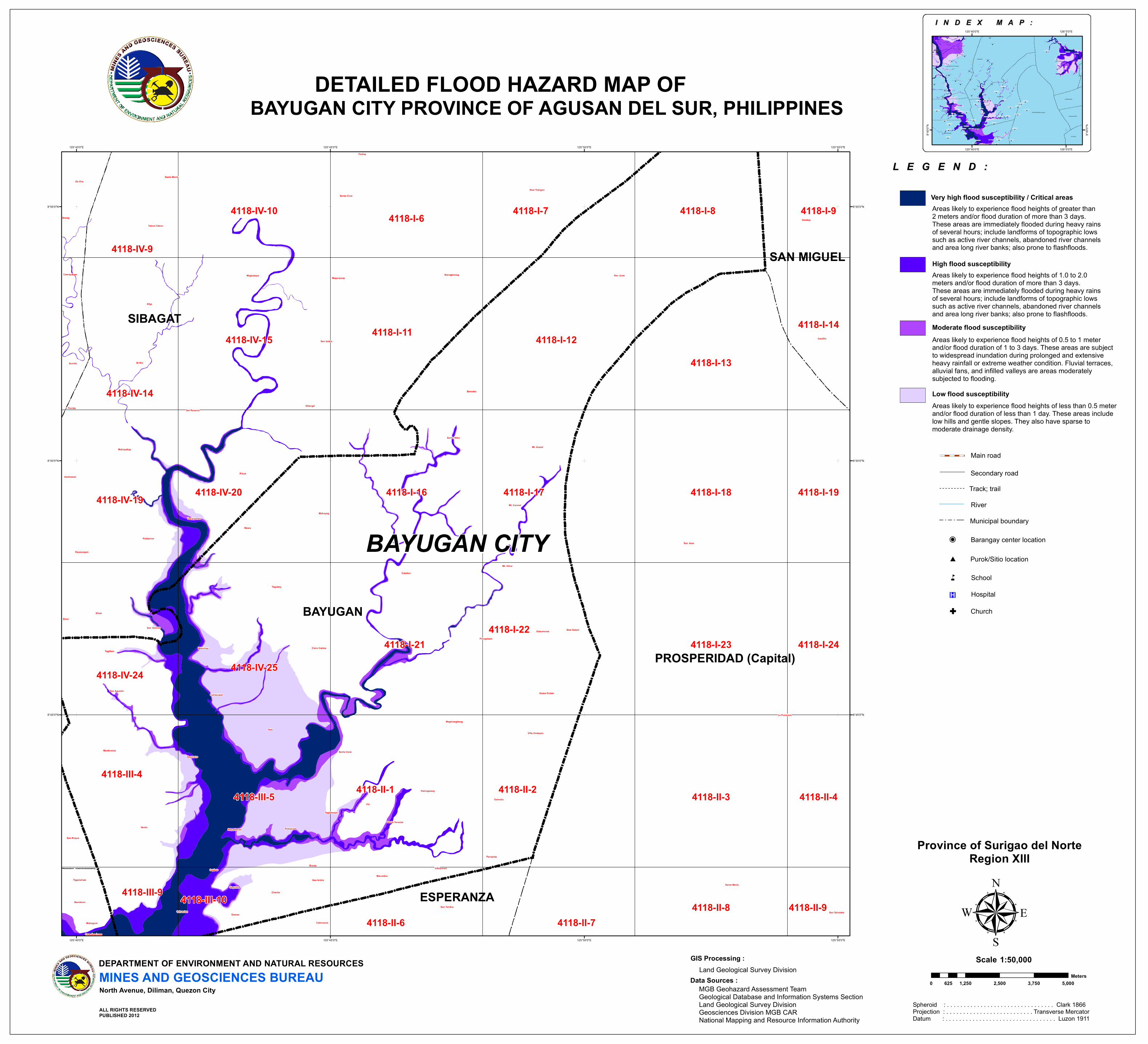
San Jose
San Juan
La Purisima
Calaitan
Verdu
Afga
Villangit
Noli
Santa Maria
Umalag
Santa Cruz
Osmeña
San Isidro
El Rio
New Tubigon
Tagubay
Wawa
Banagbanag
Kioya
Mahayag
Castillo
Fili
Santa Irene
Mt. Carmel
Mahayahay
Pinagalaan
San Toribio
Claro Cortez
Magsaysay
Poblacion
Tabon-Tabon
Berseba
San Agustin
Magkalape
Ilihan
Montivesta
Marcelina
Del Rosario
Canayugan
Santo Niño
Hamogaway
Mabuhay
Santa Maria
Catmonon
Poblacion
De Oro
Cagbas
Mt. Ararat
Charito
Magkiangkang
Tag-Uyango
Sagmone
Getsemane
Mt. Olive
Salvacion
Kauswagan
Maygatasan
Taglibas
Grace Estate
Gamao
Villa Undayon
Panaytay
Taglatawan
San Vicente New Salem
Camayahan
Sumile
Santa Teresita
San Roque
Anahawan
Bucac
Mahagcot
Bentahon
San Salvador
Katipunan
Sinai
Saguma
Taganahaw San Isidro
Padiay
Basag
Florida
Crossing Luna
4118-II-24118-II-1 4118-II-3
4118-I-11 4118-I-12
4118-I-21
4118-I-17
4118-I-22
4118-I-16
4118-III-5
4118-I-18
4118-I-23
4118-I-13
4118-IV-25
4118-IV-20
4118-IV-15
4118-I-6 4118-I-7 4118-I-8
4118-III-4
4118-IV-14
4118-IV-19
4118-IV-24
4118-IV-10
4118-IV-9
4118-II-6 4118-II-74118-II-8
4118-II-4
4118-I-24
4118-I-19
4118-I-14
4118-III-104118-III-9
4118-I-9
4118-II-9
BAYUGAN
SIBAGAT
PROSPERIDAD (Capital)
SAN MIGUEL
ESPERANZA
125°55'0"E
125°55'0"E
125°50'0"E
125°50'0"E
125°45'0"E
125°45'0"E
125°40'0"E
125°40'0"E
8°55'0"N 8°55'0"N
8°50'0"N 8°50'0"N
8°45'0"N 8°45'0"N
ALL RIGHTS RESERVEDPUBLISHED 2012
Track; trail
Main road
RiverMunicipal boundary
Barangay center location!P
L E G E N D :L E G E N D :
DEPARTMENT OF ENVIRONMENT AND NATURAL RESOURCESMINES AND GEOSCIENCES BUREAUNorth Avenue, Diliman, Quezon City
Areas likely to experience flood heights of less than 0.5 meterand/or flood duration of less than 1 day. These areas includelow hills and gentle slopes. They also have sparse to moderate drainage density.
Low flood susceptibility
Areas likely to experience flood heights of 0.5 to 1 meterand/or flood duration of 1 to 3 days. These areas are subjectto widespread inundation during prolonged and extensiveheavy rainfall or extreme weather condition. Fluvial terraces,alluvial fans, and infilled valleys are areas moderatelysubjected to flooding.
Moderate flood susceptibility
Areas likely to experience flood heights of 1.0 to 2.0meters and/or flood duration of more than 3 days.These areas are immediately flooded during heavy rainsof several hours; include landforms of topographic lowssuch as active river channels, abandoned river channelsand area long river banks; also prone to flashfloods.
High flood susceptibility
Secondary road
Fili B arangay H all
Verdu B arangay Hall
Saguma B ar angay Hall
Tagu bay Barangay H all
Sagmone B arangay Hall
Mahayag B arangay H all
Taglibas B arangay H all
Panaytay Bar an gay Hall
Calaitan B ar angay Hall
New Salem Bar angay Hall
Mt . O live Bar angay Hall
Katipunan B arangay H all
Hamogaw ay Bar an gay Hall
Getsemane B arangay H all
Santo N iño Bar angay Hall
Pinagalaan Bar angay Hall
Maygatasan B arangay H all
San Agust in Barang ay H all
Magkiang kan g Barang ay H all
Villa Undayon B arangay H all
Maug Barang ay H all
Maon Barang ay H all
Agao B arangay Hall
Mahay B arangay H all
Dulag B arangay Hall
Bilay Bar anagy Hall
Basag Bar angay Hall
Tun gao Bar an gay Hall
Sumile Bar angay Hall
De O ro B ar angay Hall
Bit-os B aranagy H all
Ampar o Barang ay H all
Pianing B ar angay Hall
Dankias Bar angay Hall
Cabcabon B arangay H all
Buhangin B arangay H all
Tiniwisan B arangay H all
Camayahan Bar angay Hall
Pangabugan B arangay H all
Leon Kilat B arangay H all Anton galon Bar anagy Hall
San Vicente B arangay Hall
M.J. S an tos Bar angay Hall
Golden R ibbon B arangay H all
Don Fr ancisco Barang ay H all
Maibu Barangay H all and Health C enter
Nato B arangay H all
Cubo B arangay H all
Odion g Barang ay H all
Dakutan B arangay H allTagabase B arangay H all
Santa Fe Bar angay Hall
Milagr os Bar an gay Hall
Haw ilian Barang ay H all
Poblacion B arangay Hall
Concor dia Baran gay H all
Aguinaldo B arangay H all
San Is idro B arangay H all
Piglaw ig an Barang ay H all
San Is idro B arangay H all
New Ging oog Bar angay Hall
Mat- I Barang ay H all
Rosario B arangay H all
Ambacon B arangay H all
Malicato B arangay hall
Pinana-an B arangay Hall
Consor cia B arangay H all
San Is idro B arangay H all
Balungagan B arangay hall
Tina Barang ay H allUmalag B ar angay Hall
Patong B arangay H all
Castillo B ar angay Hall
Poblacion B arangay Hall
Carr omata Bar angay Hall
Mahayag ( Maitu m) Bar angay Hall
Afga B arangay H all
Sinai Bar angay Hall
Kioya Bar angay Hall
Padiay Baran gay H all
Ilih an Barang ay H all
Anahaw an Bar angay Hall
Sta. Cr uz Barang ay H all
Magsaysay B ar angay Hall
Kausw agan Bar angay Hall
Tag- uyango Bar angay Hall
Kolambugan Barangay H all
Θ SIBAGAT
Θ BAYUGAN
Θ SAN MIGUEL
Θ PROSPERIDAD (Capital)
Θ ESPERANZA
Θ BUTUAN CITY (Capital)
Θ LAS NIEVES
Θ MARIHATAG
Θ LIANGA
Θ SAN AGUSTIN
Θ TAGO
126°0'0"E
126°0'0"E
125°40'0"E
125°40'0"E
8°40'0
"N
8°40'0
"N
I N D E X M A P :I N D E X M A P :
Spheroid : . . . . . . . . . . . . . . . . . . . . . . . . . . . . . . . . Clark 1866Projection : . . . . . . . . . . . . . . . . . . . . . . . . . . Transverse MercatorDatum : . . . . . . . . . . . . . . . . . . . . . . . . . . . . . . . . . Luzon 1911
1:50,000Scale
Data Sources :MGB Geohazard Assessment TeamGeological Database and Information Systems SectionLand Geological Survey DivisionGeosciences Division MGB CARNational Mapping and Resource Information Authority
GIS Processing :Land Geological Survey Division
Purok/Sitio location#
®v Hospital
n School
Areas likely to experience flood heights of greater than2 meters and/or flood duration of more than 3 days.These areas are immediately flooded during heavy rainsof several hours; include landforms of topographic lowssuch as active river channels, abandoned river channelsand area long river banks; also prone to flashfloods.
Very high flood susceptibility / Critical areas
G Church
Province of Surigao del NorteRegion XIII
µ
DETAILED FLOOD HAZARD MAP OFBAYUGAN CITY PROVINCE OF AGUSAN DEL SUR, PHILIPPINES
0 1,250 2,500 3,750 5,000625Meters
BAYUGAN CITY