Desmond Dr. Resources RE
64
April 29.2002 PUD No. m705 Mr. Gary Engman Washington Department of Wildlife Region 4 16018 Mill Creek Blvd. Mill Creek, WA 908012 Mr. Al McGuire Department of Natural Resources 919 N. Township Sedro Woolley, WA 98284 Mr. Gwill Ging US. Fish & Wildlife Service 5 10 Desmond Dr. S.E., Suite 102 Lacey, WA 98503 Mr. Daryl Williams Tulalip Tribes. Inc. 6700 Totem Beach Rd. Marysville. WA 98270 Gentlemen: RE: Jackson Hydroelectric Project -FERC it2157 Wildlife Habitat Management Plan 2001 Annual Rewrt A copy of the 2001 Annual Report on the Jackson Project Wildlife Habitat Management Plan is enclosed for your records. If you have any questions or comments. please contact me at 425-783-1746. Sincerely, Bernice Tannenbaum Environmental Coordinator Enclosure Cc: Bw Meaker, E2 Don Farwell. City of Everett Dan Mathias. City of Everen 2320 Glifomia Strecr . Everen. WA. 98201 1 MailingAdd-: P.O. Box 1 107. Everem. WAS982061 107 425-783-1000 -Tdl-f~c in Wencrn Washingon ar 3-877-783-1000 wmu.snopud.com
Transcript of Desmond Dr. Resources RE

April 29.2002 PUD No. m705
Mr. Gary Engman Washington Department of Wildlife Region 4 16018 Mill Creek Blvd. Mill Creek, WA 908012
Mr. Al McGuire Department of Natural Resources 919 N. Township Sedro Woolley, WA 98284
Mr. Gwill Ging US. Fish & Wildlife Service 5 10 Desmond Dr. S.E., Suite 102 Lacey, WA 98503
Mr. Daryl Williams Tulalip Tribes. Inc. 6700 Totem Beach Rd. Marysville. WA 98270
Gentlemen:
RE: Jackson Hydroelectric Project -FERC it2157 Wildlife Habitat Management Plan
2001 Annual Rewrt
A copy of the 2001 Annual Report on the Jackson Project Wildlife Habitat Management Plan is enclosed for your records.
If you have any questions or comments. please contact me at 425-783-1746.
Sincerely,
Bernice Tannenbaum Environmental Coordinator
Enclosure
Cc: B w Meaker, E2 Don Farwell. City of Everett Dan Mathias. City of Everen
2320 Glifomia Strecr . Everen. WA. 98201 1 MailingAdd-: P.O. Box 1 107. Everem. WAS 982061 107 425-783-1000 -Tdl-f~c in Wencrn Washingon ar 3-877-783-1000 wmu.snopud.com

2001 ANNUAL PROGRESS REPORT
WILDLIFE HABITAT MANAGEMENT PROGRAM
for the
HENRY M. JACKSON HYDROELECTRIC PROJECT
FEDERAL ENERGY REGULATORY COMMISSION Project Number 2157 - License Article 53
Submitted by
PUBLIC UTILITY DISTRICT NO. 1 OF SNOHOMISH COUNTY
and
THE CITY OF EVERETT, WASHINGTON
April 2002

2001 ANNUAL PROGRESS REPORT WILDLIFE HABITAT MANAGEMENT PLAN
TABLE OF CONTENTS
TABLE OF CONTENTS I
LIST OF FIGURES IV
LIST OF TABLES IV
1.0 SUMMARY
1.1 MAJOR TASKS ACCOMPLISHED DURING 2001
1 2 TASKS SCHEDULED FOR 2002 2
2.0 INTRODUCTION 2
3.0 WORK COMPLETED DURING 2001 4
3.1 FOREST VEGETATION MANAGEMENT ON THE LAKE CHAPLAIN TRACT 4 3.1.1 Timber Harvest 4 3.1.2 Reforestation 4 3.1.3 Harvest Unit Layout 4 3.1.4 Stand Management 4 3.1.5 Insect Outbreak 4
3.2 FOREST VEGETATION MANAGEMENT ON THE SPADA LAKE TRACT 6
3 3 FOREST VEGETATION MANAGEMENT ON THE LOST LAKE TRACT 7
3.4 SNAG AND CWD MANAGEMENT 3.4.2 Mapping of Snags and CWD 3.4.3 CWD Monitoring 3.4.4 Long-Term Snag Monitoring
3.5 REVEGETATION 3.5.1 Power Pipeline Right-of-way 3.5.2 North End of Lake Chaplain
3.6 NEST STRUCTURES 3.6.1 Floating Nest Platforms 3.6.2 Nest Boxes 3.6.3 Osprey Nest Platforms
Version 3 I W2-5'02

3.6.4 Bald Eagle Nesting 2 1
3.7 OTHER WILDLIFE OBSERVATIONS 21
3.8 BIOSOLIDS APPLICATION
3 9 DEER FORAGE MONITORING
3.10 WILLIAMSON CREEK TRACT
3.11 LAND MANAGEMENT AT LAKE CHAPLAIN
3.12 LAND MANAGEMENT ON DISTRICT PROPERTY
3.13 SECURITY MEASURES AT LAKE CHAPLAINIJACKSON PROJECT FACILITIES
4.1 FOREST VEGETATION MANAGEMENT (LAKE CHAPLAIN TRACT) 4.1.1 Road System Layout and Construction 4.1.2 Timber Harvest 4.1.3 Management of Roads and Post-harvest Units
4.2 FOREST VEGETATION MANAGEMENT (LOST LAKE TRACT)
4 3 FOREST VEGETATION MANAGEMENT (SPADA LAKE TRACT)
4.4 SNAG MANAGEMENT
4 5 COARSE WOODY DEBRIS MANAGEMENT
4.6 REVEGETATION 4.6.1 Spada Lake Drawdown Zone 4.6.2 Power Pipeline Right-of-way 4.6.3 North End of Lake Chaplain and Chaplain Marsh 4.6.4 Powerhouse Site
4.7 NEST STRUCTURES 4.7.1 Floating Nest Platforms 4.7.2 Nest Boxes 4.7.3 Osprey Nest Platforms
4.8 BIOSOLIDS APPLICATION
4.9 DEER FORAGE MONITORING
4.10 LAND ACQUISITION
Version 2

4.11 WILLIAMSON CREEK TRACT
5.0 WORK PLANNED FOR 2002
5.1 FOREST VEGETATION MANAGEMENT 5.1.1 Lake Chaplain Tract 5.1.2 Spada Lake Tract 5.1.3 Lost Lake Tract
5 3 SNAG MANAGEMENT
5 3 COARSE WOODY DEBRIS MANAGEMENT
5.4 REVEGETATION 5.4.1 Spada Lake Drawdown Zone 5.4.2 Power Pipeline Right-of-way 5.4.3 Chaplain Marsh, North End of Lake Chaplain, and Powerhouse Site
5 5 NEST STRUCTURES
5.6 DEER FORAGE MONITORING
5.7 WILLIAMSON CREEK TRACT
5.8 LAND MANAGEMENT
5.9 SECURITY MEASURES AT LAKE CHAPLAINIJACKSON PROJECT FACILITIES
6.0 SCHEDULE OF ACTIVITIES FOR 2002
Version 2

LIST OF FIGURES
FIGURE 1. WHMP PROJECT AREA WITH MANAGEMENT TRACTS 3 FIGURE 2. HARVEST ACTIVITY -LAKE CHAPLAIN TRACT 5 FIGURE 3 FOREST VEGETATION MANAGEMENT - SPADA LAKE TRACT 8 FIGURE 4 FOREST VEGETATION MANAGEMENT - LOST LAKE TRACT 9 FIGURE 5 SNAG MANAGEMENT, 2001 - SPADA LAKE TRACT 11 FIGURE 6 SNAG MANAGEMENT, 2001 -WILLIAMSON CREEK TRACT 12 FIGURE 7 SNAG AND CWD MAPPING/MONITORING 16 FIGURE 8 NEST STRUCTURES AT LOST LAKE 18 FIGURE 9 NEST STRUCTURES AT SPADA LAKE 19 FIGURE 10 NEST STRUCTURES AT LAKE CHAPLAIN TRACT 20 FIGURE 11A BIOSOLIDS APPLICATION MONITORING -- NITRATES 24 FIGURE 11B BIOSOLIDS APPLICATION MONITORING -FECAL COLIFORMS 25 FIGURE 11C BIOSOLIDS APPLICATION MONITORING -- AMMONIA 26 FIGURE 12 DEER FORAGE MONITORING 27 FIGURE 13 WILLIAMSON CREEK OLD GROWTH STANDS 10-11 AND 10-12 28 FIGURE 14 WHMP SCHEDULE VS COMPLETED FOREST VEGETATION
MANAGEMENT - LAKE CHAPLAINLOST LAKE TRACTS, 1989-2001 31 FIGURE 15 SNAG MANAGEMENT - LAKE CHAPLAIN AND LOST LAKE, 1989-2001
35
LIST OF TABLES
TABLE 1 SUMMARY OF SNAG MANAGEMENT IN 2001 13 TABLE 2. 2001 ROW VEGETATION MONITORING RESULTS 15 TABLE 3. USE OF NEST BOXES ON WHMP LANDS 21 TABLE 4. WILLIAMSON CREEK STANDS INVENTORIED AND SNAGS CREATED
IN 2001. 23 TABLE 5. WILLIAMSON CREEK 2001 SNAG INVENTORY RESULTS. 23 TABLE 6. WILLIAMSON CREEK 2001 CWD INVENTORY RESULTS. 23 TABLE 7. MODIFICATIONS OF THE FINAL HARVEST (FH) SCHEDULE ON LAKE . .
CHAPLAIN TRACT 32 TABLE 8. MODIFICATIONS OF THE COMMERCIAL THINNING (CT) SCHEDULE
ON LAKE CHAPLAIN TRACT 32 TABLE 9A SUMMARY OF SNAG MANAGEMENT THROUGHT 2001 - LAKE
CHAPLAIN AND LOST LAKE 36 TABLE 9B SUMMARY OF SNAG MANAGEMENT THROUGH 2001 - SPADA LAKE
AND WILLIAMSON CREEK 38 TABLE 10. SUMMARY OF DEER FORAGE MONITORING SCHEDULE 42 TABLE 11. WILLIAMSON CREEK BASELINE INVENTORY SUMIMARY. 43 TABLE 12. WILLIAMSON CREEK TRACT SNAG CUMULATIVE INVENTORY
SUMMARY 44 TABLE 13. WILLIAMSON CREEK CWD CUMULATIVE INVENTORY SUMMARY 44
Version 2

2001 ANNUAL PROGRESS REPORT WILDLIFE HABITAT MANAGEMENT PLAN
1.0 SUMMARY
Accomplishments of the year 2001 on the Wildlife Habitat Management Plan (WHMP) for the Henry M. Jackson Hydroelectric Project are presented in this report. A cumulative summary of tasks accomplished since the initiation of the WHMF' in 1989 is also presented in this report. Problems or changes needed during implementation of the WHMP are discussed, and updated schedules are presented. A draft of this report was submitted for comments to the US. Fish and Wildlife Service (USFWS), the Washington Department of Fish and Wildlife (WDW), and the Tulalip Tribes. The Washington Department of Natural Resources (DNR) was also consulted.
The basic habitat enhancements, monitoring programs, and reports required by the WHMP to date have been implemented consistent with the WHMP's objectives (Section 3, WHMP, by management tract) and implementation schedule (Section 5.0, WHMP). In some cases, procedures described in the WHMF' have been modified or refined to improve the usefulness and reliability of results. Similarly, the details of timber stand boundaries and harvest schedules have been modified to improve operations and reduce impacts, but all such modifications have been within the allowances provided by the WHMP. All significant modifications in procedures have been evaluated relative to the WHMP's management objectives, in consultation with agency reviewers, and have been approved only if the modifications remain consistent with the WHMP's objectives.
As described in Sections 3 and 4 of this report and in previous years' reports, implementation of the WHMP over the past decade has already provided many of the intended wildlife habitat benefits. For example, snag and coarse woody debris creation has provided critical shelter and foraging substrate that was scarce in second growth forest stands, while small-scale timber harvest has created new foraging opportunities for several species. Revegetation of areas disturbed during project construction has provided cover and forage.
1.1 MAJOR TASKS ACCOMPLISHED DURING 2001
. 0
. . Version 3
Completed planting of Linetree Sale unit 1 (Lake Chaplain Tract) Completed precomrnercial thinning of Chaplain Sale unit 1 (Lake Chaplain Tract) Completed hardwood slashing of Diversion Sale unit 2 (Lake Chaplain Tract) Completed Lake Chaplain Road drainage upgrade (Lake Chaplain Tract) Sold Donkey Damper timber sale (Lake Chaplain Tract) Started logging Donkey Damper Sale units (Lake Chaplain Tract) Plantation monitoring (Lake Chaplain Tract) Biosolids monitoring (Lake Chaplain Tract) Snag inventory and creation (Spada Lake Tract and Williamson Creek Tract) Deer forage monitoring (Lake Chaplain Tract) Seeding of power pipeline ROW (Project Facilities Tract) Monitoring of vegetation coverage on power pipeline ROW (Project Facilities Tract) Monitoring of nest structures (Lake Chaplain, Lost Lake and Spada Lake Tracts) Monitoring of revegetation and wetland sites (Lost Lake Tract, Lake Chaplain Tract) Long-term snag monitoring (Lake Chaplain Tract)

Monitoring of Williamson Creek Tract Monitoring of biosolids application sites (Lake Chaplain Tract) Layout of timber harvest units (Spada Lake Tract) Continued feasibility study of timber harvest options (Lost Lake Tract) Complete Road Maintenance and Abandonment Plan for Lost Lake, Spada Lake, Williamson Creek and Project Facilities Tracts Continued collection of baseline data at Williamson Creek Tract
1.2 TASKS SCHEDULED FOR 2002
Complete road construction on Donkey Damper Sale (Lake Chaplain Tract) Complete logging Donkey Damper Sale units (Lake Chaplain) Planting of Donkey Damper Sale units (Lake Chaplain) Complete layout of next sale (Lake Chaplain) Complete precommercial thinniig on Chaplain Sale unit 2 (Lake Chaplain Tract) Plantation monitoring (Lake Chaplain) Biosolids monitoring (Lake Chaplain) Hemlock looper infestation monitoring (Lake Chaplain) Complete Road Maintenance and Abandonment Plan for Lake Chaplain Tract Implement Road Maintenance and Abandonment Plan at Spada Lake Tract Snag monitoring (Lake Chaplain and Lost Lake Tracts) Snag inventory on Spada Lake Tract and Williamson Creek Tract Monitor Williamson Creek Tract Monitor nest structures Monitor revegetation sites Deer forage monitoring (Lake Chaplain Tract) Coarse woody debris monitoring on Lake Chaplain harvest units Monitor buffer zones and green tree areas in harvested units (Lake Chaplain Tract) Monitor precommercial thinning units (Spada Lake Tract, Lost Lake Tract)
2.0 INTRODUCTION
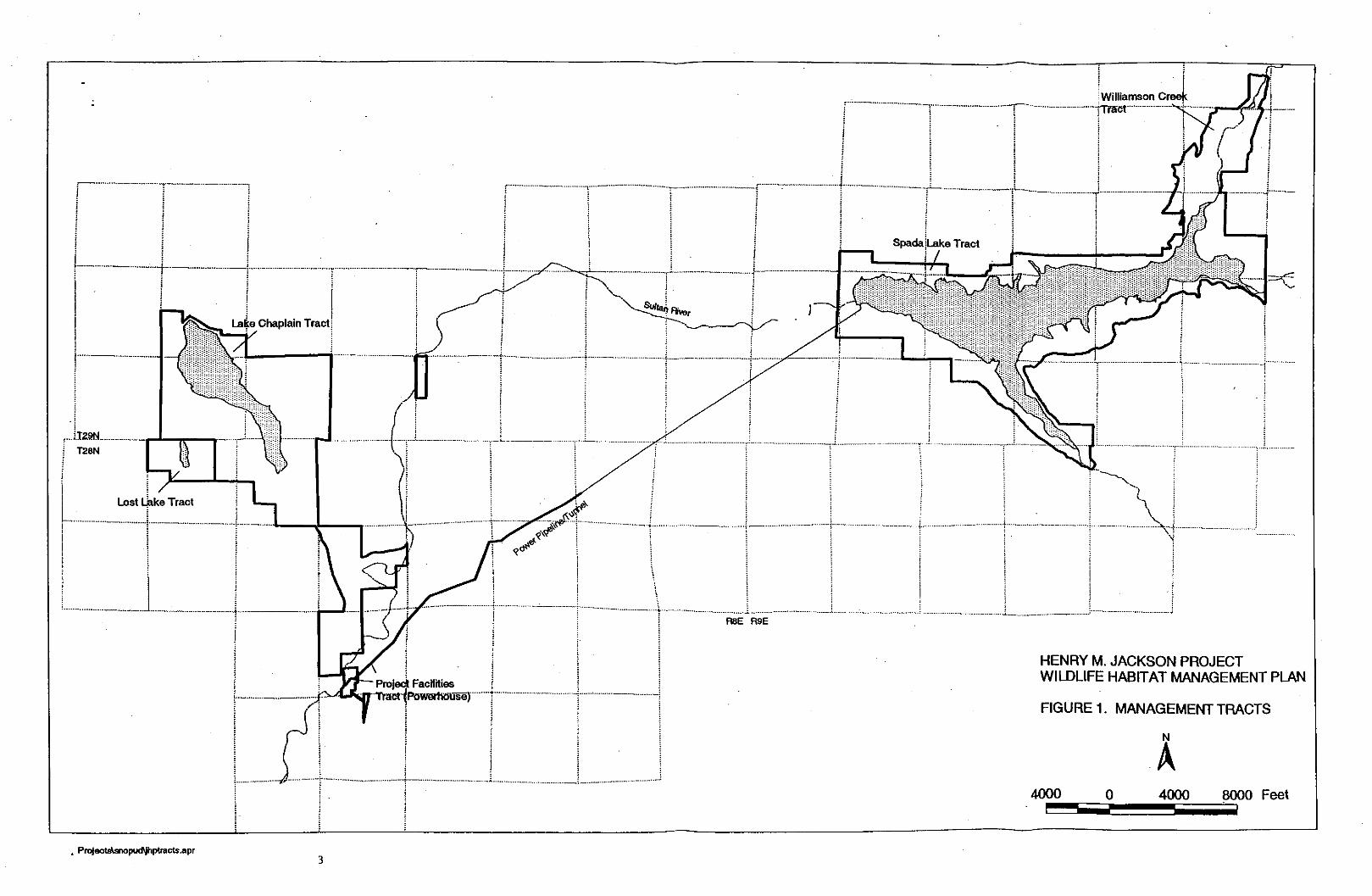
The 2001 Annual Progress Report on the Wildlife Habitat Management Plan (WHMF') for the Henry M. Jackson Hydroelectric Project was prepared by Public Utility District No. 1 of Snohomish County (District) and the City of Everett (City), who are co-licensees in the Project. The WHMP project area and management tracts are shown in Figure 1.
This annual report describes activities conducted during calendar year 2001 (see Section 3.0) and summarizes activities completed since the management program was initiated in 1988 (see Section 4.0). Activities anticipated for the calendar year 2002 are herein described. (see Section 5.0). Activities, procedures and schedules described in this report are based on the WHMP approved by the Federal Energy Regulatory Commission on May 19, 1989, in compliance with Project License Article 53 and subsequent related orders from the Commission.
.ke Tract I
HENRY M. JACKSON PROJECT WILDLIFE HABITAT MANAGEMENT PLAN
FIGURE 1. MANAGEMENT TRACTS

3.0 WORK COMPLETED DURING 2001
3.1 FOREST VEGETATION MANAGEMENT ON THE LAKE CHAPLAIN TRACT
3.1.1 Timber Harvest
The Donkey Damper sale, as described in the 2000 annual report, was sold in October 2001 (Figure 2). Harvest and road construction activities began in November 2001 and will be completed by the spring of 2002.
3.1.2 Reforestation
In the spring of 2001 the 9 acres of the Lietree unit one (Linetreel-00) that were not planted after harvest in 2000 were planted to Douglas fir at 300 trees per acre. Redcedar was not available for purchase, therefore were not planted, but they will be planted in 2002.
3.1.3 Harvest Unit Layout
Preliminary layout work for the next sale began; however no final proposal has been developed.
3.1.4 Stand Management
Chaplain sale unit one (Chapl-911, which was logged in 1991 and planted in 1992, was precommercialfy thinned in 2001 (Fig.2) . The prescription for this thinning was to thin the Douglas fu to a spacing of 12' x 12'. leave all redcedar and hardwoods but cut the Big-leaf maple clumps back to three to five stems per clump.
During the summer of 2001 conifer release slashing was completed on the Diversion sale unit two (Divr2-95). The prescription for this slashing was to cut all hardwoods to a spacing of 30 to 40 feet and cut maple clumps back to three to five stems per clump. This slashing released the overtopped conifer seedlings and retained adequate hardwood stems to provide the five to ten percent hardwood component in the overstory as required in the WHMP.
3.1.5 Insect Outbreak
During September 2001 it became obvious that there was an insect population increase that was having an impact on the Western hemlock on the Lake Chaplain Tract. The DNR had also noticed the outbreak during routine aerial forest monitoring. After several meetings DNR determined that there was a significant population increase in both the Hemlock looper and the Phantom looper. Follow-up flights and ground assessments indicated that about 11,000 acres have suffered defoliation, including 1,000 acres in the Lake Chaplain Tract and 100 acres in the Lost Lake Tract. The northeast and northwest corners of the Lake Chaplain Tract appear to have experienced the most defoliation to
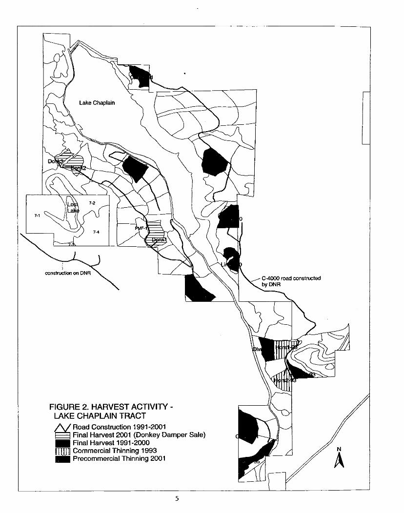
FIGURE 2. HARVEST ACTIVITY - LAKE CHAPLAIN TRACT
& Road Construction 1991 -2001 Final Harvest 2001 (Donkey Damper Sale) Final Harvest 1991 -2000 Commercial Thinning 1993 Precommercial Thinning 2001

date. The extent of mortality due to defoliation has not yet been determined. Hemlocks are more likely to succumb to defoliation than Douglas fir.
Additional survey work will follow in 2002 to determine whether the insect population is increasing or decreasing. With this information, we will be meeting again to discuss management strategies, if any, that we may use to deal with the problem One possible response to significant and widespread die-off of affected trees would be to revise the scheduled harvest dates of certain units. Commercial thinning of affected units is a possibility. No specific proposal for action has been developed yet.
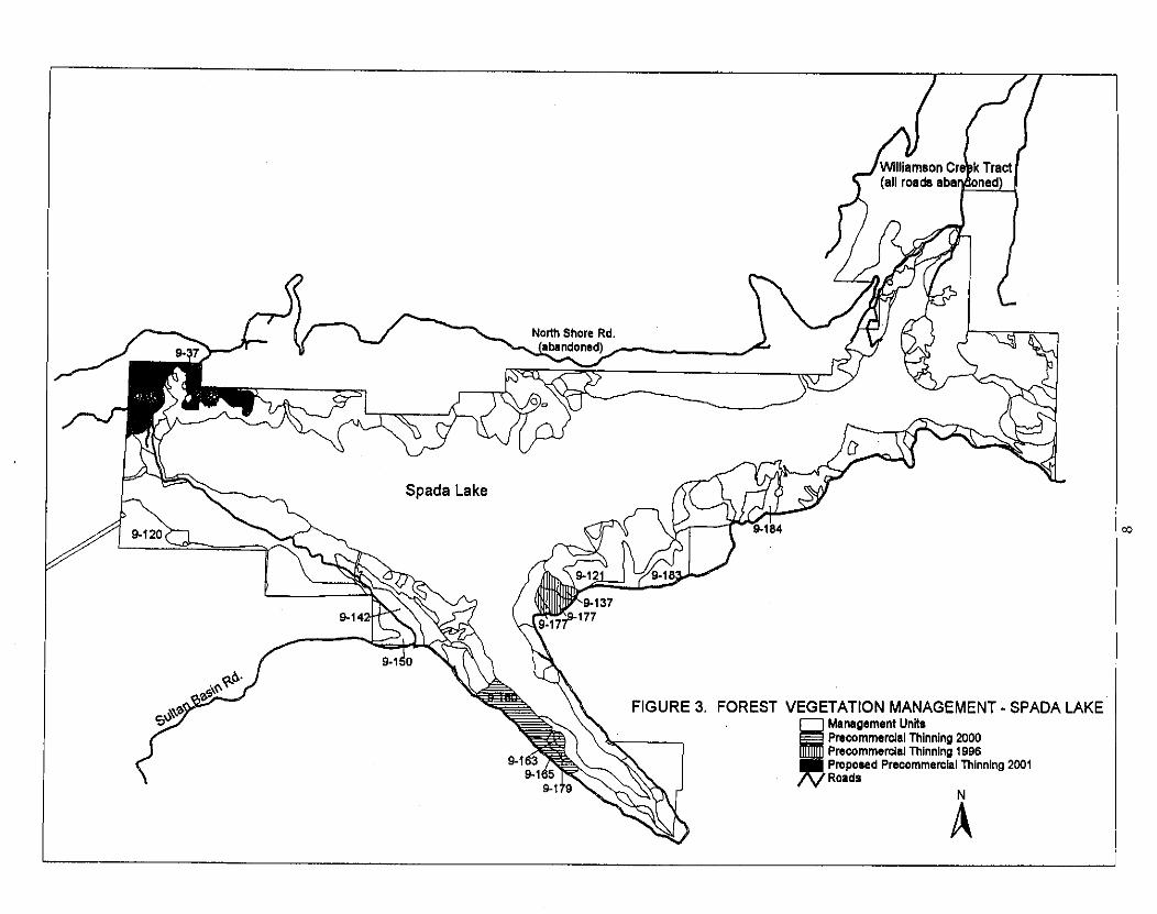
3.2 FOREST VEGETATION MANAGEMENT ON THE SPADA LAKE TRACT
The Dishict's consultant, who reported on timber harvest feasibility in late 2000, continued to advise the District on management options on its small-wd stands & 40 yrs. old). He evaluated nine Spada Lake Tract stands totaling 167 acres, and reported costs and expected revenues from commercial thinning (Fig.3). Depressed hemlock prices continued to influence decision-making in 2001 in the Spada Lake Tract, although the primary criterion will be the habitat benefits of each option. Management decisions for these stands were based on several considerations:
Wildlife habitat values on the Spada Lake stands, if left unmanaged, will not improve for many years. Prompt thinniing of the Spada Lake stands will not result in a large increase in the future value of residual timber within the next 20 years due to poor soil productivity, compared to taking no action now. Stands 9-36.37 and 38 have never been thinned, whereas the remaining stands in this analysis have been precommercially thinned in the past. Stands 9-36,37,38,120, and portions of 121 and 183 require road reconstruction or new construction, adding significantly to harvest costs
The decision was made to manage Spada Lake stands 9-36.37 and 38 through precommercial thinning in the near future, rather than the alternatives of commercial thinning or taking no action. The highly overstocked stands would require extensive road reconstruction to make commen:ial harvest possible, and the size and value of the timber present does not warrant this effm. With precommercial thinning, the stands can be improved in a more costeffective manner with no road work required, and they could be commercially harvested in the future.
The remaining stands under consideration in the consultant's report, (9-120.9-121.9- 183.9-142.9-150 and 9-184). can be commercially thinned more costeffectively than 9- 36,37 and 38. These stands were marked for future commercial thinning, including boundary tags, road alignments, and required buffer zones. Forest practices applications were prepared for submittal to the Department of Natural Resources. The stands have not been advertised for sale yet, however, due to depressed market conditions.
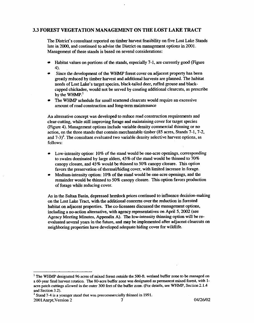
3.3 FOREST VEGETATION MANAGEMENT ON THE LOST LAKE TRACT
The District's consultant reported on timber harvest feasibility on five Lost Lake Stands late in 2000, and continued to advise the District on management options in 2001. Management of these stands is based on several considerations:
Habitat values on portions of the stands, especially 7-1, are currently good (Figure 4). Since the development of the WHMP forest cover on adjacent property has been greatly reduced by timber harvest and additional harvests are planned. The habitat needs of Lost Lake's target species, black-tailed deer, ~ f f e d grouse and black- capped chickadee, would not be served by creating additional clearcuts, as prescribe by the WHMP.' The WHMP schedule for small scattered clearcuts would require an excessive amount of road construction and long-term maintenance
An alternative concept was developed to reduce road construction requirements and clearcutting, while still improving forage and maintaining cover for target species (Figure 4). Management options include variable density commercial thinning or no action, on the three stands that contain merchantable timber (85 acres, Stands 7-1,7-2, and 7-3)2. The consultant evaluated two variable density selective harvest options, as follows:
Low-intensity option: 10% of the stand would be one-acre openings, corresponding to swales dominated by large alders, 45% of the stand would be thinned to 70% canopy closure, and 45% would be thinned to 50% canopy closure. This option favors the preservation of thermaVhidiig cover, with limited increase in forage. Medium-intensity option: 10% of the stand would be one-acre openings, and the remainder would be thinned to 50% canopy closure. This option favors production of forage while reducing cover.
As in the Sultan Basin, depressed hemlock prices continued to influence decision-making on the Lost Lake Tract, with the additional concerns over the reduction in forested habitat on adjacent properties. The co-licensees discussed the management options, including a no-action alternative, with agency representatives on April 5,2002 (see Agency Meeting Minutes, Appendii A). The low-intensity thinning option will be re- evaluated several years in the future, and may be implemented after adjacent clearcuts on neighboring properties have developed adequate hiding cover for wildlife.
' The WHMP designated 96 acres of mixed forest outside the 500-ft. wetland buffer wne to be managed on a myear final harvest rotation. The 80-acre buffer m e was designated as permanent mixed forest, with 1- acre patch cuttings allowed in the outer 300 feet of the buffer zone. (For details, see WHMP, Section 2.1.4 and Section 3.2). Stand 7-4 is a younger stand that was precommercially thiied in 1991.
2001Anrpt;Version 2 7 04/26/02

3.4 SNAG AND CWD MANAGEMENT
3.4.1 Snag Inventory and Creation
Snag management in the year 2001 consisted of 5 units inventoried (52 acres) on the Spada Lake Tract (Fig 5) and creation of 108 snags on 7 units from the Spada Lake and Williamson Creek Tracts (Figs 5 & 6, and Table 1). Snags were created on the four Williamson Creek non-old growth units inventoried in 2000. Additional snags will be created on one of these units and snag creation will be evaluated in 2002 on Stand 10-2, a small old growth stand. The remoteness of the work locations significantly influenced the numbers of acres inventoried and snags created. Additionally, some of the units (e.g. 9-126) scheduled for snag inventories in the Spada Supplement have very little potential for snag creation at this &e. Several stands a& over~tocked and average stand diameters range from 11-16. These units may be revisited in 10 years to evaluate the potential for snag creation at that time. Snags were created using a chain saw to remove the top and make several vertical cuts in the top to facilitate decay. All created snags are marked with paint and a numbered metal tag, and their location is recorded for future monitoring.
Snag inventory and creation on the Lake Chaplain Tract were deferred in 2001, pending possible changes in the harvest schedule in units affected by the hemlock looper outbreak (see Section 3.1.5)
3.4.2 Mapping of Snags and CWD
Snags and CWD on previously harvested Lake Chaplain units were mapped using GPS equipment to facilitate long-term monitoring (l3g. 7). The following units were mapped in 2001: Chap 1-91, Chap 2-91, Chap 3-91, and Divr 2-95 (Figure 4). The objective is to map at least the subset of snags and CWD that are selected for long-term monitoring, but if time allows all tagged snags and CWD will be mapped on harvest units. GPS mapping was not very successful under the tree canopy, and we will continue to map snags and CWD in forested units with compass and tape.
3.4.3 CWD Monitoring
Two large class 4 fu logs were marked and mapped prior to harvest in L i e Tree Unit 1 (LinelM)), and five class 3 and 4 fir logs were marked in Unit 2 (Liine240), for the purpose of monitoring the effects of timber harvest on existing CWD (Fig. 7). All but one of the logs was readily located in 2001 after the unit was harvested. The effects of harvest included damage to loose bark and surface wood, scraping off moss and other vegetation, and a moderate reduction in length due to breakage. All of the logs had large amounts of slash piled against them In one log, which had a burrow beneath it before the unit was harvested, the slash filled the entrance.
SPADA LAKE
FIGURE 5 SNAG MANAGEMENT, 2001 SPADA LAKE TRACT
Inventoried Inventoried/Snag Creation Occurred Meets WHMP Requirements
N

800 0 800 1MX) Feet

\1 Too few smg creation opportunities exist, re-evaluate in 10 years.
\2 Trees not of adequate size for snag c r e a h . reevaluate in 10 years.
\3 Snag creation incomplete, to be mmpleted in 2032.
W No natural snags found during inventories.
\5 OkCgmvd~ stand; wiU not have prc-active snag management.
Stand 10-1 1 " Stand 10-12~
TOTALS
50.5
6.3
171
0
0
108
32.3 1 46.0 / 6.0 /~atural snags only 30.7 / 38.3 / 6.0 /Natural snags only ----
Totals fathose 11 units with snag management in 2001 I I I

3.4.4 Long-Term Snag Monitoring
Created snags were monitored to track decay processes and use by wildlife on harvest units and forested stands at Lake Chaplain. Snags in the following units were revisited in 2001: 2015-5,2030-2,OMA-1 (part), BZ2, PMF-11, Chap 1-91, Chap 2-91, Chap 3- 91 (Fig. 7). Results are in preparation.
35 REVEGETATION
3.5.1 Power Pipeline Right+f-Way
Small areas of the ROW, which have not yet become successfully revegetated, were seeded with a mixture of annual and perennial ryes, fescues and clovers. This was the fourth year of vegetation monitoring, and most areas are showing an increase in grasdforb coverage. The lower portion of the ROW (from P10 to P15) was inadvertently mowed prior to vegetation monitoring being conducted. This undoubtedly reduced the percent coverage of most species within those plots, which comprise 113 of the total number of ROW sampling points. The remainder of the ROW was mowed later in the summer. The most commonly occurring plant or cover types were grasses, miscellaneous asteraceae and bare soil (91.2%. 63.2% and 63.2% frequency, respectively, Table 2) Other palatable plants found include clover (19.3%). trefoils (10.5%). trailing blackberry (10.5%), and wild strawbeny (5.3%). The cover types and species that were most abundant within the plots were bare soil, grasses and conifer seedlings (49.9%. 39.1% and 37.5% coverage, respectively, see Table 2). Recall that early mowing had occurred on 113 of the sample areas. While this would not likely reduce the percent frequency of plant species, one would expect the percent cover to decrease greatly after mowing for all cover types except bare soil, which would likely increase as a result.
The relative abundance of cover types and plant species is based on multiplying the percent frequency and percent cover. Those with the highest relative abundance are: grass, bare soil, and miscellaneous asteraceae (see Table 2). The largest changes from the previous year are: trefoils decreased by 80%. and mosses by 52%. It would be expected that trefoils would decrease greatly after an early summer mowing, particularly since the areas they predominate are on the portion of the ROW that was mowed early. Large increases in relative abundance were made by willow (+350%), wild strawberry (+117%), and trailing blackberry (+113%).

TABLE 2. 2001 ROW Vegetation Monitoring Results
North End of Lake Chaplain
The north end of Lake Chaplain (Stand 1-17, about 10.7 acres) is intended to be maintained as a mixed shrub/bmsh and grass meadow. It was determined in 1998 that the alders would be reduced to a few narrow corridors connecting the planted conifer row near the road to the shoreline. Alders were removed in the conifer row in 1998, and elsewhere in the stand in 2000 and 2001, using brushcutting equipment in dry portions of the stand and hand tools in the wetter areas. Cleared areas were reseeded with the same seed mixture used on the pipeline ROW.
NEST STRUCTURES
Floating Nest Platforms
District staff monitored the two platforms at Lost Lake (Figure 8) and the one platform on the Williamson Creek Arm of Spada Lake @gure 9) when they were conducting other activities on the tracts. Pied-billed grebe used the north platform at Lost Lake. The nest was composed of a small amount of down and had two broken creamy white eggs. District biologists did not observe wildlife use of the other floating platforms in 2001.

FIGURE 7. SNAG AND CWD MAPPING AND MONITORING, 2001
# Snag Monitoring Snag and CWD Mapping
3.6.2 Nest Boxes
The nest boxes at Lost Lake (Figure 8). Spada Lake (Figure 9). and Lake Chaplain (Figure 10) tracts were maintained and monitored by District staff during the 2001 nesting season. One nest box was installed in March, downstream of the concrete ford in the SW comer of Lost Lake. Another was installed in Wetland Buffer 3 east of the filtration plant on the Lake Chaplain Tract. One nest box at Spada Lake was knocked off the tree possibly by a bear, and has not been recovered.
Production was estimated by examining eggshell remains in the boxes. A nest box was considered successful if the contents of the box showed that at least one duckling had successfully fledged from the nest box (egg membrane present, no presence of duckling remains). Nesting results are summarized in Table 3. Wood ducks used three of the nest boxes at Lost Lake. Wood ducks used one of the boxes on the Lake Chaplain Tract, and both bufflehead and wood ducks used another one of the boxes on the Lake Chaplain Tract. Downy feathers and nest dishes were found in a few boxes, but further nesting attempts were apparently not made. Several boxes (5 out of 10) at Lost Lake had squirrel nests of moss in them when checked in early spring. These nests were not disturbed because the Western Gray Squirrel is listed as threatened by the state and as a species of concern by the federal government. (Additionally, no sightings of Eastern Gray Squirrels have been made on project lands to date.) Northem Flying Squirrels were confumed in 2 of these 5 boxes. No signs of successful nesting were observed at Spada Lake.
In the year 2001, five of the 24 boxes were used successfully with 40 to 41 wood ducks and two bufflehead hatched. Last year about the same number of wood ducks were hatched out with 19 to 20 hooded mergansers hatched and no bufflehead. Overall, nest box success was about 21% in 2001, down from 32% in 2000. The Spada Lake boxes bring down the success rate possibly because other habitat conditions there are poorer, such as forage and hiding cover. In the future, nest boxes may be placed in areas farther up in the Williamson Creek drainage, where the habitat may be more suitable.

FIGURE 8. NEST STRUCTURES AT LOST LAKE Duck Nest Box Floating Nest Platform Osprey Platform Structure Removed

7 \\ FIGURE 9. NEST STRUCTURES AT SPADA LAKE
0 Duck Nest Box f3 Floating Nest Platform A ~ s p r ~ ~ l a t f o r m X Structure Lost or Removed

FIGURE NEST STRUCTURES AT LAKE CHAPLAII 0 Nest Box
Floating Nest Platform X Structure removed
Table 3. Use of Nest Boxes on WHMP Lands
Site
Tract
Chaplain
Spada Lake
Totals
Boxes Used by
squirrels Brother
yellow-jacket nests) +
3.6.3 Osprey Nest Platforms
District staff monitored the osprey nest platforms at Lost Lake and Spada Lake (Figs. 8 and 9) when they were performing other duties on the tracts, during spring and summer 2001. No osprey activity was observed on the nesting platforms this year. It appears the osprey moved to a nesting site on DNR land in 1999. The District cleared branches around the platform at Lost Lake last year to try to improve it as a potential nesting site for osprey, but no use was observed in 2001.
3.6.4 Bald Eagle Nesting
The bald eagle nest established in 1997 on the Lake Chaplain Tract was occupied by nesting bald eagles from mid-March through mid-May 2001. It appears that the nesting attempt failed, because eagles were not observed on the nest after mid-May.
3.7 OTHER WILDLIFE OBSERVATIONS
Some incidental 0bSe~ati0IIS of wildlife species on WHMP lands are listed in this section. These observations are not the result of systematic surveys for wildlife, but are included in the report to document the presence of these species on management lands.
Pacific Giant Salamander on Williamson Creek Tract Several Loon sightings at Spada Lake & Lake Chaplain Barrow's Goldeneye at Spada Lake Waterfowl on Lake Chaplain: Common Merganser, American Widgeon, Gadwall, Shoveler, Common Goldeneye, Canada Geese, Pied-billed grebe catching fish Waterfowl in Chaplain Marsh: Ring-necked duck, Pied-billed grebe, Mallard, Bufflehead Bald eagle perched on snag in Williamson Creek Arm, July. Osprey near Lost Lake platform Osprey on snag near South Shore platform at Spada Lake Coopers hawk at Lake Chaplain Red-tailed hawk at Lake Chaplain

Ruffed Grouse at Lost Lake Kingfisher at Chaplain Marsh Yellow Warbler on nest with 1 chick and 3 eggs at Spada Lake Bobcat and beaver tracks in mud along Williamson Creek Arm, July. Bobcats -north end of Williamson Creek Tract; west of Spada Lake; and 2 on Lake Chaplain Tract Flying Squirrels at Lost Lake Tract Black bear with 2 cubs north of Lost Lake Otters in Lost Lake Black-tailed deer (does, fawns, spikes and 2-pt bucks) on various project lands Skunk at Williamson Creek
3.8 BIOSOLIDS APPLICATION
The City of Everett monitored vegetation growth and water quality in Chaplain Creek in relation to biosolids applications on units Horsl-93, Hors2-93 and Divrl-95. The units and the application procedures were described in the 1996 Annual Report and the 2000 Annual Report, and monitoring procedures were described in the 1996 Annual Report. Water quality data has been collected from August 1996 to November 2001. Nitrates in both upstream and downstream sampling points remain low, with nitrate levels downstream of the project slightly higher than nitrates from samples collected upstream (Figure 1 la). Fecal coliforms (Figure 1 lb), ammonia (Figure 1 lc) and total phosphorus remain low both upstream and downstream of the project. Some of the sampled parameters, such as fecal coliforms and nitrates, show predictable seasonal variations, but no biosolids effect on water quality is apparent.
Vegetation has been monitored on control plots and Hors 1-93 and Hors 2-93 (treated units) from June 1997 to 1999. No monitoring was conducted in 2000, when additional biosolids were applied to the units during the summer. Monitoring was conducted again in September 2001. The control and the treated units have approximately 120 percent cover for all understory species. There has been an increase in palatable species cover in the two treated units, whereas the control unit has not increased. Understory plants increased in height from 1997 to 2001 in the treated units, but not in the control unit.
3.9 DEER FORAGE MONITORING
Deer forage availability was sampled in late June-July 2001 on Hors 3-93 and Divr 1-95, which were harvested in 1993 and 1995, respectively, and Donkey Damper Unit 2 @onk 2-02) prior to harvest (Fig.2). Results are in preparation (E~gure. 12)
3.10 WILLIAMSON CREEK TRACT
In 2001 District biologists collected baseline data (Table 4) for the Williamson Creek Tract on two old growth stands, 10-1 1 and 10-12 (Figure 6). Procedures for data collection are described in the Cumulative Summary, Williamson Creek Tract section of this report. The benefits of creating snags and coarse woody debris were assessed in stands 10-1, 10-3, 1 0 4 and 10-5. Tree size is generally too small to allow for creation of CWD at this time, but this will be reevaluated in 10 years. Snag creation potential
was also limited due to tree size; however, some snags were created in stands 10-1, 10-3, 10-4 & 10-5.
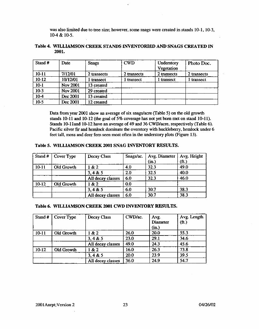
Table 4. WILLIAMSON CREEK STANDS INVENTORIED AND SNAGS CREATED IN 2001.
I Stand# 1 Date I Snags 1 Understory 1 Photo Doc. ]
Data from year 2001 show an average of six snagdacre. (Table 5) on the old growth stands 10-1 1 and 10-12 (the goal of 5% coverage has not yet been met on stand 10-1 1). Stands 10-1 land 10-12 have an average of 49 and 36 CWDIacre, respectively (Table 6). Pacific silver fu and hemlock dominate the overstory with huckleberry, hemlock under 6 feet tall, moss and deer fern seen most often in the understory plots (Figure 13).
Table 5. WILLIAMSON CREEK 2001 SNAG INVENTORY RESULTS.
I Decay Class I Snagdac. I Avg. Diameter I Avg. Height I
Table 6. WILLIAMSON CREEK U)01 CWD INVENTORY RESULTS.
Avg. Length (ft.)
Stand # Cover Type. -lac. Decay Class Avg. Diameter


FIGURE 11 B. BlOSOLlDS APPLICATION MONITORING - FECAL COLIFORMS (CFUHOOmL)

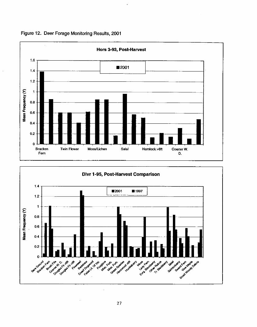
Figure 12. Deer Forage Monitoring Results, 2001
Hors 3-93, Post-Hawest
Bracken Twin Flower Mosstichen Salal Hemlock ~ 6 t l Coarse W. Fern 0.
Divr 1-95, Post-Hawest Comparison

Figure 13 WILLIAMSON CREEK OLD GROWTH STANDS 10-11 AND 10-12

The early successional forested stands (10-1,lO-3, 10-4, and 10-5) adjacent to Williamson Creek (Figure 5) were inventoried in 2000. The WHMP calls for retaining stands 10-1 and 104 as riparian forest without harvesting through the life of the plan. These stands were cover-typed as riparian, mixed, and small saw timber coniferous forest in the WHMl', which requires snag management, maintenance and monitoring in these stands. No snags were found within the transects in stand 10-1 and an average of 1.8 snagdacre were found within the transects in stand 10-4 (Table 12). Snag creation was initiated in stand 10-1 in fall of 2001 (Table 1). and will be completed to the extent possible in spring 2002. This stand is primarily composed of small (10-15") conifers and alders. As a result, snag creation potential is limited at this time. Snag creation in stand 10-4 was completed in winter 2001, with 13 snags mated (Table 1).
The WHMP calls for retaining stands 10-3 and 10-5 for late successional stage species. These stands were cover-typed as mixed, deciduous, riparian, and large saw timber coniferous forests in the WHMP, which requires ensuring adequate snags and CWD on these two stands. Snag management and monitoring is required for the life of the plan. The baseline snag and CWD inventories were completed in these two stands in 2000. The average number of snagdacre was 0.4 and 2.8 on stands 10-3 and 10-5 respectively (Table 12). The average number of CWDfacre was 3.9 and 2.1 on stands 10-3 and 10-5 respectively (Table 13). Snag creation was completed for both stands during the falllwinter of 2001. Twenty-nine snags were created in stand 10-3 and 12 snags were created in stand 10-5 (Table 1). Stand 10-3 had several irregularly distributed pockets of natural snags which were found, and thereby reduced the number of created snags required.
3.11 LAND MANAGEMENT AT LAKE CHAPLAIN
A project to improve the road drainage on the Lake Chaplain Road that was started in 2000 was completed during the summer of2001. During this project 16 culverts were replaced with larger culverts and seven additional culverts were installed to provide additional drainage for this road.
A Road Maintenance and Abandonment Plan (RMAP), required under the Washington State Forest Practices Act, was started on the Lake Chaplain Tract road network. The RMAF' must include a complete inventory of all forestland owners' road systems and a detailed plan to bring all of the forest roads used for forest practices after 1974 up to current standards within 15 years. All roads and railroad grades on forest land that have not been used since 1974 must also be inventoried for potential damage to a public resource, but no plan for improvements on these roads and railroad grades is required.
3.12 LAND MANAGEMENT ON DISTRICT PROPERTY
The District prepared and submitted an RMAF' Inventory Scheduling Proposal in March 2001. The proposal was approved, and the District worked with a consulting forester to prepare a RMAP for the entire District owned wildlife mitigation lands. The final RMAP was submitted to DNR in October and approved in December 2001. Implementation and reporting will begin in 2002.
The District has maintained contact and worked with DNR regarding DNR's Natural Resource Conservation Areas (NRCA) planning in the Upper Sultan Basin. The District commented on fire management on District owned property.
A Routine Road Maintenance Agreement was completed with the DNR for roads associated with project mitigation lands. Also, a supplemental easement was obtained on a portion of road (CD-147 in the RMAP) owned by DNR that will be used to access Spada Lake Tract lands for wildlife management purposes on land south of Culmback Dam.
3.13 SECURITY MEASURES AT LAKE CHAPLAINIJACKSON PROJECT FACILITIES
Heightened security measures at the City's water treatment facilities and the Jackson Project facilities have been implemented since the events of September 11,2001. The electric gate south of the filter plant at Lake Chaplain is kept closed at all times, and the south gate is closed on weekends. The gates at Olney Pass were closed, restricting public vehicle access to the Spada Lake Tract. Restriction of public access is under re- evaluation at the time of preparation of this report.
4.0 CUMULATIVE SUMMARY
A summary of all activities completed under the WHMP, from the earliest implementation in 1988 through the end of December 2001, is presented in this section. Appendix 1 lists milestones of WHMP implementation to date, with a reference to the location in past annual reports of discussions of each activity. This Appendix is included in this Annual Report as a method of cross-referencing reports of past activities without repeating the complete details of information presented in previous reports. For complete discussion of a particular subject, the reader should refer to the referenced annual reports.
FOREST VEGETATION MANAGEMENT (LAKE CHAPLAIN TRACT)
Road System Layout and Construction
The main road systems for the northeast side of the Tract, the area south of the Diversion Dam Road, and portions of the west side of the tract have been constructed, as shown in Figure 2. Spur roads were constructed to provide access to harvest units east of the filter plant. Construction on additional portions of the road system on the west side of the tract was started in 2001 Figure 2).
T i r Harvest
Harvest activity to date is depicted in Figure 14. All of the unit boundaries have been reconfigured somewhat to improve operational feasibility, reduce impacts to streams and wetlands, and reduce the length of access roads. As part of the process, boundaries of permanent mixed forest stands, stream and wetland buffer zones, and old growth management areas have been established. There have been some substitutions of final harvest units, as summarized below in Table 7. However, the final harvest program


complies with the WHMP's schedule and requirements including the restriction on harvest unit size and the required green-up period for adjacent harvest units.
Table 7. Modifications of the Final Harvest (FH) Schedule on Lake Chaplain Tract New Unit Name (see 1 Scheduled FH I Reasons for Modif~cation
I harvested instead of 2005-5 in 1995 2030-3 1 2005 (part) and I Units originally scheduled for FH in 2005 and
Fig. 15) 2005-5 ("Gold Camp" unit)
I 2030 (part) 1 2030 rec&fig&ed into Div12-95 and 2030-3
Commercial thinning scheduled in the WHMP (Figure 14) from 1990 to 2005 was modified for several reasons, including potential problems related to access, soil type and timber type. These issues were discussed more fully in the 1996 Annual Report (Section 4.1.3). After on-site evaluation, it was determined that several units would be eliminated from the commercial thinning schedule. The units, and the reasons for not thinning them are listed in Table 8. Two units that were not scheduled in the R'HMI' were thinned in 1993 (Table 8).
1990
1 Table 8. Modifications of the Commercial Thinning (CT) Schedule on Lake Chaplain
Existing wildlife habitat value is high. Unit Divr2-95 (portions of units originally scheduled for FH in 2005 and 2030) was
* Thinned in 1993
Additional opportunities for commercial thinning in the northeast and northwest corners of the Lake Chaplain Tract are under evaluation, following the hemlock looper outbreak observed in 2001 (Figure 14). Possibly some harvest units will be rescheduled, or the type of harvest may change. The mix of final harvest units and commercial thinning units in these corners has not yet been determined, but the required "green-up" period between adjacent harvest units will be observed. If very significant and widespread die- off results from the hemlock looper defoliation, the co-licensees may propose relaxing the green-up provision, and will consult the agencies before undertaking any action.
4.1.3 Management of Roads and Post-harvest Units

All final harvest units have been seeded with a grasslforb mix on bare areas, and replanted with Douglas fir and red cedar seedlings. Road ROW'S have also been seeded, and access roads outside the closed watershed have been gated to prevent vehicular access by the public. Small timber salvage sales were held associated with final harvest of some units: 1) adjacent to a 1991 harvest unit following a major storm in January '1993 and, 2) adjacent to two 1998 harvest units and access roads in 1998 and 1999.
Monitoring of stocking levels in post-harvest units was started in 1997. Results that year in unit Chap2-91 showed excessive conifers, adequate overall density of hardwoods, but distribution of hardwood species is clumped. In 1998 some hardwood removal and replanting was done in this harvest unit. In 2001 some hardwood removal was done in Divr2-95, and Chapl-91 was preco-rcially thinned.
4.2 FOREST VEGETATION MANAGEMENT (LOST LAKE TRACT)
Stand 7-4 was precommercially thinned in 1991 and monitored annually through 2000. The slash has begun to decompose, and access through the stand has gradually improved over time. The shrub layer, especially salmonberry, has responded to the reduction in the tree canopy, and signs of deer browsing have been observed.
A feasibility study of timber harvest on the Lost Lake Tract was performed by a consultant in 2000, results were summarized in Section 3.1 of the 2000 Annual Report A detailed timber cmise of the older stands (7-1.7-1,7-3) was performed in 2001, and several management options were prepared (see Section 3.3 of this report).
4.3 FOREST VEGETATION MANAGEMENT (SPADA LAKE TRACT)
The Spada Supplement, a plan for lands surrounding Spada Lake that were acquired in 1991, was approved by the FERC in 1997. The Spada Supplement calls for commercial and precommercial thinning of some forest stands on the Tract. Three young second growth stands (totaling about 30 acres) on the south shore of Spada Lake were precommercially thinned in September 1996. Two second growth stands totaling about 38 acres on the south fork were precommercially thinned in 2000 (Figure 3).
The DNR completed abandonment of the North Shore Road and its tributary roads from a point east of Recreation Site 8 during the summer 1999 (Figure 3). The road had become inaccessible east of Recreation Site 8 due to a massive landslide in 1997. Some of the planned forest management activities, including commercial thinning and precommercial thinning, in units formerly served by this road therefore will be affected. With the loss of road access, the only option for future commercial harvest north of the lake will be helicopter logging.
A forestry contractor performed a feasibility study of timber harvest on second growth stands at the Spada Lake Tract that can be accessed by road (see Section 3.1.5 of the 2000 Annual Report). The units were marked for future harvest, pending improvements in timber prices.

4.4 SNAG MANAGEMENT
Snag management activity from the beginning of implementation in 1989 through 2001 is shown in Figure 15 and summarized in Tables 9a and 9b. A target was established in the 1994 Annual Report to complete snag inventories in a large number of units on the Lake Chaplain and Lost Lake Tracts by the end of the 1998. This target was achieved in 1998, with the exception of four units that were removed from the inventory following the decision to commercially thin them (see Section 3.2.1 of the 1998 Annual Report). Snag creation on these four units will follow the harvest to achieve the WHMP's required size distribution. On all other targeted units, if sufficient snags to comply with the WHMP's requirements did not exist, snags were created to meet the requirements. Snag inventoryheation has been completed on all Lake Chaplain and Lost Lake units that have been harvested or thinned, and all units scheduled for harvest by 2020, except one scheduled for commercial thinning within 20 years.
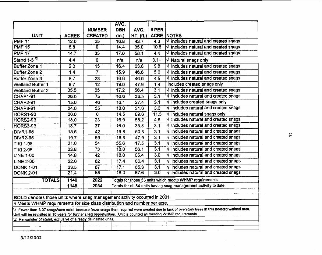
Snag creation and management activity on the Lake Chaplain and Lost Lake Tracts from 1989 through 2001 is presented in Figure 15 and summarized in Table 10a. To date, snag inventory and creation has been conducted on 54 units, totaling 1,148 acres between these two tracts. A total of 2,034 snags have been created on these two tracts. All but one of these units meets WHMP requirements for snag number and size distribution.
Additionally, 15 units totaling 381 acres on the Williamson Creek and Spada Lake Tracts have been inventoried and/or had snag creation from 1999 through 2001 (Figure 16). Of these, 8 units totaling 256 acres now meet the WHMP requirements for snags (table lob).
For all tracts, 69 units totaling 1,529 acres have had snag inventories and/or creation since 1989. A total of 2,142 snags have created, with 61 units (1,396 acres) now meeting the WHMP requirements of at least 3.07 snags per acre in the appropriate size classes. Inventories and/or creation have been conducted on the Lake Chaplain, Williamson Creek, Spada Lake and Lost Lake Tracts. The entire Lost Lake Tract now meets the WHMP requirements for snags, except for Stand 7 4 , which was harvested in the 1970's and does not have trees large enough for snag creation.
A detailed discussion of modifications to the snag management program was presented in the 1994 Annual Report (Section 4.2). In 1996 the inventory/monito~g methods for snags were revised. Methods were field tested in 1997 and revised in 1998. Long-term monitoring of created snags at the Lake Chaplain and Lost Lake Tracts was conducted in 1998,1999 and 2001. Snag management procedures specific to the Williamson Creek Tract were developed in 1999.

FIGURE 15. SNAG MANAGEMENT LAKE CHAPLAIN AND LOST LAKE l989-2OOI
P\ / Streams '0 Snag Creation
Meets WHMP Requirements Harvest Within 20 Years,
Snag Mgt. After Harvest

lain & Lost Lake Tracts I i
I I 1 NUMBER I DBH I AVG. I #PER I I
I I I I I I - ~PMF 9 1 52.2 1 71 1 17.3 1 54.9 1 3.1 Id Includes natural and created snaas
PMF 5 PMF 6 PMF 7a" PMF 7b PMF 8
I I I I - - ~ - ~ ~~~ - ~ ~~ ~
I I - PMF 10 1 34.1 1 56 ! 18.3 1 45.1 1 4.5 14 Includes natural and created snags 1
27.4 13.3 15.5 15.8 8.5
0 0
20 38 24
23.5 23.9 17.8 18.1 17.5
47.3 64.3 58.5 66.0 65.2
5.3 6.0 2.5 4.6 3.2
4 Includes natural snags only 4 Includes natural snags only 4 Includes natural and created snags 4 Includes natural and created snags 4 Includes natural and created snaas
AVG. 1 NUMBER I DBH 1 AVG. / I PER 1
I I I I I I
BOLD denotes those units where snag management activity occurred in 2001 4 Meets WHMP requirements for size class distribution and number per acre. \1 Fewer than 3.07 snaadacre exist because fewer snaas than rewired were created due to lack of overstory trees in this forested wetland area. - - - - Unit will be revisited in 10 years for further snag opportunities. Unlt .s counted as meetlng WHMP requlrements. U Remainder of stand, exclusive of already del~neated units 1 1 1

reek 8 Spada Lake Tracts
NUMBER DBH AVG. #PER UNIT ACRES CREATED (in.) HT. (ft.) ACRE NOTES
BOLD denotes those units where snag management activity occurred in 2001 d Meets WHMP requirements for size class distribution and number per acre. \ I Trees not of adequate size for snag creation, re-evaluate in 10 years. I I \2 Inventories conducted. snag creation will be completed in 2002. 1
Stand 9-24 " Stand 9-35 Stand 9-47
\3 Old-growth stand; will not have pro-active snag management. \4 5% sampling not yet completed
I I I I I I
12.1 4.5 4.3
19 13 10
15.7 15.9 15.7
62.0 54.9 64.0
2.1 3.9 3.0
Includes natural and created snags d Includes natural and created snags d Includes natural and created snags

4.5 COARSE WOODY DEBRIS MANAGEMENT
The 1995 Annual Report described the fast inventories of CWD on the Lake Chaplain Tract, and the subsequent development of the CWD management procedure to ensure compliance with WHMF' targets. The procedure was implemented on the 1995 Diversion Sale and the 1998 Tiki Sale. The 1995 and 1996 Annual Reports describe more fully the earlier inventories and consultations with the agencies regarding standards for compliance. In 19%. the inventorylmonitoring methods were revised following a consultant's review of the procedures, as described in the 1996 Annual report. The methods were finalized in 1997, field tested, and implemented on the units of the 1998 Tiki Sale, the Linetree Sale, and all future harvest units. CWD management procedures specific to the Williamson Creek Tract were developed in 1999. Created CWD on two units of the 1995 Diversion Sale was monitored in 1999 per the CWD management methods.
4.6 REVEGETATION
4.6.1 Spada Lake Drawdown Zone
Test plots of five wetland emergent species were planted at two sites in OctoberlNovember 1994 and monitored annually through 2000. Two sedge species became well established and spread vegetatively at Williamson Creek. Most plantings at the North Fork Sultan River site were damaged by wave action and floating debris. Slough sedge (Carex obnupta) recruitment on the sites may be the result of the 1994 plantings since most of the& plants are in or among the planted rows (1998 Annual Report, Section 3.4.1)- However, natural in-seeding of wetland plants on both sites, especially small fmited bulrush and other herbaceous species has been far more successful in covering the ground than the test plantings so far. The 1997 Annual Report (Section 4.6.1) describes the response of wetland plantings and natural recruitment on these sites with respect to the management of lake elevation.
4.6.2 Power Pipeliie Right-of-way
Annual seeding of the pipeline ROW with a mixture of grasses and forbs has been conducted and there now exists a good layer of herbaceous material along the entire ROW. Small bare areas still exist, primarily in areas of sandy or rocky soil, or where ORV damage has disturbed the vegetation.
Quantitative sampling of the ROW has been performed for four successive years to document the effects of the ROW management procedures and identify any changes that may be necessary. Thus far, the monitoring does not appear to identify any changes that are necessary, but shows that annual seeding and allowing the plants to go to seed prior to mowing in the fall are producing the desired effect on most of the ROW. The more than 60 sbrub groups planted on the ROW in 1998 and 1999 are surviving well, but spreading slowly due to poor soil conditions.
Restoration of a portion of the access road and replacement of a washed out culvert were completed in 1999.
4.6.3 North End of Lake Chaplain and Chaplain Marsh
The required plantings at the north end of Lake Chaplain were monitored twice annually from the time of planting in 1992 through 1995, and once in the following years. Survival of western redcedar at the north end of the lake from the time of planting to 1998 was 80 percent. Douglas fir saplings have had excellent growth, with overall survival over 90 percent. Excess alders were removed in 1998 and 2001 to release planted conifers and delay conversion of grasdshrub habitat to hardwood thickets.
The required plantings adjacent to Chaplain Marsh were monitored twice annually from the time of planting in 1993 through 1995, and once in the following years. Alders growing among the plantings were cut down in 1998 to release the planted shrubs from competition. As a result, the density of the vegetative screen between the Lake Chaplain Road and the marsh decreased, but the desired species composition was retained.
4.6.4 Powerhouse Site
Shrub and tree plantings were monitored at least twice each growing season between planting (in 1993) and 1995, and once annually from 1996-1998. In 1997, we planted a small number of cascara saplings to test whether this species is suitable for the site. Survival of the tree species has been greater than 90 percent, and growth has been variable: crabapples have grown more than ash and hawthorn. Of the shrubs, only Nootka rose has survived and grown well on this site. Many huckleberries and serviceberries have persisted, but have grown very slowly.
4.7 NEST STRUCTURES
All of the nest structures that were required by the WHMP have been installed and monitored annually thereafter. Figures 8 through 10 of this report summarize past nest structure locations. In 1990, two floating nest platforms were placed in Lost Lake (Fig. 8). The required two duck nest boxes were installed at Lost Lake in 1990. One osprey platform was installed at Lost Lake in 1990 and two at Spada Lake in 1992 (Fig. 9).
4.7.1 Floating Nest Platforms
In addition to the required nest structures, we placed two additional floating platforms (one of these in place of the third platform required at Lost Lake) in Lake Chaplain in 1990, in hopes of recruiting loons (Fig. 10). In February 19% the floating platforms at Lake Chaplain were moved to Spada Lake (Fig. 9). One was destroyed in late 1996 or early 1997 by unknown causes, and the other floated away from its anchor. The latter was placed at a different location on Spada Lake, in the Williamson Creek area in 1998.
The floating platforms have been used for resting and feeding by waterfowl and otters, with the only breeding attempt noted to date being the north platform at Lost Lake this Y-.
4.7.2 Nest Boxes
In 2001 there was a total of 24 functional waterfowl nest boxes on mitigation lands. Figure 8 through 10 of this report show nest box locations throughout implementation since the original two required nest boxes were installed in 1990 at Lost Lake.
The nest boxes have been monitored every year since installation. Waterfowl used over half of the boxes each year (61% in 1997) until 1998, when nest box success was 16%. Nest box success was only 10% in 1999. In 2000 overall nest box success was 32%. In 2001 overall nest box success was 21%. Success in 2001 at Lost Lake, Lake Chaplain Tract and Spada Lake was 30%. 33% and 0% respectively.
4.7.3 Osprey Nest Platforms
The osprey platform at Lost Lake produced one fledgling in 1994 and one in 1995. Nesting was attempted in 1996,1997, 1998, and possibly in 1999, but was not successful. It appears the osprey moved to a nest site on DNR land in 1999. No osprey use of the platform at Lost Lake was observed in 2000 or 2001.
A nest was partially constructed at the osprey platform near the South Fork Sultan River at Spada Lake during 1994, and in 1995 osprey completed a nest and were observed setting prior to abandoning the nest in June. Nesting has not been observed on the osprey platforms at Spada Lake since then. A nest was actively used from 1996 through 1998 downstream from Culmback Darn. That nesting site was replaced by another nesting site on the same hillside, which was actively used by osprey in 1999. Results for this nest site are uncertain since 2000, as it is not monitored on a regular basis.
4.8 BIOSOLIDS APPLICATION
The City of Everett applied 12.5 dry tons of biosolids per acre to units Hors 2-93 (2035- 6) and Hors 1-93 (2040-5) in the Lake Chaplain Tract in August and September of 1996, as described fully in the 1996 Annual Report, Section 3.8. This application was one half of the prescribed amount of biosolids (based on measured nitrogen requirements). In the summer of 2000. the City applied a blended soil amendment consisting of 2 parts biosolids and 1 part wood ash to units Hors 1-93, Hors 2-93, Hors 3-93, and Diwl-95. Unit's Hors 1-93 and Hors 2-93 received 37.5 dry tons per acre of soil amendment, and units Hors 3-93 and Diw 1-95 received 45 dry tons per acre.
Two water quality monitoring sites were established on Chaplain Creek. Creek waters were sampled monthly beginning in August 1996 through the end of 2001. Parameters examined were nitrates, phosphorus, fecal colifonn, ammonia, and chloride. Water quality monitoring has indicated no deleterious biosolids effect on the water quality parameters measured.
Vegetation monitoring was conducted from 1996 to 1999 and again in 2001 in accordance with the vegetation monitoring plan described in the 1996 Annual Report. No vegetation monitoring was conducted in 2000 because biosolids application at the sample sites disturbed the vegetation.
4.9 DEER FORAGE MONITORING
A revised sampling procedure was finalized in 1997, after several other procedures proved unsatisfactory in previous years. The 1997 procedure has been used in monitoring the following Lake Chaplain Tract units:
Table 10. Summary of Deer Forage Monitoring Schedule Unit Name I Harvest Year I he-Harvest I Post-Harvest
4.10 LAND ACQUISITION
In 1988 the District purchased the 205-acre Lost Lake Tract as part of the WHMP requirement. The DistrictiUSFSKlNR land exchange was completed in 1991. The District acquired 2,295 acres of upland and wetland habitat at Spada Lake and Williamson Creek. This included the entire Williamson Creek Tract identified in the WHMF'. With the exception of existing recreation sites and areas used for hydroelectric operations, the land in the Spada Lake Tract has been incorporated into the wildlife habitat management program as prescribed by the WHMP and the Spada Lake Tract Supplemental Plan. The Supplemental Plan was approved by the FERC on April 18, 1997 and will guide future forest vegetation management for that tract.
The City/DNR land exchange was completed in late 1991. All of the land specified in the WHMP in the Lake Chaplain Tract was acquired by the City and dedicated to management under the WHkP.
4.11 WILLIAMSON CREEK TRACT
Monitoring of the Williamson Creek tract has focused on baseline inventories of the stands for snags, CWD, understory vegetation, wetlands and photo documentation. The status of inventorying on each stand is summarized in Table 11. Note that old growth inventory includes snags, CWD, understory vegetation inventory and photo documentation. Wetland inventories will be done every five years. The table indicates that the initial wetland survey was completed in Stand 10-10. Baseline inventory will be complete once 15.5 old growth transects have been completed.
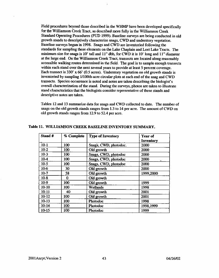
Field procedures beyond those described in the WHMP have been developed specifically for the Williamson Creek Tract, as described more fully in the Williamson Creek Standard Operating Procedures (PUD 1999). Baseline surveys are being conducted in old growth stands to descriptively characterize snags, and understory vegetation. Baseline surveys began in 1998. Snags and CWD are inventoried following the standards for sampling these elements on the Lake Chaplain and Lost Lake Tracts. The minimum size for snags is 10' tall and 11" dbh, for CWD it is 10' long and 11" diameter at the large end. On the Williamson Creek Tract, transects are located along reasonably accessible walking routes determined in the field. The goal is to sample enough transects within each stand over the next several years to provide at least 5 percent coverage. Each transect is 330' x 66' (0.5 acres). Understory vegetation on old growth stands is inventoried by sampling 11100th-acre circular plots at each end of the snag and CWD transects. Species occurrence is noted and notes are taken describing the biologist's overall characterization of the stand. During the surveys, photos are taken to illustrate stand characteristics that the biologists consider representative of these stands and descriptive notes are taken.
Tables 12 and 13 summarize data for snags and CWD collected to date. The number of snags on the old growth stands ranges from 1.3 to 14 per acre. The amount of CWD on old growth stands ranges from 12.9 to 52.4 per acre.
Table 11. WILLIAMSON CREEK BASELINE INVENTORY SUMMARY.
Table 12. WILLIAMSON CREEK TRACT SNAG CUMULATIVE INVENTORY SUMMARY
(4%) 10-12 I Old Growth 1 6.0 1 30.7 1 38.3
Table 13. WILLIAMSON CREEK CWD CUMULATIVE INVENTORY SUMMARY
(4%) 10-12 I Old Growth 1 36.0 1 24.9 1 54.7
4.12 LAND MANAGEMENT
The District has worked with landowners in the Sultan Basin over the life of the WHMP in an effort to coordinate land use activities so that they are consistent with, or at least do not interfere with management of the WHMP. Activities on adjacent property for which the District has provided time and effort in the past have included recreational pursuits, timber harvest, surveying, and road maintenance and abandonment. The District completed a Routine Road Maintenance Agreement with DNR in 2001, for roads providing access to project mitigation lands. The DNR is in the process of preparing a
Natural Resource Conservation Area (NRCA) plan for the Upper Sultan Basin and the District has been following that process and providing input since 1999. In compliance with Washington Forest Practice Rules (WAC 222-24-050 through 052). the District prepared and submitted in 2001, a Road Maintenance and Abandonment Plan (RMAP) Inventory Scheduling Roposal and an RMAP covering all of the District owned wildlife mitigation lands.
5.0 WORK PLANNED FOR 2002
FOREST VEGETATION MANAGEMENT
Lake Chaplain Tract
The two units of the Donkey Damper Sale will be logged in early 2002 and replanted with Douglas fir and western redcedar. Chap2-91 will be precommercially thinned with the following specifications:
Leave Douglas fu at 12'xl2'spacing Leave all Western rededar Leave all hardwoods, except Prune maple stump sprouts to 2 to 3 stems
Setup work will be done on the next (unnamed) sale units.
Tree seedlings on all harvest units will be monitored for survival and vigor. Conifer and hardwood densities on the three units of the 1991 Chaplain Sale will be evaluated and a schedule will be developed for future precommercial and commercial thinning activities.
We will complete work on GTA management procedures in 2002, and draft management plans for existing GTA's.
Spada Lake Tract
Spada Lake stands 9-36.37, and 38 will be precommercially thinned.
Lost Lake Tract
Harvest units identified in Section 3.1.5 may be set up for future commercial thinning, pending discussions with the regulatory agencies.
SNAG MANAGEMENT
Stands that have already been inventoried on the Spada Lake and Williamson Creek Tracts will be the first priority for snag completion in the year 2002. These include stand 9-180 on the Spada Lake Tract (see Fig. 5) and stands 10-1 and 10-2 on the Williamson Creek Tract (Fig. 6). Additional stands on the Lake Chaplain Tract will be inventoried and snags created as needed. Stands on the Spada Lake Tract will be inventoried based on Figure 3-2 of the Spada Supplement.
Also in 2002, long-term monitoring will begin on stands on the Lake Chaplain and Lost Lake Tracts where snags were created 10 years ago. The objective on harvested units is to determine whether the snags designated for each unit are still standing and whether
any replacements are now needed. Each created snag will be visited to verify its status, with notes regarding use and current decay class beiig taken. Snag inventories within those units will be conducted according to the snag SOP, to capture information relating to naturally occurring snags. Deficiencies in the numbers of natural plus created snags will be remedied during the next snag creation contract.
5.3 COARSE WOODY DEBRIS MANAGEMENT
Created CWD will be monitored on selected Lake Chaplain harvest units.
5.4 REVEGETATION
5.4.1 Spada Lake Drawdown Zone
Survival of wetland plantings and natural recruitment of vegetation will be monitored on the two shoreline revegetation sites in 2002.
5.4.2 Power Pipeline Right-of-way
Shrubs will be planted on the ROW in spring 2002 to provide additional foraging and hiding habitat. Native species such as Nootka rose, mock orange, red-osier dogwood and pacific ninebark will be planted. Soil amendments such as imported compost will be added to increase moisture and nument retention. A compost or mulch layer will be applied to the new plantings and to shrubs planted in 1998 and 1999. Disturbed soil around the new plantings will be seeded with a clover mix to provide additional nitrogen as well as reduce competition from inseeding by alder and hemlock seedlings.
5.4.3 Chaplain Marsh, North End of Lake Chaplain, and Powerhouse Site
Monitoring will be conducted as in previous years.
5 5 NEST STRUCTURES
The osprey platforms at Lost Lake and Spada Lake, will be monitored when the biologists are on site to perform other activities during the breeding season (ApriElate June). Monitoring will be reinstated on a regular basis if any platform is used for nesting. Monitoring of the floating nest platforms at Lost Lake will be reinstated in 2002 since there was use of the north platform in 2001. At the end of the nesting season the floating platforms will be visited to look for signs of use by wildlife. The floating nest platform at the east end of Spada Lake will be visited by boat and inspected when duck nest boxes in the vicinity are checked in June.
Nest boxes will be cleaned and repaired in February and checked for nesting success in June. Data from the three nest box designs that are used in this program will be evaluated to identify whether details such as roof or door design may be influencing nest box success.

5.6 DEER FORAGE MONITORING
The following harvest units will be sampled in 2002: Chap 1-91 and Linel-2000.
5.7 WILLIAMSON CREEK TRACT
Baseline old growth inventorying will continue on the Williamson Creek Tract in 2002. Snag creation will be completed for stands 10-1 and 10-2 in the spring of 2002.
5.8 LAND MANAGEMENT
The District will begin implementation of the RMAP and will prepare and submit an annual report to DNR. The City will complete its RMAP and submit it to the DNR.
The District will continue to work with D M on their NRCA plan for the Upper Sultan Basin, providing comments and suggestions on plans (habitat objectives, fire management, etc.) and coordinating land management in the basin.
5.9 SECURITY MEASURES AT LAKE CHAPLAIN/JACKSON PROJECT FACILITIES
A security assessment of these sites is in progress, and additional changes may occur in 2002, which could include surveillance cameras, additional gates, reconfigured gates or changes in locations. Impacts on public access to the Lake Chaplain Tract and other Jackson Project lands will be considered in this assessment.
6.0 SCHEDULE OF ACTIVITIES FOR 2002
Major Activities 1 Loeation I Quantity Road Construction I Lake Chaplain Tract I Complete road to Donkey
Timber Sale (Lake
Damper units
Complete 3 units TBD
Chaplain) Sale Layout (Lake Chaplain)
Commercial Thinning Sale Layout
Reforestationlseeding Harvest Unit Stocking
Snag Creation I Lake Chaplain Tract Snag Inventory I Lake Chaplain Tract, Spada
Unnamed Sale, see Fig. 2
Lost Lake Tract
- Monitoring Precommercial Thinning 2 units (approx. 38 ac.)
Complete Chap2-91 10t units, as needed 10 t units on L. Chaplain
2 units (acreage TBD)
Stands 7-1.7-2.7-3 lacreaee
Donkey Damper Sale L. Chaplain Tract, all previously harvest units Spada Lake Tract Lake Chaplain Tract
- TBD), pending agency review 2 units 10 units
CWD Creation CWD Inventory Revegetation
Grass seedinglfertilizer Shrub plantings
Monitoring Revegetation Site
spots
Monitoring of all
Lake Tract, Williamson Creek Lake Chaplain Tract Lake Chaplain Tract
Pipeline ROW
West side, Chaplain Marsh MonitoringtMaintenance
Deer Forage Snags Nesting Structures
Wetland Monitoring
planted/s&ded areas. Maintenance as needed: Weeding, brush thinning, etc.
Tract; other tracts T ~ D Donkey Damper Sale TBD
As needed to improve bare
North end, ~ . ~ h a ~ l a i n Powerhouse site Spada L. drawdown zone Pipeline ROW Lake Chaplain Tract L. Chaplain. Lost Lake Tracts Lost Lake, Spada Lake, and Chaplain Tract Lost Lake
3 units 100+ created snag trees Monitor all structures .
AU wetlands designated in
Williamson Creek
Biosolids Application Understory monitoring Water quality monitoring
GTA and BZ Management
Stands 10-6, 10-7, 10-8, 10-1 1
Land Management
- SOPS Continue old growth baselime inventory; complete snag
L. Chaplain Tract Horsl-93, Hors2-93 Chaplain Creek All established units
creation on 10-1 and 10-2 None planned 2 units plus controls 2 stations Monitor and develop long-
Spada Lake Tract Lake Chaplain Tract
term management plans Begin RMAP implementation. Complete RMAP

APPENDIX 1 - WHMP Implementation Milestones
I Activity I TI& I I (Sectiodpage #) I (This table will be updated in the fmal version)
I General 1 Management 1 Milestone
r i b e r Harvest Lake Chaplain Chaplain Sale Lake Chaplain Horseshoe Sale Lake Chaplain Diversion Sale Lake Chaplain Tiki Sale Lake Chaplain Line Tree Sale
Annual Report Reference - I
Category
Lake Chaplain Donkey Damper Sale Lake Chaplain Salvage Sales
I
~Aagement Lost Lake Precommercial Thinning Spada Lake Precommercial Thinning Lost Lake Harvest Planning Spada Lake Harvest Planning
Stream and Lake Chaplain Snag creation and Wetland Buffer monitoring Zone Management GTA Lake Chaplain Chaplain Sale Unit 1 Management
snag Lake Chaplain Implementation Management 1 Decisions
I Lake Chaplain I Snag Inventory Results I and Lost Lake I

General Activity Category
CWD Management
Revegetation
Nest Structures
Management Milestone Tract
I
Lake Chaplain I Snag Monitoring Lake Chaplain I Implementation
I
Lake Chaplain CWD Invento~y Results
Lake Chaplain CWD Creation
I
Lake Chaplain CWD Monitoring
Spada Lake Drawdown Zone Test Plantings 1
I
Pipeline ROW Plant shrubs and trees
wyy 1 Placegtree root wad; Lake Cha lain Reve etation Desi Lake Chaplain Plantings at north end of
1 lake Lake Chaplain I Plantings along
Powerhouse Plant shrubs and trees
Lost Lake Duck nest boxes I Lost Lake Osprey Platfom
Annual Report Reference - (Sectionlpage #)
1993 (4.5, p.22), 1994 (3.6.6,p.10), 1995 (3.3.2, p.ll), 1995 (Appendix A- Exhibits 1-3). 1996 (3.3, p.10) 1991 (3.10.2, p.27). 1993 (3.7.2, p.141,

General Activity Category
Bald Eagle Nest
Biosolids Application
Deer Forage Monitoring
Land Acquisition
Management Plans & Land Use Decisions
Management Milestone Tract
Lake Chaplain Floating platforms -I--- Lake Chaplain Duck Nest Boxes I Spada Lake Floating Platforms
I
Spada Lake Duck Nest Boxes I
Spada Lake Osprey Platform I
Lake Chaplain Monitoring
Lake Chaplain Biosolids Application
Lake Chaplain Monitoring
I Utilization Results Lost Lake I Lake Chanlain I Spada Lake I Williamson
( Installation Spada Lake I Supplemental Plan
Annual Report Reference - (Sectionlpage #)
1996 (3.7, p.15) 1997 (Attachment 1)
1997 (Attachment 2)

I General I Management I Milestone Annual Report Reference - I Activity Tract
Management
Consultation
Gate to restrict public access Agency tour of WHMP Sites FERC Environmental Inspection
Monitoring I
Other Monitoring
Williamson Creek

APPENDIX A - AGENCY CONSULTATION MEETING APRIL 5,2002

JACKSON HYDROELECTRIC PROJECT WILDLIFE HABITAT MANAGEMENT PLAN
Agency Meeting Minutes April 5,2002
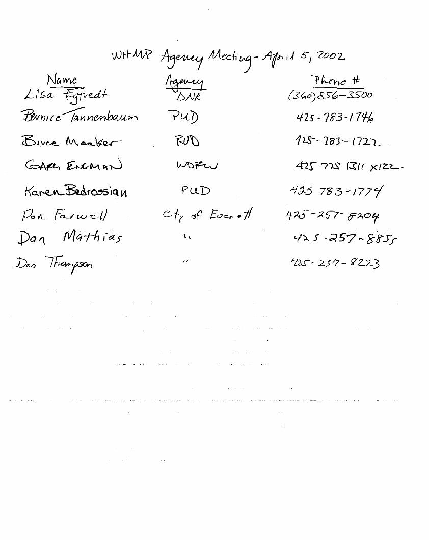
In Attendance: City of Everett - Don Fanvell, Dan Thompson, Dan Mathias District - Bernice Tannenbaq Karen Bedrossian, Bruce Meaker USFWS - Gwill Ging (by telephone) WDFW - Gary Engman WDNR - Lisa Egtvvedt
A. Introductions
B. Update on WHMP Implementation Hemlock Loowr Outbreak Don described the status of the hemlock looper and phantom looper outbreaks in the vicinity of Lake Chaplain and Lost Lake. DNR determined that trees on about 11,000 acres have suffered defoliation, including 1,000 acres in the Lake Chaplain Tract and 100 acres in the Lost Lake Tract. The extent of mortality due to defoliation ha. not yet been determined. Hemlocks are more likely to succumb to defoliation than Douglas fir.
Don will set up some infected hemlock-dominated harvest units (2000-3 and 2005-3) in the north portion of the Tract, and will leave the firdominated stands he worked on in 2001 for future harvest (See Figure 14, p. 30). He may also set up two additional hemlock stands: 2005-1 and 2005-2.
Gwill-Will this change be consistent with the WHMP requirement for allowing a "green-up" period between the harvest of adjacent units?
Don-Yes, the WHMP allows units to be harvested within ten years of the scheduled harvest date. A salvage sale may also be a possibility.
Reveeetation Monitoring Bernice reviewed the revegetation experiments on the Spada Lake shoreline. Slough sedge is the only suniving species, and it is dowly spreading via rhizomes. Planted sedges can no longer be distinguished from volunteers. She proposed discontinuing formal monitoring of the sites, and offered to visit the sites in conjunction with other activities that take us to the area.
Gwill-It's ok to terminate formal monitoring, but when we are in the area, he would like us to photodocument the sites over time.
Nest Structures Bernice reviewed the histow of floatine waterfowl nest ~latforms in Lost Lake and Snada Lake. At Spada Lake, on lyne platfoA remains in the'williamson Creek arm, whi& has had no waterfowl nesting activity. With the abandonment of the North Shore Road, the platform can no longer be viewed from a vantage point. Bernice proposed discontinuing regular monitoring during the breeding season, and offered to inspect the platform for signs of nesting use whenever other activities take us to the area. Regular
Agency Meeting Minutes April 5,2002
monitoring of the 2 Lost Lake platforms, one of which was used by nesting pied-billed grebes in 2001, will wntinue,
Gwill and Gary-Both accepted the change.
Bernice reviewed the history of the osprey platforms at Lost Lake and Spada Lake. The Lost Lake platform and one platform at Spada Lake had some nest-building activity soon after they were installed, but subsequently no use at all. Ospreys have nested in trees on the north ridge above the Sultan River gorge since the platforms were installed. She proposed eliminating regular monitoring of the Spada Lake platforms.
Gwill-That would be acceptable, but he wondered if the platforms were in very exposed sites that were not accepted by the birds. Perhaps the locations were too windy?
BemiceThe nests in trees above the gorge were also very exposed. No reason to believe that winds would be any different around the lake.
Securitv Concerns in the Sultan Basin Bruce reviewed the temDorarv closure of the Sultan Basin. The South Shore Rd. and the 6000 Rd. gates were closed ai Olney Pass following the 911 1/01. The District wants to re-open portions of the Basin for public recreation use, but needs to protect Jackson Project facilities from possible attack. There is public interest in accessing the Sultan River gorge via the 4210 road for water sports. The District and City are currently discussing various solutions. At present, they feel that the South Shore Rd. gate at Olney Pass could be re-opened to the public, which would allow access to Rec. Sites 2, 3,4 and 5. The District and City wish to restrict access to Culmback Dam, while allowing use of road 4210 for access to the river and mining claims in the vicinity.
Options include opening the 6000 Rd. gate at Olney Pass and placing a gate at the intersection of 4210 and 6000 that would close off the Dam. This option does not accomplish significant protection for the dam, as this intersection is only about !4 mile away.
Gwill-What about miners needing to cross the dam?
Bruce-They don't need to cross the dam to access their claims. Another option is to close tbe gate at Olney pass, with a changeable combination lock that wuld allow '%ontrolled access" to approved recreational and mining users. Alternatively, a security guard w d d be posted to Olney Pass, who would allow approved individuals to access the 6000 Rd.
Two major washouts on Basin roads need repairs as soon as the snow has melted: One washout is located on the 6000 Rd. midway between Olney Pass and Culmback Dam, and the other is on the South Shore Rd. west of the South Fork bridge.
Gary-Will this affect opening day at the rec sites? How bad are the slides and when will they be repaired?
Bruce-The sites won't be open for opening day of fishing, but even without the road failure, the snowpack is still too deep on the South Shore Rd. The 6000 Rd. slide is definitely undrivable, and it has higher priority for repairs, possibly in early summer.
Agency Meeting Minutes April 5,2002
The extent of the repair needed on South Shore Rd. isn't known yet. The District and city received a response from the Federal Aviation Administration regarding the request to close the air space over the Jackson Project to low-flying aircraft. The FAA stated they don't have the authority to close air space.
$ecuritv at Lake Chsolain Don described changes in security measures at Lake Chaplain. The electronic gate at the filter plant is kept closed at all times. The south gate is closed on weekdays from 6 pm to 6 am, and all day on weekends. Public access by any means is prohibited when the gate is closed. The city will do a vulnerability assessment of the watershed and roads to determine options. Possibly a new gate will be installed farther north on the Chaplain Rd., and the south gate will be reopened on weekends.
Gary-Will the agencies have an opportunity to comment on a draft of the plan? Where would the new gate be placed?
Dew-Assumes comments will be allowed. The location of the new gate is not known yet, and will be based on the recommendation of a security specialist.
Timber Manaeement at Spada Lake Bernice summarized studies of timber management options at Spada Lake and described recent management decisions. The District will precommercially thin (PCT) the northwest corner of the property (Stands 9-36 and 9-37) in 2002. We will request funding to commercially thin Stands 9-120,9-121,9-183-, 9-142,9-150 and 9-184 in the District's 2003 budget. Karen mentioned that the DNR's plan for adjacent NRCAs doesn't call for active management of second growth stands.
Gary and Gwill expressed concerns over slash load that PCT generates, but agreed that long-term benefits for wildlife will follow. Regarding commercial thinning, Gwill asked whether District management will want us to harvest the highest value trees and maximize revenue. Bernice said that detailed contract specifications would be developed to avoid this result. Don explained that the District's contract specifications and instructions to loggers would aim to remove the trees with lowest future value and retain the trees with highest future value. Dan Thompson noted that contracts typically assign penalties for failure to comply with specifications. Gwill and Gary agreed that this was logical, but wanted to be assured that there would be no management pressure to generate maximum revenue. They would like to see the contract language specific to this sale, when it is developed, that requires loggers to remove lower value trees.
Timber Manaeement at Lost Lake Bernice reviewed studies of timber management options at Lost Lake, and the reasons for departing from the WHMP schedule of small-scale clearcuts on the Tract. She described four options under consideration and the advantages and disadvantages of each:
1) Low-intensity commercial thinning 2) Medium-intensity commercial thinning 3) Salvage harvest in response to expected blowdown along south edge of property, plus
mortality due to hemlock looper defoliation 4) No management action at this time, but retain the option to pursue commercial
thinning after a "green-up" period on adjacent clearcuts
Agency Meeting Minutes April 5,2002
Gary said that he prefers the idea of delaying harvest because it is difficult to justify producing more forage at this time. He noted that the landscape has changed dramatically since the WHMP was written. He is in favor of retaining an option for reduced harvest in the future, and Gwill agreed. Local environmentalists expressing concern over timber harvest at Lost Lake contacted both of them. Gwill and Gary see the Lost Lake Tract as a good example for adaptive management.
Sultan Water Pi~eline Proiect Bernice described plans for the water supplyhridge project.
C. Problems and Concerns
Gary asked for a change in Figure 14 of the draft report, to show planned harvest units at Lake Chaplain within the next 20 years, similar to what is shown in Figure IS.
D. Future ReportsIMeetings
Bernice said that the cc-licensees will continue to produce annual reports that will be distributed to the agencies. No future meetings were planned, but Don noted that he may request a meeting in the event of a massive die-off of trees at Lake Chaplain. If this happens he may want to change the harvest schedule specified in the WHMP. Gwill and Gary said they would consider a future meeting if this happens.
E. Summary of Management Decisions
The District requested concurrence with the following changes in the WHMP schedule: Discontinue formal monitoring of the Spada Lake shoreline revegetation sites.
Agency reviewers agreed, but want photodocumentation ofthe sites to continue. Discontinue regular monitoring of the floating platform at Spada Lake.
Agency reviewers agreed. Discontinue regular monitoring of the Spada Lake osprey platforms. Agency
reviewers agreed. Eliminate clearcuts scheduled at Lost Lake Tract. Replace with option to perform
commercial thinning in the future. Agency reviewers agreed to this change.
The District will provide the agencies with contract specifications for timber harvest in the Spada Lake Tract, and ensure that higher value trees will be retained.
The District will inform the agencies of security plans in the basin and at Lake Chaplain.