Design Strategies - Center for Changing Landscapes · Black basalt or diabase rocks could be used...
42
97 Design Strategies Design Strategies Design Strategies Design Strategies Design Strategies Future growth should be environmentally sustainable and aesthetically sensitve to the unique character of the North Shore. Photo: Temperance River - by Doug VanValkenburg
Transcript of Design Strategies - Center for Changing Landscapes · Black basalt or diabase rocks could be used...
97
Design StrategiesDesign StrategiesDesign StrategiesDesign StrategiesDesign Strategies
Future growth should be environmentallysustainable and aesthetically sensitve to
the unique character of the North Shore.
Photo: Temperance River - by Doug VanValkenburg
D E S I G N S T R A T E G I E S
98
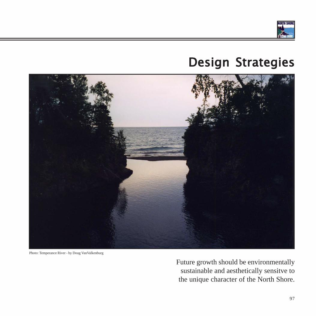
The “Scenic Drive” ConceptCreating a concept helps organize the North Shore experience based on its unique character. This project recommends a concept that focuses ondeveloping the North Shore Scenic Drive All-American Road as a scenic experience. By thinking of the road as a scenic experience instead of ahighway, the focus remains on experiencing the journey rather than on how fast it takes to get from point A to point B. An experience engages theearth and embraces the landscape, its twists and turns, its ups and downs. Experiences wander through the woods, where you follow your heart’sdesire, not a straight line. An experience goes out of its way to incorporate the most scenic views and vistas along the way. An experience stopsfrequently to rest by the cool, refreshing water, before moving on. Scenic experiences lie off the beaten track and lead into the wild unknown.Unexpected places and experiences occur along the way. The thrill of discovery and abundance of beauty makes traveling a pleasurable experience.
The North Shore Scenic Drive All-American Road follows the North Shore of Lake Superior as it travels 150 miles from Duluth to the InternationalBorder. The road maintains its timeless qualities and historic character. The road incorporates natural, cultural, and historic elements in the landscapeinto the traveler’s driving experience. Thinking of the North Shore Scenic Drive All-American Road as the “Scenic Drive” helps promote a uniqueimage and identity for the North Shore that can not be found anywhere else in the world. It also emphasizes the need to preserve the experiencesthat attract travelers to the scenic drive in the first place.
The concept behind the “Scenic Drive” is that the North Shore is a combination of key natural and cultural features overlaid producing a trulyunique landscape experience. This high caliber of intrinsic qualities qualify Highway 61 for Scenic Byway All-American Road status. Use of theword “Scenic” brings to mind an image of the character of the North Shore instead of a busy international expressway and reminds us not to let itlook like one. The concept diagram represents the road winding through the landscape of Minnesota’s North Shore Arrowhead region and itsvarious recreational/natural/cultural attributes.
Views and Vistas
Fishing and Boating Access
Overlook and Vista points
Side-Shoot Trails
Historic Features
Abundant Forests
Concept Diagram: The North Shore with it’s prototypical features: Trees, Trails, Views, Recreation, and Historic Structures

99Photo: Silver Bay Marina - by Carlos FernandezPhoto: Beaver Bay Intrusion near Caribou River - by Carlos Fernandez
Photo: Cross River - by Carlos Fernandez Photo: Taconite Harbor - by Carlos FernandezPhoto: Father Baraga’s Cross - by Carlos Fernandez

D E S I G N S T R A T E G I E S
100
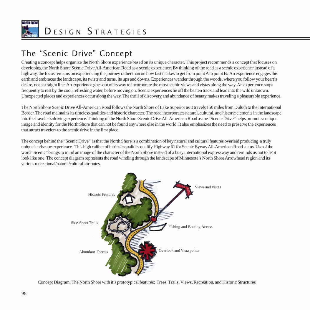
Materials PaletteAnother way to enhance the unique identity of the North Shore Scenic Drive All-American Road is to emphasize the use of local building materialsand historic building styles. There are many design influences to draw from along the North Shore, both natural and cultural. Bedrock outcroppingsoccur with great frequency along the North Shore, where wave-eroded cliffs and river-carved gorges are cracked and weathered by centuries ofexposure. Elsewhere, massive lava flows have cooled and fractured in columnar joints. The vertical emphasis of these natural rock outcroppings andlandforms is accentuated by the soaring forests and contrasted by the horizontal emphasis of Lake Superior’s horizon.
The readily available supply of local rocks and logs was put to good use by early residents of the North Shore. Living in relative isolation on theNorth Shore meant everything was built with materials that could be found on site. Log cabins and fishing shacks were common along the shore.Spectacular lodges and resorts were constructed of pine and cedar logs. Stones were collected from beaches and fields to construct foundations,fireplaces, and fences.
Cultural influences reach back several centuries and across many cultures. Native Americans arrived on the North Shore shortly after the retreat ofthe last glaciers 12,000 years ago. Their lifestyle resulted in the construction of temporary structures. Native Americans continue to hunt and fishalong the Norths Shore’s waterways. French explorers and voyageurs began arriving 350 years ago. The French lived among the Native Americans,adopting their ways, following their trade routes, and marrying into their families. Not much remains of the French influence except for theabundance of French placenames along the North Shore, many of which are French translations of their original Native American names.
British traders arrived in the region 250 years ago. The British chose to live separately from the French and Native Americans. The British left alegacy of trading posts and stockades along the fur trade routes. Competition between two British companies, Hudson’s Bay Company and theNorth West Company, frequently turned hostile and violent. The architecture of the trading post with a Great Hall, surrounded by a wooden fence,with a main gate and lookout tower has been much repeated by gift shops and tourist stops through the ages.
Scandinavian, German, and Swiss settlers began arriving 150 years ago. Wood structures with steep roofs to shed the abundant snow became thenorm. Settlers brought with them the building styles from their homelands. Thus, buildings in the German community of Beaver Bay resembleBavarian ski chalets, while the buildings in the Scandinavian community of Tofte reflect the clean, simple utilitarian lines of a Finnish sauna orSwedish stuga. Great pride and craftsmanship were used in the construction of community churches and schools up and down the North Shore.Brick was a favorite material for public buildings and was often imported because of its durability.
Temporary logging camps were built in the woods until the supply of white pine was exhausted at the turn of the century. Rough hewn logs andtimber planks were common building materials in lumber camps. During the Great Depression many state park buildings and facilities were built bythe young men of the Civilian Conservation Corps. Their handiwork survives to this day and for many people is the quintessential style for statepark architecture.
101
CCC Style Ladyslipper Lodge, Gooseberry Falls
Rustic StyleCabins, Talmadge River
Stockade Style Grand Portage
Scandinavian Style Home, Knife River

D E S I G N S T R A T E G I E S
102
Design VocabularyAnother way to enhance the North Shore’s unique identity is to create a design vocabulary which expresses the trail character of the North Shorethrough the use of common design elements. Repeating these common elements along the North Shore reinforces the sense of identity. When toomany different design elements are used in one place the character and identity can become confusing and lost amidst contrasting messages.
Cairn Trail MarkersCairn trail markers would be used to identify the North Shore Scenic Drive All-American Road. A cairn is a pile of stones stacked up to serve as alandmark. Cairns have been used for centuries by cultures around the world to mark trails, especially in backcountry areas with little evidence ofhuman inhabitation. Local rocks were stacked in an intentional manner to provide visual cues to keep travelers on the right path. Using the designvocabulary of cairn rock piles for signs along the North Shore Scenic Drive All-American Road reinforces the trail identity of the road. Cairns wouldbe made of local stone materials and located in gateway areas to announce your presence on the Superior 61 Trail North Shore Scenic DriveAll-American Road.
Cairns could take on slightly different forms based upon their location along the North Shore. Timber framing details could be used to give cairns aScandinavian influence near towns and communities. Red Rhyolite rocks could be used in areas where it is commonly found, such as at PalisadeHead. Black basalt or diabase rocks could be used in areas of columnar fracturing such as at Split Rock Lighthouse. Rounded boulders could beused to express the wave action at beaches or the power of glaciers to grind rocks smooth, such as at Iona’s Beach at Twin Points State Rest Area.
Scandinavian Influence
Cultural Expression:The Boulder/Timber creates a Trail character throughthe use of local materials. The timber elements reflectthe Scandinavian influence expressed in the Kiosk design

103
Diabase Fractures
Wave Rounded
Rhyolite Boulders
Regional Expression:This sign uses Rhyolite boulders, reddish rock commonly seen across theNorth Shore, as an expression of regional materials. Cairn signs were traditionallyconstructed from the materials whiuch were available in the native territory thetrails traversed to mark a path or route.
Geologic Expression:This sign expresses the columnar jointing that occurs in diabase intrusions along theNorth Shore. This design was created as an expression of road cut diabase seensouthwest of Split Rock Lighthouse.
Wave Expression:Various beaches along the North Shore are composed of a variety of roundedrock. The variety of smooth rock deposited by glaciers. The cairn designexpresses the historic geologic processes as well as the current erosive forceof Lake Superior.

D E S I G N S T R A T E G I E S
104
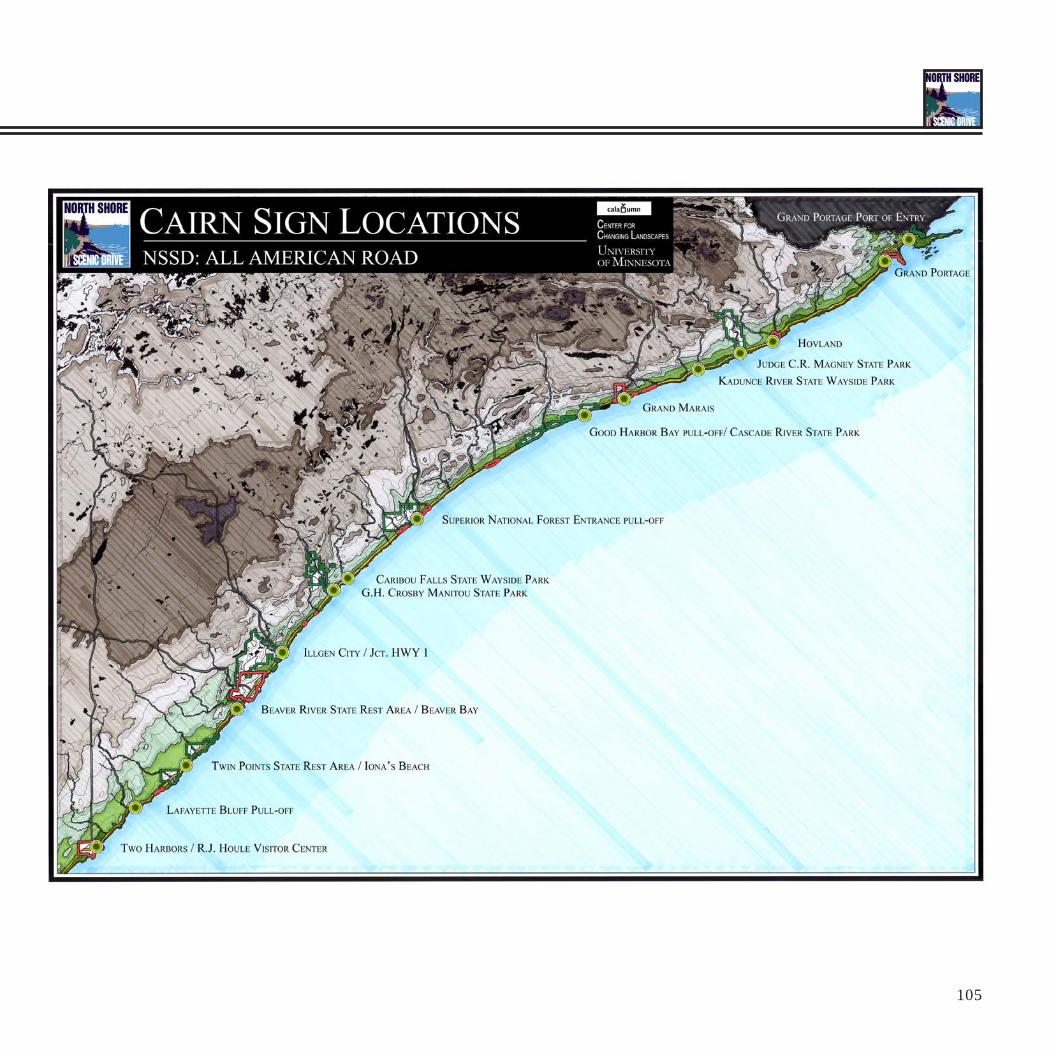
Cairn LocationsCairn trail markers would be used in strategic locations to identify the North Shore Scenic Drive All-American Road. Cairns would not be used atevery single stopping area, but instead would be used to create a rhythm along the North Shore. A variety of locations are suggested, including atnatural areas, major road junctions, nodes, and other key areas with many travelers or important interpretive opportunities.
Collection of Existing Sign StylesThere are currently many different signs and styles of signs in use along the North Shore, proclaiming the highway’s status as the North Shore ScenicDrive All-American Road, the Lake Superior Circle Tour, the Gitchi-Gami State Trail, and various state parks and attractions along the way. Thisamalgamation of multiple styles is confusing and does not create an ordered identity for the many recreational systems and special places.
All Photos by Carlos Fernandez
105
D E S I G N S T R A T E G I E S
106
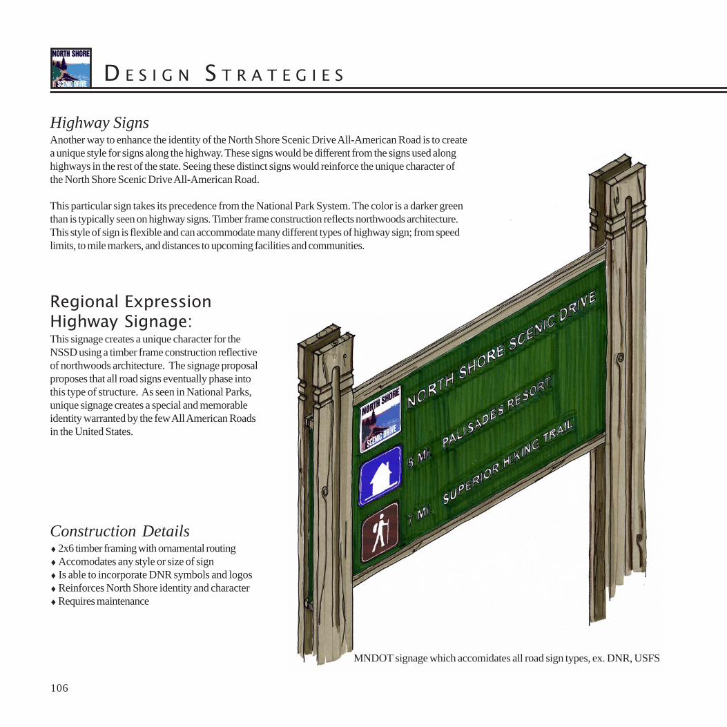
Highway SignsAnother way to enhance the identity of the North Shore Scenic Drive All-American Road is to createa unique style for signs along the highway. These signs would be different from the signs used alonghighways in the rest of the state. Seeing these distinct signs would reinforce the unique character ofthe North Shore Scenic Drive All-American Road.
This particular sign takes its precedence from the National Park System. The color is a darker greenthan is typically seen on highway signs. Timber frame construction reflects northwoods architecture.This style of sign is flexible and can accommodate many different types of highway sign; from speedlimits, to mile markers, and distances to upcoming facilities and communities.
Construction Details♦ 2x6 timber framing with ornamental routing♦ Accomodates any style or size of sign♦ Is able to incorporate DNR symbols and logos♦ Reinforces North Shore identity and character♦ Requires maintenance
MNDOT signage which accomidates all road sign types, ex. DNR, USFS
Regional ExpressionHighway Signage:This signage creates a unique character for theNSSD using a timber frame construction reflectiveof northwoods architecture. The signage proposalproposes that all road signs eventually phase intothis type of structure. As seen in National Parks,unique signage creates a special and memorableidentity warranted by the few All American Roadsin the United States.

107
Adaptable Highway Signage:The signage construction can be manipulted to accommodate all highway sign types.The proposal suggests that all road signs change over to a forest green color tocreate a unique identity for the corridor. The design follows a vocabulary seenin both the cairn and kiosk design details.
MNDOT signage which accomidates all road sign types, ex. DNR, USFS

D E S I G N S T R A T E G I E S
108
Information KioskThe Scandinavian heritage of the North Shore combined with community involvement influenced the design of information kiosks. The designprocess was started with a variety of options which were eventually narrowed to include the use of stone/timber constructions. Local stone founda-tions and the simple timber structures are cost effective. The steep metal roof ensures longevity. A series of public meetings was held to gathercommunity input which led to the design. These final kiosk design suggestions reflect the wishes and desires of local residents.
Information kiosks would be located at trailheads and parking lots to provide historic, ecologic, and geologic information at stopping areas. Maps oftrails and information about other stopping areas would be provided to tell the whole story of the North Shore.
Information Kiosk Elevation

109
The kiosk design is influenced by Scandinavian architecture. It reflectsthe cultural heritage of the people and founders of the North Shore.The high pitched roof lines and wood detailing reflects structures typicallyseen in Norway and other Scandinavian port towns. Using a cedartimber frame structure the design also reflects the natural wood character of Lake Superior.
This interpretive panel depicts some of the information that would beseen at the commercial fishing kiosk. All boards should use the samegraphic standard which strengthens the contiunity of the interpretivetrail.
Information Kiosk Detail
Information Kiosk Bird’s-eye

D E S I G N S T R A T E G I E S
110
Viewshed AestheticsIn order to maintain the trail-like character of the North Shore Scenic Drive All-American Road it may be necessary to implement design guidelinesin its viewshed. The viewshed is that portion of the landscape visible from the road. These guidelines could be incorporated into local building codesand/or zoning controls. Design guidelines would promote aesthetics that enhance the trail-like character of the road. Design guidelines could requirethe use of local building materials and the planting of native vegetation to screen undesirable views from the road and maintain the sense of enclosurealong the road. Policies could also be established to guide the design and layout of the road itself.
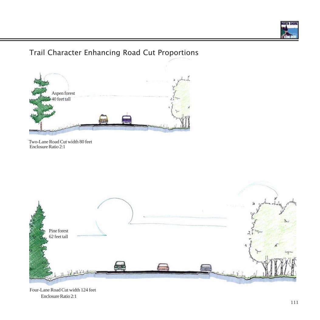
Road AlignmentHow the road is built determines how it and the surrounding landscape are experienced. Rock outcroppings and vegetation along the edge of theroad are important character-giving elements and provide visual stimulation for travelers. Wide, straight roads have less character than narrow,winding roads. Removing rocks and vegetation from the road side increases the sense of exposure and decreases the sense of character. Straightroads, however, are safer and can support higher traffic speeds. Road design should balance safety with character on the North Shore Scenic DriveAll-American Road.
Road sections were measured at 10 different locations along the North Shore to illustrate typical conditions (see Appendix). Road sections rangedfrom very narrow two-lane road cuts with dangerously small and steep shoulders to extremely wide four-lane road cuts with oversized shoulders.Character ranged from a complete sense of enclosure created by tall rock cuts and forest vegetation to a complete sense of exposure with novegetation along the edge of the road. Roadside vegetation and rock outcrops frame views down the road corridor to landforms rising in thedistance or out over the expanse of Lake Superior.
Driving lanes on the North Shore Scenic Drive All-American Road remain a standard width of 12 feet in each direction in most cases. The width ofpaved shoulders ranged from two feet to 12 feet. The overall width of pavement therefor ranges from 28 feet, with two driving lanes, each with two-foot shoulders, to 68 feet with four driving lanes each with 10-foot shoulders. The overall roadcut ranges from 54 feet where two driving lanes havetwo-foot shoulders and 12 feet to the edge of the forest, to 162 feet where four driving lanes have 12-foot shoulders and 60 feet to the forest edge.
The ideal sense of enclosure is not to exceed a ratio of 2:1 in width of road cut to height of vegetation or rock along the edge of the road. Whitepines range in height from 100 to 150 feet. Red pines grow to heights of 70 to 80 feet. Aspen range from 30 to 60 feet and birch from 50 to 70 feet.Coniferous trees are taller and therefore are more suitable roadside vegetation for wider road cuts. A forest of 30 foot aspen would provide a senseof enclosure for a road cut up to 60 feet wide, whereas a forest of 70 foot red pine provides a sense of enclosure for roadcuts up to 140 feet wide.
The ideal road alignment would be 12-foot driving lanes with 8-foot paved shoulders and 20 to 30 feet of road cut before the start of vegetation.Two-lane road sections would add up to 80 feet and need 40-foot tall vegetation along the road. Four-lane road sections would add up to 124 feetand need 62-foot tall vegetation along the road.
Ideal two-lane road configuration of 80 feet20-foot road cut 8-foot shoulder two 12-foot driving lanes = 24 feet 8-foot shoulder 20-foot road cut
Ideal four-lane road configuration of 124 feet30-foot road cut 8-foot shoulder four 12-foot driving lanes = 48 feet 8-foot shoulder 30-foot road cut
111
Four-Lane Road Cut width 124 feet
Pine forest62 feet tall
Two-Lane Road Cut width 80 feet
Aspen forest40 feet tall
Enclosure Ratio 2:1
Enclosure Ratio 2:1
Trail Character Enhancing Road Cut Proportions
D E S I G N S T R A T E G I E S
112
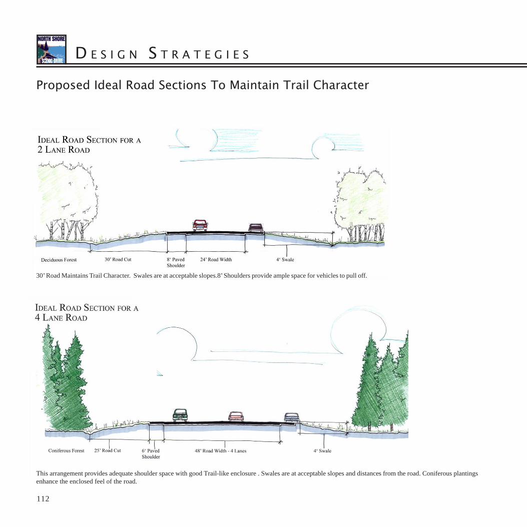
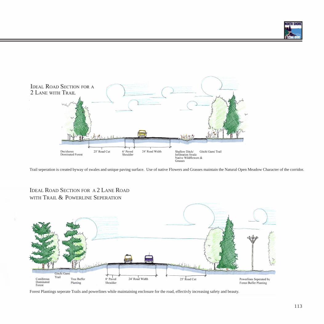
30’ Road Maintains Trail Character. Swales are at acceptable slopes.8’ Shoulders provide ample space for vehicles to pull off.
This arrangement provides adequate shoulder space with good Trail-like enclosure . Swales are at acceptable slopes and distances from the road. Coniferous plantingsenhance the enclosed feel of the road.
Proposed Ideal Road Sections To Maintain Trail Character
113
Trail seperation is created byway of swales and unique paving surface. Use of native Flowers and Grasses maintain the Natural Open Meadow Character of the corridor.
Forest Plantings seperate Trails and powerlines while maintaining enclosure for the road, effectivly increasing safety and beauty.
IDEAL ROAD SECTION FOR A 2 LANE ROAD
WITH TRAIL & POWERLINE SEPERATION

D E S I G N S T R A T E G I E S
114
Environmental SustainabilityMuch of the North Shore’s identity is derived from its wilderness character. A key part of the North Shore’s attraction is the ability to see wildanimals in their native habitats. It is important for the long-term health of the planet that development along the North Shore occur in anenvironmentally sustainable manner. It also ensures the same kind of outdoor experiences available to us remain for future generations.
Storm Water ManagementWater is one of Minnesota’s most valuable resources. The “Land of 10,000 Lakes” also has over 92,000 miles of streams and rivers. Clean water isvital to agriculture, commerce, industry, and life. Recreational use of waters contributes to our quality of life and to the state’s economy. Managingshoreland helps protect water quality and maintain scenic views. Fish and wildlife depend on vegetated shorelines to provide healthy spawninggrounds and habitat for feeding, resting, and mating. Wildlife are most abundant along riparian areas with healthy vegetation.
A few unplanned and poorly designed developments can degrade the entire waterbody for everyone. Increasing demand for shoreline propertiescan lead to an overbuilt condition which destroys the natural vegetation and scenic beauty of the shoreline. Overdevelopment increases the potentialoccurrence of flooding, water pollution, habitat loss, plant and animal extinctions, and scenic degradation. Poorly designed development may alterthe hydrology or movement of water through the landscape.
The best way to protect water quality is for new development to mimic the pre-settlement hydrologic conditions in terms of runoff volume, peakdischarge (velocity), and infiltration. When the impervious surfaces of new development replace vegetation in a landscape, the amount of infiltrationdecreases and the amount of surface water runoff increases accordingly. This disrupts the natural hydrology. Rainfall that used to soak into the earth,now runs off over the surface of the earth, causing flooding and erosion, and washing sediment and pollutants into our lakes and streams. Nutrientswashed into our waterbodies consume excessive amounts of oxygen. Summer runoff may increase water temperatures in lakes and streams that areotherwise fed by cold water springs. The stress of oxygen depletion and thermal pollution can kill fish and invertebrate populations.
An increase in runoff also means less water is soaking into the earth and recharging groundwater aquifers. Groundwater supplies the base flow tolakes and streams through seeps and springs and may be a source of well-water for local residents. Plants and animals have adapted to the localhydrologic regime. Altering the quantity and quality of available water may shift the composition of plant and animal species in a given location, byopening the door for invasive exotic species to crowd out more sensitive native plants and animals.
The major impact of new development is caused by the amount of impervious surfaces and their connectedness. The impact is minimized whenimpervious surfaces are disconnected from each other. Disconnected surfaces direct runoff away from lakes and streams into vegetated swales andbasins where all of the runoff is allowed to infiltrate into the earth as it did before the new development was added to the landscape. The impact ismaximized by connected impervious surfaces. Connected surfaces convey everyone’s runoff into gutters and storm sewers without giving it a chanceto infiltrate the earth and then deposit it directly into waterbodies. When stormwater runoff enters our lakes and streams it degrades water quality. Awatershed with 10 to 20% of its area covered with connected impervious surfaces will begin to experience water quality problems.
Some basic design principles to protect water quality include; mimicing pre-development hydrology, developing the least critical areas, fitting newdevelopment to the terrain, preserving natural drainage patterns, minimizing imperviousness and its connectedness, and using reduntant systems tohandle stormwater runoff. New development that follows these guidelines will; maximize infiltration and minimize runoff to pre-development levels,avoid developing in floodplains and on steep slopes, minimize regrading of the earth’s surface, avoid disrupting water’s natural flow paths anddrainageways, reduce the amount of roads and driveways and their use of curbs and gutters, and use yard space for bioretention ponds andinfiltration swales to handle runoff as close to where it fell as rain as possible.

115
Pre-Settlement HydrologyRain falls on vegetation and soaks into the ground.Root systems provide channels to transmit water intothe earth. Vegetation and soil particles filter impuritiesfrom the water. Water moves slowly underground torecharge aquifers and supply the base flow to streamsand lakes where it re-emerges from seeps and springs.The earth acts as a vast storage vessel and water isavailable to plants and animals throughout the year.
Post-Settlement HydrologyRain falls on impervious surfaces such as roofs, roads,and lawns and can no longer soak into the earth.Stormwater is forced to run off over the surface of theearth. Water moving rapidly over the surface of theearth has the energy to cause erosion and pick upsediments and contaminants. This dirty water isdischarged directly into our lakes, streams, andwetlands causing flooding and pollution problems.Water is no longer stored where it falls, but istransported downstream immediately. This water islost to local plants and animals who now only haveaccess to water during brief periods of rainfall.
D E S I G N S T R A T E G I E S
116
Steep Slope Vegetation and Shoreline Erosion ControlPlants and soil particles filter nutrients and pollutants out of water as it flows past. A vegetated shoreline is critical for cleaning stormwater runoffbefore it enters a waterbody. Plants also hold soil particles in place, preventing moving water from dislodging the particles and causing erosion. Thelargest load of pollutants entering a waterbody is usually the sediments dislodged by erosion. The steep slopes along the North Shore mean water ismoving fast and has more energy to erode soil particles. Steep banks are unstable under the influence of gravity, causing slumps and collapses todislodge soil particles directly into streams and lakes. It is more difficult to establish a protective vegetative cover on steep slopes. Newdevelopment and pedestrian trails on the North Shore often occur along the top edge of steep shorelines and stream banks to take advantage ofscenic views. Disturbing vegetation and compacting the soil for new development and trails, or the removal of vegetation to improve sight linesincreases the potential risk for erosion.
Wooded areas that include an understory cover of shrubs and bushes, beneath the forest canopy, are the most runoff-absorbant type of landscape.Up to 50% of rainfall never even reaches the surface of the earth under these circumstances. Raindrops that land on a tree’s leaves and branches areabsorbed for the plant’s use or evaporate back into the atmosphere. Plant roots take up a large quantity of water for the plant’s nourishment as well,and encourage infiltration of water by creating channels into the earth.
Forest Habitat FragmentationPreserving large areas of vegetation is good, not only for water quality, but also for environmental diversity. Diversity is nature’s way of ensuring thestability of natural systems through often cataclysmic events, like the North Shore’s volcanoes and glaciers. Remote areas of northeastern Minnesotaprovide valuable habitat for animals that are no longer found elsewhere in the state. Much of northeastern Minnesota is National and State Forest,which is managed for its habitat value, among other things.
Patches of habitat can be described as core, the undisturbed center of that habitat, or edge, the disturbed portion where one habitat transitions intoanother type. Certain animals can only survive in core conditions. Some habitat patches are not large enough to contain any core habitat, transitionaleffects occur all the way through the entire patch. Habitat patches with large amounts of undisturbed core are extremely valuable and extremely rare.The principle cause of habitat fragmentation is human disturbance, with the creation of roads and cabins deep in the woods. A single road cuttingthrough a large forest patch can destroy its core qualities. A road may sever an animal’s route between feeding areas or provide an opening for newplants and animals to enter the forest, either of which may cause the original animal to abandon its territory.
Clean water and diverse ecosystems are valuable resources. Low impact development sustains high quality natural resources. North Shoredevelopment ought to minimize vegetation loss and habitat fragmentation.
Forest Species CompositionAs we replant vegetation to alleviate the effects of earlier logging and development on water quality, habitat value, and scenic character, it isimportant to consider the species we select . A red oak may be a beautiful tree, but it is out of place on the North Shore. Human disturbance makesliving conditions more difficult for native species in the first place, we need to give native plant communities a boost by replanting them as much aspossible. The original red and white pine forests that were common along the North Shore 100 years ago are mostly non-existant today. Much ofthe forest cover is aspen and birch now. It is possible to recreate the conditions under which pines thrived. Selective logging of aspen and birch canreplace fire’s role in forest dynamics and become a useful tool in regenerating the pine forests once again. The pine tree is emblematic of the NorthShore’s rugged and scenic character.

117
Shoreline Erosion Control
Species Composition
Roads Cause Forest Habitat Fragmentation
Lots of Forest Core Lots of Forest Edge
Old Growth Diversity Second Growth Monoculture
Vegetation Prevents Erosion Bare Banks Erode
D E S I G N S T R A T E G I E S
118
Plant PaletteThe following plant lists are native species that do well under the extreme conditions of the North Shore. Native plants have the advantage of beingadapted to local climatic and hydrologic conditions. They are also better able to resist insect infestations and diseases. Native plant species alsoblend into the surrounding landscape better than planted cultivars. When new development calls for planting vegetation it only makes sense to selectnative plant species. Planting native species helps rebuild disturbed habitat and promotes environmental sustainability.
Coniferous Forest Plantings (dry)Tree Canopy: - Balsam Fir, Abies balsamea - Eastern White Cedar, Thuja occidentalis - White Spruce, Picea glauca - Red Pine, Pinus resinosa - Eastern White Pine, Pinus strobus - Jack Pine, Pinus banksianaShrub Layer: - Smooth Sumac, Rhus glabra - Highbush Blueberry, Vaccinium corymbosumGround Cover: - Bearberry, Artostaphylos uvva-ursi - Northern White Violet, Viola pallens - Twinflower, Linnaea borealis - Starflower, Trientalis borealis - Bluebead Lily, Clintonia borealis - Canada Mayflower, Maianthemum canadense - Harebell, Campanula rotundifolia - Wild Sarsaparilla, Aralia nuducaulis - Pipsissewa, Chimaphila umbellata - Wild Columbine, Aquilegia canadensis - Wintergreen, Gaultheria procumbens

119
Photo: Sawbill Trail - by Doug VanValkenburg

D E S I G N S T R A T E G I E S
120
Deciduous Forest Plantings (moist)Tree Canopy: - Quaking Aspen, Populus tremuloides - Paper Birch, Betula papyrifera - Balsam Poplar, Populus balsamifera - Yellow Birch, Betula alleghaniensis - Sugar Maple, Acer saccharum - Red Maple, Acer rubrumShrub Layer: - Red-osier Dogwood, Cornus stolonifera - Nannyberry, Viburnum lentago - Pin Cherry, Prunus pensylvanicaGround Cover: - Red Baneberry, Actaea rubra - Bunchberry, Cornus canadensis - Wood Anemone, Anemone quinquefolia - Common Wood Sorrel, Oxalis montana - Raspberry, Rubus odoratus - Shinleaf, Pyrola elliptica - Spring Beauty, Claytonia virginica - Jack-in-the-Pulpit, Arisaema triphyllum - Evening Primrose, Oenthera biennis
121
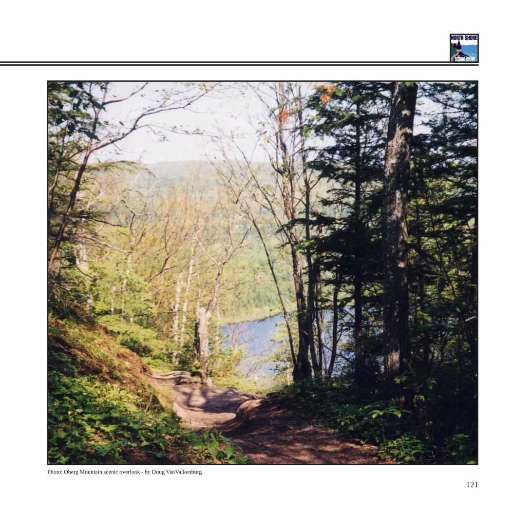
Photo: Oberg Mountain scenic overlook - by Doug VanValkenburg

D E S I G N S T R A T E G I E S
122
Meadow Plantings (wet)Tree Canopy: - Black Spruce, Picea mariana - Northern White Cedar, Thuja occidentalis - Tamarack, Larix laricinaShrub Layer: - American Mountain Ash, Sorbus americanaGround Cover: - Wild Rice, Zizania aquatica - Labrador tea, Ledum groenlandicum - Bog Cranberry, Vaccinium macrocarpon - Fringed Loosestrife, Lysimachia ciliata - Swamp Rose, Rosa palustris - Marsh Marigold, Caltha palustris - Pitcher Plant, Sarracenia purpurea - White Water-Lily, Nymphaea tuberosa - Yellow Pond Lily, Nuphar variegatum - Floating Pondweed, Potamogeton natans
Infiltration Swale Plantings (wet periodically)Tree Canopy: - Tamarack, Larix laricina - Black Spruce, Picea marianaShrub Layer: - Red-osier Dogwood, Cornus stoloniferaGround Cover: - Big Bluestem, Andropogon gerardi - Blue Flag Iris, Iris versicolor - Marsh Marigold, Caltha palustris - Swamp Rose, Rosa palustris - Fringed Loosestrife, Lysimachia ciliata
123
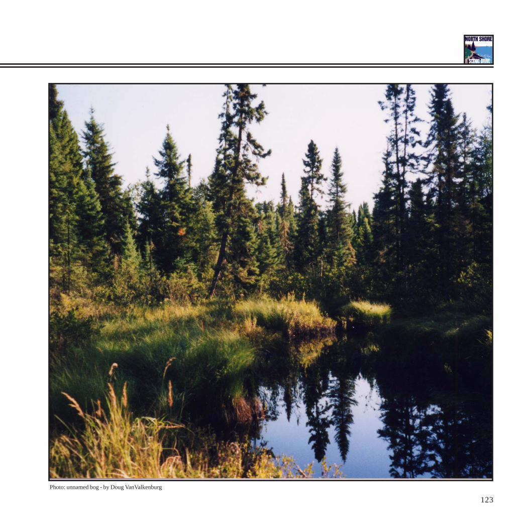
Photo: unnamed bog - by Doug VanValkenburg
D E S I G N S T R A T E G I E S
124
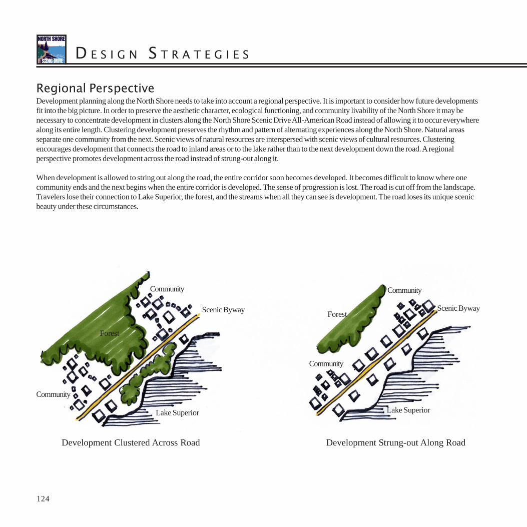
Regional PerspectiveDevelopment planning along the North Shore needs to take into account a regional perspective. It is important to consider how future developmentsfit into the big picture. In order to preserve the aesthetic character, ecological functioning, and community livability of the North Shore it may benecessary to concentrate development in clusters along the North Shore Scenic Drive All-American Road instead of allowing it to occur everywherealong its entire length. Clustering development preserves the rhythm and pattern of alternating experiences along the North Shore. Natural areasseparate one community from the next. Scenic views of natural resources are interspersed with scenic views of cultural resources. Clusteringencourages development that connects the road to inland areas or to the lake rather than to the next development down the road. A regionalperspective promotes development across the road instead of strung-out along it.
When development is allowed to string out along the road, the entire corridor soon becomes developed. It becomes difficult to know where onecommunity ends and the next begins when the entire corridor is developed. The sense of progression is lost. The road is cut off from the landscape.Travelers lose their connection to Lake Superior, the forest, and the streams when all they can see is development. The road loses its unique scenicbeauty under these circumstances.
Development Clustered Across Road Development Strung-out Along Road
Lake Superior
Forest
Community
Community
Scenic Byway
Lake Superior
Forest
Community
Community
Scenic Byway

125
Proto-typical Design ExamplesThe following three examples show how some of these guidelines for building materials, design vocabulary, viewshed aesthetics, environmentalsustainability, native plantings, and regional perspective can be incorporated into local design work.
Boat LaunchThis boat launch design incorporates environmentally sustainable design strategies. Pavement is minimized to reduce the amount of runoff generatedby impervious surfaces. Paved surfaces are graded to drain runoff away from Lake Superior. Runoff is collected in vegetated infiltration swales andretention basins where it is allowed to soak back into the earth. The shoreline remains vegetated to prevent shoreline erosion. Vegetation remainsalong the road to screen views of parked vehicles and to maintain the aesthetics of the North Shore Scenic Drive All-American Road. Native plantspecies are used throughout the site and habitat connections are maintained through the site to minimize the disturbance to the movement of animals.
D E S I G N S T R A T E G I E S
126
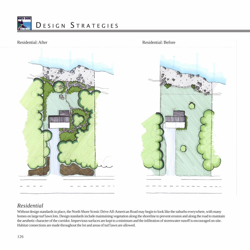
Residential: After Residential: Before
ResidentialWithout design standards in place, the North Shore Scenic Drive All-American Road may begin to look like the suburbs everywhere, with manyhomes on large turf lawn lots. Design standards include maintaining vegetation along the shoreline to prevent erosion and along the road to maintainthe aesthetic character of the corridor. Impervious surfaces are kept to a minimum and the infiltration of stormwater runoff is encouraged on-site.Habitat connections are made throughout the lot and areas of turf lawn are allowed.
127
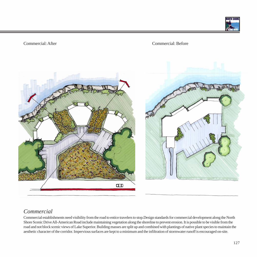
Commercial: After Commercial: Before
CommercialCommercial establishments need visibility from the road to entice travelers to stop.Design standards for commercial development along the NorthShore Scenic Drive All-American Road include maintaining vegetation along the shoreline to prevent erosion. It is possible to be visible from theroad and not block scenic views of Lake Superior. Building masses are split up and combined with plantings of native plant species to maintain theaesthetic character of the corridor. Impervious surfaces are kept to a minimum and the infiltration of stormwater runoff is encouraged on-site.

D E S I G N S T R A T E G I E S
128
NSSD Node: Beaver Bay Community DesignThe Beaver Bay design strategy uses the North Shore Scenic Drive as a spine that links the commercial and civic centers of the community, itsscenic natural environment, and the regional recreational systems that pass through it. The design demonstrates how the North Shore Scenic Bywaycan be used as an ordering device that can reinforce a sense of place in individual North Shore communities.
Elements of design include:
A design for a NSSD Rest Stop parking lot / trailhead for the Gitchi-Gami State Trail that ties together access to the local historical society,the historic cemetery, and access to the Superior Hiking Trail while addressing serious erosion concerns along the Beaver River
A streetscape design along the byway that accommodates pedestrians and bicyclists whichReinforces Beaver Bay as a special place
A civic center design that provides a civic context for the Beaver Bay Community Center and provides a welcoming entry into town

129 129

D E S I G N S T R A T E G I E S
130130

131131

D E S I G N S T R A T E G I E S
132132
133 133
D E S I G N S T R A T E G I E S
134134

135135

D E S I G N S T R A T E G I E S
136136

137 137

D E S I G N S T R A T E G I E S
138
“I shall be telling this with a sigh somewhere ages and ages hence: Tworoads diverged in a wood, and I took the one less traveled by, and thathas made all the difference.”
-Robert Frost
“In wildness is the preservation of the world.”- Henry David Thoreau


![Geochemistry and Petrogenesis of Diabase Dykes in the ... · especially on the diabase dykes and mineralization episode [4]. In the present study, a few representative dykes occurring](https://static.fdocuments.in/doc/165x107/5e86f37100131427f470b86f/geochemistry-and-petrogenesis-of-diabase-dykes-in-the-especially-on-the-diabase.jpg)