Design Concept Report East Kellogg Improvements to 159th Concept Report.pdf · Design Concept...
32
Design Concept Report East Kellogg Improvements from 127 th Street to 159 th Street (Project II) City of Wichita Project No. 472 84614 KDOT Project No. 54-87 KA-1164-01 PB Project No. 35766A Prepared for: Prepared by: Wichita Team for East Kellogg January 2010 PB Americas, Inc. Baughman Company, P.A. Kent Williams Environmental Design Land Acquisitions, Inc. MJ Harden MKEC Engineering Consultants, Inc. TranSystems Vicki Scuri SiteWorks
Transcript of Design Concept Report East Kellogg Improvements to 159th Concept Report.pdf · Design Concept...
Design Concept Report East Kellogg Improvements from 127th Street to 159th Street (Project II)
City of Wichita Project No. 472 84614 KDOT Project No. 54-87 KA-1164-01 PB Project No. 35766A
Prepared for:
Prepared by:
Wichita Team for East Kellogg January 2010 PB Americas, Inc. Baughman Company, P.A. Kent Williams Environmental Design Land Acquisitions, Inc. MJ Harden MKEC Engineering Consultants, Inc. TranSystems Vicki Scuri SiteWorks
Table of Contents
1 Introduction
2 Concept Development
3 Environmental
4 Traffic Analysis
5 Utility Relocation
6 Storm Drainage
7 Aesthetics
8 Recommended Concept
IntroductionThe City of Wichita has initiated a project to develop right-of-way plans to improve the capacity and functionality of East Kellogg Avenue (US54/400) from 127th Street to 159th Street.
1
1-1
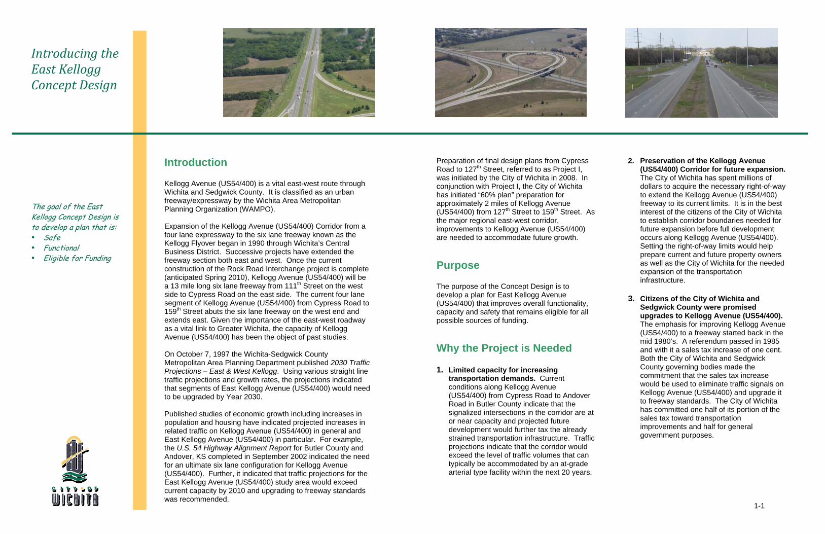
Introducing the East Kellogg Concept Design
The goal of the East Kellogg Concept Design is to develop a plan that is: Safe Functional Eligible for Funding
Introduction
Kellogg Avenue (US54/400) is a vital east-west route through Wichita and Sedgwick County. It is classified as an urban freeway/expressway by the Wichita Area Metropolitan Planning Organization (WAMPO). Expansion of the Kellogg Avenue (US54/400) Corridor from a four lane expressway to the six lane freeway known as the Kellogg Flyover began in 1990 through Wichita’s Central Business District. Successive projects have extended the freeway section both east and west. Once the current construction of the Rock Road Interchange project is complete (anticipated Spring 2010), Kellogg Avenue (US54/400) will be a 13 mile long six lane freeway from 111th Street on the west side to Cypress Road on the east side. The current four lane segment of Kellogg Avenue (US54/400) from Cypress Road to 159th Street abuts the six lane freeway on the west end and extends east. Given the importance of the east-west roadway as a vital link to Greater Wichita, the capacity of Kellogg Avenue (US54/400) has been the object of past studies. On October 7, 1997 the Wichita-Sedgwick County Metropolitan Area Planning Department published 2030 Traffic Projections – East & West Kellogg. Using various straight line traffic projections and growth rates, the projections indicated that segments of East Kellogg Avenue (US54/400) would need to be upgraded by Year 2030. Published studies of economic growth including increases in population and housing have indicated projected increases in related traffic on Kellogg Avenue (US54/400) in general and East Kellogg Avenue (US54/400) in particular. For example, the U.S. 54 Highway Alignment Report for Butler County and Andover, KS completed in September 2002 indicated the need for an ultimate six lane configuration for Kellogg Avenue (US54/400). Further, it indicated that traffic projections for the East Kellogg Avenue (US54/400) study area would exceed current capacity by 2010 and upgrading to freeway standards was recommended.
Preparation of final design plans from Cypress Road to 127th Street, referred to as Project I, was initiated by the City of Wichita in 2008. In conjunction with Project I, the City of Wichita has initiated “60% plan” preparation for approximately 2 miles of Kellogg Avenue (US54/400) from 127th Street to 159th Street. As the major regional east-west corridor, improvements to Kellogg Avenue (US54/400) are needed to accommodate future growth. Purpose
The purpose of the Concept Design is to develop a plan for East Kellogg Avenue (US54/400) that improves overall functionality, capacity and safety that remains eligible for all possible sources of funding. Why the Project is Needed
1. Limited capacity for increasing transportation demands. Current conditions along Kellogg Avenue (US54/400) from Cypress Road to Andover Road in Butler County indicate that the signalized intersections in the corridor are at or near capacity and projected future development would further tax the already strained transportation infrastructure. Traffic projections indicate that the corridor would exceed the level of traffic volumes that can typically be accommodated by an at-grade arterial type facility within the next 20 years.
2. Preservation of the Kellogg Avenue
(US54/400) Corridor for future expansion. The City of Wichita has spent millions of dollars to acquire the necessary right-of-way to extend the Kellogg Avenue (US54/400) freeway to its current limits. It is in the best interest of the citizens of the City of Wichita to establish corridor boundaries needed for future expansion before full development occurs along Kellogg Avenue (US54/400). Setting the right-of-way limits would help prepare current and future property owners as well as the City of Wichita for the needed expansion of the transportation infrastructure.
3. Citizens of the City of Wichita and
Sedgwick County were promised upgrades to Kellogg Avenue (US54/400). The emphasis for improving Kellogg Avenue (US54/400) to a freeway started back in the mid 1980’s. A referendum passed in 1985 and with it a sales tax increase of one cent. Both the City of Wichita and Sedgwick County governing bodies made the commitment that the sales tax increase would be used to eliminate traffic signals on Kellogg Avenue (US54/400) and upgrade it to freeway standards. The City of Wichita has committed one half of its portion of the sales tax toward transportation improvements and half for general government purposes.
1-2
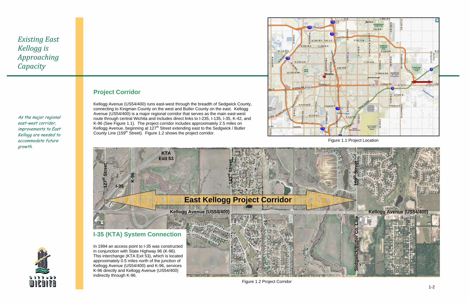
Existing East Kellogg is Approaching Capacity
As the major regional east-west corridor, improvements to East Kellogg are needed to accommodate future growth.
Project Corridor
Kellogg Avenue (US54/400) runs east-west through the breadth of Sedgwick County, connecting to Kingman County on the west and Butler County on the east. Kellogg Avenue (US54/400) is a major regional corridor that serves as the main east-west route through central Wichita and includes direct links to I-235, I-135, I-35, K-42, and K-96 (See Figure 1.1). The project corridor includes approximately 2.5 miles on Kellogg Avenue, beginning at 127th Street extending east to the Sedgwick / Butler County Line (159th Street). Figure 1.2 shows the project corridor.
1
59th
Str
eet
127
th S
tree
t
143
rd S
tree
t
Figure 1.2 Project Corridor
East Kellogg Project Corridor
K
-96
Kellogg Avenue (US54/400)
I-35 (KTA) System Connection
In 1994 an access point to I-35 was constructed in conjunction with State Highway 96 (K-96). This interchange (KTA Exit 53), which is located approximately 0.5 miles north of the junction of Kellogg Avenue (US54/400) and K-96, services K-96 directly and Kellogg Avenue (US54/400) indirectly through K-96.
KTA Exit 53
I-35
S
edgw
ick/
But
ler C
o. L
ine
Figure 1.1 Project Location
Kellogg Avenue (US54/400)
Concept DevelopmentPublic and stakeholder engagement was essential to concept consensus.
2
2-1
2007 DEC-----JAN-----FEB-----MAR-----APR-----MAY-----JUN-----JUL-----AUG-----SEP-----OCT-----NOV-----DEC-----JAN-----FEB-----MAR-----APR-----MAY-----JUN-----JUL-----AUG-----SEP-----OCT----
2008 2009
12/06 NTP
01/16 Concept Brainstorm
02/13 KTA
03/12 FHWA / KDOT / KTA
06/02 WAMPO
07/01 COW
07/11 FHWA / KDOT / KTA
07/17 Andover
08/20 Design Council
10/22 FHWA / KDOT
03/12 Public Meeting
04/24 COW
05/06 KDOT
Env. Services
04/03 DWR
07/17 ULCC
05/27 COW Water
& Sewer
07/21 City Managers
Office
06/15 Cox
06/16 KGS
01/14 Southern Star
09/09 COW Water
& Sewer
11/05 Westar
07/13 Westar
10/10 Cox
11/17 KDOT Letter 06/09
KDOT 08/04 KTA
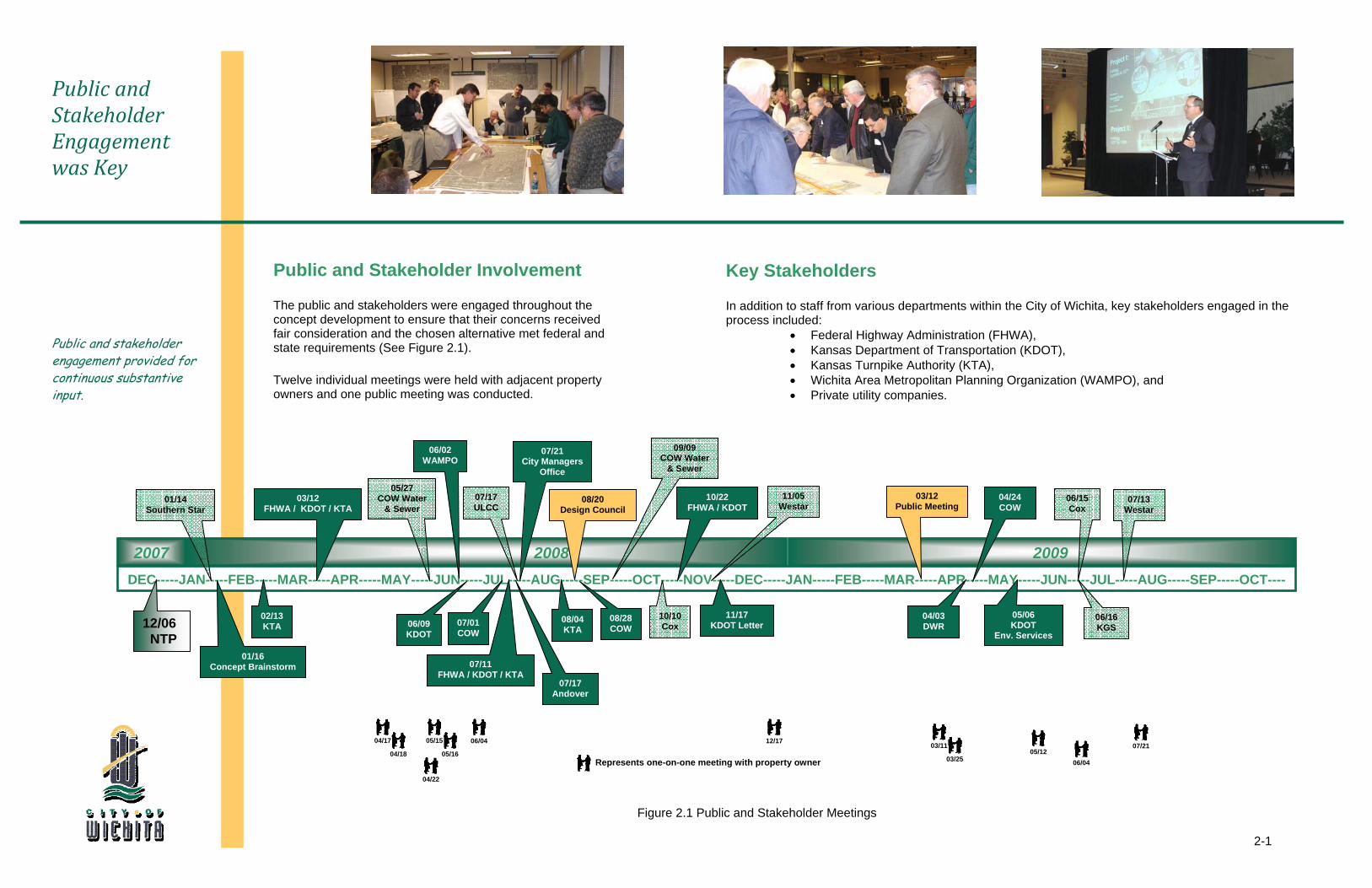
Public and Stakeholder Engagement was Key
Public and stakeholder engagement provided for continuous substantive input.
Represents one-on-one meeting with property owner
Figure 2.1 Public and Stakeholder Meetings
Public and Stakeholder Involvement
The public and stakeholders were engaged throughout the concept development to ensure that their concerns received fair consideration and the chosen alternative met federal and state requirements (See Figure 2.1).
Twelve individual meetings were held with adjacent property owners and one public meeting was conducted.
Key Stakeholders
In addition to staff from various departments within the City of Wichita, key stakeholders engaged in the process included:
• Federal Highway Administration (FHWA), • Kansas Department of Transportation (KDOT), • Kansas Turnpike Authority (KTA), • Wichita Area Metropolitan Planning Organization (WAMPO), and • Private utility companies.
07/21 04/17
04/18
04/22
05/15
05/16
06/04 12/17 03/11
03/25 05/12
06/04
08/28 COW
2-2
Brainstorming Event Established Initial Concept Alternatives
Initial “brainstorming” provided draft opportunities, constraints and design principles that demonstrated possible future directions for the improvements.
Concept “Brainstorm” Alternatives
Project stakeholders were brought together in the early stages of the concept development to establish an initial set of concept alternative definitions. The concept “brainstorm” held on January 16, 2009 consisted of representatives from the City of Wichita, FHWA, KDOT, and the project design team.
Consideration was given to roadway geometrics, traffic volumes, right-of-way, utilities, and feasibility of construction. The K-96 bridge over Kellogg Avenue (US54/400) was constructed in part with the Kellogg Avenue (US54/400) and K-96 interchange in 1994 and has sufficient design life remaining. These parameters set the premises that Kellogg Avenue (US54/400) would be reconstructed as an urban freeway on existing alignment.
The initial set of alternatives established for further investigation included:
One way frontage road system • Continuation of the one way frontage road system as
established west of the project corridor is both preferred and expected by businesses in Wichita and would aid in overall constructability and driver expectancy.
• Discontinuation of the one way frontage road system would be a significant cost savings to the project. Frontage roads have been discontinued at other system to system interchanges along the Kellogg Avenue (US54/400) corridor.
K-96 Interchange
• Utilize the existing K-96 bridge over Kellogg Avenue (US54/400) and modify the berms and ramps to retrofit the interchange (Figure 2.2)
• Reconstruct the K-96 interchange as a “Directional T” (Figure 2.3)
• Modify the existing K-96 interchange to allow for future improvements to the K-96 interchange
Kellogg Avenue (US54/400) east of the K-96 Interchange
• Establish a grade separated split diamond interchange configuration mid-mile between 143rd Street and 159th Street grade separating Kellogg Avenue (US54/400) over both 143rd Street and 159th Street. (Figure 2.4)
Figure 2.2 Retrofit Existing K-96 Interchange
Figure 2.3 Reconstruct K-96 Interchange
Figure 2.4 Split Diamond Interchange
2-3
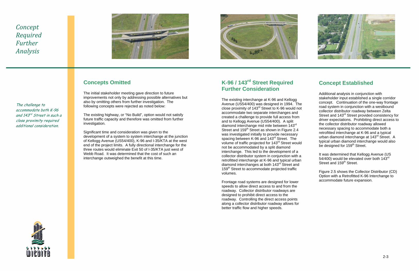
Concept Required Further Analysis
The challenge to accommodate both K-96 and 143rd Street in such a close proximity required additional consideration.
Concepts Omitted
The initial stakeholder meeting gave direction to future improvements not only by addressing possible alternatives but also by omitting others from further investigation. The following concepts were rejected as noted below: The existing highway, or “No Build”, option would not satisfy future traffic capacity and therefore was omitted from further investigation. Significant time and consideration was given to the development of a system to system interchange at the junction of Kellogg Avenue (US54/400), K-96 and I-35/KTA at the west end of the project limits. A fully directional interchange for the three routes would eliminate Exit 50 of I-35/KTA just west of Webb Road. It was determined that the cost of such an interchange outweighed the benefit at this time.
K-96 / 143rd Street Required Further Consideration
The existing interchange at K-96 and Kellogg Avenue (US54/400) was designed in 1994. The close proximity of 143rd Street to K-96 would not accommodate two separate interchanges and created a challenge to provide full access from and to Kellogg Avenue (US54/400). A split diamond interchange mid mile between 143rd Street and 159th Street as shown in Figure 2.4 was investigated initially to provide necessary spacing between K-96 and 143rd Street. The volume of traffic projected for 143rd Street would not be accommodated by a split diamond interchange. This led to the development of a collector distributor system in conjunction with a retrofitted interchange at K-96 and typical urban diamond interchanges at both 143rd Street and 159th Street to accommodate projected traffic volumes. Frontage road systems are designed for lower speeds to allow direct access to and from the roadway. Collector distributor roadways are designed to prohibit direct access to the roadway. Controlling the direct access points along a collector distributor roadway allows for better traffic flow and higher speeds.
Concept Established
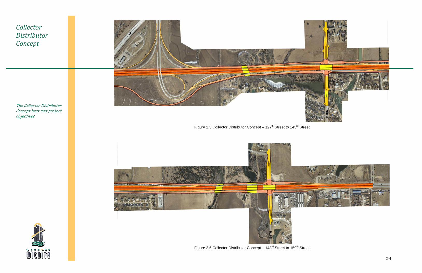
Additional analysis in conjunction with stakeholder input established a single corridor concept. Continuation of the one-way frontage road system in conjunction with a westbound collector distributor roadway between Zelta Street and 143rd Street provided consistency for driver expectations. Prohibiting direct access to the collector distributor roadway allowed necessary spacing to accommodate both a retrofitted interchange at K-96 and a typical urban diamond interchange at 143rd Street. A typical urban diamond interchange would also be designed for 159th Street. It was determined that Kellogg Avenue (US 54/400) would be elevated over both 143rd Street and 159th Street. Figure 2.5 shows the Collector Distributor (CD) Option with a Retrofitted K-96 Interchange to accommodate future expansion.
2-4
Collector Distributor Concept
The Collector Distributor Concept best met project objectives
Figure 2.6 Collector Distributor Concept – 143rd Street to 159th Street
Figure 2.5 Collector Distributor Concept – 127th Street to 143rd Street
2-5
A Second Look at the “East Junction”
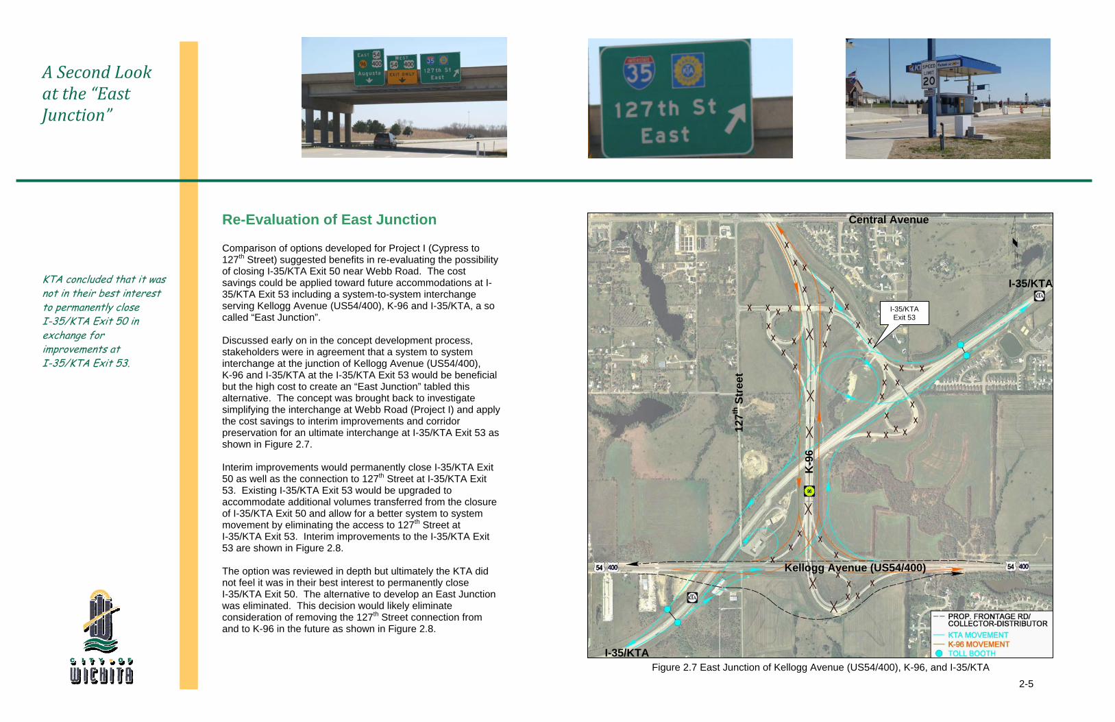
KTA concluded that it was not in their best interest to permanently close I-35/KTA Exit 50 in exchange for improvements at I-35/KTA Exit 53.
Re-Evaluation of East Junction
Comparison of options developed for Project I (Cypress to 127th Street) suggested benefits in re-evaluating the possibility of closing I-35/KTA Exit 50 near Webb Road. The cost savings could be applied toward future accommodations at I-35/KTA Exit 53 including a system-to-system interchange serving Kellogg Avenue (US54/400), K-96 and I-35/KTA, a so called “East Junction”. Discussed early on in the concept development process, stakeholders were in agreement that a system to system interchange at the junction of Kellogg Avenue (US54/400), K-96 and I-35/KTA at the I-35/KTA Exit 53 would be beneficial but the high cost to create an “East Junction” tabled this alternative. The concept was brought back to investigate simplifying the interchange at Webb Road (Project I) and apply the cost savings to interim improvements and corridor preservation for an ultimate interchange at I-35/KTA Exit 53 as shown in Figure 2.7. Interim improvements would permanently close I-35/KTA Exit 50 as well as the connection to 127th Street at I-35/KTA Exit 53. Existing I-35/KTA Exit 53 would be upgraded to accommodate additional volumes transferred from the closure of I-35/KTA Exit 50 and allow for a better system to system movement by eliminating the access to 127th Street at I-35/KTA Exit 53. Interim improvements to the I-35/KTA Exit 53 are shown in Figure 2.8. The option was reviewed in depth but ultimately the KTA did not feel it was in their best interest to permanently close I-35/KTA Exit 50. The alternative to develop an East Junction was eliminated. This decision would likely eliminate consideration of removing the 127th Street connection from and to K-96 in the future as shown in Figure 2.8.
Central Avenue
Figure 2.7 East Junction of Kellogg Avenue (US54/400), K-96, and I-35/KTA
1
27th
Str
eet
K
-96
Kellogg Avenue (US54/400)
I-35/KTA
I-35/KTA
I-35/KTA Exit 53
2-6
Concept Design Considered Future Improvements
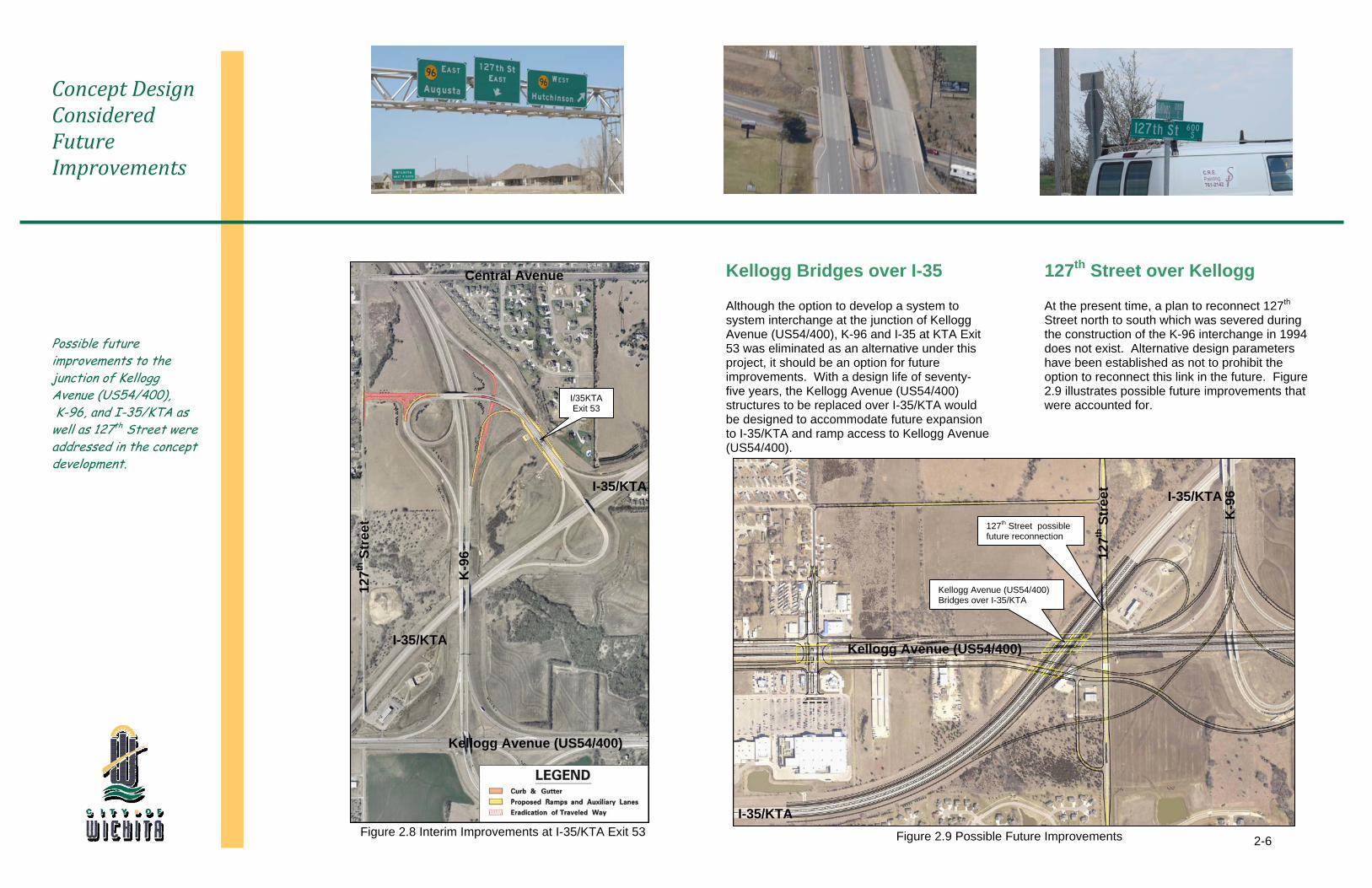
Possible future improvements to the junction of Kellogg Avenue (US54/400), K-96, and I-35/KTA as well as 127th Street were addressed in the concept development.
Kellogg Bridges over I-35
Although the option to develop a system to system interchange at the junction of Kellogg Avenue (US54/400), K-96 and I-35 at KTA Exit 53 was eliminated as an alternative under this project, it should be an option for future improvements. With a design life of seventy-five years, the Kellogg Avenue (US54/400) structures to be replaced over I-35/KTA would be designed to accommodate future expansion to I-35/KTA and ramp access to Kellogg Avenue (US54/400).
127th Street over Kellogg
At the present time, a plan to reconnect 127th Street north to south which was severed during the construction of the K-96 interchange in 1994 does not exist. Alternative design parameters have been established as not to prohibit the option to reconnect this link in the future. Figure 2.9 illustrates possible future improvements that were accounted for.
Figure 2.9 Possible Future Improvements
Kellogg Avenue (US54/400)
I-35/KTA
1
27th
Str
eet
K
-96 I-35/KTA
Figure 2.8 Interim Improvements at I-35/KTA Exit 53
127th Street possible future reconnection
1
27th
Str
eet
Kellogg Avenue (US54/400)
I-35/KTA
K
-96
Central Avenue
I-35/KTA
I/35KTA Exit 53
Kellogg Avenue (US54/400) Bridges over I-35/KTA
EnvironmentalEnvironmental overview revealed no significant impacts suggesting a Categorical Exclusion would be appropriate.
3
3-1
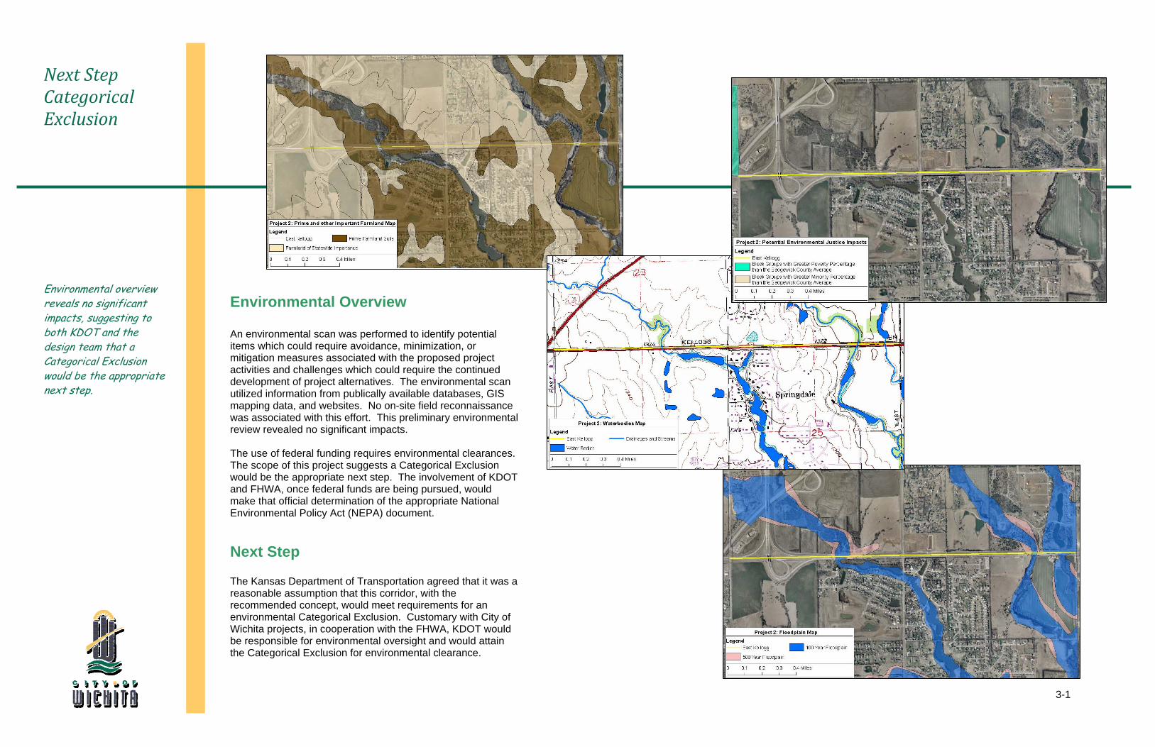
Next Step Categorical Exclusion
Environmental overview reveals no significant impacts, suggesting to both KDOT and the design team that a Categorical Exclusion would be the appropriate next step.
Environmental Overview An environmental scan was performed to identify potential items which could require avoidance, minimization, or mitigation measures associated with the proposed project activities and challenges which could require the continued development of project alternatives. The environmental scan utilized information from publically available databases, GIS mapping data, and websites. No on-site field reconnaissance was associated with this effort. This preliminary environmental review revealed no significant impacts. The use of federal funding requires environmental clearances. The scope of this project suggests a Categorical Exclusion would be the appropriate next step. The involvement of KDOT and FHWA, once federal funds are being pursued, would make that official determination of the appropriate National Environmental Policy Act (NEPA) document. Next Step
The Kansas Department of Transportation agreed that it was a reasonable assumption that this corridor, with the recommended concept, would meet requirements for an environmental Categorical Exclusion. Customary with City of Wichita projects, in cooperation with the FHWA, KDOT would be responsible for environmental oversight and would attain the Categorical Exclusion for environmental clearance.

Traffic AnalysisTraffic operations will determine the success of the Kellogg Avenue corridor.
4
4-1
WAMPO Model Served as Base for Traffic Analysis
WAMPO staff concurred with projected design year 2040 traffic volumes based on applied growth rates to the modified travel demand model.
Traffic Projected for Design Year 2040
The WAMPO travel demand model was used to project future year peak period and daily traffic volumes for the entire study area. Several modifications were made to the model including land use changes in specific traffic analysis zones and street network changes to reflect the various design concepts. The base year for the WAMPO model was 2002 and the future year model was based on a 2030 forecast adopted by WAMPO. The output from each model run was then analyzed to determine the amount of traffic growth anticipated between the base year 2002 model and the future year 2030 model. Select link analyses were conducted on all roadways entering and exiting the study area to determine the amount of growth or change of traffic flow patterns between the various scenarios. The growth factors were taken from the model more so than the actual traffic volumes. The model took traffic projections to 2030. Traffic was then projected to the design year 2040 utilizing expected growth rates. WAMPO staff concurred that the model, growth factors, and projections were reasonable.
Existing Conditions and Traffic Data
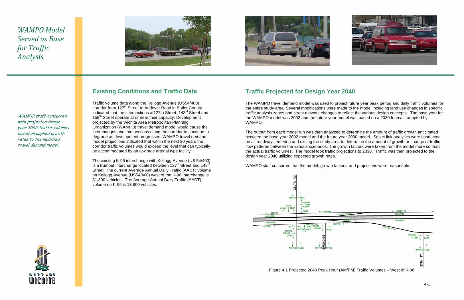
Traffic volume data along the Kellogg Avenue (US54/400) corridor from 127th Street to Andover Road in Butler County indicated that the intersections at127th Street, 143rd Street and 159th Street operate at or near their capacity. Development projected by the Wichita Area Metropolitan Planning Organization (WAMPO) travel demand model would cause the interchanges and intersections along the corridor to continue to degrade as development progresses. WAMPO travel demand model projections indicated that within the next 20 years the corridor traffic volumes would exceed the level that can typically be accommodated by an at-grade arterial type facility. The existing K-96 interchange with Kellogg Avenue (US 54/400) is a trumpet interchange located between 127th Street and 143rd Street. The current Average Annual Daily Traffic (AADT) volume on Kellogg Avenue (US54/400) west of the K-96 Interchange is 31,800 vehicles. The Average Annual Daily Traffic (AADT) volume on K-96 is 13,800 vehicles.
Figure 4.1 Projected 2040 Peak Hour (AM/PM) Traffic Volumes – West of K-96
4-2
2040 Projected Traffic Volumes
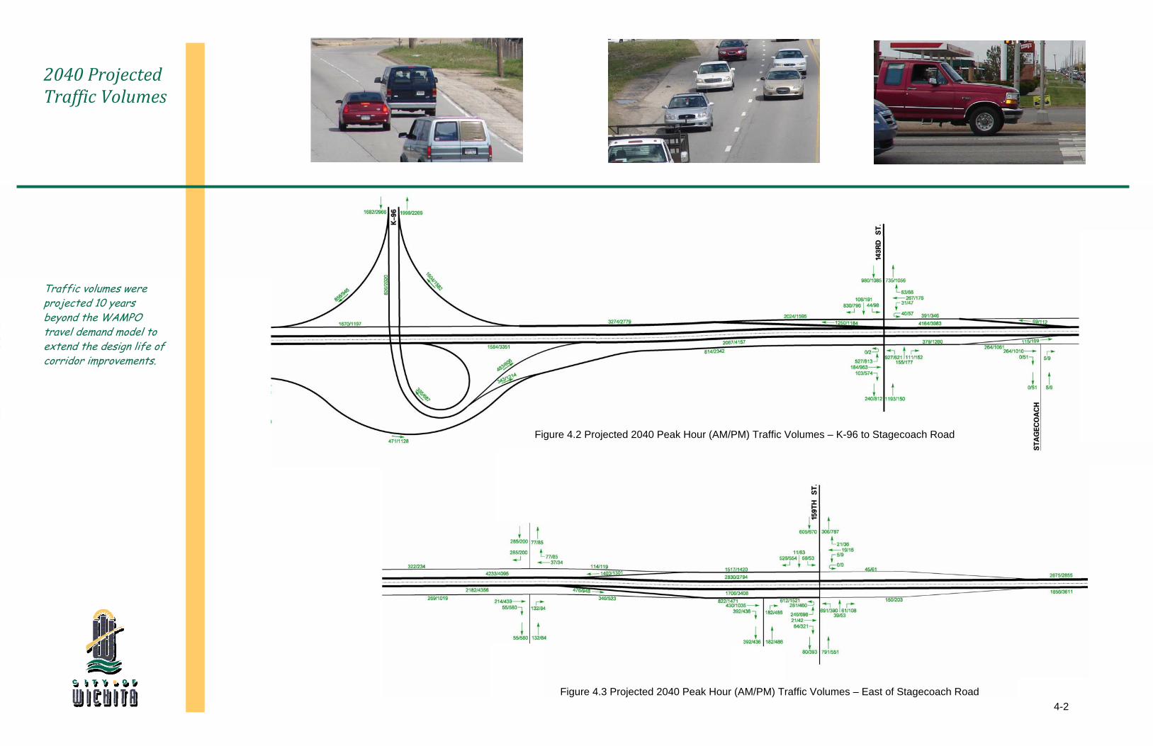
Traffic volumes were projected 10 years beyond the WAMPO travel demand model to extend the design life of corridor improvements.
Figure 4.2 Projected 2040 Peak Hour (AM/PM) Traffic Volumes – K-96 to Stagecoach Road
Figure 4.3 Projected 2040 Peak Hour (AM/PM) Traffic Volumes – East of Stagecoach Road
4-3
Collector Distributor Concept Proved Acceptable
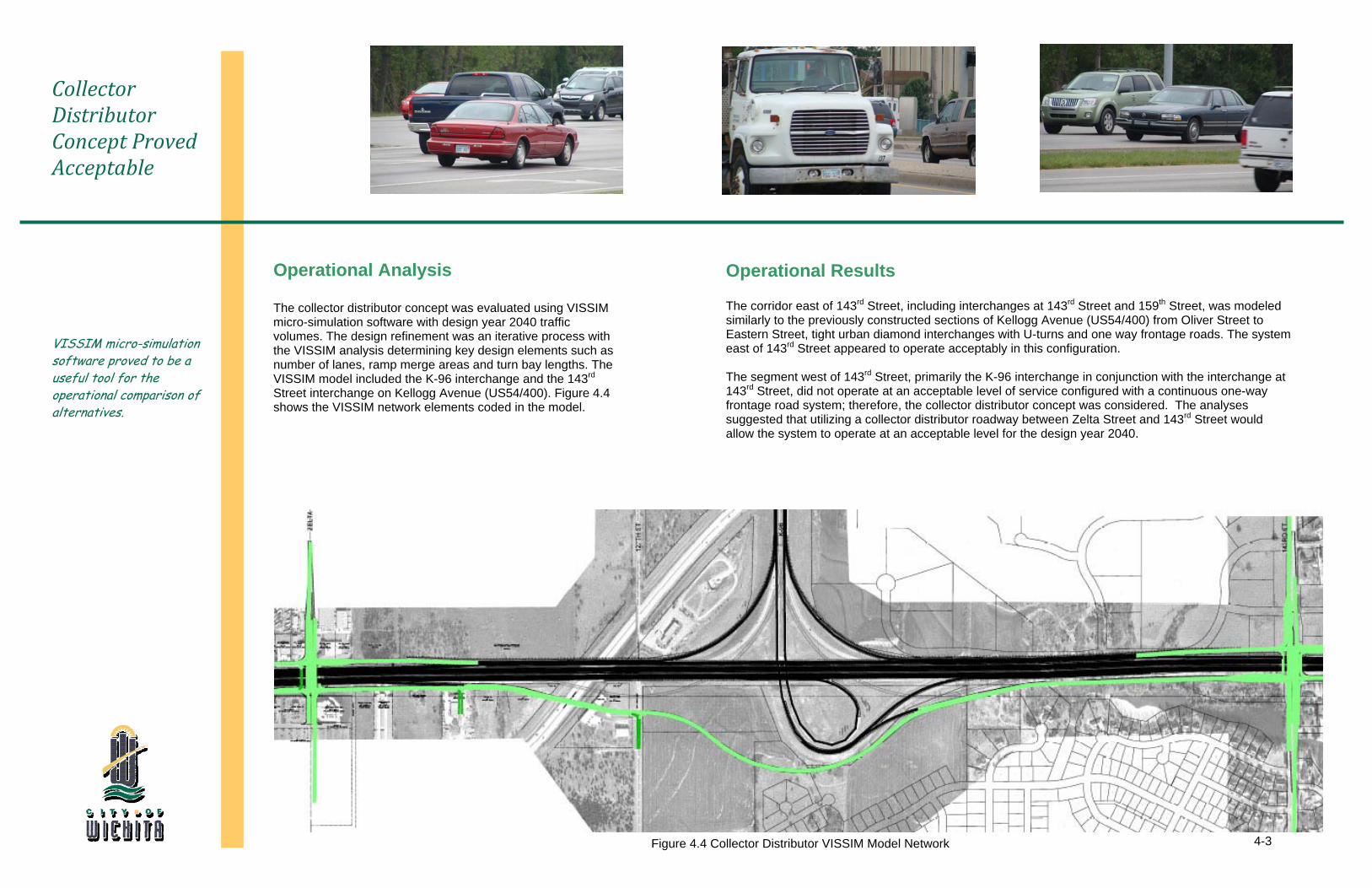
VISSIM micro-simulation software proved to be a useful tool for the operational comparison of alternatives.
Operational Analysis The collector distributor concept was evaluated using VISSIM micro-simulation software with design year 2040 traffic volumes. The design refinement was an iterative process with the VISSIM analysis determining key design elements such as number of lanes, ramp merge areas and turn bay lengths. The VISSIM model included the K-96 interchange and the 143rd Street interchange on Kellogg Avenue (US54/400). Figure 4.4 shows the VISSIM network elements coded in the model.
Operational Results
The corridor east of 143rd Street, including interchanges at 143rd Street and 159th Street, was modeled similarly to the previously constructed sections of Kellogg Avenue (US54/400) from Oliver Street to Eastern Street, tight urban diamond interchanges with U-turns and one way frontage roads. The system east of 143rd Street appeared to operate acceptably in this configuration. The segment west of 143rd Street, primarily the K-96 interchange in conjunction with the interchange at 143rd Street, did not operate at an acceptable level of service configured with a continuous one-way frontage road system; therefore, the collector distributor concept was considered. The analyses suggested that utilizing a collector distributor roadway between Zelta Street and 143rd Street would allow the system to operate at an acceptable level for the design year 2040.
Figure 4.4 Collector Distributor VISSIM Model Network
Utility RelocationEarly coordination efforts with both the City of Wichita and private utility companies set the stage for relocation efforts.
5
5-1
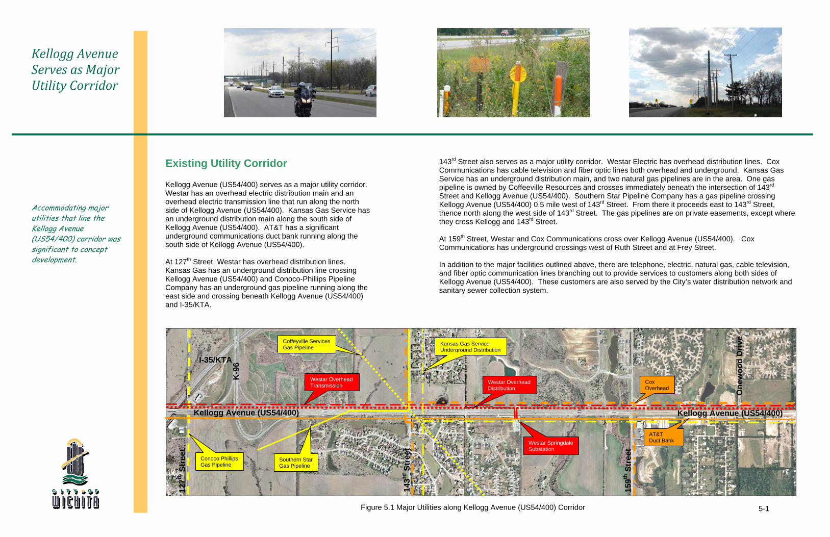
Figure 5.1 Major Utilities along Kellogg Avenue (US54/400) Corridor
Kellogg Avenue Serves as Major Utility Corridor
Accommodating major utilities that line the Kellogg Avenue (US54/400) corridor was significant to concept development.
Kellogg Avenue (US54/400)
K-9
6
1
43rd
Str
eet
15
9th S
tree
t
Kellogg Avenue (US54/400)
One
woo
d D
rive
Conoco Phillips Gas Pipeline
AT&T Duct Bank
I-35/KTA
127th
Str
eet
Kansas Gas Service Underground Distribution
Southern Star Gas Pipeline
Coffeyville Services Gas Pipeline
Existing Utility Corridor
Kellogg Avenue (US54/400) serves as a major utility corridor. Westar has an overhead electric distribution main and an overhead electric transmission line that run along the north side of Kellogg Avenue (US54/400). Kansas Gas Service has an underground distribution main along the south side of Kellogg Avenue (US54/400). AT&T has a significant underground communications duct bank running along the south side of Kellogg Avenue (US54/400). At 127th Street, Westar has overhead distribution lines. Kansas Gas has an underground distribution line crossing Kellogg Avenue (US54/400) and Conoco-Phillips Pipeline Company has an underground gas pipeline running along the east side and crossing beneath Kellogg Avenue (US54/400) and I-35/KTA.
143rd Street also serves as a major utility corridor. Westar Electric has overhead distribution lines. Cox Communications has cable television and fiber optic lines both overhead and underground. Kansas Gas Service has an underground distribution main, and two natural gas pipelines are in the area. One gas pipeline is owned by Coffeeville Resources and crosses immediately beneath the intersection of 143rd Street and Kellogg Avenue (US54/400). Southern Star Pipeline Company has a gas pipeline crossing Kellogg Avenue (US54/400) 0.5 mile west of 143rd Street. From there it proceeds east to 143rd Street, thence north along the west side of 143rd Street. The gas pipelines are on private easements, except where they cross Kellogg and 143rd Street. At 159th Street, Westar and Cox Communications cross over Kellogg Avenue (US54/400). Cox Communications has underground crossings west of Ruth Street and at Frey Street.
In addition to the major facilities outlined above, there are telephone, electric, natural gas, cable television, and fiber optic communication lines branching out to provide services to customers along both sides of Kellogg Avenue (US54/400). These customers are also served by the City’s water distribution network and sanitary sewer collection system.
Westar Springdale Substation
Westar Overhead Transmission Westar Overhead
DistributionCox Overhead
5-2
Utility Corridors along Kellogg would be Key to Utility Relocations
Through coordination efforts, a utility corridor plan was developed.
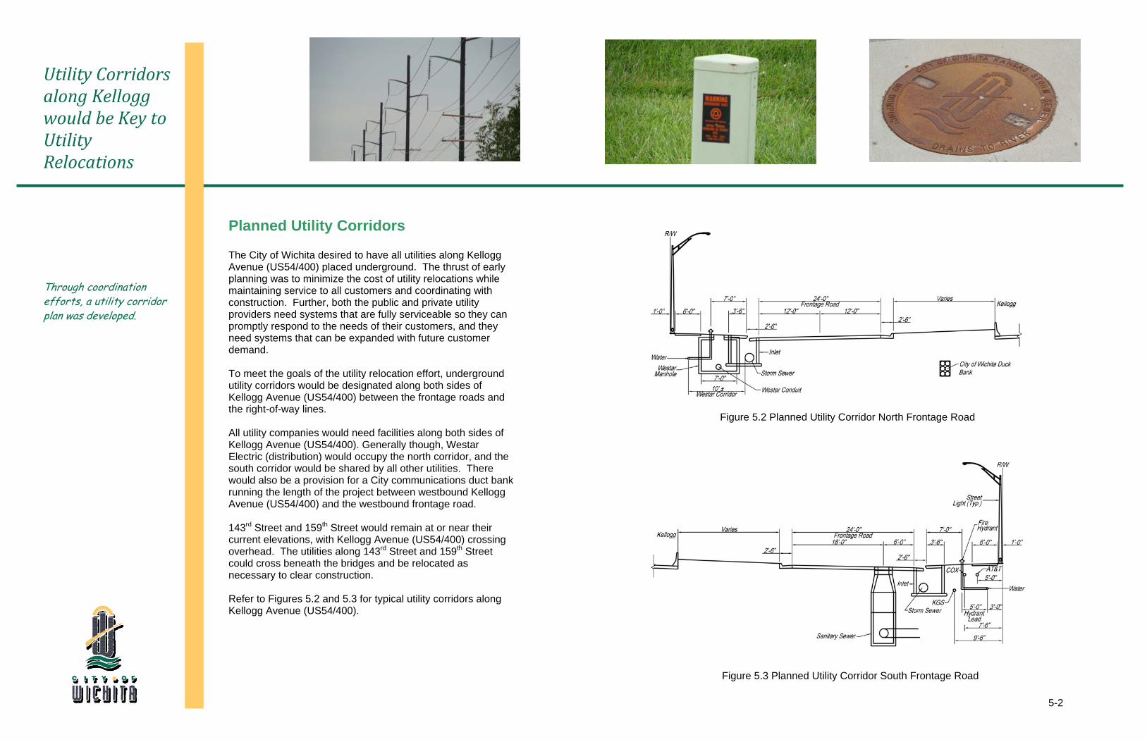
Planned Utility Corridors
The City of Wichita desired to have all utilities along Kellogg Avenue (US54/400) placed underground. The thrust of early planning was to minimize the cost of utility relocations while maintaining service to all customers and coordinating with construction. Further, both the public and private utility providers need systems that are fully serviceable so they can promptly respond to the needs of their customers, and they need systems that can be expanded with future customer demand. To meet the goals of the utility relocation effort, underground utility corridors would be designated along both sides of Kellogg Avenue (US54/400) between the frontage roads and the right-of-way lines. All utility companies would need facilities along both sides of Kellogg Avenue (US54/400). Generally though, Westar Electric (distribution) would occupy the north corridor, and the south corridor would be shared by all other utilities. There would also be a provision for a City communications duct bank running the length of the project between westbound Kellogg Avenue (US54/400) and the westbound frontage road. 143rd Street and 159th Street would remain at or near their current elevations, with Kellogg Avenue (US54/400) crossing overhead. The utilities along 143rd Street and 159th Street could cross beneath the bridges and be relocated as necessary to clear construction. Refer to Figures 5.2 and 5.3 for typical utility corridors along Kellogg Avenue (US54/400).
Figure 5.2 Planned Utility Corridor North Frontage Road
Figure 5.3 Planned Utility Corridor South Frontage Road
5-3
Early Planning could Save Millions
The thrust of early planning was to minimize the cost of utility relocations while maintaining service to all customers and coordinating with construction.
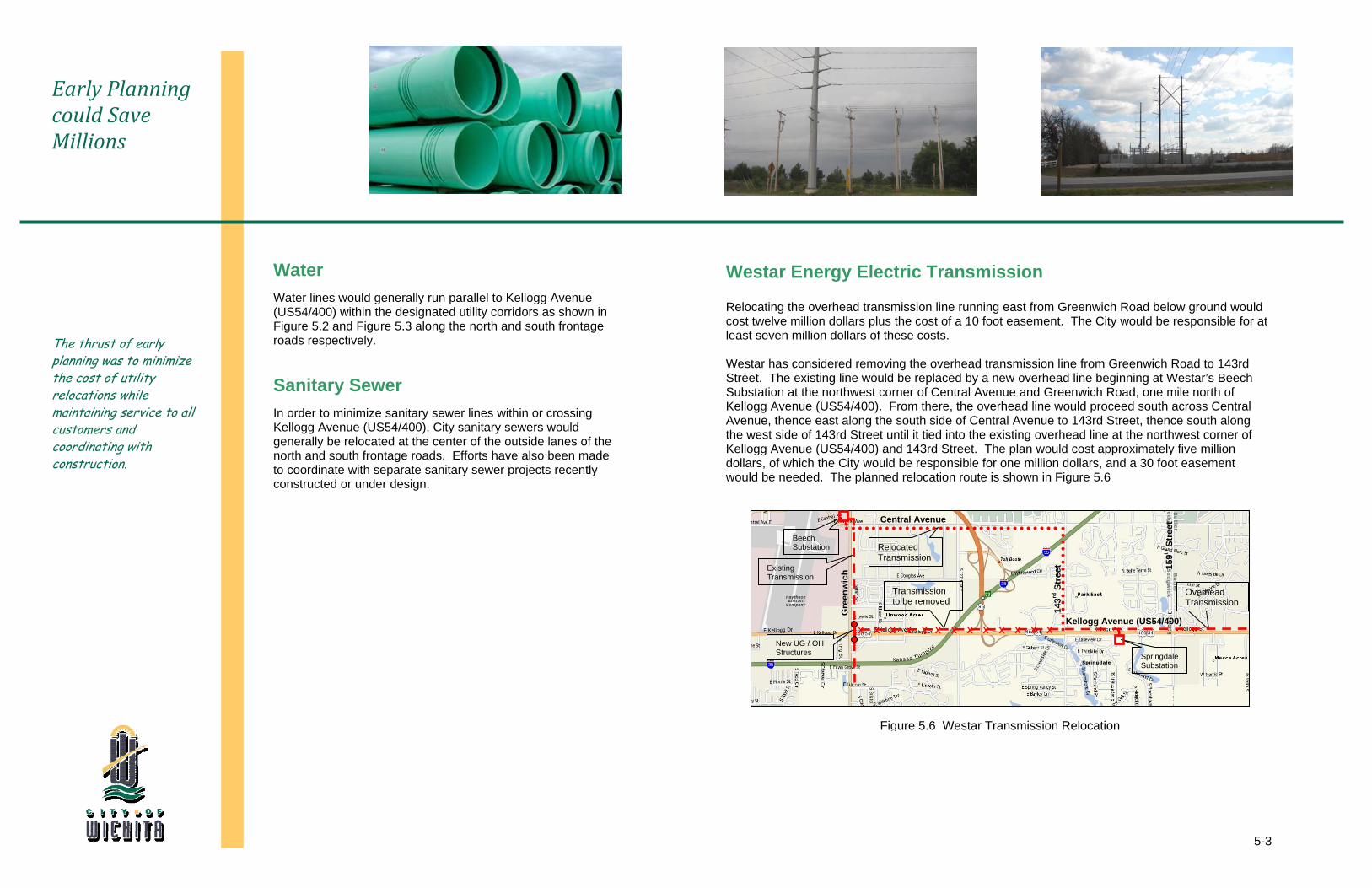
Figure 5.6 Westar Transmission Relocation
143rd
Str
eet
Water
Water lines would generally run parallel to Kellogg Avenue (US54/400) within the designated utility corridors as shown in Figure 5.2 and Figure 5.3 along the north and south frontage roads respectively. Sanitary Sewer
In order to minimize sanitary sewer lines within or crossing Kellogg Avenue (US54/400), City sanitary sewers would generally be relocated at the center of the outside lanes of the north and south frontage roads. Efforts have also been made to coordinate with separate sanitary sewer projects recently constructed or under design.
Westar Energy Electric Transmission
Relocating the overhead transmission line running east from Greenwich Road below ground would cost twelve million dollars plus the cost of a 10 foot easement. The City would be responsible for at least seven million dollars of these costs. Westar has considered removing the overhead transmission line from Greenwich Road to 143rd Street. The existing line would be replaced by a new overhead line beginning at Westar’s Beech Substation at the northwest corner of Central Avenue and Greenwich Road, one mile north of Kellogg Avenue (US54/400). From there, the overhead line would proceed south across Central Avenue, thence east along the south side of Central Avenue to 143rd Street, thence south along the west side of 143rd Street until it tied into the existing overhead line at the northwest corner of Kellogg Avenue (US54/400) and 143rd Street. The plan would cost approximately five million dollars, of which the City would be responsible for one million dollars, and a 30 foot easement would be needed. The planned relocation route is shown in Figure 5.6
159th
Str
eet
Existing Transmission
Transmission to be removed
Relocated Transmission
New UG / OH Structures
Beech Substation
Gre
enw
ich
SpringdaleSubstation
Overhead Transmission
Kellogg Avenue (US54/400)
Central Avenue
X X X X X X X X X X X X X
Storm DrainageGravity storm water sewer systems will drain the freeway, frontage roads, and side roads.
6
6-1
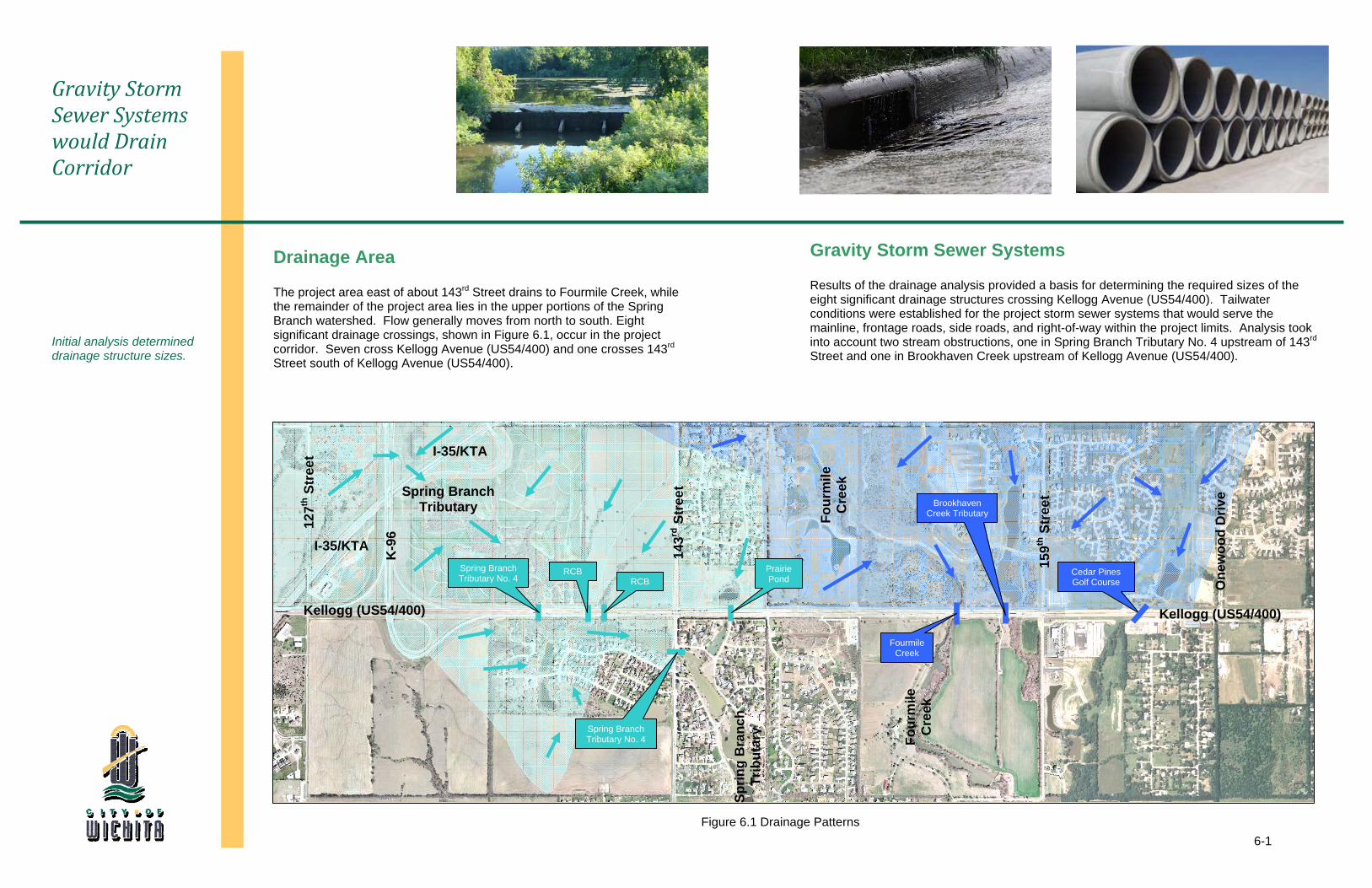
Gravity Storm Sewer Systems would Drain Corridor
Initial analysis determined drainage structure sizes.
Drainage Area
The project area east of about 143rd Street drains to Fourmile Creek, while the remainder of the project area lies in the upper portions of the Spring Branch watershed. Flow generally moves from north to south. Eight significant drainage crossings, shown in Figure 6.1, occur in the project corridor. Seven cross Kellogg Avenue (US54/400) and one crosses 143rd Street south of Kellogg Avenue (US54/400).
Figure 6.1 Drainage Patterns
159th
Str
eet
K-9
6
143rd
Str
eet
Four
mile
C
reek
Four
mile
C
reek
Kellogg (US54/400)
Gravity Storm Sewer Systems
Results of the drainage analysis provided a basis for determining the required sizes of the eight significant drainage structures crossing Kellogg Avenue (US54/400). Tailwater conditions were established for the project storm sewer systems that would serve the mainline, frontage roads, side roads, and right-of-way within the project limits. Analysis took into account two stream obstructions, one in Spring Branch Tributary No. 4 upstream of 143rd Street and one in Brookhaven Creek upstream of Kellogg Avenue (US54/400).
Sprin
g B
ranc
h Tr
ibut
ary
Spring Branch Tributary
Fourmile Creek
Prairie Pond
Brookhaven Creek Tributary
Cedar Pines Golf Course
Spring Branch Tributary No. 4
RCBRCBSpring Branch
Tributary No. 4
Kellogg (US54/400)
One
woo
d D
rive
127
th S
tree
t
I-35/KTA
I-35/KTA
AestheticsReflections and inspirations of Wichita culture including grasslands, wind and aeronautical influences inspired aesthetic treatment of corridor.
7
7-1
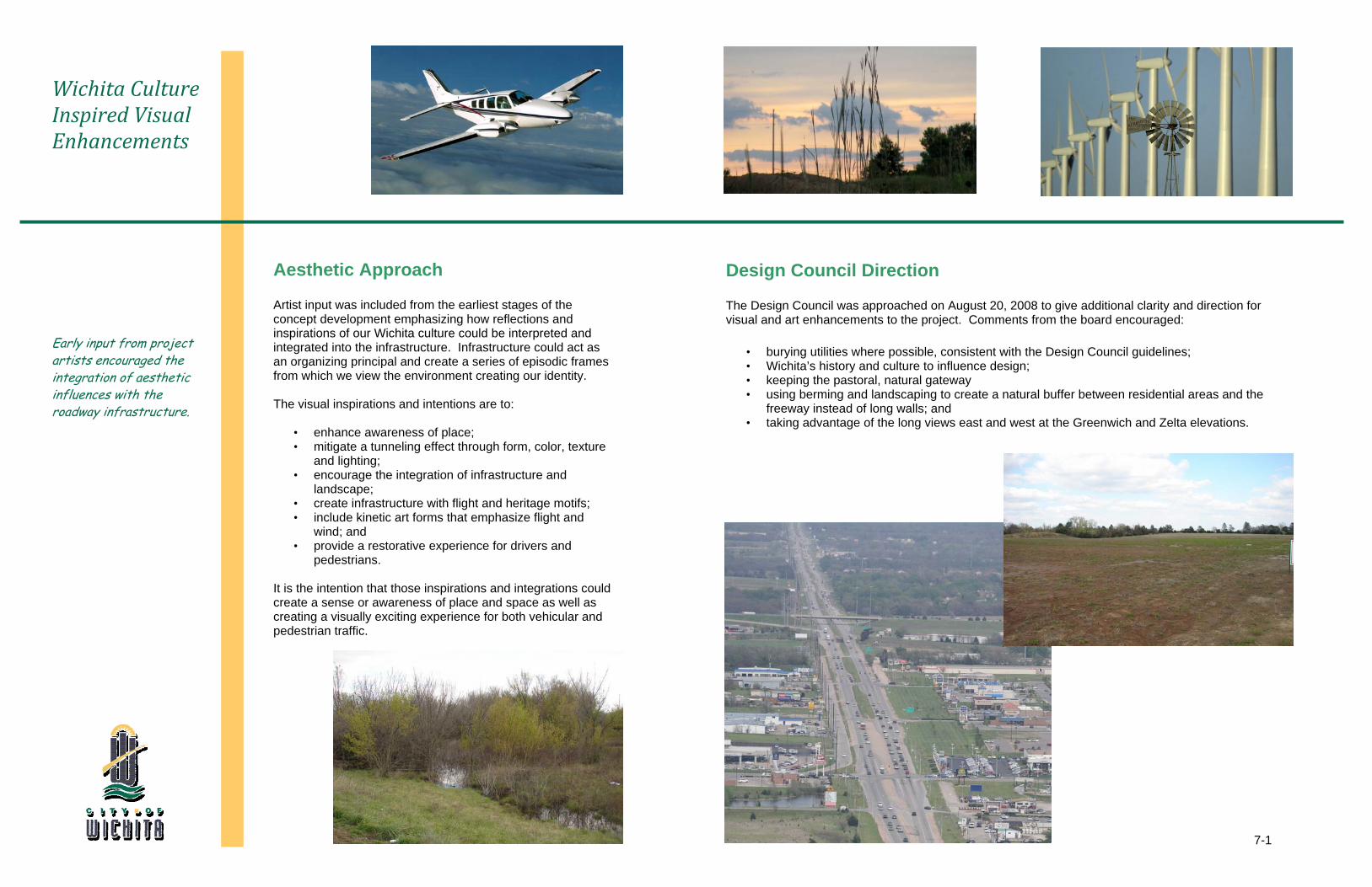
Wichita Culture Inspired Visual Enhancements
Early input from project artists encouraged the integration of aesthetic influences with the roadway infrastructure.
Aesthetic Approach
Artist input was included from the earliest stages of the concept development emphasizing how reflections and inspirations of our Wichita culture could be interpreted and integrated into the infrastructure. Infrastructure could act as an organizing principal and create a series of episodic frames from which we view the environment creating our identity. The visual inspirations and intentions are to:
• enhance awareness of place; • mitigate a tunneling effect through form, color, texture
and lighting; • encourage the integration of infrastructure and
landscape; • create infrastructure with flight and heritage motifs; • include kinetic art forms that emphasize flight and
wind; and • provide a restorative experience for drivers and
pedestrians. It is the intention that those inspirations and integrations could create a sense or awareness of place and space as well as creating a visually exciting experience for both vehicular and pedestrian traffic.
Design Council Direction
The Design Council was approached on August 20, 2008 to give additional clarity and direction for visual and art enhancements to the project. Comments from the board encouraged:
• burying utilities where possible, consistent with the Design Council guidelines; • Wichita’s history and culture to influence design; • keeping the pastoral, natural gateway • using berming and landscaping to create a natural buffer between residential areas and the
freeway instead of long walls; and • taking advantage of the long views east and west at the Greenwich and Zelta elevations.
Recommended AlternativeThe recommended design alternative would improve the capacity and functionality of East Kellogg (US54/400) from 127th Street to 159th Street.
8
8-1
2 Lanes @ 12’ = 24’ 8’
12’ Shld Varies
2 Lanes @ 12’ = 24’ 9’
12’ Shld 3 Lanes @ 12’ = 36’ 3 Lanes @ 12’ = 36’
12’ Shld
8’ Shld
12’ Aux. Lane 6’
10’ Shld 6’
6’ 9’2 Lanes
@ 12’ = 24’ Varies
12’ Aux. Lane
12’ Shld
12’ Aux. Lane Varies
2 Lanes @ 12’ = 24’ 9’
8’ Shld 3 Lanes @ 12’ = 36’ 3 Lanes @ 12’ = 36’
12’ Shld 6’
8’ Shld
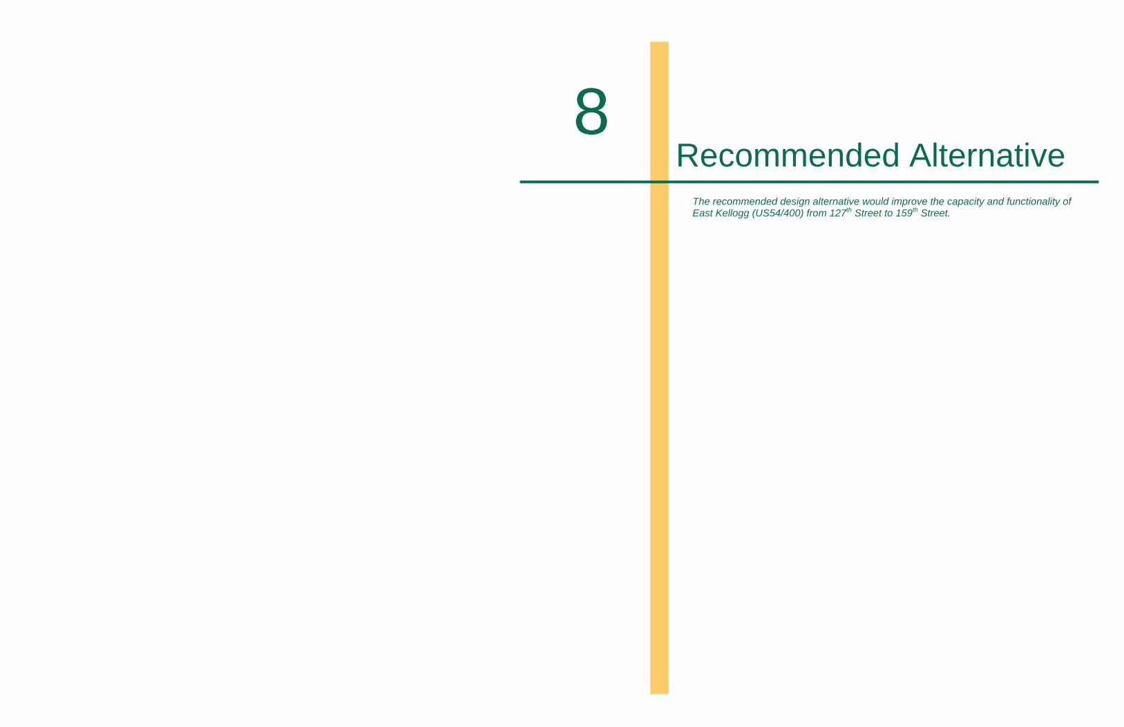
Figure 8.1 Typical At-Grade Freeway with combination Collector Distributor / Frontage Road System
Design Alternative Recommended for East Kellogg
The recommended alternative is: Safe Functional Eligible for Funding
Recommended Alternative
The proposed improvement would follow the existing Kellogg Avenue (US54/400) alignment as a six-lane freeway system with continuous one-way frontage roads to efficiently carry the projected 2040 design year traffic volumes that are estimated to range from 54,800 to 99,900 vehicles per day. The freeway width would be designed to accommodate an eight-lane section in the future. Kellogg Avenue (US54/400) would have full access control with access points provided via interchanges at the following locations:
• K-96 (Directional T Configuration) • 143rd Street (Tight Diamond Configuration) • 159th Street (Tight Diamond Configuration)
Generally, three different typical sections are recommended for completion of the Kellogg Avenue (US54/400) improvements. The freeway would be at-grade under K-96 with a combination collector distributor and one-way frontage road system as shown in Figure 8.1. Figure 8.2 represents a typical at grade section with one-way frontage roads while Figure 8.3 shows an elevated freeway over both 143rd Street and 159th Street.
Figure 8.3 Typical Elevated Freeway with Frontage Roads – 143rd Street and 159th Street
Figure 8.2 Typical At-Grade Freeway with Frontage Roads
6’ 9’2 Lanes
@ 12’ = 24’ Varies
12’ Aux. Lane
12’ Shld
12’ Aux. Lane Varies
2 Lanes @ 12’ = 24’ 9’
8’ Shld 3 Lanes @ 12’ = 36’
8’ Shld3 Lanes @ 12’ = 36’
12’ Shld 6’
8-2
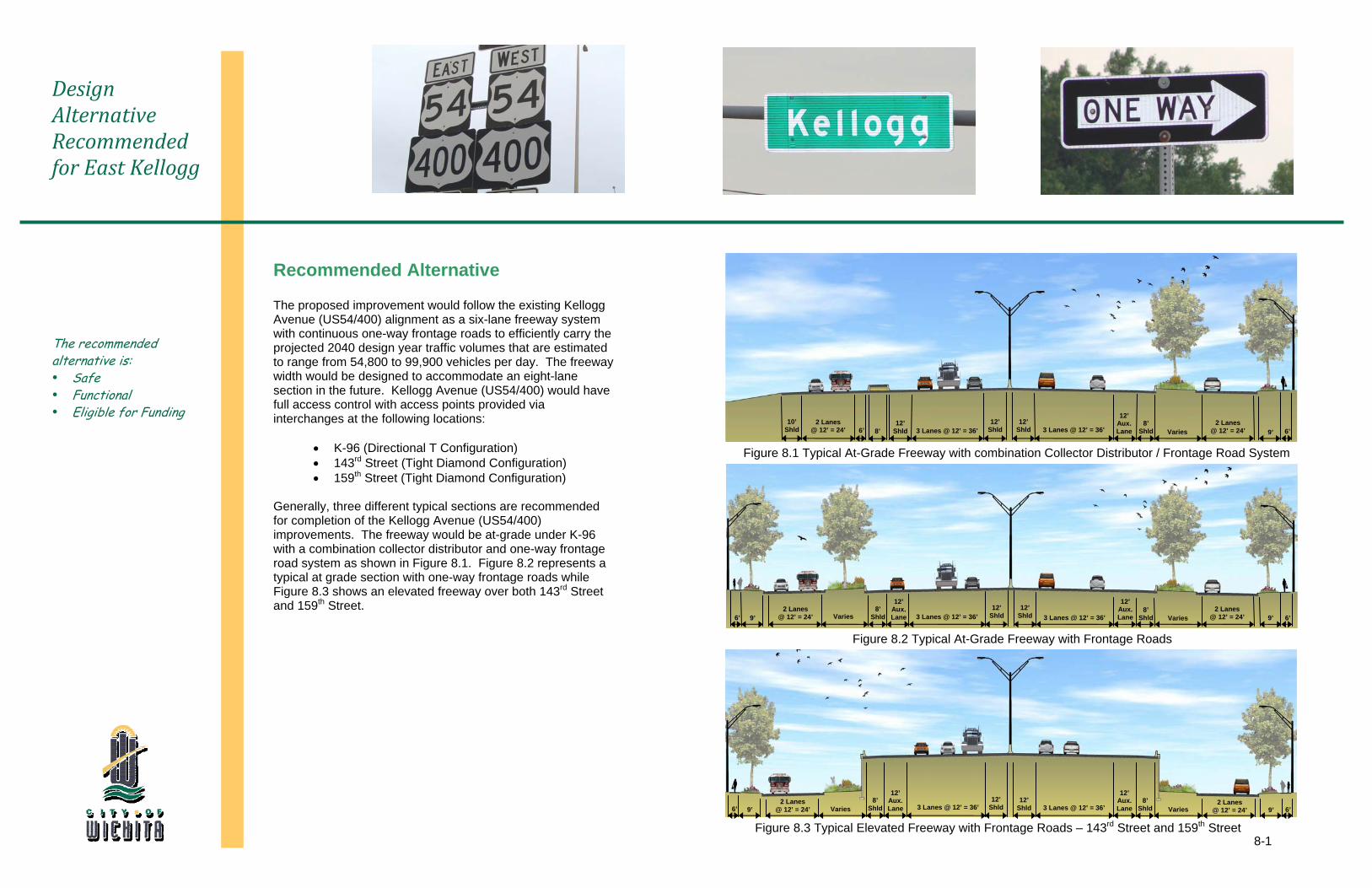
127th Street to 143rd Street
Kellogg Avenue (US54/400) would be at grade through the K-96 interchnage.
Figure 8.4 Recommended Alternative - Western Segment
8-3
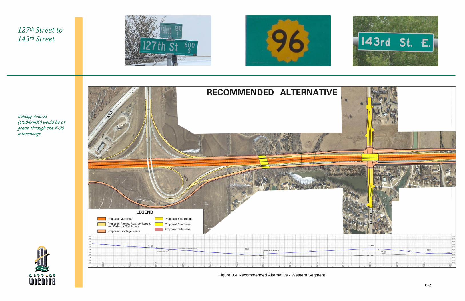
143rd Street to 159th Street
Kellogg Avenue (US54/400) would be elevated over both 143rd Street and 159th Street
Figure 8.5 Recommended Alternative - Eastern Segment
8-4
Project Utility Relocation Construction Total
127th Street to 159th Street $11,000,000 $109,800,000 $120,800,000
Side Road Minimum Distance From Edge of Frontage Road
(Feet)
143rd Street (North of Kellogg Avenue) 600
143rd Street (South of Kellogg Avenue) 600
159rthStreet (North of Kellogg Avenue) 600
159rthStreet (South of Kellogg Avenue) 400
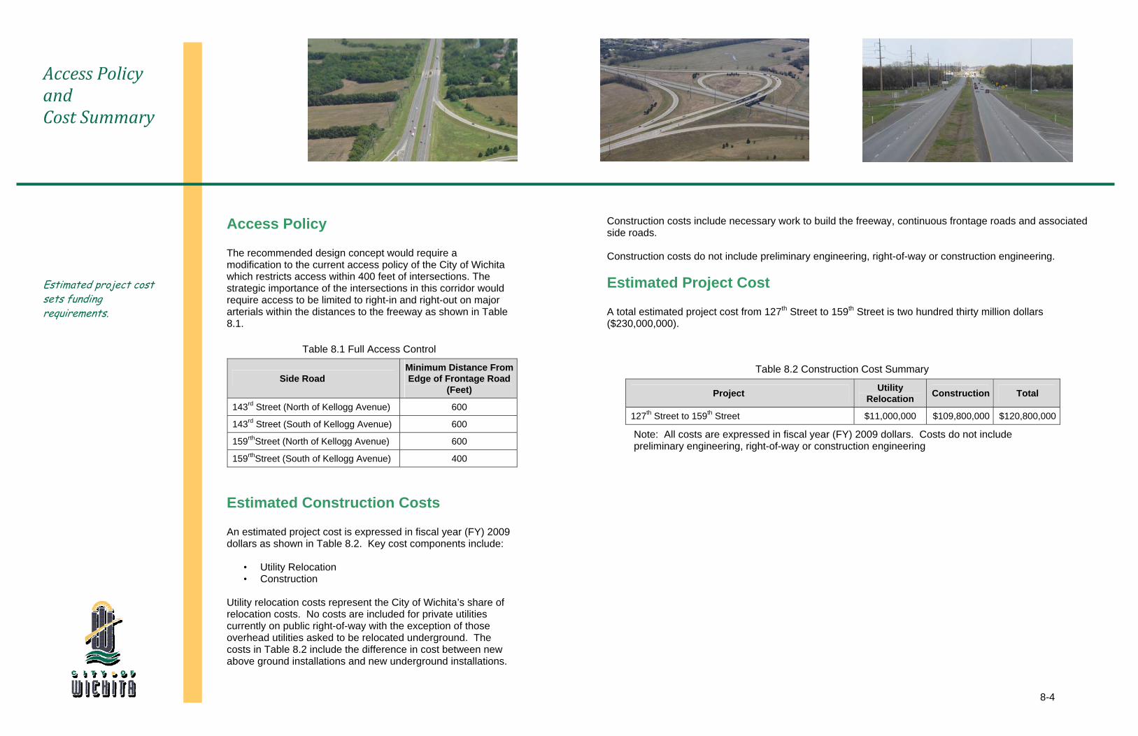
Access Policy and Cost Summary
Estimated project cost sets funding requirements.
Access Policy
The recommended design concept would require a modification to the current access policy of the City of Wichita which restricts access within 400 feet of intersections. The strategic importance of the intersections in this corridor would require access to be limited to right-in and right-out on major arterials within the distances to the freeway as shown in Table 8.1.
Table 8.2 Construction Cost Summary
Note: All costs are expressed in fiscal year (FY) 2009 dollars. Costs do not include preliminary engineering, right-of-way or construction engineering
Construction costs include necessary work to build the freeway, continuous frontage roads and associated side roads. Construction costs do not include preliminary engineering, right-of-way or construction engineering. Estimated Project Cost
A total estimated project cost from 127th Street to 159th Street is two hundred thirty million dollars ($230,000,000).
Estimated Construction Costs
An estimated project cost is expressed in fiscal year (FY) 2009 dollars as shown in Table 8.2. Key cost components include:
• Utility Relocation • Construction
Utility relocation costs represent the City of Wichita’s share of relocation costs. No costs are included for private utilities currently on public right-of-way with the exception of those overhead utilities asked to be relocated underground. The costs in Table 8.2 include the difference in cost between new above ground installations and new underground installations.
Table 8.1 Full Access Control