
Description of the Proposal
30
ENVIRONMENTAL IMPACT STATEMENT DARRYL MCCARTHY CONSTRUCTIONS PTY LTD Expansion of the Dowe’s Quarry via Tenterfield Report No. 896/13 Page 2-1 Section 2 Description of the Proposal P REAMBLE This section describes the proposed expanded operations at Dowe’s Quarry (“the Proposal”) including: • the objectives of the Proposal; • an overview of proposed activities and the need for the Proposal; • a review of local geology, resources and Quarry products; • a description of the proposed extraction and processing activities to be undertaken within the Quarry Site; • the proposed transportation regime for the delivery of fragmented and/or crushed quartzose rock from the Quarry to the New England Highway and destinations beyond, particularly to the Sunnyside Plant; • a description of the emplacement of the fines returned from the Sunnyside Plant and fines produced on site; • a description of infrastructure, utilities and services that would be located within the Quarry Site as well as proposed employment, hours of operation and Project life; and • a description of the proposed rehabilitation of areas that would be disturbed within the Quarry Site throughout the life of the Proposal. The Proposal is described in sufficient detail to provide the reader with an overall understanding of the nature and extent of all activities proposed throughout the life of the Proposal, how the various activities would be undertaken and to enable an assessment of the potential impacts on the surrounding environment.
Transcript of Description of the Proposal

ENVIRONMENTAL IMPACT STATEMENT
DARRYL MCCARTHY CONSTRUCTIONS PTY LTD Expansion of the Dowe’s Quarry via Tenterfield
Report No. 896/13
Page 2-1
Section 2
Description of
the Proposal
PREAMBLE
This section describes the proposed expanded operations at Dowe’s Quarry (“the Proposal”) including:
• the objectives of the Proposal;
• an overview of proposed activities and the need for the Proposal;
• a review of local geology, resources and Quarry products;
• a description of the proposed extraction and processing activities to be
undertaken within the Quarry Site;
• the proposed transportation regime for the delivery of fragmented and/or
crushed quartzose rock from the Quarry to the New England Highway and
destinations beyond, particularly to the Sunnyside Plant;
• a description of the emplacement of the fines returned from the Sunnyside Plant
and fines produced on site;
• a description of infrastructure, utilities and services that would be located within
the Quarry Site as well as proposed employment, hours of operation and Project
life; and
• a description of the proposed rehabilitation of areas that would be disturbed
within the Quarry Site throughout the life of the Proposal.
The Proposal is described in sufficient detail to provide the reader with an overall understanding of the nature and extent of all activities proposed throughout the life of the Proposal, how the various activities would be undertaken and to enable an assessment of the potential impacts on the surrounding environment.

ENVIRONMENTAL IMPACT STATEMENT
DARRYL MCCARTHY CONSTRUCTIONS PTY LTD Expansion of the Dowe’s Quarry via Tenterfield
Page 2-2 Report No.896/13
This page has intentionally been left blank
ENVIRONMENTAL IMPACT STATEMENT
DARRYL MCCARTHY CONSTRUCTIONS PTY LTD Expansion of the Dowe’s Quarry via Tenterfield
Report No. 896/13
Page 2-3
2.1 Objectives of the Proposal
The Applicant’s principal objective is to obtain development consent to enable the planned
extension of operations at the Quarry. The Proposal would allow the Applicant to continue and
extend operations to extract the recoverable quartzose rock to produce a range of ivory-coloured
stone products used in the manufacture of decorative concrete and landscaping products and road
pavement materials.
The Applicant would continue to operate the Quarry to meet the following objectives.
• To continue to provide a source of high-quality stone products to meet the needs of
housing and construction markets in NSW and Queensland.
• To maximise the recovery of the natural resource.
• To develop and operate the Quarry in a manner that is environmentally responsible
and complies with all statutory requirements and reasonable community
expectations.
• To create a final landform that is safe, stable and provides for long-term nature
conservation within the areas disturbed throughout the life of the Quarry.
• Achieve the above objectives in a cost-effective manner to ensure the Proposal is
viable.
These broad objectives would be achieved by:
i) planning and extracting the resource in a manner that maximises the quality and
quantity of quartzose rock recovered;
ii) undertaking all activities in an environmentally responsible manner that enables
compliance with all relevant statutory requirements;
iii) monitoring and reviewing the operational and environmental performance of all
activities; and
iv) implementing a state-of-the-art truck management system and code of conduct for
drivers (Appendix 5).
2.2 Overview of the Proposal
Overview of Proposed Activities
The activities for which the Applicant is seeking development consent would involve the
following.
• Ongoing extraction of quartzose rock within the existing extraction area and a 4.5ha
extension of the extraction area, producing up to 230 000tpa.
• Campaign crushing and screening on site using mobile processing equipment. On-
site processing would be undertaken in response to client requirements.

ENVIRONMENTAL IMPACT STATEMENT
DARRYL MCCARTHY CONSTRUCTIONS PTY LTD Expansion of the Dowe’s Quarry via Tenterfield
Page 2-4 Report No.896/13
• Ongoing transportation of fragmented and crushed rock to the State road network,
(i.e. the New England Highway), for delivery to the Sunnyside Plant, and other
destinations. Material would also continue to be delivered locally within Tenterfield
for Council-managed road and infrastructure activities and directly to the local
community.
• Ongoing transportation of material directly to end points of use, where further
processing at the Sunnyside Plant is not required.
• Ongoing backloading of clay fines and crusher fines from the Sunnyside Plant to
the Quarry;
• Progressive emplacement of overburden and fines within and adjacent to the
extraction area.
• Progressive and final rehabilitation of the Quarry to develop a landform suitable for
native vegetation conservation.
2.3 Quarry Site Layout
The Quarry Site layout displayed in Figure 2.1 incorporates the existing and proposed
components within the Quarry Site.
The principal components and the respective approximate area of disturbance within the Quarry
Site are as follows.
• Extraction area (Stage 1 – 6.9ha, Stage 2 – 10.1ha, Stage 3 – 11.4ha1)
The extraction area would be developed in three stages and would be centred on the
quartzose material defined through the exploration drilling campaign undertaken by
the Applicant.
• Processing area (1.7ha)
The processing area would be located immediately to the northwest of the
extraction area and would incorporate areas for the mobile crushing plant, raw feed
stockpiles and product stockpiles.
• Bund (0.62ha)
A bund would be constructed to the north and west of the processing area
principally to mitigate potential noise and visual impacts generated by the mobile
crushing plant. The bund would be constructed using overburden and topsoil
stripped during the development of other Quarry components.
1 The nominated areas are the cumulative area of extraction at the end of each stage.

ENVIRONMENTAL IMPACT STATEMENT
DARRYL MCCARTHY CONSTRUCTIONS PTY LTD Expansion of the Dowe’s Quarry via Tenterfield
Report No. 896/13
Page 2-5
Figure 2.1 Indicative Quarry Site Layout
A4 / Colour
Figure dated 25/9/19 inserted on 27/9/19

ENVIRONMENTAL IMPACT STATEMENT
DARRYL MCCARTHY CONSTRUCTIONS PTY LTD Expansion of the Dowe’s Quarry via Tenterfield
Page 2-6 Report No.896/13
• Overburden and fines stockpile (Stage 1 – 3.2ha, Stage 2 – 2.6ha, Stage 3 – 1.6ha)
The overburden and fines stockpile would be progressively developed using
overburden removed during extraction and fines backloaded from Sunnyside or
produced on site. The overburden and fines stockpile would be located immediately
to the north of the extraction area. No new material would be added to this area
from midway through Stage 2 of operations. As the extraction area is developed to
the north, material from the overburden and fines stockpile would be progressively
relocated to the completed areas in the eastern section of the extraction area. This
would allow for the extension of the extraction area to the north and west.
• Overburden and fines emplacement (Stage 2 – 1.9ha, Stage 3 – 2.9ha)
The overburden and fines emplacement would be developed in the eastern section
of the extraction area from midway through Stage 2 using material moved from the
overburden and fines stockpile and overburden generated during the extension of
the extraction area. It would be developed to an ultimate elevation of approximately
920m AHD (effectively ground level).
• Quarry access road (1.7km)
The Quarry access road would provide long-term vehicular access to the processing
area. Approximately 770m of the road would be sealed.
• Sediment dams (0.24ha)
The northern sediment dam is located to the north of the overburden and fines
stockpile and would contain all surface water runoff from the overburden and fines
stockpile and other disturbed areas to the north of the extraction area.
The southern sediment dam is located to the south of the extraction and would
contain all surface water runoff from disturbed areas to the south of the extraction
area.
The western sediment dam would be constructed in the vicinity of the processing
area to capture rainfall runoff from the western section of the overburden and fines
stockpile.
The total area to be designated as the Quarry Site would be approximately 26.8ha of which the
maximum area of disturbance would be 16.4ha. Approximately 6.4ha of remnant native
vegetation would be disturbed during the development of the Quarry Site.
2.4 Resources and Products
Geology and Resources
The resource being extracted has been identified as a wide (25m to 50m) quartzite lens striking
east-west within undifferentiated granite or granodiorites. The lens typically dips at
approximately between 65º to 80º to the north which provides for a near vertical resource
(Groundwork Plus, 2018). The rocks within and surrounding the Quarry Site are Lower to Middle
Permian in age (approximately 290 million years old).

ENVIRONMENTAL IMPACT STATEMENT
DARRYL MCCARTHY CONSTRUCTIONS PTY LTD Expansion of the Dowe’s Quarry via Tenterfield
Report No. 896/13
Page 2-7
Based on the outcomes of a comprehensive drilling program undertaken in July 2018, aimed at
further defining the availability resource, the Applicant conservatively estimates approximately
4.8 million tonnes of quartzose rock could be recovered from within the existing and extended
extraction area. Figure 2.2 displays the resource targeted and the location of exploration drill
holes within the Quarry Site as well as a typical cross section through the inferred quartzose lens.
Products
The principal product produced at Dowe’s Quarry is a graded fractured quartzose rock blend with
all fragments typically less than 400mm. This blend is produced principally by blasting with a
small proportion of blasted oversize rock reduced to less than 400mm through the use of a
hydraulic hammer.
As part of this application, the Applicant proposes to increase the range of products produced
from the quartzose material which would involve a proportion of the quartzose material being
processed on site prior to despatch to the Sunnyside Plant or directly to customers. On-site
processing would be undertaken using mobile crushing and screening plant to produce a range of
5mm – 24mm crushed rock products and crusher fines.
Production Rates
Despatch of quartzose rock from the Quarry Site would not exceed 230 000tpa. This rate has been
selected based on the inferred resource, anticipated demand and allows for peaks in some years.
Product despatch is described in more detail in Section 2.9, however it is noted that the Applicant
is unlikely to reach this maximum limit until the currently approved transport route is approved
for higher mass vehicles with performance based standard certification. The Applicant intends to
work with Council on this process and progressively increase the truck capacity approved on the
route. This would allow an increase in the material despatched from the Quarry without
increasing traffic levels.
2.5 Site Establishment and Construction Activities
Introduction
A range of site establishment and construction activities would be undertaken within the Quarry
Site to enable the development and expansion of the Quarry. The principal activities undertaken
would be as follows.
1. The marking out of all component areas to be disturbed during the extension of the
Quarry with highly visible permanent markers.
2. Progressive vegetation clearing and soil removal within the areas approved for
disturbance.

ENVIRONMENTAL IMPACT STATEMENT
DARRYL MCCARTHY CONSTRUCTIONS PTY LTD Expansion of the Dowe’s Quarry via Tenterfield
Page 2-8 Report No.896/13
Figure 2.2 Quarry Site Geology
A4 / Colour
Figure dated 25/9/19 inserted on 25/9/19
ENVIRONMENTAL IMPACT STATEMENT
DARRYL MCCARTHY CONSTRUCTIONS PTY LTD Expansion of the Dowe’s Quarry via Tenterfield
Report No. 896/13
Page 2-9
3. Construction of the Quarry access road to provide access to the processing area.
4. Construction of the processing area pad and bund.
Each of these activities is described in more detail in the following sections.
Component Mark Out
Prior to the commencement of any vegetation clearing or earthworks, the Applicant would
commission a surveyor to survey and physically mark out the approved areas of disturbance using
appropriately labelled and highly visible permanent survey markers. Survey markers would be
positioned at the corners of all component areas and along boundaries at distances / spacing that
allows visibility of the next marker.
Vegetation Clearing
A total of 6.4ha of vegetation would be removed for the extension of the Quarry Site. All
vegetation clearing would be undertaken in accordance with the existing Vegetation Clearing
Protocol for the Quarry (see Appendix 4).
Vegetation would be cleared progressively within the defined areas of disturbance using an
excavator. The few mature trees with tree hollows would be removed following the adoption of
the measures nominated to avoid impacts to individual fauna species (see Section 5.5.5).
Following the removal of the mature trees, selected timber may be made available for use by the
landowner or sale for the purposes of building timber, fencing materials or firewood. The
remainder would be stockpiled for rehabilitation activities or mulched for placement on terminal
benches.
Soil Removal
Any soil, where present and recoverable, would be stripped and either stockpiled for future use
in rehabilitation activities or directly transferred to an area to be revegetated. The act of stripping
the shallow, skeletal soil (where present), stockpiling and respreading would provide for adequate
blending of the topsoil and subsoil recovered.
As far as practicable, soil stripping would be undertaken during periods to avoid forecast rainfall
to potentially prevent higher levels of soil loss due to erosion. This would be particularly relevant
for the period from December to February given the higher expected rainfall levels during that
period (see Section 4.2.3). If clearing during these periods is unavoidable, additional practices
would be undertaken to reduce the erosion risk, such as placement of silt-stop fencing at a location
downslope that allows the installation of the fencing.
Soil that is not immediately applied to active rehabilitation areas would be stockpiled within the
Quarry Site, most likely within safety bunding of the extraction area, from where it would be
easily accessed, when required. Topsoil that needs to be stockpiled for more than one month
would be seeded to establish a stabilising groundcover.
ENVIRONMENTAL IMPACT STATEMENT
DARRYL MCCARTHY CONSTRUCTIONS PTY LTD Expansion of the Dowe’s Quarry via Tenterfield
Page 2-10 Report No.896/13
Construction of the Quarry Access Road
The Quarry access road would be constructed to provide long-term vehicular access to the
processing area (Figure 2.1). The existing Quarry access road from the intersection with Mount
Lindesay Road would be retained. Approximately 770m of this road is sealed to limit dust lift-
off and noise generation. The Quarry access would follow the eastern and northern boundary of
the extraction area for approximately 965m to the processing area. Within the Quarry Site, the
access road would be an unsealed internal gravel road, constructed using appropriate pavement
materials.
Construction of the Processing Area Pad and Bund
The pad for the proposed processing area would comprise a total area of 1.8ha and would be
constructed using both cut and fill to an elevation of approximately 910m AHD (Figure 2.1). Fill
material would be sourced from existing overburden stockpiles.
A bund would be constructed through the placement of overburden to the north and west of the
processing area to mitigate any potential noise and visual impacts generated by the operation of
the mobile processing plant (Figure 2.1). The bund would be up to 10m high and would be
constructed with slopes of approximately 1:1.5 (V:H). The bund would provide an effective
barrier height of 5m above the floor of the processing area.
2.6 Extraction Operations
Introduction
Extraction operations would be undertaken in a similar manner to existing operations i.e. using
conventional drill and blast methods. This subsection presents information relating to the
proposed extraction operations including design features, extraction sequence, extraction
methods, equipment used and extraction rates.
Design Features
Although subject to modifications based on localised geological conditions or the optimal
locations of Quarry ramps etc, the following general design criteria would be adopted for the
Project.
• Operational Face Height: 15m
• Operational Bench Width: 20m to 100m (longitudinal i.e. east-west)
• Terminal Bench Width: 3m (approximate)
• Face Angle: 70° (approximate)
The proposed maximum 70° (approximate) face angle would be subject to further geotechnical
investigation throughout the life of the Quarry to ensure safe and stable extraction slopes are
achieved.
ENVIRONMENTAL IMPACT STATEMENT
DARRYL MCCARTHY CONSTRUCTIONS PTY LTD Expansion of the Dowe’s Quarry via Tenterfield
Report No. 896/13
Page 2-11
Access to the extraction area, including for road-registered trucks to access the blasted rock piles,
would be provided by an access ramp from the processing area located to the northwest of the
extraction area.
Extraction Sequence
Extraction would be undertaken in a staged manner following the completion of site
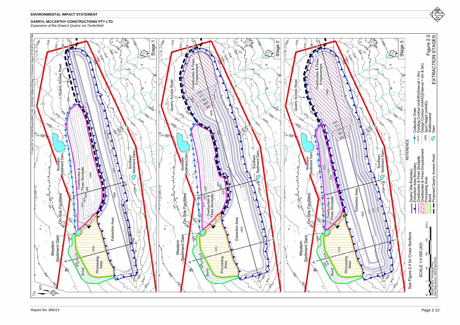
establishment and construction activities. Figure 2.3 displays the indicative extraction sequence
for the Proposal incorporating three stages. A series of three cross sections through the indicative
extraction area is presented on Figure 2.4.
Stage 1
Stage 1 would include the progressive development of the extraction area to the east of the
existing extraction area. Overburden would be removed using an excavator and hauled to the
overburden and fines stockpile to the north of the extraction area. Quartzose material would then
be extracted using drill and blast methods followed by load and haul to the processing area or
direct loading into road registered vehicles.
The proposed Stage 1 extraction area covers approximately 6.9ha. Extraction during this stage is
proposed to an elevation of approximately 905m AHD which is approximately 15m lower than
the floor of the existing extraction area. Two operational benches would be developed during
Stage 1 at approximately 935m AHD and 920m AHD.
Emphasis would be placed upon extracting all recoverable quartzose material from the eastern
end of the extraction area during Stage 1 (and early stages of Stage 2) to enable the eastern end
of the extraction area to be used for the emplacement of overburden and fines.
Stage 2
Stage 2 of operations would involve the lateral extension of the extraction area to a total area of
10.1ha. Overburden would continue to be hauled to the overburden and fines emplacement until
approximately midway through Stage 2 after which it would be emplaced within the eastern
section of the extraction area to form the overburden and fines emplacement. Overburden and
fines would also be progressively moved from the overburden and fines stockpile to the
overburden and fines emplacement from approximately midway through Stage 2 to allow for the
extension of the extraction area without the need for additional disturbance and vegetation
clearing.
Extraction within the eastern section of the extraction area is proposed to an elevation of
approximately 875m AHD. Operational benches would be established at approximately
935m AHD, 920m AHD and 905m AHD.
Stage 3
Stage 3 of operations would involve the progressive lateral extension of the extraction area. This
stage would involve the on-going relocation of material from the overburden and fines stockpile.
Overburden and fines generated during Stage 3 operations would be emplaced within the
overburden and fines emplacement (the terminal eastern area of the extraction area).

ENVIRONMENTAL IMPACT STATEMENT
DARRYL MCCARTHY CONSTRUCTIONS PTY LTD Expansion of the Dowe’s Quarry via Tenterfield
Page 2-12 Report No.896/13
The extraction area in Stage 3 would reach a maximum area of approximately 11.4ha. The Stage 3
extraction area would extend to an elevation of approximately 875m AHD with operational
benches established at approximately 935m AHD, 920m AHD, 905m AHD and 890m AHD.
Extraction Method
Drilling and blasting would continue to be used to extract the quartzose rock. Blasts would
typically fragment approximately 20 000 to 50 000 tonnes per blast. The drilling of blast holes
would typically be undertaken on a 3m x 3m pattern using 89mm drill holes to a depth of 14m
with up to 1m of sub drill. Blasting would typically occur no more than once per month. However,
in the interest of practical limits of ongoing operations, blasting of no more than once per week
(excluding that required in the event of a misfire) is proposed.
Fragmented rock may be loaded directly into highway trucks for transportation to the Sunnyside
Plant. Material that is to be proceed on-site would be hauled to the processing area for crushing
prior to loading and despatch.
Extraction Equipment
Operations currently require the use of the following equipment.
• 1 x Hydraulic Drill Rig (Atlas Copco T35) or equivalent – used typically one day
per month for drilling blast holes.
• 2 x Excavator (Komatsu PC300) or equivalent – permanently on site and used for
loading trucks, clearing vegetation, soil removal, excavation of overburden and
secondary breakage of oversize blasted rock.
• 1 x Haul Truck (22m3/40t) or equivalent – used periodically on site for transfer of
blasted rock, soil and overburden.
The Applicant intends to continue to use this equipment fleet throughout the remaining life of the
Proposal. Other equipment may be used at the Quarry Site from time to time such as a grader to
maintain roads and a water cart to reduce wind erosion from disturbed surfaces. Permanent
equipment may also be replaced over the life of the Quarry. However, it is estimated that use of
this equipment would not generate dust or noise that would exceed that applied for assessment in
the presented operational scenarios.
2.7 Processing Operations
Processing is not currently undertaken within the Quarry Site with all quartzose rock extracted
from the Quarry transported to the New England Highway and then principally to the Sunnyside
Plant or other destinations. The Applicant intends to increase the range of products produced
from the quartzose material, which would also involve a proportion of the quartzose material
being processed on site prior to its despatch to the Sunnyside Plant or directly to customers. On-
site processing would produce a range of 5mm to 24mm crushed rock products and crusher fines
for use in a variety of construction and infrastructure applications.
ENVIRONMENTAL IMPACT STATEMENT
DARRYL MCCARTHY CONSTRUCTIONS PTY LTD Expansion of the Dowe’s Quarry via Tenterfield
Report No. 896/13
Page 2-13
Figure 2.3 Extraction Stages
A3 / Colour
Figure dated 27/9/19 inserted on 27/9/19

This page has intentionally been left blank
This page has intentionally been left blank

ENVIRONMENTAL IMPACT STATEMENT
DARRYL MCCARTHY CONSTRUCTIONS PTY LTD Expansion of the Dowe’s Quarry via Tenterfield
Report No. 896/13
Page 2-15
Figure 2.4 Indicative Cross Sections
A4 / Colour
Figure dated 24/6/19 inserted on 27/6/19

ENVIRONMENTAL IMPACT STATEMENT
DARRYL MCCARTHY CONSTRUCTIONS PTY LTD Expansion of the Dowe’s Quarry via Tenterfield
Page 2-16 Report No.896/13
The mobile crushing and screening equipment would include the following. Examples of each
item of equipment are provided to indicate their size and capacity. Figure 2.5 displays the
indicative layout of the mobile crushing plant.
• 1 x Jaw Crusher e.g. Kleemann MC120Z PRO or equivalent.
• 1 x Cone Crusher e.g. Kleemann MC011 PRO or equivalent.
• 1 x Mobile Screen e.g. Kleemann MS 953 EVO or equivalent.
Figure 2.5 Indicative Mobile Processing Plant Layout
A5 / Colour
Figure dated 26/6/19 inserted on 27/6/19
Once processed, the products would be temporarily stockpiled in the processing area prior to
loading and product despatch. Stockpiles within the processing plant area would generally
contain between 5 000t and 10 000t of products awaiting despatch.
2.8 Overburden and Fines Management
Overburden Management
The thickness and quantity of overburden above the defined quartzose rock is variable. The
overburden is typically thicker on the northern side of the extraction area given the steep dip of
the quartzose material to the north.
Figure 2.3 displays the location of the overburden and fines stockpile on the northern side of the
extraction area. The overburden and fines stockpile would be constructed with slopes of
approximately 1:1.5 (V:H). It is proposed that a proportion of overburden and fines from the

ENVIRONMENTAL IMPACT STATEMENT
DARRYL MCCARTHY CONSTRUCTIONS PTY LTD Expansion of the Dowe’s Quarry via Tenterfield
Report No. 896/13
Page 2-17
overburden and fines stockpile would be progressively backfilled within the eastern section of
the extraction area from approximately midway through Stage 2 to allow for the expansion of the
extraction area to the north. Overburden and fines from the stockpile would be loaded and hauled
to the extraction area via the ramp from the extraction area to the processing area. Overburden
removed during extraction operations and fines backloaded and/or generated on site from midway
through Stage 2 would also be directly emplaced within the overburden and fines emplacement
within the depleted section of the extraction area. The overburden and fines emplacement within
the extraction area would ultimately cover approximately 2.9ha at the end of Stage 3, although it
is noted that the exact area would depend on the quantities of overburden removed during
extraction operations.
The Applicant has elected to double handle overburden and backfill the extraction area in order
to limit the need for further vegetation clearing and development and to improve the function of
the final landform through partial backfilling of extracted areas.
Fines Management
Approximately 85% of the quartzose rock processed generates saleable products whilst the
remaining 15% are effectively by-products suited for a range of other uses. The main by-product
produced is crusher fines with some low grade road base materials also likely to be produced.
Both materials may be suitable for sale, depending on demand, but are expected to be stockpiled
at least temporarily. It is acknowledged that the quantity of by-products produced currently
exceeds the available markets for these by-products. At present, a proportion of the fines have
been back-loaded from the Sunnyside Plant to Dowe’s Quarry. The Applicant proposes to
continue to backload fines to Dowe’s Quarry following the receipt of development consent. Fines
would be emplaced in the overburden and fines emplacement area to the north of the extraction
area and then within the eastern section of the final extraction void as it is created (Figure 2.3).
The Applicant proposes to emplace all fines produced during on-site processing operations in a
manner consistent with the emplacement and storage of backloaded fines. Where feasible, fines
material would be encased in overburden during emplacement to provide stable landforms.
2.9 Access, Traffic and Material Transportation
Access
All trucks would continue to access the Quarry Site from the intersection of the Quarry access
road with Mount Lindesay Road. It is noted that the Quarry access road would follow the eastern
and northern boundary of the extraction area to provide direct access to the processing area pad
(Figure 2.1) while limiting the need for vegetation clearing.
The alignment of the Quarry access road in the vicinity of Mount Lindesay Road crosses Crown
Reserve 1149 (Lot 245 DP 751540). The access road was constructed for the original operation
of the Quarry which commenced in 1987. The alignment of the road was chosen as it was
considered to provide the safest access to Mount Lindesay Road. Access via this lot is permitted
in accordance with Section 75 of the Local Land Services Act 2013. It remains a matter for
Council and the Department of Planning, Industry and Environment – Crown Lands to clarify the
legal status of the road corridor in this location.

ENVIRONMENTAL IMPACT STATEMENT
DARRYL MCCARTHY CONSTRUCTIONS PTY LTD Expansion of the Dowe’s Quarry via Tenterfield
Page 2-18 Report No.896/13
Transport Routes
The existing transport route used to transport blasted rock to the Sunnyside Plant and to back load
fines would continue to be used under the Proposal. Laden trucks transporting the quartzose rock
from Dowe’s Quarry would continue to travel along Mount Lindesay Road for a distance of
approximately 6.6km into Tenterfield, turning right at Naas Street and travelling for a distance of
approximately 0.25km before turning right onto the New England Highway. Trucks travelling to
the Sunnyside Plant would then travel northwards for approximately 8.3km. This route is
displayed on Figure 2.6.
Un-laden or back-loading trucks travel from the Sunnyside Plant for a distance of 4.8km along
the New England Highway before turning left into Old Ballandean Road and travelling for a
distance of 3.7km and then turning left onto the Mount Lindesay Road to return to Dowe’s
Quarry. This route is also displayed on Figure 2.6.
The routes taken for the laden and un-laden/back-loading trucks between Dowe’s Quarry and the
Sunnyside Plant have been in use for in excess of 30 years with typically two or three trucks
undertaking approximately six to seven return trips daily.
On occasions when a customer requires delivery of material that has been processed on site,
transport is likely to occur directly from Dowe’s Quarry to the final destination. It is anticipated
that these products would most likely be delivered within the New England region, but may
require transportation to more distant destinations. In these instances, trucks transporting products
would either follow the proposed transport route to the New England Highway or Bruxner
Highway and destinations to the north or west of Tenterfield or would turn left at Naas Street
onto Rouse Street to access the New England Highway or Bruxner Highway and destinations to
the south or east of Tenterfield. These routes are also presented in Figure 2.6.
Traffic Types and Levels
Whilst an increase in the annual extraction rate (from 150 000tpa to 230 000tpa) is proposed, the
Applicant intends to maintain the same maximum number of daily truck loads through the
progressive introduction of a fleet of high mass limit trucks with performance base standards
certification, able to transport up to approximately 50 tonnes of material in each truck. This
increase in truck capacity would result in up to 230 000tpa of materials being transported from
the Quarry without any increase in the currently approved daily truck movements.
It is noted that the majority of the transport route is approved for 25m/26m B-Double use with
only the section of Mount Lindesay Road between Old Ballandean Road and the Quarry not
currently approved for this configuration2. The Applicant has approval for higher mass limit
transportation on the transport route for a similar truck configuration as the existing operations
(that is truck and quad dog) that permits a gross combined mass of 57.45 tonne (load of 40t). It
is not currently anticipated that B-Double trucks would be utilised for the transport operations.
Should this be required in the future, an application to Tenterfield Shire Council would be made
and, if necessary, the development consent for the operation modified to permit their use.
2 See the RMS Restricted Access Vehicle (RAV) maps https://www.rms.nsw.gov.au/business-industry/heavy-
vehicles/maps/restricted-access-vehicles-map/map/index.html

ENVIRONMENTAL IMPACT STATEMENT
DARRYL MCCARTHY CONSTRUCTIONS PTY LTD Expansion of the Dowe’s Quarry via Tenterfield
Report No. 896/13
Page 2-19
Figure 2.6 Transport Route
A4 / Colour
Figure dated 26/9/19 inserted on 26/9/19

ENVIRONMENTAL IMPACT STATEMENT
DARRYL MCCARTHY CONSTRUCTIONS PTY LTD Expansion of the Dowe’s Quarry via Tenterfield
Page 2-20 Report No.896/13
The number of daily laden trucks would vary from 0 to 28 generating up to 56 truck movements
per day. It is proposed that the existing weekly limit of a maximum of 120 laden trucks
(240 movements) per week would be retained. However, in order to account for weather affected
periods (with little operation), it is proposed that the limit be applied as an average over a four-
week period. This would be required to meet market demands. The daily limit of 28 trucks per
day would restrict the maximum daily truck movements and is the level assessed in this
document.
It is noted that a higher level of traffic is likely to occur during periods of high demand for the
ivory products or following prolonged periods of wet weather when few or no truck movements
occur. In reality, transportation of quartzose rock would occur consistently throughout the year
with only minor peaks and troughs as described above.
2.10 Waste Management
Introduction
The SEARs identify “waste management” as a key issue for assessment in the EIS including the
importation of any waste material to the Quarry Site. The EPA also request that all potential waste
streams are identified and management arrangements described. The SEARs and the
requirements of relevant government agencies are included in full as Appendix 2.
The following subsection provides an overview of waste streams that would be generated by the
Proposal, approximate volumes and methods of disposal or management.
Production Wastes
Production wastes generated within the Quarry would include overburden and clay crusher fines.
Management of these materials is described in Section 2.8.
Non-Production Wastes
Non-production wastes generated through the proposed operational activities would be
negligible, with any wastes removed to the Sunnyside Plant for appropriate disposal. This would
include any general solid wastes and scrap metal.
All machinery servicing would continue to be undertaken at the Sunnyside Plant, and all waste
oils removed at this time and disposed of appropriately.
The Quarry Site does not contain any amenities or access to reticulated water or sewerage
services.

ENVIRONMENTAL IMPACT STATEMENT
DARRYL MCCARTHY CONSTRUCTIONS PTY LTD Expansion of the Dowe’s Quarry via Tenterfield
Report No. 896/13
Page 2-21
2.11 Infrastructure, Utilities and Services
There are currently no infrastructure, utilities or services located at the Quarry Site. No amenities
are regularly kept on site. As required, a portaloo is brought to site during periods of continued
activity involving one or more personnel being on site for a number of days. Truck drivers make
use of the amenities at the Sunnyside Plant, as required.
The Applicant intends to utilise a demountable office and crib room which would be located
within the processing area. A small diesel tank would be maintained at the Quarry Site with
material stored in a self-bunded container and in accordance with AS 1940 – 2017 The Storage
and Handling of Flammable and Combustible Liquids.
2.12 Employment
The Applicant employs a Quarry Manager full time to manage the operations within Dowe’s
Quarry. The manager undertakes a wide range of tasks including supervision of drilling,
overburden removal and management, surface water management and related duties. Two to
three truck drivers are employed on a full-time basis to transport the quartzose rock. In total, it is
expected that approximately eight full-time equivalent positions would be generated by the
Quarry (including drivers).
2.13 Hours of Operation and Project Life
Table 2.1 lists the proposed hours of operation for the range of activities that would be
undertaken at the Quarry Site throughout the life of the Proposal.
Table 2.1
Proposed Hours of Operation
Activity Monday to Friday Saturdays Sundays or
Public Holidays
Site establishment and construction 7:00am – 5:00pm 7:00am – 5:00pm Nil
Extraction operations 7:00am – 5:00pm 7:00am – 5:00pm Nil
Blasting operations 10:00am – 3:00pm 10:00am – 3:00pm Nil
Processing operations 7:00am – 5:00pm 7:00am – 5:00pm Nil
Product despatch 7:00am – 5:00pm 7:00am – 5:00pm (as required)
Nil
Maintenance 24 hours / day 24 hours / day Nil
It is anticipated that the Quarry would operate for until 25 March 2045 consistent with the existing
development consent. Development consent would therefore be sought for approximately 25
years.

ENVIRONMENTAL IMPACT STATEMENT
DARRYL MCCARTHY CONSTRUCTIONS PTY LTD Expansion of the Dowe’s Quarry via Tenterfield
Page 2-22 Report No.896/13
2.14 Rehabilitation
Introduction
The Applicant’s objectives for rehabilitation are centred on creating a final landform that is safe,
secure, non-polluting, stable and suitable for biodiversity conservation. The specific objectives
for the long-term rehabilitation program are to:
• provide a low maintenance, geotechnically stable and safe landform with minimal
erosion; and
• blend the created landforms and vegetation established with that of the surrounding
topography, as much as practicable.
Emphasis would be placed upon progressive rehabilitation of completed areas within the Quarry
Site.
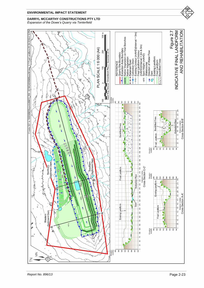
Figure 2.7 displays the indicative final landform for Dowe’s Quarry with typical sections on the
eastern, central and western ends of the extraction area.
Progressive Rehabilitation
An integrated approach would be adopted for rehabilitation of all areas to be disturbed within the
Quarry Site. Progressive rehabilitation would be undertaken principally to stabilise disturbed
areas and minimise sediment-laden runoff. The key Quarry components that would be
progressively rehabilitated are as follows.
• Bund
The bund would be constructed from overburden with a veneer of topsoil during
the site establishment and construction stage and would be shaped and revegetated
using native species endemic to the area immediately following construction.
• Overburden and Fines Stockpile
The final northern face of the overburden and fines stockpile would be
progressively shaped with the surface ripped approximately parallel to contour
levels. Available soil would be recovered and spread over the profiled slopes. The
final slopes would be direct seeded with a locally endemic native seed mix and
allowed to revegetate.
• Terminal Benches
Terminal benches within the extraction area would be progressively rehabilitated
as described in Section 2.14.3.
ENVIRONMENTAL IMPACT STATEMENT
DARRYL MCCARTHY CONSTRUCTIONS PTY LTD Expansion of the Dowe’s Quarry via Tenterfield
Report No. 896/13
Page 2-23
Figure 2.7 Indicative Final Landform and Rehabilitation
A4 / Colour
Figure dated 26/9/19 inserted on 26/9/19

ENVIRONMENTAL IMPACT STATEMENT
DARRYL MCCARTHY CONSTRUCTIONS PTY LTD Expansion of the Dowe’s Quarry via Tenterfield
Page 2-24 Report No.896/13
Extraction Area
All final or terminal benches within the extraction area would be progressively revegetated to
provide for the long-term establishment of a range of native vegetation. Weathered overburden
materials would be placed on the completed benches with an emphasis on creating a roughened
surface to contain the bulk of rain falling on the benches. Overburden would be placed on each
bench once extraction and haulage activities cease in that area but immediately prior to the
commencement of drilling for the last blast to create the terminal extraction face.. The overburden
would form a substrate which would be covered with topsoil for the subsequent growth of trees
and shrubs which would be planted either through direct seeding or tubestock. Terminal faces
within the extraction area would be retained at approximately 70 but would be partly covered
with material pushed from above the upper bench or retained on the benches towards the end of
extraction of each bench.
A suitable ramp would be retained between the final floor of the extraction area and the
processing area to provide ongoing access.
Overburden Emplacement
The Applicant proposes to backfill the eastern section of the extraction area with fines and
overburden to approximately 920m AHD. Overburden and fines would be progressively
emplaced within the extraction area from approximately midway through Stage 2. The western
batter of the overburden and fines emplacement would be created with a slope of approximately
1:1.5 (V:H). The surface of the overburden and fines emplacement would be covered with
available topsoil and revegetated using native vegetation endemic to the area.
Processing Plant Area
The processing area would be revegetated using native vegetation endemic to the area, however,
an internal road would be retained for access. The extraction floor would be revegetated and
would slope gently towards the quarry sump in the central section of the extraction area which
would be created by contouring the overburden placed on the final extraction floor.
All processing equipment would be mobile and removed at the end of the Quarry life for use at
other operations. All waste material, infrastructure and vehicles not required for rehabilitation
operations would also be removed from the processing plant area.
The bund to the north of the processing area may be removed during rehabilitation of the
processing area to provide topsoil for use in rehabilitation. Overburden from the bund would be
emplaced in the overburden and fines emplacement or on the floor of extraction area. Should
vegetation on this component be well established and a growth medium available from elsewhere
this component may be retained.
Roads and Ramps
Internal roads and ramps would be retained following the cessation of operations to provide
ongoing access to the extraction area.

ENVIRONMENTAL IMPACT STATEMENT
DARRYL MCCARTHY CONSTRUCTIONS PTY LTD Expansion of the Dowe’s Quarry via Tenterfield
Report No. 896/13
Page 2-25
Overburden and Fines Stockpile
The outer batters of the overburden and fines stockpile would be progressively profiled to create
slopes of approximately 1:1.5V:H) (~34°). Available soil would be recovered from stockpiles or
directly transferred from areas being cleared and spread over the profiled slopes. The final slopes
would be direct seeded with a locally endemic native seed mix and allowed to revegetate.
Final Land Uses
It is intended that the Quarry Site would be retained principally for biodiversity conservation. All
rehabilitation would be undertaken in consultation with the landowner. The success of
rehabilitation and revegetation would also be reviewed progressively with the landowner, with
additional soil, seed or tube stock added where revegetation is less successful.
2.15 Biodiversity Offset Strategy
Introduction
The SEARs issued for the Proposal identified that EIS should demonstrate whether the proposed
development exceeds the Biodiversity Offset Scheme threshold specified in Clause 7.23 of the
Biodiversity Conservation Regulation 2017 and if so, prepare a Biodiversity Development
Assessment Report.
The Applicant has followed the hierarchy of avoid, mitigate, offset in considering impacts to
native vegetation. The Proposal has been designed so that extraction would initially focus on the
eastern end of the extraction area with placement of overburden and fines in the completed pit
during later stages. In addition, it has been decided that the internal haul road would be located
adjacent to and between site components to limit vegetation clearing for its progressive
development. This approach limits the area of vegetation clearing required for the Proposal.
As the Proposal involves the removal of approximately 6.4ha of native vegetation and land zoning
for the property requires a minimum lot size of 100ha the Biodiversity Offset Scheme is triggered.
The Quarry Site is not located on land mapped as having high biodiversity value as indicated on
the Biodiversity Values Map3. A Biodiversity Development Assessment Report (BDAR) has
been prepared by EcoLogical Australia Pty Ltd (ELA) and is included as Appendix 10. The
following subsections describe the Biodiversity Offset Strategy for the Proposal with further
assessment of biodiversity values provided in Section 5.5.
Impacts Requiring Offsetting
Figure 2.8 presents the areas of proposed native vegetation clearing for the Proposal. It is noted
that the area that is currently approved for disturbance under DA 2014.078/1 is not included in
this figure as this area has already been subject to assessment and approval. Table 2.2 presents
the outcomes of vegetation mapping and survey of the Quarry Site undertaken on 22 to
26 April 2019.
3 https://www.lmbc.nsw.gov.au/Maps/index.html?viewer=BOSETMap

ENVIRONMENTAL IMPACT STATEMENT
DARRYL MCCARTHY CONSTRUCTIONS PTY LTD Expansion of the Dowe’s Quarry via Tenterfield
Page 2-26 Report No.896/13
Figure 2.8 Vegetation Clearing
A/4
Figure dated 26/9/19 inserted on 27/9/19

ENVIRONMENTAL IMPACT STATEMENT
DARRYL MCCARTHY CONSTRUCTIONS PTY LTD Expansion of the Dowe’s Quarry via Tenterfield
Report No. 896/13
Page 2-27
Table 2.2
Plant Community Types of the Quarry Site
Plant Community Type Vegetation Class/Formation Area Condition
Vegetation Integrity
Score
568 - Broad-leaved Stringybark shrub/grass open forest of the New England Tableland Bioregion
New England Dry Sclerophyll Forests / Dry Sclerophyll Forest (Shrub/grass sub-formation)
4.63ha Good 66.4
568 - Broad-leaved Stringybark shrub/grass open forest of the New England Tableland Bioregion
New England Dry Sclerophyll Forests / Dry Sclerophyll Forest (Shrub/grass sub-formation)
1.78ha Poor 3
Source: Modified after ELA (2019) – Table 7 and Table 8
Only the 4.63ha area of Plant Community Type (PCT) 568 mapped as being in good condition is
required to be offset and the vegetation integrity score for the poor condition vegetation does not
trigger offsetting.
Field surveys of the Quarry Site did not identify any threatened species that would require
offsetting as species credits. However, the timing of surveys did not align with the required survey
period for some species. Therefore, for the purpose of assessment, it has been assumed that the
species presented in Table 2.3 may occur within the Quarry Site. Additional targeted survey for
these species will occur in November 2019 to confirm the presence/absence of these species (in
accordance with survey requirements for these species). Potential habitat for these species has
been separated into the good and poor condition vegetation within the Quarry Site in recognition
that the better-quality habitat is more likely to be used for foraging or nesting.
Table 2.3
Threatened Fauna Species Requiring Offset
Species Common Name
Area (ha)
Good Condition Vegetation
Poor Condition Vegetation
Cercartetus nanus Eastern Pygmy Possum 4.63 -
Ninox connivens (breeding) Barking Owl 3.60 1.09
Ninox strenua (breeding) Powerful Owl 3.60 1.09
Tyto novaehollandiae (breeding) Masked Owl 3.60 1.09
Vespadelus troughtoni Eastern Cave Bat 4.63 -
Source: Modified after ELA (2019) – Table 13
Several threatened species that were identified during field surveys, or that may have the potential
to occur within the Quarry Site, are considered as ecosystem credit species under the Biodiversity
Assessment Method (BAM) and therefore satisfactory offset of the ecosystem credits is
considered to provide a satisfactory offset for these species.
Impacts Not Requiring Offsetting
Approximately 1.78ha of PCT 568 that would be cleared for the Proposal is in poor condition
due to previous clearing for agricultural activities and the presence of the weed African Love
Grass (Eragrostis curvula). ELA (2019) assessed that this vegetation has a vegetation integrity
score of 3 which does not require offsetting.

ENVIRONMENTAL IMPACT STATEMENT
DARRYL MCCARTHY CONSTRUCTIONS PTY LTD Expansion of the Dowe’s Quarry via Tenterfield
Page 2-28 Report No.896/13
Regardless, this area may be foraging habitat for a range of threatened species and therefore
requires assessment of offsetting for species credit generation (see Table 2.3).
Credit Calculations
Ecosystem Credits
Following the implementation of all practical measures to avoid or mitigate impacts to native
vegetation, it is estimated that the Proposal would result in the removal of approximately 4.63ha
of native vegetation that requires offset. The ecosystem credits required to offset the residual
impacts of the Project are provided in Table 2.4.
Table 2.4
Ecosystem Credits Required
Plant Community Type Area Credits Required
568 - Broad-leaved Stringybark shrub/grass open forest of the New England Tableland Bioregion
4.63ha 134
Source: Modified after ELA (2019) – Table 30
Species Credits
The species credits required to offset potential impacts to threatened fauna species requiring
species credit offsets are presented in Table 2.5. However, it is noted that this assessment is
preliminary as the presence/absence of these species will be confirmed following targeted survey
in November 2019.
Table 2.5
Species Credits Required
Species Credit Type Credits
Required
Eastern Pygmy Possum (Cercartetus nanus) 154
Barking Owl - breeding (Ninox connivens) 121
Powerful Owl - breeding (Ninox strenua) 121
Masked Owl - breeding (Tyto novaehollandiae) 121
Eastern Cave Bat (Vespadelus troughtoni) 230
Source: Modified after ELA (2019) – Table 31
Securing Biodiversity Credits
The Applicant has previously committed to securing a 6.4ha offset area to the north of the Quarry
Site under existing operations that are subject to DA 2014.078/1. It is proposed that in addition
to this, an area of approximately 25ha would be considered as an offset area for the ongoing
operations. The indicative offset areas are presented in Figure 2.9. This land is adjacent to Bald
Rock National Park and, subject to the agreement of National Parks and Wildlife Service
(NPWS), would be dedicated to the National Park. The Applicant would continue to manage the
land in accordance with a Biodiversity and Rehabilitation Management Plan over the life of the
Quarry, after which time the land would be managed by NPWS.

ENVIRONMENTAL IMPACT STATEMENT
DARRYL MCCARTHY CONSTRUCTIONS PTY LTD Expansion of the Dowe’s Quarry via Tenterfield
Report No. 896/13
Page 2-29
Figure 2.9 Proposed Biodiversity Offset Area
A4.
Figure dated 23/9/19 inserted on 27/9/19

ENVIRONMENTAL IMPACT STATEMENT
DARRYL MCCARTHY CONSTRUCTIONS PTY LTD Expansion of the Dowe’s Quarry via Tenterfield
Page 2-30 Report No.896/13
A preliminary assessment of the land that would be subject to offset indicates that it is of a suitable
vegetation community type (like-for-like), condition and size to satisfy the ecosystem credit
obligations of the Proposal. The presence/absence of threatened species in the offset areas is yet
to be confirmed.
It is proposed that the necessary assessments would be undertaken, and the offset area secured
under agreement with NPWS within 24 months of the date of consent for the Proposal.
Should the proposed offset area not be suitable or sufficient to satisfy all offsetting obligations of
the Proposal, the Applicant would seek to satisfy the offsetting obligations of the Proposal using
one or more of the following options
• Securing an offset area on alternative land.
• Purchasing the necessary credits from the market.
• Payment into the Biodiversity Conservation Fund.
As the Proposal does not include any species credits for species that require referral to the
Commonwealth Department of the Environment and Energy, payments into the Biodiversity
Conservation Fund are permissible. Initial assessment of the cost associated with payment to the
Biodiversity Conservation Fund using the Biodiversity Offset Payment Calculator4 indicates that
a payment of $1.4 million would be required to offset all obligations of the Proposal using this
option.
4 https://www.lmbc.nsw.gov.au/offsetpaycalc