Deschutes Subbasin Wildlife Assessment...Draft 5-22-04 Deschutes Subbasin Plan Wildlife Assessment...
161
Draft 5-22-04 Deschutes Subbasin Plan Wildlife Assessment Page 1 of 161 Deschutes Subbasin Wildlife Assessment Presented to the Deschutes Resources Conservancy In fulfillment of contract 220019 For services in conjunction with development of a Subbasin Plan for the Deschutes River Subbasin as part of the Northwest Power and Conservation Council Provincial/Subbasin Planning program under the Northwest Power Act By Gary Hostick Ecological Services, Inc. Bend, Oregon May 2004
Transcript of Deschutes Subbasin Wildlife Assessment...Draft 5-22-04 Deschutes Subbasin Plan Wildlife Assessment...

Draft 5-22-04 Deschutes Subbasin Plan Wildlife Assessment Page 1 of 161
Deschutes Subbasin Wildlife Assessment
Presented to the
Deschutes Resources Conservancy In fulfillment of contract 220019
For services in conjunction with development of a Subbasin Plan for the Deschutes River Subbasin
as part of the
Northwest Power and Conservation Council Provincial/Subbasin Planning program
under the Northwest Power Act
By
Gary Hostick Ecological Services, Inc.
Bend, Oregon
May 2004

Draft 5-22-04 Deschutes Subbasin Plan Wildlife Assessment Page 2 of 161
Table of Contents*
Section No. Page i. List of Tables 3 1. Executive Summary 4 2. Introduction 4 3. Wildlife Assessment 5 3.1. Focal species selection 5 3.2. Focal species characterization 7 3.3. Environmental conditions for focal species 8 3.3.1. Selection of focal habitats at the subbasin level 8 3.3.2. Focal habitats status for the Columbia Plateau Ecoprovince 13 3.3.3. Focal habitats status at the assessment unit level. 13 3.3.4. Focal habitats status at the HUC 6 level. 15 3.3.5. Condition, trend, connectibity and spatial issues for focal habitats. 15 3.3.6. Protection classes for focal habitats. 16 3.3.7. Potential and projected future condition of focal habitats with no future actions. 18 3.3.8. Out of subbasin effects: out of subbasin harvest of managed species. 23 3.3.9. Basin-wide assumptions: effects on productivity and sustainability. 23 3.4. Environment/population relationships. 23 3.4.1. Optimal characteristics of KECs and environmental potential for KECs. 23 3.4.2. Long-term viability of focal species based on habitat availability and condition 23 3.4.3. Determination of key ecological functions (KEFs) and functional redundancy as
a key indicator for ecological processes. 23
3.4.4. Functional specialist species and critical functional link species. 24 3.4.5. Wildlife interspecies relationships. 24 3.4.6. Key relationships between fish and wildlife. 25 3.5. Analysis of limiting factors. 25 3.5.1. Limiting factors and opportunities for action inside the subbasin. 25 3.5.2. Limiting factors outside the subbasin. 25 3.6. Synthesis 26 3.6.1. Working hypotheses. 26 3.6.2. Desired future conditions. 27 3.6.3. Opportunties for conservation and restoration. 29 4. Inventory 32 5. Management plan 32 5.1. Vision for the subbasin. 32 5.2. Biological and habitat objectives and key findings. 32 5.3. Prioritized strategies. 32 5.4. Consistency with ESA requirements. 32 5.5. Research, monitoring, and evaluation opportunities. 32 6. Appendices 37 6.1. Appendix A. Species accounts. 37 6.2. List of Appendix tables A-N. 38 6.3. List of Appendix figures A-P. 38

Draft 5-22-04 Deschutes Subbasin Plan Wildlife Assessment Page 3 of 161
7. Literature cited 34 *Section numbering follows outline in Oregon Specific Guidance, Sept. 15, 2003.
List of Tables Table No. Page
1 Wildlife species and habitats recognized as rare or significant to a local area. 7 2 Focal Species selected and rationale for selection, and associated habitats. 8 3 Focal species distribution, populations, and trends. 9 4 Current and historic wildlife habitat acreage changes. 11
4A Focal habitats selected for the Deschutes subbasin. 13 5 Habitat Condition, Trend, Connectivity and Spatial Issues in Assessment Units. 16 6 Protections in place for focal habitat attributes and components. 17
6A Protections in place for focal habitat attributes and components. 18 7 Projected and potential future condition of focal habitats and focal habitat
components and attributes, with no future actions 18
8 Acreages of all habitats within ungulate winter ranges, from current habitats map.
20
9 Acreages of all habitats within ungulate winter ranges, from historic habitats map
22
9A Acreages of focal habitats within winter ranges, from current habitats map. 22 9B Acreages of focal habitats within winter ranges, from historic habitats map 22 9C CRP-enrolled acreages within historic wildlife habitats in the Lower Eastside
Deschutes, Lower Westside Deschutes, and White River AUs. 23
10 Long-term viability of populations of focal species based on habitat availability and condition.
24
11 KEFs performed by American beaver, a critical functional link species. 25 12 Focal species interaction with salmonids 26
12A Disturbance factors inside Deschutes subbasin limiting populations, and opportunites for action in assessment units.
27
13 Habitat hypotheses and species hypotheses and supporting evidence. 30 14 Desired future conditions for focal species and focal habitats. 32 15 Highest priority habitats and species for protection or restoration, and potential
strategies and priority areas in each assessment unit. 34
Draft 5-22-04 Deschutes Subbasin Plan Wildlife Assessment Page 4 of 161
Deschutes Subbasin Wildlife Assessment 1. Executive Summary The Deschutes Subbasin is made up of diverse wildlife habitats, including Cascade Mountains east slopes, the Deschutes River and many tributary valleys, and arid steppe habitats characteristic of the Great Basin. Significant changes to wildlife habitats have occurred in the subbasin since historic times, resulting from agricultural development in the river valleys and steppe habitats, management of the forests for wood resources, and more recently an influx of people seeking the desirable living environment of Central Oregon. These changes have resulted in the loss of wildlife habitats, most notably the nearly complete loss of wild grasslands, and changes in remaining habitats such as forests, where forest tree species composition in the Cascades have shifted toward mixed conifers from pine forest types. These changes in habitat have resulted in changes in the wildlife species found in the subbasin. 2. Introduction
2.1. Description of Planning Entity. This report will assemble and analyze wildlife information for the Deschutes Subbasin as part of the Northwest Power and Conservation Council’s Provincial/Subbasin Planning program conducted under the Northwest Power Act (Northwest Power Planning Council 2001.) 2.2. List of Participants. Wildlife biologists with government agencies working within the subbasin volunteered to serve on the Deschutes Subbasin Wildlife Team (2003) to provide input during the plan development. Members of the Deschutes Coordinating Council (2003) also provided comments on early development of wildlife information. 2.3. Approach. The status of wildlife in the Deschutes Subbasin (herinafter “subbasin”) will be described by designating a short list of focal wildlife species from the full range of species occurring within the subbasin, and by designating a short list of focal wildlife habitats from the full range of habitats in the subbasin. Available data pertaining to the focal species and focal habitats in the subbasin will then be summarized and presented, and opportunities for conservation or restoration of the focal species and focal habitats will be outlined at the end of the assessment. Wildlife information will be presented at three different levels of detail for the subbasin: the Columbia Plateau Ecoprovince, a larger study area that is made up of 11 subbasins including the Deschutes subbasin; the assessment unit level, of which there are 8 in the subbasin; and the hydrogic unit code

Draft 5-22-04 Deschutes Subbasin Plan Wildlife Assessment Page 5 of 161
(HUC) 6th level subwatershed level, at the 1:24,000 scale. There are 341 HUC6 fields in the Deschutes Subbasin (O’Neil p.c.) Information from the Northwest Habitat Institute Interactive Biological Information System (IBIS) will be used as the primary source of wildlife information for this assessment. Wildlife information will be organized according to instructions and outlines in the following reports: Oregon Specific Guidance (Anon. 2003,) A technical Guide for Developing Wildlife Elements of a Subbasin Plan (Scheeler et al. 2003,) and An Oregon Technical Guide for Developing Wildlife Elements of a Subbasin Plan (Anon. 2003.) Sections of this report will be numbered after Appendix C: Outline for Oregon Subbasin Plan, revised 4/6/2003 from Oregon Specific Guidance to simplify the inclusion of this wildlife assessment report into the subbasin plan, and to present information in the expected format. Font style and outline format are kept as simple as possible to facilitate the integration of this report into the final subbasin plan. Most of the tables and figures presented in this assessment will appear as appendices, due to the length and numbers of tables and figures. The term “wildlife” will include amphibians, reptiles, birds, and mammals. Although the word “terrestrial” will be used in reference to wildlife, it will be understood that aquatic environments are required by some wildlife species, and that this term will be a general descriptive term only. 3. Wildlife Assessment Regional context. The Deschutes River flows into the Columbia River from Oregon on the south near the community of The Dalles, draining the eastern slope of the northern Cascade Mountains and the western edge of the Blue Mountains in Oregon. The Deschutes subbasin is bordered by the Willamette Subbasin on the West, the Klamath Subbasin on the south, and the John Day Subbasin on the east. The subbasin takes in most of Wasco and Sherman counties, and all of Jefferson, Crook, and Deschutes counties. The subbasin is part of the Columbia Plateau Ecoprovince, along with 10 other subbasins in Oregon and Washington, in the Northwest Power and Conservation Council planning framework. Wildlife resources in the subbasin will also be presented within the context of the Columbia Plateau Ecoprovince. 3.1. Focal species selection.. In order to select focal species, various lists of species of special status occurring within the subbasin were examined. Lists of all species thought to occur in the subbasin historically (1860) and currently (1999) and scientific names are presented in Appendix tables A and B respectively. A list comparing historic and current lists of wildlife, showing species added to the subbasin and lost to the subbasin since historic times, with notes on suggested additions and deletions, is presented in Appendix table C. Threatened, endangered, or sensitive species listed by state or federal government entities that are thought to occur currently in the subbasin are listed in Appendix table D. Wildlife recognized by local biologists as rare or significant to local areas in the subbasin are shown in Table 1, with reference to assessment units (AUs.) Maps of historic and current wildlife habitats in the subbasin, with AU boundaries shown, are presented in the Appendix.

Draft 5-22-04 Deschutes Subbasin Plan Wildlife Assessment Page 6 of 161
Table 1. Wildlife species recognized as rare or significant to a local area.
Species Significance Assessment Unit(s) Locations of Local Areas
Mule deer (white-tailed deer and black-tailed deer are also present in the subbasin)
Ungulate winter range degradation (George, p.c.)
Lower Westside Deschutes, Middle Deschutes.
Bighorn sheep (reintroduced population)
Ungulate winter range degradation (Kunkel, p.c.)
Lower Westside Deschutes, Lower Eastside Deschutes.
Mountain goat (former population)
ungulate winter range degradation (ODFW 2003b)
White River, Lower Deshutes, Middle Deschutes
Sharp-tailed grouse (former population) habitat
Habitat loss, grasslands (Kunkel p.c.)
LOWER EASTSIDE DESCHUTES, Upper Crooked, Lower Crooked
Greater sage grouse Habitat degradation, shrub-steppe (Hanf, p.c.)
Lower Crooked River, Upper Crooked River
Golden eagle habitat Threat of habitat degradation, rimrock and cliff nesting sites (Gilbert p.c.)
All except Cascade Highlands
Managed Wildlife Species. Currently, 68 wildlife species are harvested during hunting seasons in the subbasin (Appendix table E.) HEP Wildlife Species (those used in loss assessments for hydrosystem development.) Twenty-four wildlife species used in the HEP process are thought to occur currently in the subbasin (Appendix table F.) Partners in Flight high priority bird species used for monitoring. A total of 111 species occurring in the subbasin were listed by the Partners in Flight organization (Appendix table G.) Critical functionally linked species. A list of critical functionally linked species thought to occur historically in the subbasin are listed in Appendix H. Species of special cultural significance. Biologists with the Confederated Tribes of the Warm Springs Reservation of Oregon declined to draw up a list of especially important wildlife species, stating that tribal members consider all forms of wildlife to be culturally important. Although some species are important primarily for one purpose, such as food, often a single species is important for several reasons. For example, mule deer are important as food, but non-food parts of each animal could be valuable for clothing, regalia, medicine, and other uses. The presence of frogs in a small spring might indicate that the water is safe to drink. The complex relationship between tribal members and wildlife of all species in the subbasin is a fundamental part of tribal culture (Calvin 2004.) Focal wildlife species selected. Focal species were selected by considering listed species, and by considering species of concern by local biologists. Focal species were chosen to represent a “guild” of species whenever possible, for example, the sharp-tailed grouse could represent grassland species, and the sage grouse could represent shrub-steppe species. Seven species were selected (Table 2.)

Draft 5-22-04 Deschutes Subbasin Plan Wildlife Assessment Page 7 of 161
Table 2. Focal species selected and rationale for selection, and associated habitats.
Focal Species Rationale for Selection* Associated Habitats American beaver Riparian habitat species,
modifies habitat. On list 4, 5 and 6.
Riparian, herbaceous wetlands.
Columbia spotted frog Riparian habitat and herbaceous wetlands habitat species. List 1 and 2.
Riparian, herbaceous wetlands
White-headed woodpecker Large ponderosa pine tree habitat species. List 1, 2 and 3.
Ponderosa pine forest and woodlands.
Mule deer Ungulate winter range habitat species. Lists 2, 4, and 5.
Ungulate winter range.
Greater sage grouse Shrub-steppe habitat species. Lists: 1,2,3,4,5.
Shrub-steppe.
Columbian sharp-tailed grouse Grassland species. List 2 and 3.
Lower Eastside Deschutes interior grasslands.
Golden eagle Cliff and rimrock habitat, grassland, shrub-steppe habitat species. List 2.
Cliff and rimrock habitats, grassland, shrub-steppe.
* 1=threatened, endangered, and state sensitive species, 2=species recognized as rare or significant to a local area, 3=Partners in Flight species, 4=HEP species, 5=game species, 6=critically functionally-linked species. 3.2. Focal species characterization. Species accounts for each focal species are presented in the Appendix. These accounts present biological, populations and trends data if available. A summary of status for each focal wildlife species in the subbasin is presented in Table 3. Of the focal species selected, only the sharp-tailed grouse has been extirpated from the subbasin (Csuti, et.al 2001.) American beaver are thought by local biologists to be extirpated from many former habitat areas in the subbasin, as are Columbia spotted frogs. No introduced species were chosen as focal species. Table 3. Focal species distribution, populations, and trends.
Species Distribution in Assessment Units Population and trends American beaver All Historically depleted, but now
recovered. Currently harvested during hunting and trapping season, population tracked by ODFW.
Columbia spotted frog Upper Crooked River Remnant population. Declining. White-headed woodpecker All Status unknown.

Draft 5-22-04 Deschutes Subbasin Plan Wildlife Assessment Page 8 of 161
Table 3. Focal species distribution, populations, and trends. Species Distribution in Assessment Units Population and trends
Mule deer All Game animal. Population tracked by ODFW. Declining in some areas due to development on winter ranges.
Greater sage grouse Upper Crooked River, Lower Crooked River.
Game bird. Population tracked by ODFW. Declining.
Columbian sharp-tailed grouse Extirpated. Extirpated. Golden eagle All. 57 active nest territories counted
in 2000 (Clowers 2004.) Population trend unknown in Oregon (Ibid, Marshall 2003.) Some indications of decline in the general region of northern Great Basin (Marshall 2003 p. 162.)
3.3. Environmental conditions for focal species. Rather than attempt to describe the status of all habitats in the subbasin, a shorter list of focal habitats were selected to represent environmental conditions in the subbasin for focal species. Focal habitats were selected from the complete list of habitats in the subbasin by examining current habitats compared to historic habitats at the subbasin level as presented by IBIS data, and selecting those habitats that were reduced significantly from historic acreages. Some focal habitats, habitat attributes, and habitat components occurring within the more general habitats were also selected based on concerns by local biologists and others, even though IBIS information was not available to assess the status of these habitats, attributes, and components. As additional information, focal habitats status in the subbasin were compared to status at the larger ecoprovince level to discover if the focal habitats status in the subbasin were similar to the status if those habitats on a larger scale. Then, focal habitats status at the smaller assessment unit level within the subbasin are presented, followed by focal habitats status at the smallest unit, the HUC 6 small watershed level. Condition, trend, connectivity, and spatial issues for focal habitats are presented, as is the protection status of focal habitats. Projected future status of focal habitats with no future actions is also presented. 3.3.1. Selection of focal habitats at the subbasin level. IBIS Map Data. Historic and current habitat maps of habitats for the entire subbasin from IBIS show substantial changes since 1850. The historic map (see Appendix maps) shows broad bands of habitats running north and south. Beginning on the west side of the subbasin, a band of mountain fir and hemlock forest habitat types is shown in higher elevations of the Cascade Mountains. Then, a band of ponderosa pine forest, mixed with some lodgepole pine forest, is shown running from the Columbia River southward, approximately along the eastern foot of the Cascades. At the southern end of this band of mostly ponderosa pine woodland, larger blocks of lodgepole pine forest begin to break into the band of ponderosa pine. East of the Deschutes River, a band of mostly shrub-steppe habitat with interspersed interior grassland and Western juniper woodland areas again runs north-south, with a large block of shrub

Draft 5-22-04 Deschutes Subbasin Plan Wildlife Assessment Page 9 of 161
steppe habitat shown in the southeastern section of the subbasin, and a large block of Western juniper woodland southeast of Redmond. Along the east edge of the subbasin, an area of ponderosa pine forest is shown in the Blue Mountains east of Prineville, and a large block of interior grassland habitat is shown in the northeastern section of the subbasin southeast of The Dalles. The current habitat map of the subbasin shows fragmentation of the large blocks of ponderosa pine, lodgepole pine, and shrub-steppe habitats formerly existing in the subbasin, and the complete loss of the grassland habitats thought to have existed in 1860. The band of mixed conifer forests running north-south in the Cascade Mountains on the west side of the subbasin is shown to have encroached into the lower-elevation ponderosa pine and lodgepole pine forests along the eastern foot of the Cascades. The large block of juniper woodland south and east of Redmond and Prineville is shown to have spread throughout the former shrub-steppe habitat running through the center and into the southeastern part of the subbasin, fragmenting the shrub-steppe habitat. Other conifer forest types are shown to have encroached into the former ponderosa pine forests in the Blue Mountains east of Prineville. Acreages from IBIS Maps. Historic and current habitat acreages reflect the proportions shown on the habitat maps, since the acreage information is derived from the maps, but shows the habitat information in a quantitative format (Table 4). Riparian and herbaceous wetland habitats are not shown in sufficient accuracy of scale on the IBIS maps to be useful (O’Neil, p.c.,) and this was a concern for local biologists, who considered these two habitats to be the highest priority habitats for restoration or conservation in the subbasin. Due to the linear nature and small areas of occurrence of riparian wetlands, this habitat was not considered to be displayed in accurate scale. The interpretation of satellite imagery for herbaceous wetlands was felt to be possibly inaccurate due to similarity in the light reflection signature of agricultural areas. Although riparian habitat quality is also considered in the fish habitat models presented in this plan, it is only considered at a minimal level, rating vegetation shading on the immediate shoreline. The riparian wetland and herbaceous wetland habitat descriptions for wildlife include much wider areas out from the stream channel in many areas, including important areas such as oxbow sloughs, backwaters, marshes, seasonal wetland areas, and near-stream springs and seep areas which are important habitat. It is suggested that the riparian evaluations for fisheries habitat models would not correspond to an evaluation of riparian wetlands and herbaceous wetlands for wildlife. Therefore, it is apparent at the very beginning of this evaluation that there is a lack of data for riparian wetlands and herbaceous wetlands in the subbasin, since no alternate source of data on historic or current riparian wetlands or herbaceous wetlands is known. Other habitats also are not shown in large enough scale or for other reasons are not considered to show significant results (Ibid.) Canyon shrublands, for example, were a recent addition to the habitat type list, and could not be compared with historic data, and also was an unsuccessful attempt to display a linear habitat, therefore this habitat is not discussed. These habitats and other habitats that were not thought to be shown as useful acreages for comparison are indicated as “n/a” under the percent change column in Table 4. Table 4. Current and Historic Wildlife-Habitat Acreage Changes, Deschutes Subbasin

Draft 5-22-04 Deschutes Subbasin Plan Wildlife Assessment Page 10 of 161
Habitat ID
Habitat Name Current Acreage
Historic Acreage
Change from
Historic
Percent change
1 Mesic Lowlands Conifer-Hardwood Forest
2,267 34,970 -32,703 n/a
3 Southwest Oregon Mixed Conifer-Hardwood Forest
173 0 173 n/a
4 Montane Mixed Conifer Forest
546,968 194,288 352,680 182%
5 Interior Mixed Conifer Forest
676,086 350,133 325,953 93%
6 Lodgepole Pine Forest and Woodlands
213,432 532,706 -319,274 -60%
7 Ponderosa Pine & Interior White Oak Forest and Woodlands
1,320,270 1,860,264 -539,994 -29%
8 Upland Aspen Forest 741 -741 n/a 9 Subalpine Parkland 38,839 25,361 13,478 n/a
10 Alpine Grasslands and Shrublands
14,636 12,425 2,211 n/a
12 Ceanothus-Manzanita Shrublands
2,996 0 2,996 n/a
13 Western Juniper Woodlands 1,347,101 790,348 556,753 70%
14 Interior Canyon Shrublands 82,856 0 82,856 n/a 15 Interior Grasslands 4,684 630,630 -625,946 -99% 16 Shrub-steppe 1,982,194 2,299,065 -316,871 -14% 17 Dwarf Shrub-steppe 127,843 5,683 122,160 n/a 18 Desert Playa and Salt Scrub
Shrublands 3,225 1,418 1,807 n/a
19 Agriculture, Pastures, and Mixed Environs
337,369 0 337,369 n/a
20 Urban and Mixed Environs 22,026 0 22,026 n/a 21 Open Water - Lakes, Rivers,
and Streams 57,774 76,139 -18,365 n/a
22 Herbaceous Wetlands 51,512 20,263 31,249 n/a 24 Montane Coniferous
Wetlands 15,781 0 15,781 n/a
25 Interior Riparian-Wetlands 7,568 21,251 -13,683 n/a Total Acres: 6,855,591 6,855,680 *Acreages are estimates only. Subbasin total acreage may vary slightly between Current and Historic due to mapping procedures.
*Copyright 1998-2003. Please visit the IBIS web site (www.nwhi.org/ibis) for Copyright and Terms of Use limitations. This data is continually updated and therefore subject to change. *Subbasin Habitat Acreages Generated by IBIS on 10/13/2003 11:45:52 AM.
Draft 5-22-04 Deschutes Subbasin Plan Wildlife Assessment Page 11 of 161
Large-scale losses in habitats in the subbasin. The loss of over 600,000 acres of estimated historical interior grassland habitat in the subbasin, nearly all of the grassland in the subbasin, is a large-scale shift in habitat. The indicated loss of over 300,000 acres of shrub-steppe habitat in the subbasin, although amounting to a relatively low percentage of 14 percent of the estimated historic shrub-steppe acreage, is also a significant change in habitat area. The apparent loss of ponderosa pine and lodgepole pine forests due to encroachment of other conifer forest types indicated on the historic and current maps is reinforced by the acreage data showing an increase of nearly 700,000 acres in other conifer habitats since historic estimates, with corresponding decreases in ponderosa pine forest and lodgepole pine forests of over 500,000 acres and over 300,000 acres respectively, for a loss of over 800,000 acres combined of ponderosa and lodgepole forests, a significant major habitat shift in the subbasin. Large-scale increases in habitats in the subbasin that may explain large-scale losses. Increases in mixed conifer forests, juniper woodlands, and agriculture areas are large-scale changes in habitat in the subbasin. The increase in agriculture acreage would be expected, but the acreage number shown of 337,000 acres should be considered only an approximation in light of the known coarseness of the interpretation of the satellite data related to this habitat, which is especially difficult to define (O’Neil, p. c.) The increases in mixed conifer forests would also be expected, since it is apparent from inspection of the historic and current habitat maps that these habitats have encroached on the pine habitats at lower elevations along the Cascades. The increase in juniper woodland might also be expected, since the loss of grassland habitat in the subbasin could be partially attributed to encroachment by juniper woodland, as well as conversion to agriculture. Selection of three focal habitats on the basis of IBIS maps and acreage data at the subbasin level. Based on the above maps and acreage data at the subbasin level, the following habitats were selected as focal habitats. Focal habitats were designated as those habitats that have been reduced more than 25% in acreage from historic levels in the subbasin:
o Interior grasslands (99% reduction) o Lodgepole pine forest and woodlands (60% reduction) o Ponderosa pine forest and woodlands (29% reduction)
Selection of focal habitats on the basis of concern by biologists and others. Local biologists and others also identified habitats attributes and habitat components that are thought to be reduced in acreage or reduced in quality from historic levels, although IBIS data or other data were not available to support these hypotheses. These habitats and components are:
o Riparian and wetland habitats (loss of water suppy, loss of vegetation, loss of channel structures such as backwaters and oxbow sloughs, loss of springs and seeps)
o Shrub Steppe habitats (loss of plant diversity, succession advanced to juniper woodland habitat, or other vegetations)
o Habitat structure: large tree (late seral stage) structure, snag structure, rock structure such as cliffs and rimrocks degraded by development such as rock pits and dwellings).
o Habitat plant diversity: dwarf shrub-steppe brush species (loss,) quaking aspen (loss,) white oak (loss,) and cottonwood groves (loss.)
o Ungulate winter range areas (degradation.)

Draft 5-22-04 Deschutes Subbasin Plan Wildlife Assessment Page 12 of 161
o CRP lands which provide grassland habitats for wildlife (gain in grassland habitat on land classed as agricultural land.)
Summary of focal habitats selected. If the habitats selected by biologists and others are combined with the habitats that are more than 25% reduced from historic levels as displayed by current vs. historic IBIS maps and acreage data, the following list of focal habitats and habitat attributes and components is produced (Table 4A.) Table 4A. Focal habitats selected for the Deschutes subbasin.
Focal habitat Description of focal habitat Interior grasslands IBIS Habitat 15. Lodgepole pine forest and woodland IBIS Habitat 6. Ponderosa pine forest and woodland IBIS Habitat 7. Lower Eastside Deschutes Interior Riparian-Wetlands
IBIS Habitat 25. (no IBIS data)
Herbaceous Wetlands IBIS Habitat 22. (no IBIS data) Shrub Steppe habitats IBIS Habitat 16. Habitat structure: large tree structure (late seral,) rock structure.
Habitat attribute within other habitat designations.
Habitat plant diversity: dwarf shrub-steppe brush species, quaking aspen, white oak, and cottonwood groves.
Habitat attribute within other habitat designations.
Ungulate winter range areas. Habitat attribute within other habitat designations. CRP lands which provide grassland habitats. Farmed land condition producing grassland habitat. 3.3.2. Focal habitats status for the Columbia Plateau Ecoprovince. The Deschutes Subbasin is part of the larger Columbia Plateau Ecoprovince, which is made up of eleven subbasins, including the Deschutes Subbasin. Wildlife habitats thought to occur historically and currently in the Columbia Plateau Ecoprovince are displayed in the Appendix maps. These maps show that some changes that have occurred in the larger ecoprovince are similar to changes that have occurred in the Deschutes Subbasin. Specifically, changes to the four focal habitats that are shown by IBIS historic and current data for the Deschutes subbasin are shown as changing for the ecoprovince in a similar manner. Shrub-steppe and grassland habitats have been largely replaced by agricultural uses, and ponderosa pine and lodgepole pine habitats have been reduced and fragmented. Montane mixed conifer habitats have apparently increased, as have juniper woodlands. These changes are further displayed in color-coded maps presented in the Appendix maps 3.3.3. Focal habitats status for the assessment unit level. In order to display more local information, the subbasin was divided into eight smaller areas designated as assessment units (AU’s) (see subbasin Appendix maps.) The changes in wildlife habitats within the AU’s as indicated by map data are summarized and discussed in the following sections. Since no map data are available for riparian or herbaceous wetlands, these habitats are not discussed.

Draft 5-22-04 Deschutes Subbasin Plan Wildlife Assessment Page 13 of 161
Cascade Highlands AU. This higher-elevation AU was historically covered predominately with ponderosa pine forest, with substantial acreages of lodgepole pine forest and mixed conifer forest also present (see Appendix table I.) Currently, 80 percent of the former lodgepole and ponderosa pine forests have been lost. The losses in pine forests are accounted for in the increases in other mixed conifer forests. Upper Deschutes AU. This AU was historically predominately covered with ponderosa pine and lodgepole pine forests. Over 179,000 acres of lodgepole pine forest habitat have been lost, representing 50 percent of the historic area of this habitat. All of the former grassland existing in this AU, an area of approximately 37,000 acres most of which was located between Tumalo and Sisters, has also apparently been converted to other uses or habitats. A substantial loss of shrub-steppe habitat amounting to approximately 29,000 acres, representing 57 percent of the historic habitat area, has also been lost. These losses are largely balanced by gains in mixed conifer forests (145,000 acres,) and agriculture and urban areas (55,000 acres.) Another 30,000 acres of habitat gains are indicated in montane coniferous wetlands and herbaceous wetlands categories, but the location and status of these habitats in the AU are not known. The accuracy of these latter classifications is somewhat doubtful until ground-truthing can be carried out and these habitat descriptions are further clarified (O’Neil, p.c.) Middle Deschutes AU. Over 15,000 acres of grassland, or 100 percent of the historic grassland which is thought to have occurred in this AU has been lost. Map data also indicates a loss of mesic lowlands conifer-hardwood forest of over 16,000 acres. This habitat description was originally meant to describe habitats on the west side of the Cascades that included red alder and bigleaf maple intermixed with conifer species. The mapping data that indicates this habitat east of the Cascades could be recognizing areas of quaking aspen, black cottonwood, and possibly willow intermixed with conifer species. If this is the case in this AU, this mapping data could indicate a loss of substantial acreage of these mixed hardwood areas. It should be remembered that the historic habitat areas are largely educated estimates by vegetation and soils specialists, therefore this indicated loss would be an estimate by specialists. Substantial losses in pine forest areas are also indicated in this AU, with a combined estimated loss of over 156,000 acres of ponderosa pine and lodgepole pine forest, or about 48 percent of the historic area. These losses are again balanced by substantial increases in other mixed conifer forests. Lower Westside Deschutes AU. Substantial losses in pine forest habitats have occurred since historic conditions in this AU, mostly consisting of losses in ponderosa pine forests, where a loss of over 85,000 acres or 37 percent of the former area is thought to have occurred. Three large areas of former grassland in the center and north end of the AU amounting to over 99,000 acres were also lost. These losses are balanced by gains in shrub-steppe habitat and forested habitats, as well as conversion to agriculture. Groves of white oak are present in this AU, and are thought to have declined from former acreages and to be threatened with future continued declines in acreage. White oak groves are probably included in the ponderosa pine and lodgepole pine forest classifications. White River AU. A substantial loss of over 56,000 acres (57 percent) of ponderosa pine forest is indicated in this AU, as well as a loss of over 26,000 acres (36 percent) of shrub-steppe habitat. These losses are balanced by gains in mixed conifer forest and agriculture lands. Substantial groves of Oregon white oak are present in this AU, according to local biologists, and these groves are probably included in the ponderosa pine and lodgepole pine forest classifications. LOWER EASTSIDE DESCHUTES AU. This AU is where most of the historic grasslands in the subbasin were located. All of these grasslands were lost, a loss of an estimated 371,000 acres of habitat. This habitat loss was balanced by similar large increases in shrub-steppe and juniper woodlands habitats

Draft 5-22-04 Deschutes Subbasin Plan Wildlife Assessment Page 14 of 161
(160,000 acres) mixed conifer forest habitat, agriculture (71,000 acres) and some loss can be put down to a change in habitat description where part of the former grasslands may have been classified into a habitat classification called canyon shrublands, although this habitat description needs clarification. Lower Crooked AU. This AU was historically predominately composed of pine forests, juniper forest, shrub-steppe, and grassland, with shrub-steppe the largest area of habitat at over 464,000 acres. The grassland habitat was lost (35,000 acres.) Eighty-nine percent of the lodgepole pine forests were also lost (75,000 acres.) Substantial acreages of juniper forest, ponderosa pine forest, and shrub-steppe were also lost, although the percentage losses ranged only between 8-11 percent. These losses in habitat were balanced somewhat by gains in mixed conifer forest (14,000 acres,) but mostly by gains in agriculture and dwarf shrub-steppe habitat. Large areas of the eastern part of this AU indicated on the current habitat map as dwarf shrub-steppe habitat actually were cleared of sagebrush in the past and planted to exotic perennial grasses, and subsequently used intensively as livestock rangeland, and it is thought by local biologists that this area may have been incorrectly labeled as dwarf shrub-steppe if that classification was the closest to the spectral analysis results. This habitat question needs clarification. Upper Crooked AU. This AU was historically predominately covered with shrub-steppe habitat, at an estimated 1 million acres. Next in acreage were ponderosa pine forests at 454,000 acres, followed by juniper woodlands at 179,000 acres. Shrub-steppe and ponderosa pine forests were reduced from historic acreages in the AU by 38 and 35 percent respectively, amounting to a substantial habitat shift in the AU. These losses were balanced out by gains in juniper woodlands (401,000 acres) and mixed conifer forests (111,000 acres.) Scattered areas of grasslands amounting to nearly 61,000 acres were also historically present in this subbasin, and these grasslands were reduced by an estimated 93 percent to the remaining small area of about 4,000 acres. Areas of historic lodgepole pine forests amounting to an estimated 17,000 acres were also lost in the AU. 3.3.4. Focal habitats status at the HUC 6 level. A total of 341 HUC6 (habitat unit code 6th level) small watersheds are present in the subbasin. Focal habitats data at the HUC6 level are displayed as color-coded changes from historic levels to current levels (see last 12 maps in the Appendix.) Two disclaimers must be remembered when looking at these color-coded maps, however. First, if a HUC6 is shown in red, for example, that would indicate a greater than 75% decrease in habitat area, but it must be remembered that this may indicate a decrease from only 10 acres of habitat to 1 acre of habitat, to present an extreme example. The point being that the acreages that the color-coded data was drawn from are not shown, nor are the locations of the historic habitat within the HUC6. Second, it is not clear from the maps if the non-colored (white) HUC6s are areas where the focal habitat did not occur, or if it is an area where the habitat did occur historically, but the change in area fell within the 49% increase to 49% decrease category. Ideally, the acreage and location data for each HUC6 would be displayed on a table linked to each map HUC6, along with other detailed data concerning past and ongoing projects and stream reach priorities. This level of detail was not attained in this report but will remain as a goal for future work. For the present, the approximate locations of past and ongoing projects and priority stream reaches for restoration and conservation are shown on the background of wildlife habitat changes on these maps. The maps are also supplied on CD format so the maps can be manipulated using Adobe software to increase the detail, so that stream names, for example, can be seen. From these maps, it is apparent that a significant number of past and ongoing projects have been and are being initiated in the subbasin. These maps will be a possible starting point to begin coordinating the approach to restoring priority wildlife and fisheries habitats within the guidelines given in this plan.

Draft 5-22-04 Deschutes Subbasin Plan Wildlife Assessment Page 15 of 161
3.3.5. Condition, trend, connectivity and spatial issues for focal habitats. A summary of condition, trend, connectivity and spatial issues for focal habitats at the AU level is presented in Table 5. These issues will be evaluated at the HUC 6 level in later drafts. Table 5. Habitat Condition, Trend, Connectivity and Spatial Issues in Assessment Units. Assessment Unit Habitat Condition Trend Connectivity Spatial Cascade Highlands
Ponderosa pine forest
Loss large trees Losses in acreage
Fragmented Higher-elevation losses
Upper Deschutes
Lodgepole pine forest
Loss dead and large trees
Losses in acreage
Fragmented Loss of two large areas
Upper Deschutes
Grassland n/a n/a n/a Loss of one large area
Middle Deschutes
Ponderosa and lodgepole pine
Loss dead and large trees
Losses in acreage
n/a Higher-elevation losses
Lower Westside Deschutes
Ponderosa pine forest
Loss large trees Losses in acreage
n/a Higher elevation losses
Lower Westside Deschutes
Grassland n/a n/a n/a Loss of three large areas
Lower Westside Deschutes
Oak groves n/a Losses in acreage
n/a n/a
White River Oak groves n/a Losses in acreage
n/a n/a
White River Ponderosa pine Loss large trees Losses in acreage
n/a Higher elevation losses
White River Shrub-steppe n/a Loss in acreage
Fragmented n/a
LOWER EASTSIDE DESCHUTES
Grasslands n/a Loss of all acreage
n/a n/a
Lower Crooked Grasslands n/a Loss of all acreage
n/a n/a
Lower Crooked Lodgepole pine
Loss large trees and dead
Loss of acreage
Fragmented Higher elevation losses
Lower Crooked Dwarf shrub-steppe
Mis-classified n/a n/a n/a
Upper Crooked Shrub-steppe Changes in composition
Loss of acreage
Fragmented n/a
Upper Crooked Ponderosa pine Losses of large trees
Loss of acreage
Fragmented Higher elevation losses
Upper Crooked Grassland n/a Loss of all acreage
n/a Stream valley losses
3.3.6. Protection classes for focal habitats.
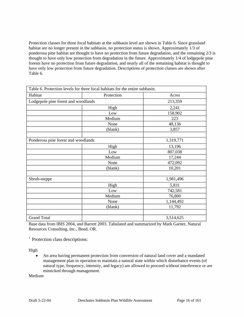
Draft 5-22-04 Deschutes Subbasin Plan Wildlife Assessment Page 16 of 161
Protection classes for three focal habitats at the subbasin level are shown in Table 6. Since grassland habitat are no longer present in the subbasin, no protection status is shown. Approximately 1/3 of ponderosa pine habitat are thought to have no protection from future degradation, and the remaining 2/3 is thought to have only low protection from degradation in the future. Approximately 1/4 of lodgepole pine forests have no protection from future degradation, and nearly all of the remaining habitat is thought to have only low protection from future degradation. Descriptions of protection classes are shown after Table 6. Table 6. Protection levels for three focal habitats for the entire subbasin. Habitat Protection Acres Lodgepole pine forest and woodlands 213,359 High 2,241 Low 158,902 Medium 223 None 48,136 (blank) 3,857 Ponderosa pine forest and woodlands 1,319,771 High 13,196 Low 807,038 Medium 17,244 None 472,092 (blank) 10,201 Shrub-steppe 1,981,496 High 5,831 Low 742,581 Medium 76,800 None 1,144,492 (blank) 11,792 Grand Total 3,514,625 Base data from IBIS 2004, and Barrett 2003. Tabulated and summarized by Mark Garner, Natural Resources Consulting, Inc., Bend, OR. 1 Protection class descriptions: High
• An area having permanent protection from conversion of natural land cover and a mandated management plan in operation to maintain a natural state within which disturbance events (of natural type, frequency, intensity, and legacy) are allowed to proceed without interference or are mimicked through management.
Medium
Draft 5-22-04 Deschutes Subbasin Plan Wildlife Assessment Page 17 of 161
• An area having permanent protection from conversion of natural land cover and a mandated management plan in operation to maintain a primarily natural state, but which may receive uses or management practices that degrade the quality of existing natural communities, including suppression of natural disturbance.
Low • An area having permanent protection from conversion of natural land cover for the majority of
the area, but subject to extractive uses of either a broad, low-intensity type (e.g., logging) or localized intense type (e.g., mining). It also confers protection to federally listed endangered and threatened species throughout the area.
None • There are no known public or private institutional mandates or legally recognized easements or
deed restrictions held by the managing entity to prevent conversion of natural habitat types to anthropogenic habitat types. The area generally allows conversion to unnatural land cover throughout.
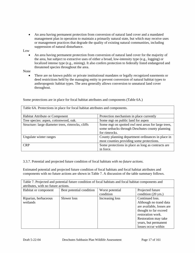
Some protections are in place for focal habitat attributes and components (Table 6A.) Table 6A. Protections in place for focal habitat attributes and components. Habitat Attribute or Component Protection mechanism in place currently Tree species: aspen, cottonwood, oak. Some mgt on public land for aspen Structure: large diameter trees, rimrocks, cliffs Some mgt on spotted owl nest areas for large trees,
some setbacks through Deschutes county planning for rimrocks.
Ungulate winter ranges County planning department ordinances in place in most counties providing some protections.
CRP Some protections in place as long as contracts are in force.
3.3.7. Potential and projected future condition of focal habitats with no future actions. Estimated potential and projected future condition of focal habitats and focal habitat attributes and components with no future actions are shown in Table 7. A discussion of the table summary follows. Table 7. Projected and potential future condition of focal habitats and focal habitat components and attributes, with no future actions. Habitat or component Best potential condition Worst potential
condition Projected future condition (20 yrs.)
Riparian, herbaceous wetlands
Slower loss Increasing loss Continued loss. Although no trand data are available, losses are thought to far exceed restoration work. Restoration may take years, but permanent losses occur within

Draft 5-22-04 Deschutes Subbasin Plan Wildlife Assessment Page 18 of 161
Table 7. Projected and potential future condition of focal habitats and focal habitat components and attributes, with no future actions. Habitat or component Best potential condition Worst potential
condition Projected future condition (20 yrs.) hours or days.
Grasslands steppe Restoration of some areas.
No restoration. Some restoration on Crooked River Natl Grasslands
Shrub steppe Slower loss, some restoration on public and private lands
Loss private lands, continued degrade on public lands
Continued loss and degradation due to vegetative succession and changes. Some restoration on public, private lands.
Ponderosa pine forests Slower loss private, some mgt on public
Continued loss private and public
Continued loss public and private
Lodgepole pine forests Slower loss Loss of all except public Loss of all except public Habitat structure Slower loss Accelerated losses Accelerated losses Plant diversity Some mgt public and
private lands Continued loss Some mgt private and
public Ungulate winter range Slower degradation Accelerated loss and
degradation Accelerated losses and degradation
CRP lands Improved mgt of contracted acreage for grassland habitat
Losses of lands from program
Unknown
Riparian wetlands and herbaceous wetlands. Although historic and current map and acreage data from IBIS is not useful to indicate the status of these habitats in the subbasin, these habitats are thought to be greatly reduced from historic conditions, and are considered to be extremely valuable for species diversity within the subbasin. The future status of remaining habitats with no action is thought to be continued loss from conversion to various other uses. Interior Grassland Habitat. With no future actions, it is estimated that most of the remaining small areas of grassland will be lost. Some acreage of grassland on the Crooked River National Grasslands near Madras will be conserved or restored, and some areas of grassland currently in CRP contract lands may be managed for natural grassland habitat in the future, but these will amount to relatively small acreages. Shrub-steppe Habitat. Over 1/3 of the acreage of remaining shrub-steppe habitat is thought to have no protection from degradation in the future, and nearly another 1/3 of the total acreage has only low protection status. With no future actions, it is projected that shrub-steppe habitat will continue to decline as juniper invasion continues and vegetation becomes more decadent. Ponderosa pine forest and oak woodlands. Although the apparent result of the decline in ponderosa pine forest is increased acreage of other conifer forests, the mechanisms causing the change are unknown, therefore the future trend with no action is unknown.

Draft 5-22-04 Deschutes Subbasin Plan Wildlife Assessment Page 19 of 161
Lodgepole pine forests. These forests occur in the same general zone as ponderosa pine, and are shown in the IBIS maps to have been reduced by over 300,000 acres, or 60 percent of the historic habitat acreage. It should be noted that the remaining acreage of this habitat is only approximately 200,000 acres, compared to ponderosa pine at 1.3 million acres in the subbasin. Remaining acreages of lodgepole pine forest are also fragmented. Much of the former area of lodgepole pine forest existed north of Bend in the Sunriver-Lapine area, and this is an area of continued development for dwellings and suburban and urban uses, therefore it is thought that lodgepole pine forests will continue to decline in this area with no action. The mechanisms causing declines in other areas are unknown, therefore the future status of the lodgepole pine forests in these areas with no action taken is unknown. Structure: Large late-seral tree forest component, large ponderosa pine trees. Local biologists indicate the continued need to consider the structural diversity within forests as a measure of the forest wildlife species productivity. For example, the structural diversity provided by large ponderosa pine groves in a late-seral condition are thought by local biologists to contribute valuable structural diversity to pine forests, and to provide habitat for a wider array of wildlife species than would otherwise exist in these forests. Large late seral ponderosa trees are thought to be required by species such as the white-headed woodpecker. Another example would be large-tree riparian cottonwood forests, a structural component of riparian wetlands habitat. Large-tree cottonwood riparian forests are thought by local biologists to have been nearly lost in the subbasin. Similarly, groves or stands of large late seral tree component within other conifer forests such as true fir, hemlock, and Douglas fir provide valuable structural diversity within these forests for a variety of wildlife species. Some protections are thought to be in place for large tree stands or groves of Douglas fir forest in a late seral condition within spotted owl nest areas; however, in other areas or tree species with protections are known, therefore, the future status of this component in the subbasin with no action is thought to be continued decline as harvest and loss from other causes occurs. Structure: Large late-seral tree forest component large juniper trees. Juniper forests composed of large trees up to 1,500 years old that occur in an area east of Bend and Redmond may be threatened by the broad perception that juniper forests are of little value or actually threaten other habitats and therefore should be removed. This perception among biologists has been apparently fostered by the observed encroachment by juniper woodland into former shrub-steppe habitats in the controlled-wildfire environment in the subbasin. This encroachment has long been a concern among fisheries and wildlife biologists in the subbasin according to local biologists, since the expansion of juniper was perceived as a loss of shrub-steppe habitat that is a component of high-quality mule deer and pronghorn antelope habitat, and was also observed to impact surface and subsurface water runoff in stream systems (as the junipers grew in, surface water runoff gradually disappeared, removing surface water from the system.) Projects have been undertaken to manually cut away younger-age junipers in some fairly large areas in the subbasin. Local biologists assert that older-age large-tree-component juniper forests are a valuable part of the wildlife habitat in the subbasin, that a wide array of wildlife occur in these forests, and that these large-tree forests should be managed for conservation in the future. Although some protections are thought to be in place, the areas and details are not known, therefore the status of this forest component in the future with no action is thought to be continued decline as losses of trees occur for various reasons. Structure: Rimrock and cliff habitats. Rock habitats are not described by the IBIS data source as a separate habitat, but are listed within habitat types as a structural component. No known source of mapped rock habitat areas or acreage estimates are known. Of concern by local biologists are the river canyon rimrocks, tableland rimrocks, and cliff habitats which are threatened by suburban homesite uses or

Draft 5-22-04 Deschutes Subbasin Plan Wildlife Assessment Page 20 of 161
other uses such as rock mining. The future status of these habitats with no action is expected to be further decline in quality and availability to wildlife. Plant diversity: Oregon white oak groves. The oak forest component of ponderosa pine forest habitat is thought by local biologists to occur as mosaic or as isolated groves along the lower foothills of the Cascades from the town of Warm Springs north to The Dalles (Team 2003.) Some oak groves were also present in the Lower Eastside Deschutes AU historically, and remnant groves are still present in that area. Oak habitat is not shown in the IBIS data, but is thought by local biologists to be much reduced from historic levels, and is thought to be threatened by development for homesites and other future changes in land use (Calvin and Kohl p.c.) The future trend for the oak component of oak grove habitat with no action is thought to be a continued decline due to conversion to other land uses such as suburbanization or clearing for agricultural use. Plant diversity: dwarf shrub-steppe. This habitat is considered by local biologists to be a valuable part of the structural diversity within the steppe habitat landscape. Since this habitat is not thought to be displayed accurately in the IBIS current habitat map, further work needs to be done to define this habitat in the subbasin, and the trend in the status of this habitat is unknown. Plant diversity: aspen groves. This habitat occurs as smaller patches within other habitats in the subbasin, according to local biologists, and these smaller patches are referred to as aspen groves rather than forests for this reason. Although this habitat is described as a habitat type in the IBIS system, it is not thought to be represented accurately by mapped data, and no data is available to compare historic and current status. However, it is thought by local biologists that aspen groves are much reduced from historic times in the subbasin, and that this habitat is valuable to the species diversity in the subbasin. While no mapped data is available from IBIS, some map data of existing aspen groves in the subbasin is thought to exist in local US Forest Service and US Bureau of Land Management offices, since aspen groves have been identified as a habitat project item in some of these offices, and field activities to re-establish former aspen groves have been conducted out of some of these offices. Aspen forests and smaller groves are of concern among biologists and others in the Western states in general (Shepperd et al. 2001.) The future status of aspen groves in the subbasin with no action is thought to be continued loss as groves are harvested or lost for various reasons. Plant diversity: cottonwood groves. Cottonwood groves once occurred along lower and middle reaches of streams and rivers in the subbasin, but are thought to be almost entirely gone from the subbasin, with only isolated groves remaining. Ungulate Winter Ranges. Ungulate winter ranges occur over large areas of the subbasin, and are not necessarily defined by existing vegetation, but by elevation, aspect, and historic use by ungulates. Ungulate species such as mule deer, elk, pronghorn antelope, bighorn sheep, and mountain goats require winter range habitat areas. Ungulate winter ranges for mule deer southwest of Bend are thought by local biologists to have declined in productivity due to encroachment by suburban and other uses, and by changes in vegetation. Acreage data from some ungulate winter ranges in the subbasin were obtained, and analyzed to show the historic and current wildlife habitats which make up these areas. This is not a complete inventory of all winter ranges in the subbasin, but is a significant proportion, to provide an example of information that can be obtained and used for management of winter ranges. The current habitats represented in the highest acreages within ungulate winter ranges in the subbasin are juniper woodlands, shrub steppe and ponderosa pine woodland (Table 9.) Shrub-steppe and ponderosa pine woodlands make up the highest acreages of focal habitats in winter ranges (Table 9A.) Other acreages of

Draft 5-22-04 Deschutes Subbasin Plan Wildlife Assessment Page 21 of 161
habitats in winter ranges, including historic acreages, and also shown by AU, are presented in 9B, 9C, and 9D. More work needs to be done to obtain complete information for the subbasin on ungulate winter ranges, and to analyze the habitat information in more detail. The future status of ungulate winter ranges with no action is expected to be further declines in quality and availability to wintering animals. Table 8. Acreages of all habitats within ungulate winter ranges, from current habitats map.
Habitat Acres Lower Eastside Deschutes (interior) grasslands 2990
Lodgepole pine forest and woodlands 8504 Montane mixed conifer forest 28026
Dwarf shrub-steppe 29003 Agriculture, pasture and mixed environs 43086
Lower Eastside Deschutes (interior) mixed conifer forest 200764 Ponderosa pine forest and woodlands 401652
Shrub-steppe 510439 Western juniper and mountain mahogany woodlands 703891
Grand Total 1928355 Table 9 Acreages of all habitats within ungulate winter ranges, from historic habitats map.
Habitat Acres Lower Eastside Deschutes (interior) grasslands 70230
Lower Eastside Deschutes (interior) mixed conifer forest 75944 Lodgepole pine forest and woodlands 55529 Ponderosa pine forest and woodlands 626710
Shrub-steppe 784424 Western juniper and mountain mahogany woodlands 319896
Grand Total 1932733 Table 9A. Acreages of focal habitats within winter ranges, from current habitats map.
Habitat Acres Ponderosa pine forest and woodlands 401652
Shrub-steppe 510439 Grand Total 912091
Table 9B Acreages of focal habitats within winter ranges, from historic habitats map.
Habitat Acres Lower Eastside Deschutes (interior) grasslands 70230
Lodgepole pine forest and woodlands 55529 Ponderosa pine forest and woodlands 626710
Shrub-steppe 784424 Grand Total 1536893

Draft 5-22-04 Deschutes Subbasin Plan Wildlife Assessment Page 22 of 161
Habitat benefits from farmed land: Conservation Reserve Program (CRP) Agricultural Lands. This habitat is not shown in the IBIS database as a separate habitat, but is lumped in with agricultural lands. As an example, a map of CRP lands in the lower subbasin is presented in the Appendix. Acreages enrolled in CRP that are within historic focal wildlife habitat areas are shown in Table 9. This table shows nearly 32,000 acres of CRP lands enrolled within historic grasslands in the Lower Eastside Deschutes AU, which indicates potential acreage for grassland habitat if these CRP lands are managed with the goal of providing grassland habitat. Agricultural acreages enrolled under this federal program are usually planted to a mixture of grasses, and generally are left undisturbed without mowing or grazing, and therefore could be considered to be grasslands wildlife habitat. Although past CRP areas have been planted to domestic grass types, in recent years these acreages have been planted to a mixture of native grasses and legumes (Todd Peplin, p.c.) These agricultural lands, whether planted to propogated or native grasses, provide habitat for grassland wildlife species. While this acreage is not comparable to the 630,000 acres of grassland habitat formerly existing in the subbasin, there is some potential for future habitat. A sentence from recent literature on the decline of prairie grouse states: “Landscape-level habitat restoration through federal conservation programs may be the only option available to prevent several of these [prairie grouse] species from declining to dangerously low levels.” (Riley 2004 p.83) The future status of these areas without action is unknown, however, since economic decisions by the landowners and government entities involved will influence the area under agreements. Table 9C. CRP-enrolled acreages within historic wildlife habitats in the LOWER EASTSIDE
DESCHUTES, Lower Westside Deschutes, and White River AUs (Wasco and Sherman Counties).
Assessment Unit Habitat Acres
LOWER EASTSIDE DESCHUTES 39625.47221 Lower Eastside Deschutes (interior)
grasslands 31977.98603
Shrub-steppe 7647.486183
LOWER WESTSIDE DESCHUTES 12195.81758 Desert playa and salt scrub shrublands 126.2443409 Lower Eastside Deschutes (interior)
grasslands 3496.669954
Herbaceous wetlands 126.5704522 Open water - lakes, rivers, streams 13.63975541 Ponderosa pine forest and woodlands 77.55271489 Shrub-steppe 8355.140358
WHITE RIVER 3151.487733 Lower Eastside Deschutes (interior)
grasslands 109.3763954
Herbaceous wetlands 310.8456137 Ponderosa pine forest and woodlands 155.647107 Shrub-steppe 2575.618617

Draft 5-22-04 Deschutes Subbasin Plan Wildlife Assessment Page 23 of 161
Table 9C. CRP-enrolled acreages within historic wildlife habitats in the LOWER EASTSIDE DESCHUTES, Lower Westside Deschutes, and White River AUs (Wasco and Sherman Counties).
Grand Total 54972.77752
Original data from IBIS and U.S. Natural Resources Conservation Service offices. Summarized by Mark Garner, Natural Resources, Inc., Bend, Oregon. 3.3.8. Out of subbasin effects: out-of-subbasin harvest of managed species Mule deer are subject to harvest during deer season when they migrate out of the subbasin. They are also susceptible to diseases. No out of subbasin harvest occurs on American beaver, the only other harvested focal species. 3.3.9. Basin-wide assumptions: effects on productivity and sustainability. 3.4. Environment/Population Relationships 3.4.1. Optimal characteristics of KECs and environmental potential for KECs Important environmental factors for species survival by life stage are referred to as key environmental correlates (KECs.) KECs for the focal species, optimal characteristics of the KECs, and environmental potential for the KECs are presented in Appendix table L. 3.4.2. Long-term viability of focal species based on habitat availability and condition Estimated long-term viability for focal species based on projected habitat availability and condition are presented in Table 10. Table 10. Long-term viability of populations of focal species based on habitat availability and condition.
Species Long-term viability American beaver Increasing in areas where riparian area is recovering.
Decreasing in areas where riparian degradation continues.
Columbia spotted frog Increasing in areas where riparian area is recovering. Decreasing in areas where riparian degradation continues.
White-headed woodpecker Stable or increasing in areas where restoration projects occur and habitat is recovering. Stable or declining in areas with continued loss of large-diameter ponderosa pine trees and snags due to increasing human population and more intensive forest management.
Mule deer Decreasing. Continued loss or fragmentation of winter range capability due to increasing human population.
Greater sage grouse Decreasing. Continued vegetative succession is

Draft 5-22-04 Deschutes Subbasin Plan Wildlife Assessment Page 24 of 161
Table 10. Long-term viability of populations of focal species based on habitat availability and condition. expected to degrade shrub-steppe habitat in the absence of vegetative management options such as controlled burning.
Golden eagle Decreasing. Loss of cliff and large tree nest sites will occur to due increasing human population, and other sources of mortality will increase.
Sharp-tailed grouse (presently extirpated) Continued absence, unless action is taken by wildlife and habitat managers to restore populations.
3.4.3. Determination of key ecological functions (KEF’s) and functional redundancy as a key indicator for ecological processes The KEFs for the focal species are shown in Appendix table M, sorted by focal species to show functional redundancy. Functional redundancy refers to more than one species performing an ecological function; therefore, if two or more species are shown with the same KEF, functional redundancy is indicated. Functional redundancy would be shown at the most specific end of the KEF hierarchy. For example, both the Columbia spotted frog and the American beaver are heterotrophic consumers, but this would not show a high degree of functional redundancy until carried down the hierarchy to the lowest level where both species are shown to be aquatic herbivores. Another example of functional redundancy by two species from the table is the fact that both sage grouse and sharp-tailed grouse are bud and catkin feeders (KEF 1.1.1.10.) 3.4.4. Functional specialist species and critical functional link species. Functional specialists are wildlife that perform very few ecological roles, and critical functional link species are wildlife that are the only species or are one of only a few species that perform a particular key ecological function in a particular wildlife habitat. Of the focal species, none were found to be functional specialists in the subbasin, and one, American beaver, was found to be a critical functional link species. The KEFs performed by the beaver are listed in Table 11. Table 11. KEFs performed by American beaver, a critical functional link species, in habitats in the Deschutes Subbasin. KEF Description Wildlife Habitat Other species that perform
KEF bark/cambium/bole feeder
Open water Black bear
Creation of aquatic structures Forest habitats None Impounds water by damming or diverting
Forests, wetlands, open water
None
Creation of ponds or wetlands by wallowing
Open water, forest habitats
Rocky Mountain elk

Draft 5-22-04 Deschutes Subbasin Plan Wildlife Assessment Page 25 of 161
3.4.5. Wildlife Interspecies relationships Inter-specific relationships between the focal species can be obtained by examining the KECs and KEFs lists, sorted by KECs and KEFs. These lists are shown as Appendix M indicating KEFs and redundancy, and Appendix N showing interdependence of focal species utilizing the same habitat correlates. The first indication of inter-specific relationships might be shared KEFs or KECs between two or more species. For example, both sharp-tailed grouse and white-headed woodpeckers share a KEF in that they both disperse seeds through ingestion or caching. Similarly, both golden eagles and white-headed woodpeckers share the KEC of utilizing snags. Other indications of relationships might be more difficult to recognize. For example, one KEF for the golden eagle is that this species is a vertebrate consumer or predator. What this actually means is that the golden eagle could (and would) prey on all other 6 focal wildlife species, which would indicate a type of inter-specific relationship. This is also shown by the KEC information that shows all 6 other focal species as “prey for secondary or tertiary consumer.” 3.4.6. Key relationships between fish and wildlife Of the 7 focal species, beaver and the golden eagle are shown to interact with salmon. Beaver play an important role in maintaining functional riparian communities and floodplains. Golden eagle utilize salmon carcasses as food (Table 12.) Table 12. Focal species interaction with salmonids.
Common Name Salmonid-wildlife-Relationship Description*
Salmonid-wildlife Stages Description
Golden Eagle Recurrent relationship Carcasses Golden Eagle Recurrent relationship Spawning - freshwater Sage Grouse No relationship Not known or none Sharp-tailed Grouse No relationship Not known or none White-headed Woodpecker No relationship Not known or none Mule Deer No relationship Not known or none Columbia Spotted Frog No known relationship Not known or none American Beaver Recurrent relationship Habitat diversity
SW-Relationship Description Carcasses Spawning - freshwater Recurrent relationship 1 1 Table supplied by NHI, 2004. 3.5. Analysis of Limiting Factors 3.5.1. Limiting factors and opportunities for action inside the subbasin.
Draft 5-22-04 Deschutes Subbasin Plan Wildlife Assessment Page 26 of 161
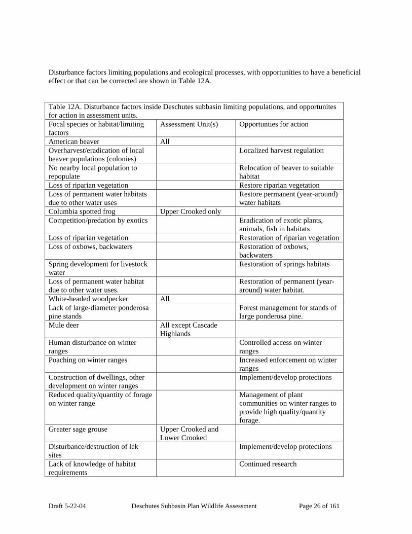
Disturbance factors limiting populations and ecological processes, with opportunities to have a beneficial effect or that can be corrected are shown in Table 12A. Table 12A. Disturbance factors inside Deschutes subbasin limiting populations, and opportunites for action in assessment units. Focal species or habitat/limiting factors
Assessment Unit(s) Opportunties for action
American beaver All Overharvest/eradication of local beaver populations (colonies)
Localized harvest regulation
No nearby local population to repopulate
Relocation of beaver to suitable habitat
Loss of riparian vegetation Restore riparian vegetation Loss of permanent water habitats due to other water uses
Restore permanent (year-around) water habitats
Columbia spotted frog Upper Crooked only Competition/predation by exotics Eradication of exotic plants,
animals, fish in habitats Loss of riparian vegetation Restoration of riparian vegetation Loss of oxbows, backwaters Restoration of oxbows,
backwaters Spring development for livestock water
Restoration of springs habitats
Loss of permanent water habitat due to other water uses.
Restoration of permanent (year-around) water habitat.
White-headed woodpecker All Lack of large-diameter ponderosa pine stands
Forest management for stands of large ponderosa pine.
Mule deer All except Cascade Highlands
Human disturbance on winter ranges
Controlled access on winter ranges
Poaching on winter ranges Increased enforcement on winter ranges
Construction of dwellings, other development on winter ranges
Implement/develop protections
Reduced quality/quantity of forage on winter range
Management of plant communities on winter ranges to provide high quality/quantity forage.
Greater sage grouse Upper Crooked and Lower Crooked
Disturbance/destruction of lek sites
Implement/develop protections
Lack of knowledge of habitat requirements
Continued research
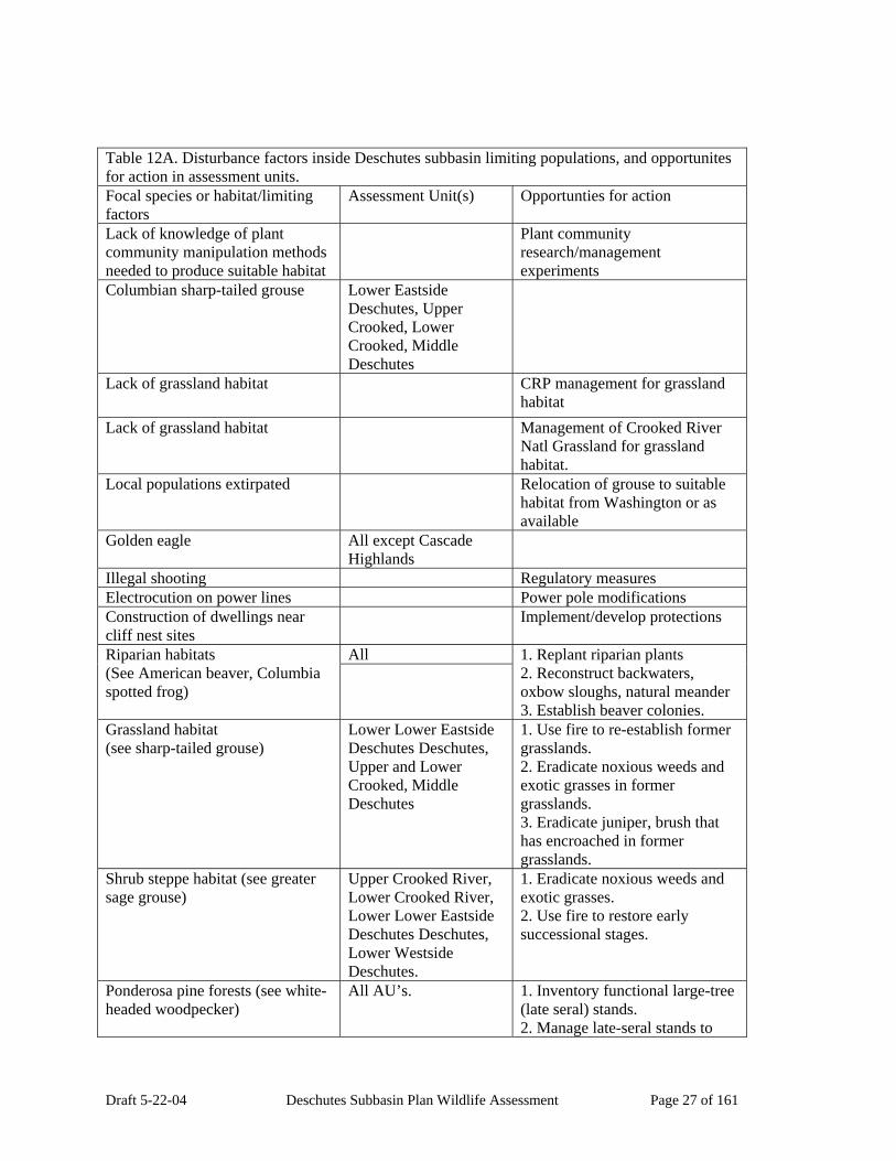
Draft 5-22-04 Deschutes Subbasin Plan Wildlife Assessment Page 27 of 161
Table 12A. Disturbance factors inside Deschutes subbasin limiting populations, and opportunites for action in assessment units. Focal species or habitat/limiting factors
Assessment Unit(s) Opportunties for action
Lack of knowledge of plant community manipulation methods needed to produce suitable habitat
Plant community research/management experiments
Columbian sharp-tailed grouse Lower Eastside Deschutes, Upper Crooked, Lower Crooked, Middle Deschutes
Lack of grassland habitat CRP management for grassland habitat
Lack of grassland habitat Management of Crooked River Natl Grassland for grassland habitat.
Local populations extirpated Relocation of grouse to suitable habitat from Washington or as available
Golden eagle All except Cascade Highlands
Illegal shooting Regulatory measures Electrocution on power lines Power pole modifications Construction of dwellings near cliff nest sites
Implement/develop protections
All Riparian habitats (See American beaver, Columbia spotted frog)
1. Replant riparian plants 2. Reconstruct backwaters, oxbow sloughs, natural meander 3. Establish beaver colonies.
Grassland habitat (see sharp-tailed grouse)
Lower Lower Eastside Deschutes Deschutes, Upper and Lower Crooked, Middle Deschutes
1. Use fire to re-establish former grasslands. 2. Eradicate noxious weeds and exotic grasses in former grasslands. 3. Eradicate juniper, brush that has encroached in former grasslands.
Shrub steppe habitat (see greater sage grouse)
Upper Crooked River, Lower Crooked River, Lower Lower Eastside Deschutes Deschutes, Lower Westside Deschutes.
1. Eradicate noxious weeds and exotic grasses. 2. Use fire to restore early successional stages.
Ponderosa pine forests (see white-headed woodpecker)
All AU’s. 1. Inventory functional large-tree (late seral) stands. 2. Manage late-seral stands to

Draft 5-22-04 Deschutes Subbasin Plan Wildlife Assessment Page 28 of 161
Table 12A. Disturbance factors inside Deschutes subbasin limiting populations, and opportunites for action in assessment units. Focal species or habitat/limiting factors
Assessment Unit(s) Opportunties for action
maintain connectivity. Lodgepole pine forests All Inventory large-tree (late seral)
stands. Loss of large diameter lodgepole pine
Management for large diameter lodgepole.
Loss of insect irruption areas Management of insect irruption areas for habitat.
Loss of fire-killed areas Management of fire-killed areas for habitat.
Ungulate winter ranges (see mule deer also)
All Inventory status of functional winter ranges.
Dwellings and other development in winter ranges.
Assess effectiveness of regulatory rules in place. Develop effective rules if needed.
Exotic ungulates and domestic livestock degrading vegetation on winter ranges.
Assess impacts of exotic and domestic livestock on winter range vegetation.
Exotic ungulates and domestic livestock communicating diseases to wild ungulates on winter ranges.
Assess impacts of disease on wild ungulate winter ranges. Example bighorn sheep are vulnerable to domestic sheep diseases, and wild elk are vulnerable to domestic livestock and exotic wild ungulate diseases.
Structure: rock cliffs, rimrocks (see also golden eagle).
Lower Eastside Deschutes, Lower Westside Deschutes, Upper Crooked and Lower Crooked, Upper Deschutes, Middle Deschutes
Inventory rimrock and cliff areas to assess impacts of development near cliffs and rimrocks
All Inventory late-seral stage forest stands to assess connectivity.
Structure: large diameter trees (late seral forest stages) (see white-headed woodpecker)
White River, Lower Eastside Deschutes, Lower Crooked River.
Inventory CRP lands where opportunity for grassland management exists.
CRP lands (see sharp-tailed grouse)
Decadent CRP grass stands: invasion by brush
Restore grass areas
Mowing, grazing of CRP grass stands
Manage mowing or grazing to protect grassland habitat values
Vegetation species diversity: All Inventory aspen stands to assess
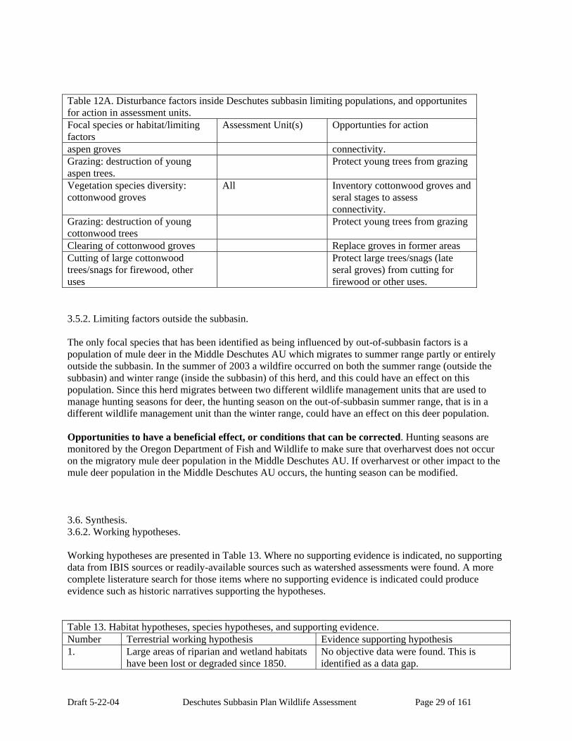
Draft 5-22-04 Deschutes Subbasin Plan Wildlife Assessment Page 29 of 161
Table 12A. Disturbance factors inside Deschutes subbasin limiting populations, and opportunites for action in assessment units. Focal species or habitat/limiting factors
Assessment Unit(s) Opportunties for action
aspen groves connectivity. Grazing: destruction of young aspen trees.
Protect young trees from grazing
Vegetation species diversity: cottonwood groves
All Inventory cottonwood groves and seral stages to assess connectivity.
Grazing: destruction of young cottonwood trees
Protect young trees from grazing
Clearing of cottonwood groves Replace groves in former areas Cutting of large cottonwood trees/snags for firewood, other uses
Protect large trees/snags (late seral groves) from cutting for firewood or other uses.
3.5.2. Limiting factors outside the subbasin. The only focal species that has been identified as being influenced by out-of-subbasin factors is a population of mule deer in the Middle Deschutes AU which migrates to summer range partly or entirely outside the subbasin. In the summer of 2003 a wildfire occurred on both the summer range (outside the subbasin) and winter range (inside the subbasin) of this herd, and this could have an effect on this population. Since this herd migrates between two different wildlife management units that are used to manage hunting seasons for deer, the hunting season on the out-of-subbasin summer range, that is in a different wildlife management unit than the winter range, could have an effect on this deer population. Opportunities to have a beneficial effect, or conditions that can be corrected. Hunting seasons are monitored by the Oregon Department of Fish and Wildlife to make sure that overharvest does not occur on the migratory mule deer population in the Middle Deschutes AU. If overharvest or other impact to the mule deer population in the Middle Deschutes AU occurs, the hunting season can be modified. 3.6. Synthesis. 3.6.2. Working hypotheses. Working hypotheses are presented in Table 13. Where no supporting evidence is indicated, no supporting data from IBIS sources or readily-available sources such as watershed assessments were found. A more complete listerature search for those items where no supporting evidence is indicated could produce evidence such as historic narratives supporting the hypotheses. Table 13. Habitat hypotheses, species hypotheses, and supporting evidence. Number Terrestrial working hypothesis Evidence supporting hypothesis 1. Large areas of riparian and wetland habitats
have been lost or degraded since 1850. No objective data were found. This is identified as a data gap.

Draft 5-22-04 Deschutes Subbasin Plan Wildlife Assessment Page 30 of 161
Table 13. Habitat hypotheses, species hypotheses, and supporting evidence. Number Terrestrial working hypothesis Evidence supporting hypothesis 2. Nearly all grassland habitats have been lost
since 1850 1. Comparison of historical and current wildlife habitat maps from IBIS indicates loss of 99 percent of interior grasslands.
3. Shrub steppe habitat has been reduced in area since 1850.
1. Comparison of historic and current wildlife habitat maps from IBIS indicates a 14 percent loss in shrub steppe since 1850.
4. Large areas of lodgepole pine forest have been lost since 1850.
1. Comparison of historic and current wildlife habitat maps from IBIS indicates a 60 percent loss in lodgepole pine forest since 1850.
5. Large areas of ponderosa pine forest have been lost since 1850.
1. Comparison of historic and current habitat maps from IBIS indicate a 29 percent loss in ponderosa pine habitat since 1850.
6. Habitat structure such as large tree structure and cliff/rimrock structure has been lost or degraded as golden eagle nesting habitat since 1850.
See golden eagle species account.
7. Aspen, cottonwood, and white oak groves have been lost since 1850
See habitat discussion sections.
8. Ungulate winter ranges have been degraded since 1850.
See discussion in winter range section.
9. CRP lands provide potential grassland habitat for wildlife.
See discussion in Columbian sharp-tailed grouse species account.
10. American beaver populations have been greatly reduced since 1850 due to loss of habitat.
See discussion in species account section.
11. Columbia spotted frog populations have declined in the Upper Crooked River AU as a result of loss of habitat.
See discussion in species account section.
12. White-headed woodpecker populations have been reduced or lost as a result of loss of large-ponderosa pine-tree breeding habitat.
See discussion in species account section. See discussion in ponderosa pine forest habitat section.
13. Mule deer populations have been reduced or lost as a result of loss or degradation of winter range habitat (see ungulate winter range.)
See discussion in species account section.
14. Greater sage grouse populations have been reduced or lost as a result of loss or degradation of shrub steppe habitats.
See discussion in species account section.
15. Columbian sharp-tailed grouse populations have been lost as a result of the loss of grassland habitat.
See discussion in species account section.
16. Golden eagle populations have been lost or are threatened as a result of loss or threatened loss of foraging habitat in
See discussion in species account section.
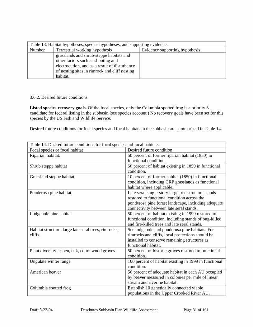
Draft 5-22-04 Deschutes Subbasin Plan Wildlife Assessment Page 31 of 161
Table 13. Habitat hypotheses, species hypotheses, and supporting evidence. Number Terrestrial working hypothesis Evidence supporting hypothesis
grasslands and shrub-steppe habitats and other factors such as shooting and electrocution, and as a result of disturbance of nesting sites in rimrock and cliff nesting habitat.
3.6.2. Desired future conditions Listed species recovery goals. Of the focal species, only the Columbia spotted frog is a priority 3 candidate for federal listing in the subbasin (see species account.) No recovery goals have been set for this species by the US Fish and Wildlife Service. Desired future conditions for focal species and focal habitats in the subbasin are summarized in Table 14. Table 14. Desired future conditions for focal species and focal habitats. Focal species or focal habitat Desired future condition Riparian habitat. 50 percent of former riparian habitat (1850) in
functional condition. Shrub steppe habitat 50 percent of habitat existing in 1850 in functional
condition. Grassland steppe habitat 10 percent of former habitat (1850) in functional
condition, including CRP grasslands as functional habitat where applicable.
Ponderosa pine habitat Late seral single-story large tree structure stands restored to functional condition across the ponderosa pine forest landscape, including adequate connectivity between late seral stands.
Lodgepole pine habitat 50 percent of habitat existing in 1999 restored to functional condition, including stands of bug-killed and fire-killed trees and late seral stands.
Habitat structure: large late seral trees, rimrocks, cliffs.
See lodgepole and ponderosa pine habitats. For rimrocks and cliffs, local protections should be installed to conserve remaining structures as functional habitat.
Plant diversity: aspen, oak, cottonwood groves 50 percent of historic groves restored to functional condition.
Ungulate winter range 100 percent of habitat existing in 1999 in functional condition.
American beaver 50 percent of adequate habitat in each AU occupied by beaver measured in colonies per mile of linear stream and riverine habitat.
Columbia spotted frog Establish 10 genetically connected viable populations in the Upper Crooked River AU.

Draft 5-22-04 Deschutes Subbasin Plan Wildlife Assessment Page 32 of 161
Table 14. Desired future conditions for focal species and focal habitats. Focal species or focal habitat Desired future condition
Establish populations in other AU’s which may be identified as areas of former occurrence.
White-headed woodpecker 100 percent of ponderosa pine forest existing in 1999 in adequate reproducing habitat condition which includes some large diameter tree stands for reproduction.
Mule deer Five-year average population levels maintained at ODFW population management objective levels as measured on winter ranges annually.
Greater sage grouse Five-year average population level maintained at 1990-1999 average as measured on leks annually.
Coumbian sharp-tailed grouse Two viable populations established including at least two leks for each population on the Crooked River National Grasslands in the Lower Lower Eastside Deschutes Deschutes, Lower Crooked, and Middle Deschutes AUs.
Golden eagle 60 viable nest territories maintained in the subbasin. 3.6.3. Opportunities for conservation and restoration All focal habitats and focal species are designated as high priority for protection or restoration in the subbasin. Findings, goals, some potential strategies, and priority areas at the AU level are presented in Table 15. This list of potential strategies should not be considered a complete list. More work needs to be done to discover additional strategies that may be most effective in local areas. Much more work needs to be done to formulate an overall plan for restoration and conservation work based on a more complete inventory of habitats such as riparian habitats, where no data is available to show linear miles or acres of habitat and the degree of functionality of the habitat. Opportunities for conservation and restoration of both fish and wildlife habitats are shown at the HUC 6 level in the Appendix maps as colored stream reaches and indicated changes in wildlife habitat from historic estimates. On these maps (a group of 12 maps) priority stream reaches are color coded as candidates for conservation, restoration, or both. These priority stream reaches are overlain on each of four focal habitat maps that are color-coded to show decreases or increases in habitat levels in each HUC6 compared to historic levels. Also shown on one set of four maps are past and ongoing habitat projects, both aquatic and terrestrial. With this information, a proposed project can be evaluated, or a project strategy can be formulated for a HUC6 or larger geographic unit, using the aquatic and terrestrial priorities presented in this plan. As previously mentioned, wildlife habitat acreages and stream miles evaluated for functionality at the HUC6 level would be useful for designing future work in the subbasin.

Draft 5-22-04 Deschutes Subbasin Plan Wildlife Assessment Page 33 of 161
Table 15. Key findings, goals, potential strategies, and priority areas for management of focal habitats and species. Species or Habitat Key findings Goals Potential Strategies Priority Areas Riparian habitats and herbaceous wetlands.
Many degraded areas, and converted to other uses.
Restore seasonal water regime
1. Purchase water rights.
All streams, all AUs.
Riparian habitats and herbaceous wetlands.
Large areas have been degraded or destroyed since historic times.
1. Restore riparian vegetation to functional status in 90 percent of stream reaches. 2. Restore 25 percent of former acreage of herbaceous wetlands in 25 percent of historic areas.
1. inventory non-functional riparian zones and former herbaceous wetland areas. 2. Purchase wetland areas and riparian zones or obtain natural resource easements.
All stream and river valleys and canyons. All AUs.
Lodgepole pine forests
Fragmented Restore 4 large blocks of forest
1. Inventory remaining blocks. 2. Inform forest managers.
South half of Upper Deschutes AU.
Lodgepole pine forests
Lack of large trees, dead trees, late seral stage stands.
Restore tree size and snag diversity in 50 percent of remaining stands.
1. Inventory remaining diverse stands, assess connectivity values. 2. Inform forest managers.
South half of Upper Deschutes AU.
Ungulate winter range (mule deer, bighorn sheep, antelope, elk)
Degraded Protect remaining habitat, restore degraded habitat.
1. Inventory winter ranges. 2. Purchase winter ranges or purchase easements. 3. Purchase grazing rights on winter ranges.
Designated areas in each AU, all AUs.
Sage grouse (shrub steppe)
Declining in numbers
Maintain minimum population of 1990-99 average as measured on leks.
1. Inventory populations. 2. Continue population management to prevent overharvest. 3. Release birds into old and new habitat
East half of Upper Crooked AU, east half of Lower Crooked, Lower Eastside Deschutes, Middle Deschutes..

Draft 5-22-04 Deschutes Subbasin Plan Wildlife Assessment Page 34 of 161
Table 15. Key findings, goals, potential strategies, and priority areas for management of focal habitats and species. Species or Habitat Key findings Goals Potential Strategies Priority Areas
areas to diversify genetics. 4. Construct new habitat centers (leks.) 5. Identify potential habitat areas. 6. Inform land managers. 7. Purchase grazing rights, pay for fire management, scarification if needed.
Dwarf shrub steppe
Declining in area, decadent stands
Protect remaining, restore to 50 percent of historic area.
1. Inventory remaining dwarf shrub habitats. 2. Manage grazing, fire, planting, scarification, if needed.
Historic area of habitat in the Lower Crooked AU, Upper Crooked, Lower Lower Eastside Deschutes Deschutes.
C. spotted frog Loss in distribution in former range.
Restore or establish 10 populations. Restore connectivity of populations and habitats.
1. Inventory former springs and other habitats. 2. Restore habitats obtained through purchase or easement.
Upper Crooked AU.
Ponderosa pine forests (white-headed woodpecker)
Declining in area and large tree (late seral stage) component
Identified large tree stands maintained throughout ponderosa pine forests to allow connectivity between stands for species such as white-headed woodpecker.
1. Inventory late seral stands remaining, and evaluate functional status such as connectivity. 2. Inform forest mgrs.
Historic ponderosa pine forested areas in all AUs.
Grasslands. Formerly 600,000 acres in subbasin, now 99 percent gone.
Restore functional blocks of grasslands in areas of AUs where grasslands
2. Add to small existing remaining areas, in Crooked River Natl Grasslands, or near
Lower Lower Eastside Deschutes Deschutes, Lower and Upper

Draft 5-22-04 Deschutes Subbasin Plan Wildlife Assessment Page 35 of 161
Table 15. Key findings, goals, potential strategies, and priority areas for management of focal habitats and species. Species or Habitat Key findings Goals Potential Strategies Priority Areas
formerly occurred..
CRP lands, for example, by informing managers or buying easements or land.
Crooked, Middle Deschutes AUs.
Aspen groves, cottonwood groves
Declining in numbers
Protect remaining groves, restore groves to 50 percent of historical locations and arcreages.
1. Inventory remaining groves, and areas of former groves. 2. Inform managers, buy easements or land.
Historic groves sites in all AUs.
White oak groves Declining in numbers and area
Protect remaining groves, restore groves to 50 percent of historic acreages and areas.
1. Inventory historic areas and acreages. 2. Inform mgrs, buy easements or land.
Historic groves sites, Lower Westside and Lower Lower Eastside Deschutes Deschutes, White River AUs.
Cliffs, rimrocks Threatened by future development
Protect remaining cliffs, rimrocks that are undeveloped.
1. Inventory cliffs and rimrocks. 2. Inform local govt 3. Buy easements or land.
Inventory may be needed. All AUs except Cascade Highlands.
Golden eagle Threatened by shooting, disturbance at nest sites, loss of foraging habitat
Maintain at least 60 nesting territories (pairs) in the subbasin.
1. Inventory nesting territories. 2. Inform local govt. 3. Identify threats to each territory or pair.
Inventory may be needed. All AUs except Cascade Highlands.
C. sharp-tailed grouse
Extirpated Establish two populations of at least 500 birds each.
1. Identify sources of proper race of birds to transplant. 2. Construct leks, water sources, inventory habitat attributes in release areas. 3. Monitor populations.
Suitable habitat in Lower Lower Eastside Deschutes Deschutes, Lower and Upper Crooked, Middle Deschutes AUs.
4. Inventory
Draft 5-22-04 Deschutes Subbasin Plan Wildlife Assessment Page 36 of 161
Visual presentations of past and ongoing stream and upland restoration projects in the subbasin are shown with wildlife habitat information in the Appendix maps. Projects are displayed as points on each of four focal wildlife habitat maps showing color-coded changes in focal wildlife habitats from historic levels, by HUC6 geographical unit. Projects are also color-coded according to 11 categories of projects on these maps, e.g. instream habitat restoration, wetlands restoration, upland habitat restoration, and so on. Appendix maps are included on a CD in Adobe format, so they can be viewed in more detail. Since the restoration projects represent projects that are ongoing or were completed within the past 5 years, it is apparent that a significant number of projects have been completed or are ongoing in the subbasin. A summary of past and ongoing projects in the subbasin is also presented in table form in the Management Plan section of the main document. 5. Management Plan 5.1.Vision for the subbasin. The full spectrum of indigenous wildlife and wildlife habitats should be present in the subbasin, but some habitats and populations would be expected to be at lower levels than historically. Degraded habitats should be restored to functional status where not permanently committed to other uses, and existing functional habitats should be conserved and managed to insure that they remain viable into the future. 5.2. Biological and habitat objectives and key findings. See main plan document for combined fish and wildlife biological and habitat objectives and key findings. 5.3. Prioritized strategies See main plan document for combined fish and wildlife prioritized strategies. 5.4. Consistency with ESA Requirements All proposals for action in this assessment are consistent with ESA requirements according to available literature information reviewed for this assessment. 5.5. Research, Monitoring and Evaluation See Table 15 for summaries of research, monitoring, and evaluation opportunities, and main plan document for combined fish and wildlife monitoring and evaluation opportunities. 6. Appendices 6.1. Species Accounts.
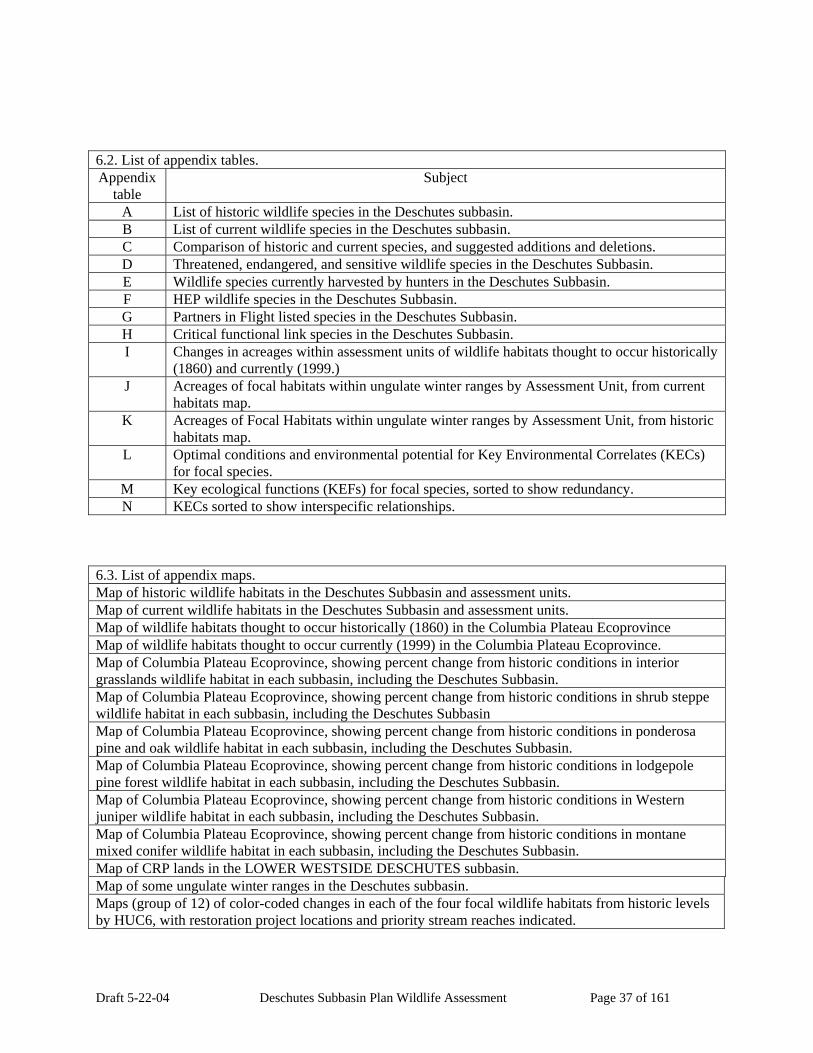
Draft 5-22-04 Deschutes Subbasin Plan Wildlife Assessment Page 37 of 161
6.2. List of appendix tables. Appendix
table Subject
A List of historic wildlife species in the Deschutes subbasin. B List of current wildlife species in the Deschutes subbasin. C Comparison of historic and current species, and suggested additions and deletions. D Threatened, endangered, and sensitive wildlife species in the Deschutes Subbasin. E Wildlife species currently harvested by hunters in the Deschutes Subbasin. F HEP wildlife species in the Deschutes Subbasin. G Partners in Flight listed species in the Deschutes Subbasin. H Critical functional link species in the Deschutes Subbasin. I Changes in acreages within assessment units of wildlife habitats thought to occur historically
(1860) and currently (1999.) J Acreages of focal habitats within ungulate winter ranges by Assessment Unit, from current
habitats map. K Acreages of Focal Habitats within ungulate winter ranges by Assessment Unit, from historic
habitats map. L Optimal conditions and environmental potential for Key Environmental Correlates (KECs)
for focal species. M Key ecological functions (KEFs) for focal species, sorted to show redundancy. N KECs sorted to show interspecific relationships.
6.3. List of appendix maps. Map of historic wildlife habitats in the Deschutes Subbasin and assessment units. Map of current wildlife habitats in the Deschutes Subbasin and assessment units. Map of wildlife habitats thought to occur historically (1860) in the Columbia Plateau Ecoprovince Map of wildlife habitats thought to occur currently (1999) in the Columbia Plateau Ecoprovince. Map of Columbia Plateau Ecoprovince, showing percent change from historic conditions in interior grasslands wildlife habitat in each subbasin, including the Deschutes Subbasin. Map of Columbia Plateau Ecoprovince, showing percent change from historic conditions in shrub steppe wildlife habitat in each subbasin, including the Deschutes Subbasin Map of Columbia Plateau Ecoprovince, showing percent change from historic conditions in ponderosa pine and oak wildlife habitat in each subbasin, including the Deschutes Subbasin. Map of Columbia Plateau Ecoprovince, showing percent change from historic conditions in lodgepole pine forest wildlife habitat in each subbasin, including the Deschutes Subbasin. Map of Columbia Plateau Ecoprovince, showing percent change from historic conditions in Western juniper wildlife habitat in each subbasin, including the Deschutes Subbasin. Map of Columbia Plateau Ecoprovince, showing percent change from historic conditions in montane mixed conifer wildlife habitat in each subbasin, including the Deschutes Subbasin. Map of CRP lands in the LOWER WESTSIDE DESCHUTES subbasin. Map of some ungulate winter ranges in the Deschutes subbasin. Maps (group of 12) of color-coded changes in each of the four focal wildlife habitats from historic levels by HUC6, with restoration project locations and priority stream reaches indicated.

Draft 5-22-04 Deschutes Subbasin Plan Wildlife Assessment Page 38 of 161
7. Literature Cited Anon. 2003. An Oregon Technical Guide for Developing Wildlife Elements of a Subbasin Plan. Dated April 16, 2003. 22 p. with flow charts. Anon. 2003. Oregon Specific Guidance. Prepared by Oregon Subbasin Planning Coordination Group. Dated Sept. 15, 2003.79 p. Ashley, Paul and Stacy Stoval. 2004. American Beaver. Species Account written for the Southeast Washington Ecoregional Assessment. 9 p. __________. 2004a. Columbian Sharp-tailed Grouse. Species Account written for the Southeast Washington Ecoregional Assessment. 12 p. _________. 2004b. Rocky Mountain Mule Deer. Species Account written for the Southeast Washington Ecoregional Assessment. 10 p. _________. 2004c. White-headed Woodpecker. Species Account written for the Southeast Washington Ecoregional Assessment. 8 p. Barrett, Charley. 2003. US Columbia River Basin Land Stewarship Status, 1st. Ed. Northwest Habitat Institute. Online_Linkage: <http://www.nwhi.org/ibis/mapping/gisdata/gisdata.asp> Burt, Henry William. 1976. A Field Guide to the Mammals: North America north of Mexico. Houghton Mifflin Co. 299 p. Carey, Chris. 2004. Pers. comm. Wildlife Biologist, Ore. Dept. Fish and Wildlife, Bend, Oregon. Calvin, Doug 2004. Personal communication. Wildlife Biologist, Confederated Tribes of the Warm Springs Reservation of Oregon, Warm Springs, OR; Clark, Jennifer Shannon and Karen Lamsen 2004. White River Watershed Assessment. Wasco County Soil and Water Conservation District, The Dalles, Oregon. 79 p. or CD. Clowers, Gary. 2004. Pers. comm. Wildlife Biologist, consulting. Madras, Oregon. Confederated Tribes of the Warm Springs Reservation of Oregon. 1999. Pelton Project Final License Application. Vol. 1 of 4. Corkran, Charlotte C. and Chris Thoms. 1996. Amphibians of Oregon, Washington and British Columbia: A Field Identification Guide. Lone Pine Publishing. 175 p. Csuti et al. 2001. Atlas of Oregon Wildlife: Distribution, Habitat, and Natural History. Oregon State Univ. Press, Corvallis, Or. 525 p.
Draft 5-22-04 Deschutes Subbasin Plan Wildlife Assessment Page 39 of 161
Deschutes Coordinating Group. 2004. Members from within the Deschutes Subbasin. Members served 2003-04 to provide technical and other stakeholder input during the process of assembling the Deschutes Subbasin Plan. Deschutes Subbasin Wildlife Team. 2004. Team members served Nov. 2003-May, 2004, to provide technical input during construction of the wildlife assessment section of the Deschutes Subbasin Plan. Members: Glen Ardt, Watershed Habitat Biologist, Oregon Dept. of Fish and Wildlife, Bend, OR; Doug Calvin, Wildlife Biologist, Confederated Tribes of the Warm Springs Reservation of Oregon, Warm Springs, OR; Nancy Gilbert, Wildlife Biologist, US Fish and Wildlife Service, Bend, OR; Ellen Hammond, Ore. Dept. of Agriculture, Bend, OR; Jan Hanf, Wildlife Biologist, US Bureau of Land Management, Prineville, OR; Shane Jeffries, Wildlife Biologist, US Forest Service, Bend, OR; Clair Kunkel, Assistant Watershed Manager, Oregon Dept. of Fish and Wildlife, Bend, OR; Robert Marheine, Wildlife Biologist, Portland General Electric, Madras, OR; Carl Scheeler, Wildlife Biologist, Confederated Tribes of the Umatilla Indian Reservation, Pendleton, OR; Gabrielson, Ira N. and Stanley G. Jewett. 1970 ed. Birds of the Pacific Northwest, With Special Reference to Oregon. (Formerly: Birds of Oregon.) Dover Publications, Inc. New York.650 p. George, Steven 2003. Personal communication. District Wildlife Biologist, Oregon Dept. of Fish and Wildlife, Bend, Oregon. Gilbert, Nancy. 2003. Personal communication. Wildlife biologist, US Fish and Wildlife Service, Bend, OR. Hanf, Jan. 2003. Personal communication. Wildlife biologist, US Bureau of Land Management, Prineville, OR. IBIS. 2004. Interactive Biological Information System. Northwest Habitat Institute, Corvallis, OR www.nhi.org Johnson, David H. and Thomas A. O’Neil (managing directors). 2001.Wildlife-Habitat Relationships in Oregon and Washington.. Oregon State Univ. Press, Corvallis, Or. 768 p. Kohl, Keith. District Wildlife Biologist, Ore. Dept. Fish and Wildlife The Dalles, Oregon. Kunkel, Clair. 2003. Assistant Watershed Manager, Ore. Dept. Fish and Wildlife, Bend, Oregon. Marshall, D.B., M.G. Hunter, and A.L. Contreras, Eds. 2003. Birds of Oregon: A General Reference. Oregon State University Press, Corvallis, OR 768 Pp. Nelson, Leslie and Clair Kunkel. 2001. Draft Deschutes River Subbasin Summary. Prepared for the Northwest Power Planning Council. Ore. Dept. of Fish and Wildlife. 167 p. Northwest Power Planning Council. 2001. Technical Guide for Subbasin Planners. Council document 2001-20. 24 p. Ore. Dept. of Fish and Wildlife. 1997. 1997 Big Game Statistics. Rev. Aug. 1997. 66 p.

Draft 5-22-04 Deschutes Subbasin Plan Wildlife Assessment Page 40 of 161
_________________________. 2002. Oregon Furbearer Trapping and Hunting Regulations, July 1, 2002 throught June 30, 2004. 11p. _________________________. 2003. Oregon’s Mule Deer Management Plan. 29 p. _________________________. 2003a. Oregon Big Game Regulations.103 p. _________________________ 2003b. Oregon’s Bighorn Sheep and Rocky Mountain Goat Management Plan. Dated December 2003. 80 p. Paul, Keith. 2004. Columbia Spotted Frog Species Account. U.S. Fish and Wildlife Service, La Grande, Or. 19 p. Peplin, Todd. 2004. Personal communication. District Conservationist, Natural Resources Conservation Service, Redmond, OR. O’Neil, Thomas A., David H. Johnson, Charley Barrett, Marla Trevithick, Kelly A. Bettinger, Chris Kiilsgaard, Madeleine Vander Heyden, Eva L. Greda, Derek Stinson, Bruce G. Marcot, Patrick J. Doran, Susan Tank, and Laurie Wunder. 2001. Matrixes for Wildlife-Habitat Relationships in Oregon and Washington. [CD-ROM] in D. H. Johnson and T. A. O’Neil (managing directors). 2001. Wildlife-Habitat Relationships in Oregon and Washington. Oregon State University Press, Corvallis, OR 768 p. Riley, Terry Z. 2004. Private-land habitat opportunities for prairie grouse through federal conservation programs. in Special prairie grouse coverage section, Wildlife Society Bulletin, spring 2004, 32(1). Robbins, Chandler S., Bertel Bruun, and Herbert S. Zim. 1966. Birds of North America. Golden Press, New York. 340 p. Scheeler, Carl A. and Paul Ashley, William Blosser, David H. Johnson, Jimmy Kagan, Catherine Macdonald, Bruce G. Marcot, Thomas A. O’Neil, Peter J. Paquet, Drew Parkin, Elizabeth Roderick, Phil Roger, Angela Sondenaa, Scot Soults. 2003. A technical Guide for Developing Wildlife Elements of a Subbasin Plan.20 p. Shepperd, Wayne D., Dan Binkley, Dale L. Bartos, Thomas J. Stohlgren, Lane G. Squeskew, compilers. 2001. Sustaining Aspen in Western Landscapes: Symposium Proceedings 13-15 June 2000, Grand Junction, CO. Proceedings RMRS-P-18, US Dept. Agriculture Forest Service, Rocky Mountain Research Station, Fort Collins, CO. 460 p. Verts, B.J. and Leslie N. Carraway. 1998. Land Mammals of Oregon. Univ. of California Press. 668 p. Wallmo, Olof C. Ed. 1981. Mule and Black-tailed Deer of North America. A Wildlife Mgt. Institute book. Developed in cooperation with U.S. Dept. of Agric., Forest Service. Univ. of Nebraska Press, Lincoln and London. 605 p.
End wildlife assessment
See attached appendices.

Draft 5-22-04 Deschutes Subbasin Plan Wildlife Assessment Page 41 of 161
Appendix
Species Accounts

Draft 5-22-04 Deschutes Subbasin Plan Wildlife Assessment Page 42 of 161
Appendix A. Focal wildlife species accounts, Deschutes subbasin, Oregon.
Contents 1. American beaver 2. Columbia spotted frog 3. White-headed woodpecker 4. Mule deer 5. Greater sage grouse 6. Golden eagle.
1. American Beaver. Note: much of this account is abstracted from Ashley and Stovall, 2004. Distribution The beaver occurs throughout most of the U.S. and Canada and into northern Mexico, except for the Arctic northern fringe, southern Florida and California, and the southern half of Nevada (Burt 1976.) In Oregon, the beaver occurs throughout the state (Verts and Carraway 1998.) The subspecies Castor Canadensis leucodontus, a large chestnut-brown colored variation, occurs in the northern two-thirds of Oregon east of the Cascade Range, including the Deschutes Subbasin (Ibid p. 257.) Historic and current populations, and population trends No estimates of beaver populations are available for Oregon and, in the absence of systematic population estimates, harvest and damage complaint levels are considered to be indicative of the population levels in local areas and statewide (Ibid.) From 1981 to 1991, over 5,000 complaints of beaver damage were received by the Oregon Department of Fish and Wildlife (Ibid.) During the 1930s many beaver were transplanted in Oregon from areas of damage to areas of suitable habitat with no beaver (Ibid.) The range of reported annual beaver harvests for the counties within the Deschutes Subbasin for the years 1990-95 are shown in Table . If the harvest ranges

Draft 5-22-04 Deschutes Subbasin Plan Wildlife Assessment Page 43 of 161
in the Deschutes Subbasin counties are compared to Clatsop County, it can be inferred that the populations are much lower in the subbasin counties than in Clatsop County, which is smaller than all of the counties in the subbasin except for Hood River, which is smaller, and Sherman, which is about the same size as Clatsop. About 10,000 beaver a year are trapped in Oregon (Csuti 2001.) Special beaver harvest regulations in place within the subbasin for July 1, 2002 through June 30, 2004 were (ODFW 2002 p. 2):
1. Prineville Reservoir up to the high water line and the Ochoco National Forest were closed to beaver harvest. 2. That portion of Willow Creek and its tributaries within the Crooked River National Grassland was closed to beaver harvest.
Table 1. Range of Annual Beaver Harvest for the Years 1990-95 for counties in the Deschutes
Subbasin . Clatsop County harvest range is shown for comparison. County Range of Numbers of Beaver Harvested
Annually, 1990-95. Clatsop 212-821
Deschutes 31-63 Crook 13-50
Hood River 18-40 Jefferson 4-31 Sherman No numbers shown (previous 5 years: 0-8) Wasco 24-86
Habitat All wetland cover types (e.g., herbaceous wetland and deciduous forested wetland) must have a permanent source of surface water with little or no fluctuation in order to provide suitable beaver habitat (Slough and Sadleir 1977). Water provides cover for the feeding and reproductive activities of the beaver. Lakes and reservoirs that have extreme annual or seasonal fluctuations in the water level will be unsuitable habitat for beaver. Similarly, intermittent streams, or streams that have major fluctuations in discharge (e.g., high spring runoff) or a stream channel gradient of 15 percent or more, will have little year-round value as beaver habitat. Assuming that there is an adequate food source available, small lakes [< 8 ha (20 acres) in surface area] are assumed to provide suitable habitat. Large lakes and reservoirs [> 8 ha (20 acres) in surface area] must have irregular shorelines (e.g., bays, coves, and inlets) in order to provide optimum habitat for beaver.(The foregoing paragraph was excerpted from Ashley and Stovall 2004.) Beavers can usually control water depth and stability on small streams, ponds, and lakes; however, larger rivers and lakes where water depth and/or fluctuation cannot be controlled are often partially or wholly unsuitable for the species (Murray 1961; Slough and Sadleir 1977). Rivers or streams that are dry during some parts of the year are assumed to be unsuitable beaver

Draft 5-22-04 Deschutes Subbasin Plan Wildlife Assessment Page 44 of 161
habitat. Beavers are absent from sizable portions of rivers in Wyoming, due to swift water and an absence of suitable dwelling sites during periods of high and low water levels (Collins 1976b). (The foregoing paragraph was excerpted from Ashley and Stovall 2004.) In riverine habitats, stream gradient is the major determinant of stream morphology and the most significant factor in determining the suitability of habitat for beavers (Slough and Sadleir 1977). Stream channel gradients of 6 percent or less have optimum value as beaver habitat. Retzer et al. (1956) reported that 68 percent of the beaver colonies recorded in Colorado were in valleys with a stream gradient of less than 6 percent, 28 percent were associated with stream gradients from 7 to 12 percent, and only 4 percent were located along streams with gradients of 13 to 14 percent. No beaver colonies were recorded in streams with a gradient of 15 percent or more. Valleys that were only as wide as the stream channel were unsuitable beaver habitat, while valleys wider than the stream channel were frequently occupied by beavers. Valley widths of 46 m (150 ft) or more were considered the most suitable. Marshes, ponds, and lakes were nearly always occupied by beavers when an adequate supply of food was available. (The foregoing paragraph was excerpted from Ashley and Stovall 2004.) Feeding Beavers are generalized herbivores; however, they show strong preferences for particular plant species and size classes (Jenkins 1975; Collins 1975a; Jenkins 1979). The leaves, twigs, and bark of woody plants are eaten, as well as many species of aquatic and terrestrial herbaceous vegetation. Food preferences may vary seasonally, or from year to year, as a result of variation in the nutritional value of food sources (Jenkins 1979). (The foregoing paragraph was excerpted from Ashley and Stovall 2004.) An adequate and accessible supply of food must be present for the establishment of a beaver colony (Slough and Sadleir 1977). The actual biomass of herbaceous vegetation will probably not limit the potential of an area to support a beaver colony (Boyce 1981). However, total biomass of winter food cache plants (woody plants) may be limiting. Low marshy areas and streams flowing in and out of lakes allow the channelization and damming of water, allowing access to, and transportation of, food materials. Steep topography prevents the establishment of a food transportation system (Williams 1965; Slough and Sadleir 1977). Trees and shrubs closest to the pond or stream periphery are generally utilized first (Brenner 1962; Rue 1964). Jenkins (1980) reported that most of the trees utilized by beaver in his Massachusetts study area were within 30 m (98.4 ft) of the water's edge. However, some foraging did extend up to 100 m (328 ft). Foraging distances of up to 200 m (656 ft) have been reported (Bradt 1938). In a California study, 90 percent of all cutting of woody material was within 30 m (98.4 ft) of the water's edge (Hall 1970). (The foregoing paragraph was excerpted from Ashley and Stovall 2004.) Woody stems cut by beavers are usually less than 7.6 to 10.1 cm (3 to 4 inches) DBH (Bradt 1947; Hodgdon and Hunt 1953; Longley and Moyle 1963; Nixon and Ely 1969). Jenkins (1980) reported a decrease in mean stem size cut and greater selectivity for size and species with

Draft 5-22-04 Deschutes Subbasin Plan Wildlife Assessment Page 45 of 161
increasing distance from the water's edge. Trees of all size classes were felled close to the water's edge, while only smaller diameter trees were felled farther from the shore. (The foregoing paragraph was excerpted from Ashley and Stovall 2004.) Beavers rely largely on herbaceous vegetation, or on the leaves and twigs of woody vegetation, during the summer (Bradt 1938, 1947; Brenner 1962; Longley and Moyle 1963; Brenner 1967; Aleksiuk 1970; Jenkins 1981). Forbs and grasses comprised 30 percent of the summer diet in Wyoming (Collins 1976a). Beavers appear to prefer herbaceous vegetation over woody vegetation during all seasons of the year, if it is available (Jenkins 1981). (The foregoing paragraph was excerpted from Ashley and Stovall 2004.) Reproduction The basic composition of a beaver colony is the extended family, comprised of a monogamous pair of adults, subadults (young of the previous year), and young of the year (Svendsen 1980). Female beavers are sexually mature at 2.5 years old. Females normally produce litters of three to four young with most kits being born during May and June. Gestation is approximately 107 days (Linzey 1998). Kits are born with all of their fur, their eyes open, and their incisor teeth erupted. (The foregoing paragraph was excerpted from Ashley and Stovall 2004.) Dispersal of subadults occurs during the late winter or early spring of their second year and coincides with the increased runoff from snowmelt or spring rains. Subadult beavers have been reported to disperse as far as 236 stream km (147 mi) (Hibbard 1958), although average emigration distances range from 8 to 16 stream km (5 to 10 mi) (Hodgdon and Hunt 1953; Townsend 1953; Hibbard 1958; Leege 1968). The daily movement patterns of the beaver centers around the lodge or burrow and pond (Rutherford 1964). The density of colonies in favorable habitat ranges from 0.4 to 0.8/km2 (1 to 2/mi2) (Lawrence 1954; Aleksiuk 1968; Voigt et al. 1976; Bergerud and Miller 1977 cited by Jenkins and Busher 1979). (The foregoing paragraph was excerpted from Ashley and Stovall 2004.) Limiting Factors A primary predator of the beaver historically was the wolf, now extirpated in Oregon, but other predators known to take beaver in Oregon are coyotes, red foxes, mink, and river otter (Verts and Carraway 1998.) Water is a limiting factor for beaver. Beaver require a permanent source of water, preferably small ponds or slow streams meandering through low-gradient valleys (Ibid p. 257,) therefore, lack of water in a stream or pond during part of the year would render the stream or pond unusable for beaver. In addition, relatively stable water level is more favorable, thus river or streams with wide variation in levels during the year are not habitable. Due to the impact of beaver on their habitat, which may be a plus or minus depending on the point of view in each situation, beaver numbers are often controlled most importantly by humans.

Draft 5-22-04 Deschutes Subbasin Plan Wildlife Assessment Page 46 of 161
Literature Cited Ashley, Paul and Stacy Stoval. 2004. American Beaver. Species Account written for the Southeast Washington Ecoregional Assessment. 9 p. Beer, J. R. 1942. Notes on the winter food of beavers in the Palouse Prairies, Washington. Journal of Mammalogy, 23:444-445. Hill, E. P. 1982. Beaver: Castor Canadensis. Pp. 256-281, in Wild mammals of North America: biology, management, and economics (J. A. Chapman and G. A. Feldhamer, eds.). The Johns Hopkins University Press, Baltimore, 1147 pp. Jenkins, S. H. 1979. Seasonal and year-to-year differences in food selection by beavers. Oecologia, 44:112-116. Jenkins, S. H., and P. E. Busher. 1979. Castor Canadensis. Mammalian Species, 120:1-8. Kindschy, R. R. 1985. Response of red willow to beaver use in southeastern Oregon. The Journal of Wildlife Management, 49:26-28. Svendsen, G. E. 1980. Seasonal change in feeding patterns of beaver in southeastern Ohio. The Journal of Wildlife Management, 44:285-290. Verts, B. J., and L. N. Carraway. 1998. Land Mammals of Oregon. University of California Press, 668 pp. Additional references from Ashley and Stovall 2004 Aleksiuk, M. 1968. Scent-mound communication, territoriality and population regulation in beaver. J. Mammal. 49(4):759-762. _____1970. The seasonal food regime of arctic beavers. Ecology. 51:264-270. Allen, A. W. 1983. Habitat suitability index models: beaver. FWS/OBS-82/10.30 (Revised). Washingtion, DC: U.S. Department of the Interior, Fish and Wildlife Service. 20 p. Bergerud, A. T., and D. R. Miller. 1977. Population dynamics of Newfoundland beaver. Can. J. Zool. 55(2):1480-1492. Cited by Jenkins and Busher 1979. Boyce, M. S. 1981. Habitat ecology of an unexploited population of beavers in interior Alaska. Pages 155-186 in J. A. Chapman and D. Pursley, eds. - Worldwide Furbearer Conf. Proc. Vol. I.

Draft 5-22-04 Deschutes Subbasin Plan Wildlife Assessment Page 47 of 161
Bradt, G. W. 1938. A study of beaver colonies in Michigan. J. Mammal. 19:139-162. _____1947. Michigan beaver management. Mich. Dept. Conserv., Lansing. 56 pp. Brenner F. J. 1962. Food consumed by beavers in Crawford County, Pennsylvania. 3. Wildl. Manage. 26(1):104-107. _____. 1967. Spatial and energy requirements of beaver. Ohio J. Sci. 67(4):242-246. Collins, T. C. 1976a. Population characteristics and habitat relationships of beaver in Northwest Wyoming. Ph.D. Diss., Univ. Wyoming, Laramie [Abstract only, from Diss. Abst. Int. B Sci. Eng. 37(11):5459, 19771. _____. 1976b. Stream flow effects on beaver populations in Grand Teton National Park. Pages 349-352 in Proceedings of the First Conference - on Scientific Research in the National Parks, U.S. Dept. Int. Nat. Park Serv., Trans. Proc. Series 5. Vol. I. Denney, R. N. 1952. A summary of North American beaver management. 1946-1948. Colo. Fish Game Dept. Rep. 28, Colo. Div. Wildl. 14 pp. Findley, J.S. 1987. The Natural History of New Mexican Mammals. University of New Mexico Press, Albuquerque, p85-88. Hall, J. G. 1970. Willow and aspen in the ecology of beaver in Sagehen Creek, California. Ecology 41(3):484-494. Hammond, M. C. 1943. Beaver on the Lower Souris Refuge. J. Wildl. Manage. 7(3):316-321. Hays, R. L., C. S. Summers, and W. Seitz. 1981. Estimating wildlife habitat variables. U.S. Dept. Int., Fish and Wildl. Serv. FWS/OBS-81/47. 111 pp. Hibbard, E. A. 1958. Movements of beaver transplanted in North Dakota. J. Wildl. Manage. 22(2):209-211. Hodgdon, H. W., and J. H. Hunt. 1953. Beaver management in Maine. Maine Dept. Inland Fish Game, Game Div. Bu 11. 3. 102 pp. Hoffman, R. S., and D. L. Pattie. 1968. A guide to Montana mammals: identification, habitat, distribution and abundance. Univ. Montana Printing Services, Missoula. 333 pp. Howard, R. J. 1982. Beaver habitat classification in Massachusetts. M.S. Thesis. Univ. Mass., Amherst. 67 pp. Jenkins, S. H. 1975. Food selection by beavers: a multidimensional contingency table analysis. Oecologia 21:157-173.

Draft 5-22-04 Deschutes Subbasin Plan Wildlife Assessment Page 48 of 161
_____. 1979. Seasonal and year-to-year differences in food selection by beavers. Oecologia. (Berl.) 44:112-116. _____. 1980. A size-distance relation in food selection by beavers. Ecology 61(4):740-746. _____. 1981. Problems, progress, and prospects in studies of food selection by beavers. Pages 559-579 in J. A. Chapman and D. Pursley, eds. Worldwide Furbearer Conf. Proc., Vol I. _____. Personnal communication (letter dated 4 January 1982). University of Nevada, Reno, NV. Jenkins, S. H., and P. E. Busher. 1979. Castor canadensis. Am. Sot. Mammal, New York. Mammalian Species 120:1-8. Lawrence, W. H. 1954. Michigan beaver populations as influenced by fire and logging. Ph.D. Diss., Univ. Michigan, Ann Arbor. 219 pp. Cited by Jenkins and Busher 1979. Leege, T. A. 1968. Natural movements of beavers in southeastern Idaho. J. Wildl. Manage. 32(4):973-976. Linzey, D. W. 1998. The Mammals of Virginia. Blacksburg, Virginia: The McDonald & Wood ward Publishing Company, Inc. Linzey, D. and C. Brecht. 2002. Website accessed on 26 June 2003. http://www.discoverlife.org/nh/tx/Vertebrata/Mammalia/Castoridae/Castor/canadensis/ Longley, W. H., and J. B. Moyle. 1963. The beaver in Minnesota. Minn. Dept. Conserv. Tech. Bull. 6. 87 pp. Lowery, G. H., Jr. 1974. The mammals of Louisiana and its adjacent waters. Shreveport, LA: Louisiana State University Press. 565 p. Merritt, J. F. 1987. Guide to the mammals of Pennsylvania. Pittsburg, PA: University of Pittsburgh Press. 408 p. Murray, D. F. 1961. Some factors affecting the production and harvest of beaver in the upper Tanana River Valley, Alaska. M.S. Thesis, Univ. Alaska, Anchorage. 140 pp. Nixon, C. M., and J. Ely. 1969. Foods eaten by a beaver colony in southeastern Ohio. Ohio J. Sci. 69(5):313-319. Retzer, J. L., H. M. Swope, J. 0. Remington, and W. H. Rutherford. 1956. Suitability of physical factors for beaver management in the Rocky Mountains of Colorado. Colo. Dept. Game, Fish and Parks, Tech. Bull. 2:1-32.

Draft 5-22-04 Deschutes Subbasin Plan Wildlife Assessment Page 49 of 161
Rue, L. E., III. 1964. The world of the beaver. J. B. Lippincott Co., Philadelphia and New York. 155 pp. _____. 1967. Pictorial guide to the mammals of North America. New York: Thomas Y. Crowell Company. 299 p. Rutherford, W. H. 1964. The beaver in Colorado. Colo. Dept. Game, Fish and Parks Dept., Tech. Publ. 17. 49 pp. Slough, B. G., and R. M. F. S. Sadleir. 1977. A land capability classification system for beaver (Castor canadensis Kuhl). Can. J. Zool. 55(8):1324-1335. Svendsen, G. E. 1980. Population parameters and colony composition of beaver (Castor canadensis) in southeast Ohio. Am. Midl. Nat. 104(1):47-56. Townsend, J. E. 1953. Beaver ecology in western Montana with special reference to movements. J. Mammal. 34(1):459-479. U.S. Fish and Wildlife Service. 1981. Standards for the development of habitat suitability index models. 103 ESM. U.S. Dept. Int., Fish Wildl. Serv., Div. Ecol. Serv. n.p. Van Gelden, R. G. 1982. Mammals of the National Parks. Baltimore, MD: Johns Hopkins University Press. 310 p. Voigt, D. R., G. B. Kolenosky, and D. H. Pimlott. 1976. Changes in summer foods of wolves in central Ontario. J. Wildl. Manage. 40(4):663-668. Williams, R. M. 1965. Beaver habitat and management. Idaho Wildl. Rev. 17(4):3-7. Zeveloff, S. I. 1988. Mammals of the Intermountain West. Salt Lake City, UT: University of Utah Pres 2. Columbia Spotted Frog in the Deschutes Subbasin Note: this account is mostly exerpted from an account written by Kieth Paul, US Fish and Wildlife Service, LaGrande, Oregon. Identification The adult Columbia spotted frog (Rana luteiventris) is about 4 in. long, not including the legs. The adult frogs are green to greenish-brown, with large black spots on the back. Eggs are deposited in a soft, orange-sized egg masses, sometimes several egg masses on top of one

Draft 5-22-04 Deschutes Subbasin Plan Wildlife Assessment Page 50 of 161
another, and the egg masses may separate and float on the top of the water in a frothy mass before hatching. Tadpoles are small, from 0.25 in. to 1.5 in. long (Corkran and Thoms 1996.). Similar species The Columbia spotted frog is similar in appearance to the Oregon spotted frog (R. pretiosa), which also occurs in the Deschutes Subbasin, but currently is only present in a small remnant population in the southern end of the subbasin (Csuti et al. 2001.) Also similar in appearance is the Cascades frog (R. cascadae) that occurs at higher elevations in the Cascade Mountains in the subbasin, and the Northern leopard frog (R. pipiens) that formerly occurred in the subbasin but is thought to be currently extirpated. Distribution This frog occurs from British Columbia south into Eastern Oregon and Northern Nevada and Utah in small isolated populations (Csuti et al. 2001.) In the Deschutes Subbasin, small areas of occurrence are Indicated in eastern Crook County in the upper Crooked River Valley (Ibid.) Habitat and feeding behavior (this section was excerpted from Paul, 2004.) This species is relatively aquatic and is rarely found far from water. It occupies a variety of still water habitats and can also be found in streams and creeks (Hallock and McAllister 2002). CSF’s are found closely associated with clear, slow-moving or ponded surface waters, with little shade (Reaser 1997). CSF’s are found in aquatic sites with a variety of vegetation types, from grasslands to forests (Csuti 1997). A deep silt or muck substrate may be required for hibernation and torpor (Morris and Tanner 1969). In colder portions of their range, CSF’s will use areas where water does not freeze, such as spring heads and undercut streambanks with overhanging vegetation (IDFG et al. 1995). CSF’s may disperse into forest, grassland, and brushland during wet weather (NatureServe 2003). They will use stream-side small mammal burrows as shelter. Overwintering sites in the Great Basin include undercut banks and spring heads (Blomquist and Tull 2002). The CSF eats a variety of food including arthropods (e.g., spiders, insects), earthworms and other invertebrate prey (Whitaker et al. 1982). Adult CSFs are opportunistic feeders and feed primarily on invertebrates (Nussbaum et al. 1983). Larval frogs feed on aquatic algae and vascular plants, and scavenged plant and animal materials (Morris and Tanner 1969). Reproduction (this section was excerpted from Paul, 2004.) Reproducing populations have been found in habitats characterized by springs, floating vegetation, and larger bodies of pooled water (e.g., oxbows, lakes, stock ponds, beaver-created ponds, seeps in wet meadows, backwaters) (IDFG et al. 1995; Reaser 1997). Breeding habitat is

Draft 5-22-04 Deschutes Subbasin Plan Wildlife Assessment Page 51 of 161
the temporarily flooded margins of wetlands, ponds, and lakes (Hallock and McAllister 2002). Breeding habitats include a variety of relatively exposed, shallow-water (<60 cm), emergent wetlands such as sedge fens, riverine over-bank pools, beaver ponds, and the wetland fringes of ponds and small lakes. Vegetation in the breeding pools generally is dominated by herbaceous species such as grasses, sedges (Cares spp.) and rushes (Juncus spp.) (Amphibia Web 2004). Migration (this section was excerpted from Paul, 2004.) [Though movements exceeding 1 km (0.62 mi) and up 5 km (3.11 mi) have been recorded, these frogs generally stay in wetlands and along streams within 0.6 km (0.37 mi) of their breeding pond (Turner 1960, Hollenbeck 1974, Bull and Hayes 2001). Frogs in isolated ponds may not leave those sites (Bull and Hayes 2001) (NatureServe 2003)]. Historic and current populations and population trends (This section was excerpted from Paul, 2004.) [Surveys conducted in the Raft River and Goose Creek drainages in Idaho failed to relocate spotted frogs (Reaser 1997; Shipman and Anderson 1997; Turner 1962). In 1994 and 1995, the Bureau of Land Management (BLM) conducted surveys in the Jarbidge and Snake River Resource Areas in Twin Falls County, Idaho. These efforts were also unsuccessful in locating spotted frogs (McDonald 1996). Only six historical sites were known in the Owyhee Mountain range in Idaho, and only 11 sites were known in southeastern Oregon in Malheur County prior to 1995 (Munger et al. 1996) (USFWS 2002c)]. (The preceding paragraph was excerpted from Paul, 2004.) Currently, Columbia spotted frogs appear to be widely distributed throughout southwestern Idaho (mainly in Owyhee County) and eastern Oregon, but local populations within this general area appear to be isolated from each other by either natural or human induced habitat disruptions. The largest local population of spotted frogs in Idaho occurs in Owyhee County in the Rock Creek drainage. The largest local population of spotted frogs in Oregon occurs in Malheur County in the Dry Creek Drainage (USFWS 2002c). (The preceding paragraph was excerpted from Paul, 2004.) Figure . Current range of the Columbia and Oregon spotted frog.

Draft 5-22-04 Deschutes Subbasin Plan Wildlife Assessment Page 52 of 161
USGS, Northern Prairie Wildlife Research Center; range acquired from Green et al. 1997. (map exerpted from Paul 2004) Legal status In 1989, the U.S. Fish and Wildlife Service (USFWS) was petitioned to list the spotted frog (referred to as Rana pretiosa) under ESA (Federal Register 54[1989]:42529). The USFWS ruled on April 23, 1993, that the listing of the spotted frog was warranted and designated it a candidate for listing with a priority 3 for the Great Basin population, but was precluded from listing due to higher priority species (Federal Register 58[87]:27260). The major impetus behind the petition was the reduction in distribution apparently associated with impacts from water developments and the introduction of nonnative species. On September 19, 1997 (Federal Register 62[182]:49401), the USFWS downgraded the priority status for the Great Basin population of Columbia spotted frogs to a priority 9, thus relieving the pressure to list the population while efforts to develop and implement specific conservation measures were ongoing. As of January 8, 2001 (Federal Register 66[5]:1295- 1300), however, the priority ranking has been raised back to a priority 3 due to increased threats to the species. This includes the Great Basin DPS Columbia spotted frog populations. (The preceding paragraph was excerpted from Paul, 2004.) Limiting factors (this entire section was excerpted from Paul, 2004.) The present or threatened destruction, modification, or curtailment of its habitat or range [Spotted frog habitat degradation and fragmentation is probably a combined result of past and current influences of heavy livestock grazing, spring development, agricultural development, urbanization, and mining activities. These activities eliminate vegetation necessary to protect

Draft 5-22-04 Deschutes Subbasin Plan Wildlife Assessment Page 53 of 161
frogs from predators and UV-B radiation; reduce soil moisture; create undesirable changes in water temperature, chemistry and water availability; and can cause restructuring of habitat zones through trampling, rechanneling, or degradation which in turn can negatively affect the available invertebrate food source (IDFG et al. 1995; Munger et al. 1997; Reaser 1997; Engle and Munger 2000; Engle 2002). Spotted frog habitat occurs in the same areas where these activities are likely to take place or where these activities occurred in the past and resulting habitat degradation has not improved over time. Natural fluctuations in environmental conditions tend to magnify the detrimental effects of these activities, just as the activities may also magnify the detrimental effects of natural environmental events (USFWS 2002c)]. [Springs provide a stable, permanent source of water for frog breeding, feeding, and winter refugia (IDFG et al. 1995). Springs provide deep, protected areas which serve as hibernacula for spotted frogs in cold climates. Springs also provide protection from predation through underground openings (IDFG et al. 1995; Patla and Peterson 1996). Most spring developments result in the installation of a pipe or box to fully capture the water source and direct water to another location such as a livestock watering trough. Loss of this permanent source of water in desert ecosystems can also lead to the loss of associated riparian habitats and wetlands used by spotted frogs. Developed spring pools could be functioning as attractive nuisances for frogs, concentrating them into isolated groups, increasing the risk of disease and predation (Engle 2001). Many of the springs in southern Idaho, eastern Oregon, and Nevada have been developed (USFWS 2002c)]. [The reduction of beaver populations has been noted as an important feature in the reduction of suitable habitat for spotted frogs. Beaver are important in the creation of small pools with slow-moving water that function as habitat for frog reproduction and create wet meadows that provide foraging habitat and protective vegetation cover, especially in the dry interior western United States (St. John 1994). Beaver trapping is still common in Idaho and harvest is unregulated in most areas (IDFG et al. 1995). In some areas, beavers are removed because of a perceived threat to water for agriculture or horticultural plantings. As indicated above, permanent ponded waters are important in maintaining spotted frog habitats during severe drought or winter periods. Removal of a beaver dam in Stoneman Creek in Idaho is believed to be directly related to the decline of a spotted frog subpopulation there. Intensive surveying of the historical site where frogs were known to have occurred has documented only one adult spotted frog (Engle 2000) (USFWS 2002c)]. [Fragmentation of habitat may be one of the most significant barriers to spotted frog recovery and population persistence. Recent studies in Idaho indicate that spotted frogs exhibit breeding site fidelity (Patla and Peterson 1996; Engle 2000; Munger and Engle 2000; J. Engle, IDFG, pers. comm., 2001). Movement of frogs from hibernation ponds to breeding ponds may be impeded by zones of unsuitable habitat. As movement corridors become more fragmented due to loss of flows within riparian or meadow habitats, local populations will become more isolated (Engle 2000; Engle 2001). Vegetation and surface water along movement corridors provide relief from high temperatures and arid environmental conditions, as well as protection from predators. Loss of vegetation and/or lowering of the water table as a result of the above

Draft 5-22-04 Deschutes Subbasin Plan Wildlife Assessment Page 54 of 161
mentioned activities can pose a significant threat to frogs moving from one area to another. Likewise, fragmentation and loss of habitat can prevent frogs from colonizing suitable sites elsewhere (USFWS 2002c)]. [Though direct correlation between spotted frog declines and livestock grazing has not been studied, the effects of heavy grazing on riparian areas are well documented (Kauffman et al. 1982; Kauffman and Kreuger 1984; Skovlin 1984; Kauffman et al. 1985; Schulz and Leininger 1990). Heavy grazing in riparian areas on state and private lands is a chronic problem throughout the Great Basin. Efforts to protect spotted frog habitat on state lands in Idaho have been largely unsuccessful because of lack of cooperation from the State. In northeast Nevada, the Forest Service has completed three riparian area protection projects in areas where spotted frogs occur. These projects include altering stocking rates or changing the grazing season in two allotments known to have frogs and constructing riparian fencing on one allotment. However, these three sites have not been monitored to determine whether efforts to protect riparian habitat and spotted frogs have been successful. In the Toiyabe Range, a proposal to fence 3.2 kilometers (km) (2 miles (mi)) of damaged riparian area along Cloverdale Creek to protect it from grazing is scheduled to occur in the summer of 2002. In addition to the riparian exclosure, BLM biologists located a diversion dam in 1998 on Cloverdale Creek which was completely de- watering approximately 1.6 km (1 mi) of stream. During the summer of 2000, this area was reclaimed and water was put back into the stream. This area of the stream is not currently occupied by spotted frogs but it is historical habitat (USFWS 2002c)]. [The effects of mining on Great Basin Columbia spotted frogs, specifically, have not been studied, but the adverse effects of mining activities on water quality and quantity, other wildlife species, and amphibians in particular have been addressed in professional scientific forums (Chang et al. 1974; Birge et al. 1975; Greenhouse 1976; Khangarot et al. 1985) (USFWS 2002c)]. Disease or predation [Predation by fishes is likely an important threat to spotted frogs. The introduction of nonnative salmonid and bass species for recreational fishing may have negatively affected frog species throughout the United States. The negative effects of predation of this kind are difficult to document, particularly in stream systems. However, significant negative effects of predation on frog populations in lacustrine systems have been documented (Hayes and Jennings 1986; Pilliod et al. 1996, Knapp and Matthews 2000). One historic site in southern Idaho no longer supports spotted frog although suitable habitat is available. This may be related to the presence of introduced bass in the Owyhee River (IDCDC 2000). The stocking of nonnative fishes is common throughout waters of the Great Basin. The Nevada Division of Wildlife (NDOW) has committed to conducting stomach sampling of stocked nonnative and native species to determine the effects of predation on spotted frogs. However, this commitment will not be fulfilled until the spotted frog conservation agreements are signed. To date, NDOW has not altered fish stocking rates or locations in order to benefit spotted frogs (USFWS 2002c)].

Draft 5-22-04 Deschutes Subbasin Plan Wildlife Assessment Page 55 of 161
[The bull frog (Rana catesbeiana), a nonnative ranid species, occurs within the range of the spotted frog in the Great Basin. Bullfrogs are known to prey on other frogs (Hayes and Jennings 1986). They are rarely found to co-occur with spotted frogs, but whether this is an artifact of competitive exclusion is unknown at this time (USFWS 2002c)]. [Although a diversity of microbial species is naturally associated with amphibians, it is generally accepted that they are rarely pathogenic to amphibians except under stressful environmental conditions. Chytridiomycosis (chytrid) is an emerging panzootic fungal disease in the United States (Fellers et al. 2001). Clinical signs of amphibian chytrid include abnormal posture, lethargy, and loss of righting reflex. Gross lesions, which are usually not apparent, consist of abnormal epidermal sloughing and ulceration; hemorrhages in the skin, muscle, or eye; hyperemia of digital and ventrum skin, and congestion of viscera. Diagnosis is by identification of characteristic intracellular flask-shaped sporangia and septate thalli within the epidermis. Chytrid can be identified in some species of frogs by examining the oral discs of tadpoles which may be abnormally formed or lacking pigment (Fellers et al. 2001) (USFWS 2002c)]. [Chytrid was confirmed in the Circle Pond site, Idaho, where long term monitoring since 1998 has indicated a general decline in the population (Engle 2002). It is unclear whether the presence of this disease will eventually result in the loss of this subpopulation. Two additional sites may have chytrid, but this has yet to be determined (J. Engle, pers. comm., 2001). Protocols to prevent further spread of the disease by researchers were instituted in 2001. Chytrid has also been found in the Wasatch Columbia spotted frog distinct population segment (K. Wilson, pers comm., 2002). Chytrid has not been found in Nevada populations of spotted frogs (USFWS 2002c)]. The inadequacy of existing regulatory mechanisms [Spotted frog occurrence sites and potential habitats occur on both public and private lands. This species is included on the Forest Service sensitive species list; as such, its management must be considered during forest planning processes. However, little habitat restoration, monitoring or surveying has occurred on Forest Service lands (USFWS 2002c)]. [In the fall of 2000, 250 head of cattle were allowed to graze for 45 days on one pasture in the Indian Valley Creek drainage of the Humboldt-Toiyabe National Forest in central Nevada for the first time in 6 years (M. Croxen, pers. comm., 2002). Grazing was not allowed in this allotment in 2001. Recent mark-recapture data indicated that this drainage supports more frogs than previously presumed, potentially around 5,000 individuals (K. Hatch, pers. comm., 2000). Perceived improvements in the status of frog populations in the Indian Valley Creek area may be a result of past removal of livestock grazing. The reintroduction of grazing disturbance into this relatively dense area of frogs has yet to be determined (USFWS 2002c)]. [BLM policies direct management to consider candidate species on public lands under their jurisdiction. To date, BLM efforts to conserve spotted frogs and their habitat in Idaho, Oregon, and Nevada have not been adequate to address threats (USFWS 2002c)].

Draft 5-22-04 Deschutes Subbasin Plan Wildlife Assessment Page 56 of 161
[The southernmost known population of spotted frogs can be found on the BLM San Antone Allotment south of Indian Valley Creek in the Toiyabe Range. Grazing is allowed in this area from November until June (L. Brown, pers. comm., 2002). The season of use is a very sensitive portion of the spotted frog annual life cycle which includes migration from winter hibernacula to breeding ponds, breeding, egg laying and hatching, and metamorphosing of young. Additionally, the riparian Standards and Guidelines were not met in 1996, the last time the allotment was evaluated (USFWS 2002c)]. [The status of local populations of spotted frogs on Yomba-Shoshone or Duck Valley Tribal lands is unknown. Tribal governments do not have regulatory or protective mechanisms in place to protect spotted frogs (USFWS 2002c)]. [The Nevada Division of Wildlife classifies the spotted frog as a protected species, but they are not afforded official protection and populations are not monitored. Though the spotted frog is on the sensitive species list for the State of Idaho, this species is not given any special protection by the State. Columbia spotted frogs are not on the sensitive species list for the State of Oregon. Protection of wetland habitat from loss of water to irrigation or spring development is difficult because most water in the Great Basin has been allocated to water rights applicants based on historical use and spring development has already occurred within much of the known habitat of spotted frogs. Federal lands may have water rights that are approved for wildlife use, but these rights are often superceded by historic rights upstream or downstream that do not provide for minimum flows. Also, most public lands are managed for multiple use and are subject to livestock grazing, silvicultural activities, and recreation uses that may be incompatible with spotted frog conservation without adequate mitigation measures (USFWS 2002c)]. Other natural or manmade factors affecting its continued existence [Multiple consecutive years of less than average precipitation may result in a reduction in the number of suitable sites available to spotted frogs. Local extirpations eliminate source populations from habitats that in normal years are available as frog habitat (Lande and Barrowclough 1987; Schaffer 1987; Gotelli 1995). These climate events are likely to exacerbate the effects of other threats, thus increasing the possibility of stochastic extinction of subpopulations by reducing their size and connectedness to other subpopulations (see Factor A for additional information). As movement corridors become more fragmented, due to loss of flows within riparian or meadow habitats, local populations will become more isolated (Engle 2000). Increased fragmentation of the habitat can lead to greater loss of populations due to demographic and/or environmental stochasticity (USFWS 2002c)]. References (from Paul 2004) AmphibiaWeb: Information on amphibian biology and conservation. [web application]. 2004. Berkeley, California: AmphibiaWeb. Available: http://amphibiaweb.org/. (Accessed: 2004).

Draft 5-22-04 Deschutes Subbasin Plan Wildlife Assessment Page 57 of 161
Birge, W.J., J.J. Just, A.G. Westerman, J.A. Black, and O.W. Roberts. 1975. Sensitivity of Vertebrate Embryos to Heavy Metals as a Criterion of Water Quality. Phase II. Bioassay Procedures Using Developmental Stages As Test . Water Resour. Res. Inst., Kentucky Univ., Lexington, KY; U.S. NTIS PB-240 987: 36 pp. Blomquist, S. M., and J. C. Tull. 2002. Rana luteiventris: burrow use. Herpetological Review 33:131. Brown, L. 2002. Wildlife Biologist, Bureau of Land Management. Tonopah Field Station, Nevada, personal communication. Bull, E. L., and M. P. Hayes. 2001. Post-breeding season movements of Columbia spotted frogs (RANA LUTEIVENTRIS) in northeastern Oregon. Western North American Naturalist 61:119-123. Chang, L.W., K.R. Reuhl, and A.W. Dudley, Jr. 1974. Effects of Methylmercury Chloride on Rana pipiens tadpoles. Environ. Res. 8(1):82-91. Croxen, M. 2002. Range Conservation Specialist, U.S. Forest Service. Tonopah Ranger District, Nevada, personal communication. Csuti, B., A.J. Kimmerling, T.A. O’Neil, M.M. Shaughnessy, E.P. Gaines, and M.M.P. Huso. 1997. Atlas of Oregon Wildlife. Oregon State University Press. 492 pp. Davidson C. 1995. Frog and Toad Calls of the Pacific Coast: Vanishing Voices. Ithaca, NY: Library of Natural Sounds, Cornell Laboratory of Ornithology. [Compact disc]. Engle, J.C. 2004. Fish and Wildlife Biologist. U.S. Fish and Wildlife Service, Snake River Fish and Wildlife Office, Boise, Idaho. Engle, J.C. 2004. Columbia Spotted Frog, Great Basin Population. Species profile on USFWS website: http://idahoes.fws.gov/fact/spotfrog.html. Engle, J.C. 2002. Columbia spotted frog Great Basin population (Owyhee subpopulation) longterm monitoring plan. Year 2001 results. Idaho Department of Fish and Game Report. Boise, Idaho. 64 pp. Engle, J.C. 2001. Columbia spotted frog project: the translocation of 2 male Columbia spotted frogs between breeding sites within an element occurrence in the Owyhee subpopulation of the Great Basin population. Idaho Department of Fish and Game Report. Boise, Idaho. 19 pp. Engle, J.C. 2001. Wildlife Research Biologist, Idaho Department of Fish and Game, Boise, Idaho, personal communication. Engle, J.C. 2000. Columbia spotted frog Great Basin population (Owyhee Mountains

Draft 5-22-04 Deschutes Subbasin Plan Wildlife Assessment Page 58 of 161
subpopulation) long-term monitoring plan. Year 2000 Results. (draft). Boise, Idaho. Engle, J.C. and J.C. Munger. 2000. Population fragmentation of spotted frogs in the Owyhee Mountains. Field Report from a cost share agreement between Boise State University and the Bureau of Land Management (DBP990048). Boise, Idaho. Fellers, G.M., D.E. Green, and J.E. Longcore. 2001. Oral chytridiomycosis in the mountain yellow-legged frog (Rana muscosa). Copeia 2001:945-953. Gotelli, N.J. 1995. A primer of ecology, Sinauer and Associates, Sunderland, Massachusetts. 206 pp. Green, D.M., T.F. Sharbel, J. Kearsley, and H. Kaiser. 1996. Postglacial range fluctuation, genetic subdivision and speciation in the western North American spotted frog complex, Rana pretiosa. Evolution 50:(1):374-390. Green, D.M., H. Kaiser, T.F. Sharbel, J. Kearsley, and K.R. McAllister. 1997. Cryptic species of spotted frogs, Rana pretiosa complex, in Western North America. Copeia 1997 (1): 1-8. Greenhouse, G. 1976. Effects of Pollutants on Eggs, Embryos and Larvae of Amphibian Species University of California, Irvine, CA, Air Force Tech. Report AMRL-TR-76-31, U.S. NTIS AD-A025 403:24 p. Hallock, L.A. and McAllister, K.R. 2002. Columbia Spotted Frog. Washington Herp Atlas. http://www.dnr.wa.gov/nhp/refdesk/herp/. Hatch, K. 2000. Researcher, University of Nevada, Reno, personal communication. Hatch, K. 2001. Researcher, University of Nevada, Reno, personal communication. Hayes, M.P. and M.R. Jennings. 1986. Decline of ranid frog species in western North America: are bullfrogs responsible? Journal of Herpetology 20:490-509. Hollenbeck, R. R. 1974. Growth rates and movements within a population of RANA PRETIOSA PRETIOSA Baird and Girard in south central Montana. M.A. thesis, Montana State University, Bozeman. Hovingh, P. 1990. Investigations of aquatic resources in the Great Basin and adjacent regions with respect to amphibians, mollusks and leeches: a preliminary report for the tri-state region of Idaho, Nevada, and Utah. March 1990. 12 pp. + appendices. Idaho Conservation Data Center. 2000. Spotted frog database. Idaho Department of Fish and Game, Boise, Idaho.

Draft 5-22-04 Deschutes Subbasin Plan Wildlife Assessment Page 59 of 161
Idaho Department of Fish and Game, Idaho Department of Parks and Recreation, Bureau of Land Management, Regions 1 and 4 of U.S. Forest Service, and U.S. Fish and Wildlife Service. 1995. Habitat Conservation Assessment and Conservation Strategy: Spotted Frog (Rana pretiosa). (Draft) Idaho State Conservation Effort. Kauffman, J.B., W.C. Krueger, and M. Vavra. 1985. Impacts of cattle on streambanks in northeastern Oregon. Journal of Range Management 36(6):683-685. Kauffman, J.B. and W.C. Krueger. 1984. Livestock impacts on riparian plant communities and stream-side management implications, a review. Journal of Range Management 37(5):430-437. Kauffman, J.B., W.L. Krueger, and M. Vavra. 1982. Effects of late season cattle grazing on riparian plant communities. Journal of Range Management 36(6):685-691. Khangarot, B.S., A. Sehgal and M.K. Bhasin. 1985. Man and biosphere-studies on the Sikkim. Part 5: acute toxicity of selected heavy metals on the tadpoles of Rana hexadactyla. Acta Hydrochim. Hydrobiol. 13(2):259-263. Knapp, R. A. and K. R. Matthews. 2000. Non-native fish introductions and the decline of the mountain yellow-legged frog from within protected areas. Conservation Biology 14(2):428-438. Koch, E.D., G. Williams, C.R. Peterson, and P.S. Corn. 1997. A summary of the conference on declining and sensitive amphibians in the Rocky Mountains and Pacific Northwest. November 7-8, 1996, Boise Idaho. Meeting sponsored by U.S. Fish and Wildlife Service, U.S. Forest Service, U.S. Bureau of Land Management, Idaho Herpetological Society, Declining Amphibian Population Task Force Rocky Mountain Working Group, U.S. Geological Survey - Biological Resources Division, Idaho Museum of Natural History, Idaho State University. Lande, R. and G.F. Barrowclough. 1987. Effective population size, genetic variation, and their use in population management, pages 87-124, in Viable Populations for Conservation, M. E. Soul (ed.), Cambridge University Press, Cambridge, Great Britain. McDonald, M. 1996. Amphibian Inventory of the Jarbidge and Snake River Resource Areas. Idaho Bureau of Land Management Technical Bulletin No. 96-13. 23 pp. Leonard, W.P., Brown H.A., Jones, L.L.C., McAllister, Storm R.M. 1993. Amphibians of Washington and Oregon. Seattle, WA: Seattle Audubon Society. 168 p. Leonard, W.P., Leonard N.P., Storm R.M., and P.E. Petzel. 1996. Rana pretiosa (spotted frog). Behavior and reproduction. Herpetological Review, 27(4), 195. Licht, L.E. 1975. Comparative life history features of the western spotted frog, rana pretiosa, from low- and high-elevation populations. Canadian Journal of Zoology 53: 1254-1257.

Draft 5-22-04 Deschutes Subbasin Plan Wildlife Assessment Page 60 of 161
Mellison, C. 2004. Fish and Wildlife Biologist. U.S. Fish and Wildlife Service, Nevada Fish and Wildlife Office, Reno, Nevada. Morris, R. L. and W. W. Tanner. 1969. The ecology of the western spotted frog, Rana pretiosa pretiosa Baird and Girard, a life history study. Great Basin Naturalist 2:45-81. Munger, J.C., M. Gerber, M. Carroll, K. Madric, and C. Peterson. 1996. Status and habitat associations of the spotted frog (Rana pretiosa) in southwestern Idaho. Bureau of Land Management Technical Bulletin No. 96- 1. Boise, Idaho. Munger, J.C., A. Ames, and B. Barnett. 1997. 1996 Survey for Columbia spotted frogs in the Owyhee Mountains of southwestern Idaho. Technical Bulletin No. 97-13. Idaho Bureau of Land Management. Boise, Idaho. NatureServe. 2003. NatureServe Explorer: An online encyclopedia of life [web application]. Version 1.8. NatureServe, Arlington, Virginia. Available http://www.natureserve.org/explorer. (Accessed: February 2, 2004 ). Nussbaum, R.A., E.D. Brodie Jr., and R.M. Storm. 1983. Amphibians and reptiles of the Pacific Northwest. University of Idaho Press. Moscow, Idaho. pp. 183-187. Patla, D.A. and C.R. Peterson. 1996. The effects of habitat modification on a spotted frog population in Yellowstone National Park in A summary of the conference on declining and sensitive amphibians in the Rocky Mountains and Pacific Northwest. Idaho Herpetological Society and U. S. Fish and Wildlife Service, Snake River Basin Office Report, Boise, Idaho. 96 pp. Pearl, C.A. 2000. Amphibian survey and monitoring on the Baker District, Wallowa-Whitman National Forest: Summary of 1999 Findings. Prepared for the Wallowa-Whitman National Forest, Baker Ranger District. Pilliod, D., C.R, Peterson, and P. Ritson. 1996. Impacts of introduced fish on spotted frog populations in high mountain lakes of central Idaho. A Summary of the Conference on Declining and Sensitive Amphibians in the Rocky Mountains and Pacific Northwest Idaho Herpetological Society and U.S. Fish and Wildlife Service, Snake River Basin Office Report, Boise, Idaho, November 7-8, 1996. Reaser, J.K. 1996a. Conservation status of spotted frogs in Nevada: 1996 state-wide surveys. Cooperative Agreement between the U.S. Fish and Wildlife Service and the Center for Conservation Biology, Stanford University. Attachment A. August 9, 1996. 15 pp. Reaser, J.K. 1996b. Conservation of the spotted frog (Rana pretiosa) in Nevada: Multi-scale population status and trends assessment. A Summary of the Conference on Declining and

Draft 5-22-04 Deschutes Subbasin Plan Wildlife Assessment Page 61 of 161
Sensitive Amphibians in the Rocky Mountains and Pacific Northwest. Idaho Herpetological Society and U.S. Fish and Wildlife Service, Snake River Basin Office Report, Boise, Idaho, November 7-8, 1996. Reaser, J.K. 1997. Amphibian declines: Conservation science and adaptive management. Doctoral Dissertation. Stanford University. Reaser, J.K. 1998. Jamie K. Reaser, private consultant, Springfield, Virginia, personal communication. Reaser, J. K. 2000. Demographic analyses of the Columbia spotted frog (Rana luteiventris): case study in spatiotemporal variation. Canadian Journal of Zoology 78:1158-1167. Schulz, T.T. and W.C. Leininger. 1990. Differences in riparian vegetation structure between grazed areas and exclosures. Journal of Range Management 43(4):295-299. Schaffer, M. 1987. Minimum viable populations: coping with uncertainty, pages 69-86, in Viable Populations for Conservation, M. E. Soul (ed.), Cambridge University Press, Cambridge, Great Britain. Shipman, M. and S. Anderson. 1997. General survey of the Great Basin population of Columbia spotted frogs (Rana luteiventris) in the Jarbidge, Mountain City, and Santa Rosa Ranger Districts of Northern Nevada. Unpublished report prepared for the U.S. Forest Service, Humboldt-Toiyabe National Forest, September 1997. Skovlin, J.M. 1984. Impacts of grazing on wetlands and riparian habitat: A review of our knowledge. Pages 1001- 1104, in Developing strategies for rangeland management-a report prepared by the committee on developing strategies for rangeland management. National Research Council/National Academy of Sciences. Westview Press, Boulder, Colorado. St. John, A.D. 1994. The spotted frog in the Lakeview District of Oregon. Report to the Bureau of Land Management Lakeview District Office. Stebbins, R.C. 1985. A field guide to western reptiles and amphibians. Houghton Mifflin Co., Boston. 336 pp. Tull, J. 1998. U.S. Forest Service, Ely Ranger District, Nevada, personal communication. Turner, F.B. 1958. Life history of the western spotted frog in Yellowstone National Park. Herptelogica 14: 96-100. Turner, F.B. 1960. Population structure and dynamics of the western spotted frog, Rana pretiosa. Baird and Girard, in Yellowstone Park, Wyoming. Ecological Monographs 30(3): 251-278.
Draft 5-22-04 Deschutes Subbasin Plan Wildlife Assessment Page 62 of 161
Turner, F.B. 1962. An analysis of geographic variation and distribution of Rana pretiosa. American Philosophical Society Yearbook 1962. Pp. 325-328. U.S. Fish and Wildlife Service. 2002a. Section 7 Guidelines: Columbia Spotted Frog – Great Basin Population. United States Department of the Interior, Snake River Basin Office, Boise, Idaho. U.S. Fish and Wildlife Service. 2002b. Status Review for the Columbia Spotted Frog (Rana luteiventris) on the Wasatch Front, Utah. United States Department of the Interior U.S. Fish and Wildlife Service Region 6, Denver, Colorado. U.S. Fish and Wildlife Service. 2002c. Candidate and Listing Priority Assignment Form: Columbia Spotted Frog. United States Department of the Interior, Nevada Fish and Wildlife Office, Reno, Nevada. U.S. Geological Service. Northern Prairie Wildlife Research Center. Website: http://www.npwrc.usgs.gov/narcam/idguide/rpret.htm. Accessed 2/2004. Utah Division of Wildlife Resources. 1998. Conservation Strategy for the spotted frog. January 22, 1998. Whitaker, J.O., S.P. Cross, J.M. Skovlin, and C. Maser. 1982. Food habits of the spotted frog (Rana pretiosa) from managed sites in Grant County, Oregon. Northwest Science 57(2): 147-154. Wilson, K. 2002. Wildlife Biologist, Utah Division of Wildlife Resources, Salt Lake City, Utah, personal communication. End
3. White-headed Woodpecker. Identification The white-headed woodpecker (Picoides albolarvatus) is a robin-sized black woodpecker with white wing patches which are visible in flight, and is the only woodpecker in Oregon with a white head, although the acorn woodpecker (Melanerpes formicivoris) is somewhat similar with some white on the head (Robbins 1966.)

Draft 5-22-04 Deschutes Subbasin Plan Wildlife Assessment Page 63 of 161
Distribution, historic and current populations and population trends. This woodpecker is found from interior British Columbia south to Nevada and southern California. In Oregon, it is found in the Ochoco, Blue, and Wallowa mountains in Eastern Oregon, and also in some areas in the Siskiyou Mountains and on the “north part of the east slope of the Cascades” (Marshall et al. 2003.) The range in Oregon appears not to have changed from that reported by Gabrielson and Jewett in 1940, but “…seems to have become more patchy because of habitat deterioration (Ibid.) White-headed woodpecker density found in 1997 on five study areas in the Deschutes NF were calculated to be 0.03-1.54 birds per 100 acres, however, the population is thought to be declining in the Deschutes NF, in spite of the fact that some of the best remaining white-headed woodpecker habitat in Oregon is thought to exist in the Deschutes and Winema NFs (Ibid.) Habitat The white-headed woodpecker is referred to by Gabrielson and Jewett (1970) as “…a regular permanent Oregon resident wherever the yellow pine is found in good stands.” Marshall et al. (2003) states that this bird occurs in “…open ponderosa pine or mixed-conifer forest dominated by ponderosa pine.” It may occur in areas dominated by large-diameter ponderosa pine even if the stand has undergone silvicultural treatments such as thinning (Ibid.) Feeding Although the diet varies somewhat for this bird depending on local availability, ponderosa pine seeds, insects, and sap are main food items (Ibid.) In Oregon, ponderosa pine seeds are the most important plant item (Ibid p. 365.) Birds have been observed feeding on spruce budworms, larvae, ants and cicadas (Ibid.) Reproduction White-headed woodpeckers Excavate nests in large-diameter snags, stumps, leaning logs, and dead tops of live trees. Mean dbh of nest trees in the Deschutes National Forest was found to be 25.6 in. or 65 cm for 43 nests observed (Ibid p. 365.) Nesting activities occur in May and June, and young birds fledge in June and July. Migration This woodpecker is non-migratory. Some seasonal wandering outside the nesting territory occurs (Ibid. p. 366.)
Draft 5-22-04 Deschutes Subbasin Plan Wildlife Assessment Page 64 of 161
Limiting Factors Lack of large-diameter ponderosa pine trees in an open forest setting for nesting is apparently a limiting factor for this bird. Large-diameter ponderosa pine forests are thought to have been reduced by more than 90 percent in Oregon and Washington compared to what existed prior to pioneer settlement (Ibid.) Large-diameter ponderosa pine forests have been reduced by: timber harvest that has concentrated on large-diameter ponderosa pines; fire suppression that precludes natural thinning and results in replacement of ponderosa pines with firs; and livestock grazing that reduced grasses needed to carry ground fires; and shrub growth on the forest floor resulting from fire suppression that may have facilitated predation by avian and mammalian predators(Ibid.) Literature Cited Robbins, Chandler S., Bertel Bruun, and Herbert S. Zim. 1966. Birds of North America. Golden Press, New York. 340 p. Marshall, D.B., M.G. Hunter, and A.L. Contreras, Eds. 2003. Birds of Oregon: A General Reference. Oregon State University Press, Corvallis, OR 768 Pp. Gabrielson, Ira N. and Stanley G. Jewett. 1970 ed. Birds of the Pacific Northwest, With Special Reference to Oregon. (Formerly: Birds of Oregon.) Dover Publications, Inc. New York.650 p. 4. Mule Deer. Distribution and habitat The Rocky Mountain Mule Deer (Odocoileus hemionus hemionus) is a native species to Oregon, and occurs generally east of the crest of the Cascade Mountains, including the entire Deschutes Subbasin (ODFW 2003.) Mule deer occupy all terrestrial habitats in the subbasin (IBIS 2004.) Food Habits and Nutrition Mule deer are ruminants, like cattle. Deer feed on a wide variety of grasses, small weedy plants, and leaves and twigs in a selective manner, choosing the best pieces of forage on the basis of smell, taste, appearance, and touch, and the physical form of their long nose and teeth are well suited to this selective feeding (Wallmo 1981 p. 99.) During critical winter months, new growth on the ends of twigs on shrubs and trees are important as food for mule deer. Sagebrush (Artemesia spp.), bitterbrush (Purshia tridentata), rabbitbrush (Chrysothamnos spp.), juniper

Draft 5-22-04 Deschutes Subbasin Plan Wildlife Assessment Page 65 of 161
Juniperus occidentalis), and mountain mahogany (Cercocarpus spp.) are utilized during the winter (Verts and Carraway 1998.) Deer will also eat acorns, legume seeds, and fleshy fruits, and mushrooms and other fungi, all of which are highly digestible for the deer digestive system (Wallmo 1981 p. 114.) A diet that provides 15-16 percent protein during the summer when fawning and lactation occurs, and a diet providing 10 percent protein during winter maintenance periods “probably are adequate for deer.” (Ibid p. 110) Mule deer are adapted to the cycle of food availability during the year, so that they are able to maintain functions during cold winters when food is scarce, and then are able to take advantage of food abundance in the summer for reproduction and for storing fat reserves for winter (Ibid p. 99.) During winter, mule deer utilize snow as a source of water, but require free water during other times of the year, especially nursing females and fawns (Ibid p. 111.) Supplemental winter feeding may or may not be effective in saving deer which are starving, depending on when the feeding is started and what feed is provided to the deer (Ibid p. 126.) Reproduction Breeding occurs in the fall and winter from October through early January, and 1-3 fawns are borne by each doe the following May through July (Verts and Carraway 1998.) A buck deer will seek out and mate with many females, and there is no pair fidelity. The female cares for the fawn (Ibid.) Migration Mule deer generally summer at higher elevations, then move to lower elevations for the winter (Ibid p. 474.) These lower elevation areas are referred to as winter ranges. Population Limiting Factors Mule deer numbers are limited by some combination of effects from weather, food supply, predation, hunting, parasites and diseases, and human activities in deer habitat (Wallmo 1981 p. 245.) Many managers believe that of these effects, the most important limiting factor generally is the food supply (Ibid p. 247.) Food supply evaluation for mule deer is complex, and generally methods satisfactory to most managers have not been developed (Ibid p. 421.) Weather affects mule deer through the quantity and quality of the food supply, when rain or lack of rain affects growth, for example, or indirectly by covering up food supplies with snow or through extremely low temperatures for extended periods during the winter causing the deer to starve to death from lack of forage of adequate nutritive value and depleted body fat reserves (Ibid p.248.)

Draft 5-22-04 Deschutes Subbasin Plan Wildlife Assessment Page 66 of 161
Hunting management is based on the premise that numbers of deer can be harvested each year without reducing the base population, and this is the goal of hunting season managers. This being said, it is known that hunting harvest changes the population size and composition of deer populations (Ibid p. 253.) “Predators on many ranges kill substantial numbers of mule and black-tailed deer, but only by careful local study can it be determined whether such predation causes the deer to be less numerous than they would be in the absence of predation.” “In no case has predation by coyotes or mountain lions been documented as the principal cause of a mule deer population decline.” (Wallmo 1981 p. ) Diseases can be a primary mortality factor for deer, or can be the result of conditions such as overcrowding in the habitat or low nutrition, among many other causes (Ibid p.129.) “Mule deer populations that are relatively stable and that are found in good habitat rarely are in danger of disease epizootics [outbreaks].” (ODFW 2003.) This is not to say that disease outbreaks do not occur or that they will not reduce a population of mule deer. Diseases and parasites do impact deer populations, but the exact numbers of deer removed from a population is difficult to measure, and often all a manager can say is that an outbreak has occurred (Wallmo 1981.) On the Warm Springs Reservation in the Deschutes Subbasin, a lack of quality winter range is thought to be a limiting factor to mule deer population (CTWSR 1999 p.E-III-71.) Degradation of designated big game winter range areas by development and changes in vegetation is thought to be a limiting factor for mule deer populations south and west of Bend (Team 2004.) A wide array of changes to habitat and conflicts with human activities that are detrimental to deer have been documented (Wallmo 1981 p. 509-535.) Some of these detrimental changes and conflicts are: overgrazing; conversion of habitat to cropland, highways, subdivisions, reservoirs, subdivisions and homesites; mining; fencing; and free-roaming dogs (Ibid.) Historic Populations and Trends On his expedition through Eastern Oregon in 1826 and 1827, Peter Skene Ogden wrote in his journal that deer were scarce, and John Fremont saw few deer or other big game animals in Southeastern Oregon during the 1840’s. Mule deer were reported to be abundant in Eastern Oregon in the 1920’s and 30’s, and deer populations increased through the 30’s and 40’s until peaking in the mid-1950’s (ODFW 2003.) By the late 1960’s, however, mule deer populations throughout the west started to decline, and have remained at lower populations since then with some fluctuations (Wallmo 1981 p. 236) (ODFW 2003.) Current Populations Oregon Department of Fish and Wildlife biologists survey mule deer in Oregon each year to estimate the populations in each of the wildlife management units (wmu’s) that make up the

Draft 5-22-04 Deschutes Subbasin Plan Wildlife Assessment Page 67 of 161
Eastern Oregon mule deer range. As can be seen from Figure 1, 9 wmu’s take in the approximate area of the Deschutes Subbasin (checked,) along with the Warm Springs Reservation (WSR) which is managed by the Confederated Tribes of the Warm Springs Reservation (CTWSR.) The population objectives for each of these 9 wmu’s established in 1990, a spring population estimate for the WSR calculated in 1998, and a total of 71,500 deer is shown in Table 1. This total could be considered an estimate of the current deer population in the Deschutes Subbasin.
Figure 1. Range of mule deer in Oregon, with wildlife management units and the Warm Springs Reservation also indicated (ODFW 2003.) Table 1. Population management objectives for mule deer for 9 wildlife management units that
approximately make up the Deschutes Subbasin, Oregon; mule deer population estimate

Draft 5-22-04 Deschutes Subbasin Plan Wildlife Assessment Page 68 of 161
for Warm Springs Reservation; and hunting tags issued, hunter-days expended, and deer harvest estimates for 1996 for the 9 wildlife management units and the Warm Springs Reservation.
Wildlife
management unit 1996
Hunting Tags
1996 Hunter-days
used
1996 Hunting Harvest
Population management
objective (1990) Ochoco 6324 34,959 1199 20,500 Grizzly 2843 15,823 810 8,500 Maury 1035 4,804 273 5,200 Maupin 355 1,167 198 3,000
White River 2920 12,977 826 9,000 Hood 641 2,923 118 400
Metolius 2307 11,420 581 6,200 Paulina 3425 20,088 705 16,500
Upper Deschutes 4425 26,971 679 2,200 Warm Springs
Reservation 1300 -- 455 7,100*
Total 25,575 131,132 5844 71,500 Table data in from ODFW (2003) and (1997.) *Population estimate calculated by biologists in the spring of 1998 (Conf. Tribes of the WSR 1999 p.E-III-72.) Population trends Hunting Seasons and Harvest Oregon’s first deer season was set in 1901 for a season running July 15-Oct. 31. Mule deer hunting seasons occur during the late summer and fall (ODFW 2003a.) As can be seen from Table , over 25 thousand persons hunted deer in the subbasin in 1996, harvesting nearly 6 thousand deer that represents approximately 8 percent of the population. An estimated 131 thousand hunter days were expended, not including the WSR. Economic Impact of Mule Deer Hunting In 1994, an estimate of the mean net economic value per day of deer hunting in Oregon was $59 (ODFW 2003.) If this number is applied to the number of hunter-days for 1996 in the subbasin,

Draft 5-22-04 Deschutes Subbasin Plan Wildlife Assessment Page 69 of 161
the result is an estimate of $7.7 million dollars net economic value to Oregon for deer hunting in the area approximating the Deschutes Subbasin. end 5. Greater Sage Grouse. Identification The greater sage grouse is a pheasant-sized bird. The male has black markings on the belly and throat and neck, while the female appears uniformly gray (Robbins et al. 1966.)Of the three subspecies of sage grouse, the subspecies occupying areas in the Deschutes Subbasin is Centrocercus urophasianus urophasianus (Marshall et al. 2003.) Distribution Once found across most of the Western U.S. and into Canada, the sage grouse “…now has a local reduced population in the central part of western North America.” “…from Eastern Washington to North Dakota.” (Csuti et al, 2001.) Marshall (2003 p. 178) states that sage grouse had contracted in range in Oregon by 50 percent from previous population levels by the 1940’s, and that populations were lost in the Blue Mountains and Columbia Plateau ecoregions of Oregon by that time. In the Deschutes Subbasin, sage grouse are currently found in eastern Crook and Deschutes counties (Ibid,) within the Upper Crooked and Lower Crooked AUs. Migration No regular migration occurs, but sage grouse may move several miles between feeding and brooding areas to find suitable forage, and will move several miles to areas where sage is not covered by snow to obtain forage in the winter (Marshall et al. 2003.) Diet and feeding behavior Sage grouse primarily eat the leaves of sagebrush throughout the year, but small weedy plants and insects are important during the nesting and brood seasons. Grasses are not eaten. (Marshall et al. 2003.) Reproduction

Draft 5-22-04 Deschutes Subbasin Plan Wildlife Assessment Page 70 of 161
Male sage grouse gather on display areas, or leks, in late February, and strut early in the mornings, beginning before dawn, to attract females. Females are attracted from surrounding habitat by the males displaying, and may choose a single male in a certain area of the lek as the primary breeding male. Leks are usually areas of sparse vegetation within sagebrush habitat. New leks have been established on recently burned sites. Nests are established as shallow depressions lined with grass, usually under a sagebrush, and usually in taller sagebrush habitat. Eggs are laid in May, and hatch in late May to mid-June. Nest success from an area near Prineville was 31 percent, with most unsuccessful nests the victims of predators. Hens may return to the lek and then renest after losing the first nest. Nest success in Oregon is lower than that reported from other areas states. (Marshall 2002.) Historic and current populations, and population trends The sage grouse range in in the Western U.S., and in states that it occupies, has become smaller (Marshall et al. 2003.) Formerly widespread in Eastern Oregon sagebrush prairies, by the 1940’s sage grouse range had “contracted by about 50 percent” (Ibid.) “In Oregon, numbers of males counted at leks declined approximately 60% from the late 1950s to the early 1980s.” (Ibid.) Limiting factors “Although the sage grouse is a game species in Oregon, the season is closed in much of the State.” (Csuti et al. 2001.) Human disturbance at display leks can cause abandonment (Marshall et al. 2003.) The sage grouse is thought to require large areas of sagebrush with healthy native plant understory (Ibid.) Habitat loss primarily as a result of conversion to agriculture use is thought to be a major factor in the decline of sage grouse, as is encroachment by juniper into sagebrush prairies; fragmentation of habitat from roads and other changes; and changes in the composition of the sagebrush vegetation communities as a result of grazing, fire suppression or higher frequency of fires, and herbicide use (Ibid.) Literature Cited *Csuti et al. 2001. Atlas of Oregon Wildlife: Distribution, Habitat, and Natural History. Oregon State Univ. Press, Corvallis, Or. 525 p. *Marshall, D.B., M.G. Hunter, and A.L. Contreras, Eds. 2003. Birds of Oregon: A General Reference. Oregon State University Press, Corvallis, OR 768 Pp. *Robbins, Chandler S., Bertel Bruun, and Herbert S. Zim. 1966. Birds of North America. Golden Press, New York. 340 p.
Draft 5-22-04 Deschutes Subbasin Plan Wildlife Assessment Page 71 of 161
6. Columbian Sharp-tailed Grouse. Introduction Sharp-tailed grouse were called prairie chickens by early Oregon residents, and these birds were abundant in grasslands and foothills in Eastern Oregon “prior to the late 1800s” (Marshall, 2003 p. 183.) Although sharp-tailed grouse have not been found in Eastern Oregon or the Deschutes Subbasin since the 1970s, it is thought by local biologists to be a good candidate for future re-introduction in the subbasin. An usuccessful re-introduction of the plains sharp-tailed grouse subspecies Tympanuchus phasianellus jamesi was conducted in Jefferson and Wasco counties in 1963 (Marshall et al. 2003.) Columbian sharp-tailed grouse (Tympanuchus phasianellus columbianus are being re-introduced in an ongoing effort near Enterprise in Wallowa County, Oregon that was started in 1991, and some success seems to have occurred. The Oregon Department of Fish and Wildlife was reported to be considering areas for restoration of sharp-tailed grouse populations west of the Blue Mountains prior to 2003 (Ibid.) Identification The sharp-tailed grouse is a pheasant-sized bird with an overall light gray-brown coloration. Sexes are similar in appearance. When in flight, the narrow pointed tail is edged in white, distinguishing the sharp-tail from pheasants (Robbins et al. 1966.) Of six subspecies, only the Columbian sharp-tailed grouse (Tympanuchus phasianellus columbianus) was found in Oregon (Marshall et al. 2003.) Similar species The greater sage grouse also occurs in the subbasin, and the habitats of sage grouse and sharp-tailed grouse probably overlapped in some areas in historic times. Distribution Found from Alaska and Canada south through the Great Plains states to New Mexico. In Oregon, the following status was described by Gabrielson and Jewett (1970) as existing in 1940: “ found over most of Eastern Oregon, but now, greatly reduced in numbers, and uncommon resident of a few counties. Recorded in recent years [prior to 1940] in Wasco, Sherman, Morrow, Unatilla, Wallowa, Union, Baker, and Harney Counties.” Habitat and Nesting and Feeding Behavior

Draft 5-22-04 Deschutes Subbasin Plan Wildlife Assessment Page 72 of 161
Sharp-tailed grouse inhabit grasslands or grass-shrublands and utilize deciduous shrubs and trees for wintering (Marshall et al. 2003.) Adult birds feed extensively on small weedy plants, and chicks require insects for feed (Ibid.) In the winter, when snow covers ground plants, birds feed on the buds of quaking aspen, chokecherry, black hawthorn, and willow (Ibid.) In Wallowa County, Oregon where Columbian sharp-tailed grouse are being released to establish new populations, birds can be seen in the winter perched in shrubs and small trees, presumably feeding on buds. Marshall (2003) reports that birds moved as far as 4 miles to deciduous shrub patches after a heavy snowfall. In Wallowa County, Oregon released birds used CRP program agricultural fields that were planted to perennial grasses and small weedy plants for lek sites and for late summer and fall feeding (Ibid p. 184.) In Wallowa County, native prairie was used by released birds for early spring feeding and nesting, and early summer brood rearing (Ibid p. 184.) Reproduction Male birds display on special openings in the grasslands or grass-shrubland called leks from early March through early June, attracting females for breeding. Nesting occurs in May and June. Two nests found near the mouth of the Deschutes in 1935 consisted of slight hollows in the ground of an agricultural grainfield lined with grasses, grains, stems, and feathers (Gabrielson and Jewett 1970.) Migration Columbian sharp-tailed grouse are non-migratory, but may move several miles away from the lek during the year (Csuti et al. 2001 p. 136.) The grouse form flocks during the winter (Ibid.) Historic and current populations, and population trends Although sharp-tailed grouse populations still exist in several midwest states, and remnant populations of the Columbian sharp-tailed grouse are present as close as Washington state (Ashley and Stoval 2004), sharp-tailed grouse are of concern in connection with disappearing habitat nationwide, and a recent publication states: “Prairie grouse [Tympanuchus spp] populations throughout North America have declined sharply in the last 3 decades.” Silvy and Hagen 2004 p. 2) In Oregon, specimens of sharp-tailed grouse were taken by the Lewis and Clark expedition along the Columbia River and was described in documents written in 1815. In 1857 sharp-tailed grouse were reported as occurring “from the Deschutes to The Dalles” (Gabrielson and Jewett 1970.) However, as early as 1940 the status of the sharp-tail in Oregon was described as “precarious” due to “continual persecution and shooting.”(Ibid.) Sharp-tailed grouse were considered extirpated in Oregon by the 1970s (Marshall et al. 2003.)

Draft 5-22-04 Deschutes Subbasin Plan Wildlife Assessment Page 73 of 161
Limiting factors In 1940, Gabrielson and Jewett (1970) indicated that human encroachment on the breeding grounds was threatening populations of sharp-tailed grouse, along with “continual persecution and shooting.” In Wallowa County, Oregon predation has been a barrier to establishing new populations (Marshall et al. 2003.) Suitable habitat is apparently present in Wallowa County, Oregon where restoration of grassland and riparian areas has occurred, and where large grain fields have been replaced by CRP lands planted to permanent grasses and forbs (Marshall et al. 2003. p. 184.) (Gabrielson and Jewett 1970.) Literature Cited Ashley, Paul and Stacy Stoval. 2004. Columbian Sharp-tailed Grouse. Species Account written for the Southeast Washington Ecoregional Assessment. 12 p. Csuti et al. 2001. Atlas of Oregon Wildlife: Distribution, Habitat, and Natural History. Oregon State Univ. Press, Corvallis, Or. 525 p. Gabrielson, Ira N. and Stanley G. Jewett. 1970 ed. Birds of the Pacific Northwest, With Special Reference to Oregon. (Formerly: Birds of Oregon.) Dover Publications, Inc. New York.650 p. Marshall, D.B., M.G. Hunter, and A.L. Contreras, Eds. 2003. Birds of Oregon: A General Reference. Oregon State University Press, Corvallis, OR 768 Pp. *Riley, Terry Z. 2004. Private-land habitat opportunities for prairie grouse through federal conservation programs. in Special prairie grouse coverage section, Wildlife Society Bulletin, spring 2004, 32(1). Robbins, Chandler S., Bertel Bruun, and Herbert S. Zim. 1966. Birds of North America. Golden Press, New York. 340 p. Silva, Nova J. and Christian A. Hagen. 2004. Introduction: management of imperiled prairie grouse species and their habitat. in special prairie grouse coverage section, Wildlife Society Bulletin, spring 2004, 32(1). 7. Golden Eagle. Introduction

Draft 5-22-04 Deschutes Subbasin Plan Wildlife Assessment Page 74 of 161
Golden eagles are a native species to the subbasin. The first recorded listing of golden eagles in Oregon was in 1839 (Jewett and Gabrielson, 1970.) Since then observations on road surveys and other surveys have recorded substantial numbers of golden eagles in various areas of Eastern Oregon. Identification The golden eagle (Aquila Chrysaetos) is one of two eagles occurring in Oregon, the other being the bald eagle. The golden and bald eagle are the largest raptors currently occurring in Oregon, formerly being exceeded in size only by the condor. Adult golden eagles are colored a rich brown with lighter golden nape feathers, and the sexes are similarly colored. Adult and juvenile golden eagles are easily confused with immature bald eagles, all three birds being generally dark colored at a distance (Robbins 1966.) Similar species Bald eagle juveniles and golden eagle adults juveniles are easily confused. Vulture, red-tail hawk, rough-legged and ferruginous hawks appear similar (Wheeler 2003 p. 415.) Distribution The golden eagle occurs worldwide. In North America, it occurs in Alaska and Canada, and in western North American south to Mexico (Csuti et al. 2001.) Golden eagles occur most commonly east of the Cascades in Oregon, and have been noted from all Eastern Oregon counties, including all counties in the Deschutes Subbasin (Marshall et al. 2003.) Migration Generally golden eagles in Oregon are considered resident birds, but out-of-state migrant golden eagles from northern regions have been recorded passing through the State (Ibid.) Diet and feeding behavior Unlike the bald eagle, golden eagles are aggressive hunters. The black-tailed jackrabbit is considered to be historically a basic food item for golden eagles, but other animals such as marmots, ground squirrels, birds such as sage grouse and sharp-tailed grouse, and other species are taken. Golden eagles are known to kill deer and pronghorn fawns, wild and domestic lambs, and will eat fresh carrion and will steal prey from other raptors (Ibid.) Reproduction

Draft 5-22-04 Deschutes Subbasin Plan Wildlife Assessment Page 75 of 161
Nests are established most frequently in cliffs (65 percent of 506 occupied nests in Oregon in 1982), but nests are also built in large trees greater than 30 in. dbh, and occasionally on electric towers. Egg-laying occurs from late February to mid-April and young are fledged between Late June and early August. Breeding territories range in size between 10-40 sq. mi., and may include several habitat types. Alternate nest sites, consisting of partially-built or complete nests, within the same nesting territory may be maintained. Tolerance to human disturbance at nest sites varies widely among individual nesting pairs; some are very tolerant, others will abandon the nest if disturbed (Ibid.) Historic and current populations, and population trends. Numbers of golden eagles in Oregon were estimated to number 1,000-1,500 in 1982 (Marshall et al 2003.) Numbers of golden eagles observed during mid-winter bald eagle surveys in Oregon during 1992-2001 have averaged 97 (Ibid.) Number of observed active golden eagle nesting territories in the Deschutes Subbasin was 57 in 2000 (Clowers 2004.) Taking into account areas not inventoried by past surveys, a reasonable current estimate (2004) of nesting territories in the subbasin is considered to be 60 (Carey 2004.) Golden eagle populations in the Northern Great Basin, especially Idaho and Northern Utah, have been reported to be declining (Marshall et al 2003.) The population trend of golden eagles in Oregon, or the Deschutes subbasin is basically unknown (Marshall et al. 2003, Clowers, 2004.) Legal status Golden eagles are protected by the Bald Eagle Protection Act through special provisions added in 1962 due to declining numbers of eagles and similarity of appearance between golden and bald eagle immature birds. It is unlawful to possess any part of any eagle except by federal permit. Four counties in the Deschutes subbasin have adopted ordinances designed to protect golden eagle nest sites by regulating development within a 0.25-mile zone around the nest: Deschutes, Jefferson, Crook, and Wasco counties. (Ibid.) Limiting factors It is reported that some nest territories in Central Oregon have been lost due to “…urban sprawl, residential developments, and disturbing recreational activities such as off-highway vehicles.” (Ibid.) Other causes of mortality are electrocution on power line utility poles, poisoning from application of chemicals meant to kill other pests, collisions with wind-turbines, occasional shooting although this doesn’t seem to be as much of a problem as before the bird became federally protected, and vehicle strikes when eagles land near highways to feed on road-kills (Wheeler 2003. p. 414-415.)

Draft 5-22-04 Deschutes Subbasin Plan Wildlife Assessment Page 76 of 161
Literature Cited Carey, Chris. 2004. Pers. comm. Wildlife Biologist, Ore. Dept. Fish and Wildlife, Bend, Oregon. Clowers, Gary. 2004. Pers. comm. Wildlife Biologist, consulting. Madras, Oregon. Gabrielson, Ira N. and Stanley G. Jewett. 1970 ed. Birds of the Pacific Northwest, With Special Reference to Oregon. (Formerly: Birds of Oregon.) Dover Publications, Inc. New York.650 p. Marshall, D.B., M.G. Hunter, and A.L. Contreras, Eds. 2003. Birds of Oregon: A General Reference. Oregon State University Press, Corvallis, OR 768 Pp. End Species Accounts

Draft 5-22-04 Deschutes Subbasin Plan Wildlife Assessment Page 77 of 161
Appendix
Tables
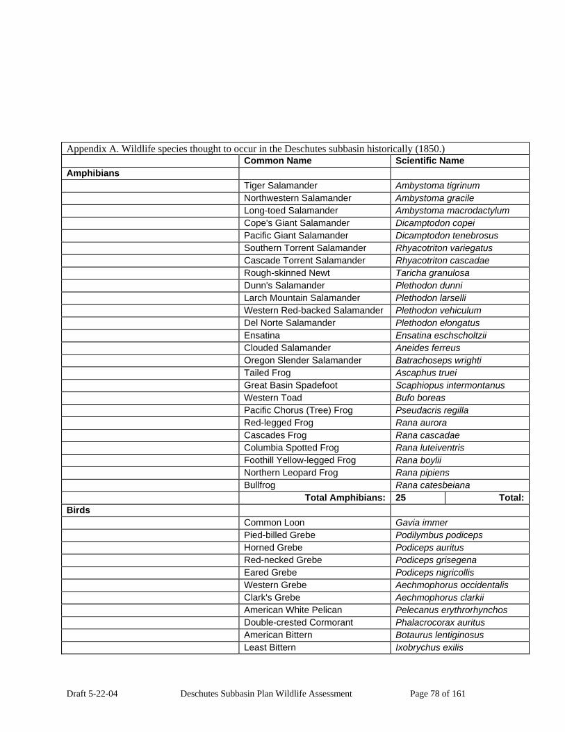
Draft 5-22-04 Deschutes Subbasin Plan Wildlife Assessment Page 78 of 161
Appendix A. Wildlife species thought to occur in the Deschutes subbasin historically (1850.) Common Name Scientific Name Amphibians Tiger Salamander Ambystoma tigrinum Northwestern Salamander Ambystoma gracile Long-toed Salamander Ambystoma macrodactylum Cope's Giant Salamander Dicamptodon copei Pacific Giant Salamander Dicamptodon tenebrosus Southern Torrent Salamander Rhyacotriton variegatus Cascade Torrent Salamander Rhyacotriton cascadae Rough-skinned Newt Taricha granulosa Dunn's Salamander Plethodon dunni Larch Mountain Salamander Plethodon larselli Western Red-backed Salamander Plethodon vehiculum Del Norte Salamander Plethodon elongatus Ensatina Ensatina eschscholtzii Clouded Salamander Aneides ferreus Oregon Slender Salamander Batrachoseps wrighti Tailed Frog Ascaphus truei Great Basin Spadefoot Scaphiopus intermontanus Western Toad Bufo boreas Pacific Chorus (Tree) Frog Pseudacris regilla Red-legged Frog Rana aurora Cascades Frog Rana cascadae Columbia Spotted Frog Rana luteiventris Foothill Yellow-legged Frog Rana boylii Northern Leopard Frog Rana pipiens Bullfrog Rana catesbeiana Total Amphibians: 25 Total:Birds Common Loon Gavia immer Pied-billed Grebe Podilymbus podiceps Horned Grebe Podiceps auritus Red-necked Grebe Podiceps grisegena Eared Grebe Podiceps nigricollis Western Grebe Aechmophorus occidentalis Clark's Grebe Aechmophorus clarkii American White Pelican Pelecanus erythrorhynchos Double-crested Cormorant Phalacrocorax auritus American Bittern Botaurus lentiginosus Least Bittern Ixobrychus exilis

Draft 5-22-04 Deschutes Subbasin Plan Wildlife Assessment Page 79 of 161
Appendix A. Wildlife species thought to occur in the Deschutes subbasin historically (1850.) Common Name Scientific Name Great Blue Heron Ardea herodias Great Egret Ardea alba Snowy Egret Egretta thula Cattle Egret Bubulcus ibis Green Heron Butorides virescens Black-crowned Night-heron Nycticorax nycticorax White-faced Ibis Plegadis chihi Turkey Vulture Cathartes aura Greater White-fronted Goose Anser albifrons Snow Goose Chen Ccaerulescens Ross's Goose Chen rossii Canada Goose Branta canadensis Trumpeter Swan Cygnus buccinator Tundra Swan Cygnus columbianus Wood Duck Aix sponsa Gadwall Anas strepera Eurasian Wigeon Anas penelope American Wigeon Anas americana Mallard Anas platyrhynchos Blue-winged Teal Anas discors Cinnamon Teal Anas cyanoptera Northern Shoveler Anas clypeata Northern Pintail Anas acuta Green-winged Teal Anas crecca Canvasback Aythya valisineria Redhead Aythya americana Ring-necked Duck Aythya collaris Greater Scaup Aythya marila Lesser Scaup Aythya affinis Harlequin Duck Histrionicus histrionicus Surf Scoter Melanitta perspicillata Bufflehead Bucephala albeola Common Goldeneye Bucephala clangula Barrow's Goldeneye Bucephala islandica Hooded Merganser Lophodytes cucullatus Common Merganser Mergus merganser Red-breasted Merganser Mergus serrator Ruddy Duck Oxyura jamaicensis Osprey Pandion haliaetus White-tailed Kite Elanus leucurus Bald Eagle Haliaeetus leucocephalus Northern Harrier Circus cyaneus Sharp-shinned Hawk Accipiter striatus

Draft 5-22-04 Deschutes Subbasin Plan Wildlife Assessment Page 80 of 161
Appendix A. Wildlife species thought to occur in the Deschutes subbasin historically (1850.) Common Name Scientific Name Cooper's Hawk Accipiter cooperii Northern Goshawk Accipiter gentilis Red-shouldered Hawk Buteo lineatus Swainson's Hawk Buteo swainsoni Red-tailed Hawk Buteo jamaicensis Ferruginous Hawk Buteo regalis Rough-legged Hawk Buteo lagopus Golden Eagle Aquila chrysaetos American Kestrel Falco sparverius Merlin Falco columbarius Gyrfalcon Falco rusticolus Peregrine Falcon Falco peregrinus Prairie Falcon Falco mexicanus Chukar Alectoris chukar Gray Partridge Perdix perdix Ring-necked Pheasant Phasianus colchicus Ruffed Grouse Bonasa umbellus Sage Grouse Centrocercus urophasianus Blue Grouse Dendragapus obscurus Sharp-tailed Grouse Tympanuchus phasianellus Wild Turkey Meleagris gallopavo Mountain Quail Oreortyx pictus California Quail Callipepla californica Northern Bobwhite Colinus virginianus Yellow Rail Coturnicops noveboracensis Virginia Rail Rallus limicola Sora Porzana carolina American Coot Fulica americana Sandhill Crane Grus canadensis Black-bellied Plover Pluvialis squatarola Pacific Golden-Plover Pluvialis fulva Snowy Plover Charadrius alexandrinus Semipalmated Plover Charadrius semipalmatus Killdeer Charadrius vociferus Black-necked Stilt Himantopus mexicanus American Avocet Recurvirostra americana Greater Yellowlegs Tringa melanoleuca Lesser Yellowlegs Tringa flavipes Solitary Sandpiper Tringa solitaria Willet Catoptrophorus semipalmatus Spotted Sandpiper Actitis macularia Upland Sandpiper Bartramia longicauda Long-billed Curlew Numenius americanus

Draft 5-22-04 Deschutes Subbasin Plan Wildlife Assessment Page 81 of 161
Appendix A. Wildlife species thought to occur in the Deschutes subbasin historically (1850.) Common Name Scientific Name Marbled Godwit Limosa fedoa Black Turnstone Arenaria melanocephala Sanderling Calidris alba Semipalmated Sandpiper Calidris pusilla Western Sandpiper Calidris mauri Least Sandpiper Calidris minutilla Baird's Sandpiper Calidris bairdii Pectoral Sandpiper Calidris melanotos Dunlin Calidris alpina Stilt Sandpiper Calidris himantopus Ruff Philomachus pugnax Short-billed Dowitcher Limnodromus griseus Long-billed Dowitcher Limnodromus scolopaceus Common Snipe Gallinago gallinago Wilson's Phalarope Phalaropus tricolor Red-necked Phalarope Phalaropus lobatus Franklin's Gull Larus pipixcan Bonaparte's Gull Larus philadelphia Mew Gull Larus canus Ring-billed Gull Larus delawarensis California Gull Larus californicus Herring Gull Larus argentatus Thayer's Gull Larus thayeri Western Gull Larus occidentalis Glaucous-winged Gull Larus glaucescens Glaucous Gull Larus hyperboreus Caspian Tern Sterna caspia Common Tern Sterna hirundo Forster's Tern Sterna forsteri Black Tern Chlidonias niger Marbled Murrelet Brachyramphus marmoratus Rock Dove Columba livia Band-tailed Pigeon Columba fasciata Mourning Dove Zenaida macroura Yellow-billed Cuckoo Coccyzus americanus Barn Owl Tyto alba Flammulated Owl Otus flammeolus Western Screech-owl Otus kennicottii Great Horned Owl Bubo virginianus Snowy Owl Nyctea scandiaca Northern Pygmy-owl Glaucidium gnoma Burrowing Owl Athene cunicularia Spotted Owl Strix occidentalis

Draft 5-22-04 Deschutes Subbasin Plan Wildlife Assessment Page 82 of 161
Appendix A. Wildlife species thought to occur in the Deschutes subbasin historically (1850.) Common Name Scientific Name Barred Owl Strix varia Great Gray Owl Strix nebulosa Long-eared Owl Asio otus Short-eared Owl Asio flammeus Boreal Owl Aegolius funereus Northern Saw-whet Owl Aegolius acadicus Common Nighthawk Chordeiles minor Common Poorwill Phalaenoptilus nuttallii Black Swift Cypseloides niger Vaux's Swift Chaetura vauxi White-throated Swift Aeronautes saxatalis Black-chinned Hummingbird Archilochus alexandri Anna's Hummingbird Calypte anna Calliope Hummingbird Stellula calliope Broad-tailed Hummingbird Selasphorus platycercus Rufous Hummingbird Selasphorus rufus Allen's Hummingbird Selasphorus sasin Belted Kingfisher Ceryle alcyon Lewis's Woodpecker Melanerpes lewis Acorn Woodpecker Melanerpes formicivorus Williamson's Sapsucker Sphyrapicus thyroideus Red-naped Sapsucker Sphyrapicus nuchalis Red-breasted Sapsucker Sphyrapicus ruber Downy Woodpecker Picoides pubescens Hairy Woodpecker Picoides villosus White-headed Woodpecker Picoides albolarvatus Three-toed Woodpecker Picoides tridactylus Black-backed Woodpecker Picoides arcticus Northern Flicker Colaptes auratus Pileated Woodpecker Dryocopus pileatus Olive-sided Flycatcher Contopus cooperi Western Wood-pewee Contopus sordidulus Willow Flycatcher Empidonax traillii Least Flycatcher Empidonax minimus Hammond's Flycatcher Empidonax hammondii Gray Flycatcher Empidonax wrightii Dusky Flycatcher Empidonax oberholseri Pacific-slope Flycatcher Empidonax difficilis Cordilleran Flycatcher Empidonax occidentalis Black Phoebe Sayornis nigricans Say's Phoebe Sayornis saya Ash-throated Flycatcher Myiarchus cinerascens Western Kingbird Tyrannus verticalis

Draft 5-22-04 Deschutes Subbasin Plan Wildlife Assessment Page 83 of 161
Appendix A. Wildlife species thought to occur in the Deschutes subbasin historically (1850.) Common Name Scientific Name Eastern Kingbird Tyrannus tyrannus Loggerhead Shrike Lanius ludovicianus Northern Shrike Lanius excubitor Cassin's Vireo Vireo cassinii Hutton's Vireo Vireo huttoni Warbling Vireo Vireo gilvus Red-eyed Vireo Vireo olivaceus Gray Jay Perisoreus canadensis Steller's Jay Cyanocitta stelleri Western Scrub-Jay Aphelocoma californica Pinyon Jay Gymnorhinus cyanocephalus Clark's Nutcracker Nucifraga columbiana Black-billed Magpie Pica pica American Crow Corvus brachyrhynchos Common Raven Corvus corax Horned Lark Eremophila alpestris Purple Martin Progne subis Tree Swallow Tachycineta bicolor Violet-green Swallow Tachycineta thalassina Northern Rough-winged Swallow Stelgidopteryx serripennis Bank Swallow Riparia riparia Cliff Swallow Petrochelidon pyrrhonota Barn Swallow Hirundo rustica Black-capped Chickadee Poecile atricapillus Mountain Chickadee Poecile gambeli Chestnut-backed Chickadee Poecile rufescens Oak Titmouse Baeolophus inornatus Juniper Titmouse Baeolophus griseus Bushtit Psaltriparus minimus Red-breasted Nuthatch Sitta canadensis White-breasted Nuthatch Sitta carolinensis Pygmy Nuthatch Sitta pygmaea Brown Creeper Certhia americana Rock Wren Salpinctes obsoletus Canyon Wren Catherpes mexicanus Bewick's Wren Thryomanes bewickii House Wren Troglodytes aedon Winter Wren Troglodytes troglodytes Marsh Wren Cistothorus palustris American Dipper Cinclus mexicanus Golden-crowned Kinglet Regulus satrapa Ruby-crowned Kinglet Regulus calendula Blue-gray Gnatcatcher Polioptila caerulea
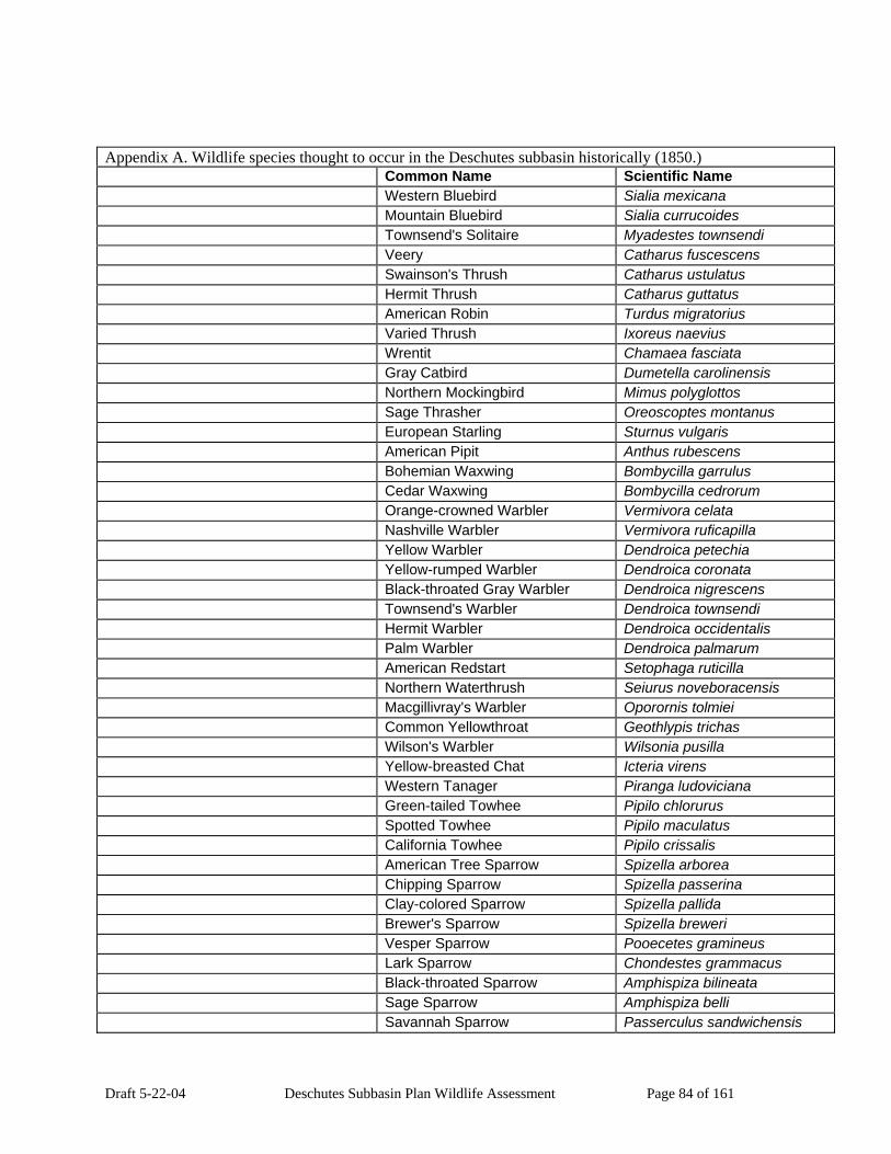
Draft 5-22-04 Deschutes Subbasin Plan Wildlife Assessment Page 84 of 161
Appendix A. Wildlife species thought to occur in the Deschutes subbasin historically (1850.) Common Name Scientific Name Western Bluebird Sialia mexicana Mountain Bluebird Sialia currucoides Townsend's Solitaire Myadestes townsendi Veery Catharus fuscescens Swainson's Thrush Catharus ustulatus Hermit Thrush Catharus guttatus American Robin Turdus migratorius Varied Thrush Ixoreus naevius Wrentit Chamaea fasciata Gray Catbird Dumetella carolinensis Northern Mockingbird Mimus polyglottos Sage Thrasher Oreoscoptes montanus European Starling Sturnus vulgaris American Pipit Anthus rubescens Bohemian Waxwing Bombycilla garrulus Cedar Waxwing Bombycilla cedrorum Orange-crowned Warbler Vermivora celata Nashville Warbler Vermivora ruficapilla Yellow Warbler Dendroica petechia Yellow-rumped Warbler Dendroica coronata Black-throated Gray Warbler Dendroica nigrescens Townsend's Warbler Dendroica townsendi Hermit Warbler Dendroica occidentalis Palm Warbler Dendroica palmarum American Redstart Setophaga ruticilla Northern Waterthrush Seiurus noveboracensis Macgillivray's Warbler Oporornis tolmiei Common Yellowthroat Geothlypis trichas Wilson's Warbler Wilsonia pusilla Yellow-breasted Chat Icteria virens Western Tanager Piranga ludoviciana Green-tailed Towhee Pipilo chlorurus Spotted Towhee Pipilo maculatus California Towhee Pipilo crissalis American Tree Sparrow Spizella arborea Chipping Sparrow Spizella passerina Clay-colored Sparrow Spizella pallida Brewer's Sparrow Spizella breweri Vesper Sparrow Pooecetes gramineus Lark Sparrow Chondestes grammacus Black-throated Sparrow Amphispiza bilineata Sage Sparrow Amphispiza belli Savannah Sparrow Passerculus sandwichensis

Draft 5-22-04 Deschutes Subbasin Plan Wildlife Assessment Page 85 of 161
Appendix A. Wildlife species thought to occur in the Deschutes subbasin historically (1850.) Common Name Scientific Name Grasshopper Sparrow Ammodramus savannarum Fox Sparrow Passerella iliaca Song Sparrow Melospiza melodia Lincoln's Sparrow Melospiza lincolnii Swamp Sparrow Melospiza georgiana White-crowned Sparrow Zonotrichia leucophrys Golden-crowned Sparrow Zonotrichia atricapilla Dark-eyed Junco Junco hyemalis Lapland Longspur Calcarius lapponicus Snow Bunting Plectrophenax nivalis Black-headed Grosbeak Pheucticus melanocephalus Lazuli Bunting Passerina amoena Bobolink Dolichonyx oryzivorus Red-winged Blackbird Agelaius phoeniceus Tricolored Blackbird Agelaius tricolor Western Meadowlark Sturnella neglecta Yellow-headed Blackbird Xanthocephalus
xanthocephalus Brewer's Blackbird Euphagus cyanocephalus Brown-headed Cowbird Molothrus ater Bullock's Oriole Icterus bullockii Gray-crowned Rosy-Finch Leucosticte tephrocotis Black Rosy-finch Leucosticte atrata Pine Grosbeak Pinicola enucleator Purple Finch Carpodacus purpureus Cassin's Finch Carpodacus cassinii House Finch Carpodacus mexicanus Red Crossbill Loxia curvirostra White-winged Crossbill Loxia leucoptera Common Redpoll Carduelis flammea Pine Siskin Carduelis pinus Lesser Goldfinch Carduelis psaltria American Goldfinch Carduelis tristis Evening Grosbeak Coccothraustes vespertinus Total Birds: 302 :Mammals Virginia Opossum Didelphis virginiana Preble's Shrew Sorex preblei Vagrant Shrew Sorex vagrans Montane Shrew Sorex monticolus Baird's Shrew Sorex bairdi Fog Shrew Sorex sonomae Pacific Shrew Sorex pacificus Water Shrew Sorex palustris

Draft 5-22-04 Deschutes Subbasin Plan Wildlife Assessment Page 86 of 161
Appendix A. Wildlife species thought to occur in the Deschutes subbasin historically (1850.) Common Name Scientific Name Pacific Water Shrew Sorex bendirii Trowbridge's Shrew Sorex trowbridgii Merriam's Shrew Sorex merriami Shrew-mole Neurotrichus gibbsii Townsend's Mole Scapanus townsendii Coast Mole Scapanus orarius Broad-footed Mole Scapanus latimanus California Myotis Myotis californicus Western Small-footed Myotis Myotis ciliolabrum Yuma Myotis Myotis yumanensis Little Brown Myotis Myotis lucifugus Long-legged Myotis Myotis volans Fringed Myotis Myotis thysanodes Long-eared Myotis Myotis evotis Silver-haired Bat Lasionycteris noctivagans Western Pipistrelle Pipistrellus hesperus Big Brown Bat Eptesicus fuscus Hoary Bat Lasiurus cinereus Spotted Bat Euderma maculatum Townsend's Big-eared Bat Corynorhinus townsendii Pallid Bat Antrozous pallidus Brazilian Free-tailed Bat Tadarida brasiliensis American Pika Ochotona princeps Pygmy Rabbit Brachylagus idahoensis Brush Rabbit Sylvilagus bachmani Eastern Cottontail Sylvilagus floridanus Nuttall's (Mountain) Cottontail Sylvilagus nuttallii Snowshoe Hare Lepus americanus White-tailed Jackrabbit Lepus townsendii Black-tailed Jackrabbit Lepus californicus Mountain Beaver Aplodontia rufa Least Chipmunk Tamias minimus Yellow-pine Chipmunk Tamias amoenus Townsend's Chipmunk Tamias townsendii Allen's Chipmunk Tamias senex Siskiyou Chipmunk Tamias siskiyou Yellow-bellied Marmot Marmota flaviventris White-tailed Antelope Squirrel Ammospermophilus leucurus Townsend's Ground Squirrel Spermophilus townsendii Merriam's Ground Squirrel Spermophilus canus Piute Ground Squirrel Spermophilus mollis Belding's Ground Squirrel Spermophilus beldingi Columbian Ground Squirrel Spermophilus columbianus

Draft 5-22-04 Deschutes Subbasin Plan Wildlife Assessment Page 87 of 161
Appendix A. Wildlife species thought to occur in the Deschutes subbasin historically (1850.) Common Name Scientific Name California Ground Squirrel Spermophilus beecheyi Golden-mantled Ground Squirrel Spermophilus lateralis Eastern Fox Squirrel Sciurus niger Western Gray Squirrel Sciurus griseus Red Squirrel Tamiasciurus hudsonicus Douglas' Squirrel Tamiasciurus douglasii Northern Flying Squirrel Glaucomys sabrinus Northern Pocket Gopher Thomomys talpoides Western Pocket Gopher Thomomys mazama Townsend's Pocket Gopher Thomomys townsendii Great Basin Pocket Mouse Perognathus parvus Little Pocket Mouse Perognathus longimembris Dark Kangaroo Mouse Microdipodops megacephalus Ord's Kangaroo Rat Dipodomys ordii Chisel-toothed Kangaroo Rat Dipodomys microps California Kangaroo Rat Dipodomys californicus American Beaver Castor canadensis Western Harvest Mouse Reithrodontomys megalotis Deer Mouse Peromyscus maniculatus Canyon Mouse Peromyscus crinitus Pinon Mouse Peromyscus truei Northern Grasshopper Mouse Onychomys leucogaster Desert Woodrat Neotoma lepida Dusky-footed Woodrat Neotoma fuscipes Bushy-tailed Woodrat Neotoma cinerea Southern Red-backed Vole Clethrionomys gapperi Western Red-backed Vole Clethrionomys californicus Heather Vole Phenacomys intermedius White-footed Vole Phenacomys albipes Red Tree Vole Phenacomys longicaudus Montane Vole Microtus montanus California Vole Microtus californicus Townsend's Vole Microtus townsendii Long-tailed Vole Microtus longicaudus Creeping Vole Microtus oregoni Water Vole Microtus richardsoni Sagebrush Vole Lemmiscus curtatus Muskrat Ondatra zibethicus Western Jumping Mouse Zapus princeps Pacific Jumping Mouse Zapus trinotatus Common Porcupine Erethizon dorsatum Nutria Myocastor coypus Coyote Canis latrans
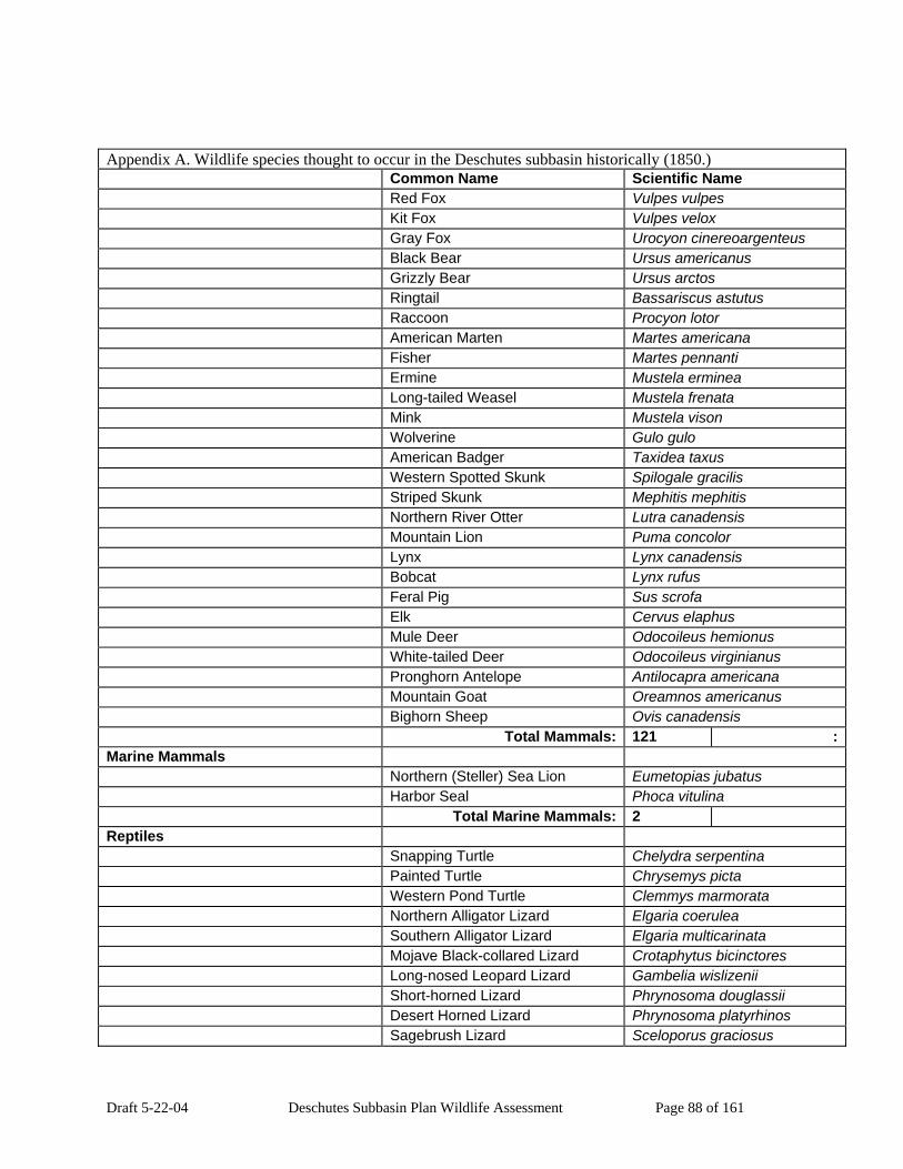
Draft 5-22-04 Deschutes Subbasin Plan Wildlife Assessment Page 88 of 161
Appendix A. Wildlife species thought to occur in the Deschutes subbasin historically (1850.) Common Name Scientific Name Red Fox Vulpes vulpes Kit Fox Vulpes velox Gray Fox Urocyon cinereoargenteus Black Bear Ursus americanus Grizzly Bear Ursus arctos Ringtail Bassariscus astutus Raccoon Procyon lotor American Marten Martes americana Fisher Martes pennanti Ermine Mustela erminea Long-tailed Weasel Mustela frenata Mink Mustela vison Wolverine Gulo gulo American Badger Taxidea taxus Western Spotted Skunk Spilogale gracilis Striped Skunk Mephitis mephitis Northern River Otter Lutra canadensis Mountain Lion Puma concolor Lynx Lynx canadensis Bobcat Lynx rufus Feral Pig Sus scrofa Elk Cervus elaphus Mule Deer Odocoileus hemionus White-tailed Deer Odocoileus virginianus Pronghorn Antelope Antilocapra americana Mountain Goat Oreamnos americanus Bighorn Sheep Ovis canadensis Total Mammals: 121 :Marine Mammals Northern (Steller) Sea Lion Eumetopias jubatus Harbor Seal Phoca vitulina Total Marine Mammals: 2 Reptiles Snapping Turtle Chelydra serpentina Painted Turtle Chrysemys picta Western Pond Turtle Clemmys marmorata Northern Alligator Lizard Elgaria coerulea Southern Alligator Lizard Elgaria multicarinata Mojave Black-collared Lizard Crotaphytus bicinctores Long-nosed Leopard Lizard Gambelia wislizenii Short-horned Lizard Phrynosoma douglassii Desert Horned Lizard Phrynosoma platyrhinos Sagebrush Lizard Sceloporus graciosus

Draft 5-22-04 Deschutes Subbasin Plan Wildlife Assessment Page 89 of 161
Appendix A. Wildlife species thought to occur in the Deschutes subbasin historically (1850.) Common Name Scientific Name Western Fence Lizard Sceloporus occidentalis Side-blotched Lizard Uta stansburiana Western Skink Eumeces skiltonianus Western Whiptail Cnemidophorus tigris Plateau Striped Whiptail Cnemidophorus velox Rubber Boa Charina bottae Racer Coluber constrictor Sharptail Snake Contia tenuis Ringneck Snake Diadophis punctatus Night Snake Hypsiglena torquata Common Kingsnake Lampropeltis getula California Mountain Kingsnake Lampropeltis zonata Striped Whipsnake Masticophis taeniatus Gopher Snake Pituophis catenifer Pacific Coast Aquatic Garter
Snake Thamnophis atratus
Western Terrestrial Garter Snake Thamnophis elegans Northwestern Garter Snake Thamnophis ordinoides Common Garter Snake Thamnophis sirtalis Western Rattlesnake Crotalus viridis Total Reptiles: 29 : Total Species: 479 Subbasin Species Occurrences Generated by IBIS on 10/13/2003 12:00:16 PM.
Copyright 1998-2003. Please visit the IBIS web site (www.nwhi.org/ibis) for Copyright and Terms of Use limitations. This data is continually updated and therefore subject to change.
Appendix B. Wildlife thought to occur in the Deschutes subbasin currently (1999.) Common Name Scientific Name Amphibians Tiger Salamander Ambystoma tigrinum

Draft 5-22-04 Deschutes Subbasin Plan Wildlife Assessment Page 90 of 161
Appendix B. Wildlife thought to occur in the Deschutes subbasin currently (1999.) Common Name Scientific Name Northwestern Salamander Ambystoma gracile Long-toed Salamander Ambystoma macrodactylum Cope's Giant Salamander Dicamptodon copei Pacific Giant Salamander Dicamptodon tenebrosus Southern Torrent Salamander Rhyacotriton variegatus Cascade Torrent Salamander Rhyacotriton cascadae Rough-skinned Newt Taricha granulosa Dunn's Salamander Plethodon dunni Larch Mountain Salamander Plethodon larselli Western Red-backed Salamander Plethodon vehiculum Del Norte Salamander Plethodon elongatus Ensatina Ensatina eschscholtzii Clouded Salamander Aneides ferreus Oregon Slender Salamander Batrachoseps wrighti Tailed Frog Ascaphus truei Great Basin Spadefoot Scaphiopus intermontanus Western Toad Bufo boreas Pacific Chorus (Tree) Frog Pseudacris regilla Red-legged Frog Rana aurora Cascades Frog Rana cascadae Columbia Spotted Frog Rana luteiventris Foothill Yellow-legged Frog Rana boylii Northern Leopard Frog Rana pipiens Bullfrog Rana catesbeiana Total Amphibians: 25 TBirds Common Loon Gavia immer Pied-billed Grebe Podilymbus podiceps Horned Grebe Podiceps auritus Red-necked Grebe Podiceps grisegena Eared Grebe Podiceps nigricollis Western Grebe Aechmophorus occidentalis Clark's Grebe Aechmophorus clarkii American White Pelican Pelecanus erythrorhynchos Brown Pelican Pelecanus occidentalis Double-crested Cormorant Phalacrocorax auritus American Bittern Botaurus lentiginosus Least Bittern Ixobrychus exilis Great Blue Heron Ardea herodias Great Egret Ardea alba Snowy Egret Egretta thula Cattle Egret Bubulcus ibis Green Heron Butorides virescens
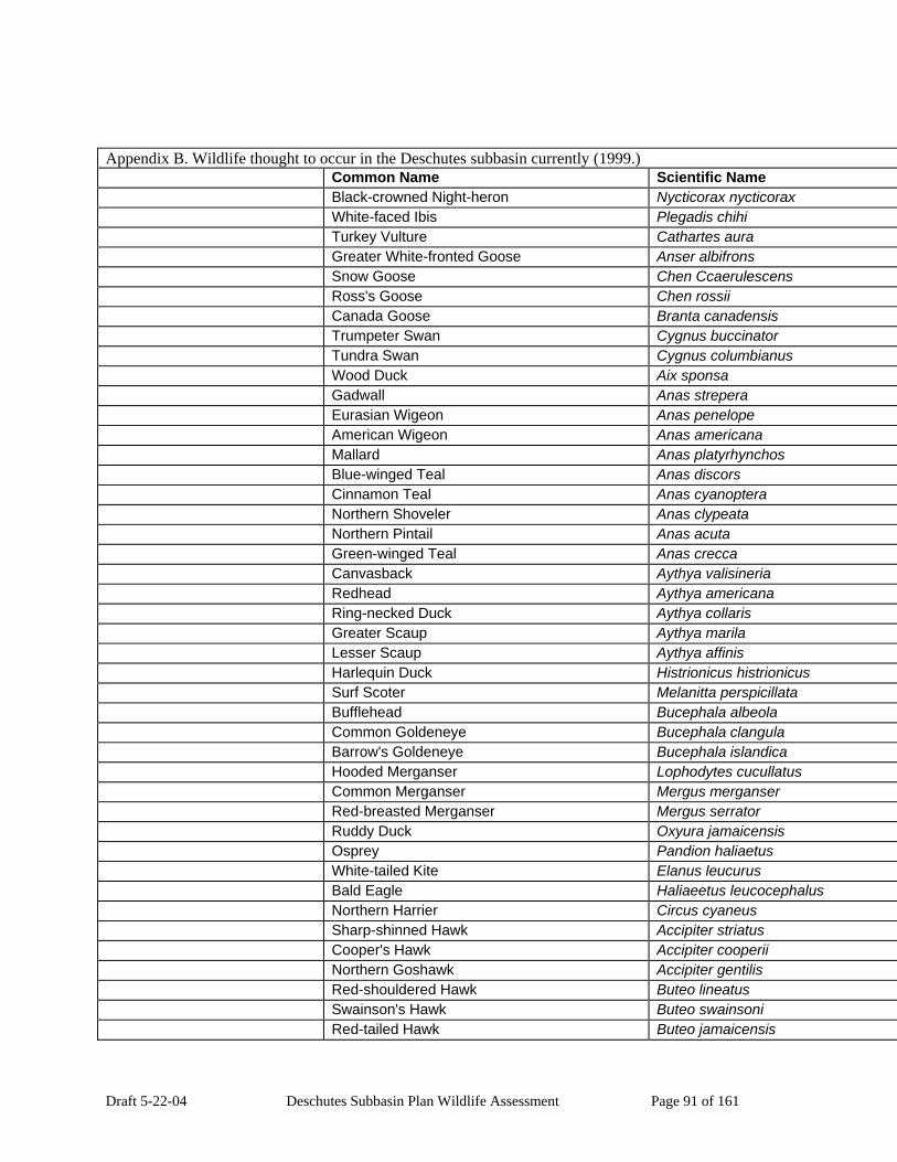
Draft 5-22-04 Deschutes Subbasin Plan Wildlife Assessment Page 91 of 161
Appendix B. Wildlife thought to occur in the Deschutes subbasin currently (1999.) Common Name Scientific Name Black-crowned Night-heron Nycticorax nycticorax White-faced Ibis Plegadis chihi Turkey Vulture Cathartes aura Greater White-fronted Goose Anser albifrons Snow Goose Chen Ccaerulescens Ross's Goose Chen rossii Canada Goose Branta canadensis Trumpeter Swan Cygnus buccinator Tundra Swan Cygnus columbianus Wood Duck Aix sponsa Gadwall Anas strepera Eurasian Wigeon Anas penelope American Wigeon Anas americana Mallard Anas platyrhynchos Blue-winged Teal Anas discors Cinnamon Teal Anas cyanoptera Northern Shoveler Anas clypeata Northern Pintail Anas acuta Green-winged Teal Anas crecca Canvasback Aythya valisineria Redhead Aythya americana Ring-necked Duck Aythya collaris Greater Scaup Aythya marila Lesser Scaup Aythya affinis Harlequin Duck Histrionicus histrionicus Surf Scoter Melanitta perspicillata Bufflehead Bucephala albeola Common Goldeneye Bucephala clangula Barrow's Goldeneye Bucephala islandica Hooded Merganser Lophodytes cucullatus Common Merganser Mergus merganser Red-breasted Merganser Mergus serrator Ruddy Duck Oxyura jamaicensis Osprey Pandion haliaetus White-tailed Kite Elanus leucurus Bald Eagle Haliaeetus leucocephalus Northern Harrier Circus cyaneus Sharp-shinned Hawk Accipiter striatus Cooper's Hawk Accipiter cooperii Northern Goshawk Accipiter gentilis Red-shouldered Hawk Buteo lineatus Swainson's Hawk Buteo swainsoni Red-tailed Hawk Buteo jamaicensis

Draft 5-22-04 Deschutes Subbasin Plan Wildlife Assessment Page 92 of 161
Appendix B. Wildlife thought to occur in the Deschutes subbasin currently (1999.) Common Name Scientific Name Ferruginous Hawk Buteo regalis Rough-legged Hawk Buteo lagopus Golden Eagle Aquila chrysaetos American Kestrel Falco sparverius Merlin Falco columbarius Gyrfalcon Falco rusticolus Peregrine Falcon Falco peregrinus Prairie Falcon Falco mexicanus Chukar Alectoris chukar Gray Partridge Perdix perdix Ring-necked Pheasant Phasianus colchicus Ruffed Grouse Bonasa umbellus Sage Grouse Centrocercus urophasianus Blue Grouse Dendragapus obscurus Sharp-tailed Grouse Tympanuchus phasianellus Wild Turkey Meleagris gallopavo Mountain Quail Oreortyx pictus California Quail Callipepla californica Northern Bobwhite Colinus virginianus Yellow Rail Coturnicops noveboracensis Virginia Rail Rallus limicola Sora Porzana carolina American Coot Fulica americana Sandhill Crane Grus canadensis Black-bellied Plover Pluvialis squatarola Pacific Golden-Plover Pluvialis fulva Snowy Plover Charadrius alexandrinus Semipalmated Plover Charadrius semipalmatus Killdeer Charadrius vociferus Black-necked Stilt Himantopus mexicanus American Avocet Recurvirostra americana Greater Yellowlegs Tringa melanoleuca Lesser Yellowlegs Tringa flavipes Solitary Sandpiper Tringa solitaria Willet Catoptrophorus semipalmatus Spotted Sandpiper Actitis macularia Upland Sandpiper Bartramia longicauda Whimbrel Numenius phaeopus Long-billed Curlew Numenius americanus Marbled Godwit Limosa fedoa Black Turnstone Arenaria melanocephala Red Knot Calidris canutus Sanderling Calidris alba

Draft 5-22-04 Deschutes Subbasin Plan Wildlife Assessment Page 93 of 161
Appendix B. Wildlife thought to occur in the Deschutes subbasin currently (1999.) Common Name Scientific Name Semipalmated Sandpiper Calidris pusilla Western Sandpiper Calidris mauri Least Sandpiper Calidris minutilla Baird's Sandpiper Calidris bairdii Pectoral Sandpiper Calidris melanotos Dunlin Calidris alpina Stilt Sandpiper Calidris himantopus Ruff Philomachus pugnax Short-billed Dowitcher Limnodromus griseus Long-billed Dowitcher Limnodromus scolopaceus Common Snipe Gallinago gallinago Wilson's Phalarope Phalaropus tricolor Red-necked Phalarope Phalaropus lobatus Franklin's Gull Larus pipixcan Bonaparte's Gull Larus philadelphia Heermann's Gull Larus heermanni Mew Gull Larus canus Ring-billed Gull Larus delawarensis California Gull Larus californicus Herring Gull Larus argentatus Thayer's Gull Larus thayeri Western Gull Larus occidentalis Glaucous-winged Gull Larus glaucescens Glaucous Gull Larus hyperboreus Caspian Tern Sterna caspia Common Tern Sterna hirundo Forster's Tern Sterna forsteri Black Tern Chlidonias niger Marbled Murrelet Brachyramphus marmoratus Rock Dove Columba livia Band-tailed Pigeon Columba fasciata Mourning Dove Zenaida macroura Yellow-billed Cuckoo Coccyzus americanus Barn Owl Tyto alba Flammulated Owl Otus flammeolus Western Screech-owl Otus kennicottii Great Horned Owl Bubo virginianus Snowy Owl Nyctea scandiaca Northern Pygmy-owl Glaucidium gnoma Burrowing Owl Athene cunicularia Spotted Owl Strix occidentalis Barred Owl Strix varia Great Gray Owl Strix nebulosa

Draft 5-22-04 Deschutes Subbasin Plan Wildlife Assessment Page 94 of 161
Appendix B. Wildlife thought to occur in the Deschutes subbasin currently (1999.) Common Name Scientific Name Long-eared Owl Asio otus Short-eared Owl Asio flammeus Boreal Owl Aegolius funereus Northern Saw-whet Owl Aegolius acadicus Common Nighthawk Chordeiles minor Common Poorwill Phalaenoptilus nuttallii Black Swift Cypseloides niger Vaux's Swift Chaetura vauxi White-throated Swift Aeronautes saxatalis Black-chinned Hummingbird Archilochus alexandri Anna's Hummingbird Calypte anna Calliope Hummingbird Stellula calliope Broad-tailed Hummingbird Selasphorus platycercus Rufous Hummingbird Selasphorus rufus Allen's Hummingbird Selasphorus sasin Belted Kingfisher Ceryle alcyon Lewis's Woodpecker Melanerpes lewis Acorn Woodpecker Melanerpes formicivorus Williamson's Sapsucker Sphyrapicus thyroideus Red-naped Sapsucker Sphyrapicus nuchalis Red-breasted Sapsucker Sphyrapicus ruber Downy Woodpecker Picoides pubescens Hairy Woodpecker Picoides villosus White-headed Woodpecker Picoides albolarvatus Three-toed Woodpecker Picoides tridactylus Black-backed Woodpecker Picoides arcticus Northern Flicker Colaptes auratus Pileated Woodpecker Dryocopus pileatus Olive-sided Flycatcher Contopus cooperi Western Wood-pewee Contopus sordidulus Willow Flycatcher Empidonax traillii Least Flycatcher Empidonax minimus Hammond's Flycatcher Empidonax hammondii Gray Flycatcher Empidonax wrightii Dusky Flycatcher Empidonax oberholseri Pacific-slope Flycatcher Empidonax difficilis Cordilleran Flycatcher Empidonax occidentalis Black Phoebe Sayornis nigricans Say's Phoebe Sayornis saya Ash-throated Flycatcher Myiarchus cinerascens Western Kingbird Tyrannus verticalis Eastern Kingbird Tyrannus tyrannus Loggerhead Shrike Lanius ludovicianus

Draft 5-22-04 Deschutes Subbasin Plan Wildlife Assessment Page 95 of 161
Appendix B. Wildlife thought to occur in the Deschutes subbasin currently (1999.) Common Name Scientific Name Northern Shrike Lanius excubitor Cassin's Vireo Vireo cassinii Hutton's Vireo Vireo huttoni Warbling Vireo Vireo gilvus Red-eyed Vireo Vireo olivaceus Gray Jay Perisoreus canadensis Steller's Jay Cyanocitta stelleri Western Scrub-Jay Aphelocoma californica Pinyon Jay Gymnorhinus cyanocephalus Clark's Nutcracker Nucifraga columbiana Black-billed Magpie Pica pica American Crow Corvus brachyrhynchos Common Raven Corvus corax Horned Lark Eremophila alpestris Purple Martin Progne subis Tree Swallow Tachycineta bicolor Violet-green Swallow Tachycineta thalassina Northern Rough-winged Swallow Stelgidopteryx serripennis Bank Swallow Riparia riparia Cliff Swallow Petrochelidon pyrrhonota Barn Swallow Hirundo rustica Black-capped Chickadee Poecile atricapillus Mountain Chickadee Poecile gambeli Chestnut-backed Chickadee Poecile rufescens Oak Titmouse Baeolophus inornatus Juniper Titmouse Baeolophus griseus Bushtit Psaltriparus minimus Red-breasted Nuthatch Sitta canadensis White-breasted Nuthatch Sitta carolinensis Pygmy Nuthatch Sitta pygmaea Brown Creeper Certhia americana Rock Wren Salpinctes obsoletus Canyon Wren Catherpes mexicanus Bewick's Wren Thryomanes bewickii House Wren Troglodytes aedon Winter Wren Troglodytes troglodytes Marsh Wren Cistothorus palustris American Dipper Cinclus mexicanus Golden-crowned Kinglet Regulus satrapa Ruby-crowned Kinglet Regulus calendula Blue-gray Gnatcatcher Polioptila caerulea Western Bluebird Sialia mexicana Mountain Bluebird Sialia currucoides

Draft 5-22-04 Deschutes Subbasin Plan Wildlife Assessment Page 96 of 161
Appendix B. Wildlife thought to occur in the Deschutes subbasin currently (1999.) Common Name Scientific Name Townsend's Solitaire Myadestes townsendi Veery Catharus fuscescens Swainson's Thrush Catharus ustulatus Hermit Thrush Catharus guttatus American Robin Turdus migratorius Varied Thrush Ixoreus naevius Wrentit Chamaea fasciata Gray Catbird Dumetella carolinensis Northern Mockingbird Mimus polyglottos Sage Thrasher Oreoscoptes montanus European Starling Sturnus vulgaris American Pipit Anthus rubescens Bohemian Waxwing Bombycilla garrulus Cedar Waxwing Bombycilla cedrorum Orange-crowned Warbler Vermivora celata Nashville Warbler Vermivora ruficapilla Yellow Warbler Dendroica petechia Yellow-rumped Warbler Dendroica coronata Black-throated Gray Warbler Dendroica nigrescens Townsend's Warbler Dendroica townsendi Hermit Warbler Dendroica occidentalis Palm Warbler Dendroica palmarum American Redstart Setophaga ruticilla Northern Waterthrush Seiurus noveboracensis Macgillivray's Warbler Oporornis tolmiei Common Yellowthroat Geothlypis trichas Wilson's Warbler Wilsonia pusilla Yellow-breasted Chat Icteria virens Western Tanager Piranga ludoviciana Green-tailed Towhee Pipilo chlorurus Spotted Towhee Pipilo maculatus California Towhee Pipilo crissalis American Tree Sparrow Spizella arborea Chipping Sparrow Spizella passerina Clay-colored Sparrow Spizella pallida Brewer's Sparrow Spizella breweri Vesper Sparrow Pooecetes gramineus Lark Sparrow Chondestes grammacus Black-throated Sparrow Amphispiza bilineata Sage Sparrow Amphispiza belli Savannah Sparrow Passerculus sandwichensis Grasshopper Sparrow Ammodramus savannarum Fox Sparrow Passerella iliaca

Draft 5-22-04 Deschutes Subbasin Plan Wildlife Assessment Page 97 of 161
Appendix B. Wildlife thought to occur in the Deschutes subbasin currently (1999.) Common Name Scientific Name Song Sparrow Melospiza melodia Lincoln's Sparrow Melospiza lincolnii Swamp Sparrow Melospiza georgiana White-throated Sparrow Zonotrichia albicollis Harris's Sparrow Zonotrichia querula White-crowned Sparrow Zonotrichia leucophrys Golden-crowned Sparrow Zonotrichia atricapilla Dark-eyed Junco Junco hyemalis Lapland Longspur Calcarius lapponicus Snow Bunting Plectrophenax nivalis Black-headed Grosbeak Pheucticus melanocephalus Lazuli Bunting Passerina amoena Bobolink Dolichonyx oryzivorus Red-winged Blackbird Agelaius phoeniceus Tricolored Blackbird Agelaius tricolor Western Meadowlark Sturnella neglecta Yellow-headed Blackbird Xanthocephalus xanthocephalus Brewer's Blackbird Euphagus cyanocephalus Brown-headed Cowbird Molothrus ater Bullock's Oriole Icterus bullockii Gray-crowned Rosy-Finch Leucosticte tephrocotis Black Rosy-finch Leucosticte atrata Pine Grosbeak Pinicola enucleator Purple Finch Carpodacus purpureus Cassin's Finch Carpodacus cassinii House Finch Carpodacus mexicanus Red Crossbill Loxia curvirostra White-winged Crossbill Loxia leucoptera Common Redpoll Carduelis flammea Pine Siskin Carduelis pinus Lesser Goldfinch Carduelis psaltria American Goldfinch Carduelis tristis Evening Grosbeak Coccothraustes vespertinus House Sparrow Passer domesticus Total Birds: 309 TMammals Virginia Opossum Didelphis virginiana Preble's Shrew Sorex preblei Vagrant Shrew Sorex vagrans Montane Shrew Sorex monticolus Baird's Shrew Sorex bairdi Fog Shrew Sorex sonomae Pacific Shrew Sorex pacificus

Draft 5-22-04 Deschutes Subbasin Plan Wildlife Assessment Page 98 of 161
Appendix B. Wildlife thought to occur in the Deschutes subbasin currently (1999.) Common Name Scientific Name Water Shrew Sorex palustris Pacific Water Shrew Sorex bendirii Trowbridge's Shrew Sorex trowbridgii Merriam's Shrew Sorex merriami Shrew-mole Neurotrichus gibbsii Townsend's Mole Scapanus townsendii Coast Mole Scapanus orarius Broad-footed Mole Scapanus latimanus California Myotis Myotis californicus Western Small-footed Myotis Myotis ciliolabrum Yuma Myotis Myotis yumanensis Little Brown Myotis Myotis lucifugus Long-legged Myotis Myotis volans Fringed Myotis Myotis thysanodes Long-eared Myotis Myotis evotis Silver-haired Bat Lasionycteris noctivagans Western Pipistrelle Pipistrellus hesperus Big Brown Bat Eptesicus fuscus Hoary Bat Lasiurus cinereus Spotted Bat Euderma maculatum Townsend's Big-eared Bat Corynorhinus townsendii Pallid Bat Antrozous pallidus Brazilian Free-tailed Bat Tadarida brasiliensis American Pika Ochotona princeps Pygmy Rabbit Brachylagus idahoensis Brush Rabbit Sylvilagus bachmani Eastern Cottontail Sylvilagus floridanus Nuttall's (Mountain) Cottontail Sylvilagus nuttallii Snowshoe Hare Lepus americanus White-tailed Jackrabbit Lepus townsendii Black-tailed Jackrabbit Lepus californicus Mountain Beaver Aplodontia rufa Least Chipmunk Tamias minimus Yellow-pine Chipmunk Tamias amoenus Townsend's Chipmunk Tamias townsendii Allen's Chipmunk Tamias senex Siskiyou Chipmunk Tamias siskiyou Yellow-bellied Marmot Marmota flaviventris White-tailed Antelope Squirrel Ammospermophilus leucurus Townsend's Ground Squirrel Spermophilus townsendii Merriam's Ground Squirrel Spermophilus canus Piute Ground Squirrel Spermophilus mollis Belding's Ground Squirrel Spermophilus beldingi
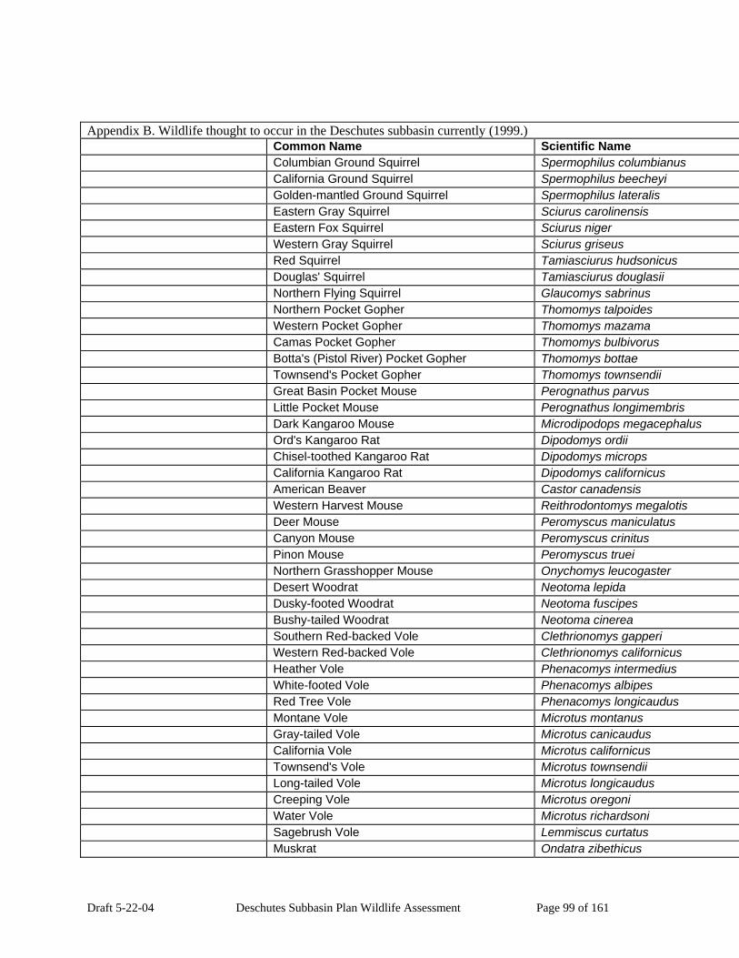
Draft 5-22-04 Deschutes Subbasin Plan Wildlife Assessment Page 99 of 161
Appendix B. Wildlife thought to occur in the Deschutes subbasin currently (1999.) Common Name Scientific Name Columbian Ground Squirrel Spermophilus columbianus California Ground Squirrel Spermophilus beecheyi Golden-mantled Ground Squirrel Spermophilus lateralis Eastern Gray Squirrel Sciurus carolinensis Eastern Fox Squirrel Sciurus niger Western Gray Squirrel Sciurus griseus Red Squirrel Tamiasciurus hudsonicus Douglas' Squirrel Tamiasciurus douglasii Northern Flying Squirrel Glaucomys sabrinus Northern Pocket Gopher Thomomys talpoides Western Pocket Gopher Thomomys mazama Camas Pocket Gopher Thomomys bulbivorus Botta's (Pistol River) Pocket Gopher Thomomys bottae Townsend's Pocket Gopher Thomomys townsendii Great Basin Pocket Mouse Perognathus parvus Little Pocket Mouse Perognathus longimembris Dark Kangaroo Mouse Microdipodops megacephalus Ord's Kangaroo Rat Dipodomys ordii Chisel-toothed Kangaroo Rat Dipodomys microps California Kangaroo Rat Dipodomys californicus American Beaver Castor canadensis Western Harvest Mouse Reithrodontomys megalotis Deer Mouse Peromyscus maniculatus Canyon Mouse Peromyscus crinitus Pinon Mouse Peromyscus truei Northern Grasshopper Mouse Onychomys leucogaster Desert Woodrat Neotoma lepida Dusky-footed Woodrat Neotoma fuscipes Bushy-tailed Woodrat Neotoma cinerea Southern Red-backed Vole Clethrionomys gapperi Western Red-backed Vole Clethrionomys californicus Heather Vole Phenacomys intermedius White-footed Vole Phenacomys albipes Red Tree Vole Phenacomys longicaudus Montane Vole Microtus montanus Gray-tailed Vole Microtus canicaudus California Vole Microtus californicus Townsend's Vole Microtus townsendii Long-tailed Vole Microtus longicaudus Creeping Vole Microtus oregoni Water Vole Microtus richardsoni Sagebrush Vole Lemmiscus curtatus Muskrat Ondatra zibethicus

Draft 5-22-04 Deschutes Subbasin Plan Wildlife Assessment Page 100 of 161
Appendix B. Wildlife thought to occur in the Deschutes subbasin currently (1999.) Common Name Scientific Name Black Rat Rattus rattus Norway Rat Rattus norvegicus House Mouse Mus musculus Western Jumping Mouse Zapus princeps Pacific Jumping Mouse Zapus trinotatus Common Porcupine Erethizon dorsatum Nutria Myocastor coypus Coyote Canis latrans Red Fox Vulpes vulpes Kit Fox Vulpes velox Gray Fox Urocyon cinereoargenteus Black Bear Ursus americanus Grizzly Bear Ursus arctos Ringtail Bassariscus astutus Raccoon Procyon lotor American Marten Martes americana Fisher Martes pennanti Ermine Mustela erminea Long-tailed Weasel Mustela frenata Mink Mustela vison Wolverine Gulo gulo American Badger Taxidea taxus Western Spotted Skunk Spilogale gracilis Striped Skunk Mephitis mephitis Northern River Otter Lutra canadensis Mountain Lion Puma concolor Lynx Lynx canadensis Bobcat Lynx rufus Feral Pig Sus scrofa Elk Cervus elaphus Mule Deer Odocoileus hemionus White-tailed Deer Odocoileus virginianus Pronghorn Antelope Antilocapra americana Mountain Goat Oreamnos americanus Bighorn Sheep Ovis canadensis Total Mammals: 128 TMarine Mammals Northern (Steller) Sea Lion Eumetopias jubatus Harbor Seal Phoca vitulina Total Marine Mammals: 2 TReptiles Snapping Turtle Chelydra serpentina Painted Turtle Chrysemys picta

Draft 5-22-04 Deschutes Subbasin Plan Wildlife Assessment Page 101 of 161
Appendix B. Wildlife thought to occur in the Deschutes subbasin currently (1999.) Common Name Scientific Name Western Pond Turtle Clemmys marmorata Northern Alligator Lizard Elgaria coerulea Southern Alligator Lizard Elgaria multicarinata Mojave Black-collared Lizard Crotaphytus bicinctores Long-nosed Leopard Lizard Gambelia wislizenii Short-horned Lizard Phrynosoma douglassii Desert Horned Lizard Phrynosoma platyrhinos Sagebrush Lizard Sceloporus graciosus Western Fence Lizard Sceloporus occidentalis Side-blotched Lizard Uta stansburiana Western Skink Eumeces skiltonianus Western Whiptail Cnemidophorus tigris Plateau Striped Whiptail Cnemidophorus velox Rubber Boa Charina bottae Racer Coluber constrictor Sharptail Snake Contia tenuis Ringneck Snake Diadophis punctatus Night Snake Hypsiglena torquata Common Kingsnake Lampropeltis getula California Mountain Kingsnake Lampropeltis zonata Striped Whipsnake Masticophis taeniatus Gopher Snake Pituophis catenifer Pacific Coast Aquatic Garter Snake Thamnophis atratus Western Terrestrial Garter Snake Thamnophis elegans Northwestern Garter Snake Thamnophis ordinoides Common Garter Snake Thamnophis sirtalis Western Rattlesnake Crotalus viridis Total Reptiles: 29 T Total Species: 493 T Subbasin Species Occurrences Generated by IBIS on 10/10/2003 4:56:56 PM.
Copyright 1998-2003. Please visit the IBIS web site (www.nwhi.org/ibis) for Copyright and Terms of Use limitations. This data is continually updated and therefore subject to change.
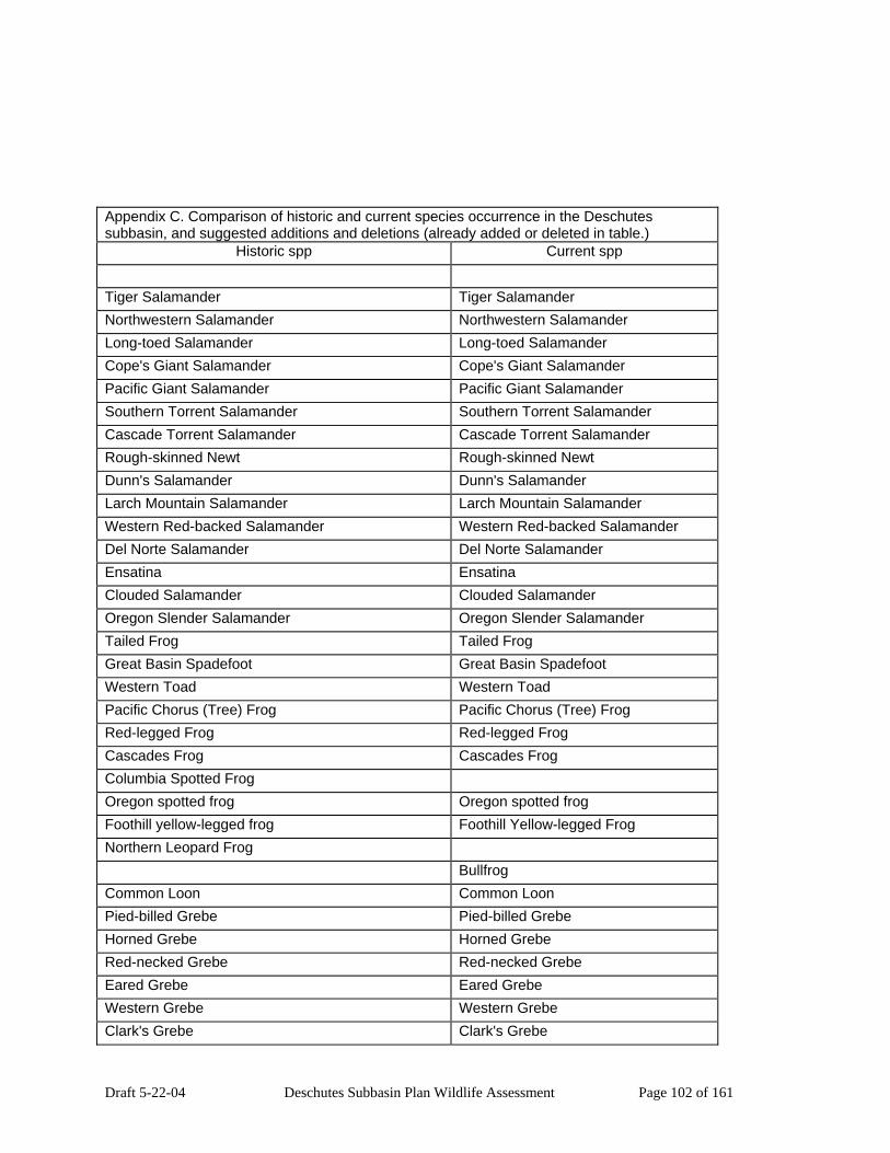
Draft 5-22-04 Deschutes Subbasin Plan Wildlife Assessment Page 102 of 161
Appendix C. Comparison of historic and current species occurrence in the Deschutes subbasin, and suggested additions and deletions (already added or deleted in table.)
Historic spp Current spp Tiger Salamander Tiger Salamander Northwestern Salamander Northwestern Salamander Long-toed Salamander Long-toed Salamander Cope's Giant Salamander Cope's Giant Salamander Pacific Giant Salamander Pacific Giant Salamander Southern Torrent Salamander Southern Torrent Salamander Cascade Torrent Salamander Cascade Torrent Salamander Rough-skinned Newt Rough-skinned Newt Dunn's Salamander Dunn's Salamander Larch Mountain Salamander Larch Mountain Salamander Western Red-backed Salamander Western Red-backed Salamander Del Norte Salamander Del Norte Salamander Ensatina Ensatina Clouded Salamander Clouded Salamander Oregon Slender Salamander Oregon Slender Salamander Tailed Frog Tailed Frog Great Basin Spadefoot Great Basin Spadefoot Western Toad Western Toad Pacific Chorus (Tree) Frog Pacific Chorus (Tree) Frog Red-legged Frog Red-legged Frog Cascades Frog Cascades Frog Columbia Spotted Frog Oregon spotted frog Oregon spotted frog Foothill yellow-legged frog Foothill Yellow-legged Frog Northern Leopard Frog Bullfrog Common Loon Common Loon Pied-billed Grebe Pied-billed Grebe Horned Grebe Horned Grebe Red-necked Grebe Red-necked Grebe Eared Grebe Eared Grebe Western Grebe Western Grebe Clark's Grebe Clark's Grebe

Draft 5-22-04 Deschutes Subbasin Plan Wildlife Assessment Page 103 of 161
Appendix C. Comparison of historic and current species occurrence in the Deschutes subbasin, and suggested additions and deletions (already added or deleted in table.)
Historic spp Current spp American White Pelican American White Pelican Brown Pelican Double-crested Cormorant Double-crested Cormorant American Bittern American Bittern Least Bittern Least Bittern Great Blue Heron Great Blue Heron Great Egret Great Egret Snowy Egret Snowy Egret Cattle Egret Cattle Egret Green Heron Green Heron Black-crowned Night-heron Black-crowned Night-heron White-faced Ibis White-faced Ibis Turkey Vulture Turkey Vulture Greater White-fronted Goose Greater White-fronted Goose Snow Goose Snow Goose Ross's Goose Ross's Goose Canada Goose Canada Goose Trumpeter Swan Trumpeter Swan Tundra Swan Tundra Swan Wood Duck Wood Duck Gadwall Gadwall Eurasian Wigeon Eurasian Wigeon American Wigeon American Wigeon Mallard Mallard Blue-winged Teal Blue-winged Teal Cinnamon Teal Cinnamon Teal Northern Shoveler Northern Shoveler Northern Pintail Northern Pintail Green-winged Teal Green-winged Teal Canvasback Canvasback Redhead Redhead Ring-necked Duck Ring-necked Duck Greater Scaup Greater Scaup Lesser Scaup Lesser Scaup Harlequin Duck Harlequin Duck Surf Scoter Surf Scoter

Draft 5-22-04 Deschutes Subbasin Plan Wildlife Assessment Page 104 of 161
Appendix C. Comparison of historic and current species occurrence in the Deschutes subbasin, and suggested additions and deletions (already added or deleted in table.)
Historic spp Current spp Bufflehead Bufflehead Common Goldeneye Common Goldeneye Barrow's Goldeneye Barrow's Goldeneye Hooded Merganser Hooded Merganser Common Merganser Common Merganser Red-breasted Merganser Red-breasted Merganser Ruddy Duck Ruddy Duck Osprey Osprey White-tailed Kite White-tailed Kite Bald Eagle Bald Eagle Northern Harrier Northern Harrier Sharp-shinned Hawk Sharp-shinned Hawk Cooper's Hawk Cooper's Hawk Northern Goshawk Northern Goshawk Red-shouldered Hawk Red-shouldered Hawk Swainson's Hawk Swainson's Hawk Red-tailed Hawk Red-tailed Hawk Ferruginous Hawk Ferruginous Hawk Rough-legged Hawk Rough-legged Hawk Golden Eagle Golden Eagle American Kestrel American Kestrel Merlin Merlin Gyrfalcon Gyrfalcon Peregrine Falcon Peregrine Falcon Prairie Falcon Prairie Falcon Chukar Gray Partridge Ring-necked Pheasant Ruffed Grouse Ruffed Grouse Sage Grouse Sage Grouse Blue Grouse Blue Grouse Sharp-tailed Grouse Wild Turkey Mountain Quail Mountain Quail California Quail California Quail Northern Bobwhite

Draft 5-22-04 Deschutes Subbasin Plan Wildlife Assessment Page 105 of 161
Appendix C. Comparison of historic and current species occurrence in the Deschutes subbasin, and suggested additions and deletions (already added or deleted in table.)
Historic spp Current spp Yellow Rail Yellow Rail Virginia Rail Virginia Rail Sora Sora American Coot American Coot Sandhill Crane Sandhill Crane Black-bellied Plover Black-bellied Plover Pacific Golden-Plover Pacific Golden-Plover Snowy Plover Snowy Plover Semipalmated Plover Semipalmated Plover Killdeer Killdeer Black-necked Stilt Black-necked Stilt American Avocet American Avocet Greater Yellowlegs Greater Yellowlegs Lesser Yellowlegs Lesser Yellowlegs Solitary Sandpiper Solitary Sandpiper Willet Willet Spotted Sandpiper Spotted Sandpiper Upland Sandpiper Upland Sandpiper Whimbrel Long-billed Curlew Long-billed Curlew Marbled Godwit Marbled Godwit Black Turnstone Black Turnstone Red Knot Sanderling Sanderling Semipalmated Sandpiper Semipalmated Sandpiper Western Sandpiper Western Sandpiper Least Sandpiper Least Sandpiper Baird's Sandpiper Baird's Sandpiper Pectoral Sandpiper Pectoral Sandpiper Dunlin Dunlin Stilt Sandpiper Stilt Sandpiper Ruff Ruff Short-billed Dowitcher Short-billed Dowitcher Long-billed Dowitcher Long-billed Dowitcher Common Snipe Common Snipe Wilson's Phalarope Wilson's Phalarope
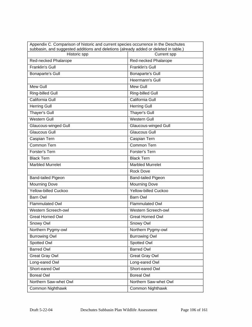
Draft 5-22-04 Deschutes Subbasin Plan Wildlife Assessment Page 106 of 161
Appendix C. Comparison of historic and current species occurrence in the Deschutes subbasin, and suggested additions and deletions (already added or deleted in table.)
Historic spp Current spp Red-necked Phalarope Red-necked Phalarope Franklin's Gull Franklin's Gull Bonaparte's Gull Bonaparte's Gull Heermann's Gull Mew Gull Mew Gull Ring-billed Gull Ring-billed Gull California Gull California Gull Herring Gull Herring Gull Thayer's Gull Thayer's Gull Western Gull Western Gull Glaucous-winged Gull Glaucous-winged Gull Glaucous Gull Glaucous Gull Caspian Tern Caspian Tern Common Tern Common Tern Forster's Tern Forster's Tern Black Tern Black Tern Marbled Murrelet Marbled Murrelet Rock Dove Band-tailed Pigeon Band-tailed Pigeon Mourning Dove Mourning Dove Yellow-billed Cuckoo Yellow-billed Cuckoo Barn Owl Barn Owl Flammulated Owl Flammulated Owl Western Screech-owl Western Screech-owl Great Horned Owl Great Horned Owl Snowy Owl Snowy Owl Northern Pygmy-owl Northern Pygmy-owl Burrowing Owl Burrowing Owl Spotted Owl Spotted Owl Barred Owl Barred Owl Great Gray Owl Great Gray Owl Long-eared Owl Long-eared Owl Short-eared Owl Short-eared Owl Boreal Owl Boreal Owl Northern Saw-whet Owl Northern Saw-whet Owl Common Nighthawk Common Nighthawk

Draft 5-22-04 Deschutes Subbasin Plan Wildlife Assessment Page 107 of 161
Appendix C. Comparison of historic and current species occurrence in the Deschutes subbasin, and suggested additions and deletions (already added or deleted in table.)
Historic spp Current spp Common Poorwill Common Poorwill Black Swift Black Swift Vaux's Swift Vaux's Swift White-throated Swift White-throated Swift Black-chinned Hummingbird Black-chinned Hummingbird Anna's Hummingbird Anna's Hummingbird Calliope Hummingbird Calliope Hummingbird Broad-tailed Hummingbird Broad-tailed Hummingbird Rufous Hummingbird Rufous Hummingbird Allen's Hummingbird Allen's Hummingbird Belted Kingfisher Belted Kingfisher Lewis's Woodpecker Lewis's Woodpecker Acorn Woodpecker Acorn Woodpecker Williamson's Sapsucker Williamson's Sapsucker Red-naped Sapsucker Red-naped Sapsucker Red-breasted Sapsucker Red-breasted Sapsucker Downy Woodpecker Downy Woodpecker Hairy Woodpecker Hairy Woodpecker White-headed Woodpecker White-headed Woodpecker Three-toed Woodpecker Three-toed Woodpecker Black-backed Woodpecker Black-backed Woodpecker Northern Flicker Northern Flicker Pileated Woodpecker Pileated Woodpecker Olive-sided Flycatcher Olive-sided Flycatcher Western Wood-pewee Western Wood-pewee Willow Flycatcher Willow Flycatcher Least Flycatcher Least Flycatcher Hammond's Flycatcher Hammond's Flycatcher Gray Flycatcher Gray Flycatcher Dusky Flycatcher Dusky Flycatcher Pacific-slope Flycatcher Pacific-slope Flycatcher Cordilleran Flycatcher Cordilleran Flycatcher Black Phoebe Black Phoebe Say's Phoebe Say's Phoebe Ash-throated Flycatcher Ash-throated Flycatcher Western Kingbird Western Kingbird

Draft 5-22-04 Deschutes Subbasin Plan Wildlife Assessment Page 108 of 161
Appendix C. Comparison of historic and current species occurrence in the Deschutes subbasin, and suggested additions and deletions (already added or deleted in table.)
Historic spp Current spp Eastern Kingbird Eastern Kingbird Loggerhead Shrike Loggerhead Shrike Northern Shrike Northern Shrike Cassin's Vireo Cassin's Vireo Hutton's Vireo Hutton's Vireo Warbling Vireo Warbling Vireo Red-eyed Vireo Red-eyed Vireo Gray Jay Gray Jay Steller's Jay Steller's Jay Western Scrub-Jay Western Scrub-Jay Pinyon Jay Pinyon Jay Clark's Nutcracker Clark's Nutcracker Black-billed Magpie Black-billed Magpie American Crow American Crow Common Raven Common Raven Horned Lark Horned Lark Purple Martin Purple Martin Tree Swallow Tree Swallow Violet-green Swallow Violet-green Swallow Northern Rough-winged Swallow Northern Rough-winged Swallow Bank Swallow Bank Swallow Cliff Swallow Cliff Swallow Barn Swallow Barn Swallow Black-capped Chickadee Black-capped Chickadee Mountain Chickadee Mountain Chickadee Chestnut-backed Chickadee Chestnut-backed Chickadee Oak Titmouse Oak Titmouse Juniper Titmouse Juniper Titmouse Bushtit Bushtit Red-breasted Nuthatch Red-breasted Nuthatch White-breasted Nuthatch White-breasted Nuthatch Pygmy Nuthatch Pygmy Nuthatch Brown Creeper Brown Creeper Rock Wren Rock Wren Canyon Wren Canyon Wren Bewick's Wren Bewick's Wren
Draft 5-22-04 Deschutes Subbasin Plan Wildlife Assessment Page 109 of 161
Appendix C. Comparison of historic and current species occurrence in the Deschutes subbasin, and suggested additions and deletions (already added or deleted in table.)
Historic spp Current spp House Wren House Wren Winter Wren Winter Wren Marsh Wren Marsh Wren American Dipper American Dipper Golden-crowned Kinglet Golden-crowned Kinglet Ruby-crowned Kinglet Ruby-crowned Kinglet Blue-gray Gnatcatcher Blue-gray Gnatcatcher Western Bluebird Western Bluebird Mountain Bluebird Mountain Bluebird Townsend's Solitaire Townsend's Solitaire Veery Veery Swainson's Thrush Swainson's Thrush Hermit Thrush Hermit Thrush American Robin American Robin Varied Thrush Varied Thrush Wrentit Wrentit Gray Catbird Gray Catbird Northern Mockingbird Northern Mockingbird Sage Thrasher Sage Thrasher European Starling European Starling American Pipit American Pipit Bohemian Waxwing Bohemian Waxwing Cedar Waxwing Cedar Waxwing Orange-crowned Warbler Orange-crowned Warbler Nashville Warbler Nashville Warbler Yellow Warbler Yellow Warbler Yellow-rumped Warbler Yellow-rumped Warbler Black-throated Gray Warbler Black-throated Gray Warbler Townsend's Warbler Townsend's Warbler Hermit Warbler Hermit Warbler Palm Warbler Palm Warbler American Redstart American Redstart Northern Waterthrush Northern Waterthrush Macgillivray's Warbler Macgillivray's Warbler Common Yellowthroat Common Yellowthroat Wilson's Warbler Wilson's Warbler

Draft 5-22-04 Deschutes Subbasin Plan Wildlife Assessment Page 110 of 161
Appendix C. Comparison of historic and current species occurrence in the Deschutes subbasin, and suggested additions and deletions (already added or deleted in table.)
Historic spp Current spp Yellow-breasted Chat Yellow-breasted Chat Western Tanager Western Tanager Green-tailed Towhee Green-tailed Towhee Spotted Towhee Spotted Towhee California Towhee California Towhee American Tree Sparrow American Tree Sparrow Chipping Sparrow Chipping Sparrow Clay-colored Sparrow Clay-colored Sparrow Brewer's Sparrow Brewer's Sparrow Vesper Sparrow Vesper Sparrow Lark Sparrow Lark Sparrow Black-throated Sparrow Black-throated Sparrow Sage Sparrow Sage Sparrow Savannah Sparrow Savannah Sparrow Grasshopper Sparrow Grasshopper Sparrow Fox Sparrow Fox Sparrow Song Sparrow Song Sparrow Lincoln's Sparrow Lincoln's Sparrow Swamp Sparrow Swamp Sparrow White-crowned Sparrow White-throated Sparrow Harris's Sparrow White-crowned Sparrow Golden-crowned Sparrow Golden-crowned Sparrow Dark-eyed Junco Dark-eyed Junco Lapland Longspur Lapland Longspur Snow Bunting Snow Bunting Black-headed Grosbeak Black-headed Grosbeak Lazuli Bunting Lazuli Bunting Bobolink Bobolink Red-winged Blackbird Red-winged Blackbird Tricolored Blackbird Tricolored Blackbird Western Meadowlark Western Meadowlark Yellow-headed Blackbird Yellow-headed Blackbird Brewer's Blackbird Brewer's Blackbird Brown-headed Cowbird Brown-headed Cowbird Bullock's Oriole Bullock's Oriole

Draft 5-22-04 Deschutes Subbasin Plan Wildlife Assessment Page 111 of 161
Appendix C. Comparison of historic and current species occurrence in the Deschutes subbasin, and suggested additions and deletions (already added or deleted in table.)
Historic spp Current spp Gray-crowned Rosy-Finch Gray-crowned Rosy-Finch Black Rosy-finch Black Rosy-finch Pine Grosbeak Pine Grosbeak Purple Finch Purple Finch Cassin's Finch Cassin's Finch House Finch House Finch Red Crossbill Red Crossbill White-winged Crossbill White-winged Crossbill Common Redpoll Common Redpoll Pine Siskin Pine Siskin Lesser Goldfinch Lesser Goldfinch American Goldfinch American Goldfinch Evening Grosbeak Evening Grosbeak
House Sparrow Virginia Opossum Preble's Shrew Preble's Shrew Vagrant Shrew Vagrant Shrew Montane Shrew Montane Shrew Baird's Shrew Baird's Shrew Fog Shrew Fog Shrew Pacific Shrew Pacific Shrew Water Shrew Water Shrew Pacific Water Shrew Pacific Water Shrew Trowbridge's Shrew Trowbridge's Shrew Merriam's Shrew Merriam's Shrew Shrew-mole Shrew-mole Townsend's Mole Townsend's Mole Coast Mole Coast Mole Broad-footed Mole Broad-footed Mole California Myotis California Myotis Western Small-footed Myotis Western Small-footed Myotis Yuma Myotis Yuma Myotis Little Brown Myotis Little Brown Myotis Long-legged Myotis Long-legged Myotis Fringed Myotis Fringed Myotis Long-eared Myotis Long-eared Myotis
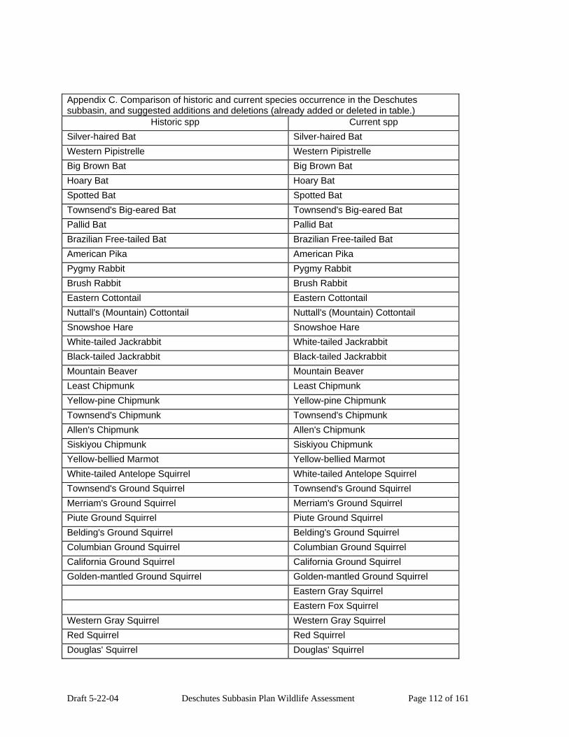
Draft 5-22-04 Deschutes Subbasin Plan Wildlife Assessment Page 112 of 161
Appendix C. Comparison of historic and current species occurrence in the Deschutes subbasin, and suggested additions and deletions (already added or deleted in table.)
Historic spp Current spp Silver-haired Bat Silver-haired Bat Western Pipistrelle Western Pipistrelle Big Brown Bat Big Brown Bat Hoary Bat Hoary Bat Spotted Bat Spotted Bat Townsend's Big-eared Bat Townsend's Big-eared Bat Pallid Bat Pallid Bat Brazilian Free-tailed Bat Brazilian Free-tailed Bat American Pika American Pika Pygmy Rabbit Pygmy Rabbit Brush Rabbit Brush Rabbit Eastern Cottontail Eastern Cottontail Nuttall's (Mountain) Cottontail Nuttall's (Mountain) Cottontail Snowshoe Hare Snowshoe Hare White-tailed Jackrabbit White-tailed Jackrabbit Black-tailed Jackrabbit Black-tailed Jackrabbit Mountain Beaver Mountain Beaver Least Chipmunk Least Chipmunk Yellow-pine Chipmunk Yellow-pine Chipmunk Townsend's Chipmunk Townsend's Chipmunk Allen's Chipmunk Allen's Chipmunk Siskiyou Chipmunk Siskiyou Chipmunk Yellow-bellied Marmot Yellow-bellied Marmot White-tailed Antelope Squirrel White-tailed Antelope Squirrel Townsend's Ground Squirrel Townsend's Ground Squirrel Merriam's Ground Squirrel Merriam's Ground Squirrel Piute Ground Squirrel Piute Ground Squirrel Belding's Ground Squirrel Belding's Ground Squirrel Columbian Ground Squirrel Columbian Ground Squirrel California Ground Squirrel California Ground Squirrel Golden-mantled Ground Squirrel Golden-mantled Ground Squirrel Eastern Gray Squirrel Eastern Fox Squirrel Western Gray Squirrel Western Gray Squirrel Red Squirrel Red Squirrel Douglas' Squirrel Douglas' Squirrel

Draft 5-22-04 Deschutes Subbasin Plan Wildlife Assessment Page 113 of 161
Appendix C. Comparison of historic and current species occurrence in the Deschutes subbasin, and suggested additions and deletions (already added or deleted in table.)
Historic spp Current spp Northern Flying Squirrel Northern Flying Squirrel Northern Pocket Gopher Northern Pocket Gopher Western Pocket Gopher Western Pocket Gopher Camas Pocket Gopher Botta's (Pistol River) Pocket Gopher Townsend's Pocket Gopher Townsend's Pocket Gopher Great Basin Pocket Mouse Great Basin Pocket Mouse Little Pocket Mouse Little Pocket Mouse Dark Kangaroo Mouse Dark Kangaroo Mouse Ord's Kangaroo Rat Ord's Kangaroo Rat Chisel-toothed Kangaroo Rat Chisel-toothed Kangaroo Rat California Kangaroo Rat California Kangaroo Rat American Beaver American Beaver Western Harvest Mouse Western Harvest Mouse Deer Mouse Deer Mouse Canyon Mouse Canyon Mouse Pinon Mouse Pinon Mouse Northern Grasshopper Mouse Northern Grasshopper Mouse Desert Woodrat Desert Woodrat Dusky-footed Woodrat Dusky-footed Woodrat Bushy-tailed Woodrat Bushy-tailed Woodrat Southern Red-backed Vole Southern Red-backed Vole Western Red-backed Vole Western Red-backed Vole Heather Vole Heather Vole White-footed Vole White-footed Vole Red Tree Vole Red Tree Vole Montane Vole Montane Vole Gray-tailed Vole California Vole California Vole Townsend's Vole Townsend's Vole Long-tailed Vole Long-tailed Vole Creeping Vole Creeping Vole Water Vole Water Vole Sagebrush Vole Sagebrush Vole Muskrat Muskrat Black Rat

Draft 5-22-04 Deschutes Subbasin Plan Wildlife Assessment Page 114 of 161
Appendix C. Comparison of historic and current species occurrence in the Deschutes subbasin, and suggested additions and deletions (already added or deleted in table.)
Historic spp Current spp Norway Rat House Mouse Western Jumping Mouse Western Jumping Mouse Pacific Jumping Mouse Pacific Jumping Mouse Common Porcupine Common Porcupine Nutria Coyote Coyote Gray wolf Red Fox Red Fox Kit Fox Kit Fox Gray Fox Gray Fox Black Bear Black Bear Grizzly Bear Ringtail Ringtail Raccoon Raccoon American Marten American Marten Fisher Fisher Ermine Ermine Long-tailed Weasel Long-tailed Weasel Mink Mink Wolverine Wolverine American Badger American Badger Western Spotted Skunk Western Spotted Skunk Striped Skunk Striped Skunk Northern River Otter Northern River Otter Mountain Lion Mountain Lion Lynx Lynx Bobcat Bobcat Feral Pig Elk Elk Mule Deer Mule Deer White-tailed Deer Pronghorn Antelope Pronghorn Antelope Mountain Goat Bighorn Sheep Bighorn Sheep Northern (Steller) Sea Lion Northern (Steller) Sea Lion
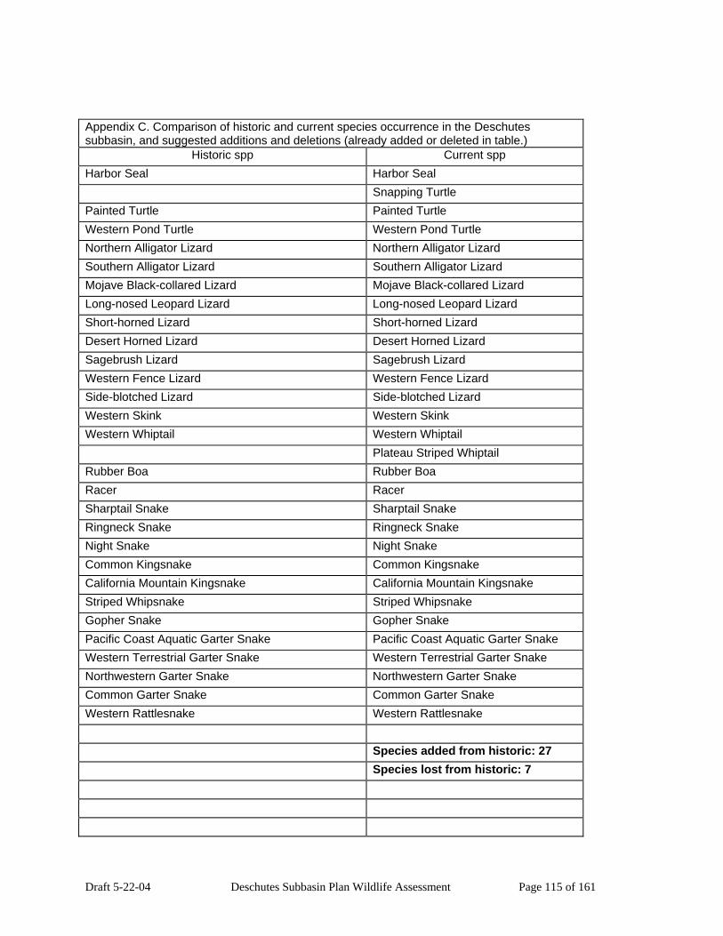
Draft 5-22-04 Deschutes Subbasin Plan Wildlife Assessment Page 115 of 161
Appendix C. Comparison of historic and current species occurrence in the Deschutes subbasin, and suggested additions and deletions (already added or deleted in table.)
Historic spp Current spp Harbor Seal Harbor Seal Snapping Turtle Painted Turtle Painted Turtle Western Pond Turtle Western Pond Turtle Northern Alligator Lizard Northern Alligator Lizard Southern Alligator Lizard Southern Alligator Lizard Mojave Black-collared Lizard Mojave Black-collared Lizard Long-nosed Leopard Lizard Long-nosed Leopard Lizard Short-horned Lizard Short-horned Lizard Desert Horned Lizard Desert Horned Lizard Sagebrush Lizard Sagebrush Lizard Western Fence Lizard Western Fence Lizard Side-blotched Lizard Side-blotched Lizard Western Skink Western Skink Western Whiptail Western Whiptail Plateau Striped Whiptail Rubber Boa Rubber Boa Racer Racer Sharptail Snake Sharptail Snake Ringneck Snake Ringneck Snake Night Snake Night Snake Common Kingsnake Common Kingsnake California Mountain Kingsnake California Mountain Kingsnake Striped Whipsnake Striped Whipsnake Gopher Snake Gopher Snake Pacific Coast Aquatic Garter Snake Pacific Coast Aquatic Garter Snake Western Terrestrial Garter Snake Western Terrestrial Garter Snake Northwestern Garter Snake Northwestern Garter Snake Common Garter Snake Common Garter Snake Western Rattlesnake Western Rattlesnake Species added from historic: 27 Species lost from historic: 7

Draft 5-22-04 Deschutes Subbasin Plan Wildlife Assessment Page 116 of 161
Appendix C. Comparison of historic and current species occurrence in the Deschutes subbasin, and suggested additions and deletions (already added or deleted in table.)
Historic spp Current spp Suggested deletions *: Suggested deletions*: Bullfrog Columbia spotted frog Chukar Northern leopard frog Gray partridge White-tailed deer Ring-necked pheasant Grizzly bear Wild turkey Sharp-tailed grouse Northern bobwhite Mountain goat Rock dove Virginia opossum T Eastern cottontail Eastern fox squirrel Nutria Feral pig Snapping turtle Plateau striped whiptail Suggested additions*: Oregon spotted frog Suggested additions*: Gray wolf Oregon spotted frog
Original tables supplied by IBIS, 2003. * Csuti, et. al. 2001. Atlas of Oregon Wildlife.
Appendix Table D. Threatened, endangered, and Oregon-listed wildlife species thought to occur currently or historically in the Deschutes Subbasin. Common Name Scientific Name State Status Federal StatusCope's Giant Salamander
Dicamptodon copei OR Unclear Status

Draft 5-22-04 Deschutes Subbasin Plan Wildlife Assessment Page 117 of 161
Appendix Table D. Threatened, endangered, and Oregon-listed wildlife species thought to occur currently or historically in the Deschutes Subbasin. Common Name Scientific Name State Status Federal StatusColumbia Torrent Salamander
Rhyacotriton kezeri OR Candidate Species
Southern Torrent Salamander
Rhyacotriton variegatus
OR Species listing avoidable
Cascade Torrent Salamander
Rhyacotriton cascadae
OR Species listing avoidable
Larch Mountain Salamander
Plethodon larselli OR Species listing avoidable
Del Norte Salamander Plethodon elongatus OR Species listing avoidable
Clouded Salamander Aneides ferreus OR Unclear Status Oregon Slender Salamander
Batrachoseps wrighti OR Unclear Status
Tailed Frog Ascaphus truei OR Species listing avoidable
Western Toad Bufo boreas OR Species listing avoidable
Red-legged Frog Rana aurora OR combined status S-V and S-US
Cascades Frog Rana cascadae OR Species listing avoidable
Oregon Spotted Frog Rana pretiosa OR Candidate Species Anticipated Candidate
Columbia Spotted Frog
Rana luteiventris OR Unclear Status Anticipated Candidate
Foothill Yellow-legged Frog
Rana boylii OR Species listing avoidable
Northern Leopard Frog
Rana pipiens OR Candidate Species
Horned Grebe Podiceps auritus OR Peripheral and Naturally Rare
Red-necked Grebe Podiceps grisegena OR Candidate Species American White Pelican
Pelecanus erythrorhynchos
OR Species listing avoidable
Brown Pelican Pelecanus occidentalis
OR Endangered Endangered
Least Bittern Ixobrychus exilis OR Peripheral and Naturally Rare
Snowy Egret Egretta thula OR Species listing avoidable

Draft 5-22-04 Deschutes Subbasin Plan Wildlife Assessment Page 118 of 161
Appendix Table D. Threatened, endangered, and Oregon-listed wildlife species thought to occur currently or historically in the Deschutes Subbasin. Common Name Scientific Name State Status Federal StatusHarlequin Duck Histrionicus
histrionicus OR Unclear Status
Bufflehead Bucephala albeola OR Unclear Status Barrow's Goldeneye Bucephala islandica OR Unclear Status Bald Eagle Haliaeetus
leucocephalus OR Threatened Threatened
Northern Goshawk Accipiter gentilis OR Candidate Species Swainson's Hawk Buteo swainsoni OR Species listing
avoidable
Ferruginous Hawk Buteo regalis OR Candidate Species Peregrine Falcon Falco peregrinus OR Endangered Sage Grouse Centrocercus
urophasianus OR Species listing
avoidable
Mountain Quail Oreortyx pictus OR Unclear Status Yellow Rail Coturnicops
noveboracensis OR Candidate Species
Sandhill Crane Grus canadensis OR Species listing avoidable
Snowy Plover Charadrius alexandrinus
OR Threatened Threatened
Upland Sandpiper Bartramia longicauda OR Candidate Species Long-billed Curlew Numenius americanus OR Species listing
avoidable
Franklin's Gull Larus pipixcan OR Peripheral and Naturally Rare
Marbled Murrelet Brachyramphus marmoratus
OR Threatened Threatened
Yellow-billed Cuckoo Coccyzus americanus OR Candidate Species Anticipated Candidate
Flammulated Owl Otus flammeolus OR Candidate Species Northern Pygmy-owl Glaucidium gnoma OR Candidate Species Burrowing Owl Athene cunicularia OR Candidate Species Spotted Owl Strix occidentalis OR Threatened Threatened Great Gray Owl Strix nebulosa OR Species listing
avoidable
Boreal Owl Aegolius funereus OR Unclear Status Common Nighthawk Chordeiles minor OR Candidate Species Black Swift Cypseloides niger OR Peripheral and
Naturally Rare
Lewis's Woodpecker Melanerpes lewis OR Candidate Species

Draft 5-22-04 Deschutes Subbasin Plan Wildlife Assessment Page 119 of 161
Appendix Table D. Threatened, endangered, and Oregon-listed wildlife species thought to occur currently or historically in the Deschutes Subbasin. Common Name Scientific Name State Status Federal StatusWilliamson's Sapsucker
Sphyrapicus thyroideus
OR Unclear Status
White-headed Woodpecker
Picoides albolarvatus OR Candidate Species
Three-toed Woodpecker
Picoides tridactylus OR Candidate Species
Black-backed Woodpecker
Picoides arcticus OR Candidate Species
Pileated Woodpecker Dryocopus pileatus OR Species listing avoidable
Olive-sided Flycatcher Contopus cooperi OR Species listing avoidable
Willow Flycatcher Empidonax traillii OR combined status S-V and S-US
Loggerhead Shrike Lanius ludovicianus OR Species listing avoidable
Purple Martin Progne subis OR Candidate Species Bank Swallow Riparia riparia OR Unclear Status Pygmy Nuthatch Sitta pygmaea OR Species listing
avoidable
Western Bluebird Sialia mexicana OR Species listing avoidable
Yellow-breasted Chat Icteria virens OR Candidate Species Vesper Sparrow Pooecetes gramineus OR Candidate Species Black-throated Sparrow
Amphispiza bilineata OR Peripheral and Naturally Rare
Sage Sparrow Amphispiza belli OR Candidate Species Grasshopper Sparrow Ammodramus
savannarum OR combined status S-V
and S-PN
Bobolink Dolichonyx oryzivorus OR Species listing avoidable
Tricolored Blackbird Agelaius tricolor OR Peripheral and Naturally Rare
Western Meadowlark Sturnella neglecta OR Candidate Species Black Rosy-finch Leucosticte atrata OR Peripheral and
Naturally Rare
Western Small-footed Myotis
Myotis ciliolabrum OR Unclear Status
Long-legged Myotis Myotis volans OR Unclear Status Fringed Myotis Myotis thysanodes OR Species listing
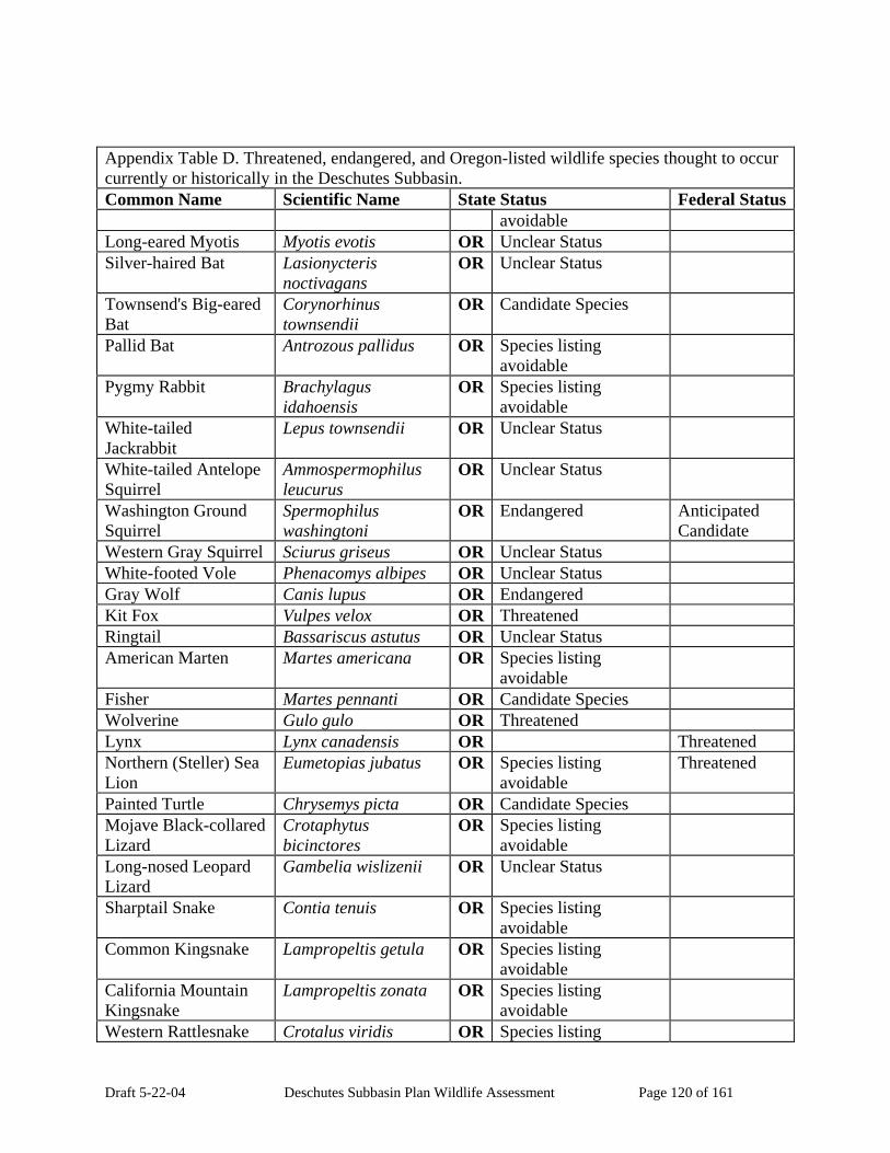
Draft 5-22-04 Deschutes Subbasin Plan Wildlife Assessment Page 120 of 161
Appendix Table D. Threatened, endangered, and Oregon-listed wildlife species thought to occur currently or historically in the Deschutes Subbasin. Common Name Scientific Name State Status Federal Status
avoidable Long-eared Myotis Myotis evotis OR Unclear Status Silver-haired Bat Lasionycteris
noctivagans OR Unclear Status
Townsend's Big-eared Bat
Corynorhinus townsendii
OR Candidate Species
Pallid Bat Antrozous pallidus OR Species listing avoidable
Pygmy Rabbit Brachylagus idahoensis
OR Species listing avoidable
White-tailed Jackrabbit
Lepus townsendii OR Unclear Status
White-tailed Antelope Squirrel
Ammospermophilus leucurus
OR Unclear Status
Washington Ground Squirrel
Spermophilus washingtoni
OR Endangered Anticipated Candidate
Western Gray Squirrel Sciurus griseus OR Unclear Status White-footed Vole Phenacomys albipes OR Unclear Status Gray Wolf Canis lupus OR Endangered Kit Fox Vulpes velox OR Threatened Ringtail Bassariscus astutus OR Unclear Status American Marten Martes americana OR Species listing
avoidable
Fisher Martes pennanti OR Candidate Species Wolverine Gulo gulo OR Threatened Lynx Lynx canadensis OR Threatened Northern (Steller) Sea Lion
Eumetopias jubatus OR Species listing avoidable
Threatened
Painted Turtle Chrysemys picta OR Candidate Species Mojave Black-collared Lizard
Crotaphytus bicinctores
OR Species listing avoidable
Long-nosed Leopard Lizard
Gambelia wislizenii OR Unclear Status
Sharptail Snake Contia tenuis OR Species listing avoidable
Common Kingsnake Lampropeltis getula OR Species listing avoidable
California Mountain Kingsnake
Lampropeltis zonata OR Species listing avoidable
Western Rattlesnake Crotalus viridis OR Species listing

Draft 5-22-04 Deschutes Subbasin Plan Wildlife Assessment Page 121 of 161
Appendix Table D. Threatened, endangered, and Oregon-listed wildlife species thought to occur currently or historically in the Deschutes Subbasin. Common Name Scientific Name State Status Federal Status
avoidable
Threatened and Endangered Species Status for the Columbia Plateau Ecological Province. Generated by IBIS on 11/12/2003 4:05:53 PM. Copyright 1998-2003. Please visit the IBIS web site (www.nwhi.org/ibis) for Copyright and Terms of Use limitations. This data is continually updated and therefore subject to change.
Appendix E. Wildlife species currently harvested by hunters in the Deschutes subbasin. No. Common Name Scientific Name OR 1. Greater White-fronted Goose Anser albifrons Game Bird 2. Snow Goose Chen Ccaerulescens Game Bird 3. Ross's Goose Chen rossii Game Bird 4. Canada Goose Branta canadensis Game Bird 5. Wood Duck Aix sponsa Game Bird 6. Gadwall Anas strepera Game Bird 7. Eurasian Wigeon Anas penelope Game Bird 8. American Wigeon Anas americana Game Bird 9. Mallard Anas platyrhynchos Game Bird 10. Blue-winged Teal Anas discors Game Bird 11. Cinnamon Teal Anas cyanoptera Game Bird 12. Northern Shoveler Anas clypeata Game Bird 13. Northern Pintail Anas acuta Game Bird 14. Green-winged Teal Anas crecca Game Bird 15. Canvasback Aythya valisineria Game Bird 16. Redhead Aythya americana Game Bird 17. Ring-necked Duck Aythya collaris Game Bird 18. Greater Scaup Aythya marila Game Bird 19. Lesser Scaup Aythya affinis Game Bird 20. Harlequin Duck Histrionicus histrionicus Game Bird 21. Surf Scoter Melanitta perspicillata Game Bird 22. Bufflehead Bucephala albeola Game Bird 23. Common Goldeneye Bucephala clangula Game Bird 24. Barrow's Goldeneye Bucephala islandica Game Bird 25. Hooded Merganser Lophodytes cucullatus Game Bird 26. Common Merganser Mergus merganser Game Bird

Draft 5-22-04 Deschutes Subbasin Plan Wildlife Assessment Page 122 of 161
Appendix E. Wildlife species currently harvested by hunters in the Deschutes subbasin. No. Common Name Scientific Name OR 27. Red-breasted Merganser Mergus serrator Game Bird 28. Ruddy Duck Oxyura jamaicensis Game Bird 29. Chukar Alectoris chukar Game Bird 30. Gray Partridge Perdix perdix Game Bird 31. Ring-necked Pheasant Phasianus colchicus Game Bird 32. Ruffed Grouse Bonasa umbellus Game Bird 33. Sage Grouse Centrocercus urophasianus Game Bird 34. Spruce Grouse Falcipennis canadensis Game Bird 35. Blue Grouse Dendragapus obscurus Game Bird 36. Wild Turkey Meleagris gallopavo Game Bird 37. Mountain Quail Oreortyx pictus Game Bird 38. California Quail Callipepla californica Game Bird 39. Northern Bobwhite Colinus virginianus Game Bird 40. American Coot Fulica americana Game Bird 41. Common Snipe Gallinago gallinago Game Bird 42. Band-tailed Pigeon Columba fasciata Game Bird 43. Mourning Dove Zenaida macroura Game Bird 44. American Crow Corvus brachyrhynchos Game Bird 45. American Beaver Castor canadensis Furbearer 46. Muskrat Ondatra zibethicus Furbearer 47. Nutria Myocastor coypus Furbearer 48. Coyote Canis latrans Hunted 49. Red Fox Vulpes vulpes Furbearer 50. Gray Fox Urocyon cinereoargenteus Furbearer 51. Raccoon Procyon lotor Furbearer 52. American Marten Martes americana Furbearer 53. Mink Mustela vison Furbearer 54. Ermine Mustela erminea Furbearer 55. Long-tailed Weasel Mustela frenata Furbearer 56. American Badger Taxidea taxus Furbearer 57. Western Spotted Skunk Spilogale gracilis Furbearer 58. Striped Skunk Mephitis mephitis Furbearer 59. Northern River Otter Lutra canadensis Furbearer 60. Bobcat Lynx rufus Furbearer 61. Western Gray Squirrel Sciurus griseus Game Mammal62. Feral Pig Sus scrofa Hunted 63. Black Bear Ursus americanus Game Mammal64. Mountain Lion Puma concolor Game Mammal65. Rocky Mountain Elk Cervus elaphus nelsoni Game Mammal66. Black-tailed Deer O. hemionus columbianus Game Mammal

Draft 5-22-04 Deschutes Subbasin Plan Wildlife Assessment Page 123 of 161
Appendix E. Wildlife species currently harvested by hunters in the Deschutes subbasin. No. Common Name Scientific Name OR 67. Mule Deer O. hemionus Game Mammal68. Pronghorn Antelope Antilocapra americana Game Mammal
Sources for data: 1. Game Species Listing for the Columbia Plateau Ecological Province. Generated by IBIS on 2/9/2004 5:25:42 PM. Copyright 1998-2003. Please visit the IBIS web site (www.nwhi.org/ibis) for Copyright and Terms of Use limitations. This data is continually updated and therefore subject to change. 2. Oregon Dept. of Fish and Wildlife. Big Game, Game Bird, and Furbearer hunting Rgulations, and Trapping Regulations. 2003.
Appendix F. HEP wildlife species thought to occur currently in the Deschutes subbasin.
No. Common Name Scientific Name Comments 1. Spotted sandpiper Actitis macularia HEP Species used in the loss
assessments for the lower four Columbia River Dam with existing models.
2. Lesser scaup Aytha affinis HEP Species used in the loss assessments for the lower four Columbia River Dam with existing models.
3. Canada goose Branta Canadensis HEP Species used in the loss assessments for the lower four Columbia River Dam with existing models.
4. Great blue heron Ardea herodias HEP Species used in the loss assessments for the lower four Columbia River Dam with existing models.
5. Yellow warbler Dendroica petechia HEP Species used in the loss assessments for the lower four Columbia River Dam with existing models.
6. Black-capped chickadee Parus atricopillus HEP Species used in the loss assessments for the lower four Columbia River Dam with existing models.
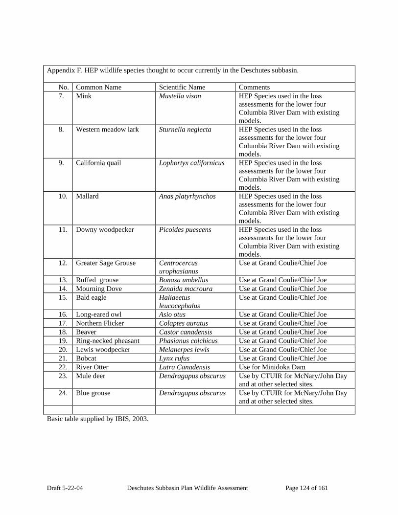
Draft 5-22-04 Deschutes Subbasin Plan Wildlife Assessment Page 124 of 161
Appendix F. HEP wildlife species thought to occur currently in the Deschutes subbasin.
No. Common Name Scientific Name Comments 7. Mink Mustella vison HEP Species used in the loss
assessments for the lower four Columbia River Dam with existing models.
8. Western meadow lark Sturnella neglecta HEP Species used in the loss assessments for the lower four Columbia River Dam with existing models.
9. California quail Lophortyx californicus HEP Species used in the loss assessments for the lower four Columbia River Dam with existing models.
10. Mallard Anas platyrhynchos HEP Species used in the loss assessments for the lower four Columbia River Dam with existing models.
11. Downy woodpecker Picoides puescens HEP Species used in the loss assessments for the lower four Columbia River Dam with existing models.
12. Greater Sage Grouse Centrocercus urophasianus
Use at Grand Coulie/Chief Joe
13. Ruffed grouse Bonasa umbellus Use at Grand Coulie/Chief Joe 14. Mourning Dove Zenaida macroura Use at Grand Coulie/Chief Joe 15. Bald eagle Haliaeetus
leucocephalus Use at Grand Coulie/Chief Joe
16. Long-eared owl Asio otus Use at Grand Coulie/Chief Joe 17. Northern Flicker Colaptes auratus Use at Grand Coulie/Chief Joe 18. Beaver Castor canadensis Use at Grand Coulie/Chief Joe 19. Ring-necked pheasant Phasianus colchicus Use at Grand Coulie/Chief Joe 20. Lewis woodpecker Melanerpes lewis Use at Grand Coulie/Chief Joe 21. Bobcat Lynx rufus Use at Grand Coulie/Chief Joe 22. River Otter Lutra Canadensis Use for Minidoka Dam 23. Mule deer Dendragapus obscurus Use by CTUIR for McNary/John Day
and at other selected sites. 24. Blue grouse Dendragapus obscurus Use by CTUIR for McNary/John Day
and at other selected sites. Basic table supplied by IBIS, 2003.

Draft 5-22-04 Deschutes Subbasin Plan Wildlife Assessment Page 125 of 161
Appendix G. Partners in Flight listed species thought to occur in the Deschutes Subbasin.
No. Common Name PIF 1998-1999 Continental
PIF Ranking by Super Region Draft 2002
OR PIF Priority & Focal Species
1. Ross's Goose Yes 2. Trumpeter Swan Yes 3. Northern Harrier Yes 4. Swainson's Hawk MO (Intermountain West,
Prairies) Yes
5. Ferruginous Hawk Yes 6. American Kestrel Yes 7. Sage Grouse MA (Intermountain West,
Prairies)
8. Blue Grouse MA (Pacific, Intermountain West)
9. Sharp-tailed Grouse MO (Prairies) Yes 10 Mountain Quail MO (Pacific) 11 Yellow Rail Yes 12 Snowy Plover Yes 13 Willet Yes 14 Long-billed Curlew Yes 15 Black Turnstone Yes 16 Red Knot Yes 17 Stilt Sandpiper Yes 18 Short-billed Dowitcher Yes 19 Franklin's Gull Yes 20 Heermann's Gull Yes 21 Band-tailed Pigeon Yes MA (Pacific) Yes 22 Yellow-billed Cuckoo Yes 23 Flammulated Owl MO (Pacific,
Intermountain West, Southwest)
Yes
24 Northern Pygmy-owl PR (Pacific) 25 Burrowing Owl Yes 26 Spotted Owl IM (Pacific, Intermountain
West, Southwest)
27 Great Gray Owl Yes 28 Short-eared Owl Yes MA (Arctic, Northern
Forests, Intermountain West, Prairies)
Yes
29 Common Poorwill Yes 30 Black Swift Yes IM (Pacific, Intermountain
West) Yes

Draft 5-22-04 Deschutes Subbasin Plan Wildlife Assessment Page 126 of 161
Appendix G. Partners in Flight listed species thought to occur in the Deschutes Subbasin.
No. Common Name PIF 1998-1999 Continental
PIF Ranking by Super Region Draft 2002
OR PIF Priority & Focal Species
31 Vaux's Swift Yes 32 White-throated Swift MA (Intermountain West,
Southwest) Yes
33 Calliope Hummingbird MO (Intermountain West) Yes 34 Rufous Hummingbird Yes MA (Pacific,
Intermountain West) Yes
35 Allen's Hummingbird Yes MO (Pacific) 36 Lewis's Woodpecker Yes MO (Intermountain West,
Prairies) Yes
37 Acorn Woodpecker Yes 38 Williamson's Sapsucker MO (Intermountain West) Yes 39 Red-naped Sapsucker MO (Intermountain West) Yes 40 Red-breasted Sapsucker MO (Pacific) Yes 41 Downy Woodpecker Yes 42 White-headed
Woodpecker Yes PR (Pacific, Intermountain
West) Yes
43 Black-backed Woodpecker
PR (Northern Forests) Yes
44 Pileated Woodpecker Yes 45 Olive-sided Flycatcher MA (Pacific, Northern
Forests, Intermountain West)
Yes
46 Western Wood-pewee Yes 47 Willow Flycatcher MA (Prairies, East) Yes 48 Hammond's Flycatcher Yes 49 Gray Flycatcher PR (Intermountain West) Yes 50 Dusky Flycatcher MA (Intermountain West) Yes 51 Pacific-slope Flycatcher PR (Pacific) Yes 52 Ash-throated Flycatcher Yes 53 Loggerhead Shrike Yes 54 Hutton's Vireo Yes 55 Warbling Vireo Yes 56 Red-eyed Vireo Yes 57 Pinyon Jay MA (Intermountain West) 58 Clark's Nutcracker PR (Intermountain West) Yes 59 Horned Lark Yes 60 Purple Martin Yes 61 Bank Swallow Yes 62 Chestnut-backed
Chickadee PR (Pacific)
63 Oak Titmouse Yes MA (Pacific) Yes 64 Bushtit Yes 65 White-breasted Nuthatch Yes

Draft 5-22-04 Deschutes Subbasin Plan Wildlife Assessment Page 127 of 161
Appendix G. Partners in Flight listed species thought to occur in the Deschutes Subbasin.
No. Common Name PIF 1998-1999 Continental
PIF Ranking by Super Region Draft 2002
OR PIF Priority & Focal Species
66 House Wren Yes 67 Winter Wren Yes 68 American Dipper Yes 69 Blue-gray Gnatcatcher Yes 70 Western Bluebird Yes 71 Mountain Bluebird PR (Intermountain West) 72 Townsend's Solitaire Yes 73 Veery Yes 74 Swainson's Thrush Yes 75 Hermit Thrush Yes 76 Varied Thrush Yes 77 Wrentit MA (Pacific) Yes 78 Sage Thrasher PR (Intermountain West) Yes 79 American Pipit PR (Arctic) Yes 80 Orange-crowned Warbler Yes 81 Nashville Warbler PR (Northern Forests) Yes 82 Yellow Warbler Yes 83 Yellow-rumped Warbler Yes 84 Black-throated Gray
Warbler MO (Pacific) Yes
85 Townsend's Warbler Yes 86 Hermit Warbler Yes MO (Pacific) Yes 87 Macgillivray's Warbler Yes 88 Wilson's Warbler Yes 89 Yellow-breasted Chat Yes 90 Western Tanager Yes 91 Green-tailed Towhee MO (Intermountain West) Yes 92 Chipping Sparrow Yes 93 Brewer's Sparrow Yes MA (Intermountain West) Yes 94 Vesper Sparrow Yes 95 Lark Sparrow Yes 96 Black-throated Sparrow Yes 97 Sage Sparrow Yes PR (Intermountain West) Yes 98 Grasshopper Sparrow MA (Prairies) Yes 99 Fox Sparrow Yes 10 Lincoln's Sparrow PR (Northern Forests) Yes 10 Harris's Sparrow Yes MA (Arctic, Northern
Forests)
10 Black-headed Grosbeak Yes 10 Bobolink Yes 10 Tricolored Blackbird MO (Pacific) 10 Western Meadowlark Yes

Draft 5-22-04 Deschutes Subbasin Plan Wildlife Assessment Page 128 of 161
Appendix G. Partners in Flight listed species thought to occur in the Deschutes Subbasin.
No. Common Name PIF 1998-1999 Continental
PIF Ranking by Super Region Draft 2002
OR PIF Priority & Focal Species
10 Bullock's Oriole Yes 10 Black Rosy-finch IM (Intermountain West) 10 Purple Finch Yes 10 Cassin's Finch MA (Intermountain West) 11 Red Crossbill Yes 11 Lesser Goldfinch Yes
Basic table supplied by IBIS, 2003.
Appendix H. Critical functional link species thought to occur in the Deschutes subbasin. KEF* Code KEF Description Species Common
Name Wildlife-Habitat Type
Trophic relationships: Heterotrophic consumer: Primary consumer (herbivore):
1_1_1_13
Bark/cambium/bole feeder
American Beaver Open Water - Lakes, Rivers, and Streams
Trophic relationships: Alpine Grasslands and Shrublands
Heterotrophic consumer: Interior Grasslands Primary consumer (herbivore): Dwarf Shrub-steppe
1_1_1_13
Bark/cambium/bole feeder
Black Bear
Trophic relationships: Heterotrophic consumer: Primary consumer (herbivore):
1_1_1_7
Root feeders
Northern Pocket Gopher
Desert Playa and Salt Scrub Shrublands
Trophic relationships: Shrub-steppe Heterotrophic consumer: Dwarf Shrub-steppe Primary consumer (herbivore): Desert Playa and Salt
Scrub Shrublands
1_1_1_8
Nectivore (nectar feeder)
Black-chinned Hummingbird
Trophic relationships: Alpine Grasslands and
Shrublands Heterotrophic consumer Interior Canyon
Shrublands Secondary consumer Invertebrate eater
1_1_2_1_3
Freshwater or marine zooplankton
Long-toed Salamander
1_1_2_1_3 Trophic relationships: Rough-skinned Ceanothus-Manzanita
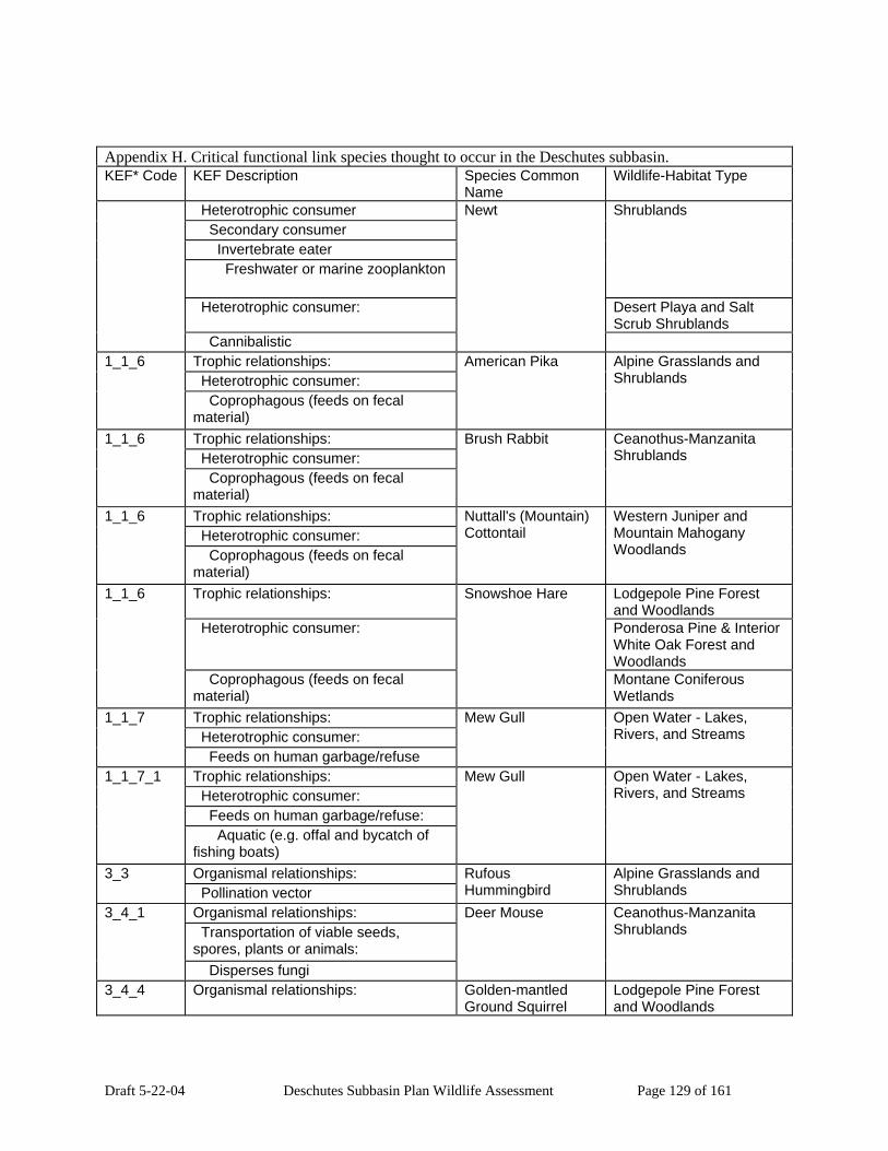
Draft 5-22-04 Deschutes Subbasin Plan Wildlife Assessment Page 129 of 161
Appendix H. Critical functional link species thought to occur in the Deschutes subbasin. KEF* Code KEF Description Species Common
Name Wildlife-Habitat Type
Heterotrophic consumer Secondary consumer Invertebrate eater Freshwater or marine zooplankton
Shrublands
Heterotrophic consumer: Desert Playa and Salt Scrub Shrublands
Cannibalistic
Newt
Trophic relationships: Heterotrophic consumer:
1_1_6
Coprophagous (feeds on fecal material)
American Pika Alpine Grasslands and Shrublands
Trophic relationships: Heterotrophic consumer:
1_1_6
Coprophagous (feeds on fecal material)
Brush Rabbit Ceanothus-Manzanita Shrublands
Trophic relationships: Heterotrophic consumer:
1_1_6
Coprophagous (feeds on fecal material)
Nuttall's (Mountain) Cottontail
Western Juniper and Mountain Mahogany Woodlands
Trophic relationships: Lodgepole Pine Forest and Woodlands
Heterotrophic consumer: Ponderosa Pine & Interior White Oak Forest and Woodlands
1_1_6
Coprophagous (feeds on fecal material)
Snowshoe Hare
Montane Coniferous Wetlands
Trophic relationships: Heterotrophic consumer:
1_1_7
Feeds on human garbage/refuse
Mew Gull Open Water - Lakes, Rivers, and Streams
Trophic relationships: Heterotrophic consumer: Feeds on human garbage/refuse:
1_1_7_1
Aquatic (e.g. offal and bycatch of fishing boats)
Mew Gull Open Water - Lakes, Rivers, and Streams
Organismal relationships: 3_3 Pollination vector
Rufous Hummingbird
Alpine Grasslands and Shrublands
Organismal relationships: Transportation of viable seeds, spores, plants or animals:
3_4_1
Disperses fungi
Deer Mouse Ceanothus-Manzanita Shrublands
3_4_4 Organismal relationships: Golden-mantled Ground Squirrel
Lodgepole Pine Forest and Woodlands

Draft 5-22-04 Deschutes Subbasin Plan Wildlife Assessment Page 130 of 161
Appendix H. Critical functional link species thought to occur in the Deschutes subbasin. KEF* Code KEF Description Species Common
Name Wildlife-Habitat Type
Transportation of viable seeds, spores, plants or animals:
Ceanothus-Manzanita Shrublands
Disperses insects and other invertebrates
Interior Canyon Shrublands
Organismal relationships: Ceanothus-Manzanita Shrublands
Transportation of viable seeds, spores, plants or animals:
Western Juniper and Mountain Mahogany Woodlands
3_4_6
Disperses vascular plants
Golden-mantled Ground Squirrel
Interior Canyon Shrublands
Organismal relationships: 3_5 Creates feeding, roosting, denning, or nesting opportunities for other organisms
Great Blue Heron Open Water - Lakes, Rivers, and Streams
Organismal relationships: 3_5 Creates feeding, roosting, denning, or nesting opportunities for other organisms
Grizzly Bear Interior Grasslands
Organismal relationships: 3_5 Creates feeding, roosting, denning, or nesting opportunities for other organisms
Mountain Lion Ceanothus-Manzanita Shrublands
Organismal relationships: Creates feeding, roosting, denning, or nesting opportunities for other organisms: Creates feeding opportunities (other than direct prey relations) Creates feeding, roosting, denning, or nesting opportunities for other organisms:
3_5_1
Creates feeding opportunities (other than direct prey relations)
Great Blue Heron Open Water - Lakes, Rivers, and Streams
Organismal relationships: Creates feeding, roosting, denning, or nesting opportunities for other organisms:
3_5_1
Creates feeding opportunities (other than direct prey relations)
Mountain Lion Ceanothus-Manzanita Shrublands
Organismal relationships: Western Juniper and Mountain Mahogany Woodlands
3_5_1_1
Creates feeding, roosting, denning, or nesting opportunities for other organisms:
Williamson's Sapsucker
Interior Canyon Shrublands

Draft 5-22-04 Deschutes Subbasin Plan Wildlife Assessment Page 131 of 161
Appendix H. Critical functional link species thought to occur in the Deschutes subbasin. KEF* Code KEF Description Species Common
Name Wildlife-Habitat Type
Creates feeding opportunities: Creates sapwells in trees
Organismal relationships: Mesic Lowlands Conifer-Hardwood Forest
Creates feeding, roosting, denning, or nesting opportunities for other organisms:
Southwest Oregon Mixed Conifer-Hardwood Forest
Creates feeding opportunities:
3_5_1_1
Creates sapwells in trees
Red-breasted Sapsucker
Organismal relationships: Mesic Lowlands Conifer-
Hardwood Forest Creates feeding, roosting, denning, or nesting opportunities for other organisms:
Open Water - Lakes, Rivers, and Streams
Creates roosting, denning, or nesting opportunities
Herbaceous Wetlands
3_5_2
Great Blue Heron
Interior Riparian-Wetlands Organismal relationships: Montane Mixed Conifer
Forest Creates feeding, roosting, denning, or nesting opportunities for other organisms:
Interior Mixed Conifer Forest
Creates roosting, denning, or nesting opportunities
Lodgepole Pine Forest and Woodlands
3_5_2
Red Squirrel
Ponderosa Pine & Interior White Oak Forest and Woodlands
Organismal relationships: Primary creation of structures (possibly used by other organisms):
3_6_2
Ground structures
Dusky-footed Woodrat
Ceanothus-Manzanita Shrublands
Organismal relationships: Montane Coniferous Wetlands
Primary creation of structures (possibly used by other organisms):
Interior Riparian-Wetlands
3_6_2
Ground structures
Bushy-tailed Woodrat
Organismal relationships: Mesic Lowlands Conifer-
Hardwood Forest Primary creation of structures (possibly used by other organisms):
Southwest Oregon Mixed Conifer-Hardwood Forest
Aquatic structures Montane Mixed Conifer Forest
Interior Mixed Conifer Forest
3_6_3
American Beaver
Lodgepole Pine Forest and Woodlands

Draft 5-22-04 Deschutes Subbasin Plan Wildlife Assessment Page 132 of 161
Appendix H. Critical functional link species thought to occur in the Deschutes subbasin. KEF* Code KEF Description Species Common
Name Wildlife-Habitat Type
Ponderosa Pine & Interior White Oak Forest and Woodlands
Subalpine Parkland Western Juniper and
Mountain Mahogany Woodlands
Montane Coniferous Wetlands
Organismal relationships: User of structures created by other species:
3_7_1
Aerial structures
Black Tern Open Water - Lakes, Rivers, and Streams
Organismal relationships: Ceanothus-Manzanita Shrublands
User of structures created by other species:
Desert Playa and Salt Scrub Shrublands
3_7_1
Aerial structures
Great Horned Owl
Organismal relationships: Alpine Grasslands and
Shrublands User of structures created by other species:
Desert Playa and Salt Scrub Shrublands
3_7_2
Ground structures
Deer Mouse
Organismal relationships: User of structures created by other species:
3_7_3
Aquatic structures
Fisher Subalpine Parkland
Organismal relationships: Lodgepole Pine Forest and Woodlands
User of structures created by other species:
Ceanothus-Manzanita Shrublands
Aquatic structures Western Juniper and Mountain Mahogany Woodlands
Interior Canyon Shrublands
Interior Grasslands Shrub-steppe
3_7_3
Mink
Desert Playa and Salt Scrub Shrublands
Organismal relationships: Nest parasite:
3_8_1
Interspecies parasite
Redhead Open Water - Lakes, Rivers, and Streams
3_8_1 Organismal relationships: Brown-headed Cowbird
Mesic Lowlands Conifer-Hardwood Forest

Draft 5-22-04 Deschutes Subbasin Plan Wildlife Assessment Page 133 of 161
Appendix H. Critical functional link species thought to occur in the Deschutes subbasin. KEF* Code KEF Description Species Common
Name Wildlife-Habitat Type
Nest parasite: Southwest Oregon Mixed Conifer-Hardwood Forest
Interspecies parasite Montane Mixed Conifer Forest
Interior Mixed Conifer Forest
Lodgepole Pine Forest and Woodlands
Ponderosa Pine & Interior White Oak Forest and Woodlands
Subalpine Parkland Ceanothus-Manzanita
Shrublands Western Juniper and
Mountain Mahogany Woodlands
Interior Canyon Shrublands
Interior Grasslands Shrub-steppe Dwarf Shrub-steppe Desert Playa and Salt
Scrub Shrublands
Montane Coniferous Wetlands
Organismal relationships: Nest parasite:
3_8_2
Common interspecific host
Greater Scaup Open Water - Lakes, Rivers, and Streams
Organismal relationships: Interior Grasslands Primary cavity excavator in snags or live trees
Dwarf Shrub-steppe 3_9
Black Bear
Herbaceous Wetlands Carrier, transmitter, or reservoir of vertebrate diseases:
Open Water - Lakes, Rivers, and Streams
Diseases that affect domestic animals Herbaceous Wetlands
4_2
Double-crested Cormorant
Interior Riparian-Wetlands Carrier, transmitter, or reservoir of vertebrate diseases:
Ceanothus-Manzanita Shrublands
4_3
Diseases that affect other wildlife species
Common Porcupine
Montane Coniferous Wetlands
Wood structure relationships (either living or dead wood):
Alpine Grasslands and Shrublands
6_2
Physically fragments standing wood
Black Bear
Dwarf Shrub-steppe

Draft 5-22-04 Deschutes Subbasin Plan Wildlife Assessment Page 134 of 161
Appendix H. Critical functional link species thought to occur in the Deschutes subbasin. KEF* Code KEF Description Species Common
Name Wildlife-Habitat Type
Herbaceous Wetlands Water relationships: Mesic Lowlands Conifer-
Hardwood Forest Impounds water by creating diversions or dams
Southwest Oregon Mixed Conifer-Hardwood Forest
Montane Mixed Conifer Forest
Interior Mixed Conifer Forest
Lodgepole Pine Forest and Woodlands
Ponderosa Pine & Interior White Oak Forest and Woodlands
Subalpine Parkland Western Juniper and
Mountain Mahogany Woodlands
Open Water - Lakes, Rivers, and Streams
Herbaceous Wetlands Montane Coniferous
Wetlands
7_1
American Beaver
Interior Riparian-Wetlands Water relationships: Southwest Oregon Mixed
Conifer-Hardwood Forest 7_2
Creates ponds or wetlands through wallowing
American Beaver
Open Water - Lakes, Rivers, and Streams
Water relationships: Alpine Grasslands and Shrublands
Creates ponds or wetlands through wallowing
Interior Canyon Shrublands
Interior Grasslands Shrub-steppe
7_2
Rocky Mountain Elk
Dwarf Shrub-steppe Vegetation structure and composition relationships:
Alpine Grasslands and Shrublands
Creates standing dead trees (snags) Interior Grasslands Dwarf Shrub-steppe
8_1
Herbivory on trees or shrubs that may alter vegetation structure and composition (browsers)
Black Bear
8_3 Vegetation structure and composition relationships:
Canada Goose Open Water - Lakes, Rivers, and Streams
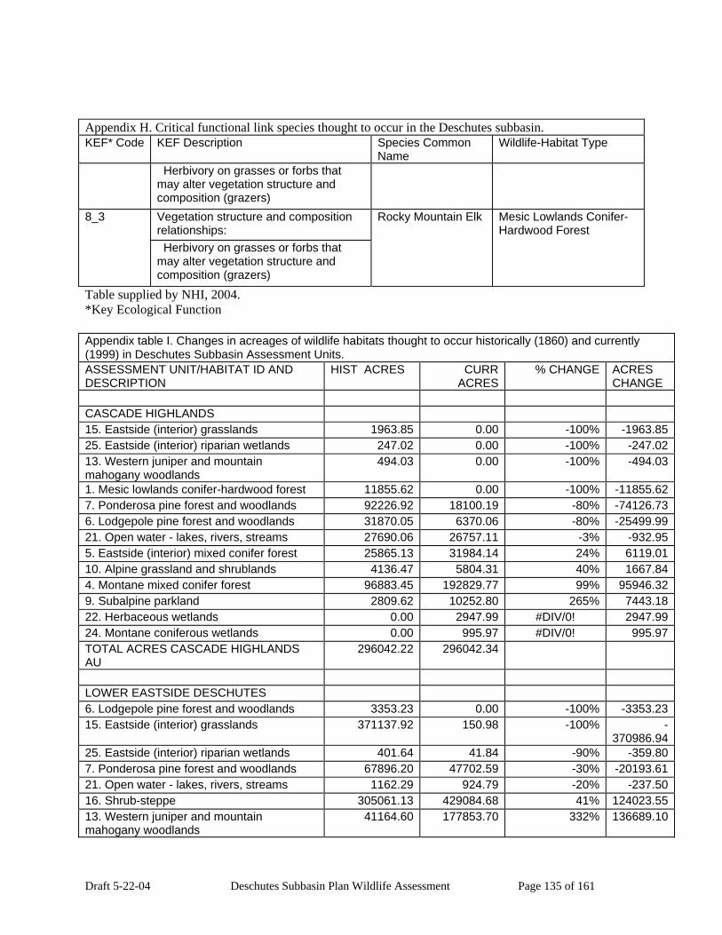
Draft 5-22-04 Deschutes Subbasin Plan Wildlife Assessment Page 135 of 161
Appendix H. Critical functional link species thought to occur in the Deschutes subbasin. KEF* Code KEF Description Species Common
Name Wildlife-Habitat Type
Herbivory on grasses or forbs that may alter vegetation structure and composition (grazers)
Vegetation structure and composition relationships:
8_3
Herbivory on grasses or forbs that may alter vegetation structure and composition (grazers)
Rocky Mountain Elk Mesic Lowlands Conifer-Hardwood Forest
Table supplied by NHI, 2004. *Key Ecological Function Appendix table I. Changes in acreages of wildlife habitats thought to occur historically (1860) and currently (1999) in Deschutes Subbasin Assessment Units. ASSESSMENT UNIT/HABITAT ID AND DESCRIPTION
HIST ACRES CURR ACRES
% CHANGE ACRES CHANGE
CASCADE HIGHLANDS 15. Eastside (interior) grasslands 1963.85 0.00 -100% -1963.8525. Eastside (interior) riparian wetlands 247.02 0.00 -100% -247.0213. Western juniper and mountain mahogany woodlands
494.03 0.00 -100% -494.03
1. Mesic lowlands conifer-hardwood forest 11855.62 0.00 -100% -11855.627. Ponderosa pine forest and woodlands 92226.92 18100.19 -80% -74126.736. Lodgepole pine forest and woodlands 31870.05 6370.06 -80% -25499.9921. Open water - lakes, rivers, streams 27690.06 26757.11 -3% -932.955. Eastside (interior) mixed conifer forest 25865.13 31984.14 24% 6119.0110. Alpine grassland and shrublands 4136.47 5804.31 40% 1667.844. Montane mixed conifer forest 96883.45 192829.77 99% 95946.329. Subalpine parkland 2809.62 10252.80 265% 7443.1822. Herbaceous wetlands 0.00 2947.99 #DIV/0! 2947.9924. Montane coniferous wetlands 0.00 995.97 #DIV/0! 995.97TOTAL ACRES CASCADE HIGHLANDS AU
296042.22 296042.34
LOWER EASTSIDE DESCHUTES 6. Lodgepole pine forest and woodlands 3353.23 0.00 -100% -3353.2315. Eastside (interior) grasslands 371137.92 150.98 -100% -
370986.9425. Eastside (interior) riparian wetlands 401.64 41.84 -90% -359.807. Ponderosa pine forest and woodlands 67896.20 47702.59 -30% -20193.6121. Open water - lakes, rivers, streams 1162.29 924.79 -20% -237.5016. Shrub-steppe 305061.13 429084.68 41% 124023.5513. Western juniper and mountain mahogany woodlands
41164.60 177853.70 332% 136689.10

Draft 5-22-04 Deschutes Subbasin Plan Wildlife Assessment Page 136 of 161
Appendix table I. Changes in acreages of wildlife habitats thought to occur historically (1860) and currently (1999) in Deschutes Subbasin Assessment Units. ASSESSMENT UNIT/HABITAT ID AND DESCRIPTION
HIST ACRES CURR ACRES
% CHANGE ACRES CHANGE
5. Eastside (interior) mixed conifer forest 1481.98 26941.40 1718% 25459.4219. Agriculture, pasture and mixed environs 0.00 71369.50 #DIV/0! 71369.5014. Eastside (interior) canyon shrublands 0.00 34382.22 #DIV/0! 34382.2222. Herbaceous wetlands 0.00 1081.51 #DIV/0! 1081.5120. Urban and mixed environs 0.00 2126.02 #DIV/0! 2126.02TOTAL ACRES LOWER EASTSIDE DESCHUTES ASSESSMENT UNIT
791658.99 791659.23
LOWER CROOKED 9. Subalpine parkland 1663.25 0.00 -100% -1663.258. Upland Aspen forest 740.99 0.00 -100% -740.9915. Eastside (interior) grasslands 34592.84 125.97 -100% -34466.876. Lodgepole pine forest and woodlands 84160.50 9019.54 -89% -75140.9613. Western juniper and mountain mahogany woodlands
388845.39 346629.64 -11% -42215.75
7. Ponderosa pine forest and woodlands 124663.95 113520.54 -9% -11143.4116. Shrub-steppe 464796.99 428886.05 -8% -35910.9421. Open water - lakes, rivers, streams 1706.46 2609.15 53% 902.695. Eastside (interior) mixed conifer forest 15140.22 29950.91 98% 14810.6922. Herbaceous wetlands 0.02 2019.94 10099600% 2019.9219. Agriculture, pasture and mixed environs 0.00 94469.38 #DIV/0! 94469.3818. Desert playa and salt scrub shrublands 0.00 57.58 #DIV/0! 57.5817. Dwarf Shrub-steppe 0.00 85752.72 #DIV/0! 85752.7225. Eastside (interior) riparian wetlands 0.00 774.08 #DIV/0! 774.084. Montane mixed conifer forest 0.00 87.38 #DIV/0! 87.3820. Urban and mixed environs 0.00 2480.93 #DIV/0! 2480.93TOTAL ACRES LOWER CROOKED AU 1116310.61 1116383.81 LOWER WESTSIDE DESCHUTES 18. Desert playa and salt scrub shrublands 1001.60 0.00 -100% -1001.6015. Eastside (interior) grasslands 99279.39 0.00 -100% -99279.3922. Herbaceous wetlands 11808.24 237.18 -98% -11571.0625. Eastside (interior) riparian wetlands 9244.58 499.13 -95% -8745.451. Mesic lowlands conifer-hardwood forest 4831.69 334.12 -93% -4497.5710. Alpine grassland and shrublands 402.15 62.66 -84% -339.496. Lodgepole pine forest and woodlands 6360.54 1700.99 -73% -4659.557. Ponderosa pine forest and woodlands 227418.98 142177.79 -37% -85241.1916. Shrub-steppe 344183.95 370939.00 8% 26755.0513. Western juniper and mountain mahogany woodlands
42244.98 53109.19 26% 10864.21
5. Eastside (interior) mixed conifer forest 94472.99 141490.65 50% 47017.66

Draft 5-22-04 Deschutes Subbasin Plan Wildlife Assessment Page 137 of 161
Appendix table I. Changes in acreages of wildlife habitats thought to occur historically (1860) and currently (1999) in Deschutes Subbasin Assessment Units. ASSESSMENT UNIT/HABITAT ID AND DESCRIPTION
HIST ACRES CURR ACRES
% CHANGE ACRES CHANGE
9. Subalpine parkland 963.51 1478.58 53% 515.074. Montane mixed conifer forest 21202.70 44340.97 109% 23138.2721. Open water - lakes, rivers, streams 1017.15 5845.91 475% 4828.7619. Agriculture, pasture and mixed environs 0.00 52138.81 #DIV/0! 52138.8114. Eastside (interior) canyon shrublands 0.00 47616.57 #DIV/0! 47616.5724. Montane coniferous wetlands 0.00 1776.91 #DIV/0! 1776.913. Southwest Oregon mixed conifer-hardwood forest
0.00 40.45 #DIV/0! 40.45
20. Urban and mixed environs 0.00 730.23 #DIV/0! 730.23TOTAL ACRES LOWER WESTSIDE DESCHUTES AU
864432 864519.14
MIDDLE DESCHUTES 15. Eastside (interior) grasslands 15686.87 0.00 -100% -15686.8725. Eastside (interior) riparian wetlands 1222.44 3.51 -100% -1218.931. Mesic lowlands conifer-hardwood forest 16391.91 819.58 -95% -15572.3321. Open water - lakes, rivers, streams 11840.95 4922.30 -58% -6918.6510. Alpine grassland and shrublands 5525.30 2578.28 -53% -2947.026. Lodgepole pine forest and woodlands 22910.88 11836.64 -48% -11074.247. Ponderosa pine forest and woodlands 307650.56 162117.70 -47% -
145532.8622. Herbaceous wetlands 1481.97 1575.58 6% 93.6116. Shrub-steppe 30569.86 36036.10 18% 5466.249. Subalpine parkland 14129.77 19684.16 39% 5554.3913. Western juniper and mountain mahogany woodlands
37417.47 67250.01 80% 29832.54
5. Eastside (interior) mixed conifer forest 53226.54 106881.34 101% 53654.804. Montane mixed conifer forest 18235.08 112138.08 515% 93903.0019. Agriculture, pasture and mixed environs 0.00 9066.93 #DIV/0! 9066.9312. Ceanothus-manzanita shrublands 0.00 74.41 #DIV/0! 74.4124. Montane coniferous wetlands 0.00 717.69 #DIV/0! 717.6920. Urban and mixed environs 0.00 587.53 #DIV/0! 587.53TOTAL ACRES MIDDLE DESCHUTES AU 536289.60 536289.84 UPPER CROOKED 6. Lodgepole pine forest and woodlands 17304.74 0.00 -100% -17304.7415. Eastside (interior) grasslands 60817.21 4287.48 -93% -56529.7316. Shrub-steppe 1017733.63 635409.07 -38% -
382324.567. Ponderosa pine forest and woodlands 453939.94 295382.72 -35% -
158557.2225. Eastside (interior) riparian wetlands 8150.78 5591.18 -31% -2559.60
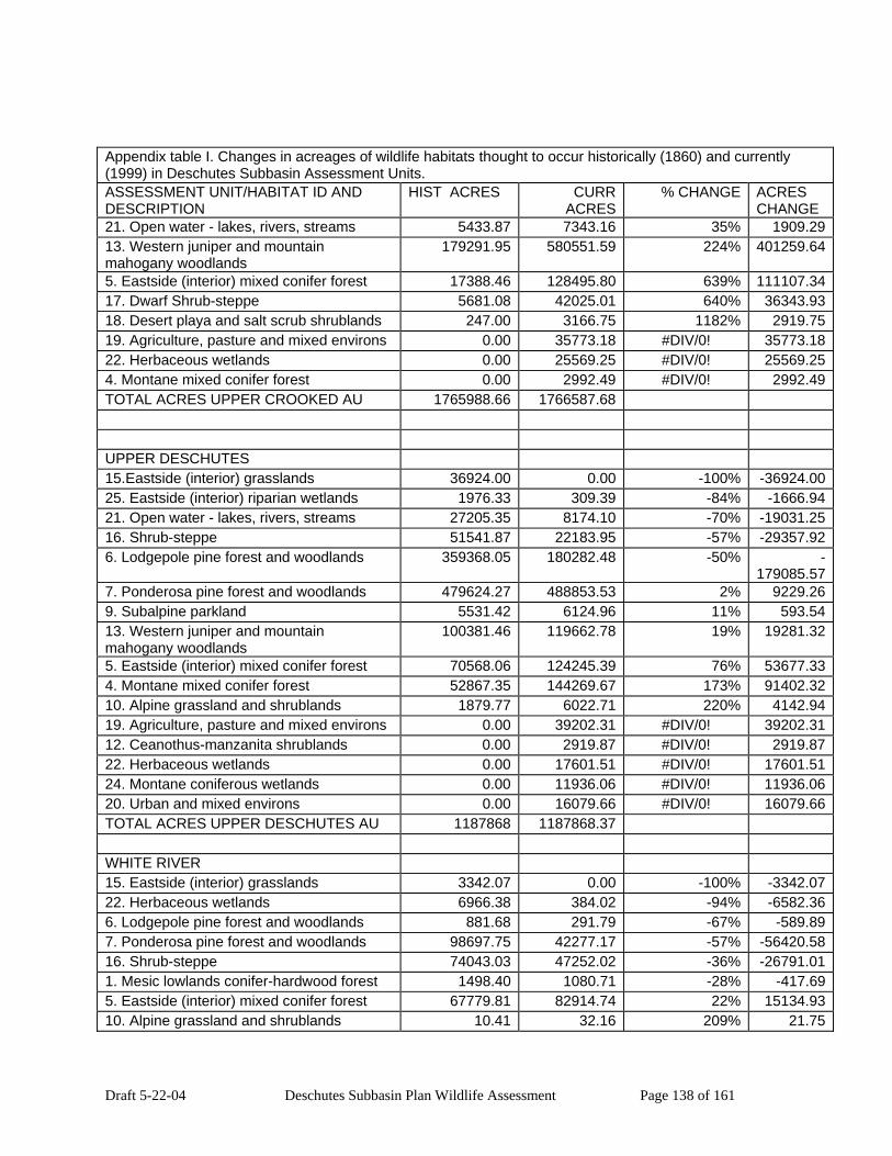
Draft 5-22-04 Deschutes Subbasin Plan Wildlife Assessment Page 138 of 161
Appendix table I. Changes in acreages of wildlife habitats thought to occur historically (1860) and currently (1999) in Deschutes Subbasin Assessment Units. ASSESSMENT UNIT/HABITAT ID AND DESCRIPTION
HIST ACRES CURR ACRES
% CHANGE ACRES CHANGE
21. Open water - lakes, rivers, streams 5433.87 7343.16 35% 1909.2913. Western juniper and mountain mahogany woodlands
179291.95 580551.59 224% 401259.64
5. Eastside (interior) mixed conifer forest 17388.46 128495.80 639% 111107.3417. Dwarf Shrub-steppe 5681.08 42025.01 640% 36343.9318. Desert playa and salt scrub shrublands 247.00 3166.75 1182% 2919.7519. Agriculture, pasture and mixed environs 0.00 35773.18 #DIV/0! 35773.1822. Herbaceous wetlands 0.00 25569.25 #DIV/0! 25569.254. Montane mixed conifer forest 0.00 2992.49 #DIV/0! 2992.49TOTAL ACRES UPPER CROOKED AU 1765988.66 1766587.68 UPPER DESCHUTES 15.Eastside (interior) grasslands 36924.00 0.00 -100% -36924.0025. Eastside (interior) riparian wetlands 1976.33 309.39 -84% -1666.9421. Open water - lakes, rivers, streams 27205.35 8174.10 -70% -19031.2516. Shrub-steppe 51541.87 22183.95 -57% -29357.926. Lodgepole pine forest and woodlands 359368.05 180282.48 -50% -
179085.577. Ponderosa pine forest and woodlands 479624.27 488853.53 2% 9229.269. Subalpine parkland 5531.42 6124.96 11% 593.5413. Western juniper and mountain mahogany woodlands
100381.46 119662.78 19% 19281.32
5. Eastside (interior) mixed conifer forest 70568.06 124245.39 76% 53677.334. Montane mixed conifer forest 52867.35 144269.67 173% 91402.3210. Alpine grassland and shrublands 1879.77 6022.71 220% 4142.9419. Agriculture, pasture and mixed environs 0.00 39202.31 #DIV/0! 39202.3112. Ceanothus-manzanita shrublands 0.00 2919.87 #DIV/0! 2919.8722. Herbaceous wetlands 0.00 17601.51 #DIV/0! 17601.5124. Montane coniferous wetlands 0.00 11936.06 #DIV/0! 11936.0620. Urban and mixed environs 0.00 16079.66 #DIV/0! 16079.66TOTAL ACRES UPPER DESCHUTES AU 1187868 1187868.37 WHITE RIVER 15. Eastside (interior) grasslands 3342.07 0.00 -100% -3342.0722. Herbaceous wetlands 6966.38 384.02 -94% -6582.366. Lodgepole pine forest and woodlands 881.68 291.79 -67% -589.897. Ponderosa pine forest and woodlands 98697.75 42277.17 -57% -56420.5816. Shrub-steppe 74043.03 47252.02 -36% -26791.011. Mesic lowlands conifer-hardwood forest 1498.40 1080.71 -28% -417.695. Eastside (interior) mixed conifer forest 67779.81 82914.74 22% 15134.9310. Alpine grassland and shrublands 10.41 32.16 209% 21.75

Draft 5-22-04 Deschutes Subbasin Plan Wildlife Assessment Page 139 of 161
Appendix table I. Changes in acreages of wildlife habitats thought to occur historically (1860) and currently (1999) in Deschutes Subbasin Assessment Units. ASSESSMENT UNIT/HABITAT ID AND DESCRIPTION
HIST ACRES CURR ACRES
% CHANGE ACRES CHANGE
4. Montane mixed conifer forest 354.56 44148.78 12352% 43794.2219. Agriculture, pasture and mixed environs 0.00 31538.27 #DIV/0! 31538.2714. Eastside (interior) canyon shrublands 0.00 727.85 #DIV/0! 727.8525. Eastside (interior) riparian wetlands 0.00 346.40 #DIV/0! 346.4024. Montane coniferous wetlands 0.00 349.91 #DIV/0! 349.9121. Open water - lakes, rivers, streams 0.00 1149.21 #DIV/0! 1149.213. Southwest Oregon mixed conifer-hardwood forest
0.00 107.13 #DIV/0! 107.13
9. Subalpine parkland 0.00 974.06 #DIV/0! 974.06TOTAL ACRES WHITE RIVER ASSESSMENT UNIT
253574.22 253574.22
Appendix Table J Acreages of focal habitats within winter ranges by assessment unit, from current habitats map.
Assessment Unit Habitat Acres LOWER EASTSIDE DESCHUTES 16787.13
Eastside (interior) grasslands 17.85 Shrub-steppe 1166.37 Ponderosa pine forest and woodlands 15602.91
LOWER CROOKED 133242.54 Eastside (interior) grasslands 90.50 Herbaceous wetlands 552.95 Lodgepole pine forest and woodlands 1849.73 Dwarf shrub-steppe 2998.25 Ponderosa pine forest and woodlands 39761.49 Shrub-steppe 87989.62
LOWER WESTSIDE DESCHUTES 2660.19 Lodgepole pine forest and woodlands 163.71 Ponderosa pine forest and woodlands 2496.48
MIDDLE DESCHUTES 86184.78 Eastside (interior) riparian wetlands 0.21 Herbaceous wetlands 262.77 Lodgepole pine forest and woodlands 1340.06 Shrub-steppe 17344.62 Ponderosa pine forest and woodlands 67237.11
UPPER CROOKED 606500.76 Eastside (interior) grasslands 2881.77 Eastside (interior) riparian wetlands 3774.33 Herbaceous wetlands 17128.71

Draft 5-22-04 Deschutes Subbasin Plan Wildlife Assessment Page 140 of 161
Appendix Table J Acreages of focal habitats within winter ranges by assessment unit, from current habitats map.
Assessment Unit Habitat Acres Dwarf shrub-steppe 26005.35 Ponderosa pine forest and woodlands 165167.09 Shrub-steppe 391543.52
UPPER DESCHUTES 86050.20 Eastside (interior) riparian wetlands 18.35 Herbaceous wetlands 818.44 Shrub-steppe 4005.91 Lodgepole pine forest and woodlands 4858.71 Ponderosa pine forest and woodlands 76348.79
WHITE RIVER 43994.73 Herbaceous wetlands 274.54 Lodgepole pine forest and woodlands 291.79 Shrub-steppe 8389.87 Ponderosa pine forest and woodlands 35038.53
Grand Total 975420.33 Appendix Table K. Acreages of Focal Habitats within ungulate winter ranges by Assessment Unit, from historic habitats map.
Assessment Unit Habitat AcresLOWER EASTSIDE DESCHUTES 31701.25
Eastside (interior) grasslands 343.98 Lodgepole pine forest and woodlands 513.27 Ponderosa pine forest and woodlands 28618.63 Shrub-steppe 2225.37
LOWER CROOKED 158718.01 Eastside (interior) grasslands 9024.25 Lodgepole pine forest and woodlands 17818.55 Ponderosa pine forest and woodlands 68082.58 Shrub-steppe 63413.31 Upland aspen forest 379.32
LOWER WESTSIDE DESCHUTES 6283.21 Ponderosa pine forest and woodlands 6234.61 Shrub-steppe 48.60
MIDDLE DESCHUTES 125161.20 Eastside (interior) grasslands 10054.64 Herbaceous wetlands 347.88 Ponderosa pine forest and woodlands 97895.72

Draft 5-22-04 Deschutes Subbasin Plan Wildlife Assessment Page 141 of 161
Appendix Table K. Acreages of Focal Habitats within ungulate winter ranges by Assessment Unit, from historic habitats map.
Assessment Unit Habitat Acres Shrub-steppe 16862.97
UPPER CROOKED 1013300.64 Dwarf shrub-steppe 4392.74 Eastside (interior) grasslands 40038.43 Eastside (interior) riparian wetlands 7703.15 Lodgepole pine forest and woodlands 16795.76 Ponderosa pine forest and woodlands 260570.43 Shrub-steppe 683800.13
UPPER DESCHUTES 111957.99 Eastside (interior) grasslands 10174.46 Lodgepole pine forest and woodlands 19768.44 Ponderosa pine forest and woodlands 74078.16 Shrub-steppe 7936.93
WHITE RIVER 102894.29 Eastside (interior) grasslands 594.66 Herbaceous wetlands 299.15 Lodgepole pine forest and woodlands 633.38 Ponderosa pine forest and woodlands 91230.40 Shrub-steppe 10136.70
Grand Total 1550016.59 Appendix Table L. Optimal conditions and environmental potential for Key Environmental Correlates
(KECs) for focal species.
Species/KEC Description Optimal Conditions1 Environmental Potential Columbia Spotted Frog exotic species No exotic species should be present.
Exotic bullfrog, bass, brown, brook trout may prey on frogs.
High
beaver/muskrat activity (dams, lodges, ponds) (Positive only)
Beaver ponds and channels are used as habitat.
High
water depth Sufficient depth to be permanent optimal, but shallow ephemeral edges also used for reproduction.
High
Channel changes Permanent unchanging channel High

Draft 5-22-04 Deschutes Subbasin Plan Wildlife Assessment Page 142 of 161
Appendix Table L. Optimal conditions and environmental potential for Key Environmental Correlates (KECs) for focal species.
Species/KEC Description Optimal Conditions1 Environmental Potential
optimal. water velocity Ponded, slow-moving, or slack water
optimal. High
rivers & streams Oxbows, backwaters used. High banks Vegetated, undercut banks used for
winter hibernation. High
emergent vegetation Eggs deposited among emergent vegetation.
High
ephemeral pools Used as refuge during movement from wintering to breeding sites.
Low
lakes/ponds/reservoirs Reservoirs not used. sand/mud Soft muck bottom used for
hibernation High
floating mats Required. High riverine wetlands Larger areas of pooled or slack water
used. High
seasonal flooding Seasonally flooded edges of permanent water areas used for reproduction.
High
toxic chemical use (indicate only documented affects)
Unknown.
pesticides Unknown hatchery facilities and fish Stocked exotic fish are thought to
impact frog populations. High
Golden Eagle
Forest, Shrubland, & Grassland Habitat Elements
forest/woodland vegetative elements or substrates
Cliff sites are used for nesting. High
snag size (dbh) Large trees or snags greater than 30 in dbh may be used for nesting.
Low
giant tree >= 30” dbh Large trees or snags greater than 30 in dbh may be used for nesting.
Low
shrubland/grassland vegetative elements or substrates
Cliff sites are used for nesting. High
trees (located in a shrubland/grassland context)
Large trees or snags may be used for nesting
Low
Ecological Habitat Elements

Draft 5-22-04 Deschutes Subbasin Plan Wildlife Assessment Page 143 of 161
Appendix Table L. Optimal conditions and environmental potential for Key Environmental Correlates (KECs) for focal species.
Species/KEC Description Optimal Conditions1 Environmental Potential
exotic species (specify whether the species is negatively or positively influenced by the presence of introduced plants or animals)
No information. Low
exotic plants No information. Low Non-vegetative, Abiotic Habitat Elements
No information.
cliffs Used for nesting High rocky outcrops and ridges Used for nesting High rock crevices Used for nesting High Freshwater Riparian & Aquatic Bodies Habitat Elements
seasonal flooding Anthropogenic-related Habitat Elements
toxic chemical use (indicate only documented affects)
Birds are poisoned by chemicals used for other pests. No chemicals is optimal.
High
pesticides Birds are poisoned by chemicals used for other pests. No chemicals is optimal.
High
powerlines/corridors Will sometimes build nests on power poles, or perch on power poles. Electrocution of birds a source of mortality. No power lines is optimal.
High
harvest/persecution (of animals) (includes legal and illegal harvest, and incidental take)
Birds are sometimes killed. No illegal take is optimal.
High
Sage Grouse
Forest, Shrubland, & Grassland Habitat Elements
shrubland/grassland vegetative elements or substrates
herbaceous layer Full range of native herbaceous plants is optimal.
High
grasses Full range of native grasses is optimal, nest areas were found to have a greater cover of grasses more than 7 in tall.
High
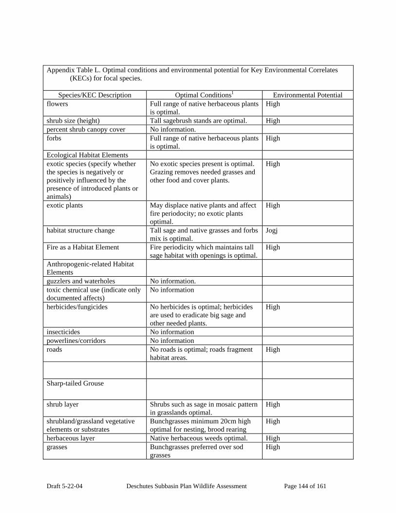
Draft 5-22-04 Deschutes Subbasin Plan Wildlife Assessment Page 144 of 161
Appendix Table L. Optimal conditions and environmental potential for Key Environmental Correlates (KECs) for focal species.
Species/KEC Description Optimal Conditions1 Environmental Potential
flowers Full range of native herbaceous plants is optimal.
High
shrub size (height) Tall sagebrush stands are optimal. High percent shrub canopy cover No information. forbs Full range of native herbaceous plants
is optimal. High
Ecological Habitat Elements exotic species (specify whether the species is negatively or positively influenced by the presence of introduced plants or animals)
No exotic species present is optimal. Grazing removes needed grasses and other food and cover plants.
High
exotic plants May displace native plants and affect fire periodocity; no exotic plants optimal.
High
habitat structure change Tall sage and native grasses and forbs mix is optimal.
Jogj
Fire as a Habitat Element Fire periodicity which maintains tall sage habitat with openings is optimal.
High
Anthropogenic-related Habitat Elements
guzzlers and waterholes No information. toxic chemical use (indicate only documented affects)
No information
herbicides/fungicides No herbicides is optimal; herbicides are used to eradicate big sage and other needed plants.
High
insecticides No information powerlines/corridors No information roads No roads is optimal; roads fragment
habitat areas. High
Sharp-tailed Grouse
shrub layer Shrubs such as sage in mosaic pattern in grasslands optimal.
High
shrubland/grassland vegetative elements or substrates
Bunchgrasses minimum 20cm high optimal for nesting, brood rearing
High
herbaceous layer Native herbaceous weeds optimal. High grasses Bunchgrasses preferred over sod
grasses High

Draft 5-22-04 Deschutes Subbasin Plan Wildlife Assessment Page 145 of 161
Appendix Table L. Optimal conditions and environmental potential for Key Environmental Correlates (KECs) for focal species.
Species/KEC Description Optimal Conditions1 Environmental Potential
edges Mosaic pattern of shrublands, grasslands, riparian brushy habitats, and woodland edges are optimal.
High
exotic plants Cheatgrass, thistle, and other exotic weeds may displace native plants. No exotics is optimal.
Low
exotic animals Grazing degrades habitat by removing tall grasses needed for nesting and refuge, and by removing riparian brush needed for feeding and resting cover. Other exotic animals such as foxes prey on eggs or adults. Introduced exotic birds such as pheasant may communicate diseases.
High
habitat structure change Permanent grass structure for nesting is optimal.
High
Freshwater Riparian & Aquatic Bodies Habitat Elements
Streams with riparian vegetation such as hawthorn, aspen, willow, are optimal.
High
rivers & streams Stream and river brushy riparian zones optimal
High
seeps or springs Brushy riparian zones around springs are optimal
High
Fire as a Habitat Element Periodic fire if maintains grassland and brush areas is optimal.
High
Anthropogenic-related Habitat Elements
toxic chemical use (indicate only documented affects)
No information.
hedgerows/windbreaks If natural patches of shrubs or riparian brushy areas are not available, planted areas would be optimal.
Low
powerlines/corridors No information. roads Roads fragment habitat, so low
number of roads is optimal. Low
White-headed Woodpecker
forest/woodland vegetative elements or substrates
Open pine forests of two species of pine mixed with large ponderosa pine is optimal.
High

Draft 5-22-04 Deschutes Subbasin Plan Wildlife Assessment Page 146 of 161
Appendix Table L. Optimal conditions and environmental potential for Key Environmental Correlates (KECs) for focal species.
Species/KEC Description Optimal Conditions1 Environmental Potential
trees Large diameter ponderosa pine in open woodland condition is optimal.
High
snags Large diameter snags with hard outer wood and soft heartwood optimal for nesting.
High
snag size (dbh) Large-diameter snags optimal. High
tree size (dbh) Nest trees in the Deschutes NF mean dbh 25.6 inches.
High
fruits/seeds/nuts Ponderosa pine seeds needed for food.
High
insect population irruptions (specify whether negative or positive relationship in comments)
Insects are needed as food. Low
Fire as a Habitat Element Fire is needed to maintain open pine forests which are optimal for nesting.
High
American Beaver
trees Aspen, cottonwood, alder are preferred for food.
High
shrubland/grassland vegetative elements or substrates
Herbaceous plants used for food. High
shrubs Willow, alder are preferred food items.
High
water characteristics (specify whether negative or positive relationship in comments)
Permanent water of stable water level and sufficient depth and area for refuge. Reservoirs are not suitable.
High
water velocity Fast-flowing upper tributaries of gradient more than 15 percent are not suitable.
High
rivers & streams Gradient less than 6 percent, with wide banks optimal, with minimal water level fluctuation.
High
intermittent Not suitable for habitat. Low upper perennial Fast-flowing upper tribs in v-shaped
canyons not suitable habitat, but necessary to provide lower-area perennial water habitat.
High
open water Protected open water needed for refuge.
Low

Draft 5-22-04 Deschutes Subbasin Plan Wildlife Assessment Page 147 of 161
Appendix Table L. Optimal conditions and environmental potential for Key Environmental Correlates (KECs) for focal species.
Species/KEC Description Optimal Conditions1 Environmental Potential
shoreline Large lakes must have irregular shoreline with bays and coves.
Low
lakes/ponds/reservoirs Reservoirs usually not suitable due to water level fluctuation.
Low
ponds (<2ha) Suitable if forage available. Low wetlands/marshes/wet meadows/bogs and swamps (Positive relationships only)
Permanent open water with forage available optimal.
High
Anthropogenic-related Habitat Elements
Agricultural areas not suitable habitat: clearing of riparian vegetation and conflicts with damming and cutting trees.
High
repellents Used to prevent beaver damage. Low chemical (taste or smell) No information. irrigation ditches/canals Conflicts with beaver habitat. Low pollution No information. chemical No information. sewage No information.
Mule Deer
Forest, Shrubland, & Grassland Habitat Elements
All habitats used.
forest/woodland vegetative elements or substrates
Wide variety and high quality browse optimal.
Low
herbaceous layer Vigorous, healthy plants optimal Low edges Mosaic of vegetation and habitats
optimal Low
shrub layer Vigorous, healthy plants optimal Low forbs Vigorous, healthy plants optimal Low shrubland/grassland vegetative elements or substrates
Wide vegetative variety and high quality browse optimal.
Low
Ecological Habitat Elements exotic species (specify whether the species is negatively or positively influenced by the presence of introduced plants or animals)
No competition from other ungulates is optimal.
Low
exotic animals predation Low or no numbers of predators such
as coyote and cougar is optimal. Low
direct displacement No displacement by cattle, elk, or Low

Draft 5-22-04 Deschutes Subbasin Plan Wildlife Assessment Page 148 of 161
Appendix Table L. Optimal conditions and environmental potential for Key Environmental Correlates (KECs) for focal species.
Species/KEC Description Optimal Conditions1 Environmental Potential
other grazing animals is optimal habitat structure change insect population irruptions (specify whether negative or positive relationship in comments)
May be beneficial if growth of shrubs, forbs, and grasses on the exposed forest floor is initiated.
High
mountain pine beetle May be beneficial if growth of shrubs, forbs, and grasses on the exposed forest floor is initiated.
High
Non-vegetative, Abiotic Habitat Elements
snow Short time of snow and frequent snow cover is optimal, since plants will be adequately watered for greenup but not covered so they are not available to deer.
Low
snow depth (specify whether negative or positive relationship in comments)
Shallow depth and frequent snow during the precipitation season is optimal.
Low
Freshwater Riparian & Aquatic Bodies Habitat Elements
water characteristics (specify whether negative or positive relationship in comments)
Free water throughout the habitat is optimal.
High
free water (derived from any source)
Free water availability is optimal. High
wetlands/marshes/wet meadows/bogs and swamps (Positive relationships only)
No information.
context forest non-forest Fire as a Habitat Element Periodic fires in a mosaic pattern is
optimal to rejuvenate brush and other vegetation for high quality forage.
High
Anthropogenic-related Habitat Elements
guzzlers and waterholes May improve habitat where natural free water is not available.
High
repellents If repellent is effective in solving deer damage complaints, it would be considered optimal since deer would not have to be removed from the
Low

Draft 5-22-04 Deschutes Subbasin Plan Wildlife Assessment Page 149 of 161
Appendix Table L. Optimal conditions and environmental potential for Key Environmental Correlates (KECs) for focal species.
Species/KEC Description Optimal Conditions1 Environmental Potential
damaged area chemical (taste or smell) No unnatural taste or smell is
optimal, since food items are chosen by deer partly on the basis of taste and smell.
Low
irrigation ditches/canals No barriers in habitat is optimal. If t fencing presen to prevent drowning of deer, with overpass bridges is optimal. Water presence is beneficial.
Low
roads No barriers in habitat is optimal. If present, underpasses or overpasses with fences to prevent deer-vehicle collisions is optimal. Access roads on winter ranges closed in winter optimal.
High
harvest/persecution (of animals) (includes legal and illegal harvest, and incidental take)
Well-regulated hunting seasons with no illegal harvest is optimal. If illegal harvest occurs, consideration along with legal harvest when setting harvest levels is optimal.
High
fences/corrals No barriers in habitat is optimal. High supplemental food No supplemental food is optimal. Low Table supplied by NHI, 2004. 1 optimal conditions are taken from species accounts. Appendix Table M. Key ecological functions (KEFs) for focal species, sorted to show redundancy.
Common Name SHP-KEF* KEF Description
Columbia Spotted Frog 1 Trophic relationships American Beaver 1 Trophic relationships Columbia Spotted Frog 1.1 heterotrophic consumer American Beaver 1.1 heterotrophic consumer Columbia Spotted Frog 1.1.1 primary consumer (herbivore) (also see below
under Herbivory) American Beaver 1.1.1 primary consumer (herbivore) (also see below
under Herbivory)
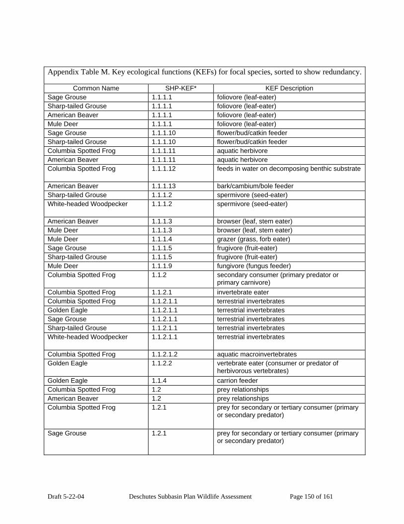
Draft 5-22-04 Deschutes Subbasin Plan Wildlife Assessment Page 150 of 161
Appendix Table M. Key ecological functions (KEFs) for focal species, sorted to show redundancy.
Common Name SHP-KEF* KEF Description Sage Grouse 1.1.1.1 foliovore (leaf-eater) Sharp-tailed Grouse 1.1.1.1 foliovore (leaf-eater) American Beaver 1.1.1.1 foliovore (leaf-eater) Mule Deer 1.1.1.1 foliovore (leaf-eater) Sage Grouse 1.1.1.10 flower/bud/catkin feeder Sharp-tailed Grouse 1.1.1.10 flower/bud/catkin feeder Columbia Spotted Frog 1.1.1.11 aquatic herbivore American Beaver 1.1.1.11 aquatic herbivore Columbia Spotted Frog 1.1.1.12 feeds in water on decomposing benthic substrate
American Beaver 1.1.1.13 bark/cambium/bole feeder Sharp-tailed Grouse 1.1.1.2 spermivore (seed-eater) White-headed Woodpecker 1.1.1.2 spermivore (seed-eater)
American Beaver 1.1.1.3 browser (leaf, stem eater) Mule Deer 1.1.1.3 browser (leaf, stem eater) Mule Deer 1.1.1.4 grazer (grass, forb eater) Sage Grouse 1.1.1.5 frugivore (fruit-eater) Sharp-tailed Grouse 1.1.1.5 frugivore (fruit-eater) Mule Deer 1.1.1.9 fungivore (fungus feeder) Columbia Spotted Frog 1.1.2 secondary consumer (primary predator or
primary carnivore) Columbia Spotted Frog 1.1.2.1 invertebrate eater Columbia Spotted Frog 1.1.2.1.1 terrestrial invertebrates Golden Eagle 1.1.2.1.1 terrestrial invertebrates Sage Grouse 1.1.2.1.1 terrestrial invertebrates Sharp-tailed Grouse 1.1.2.1.1 terrestrial invertebrates White-headed Woodpecker 1.1.2.1.1 terrestrial invertebrates
Columbia Spotted Frog 1.1.2.1.2 aquatic macroinvertebrates Golden Eagle 1.1.2.2 vertebrate eater (consumer or predator of
herbivorous vertebrates) Golden Eagle 1.1.4 carrion feeder Columbia Spotted Frog 1.2 prey relationships American Beaver 1.2 prey relationships Columbia Spotted Frog 1.2.1 prey for secondary or tertiary consumer (primary
or secondary predator)
Sage Grouse 1.2.1 prey for secondary or tertiary consumer (primary or secondary predator)

Draft 5-22-04 Deschutes Subbasin Plan Wildlife Assessment Page 151 of 161
Appendix Table M. Key ecological functions (KEFs) for focal species, sorted to show redundancy.
Common Name SHP-KEF* KEF Description Sharp-tailed Grouse 1.2.1 prey for secondary or tertiary consumer (primary
or secondary predator)
American Beaver 1.2.1 prey for secondary or tertiary consumer (primary or secondary predator)
Mule Deer 1.2.1 prey for secondary or tertiary consumer (primary or secondary predator)
Columbia Spotted Frog 2 aids in physical transfer of substances for nutrient cycling (C,N,P, etc.)
American Beaver 2 aids in physical transfer of substances for nutrient cycling (C,N,P, etc.)
Golden Eagle 3 organismal relationships Sharp-tailed Grouse 3 organismal relationships White-headed Woodpecker 3 organismal relationships
American Beaver 3 organismal relationships Mule Deer 3 organismal relationships American Beaver 3.11 primary burrow excavator (fossorial or
underground burrows) American Beaver 3.11.1 creates large burrows (rabbit-sized or larger)
American Beaver 3.13 creates runways (possibly used by other species)
Mule Deer 3.13 creates runways (possibly used by other species)
Mule Deer 3.14 uses runways created by other species)
Mule Deer 3.16 interspecific hybridization Golden Eagle 3.2 controls terrestrial vertebrate populations
(through predation or displacement)
American Beaver 3.4 transportation ofviable seeds, spores, plants or animals
Sharp-tailed Grouse 3.4.5 disperses seeds/fruits (through ingestion or caching)
White-headed Woodpecker 3.4.5 disperses seeds/fruits (through ingestion or caching)
American Beaver 3.6 primary creation of structures (possibly used by other organisms)
Golden Eagle 3.6.1 aerial structures American Beaver 3.6.3 aquatic structures
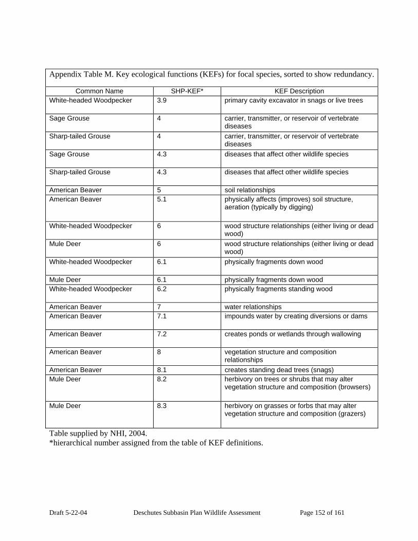
Draft 5-22-04 Deschutes Subbasin Plan Wildlife Assessment Page 152 of 161
Appendix Table M. Key ecological functions (KEFs) for focal species, sorted to show redundancy.
Common Name SHP-KEF* KEF Description White-headed Woodpecker 3.9 primary cavity excavator in snags or live trees
Sage Grouse 4 carrier, transmitter, or reservoir of vertebrate diseases
Sharp-tailed Grouse 4 carrier, transmitter, or reservoir of vertebrate diseases
Sage Grouse 4.3 diseases that affect other wildlife species
Sharp-tailed Grouse 4.3 diseases that affect other wildlife species
American Beaver 5 soil relationships American Beaver 5.1 physically affects (improves) soil structure,
aeration (typically by digging)
White-headed Woodpecker 6 wood structure relationships (either living or dead wood)
Mule Deer 6 wood structure relationships (either living or dead wood)
White-headed Woodpecker 6.1 physically fragments down wood
Mule Deer 6.1 physically fragments down wood White-headed Woodpecker 6.2 physically fragments standing wood
American Beaver 7 water relationships American Beaver 7.1 impounds water by creating diversions or dams
American Beaver 7.2 creates ponds or wetlands through wallowing
American Beaver 8 vegetation structure and composition relationships
American Beaver 8.1 creates standing dead trees (snags) Mule Deer 8.2 herbivory on trees or shrubs that may alter
vegetation structure and composition (browsers)
Mule Deer 8.3 herbivory on grasses or forbs that may alter vegetation structure and composition (grazers)
Table supplied by NHI, 2004. *hierarchical number assigned from the table of KEF definitions.

Draft 5-22-04 Deschutes Subbasin Plan Wildlife Assessment Page 153 of 161
Appendix Table N. KECs sorted to show interspecific relationships.
Common Name KEC_Description Columbia Spotted Frog Anthropogenic-related Habitat Elements
Golden Eagle Anthropogenic-related Habitat Elements
Sage Grouse Anthropogenic-related Habitat Elements
Sharp-tailed Grouse Anthropogenic-related Habitat Elements
American Beaver Anthropogenic-related Habitat Elements
Mule Deer Anthropogenic-related Habitat Elements
Columbia Spotted Frog banks American Beaver banks Columbia Spotted Frog beaver/muskrat activity (dams, lodges, ponds) (Positive
only) American Beaver beaver/muskrat activity (dams, lodges, ponds) (Positive
only) American Beaver chemical American Beaver chemical (taste or smell) Mule Deer chemical (taste or smell) Golden Eagle cliffs American Beaver coarse woody debris in streams and rivers
American Beaver context Mule Deer context White-headed Woodpecker decay class
Columbia Spotted Frog direct displacement Mule Deer direct displacement Mule Deer down wood (includes downed logs, branches, and
rootwads, in any context)
Columbia Spotted Frog Ecological Habitat Elements Golden Eagle Ecological Habitat Elements Sage Grouse Ecological Habitat Elements Sharp-tailed Grouse Ecological Habitat Elements White-headed Woodpecker Ecological Habitat Elements
American Beaver Ecological Habitat Elements Mule Deer Ecological Habitat Elements
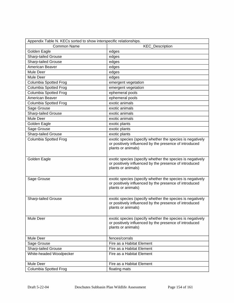
Draft 5-22-04 Deschutes Subbasin Plan Wildlife Assessment Page 154 of 161
Appendix Table N. KECs sorted to show interspecific relationships. Common Name KEC_Description
Golden Eagle edges Sharp-tailed Grouse edges Sharp-tailed Grouse edges American Beaver edges Mule Deer edges Mule Deer edges Columbia Spotted Frog emergent vegetation Columbia Spotted Frog emergent vegetation Columbia Spotted Frog ephemeral pools American Beaver ephemeral pools Columbia Spotted Frog exotic animals Sage Grouse exotic animals Sharp-tailed Grouse exotic animals Mule Deer exotic animals Golden Eagle exotic plants Sage Grouse exotic plants Sharp-tailed Grouse exotic plants Columbia Spotted Frog exotic species (specify whether the species is negatively
or positively influenced by the presence of introduced plants or animals)
Golden Eagle exotic species (specify whether the species is negatively or positively influenced by the presence of introduced plants or animals)
Sage Grouse exotic species (specify whether the species is negatively or positively influenced by the presence of introduced plants or animals)
Sharp-tailed Grouse exotic species (specify whether the species is negatively or positively influenced by the presence of introduced plants or animals)
Mule Deer exotic species (specify whether the species is negatively or positively influenced by the presence of introduced plants or animals)
Mule Deer fences/corrals Sage Grouse Fire as a Habitat Element Sharp-tailed Grouse Fire as a Habitat Element White-headed Woodpecker Fire as a Habitat Element
Mule Deer Fire as a Habitat Element Columbia Spotted Frog floating mats

Draft 5-22-04 Deschutes Subbasin Plan Wildlife Assessment Page 155 of 161
Appendix Table N. KECs sorted to show interspecific relationships. Common Name KEC_Description
Sage Grouse flowers Sharp-tailed Grouse flowers Sage Grouse forbs Sharp-tailed Grouse forbs Mule Deer forbs Mule Deer forbs American Beaver forest Mule Deer forest Golden Eagle Forest, Shrubland, & Grassland Habitat Elements
Sage Grouse Forest, Shrubland, & Grassland Habitat Elements
Sharp-tailed Grouse Forest, Shrubland, & Grassland Habitat Elements
White-headed Woodpecker Forest, Shrubland, & Grassland Habitat Elements
American Beaver Forest, Shrubland, & Grassland Habitat Elements
Mule Deer Forest, Shrubland, & Grassland Habitat Elements
Golden Eagle forest/woodland vegetative elements or substrates
Sharp-tailed Grouse forest/woodland vegetative elements or substrates
White-headed Woodpecker forest/woodland vegetative elements or substrates
American Beaver forest/woodland vegetative elements or substrates
Mule Deer forest/woodland vegetative elements or substrates
American Beaver free water (derived from any source) Mule Deer free water (derived from any source) Columbia Spotted Frog Freshwater Riparian & Aquatic Bodies Habitat Elements
Golden Eagle Freshwater Riparian & Aquatic Bodies Habitat Elements
Sharp-tailed Grouse Freshwater Riparian & Aquatic Bodies Habitat Elements
American Beaver Freshwater Riparian & Aquatic Bodies Habitat Elements
Mule Deer Freshwater Riparian & Aquatic Bodies Habitat Elements
White-headed Woodpecker fruits/seeds/nuts

Draft 5-22-04 Deschutes Subbasin Plan Wildlife Assessment Page 156 of 161
Appendix Table N. KECs sorted to show interspecific relationships. Common Name KEC_Description
Golden Eagle giant tree >= 30” dbh Golden Eagle giant tree >= 30” dbh Golden Eagle giant tree >= 30” dbh Golden Eagle giant tree >= 30” dbh White-headed Woodpecker giant tree >= 30” dbh
White-headed Woodpecker giant tree >= 30” dbh
American Beaver giant tree >= 30” dbh American Beaver giant tree >= 30” dbh Sage Grouse grasses Sharp-tailed Grouse grasses Sage Grouse guzzlers and waterholes Mule Deer guzzlers and waterholes Columbia Spotted Frog habitat structure change Sage Grouse habitat structure change Sharp-tailed Grouse habitat structure change Mule Deer habitat structure change Golden Eagle harvest/persecution (of animals) (includes legal and
illegal harvest, and incidental take)
Mule Deer harvest/persecution (of animals) (includes legal and illegal harvest, and incidental take)
Columbia Spotted Frog hatchery facilities and fish Sharp-tailed Grouse hedgerows/windbreaks Sage Grouse herbaceous layer Sharp-tailed Grouse herbaceous layer Mule Deer herbaceous layer Mule Deer herbaceous layer Sage Grouse herbicides/fungicides White-headed Woodpecker insect population irruptions (specify whether negative or
positive relationship in comments)
Mule Deer insect population irruptions (specify whether negative or positive relationship in comments)
Sage Grouse insecticides Sharp-tailed Grouse insecticides American Beaver intermittent Columbia Spotted Frog in-water substrate American Beaver irrigation ditches/canals Mule Deer irrigation ditches/canals Columbia Spotted Frog lakes/ponds/reservoirs

Draft 5-22-04 Deschutes Subbasin Plan Wildlife Assessment Page 157 of 161
Appendix Table N. KECs sorted to show interspecific relationships. Common Name KEC_Description
American Beaver lakes/ponds/reservoirs American Beaver large – 6.6’ – 16.5’ Golden Eagle large tree 20-29” dbh Golden Eagle large tree 20-29” dbh Golden Eagle large tree 20-29” dbh Golden Eagle large tree 20-29” dbh White-headed Woodpecker large tree 20-29” dbh
White-headed Woodpecker large tree 20-29” dbh
American Beaver large tree 20-29” dbh Golden Eagle live remnant/legacy trees White-headed Woodpecker live remnant/legacy trees
American Beaver lower perennial Sage Grouse medium – 20”- 6.5’ American Beaver medium – 20”- 6.5’ Golden Eagle medium tree 15-19” dbh Golden Eagle medium tree 15-19” dbh Golden Eagle medium tree 15-19” dbh Golden Eagle medium tree 15-19” dbh White-headed Woodpecker medium tree 15-19” dbh
White-headed Woodpecker medium tree 15-19” dbh
American Beaver medium tree 15-19” dbh American Beaver medium tree 15-19” dbh White-headed Woodpecker moderate [class 3]
Mule Deer mountain pine beetle American Beaver non-forest Mule Deer non-forest Golden Eagle Non-vegetative, Abiotic Habitat Elements
Mule Deer Non-vegetative, Abiotic Habitat Elements
American Beaver open water American Beaver open water American Beaver order and class Columbia Spotted Frog oxbows American Beaver oxbows Sage Grouse percent shrub canopy cover Columbia Spotted Frog pesticides Golden Eagle pesticides
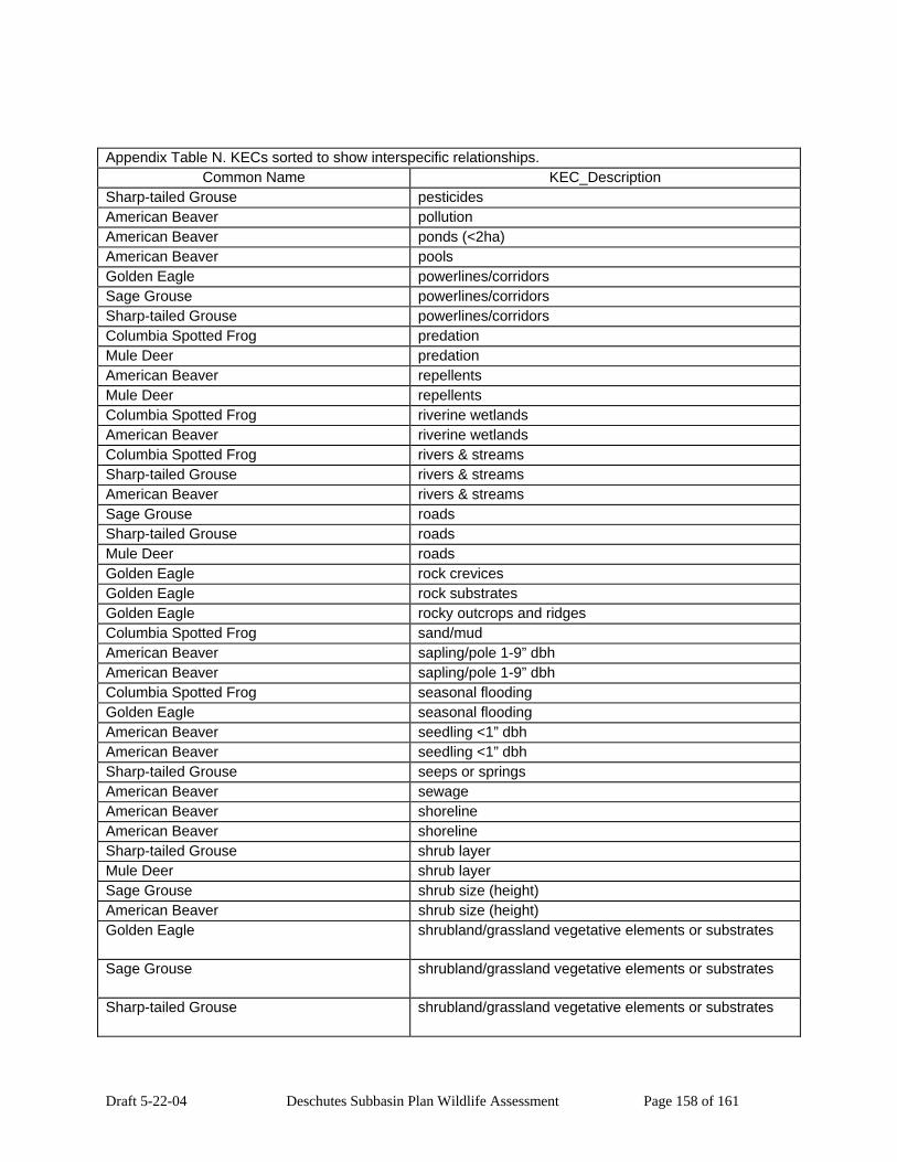
Draft 5-22-04 Deschutes Subbasin Plan Wildlife Assessment Page 158 of 161
Appendix Table N. KECs sorted to show interspecific relationships. Common Name KEC_Description
Sharp-tailed Grouse pesticides American Beaver pollution American Beaver ponds (<2ha) American Beaver pools Golden Eagle powerlines/corridors Sage Grouse powerlines/corridors Sharp-tailed Grouse powerlines/corridors Columbia Spotted Frog predation Mule Deer predation American Beaver repellents Mule Deer repellents Columbia Spotted Frog riverine wetlands American Beaver riverine wetlands Columbia Spotted Frog rivers & streams Sharp-tailed Grouse rivers & streams American Beaver rivers & streams Sage Grouse roads Sharp-tailed Grouse roads Mule Deer roads Golden Eagle rock crevices Golden Eagle rock substrates Golden Eagle rocky outcrops and ridges Columbia Spotted Frog sand/mud American Beaver sapling/pole 1-9” dbh American Beaver sapling/pole 1-9” dbh Columbia Spotted Frog seasonal flooding Golden Eagle seasonal flooding American Beaver seedling <1” dbh American Beaver seedling <1” dbh Sharp-tailed Grouse seeps or springs American Beaver sewage American Beaver shoreline American Beaver shoreline Sharp-tailed Grouse shrub layer Mule Deer shrub layer Sage Grouse shrub size (height) American Beaver shrub size (height) Golden Eagle shrubland/grassland vegetative elements or substrates
Sage Grouse shrubland/grassland vegetative elements or substrates
Sharp-tailed Grouse shrubland/grassland vegetative elements or substrates
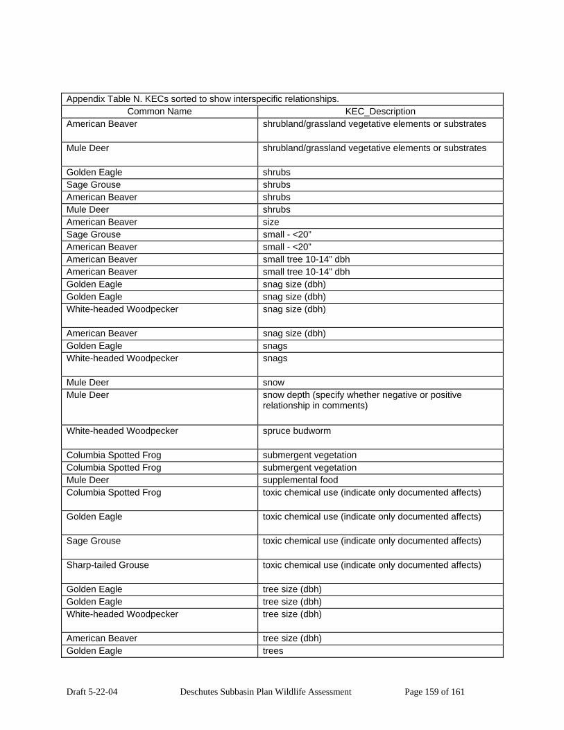
Draft 5-22-04 Deschutes Subbasin Plan Wildlife Assessment Page 159 of 161
Appendix Table N. KECs sorted to show interspecific relationships. Common Name KEC_Description
American Beaver shrubland/grassland vegetative elements or substrates
Mule Deer shrubland/grassland vegetative elements or substrates
Golden Eagle shrubs Sage Grouse shrubs American Beaver shrubs Mule Deer shrubs American Beaver size Sage Grouse small - <20” American Beaver small - <20” American Beaver small tree 10-14” dbh American Beaver small tree 10-14” dbh Golden Eagle snag size (dbh) Golden Eagle snag size (dbh) White-headed Woodpecker snag size (dbh)
American Beaver snag size (dbh) Golden Eagle snags White-headed Woodpecker snags
Mule Deer snow Mule Deer snow depth (specify whether negative or positive
relationship in comments)
White-headed Woodpecker spruce budworm
Columbia Spotted Frog submergent vegetation Columbia Spotted Frog submergent vegetation Mule Deer supplemental food Columbia Spotted Frog toxic chemical use (indicate only documented affects)
Golden Eagle toxic chemical use (indicate only documented affects)
Sage Grouse toxic chemical use (indicate only documented affects)
Sharp-tailed Grouse toxic chemical use (indicate only documented affects)
Golden Eagle tree size (dbh) Golden Eagle tree size (dbh) White-headed Woodpecker tree size (dbh)
American Beaver tree size (dbh) Golden Eagle trees

Draft 5-22-04 Deschutes Subbasin Plan Wildlife Assessment Page 160 of 161
Appendix Table N. KECs sorted to show interspecific relationships. Common Name KEC_Description
White-headed Woodpecker trees
American Beaver trees Golden Eagle trees (located in a shrubland/grassland context)
American Beaver upper perennial Columbia Spotted Frog vegetation Columbia Spotted Frog vegetation Columbia Spotted Frog water characteristics (specify whether negative or
positive relationship in comments)
American Beaver water characteristics (specify whether negative or positive relationship in comments)
Mule Deer water characteristics (specify whether negative or positive relationship in comments)
Columbia Spotted Frog water depth American Beaver water depth Columbia Spotted Frog water velocity American Beaver water velocity Columbia Spotted Frog wetlands/marshes/wet meadows/bogs and swamps
(Positive relationships only)
American Beaver wetlands/marshes/wet meadows/bogs and swamps (Positive relationships only)
Mule Deer wetlands/marshes/wet meadows/bogs and swamps (Positive relationships only)
American Beaver zone American Beaver zone Table supplied by NHI, 2004.

Draft 5-22-04 Deschutes Subbasin Plan Wildlife Assessment Page 161 of 161
Appendix
Maps