DEPARTMENT OF TRANSPORTATION DIVISION: … OF TRANSPORTATION DIVISION: MATERIALS REPORT COVER SHEET...
28
LD-450 5/12/09 DEPARTMENT OF TRANSPORTATION DIVISION: MATERIALS REPORT COVER SHEET M or Structure Recommendations Report Authored By: Stephen A. Chaos VDOT Materials Division Salem District Geotechnical Engineer Responsible for Pages: All UPC No.: (0 - 9-1 , )
Transcript of DEPARTMENT OF TRANSPORTATION DIVISION: … OF TRANSPORTATION DIVISION: MATERIALS REPORT COVER SHEET...

LD-450 5/12/09
DEPARTMENT OF TRANSPORTATION
DIVISION: MATERIALS
REPORT COVER SHEET
Minor Structures Recommendations Report
January 25, 2017 Authored By: Stephen A. Chaos
VDOT Materials Division
Salem District Geotechnical Engineer
Responsible for Pages: All
UPC No.: 8753 (0460-129-103, C501)East Main Street - City of Salem
travis.higgs
Dynamic

VIRGINIA DEPARTMENT OF TRANSPORTATION
SALEM DISTRICT MATERIALS SECTION
January 5, 2017
Project 0460-129-103, C501 City of Salem UPC# 8753
MEMORANDUM To : Mr. Alex H. Price, PE Subject: Subsurface Conditions for Minor structures
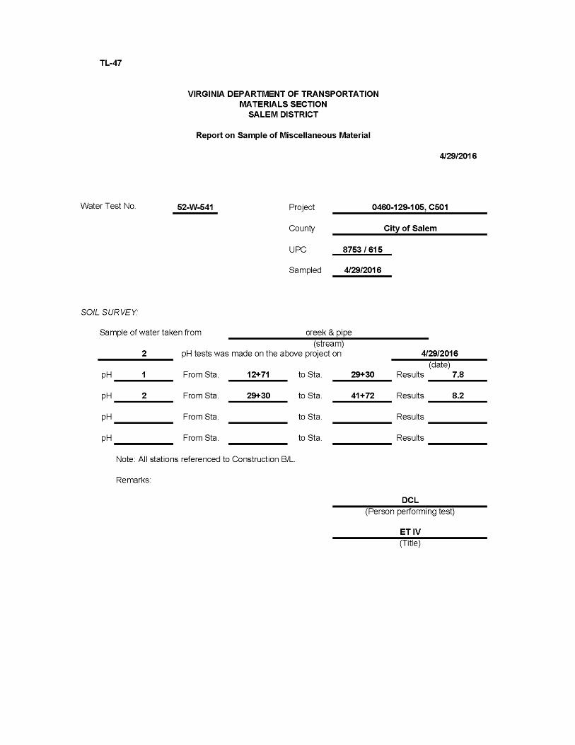
An evaluation of drainage structure foundations has been completed for the captioned project. The investigation consisted of hollow stem auger borings with standard penetration tests. There were 18 drainage structures investigated and evaluated herein. Attached are logs of borings for the structures detailing location, elevation, and subsurface information. Locations and elevations for the borings were established by the VDOT Geology crew. Foundation Recommendations for the pipes are listed by structure below. There were several structures that require Open Graded Aggregate No. 57 pipe bedding material to facilitate drainage in de-watering conditions. These structures have No. 57 Aggregate listed with the PB Standard in the Recommendation. Pipe bedding should be placed in accordance with section 302 and 303 of the 2016 Road and Bridge Specifications. Designer: For Recommendations of Soft, yielding, or otherwise unsuitable material, utilize an additional 8 inches of bedding material below the initial 4 inches (total of 12 inches below the pipe). Place quantity, depth, and type of bedding material to be utilized under the structure description on plans. A pay item should be established for pipe bedding material in addition to the initial 4 inches. For all drainage structures that extend beneath the travel lanes and shoulders of the proposed roadway, it is recommended that excavated material be wasted or used to flatten embankment slopes and replaced with Aggregate Material, Type I, 21-B, as pipe backfill. The 21-B aggregate should be compacted to specifications and extend vertically to top of subgrade elevation. This recommendation applies only to structures which will be installed via an open trench excavation. Further, several borings for structures outside of the travel surface encountered soil which was well above optimum moisture at the time of this investigation. Depending on soil conditions at the time of construction, this material may be unsuitable as pipe backfill due to moisture content and physical properties. At the direction of the Engineer, all or selected quantities of minor structure excavation may be wasted and replaced with suitable material from a cut section or commercially produced dense graded aggregate.
2
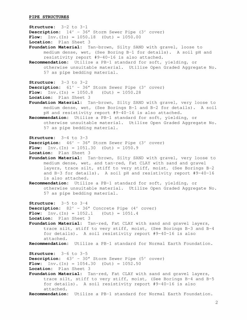
PIPE STRUCTURES Structure: 3-2 to 3-1 Description: 14’ – 36” Storm Sewer Pipe (3’ cover) Flow: Inv.(In) = 1050.18 (Out) = 1050.00 Location: Plan Sheet 3 Foundation Material: Tan-brown, Silty SAND with gravel, loose to
medium dense, wet, (See Boring B-1 for details). A soil pH and resistivity report #9-40-16 is also attached.
Recommendation: Utilize a PB-1 standard for soft, yielding, or otherwise unsuitable material. Utilize Open Graded Aggregate No. 57 as pipe bedding material.
Structure: 3-3 to 3-2 Description: 61’ – 36” Storm Sewer Pipe (3’ cover) Flow: Inv.(In) = 1050.8 (Out) = 1050.28 Location: Plan Sheet 3 Foundation Material: Tan-brown, Silty SAND with gravel, very loose to
medium dense, wet, (See Borings B-1 and B-2 for details). A soil pH and resistivity report #9-40-16 is also attached.
Recommendation: Utilize a PB-1 standard for soft, yielding, or otherwise unsuitable material. Utilize Open Graded Aggregate No. 57 as pipe bedding material.
Structure: 3-4 to 3-3 Description: 46’ – 36” Storm Sewer Pipe (3’ cover) Flow: Inv.(In) = 1051.30 (Out) = 1050.9 Location: Plan Sheet 3 Foundation Material: Tan-brown, Silty SAND with gravel, very loose to
medium dense, wet, and tan-red, Fat CLAY with sand and gravel layers, trace silt, stiff to very stiff, moist, (See Borings B-2 and B-3 for details). A soil pH and resistivity report #9-40-16 is also attached.
Recommendation: Utilize a PB-1 standard for soft, yielding, or otherwise unsuitable material. Utilize Open Graded Aggregate No. 57 as pipe bedding material.
Structure: 3-5 to 3-4 Description: 82’ – 36” Concrete Pipe (4’ cover) Flow: Inv.(In) = 1052.1 (Out) = 1051.4 Location: Plan Sheet 3 Foundation Material: Tan-red, Fat CLAY with sand and gravel layers,
trace silt, stiff to very stiff, moist, (See Borings B-3 and B-4 for details). A soil resistivity report #9-40-16 is also attached.
Recommendation: Utilize a PB-1 standard for Normal Earth Foundation. Structure: 3-6 to 3-5 Description: 43’ – 30” Storm Sewer Pipe (5’ cover) Flow: Inv.(In) = 1054.30 (Out) = 1052.50 Location: Plan Sheet 3 Foundation Material: Tan-red, Fat CLAY with sand and gravel layers,
trace silt, stiff to very stiff, moist, (See Borings B-4 and B-5 for details). A soil resistivity report #9-40-16 is also attached.
Recommendation: Utilize a PB-1 standard for Normal Earth Foundation.
3
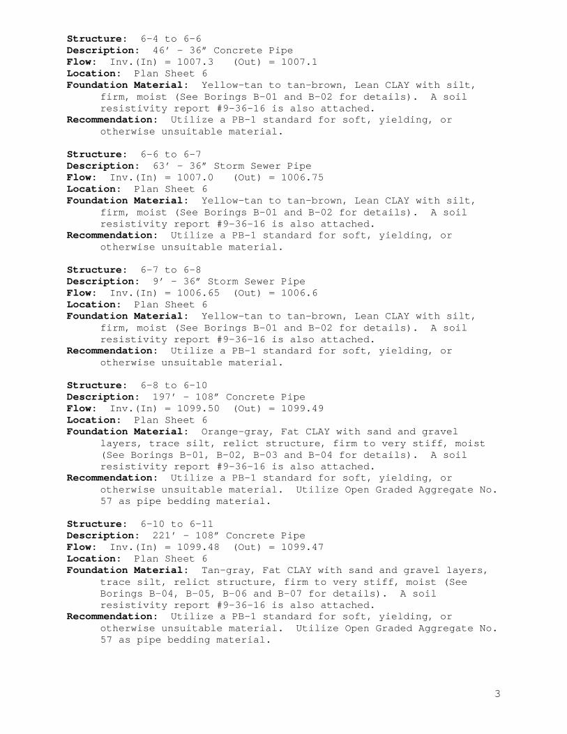
Structure: 6-4 to 6-6 Description: 46’ – 36” Concrete Pipe Flow: Inv.(In) = 1007.3 (Out) = 1007.1 Location: Plan Sheet 6 Foundation Material: Yellow-tan to tan-brown, Lean CLAY with silt,
firm, moist (See Borings B-01 and B-02 for details). A soil resistivity report #9-36-16 is also attached.
Recommendation: Utilize a PB-1 standard for soft, yielding, or otherwise unsuitable material.
Structure: 6-6 to 6-7 Description: 63’ – 36” Storm Sewer Pipe Flow: Inv.(In) = 1007.0 (Out) = 1006.75 Location: Plan Sheet 6 Foundation Material: Yellow-tan to tan-brown, Lean CLAY with silt,
firm, moist (See Borings B-01 and B-02 for details). A soil resistivity report #9-36-16 is also attached.
Recommendation: Utilize a PB-1 standard for soft, yielding, or otherwise unsuitable material.
Structure: 6-7 to 6-8 Description: 9’ – 36” Storm Sewer Pipe Flow: Inv.(In) = 1006.65 (Out) = 1006.6 Location: Plan Sheet 6 Foundation Material: Yellow-tan to tan-brown, Lean CLAY with silt,
firm, moist (See Borings B-01 and B-02 for details). A soil resistivity report #9-36-16 is also attached.
Recommendation: Utilize a PB-1 standard for soft, yielding, or otherwise unsuitable material.
Structure: 6-8 to 6-10 Description: 197’ – 108” Concrete Pipe Flow: Inv.(In) = 1099.50 (Out) = 1099.49 Location: Plan Sheet 6 Foundation Material: Orange-gray, Fat CLAY with sand and gravel
layers, trace silt, relict structure, firm to very stiff, moist (See Borings B-01, B-02, B-03 and B-04 for details). A soil resistivity report #9-36-16 is also attached.
Recommendation: Utilize a PB-1 standard for soft, yielding, or otherwise unsuitable material. Utilize Open Graded Aggregate No. 57 as pipe bedding material.
Structure: 6-10 to 6-11 Description: 221’ – 108” Concrete Pipe Flow: Inv.(In) = 1099.48 (Out) = 1099.47 Location: Plan Sheet 6 Foundation Material: Tan-gray, Fat CLAY with sand and gravel layers,
trace silt, relict structure, firm to very stiff, moist (See Borings B-04, B-05, B-06 and B-07 for details). A soil resistivity report #9-36-16 is also attached.
Recommendation: Utilize a PB-1 standard for soft, yielding, or otherwise unsuitable material. Utilize Open Graded Aggregate No. 57 as pipe bedding material.
4
Structure: 6-11 to 6-13 Description: 47’ – 36” Storm Sewer Pipe Flow: Inv.(In) = 1099.40 (Out) = 1099.02 Location: Plan Sheet 6 Foundation Material: Tan-gray, Fat CLAY with sand and gravel layers,
trace silt, relict structure, firm to very stiff, moist (See Borings B-07 and B-08 for details). A soil resistivity report #9-36-16 is also attached.
Recommendation: Utilize a PB-1 standard for Normal Earth Foundation. Utilize Open Graded Aggregate No. 57 as pipe bedding material.
Structure: 6-13 to 7-1 Description: 192’ – 36” Concrete Pipe Flow: Inv.(In) = 1098.92 (Out) = 1097.80 Location: Plan Sheets 6 & 7 Foundation Material: Tan-gray, Fat CLAY with sand and gravel layers,
trace silt, relict structure, firm to very stiff, moist and yellow-tan, Fat CLAY with highly weathered shale layers, relict structure, stiff, moist (See Borings B-08, B-09, B-10 and B-11 for details). A soil resistivity report #9-36-16 is also attached.
Recommendation: Utilize a PB-1 standard for soft, yielding, or otherwise unsuitable material. Utilize Open Graded Aggregate No. 57 as pipe bedding material.
Structure: 6-19 to 6-21 Description: 125’ – 36” Concrete Pipe Flow: Inv.(In) = 1103.25 (Out) = 1102.3 Location: Plan Sheet 6 Foundation Material: Tan-gray, Fat CLAY with sand and gravel layers,
trace silt, relict structure, firm to very stiff, moist, and light gray, sandy silt with gravel, trace clay, stiff, moist (See Borings B-08, B-09, and B-10 for details). A soil resistivity report #9-36-16 is also attached.
Recommendation: Utilize a PB-1 standard for Normal Earth Foundation. Structure: 6-21 to 7-8 Description: 109’ – 36” Concrete Pipe Flow: Inv.(In) = 1102.20 (Out) = 1101.84 Location: Plan Sheets 6 & 7 Foundation Material: Light gray, sandy silt with gravel, trace clay,
firm to very stiff, moist (See Borings B-11, B-12, and B-13 for details). A soil resistivity report #9-36-16 is also attached.
Recommendation: Utilize a PB-1 standard for Normal Earth Foundation. Structure: 7-1 to 7-2 Description: 62’ – 36” Storm Sewer Pipe Flow: Inv.(In) = 1097.15 (Out) = 1096.65 Location: Plan Sheet 7 Foundation Material: Tan-gray, Fat CLAY with sand and gravel layers,
trace silt, relict structure, firm to very stiff, moist (See Borings B-11 and B-12 for details). A soil resistivity report #9-36-16 is also attached.
Recommendation: Utilize a PB-1 standard for soft, yielding, or otherwise unsuitable material. Utilize Open Graded Aggregate No. 57 as pipe bedding material.
5
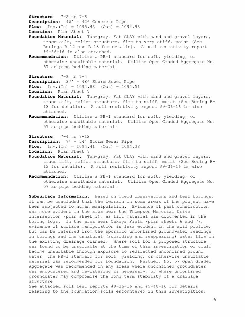
Structure: 7-2 to 7-8 Description: 46’ – 42” Concrete Pipe Flow: Inv.(In) = 1095.43 (Out) = 1094.98 Location: Plan Sheet 7 Foundation Material: Tan-gray, Fat CLAY with sand and gravel layers,
trace silt, relict structure, firm to very stiff, moist (See Borings B-12 and B-13 for details). A soil resistivity report #9-36-16 is also attached.
Recommendation: Utilize a PB-1 standard for soft, yielding, or otherwise unsuitable material. Utilize Open Graded Aggregate No. 57 as pipe bedding material.
Structure: 7-8 to 7-4 Description: 37’ – 48” Storm Sewer Pipe Flow: Inv.(In) = 1094.88 (Out) = 1094.51 Location: Plan Sheet 7 Foundation Material: Tan-gray, Fat CLAY with sand and gravel layers,
trace silt, relict structure, firm to stiff, moist (See Boring B-13 for details). A soil resistivity report #9-36-16 is also attached.
Recommendation: Utilize a PB-1 standard for soft, yielding, or otherwise unsuitable material. Utilize Open Graded Aggregate No. 57 as pipe bedding material.
Structure: 7-4 to 7-12 Description: 7’ – 54” Storm Sewer Pipe Flow: Inv.(In) = 1094.41 (Out) = 1094.38 Location: Plan Sheet 7 Foundation Material: Tan-gray, Fat CLAY with sand and gravel layers,
trace silt, relict structure, firm to stiff, moist (See Boring B-13 for details). A soil resistivity report #9-36-16 is also attached.
Recommendation: Utilize a PB-1 standard for soft, yielding, or otherwise unsuitable material. Utilize Open Graded Aggregate No. 57 as pipe bedding material.
Subsurface Information: Based on field observations and test borings, it can be concluded that the terrain in some areas of the project have been subjected to human manipulation. Evidence of past construction was more evident in the area near the Thompson Memorial Drive intersection (plan sheet 3), as fill material was documented in the boring logs. In the area near Oakeys Field (plan sheets 6 and 7), evidence of surface manipulation is less evident in the soil profile, but can be inferred from the sporadic unconfined groundwater readings in borings and the unnatural (subsiding and reappearing) water flow in the existing drainage channel. Where soil for a proposed structure was found to be unsuitable at the time of this investigation or could become unsuitable through exposure to redirected unconfined ground water, the PB-1 standard for soft, yielding, or otherwise unsuitable material was recommended for foundation. Further, No. 57 Open Graded Aggregate was recommended in any areas where unconfined groundwater was encountered and de-watering is necessary, or where unconfined groundwater may compromise the long term stability of a drainage structure. See attached soil test reports #9-36-16 and #9-40-16 for details relating to the foundation soils encountered in this investigation.


60
100
100
100
6
1
8
4
9
2
9
5
5
2
12
6
0.0 / 1,056.9PAVEMENT: 4" Asphalt, 6" Concrete, 7" Aggregate base
1.4 / 1,055.5FILL: Brown-red, Clayey SAND with gravel, wet.
5.2 / 1,051.7ALLUVIUM: Tan-brown, Silty SAND with gravel, loose to mediumdense, wet.
Free water in SPT sample
8.8 / 1,048.1RESIDUUM: Green-tan-brown, Fat CLAY with sand and gravellayers, trace silt, relict structure, stiff to very stiff, moist to wet.See Soil Sample Report #9-40-16
Free water in SPT sample
Free water in SPT sample
14.0 / 1,042.9Bottom of Boring
REMARKS: RIG TYPE: CME 300 Track Drill. BM: Concrete DI Rim, 22' left station 14+98 Const. BL. Elevation 1061.19.
PAGE 1 OF 1
PAGE 1 OF 1 Boring B-1 referenced to drainage structures: 3-3 to 3-2, 3-2 to 3-1.
B-1
OFFSET: 15 ft LTLONGITUDE: 80.052981 °WCOORD. DATUM: NAD 83
FIELD DESCRIPTION OF STRATA
GROUND WATER
B-1
Copyright 2016, Commonwealth of Virginia
SP
T_L
OG
:EA
ST
MA
IN S
TR
EE
T M
S T
HO
MP
SO
N.G
PJ:
8.30
.003
:120
508:
12/1
3/16
LIQ
UID
LIM
IT
LAB DATA
PLA
ST
ICIT
Y IN
DE
X
PILL
MO
IST
UR
E C
ON
TE
NT
(%
)R O C K
0460-129-103, C501 UPC: 8753City of SalemSheet 3 Storm Drains
SA
MP
LE L
EG
EN
D
JOIN
TS
Date(s) Drilled: 03/01/16 - 03/01/16Drilling Method(s): Hollow Stem AugerSPT Method: Automatic HammerOther Test(s):Driller: JLOLogger: SAC
ST
RA
TA
S O I L
PROJECT #:LOCATION:STRUCTURE:
2
4
6
8
10
12
14
FIELD DATA
ST
RA
TA
LE
GE
ND
SO
IL R
EC
OV
ER
Y (
%)
CO
RE
RE
CO
VE
RY
(%
)
STATION: 12+80 Const. BLLATITUDE: 37.293730 °NSURFACE ELEVATION: 1,056.9 ft
ELE
VA
TIO
N (
ft)
1055
1050
1045
DE
PT
H (
ft)
SA
MP
LE IN
TE
RV
AL
RO
CK
QU
ALI
TY
DE
SIG
NA
TIO
N
ST
AN
DA
RD
PE
NE
TR
AT
ION
TE
ST
HA
MM
ER
BLO
WS
FIRST ENCOUNTERED AT 7.0 ft DEPTH
STABILIZED AT 7.5 ft (1,049.4ft ELEV.) AFTER 2 HOURS
DIP °
4.8
6.3
7.5
9
9.8
11.3
12.5
14

100
100
100
100
WH
4
4
6
WH
5
6
6
1
6
11
8
0.0 / 1,056.9PAVEMENT: 6" Asphalt, 9" Aggregate base
1.3 / 1,055.6FILL: Brown-red, Clayey SAND with gravel, wet.
4.5 / 1,052.4ALLUVIUM: Tan-brown, Silty SAND with gravel, very loose tomedium dense, wet.Free water in SPT sample
Free water in SPT sample9.5 / 1,047.4RESIDUUM: Green-tan-brown, Fat CLAY with sand and gravellayers, trace silt, relict structure, stiff to very stiff, moist to wet.
See Soil Sample Report #9-40-16
14.0 / 1,042.9Bottom of Boring
REMARKS: RIG TYPE: CME 300 Track Drill. BM: Concrete DI Rim, 22' left station 14+98 Const. BL. Elevation 1061.19.
PAGE 1 OF 1
PAGE 1 OF 1 Boring B-2 referenced to drainage structures: 3-4 to 3-3, 3-3 to 3-2.
B-2
OFFSET: 15 ft LTLONGITUDE: 80.052761 °WCOORD. DATUM: NAD 83
FIELD DESCRIPTION OF STRATA
GROUND WATER
B-2
Copyright 2016, Commonwealth of Virginia
SP
T_L
OG
:EA
ST
MA
IN S
TR
EE
T M
S T
HO
MP
SO
N.G
PJ:
8.30
.003
:120
508:
12/1
3/16
LIQ
UID
LIM
IT
LAB DATA
PLA
ST
ICIT
Y IN
DE
X
PILL
MO
IST
UR
E C
ON
TE
NT
(%
)R O C K
0460-129-103, C501 UPC: 8753City of SalemSheet 3 Storm Drains
SA
MP
LE L
EG
EN
D
JOIN
TS
Date(s) Drilled: 03/01/16 - 03/01/16Drilling Method(s): Hollow Stem AugerSPT Method: Automatic HammerOther Test(s):Driller: JLOLogger: SAC
ST
RA
TA
S O I L
PROJECT #:LOCATION:STRUCTURE:
2
4
6
8
10
12
14
FIELD DATA
ST
RA
TA
LE
GE
ND
SO
IL R
EC
OV
ER
Y (
%)
CO
RE
RE
CO
VE
RY
(%
)
STATION: 13+47 Const. BLLATITUDE: 37.293765 °NSURFACE ELEVATION: 1,056.9 ft
ELE
VA
TIO
N (
ft)
1055
1050
1045
DE
PT
H (
ft)
SA
MP
LE IN
TE
RV
AL
RO
CK
QU
ALI
TY
DE
SIG
NA
TIO
N
ST
AN
DA
RD
PE
NE
TR
AT
ION
TE
ST
HA
MM
ER
BLO
WS
NOT ENCOUNTERED DURING DRILLING
DRY AFTER 2 HRS
DIP °
5
6.5
7
8.5
9
10.5
12.5
14

100
100
100
100
1
5
5
5
2
7
7
6
3
8
9
7
0.0 / 1,057.9TOPSOIL0.5 / 1,057.4FILL: Brown-red, Clayey SAND with gravel, wet.
3.5 / 1,054.4ALLUVIUM: Tan-brown, Silty SAND with gravel, loose, wet.
7.0 / 1,050.9RESIDUUM: Tan-red, Fat CLAY with sand and gravel layers, tracesilt, relict structure, stiff to very stiff, moist.
See Soil Sample Report #9-40-16
14.0 / 1,043.9Bottom of Boring
REMARKS: RIG TYPE: CME 300 Track Drill. BM: Concrete DI Rim, 22' left station 14+98 Const. BL. Elevation 1061.19.
PAGE 1 OF 1
PAGE 1 OF 1 Boring B-3 referenced to drainage structures: 3-5 to 3-4, 3-4 to 3-3.
B-3
OFFSET: 50 ft LTLONGITUDE: 80.052684 °WCOORD. DATUM: NAD 83
FIELD DESCRIPTION OF STRATA
GROUND WATER
B-3
Copyright 2016, Commonwealth of Virginia
SP
T_L
OG
:EA
ST
MA
IN S
TR
EE
T M
S T
HO
MP
SO
N.G
PJ:
8.30
.003
:120
508:
12/1
3/16
LIQ
UID
LIM
IT
LAB DATA
PLA
ST
ICIT
Y IN
DE
X
PILL
MO
IST
UR
E C
ON
TE
NT
(%
)R O C K
0460-129-103, C501 UPC: 8753City of SalemSheet 3 Storm Drains
SA
MP
LE L
EG
EN
D
JOIN
TS
Date(s) Drilled: 03/01/16 - 03/01/16Drilling Method(s): Hollow Stem AugerSPT Method: Automatic HammerOther Test(s):Driller: JLOLogger: SAC
ST
RA
TA
S O I L
PROJECT #:LOCATION:STRUCTURE:
2
4
6
8
10
12
14
FIELD DATA
ST
RA
TA
LE
GE
ND
SO
IL R
EC
OV
ER
Y (
%)
CO
RE
RE
CO
VE
RY
(%
)
STATION: 13+82 Const. BLLATITUDE: 37.293884 °NSURFACE ELEVATION: 1,057.9 ft
ELE
VA
TIO
N (
ft)
1055
1050
1045
DE
PT
H (
ft)
SA
MP
LE IN
TE
RV
AL
RO
CK
QU
ALI
TY
DE
SIG
NA
TIO
N
ST
AN
DA
RD
PE
NE
TR
AT
ION
TE
ST
HA
MM
ER
BLO
WS
NOT ENCOUNTERED DURING DRILLING
DRY AFTER 2 HRS
DIP °
5
6.5
7.5
9
10
11.5
12.5
14

100
100
100
100
6
6
4
5
10
11
6
6
11
11
6
7
0.0 / 1,059.2TOPSOIL0.3 / 1,058.9FILL: Brown-red, Clayey SAND with gravel, wet.
3.5 / 1,055.7RESIDUUM: Tan-red, Fat CLAY with sand and gravel layers, tracesilt, relict structure, stiff to very stiff, moist.
See Soil Sample Report #9-40-16
14.0 / 1,045.2Bottom of Boring
REMARKS: RIG TYPE: CME 300 Track Drill. BM: Concrete DI Rim, 22' left station 14+98 Const. BL. Elevation 1061.19.
PAGE 1 OF 1
PAGE 1 OF 1 Boring B-4 referenced to drainage structures: 3-6 to 3-5, 3-5 to 3-4.
B-4
OFFSET: 60 ft LTLONGITUDE: 80.052378 °WCOORD. DATUM: NAD 83
FIELD DESCRIPTION OF STRATA
GROUND WATER
B-4
Copyright 2016, Commonwealth of Virginia
SP
T_L
OG
:EA
ST
MA
IN S
TR
EE
T M
S T
HO
MP
SO
N.G
PJ:
8.30
.003
:120
508:
12/1
3/16
LIQ
UID
LIM
IT
LAB DATA
PLA
ST
ICIT
Y IN
DE
X
PILL
MO
IST
UR
E C
ON
TE
NT
(%
)R O C K
0460-129-103, C501 UPC: 8753City of SalemSheet 3 Storm Drains
SA
MP
LE L
EG
EN
D
JOIN
TS
Date(s) Drilled: 03/01/16 - 03/01/16Drilling Method(s): Hollow Stem AugerSPT Method: Automatic HammerOther Test(s):Driller: JLOLogger: SAC
ST
RA
TA
S O I L
PROJECT #:LOCATION:STRUCTURE:
2
4
6
8
10
12
14
FIELD DATA
ST
RA
TA
LE
GE
ND
SO
IL R
EC
OV
ER
Y (
%)
CO
RE
RE
CO
VE
RY
(%
)
STATION: 14+80 Const. BLLATITUDE: 37.293955 °NSURFACE ELEVATION: 1,059.2 ft
ELE
VA
TIO
N (
ft)
1055
1050
DE
PT
H (
ft)
SA
MP
LE IN
TE
RV
AL
RO
CK
QU
ALI
TY
DE
SIG
NA
TIO
N
ST
AN
DA
RD
PE
NE
TR
AT
ION
TE
ST
HA
MM
ER
BLO
WS
NOT ENCOUNTERED DURING DRILLING
DRY AFTER 2 HRS
DIP °
5
6.5
7.5
9
10
11.5
12.5
14

100
100
100
100
2
6
8
5
5
8
10
6
5
12
12
7
0.0 / 1,063.2TOPSOIL
0.8 / 1,062.4FILL: Brown-red, Clayey SILT with sand, trace gravel, brickfragments, and organic debris, wet.
8.0 / 1,055.2RESIDUUM: Tan-red, Fat CLAY with sand and gravel layers, tracesilt, relict structure, stiff to very stiff, moist.
See Soil Sample Report #9-40-16
16.5 / 1,046.7Bottom of Boring
REMARKS: RIG TYPE: CME 300 Track Drill. BM: Concrete DI Rim, 22' left station 14+98 Const. BL. Elevation 1061.19.
PAGE 1 OF 1
PAGE 1 OF 1 Boring B-5 referenced to drainage structures: 3-12 to 3-6, 3-6 to 3-5.
B-5
OFFSET: 40 ft LTLONGITUDE: 80.052214 °WCOORD. DATUM: NAD 83
FIELD DESCRIPTION OF STRATA
GROUND WATER
B-5
Copyright 2016, Commonwealth of Virginia
SP
T_L
OG
:EA
ST
MA
IN S
TR
EE
T M
S T
HO
MP
SO
N.G
PJ:
8.30
.003
:120
508:
12/1
3/16
LIQ
UID
LIM
IT
LAB DATA
PLA
ST
ICIT
Y IN
DE
X
PILL
MO
IST
UR
E C
ON
TE
NT
(%
)R O C K
0460-129-103, C501 UPC: 8753City of SalemSheet 3 Storm Drains
SA
MP
LE L
EG
EN
D
JOIN
TS
Date(s) Drilled: 03/01/16 - 03/01/16Drilling Method(s): Hollow Stem AugerSPT Method: Automatic HammerOther Test(s):Driller: JLOLogger: SAC
ST
RA
TA
S O I L
PROJECT #:LOCATION:STRUCTURE:
2
4
6
8
10
12
14
16
FIELD DATA
ST
RA
TA
LE
GE
ND
SO
IL R
EC
OV
ER
Y (
%)
CO
RE
RE
CO
VE
RY
(%
)
STATION: 15+18 Const. BLLATITUDE: 37.293904 °NSURFACE ELEVATION: 1,063.2 ft
ELE
VA
TIO
N (
ft)
1060
1055
1050
DE
PT
H (
ft)
SA
MP
LE IN
TE
RV
AL
RO
CK
QU
ALI
TY
DE
SIG
NA
TIO
N
ST
AN
DA
RD
PE
NE
TR
AT
ION
TE
ST
HA
MM
ER
BLO
WS
NOT ENCOUNTERED DURING DRILLING
DRY AFTER 2 HRS
DIP °
4.2
5.7
9
10.5
12
13.5
15
16.5

100
100
100
100
7
7
6
2
10
11
7
7
12
15
7
8
0.0 / 1,110.4TOPSOIL0.5 / 1,109.9RESIDUUM: Tan-brown, Lean CLAY with silt, moist.
3.0 / 1,107.4RESIDUUM: Yellow-tan, Lean CLAY with silt, moist.
4.5 / 1,105.9RESIDUUM: Orange-gray, Fat CLAY with sand and gravel layers,trace silt, relict structure, very stiff, moist.
See Soil Sample Report #9-36-16
Free water in SPT sample
Free water in SPT sample
16.5 / 1,093.9Bottom of Boring
REMARKS: RIG TYPE: CME 300 Track Drill. BM: SMH Rim, 32' left station 34+94 Construction Baseline. Elevation 1110.05.
PAGE 1 OF 1
PAGE 1 OF 1 Boring B-01 referenced to drainage structures: 6-4 to 6-6, 6-6 to 6-7, 6-7 to 6-8, 6-8 to 6-10.
B-01
OFFSET: 40 ft LTLONGITUDE: 80.046025 °WCOORD. DATUM: NAD 83
FIELD DESCRIPTION OF STRATA
GROUND WATER
B-01
Copyright 2016, Commonwealth of Virginia
SP
T_L
OG
:EA
ST
MA
IN S
TR
EE
T M
S O
AK
EY
S.G
PJ:
8.30
.003
:120
508:
12/1
3/16
LIQ
UID
LIM
IT
LAB DATA
PLA
ST
ICIT
Y IN
DE
X
PILL
MO
IST
UR
E C
ON
TE
NT
(%
)R O C K
0460-129-103, C501 UPC: 8753City of SalemSheet 6 Storm Drains
SA
MP
LE L
EG
EN
D
JOIN
TS
Date(s) Drilled: 01/20/16 - 01/20/16Drilling Method(s): Hollow Stem AugerSPT Method: Automatic HammerOther Test(s):Driller: JLOLogger: SAC
ST
RA
TA
S O I L
PROJECT #:LOCATION:STRUCTURE:
2
4
6
8
10
12
14
16
FIELD DATA
ST
RA
TA
LE
GE
ND
SO
IL R
EC
OV
ER
Y (
%)
CO
RE
RE
CO
VE
RY
(%
)
STATION: 33+77 Const. BLLATITUDE: 37.294998 °NSURFACE ELEVATION: 1,110.4 ft
ELE
VA
TIO
N (
ft)
1110
1105
1100
1095
DE
PT
H (
ft)
SA
MP
LE IN
TE
RV
AL
RO
CK
QU
ALI
TY
DE
SIG
NA
TIO
N
ST
AN
DA
RD
PE
NE
TR
AT
ION
TE
ST
HA
MM
ER
BLO
WS
DRY AFTER 4 HRS
DIP °
5
6.5
10
11.5
12
13.5
15
16.5

100
100
100
100
100
2
6
3
3
2
3
7
6
7
8
4
9
7
7
5
0.0 / 1,109.7TOPSOIL0.5 / 1,109.2RESIDUUM: Tan-brown, Lean CLAY with silt, moist.
4.0 / 1,105.7RESIDUUM: Orange-gray, Fat CLAY with sand and gravel layers,trace silt, relict structure, firm to very stiff, moist.
See Soil Sample Report #9-36-16
16.5 / 1,093.2Bottom of Boring
REMARKS: RIG TYPE: CME 300 Track Drill. BM: SMH Rim, 32' left station 34+94 Construction Baseline. Elevation 1110.05.
PAGE 1 OF 1
PAGE 1 OF 1 Boring B-02 referenced to drainage structures: 6-4 to 6-6, 6-6 to 6-7, 6-7 to 6-8, 6-8 to 6-10.
B-02
OFFSET: 62 ft LTLONGITUDE: 80.045818 °WCOORD. DATUM: NAD 83
FIELD DESCRIPTION OF STRATA
GROUND WATER
B-02
Copyright 2016, Commonwealth of Virginia
SP
T_L
OG
:EA
ST
MA
IN S
TR
EE
T M
S O
AK
EY
S.G
PJ:
8.30
.003
:120
508:
12/1
3/16
LIQ
UID
LIM
IT
LAB DATA
PLA
ST
ICIT
Y IN
DE
X
PILL
MO
IST
UR
E C
ON
TE
NT
(%
)R O C K
0460-129-103, C501 UPC: 8753City of SalemSheet 6 Storm Drains
SA
MP
LE L
EG
EN
D
JOIN
TS
Date(s) Drilled: 02/01/16 - 02/10/16Drilling Method(s): Hollow Stem AugerSPT Method: Automatic HammerOther Test(s):Driller: JLOLogger: SAC
ST
RA
TA
S O I L
PROJECT #:LOCATION:STRUCTURE:
2
4
6
8
10
12
14
16
FIELD DATA
ST
RA
TA
LE
GE
ND
SO
IL R
EC
OV
ER
Y (
%)
CO
RE
RE
CO
VE
RY
(%
)
STATION: 34+53 Const. BLLATITUDE: 37.295117 °NSURFACE ELEVATION: 1,109.7 ft
ELE
VA
TIO
N (
ft)
1105
1100
1095
DE
PT
H (
ft)
SA
MP
LE IN
TE
RV
AL
RO
CK
QU
ALI
TY
DE
SIG
NA
TIO
N
ST
AN
DA
RD
PE
NE
TR
AT
ION
TE
ST
HA
MM
ER
BLO
WS
FIRST ENCOUNTERED AT 3.2 ft DEPTH
STABILIZED AT 3.0 ft (1,106.7ft ELEV.) AFTER 216 HOURS
DIP °
5
6.5
9
10.5
11
12.5
13
14.5
15
16.5

100
100
100
100
100
4
4
2
3
5
6
4
5
5
7
9
4
5
9
22
0.0 / 1,109.2TOPSOIL0.5 / 1,108.7RESIDUUM: Orange-gray, Fat CLAY, trace silt, relict structure,stiff, moist.
8.0 / 1,101.2RESIDUUM: Orange-gray, Fat CLAY with sand and gravel layers,trace silt, relict structure, very stiff, moist.
See Soil Sample Report #9-36-16
Free water on outside of SPT sampler
16.0 / 1,093.2WEATHERED BEDROCK: Dark red, highly weathered SHALE.16.5 / 1,092.7Bottom of Boring
REMARKS: RIG TYPE: CME 300 Track Drill. BM: SMH Rim, 32' left station 34+94 Construction Baseline. Elevation 1110.05.
PAGE 1 OF 1
PAGE 1 OF 1 Boring B-03 referenced to drainage structure: 6-8 to 6-10.
B-03
OFFSET: 41 ft LTLONGITUDE: 80.045537 °WCOORD. DATUM: NAD 83
FIELD DESCRIPTION OF STRATA
GROUND WATER
B-03
Copyright 2016, Commonwealth of Virginia
SP
T_L
OG
:EA
ST
MA
IN S
TR
EE
T M
S O
AK
EY
S.G
PJ:
8.30
.003
:120
508:
12/1
3/16
LIQ
UID
LIM
IT
LAB DATA
PLA
ST
ICIT
Y IN
DE
X
PILL
MO
IST
UR
E C
ON
TE
NT
(%
)R O C K
0460-129-103, C501 UPC: 8753City of SalemSheet 6 Storm Drains
SA
MP
LE L
EG
EN
D
JOIN
TS
Date(s) Drilled: 02/01/16 - 02/01/16Drilling Method(s): Hollow Stem AugerSPT Method: Automatic HammerOther Test(s):Driller: JLOLogger: SAC
ST
RA
TA
S O I L
PROJECT #:LOCATION:STRUCTURE:
2
4
6
8
10
12
14
16
FIELD DATA
ST
RA
TA
LE
GE
ND
SO
IL R
EC
OV
ER
Y (
%)
CO
RE
RE
CO
VE
RY
(%
)
STATION: 35+28 Const. BLLATITUDE: 37.295131 °NSURFACE ELEVATION: 1,109.2 ft
ELE
VA
TIO
N (
ft)
1105
1100
1095
DE
PT
H (
ft)
SA
MP
LE IN
TE
RV
AL
RO
CK
QU
ALI
TY
DE
SIG
NA
TIO
N
ST
AN
DA
RD
PE
NE
TR
AT
ION
TE
ST
HA
MM
ER
BLO
WS
DRY AFTER 4 HRS
DIP °
5
6.5
9
10.5
11
12.5
13
14.5
15
16.5

100
100
100
100
100
4
4
3
3
2
5
5
5
4
3
6
7
7
5
4
0.0 / 1,108.7TOPSOIL0.5 / 1,108.2RESIDUUM: Orange-gray, Fat CLAY, trace silt, relict structure,stiff, moist.
8.5 / 1,100.2RESIDUUM: Tan-gray, Fat CLAY with sand and gravel layers,trace silt, relict structure, firm to stiff, moist.
See Soil Sample Report #9-36-16
16.5 / 1,092.2Bottom of Boring
REMARKS: RIG TYPE: CME 300 Track Drill. BM: SMH Rim, 32' left station 34+94 Construction Baseline. Elevation 1110.05.
PAGE 1 OF 1
PAGE 1 OF 1 Boring B-04 referenced to drainage structures: 6-8 to 6-10, 6-10 to 6-11.
B-04
OFFSET: 63 ft LTLONGITUDE: 80.045324 °WCOORD. DATUM: NAD 83
FIELD DESCRIPTION OF STRATA
GROUND WATER
B-04
Copyright 2016, Commonwealth of Virginia
SP
T_L
OG
:EA
ST
MA
IN S
TR
EE
T M
S O
AK
EY
S.G
PJ:
8.30
.003
:120
508:
12/1
3/16
LIQ
UID
LIM
IT
LAB DATA
PLA
ST
ICIT
Y IN
DE
X
PILL
MO
IST
UR
E C
ON
TE
NT
(%
)R O C K
0460-129-103, C501 UPC: 8753City of SalemSheet 6 Storm Drains
SA
MP
LE L
EG
EN
D
JOIN
TS
Date(s) Drilled: 02/01/16 - 02/01/16Drilling Method(s): Hollow Stem AugerSPT Method: Automatic HammerOther Test(s):Driller: JLOLogger: SAC
ST
RA
TA
S O I L
PROJECT #:LOCATION:STRUCTURE:
2
4
6
8
10
12
14
16
FIELD DATA
ST
RA
TA
LE
GE
ND
SO
IL R
EC
OV
ER
Y (
%)
CO
RE
RE
CO
VE
RY
(%
)
STATION: 36+03 Const. BLLATITUDE: 37.295225 °NSURFACE ELEVATION: 1,108.7 ft
ELE
VA
TIO
N (
ft)
1105
1100
1095
DE
PT
H (
ft)
SA
MP
LE IN
TE
RV
AL
RO
CK
QU
ALI
TY
DE
SIG
NA
TIO
N
ST
AN
DA
RD
PE
NE
TR
AT
ION
TE
ST
HA
MM
ER
BLO
WS
DRY AFTER 2 HRS
DIP °
5
6.5
8
9.5
10
11.5
12
13.5
15
16.5

100
100
100
100
100
4
2
6
5
6
4
5
4
6
9
6
5
4
7
8
0.0 / 1,108.4TOPSOIL0.5 / 1,107.9RESIDUUM: Tan-gray, Fat CLAY with sand and gravel layers,trace silt, relict structure, firm to stiff, moist.
See Soil Sample Report #9-36-16
11.0 / 1,097.4RESIDUUM: Orange-brown, Clayey SILT with highly weatheredshale layers, relict structure, firm to very stiff, wet.
16.5 / 1,091.9Bottom of Boring
REMARKS: RIG TYPE: CME 300 Track Drill. BM: SMH Rim, 32' left station 34+94 Construction Baseline. Elevation 1110.05.
PAGE 1 OF 1
PAGE 1 OF 1 Boring B-05 referenced to drainage structure: 6-10 to 6-11.
B-05
OFFSET: 41 ft LTLONGITUDE: 80.045054 °WCOORD. DATUM: NAD 83
FIELD DESCRIPTION OF STRATA
GROUND WATER
B-05
Copyright 2016, Commonwealth of Virginia
SP
T_L
OG
:EA
ST
MA
IN S
TR
EE
T M
S O
AK
EY
S.G
PJ:
8.30
.003
:120
508:
12/1
3/16
LIQ
UID
LIM
IT
LAB DATA
PLA
ST
ICIT
Y IN
DE
X
PILL
MO
IST
UR
E C
ON
TE
NT
(%
)R O C K
0460-129-103, C501 UPC: 8753City of SalemSheet 6 Storm Drains
SA
MP
LE L
EG
EN
D
JOIN
TS
Date(s) Drilled: 02/01/16 - 02/01/16Drilling Method(s): Hollow Stem AugerSPT Method: Automatic HammerOther Test(s):Driller: JLOLogger: SAC
ST
RA
TA
S O I L
PROJECT #:LOCATION:STRUCTURE:
2
4
6
8
10
12
14
16
FIELD DATA
ST
RA
TA
LE
GE
ND
SO
IL R
EC
OV
ER
Y (
%)
CO
RE
RE
CO
VE
RY
(%
)
STATION: 36+79 Const. BLLATITUDE: 37.295255 °NSURFACE ELEVATION: 1,108.4 ft
ELE
VA
TIO
N (
ft)
1105
1100
1095
DE
PT
H (
ft)
SA
MP
LE IN
TE
RV
AL
RO
CK
QU
ALI
TY
DE
SIG
NA
TIO
N
ST
AN
DA
RD
PE
NE
TR
AT
ION
TE
ST
HA
MM
ER
BLO
WS
DRY AFTER 1.5 HRS
DIP °
5
6.5
8.5
10
10.5
12
12.5
14
15
16.5
100
100
100
100
100
8
6
5
5
15
10
8
6
7
10
13
11
5
9
17
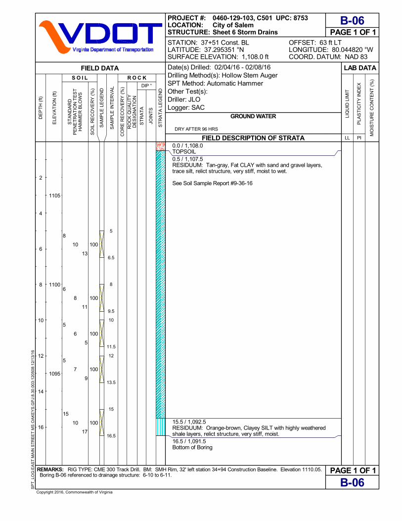
0.0 / 1,108.0TOPSOIL0.5 / 1,107.5RESIDUUM: Tan-gray, Fat CLAY with sand and gravel layers,trace silt, relict structure, very stiff, moist to wet.
See Soil Sample Report #9-36-16
15.5 / 1,092.5RESIDUUM: Orange-brown, Clayey SILT with highly weatheredshale layers, relict structure, very stiff, moist.16.5 / 1,091.5Bottom of Boring
REMARKS: RIG TYPE: CME 300 Track Drill. BM: SMH Rim, 32' left station 34+94 Construction Baseline. Elevation 1110.05.
PAGE 1 OF 1
PAGE 1 OF 1 Boring B-06 referenced to drainage structure: 6-10 to 6-11.
B-06
OFFSET: 63 ft LTLONGITUDE: 80.044820 °WCOORD. DATUM: NAD 83
FIELD DESCRIPTION OF STRATA
GROUND WATER
B-06
Copyright 2016, Commonwealth of Virginia
SP
T_L
OG
:EA
ST
MA
IN S
TR
EE
T M
S O
AK
EY
S.G
PJ:
8.30
.003
:120
508:
12/1
3/16
LIQ
UID
LIM
IT
LAB DATA
PLA
ST
ICIT
Y IN
DE
X
PILL
MO
IST
UR
E C
ON
TE
NT
(%
)R O C K
0460-129-103, C501 UPC: 8753City of SalemSheet 6 Storm Drains
SA
MP
LE L
EG
EN
D
JOIN
TS
Date(s) Drilled: 02/04/16 - 02/08/16Drilling Method(s): Hollow Stem AugerSPT Method: Automatic HammerOther Test(s):Driller: JLOLogger: SAC
ST
RA
TA
S O I L
PROJECT #:LOCATION:STRUCTURE:
2
4
6
8
10
12
14
16
FIELD DATA
ST
RA
TA
LE
GE
ND
SO
IL R
EC
OV
ER
Y (
%)
CO
RE
RE
CO
VE
RY
(%
)
STATION: 37+51 Const. BLLATITUDE: 37.295351 °NSURFACE ELEVATION: 1,108.0 ft
ELE
VA
TIO
N (
ft)
1105
1100
1095
DE
PT
H (
ft)
SA
MP
LE IN
TE
RV
AL
RO
CK
QU
ALI
TY
DE
SIG
NA
TIO
N
ST
AN
DA
RD
PE
NE
TR
AT
ION
TE
ST
HA
MM
ER
BLO
WS
DRY AFTER 96 HRS
DIP °
5
6.5
8
9.5
10
11.5
12
13.5
15
16.5

100
100
100
100
100
5
6
2
2
1
7
8
4
4
4
11
8
7
6
7
0.0 / 1,107.7TOPSOIL0.5 / 1,107.2RESIDUUM: Tan-gray, Fat CLAY with sand and gravel layers,trace silt, relict structure, stiff to very stiff, moist.
See Soil Sample Report #9-36-16
16.5 / 1,091.2Bottom of Boring
REMARKS: RIG TYPE: CME 300 Track Drill. BM: SMH Rim, 32' left station 34+94 Construction Baseline. Elevation 1110.05.
PAGE 1 OF 1
PAGE 1 OF 1 Boring B-07 referenced to drainage structures: 6-10 to 6-11, 6-11 to 6-13.
B-07
OFFSET: 37 ft LTLONGITUDE: 80.044605 °WCOORD. DATUM: NAD 83
FIELD DESCRIPTION OF STRATA
GROUND WATER
B-07
Copyright 2016, Commonwealth of Virginia
SP
T_L
OG
:EA
ST
MA
IN S
TR
EE
T M
S O
AK
EY
S.G
PJ:
8.30
.003
:120
508:
12/1
3/16
LIQ
UID
LIM
IT
LAB DATA
PLA
ST
ICIT
Y IN
DE
X
PILL
MO
IST
UR
E C
ON
TE
NT
(%
)R O C K
0460-129-103, C501 UPC: 8753City of SalemSheet 6 Storm Drains
SA
MP
LE L
EG
EN
D
JOIN
TS
Date(s) Drilled: 02/04/16 - 02/07/16Drilling Method(s): Hollow Stem AugerSPT Method: Automatic HammerOther Test(s):Driller: JLOLogger: SAC
ST
RA
TA
S O I L
PROJECT #:LOCATION:STRUCTURE:
2
4
6
8
10
12
14
16
FIELD DATA
ST
RA
TA
LE
GE
ND
SO
IL R
EC
OV
ER
Y (
%)
CO
RE
RE
CO
VE
RY
(%
)
STATION: 38+05 Const. BLLATITUDE: 37.295343 °NSURFACE ELEVATION: 1,107.7 ft
ELE
VA
TIO
N (
ft)
1105
1100
1095
DE
PT
H (
ft)
SA
MP
LE IN
TE
RV
AL
RO
CK
QU
ALI
TY
DE
SIG
NA
TIO
N
ST
AN
DA
RD
PE
NE
TR
AT
ION
TE
ST
HA
MM
ER
BLO
WS
DRY AFTER 72 HRS
DIP °
5
6.5
8
9.5
10
11.5
12
13.5
15
16.5

100
100
100
100
100
4
3
3
4
5
4
3
4
5
7
6
5
7
8
9
0.0 / 1,106.8ASPHALT PAVEMENT & AGGREGATE BASE0.6 / 1,106.2RESIDUUM: Tan-gray, Fat CLAY with sand and gravel layers,trace silt, relict structure, firm to very stiff, moist.
See Soil Sample Report #9-36-16
Free water on outside of SPT sampler
Free water on outside of SPT sampler
16.5 / 1,090.3Bottom of Boring
REMARKS: RIG TYPE: CME 300 Track Drill. BM: SMH Rim, 32' left station 34+94 Construction Baseline. Elevation 1110.05.
PAGE 1 OF 1
PAGE 1 OF 1 Boring B-08 referenced to drainage structures: 6-13 to 7-1, 6-19 to 6-21.
B-08
OFFSET: 34 ft LTLONGITUDE: 80.044472 °WCOORD. DATUM: NAD 83
FIELD DESCRIPTION OF STRATA
GROUND WATER
B-08
Copyright 2016, Commonwealth of Virginia
SP
T_L
OG
:EA
ST
MA
IN S
TR
EE
T M
S O
AK
EY
S.G
PJ:
8.30
.003
:120
508:
12/1
3/16
LIQ
UID
LIM
IT
LAB DATA
PLA
ST
ICIT
Y IN
DE
X
PILL
MO
IST
UR
E C
ON
TE
NT
(%
)R O C K
0460-129-103, C501 UPC: 8753City of SalemSheet 6 & 7 Storm Drains
SA
MP
LE L
EG
EN
D
JOIN
TS
Date(s) Drilled: 02/04/16 - 02/08/16Drilling Method(s): Hollow Stem AugerSPT Method: Automatic HammerOther Test(s):Driller: JLOLogger: SAC
ST
RA
TA
S O I L
PROJECT #:LOCATION:STRUCTURE:
2
4
6
8
10
12
14
16
FIELD DATA
ST
RA
TA
LE
GE
ND
SO
IL R
EC
OV
ER
Y (
%)
CO
RE
RE
CO
VE
RY
(%
)
STATION: 38+54 Const. BLLATITUDE: 37.295374 °NSURFACE ELEVATION: 1,106.8 ft
ELE
VA
TIO
N (
ft)
1105
1100
1095
DE
PT
H (
ft)
SA
MP
LE IN
TE
RV
AL
RO
CK
QU
ALI
TY
DE
SIG
NA
TIO
N
ST
AN
DA
RD
PE
NE
TR
AT
ION
TE
ST
HA
MM
ER
BLO
WS
STABILIZED AT 3.1 ft (1,103.7ft ELEV.) AFTER 96 HOURS
DIP °
5
6.5
7.5
9
10
11.5
12
13.5
15
16.5
100
100
100
100
100
6
3
3
3
6
7
5
4
5
10
7
5
4
7
11
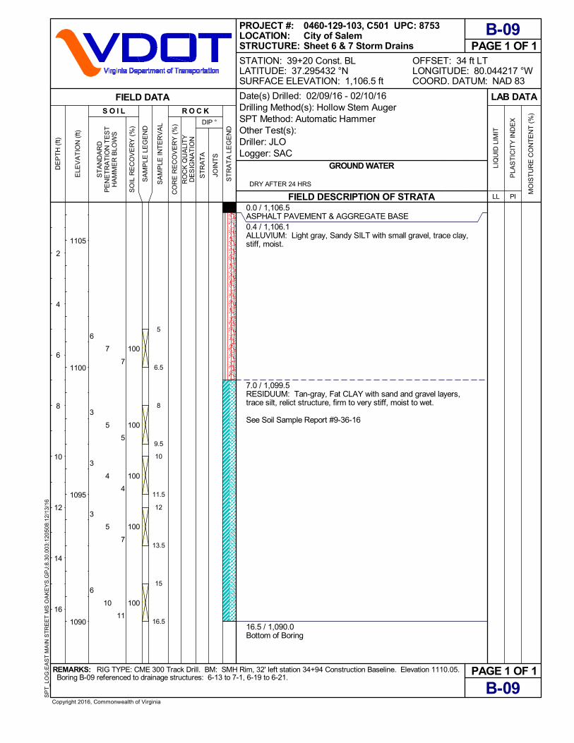
0.0 / 1,106.5ASPHALT PAVEMENT & AGGREGATE BASE0.4 / 1,106.1ALLUVIUM: Light gray, Sandy SILT with small gravel, trace clay,stiff, moist.
7.0 / 1,099.5RESIDUUM: Tan-gray, Fat CLAY with sand and gravel layers,trace silt, relict structure, firm to very stiff, moist to wet.
See Soil Sample Report #9-36-16
16.5 / 1,090.0Bottom of Boring
REMARKS: RIG TYPE: CME 300 Track Drill. BM: SMH Rim, 32' left station 34+94 Construction Baseline. Elevation 1110.05.
PAGE 1 OF 1
PAGE 1 OF 1 Boring B-09 referenced to drainage structures: 6-13 to 7-1, 6-19 to 6-21.
B-09
OFFSET: 34 ft LTLONGITUDE: 80.044217 °WCOORD. DATUM: NAD 83
FIELD DESCRIPTION OF STRATA
GROUND WATER
B-09
Copyright 2016, Commonwealth of Virginia
SP
T_L
OG
:EA
ST
MA
IN S
TR
EE
T M
S O
AK
EY
S.G
PJ:
8.30
.003
:120
508:
12/1
3/16
LIQ
UID
LIM
IT
LAB DATA
PLA
ST
ICIT
Y IN
DE
X
PILL
MO
IST
UR
E C
ON
TE
NT
(%
)R O C K
0460-129-103, C501 UPC: 8753City of SalemSheet 6 & 7 Storm Drains
SA
MP
LE L
EG
EN
D
JOIN
TS
Date(s) Drilled: 02/09/16 - 02/10/16Drilling Method(s): Hollow Stem AugerSPT Method: Automatic HammerOther Test(s):Driller: JLOLogger: SAC
ST
RA
TA
S O I L
PROJECT #:LOCATION:STRUCTURE:
2
4
6
8
10
12
14
16
FIELD DATA
ST
RA
TA
LE
GE
ND
SO
IL R
EC
OV
ER
Y (
%)
CO
RE
RE
CO
VE
RY
(%
)
STATION: 39+20 Const. BLLATITUDE: 37.295432 °NSURFACE ELEVATION: 1,106.5 ft
ELE
VA
TIO
N (
ft)
1105
1100
1095
1090
DE
PT
H (
ft)
SA
MP
LE IN
TE
RV
AL
RO
CK
QU
ALI
TY
DE
SIG
NA
TIO
N
ST
AN
DA
RD
PE
NE
TR
AT
ION
TE
ST
HA
MM
ER
BLO
WS
DRY AFTER 24 HRS
DIP °
5
6.5
8
9.5
10
11.5
12
13.5
15
16.5

100
100
100
100
100
5
4
2
2
2
9
6
4
3
3
8
6
4
4
5
0.0 / 1,106.1ASPHALT PAVEMENT & AGGREGATE BASE0.6 / 1,105.5ALLUVIUM: Light gray, Sandy SILT with small gravel, trace clay,stiff, moist.
7.0 / 1,099.1RESIDUUM: Yellow-tan, Fat CLAY with highly weathered shalelayers, relict structure, stiff, moist.
See Soil Sample Report #9-36-16
10.2 / 1,095.9RESIDUUM: Tan-gray, Fat CLAY with sand and gravel layers,trace silt, relict structure, firm to very stiff, moist to wet.
16.5 / 1,089.6Bottom of Boring
REMARKS: RIG TYPE: CME 300 Track Drill. BM: SMH Rim, 32' left station 34+94 Construction Baseline. Elevation 1110.05.
PAGE 1 OF 1
PAGE 1 OF 1 Boring B-10 referenced to drainage structures: 6-13 to 7-1, 6-19 to 6-21.
B-10
OFFSET: 36 ft LTLONGITUDE: 80.044052 °WCOORD. DATUM: NAD 83
FIELD DESCRIPTION OF STRATA
GROUND WATER
B-10
Copyright 2016, Commonwealth of Virginia
SP
T_L
OG
:EA
ST
MA
IN S
TR
EE
T M
S O
AK
EY
S.G
PJ:
8.30
.003
:120
508:
12/1
3/16
LIQ
UID
LIM
IT
LAB DATA
PLA
ST
ICIT
Y IN
DE
X
PILL
MO
IST
UR
E C
ON
TE
NT
(%
)R O C K
0460-129-103, C501 UPC: 8753City of SalemSheet 6 & 7 Storm Drains
SA
MP
LE L
EG
EN
D
JOIN
TS
Date(s) Drilled: 02/04/16 - 02/08/16Drilling Method(s): Hollow Stem AugerSPT Method: Automatic HammerOther Test(s):Driller: JLOLogger: SAC
ST
RA
TA
S O I L
PROJECT #:LOCATION:STRUCTURE:
2
4
6
8
10
12
14
16
FIELD DATA
ST
RA
TA
LE
GE
ND
SO
IL R
EC
OV
ER
Y (
%)
CO
RE
RE
CO
VE
RY
(%
)
STATION: 39+76 Const. BLLATITUDE: 37.295481 °NSURFACE ELEVATION: 1,106.1 ft
ELE
VA
TIO
N (
ft)
1105
1100
1095
1090
DE
PT
H (
ft)
SA
MP
LE IN
TE
RV
AL
RO
CK
QU
ALI
TY
DE
SIG
NA
TIO
N
ST
AN
DA
RD
PE
NE
TR
AT
ION
TE
ST
HA
MM
ER
BLO
WS
STABILIZED AT 11.5 ft (1,094.6ft ELEV.) AFTER 96 HOURS
DIP °
5
6.5
8
9.5
10
11.5
12
13.5
15
16.5

100
100
100
100
100
6
7
8
8
7
10
8
11
11
12
13
13
13
14
14
0.0 / 1,105.6ASPHALT PAVEMENT & AGGREGATE BASE0.6 / 1,105.0ALLUVIUM: Light gray, Sandy SILT with small gravel, trace clay,very stiff, moist.
7.0 / 1,098.6RESIDUUM: Tan-gray, Fat CLAY with sand and gravel layers,trace silt, relict structure, very stiff, moist.
See Soil Sample Report #9-36-16
16.3 / 1,089.3Bottom of Boring
REMARKS: RIG TYPE: CME 300 Track Drill. BM: SMH Rim, 32' left station 34+94 Construction Baseline. Elevation 1110.05.
PAGE 1 OF 1
PAGE 1 OF 1 Boring B-11 referenced to drainage structures: 6-13 to 7-1, 7-1 to 7-2, 6-21 to 7-8.
B-11
OFFSET: 36 ft LTLONGITUDE: 80.043774 °WCOORD. DATUM: NAD 83
FIELD DESCRIPTION OF STRATA
GROUND WATER
B-11
Copyright 2016, Commonwealth of Virginia
SP
T_L
OG
:EA
ST
MA
IN S
TR
EE
T M
S O
AK
EY
S.G
PJ:
8.30
.003
:120
508:
12/1
3/16
LIQ
UID
LIM
IT
LAB DATA
PLA
ST
ICIT
Y IN
DE
X
PILL
MO
IST
UR
E C
ON
TE
NT
(%
)R O C K
0460-129-103, C501 UPC: 8753City of SalemSheet 6 & 7 Storm Drains
SA
MP
LE L
EG
EN
D
JOIN
TS
Date(s) Drilled: 02/09/16 - 02/10/16Drilling Method(s): Hollow Stem AugerSPT Method: Automatic HammerOther Test(s):Driller: JLOLogger: SAC
ST
RA
TA
S O I L
PROJECT #:LOCATION:STRUCTURE:
2
4
6
8
10
12
14
16
FIELD DATA
ST
RA
TA
LE
GE
ND
SO
IL R
EC
OV
ER
Y (
%)
CO
RE
RE
CO
VE
RY
(%
)
STATION: 40+50 Const. BLLATITUDE: 37.295559 °NSURFACE ELEVATION: 1,105.6 ft
ELE
VA
TIO
N (
ft)
1105
1100
1095
1090
DE
PT
H (
ft)
SA
MP
LE IN
TE
RV
AL
RO
CK
QU
ALI
TY
DE
SIG
NA
TIO
N
ST
AN
DA
RD
PE
NE
TR
AT
ION
TE
ST
HA
MM
ER
BLO
WS
DRY AFTER 24 HRS
DIP °
4.8
6.3
8
9.59.8
11.3
12
13.5
14.8
16.3

100
100
100
100
5
8
7
8
7
9
8
9
10
13
12
14
0.0 / 1,106.3ASPHALT PAVEMENT & AGGREGATE BASE0.6 / 1,105.7FILL: Tan-orange, Lean CLAY with silt, trace gravel, wet.
3.5 / 1,102.8RESIDUUM: Tan-gray, Fat CLAY with sand and gravel layers,trace silt, relict structure, very stiff, moist.
See Soil Sample Report #9-36-16
16.2 / 1,090.1Bottom of Boring
REMARKS: RIG TYPE: CME 300 Track Drill. BM: SMH Rim, 32' left station 34+94 Construction Baseline. Elevation 1110.05.
PAGE 1 OF 1
PAGE 1 OF 1 Boring B-12 referenced to drainage structures: 7-1 to 7-2, 7-2 to 7-8, 6-21 to 7-8.
B-12
OFFSET: 38 ft LTLONGITUDE: 80.043589 °WCOORD. DATUM: NAD 83
FIELD DESCRIPTION OF STRATA
GROUND WATER
B-12
Copyright 2016, Commonwealth of Virginia
SP
T_L
OG
:EA
ST
MA
IN S
TR
EE
T M
S O
AK
EY
S.G
PJ:
8.30
.003
:120
508:
12/1
3/16
LIQ
UID
LIM
IT
LAB DATA
PLA
ST
ICIT
Y IN
DE
X
PILL
MO
IST
UR
E C
ON
TE
NT
(%
)R O C K
0460-129-103, C501 UPC: 8753City of SalemSheet 6 & 7 Storm Drains
SA
MP
LE L
EG
EN
D
JOIN
TS
Date(s) Drilled: 02/09/16 - 02/10/16Drilling Method(s): Hollow Stem AugerSPT Method: Automatic HammerOther Test(s):Driller: JLOLogger: SAC
ST
RA
TA
S O I L
PROJECT #:LOCATION:STRUCTURE:
2
4
6
8
10
12
14
16
FIELD DATA
ST
RA
TA
LE
GE
ND
SO
IL R
EC
OV
ER
Y (
%)
CO
RE
RE
CO
VE
RY
(%
)
STATION: 41+10 Const. BLLATITUDE: 37.295601 °NSURFACE ELEVATION: 1,106.3 ft
ELE
VA
TIO
N (
ft)
1105
1100
1095
1090
DE
PT
H (
ft)
SA
MP
LE IN
TE
RV
AL
RO
CK
QU
ALI
TY
DE
SIG
NA
TIO
N
ST
AN
DA
RD
PE
NE
TR
AT
ION
TE
ST
HA
MM
ER
BLO
WS
DRY AFTER 24 HRS
DIP °
4.7
6.2
9.7
11.2
12
13.5
14.7
16.2

100
100
100
100
1
5
4
1
4
6
5
2
3
7
7
3
0.0 / 1,107.4ASPHALT PAVEMENT & AGGREGATE BASE:6" Asphalt, 10" Aggregate Base
1.3 / 1,106.1FILL: Gray-brown, Clayey SILT with sand and gravel, containsbrick fragments, very wet.
3.5 / 1,103.9ALLUVIUM: Light gray, Sandy SILT with small gravel, trace clay,very stiff, moist.
8.1 / 1,099.3RESIDUUM: Tan-gray, Fat CLAY with sand and gravel layers,trace silt, relict structure, firm to stiff, moist.
See Soil Sample Report #9-36-16
Free water in SPT sample
16.5 / 1,090.9Bottom of Boring
REMARKS: RIG TYPE: CME 300 Track Drill. BM: SMH Rim, 32' left station 34+94 Construction Baseline. Elevation 1110.05.
PAGE 1 OF 1
PAGE 1 OF 1 Boring B-13 referenced to drainage structures: 7-2 to 7-8, 7-8 to 7-4, 7-4 to 7-12.
B-13
OFFSET: 23 ft RTLONGITUDE: 80.043447 °WCOORD. DATUM: NAD 83
FIELD DESCRIPTION OF STRATA
GROUND WATER
B-13
Copyright 2016, Commonwealth of Virginia
SP
T_L
OG
:EA
ST
MA
IN S
TR
EE
T M
S O
AK
EY
S.G
PJ:
8.30
.003
:120
508:
12/1
3/16
LIQ
UID
LIM
IT
LAB DATA
PLA
ST
ICIT
Y IN
DE
X
PILL
MO
IST
UR
E C
ON
TE
NT
(%
)R O C K
0460-129-103, C501 UPC: 8753City of SalemSheet 7 Storm Drains
SA
MP
LE L
EG
EN
D
JOIN
TS
Date(s) Drilled: 02/09/16 - 02/09/16Drilling Method(s): Hollow Stem AugerSPT Method: Automatic HammerOther Test(s):Driller: JLOLogger: SAC
ST
RA
TA
S O I L
PROJECT #:LOCATION:STRUCTURE:
2
4
6
8
10
12
14
16
FIELD DATA
ST
RA
TA
LE
GE
ND
SO
IL R
EC
OV
ER
Y (
%)
CO
RE
RE
CO
VE
RY
(%
)
STATION: 41+42 Const. BLLATITUDE: 37.295457 °NSURFACE ELEVATION: 1,107.4 ft
ELE
VA
TIO
N (
ft)
1105
1100
1095
DE
PT
H (
ft)
SA
MP
LE IN
TE
RV
AL
RO
CK
QU
ALI
TY
DE
SIG
NA
TIO
N
ST
AN
DA
RD
PE
NE
TR
AT
ION
TE
ST
HA
MM
ER
BLO
WS
DRY AFTER 3 HRS
DIP °
5
6.5
10
11.5
12.5
14
15
16.5

Form TL-32 (5/31/2005)
Revised: 3/10/2014
Soil Sample ReportMaterials Division
Project No. : Report No. :
UPC No. : Sample No. :
Route No. : Submitted By :
County : Tested by:
For Use In : Reviewed by:
Date of Report: 3/2/16
Sieve SizesGrams
Retained
Percent
Retained
Percent
PassingSieve
Sizes
Grams
Retained
Percent
Retained
Percent
Passing
>63.00mm
(+2 1/2 in.) 0.0 0.0% 100.0%
>63.00mm
(+2 1/2 in.)
63.00mm
(2 1/2 in.) 0.0 0.0% 100.0%
63.00mm
(2 1/2 in.)
50.00mm
(2 in.) 0.0 0.0% 100.0%
50.00mm
(2 in.)
37.50mm
(1 1/2 in.) 0.0 0.0% 100.0%
37.50mm
(1 1/2 in.)
25.00mm
(1 in.) 0.0 0.0% 100.0%
25.00mm
(1 in.)
19.00mm
(3/4 in.) 0.0 0.0% 100.0%19.00mm
(3/4 in.)
9.50mm
(3/8 in.) 132.0 5.8% 94.2%
9.50mm
(3/8 in.)
4.75mm
(#4) 567.0 25.0% 69.1%
4.75mm
(#4)
2.00mm
(#10) 1034.0 45.7% 23.5%2.00mm
(#10) 100.0%
0.850mm
(#20) 0.0 0.9% 22.6%
0.850mm
(#20) 4.9 3.7% 96.3%
0.425mm
(#40) 0.0 0.8% 21.8%
0.425mm
(#40) 4.4 3.3% 93.0%
0.250mm (#60)0.0 0.7% 21.1%
0.250mm
(#60) 4.0 3.0% 90.0%
0.180mm
(#80) 0.0 0.4% 20.7%
0.180mm
(#80) 2.5 1.9% 88.1%
0.150mm
(#100) 0.0 0.3% 20.4%0.150mm
(#100) 1.6 1.2% 86.9%
0.075mm
(#200) 0.0 1.0% 19.4%
0.075mm
(#200) 5.6 4.2% 82.7%
<0.075mm
(-#200 on Pan) 0.0 19.4% 0.0%
<0.075mm
(-#200) 82.7%
Total 2265.0 Total 133.1Compacted
Specimen
Specimen
After
Immersion
N/A N/A
23 35.48 N/A N/A
34.54 42.81 N/A
53.82 41.29 N/A
47.11 1.52 N/A
6.71 5.81 N/A N/A
12.57 26%
53%
53%
Location : See Remarks * Sampled from the property of : N/A
Depth : 7' - 16.5'
Representing : pipe / dry swale foundation
Date Sampled : 2/16/16
Date Recieved : N/A
Field descripts :
Remarks :
Reported By : Paul Baldwin for John Schuler, PE, For : Andy Babish, PE Materials Program Manager State Materials Engineer
Test procedures include: a=T99 (VTM 1), b=T89 (VTM 7), c=T90 (VTM 7), d=T193 (VTM 8), e=T88, f=M145, g=T265 & h= D2488 (D2487). Page 1 of 3
Liquid Limit:
Atterberg Limits
Salem City, Roanoke
N/A
Wade H. Pence
C. Gresham
Clayey SAND, with gravel ( SC )
USCS (ASTM) Soil Classification (h):
N/A N/A
Water Content:
Weight of Dish + Wet Soil:
Weight of Water:
Plastic Limit:
Weight of Dish:
Weight of Water:
Weight of Dish + Dry Soil:
Weight of Dish:
Weight of Dry Soil:
0460-129-105, C501
8753
460 East Main Street
9-36-16
Plastic Limit:
Plastic Limit (c)Liquid Limit (b)
AASHTO Soil Classification: (f)
Weight of Dish + Wet Soil:
Number of Blows
A-2-7 (0)
(Assumed)
Maximum Dry Density (lbs./cu. ft.) (a)
N/A
N/A
26%
Total Soil
CBR Value (0.1 in)
CBR Value (0.2 in)
Bulk Specific Gravity of +#4 sieve
N/A
Liquid Limit:
Mechanical Analysis of Total Sample (e) Mechanical Analysis of -#10 Sieve (e)
Weight of Dry Soil:
27%
N/A
Natural Water Content (g):
N/A
Plasticity Index:
N/A
Total Soil
-4 Portion
-4 Portion
53%
Optimum Water Content (a)
CBR Data (d)
% Water
location: 40' to 60' left between sta. 33+77 & sta. 41+10 Rte. 460 Const. BL (pH = 4.6). (Minimum Resistivity = 8922 ohm-cm).
N/A
% Density
CBR Value (per VTM 8)
Weight of Dish + Dry Soil:
% Swell After Soaking "
stephen.chaos
Highlight
stephen.chaos
Highlight
stephen.chaos
Highlight
stephen.chaos
Highlight
stephen.chaos
Highlight

Form TL-32 (5/31/2005)
Revised: 3/10/2014
Soil Sample ReportMaterials Division
Project No. : Report No. :
UPC No. : Sample No. :
Route No. : Submitted By :
County : Tested by:
For Use In : Reviewed by:
Date of Report: 3/18/16
Sieve SizesGrams
Retained
Percent
Retained
Percent
PassingSieve
Sizes
Grams
Retained
Percent
Retained
Percent
Passing
>63.00mm
(+2 1/2 in.) 0.0 0.0% 100.0%
>63.00mm
(+2 1/2 in.)
63.00mm
(2 1/2 in.) 0.0 0.0% 100.0%
63.00mm
(2 1/2 in.)
50.00mm
(2 in.) 0.0 0.0% 100.0%
50.00mm
(2 in.)
37.50mm
(1 1/2 in.) 0.0 0.0% 100.0%
37.50mm
(1 1/2 in.)
25.00mm
(1 in.) 0.0 0.0% 100.0%
25.00mm
(1 in.)
19.00mm
(3/4 in.) 0.0 0.0% 100.0%19.00mm
(3/4 in.)
9.50mm
(3/8 in.) 10.0 0.4% 99.6%
9.50mm
(3/8 in.)
4.75mm
(#4) 17.0 0.7% 98.9%
4.75mm
(#4)
2.00mm
(#10) 33.0 1.3% 97.6%2.00mm
(#10) 100.0%
0.850mm
(#20) 0.0 2.3% 95.3%
0.850mm
(#20) 4.0 2.4% 97.6%
0.425mm
(#40) 0.0 4.5% 90.8%
0.425mm
(#40) 7.7 4.6% 93.0%
0.250mm (#60)0.0 6.9% 83.9%
0.250mm
(#60) 11.8 7.1% 85.9%
0.180mm
(#80) 0.0 5.9% 77.9%
0.180mm
(#80) 10.1 6.1% 79.9%
0.150mm
(#100) 0.0 3.6% 74.4%0.150mm
(#100) 6.1 3.7% 76.2%
0.075mm
(#200) 0.0 10.8% 63.6%
0.075mm
(#200) 18.4 11.0% 65.2%
<0.075mm
(-#200 on Pan) 0.0 63.6% 0.0%
<0.075mm
(-#200) 65.2%
Total 2511.0 Total 166.8Compacted
Specimen
Specimen
After
Immersion
N/A N/A
28 33.96 N/A N/A
31.61 40.73 N/A
51.12 39.71 N/A
45.32 1.02 N/A
5.8 5.75 N/A N/A
13.71 18%
42%
43%
Location : See Remarks * Sampled from the property of : N/A
Depth : 4.8' - 16.5'
Representing : Pipe Foundation
Date Sampled : 3/8/16
Date Recieved : N/A
Field descripts :
Remarks :
Reported By : Paul Baldwin for John Schuler, PE, For : Andy Babish, PE Materials Program Manager State Materials Engineer
Test procedures include: a=T99 (VTM 1), b=T89 (VTM 7), c=T90 (VTM 7), d=T193 (VTM 8), e=T88, f=M145, g=T265 & h= D2488 (D2487). Page 1 of 3
Liquid Limit:
Atterberg Limits
Salem City, Roanoke
N/A
Wade H. Pence
C. Gresham
Sandy lean CLAY ( CL )
USCS (ASTM) Soil Classification (h):
N/A N/A
Water Content:
Weight of Dish + Wet Soil:
Weight of Water:
Plastic Limit:
Weight of Dish:
Weight of Water:
Weight of Dish + Dry Soil:
Weight of Dish:
Weight of Dry Soil:
0460-129-105, C501
8753
460 East Main Street
9-40-16
Plastic Limit:
Plastic Limit (c)Liquid Limit (b)
AASHTO Soil Classification: (f)
Weight of Dish + Wet Soil:
Number of Blows
A-7-6 (14)
(Assumed)
Maximum Dry Density (lbs./cu. ft.) (a)
N/A
N/A
18%
Total Soil
CBR Value (0.1 in)
CBR Value (0.2 in)
Bulk Specific Gravity of +#4 sieve
N/A
Liquid Limit:
Mechanical Analysis of Total Sample (e) Mechanical Analysis of -#10 Sieve (e)
Weight of Dry Soil:
25%
N/A
Natural Water Content (g):
N/A
Plasticity Index:
N/A
Total Soil
-4 Portion
-4 Portion
43%
Optimum Water Content (a)
CBR Data (d)
% Water
location: 15' to 60' left between sta. 12+80 & sta. 15+18 Rte. 460 Const. BL (pH = 5.4). (Minimum Resistivity = 3096 ohm-cm). AASHTO T-
289 performed at Central Office Chemistry Lab.
N/A
% Density
CBR Value (per VTM 8)
Weight of Dish + Dry Soil:
% Swell After Soaking "
stephen.chaos
Highlight
stephen.chaos
Highlight
stephen.chaos
Highlight
stephen.chaos
Highlight
stephen.chaos
Highlight