
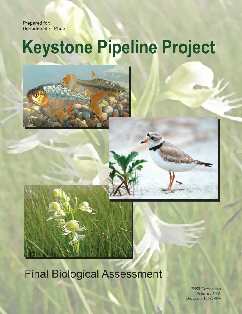
Department of State Keystone Pipeline Project
91
Prepared for: Department of State Final Biological Assessment ENSR Corporation February 2008 Document 10623-004 Keystone Pipeline Project
Transcript of Department of State Keystone Pipeline Project
Prepared for:Department of State
Final Biological AssessmentENSR Corporation
February 2008Document 10623-004
Keystone Pipeline Project
Prepared for: Department of State
Keystone Pipeline Project Biological Assessment Final
February 2008 Document No.: 10623-004r1
i February 2008 Biological Assessment
Contents
1.0 Introduction ................................................................................................................................................1-1 1.1 Section 7 Process................................................................................................................................1-1 1.2 Consultation History ............................................................................................................................1-1 1.3 Analysis Summary...............................................................................................................................1-4 1.4 Summary of Species Considered but Eliminated from Detailed Analysis for the Biological
Assessment .........................................................................................................................................1-5 1.4.1 Gray Bat .................................................................................................................................1-5 1.4.2 Winged Mapleleaf ..................................................................................................................1-5 1.4.3 Gray Wolf ...............................................................................................................................1-6 1.4.4 Literature Cited ......................................................................................................................1-6
2.0 Proposed Action ........................................................................................................................................2-1 2.1.1 Land Requirements ...............................................................................................................2-2 2.1.2 Pipeline ROW ........................................................................................................................2-5 2.1.3 Additional Temporary Workspace Areas ..............................................................................2-5 2.1.4 Pipe Storage and Contractor Yards ......................................................................................2-6 2.1.5 Access Roads........................................................................................................................2-8 2.1.6 Aboveground Facilities ..........................................................................................................2-8 2.1.7 Operation and Maintenance................................................................................................2-19
3.0 Species Evaluation ....................................................................................................................................3-1 3.1 Federal Endangered............................................................................................................................3-1
3.1.1 Indiana Bat .............................................................................................................................3-1 3.1.2 Interior Least Tern ...............................................................................................................3-10 3.1.3 Whooping Crane..................................................................................................................3-14 3.1.4 Pallid Sturgeon.....................................................................................................................3-18 3.1.5 Topeka Shiner......................................................................................................................3-20 3.1.6 Higgins Eye Pearlymussel...................................................................................................3-28 3.1.7 Scaleshell Mussel ................................................................................................................3-31 3.1.8 Running Buffalo Clover........................................................................................................3-34
3.2 Federal Threatened ...........................................................................................................................3-37 3.2.1 Piping Plover........................................................................................................................3-37 3.2.2 Arkansas River Shiner.........................................................................................................3-41 3.2.3 Neosho Madtom ..................................................................................................................3-45 3.2.4 Decurrent False Aster..........................................................................................................3-47 3.2.5 Western Prairie Fringed Orchid...........................................................................................3-49
ii February 2008 Biological Assessment
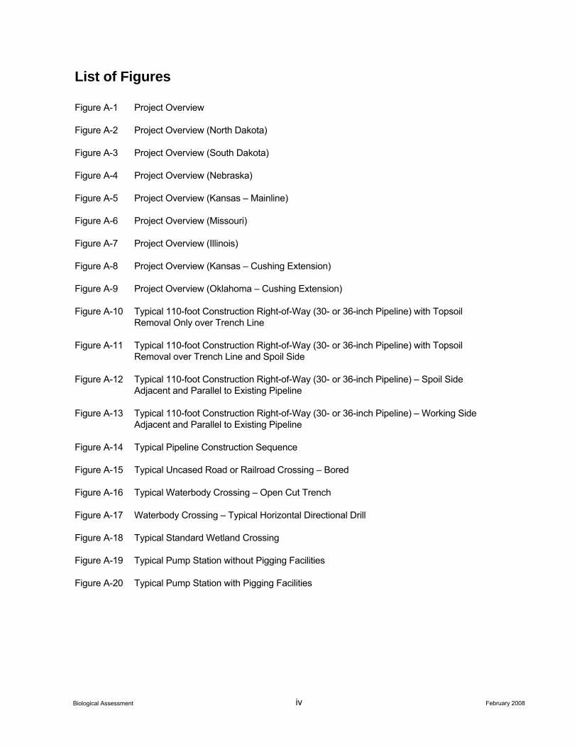
List of Appendices Appendix A – Figures
Appendix B – Indiana Bat Impact Analysis
B-1 – Missouri Bat Habitat Report B-2 – Illinois Bat Habitat Report B-3 – Missouri Woodlots Worksheet B-4 – Illinois Woodlots Worksheet
Appendix C – Construction Mitigation and Reclamation Plan
Appendix D – Hydrostatic Test Plan
Appendix E – Environmental Fate and Risk Associated with Crude Oil
iii February 2008 Biological Assessment
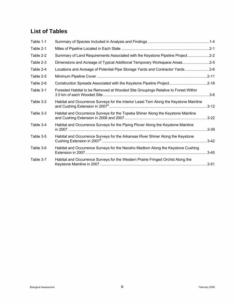
List of Tables Table 1-1 Summary of Species Included in Analysis and Findings ............................................................1-4 Table 2-1 Miles of Pipeline Located in Each State ......................................................................................2-1 Table 2-2 Summary of Land Requirements Associated with the Keystone Pipeline Project.....................2-2 Table 2-3 Dimensions and Acreage of Typical Additional Temporary Workspace Areas..........................2-5 Table 2-4 Locations and Acreage of Potential Pipe Storage Yards and Contractor Yards........................2-6 Table 2-5 Minimum Pipeline Cover ............................................................................................................2-11 Table 2-6 Construction Spreads Associated with the Keystone Pipeline Project.....................................2-18 Table 3-1 Forested Habitat to be Removed at Wooded Site Groupings Relative to Forest Within
3.5 km of each Wooded Site........................................................................................................3-6 Table 3-2 Habitat and Occurrence Surveys for the Interior Least Tern Along the Keystone Mainline
and Cushing Extension in 20071................................................................................................3-12 Table 3-3 Habitat and Occurrence Surveys for the Topeka Shiner Along the Keystone Mainline
and Cushing Extension in 2006 and 2007.................................................................................3-22 Table 3-4 Habitat and Occurrence Surveys for the Piping Plover Along the Keystone Mainline
in 2007 ........................................................................................................................................3-39 Table 3-5 Habitat and Occurrence Surveys for the Arkansas River Shiner Along the Keystone
Cushing Extension in 20071 .......................................................................................................3-42 Table 3-6 Habitat and Occurrence Surveys for the Neosho Madtom Along the Keystone Cushing
Extension in 2007 .......................................................................................................................3-45 Table 3-7 Habitat and Occurrence Surveys for the Western Prairie Fringed Orchid Along the
Keystone Mainline in 2007 .........................................................................................................3-51
iv February 2008 Biological Assessment
List of Figures
Figure A-1 Project Overview
Figure A-2 Project Overview (North Dakota)
Figure A-3 Project Overview (South Dakota)
Figure A-4 Project Overview (Nebraska)
Figure A-5 Project Overview (Kansas – Mainline)
Figure A-6 Project Overview (Missouri)
Figure A-7 Project Overview (Illinois)
Figure A-8 Project Overview (Kansas – Cushing Extension)
Figure A-9 Project Overview (Oklahoma – Cushing Extension)
Figure A-10 Typical 110-foot Construction Right-of-Way (30- or 36-inch Pipeline) with Topsoil Removal Only over Trench Line
Figure A-11 Typical 110-foot Construction Right-of-Way (30- or 36-inch Pipeline) with Topsoil Removal over Trench Line and Spoil Side
Figure A-12 Typical 110-foot Construction Right-of-Way (30- or 36-inch Pipeline) – Spoil Side Adjacent and Parallel to Existing Pipeline
Figure A-13 Typical 110-foot Construction Right-of-Way (30- or 36-inch Pipeline) – Working Side Adjacent and Parallel to Existing Pipeline
Figure A-14 Typical Pipeline Construction Sequence
Figure A-15 Typical Uncased Road or Railroad Crossing – Bored
Figure A-16 Typical Waterbody Crossing – Open Cut Trench
Figure A-17 Waterbody Crossing – Typical Horizontal Directional Drill
Figure A-18 Typical Standard Wetland Crossing
Figure A-19 Typical Pump Station without Pigging Facilities
Figure A-20 Typical Pump Station with Pigging Facilities

v February 2008 Biological Assessment
Acronyms and Abbreviations
°F degrees Fahrenheit
API American Petroleum Institute
AWBP Aransas-Wood Buffalo National Park Population
BA Biological Assessment
BHE BHE Environmental, Inc.
bpd barrels per day
CFR Code of Federal Regulations
CMR Plan Construction Mitigation and Reclamation Plan
CWS Canadian Wildlife Service
dbh diameter at breast height
DNR Department of Natural Resources
DOS Department of State
ERP Emergency Response Plan
ESA Endangered Species Act
FR Federal Register
HDD horizontal directional drill
I-80 Interstate 80
KDWP Kansas Department of Wildlife and Parks
Keystone TransCanada Keystone Pipeline, L.P.
km kilometer
MDC Missouri Department of Conservation
MP milepost
NLAA May affect, not likely to adversely affect
NRC National Response Center
NRCS Natural Resource Conservation Service
OPS Office of Pipeline Safety
vi February 2008 Biological Assessment
PHMSA Pipeline Hazardous Materials and Safety Administration
REX-West Rockies Express-West
ROW right-of-way
SCADA Supervisory Control and Data Acquisition
SPCC Plan Spill Prevention, Control, and Countermeasure Plan
U.S. United States
USDOT U.S. Department of Transportation
USEPA U.S. Environmental Protection Agency
USFWS U.S. Fish and Wildlife Service
USGS U.S. Geological Survey
WMA Wildlife Management Area
1-1 February 2008 Biological Assessment
1.0 Introduction
1.1 Section 7 Process The Department of State (DOS) is the lead federal agency for the evaluation of anticipated impacts of the proposed Keystone Pipeline Project (project). Federal agencies, in consultation with the U.S. Fish and Wildlife Service (USFWS), are required to ensure that any action they authorize, fund, or carry out will not adversely affect a federally listed species or species proposed for federal listing. A Biological Assessment (BA) is required under Section 7(c) of the Endangered Species Act (ESA), if listed species or their critical habitat may be present in the area affected by any aspect of the project.
1.2 Consultation History Construction and operation of the project may affect habitats and populations of species protected under the federal ESA and by individual state legislation. The DOS appointed TransCanada Keystone Pipeline, L.P. (Keystone) and its subcontractors to act as its designated non-federal representatives for Section 7 Consultation in a letter dated January 5, 2007. During 2006, Keystone, on behalf of the DOS, initiated consultation with the USFWS, and state natural heritage programs and wildlife agencies to identify species and habitats of concern. After receiving lists of species and habitats, Keystone developed field survey protocols, target survey areas, and survey schedules. These protocols were submitted to the USFWS and state agencies for review. No agencies objected to the proposed protocols; agency comments received on the protocols were incorporated into survey protocols. Agency coordination documentation and survey protocols were filed by Keystone with the DOS in September and November 2006, and in January, March, and September 2007.
Biological field surveys within the project footprint (e.g., pipeline right-of-way (ROW), pump stations, access roads, pipe yards, contractor yards, extra workspace, etc.) were initiated in spring 2006. These surveys were conducted along the project ROW that was filed with the DOS in September 2006. Additional surveys were conducted along the project in late 2006 and 2007, to accommodate route alignment modifications that were filed with the DOS in November 2006; and in January, March, and September 2007. Due to access denials by private landowners, some surveys have not been completed. If necessary, additional species-specific field surveys would be conducted prior to construction, in coordination with the USFWS.
The following provides a summary of Keystone’s agency correspondence, species specific survey information, and continued consultation with the USFWS regarding coordination of biological surveys and determination of biological impacts for the project:
• January 2006, Multiple Agencies: Keystone sent initial consultation letters to the USFWS, state wildlife agencies, and state natural heritage programs to request their input on identifying prominent terrestrial and aquatic resource issues or concerns that may occur within or adjacent to the project area, focusing on species that are either sensitive (e.g., federally listed), have high economic value (e.g., big game, waterfowl), or are considered important resources (e.g., raptors, fish). The consultation letters included an overview project map and a compact disk containing electronic files of the project ROW. The letters also requested input into survey requirements for species and habitats, including preferred survey methodology and acceptable survey efforts.
• February 15, 2006, USFWS – Grand Island Field Office: Project representatives met with the USFWS in Grand Island, Nebraska, to discuss construction aspects of the project, as well as environmental impacts of concern to the USFWS. During this meeting, Keystone was informed that the USFWS Nebraska Field Office would be the lead field office for the USFWS for the project.
1-2 February 2008 Biological Assessment
• April 28, 2006, USFWS: Keystone received a consultation letter from the USFWS regarding sensitive habitats, federally listed or candidate species, and other species of concern (e.g., migratory birds) potentially occurring along the project. Keystone incorporated this information into project planning for sensitive species and habitats, and developed survey schedules and protocols to be implemented along the Keystone Mainline beginning in the fall of 2006.
• June 8, 2006, USFWS: Keystone received a supplemental consultation letter from the USFWS regarding federal easements in North Dakota and South Dakota crossed by the Keystone Mainline. The USFWS was particularly concerned with construction impacts in several ecologically sensitive areas. Keystone incorporated the information into route realignments and alternatives to avoid, where necessary and feasible, disturbance of the ecologically sensitive areas along the Keystone Mainline.
• June 14, 2006, Multiple Agencies: Project representatives met with staff from the USFWS Marion Field Office, and other state and federal agencies at Carlyle Lake, Illinois. The primary purpose of the meeting was to address questions agency representatives might have regarding the crossing of the Carlyle Lake Wildlife Management Area (WMA), and to obtain input on environmental issues such as recommended threatened and endangered species surveys. Survey recommendations for the Indiana bat, decurrent false aster, massasauga rattlesnake, migratory birds, and bald eagle and raptors were discussed during the meeting. Keystone incorporated recommendations into the biological survey plan.
• June 26, 2006, USFWS – Nebraska Field Office: Keystone sent the USFWS – Nebraska Field Office and each state wildlife agency a consultation package that included state-specific special status species tables compiled from data received from each state and the USFWS, with brief descriptions of species habitat, miles of potential habitat crossed by the project, and approximate mileposts where potential habitat was identified along the project . Topographic maps (1:100,000-scale) identifying potentially sensitive habitat along the project were included in the consultation package.
• July 18, 2006, USFWS – Nebraska Field Office: Keystone held an agency meeting with the USFWS Nebraska Field Office in Grand Island, Nebraska, to discuss issues pertaining to wildlife, special status species, migratory birds, and sensitive habitat that could potentially occur along the project. The goal of this meeting was to verify Keystone’s habitat assessment approach, species occurrence information, discuss required field surveys, and review the information that was sent to the USFWS in the June 26, 2006, consultation package. The USFWS concurred with Keystone’s approach to identifying special status species habitat, and Keystone incorporated comments from the meeting regarding additional survey recommendations and protocols for special status species surveys along the project.
• October 16, 2006, Missouri Department of Conservation (MDC) and Illinois Department of Natural Resources (DNR): Keystone sent study plans for the massasauga rattlesnake, western fox snake, and Kirtland’s snake to the MDC and Illinois DNR for concurrence and approval to move forward with the habitat surveys for these species. The study plans included detailed, state-specific survey protocols for the habitat assessment surveys. Concurrence from both the MDC and Illinois DNR was received.
• October 31, 2006, Kansas Department of Wildlife and Parks (KDWP): Keystone received a consultation letter from the KDWP regarding sensitive species and habitats along the Cushing Extension. The consultation letter included information on federally listed species and their potential for occurrence along the Cushing Extension. Keystone incorporated the sensitive species information to plan species-specific surveys along the Cushing Extension.
• November 7, 2006, USFWS – Missouri Ecological Services Field Office: Keystone sent a study plan to the USFWS Missouri Ecological Services Field Office in Columbia, Missouri, requesting concurrence with the proposed Indiana bat habitat assessment method that would be used to characterize suitable maternity roost habitat for the species in the state of Missouri. Concurrence was received on November 21, 2006, and habitat surveys were initiated following receipt of this approval.
1-3 February 2008 Biological Assessment
• November 14, 2006, USFWS Marion Field Office: Keystone sent a detailed study plan to the USFWS Marion Field Office in Illinois. Keystone requested concurrence with the proposed Indiana bat habitat survey method specific to the state of Illinois. Keystone received comments back from Joyce Collins (USFWS Marion Field Office) regarding the study plan, and the plan was accepted and signed on November 16, 2006. Habitat surveys were initiated shortly after receiving confirmation of the study plan.
• December 18, 2006, USFWS Nebraska Field Office: Keystone sent email correspondence to the USFWS Nebraska Field Office regarding the upcoming January/February 2007 aerial raptor and bald eagle winter roost and nest surveys. Comments and concurrence were received on the survey locations and methodology on January 24, 2007, and surveys were initiated following receipt of approval.
• December 19, 2006, Multiple Agencies: Keystone distributed copies of the 2006 biological survey reports to the appropriate state wildlife and USFWS representatives for their review. Keystone requested that each species expert review the corresponding report and provide Keystone with comments in order to address any concerns. Keystone followed-up with each agency evaluating biological reports, and no significant comments or concerns were received from any of the report reviewers.
• January 4, 2007, Multiple Agencies: Keystone sent emails to each state wildlife agency representative working on the project, and the USFWS Nebraska Field Office, requesting that Keystone meet with them in early February, in person, to review the overall proposed surveys plans for 2007 and any other outstanding issues.
• January 23, 2007, USFWS: Keystone met with USFWS representatives in Columbia, Missouri, to discuss strategies and opportunities to optimize project scheduling and conservation benefits to Indiana bats.
• February 5, 2007, USFWS – Nebraska Field Office: Keystone met with the USFWS Nebraska Field Office in Grand Island, Nebraska. The goals of the meeting were to: 1) discuss the 2006 survey results for federally listed and candidate species, 2) obtain concurrence on the proposed 2007 survey protocols and survey locations, and 3) discuss other issues or concerns that USFWS had regarding the project.
• February 9, 2007, Multiple Agencies: Keystone distributed copies of the fall/winter 2006 biological survey reports to the appropriate state wildlife and USFWS representatives for their review. Keystone requested that each species expert review the corresponding report and provide Keystone with comments in order to address any concerns. Keystone followed-up with each agency evaluating biological reports, and no significant comments or concerns were received from any of the report reviewers.
• April 12, 2007, Multiple Agencies: Keystone distributed copies of the spring 2007 biological survey reports to the appropriate state wildlife and USFWS representatives for their review. Keystone requested that each species expert review the corresponding report and provide Keystone with comments in order to address any concerns. Keystone followed-up with each agency evaluating biological reports, and no significant comments or concerns were received from any of the report reviewers.
• September 2007, Multiple Agencies: Keystone distributed copies of the summer 2007 biological survey reports to the appropriate state wildlife and USFWS representatives for their review. Keystone requested that each species expert review the corresponding report and provide Keystone with comments in order to address any concerns.
• November 16, 2007, USFWS – Nebraska Field Office: Keystone met with the USFWS Nebraska Field Office in Grand Island, Nebraska. The goals of the meeting were to discuss with the USFWS the schedule for submitting a preliminary final biological assessment for the Keystone Pipeline Project,

1-4 February 2008 Biological Assessment
review species analyses, and to address unresolved comments from the USFWS and DOS on the draft document.
• November 2007 Preliminary Final Biological Assessment, Multiple Agencies: Keystone distributed copies of the Preliminary Final Biological Assessment to DOS for review and distribution to the USFWS.
Based on the consultation with state agencies and the USFWS throughout 2006 and 2007, Keystone was able to refine the proposed biological surveys and survey requirements for each species that may potentially be affected by the project.
1.3 Analysis Summary This species analysis addresses the impacts to 17 federally listed species that were identified by the USFWS and state wildlife agencies as potentially occurring along the project. Table 1-1 summarizes these species and the impact determinations, based on: 1) correspondence with the USFWS and state wildlife agencies, 2) habitat requirements and the known distribution of these species within the project area, and 3) habitat analysis and field surveys that were conducted for these species in 2006 and 2007.The analysis did not include the associated electrical infrastructure necessary for the Keystone Project. Because a third party will build these facilities, and the locations and construction methods are unknown at this time, the DOS will consult with the USFWS under section 7 of the Endangered Species Act (ESA) when this information becomes available.
Table 1-1 Summary of Species Included in Analysis and Findings
Common Name Scientific Name Federal Status Included in Analysis Findings Summary1
Mammals Indiana bat Myotis sodalis Endangered Yes NLAA Gray bat Myotis grisescens Endangered No No Effect Gray wolf Canis lupus ND, SD
population – delisted Considered extirpated from remaining states crossed by the project
No No Effect
Birds Interior least tern Sterna antillarum
athalassos Endangered Yes NLAA
Whooping crane Grus americana Endangered Yes NLAA Bald Eagle Haliaeetus
leucocephalus Delisted No NA
Piping plover Charadrius melodus Threatened Yes NLAA Fish Pallid sturgeon Scaphirhynchus
albus Endangered Yes NLAA
Topeka shiner Notropis topeka Endangered Yes NLAA Arkansas River shiner
Notropis girardi Threatened Yes NLAA
Neosho madtom Noturus pacidus Threatened Yes NLAA
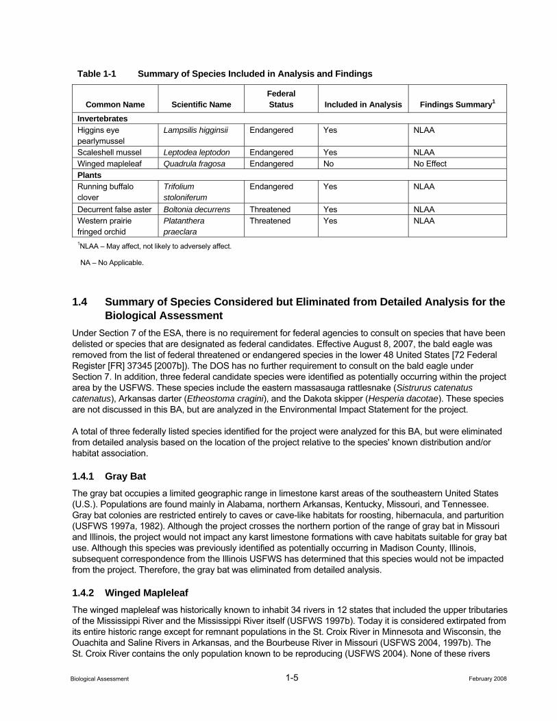
1-5 February 2008 Biological Assessment
Table 1-1 Summary of Species Included in Analysis and Findings
Common Name Scientific Name Federal Status Included in Analysis Findings Summary1
Invertebrates Higgins eye pearlymussel
Lampsilis higginsii Endangered Yes NLAA
Scaleshell mussel Leptodea leptodon Endangered Yes NLAA Winged mapleleaf Quadrula fragosa Endangered No No Effect Plants Running buffalo clover
Trifolium stoloniferum
Endangered Yes NLAA
Decurrent false aster Boltonia decurrens Threatened Yes NLAA Western prairie fringed orchid
Platanthera praeclara
Threatened Yes NLAA
1NLAA – May affect, not likely to adversely affect.
NA – No Applicable.
1.4 Summary of Species Considered but Eliminated from Detailed Analysis for the Biological Assessment
Under Section 7 of the ESA, there is no requirement for federal agencies to consult on species that have been delisted or species that are designated as federal candidates. Effective August 8, 2007, the bald eagle was removed from the list of federal threatened or endangered species in the lower 48 United States [72 Federal Register [FR] 37345 [2007b]). The DOS has no further requirement to consult on the bald eagle under Section 7. In addition, three federal candidate species were identified as potentially occurring within the project area by the USFWS. These species include the eastern massasauga rattlesnake (Sistrurus catenatus catenatus), Arkansas darter (Etheostoma cragini), and the Dakota skipper (Hesperia dacotae). These species are not discussed in this BA, but are analyzed in the Environmental Impact Statement for the project.
A total of three federally listed species identified for the project were analyzed for this BA, but were eliminated from detailed analysis based on the location of the project relative to the species' known distribution and/or habitat association.
1.4.1 Gray Bat The gray bat occupies a limited geographic range in limestone karst areas of the southeastern United States (U.S.). Populations are found mainly in Alabama, northern Arkansas, Kentucky, Missouri, and Tennessee. Gray bat colonies are restricted entirely to caves or cave-like habitats for roosting, hibernacula, and parturition (USFWS 1997a, 1982). Although the project crosses the northern portion of the range of gray bat in Missouri and Illinois, the project would not impact any karst limestone formations with cave habitats suitable for gray bat use. Although this species was previously identified as potentially occurring in Madison County, Illinois, subsequent correspondence from the Illinois USFWS has determined that this species would not be impacted from the project. Therefore, the gray bat was eliminated from detailed analysis.
1.4.2 Winged Mapleleaf The winged mapleleaf was historically known to inhabit 34 rivers in 12 states that included the upper tributaries of the Mississippi River and the Mississippi River itself (USFWS 1997b). Today it is considered extirpated from its entire historic range except for remnant populations in the St. Croix River in Minnesota and Wisconsin, the Ouachita and Saline Rivers in Arkansas, and the Bourbeuse River in Missouri (USFWS 2004, 1997b). The St. Croix River contains the only population known to be reproducing (USFWS 2004). None of these rivers
1-6 February 2008 Biological Assessment
would be crossed by the project, and no populations are known to occur downstream of waterbodies that would be crossed by the project. Therefore, the winged mapleleaf was eliminated from detailed analysis
1.4.3 Gray Wolf Effective March 12, 2007, the western great lakes population of gray wolves was designated as a distinct population segment and was removed from the list of federal threatened or endangered species (72 FR 6051[2007a]). This population includes wolves that may occur along the project in the eastern half of North Dakota and South Dakota. Based on correspondence from the USFWS (USFWS 2006a,b), this species was only identified as potentially occurring within the project area in North Dakota. Therefore, this species was eliminated from detailed analysis.
1.4.4 Literature Cited Federal Register (FR). 2007a. Endangered and Threatened Wildlife and Plants; Final Rule Designating the
Western Great Lakes Populations of Gray Wolves as a Distinct Population Segment; Removing the Western Great Lakes Distinct Population Segment of the Gray Wolf from the List of Endangered and Threatened Wildlife; Final Rule. Federal Register 17(26):6051-6103.
_____. 2007b. Endangered and Threatened Wildlife and Plants; Removing the Bald Eagle in the Lower 48 States From the List of Endangered and Threatened Wildlife; Final Rule; Endangered and Threatened Wildlife and Plants; Draft Post-Delisting and Monitoring Plan for the Bald Eagle (Haliaeetus leucocephalus) and Proposed Information Collection; Notice. Federal Register 17(130): 37345-37372
U.S. Fish and Wildlife Service (USFWS). 2006a. Draft U.S. Fish and Wildlife Service Mountain-Prairie Region. Letter [No date].
_____. 2006b. U.S. Fish and Wildlife Service Mountain-Prairie Region. Letter dated April 28, 2006.
_____. 2004. Endangered species winged mapleleaf fact sheet. http://www.fws.gov/midwest/Endangered/ clams/winge_fc.html.
_____. 1997a. Endangered species gray bat fact sheet. http://www.fws.gov/midwest/Endangered/mammals/ grbat_fc.html.
_____. 1997b. Winged mapleleaf mussel recovery plan. Region 3, U.S. Fish and Wildlife Service, Fort Snelling, Minnesota. 59 pp. + appendices.
_____. 1982. Gray bat recovery plan. U.S. Fish and Wildlife Service in cooperation with the gray bat recovery team, Denver, Colorado. 27 pp. + appendices.
2-1 February 2008 Biological Assessment
2.0 Proposed Action
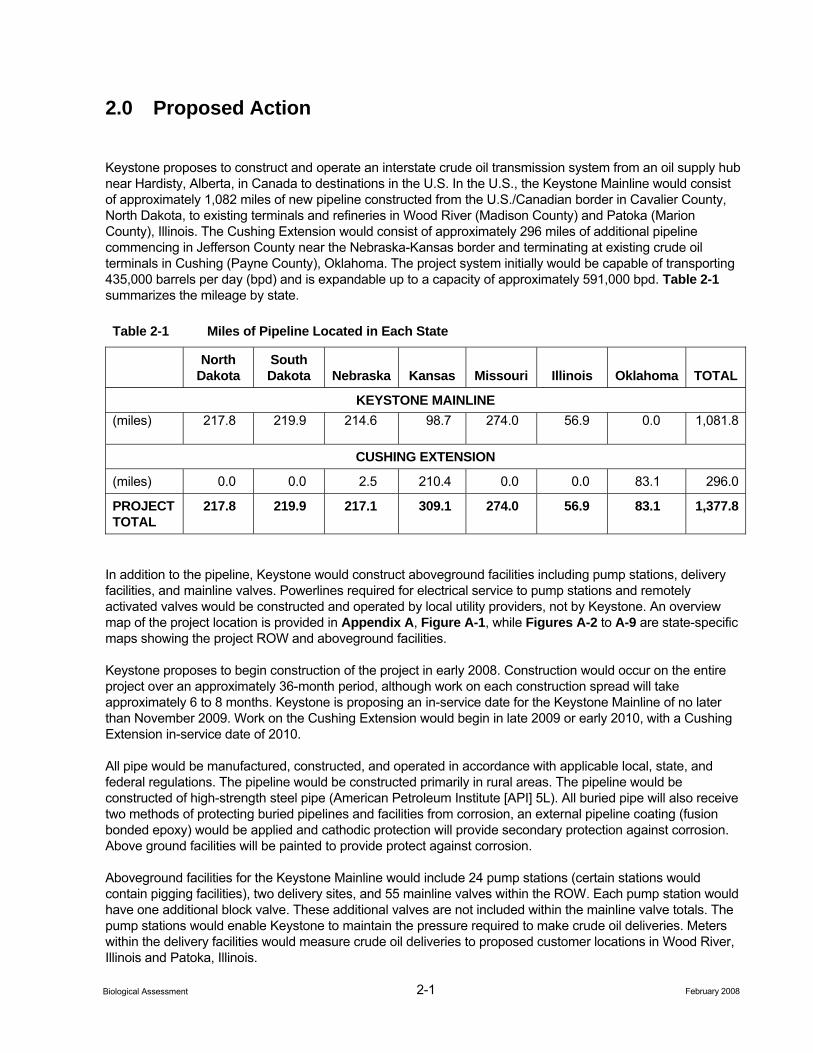
Keystone proposes to construct and operate an interstate crude oil transmission system from an oil supply hub near Hardisty, Alberta, in Canada to destinations in the U.S. In the U.S., the Keystone Mainline would consist of approximately 1,082 miles of new pipeline constructed from the U.S./Canadian border in Cavalier County, North Dakota, to existing terminals and refineries in Wood River (Madison County) and Patoka (Marion County), Illinois. The Cushing Extension would consist of approximately 296 miles of additional pipeline commencing in Jefferson County near the Nebraska-Kansas border and terminating at existing crude oil terminals in Cushing (Payne County), Oklahoma. The project system initially would be capable of transporting 435,000 barrels per day (bpd) and is expandable up to a capacity of approximately 591,000 bpd. Table 2-1 summarizes the mileage by state.
Table 2-1 Miles of Pipeline Located in Each State
North
Dakota South Dakota Nebraska Kansas Missouri Illinois Oklahoma TOTAL
KEYSTONE MAINLINE (miles) 217.8 219.9 214.6 98.7 274.0 56.9 0.0 1,081.8
CUSHING EXTENSION
(miles) 0.0 0.0 2.5 210.4 0.0 0.0 83.1 296.0
PROJECT TOTAL
217.8 219.9 217.1 309.1 274.0 56.9 83.1 1,377.8
In addition to the pipeline, Keystone would construct aboveground facilities including pump stations, delivery facilities, and mainline valves. Powerlines required for electrical service to pump stations and remotely activated valves would be constructed and operated by local utility providers, not by Keystone. An overview map of the project location is provided in Appendix A, Figure A-1, while Figures A-2 to A-9 are state-specific maps showing the project ROW and aboveground facilities.
Keystone proposes to begin construction of the project in early 2008. Construction would occur on the entire project over an approximately 36-month period, although work on each construction spread will take approximately 6 to 8 months. Keystone is proposing an in-service date for the Keystone Mainline of no later than November 2009. Work on the Cushing Extension would begin in late 2009 or early 2010, with a Cushing Extension in-service date of 2010.
All pipe would be manufactured, constructed, and operated in accordance with applicable local, state, and federal regulations. The pipeline would be constructed primarily in rural areas. The pipeline would be constructed of high-strength steel pipe (American Petroleum Institute [API] 5L). All buried pipe will also receive two methods of protecting buried pipelines and facilities from corrosion, an external pipeline coating (fusion bonded epoxy) would be applied and cathodic protection will provide secondary protection against corrosion. Above ground facilities will be painted to provide protect against corrosion.
Aboveground facilities for the Keystone Mainline would include 24 pump stations (certain stations would contain pigging facilities), two delivery sites, and 55 mainline valves within the ROW. Each pump station would have one additional block valve. These additional valves are not included within the mainline valve totals. The pump stations would enable Keystone to maintain the pressure required to make crude oil deliveries. Meters within the delivery facilities would measure crude oil deliveries to proposed customer locations in Wood River, Illinois and Patoka, Illinois.
2-2 February 2008 Biological Assessment
Aboveground facilities for the Cushing Extension would include three pump stations (certain stations would contain pigging facilities), two delivery facilities and 15 mainline valves within the ROW. The Keystone delivery facility would be located adjacent to operational tanks in Ponca City, Oklahoma, and Cushing, Oklahoma.
One to three additional pumps would be added at existing pump stations along the Keystone Mainline to achieve a throughput to 591,000 bpd. Such increased throughput would require one additional pump station (Pump Station Number 38, containing two pumps) to be constructed along the Keystone Mainline in Bond County, Illinois.
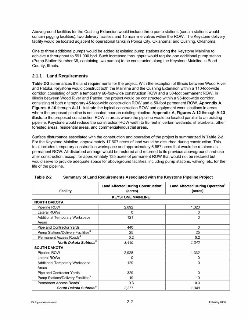
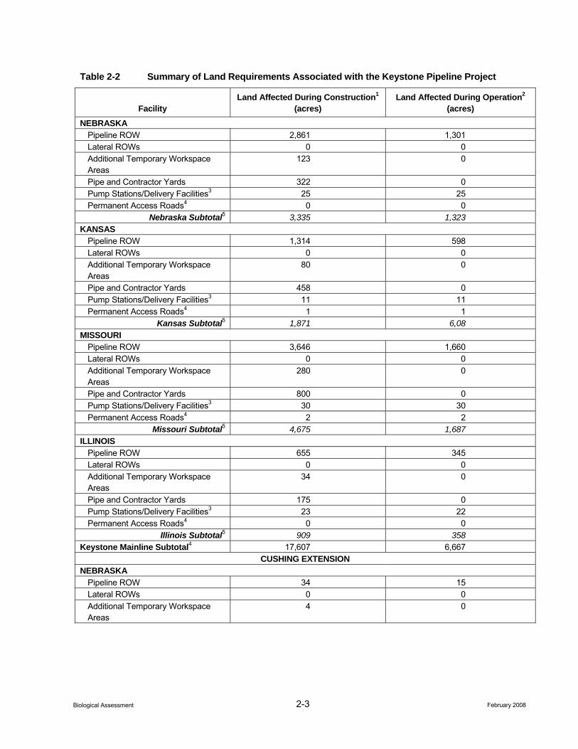
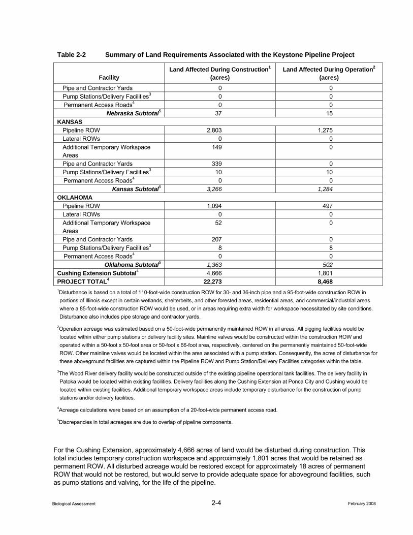
2.1.1 Land Requirements Table 2-2 summarizes the land requirements for the project. With the exception of Illinois between Wood River and Patoka, Keystone would construct both the Mainline and the Cushing Extension within a 110-foot-wide corridor, consisting of both a temporary 60-foot-wide construction ROW and a 50-foot permanent ROW. In Illinois between Wood River and Patoka, the project would be constructed within a 95-foot-wide corridor, consisting of both a temporary 45-foot-wide construction ROW and a 50-foot permanent ROW. Appendix A, Figures A-10 through A-11 illustrate the typical construction ROW and equipment work locations in areas where the proposed pipeline is not located near an existing pipeline. Appendix A, Figures A-12 through A-13 illustrate the proposed construction ROW in areas where the pipeline would be located parallel to an existing pipeline. Keystone would reduce the construction ROW width to 85 feet in certain wetlands, shelterbelts, other forested areas, residential areas, and commercial/industrial areas.
Surface disturbance associated with the construction and operation of the project is summarized in Table 2-2. For the Keystone Mainline, approximately 17,607 acres of land would be disturbed during construction. This total includes temporary construction workspace and approximately 6,667 acres that would be retained as permanent ROW. All disturbed acreage would be restored and returned to its previous aboveground land-use after construction, except for approximately 135 acres of permanent ROW that would not be restored but would serve to provide adequate space for aboveground facilities, including pump stations, valving, etc. for the life of the pipeline.
Table 2-2 Summary of Land Requirements Associated with the Keystone Pipeline Project
Facility Land Affected During Construction1
(acres) Land Affected During Operation2
(acres) KEYSTONE MAINLINE
NORTH DAKOTA Pipeline ROW 2,892 1,320 Lateral ROWs 0 0 Additional Temporary Workspace Areas
121 0
Pipe and Contractor Yards 440 0 Pump Stations/Delivery Facilities3 25 25
Permanent Access Roads4 0.2 0.2 North Dakota Subtotal5 3,440 1,342
SOUTH DAKOTA Pipeline ROW 2,928 1,332 Lateral ROWs 0 0 Additional Temporary Workspace Areas
129 0
Pipe and Contractor Yards 329 0 Pump Stations/Delivery Facilities3 19 19 Permanent Access Roads4 0.3 0.3
South Dakota Subtotal5 3,377 1,349
2-3 February 2008 Biological Assessment
Table 2-2 Summary of Land Requirements Associated with the Keystone Pipeline Project
Facility Land Affected During Construction1
(acres) Land Affected During Operation2
(acres) NEBRASKA
Pipeline ROW 2,861 1,301 Lateral ROWs 0 0 Additional Temporary Workspace Areas
123 0
Pipe and Contractor Yards 322 0 Pump Stations/Delivery Facilities3 25 25 Permanent Access Roads4 0 0
Nebraska Subtotal5 3,335 1,323 KANSAS
Pipeline ROW 1,314 598 Lateral ROWs 0 0 Additional Temporary Workspace Areas
80 0
Pipe and Contractor Yards 458 0 Pump Stations/Delivery Facilities3 11 11 Permanent Access Roads4 1 1
Kansas Subtotal5 1,871 6,08 MISSOURI
Pipeline ROW 3,646 1,660 Lateral ROWs 0 0 Additional Temporary Workspace Areas
280 0
Pipe and Contractor Yards 800 0 Pump Stations/Delivery Facilities3 30 30 Permanent Access Roads4 2 2
Missouri Subtotal5 4,675 1,687 ILLINOIS
Pipeline ROW 655 345 Lateral ROWs 0 0 Additional Temporary Workspace Areas
34 0
Pipe and Contractor Yards 175 0 Pump Stations/Delivery Facilities3 23 22 Permanent Access Roads4 0 0
Illinois Subtotal5 909 358 Keystone Mainline Subtotal4 17,607 6,667
CUSHING EXTENSION NEBRASKA
Pipeline ROW 34 15 Lateral ROWs 0 0 Additional Temporary Workspace Areas
4 0
2-4 February 2008 Biological Assessment
Table 2-2 Summary of Land Requirements Associated with the Keystone Pipeline Project
Facility Land Affected During Construction1
(acres) Land Affected During Operation2
(acres) Pipe and Contractor Yards 0 0 Pump Stations/Delivery Facilities3 0 0
Permanent Access Roads4 0 0 Nebraska Subtotal5 37 15
KANSAS Pipeline ROW 2,803 1,275 Lateral ROWs 0 0 Additional Temporary Workspace Areas
149 0
Pipe and Contractor Yards 339 0 Pump Stations/Delivery Facilities3 10 10
Permanent Access Roads4 0 0 Kansas Subtotal5 3,266 1,284
OKLAHOMA Pipeline ROW 1,094 497 Lateral ROWs 0 0 Additional Temporary Workspace Areas
52 0
Pipe and Contractor Yards 207 0 Pump Stations/Delivery Facilities3 8 8
Permanent Access Roads4 0 0 Oklahoma Subtotal5 1,363 502
Cushing Extension Subtotal4 4,666 1,801 PROJECT TOTAL4 22,273 8,468 1Disturbance is based on a total of 110-foot-wide construction ROW for 30- and 36-inch pipe and a 95-foot-wide construction ROW in portions of Illinois except in certain wetlands, shelterbelts, and other forested areas, residential areas, and commercial/industrial areas where a 85-foot-wide construction ROW would be used, or in areas requiring extra width for workspace necessitated by site conditions. Disturbance also includes pipe storage and contractor yards.
2Operation acreage was estimated based on a 50-foot-wide permanently maintained ROW in all areas. All pigging facilities would be located within either pump stations or delivery facility sites. Mainline valves would be constructed within the construction ROW and operated within a 50-foot x 50-foot area or 50-foot x 66-foot area, respectively, centered on the permanently maintained 50-foot-wide ROW. Other mainline valves would be located within the area associated with a pump station. Consequently, the acres of disturbance for these aboveground facilities are captured within the Pipeline ROW and Pump Station/Delivery Facilities categories within the table.
3The Wood River delivery facility would be constructed outside of the existing pipeline operational tank facilities. The delivery facility in Patoka would be located within existing facilities. Delivery facilities along the Cushing Extension at Ponca City and Cushing would be located within existing facilities. Additional temporary workspace areas include temporary disturbance for the construction of pump stations and/or delivery facilities.
4Acreage calculations were based on an assumption of a 20-foot-wide permanent access road.
5Discrepancies in total acreages are due to overlap of pipeline components.
For the Cushing Extension, approximately 4,666 acres of land would be disturbed during construction. This total includes temporary construction workspace and approximately 1,801 acres that would be retained as permanent ROW. All disturbed acreage would be restored except for approximately 18 acres of permanent ROW that would not be restored, but would serve to provide adequate space for aboveground facilities, such as pump stations and valving, for the life of the pipeline.
2-5 February 2008 Biological Assessment
Almost all of the land affected by the construction and operation of the project would be privately owned; less than one percent would be public lands.
2.1.2 Pipeline ROW Along the Keystone Mainline, approximately 377 miles (34.8 percent) of the 1,082 miles of the project would be located within about 300 feet of existing pipeline, utility, or road ROWs. Approximately 705 miles (56.6 percent) would be new ROW.
For the Cushing Extension, approximately 48 miles (16.2 percent) of the 296 miles of the project would be within approximately 300 feet of existing pipeline, utility, or road ROWs. Approximately 248 miles (94.7 percent) would be new ROW.
In locations where the project would parallel existing utilities, the project’s new permanent ROW would be immediately adjacent to the existing permanent ROW. Pipeline generally would be installed at a 40-foot offset from the nearest existing pipeline centerline (Appendix A, Figure A-12) except in areas where the working side of the pipeline construction ROW is adjacent to the existing pipeline. In these areas, the pipeline would be installed at a 60-foot offset from the nearest existing pipeline centerline (Appendix A, Figure A-13).
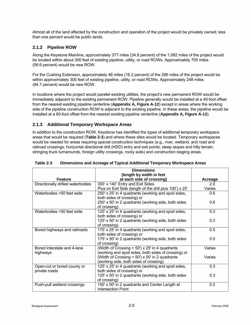
2.1.3 Additional Temporary Workspace Areas In addition to the construction ROW, Keystone has identified the types of additional temporary workspace areas that would be required (Table 2-3) and where these sites would be located. Temporary workspaces would be needed for areas requiring special construction techniques (e.g., river, wetland, and road and railroad crossings; horizontal directional drill (HDD) entry and exit points; steep slopes and hilly terrain; stringing truck turnarounds, foreign utility crossings, rocky soils) and construction staging areas.
Table 2-3 Dimensions and Acreage of Typical Additional Temporary Workspace Areas
Feature
Dimensions (length by width in feet
at each side of crossing) Acreage Directionally drilled waterbodies 300’ x 140’ Entry and Exit Sides
Plus on Exit Side (length of the drill plus 100’) x 25’ 2.0
Varies Waterbodies >50 feet wide 250' x 25' in 4 quadrants (working and spoil sides,
both sides of crossing) or 250' x 50' in 2 quadrants (working side, both sides of crossing)
0.6
0.6
Waterbodies <50 feet wide 125' x 25' in 4 quadrants (working and spoil sides, both sides of crossing) or 125' x 50' in 2 quadrants (working side, both sides of crossing)
0.3
0.3
Bored highways and railroads 175' x 25' in 4 quadrants (working and spoil sides, both sides of crossing) or 175' x 50' in 2 quadrants (working side, both sides of crossing)
0.5
0.5
Bored interstate and 4-lane highways
(Width of Crossing + 50') x 25' in 4 quadrants (working and spoil sides, both sides of crossing) or (Width of Crossing + 50') x 50' in 2 quadrants (working side, both sides of crossing)
Varies
Varies
Open-cut or bored county or private roads
125' x 25' in 4 quadrants (working and spoil sides, both sides of crossing) or 125' x 50' in 2 quadrants (working side, both sides of crossing)
0.3
0.3
Push-pull wetland crossings 150' x 50' in 2 quadrants and Center Length at Intersection Point
0.2
2-6 February 2008 Biological Assessment
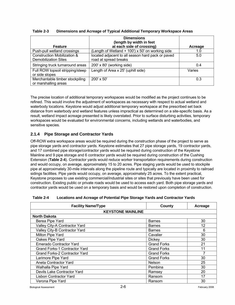
Table 2-3 Dimensions and Acreage of Typical Additional Temporary Workspace Areas
Feature
Dimensions (length by width in feet
at each side of crossing) Acreage Push-pull wetland crossings (Length of Wetland + 100') x 50' on working side 1.0 Construction Mobilization & Demobilization Sites
located adjacent to all season hard pack or paved road at spread breaks
5.0
Stringing truck turnaround areas 200' x 80' (working side) 0.4 Full ROW topsoil stripping/steep or side slopes
Length of Area x 25' (uphill side) Varies
Merchantable timber stockpiling or marshalling areas
200' x 50' 0.3
The precise location of additional temporary workspaces would be modified as the project continues to be refined. This would involve the adjustment of workspaces as necessary with respect to actual wetland and waterbody locations. Keystone would adjust additional temporary workspace at the prescribed set back distance from waterbody and wetland features unless impractical as determined on a site-specific basis. As a result, wetland impact acreage presented is likely overstated. Prior to surface disturbing activities, temporary workspaces would be evaluated for environmental concerns, including wetlands and waterbodies, and sensitive species.
2.1.4 Pipe Storage and Contractor Yards Off-ROW extra workspace areas would be required during the construction phase of the project to serve as pipe storage yards and contractor yards. Keystone estimates that 27 pipe storage yards, 19 contractor yards, and 17 combined pipe storage/contractor yards would be required during construction of the Keystone Mainline and 9 pipe storage and 6 contractor yards would be required during construction of the Cushing Extension (Table 2-4). Contractor yards would reduce worker transportation requirements during construction and would occupy, on average, approximately 15 to 20 acres. Pipe staging yards would be used to stockpile pipe at approximately 30-mile intervals along the pipeline route and typically are located in proximity to railroad sidings facilities. Pipe yards would occupy, on average, approximately 25 acres. To the extent practical, Keystone proposes to use existing commercial/industrial sites or sites that previously have been used for construction. Existing public or private roads would be used to access each yard. Both pipe storage yards and contractor yards would be used on a temporary basis and would be restored upon completion of construction.
Table 2-4 Locations and Acreage of Potential Pipe Storage Yards and Contractor Yards
Facility Name/Type County Acreage KEYSTONE MAINLINE
North Dakota Berea Pipe Yard Barnes 30 Valley City-A Contractor Yard Barnes 12 Valley City-B Contractor Yard Barnes 6 Milton Pipe Yard Cavalier 30 Oakes Pipe Yard Dickey 30 Emerado Contractor Yard Grand Forks 21 Grand Forks-1 Contractor Yard Grand Forks 11 Grand Forks-2 Contractor Yard Grand Forks 7 Larimore Pipe Yard Grand Forks 30 Aneta Contractor Yard Nelson 25 Walhalla Pipe Yard Pembina 30 Devils Lake Contractor Yard Ramsey 20 Lisbon Contractor Yard Ransom 17 Verona Pipe Yard Ransom 30
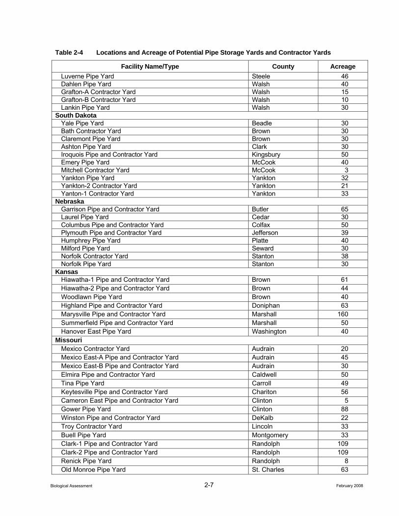
2-7 February 2008 Biological Assessment
Table 2-4 Locations and Acreage of Potential Pipe Storage Yards and Contractor Yards
Facility Name/Type County Acreage Luverne Pipe Yard Steele 46 Dahlen Pipe Yard Walsh 40 Grafton-A Contractor Yard Walsh 15 Grafton-B Contractor Yard Walsh 10 Lankin Pipe Yard Walsh 30
South Dakota Yale Pipe Yard Beadle 30 Bath Contractor Yard Brown 30 Claremont Pipe Yard Brown 30 Ashton Pipe Yard Clark 30 Iroquois Pipe and Contractor Yard Kingsbury 50 Emery Pipe Yard McCook 40 Mitchell Contractor Yard McCook 3 Yankton Pipe Yard Yankton 32 Yankton-2 Contractor Yard Yankton 21 Yanton-1 Contractor Yard Yankton 33
Nebraska Garrison Pipe and Contractor Yard Butler 65 Laurel Pipe Yard Cedar 30 Columbus Pipe and Contractor Yard Colfax 50 Plymouth Pipe and Contractor Yard Jefferson 39 Humphrey Pipe Yard Platte 40 Milford Pipe Yard Seward 30 Norfolk Contractor Yard Stanton 38 Norfolk Pipe Yard Stanton 30
Kansas Hiawatha-1 Pipe and Contractor Yard Brown 61 Hiawatha-2 Pipe and Contractor Yard Brown 44 Woodlawn Pipe Yard Brown 40 Highland Pipe and Contractor Yard Doniphan 63 Marysville Pipe and Contractor Yard Marshall 160 Summerfield Pipe and Contractor Yard Marshall 50 Hanover East Pipe Yard Washington 40
Missouri Mexico Contractor Yard Audrain 20 Mexico East-A Pipe and Contractor Yard Audrain 45 Mexico East-B Pipe and Contractor Yard Audrain 30 Elmira Pipe and Contractor Yard Caldwell 50 Tina Pipe Yard Carroll 49 Keytesville Pipe and Contractor Yard Chariton 56 Cameron East Pipe and Contractor Yard Clinton 5 Gower Pipe Yard Clinton 88 Winston Pipe and Contractor Yard DeKalb 22 Troy Contractor Yard Lincoln 33 Buell Pipe Yard Montgomery 33 Clark-1 Pipe and Contractor Yard Randolph 109 Clark-2 Pipe and Contractor Yard Randolph 109 Renick Pipe Yard Randolph 8 Old Monroe Pipe Yard St. Charles 63
2-8 February 2008 Biological Assessment
Table 2-4 Locations and Acreage of Potential Pipe Storage Yards and Contractor Yards
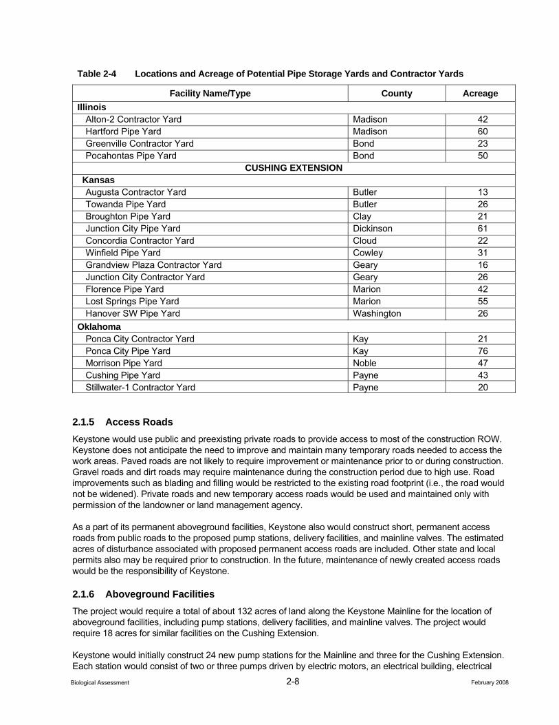
Facility Name/Type County Acreage Illinois
Alton-2 Contractor Yard Madison 42 Hartford Pipe Yard Madison 60 Greenville Contractor Yard Bond 23 Pocahontas Pipe Yard Bond 50
CUSHING EXTENSION Kansas Augusta Contractor Yard Butler 13 Towanda Pipe Yard Butler 26 Broughton Pipe Yard Clay 21 Junction City Pipe Yard Dickinson 61 Concordia Contractor Yard Cloud 22 Winfield Pipe Yard Cowley 31 Grandview Plaza Contractor Yard Geary 16 Junction City Contractor Yard Geary 26 Florence Pipe Yard Marion 42 Lost Springs Pipe Yard Marion 55 Hanover SW Pipe Yard Washington 26
Oklahoma Ponca City Contractor Yard Kay 21 Ponca City Pipe Yard Kay 76 Morrison Pipe Yard Noble 47 Cushing Pipe Yard Payne 43 Stillwater-1 Contractor Yard Payne 20
2.1.5 Access Roads Keystone would use public and preexisting private roads to provide access to most of the construction ROW. Keystone does not anticipate the need to improve and maintain many temporary roads needed to access the work areas. Paved roads are not likely to require improvement or maintenance prior to or during construction. Gravel roads and dirt roads may require maintenance during the construction period due to high use. Road improvements such as blading and filling would be restricted to the existing road footprint (i.e., the road would not be widened). Private roads and new temporary access roads would be used and maintained only with permission of the landowner or land management agency.
As a part of its permanent aboveground facilities, Keystone also would construct short, permanent access roads from public roads to the proposed pump stations, delivery facilities, and mainline valves. The estimated acres of disturbance associated with proposed permanent access roads are included. Other state and local permits also may be required prior to construction. In the future, maintenance of newly created access roads would be the responsibility of Keystone.
2.1.6 Aboveground Facilities The project would require a total of about 132 acres of land along the Keystone Mainline for the location of aboveground facilities, including pump stations, delivery facilities, and mainline valves. The project would require 18 acres for similar facilities on the Cushing Extension.
Keystone would initially construct 24 new pump stations for the Mainline and three for the Cushing Extension. Each station would consist of two or three pumps driven by electric motors, an electrical building, electrical
2-9 February 2008 Biological Assessment
substation, two sump tanks, a small maintenance building, and parking area for station personnel. Stations would operate on locally purchased electric power for pumps, lights, and heating in the buildings and would be fully automated for unmanned operation. Remote start/stop, set point controls, unit monitoring equipment, and station information would be installed at each location. The pipe entering and exiting the pump station sites would be located below grade. The pipe within the pump station (after entering and prior to exiting the pump station facilities) would be aboveground.
Keystone would install two delivery facilities along the Keystone Mainline at Wood River and Patoka and two along the Cushing Extension (Ponca City and Cushing). The delivery facilities would include pressure regulating, heating, sampling, chromatography, tube switching, and crude oil measurement equipment. At Patoka, delivery facilities would be located entirely within existing tank storage facilities. At Wood River, the delivery facilities will be incorporated within one of the aforementioned pump stations. Cushing Extension delivery facilities would be located within the Ponca City and Cushing tank storage facilities.
Keystone would construct 55 mainline valves along the Keystone Mainline and 15 mainline valves along the Cushing Extension. Mainline valves would be installed at each pump station and along the ROW. When not located at a pump station, mainline valves would be sectionalizing block valves constructed within a fenced 25-foot-wide by 25-foot-long site located within the pipeline construction ROW and centered on the 50-foot-wide permanently maintained ROW. Remotely activated valves are located at pump stations, upstream of major river crossings, and sensitive waterbodies. These valves can be activated to shutdown the pipeline in the event of an emergency to minimize environmental impacts in the unlikely event of a spill. Mainline valve intervals would be a maximum of approximately 64 miles, with an average spacing interval of approximately every 15 to 20 miles. The spacing intervals between the mainline valves along the ROW are based upon the location of the pump stations, waterbodies greater than 100 feet in width, high consequence areas such as densely populated areas, and other topographic and environmental considerations.
The project would be designed to permit full in-line inspection of the pipeline with a minimum interruption of service. Pig launchers and/or receivers would likely be constructed and operated completely within the boundaries of the pump stations or delivery facilities.
Construction Procedures
The proposed facilities would be designed, constructed, tested, and operated in accordance with all applicable requirements included in the U.S. Department of Transportation (USDOT) regulations at 49 Code of Federal Regulations (CFR) Part 195, Transportation of Hazardous Liquids by Pipeline, and other applicable federal and state regulations. These regulations are intended to ensure adequate protection for the public and to prevent crude oil pipeline accidents and failures. Among other design standards, Part 195 specifies pipeline material and qualification, minimum design requirements, and pipeline integrity requirements.
To manage construction impacts, Keystone would implement Keystone’s Construction Mitigation and Reclamation (CMR) Plan (Keystone’s Plan; Appendix C). This Plan contains construction and mitigation procedures that would be used throughout the project, with subsections to address specific environmental conditions.
Keystone would implement its Spill Prevention, Control, and Countermeasure (SPCC) Plan to avoid or minimize the potential for harmful spills and leaks during construction. The plan describes spill prevention practices, emergency response procedures, emergency and personnel protection equipment, release notification procedures, and cleanup procedures.
Keystone would implement its Emergency Response Plan (ERP) to identify its emergency personnel and the logical sequence of actions, which should be taken in the event of an emergency involving the Keystone system facilities during construction or operation. The ERP would meet federal safety requirements (49 CFR Parts 194 and 195). The ERP establishes written emergency shut down procedures, communication coordination, and clean-up responsibilities in the event of a crude oil pipeline emergency. A draft of Keystone’s ERP was submitted to the Department of State on July 1, 2006. A final draft would be submitted to the USDOT
2-10 February 2008 Biological Assessment
Pipeline Hazardous Materials and Safety Administration (PHMSA) prior to commencement of line filling and operations.
2.1.6.1 General Pipeline Construction Procedures
Before starting construction, Keystone would finalize engineering surveys of the ROW centerline and extra workspaces and substantially complete the acquisition of ROW easements and any necessary acquisitions of property in fee.
Overland pipeline construction generally proceeds as a moving assembly line as shown in Appendix A, Figure A-14 and as summarized below. Keystone currently plans to construct the pipeline in 11 spreads; 8 spreads along the Keystone Mainline and three spreads along the Cushing Extension. Each of the pipeline spreads would consist of approximately 100 to 180 miles of pipeline on the Mainline and 80 to 110 miles on the Cushing Extension. Separate crews would be used for construction of the aboveground facilities.
Standard pipeline construction is composed of specific activities including survey and staking of the ROW, clearing and grading, trenching, pipe stringing, bending, welding, lowering-in, backfilling, hydrostatic testing, and cleanup. In addition to standard pipeline construction methods, Keystone would use special construction techniques where warranted by site-specific conditions. These special techniques would be used when constructing across rugged terrain, waterbodies, wetlands, paved roads, highways, and railroads.
Survey and Staking
The first step of construction involves marking the limits of the approved work area (i.e., the construction ROW boundaries and any additional temporary workspace areas) and flagging the location of approved access roads and foreign utility lines. Wetland boundaries and other environmentally sensitive areas also would be marked or fenced for protection at this time. Before the pipeline trench is excavated, a survey crew would stake the centerline of the proposed trench.
Clearing and Grading
Before clearing and grading activities are conducted, landowner fences would be braced and cut and temporary gates and fences would be installed to contain livestock, if present. A clearing crew would follow the fence crew and would clear the work area of vegetation (including crops) and obstacles (e.g., trees, logs, brush, rocks). Temporary erosion control measures such as silt fences or straw bales would be installed prior to vegetation removal down slopes into wetlands and riparian areas. Grading would be conducted where necessary to provide a reasonably level work surface. Where the ground is relatively flat and does not require grading, disturbance to soils would be substantially reduced and sod and rootmats would be left in the ground. More extensive grading would be required in steep side-slopes or vertical areas and where necessary to prevent excessive bending of the pipeline.
Trenching
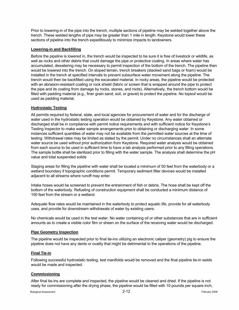
The trench would be excavated to a depth that provides sufficient cover over the pipeline after backfilling. Typically, the trench would be about seven to eight feet deep and about four to five feet wide in stable soils. In most areas, the USDOT requires a minimum of 36 inches of cover. In rocky areas the USDOT requires a minimum depth of cover of 18 inches. In most locations, the depth of cover for the project would be a minimum of 48 inches (Table 2-5). Trenching may precede bending and welding or may follow based on several factors including soil characteristics, water table, existence of drain tiles, and weather conditions at the time of construction.
When rock or rocky formations are encountered, tractor-mounted mechanical rippers or rock trenchers would be used to fracture the rock prior to excavation. In areas where mechanical equipment can not break up or loosen the bedrock, blasting (use of explosives) would be required. Excavated rock would be used to backfill the trench to the top of the existing bedrock profile. Table 2-5 summarizes minimum pipeline cover for various land use types.
2-11 February 2008 Biological Assessment
Table 2-5 Minimum Pipeline Cover
Location
Cover, Normal
Excavation (inches)
For Rock Excavation
(inches) All waterbodies 60 36 Dry creeks, ditches, drains, washes, gullies, etc. 60 36 Drainage ditches at public roads and railroads 60 48 All other land 48 36
Topsoil would be separated from subsoil over the trench or over the trench and spoil side. In areas of removal of topsoil only over the trench, separated topsoil would be stored on the near side of the trench and in a pile separate from subsoil (which would be stored on the far side of the trench) to allow for proper restoration of the soil during the backfilling process (see Appendix A, Figures A-10 through A-13). In areas where topsoil over the trench and spoil side is removed, separated topsoils would be stored on the edge of the spoil side of the construction ROW (or, optionally, on the edge of the working side of the construction ROW) and in a pile separate from subsoil (which would be stored on the spoil side of the trench) to allow for proper restoration of the soil during the backfilling process. In areas where the ROW would be graded to provide a level working surface and where there is a need to separate topsoil from subsoil, the ROW would be graded to collect topsoil before any subsoil is disturbed.
Topsoil would be piled such that the mixing of subsoil and topsoil would not occur. Gaps would be left between the spoil piles to prevent storm water runoff from backing up or flooding. Topsoil would be returned to its original horizon after subsoil is backfilled in the trench.
Pipe Stringing, Bending, and Welding
Prior to or following trenching, sections of externally coated pipe up to 80 feet long (also referred to as “joints”) would be transported by truck over public road networks and along authorized private access roads to the ROW and placed or “strung” along the trench in a continuous line.
After the pipe sections are strung along the trench and before joints are welded together, individual sections of the pipe would be bent where necessary to allow for uniform fit of the pipeline with the varying contours of the bottom of the trench. A track-mounted, hydraulic pipe-bending machine would shape the pipe to conform to the contours of the terrain. Where multiple or complex bends are required in a section of pipe, that section of the pipeline would be bent at the factory.
After the pipe sections are bent, the joints would be welded together into long strings and placed on temporary supports. The pipeline joints would be lined up and held in position until securely joined by welding. Keystone would non-destructively inspect 100 percent of the welds using radiographic or ultrasonic methods. Welds that do not meet established specifications would be removed. Once the welds are approved, a protective epoxy coating would be applied to the welded joints. The pipeline would then be electronically inspected or “jeeped” for faults or voids in the epoxy coating and visually inspected for any faults, scratches, or other coating defects. Damage to the coating would be repaired before the pipeline is lowered into the trench.
In rangeland areas used for grazing and livestock, construction activities potentially can hinder the movement of livestock if the livestock cannot be relocated temporarily by the owner. The movement of wildlife in search of food and water also can be hindered by construction activities. To minimize impact on livestock and wildlife movements during construction, Keystone would leave hard plugs (short lengths of unexcavated trench) or install soft plugs (areas where the trench is excavated and replaced with minimal compaction) to allow livestock and wildlife to cross the open trench safely. Soft plugs would be constructed with a ramp on each side to provide an avenue of escape for animals that fall into the trench.
2-12 February 2008 Biological Assessment
Prior to lowering-in of the pipe into the trench, multiple sections of pipeline may be welded together above the trench. These welded lengths of pipe may be greater than 1 mile in length. Keystone would lower these sections of pipeline into the trench expeditiously to minimize impacts to landowners.
Lowering-in and Backfilling
Before the pipeline is lowered in, the trench would be inspected to be sure it is free of livestock or wildlife, as well as rocks and other debris that could damage the pipe or protective coating. In areas where water has accumulated, dewatering may be necessary to permit inspection of the bottom of the trench. The pipeline then would be lowered into the trench. On sloped terrain, trench breakers (stacked sand bags or foam) would be installed in the trench at specified intervals to prevent subsurface water movement along the pipeline. The trench would then be backfilled using the excavated material. In rocky areas, the pipeline would be protected with an abrasion-resistant coating or rock shield (fabric or screen that is wrapped around the pipe to protect the pipe and its coating from damage by rocks, stones, and roots). Alternatively, the trench bottom would be filled with padding material (e.g., finer grain sand, soil, or gravel) to protect the pipeline. No topsoil would be used as padding material.
Hydrostatic Testing
All permits required by federal, state, and local agencies for procurement of water and for the discharge of water used in the hydrostatic testing operation would be obtained by Keystone. Any water obtained or discharged shall be in compliance with permit notice requirements and with sufficient notice for Keystone’s Testing Inspector to make water sample arrangements prior to obtaining or discharging water. In some instances sufficient quantities of water may not be available from the permitted water sources at the time of testing. Withdrawal rates may be limited as stated by the permit. Under no circumstances shall an alternate water source be used without prior authorization from Keystone. Required water analysis would be obtained from each source to be used in sufficient time to have a lab analysis performed prior to any filling operations. The sample bottle shall be sterilized prior to filling with the water sample. The analysis shall determine the pH value and total suspended solids
Staging areas for filling the pipeline with water shall be located a minimum of 50 feet from the waterbody or a wetland boundary if topographic conditions permit. Temporary sediment filter devices would be installed adjacent to all streams where runoff may enter.
Intake hoses would be screened to prevent the entrainment of fish or debris. The hose shall be kept off the bottom of the waterbody. Refueling of construction equipment shall be conducted a minimum distance of 100 feet from the stream or a wetland.
Adequate flow rates would be maintained in the waterbody to protect aquatic life, provide for all waterbody uses, and provide for downstream withdrawals of water by existing users.
No chemicals would be used in the test water. No water containing oil or other substances that are in sufficient amounts as to create a visible color film or sheen on the surface of the receiving water would be discharged.
Pipe Geometry Inspection
The pipeline would be inspected prior to final tie-ins utilizing an electronic caliper (geometry) pig to ensure the pipeline does not have any dents or ovality that might be detrimental to the operations of the pipeline.
Final Tie-in
Following successful hydrostatic testing, test manifolds would be removed and the final pipeline tie-in welds would be made and inspected.
Commissioning
After final tie-ins are complete and inspected, the pipeline would be cleaned and dried. If the pipeline is not ready for commissioning after the drying phase, the pipeline would be filled with 10 pounds per square inch,
2-13 February 2008 Biological Assessment
gauge of dry air until ready for commissioning. Commissioning involves verifying that equipment has been properly installed and is working, the controls and communications systems are functional, and the pipeline is ready for service. In the final step, the pipeline is prepared for service by purging the line of air and filling the line with crude oil.
Cleanup and Restoration
During cleanup, construction debris on the ROW would be disposed of and work areas would be final graded. Preconstruction contours would be restored as closely as possible. Segregated topsoil would be spread over the surface of the ROW and permanent erosion control measures would be installed. After backfilling, final cleanup would begin as soon as weather and site conditions permit. Every reasonable effort would be made to complete final cleanup (including final grading and installation of erosion control devices) within approximately 20 days after backfilling the trench (approximately 10 days in residential areas). Construction debris would be cleaned up and taken to a disposal facility.
After permanent erosion control devices are installed and final grading has occurred, all disturbed work areas except annually cultivated fields would be seeded as soon as possible. Seeding is intended to stabilize the soil, revegetate areas disturbed by construction, and, depending upon land use, restore native flora. Timing of the reseeding efforts would depend upon weather and soil conditions and would be subject to the prescribed dates and seed mixes specified by the landowner, land-managing agency, or Natural Resource Conservation Service (NRCS) recommendations. On agricultural lands, seeding would be conducted only as agreed upon with the landowner.
Keystone would restrict access along the ROW using gates, boulders, or other barriers to minimize unauthorized access by all-terrain vehicles in wooded areas if requested by the landowner. Pipeline markers would be installed at road and railroad crossings and other locations (as required by 49 CFR Part 195) to show the location of the pipeline. Markers would identify the owner of the pipeline and convey emergency information. Special markers providing information and guidance to aerial patrol pilots also would be installed.
2.1.6.2 Special Construction Procedures
In addition to standard pipeline construction methods, Keystone would use special construction techniques where warranted by site-specific conditions. These special techniques would be used when constructing in steep terrain, waterbodies, wetlands, and when blasting through rock. These special techniques are described below.
Steep Terrain
Additional grading may be required in areas where the project would cross steep slopes. Steep slopes often need to be graded down to a gentler slope for safe operation of construction equipment and to accommodate pipe-bending limitations. In such areas, the slopes would be excavated prior to pipeline installation and reconstructed to their original contours during restoration.
In areas where the project crosses laterally along the side of a slope, cut and fill grading may be required to obtain a safe, flat work terrace. Topsoil would be stripped from the entire ROW and stockpiled prior to cut and fill grading on steep terrain. Generally, on steep side-slopes, soil from the high side of the ROW would be excavated and moved to the low side of the ROW to create a safe and level work terrace. After the pipeline is installed, the soil from the low side of the ROW would be returned to the high side and the slope’s original contours would be restored. Topsoil from the stockpile would be spread over the surface, erosion control features installed, and seeding implemented.
In steep terrain, temporary sediment barriers such as silt fence and straw bales would be installed during clearing to prevent the movement of disturbed soil into wetland, waterbody, or other environmentally sensitive areas. Temporary slope breakers consisting of mounded and compacted soil would be installed across the ROW during grading and permanent slope breakers would be installed during cleanup. Following construction, seed would be applied to steep slopes and the ROW would be mulched with hay or non-brittle straw or
2-14 February 2008 Biological Assessment
covered with erosion control fabric. Sediment barriers would be maintained across the ROW until permanent vegetation is established.
Waterbody Crossings
A total of 213 perennial stream and river crossings would occur during the construction of the Keystone Mainline and 58 perennial waterbody crossings would occur on the Cushing Extension. Perennial waterbodies would be crossed using one of four techniques: the open-cut wet method (Keystone’s preferred method), open-cut flume method, open-cut dam-and-pump method, or HDD method as described below.
Keystone’s preferred crossing method would be to use an open-cut wet crossing. The open-cut wet method involves trenching through the waterbody while water continues to flow through the construction work area (Appendix A, Figure A-16). This crossing method results in a shorter construction/disturbance period to the stream. Pipe segments for the crossing would be fabricated adjacent to the waterbody. Generally, backhoes operating from one or both banks would excavate the trench within the streambed. In wider rivers, in-stream operation of equipment may be necessary. Trench plugs consisting of a hard or soft plug would be placed to prevent the flow of water into the upland portions of the trench. Trench spoil excavated from the streambed generally would be placed at least 10 feet away from the water’s edge unless stream width is great enough to require placement in the stream bed. Sediment barriers would be installed where necessary to control sediment and to prevent excavated spoil from entering the water. After the trench is dug, the prefabricated pipeline segment would be carried, pushed, or pulled across the waterbody and positioned in the trench. When crossing saturated wetlands and flowing waterbodies using the open-cut method, the pipe coating would be covered with reinforced concrete or concrete weights to provide negative bouyancy. The trench would then be backfilled with native material or with imported material if required by applicable permits. Following backfilling, the banks would be restored and stabilized.
Keystone would utilize dam and pump or dry flume crossings where technically feasible on environmentally sensitive waterbodies as warranted by resource-specific sensitivities. The flume crossing method involves diverting the flow of water across the trenching area through one or more flume pipes placed in the waterbody. The dam-and-pump method is similar to the flume method except that pumps and hoses would be used instead of flumes to move water around the construction work area. In both methods, trenching, pipe installation, and backfilling are done in isolation from the live stream while water flow is maintained for all but a short reach of the waterbody at the actual crossing. Once backfilling is completed, the flume or pump hoses are removed and the streambanks restored and stabilized.
Along the Mainline, Keystone plans to use the HDD method of construction at the Pembina River, South Branch Park River, Missouri River (two crossings), Elkhorn River, Platte River, Chariton River, Cuivre River (two crossings), Mississippi River, Silver Creek, Hurricane Creek, and Kaskaskia River. Along the Cushing Extension, Keystone plans to use the HDD method of construction at the Republican River, Arkansas River, Salt Fork Arkansas River, and Cimarron River. The HDD method involves drilling a pilot hole under the waterbody and banks, then enlarging the hole through successive reamings until the hole is large enough to accommodate a prefabricated segment of pipe. Throughout the process of drilling and enlarging the hole, a slurry consisting mainly of water and bentonite clay would be circulated to power and lubricate the down-hole tools, remove drill cuttings, and hold the hole open. Pipe sections long enough to span the entire crossing would be staged and welded along the construction work area on the opposite side of the waterbody and then pulled through the drilled hole. Ideally, use of the HDD method results in no impact on the banks, bed, or water quality of the waterbody being crossed; however access to the waterbody, and access across the waterbody is often required. Appendix A, Figure A-17 shows a conceptual HDD waterbody crossing.
Approximately 605 intermittent waterbody crossings would occur on the Keystone Mainline and about 195 intermittent waterbody crossings on the Cushing Extension. If these intermittent waterbodies are dry at the time of crossing, Keystone proposes to use conventional upland cross-country construction techniques. If an intermittent waterbody is flowing when crossed, Keystone would install the pipeline using the open cut wet crossing method discussed above. When crossing waterbodies, Keystone would adhere to the guidelines outlined in its Site-specific Waterbody Crossing Plans, Keystone’s Plan (Appendix C) and the requirements of its waterbody crossing permits.

2-15 February 2008 Biological Assessment
Additional temporary workspace areas would be required on both sides of all waterbodies to stage construction, fabricate the pipeline, and store materials. These workspaces would be located at least 10 feet away from the water’s edge, except where the adjacent upland consists of actively cultivated or rotated cropland or other disturbed land. Before construction, temporary bridges (e.g., clean rock/gravel fill over culverts, timber mats supported by flumes, railcar flatbeds, flexi-float apparatus) would be installed across all perennial waterbodies to allow construction equipment to cross. Construction equipment would be required to use the bridges, except the clearing crew, which would be allowed one pass through the waterbodies before the bridges are installed.
During clearing, sediment barriers such as silt fence and staked straw bales would be installed and maintained on drainages across the ROW adjacent to waterbodies and within additional temporary workspace areas to minimize the potential for sediment runoff. Silt fence and/or straw bales located across the working side of the ROW would be removed during the day when vehicle traffic is present and would be replaced each night. Alternatively, drivable berms could be installed and maintained across the ROW in lieu of silt fence and/or straw bales.
In general, equipment refueling and lubricating at waterbodies would take place in upland areas that are 100 feet or more from the edges of the water. When circumstances dictate that equipment refueling and lubricating would be necessary in or near waterbodies, Keystone would follow its SPCC Plan to address the handling of fuel and other hazardous materials.
After the pipeline is installed beneath the waterbody, restoration would begin. Waterbody banks would be restored to preconstruction contours or to a stable configuration. Appropriate erosion control measures such as rock riprap or gabion baskets (rock enclosed in wire bins), log walls, vegetated geogrids, willow cuttings, etc.) would be installed as necessary on steep waterbody banks in accordance with permit requirements. More stable banks would be seeded with native grasses and mulched or covered with erosion control fabric. Waterbody banks would be temporarily stabilized within 24 hours of completing in-stream construction. Sediment barriers, such as silt fence and/or straw bales or drivable berms would be maintained across the ROW at all waterbody approaches until permanent vegetation is established. Temporary equipment bridges would be removed following construction.
Wetland Crossings
Data from wetland delineation field surveys, aerial photography, and National Wetland Inventory map data were used to identify wetlands crossed by the proposed project. Pipeline construction across wetlands would be similar to typical conventional upland cross-country construction procedures, with several modifications where necessary to reduce the potential for pipeline construction to affect wetland hydrology and soil structure.
The wetland crossing method used would depend largely on the stability of the soils at the time of construction. If wetland soils are not excessively saturated at the time of construction and can support construction equipment without equipment mats, construction would occur in a manner similar to conventional upland cross-country construction techniques (Appendix A, Figure A-18). Topsoil would be salvaged over the trenchline. In saturated soils, topsoil segregation generally would not be possible. Keystone typically would use an 85-foot-wide construction ROW through saturated wetlands unless non-cohesive soils are present that would require a wider construction ROW. Additional temporary workspace areas would be required on both sides of particularly wide saturated wetlands to stage construction, fabricate the pipeline, and store materials. These additional temporary workspace areas would be located in upland areas a minimum of 10 feet from the wetland edge.
Construction equipment working in saturated wetlands would be limited to that area essential for ROW clearing, excavating the trench, fabricating and installing the pipeline, backfilling the trench, and restoring the ROW. In areas where there is no reasonable access to the ROW except through wetlands, non-essential equipment would be allowed to travel through wetlands only if the ground is firm enough or has been stabilized to avoid rutting.
2-16 February 2008 Biological Assessment
Clearing of vegetation in wetlands would be limited to trees and shrubs, which would be cut flush with the surface of the ground and removed from the wetland. To avoid excessive disruption of wetland soils and the native seed and rootstock within the wetland soils, stump removal, grading, topsoil segregation, and excavation would be limited to the area immediately over the trenchline. During clearing, sediment barriers, such as silt fence and staked straw bales, would be installed and maintained on downslopes adjacent to saturated wetlands and within additional temporary workspace areas as necessary to minimize the potential for sediment runoff.
Where wetland soils are saturated and/or inundated, the pipeline can be installed using the push-pull technique. The push-pull technique would involve stringing and welding the pipeline outside of the wetland and excavating and backfilling the trench using a backhoe supported by equipment mats or timber riprap. The prefabricated pipeline is installed in the wetland by equipping it with buoys and pushing or pulling it across the water-filled trench. After the pipeline is floated into place, the floats are removed and the pipeline sinks into place. Most pipe installed in saturated wetlands would be coated with concrete or equipped with set-on weights to provide negative buoyancy. Because little or no grading would occur in wetlands, restoration of contours would be accomplished during backfilling. Prior to backfilling, trench breakers would be installed where necessary to prevent the subsurface drainage of water from wetlands. Where topsoil has been segregated from subsoil, the subsoil would be backfilled first, followed by the topsoil. Topsoil would be replaced to the original ground level leaving no crown over the trenchline. In some areas where wetlands overlie rocky soils, the pipe would be padded with rock-free soil or sand before backfilling with native bedrock and soil. Equipment mats, timber riprap, gravel fill, geotextile fabric, and/or straw mats would be removed from wetlands following backfilling.
Where wetlands are located at the base of slopes, permanent slope breakers would be constructed across the ROW in upland areas adjacent to the wetland boundary. Temporary sediment barriers would be installed where necessary until revegetation of adjacent upland areas is successful. Once revegetation is successful, sediment barriers would be removed from the ROW and disposed of properly.
In wetlands where no standing water is present, the construction ROW would be seeded in accordance with the recommendations of the local soil conservation authorities or land management agency.
Blasting
Although no blasting activities (use of explosives to fracture rock) are anticipated, blasting may be required in areas where consolidated shallow bedrock or boulders are encountered, which cannot be removed by conventional excavation methods. If blasting is required to clear the ROW and to fracture the ditch, strict safety precautions would be followed. Keystone would exercise extreme care to avoid damage to underground structures, cables, conduits, pipelines, and underground watercourses or springs. To protect property or livestock, Keystone would provide adequate notice to adjacent landowners or tenants in advance of blasting. Blasting activity would be performed during daylight hours and in compliance with federal, state, and local codes and ordinances and manufacturers’ prescribed safety procedures and industry practices.
Fences and Grazing
Fences would be crossed or paralleled by the construction ROW. Before cutting any fences for pipeline construction, each fence crossed by the ROW would be braced and secured to prevent the slacking of the fence. To prevent the passage of livestock, the opening in the fenceline would be temporarily closed when construction crews enter and leave the area. If gaps in natural barriers used for livestock control are created by the pipeline construction, the gaps would be fenced according to the landowner’s requirements. All existing improvements, such as fences, gates, irrigation ditches, cattle guards, and reservoirs would be maintained during construction and repaired to pre-construction conditions or better.
2.1.6.3 Aboveground Facility Construction Procedures
Construction activities at each of the pump stations would follow a standard sequence of activities: clearing and grading, installing foundations for the electrical building and support buildings, and erecting the structures to support the pumps and associated facilities. A block valve is installed in the mainline with two side block
2-17 February 2008 Biological Assessment
valves, one to the suction piping of the pumps and one from the discharge piping of the pumps. Construction activities and the storage of building materials would be confined to the pump station construction sites. Appendix A, Figures A-19 and A-20 illustrates a typical plot plan for a pump station.
The sites for the pump stations would be cleared of vegetation and graded as necessary to create a level surface for the movement of construction vehicles and to prepare the area for the building foundations. Foundations would be constructed for the pumps and buildings and soil would be stripped from the area of the building foundations. A permanent security fence would be installed around each pump station site.
Each pump station would include one electrical building and one support building. The electrical building would include electrical systems, communications, and control equipment. The second building houses a small office and washroom. The crude oil piping, both aboveground and belowground, would be installed and pressure-tested using methods similar to those used for the main pipeline. After testing is successfully completed, the piping would be tied in to the main pipeline. Piping installed below grade would be coated for corrosion protection prior to backfilling. In addition, all below grade facilities would be protected by a cathodic protection system. Before being put into service, pumps, controls, and safety devices would be checked and tested to ensure proper system operation and activation of safety mechanisms.
Each pump station would require electricity and telephone facilities, which would be obtained from local utilities. Electric power infrastructure for the project would be constructed, permitted, and operated by local cooperative utility providers, not by Keystone. Therefore, inferring reasonably foreseeable impacts from construction and operation of electric power infrastructure to threatened and endangered species is not feasible in this species analysis. Construction of electric power infrastructure would be analyzed under section 7 of ESA at a later date. The DOS, Rural Utilities Services (RUS), Western Area Power Administration (WAPA), and Keystone entered into a Letter of Intent that provides binding assurance that these agencies will consult with the USFWS under section 7 of ESA for the electrical infrastructure component of the Keystone Project. Where delivery and pigging facilities are co-located with pump stations, the delivery and pigging facilities would be located entirely within the pump station sites. Construction activities would include clearing, grading, trenching, installing piping, erecting buildings, fencing the facilities, cleanup, and restoration. The delivery facilities would operate on locally provided power.
Mainline valve construction would be carried out concurrent with the construction of the pipeline. Where practical, mainline valves typically would be located near public roads to allow year-round access. If necessary, permanent access roads or approaches would be constructed within the permanent ROW to each mainline valve site.
The construction of pig launchers and receivers would be carried out concurrent with the construction of the pump stations and delivery facilities. Activities such as clearing, grading, trenching, and clean-up would occur simultaneously with construction activities associated with the pump stations and delivery facilities.
2.1.6.4 Construction Workforce and Schedule
Keystone proposes to begin construction in early 2008. Construction of the Mainline is expected to last 24 months, ending in September 2009. Keystone proposes to commence service by November 30, 2009. Work on the Cushing Extension would begin in late 2009 or early 2010, with an in-service date for the Cushing Extension of 2010. Keystone anticipates a peak workforce of approximately 2,500 to 3,000 construction personnel. Construction personnel would consist of Keystone employees, contractor employees, construction inspection staff, and environmental inspection staff.
Keystone is planning to build the Keystone Mainline in eight spreads and the Cushing Extension in three spreads (Table 2-6).
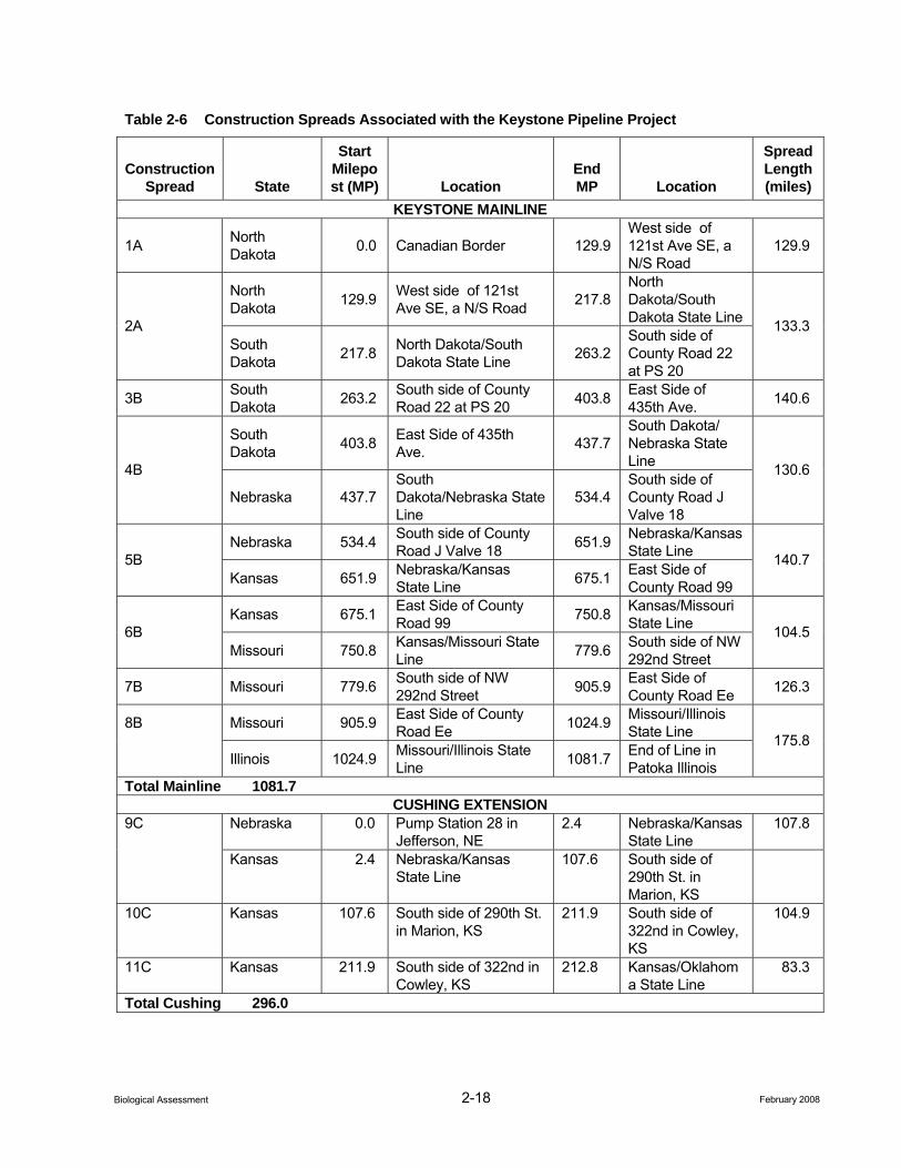
2-18 February 2008 Biological Assessment
Table 2-6 Construction Spreads Associated with the Keystone Pipeline Project
Construction Spread State
Start Milepost (MP) Location
End MP Location
Spread Length (miles)
KEYSTONE MAINLINE
1A North Dakota 0.0 Canadian Border 129.9
West side of 121st Ave SE, a N/S Road
129.9
North Dakota 129.9 West side of 121st
Ave SE, a N/S Road 217.8 North Dakota/South Dakota State Line 2A
South Dakota 217.8 North Dakota/South
Dakota State Line 263.2 South side of County Road 22 at PS 20
133.3
3B South Dakota 263.2 South side of County
Road 22 at PS 20 403.8 East Side of 435th Ave. 140.6
South Dakota 403.8 East Side of 435th
Ave. 437.7 South Dakota/ Nebraska State Line 4B
Nebraska 437.7 South Dakota/Nebraska State Line
534.4 South side of County Road J Valve 18
130.6
Nebraska 534.4 South side of County Road J Valve 18 651.9 Nebraska/Kansas
State Line 5B Kansas 651.9 Nebraska/Kansas
State Line 675.1 East Side of County Road 99
140.7
Kansas 675.1 East Side of County Road 99 750.8 Kansas/Missouri
State Line 6B Missouri 750.8 Kansas/Missouri State
Line 779.6 South side of NW 292nd Street
104.5
7B Missouri 779.6 South side of NW 292nd Street 905.9 East Side of
County Road Ee 126.3
8B Missouri 905.9 East Side of County Road Ee 1024.9 Missouri/Illinois
State Line
Illinois 1024.9 Missouri/Illinois State Line 1081.7 End of Line in
Patoka Illinois
175.8
Total Mainline 1081.7 CUSHING EXTENSION
9C Nebraska 0.0 Pump Station 28 in Jefferson, NE
2.4 Nebraska/Kansas State Line
107.8
Kansas 2.4 Nebraska/Kansas State Line
107.6 South side of 290th St. in Marion, KS
10C Kansas 107.6 South side of 290th St. in Marion, KS
211.9 South side of 322nd in Cowley, KS
104.9
11C Kansas 211.9 South side of 322nd in Cowley, KS
212.8 Kansas/Oklahoma State Line
83.3
Total Cushing 296.0
2-19 February 2008 Biological Assessment
Keystone anticipates 500 to 600 construction and inspection personnel associated with each spread. Each spread would require approximately 6 to 8 months to complete. All construction work is expected to be completed by the end of December 2009. Currently, Keystone proposes to start construction of the aboveground facilities in the summer of 2008. Construction of each pump station would require approximately 20 to 30 additional workers. Construction of all pump stations would be completed in 18 months.
Keystone, through its construction contractors and subcontractors, would attempt to hire temporary construction staff from the local population. At peak workforce, Keystone anticipates that an average of 10 to 15 percent of the total construction workforce may be hired locally, with the remaining portion of the workforce (85 to 90 percent or more) consisting of non-local personnel.
Only work vehicles would be allowed on the construction ROW or additional temporary workspace areas during construction.
2.1.6.5 Abandonment
The project is expected to operate for 50 or more years. Keystone has not identified plans for abandonment of these facilities at this time. If abandonment of any facilities is proposed in the future, the abandonment would be subject to approvals by state and/or federal agencies having jurisdiction. Abandonment would be implemented in accordance with then-applicable permits, approvals, codes, and regulations.
2.1.7 Operation and Maintenance Keystone would operate and maintain the project facilities in accordance with the USDOT regulations in 49 CFR Parts 194 and 195 and other applicable federal and state regulations. Operation and maintenance of the pipeline system in most cases would be accomplished by Keystone personnel. Keystone estimates that operation of the pipeline would require approximately 20 employees in the U.S.
2.1.7.1 Normal Operations and Routine Maintenance
The pipeline would be inspected periodically in accordance with 49 CFR Part 195. These surveillance activities would provide information on possible encroachments and nearby construction activities, erosion, exposed pipe, and other potential concerns that may affect the safety and operation of the pipeline. Evidence of population changes would be monitored and High Consequence Areas identified as necessary. Mainline valves also would be inspected annually and the results documented.
In order to maintain operational accessibility of the ROW in order to accommodate pipeline integrity surveys and comply with federal regulations, shrubs and trees would be maintained in an herbaceous state over portions of the pipeline ROW. Cultivated croplands would be allowed to grow in the permanent ROW. Keystone would use mechanical mowing or cutting along the ROW for normal vegetation maintenance and will avoid the use pesticides during construction or ROW maintenance activities except for application at aboveground operational facilities or on the ROW during construction or maintenance using spot treatment as part of a noxious weed management plan.
During operations, Keystone would monitor the pipeline and conduct pipeline integrity surveys to identify any potential integrity concerns. Plans related to waterbodies, wetlands, and upland areas are discussed in Keystone’s Plan (Appendix C). Operation and maintenance procedures, including record keeping, would be performed in accordance with the USDOT requirements. Keystone would survey the ROW to identify areas where permanent erosion control devices require repair or additional erosion control devices are necessary to prevent future degradation.
Keystone would further monitor the ROW to identify any areas where soil productivity has been degraded as a result of pipeline construction and reclamation measures would be implemented to rectify any such concerns. Applicable reclamation measures are outlined in the Plan (Appendix C).
2-20 February 2008 Biological Assessment
Supervisory Control and Data Acquisition (SCADA) facilities would be located at all pump stations and delivery facilities. The pipeline SCADA system would be capable of the following functions:
• Mainline valve position remote indication;
• Mainline valve remote closing and opening control from a control center;
• Remote indication of line pressure and temperature; and
• Remote indication of delivery flow and total flow.
The project would have a control center manned by an experienced and highly trained crew 24 hours per day for 365 days per year. A backup control center also would be constructed.
Communications systems would provide up-to-date information from the pump stations to the control center plus the capability to contact field personnel. A backup communications system would be included within the system design and installation. The control center has state-of-the-art pipeline monitoring systems including a leak detection system that would indicate out-of-normal conditions (see Section 2.1.9.2, Abnormal Operations) and initiate visual and audible alarms if they detect an operating condition that warrant operator investigation. Serious abnormal situations that are not investigated would initiate automatic pipeline shutdown systems.
2.1.7.2 Abnormal Operations
Abnormal operating procedures would be implemented whenever appropriate in accordance with 49 CFR Section 195.402(d). In the event of any unusual situation, the operations manager on duty would alter the pipeline’s operation. In the event pressure indications show a change, higher or lower, the pipeline controller would immediately make an evaluation. If a leak is suspected, Keystone would initiate its ERP (preliminary draft submitted to the DOS on July 1, 2006). A final draft would be submitted to the USDOT PHMSA prior to commencement of line filling and operations.
If a leak is suspected and the pipe is shutdown, the operation of the segment would not be resumed until the cause of the alarm (e.g., false alarm by instrumentation) or the leak is identified and repaired. If a reportable leak were to occur, USDOT approval would be required to resume operation of the affected segment.
Keystone would perform aerial surveillance of the pipeline ROW at least 26 times a year not to exceed 3 weeks between intervals in accordance with 49 CFR Part 195. In addition to visual surveillance and operator diligence, Keystone would employ two technology-based leak detection systems to facilitate the early detection of pipeline leaks. These systems include:
• Leak detection software associated with the SCADA monitoring system; and
• Volumetric balancing.
As described above, Keystone’s SCADA system would constantly monitor pipeline operation to quickly detect abnormal operation, including the detection of leaks. The SCADA system and leak detection software would fully comply with industry standards (API 1149). Using real-time dynamic flow modeling software, line-pack compensated volumetric balancing, and a hydraulic gradient model, the SCADA system would check pipeline conditions (e.g., flow rates, pressure, temperature, and fluid density) every 3 to 5 seconds while the pipeline is actively transporting crude oil. Pressure transducers and other monitoring equipment would be located at pump stations and data from these locations would be transmitted via satellite to the centralized SCADA location. The SCADA system would acquire and accumulate these data, which would then be fed into a leak detection model for analysis and trending. Real-time measurements would be analyzed against predetermined thresholds; if a predetermined threshold is exceeded, the information would be sent to the SCADA system, and the operator would be informed to take corrective actions. Compared to older leak detection programs, line-pack compensated volume-balancing represents an improved method for volume accounting that calculates changes in fluid volume within the pipeline.
2-21 February 2008 Biological Assessment
When the project is not actively transporting oil, the pipeline would enter a “static” mode. Since crude oil would not be moving, the pressures between pressure transducers should remain relatively constant after accounting for temperature changes and other minor pressure changes.
Emergency Response Procedures
Potential system emergencies include leaks or fires located near or directly involving a pipeline or pipeline facility and pipeline or pipeline facility damage from natural and human causes. If an emergency were to occur, pipeline flow would be stopped and would not resume until the cause of the problem (e.g., instrumentation failure or leak) is detected and repaired.
Keystone would be required to prepare site-specific ERPs for the system, which would be submitted to and reviewed by the Office of Pipeline Safety (OPS) prior to operation. A preliminary draft ERP has been submitted to the DOS (July 1, 2006). The ERP would: 1) establish guidelines and procedures to be followed in emergencies and to minimize hazards resulting from pipeline emergencies, 2) establish procedures for training Keystone’s employees on emergency procedures, and 3) establish guidelines for continuing educational programs designed to inform the public of the procedures to follow in recognizing and reporting an emergency condition in compliance with the recommended practice of API 1162.
If a spill were to occur, Keystone would be required to immediately notify the National Response Center (NRC) in the event of a release of crude oil that: 1) violates water quality standards, 2) creates a sheen on water, or 3) causes a sludge or emulsion to be deposited beneath the surface of the water or upon adjoining shorelines (40 CFR Part 112). In addition to the NRC, Keystone would make timely notifications to other agencies, including the appropriate Local Emergency Planning Committees, sheriff’s departments, the applicable state’s Department of Environmental Qualifications, U.S. Environmental Protection Agency (USEPA), and affected landowners.
Under the National Contingency Plan, USEPA is the lead federal response agency for oil spills occurring on land and in inland waters. USEPA would evaluate the size and nature of a spill, its potential hazards, the resources needed to contain and clean it up, and the ability of the responsible party or local authorities to handle the incident. The USEPA would monitor all activities to ensure that the spill is being contained and cleaned up appropriately. All spills meeting legally defined criteria (see criteria above per 40 CFR Part 112) must be monitored by the USEPA, even though most spills may be small and cleaned up by the responsible party. In the unlikely event of a large spill, Keystone and its contractors would be expected to take the lead in recovery and cleanup. The role of local emergency responders is typically to notify community members, direct people away from the hazard area, and address potential impacts to the community such as temporary road closings.
A fire associated with a spill is relatively rare. According to historical data (OPS 2005), only about four percent of reportable liquid spills are ignited. In the event of a fire, local emergency responders would execute the roles listed above and firefighters would take actions to prevent the crude oil fire from spreading to adjacent foliage or structures. Fire departments might choose to extinguish a small- or moderate-sized crude oil fire, but in many cases the best course of action may be to let the fire burn itself out. Local emergency responders typically are trained and able to execute the roles described above without any additional training or specialized equipment. Keystone also would work with emergency response agencies to provide pipeline awareness education and other support.
2-22 February 2008 Biological Assessment
Remediation
Corrective remedial actions would be dictated by federal regulations and enforced by the USEPA and OPS. Required remedial actions may range from the excavation and removal of contaminated soil allowing the contaminated soil to recover through natural environmental fate processes (e.g., evaporation, biodegradation). Decisions concerning remedial methods and extent of the cleanup would consider state-mandated remedial cleanup levels, potential effects to sensitive receptors, volume and extent of the contamination, compliance with water quality standards, and the magnitude of adverse impacts that would be caused by remedial activities.
In the event of a spill, several federal regulatory programs define the notification requirements and required response actions, including the National Oil and Hazardous Substances Pollution Contingency Plan (40 CFR Part 300), the Clean Water Act, and the Oil Pollution Act. At the most fundamental level, these interlocking programs mandate notification and initiation of response actions in a timeframe and on a scale commensurate with the threats posed. They also establish a required endpoint for response actions: the mitigation of any unacceptable threat to human health and safety or the environment. The cumulative result of these regulatory constraints is that the adverse impacts of a release event would be temporary and baseline conditions ultimately would be restored.
3-1 February 2008 Biological Assessment
3.0 Species Evaluation
3.1 Federal Endangered 3.1.1 Indiana Bat
3.1.1.1 Natural History and Habitat Association
The Indiana bat (Myotis sodalis) was federally listed as endangered on March 11, 1967 (32 FR 4001) under the Endangered Species Preservation Act of October 15, 1966 (80 Stat. 926; 16 United States Code 668aa(c)). Across the species range, the population declined dramatically from 800,000 bats in 1965 to an estimated 382,350 bats in 2002 (Clawson 2002). Population declines are primarily attributed to: 1) destruction/ degradation on hibernacula; 2) loss/degradation of summer habitat, migration habitat, and swarming habitat; 3) disturbance of hibernating bats, and to a lesser extent summering bats; and 4) natural events such as the flooding of hibernacula (USFWS 2007). Although, the latest survey efforts did not show the same declining trends, present population estimates are still much lower than historical estimates. As of 2005, the total Indiana bat population was estimated at 457,000 bats. Of these, 81.9 percent are found in 23 Priority 1 hibernacula (i.e., hibernacula containing 10,000 bats or more) in seven states including, Illinois (n=1), Indiana (n=7), Kentucky (n=5), Missouri (n=6), New York (n=2), Tennessee (n=1), and West Virginia (n=1). The remaining 18.1 percent are in Priority 2, 3, and 4 hibernacula (personal communication with Bloomington, Indiana, USFWS Field Office).
The Indiana bat occurs in most of the eastern half of the U.S. The Indiana bat is a migratory bat that hibernates in caves or mines from mid-October through mid-April. During summer months (approximately mid-May through mid-August), Indiana bats forage at night in upland and riparian forests, along wooded edges between forests and croplands, and over fields. Indiana bats roost during daytime in upland or bottomland habitats under exfoliating bark, in crevices/hollows of live or dead trees, or occasionally in tree cavities. Female Indiana bats (usually less than 100) gather in maternity roosts in trees, where they give birth and raise a single young each year (Barbour and Davis 1969; Whitaker and Hamilton 1998). Female Indiana bats are known to migrate long distances to set up maternity colonies. Maternity colonies usually consist primarily of females and young (Humphrey et al. 1977) with non-reproductive females and males roosting separately (Hall 1962). Male Indiana bats typically roost beneath bark or in cavities of trees, and tend to roost singly or in small groups (Thomson 1982).
The Indiana bat requires specific habitat conditions during hibernation and for summer roosting and foraging. Indiana bats hibernate in caves or mines that provide a narrow range of climatic conditions. The best hibernacula in the south and central portions of the winter range tend to have large openings with a large volume, and vertical shafts. Occupied hibernacula have stable ambient temperatures typically below 50 degrees Fahrenheit (°F), and generally between 37 to 43°F (Tuttle and Kennedy 2002). Warmer temperatures may increase metabolic rates and expedite fat depletion during hibernation (Richter et al. 1993). Relative humidity for occupied hibernacula is typically between 70 and 100 percent (Hall 1962; LaVal et al. 1976; Humphrey 1978; Tuttle and Kennedy 1999). Preferred hibernacula also have noticeable airflow (Henshaw 1965) and often have multiple openings at different elevations exhibiting the chimney effect (Tuttle and Kennedy 2002). However, in the northern portion of the Indiana bat’s range, most suitable hibernacula do not exhibit the chimney effect.
Summer maternity habitat consists of mature trees in riparian or upland forests. In Michigan, over 97 percent of roost trees used by adult females and young were located in wetlands (Kurta et al. 2002). Upland forests also provide important maternity, roosting, and foraging habitat (Gardner et al. 1991; BHE Environmental, Inc. [BHE] 2001). Callahan et al. (1997) reported maternity roosts are often found under exfoliating bark or in crevices of trees 8.7 inches in diameter at breast height (dbh) or larger, with exposure to direct sunlight. Gardner et al. (1991) found roost tree averages of 14.4 inches dbh while Callahan et al. (1997) found roost tree averages to be 23.0 + 1.7 inches dbh. At least 33 species of trees have been documented as maternity
3-2 February 2008 Biological Assessment
roosts (USFWS 2007). Snags (standing dead trees) are most commonly used, but some maternity colonies have been found in live trees.
The use of snags by Indiana bats may be influenced by bark characteristics. Because virtually all maternity roosts are found under exfoliating bark, the characteristics of a species as a snag may be more important than the specific tree species on which the bark is present (Rommé et al. 1995). The ability of a tree species to produce plates of exfoliating bark probably influences Indiana bat use (Callahan et al. 1997; Rommé et al. 1995). Nevertheless, Indiana bat maternity roosts have been found in trees which typically do not exhibit these characteristics, such as a pine snags, and eastern hemlock (Britzke et al. 2003).
Snags providing suitable habitat for roosting Indiana bats are an ephemeral resource. Maternity colonies often use numerous (10 to 20) roost trees, including 1 to 3 primary roosts which are used by many adult females and young, and alternate roost trees which support fewer individuals and are used intermittently (Callahan et al. 1997). Females may use the same maternity roosts in successive summers if the trees remain standing and retain exfoliating bark (Kurta et al. 2002; Gumbert et al. 2002; Gardner et al. 1991; Callahan et al. 1997). If the primary roost tree is destroyed, surviving members of the maternity colony may move to one of the other roosts. A maternity colony may use several roosts up to 2.3 miles apart (Kurta et al. 2002). Adult male Indiana bats typically roost separately from the females and often use several different roost trees in an area from night to night (Rommé et al. 1995; Gardner et al. 1991).
While female Indiana bats typically migrate from hibernacula to summer habitat, male Indiana bats may roost in hibernacula and in trees near hibernacula throughout the summer. In addition, male and female Indiana bats are active near caves during spring staging and autumn swarming.
Spring staging occurs from approximately mid-April through early May. Females typically leave caves before males (Humphrey 1978; LaVal and LaVal 1980). Following mid-May emergence from hibernation, a single radio-marked male was followed for two weeks and traveled 10 miles in western Virginia (Hobson and Holland 1995). During staging, Indiana bats emerge from hibernation to roost in trees, and forage near hibernacula. In Missouri, staging male and female Indiana bats traveled between 1.2 and 6.4 miles from their hibernaculum nightly (Rommé et al. 2002). Females may leave immediately for their summer habitat or linger for a number of days.
Autumn swarming occurs from approximately mid-August through September. During swarming, numerous bats fly in and out of cave entrances from dusk to dawn, while relatively few roost in caves during the day (Cope and Humphrey 1977). In Missouri, swarming Indiana bats traveled up to 4 miles from roost sites (Rommé et al. 2002). In Kentucky, male Indiana bats radio-tracked during October were found to travel up to 1.7 miles from their roost sites, and roosted in trees between 0.5 and 1.5 miles from the hibernaculum (Kiser and Elliot 1996). Indiana bats periodically use tree roosts during fall swarming (Menzel et al. 2001). In eastern Kentucky and West Virginia, roosts were located predominately in medium-size hardwood snags and trees with a mean dbh of 10.6 inches and 13 inches, respectively (Kiser and Elliot 1996). These snags and trees were located in small forest openings or canopy gaps.
Additional data describing the life history of the Indiana bat is well summarized in the document Indiana Bat (Myotis sodalis) Draft Recovery Plan: First Revision, April 2007 (USFWS). That document is hereby incorporated by reference.
3.1.1.2 Potential Presence in Project Area
Indiana bats are assumed to be present between April 1 and September 30 during spring, summer, and autumn seasons in all Missouri and Illinois counties crossed by the Keystone Mainline. The bats are presumed absent from the project area during October 1 through March 31. Habitat assessments have revealed that high quality summer habitat exists within some of the woodlots that the Keystone Mainline will cross in Missouri. A detailed description of the habitat assessment can be found in Appendix B-1. Known summer occurrences in the 10 counties of Missouri crossed by the project are limited to captures in Clinton, Chariton, and Randolph counties. The 1983 record from Chariton County was of a maternity roost tree. Indiana bats have more
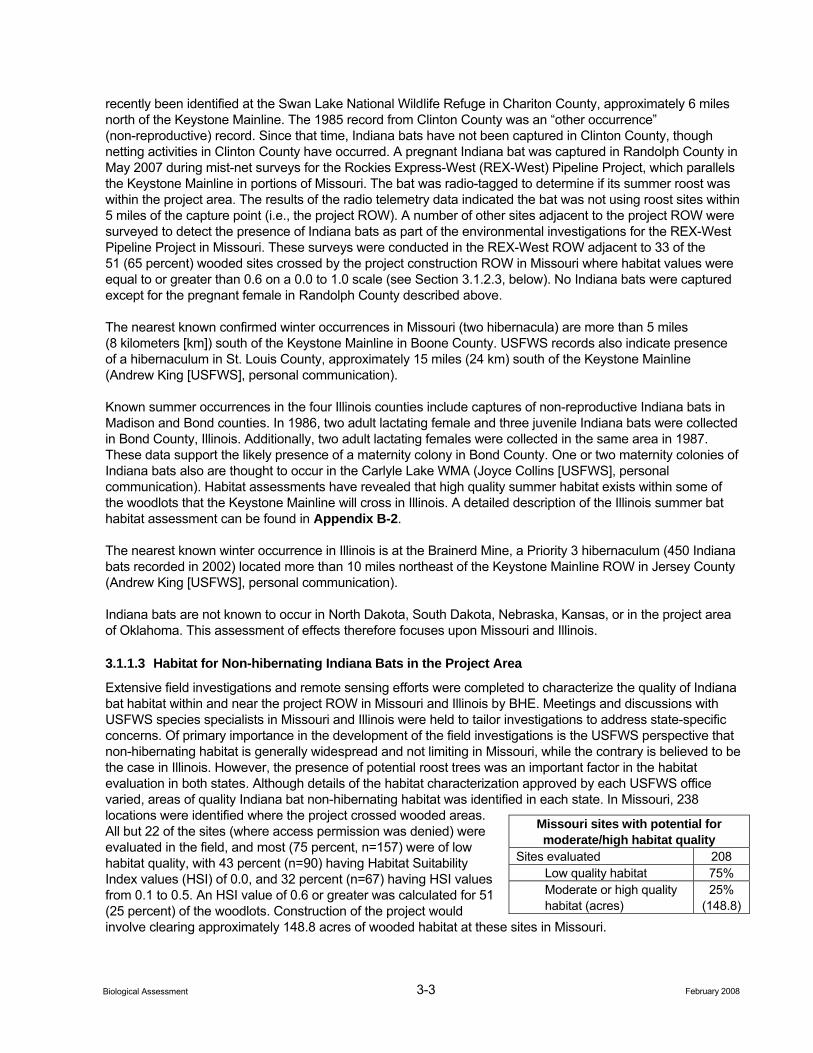
3-3 February 2008 Biological Assessment
recently been identified at the Swan Lake National Wildlife Refuge in Chariton County, approximately 6 miles north of the Keystone Mainline. The 1985 record from Clinton County was an “other occurrence” (non-reproductive) record. Since that time, Indiana bats have not been captured in Clinton County, though netting activities in Clinton County have occurred. A pregnant Indiana bat was captured in Randolph County in May 2007 during mist-net surveys for the Rockies Express-West (REX-West) Pipeline Project, which parallels the Keystone Mainline in portions of Missouri. The bat was radio-tagged to determine if its summer roost was within the project area. The results of the radio telemetry data indicated the bat was not using roost sites within 5 miles of the capture point (i.e., the project ROW). A number of other sites adjacent to the project ROW were surveyed to detect the presence of Indiana bats as part of the environmental investigations for the REX-West Pipeline Project in Missouri. These surveys were conducted in the REX-West ROW adjacent to 33 of the 51 (65 percent) wooded sites crossed by the project construction ROW in Missouri where habitat values were equal to or greater than 0.6 on a 0.0 to 1.0 scale (see Section 3.1.2.3, below). No Indiana bats were captured except for the pregnant female in Randolph County described above.
The nearest known confirmed winter occurrences in Missouri (two hibernacula) are more than 5 miles (8 kilometers [km]) south of the Keystone Mainline in Boone County. USFWS records also indicate presence of a hibernaculum in St. Louis County, approximately 15 miles (24 km) south of the Keystone Mainline (Andrew King [USFWS], personal communication).
Known summer occurrences in the four Illinois counties include captures of non-reproductive Indiana bats in Madison and Bond counties. In 1986, two adult lactating female and three juvenile Indiana bats were collected in Bond County, Illinois. Additionally, two adult lactating females were collected in the same area in 1987. These data support the likely presence of a maternity colony in Bond County. One or two maternity colonies of Indiana bats also are thought to occur in the Carlyle Lake WMA (Joyce Collins [USFWS], personal communication). Habitat assessments have revealed that high quality summer habitat exists within some of the woodlots that the Keystone Mainline will cross in Illinois. A detailed description of the Illinois summer bat habitat assessment can be found in Appendix B-2.
The nearest known winter occurrence in Illinois is at the Brainerd Mine, a Priority 3 hibernaculum (450 Indiana bats recorded in 2002) located more than 10 miles northeast of the Keystone Mainline ROW in Jersey County (Andrew King [USFWS], personal communication).
Indiana bats are not known to occur in North Dakota, South Dakota, Nebraska, Kansas, or in the project area of Oklahoma. This assessment of effects therefore focuses upon Missouri and Illinois.
3.1.1.3 Habitat for Non-hibernating Indiana Bats in the Project Area
Extensive field investigations and remote sensing efforts were completed to characterize the quality of Indiana bat habitat within and near the project ROW in Missouri and Illinois by BHE. Meetings and discussions with USFWS species specialists in Missouri and Illinois were held to tailor investigations to address state-specific concerns. Of primary importance in the development of the field investigations is the USFWS perspective that non-hibernating habitat is generally widespread and not limiting in Missouri, while the contrary is believed to be the case in Illinois. However, the presence of potential roost trees was an important factor in the habitat evaluation in both states. Although details of the habitat characterization approved by each USFWS office varied, areas of quality Indiana bat non-hibernating habitat was identified in each state. In Missouri, 238 locations were identified where the project crossed wooded areas. All but 22 of the sites (where access permission was denied) were evaluated in the field, and most (75 percent, n=157) were of low habitat quality, with 43 percent (n=90) having Habitat Suitability Index values (HSI) of 0.0, and 32 percent (n=67) having HSI values from 0.1 to 0.5. An HSI value of 0.6 or greater was calculated for 51 (25 percent) of the woodlots. Construction of the project would involve clearing approximately 148.8 acres of wooded habitat at these sites in Missouri.
Missouri sites with potential for moderate/high habitat quality
Sites evaluated 208 Low quality habitat 75% Moderate or high quality habitat (acres)
25% (148.8)
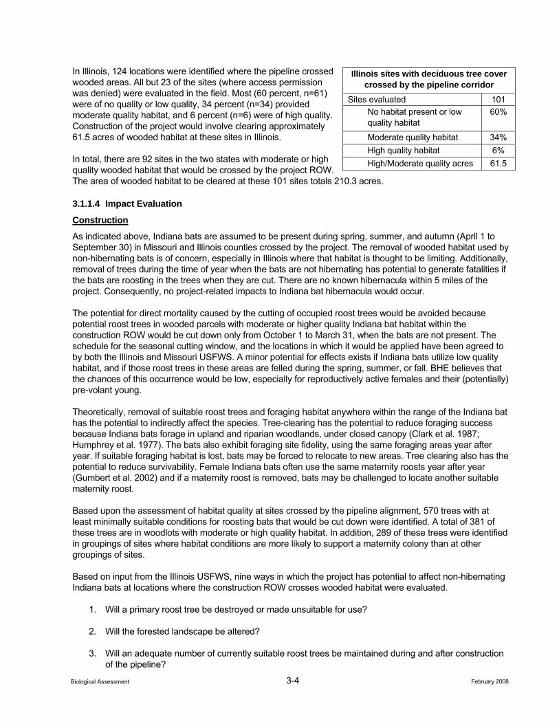
3-4 February 2008 Biological Assessment
In Illinois, 124 locations were identified where the pipeline crossed wooded areas. All but 23 of the sites (where access permission was denied) were evaluated in the field. Most (60 percent, n=61) were of no quality or low quality, 34 percent (n=34) provided moderate quality habitat, and 6 percent (n=6) were of high quality. Construction of the project would involve clearing approximately 61.5 acres of wooded habitat at these sites in Illinois.
In total, there are 92 sites in the two states with moderate or high quality wooded habitat that would be crossed by the project ROW. The area of wooded habitat to be cleared at these 101 sites totals 210.3 acres.
3.1.1.4 Impact Evaluation
Construction
As indicated above, Indiana bats are assumed to be present during spring, summer, and autumn (April 1 to September 30) in Missouri and Illinois counties crossed by the project. The removal of wooded habitat used by non-hibernating bats is of concern, especially in Illinois where that habitat is thought to be limiting. Additionally, removal of trees during the time of year when the bats are not hibernating has potential to generate fatalities if the bats are roosting in the trees when they are cut. There are no known hibernacula within 5 miles of the project. Consequently, no project-related impacts to Indiana bat hibernacula would occur.
The potential for direct mortality caused by the cutting of occupied roost trees would be avoided because potential roost trees in wooded parcels with moderate or higher quality Indiana bat habitat within the construction ROW would be cut down only from October 1 to March 31, when the bats are not present. The schedule for the seasonal cutting window, and the locations in which it would be applied have been agreed to by both the Illinois and Missouri USFWS. A minor potential for effects exists if Indiana bats utilize low quality habitat, and if those roost trees in these areas are felled during the spring, summer, or fall. BHE believes that the chances of this occurrence would be low, especially for reproductively active females and their (potentially) pre-volant young.
Theoretically, removal of suitable roost trees and foraging habitat anywhere within the range of the Indiana bat has the potential to indirectly affect the species. Tree-clearing has the potential to reduce foraging success because Indiana bats forage in upland and riparian woodlands, under closed canopy (Clark et al. 1987; Humphrey et al. 1977). The bats also exhibit foraging site fidelity, using the same foraging areas year after year. If suitable foraging habitat is lost, bats may be forced to relocate to new areas. Tree clearing also has the potential to reduce survivability. Female Indiana bats often use the same maternity roosts year after year (Gumbert et al. 2002) and if a maternity roost is removed, bats may be challenged to locate another suitable maternity roost.
Based upon the assessment of habitat quality at sites crossed by the pipeline alignment, 570 trees with at least minimally suitable conditions for roosting bats that would be cut down were identified. A total of 381 of these trees are in woodlots with moderate or high quality habitat. In addition, 289 of these trees were identified in groupings of sites where habitat conditions are more likely to support a maternity colony than at other groupings of sites.
Based on input from the Illinois USFWS, nine ways in which the project has potential to affect non-hibernating Indiana bats at locations where the construction ROW crosses wooded habitat were evaluated.
1. Will a primary roost tree be destroyed or made unsuitable for use?
2. Will the forested landscape be altered?
3. Will an adequate number of currently suitable roost trees be maintained during and after construction of the pipeline?
Illinois sites with deciduous tree cover crossed by the pipeline corridor
Sites evaluated 101 No habitat present or low quality habitat
60%
Moderate quality habitat 34% High quality habitat 6% High/Moderate quality acres 61.5
3-5 February 2008 Biological Assessment
4. Will the appropriate species of trees be maintained in adequate densities to provide for the future recruitment of roost trees?
5. Will a continuous supply of future suitable roost trees be available following the project?
6. Will access to drinking water be maintained?
7. Will appropriate-sized trees be maintained?
8. Will the roosting area provide suitable microclimate diversity?
9. Will connectivity between roosting and foraging areas be maintained?
The results of this analysis (Appendix B-3 and B-4) indicate that the conditions addressed in Question 3 through Question 9, when considered in the context of Indiana bat biology/life history, including a landscape scale assessment of habitat within 3.5 km of trees that would be felled, indicate that the project is unlikely to change habitat to any meaningful extent. In assessing the effects of the project on amount of forest cover near areas to be cleared (Question 2), It was determined that although forest clearing would total approximately 680 acres within the construction ROW in Missouri and Illinois (in total), in all cases, the forest to be removed constitutes an exceedingly small percentage of the forest within 3.5 km of each site. The post-project reduction in forest cover varied with the amount of forest near the project ROW, and the amount of forest within the construction ROW, and ranged from 0 to 2.32 percent. This level of change is believed to be inconsequential relative to the biology of the Indiana bat. With Question 2 through Question 9 addressed as described above, the likelihood that proposed forest clearing would remove primary maternity roost trees (Question 1) was addressed.
To facilitate this analysis wooded tracts crossed by the project were grouped based upon geographic proximity and/or similarities in habitat attributes (e.g., amount of forest cover within 3.5 km of the sites). Results available from recent mist net surveys completed at sites adjacent to the project sites (i.e., sites along the REX-West Pipeline ROW in central and western Missouri – see Appendix B-3) were utilized in the analysis. As presence/absence data (mist net survey results) and habitat utilization data (telemetry investigations) are unavailable for many project sites in Missouri and Illinois, it was not possible to definitively determine if maternity roost trees would be removed. Instead, the likelihood that a maternity roost would be present based upon data gathered in the assessment of habitat suitability in woodlots crossed by the project ROW in the two states was qualitatively described (Appendices B-3 and B-4).
This approach is believed to be extremely conservative (i.e., overstates the potential impact), because it assumes maternity roosts would be present in areas of quality habitat. Based upon the documented occurrence of maternity roosts throughout the species range, it is reasonable to conclude roosts occur in only a minute fraction of sites that appear to provide suitable habitat. Furthermore, the forest to be removed as part of this project constitutes an exceedingly small percentage of the forest habitat near each site. This analysis conservatively assumes the primary roost trees in the project area are coincident with the project ROW. For purposes of the analysis, and where groupings of wooded sites span considerable distances, it is assumed that primary roosts would be no closer together than two times the average travel distance from roosts (3.5 km or 2.2.miles) (Murray and Kurta 2004; Sparks et al. 2005; Butchkoski and Hassinger 2002), that is, 7.0 km or 4.3 miles.
This assessment identified 32 groupings of wooded areas crossed by the project ROW; 20 groups in Missouri and 12 groups in Illinois. Of the 20 groups of wooded sites in Missouri, two have habitat that has a greater likelihood of supporting a primary maternity roost. Six of 12 such groups of sites were identified in Illinois. Based upon the very conservative assumption that each of these 8 groups of sites supports one or more maternity roost(s), the project may remove up to approximately 19 primary maternity roosts. In all likelihood the actual number of primary roosts removed would be significantly lower than this estimate, with an estimate of zero occupied primary roost trees removed being a distinct possibility/probability.
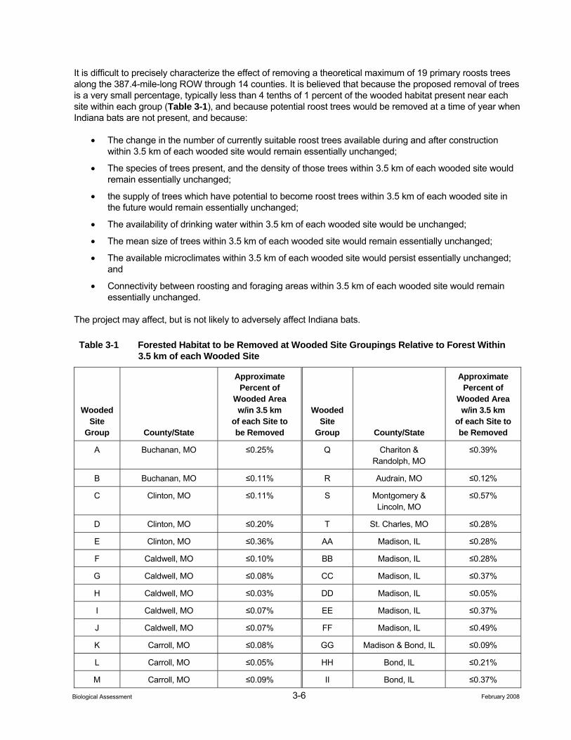
3-6 February 2008 Biological Assessment
It is difficult to precisely characterize the effect of removing a theoretical maximum of 19 primary roosts trees along the 387.4-mile-long ROW through 14 counties. It is believed that because the proposed removal of trees is a very small percentage, typically less than 4 tenths of 1 percent of the wooded habitat present near each site within each group (Table 3-1), and because potential roost trees would be removed at a time of year when Indiana bats are not present, and because:
• The change in the number of currently suitable roost trees available during and after construction within 3.5 km of each wooded site would remain essentially unchanged;
• The species of trees present, and the density of those trees within 3.5 km of each wooded site would remain essentially unchanged;
• the supply of trees which have potential to become roost trees within 3.5 km of each wooded site in the future would remain essentially unchanged;
• The availability of drinking water within 3.5 km of each wooded site would be unchanged;
• The mean size of trees within 3.5 km of each wooded site would remain essentially unchanged;
• The available microclimates within 3.5 km of each wooded site would persist essentially unchanged; and
• Connectivity between roosting and foraging areas within 3.5 km of each wooded site would remain essentially unchanged.
The project may affect, but is not likely to adversely affect Indiana bats.
Table 3-1 Forested Habitat to be Removed at Wooded Site Groupings Relative to Forest Within 3.5 km of each Wooded Site
Wooded Site
Group County/State
Approximate Percent of
Wooded Area w/in 3.5 km
of each Site to be Removed
Wooded Site
Group County/State
Approximate Percent of
Wooded Area w/in 3.5 km
of each Site to be Removed
A Buchanan, MO ≤0.25% Q Chariton & Randolph, MO
≤0.39%
B Buchanan, MO ≤0.11% R Audrain, MO ≤0.12%
C Clinton, MO ≤0.11% S Montgomery & Lincoln, MO
≤0.57%
D Clinton, MO ≤0.20% T St. Charles, MO ≤0.28%
E Clinton, MO ≤0.36% AA Madison, IL ≤0.28%
F Caldwell, MO ≤0.10% BB Madison, IL ≤0.28%
G Caldwell, MO ≤0.08% CC Madison, IL ≤0.37%
H Caldwell, MO ≤0.03% DD Madison, IL ≤0.05%
I Caldwell, MO ≤0.07% EE Madison, IL ≤0.37%
J Caldwell, MO ≤0.07% FF Madison, IL ≤0.49%
K Carroll, MO ≤0.08% GG Madison & Bond, IL ≤0.09%
L Carroll, MO ≤0.05% HH Bond, IL ≤0.21%
M Carroll, MO ≤0.09% II Bond, IL ≤0.37%
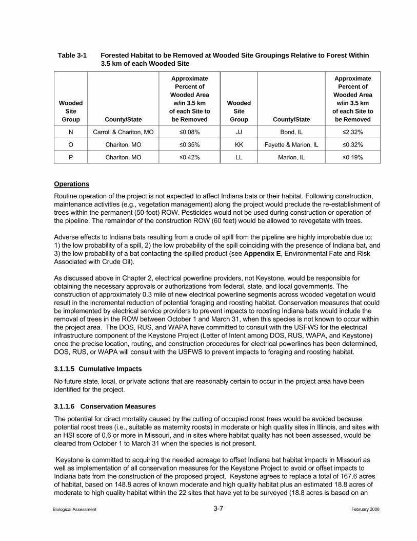
3-7 February 2008 Biological Assessment
Table 3-1 Forested Habitat to be Removed at Wooded Site Groupings Relative to Forest Within 3.5 km of each Wooded Site
Wooded Site
Group County/State
Approximate Percent of
Wooded Area w/in 3.5 km
of each Site to be Removed
Wooded Site
Group County/State
Approximate Percent of
Wooded Area w/in 3.5 km
of each Site to be Removed
N Carroll & Chariton, MO ≤0.08% JJ Bond, IL ≤2.32%
O Chariton, MO ≤0.35% KK Fayette & Marion, IL ≤0.32%
P Chariton, MO ≤0.42% LL Marion, IL ≤0.19%
Operations
Routine operation of the project is not expected to affect Indiana bats or their habitat. Following construction, maintenance activities (e.g., vegetation management) along the project would preclude the re-establishment of trees within the permanent (50-foot) ROW. Pesticides would not be used during construction or operation of the pipeline. The remainder of the construction ROW (60 feet) would be allowed to revegetate with trees.
Adverse effects to Indiana bats resulting from a crude oil spill from the pipeline are highly improbable due to: 1) the low probability of a spill, 2) the low probability of the spill coinciding with the presence of Indiana bat, and 3) the low probability of a bat contacting the spilled product (see Appendix E, Environmental Fate and Risk Associated with Crude Oil).
As discussed above in Chapter 2, electrical powerline providers, not Keystone, would be responsible for obtaining the necessary approvals or authorizations from federal, state, and local governments. The construction of approximately 0.3 mile of new electrical powerline segments across wooded vegetation would result in the incremental reduction of potential foraging and roosting habitat. Conservation measures that could be implemented by electrical service providers to prevent impacts to roosting Indiana bats would include the removal of trees in the ROW between October 1 and March 31, when this species is not known to occur within the project area. The DOS, RUS, and WAPA have committed to consult with the USFWS for the electrical infrastructure component of the Keystone Project (Letter of Intent among DOS, RUS, WAPA, and Keystone) once the precise location, routing, and construction procedures for electrical powerlines has been determined, DOS, RUS, or WAPA will consult with the USFWS to prevent impacts to foraging and roosting habitat.
3.1.1.5 Cumulative Impacts
No future state, local, or private actions that are reasonably certain to occur in the project area have been identified for the project.
3.1.1.6 Conservation Measures
The potential for direct mortality caused by the cutting of occupied roost trees would be avoided because potential roost trees (i.e., suitable as maternity roosts) in moderate or high quality sites in Illinois, and sites with an HSI score of 0.6 or more in Missouri, and in sites where habitat quality has not been assessed, would be cleared from October 1 to March 31 when the species is not present.
Keystone is committed to acquiring the needed acreage to offset Indiana bat habitat impacts in Missouri as well as implementation of all conservation measures for the Keystone Project to avoid or offset impacts to Indiana bats from the construction of the proposed project. Keystone agrees to replace a total of 167.6 acres of habitat, based on 148.8 acres of known moderate and high quality habitat plus an estimated 18.8 acres of moderate to high quality habitat within the 22 sites that have yet to be surveyed (18.8 acres is based on an
3-8 February 2008 Biological Assessment
estimated 25 percent of the sites consisting of moderate to high quality habitat). If the actual acreage for all sites in Missouri is 10% above or below the estimated total of 167.6 acres (i.e., less than 150.8 acres, or more than 184.4 acres), Keystone would notify the MO FWS and the conservation measure would be adjusted to accurately reflect the actual number of moderate and high quality habitat acres. To offset habitat loses, Keystone would replace habitat at a 2:1 ratio, resulting in Keystone replacing approximately 335.4 acres of habitat
3.1.1.7 Determination
Effect on Critical Habitat. The project would have “no effect” on critical habitat for the Indiana bat. No direct or indirect effects to Critical Habitat for the Indiana bat are anticipated from the project. The USFWS has designated the following areas as Critical Habitat in Missouri – Cave 021 (Crawford County), Caves 009 and 017 (Franklin County), Pilot Knob Mine (Iron County), Bat Cave (Shannon County), Cave 029 (Washington County) and Blackball mine (La Salle County) in Illinois. None of these areas occur within 5 miles of the project.
Effect on the Species. The project “may affect, but is not likely to adversely affect” Indiana bats. This determination is based on the amount of remaining habitat available to Indiana bats that may utilize roost trees in or near the project ROW and fact that no Indiana bat hibernacula would be impacted by the project.
Adverse effects to Indiana bats resulting from a crude oil spill from the pipeline are highly improbable due to: 1) the low probability of a spill, 2) the low probability of the spill coinciding with the presence of Indiana bat, and 3) the low probability of a bat contacting the spilled product.
3.1.1.8 Literature Cited
Barbour, R. W. and W. H. Davis. 1969. Bats of America. University Press, Lexington, Kentucky. 286 pp.
BHE Environmental, Inc. (BHE). 2006a. Assessment of Indiana Bat Summer Habitat Along the Proposed Keystone Pipeline in Missouri. Project Report filed with the DOS. ENSR Corporation, 1601 Prospect Parkway, Fort Collins, Colorado 80525.
_____. 2006b. Assessment of Indiana Bat Summer Habitat Along the Proposed Keystone Pipeline in Illinois. Project Report filed with the DOS. ENSR Corporation, 1601 Prospect Parkway, Fort Collins, Colorado 80525.
_____. 2001. A Mist Net Survey and Telemetry Study of Indiana bats at Wright-Patterson Air Force Base in Greene and Montgomery counties, Ohio. Project Report, Wright-Patterson Air Force Base, 88th Air Base Wing, Office of Environmental Management, WPAFB, Ohio. 39 pp + appendices
Britzke, E. R., M. J. Harvey, and S. C. Loeb. 2003. Indiana bat, Myotis sodalis, Maternity Roosts in the Southern United States. Southeastern Naturalist 2(2):235–242.
Butchkoski, C. and J. Hassinger. 2002. Ecology of Maternity Colony Roosting in a Building. Pp 130-142 In: A. Kurta and J. Kennedy (eds.), The Indiana Bat: Biology and Management of an Endangered Species. Bat Conservation International, Austin, Texas.
Callahan, E. V., R. D. Drobney, and R. L. Clawson. 1997. Selection of Summer Roosting Sites by Indiana bats (Myotis sodalis) in Missouri. Journal of Mammalogy 78:818 825.
Clark, B. K., J. B. Bowels, and B. S. Clark. 1987. Summer Status of the Endangered Indiana Bat in Iowa. American Midland Naturalist 118:32–39.
Clawson, R. L. 2002. Trends in Population Size and Current Status. Pp. 2-8 In: The Indiana Bat: Biology and Management of an Endangered Species. A. Kurta and J. Kennedy (ed). Bat Conservation International, Austin, Texas.
3-9 February 2008 Biological Assessment
Cope, J. B. and S. Humphrey. 1977. Spring and Autumn Swarming Behavior in the Indiana bat, Myotis sodalis. Journal of Mammalogy 58:93–95.
Cope, J. B., A. R. Richter, and R. S. Mills. 1974. A Summer Concentration of the Indiana Bat, Myotis sodalis, in Wayne County, Indiana. Proceedings of the Indiana Academy of Science 83:482–484.
Gardner, J. E., J. D. Garner, and J. E. Hofmann. 1991. Summer Roost Selection and Roosting Behavior of Myotis sodalis (Indiana bat) in Illinois. Unpublished report, Illinois Natural History Survey, Section of Faunistic Surveys and Insect Identification. 56 pp.
Gumbert, M. W., J. M. O’Keefe, and J. R. MacGregor. 2002. Roost Fidelity in Kentucky. Pp. 143–152 In: The Indiana Bat: Biology and Management of an Endangered Species. A. Kurta and J. Kennedy (ed). Bat Conservation International, Austin, Texas.
Hall, J. 1962. A Life History and Taxonomic Study of the Indiana Bat, Myotis sodalis. Reading Public Museum and Art Gallery Publication 12:1–68.
Henshaw, R. E. 1965. Physiology of Hibernation and Acclimatization in two Species of bats (Myotis lucifugus and M. sodalis). Dissertation Abstracts 26:2837–2838.
Hobson, C. S. and J. N. Holland. 1995. Post-hibernation Movement and Foraging Habitat of a Male Indiana Bat, Myotis sodalis (Chiroptera: Vespertilionidae), in Western Virginia. Brimleyana 23:95–101.
Humphrey, S. R. 1978. Status, Winter Habitat and Management of the Endangered Indiana Bat, Myotis sodalis. Florida Scientist 41:65–76.
Humphrey, S. R., A. R. Richter, and J. B. Cope. 1977. Summer Habitat and Ecology of the Endangered Indiana Bat, Myotis sodalis. Journal of Mammalogy 58:334–346.
Kiser, J. D. and C. L. Elliott. 1996. Foraging Habitat, Food Habits, and Roost Tree Characteristics of the Indiana Bat (Myotis sodalis) During Autumn in Johnson County, Kentucky. Final report, Kentucky Department of Fish and Wildlife Resources, Frankfort, Kentucky. 65 pp.
Kurta, A., D. H. Miller, and S. W. Murray. 2002. Roost Selection and Movements Across the Summer Landscape. Pp. 118–129 In: The Indiana Bat: Biology and Management of an Endangered Species. A. Kurta and J. Kennedy (ed). Bat Conservation International, Austin, Texas.
LaVal, R. K. and M. L. LaVal. 1980. Ecological Studies and Management of Missouri Bats, with Emphasis on Cave-dwelling Species. Missouri Department of Conservation: Terrestrial Series 8:1-53.
LaVal, R. K., R. L. Clawson, W. Caire, L. R. Wingate, and M. L. LaVal. 1976. An Evaluation of the Status of Myotine Bats in the Proposed Meramec Park Lake and Union Lake Project Areas, Missouri. Final Report, St. Louis, Missouri U.S. Army Corps of Engineers. 136 pp.
Menzel, M. A., J. M. Menzel, T. C. Carter, W. M. Ford, and J. W; Edwards. 2001. Review of the Forest Habitat Relationships of the Indiana Bat (Myotis sodalis). Technical Report, NE-284: U. S. Department of Agriculture, Forest Service, Northeastern Research Station, Newtown Square, Pennsylvania. 21 pp.
Murray, S. and A. Kurta. 2004. Nocturnal activity of the endangered Indiana bat (Myotis sodalis). Journal of Zoology, London 262:1-10.
Raesly, R. L. and J. E. Gates. 1986. Winter Habitat Selection by North Temperate Cave Bats. American Midland Naturalist 118:15–31.
3-10 February 2008 Biological Assessment
Richter, A. R., S. R. Humphrey, J. B. Cope, and V. Brack. 1993. Modified Cave Entrances: Thermal Effect on Body Mass and Resulting Decline of the Endangered Indiana bats (Myotis sodalis). Conservation Biology 7:407–415.
Rommé, R. C., K. Tyrell, and V. Brack. 1995. Literature Summary and Habitat Suitability Index Model: Components of Summer Habitat for the Indiana bat, Myotis sodalis. Unpublished report, U.S. Fish and Wildlife Service and Indiana Department of Natural Resources, Division of Fish and Wildlife. 38 pp + appendices.
Rommé, R. A., H. R. King, T. Glueck, and K. Tyrell. 2002. Home Range Near Hibernacula in Spring and Autumn. Pp. 153–158 In: The Indiana Bat: Biology and Management of an Endangered Species. A. Kurta and J. Kennedy (ed). Bat Conservation International, Austin, Texas.
Sparks, D., C. Ritzi, J. Duchamp, and J. Whitaker. 2005. Foraging habitat of the Indiana bat (Myotis sodalis) at an urban-rural interface. Journal of Mammalogy 86(4) 713–718.
Thomson, C. 1982. Myotis sodalis. Mammalian Species 163:1–5.
Tuttle, M. D. and J. Kennedy. 2002. Thermal Requirements During Hibernation. Pp. 68-78 In: A. Kurta and J. Kennedy (eds.), The Indiana Bat: Biology and Management of an Endangered Species. Bat Conservation International, Austin, Texas.
Tuttle, M. D. and J. Kennedy. 1999. Indiana Bat Hibernation Roost Evaluation: Phase II – Results from the First Annual Cycle. Bat Conservation International, Austin, Texas. 11pp.
U.S. Fish and Wildlife Service (USFWS). 2007. Indiana Bat (Myotis sodalis) Draft Recovery Plan: First Revision. Fort Snelling, Minnesota. 221 pp.
Whitaker, J. O. and W. J. Hamilton. 1998. Mammals of the Eastern United States. Cornell University Press, Ithaca, New York, 583 pp.
3.1.2 Interior Least Tern
3.1.2.1 Natural History and Habitat Association
The interior least tern (Sterna antillarum athalassos) was listed as endangered on May 28, 1985 (50 FR 21784). Historically, the breeding range of this subspecies extended from Texas to Montana and from eastern Colorado and New Mexico to southern Indiana. It included the Rio Grande, Red, Missouri, Arkansas, Mississippi, and Ohio River systems. It winters along the Gulf Coast, the coast of Caribbean Islands, the eastern coast of Central America and northern South America. The interior least tern continues to breed in most of the historic river systems, although its distribution generally is restricted to less altered river segments (USFWS 1990). No critical habitat has been designated for this subspecies, but essential breeding habitat has been identified within its historic range (USFWS 1990).
Interior least terns spend 4 to 5 months at their breeding sites. They arrive at breeding areas from late April to early June. The riverine nesting areas of interior least terns are sparsely vegetated sand and gravel bars within a wide, unobstructed river channel or salt flats along lake shorelines (Nelson 1998; USFWS 1990). Nesting locations are usually well above the water's edge, since nesting is typically initiated during high river flows, when only small amounts of sandy shoreline are exposed. Therefore, the size of nesting areas depends on water levels and the extent of associated sandbars. The least tern also will nest on artificial habitats including sand and gravel pits and dredge islands (Campbell 1995; USFWS 1990).
Least terns are considered colonial nesters that generally consist of up to 20 nests. However, colonies with up to 75 nests have been recorded on the Mississippi River (http://ecos.fws.gov/docs/life_histories/BO7N.html). Due to the narrow footprint of the Keystone Project, it is likely that occurrence by this species would be limited to only a few nesting pairs in the project area. Least terns nest on the ground in a simple unlined scrape,
3-11 February 2008 Biological Assessment
typically on sites that are sandy and relatively free of vegetation. Usually two to three eggs are laid by late May (Biota Information System of New Mexico 2002). Both the male and female share incubation duty which generally lasts from 20 to 25 days. Fledging occurs within 3 weeks after hatching. Departure from colonies varies but is usually complete by early September (USFWS 1990).
The interior least tern is piscivorous, feeding in shallow waters of rivers, streams, and lakes. In addition to small fish, terns also may feed on crustaceans, insects, mollusks, and annelids. On the Great Plains, fish are the primary diet of this species (Nelson 1998; USFWS 1990). Although terns nesting at sand and gravel pits or other artificial habitats may travel up to 2 miles to forage (USFWS 1990), terns usually feed close to their nesting sites. Feeding behavior involves hovering and diving over standing or flowing water.
3.1.2.2 Potential Presence in Project Area
North Dakota. No river crossings in North Dakota have historically supported, or currently support, breeding populations of interior least tern.
Nebraska and South Dakota. The distribution of interior least tern along the Platte River formerly included western Nebraska, but today breeding least terns are only found in the central and eastern portions of the state (USFWS 1990). The project would cross the Platte River at the border between Colfax and Butler counties, and sandbars and sand/gravel pits associated with this segment of the river are known to still support breeding populations of least tern. The Elkhorn River, a tributary to the Platte River, would be crossed in Stanton County, and sandbars and sand/gravel pits along this segment of the Elkhorn also continue to support breeding least terns (USFWS 1990). Finally, the segment of the Missouri River along the Nebraska-South Dakota state line from Sioux City, Iowa, upstream to near Pickstown, South Dakota, still supports breeding terns along the Missouri River (USFWS 1990). The project crosses this segment of the river at the Cedar County, Nebraska–Yankton County, South Dakota line.
Illinois, Missouri, and Kansas. Historically the interior least tern bred on the Mississippi River from south of Cairo, Illinois (south of the project) to Iowa. The least tern is currently known to nest at various locations on the Mississippi River in Alexander and Jackson counties, Illinois, and Mississippi, Scott, Cape Giradeau and Perry counties, Missouri. Additionally, nesting attempts have occurred on Ellis Island in St. Charles County, Missouri, north of the project area (Joyce Collins, USFWS 2007). Least terns are not known to occur at the Mississippi River where the project would cross the river.
Although the interior least tern was formerly a common breeder along most of the Missouri River, it now is entirely absent along the river from St. Louis to Sioux City, Iowa (USFWS 1990). The project crossing location of the Missouri River at the Kansas-Missouri state line is included in this segment. This is the only river crossing for the project in Kansas that formerly supported breeding least terns.
Oklahoma. Known breeding areas in the Arkansas River system in Oklahoma include sandbars on the Arkansas and Cimarron rivers. The project would cross the Arkansas River into Kay County, and this segment of river does not support breeding activity by interior least tern (USFWS 1990). The Cimarron River would be crossed in Payne County where breeding least terns are known to occur (USFWS 1990).
Summary. Potential interior least tern breeding habitat that is traversed by the project include the Cimarron River in Oklahoma, the Platte and Elkhorn rivers in Nebraska, and the Missouri River at the Nebraska-South Dakota state line. Table 3-2 identifies the results of habitat and occurrence surveys that were conducted at these habitat locations in 2007. If construction were to occur within the breeding season window (April 15 to August 15), Keystone will conduct surveys no more than two weeks prior to construction at these locations. If nesting terns are found then construction within 0.25 miles of the nest will be suspended until the fledglings have left the nest area.
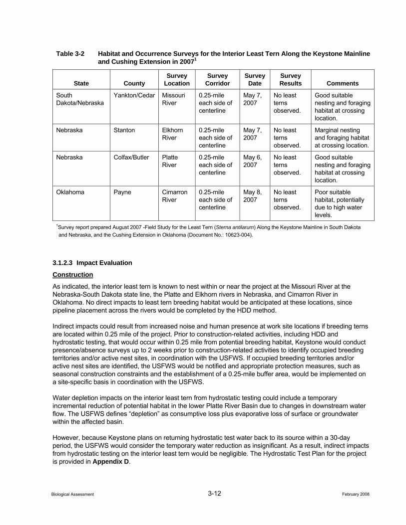
3-12 February 2008 Biological Assessment
Table 3-2 Habitat and Occurrence Surveys for the Interior Least Tern Along the Keystone Mainline and Cushing Extension in 20071
State County Survey
Location Survey
Corridor Survey
Date Survey Results Comments
South Dakota/Nebraska
Yankton/Cedar Missouri River
0.25-mile each side of centerline
May 7, 2007
No least terns observed.
Good suitable nesting and foraging habitat at crossing location.
Nebraska Stanton Elkhorn River
0.25-mile each side of centerline
May 7, 2007
No least terns observed.
Marginal nesting and foraging habitat at crossing location.
Nebraska Colfax/Butler Platte River
0.25-mile each side of centerline
May 6, 2007
No least terns observed.
Good suitable nesting and foraging habitat at crossing location.
Oklahoma Payne Cimarron River
0.25-mile each side of centerline
May 8, 2007
No least terns observed.
Poor suitable habitat, potentially due to high water levels.
1Survey report prepared August 2007 -Field Study for the Least Tern (Sterna antilarum) Along the Keystone Mainline in South Dakota and Nebraska, and the Cushing Extension in Oklahoma (Document No.: 10623-004).
3.1.2.3 Impact Evaluation
Construction
As indicated, the interior least tern is known to nest within or near the project at the Missouri River at the Nebraska-South Dakota state line, the Platte and Elkhorn rivers in Nebraska, and Cimarron River in Oklahoma. No direct impacts to least tern breeding habitat would be anticipated at these locations, since pipeline placement across the rivers would be completed by the HDD method.
Indirect impacts could result from increased noise and human presence at work site locations if breeding terns are located within 0.25 mile of the project. Prior to construction-related activities, including HDD and hydrostatic testing, that would occur within 0.25 mile from potential breeding habitat, Keystone would conduct presence/absence surveys up to 2 weeks prior to construction-related activities to identify occupied breeding territories and/or active nest sites, in coordination with the USFWS. If occupied breeding territories and/or active nest sites are identified, the USFWS would be notified and appropriate protection measures, such as seasonal construction constraints and the establishment of a 0.25-mile buffer area, would be implemented on a site-specific basis in coordination with the USFWS.
Water depletion impacts on the interior least tern from hydrostatic testing could include a temporary incremental reduction of potential habitat in the lower Platte River Basin due to changes in downstream water flow. The USFWS defines “depletion” as consumptive loss plus evaporative loss of surface or groundwater within the affected basin.
However, because Keystone plans on returning hydrostatic test water back to its source within a 30-day period, the USFWS would consider the temporary water reduction as insignificant. As a result, indirect impacts from hydrostatic testing on the interior least tern would be negligible. The Hydrostatic Test Plan for the project is provided in Appendix D.
3-13 February 2008 Biological Assessment
Operations
Similar constraints and/or mitigation measures may apply to any pipeline maintenance activities if nesting terns are present within 0.25 mile of the project. Operations personnel would coordinate with the USFWS to establish authorized mitigation if maintenance activities are required during the nesting season within 0.25 mile of suitable nesting habitat.
The major rivers that contain interior least tern habitat (Cimarron, Platte, Elkhorn, and Missouri at the Nebraska/South Dakota state line) would be crossed using the HDD method. In the unlikely event of a leak, the crude oil would need to penetrate this significant amount of overburden before reaching the river, thereby reducing the risk of crude oil reaching the river and the potential for least tern exposure. Additionally, these major rivers also are subject to an intensive integrity management program stipulated by the USDOT (Integrity Management Rule, 49 CFR Part 195). Further, if a spill event were to occur, federal and state laws would require cleanup of a spill of sufficient size to potentially impact interior least tern.
Direct contact with a crude oil spill could result in adverse effects to interior least terns due to oiling of plumage, ingestion of crude oil from contaminated plumage and prey, and transfer of crude oil to eggs and young. While these exposure routes have the potential to cause adverse effects to individuals, the probability of adverse effects to interior least terns are unlikely due to: 1) the low probability of a spill and 2) the low probability of the spill coinciding with the presence of least tern individuals (see Appendix E, Environmental Fate and Risk Associated with Crude Oil, for further information regarding impacts to wildlife from a potential spill event).
As discussed above in Chapter 2, electrical powerline providers, not Keystone, would be responsible for obtaining the necessary approvals or authorizations from federal, state, and local governments. The construction of a new electrical powerline segment across the Elkhorn River would incrementally increase the collision potential for foraging interior least terns in the project area. Based on the 2007 habitat and occurrence surveys for this species at the Elkhorn River crossing, breeding habitat quality within 0.25-mile from the project was considered to be of marginal quality. Protection measures that could be implemented by electrical service providers to minimize or prevent collision risk to foraging interior least terns at the Elkhorn River crossing would include the use of standard measures as outlined in Mitigating Bird Collision with Power Lines (Avian Power Line Interaction Committee [APLIC] 1994). The DOS, RUS, and WAPA have committed to consult with the USFWS for the electrical infrastructure component of the Keystone Project (Letter of Intent among DOS, RUS, WAPA, and Keystone) once the precise location, routing, and construction procedures for electrical powerlines has been determined, DOS, RUS, or WAPA will consult with the USFWS to prevent impacts to foraging and roosting habitat.
3.1.2.4 Cumulative Impacts
No future state, local, or private actions that are reasonably certain to occur in the project area have been identified for the project.
3.1.2.5 Conservation Measures
The following conservation measures would apply if construction-related activities, including HDD and hydrostatic testing, were to occur during the interior least tern breeding season:
• Pre-construction surveys would occur within 0.25 mile from suitable breeding habitat at the Cimarron River in Oklahoma, the Platte and Elkhorn rivers in Nebraska, or the Missouri River at the Nebraska-South Dakota state line, no more than two weeks prior to construction.
• Construction would not be permitted within a 0.25-mile buffer from an occupied nest site during the breeding season (April 15 though August 15).
3-14 February 2008 Biological Assessment
3.1.2.6 Determination
Effect on Critical Habitat. No critical habitat has been identified for this species. Therefore, the project would have “no effect” on critical habitat for the interior least tern.
Effect on the Species. The project “may affect, but is not likely to adversely affect” interior least terns. This determination is based on Keystone’s plan to HDD the Missouri (Missouri River at the Nebraska-South Dakota state line), Platte, Elkhorn, and Cimarron rivers; Keystone’s CMR and Hydrostatic Test plans; and applicable protection measures that have been developed for this species. As a result no direct or indirect impacts would result from project construction.
The project would have no effect on the interior least tern from water depletion issues resulting from hydrostatic testing. This finding is based on Keystone’s commitment to return the hydrostatic test water to its source within a 30-day period.
Although it is possible that a spill event could result in an adverse affect on this species, the probability of adverse effects to interior least terns are unlikely due to: 1) the low probability of a spill and 2) the low probability of the spill coinciding with the presence of least tern individuals.
3.1.2.7 Literature Cited
Avian Power Line Interaction Committee (APLIC). 1994. Mitigating Bird Collision with Power Lines: The State of the Art in 1994. Edison Electrical Institute. Washington, D.C.
Biota Information System of New Mexico. 2002. Biological Database for New Mexico. The New Mexico Department of Game and Fish in Cooperation with the Bureau of Land Management, U.S. Fish and Wildlife Service, U.S. Army Corps of Engineers, Bureau of Reclamation, U.S. Forest Service, and the University of New Mexico. http://www.gmfsh.state.nm.us/PageMill_TExt/NonGame/swwh.html
Campbell, L. 1995. Endangered and Threatened Animals of Texas: Their Life Histories and Management. Texas Parks and Wildlife Department, Resource Protection Division, Endangered Resources Branch. 130 pp.
Federal Register (FR). 1985. Endangered and Threatened Wildlife and Plants; Interior Population of Least Tern to be Endangered. Final Rule. Federal Register 50(102):21784-21792.
Nelson, D. L. 1998. Least Tern In: Colorado Breeding Bird Atlas. H. E. Kingery (ed.) Published by Colorado Bird Atlas Partnership; co-published by Colorado Division of Wildlife. pp. 192-193.
U.S. Fish and Wildlife Service (USFWS). 2006a. Draft U.S. Fish and Wildlife Service Mountain-Prairie Region. Letter [No date].
_____. 2006b. U.S. Fish and Wildlife Service Mountain-Prairie Region. Letter dated April 28, 2006.
_____. 1990. Recovery Plan for the Interior Least Tern (Sterna antillarum). U.S. Fish and Wildlife Service. Twin Cities, Minnesota. 90 pp.
Whittier, J. 2001. U.S. Fish and Wildlife Biologist, South Dakota Ecological Field Office, Pierre, South Dakota. Personal communication with C. Johnson, ENSR, Fort Collins, Colorado. November 30, 2001.
3.1.3 Whooping Crane
3.1.3.1 Natural History and Habitat Association
The whooping crane (Grus americana) was listed as endangered on March 11, 1967 (32 FR 4001). Whooping cranes occur only in North America and the total wild population was estimated at 315 birds in 2003 (Canadian Wildlife Service [CWS] and USFWS 2005). This estimate includes the 194 birds in the only self-sustaining
3-15 February 2008 Biological Assessment
Aransas-Wood Buffalo National Park Population (AWBP) that winters in coastal marshes in Texas and migrates to Canada to nest in Wood Buffalo National Park and adjacent areas as well as the 121 captive-raised birds that have been released in Florida and the eastern U.S. in an effort to establish a non-migratory population in Florida and a migratory population between Florida and Wisconsin (CWS and USFWS 2005). The last remaining bird in the Rocky Mountain reintroduced population died in the spring of 2002 (CWS and USFWS 2005). The overall decline of the whooping crane has been attributed to habitat loss, direct disturbance and hunting by humans, predation, disease, and collisions with manmade features (CWS and USFWS 2005).
During spring and fall migration, the AWBP population moves through the central Great Plains including portions of North Dakota, South Dakota, Nebraska, Kansas, and Oklahoma. Birds from the AWBP population depart from their wintering grounds in Texas from late March through May 1. Fall migration typically begins in mid-September with most birds arriving on wintering grounds between late October and mid-November (CWS and USFWS 2005).
Whooping cranes use a variety of habitats during migration (Howe 1987; Lingle 1987; Lingle et al. 1991; Johns et al. 1997). The whooping crane is most closely associated with river bottoms, marshes, potholes, prairie grasslands, and croplands (CWS and USFWS 2005). In states without riverine habitats, seasonally and semi-permanently flooded palustrine wetlands are used for roosting and various cropland and emergent wetlands for feeding (Austin and Richert 2001; Johns et al. 1997). They generally feed on small grains (including a number of cultivated crops), aquatic plants, insects, crustaceans, and small vertebrates (Oklahoma State University 1993). Cranes roost on submerged sandbars in wide unobstructed channels that are isolated from human disturbance (Armbruster 1990).
Critical habitat for migrating birds has been designated in three states (Nebraska, Kansas, Oklahoma) crossed by the project (CWS and USFWS 2005). However, no critical habitat would be crossed by the project. In Nebraska an area of critical habitat has been designated along the “Platte River Bottoms,” which includes a 3-mile swath along the river, with the south boundary paralleling Interstate 80 (I-80), beginning at the junction of U.S. Highway 283 and I-80 near Lexington and extending eastward along I-80 to the interchange for Shelton and Dehman, Nebraska, near the Buffalo-Hall County line. The two critical habitat areas in Kansas are: 1) Quivira National Wildlife Refuge in Stafford, Reno, and Rice counties and 2) Cheyenne Bottoms State Waterfowl Management Area in Barton County. The Salt Plains National Wildlife Refuge in Alfalfa County is the critical habitat area identified in Oklahoma.
3.1.3.2 Potential Presence in Project Area
The project in Oklahoma, Kansas, Nebraska, South Dakota, and North Dakota is east of the primary migration pathway of whooping crane through the central Great Plains (CWS and USFWS 2005). However, individual birds can be found outside the primary movement corridor and could possibly occur along the project during spring and fall migration. Possible areas of occurrence would include the major rivers crossed by the project and associated river bottom wetlands. Designated Critical Habitat Areas and other identified important stopover or roosting sites occur several miles west of the project (CWS and USFWS 2005). Therefore, the probability of whooping cranes being found on or near the project during spring and fall migration is low.
3.1.3.3 Impact Evaluation
Construction
No direct impacts to the whooping crane are anticipated from the construction and operation of the project. Although potentially suitable roosting and /or foraging habitat may occur along the project, historic records for this species in the project area are sporadic, and established communal roost sites have not been documented in or adjacent to the project. Consequently, based on the current migration pathway of this species through central Oklahoma, Kansas, Nebraska, South Dakota, and North Dakota, potential occurrence within or near the project would be limited to individual migrants.
3-16 February 2008 Biological Assessment
Indirect impacts could result from migrating individuals being flushed from the project during construction-related activities. Since whooping cranes are highly mobile, it is anticipated that individuals would move to other suitable resting and foraging habitats within the project region. Based on the rarity of the species, and location of the project outside of the primary migration route for this species, potential impacts from encountering and flushing a migrating whooping crane from the project would be negligible. Habitat loss from project construction would be negligible since the major river crossings would be crossed using the HDD method and any disturbance adjacent to suitable riverine habitat would be allowed to completely revegetate following project construction.
Water depletion impacts on the whooping crane from hydrostatic testing could include a temporary incremental reduction of potential habitat in the lower Platte River Basin due to changes in downstream water flow. The USFWS defines “depletion” as consumptive loss plus evaporative loss of surface or groundwater within the affected basin.
However, because Keystone plans on returning water back to its source within a 30-day period, the USFWS would consider the temporary water reduction as insignificant. As a result, indirect impacts from hydrostatic testing on the whooping crane would be negligible. The Hydrostatic Test Plan for the project is provided in Appendix D.
Operations
Because the project is downstream of designated whooping crane critical habitat, it is unlikely that impacts from operations would affect this species.
The major rivers with the highest potential for occurrence for whooping cranes (Cimarron, Platte, Elkhorn, and Missouri at the Nebraska/South Dakota state line) would be crossed by HDD. In the unlikely event of a leak, the crude oil would need to penetrate this significant amount of overburden before reaching the river, thereby reducing the risk of crude oil reaching the river and thereby reducing the potential for whooping crane exposure. Additionally, these major rivers also are subject to an intensive integrity management program stipulated by the USDOT (Integrity Management Rule, 49 CFR Part 195). Further, if a spill event were to occur, federal and state laws would require cleanup of a spill of sufficient size to potentially impact whooping crane.
Direct contact with a crude oil spill could result in adverse effects to whooping crane due to oiling of plumage, ingestion of crude oil from contaminated plumage and prey, and transfer of crude oil to eggs and young. While these exposure routes have the potential to cause adverse effects to individuals, the probability of adverse effects to whooping cranes are unlikely due to: 1) the low probability of a spill and 2) the low probability of the spill coinciding with the presence of whooping crane individuals (see Appendix E, Environmental Fate and Risk Associated with Crude Oil, for further information regarding impacts to wildlife from a potential spill event).
As discussed above in Chapter 2, electrical powerline providers, not Keystone, would be responsible for obtaining the necessary approvals or authorizations from federal, state, and local governments. The construction of approximately 173 miles of new electrical powerline segments would incrementally increase the collision potential for migrating whooping cranes in the project area. However, because the primary migration corridor for this species occurs west of the project area, the likelihood for migrating individuals to collide with a powerline located in the project area would be relatively low. Protection measures that could be implemented by electrical service providers to minimize or prevent collision risk to migrating whooping cranes in the project area would include the use of standard measures as outlined in Mitigating Bird Collision with Power Lines (APLIC 1994). The DOS, RUS, and WAPA have committed to consult with the USFWS for the electrical infrastructure component of the Keystone Project (Letter of Intent among DOS, RUS, WAPA, and Keystone) once the precise location, routing, and construction procedures for electrical powerlines has been determined, DOS, RUS, or WAPA will consult with the USFWS to prevent impacts to foraging habitat.
3-17 February 2008 Biological Assessment
3.1.3.4 Cumulative Impacts
No future state, local, or private actions that are reasonably certain to occur in the project area have been identified for the project.
3.1.3.5 Conservation Measures
Keystone will provide monitors during the spring and autumn migrations in those locations along the ROW where suitable habitat exists to be vigilant for the presence of whooping cranes. If a crane is found close to the ROW, then work will be suspended until released by the FWS.
3.1.3.6 Determination
Effect on Critical Habitat. The project would have “no effect” on critical habitat for the whooping crane. Areas of designated critical habitat for whooping crane are well outside of the project area.
Effect on the Species. The project “may affect, but is not likely to adversely affect” whooping cranes. This determination is based on the rarity of the species, and the location of the project area, located outside of the primary migration route for this species. This determination also is based on Keystone’s CMR and Hydrostatic Test plans that have been developed for the project. As a result, no direct impacts would result from project construction. Indirect impacts from encountering and flushing a migrating whooping crane from the project would be negligible.
The project would have no effect on the whooping crane from water depletion issues resulting from hydrostatic testing. This finding is based on Keystone’s commitment to return the hydrostatic test water to its source within a 30-day period.
Although it is possible that a spill event could result in an adverse affect on this species, the probability of adverse effects to whooping cranes are unlikely due to: 1) the low probability of a spill and 2) the low probability of the spill coinciding with the presence of whooping crane individuals.
3.1.3.7 Literature Cited
Armbruster, M. J. 1990. Characterization of habitat used by whooping cranes during migration. Biological Report 90(4):1-16.
Austin, J. E. and A. L. Richert. 2001. A Comprehensive Review of the Observational and Site Evaluation Data of Migrant Whooping Cranes in the United States, 1943-99. U.S. Geological Survey, Northern Prairie Wildlife Research Center, Jamestown, North Dakota, and State Museum, University of Nebraska, Lincoln, Nebraska. 157 pp. http://www.npwrc.usgs.gov/resource/2003/wcdata/ wcdata/.htm. (Version 01JUL03).
Avian Power Line Interaction Committee (APLIC). 1994. Mitigating Bird Collision with Power Lines: The State of the Art in 1994. Edison Electrical Institute. Washington, D.C.
Canadian Wildlife Service (CWS) and U.S. Fish and Wildlife Service (USFWS). 2005. Draft International Recovery Plan for the Whooping Crane. Ottawa: Recovery of Nationally Endangered Wildlife (RENEW) and U.S. Fish and Wildlife Service, Albuquerque, New Mexico. 196 pp.
Federal Register (FR). 1967. Endangered Species List-1967. Federal Register 32:4001.
Howe, M. A. 1987. Habitat Use by Migrating Whooping Cranes in the Aransas-Wood Buffalo Corridor. Pages 303-311, In: J. C. Lewis and J. W. Ziewitz, eds. Proc. 1985 Crane Workshop. Platte River Whooping Crane Habitat Maintenance Trust and USFWS, Grand Island, Nebraska.
Johns, B. W., E. J. Woodsworth, and E. A. Driver. 1997. Habitat Use by Migrant Whooping Cranes in Saskatchewan. Proceedings North American Crane Workshop 7:123-131.
3-18 February 2008 Biological Assessment
Lingle, G. R. 1987. Status of Whooping Crane Migration Habitat Within the Great Plains of North America. Pages 331-340 In: J. C. Lewis and J. Zewitz, eds. Proc. 1985. Crane Workshop. Platte River Whooping Crane Habitat Maintenance Trust and USFWS, Grand Island, Nebraska.
Lingle, G. R., G. A. Wingfield, and J. W. Ziewitz. 1991. The Migration Ecology of Whooping Cranes in Nebraska, U.S.A. Pages 395-401 In: J. Harris, ed. Proc. 1987 International Crane Workshop, International Crane Foundation, Baraboo, Wisconsin.
Oklahoma State University. 1993. Oklahoma’s Endangered and Threatened Species. Forestry Extension Report #6. Oklahoma Cooperative Extension Service, Division of Agricultural Sciences and Natural Resources, Oklahoma State University. 43 pp.
3.1.4 Pallid Sturgeon
3.1.4.1 Natural History and Habitat Association
The pallid sturgeon (Scaphirhynchus albus) was listed as endangered on September 6, 1990 (55 FR 36641). This species is native to the Missouri and Mississippi rivers and is adapted to habitat conditions in these large rivers prior to river modifications. Preferred habitat is described as large, free-flowing rivers with warm water, turbid habitat with a diverse mix of physical habitats that were in a constant state of change (USFWS 1993). Pallid sturgeon is adapted for living close to the bottom of large, shallow, silty rivers with sand and gravel bars. Adults and larger juveniles feed primarily on fish while smaller juveniles feed primarily on the larvae of aquatic insects (Wilson 2004).
Macrohabitat environments required by pallid sturgeon are formed by floodplains, backwaters, chutes, sloughs, islands, sandbars, and main channel waters within the large river ecosystem. Prior to dam development along the Missouri and Mississippi rivers, these features were in a constant state of change. With the introduction of dams and bank stabilization, areas of former river habitat have been covered by lakes, water velocity has increased in remaining river sections making deep stretches of clear water, and water temperatures have significantly decreased. All of these factors are believed to have contributed to the decline in pallid sturgeon populations (USFWS 1993).
The pallid sturgeon has never been common since it was first described in 1905, and catch records and recovery and research efforts since that time have indicated a steady decline in this species (Wilson 2004). The historic range of this fish formerly included the Mississippi River (below its confluence with the Missouri River), the Missouri River, and the very lower reaches of the Platte, Kansas, and Yellowstone Rivers near their confluence with the Missouri or Mississippi (USFWS 1993). Although widely distributed, pallid sturgeon remains one of the rarest fish in the Missouri and Mississippi river basins.
No critical habitat has been designated for the pallid sturgeon (http://ecos.fws.gov/speciesProfile/ SpeciesReport.do?spcode=E06X), but sections of rivers relatively unchanged by dam construction and operation that maintain large, turbid, free-flowing river characteristics are important in maintaining residual populations of this species.
3.1.4.2 Potential Presence in Project Area
River sections near the project where pallid sturgeon are most frequently collected include the Missouri River at the mouth of the Platte River near Plattsmouth, Nebraska, east of the project, and the Mississippi River near Chester, Illinois, south of the project (USFWS 1993; Wilson 2004). Recent collections data indicate that the Chain-of-Rocks area in the Mississippi River, below the mouth of the Missouri River, may be an important area for pallid sturgeon (Collins 2007). The river crossings where the pallid sturgeon may occur, but is not likely to be common, include the Mississippi River at the Illinois-Missouri state line, the Platte River in Nebraska, and the Missouri River near Yankton at the Nebraska-South Dakota state line.
3-19 February 2008 Biological Assessment
3.1.4.3 Impact Evaluation
Construction
No direct impacts to the pallid sturgeon would result from the project. Although pallid sturgeon may be present at the crossings of the Mississippi River at the Illinois-Missouri state line, the Platte River in Nebraska, and the Missouri River near Yankton at the Nebraska-South Dakota state line, these river crossings would be crossed using the HDD method, and there would be no direct effect on potential river bottom habitat for pallid sturgeon.
At streams and rivers crossed by the HDD method, a small electric pump and hose (1 to 2 inches in diameter) would be placed in the waterbody to provide water to the HDD operation. The intake end of this pump would be screened using an appropriate mesh size to prevent entrainment or entrapment of larval fish or other aquatic organisms. The withdrawal rates for the pumps would occur at a rate of less than 15cm/s, thus reducing the potential for entrainment or entrapment of aquatic species. The intake screens would be periodically checked for entrainment of fish. Should a sturgeon become entrained, Keystone would immediately stop operations contact the USFWS to determine if additional protection measures would be required. The water withdrawals would take place in conjunction with the HDD operations. Many of the HDDs would take place early in the construction period, potentially during the pallid sturgeon spawning period. However, the combination of effective screening and low water withdrawal rates would prevent impacts to the species.
Additionally, the Mississippi River at the Illinois-Missouri state line, the Platte River in Nebraska, and the Missouri River near Yankton at the Nebraska-South Dakota state line have been identified as water sources to be used for hydrostatically testing the pipeline. During this testing process, a pump would be placed in or adjacent to the river for the duration of the water intake and filling period. The intake end of the pump would be screened to prevent entrainment of larval fish or debris. Care would be taken during the discharge to prevent erosion or scouring of the waterbody bed and banks.
Water depletion impacts on the pallid sturgeon from hydrostatic testing could include a temporary incremental reduction of potential habitat in the lower Platte River Basin due to changes in downstream water flow. The USFWS defines “depletion” as consumptive loss plus evaporative loss of surface or groundwater within the affected basin.
However, because Keystone plans on returning water back to its source within a 30-day period, the USFWS would consider the temporary water reduction as insignificant. As a result, indirect impacts from hydrostatic testing on the pallid sturgeon would be negligible. The Hydrostatic Test Plan for the project is provided in Appendix D.
Operations
Routine pipeline operations would not affect the pallid sturgeon.
Suitable habitat within the Missouri River (both crossings) and the Mississippi River would be crossed by HDD. In the unlikely event of a leak, the crude oil would need to penetrate this significant amount of overburden before reaching the river, thereby reducing the risk of crude oil reaching the river and thereby reducing the potential for pallid sturgeon exposure. Additionally, these major rivers also are subject to an intensive integrity management program stipulated by the USDOT (Integrity Management Rule, 49 CFR Part 195).
In the unlikely event of a spill that would enter a river, exposure to crude could result in adverse toxicological effects to pallid sturgeon. However, the probability of adverse effects to pallid sturgeon are unlikely due to: 1) the low probability of a spill, 2) the low probability of the spill reaching a major river in sufficient amounts to cause toxic effects, and 3) low probability of a spill in a river reach where pallid sturgeon are present. Further, if a spill event were to occur, federal and state laws would require cleanup of a spill of sufficient size to potentially impact pallid sturgeon (see Appendix E, Environmental Fate and Risk Associated with Crude Oil, for further information regarding impacts to wildlife from a potential spill event).
3-20 February 2008 Biological Assessment
3.1.4.4 Cumulative Impacts
No future state, local, or private actions that are reasonably certain to occur in the project area have been identified for the project.
3.1.4.5 Conservation Measures
The Keystone Project proposes to implement HDD under the Missouri (both crossings) and Mississippi rivers.
3.1.4.6 Determination
Effect on Critical Habitat. No areas of critical habitat have been identified for pallid sturgeon. Therefore, the project would have “no effect” on critical habitat for pallid sturgeon.
Effect on the Species. The project “may affect, but is not likely to adversely affect” the pallid sturgeon. This determination is based on Keystone’s plan to HDD the Missouri and Mississippi rivers, and Keystone’s CMR Plan that have been developed for the project. As a result, no direct or indirect impacts would result from project construction.
The project would have no effect on the pallid sturgeon from water depletion issues resulting from hydrostatic testing. This finding is based on Keystone’s commitment to return the hydrostatic test water to its source within a 30-day period.
Although it is possible that a spill event could result in an adverse affect on this species, the probability of such an event would be unlikely due to: 1) the low probability of a spill, 2) the low probability of the spill reaching a major river in sufficient amounts to cause toxic effects, and 3) low probability of a spill in a river reach where pallid sturgeon are present.
3.1.4.7 Literature Cited
Collins, J. 2007. U.S. Fish and Wildlife Service, Illinois Ecological Field Office. Draft Biological Assessment Comments. Fall 2007.
Federal Register (FR). 1990. Endangered and Threatened Wildlife and Plants; Determination of Endangered Status of Pallid Sturgeon. Final Rule. Federal Register 55(173):36641-36647.
U.S. Fish and Wildlife Service (USFWS). 1993. Pallid Sturgeon Recovery Plan. U.S. Fish and Wildlife Service, Bismarck, North Dakota. 55 pp.
Wilson, R. 2004. Pallid sturgeon recovery update. Issue No.14:1-25. http://www.fws.gov/moriver/Pallid% 20Sturgeon%20Activities.htm.
3.1.5 Topeka Shiner
3.1.5.1 Natural History and Habitat Association
The Topeka shiner (Notropis topeka) was listed as federally endangered on December 15, 1998 (63 FR 69008). Protection was deemed necessary as the result of precipitous population declines and range contractions that have been attributed to: 1) increased sedimentation as the result of row crop agriculture; 2) increased pesticide use; 3) construction of watershed lakes and associated introduction of large piscivores; and 4) over-grazing of riparian vegetation, among others.
Topeka shiners are typically found in small prairie streams with good water quality, having water temperatures moderated by groundwater inputs, and low fish diversity (Minckley and Cross 1959; Barber 1986; Pflieger 1997). Streams are generally categorized as perennial but might become intermittent during the summer or in extreme weather patterns. Regardless of flow, most observations in Kansas, Missouri, and Nebraska indicated the importance of and preference of Topeka shiners for pool macrohabitat types (Everman and Cox 1896;
3-21 February 2008 Biological Assessment
Minckley and Cross 1959; Pflieger 1997) having water levels stabilized by ground water inputs. In South Dakota, Wall et al. (2001) and Cunningham (2002) reported the occurrence of Topeka shiners from a variety of macrohabitat types including; degraded streams, off-channel backwaters, borrow pits, and sloughs in contrast to those considered typical in Nebraska, Kansas, and Missouri. However, groundwater availability was a primary predictor of presence within the native range in South Dakota (Blausey 2001; Wall et al. 2001).
The Topeka shiner is a shoaling species found throughout the water column and often in association with other species including central stonerollers (Campostoma anomalum), bluntnose minnows (P. notatus), and fathead minnows (Kerns 1983; Stark et al. 1999). Topeka shiners feed on small macroinvertebrates, fish larvae, microcrustaceans, and some plant material. These might be taken in an opportunistic fashion from the surface and midwater or in association with the activity of the benthic species mentioned above.
Topeka shiners spawn from late-May to mid-August in pool habitats over green sunfish (Lepomis cyanellus) and orangespotted sunfish (L. humulis) nests (Cross 1962; Pflieger 1997; Kerns and Bonneau 2002) and perhaps near fathead minnow (Pimephales promelas) nests (Stark et al. 2002). Groups of mature Topeka shiners aggregate during the spawning season and breeding males defend small territories associated with centrarchid nests or other areas of having coarse clean substrates (Pflieger 1997; Katula 1998; Hatch 2001; Kerns and Bonneau 2002; Stark et al. 2002). Based on ovarian development Topeka shiners appear to be multiple-clutch spawners (Hatch 2001).
Historically, the Topeka shiner was widespread throughout the prairie region of the central U.S. and had a range that included eastern South Dakota, southwestern Minnesota, Iowa, Nebraska, Kansas, and Missouri (Bailey and Allum 1962; Gilbert 1884). The species has exhibited major declines throughout this historic range. Specifically, there has been an 80 percent reduction in the number of historic locations where populations still persist; the majority of these losses occurring in the last 50 years (USFWS 2001). Currently, Topeka shiners occur in fragmented populations within a small portion of the historic range but recent surveys indicate that the species still occurs in isolated locations in the Smoky Hill, Big Blue, and Lower Kansas watersheds in the Kansas River Basin in Kansas; the Neosho watershed in the Arkansas River Basin in central Kansas; the Missouri, Grand, Lamine, Chariton, and Des Moines watersheds in the Missouri River Basin in Missouri; the Elkhorn and Loup watersheds in Nebraska; the Des Moines, Raccoon, Boone, Big Sioux, and Rock watersheds in Iowa; the Big Sioux, Vermilion, and James watersheds in eastern South Dakota and; the Big Sioux and Rock watersheds in southwestern Minnesota.
The USFWS has designated critical habitat for Topeka shiner in five different watersheds (60 FR 9607, 70 FR 15239). These include the North Raccoon River, Boone River, and Rock River watersheds in Iowa; the Big Sioux/Rock Rivers Watershed in Minnesota; and the Elkhorn River Watershed in Madison County, Nebraska. The USFWS excluded all previously proposed critical habitat in the states of Kansas, Missouri, and South Dakota (70 FR 15239).
3.1.5.2 Potential Presence in Project Area
South Dakota
According to recent surveys, Topeka shiner populations persist in the James and Vermillion watersheds in South Dakota (Cunningham 1999). Initial habitat surveys indicated good to marginal habitat persists at only seven stream-crossings within the historic range in South Dakota (ENSR 2006). Topeka shiner occurrence surveys were completed in June 2007 at all sites identified as suitable Topeka shiner habitat. Six Topeka shiners were identified at the Redstone Creek stream crossing location in Miner County, South Dakota. Surveys confirmed that no other stream crossing locations supported Topeka shiner populations (Table 3-3).
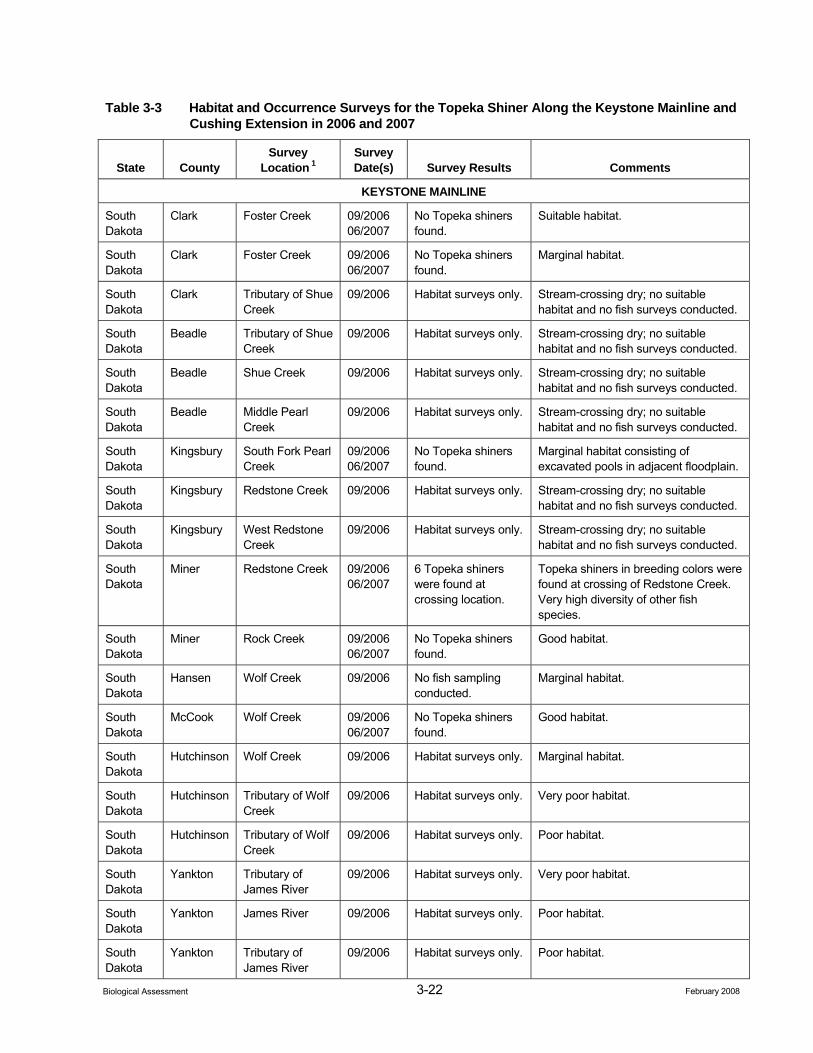
3-22 February 2008 Biological Assessment
Table 3-3 Habitat and Occurrence Surveys for the Topeka Shiner Along the Keystone Mainline and Cushing Extension in 2006 and 2007
State County Survey
Location 1 Survey Date(s) Survey Results Comments
KEYSTONE MAINLINE
South Dakota
Clark Foster Creek 09/2006 06/2007
No Topeka shiners found.
Suitable habitat.
South Dakota
Clark Foster Creek 09/2006 06/2007
No Topeka shiners found.
Marginal habitat.
South Dakota
Clark Tributary of Shue Creek
09/2006 Habitat surveys only. Stream-crossing dry; no suitable habitat and no fish surveys conducted.
South Dakota
Beadle Tributary of Shue Creek
09/2006 Habitat surveys only. Stream-crossing dry; no suitable habitat and no fish surveys conducted.
South Dakota
Beadle Shue Creek 09/2006 Habitat surveys only. Stream-crossing dry; no suitable habitat and no fish surveys conducted.
South Dakota
Beadle Middle Pearl Creek
09/2006 Habitat surveys only. Stream-crossing dry; no suitable habitat and no fish surveys conducted.
South Dakota
Kingsbury South Fork Pearl Creek
09/2006 06/2007
No Topeka shiners found.
Marginal habitat consisting of excavated pools in adjacent floodplain.
South Dakota
Kingsbury Redstone Creek 09/2006 Habitat surveys only. Stream-crossing dry; no suitable habitat and no fish surveys conducted.
South Dakota
Kingsbury West Redstone Creek
09/2006 Habitat surveys only. Stream-crossing dry; no suitable habitat and no fish surveys conducted.
South Dakota
Miner Redstone Creek 09/2006 06/2007
6 Topeka shiners were found at crossing location.
Topeka shiners in breeding colors were found at crossing of Redstone Creek. Very high diversity of other fish species.
South Dakota
Miner Rock Creek 09/2006 06/2007
No Topeka shiners found.
Good habitat.
South Dakota
Hansen Wolf Creek 09/2006 No fish sampling conducted.
Marginal habitat.
South Dakota
McCook Wolf Creek 09/2006 06/2007
No Topeka shiners found.
Good habitat.
South Dakota
Hutchinson Wolf Creek 09/2006 Habitat surveys only. Marginal habitat.
South Dakota
Hutchinson Tributary of Wolf Creek
09/2006 Habitat surveys only. Very poor habitat.
South Dakota
Hutchinson Tributary of Wolf Creek
09/2006 Habitat surveys only. Poor habitat.
South Dakota
Yankton Tributary of James River
09/2006 Habitat surveys only. Very poor habitat.
South Dakota
Yankton James River 09/2006 Habitat surveys only. Poor habitat.
South Dakota
Yankton Tributary of James River
09/2006 Habitat surveys only. Poor habitat.
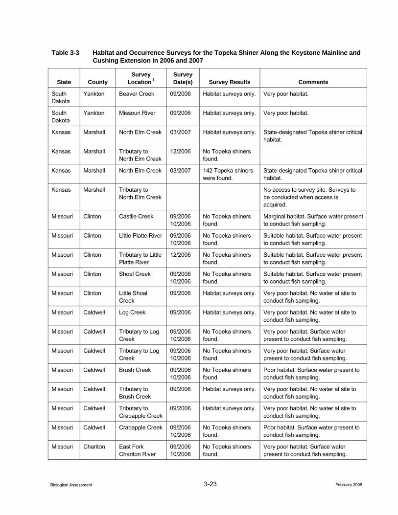
3-23 February 2008 Biological Assessment
Table 3-3 Habitat and Occurrence Surveys for the Topeka Shiner Along the Keystone Mainline and Cushing Extension in 2006 and 2007
State County Survey
Location 1 Survey Date(s) Survey Results Comments
South Dakota
Yankton Beaver Creek 09/2006 Habitat surveys only. Very poor habitat.
South Dakota
Yankton Missouri River 09/2006 Habitat surveys only. Very poor habitat.
Kansas Marshall North Elm Creek 03/2007 Habitat surveys only. State-designated Topeka shiner critical habitat.
Kansas Marshall Tributary to North Elm Creek
12/2006 No Topeka shiners found.
Kansas Marshall North Elm Creek 03/2007 142 Topeka shiners were found.
State-designated Topeka shiner critical habitat.
Kansas Marshall Tributary to North Elm Creek
No access to survey site. Surveys to be conducted when access is acquired.
Missouri Clinton Castile Creek 09/2006 10/2006
No Topeka shiners found.
Marginal habitat. Surface water present to conduct fish sampling.
Missouri Clinton Little Platte River 09/2006 10/2006
No Topeka shiners found.
Suitable habitat. Surface water present to conduct fish sampling.
Missouri Clinton Tributary to Little Platte River
12/2006 No Topeka shiners found.
Suitable habitat. Surface water present to conduct fish sampling.
Missouri Clinton Shoal Creek 09/2006 10/2006
No Topeka shiners found.
Suitable habitat. Surface water present to conduct fish sampling.
Missouri Clinton Little Shoal Creek
09/2006 Habitat surveys only. Very poor habitat. No water at site to conduct fish sampling.
Missouri Caldwell Log Creek 09/2006 Habitat surveys only. Very poor habitat. No water at site to conduct fish sampling.
Missouri Caldwell Tributary to Log Creek
09/2006 10/2006
No Topeka shiners found.
Very poor habitat. Surface water present to conduct fish sampling.
Missouri Caldwell Tributary to Log Creek
09/2006 10/2006
No Topeka shiners found.
Very poor habitat. Surface water present to conduct fish sampling.
Missouri Caldwell Brush Creek 09/2006 10/2006
No Topeka shiners found.
Poor habitat. Surface water present to conduct fish sampling.
Missouri Caldwell Tributary to Brush Creek
09/2006 Habitat surveys only. Very poor habitat. No water at site to conduct fish sampling.
Missouri Caldwell Tributary to Crabapple Creek
09/2006 Habitat surveys only. Very poor habitat. No water at site to conduct fish sampling.
Missouri Caldwell Crabapple Creek 09/2006 10/2006
No Topeka shiners found.
Poor habitat. Surface water present to conduct fish sampling.
Missouri Chariton East Fork Chariton River
09/2006 10/2006
No Topeka shiners found.
Very poor habitat. Surface water present to conduct fish sampling.
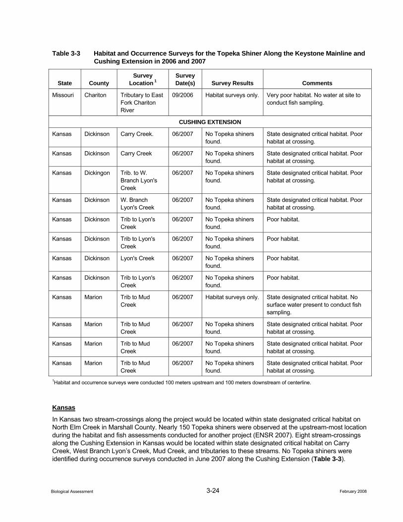
3-24 February 2008 Biological Assessment
Table 3-3 Habitat and Occurrence Surveys for the Topeka Shiner Along the Keystone Mainline and Cushing Extension in 2006 and 2007
State County Survey
Location 1 Survey Date(s) Survey Results Comments
Missouri Chariton Tributary to East Fork Chariton River
09/2006 Habitat surveys only. Very poor habitat. No water at site to conduct fish sampling.
CUSHING EXTENSION
Kansas Dickinson Carry Creek. 06/2007 No Topeka shiners found.
State designated critical habitat. Poor habitat at crossing.
Kansas Dickinson Carry Creek 06/2007 No Topeka shiners found.
State designated critical habitat. Poor habitat at crossing.
Kansas Dickingon Trib. to W. Branch Lyon's Creek
06/2007 No Topeka shiners found.
State designated critical habitat. Poor habitat at crossing.
Kansas Dickinson W. Branch Lyon's Creek
06/2007 No Topeka shiners found.
State designated critical habitat. Poor habitat at crossing.
Kansas Dickinson Trib to Lyon's Creek
06/2007 No Topeka shiners found.
Poor habitat.
Kansas Dickinson Trib to Lyon's Creek
06/2007 No Topeka shiners found.
Poor habitat.
Kansas Dickinson Lyon's Creek 06/2007 No Topeka shiners found.
Poor habitat.
Kansas Dickinson Trib to Lyon's Creek
06/2007 No Topeka shiners found.
Poor habitat.
Kansas Marion Trib to Mud Creek
06/2007 Habitat surveys only. State designated critical habitat. No surface water present to conduct fish sampling.
Kansas Marion Trib to Mud Creek
06/2007 No Topeka shiners found.
State designated critical habitat. Poor habitat at crossing.
Kansas Marion Trib to Mud Creek
06/2007 No Topeka shiners found.
State designated critical habitat. Poor habitat at crossing.
Kansas Marion Trib to Mud Creek
06/2007 No Topeka shiners found.
State designated critical habitat. Poor habitat at crossing.
1Habitat and occurrence surveys were conducted 100 meters upstream and 100 meters downstream of centerline.
Kansas
In Kansas two stream-crossings along the project would be located within state designated critical habitat on North Elm Creek in Marshall County. Nearly 150 Topeka shiners were observed at the upstream-most location during the habitat and fish assessments conducted for another project (ENSR 2007). Eight stream-crossings along the Cushing Extension in Kansas would be located within state designated critical habitat on Carry Creek, West Branch Lyon’s Creek, Mud Creek, and tributaries to these streams. No Topeka shiners were identified during occurrence surveys conducted in June 2007 along the Cushing Extension (Table 3-3).
3-25 February 2008 Biological Assessment
Missouri
In Missouri, most stream-crossings had poor habitat within streams having historic occurrences. No individuals were observed during assessments of these stream locations (Table 3-3).
Topeka shiners might move short distances upstream or downstream to spawn (Barber 1986), and vagrants from adjacent populations have been observed (Kerns 1983). However, genetic analysis suggests that migration over short distances is rare and over long distances unlikely (Michels 2000). The relatively sedentary behavior indicates that recent surveys are likely to accurately reflect the presence or absence of Topeka shiners at a given location.
3.1.5.3 Impact Evaluation
Construction
Only populations that occur within the ROW or immediately adjacent to the ROW are likely to be affected given the apparent low vagility of the species. Direct impacts to these populations could result from in-stream construction activities. Indirect affects could result from increased sediment loading within suitable habitat. However, there would be no in-stream construction during the spawning season; May 15th through July 31 at locations with known Topeka shiner populations, or within state-designated critical habitat. Exclusive of the spawning season at crossings of known occurrence, pre-construction relocations to upstream suitable habitat would occur to avoid “takings” of individuals. On small streams (discharges less than 20 cubic feet per second), if the crossings are made rapidly (24 to 48 hours), and stream banks and channels are stabilized with clean coarse substrates to minimize siltation as part of the construction activities, the effect on Topeka shiner populations would be minimal. On moderate to large streams, some means of maintaining flow regime would be maintained to preserve the integrity of downstream habitats. These safeguards would be implemented in Marshall, Dickinson, and Marion counties, Kansas, at the locations within state designated critical habitats, and at all other locations where fish surveys have indicated presence.
Additionally, four creeks have been identified as water sources to be used for hydrostatically testing the pipeline including three creeks in South Dakota (Foster Creek, Redstone Creek, and Wolf Creek), and one creek in Kansas (Carry Creek). During this testing process, a pump would be placed in or adjacent to the river for the duration of the water intake and filling period. The intake end of the pump would be screened to prevent entrainment of free-swimming larva or debris. Once the pipeline is filled with water and pressure tested, the water would be returned to the same drainage where it was originally withdrawn. Keystone plans on returning water back to its source within a 30-day period. Care would be taken during the discharge to prevent erosion or scouring of the waterbody bed and banks. No direct impacts are anticipated from this process to the Topeka shiner.
During hydrostatic test water withdrawals, Keystone will not withdraw more than 10 percent of the ambient stream flow, and adequate flow rates would be maintained in the waterbody to protect aquatic life and provide for downstream uses, in compliance with regulatory and permit requirements. In the event that primary test water sources do not contain adequate flow rates to support the hydrostatic test water withdrawal without affecting downstream uses and resources, the alternate water sources identified in Attachment A may be used. In some cases, the alternate water source may replace more than one primary water source. In waterbodies where sensitive species are located, Keystone would generally avoid withdrawal of hydrostatic test water until after August 1, unless specific approval is obtained in advance from the appropriate regulatory or resource agency(ies). Small withdrawals associated with horizontal directional drills may take place before August 1. In these cases, the withdrawal rates would be minor and the pump intakes would be screened with fine mesh to avoid entrainment or impingement of fish or debris. The Hydrostatic Test Plan for the project is provided in Appendix D.
Operations
Routine pipeline operations would not affect Topeka shiner.
3-26 February 2008 Biological Assessment
Most suitable Topeka shiner habitat is contained within USDOT-designated High Consequence Areas and are subject to an intensive integrity management program stipulated by the USDOT (Integrity Management Rule, 49 CFR Part 195). Consequently, the risk of a spill in these areas would be extremely unlikely, and minimizes potential impacts to this species.
In the unlikely event of a spill that would enter a river, exposure to crude could result in adverse toxicological effects to Topeka shiner. However, the probability of adverse effects to Topeka shiner are unlikely due to: 1) the low probability of a spill, 2) the low probability of the spill reaching a waterbody in sufficient amounts to cause toxic effects, and 3) low probability of a spill in a stream reach where Topeka shiner are present. Further, if a spill event were to occur, federal and state laws would require cleanup of a spill of sufficient size to potentially impact Topeka shiner (see Appendix E, Environmental Fate and Risk Associated with Crude Oil, for further information regarding impacts to wildlife from a potential spill event).
3.1.5.4 Cumulative Impacts
No future state, local, or private actions that are reasonably certain to occur in the project area have been identified for the project.
3.1.5.5 Conservation Measures
Conservation measures to be employed at crossings inhabited by Topeka shiner or within state designated Topeka shiner critical habitat would be as follows:
• Construction activities would be prohibited during the spawning period (May 15 through July 31), unless HDD methods are used. Further if the HDD method for crossing streams is not used and stream trenching is employed, conservation measures to avoid impacts to the Topeka shiner would be completed by a qualified biologist who has a federal permit to collect federally listed species.
• Outside of the spawning season, all pools would be seined within the ROW at least 2 weeks prior to construction, and fish would be relocated upstream to a pool or location of similar depth. Repeated relocation efforts may be necessary if high-water events were to delay construction activities more than 2 weeks following the initial relocation efforts. Temporary cofferdams would block off the work area in which salvage operations occur in order to prevent fish from repopulating the work area.
• Relocation activities would occur during ambient weather conditions suitable to ensure survivorship during relocation. Relocation activities would be performed in the early daytime hours to avoid ambient air temperatures that exceed 80oF.
• Individuals would be held in proper transfer containers that ensure suitable water quality conditions. This includes utilizing aeration equipment and ensuring water temperatures do not exceed ambient water temperatures. Ambient water temperatures would be collected at a depth of no more than 60 percent of maximum pool depth from the pools in which salvage efforts are attempted.
• Relocation efforts would be implemented rapidly to avoid excessive holding time prior to relocation.
• Erosion control measures would be implemented as described in Keystone’s CMR Plan (Appendix C). Erosion and sediment controls would be monitored daily during construction to ensure effectiveness, particularly after storm events.
• Banks and beds of streams would be restored using erosion control and revegetation measures as described in Keystone’s CMR Plan (Appendix C).
During operation of the pipeline and during routine inspection and maintenance, crews should be aware of the location of populations of Topeka shiners within the ROW and locations should be clearly marked on maps and described in maintenance orders. Adherence to these construction and operation guidelines and conservation measures would result in negligible foreseeable impacts to Topeka shiner populations as the result of construction and operations activities.
3-27 February 2008 Biological Assessment
3.1.5.6 Determination
Effect on Critical Habitat. No areas of federal designated critical habitat for Topeka shiner would be crossed by the project or are downstream of the project. Therefore, the project would have “no effect” on critical habitat for the Topeka shiner.
Effect on the Species. The project “may affect, but is not likely to adversely affect” the Topeka shiner. This determination is based on Keystone’s CMR and Hydrostatic Test plans, and the applicable protection measures that have been developed for this species.
Although it is possible that a spill event could result in an adverse affect on this species, the probability of such an event would be unlikely due to: 1) the low probability of a spill, 2) the low probability of the spill reaching a major river in sufficient amounts to cause toxic effects, and 3) low probability of a spill in a stream reach where Topeka shiner are present.
3.1.5.7 Literature Cited
Bailey, R. M. and M. O. Allum. 1962. Fishes of South Dakota. Miscellaneous Publications of the Museum of Zoology, University of Michigan 119:1-131.
Barber, J. M. 1986. Ecology of Topeka shiners in flint Hills streams. Unpublished master of Science thesis. Emporia state University, Emporia , Kansas.
Blausey, C. M. 2001. The status and distribution of the Topeka Shiner Notropis Topeka in eastern South Dakota. Unpublished Maser of Science thesis. South Dakota State University, Brookings.
Cross, F. B. 1962. Handbook of Fishes of Kansas. Miscellaneous Publication of the University of Kansas Museum of Natural History. No. 45, pp. 1-357.
Cunningham, G. R. 1999. A survey for the Topeka shiner (Notropis topeka) survey at selected sites within the Big Sioux, Vermillion, and James river basins in South Dakota. Eco-Centrics, Omaha. NE. 73 pp.
Cunningham, G. R. 2002. Topeka shiner surveys and population estimates in eastern South Dakota survey year 1999. Eco-Centrics, Omaha, Nebraska.
ENSR. 2007. Assessment of potential effects on Topeka shiner populations by the construction of the proposed Rockies Express Pipeline – West (REX-West) Project in Kansas and Missouri based on surveys of aquatic habitat and fish. Document No.: 04060-018-140.
_____. 2006. A field survey of suitable habitat and fish sampling for the Topeka shiner (Notropis topeka) for the Keystone Pipeline Project in Kansas and Missouri. Document No. 10623-004.
Everman B. W. and U. O. Cox. 1896. Report upon the fishes of the Missouri River Basin. Report of the U.S. Commissioner of Fish and Fisheries for 1894. Appendix 5, pp. 325-429.
Federal Register (FR). 2005. Endangered and Threatened Wildlife and Plants; Final Designation of Critical Habitat for the Topeka shiner (final rule correction). Federal Register 70(57):15239-15245.
_____. 2004. Endangered and Threatened Wildlife and Plants; Final Designation of Critical Habitat for the Topeka shiner. Federal Register 60(143):9607-9615.
_____. 1998. Endangered and Threatened Wildlife and Plants; Final Rule to List the Topeka Shiner as Endangered. Final Rule. Federal Register 63(240):69008-69021.
Gilbert, C. H. 1884. Notes on the fishes of Kansas. Bulletin Washburn College Laboratory Natural History 1(1):10-16.
3-28 February 2008 Biological Assessment
Hatch, J. T. 2001. What we know about Minnesota’s first endangered fish species: the Topeka shiner. Journal of Minnesota Academy of Science 65 (1):31-38.
Katula, R. 1998. Eureka Topeka! Tropical Fish Hobbyist 47(4):54-60.
Kerns, H. A. 1983. Notropis Topeka in Kansas distribution, habitat, life history. Unpublished Master of Art theses. University of Kansas, Lawrence. 27 pp.
Kerns, H. A and J. L. Bonneau. 2002. Aspects of life history and feeding habits of the Topeka shiner (Notropis topeka) in Kansas. Transactions of the Kansas Academy of Sciences 105 (3-4): 125-142.
Michels, A. M. 2000. Population genetic structure and phylogeography of the endangered Topeka shiner (Notropis Topeka) and the abundant sand shiner (Notropis ludibundus) using mitochondrial DNA sequence. Unpublished PhD Dissertation University of Kansas Lawrence, Kansas.
Minckley, W. L. and F. B. Cross. 1959. Distribution, habitat and abundance of the Topeka shiner Notropis Topeka (Gilbert) in Kansas. The American Midland Naturalist 61(1):210-217.
Pflieger, W. L. 1997. The fishes of Missouri. Missouri Department of Conservation, Jefferson City, Missouri. 372 pp.
Stark, W., J. Luginbill, and M. E. Eberle. 1999. The Status of the Topeka Shiner (Notropis topeka) in Willow Creek, Wallace County, Kansas. Kansas Department of Wildlife & parks, Nongame Species Program, Final Report. 13 pp.
Stark, W., J. Luginbill, and M. E. Eberle. 2002. Natural History of a Relict Population of Topeka shiner (Notropis topeka) in Northwestern Kansas. Transactions of the Kansas Academy of Sciences 105 (3-3): 143-152.
United States Fish and Wildlife Service (USFWS). 1998. Endangered and threatened wildlife and plants; final rule to list the Topeka shiner as endangered. Federal Register 63 (240: 69008-69021).
_____. 2001. Topeka Shiner-Recovery Team Technical Guidance Document (Draft). Manhattan, Kansas. Pp. 42.
Wall, S. S., C. M. Blausey, J. A. Jenks, and C. R. Berry, Jr. 2001. Topeka shiner (Notropis topeka) population status and habitat conditions in South Dakota. South Dakota Cooperative Fish and Wildlife Research Unit, Completion Report, Research Work Order 73, Brookings.
3.1.6 Higgins Eye Pearlymussel
3.1.6.1 Natural History and Habitat Association
The Higgins eye pearlymussel (Lampsilis higginsii) was listed as federally endangered on June 14, 1976 (41 FR 24062). It is a large river mussel species that occupies stable substrates varying from sand to boulders, but not substrates consisting of packed clay, flocculent silt, organic material, bedrock, concrete, or unstable sand (USFWS 2004). Higgins eye pearlymussel are usually found in mussel beds containing at least 15 other species at densities greater than 0.01 individual per square miles (mi2). In the Mississippi River, the density of all mussels in the bed typically exceeds 10/mi2 (USFWS 2004).
The historic range of Higgins eye pearlymussel included: the main stem of the Mississippi River from just north of St. Louis, Missouri to just south of St. Paul, Minnesota; Illinois, Sangamon, Rock rivers in Illinois; Iowa, Cedar, and Wapsipinicon rivers in Iowa; Wisconsin and St. Croix rivers in Wisconsin; and Minnesota River in Minnesota (USFWS 2004). Its current range is about 50 percent reduced from its historic distribution. The revised recovery plan for Higgins eye pearlymussel identifies 10 “Essential Habitat Areas” that the USFWS and its partners considered of utmost importance to the conservation of this species. Three are in the St. Croix
3-29 February 2008 Biological Assessment
River near its confluence with the Mississippi River at Prescott, Wisconsin. One is in the Wisconsin River near Orion, Wisconsin. The remaining six are in the Mississippi River between river miles 489 (Sylvan Slough, near Moline, Illinois) and 656 (Whiskey Rock, near Lansing, Iowa). These areas currently sustain, or once supported, high populations of Higgins eye pearlymussel.
Higgins eye pearlymussel occurs elsewhere in the Mississippi River but much of its former range has become severely infested by the non-native zebra mussel (Dreissena polymorpha), which has reduced habitat suitability for Higgins eye pearlymussel and other native mussel species. Zebra mussels have been identified as the most serious threat to native populations of Higgins eye pearlymussel, although construction activities, environmental contaminants, and poor water quality may also pose significant threats to mussel populations (USFWS 2004). Since zebra mussels invaded the Mississippi River in the early 1990s, only one Essential Habitat Area on the St. Croix remains free of zebra mussels and three other Essential Habitat Areas have become severely infested (USFWS 2004). There are currently no effective means of controlling or eliminating populations of zebra mussel that threaten Higgins eye pearlymussel.
Reproduction occurs when male mussels release sperm into the water, and the sperm are taken into the incurrent siphon of female mussels. Fertilized eggs (zygotes) are brooded in the gills of the females until they are released as larvae (glochidia). The glochidia attach to the gills of a fish host where they remain for about 3 weeks as they transform into juveniles. At this stage of their life cycle, the juveniles drop off their fish host and settle on suitable habitat substrate where they attach by means of a byssal thread, which prevents them from being swept away by water currents (USFWS 2004). Higgins eye pearlymussels are filter feeders. They remove small suspended food particles from the water by using their gills as feeding organs.
3.1.6.2 Potential Presence in Project Area
The historic range of the Higgins eye pearlymussel included the Mississippi River just north of St. Louis (near the project crossing of the Mississippi), upstream to the Upper Mississippi. The current distribution of the mussel extends to Pool 22 along the Upper Mississippi River. Although known populations in “Essential Habitat Areas” are all located considerable distances upstream of the project crossing of the Mississippi, it is unknown if populations of Higgins eye pearlymussel remain in the Mississippi River near the project crossing.
The Missouri River near Yankton at the Nebraska-South Dakota state line would be an additional location where the Higgins eye pearlymussel may occur, but is not likely to be common. The likelihood that populations of Higgins eye pearlymussel remain at the project crossing of the Mississippi and Missouri rivers and downstream segments potentially affected is low. The James River project crossing would be the only large river crossing with potential mussel habitat that would not be crossed using the HDD method. Surveys completed at the James River crossing in 2006 found no evidence of Higgins eye pearlymussel (ENSR 2006).
Construction
Direct impacts to the Higgins eye pearlymussel would not result from the project. Although the mussel may be present at the crossings of the Mississippi River at the Illinois-Missouri state line, and the Missouri River at the Nebraska-South Dakota state line, these rivers would be crossed using the HDD method. Consequently, there would be no direct effect on potential river bottom habitat for Higgins eye pearlymussel. The James River crossing was the only other large river crossing identified that may have potential mussel habitat. This river would not be crossed using the HDD method. Surveys completed at the James River crossing in 2006 found no evidence of Higgins eye pearlymussel (ENSR 2006).
At streams and rivers crossed by the HDD method, a small electric pump and hose (1 to 2 inches in diameter) would be placed in the waterbody to provide water to the HDD operation. The intake end of this pump would be screened using an appropriate mesh size to prevent entrainment or entrapment of free-swimming aquatic larva or other aquatic organisms. The withdrawal rates for the pumps would be low, thus reducing the potential for entrainment or entrapment of aquatic species. The water withdrawals would take place in conjunction with the HDD operations. The combination of effective screening and low water withdrawal rates would prevent direct impacts to the species.
3-30 February 2008 Biological Assessment
Additionally, the Mississippi River at the Missouri-Illinois state line, and the Missouri River at the South Dakota-Nebraska state line have been identified as water sources to be used for hydrostatically testing the pipeline. During this testing process, a pump would be placed in or adjacent to the river for the duration of the water intake and filling period. The intake end of the pump would be screened to prevent entrainment of free-swimming larva or debris. Based, on correspondence with the Missouri USFWS Ecological Field Office (USFWS 2007), no further measures for mussels would be required. Once the pipeline is filled with water and pressure tested, the water would be returned to the same drainage where it was originally withdrawn. Care would be taken during the discharge to prevent erosion or scouring of the waterbody bed and banks. No direct impacts are anticipated from this process to the Higgins eye pearlymussel. The Hydrostatic Test Plan for the project is provided in Appendix D.
Operations
Routine pipeline operations would not affect Higgins eye pearlymussel.
Suitable habitat within the Missouri River (Nebraska-South Dakota crossing) and the Mississippi River would be crossed by HDD. In the unlikely event of a leak, the crude oil would need to penetrate this significant amount of overburden before reaching the river, thereby reducing the risk of crude oil reaching the river and thereby reducing the potential for Higgins eye pearlymussel exposure. Additionally, the Missouri River crossing location is subject to an intensive integrity management program stipulated by the USDOT (Integrity Management Rule, 49 CFR Part 195).
In the unlikely event of a spill that would enter a river, exposure to crude could result in adverse toxicological effects to Higgins eye pearlymussel. However, the probability of adverse effects to Higgins eye pearlymussel are unlikely due to: 1) the low probability of a spill, 2) the low probability of the spill reaching a major river in sufficient amounts to cause toxic effects, and 3) low probability of a spill in a river reach where Higgins eye pearlymussel individuals were present. Further, if a spill event were to occur, federal and state laws would require cleanup of a spill of sufficient size to potentially impact Higgins eye pearlymussel (see Appendix E, Environmental Fate and Risk Associated with Crude Oil, for further information regarding impacts to wildlife from a potential spill event).
3.1.6.3 Cumulative Impacts
No future state, local, or private actions that are reasonably certain to occur in the project area have been identified for the project.
3.1.6.4 Conservation Measures
Keystone proposes to HDD the Mississippi and Missouri rivers used by the Higgins eye pearlymussel. Further, the project will screen any intake pumps used to withdraw water for hydrostatic testing from the rivers that may contain the mussels.
3.1.6.5 Determination
Effect on Critical Habitat. No critical habitat has been designated for Higgins eye pearlymussel. Therefore, the project would have “no effect” on critical habitat for the Higgins eye pearlymussel.
Effect on the Species. The project “may affect, but is not likely to adversely affect” the Higgins eye pearlymussel. This determination is based on Keystone’s plan to HDD the Missouri and Mississippi rivers, and Keystone’s CMR and Hydrostatic Test plans that have been developed for the project. The James River would be the only large river crossing with potential mussel habitat that would not be crossed using the HDD method. Surveys completed at the James River crossing in 2006 found no evidence of Higgins eye pearlymussel (ENSR 2006). As a result, no direct or indirect impacts to this species would result from project construction.
Although it is possible that a spill event could result in an adverse affect on this species, the probability of such an event would be unlikely due to: 1) the low probability of a spill, 2) the low probability of the spill reaching a
3-31 February 2008 Biological Assessment
major river in sufficient amounts to cause toxic effects, and 3) low probability of a spill in a river reach where Higgins eye pearlymussel are present.
3.1.6.6 Literature Cited
ENSR. 2006. A field survey for the winged mapleleaf (Quadrula fagosa) and scaleshale mussel (Leptodea leptodon) for the Keystone Pipeline Project at the James River crossing in South Dakota. Unpublished report prepared by ENSR Corporation for the Keystone Pipeline Project. Document No. 10623-004. 7 pp. + appendices.
Federal Register (FR). 1976. Endangered Status for 159 Animal Taxa. Federal Register 41:24062-24067.
U.S. Fish and Wildlife Service (USFWS). 2004. Higgins eye pearlymussel (Lampsilis higgins) Recovery Plan: first revision. U.S. Fish and Wildlife Service, Fort Snelling, Minnesota. 126 pp.
_____. 2007. Andy Roberts, Missouri - U.S. Fish and Wildlife Service. Personal communication with S. Stribley, ENSR. November 20, 2007.
3.1.7 Scaleshell Mussel
3.1.7.1 Natural History and Habitat Association
The scaleshell mussel (Leptodea leptodon) was federally listed as endangered in 2001. Scaleshell mussels live in large and medium-sized rivers with low to medium gradients, stable channels, and good water quality (USFWS 2004). It prefers stable riffles and runs with gravel or mud substrate and moderate current velocity. It is usually found where a diversity of other mussel species are concentrated (USFWS 2004). This mussel buries itself in sand, gravel, or mud bottoms with only the edge of their partially opened shells exposed. They feed by siphoning water over their gills and removing small, suspended food particles (plant debris, plankton, and other microorganisms) from the water.
The scaleshell mussel historically occurred in 55 rivers in the Mississippi River drainage over much of the eastern U.S. in a total of 13 states but, apparently, was never common (Szymanski 1998). The scaleshell mussel has been extirpated from all states in the northern and eastern portions of its range and is now known from only 14 rivers in Arkansas, Missouri, and Oklahoma (USFWS 2001). Rivers with known populations include the Meramec, Bourbeuse, Big, Gasconade, and Osage rivers in Missouri; Frog Bayou and the St. Francis, Spring, South Fork Spring, South Fourhe LaFave, and White rivers in Arkansas; and Little, Mountain Fork, and Kiamichi rivers in Oklahoma. Populations in 13 of these rivers are believed to be declining (USFWS 2004).
Relatively little is known about the life history of the scaleshell mussel. Its general biology is believed to be similar to other fresh water mussels in the family Unionidae. Like Higgins eye pearlymussel, reproduction occurs when male mussels release sperm into the water, and the sperm are taken into the incurrent siphon of female mussels. Fertilized eggs (zygotes) are brooded in the gills of the females until they mature as larvae (glochidia). The transfer pathway of Scaleshell glochidia to a host fish is unknown, but one hypothesis is that the transfer occurs through fish predation of female scaleshells. The glochidia attach to the gills of a fish host where they remain for about 2 to 3 weeks as they transform into juveniles. Laboratory studies indicate scaleshell mussels appear to utilize the freshwater drum (Aplodinotus grunniens) exclusively as a host for its larvae, although this has not been confirmed by field studies (USFWS 2004). The fact that freshwater drum are molluscivores lends some support to the ingestion hypothesis for scaleshell glochidia transfer to its fish host. Once the glochidia mature to juveniles, they drop off their fish host and settle into suitable habitat substrate (USFWS 2004).
Habitat destruction and degradation as a result of physical, chemical, and biological alterations, has and continues to threaten scaleshell populations. The major causes of such alteration are water pollution, sedimentation, channelization, sand and gravel mining, dredging, and impoundments (Szymanski 1998). The introduction of non-native freshwater bivalves into the U.S. has contributed to the decline of the native mussel
3-32 February 2008 Biological Assessment
fauna and also is likely to impact existing scaleshell populations in the future (USFWS 2004). Zebra mussels starve and suffocate native mussels by attaching to their shells to the surrounding habitat in large numbers. Zebra mussels have spread throughout much of the Mississippi River Basin, but at this time, no established populations are known to occur in streams occupied by scaleshell (USFWS 2004). However, they are likely to eventually invade these streams based on the proliferation and spread of this species that has already occurred.
3.1.7.2 Potential Presence in Project Area
Within the project area, there are no known extant populations of scaleshell mussel. The only historic population location within the project area is the Missouri River near Yankton, South Dakota (Hoke 1983; Perkins and Backlund 2003). The James River project crossing would be the only large river crossing with potential scaleshell habitat that would not be crossed using the HDD method. Surveys completed at the James River crossing in 2006 found no evidence of scaleshell mussel (ENSR 2006).
Construction
Direct impacts to the scaleshell mussel would not result from the project. Although there is a remote possibility the scaleshell may be present at the crossing of the Missouri River near Yankton, South Dakota, this river crossing would be crossed using the HDD method, and there would be no direct effect on potential river bottom habitat for scaleshell mussel. The James River crossing would be the only large river crossing with potential scaleshell habitat that would not be crossed using the HDD method. Surveys completed at the James River crossing in 2006 found no evidence of scaleshell mussel (ENSR 2006).
At streams and rivers crossed by the HDD method, a small electric pump and hose (1 to 2 inches in diameter) would be placed in the waterbody to provide water to the HDD operation. The intake end of this pump would be screened using an appropriate mesh size to prevent entrainment or entrapment of free-swimming aquatic larva or other aquatic organisms. The withdrawal rates for the pumps would be low, thus reducing the potential for entrainment or entrapment of aquatic species. The water withdrawals would take place in conjunction with the HDD operations. HDD methods are a critical part of the project and may require multiple attempts to complete the crossings. The combination of effective screening and low water withdrawal rates would prevent direct impacts to the species.
Additionally, the Missouri River at the South Dakota-Nebraska state line has been identified as water sources to be used for hydrostatically testing the pipeline. During this testing process, a pump would be placed in or adjacent to the river for the duration of the water intake and filling period. The intake end of the pump would be screened to prevent entrainment of free-swimming larva or debris. Based, on correspondence with the Missouri USFWS Ecological Field Office (USFWS 2007), no further measures for mussels would be required. Once the pipeline is filled with water and pressure tested, the water would be returned to the same drainage where it was originally withdrawn. Care would be taken during the discharge to prevent erosion or scouring of the waterbody bed and banks. No direct impacts are anticipated from this process to the scaleshell mussel. The Hydrostatic Test Plan for the project is provided in Appendix D.
Operations
Routine pipeline operations would not affect scaleshell mussel.
Suitable habitat within the Missouri River (Nebraska-South Dakota crossing) would be crossed using the HDD method. In the unlikely event of a leak, the crude oil would need to penetrate this significant amount of overburden before reaching the river, thereby reducing the risk of crude oil reaching the river and thereby reducing the potential for scaleshell mussel exposure. Additionally, the Missouri River crossing location is subject to an intensive integrity management program stipulated by the USDOT (Integrity Management Rule, 49 CFR Part 195).
In the unlikely event of a spill that would enter a river, exposure to crude could result in adverse toxicological effects to scaleshell mussel. However, the probability of adverse effects to scaleshell mussel are unlikely due to: 1) the low probability of a spill, 2) the low probability of the spill reaching a major river in sufficient amounts
3-33 February 2008 Biological Assessment
to cause toxic effects, and 3) low probability of a spill in a river reach where scaleshell mussel individuals were present. Further, if a spill event were to occur, federal and state laws would require cleanup of a spill of sufficient size to potentially impact scaleshell mussel (see Appendix E, Environmental Fate and Risk Associated with Crude Oil, for further information regarding impacts to wildlife from a potential spill event).
3.1.7.3 Cumulative Impacts
No future state, local, or private actions that are reasonably certain to occur in the project area have been identified for the project.
3.1.7.4 Conservation Measures
Keystone proposes to HDD the Missouri River at the Nebraska-South Dakota crossing, which is an area potentially used by the Higgins eye pearlymussel. Further, the project will screen any intake pumps used to withdraw water for hydrostatic testing from the rivers that may contain the mussels.
3.1.7.5 Determination
Effect on Critical Habitat. No critical habitat has been designated for scaleshell mussel. Therefore, the project would have “no effect” on critical habitat for the scaleshell mussel.
Effect on the Species. The project “may affect, but is not likely to adversely affect” the scaleshell mussel. This determination is based on Keystone’s plan to HDD the Missouri and Mississippi rivers, and Keystone’s CMR and Hydrostatic Test plans that have been developed for the project. The James River would be the only large river crossing with potential mussel habitat that would not be crossed using the HDD method. Surveys completed at the James River crossing in 2006 found no evidence of scaleshell mussel (ENSR 2006). As a result, no direct or indirect impacts to this species would result from project construction.
Although it is possible that a spill event could result in an adverse affect on this species, the probability of such an event would be unlikely due to: 1) the low probability of a spill, 2) the low probability of the spill reaching a major river in sufficient amounts to cause toxic effects, and 3) low probability of a spill in a river reach where scaleshell mussel are present.
3.1.7.6 Literature Cited
ENSR. 2006. A field survey for the winged mapleleaf (Quadrula fagosa) and scaleshale mussel (Leptodea leptodon) for the Keystone Pipeline Project at the James River crossing in South Dakota. Unpublished report prepared by ENSR Corporation for the Keystone Pipeline Project. Document No. 10623-004. 7 pp. + appendices.
Hoke, E. 1983. Unionid mollusks of the Missouri River on the Nebraska border. American Malacological Bulletin 1:71-74.
Perkins, III, K. and D. C. Backlund. 2003. A survey for winged mapleleaf (Quadula fragosa) and scaleshell (Leptodea leptodon) in the James River, South Dakota. South Dakota Department of Game, Fish and Parks Report 2003-17.
Szymanski, J. 1998. Leptodea leptodon (scaleshell mussel) rangewide status assessment 1998. U.S. Fish and Wildlife Service, Fort Snelling, Minnesota. 16 pp. + appenidices.
U.S. Fish and Wildlife Service (USFWS). 2001. Endangered and threatened wildlife and plants; final rule to list the scaleshell mussel as endangered. Federal Register 66(195) 51322-51339, October 2001.
_____. 2004. Scaleshell mussel draft recovery plan (Leptodea leptodon). U.S. Fish and Wildlife Service, Fort Snelling, Minnesota. 90 pp.
3-34 February 2008 Biological Assessment
_____. 2007. Andy Roberts, Missouri - U.S. Fish and Wildlife Service. Personal communication with S. Stribley, ENSR. November 20, 2007.
3.1.8 Running Buffalo Clover
3.1.8.1 Natural History and Habitat Association
Running buffalo clover (Trifolium stoloniferum) was listed as federally endangered on June 5, 1987 (52 FR 21478). Historically widespread from eastern Kansas to West Virginia, the population started to decline in the late 1800’s (52 FR 21478). The population decline is believed to be linked to the arrival of European settlers and the subsequent decline of bison (Bison bison) (Ford et al. 2003; Missouri Department of Conservation 2000; 52 FR 21478). Running buffalo clover was considered extinct from 1940 until the discovery of a population of four individuals in West Virginia in 1983. In 1987, it was federally listed as endangered (52 FR 21478). Since that discovery, 120 populations have been identified in five states, West Virginia, Ohio, Kentucky, Indiana, and Missouri (USFWS 2005). The largest populations are in West Virginia, while the greatest number of populations is located in Kentucky (USFWS 2007a,b).
Running buffalo clover is a short lived, stoloniferous herb (52 FR 21478; Ohio DNR 1985). Its name derives from the stolons, also called runners, which root at the nodes (USFWS 2005). Individuals are defined as a “rosette that is rooted into the ground” called a rooted crown (USFWS 2005). The species lacks a rhizobial associate, but it is unclear whether it has lost a past association or did not develop a need for an association due to a low nitrogen requirement (NatureServe 2006; USFWS 2005). While research has suggested a low nitrogen requirement (USFWS 2005), running buffalo clover is limited by its inability to fix nitrogen to areas underlain with limestone or other calcareous bedrock or soils (Missouri Department of Conservation 2007; USFWS 2005; Schuler et al. 2004). In addition, it is found in soils with a pH ranging from neutral to moderately alkaline (Missouri Department of Conservation 2007; Schuler et al. 2004). The elevation range for running buffalo clover extends from 120 to 1,000 feet (Missouri Department of Conservation 2007).
Running buffalo clover favors areas of partial to filtered sunlight as it does not tolerate full sun or full shade (USFWS 2007a,b). Mesic forests and woodlands; areas of rich soils in the stable ecotones between open forest and prairie; moist, partially shaded woodlands and along stream or river terraces are all preferred habitat (52 FR 21478). Based on historical accounts, the distribution of running buffalo clover seems to have followed the bison (Bison bison) (Ford et al. 2003). Bison and other ungulates would have created a continual, moderately disturbed habitat. Running buffalo clover is commonly found in areas with a continual, moderately intense disturbance such as grazing, mowing or trampling by ungulates (Missouri Department of Conservation 2007; 52 FR 21478). These include areas such as old trails, logging roads, jeep trails, mowed paths, old home sites and mowed wildlife openings (Missouri Department of Conservation 2007; NatureServe 2006; Ford et al. 2003). It is theorized that bison and other ungulates increased germination rates by dispersing seeds, scarifying seeds passed through their digestive tract, and enriching soils (NatureServe 2006; Ford et al. 2003).
The primary threat to running buffalo clover is habitat alteration (USFWS 2007b). Habitat destruction, the closing of forest canopies, invasive species, small natural populations, and reduction in pollinators are all threats to the survival of running buffalo (USFWS 2007b). While there is distinct genetic differences between the natural populations, individual natural populations have low genetic diversity (Crawford et al. 1998; Hickey et al. 1991). While it is unclear whether this is either a causal factor in the species’ decline or the result of having smaller, more isolated populations (Hickey et al. 1991), it is a concern in the long-term survival of the species (Crawford et al. 1998). Small populations are at risk of extirpation from physical disturbances (NatureServe 2006). Other factors that make running buffalo clover vulnerable include its dependence on seed scarification, seed dispersal and moderate disturbance by ungulates, especially bison (USFWS 2007b). In 1995, the Missouri Department of Conservation and Missouri Botanical Gardens established 24 reintroduced populations throughout Missouri. The running buffalo clover reintroductions have been relatively unsuccessful, but four populations have persisted (USFWS 2007b).
The introduction of invasive species such as European white clover (Trifolium repens), bluegrass (Poa pratensis), Nepalese browntop (Microstegium vimineum), and Garlic mustard (Alliaria petiolata) into running buffalo clover habitat has contributed to its decline (NatureServe 2006; U.S. Department of Agriculture, Natural
3-35 February 2008 Biological Assessment
Resources Conservation Service 2007). These invasive species are commonly found in disturbed areas and compete with running buffalo clover for resources (NatureServe 2006).
3.1.8.2 Potential Presence in Project Area
Historically, running buffalo clover was widespread in eastern Kansas, Missouri, and Illinois. Running buffalo clover populations in Kansas and Illinois are presumed extirpated (NatureServe 2006). In Missouri, running buffalo clover populations are found in Madison, Maries, Lincoln, and Montgomery counties. The project crosses only through Montgomery and Lincoln counties. The largest known Missouri population was found in the Loutre River Valley in 2003 at Graham Cave State Park in Montgomery County, approximately 15 miles south of the project. The project does not cross the Loutre River or tributaries to the river. The second known population of running buffalo clover is present on the floodplain of the Cuivre River in Cuivre River State Park, northeast of Troy in Lincoln County (USFWS 2006). The project would cross the Cuivre River floodplain just south of the Cuivre River State Park. Surveys would be conducted where the project crosses the floodplains of the West Fork Cuivre River and Cuivre River in Missouri prior to construction during the flowering period.
3.1.8.3 Impact Evaluation
Construction
If running buffalo clover is located within the ROW, construction of the pipeline would disturb existing plant communities as vegetation is cleared and the ground is graded. Construction of permanent ancillary facilities also could displace plant communities for the lifetime of the project. Revegetation of the ROW could introduce or expand invasive species into the project area that could compete with running buffalo clover, potentially contributing to its decline. In forested areas, construction of the pipeline would involve clearing trees and shrubs in the ROW. The creation of open areas with full sunlight could adversely affect running buffalo clover as it does not tolerate full sun.
As discussed above in Chapter 2, electrical powerline providers, not Keystone, would be responsible for obtaining the necessary approvals or authorizations from federal, state, and local governments. The construction of new electrical powerline segments could impact the running buffalo clover if powerline ROWs were to disturb potential habitat for this species. Protection measures that could be implemented by electrical service providers to prevent impacts to this species would be the same as described below under Conservation Measures.
Operations
In order to maintain accessibility of the ROW, woody vegetation directly above the pipeline periodically would be cleared and large trees would be removed from the permanent ROW. Smaller trees and shrubs would be allowed to revegetate the permanent ROW, except for an approximately 30-foot-wide corridor that would be maintained. This ROW maintenance activity could potentially benefit running buffalo clover by providing partial shade habitat needed for the species. Other maintenance activities of the ROW would include infrequent mowing, which also could benefit running buffalo clover as it would provide a source of continual moderate disturbance. Mowing would be scheduled outside the April through August sexual reproduction window (Missouri Department of Conservation 2007). If herbicides must be used for noxious weed control, application would be conducted by spot spraying. Populations of running buffalo clover would be identified and no herbicides would be used at those locations.
Direct contact with a crude oil spill could result in adverse toxicological effects to running buffalo clover. While these exposure routes have the potential to cause adverse effects, the probability of adverse effects to running buffalo clover are unlikely due to: 1) the low probability of a spill and 2) the low probability of the spill coinciding with the presence of running buffalo clover (see Appendix E, Environmental Fate and Risk Associated with Crude Oil, for further information regarding impacts to wildlife from a potential spill event).
3-36 February 2008 Biological Assessment
3.1.8.4 Cumulative Impacts
No future state, or local, or private actions that are reasonably certain to occur in the project area have been identified for the project.
3.1.8.5 Conservation Measures
Surveys for running buffalo clover would be conducted prior to construction within the floodplains of the West Fork Cuirvre River and Cuivre River in Missouri. If surveys identify running buffalo clover, Keystone would consult with the USFWS to determine appropriate conservation measures. Conservation measures for identified populations could include:
• Reducing the width of the construction ROW in areas where populations have been identified, to the extent possible.
• Salvaging and segregating topsoil appropriately where populations have been identified to preserve native seed sources in the soil for use in re-vegetation efforts in the ROW.
• Restoring habitat by using an approved seed mix provided by the NRCS or appropriate state agency.
• Collecting seed to repopulate the ROW or an appropriate offsite location, or for creation of a nursery population until viable natural populations have established themselves.
• Avoiding the population by rerouting around plants or boring under plants.
• Implementing procedures in the ROW maintenance plan that would not allow mowing or disruption of the plants during the period of sexual reproduction (April through August).
Other recommended conservation measures for populations of running buffalo clover would be developed on a site-specific basis, in consultation with the USFWS, if warranted.
3.1.8.6 Determination
Effect on Critical Habitat. No critical habitat has been identified for this species. Therefore, the project would have “no effect” on critical habitat for the running buffalo clover.
Effect on the Species. The project “may affect, but is not likely to adversely affect” running buffalo clover. This determination is based on Keystone’s CMR Plan and applicable protection measures that have been developed for this species. As a result no direct impacts would result from project construction. Indirect impacts could result from the incremental reduction of potential habitat for this species.
Although it is possible that a spill event could result in an adverse affect on this species, the probability of adverse effects to running buffalo clover are unlikely due to: 1) the low probability of a spill and 2) the low probability of the spill coinciding with the presence of running buffalo clover.
3.1.8.7 Literature Cited
Crawford, D. J., E. J. Esselman, J. L. Windus, and C. S. Pabin. 1998. Genetic Variation in Running Buffalo Clover (Trifolium stoloniferum: Fabaceae) Using Random Amplified Polymorphic DNA Markers (RAPDs). Ann. Missouri Bot. Gard. 85:81-89.
Federal Register (FR). 1987. Endangered and Threatened Wildlife and Plants; Determination of Endangered Status for Trifolium stoloniferum (Running Buffalo Clover). Final Rule. Federal Register 52(108):21478-21481.
Ford, W. M., D. Madarish, T. M. Schuler, and S. B. Castleberry. 2003. Influence of White-Tailed Deer Digestion on Running Buffalo Clover (Trifolium stoloniferum: Fabaceae Muhl. Ex A. Eaton) Germination. American Midland Naturalist. 149:425-428.
3-37 February 2008 Biological Assessment
Hickey, R. J., M. A. Vincent, and S. I. Guttman. 1991. Genetic Variation in Running Buffalo Clover (Trifolium stoloniferum, Fabaceae). Conservation Biology. 5:309-316.
Missouri Department of Conservation. 2007. Missouri Fish and Wildlife Information System Species Report. Missouri Department of Conservation Commission of Missouri. (http://mdc4.mdc.mo.gov/applications/mofwis/Mofwis_Detail.aspx?id=2012790) April 2007.
Missouri Department of Conservation. 2000. Best Management Practices, Running Buffalo Clover, Trifolium stoloniferum. Missouri Department of Conservation. (http://www.mdc.mo.gov/documents/nathis/ endangered/clover.pdf) April 2007.
NatureServe. 2006. NatureServe Explorer: An online encyclopedia of life [web application]. Version 6.1. NatureServe, Arlington, Virginia. Available http://www.natureserve.org/explorer (Accessed April 5, 2007).
Ohio Department of Natural Resources. 1985. Trifolium stoloniferum (Muhl. ex A Eaton) Running Buffalo Clover. Ohio Department of Natural Resources Division of Natural Areas and Preserves. (http://www.ohiodnr.com/dnap/Abstracts/T/trifstol.htm) April 2007.
Schuler, T. M., W. M. Ford, M. B. Adams, J. N. Kochenderfer, and P. J. Edwards. 2004. Large Area Comparisons of Forest Management Practices in West Virginia (1951-Present).
U.S. Department of Agriculture, Natural Resources Conservation Service. 2007. The PLANTS Database (http://plants.usda.gov, 10 April 2007). National Plant Data Center, Baton Rouge, LA 70874-4490 USA.
U.S. Fish and Wildlife Service (USFWS). 2007a. Endangered Species: Running Buffalo Clover (Trifolium stoloniferum) Fact Sheet. U.S. Fish and Wildlife Service Great Lakes-Big Rivers Region 3. (http://www.fws.gov/midwest/endangered/plants/runningb.html) April 2007
_____. 2007b. Running Buffalo Clover (Trifolium stoloniferum) Recovery Plan: First Revision. U.S. Fish and Wildlife Service, Fort Snelling, Minnesota. 76 pp.
_____. 2006. U.S. Fish and Wildlife Service Mountain-Prairie Region. Letters dated April 2006.
_____. 2005. Running Buffalo Clover (Trifolium stoloniferum) Draft Recovery Plan: First Revision. U.S. Fish and Wildlife Service, Fort Snelling, Minnesota. 65 pp.
3.2 Federal Threatened 3.2.1 Piping Plover
3.2.1.1 Natural History and Habitat Association
The piping plover (Chardrius melodus) was listed as endangered December 11, 1985 (50 FR 50726). Piping plover on the Great Lakes were listed as endangered, while the remaining Atlantic and Northern Great Plains populations were listed as threatened. Migrating and wintering populations of piping plover also were classified as threatened. Populations of piping plover near the project area fall under the threatened classification.
Historically, piping plover bred across three geographic regions: 1) U.S. and Canadian Northern Great Plains from Alberta to Manitoba south to Nebraska, 2) Great Lakes beaches, and 3) Atlantic coastal beaches from Newfoundland to North Carolina. Wintering areas are not well known, although wintering birds have been most often seen along the Gulf of Mexico, southern U.S. Atlantic coastal beaches from North Carolina to Florida, eastern Mexico, and scattered Caribbean Islands (Haig 1986; USFWS 1988). The piping plover’s current breeding range is similar except that breeding populations in the Great Lakes have almost disappeared (Haig and Plissner 1993).

3-38 February 2008 Biological Assessment
Piping plover begin arriving on breeding grounds in mid-April, and most birds have arrived in the Northern Great Plains and initiate breeding behavior by mid-May (USFWS 1994). Populations that nest on the Missouri, Platte, Niobrara, and other rivers use beaches and dry barren sandbars in wide, open channel beds. Nesting habitat of inland populations consists of sparsely vegetated shorelines around small alkali lakes, large reservoir beaches, river islands and adjacent sandpits, and shorelines associated with industrial ponds (Haig and Plissner 1993). Vegetation cover is usually 25 percent or less (USFWS 1994). The piping plover will feed by probing the sand and mud for insects, small crustaceans, and other invertebrates in or near shallow water. This species feeds more leisurely than other sandpipers, alternating running and pausing to search for prey (Bent 1929).
Nests consist of shallow scrapes in the sand with the nest cup often lined with small pebbles or shell fragments. The nest is typically far from cover. Nesting piping plover have been found in least tern nesting colonies at a number of sites on Great Plains river sandbars and sand pits (USFWS 1994). Egg laying commences by the second or third week in May. The female generally chooses from several nest sites the male has constructed. Complete clutches contain three to four cryptically colored eggs (USFWS 1994). Incubation is shared by the male and female and averages 26 days. Incubation begins only after the last egg is laid and eggs typically hatch on the same day. Brooding duties also are shared by the male and female. Broods remain in nesting territories until they mature unless they are disturbed. Fledging takes approximately 21 to 35 days (USFWS 1994). If a nest fails or is destroyed, adults may re-nest up to four times (USFWS 1987). Breeding adults begin leaving nesting grounds as early as mid-July with the majority gone by the end of August (Wiens 1986, as cited in USFWS 1994).
3.2.1.2 Potential Presence in Project Area
Presence of breeding piping plover within the project area is restricted to South Dakota and Nebraska. Potential breeding habitat along the project for the piping plover is restricted to sandy beaches and sandbars along the Missouri River at the Nebraska-South Dakota border; shorelines of lakes in eastern South Dakota; the Elkhorn River, Nebraska; and the Platte River, Nebraska.
On the Missouri River at the Nebraska-South Dakota state line, most breeding activity occurs on sandbars from Yankton, South Dakota, to Ponca, Nebraska, and from the Fort Randall Dam to Springfield (USFWS 1994). This section of the river has been designated as critical habitat for piping plover (USFWS 2002). Piping plover also have been found to occasionally breed on saline wetlands in northeast South Dakota (USFWS 1994). Birds breeding in Nebraska are found on sandbars and at commercial sand pits along three rivers crossed by the project: Missouri River (discussed previously), Elkhorn River, and Platte River. Crossings of these rivers were surveyed by ENSR in May 2007 to confirm absence or presence of suitable breeding habitat and breeding piping plover. One pair of foraging plovers was identified at the Missouri River crossing near Yankton, South Dakota. No nesting piping plover were identified within 0.25 mile of the ROW crossing of the rivers identified below (Table 3-4). Surveys would be repeated at these locations prior to construction to ensure that no new nests have been built within 0.25 mile of the ROW.
3.2.1.3 Impact Evaluation
Construction
Threats to piping plover nesting habitat include reservoirs, channelization of rivers, and modifications of river flows that have eliminated hundreds of kilometers of nesting habitat along Northern Great Plains’ rivers (USFWS 1994). Eggs and young are vulnerable to predation and human disturbance, including recreational activities and off-road vehicle use.
As indicated, the piping plover is known to nest within or near the project at the Missouri River (Nebraska-South Dakota state line) and the Platte and Elkhorn rivers in Nebraska. No direct impacts to the piping plover or its breeding habitat would be anticipated at these locations, since pipeline placement across the rivers would be completed using the HDD method. As a result, no impacts to breeding habitat or designated critical habitat would occur from the project.
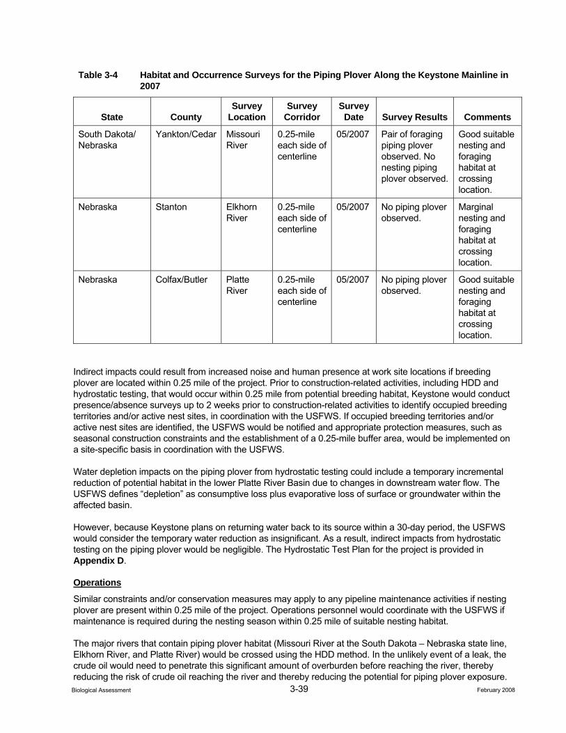
3-39 February 2008 Biological Assessment
Table 3-4 Habitat and Occurrence Surveys for the Piping Plover Along the Keystone Mainline in 2007
State County Survey
Location Survey
Corridor Survey
Date Survey Results Comments
South Dakota/ Nebraska
Yankton/Cedar Missouri River
0.25-mile each side of centerline
05/2007 Pair of foraging piping plover observed. No nesting piping plover observed.
Good suitable nesting and foraging habitat at crossing location.
Nebraska Stanton Elkhorn River
0.25-mile each side of centerline
05/2007 No piping plover observed.
Marginal nesting and foraging habitat at crossing location.
Nebraska Colfax/Butler Platte River
0.25-mile each side of centerline
05/2007 No piping plover observed.
Good suitable nesting and foraging habitat at crossing location.
Indirect impacts could result from increased noise and human presence at work site locations if breeding plover are located within 0.25 mile of the project. Prior to construction-related activities, including HDD and hydrostatic testing, that would occur within 0.25 mile from potential breeding habitat, Keystone would conduct presence/absence surveys up to 2 weeks prior to construction-related activities to identify occupied breeding territories and/or active nest sites, in coordination with the USFWS. If occupied breeding territories and/or active nest sites are identified, the USFWS would be notified and appropriate protection measures, such as seasonal construction constraints and the establishment of a 0.25-mile buffer area, would be implemented on a site-specific basis in coordination with the USFWS.
Water depletion impacts on the piping plover from hydrostatic testing could include a temporary incremental reduction of potential habitat in the lower Platte River Basin due to changes in downstream water flow. The USFWS defines “depletion” as consumptive loss plus evaporative loss of surface or groundwater within the affected basin.
However, because Keystone plans on returning water back to its source within a 30-day period, the USFWS would consider the temporary water reduction as insignificant. As a result, indirect impacts from hydrostatic testing on the piping plover would be negligible. The Hydrostatic Test Plan for the project is provided in Appendix D.
Operations
Similar constraints and/or conservation measures may apply to any pipeline maintenance activities if nesting plover are present within 0.25 mile of the project. Operations personnel would coordinate with the USFWS if maintenance is required during the nesting season within 0.25 mile of suitable nesting habitat.
The major rivers that contain piping plover habitat (Missouri River at the South Dakota – Nebraska state line, Elkhorn River, and Platte River) would be crossed using the HDD method. In the unlikely event of a leak, the crude oil would need to penetrate this significant amount of overburden before reaching the river, thereby reducing the risk of crude oil reaching the river and thereby reducing the potential for piping plover exposure.
3-40 February 2008 Biological Assessment
Additionally, these major rivers also are subject to an intensive integrity management program stipulated by the USDOT (Integrity Management Rule, 49 CFR Part 195). Further, if a spill event were to occur, federal and state laws would require cleanup of a spill of sufficient size to potentially impact piping plover.
Direct contact with a crude oil spill could result in adverse effects to piping plover due to oiling of plumage, ingestion of crude oil from contaminated plumage and prey, and transfer of crude oil to eggs and young. While these exposure routes have the potential to cause adverse effects to individuals, the probability of adverse effects to piping plover are unlikely due to: 1) the low probability of a spill and 2) the low probability of the spill coinciding with the presence of piping plover individuals (see Appendix E, Environmental Fate and Risk Associated with Crude Oil, for further information regarding impacts to wildlife from a potential spill event).
As discussed above in Chapter 2, electrical powerline providers, not Keystone, would be responsible for obtaining the necessary approvals or authorizations from federal, state, and local governments. The construction of a new electrical powerline segment across the Elkhorn River would incrementally increase the collision potential for foraging piping plover in the project area. Based on the 2007 habitat and occurrence surveys for this species at the Elkhorn River crossing, breeding habitat quality within 0.25-mile from the project was considered to be of marginal quality. Protection measures that could be implemented by electrical service providers to minimize or prevent collision risk to foraging piping plover at the Elkhorn River crossing would include the use of standard measures as outlined in Mitigating Bird Collision with Power Lines (APLIC 1994).
3.2.1.4 Cumulative Impacts
No future state, local, or private actions that are reasonably certain to occur in the project area have been identified for the project.
3.2.1.5 Conservation Measures
The following conservation measures would apply if construction-related activities, including HDD and hydrostatic testing, were to occur during the piping plover breeding season:
• If construction were to occur during the plover breeding season (April 15 through August 15), Keystone will conduct pre-construction surveys within 0.25 mile from suitable breeding habitat at the Platte and Elkhorn rivers in Nebraska, or the Missouri River at the Nebraska-South Dakota state line, no more than 2 weeks prior to construction.
• If nesting terns are found, then construction within 0.25 miles of the nest will be suspended until the fledglings have left the nest area.
3.2.1.6 Determination
Effect on Critical Habitat. The project would have “no effect” on designated critical habitat for the piping plover. The project would cross designated piping plover critical habitat along the Missouri River at the Nebraska-South Dakota state line: however, the project crossing of the river would be HDD. Therefore, no impacts to piping plover critical habitat would occur.
Effect on the Species. The project “may affect, but is not likely to adversely affect” the piping plover. This determination is based on Keystone’s construction plan to HDD the Missouri (Missouri River at the Nebraska-South Dakota state line), Platte, and Elkhorn rivers; Keystone’s CMR and Hydrostatic Test plans; and applicable protection measures that have been developed for this species.
The project would have no effect on the piping plover from water depletion issues resulting from hydrostatic testing. This finding is based on Keystone’s commitment to return the hydrostatic test water to its source within a 30-day period.
3-41 February 2008 Biological Assessment
Although it is possible that a spill event could result in an adverse affect on this species, the probability of adverse effects to piping plover are unlikely due to: 1) the low probability of a spill and 2) the low probability of the spill coinciding with the presence of piping plover individuals.
3.2.1.7 Literature Cited
Avian Power Line Interaction Committee (APLIC). 1994. Mitigating Bird Collision with Power Lines: The State of the Art in 1994. Edison Electrical Institute. Washington, D.C.
Bent, A. C. 1929. Life Histories of North American Shorebirds (Part II). U.S. National Museum Bulletin 146. Washington, D.C.
Federal Register (FR). 1985. Endangered and Threatened Wildlife and Plants; Determination of Endangered and Threatened Status for Piping Plover. Final Rule. Federal Register 50:50726-50734.
Haig, S. M. 1986. Piping Plover Species Distribution. U.S. Fish and Wildlife Service, Endangered Species Information System Workbook I.
Haig, S. M. and J. H. Plissner. 1993. Distribution and abundance of piping plover: results and implications of the 1991 census. Condor 95:145-156.
U.S. Fish and Wildlife Service (USFWS). 2002. Endangered and threatened wildlife and plants; designation of critical habitat for the Northern Great Plains breeding population of the piping plover. Federal Register 67(176):57638-57717.
_____. 1994. Draft revised recovery plan for piping plover, Charadrius melodus, breeding n the Great Lakes and Northern Great Plains of the United States. June 28, 1994. U.S. Fish and Wildlife Service, Twin Cities, Minnesota. 85 pp. + appendices.
_____. 1988. Recovery plan for piping plover breeding n the Great Lakes and Northern Great Plains. U.S. Fish and Wildlife Service, Twin Cities, Minnesota. 160 pp.
_____. 1987. Atlantic coast piping plover recovery plan. U.S. Fish and Wildlife Service, Newton Corner, Massachusetts. 245 pp.
3.2.2 Arkansas River Shiner
3.2.2.1 Natural History and Habitat Association
The Arkansas River shiner (Notropis girardi) was listed as threatened on November 23, 1998 (63 FR 64771). This listing was based on habitat destruction and modification from stream dewatering or depletions due to diversion of surface water and groundwater pumping, construction impoundments, and water quality degradation (USFWS 1998). Competition with the Red River shiner (Notropis bairdi) in the Cimarron River also has contributed to reduced distribution and abundance of Arkansas River shiner. Critical habitat has been designated for the Arkansas River shiner in the Cimarron River in Kansas and Oklahoma and the Canadian River in Oklahoma (USFWS 2005). The critical habitat includes a lateral distance of 300 feet on each side of the river width at bankfull discharge. The reach of critical habitat on the Cimarron River begins at U.S. Highway 54 in Seward County, Kansas, and continues downstream to U.S. Highway 77 Bridge near I-35 in Logan County, Oklahoma (USFWS 2005). The ROW crossing location is over 25 miles downstream of the east end of the reach of the Cimarron River designated as critical habitat.
The Arkansas River shiner inhabits the main channels of wide, shallow, sandy bottomed rivers and larger streams in the Arkansas River basin (Gilbert 1980). Adults usually are not found in quiet pools or backwaters (Cross 1967, as cited in USFWS 1998). Studies by Polivka and Matthews (1997) in the South Canadian River indicated that this species used a broad range of microhabitat features. Microhabitat types such as bank, island, sandridges, backwaters, midchannel, and pools were analyzed separately for abundance at all
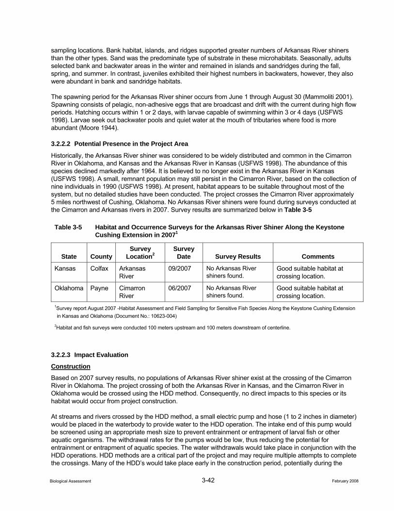
3-42 February 2008 Biological Assessment
sampling locations. Bank habitat, islands, and ridges supported greater numbers of Arkansas River shiners than the other types. Sand was the predominate type of substrate in these microhabitats. Seasonally, adults selected bank and backwater areas in the winter and remained in islands and sandridges during the fall, spring, and summer. In contrast, juveniles exhibited their highest numbers in backwaters, however, they also were abundant in bank and sandridge habitats.
The spawning period for the Arkansas River shiner occurs from June 1 through August 30 (Mammoliti 2001). Spawning consists of pelagic, non-adhesive eggs that are broadcast and drift with the current during high flow periods. Hatching occurs within 1 or 2 days, with larvae capable of swimming within 3 or 4 days (USFWS 1998). Larvae seek out backwater pools and quiet water at the mouth of tributaries where food is more abundant (Moore 1944).
3.2.2.2 Potential Presence in the Project Area
Historically, the Arkansas River shiner was considered to be widely distributed and common in the Cimarron River in Oklahoma, and Kansas and the Arkansas River in Kansas (USFWS 1998). The abundance of this species declined markedly after 1964. It is believed to no longer exist in the Arkansas River in Kansas (USFWS 1998). A small, remnant population may still persist in the Cimarron River, based on the collection of nine individuals in 1990 (USFWS 1998). At present, habitat appears to be suitable throughout most of the system, but no detailed studies have been conducted. The project crosses the Cimarron River approximately 5 miles northwest of Cushing, Oklahoma. No Arkansas River shiners were found during surveys conducted at the Cimarron and Arkansas rivers in 2007. Survey results are summarized below in Table 3-5
Table 3-5 Habitat and Occurrence Surveys for the Arkansas River Shiner Along the Keystone Cushing Extension in 20071
State County Survey
Location2 Survey
Date Survey Results Comments
Kansas Colfax Arkansas River
09/2007 No Arkansas River shiners found.
Good suitable habitat at crossing location.
Oklahoma Payne Cimarron River
06/2007 No Arkansas River shiners found.
Good suitable habitat at crossing location.
1Survey report August 2007 -Habitat Assessment and Field Sampling for Sensitive Fish Species Along the Keystone Cushing Extension in Kansas and Oklahoma (Document No.: 10623-004)
2Habitat and fish surveys were conducted 100 meters upstream and 100 meters downstream of centerline.
3.2.2.3 Impact Evaluation
Construction
Based on 2007 survey results, no populations of Arkansas River shiner exist at the crossing of the Cimarron River in Oklahoma. The project crossing of both the Arkansas River in Kansas, and the Cimarron River in Oklahoma would be crossed using the HDD method. Consequently, no direct impacts to this species or its habitat would occur from project construction.
At streams and rivers crossed by the HDD method, a small electric pump and hose (1 to 2 inches in diameter) would be placed in the waterbody to provide water to the HDD operation. The intake end of this pump would be screened using an appropriate mesh size to prevent entrainment or entrapment of larval fish or other aquatic organisms. The withdrawal rates for the pumps would be low, thus reducing the potential for entrainment or entrapment of aquatic species. The water withdrawals would take place in conjunction with the HDD operations. HDD methods are a critical part of the project and may require multiple attempts to complete the crossings. Many of the HDD’s would take place early in the construction period, potentially during the
3-43 February 2008 Biological Assessment
Arkansas River shiner spawning period. However, the combination of effective screening and low water withdrawal rates would prevent direct impacts to the species.
Additionally, the Arkansas River in Kansas and the Cimarron River in Oklahoma have been identified as water sources to be used for hydrostatically testing the pipeline. During this testing process, a pump would be placed in or adjacent to the river for the duration of the water intake and filling period. The intake end of the pump would be screened to prevent entrainment of larval fish or debris. Once the pipeline is filled with water and pressure tested, the water would be returned to the same drainage where it was originally withdrawn. Care would be taken during the discharge to prevent erosion or scouring of the waterbody bed and banks. Hydrostatic testing operations would generally take place outside the spawning season for the Arkansas River shiner, and no direct impacts are anticipated.
During hydrostatic test water withdrawals, Keystone will not withdraw more than 10 percent of the ambient stream flow, and adequate flow rates would be maintained in the waterbody to protect aquatic life and provide for downstream uses, in compliance with regulatory and permit requirements. In the event that primary test water sources do not contain adequate flow rates to support the hydrostatic test water withdrawal without affecting downstream uses and resources, the alternate water sources identified in Attachment A may be used. In some cases, the alternate water source may replace more than one primary water source. In waterbodies where sensitive species are located, Keystone would generally avoid withdrawal of hydrostatic test water until after August 1, unless specific approval is obtained in advance from the appropriate regulatory or resource agency(ies). Small withdrawals associated with horizontal directional drills may take place before August 1. In these cases, the withdrawal rates would be minor and the pump intakes would be screened with fine mesh to avoid entrainment or impingement of fish or debris. The Hydrostatic Test Plan for the project is provided in Appendix D.
Operations
Routine pipeline operations would not affect Arkansas River shiner.
The potential for remnant populations of Arkansas River shiner at or downstream of the Arkansas and Cimarron river crossing locations are very low. Nevertheless, these locations are within USDOT-designated High Consequence Areas and are subject to an intensive integrity management program stipulated by the USDOT (Integrity Management Rule, 49 CFR Part 195). Consequently, the risk of a spill in these areas would be extremely unlikely, and minimizes potential impacts to this species.
In the unlikely event of a spill that would enter a river, exposure to crude could result in adverse toxicological effects to Arkansas River shiner. However, the probability of adverse effects to Arkansas River shiner are unlikely due to: 1) the low probability of a spill, 2) the low probability of the spill reaching a waterbody in sufficient amounts to cause toxic effects, and 3) low probability of a spill in a river reach where Arkansas River shiner individuals were present. Further, if a spill event were to occur, federal and state laws would require cleanup of a spill of sufficient size to potentially impact Arkansas River shiner (see Appendix E, Environmental Fate and Risk Associated with Crude Oil, for further information regarding impacts to wildlife from a potential spill event).
3.2.2.4 Cumulative Impacts
No future federal, state, or local, or private actions that are reasonably certain to occur in the project area have been identified for the project.
3.2.2.5 Conservation Measures
The Arkansas River crossing is state designated critical habitat for this species. There are no federally designated critical habitat areas crossed by the project. The following conservation measures would apply to minimize impacts to the Arkansas River shiner:
3-44 February 2008 Biological Assessment
• Construction activities would be prohibited during the spawning period (June 1 through August 30) at the Arkansas and Cimarron river crossings unless HDD methods are used.
• Outside of the spawning season and if HDD methods were not used, the following measures would be implemented by a qualified biologist with the necessary state and federal collecting permits:
− Salvage – relocation effort will occur within 2 weeks prior to commencing work within the bed and banks of identified Arkansas River shiner streams. Repeated salvage efforts may be necessary if high-water events delay construction activities more than two weeks following initial salvage – relocation efforts.
− Salvage efforts will occur in all pools within the impacted ROW of streams that contain suitable habitat for Arkansas River shiner.
− Extensive efforts will be made to collect all individuals of the species including multiple seine attempts both upstream and downstream within pools and/or electroshocking. Temporary cofferdams should block off the work area in which salvage operations occur.
− Activities will occur during ambient weather conditions suitable to ensure survivorship during relocation. This includes utilizing aeration equipment and ensuring water temperatures do not exceed ambient water temperatures. Ambient water temperature should be collected at a depth of no more than 60% of maximum pool depth from the pools in which salvage efforts are attempted.
− Salvage and relocation efforts will be implemented rapidly to avoid excessive holding time prior to relocation.
− The relocation will be upstream (if possible) and include similar habitat from which Arkansas River shiner are collected. No significant differences in habitat conditions (including riparian canopy cover) or water quality should occur between the salvage pools versus the relocation pools.
• Erosion control measures would be implemented as described in the CMR Plan. Erosion and sediment controls would be monitored daily during construction to ensure effectiveness, particularly after storm events, and only the most effective techniques would be utilized.
3.2.2.6 Determination
Effect on Critical Habitat. The project would have “no effect” on critical habitat for the Arkansas River shiner. No areas of federal designated critical habitat for Arkansas River shiner would be crossed by the project.
Effect on the Species. The project “may affect, but is not likely to adversely affect the Arkansas River shiner. This determination is based on Keystone’s plan to HDD the Cimarron and Arkansas rivers, Keystone’s CMR and Hydrostatic Test plans, and applicable protection measures that have been developed for this species. As a result no direct or indirect impacts would result from project construction.
Although it is possible that a spill event could result in an adverse affect on this species, the probability of such an event would be unlikely due to: 1) the low probability of a spill, 2) the low probability of the spill reaching a major river in sufficient amounts to cause toxic effects, and 3) low probability of a spill in a river reach where Arkansas River shiners are present.
3.2.2.7 Literature Cited
Federal Register (FR). 1998. Endangered and Threatened Wildlife and Plants; Final Rule to List the Arkansas River Basin Population of the Arkansas River Shiner (Notropis girardi) as Threatened. Final Rule. Federal Register 63(225):64771-64799.
Gilbert, C. R. 1980. Notropis girardi Hubbs and Ortenburger Arkansas River Shiner. In: Lee, D. S.; C. R. Gilbert; H. Hocutt; R. E. Jenkins; D. E. McCallister; and J. R. Staufer. Atlas of North American Freshwater Fishes. North Carolina Biological Survey Publication No. 1980-12, North Carolina State Museum of Natural History, Raleigh, North Carolina. 854 pp.
3-45 February 2008 Biological Assessment
Mammoliti, C. 2001. Chief of Environmental Services Section, Kansas Department of Wildlife and Parks. Personal Communication with R. Daggett, ENSR, Fort Collins, Colorado. March 16, 2001.
Moore, G. A. 1944. Note on the Early Life History of Notropis girardi. Copei 1944: 209-214.
Polivka, K. M. and W. J. Matthews. 1997. Habitat Requirements of the Arkansas River Shiner, Notropis girardi; August 1, 1994 - August 7, 1997. Final Report, Federal Aid Project No. E-33, Oklahoma Department of Wildlife Conservation, Oklahoma City, Oklahoma. 13 pp.
U.S. Fish and Wildlife Service (USFWS). 2005. Endangered and Threatened Wildlife and Plants; Final Designation of Critical Habitat for the Arkansas River Basin Population of the Arkansas River Shiner (Notorpis girardi); Final Rule. Federal Register 70(197): 59808-59846.
_____. 1998. Endangered and Threatened Wildlife and Plants; Final Rule to List the Arkansas River Basin Population of the Arkansas River Shiner (Notropis girardi) as Threatened; Final Rule. Federal Register 63 (225): 64772-64799.
3.2.3 Neosho Madtom
3.2.3.1 Natural History and Habitat Association
The Neosho madtom (Noturus placidus) was listed as federally threatened on May 22, 1990 (55 FR 21148). This fish is a small member of the catfish family that resides within the Neosho, Cottonwood, and Spring rivers within the Arkansas River Basin. It formerly was found in the Illinois River as well. Threats to this species are primarily the result of impoundment construction, which inundates suitable habitat areas and renders river reaches downstream of the dam unsuitable as a result of cold water discharges (Wenke and Eberle 1991). Removal of gravel bars also has resulted in the loss of Neosho madtom populations (Wenke and Eberle 1991).
Neosho madtom prefer stream riffles with gravel bottoms although smaller populations occasionally are found in other habitat types. They have been collected from areas with fine gravel or sand bottoms overlain with leaf litter and detritus as well as stream reaches with large stone or cobble bottoms (Wenke and Eberle 1991). They feed on a variety of aquatic insects, principally the larvae of caddisflies, mayflies, and dipterans. Egg development begins in March, but it is speculated that spawning typically takes place in June and July (Moss 1981), which usually coincides with peak streamflow.
3.2.3.2 Potential Presence in Project Area
The project crosses the Cottonwood River near the east end of Marion Reservoir. Neosho madtom has been found within the Cottonwood River but only as far upstream at its confluence near Middle Creek near Elmdale, Kansas in Chase County (55 FR 21148). This area is more than 20 miles downstream of the crossing of the Cottonwood River. No Neosho madtom fish were observed during surveys conducted at the Cottonwood River in summer 2007 (Table 3-6). No other rivers or streams crossed by the project are inhabited by Neosho madtom.
Table 3-6 Habitat and Occurrence Surveys for the Neosho Madtom Along the Keystone Cushing Extension in 2007
State County Survey
Location1 Survey
Date Survey Results Comments
Kansas Marion Cottonwood River
06/2007 No Neosho madtoms found.
Poor quality habitat for the Neosho madtom at crossing location.
1Habitat and fish surveys were conducted 100 meters upstream and 100 meters downstream of centerline.
3-46 February 2008 Biological Assessment
Construction
Neosho madtom is known to occur in the Cottonwood River but considerably downstream of the project crossing of the river. According to Kansas Department of Wildlife and Parks (KDWP), if surveys determined habitat to be unsuitable at the Cottonwood River crossing, no seasonal restrictions or conservation measures would apply. Based on the results of the habitat and occurrence surveys at the Cottonwood River in 2007, no impacts to this species would be anticipated from project construction.
Operations
Routine pipeline operations would not affect Neosho madtom.
In the unlikely event of a spill that would enter a river, exposure to crude could result in adverse toxicological effects to Neosho madtom. However, the probability of adverse effects to Neosho madtom are unlikely due to: 1) the low probability of a spill, 2) the low probability of the spill reaching a waterbody in sufficient amounts to cause toxic effects, and 3) low probability of a spill in a river reach where Neosho madtom individuals were present. Further, if a spill event were to occur, federal and state laws would require cleanup of a spill of sufficient size to potentially impact Neosho madtom (see Appendix E, Environmental Fate and Risk Associated with Crude Oil, for further information regarding impacts to wildlife from a potential spill event).
3.2.3.3 Cumulative Effects
No future state, local, or private actions that are reasonably certain to occur in the project area have been identified for the project.
3.2.3.4 Conservation Measures
No conservation measures are recommended for the Neosho madtom.
3.2.3.5 Determination
Effect on Critical Habitat. No areas of federal designated critical habitat have been identified for Neosho madtom. Therefore, the project would have “no effect” on critical habitat for the species.
Effect on the Species. The project “may affect, but is not likely to adversely affect” on the Neosho madtom. This determination is based on the location of known populations of this species relative to the crossing at the Cottonwood River and Keystone’s CMR Plan that have been developed for the project. As a result no direct or indirect impacts would result from project construction.
Although it is possible that a spill event could result in an adverse affect on this species, the probability of adverse effects to Neosho madtom are unlikely due to: 1) the low probability of a spill, 2) the low probability of the spill reaching a waterbody in sufficient amounts to cause toxic effects, and 3) low probability of a spill in a river reach where Neosho madtom individuals were present. Further, if a spill event were to occur, federal and state laws would require cleanup of a spill of sufficient size to potentially impact Neosho madtom.
3.2.3.6 Literature Cited
Federal Register (FR). 1990. Endangered and Threatened Wildlife and Plants; Neosho Madtom determined to be Threatened. Final Rule. Federal Register 55(90):21148-21153.
Moss, R. E. 1981. Life History Information for the Neosho madtom (Noturus placidus). Kansas Department of Wildlife and Parks Contract No. 38. Pratt, Kansas. 33 pp.
Wenke, T. L. and M. E. Eberle. 1991. Neosho madtom, Noturus placidus, (Taylor) recovery plan. Natural Science Research Associates and U.S. Fish and Wildlife Service, Region 6, Denver, Colorado. 42 pp. + appendices.
3-47 February 2008 Biological Assessment
3.2.4 Decurrent False Aster
3.2.4.1 Natural History and Habitat Association
Decurrent false aster (Boltonia decurrens) was listed as threatened on November 14, 1988 (53 FR 45858). It is a member of the Asteraceae (Sunflower) family. As a big river floodplain species, it is endemic to a 400 km stretch of floodplains of the Mississippi and Illinois Rivers (Smith and Keene 1998). Its historic range stretched 250 miles from LaSalle, Illinois, on the Illinois River to St. Louis, Missouri, on the Mississippi River (53 FR 45858). One historical record identified a population outside of this range, in Cape Giradeau County, Missouri, 120 miles south of St. Louis (Baskin and Baskin 2002; 53 FR 45858). This population has not been found again. With the conversion of floodplains to agriculture land and the drainage of wetlands, suitable habitat for the species decreased (Stoecker et al. 1995; 53 FR 45858). Eighteen extant populations occur in Illinois and two extant populations occur in Missouri (USFWS 1990). It was federally listed as threatened in 1988 (53 FR 45858).
Decurrent false aster prefers moist soils and open areas (MDC 2000; USFWS 1990). The species is dependent on regular disturbances such as periodic flooding to maintain these open areas and wet soils, as well as decrease competition from other species (MDC 2000; USFWS 1990). Open areas provide high light which seems to increase germination, plant growth and seed production (Smith and Moss 1998) in the species. Decurrent false aster has high flood-tolerance especially in comparison with competitors, which may provide it a competitive light advantage during early growth (Smith and Moss 1998; Stoecker et al. 1995). Historically, cyclical flooding, with floodwaters receding in the spring, occurred regularly in the historic range of the decurrent false aster (Smith and Moss 1998; Stoecker et al. 1995). Due to extensive levee systems and the conversion of floodplain to agriculture land, most of the floodplain areas no longer flood or are underwater for long periods of time (Smith and Moss 1988). Without disturbances such as flooding, decurrent false aster is quickly overtaken by faster growing species that can over-shade it. Another possible cause in the decline of the decurrent false aster is increased siltation in the floodplains from the extensive levee systems and agriculture practices (USFWS 1990). Excessive silt can decrease seed germination (USFWS 1990).
With the decline in its natural habitats such as wet prairies, marshes, lakeshores and streambanks, the species is now most commonly found in human disturbed lowland areas, roadsides, bottomland field margins, moist–soil regions behind levees, alluvial soil habitats, and disturbed bottom-land lake shores (MDC 2004; Smith and Moss 1998).
3.2.4.2 Potential Presence in Project Area
As mentioned above, decurrent false aster historically was found in a 250-mile stretch of the Illinois and Mississippi rivers. It is still found in isolated populations in the floodplains, including the Mississippi River floodplain in Madison County, Illinois, and the Mississippi/Missouri River floodplain in St. Charles County. The most likely occurrence in the project area would be in the eastern half of St. Charles County, Missouri, in the Confluence State Park, where known populations of the aster occur (USFWS 2006). The species will most likely be found in seasonally flooded emergent wetlands, and disturbed alluvial soils in the floodplain. Surveys were conducted on September 19, 2007, for the decurrent false aster in the floodplain of the Mississippi River in Confluence State Park, St. Charles County, Missouri. Decurrent false aster was identified within the state park; however, no decurent false aster was identified within the ROW during the survey. Surveys for decurrent false aster would be conducted in the Mississippi River floodplain in St. Charles County, Missouri, and Madison County, Illinois, prior to construction.
3.2.4.3 Impact Evaluation
Construction
No decurrent false asters were found during surveys conducted within the ROW in 2007. If the decurrent false aster is found during preconstruction surveys, construction of the pipeline would disturb these plant communities as vegetation is cleared and graded. These activities could lead to the loss of decurrent false aster populations if they are present in the ROW. Construction of permanent ancillary facilities also could displace plant communities for the lifetime of the project; however, no permanent facilities would be built within
3-48 February 2008 Biological Assessment
wetlands. Revegetation of the pipeline could introduce or expand invasive species into the project area, which could compete with decurrent false aster and potentially contribute to its decline.
As discussed above in Chapter 2, electrical powerline providers, not Keystone, would be responsible for obtaining the necessary approvals or authorizations from federal, state, and local governments. The construction of new electrical powerline segments could impact the decurrent false aster if powerline ROWs were to disturb potential habitat for this species. Protection measures that could be implemented by electrical service providers to prevent impacts to this species would be the same as described below under Conservation Measures.
Operations
In order to maintain accessibility of the ROW, woody vegetation directly above the pipeline periodically would be cleared and large trees would be removed from the permanent ROW. Smaller trees and shrubs would be allowed to revegetate the permanent ROW, except for an approximately 30-foot-wide corridor that would be maintained. This ROW maintenance activity could potentially benefit decurrent false aster by preventing forest succession and maintaining open habitat needed for the species. Other maintenance activities of the ROW would include infrequent mowing, which also could benefit decurrent false aster as it would provide a source of disturbance. If herbicides must be used for noxious weed control, application would be conducted by spot spraying. Populations of decurrent false aster would be identified and no herbicides would be used at those locations.
Direct contact with a crude oil spill could result in adverse toxicological effects to decurrent false aster. While these exposure routes have the potential to cause adverse effects, the probability of adverse effects to decurrent false aster are unlikely due to: 1) the low probability of a spill and 2) the low probability of the spill coinciding with the presence of decurrent false aster (see Appendix E, Environmental Fate and Risk Associated with Crude Oil, for further information regarding impacts to wildlife from a potential spill event).
3.2.4.4 Cumulative Impacts
No future state, or local, or private actions that are reasonably certain to occur in the project area have been identified for the project.
3.2.4.5 Conservation Measures
Surveys for decurrent false aster were conducted in the Mississippi River floodplain in Confluence State Park, St Charles County, Missouri, in 2007. Surveys also would be conducted prior to construction within suitable habitat during the flowering period. If surveys identify decurrent false aster, Keystone would consult with the USFWS to determine appropriate conservation measures. Conservation measures for identified populations could include:
• Reducing the width of the construction ROW in areas where populations have been identified, to the extent possible.
• Salvaging and segregating topsoil appropriately where populations have been identified to preserve native seed sources in the soil for use in re-vegetation efforts in the ROW.
• Restoring habitat by using an approved seed mix provided by the NRCS or appropriate state agency.
• Collecting seed to repopulate the ROW or an appropriate offsite location, or for creation of a nursery population until viable natural populations have established themselves.
• Avoiding the population by rerouting around plants or boring under plants.
• Monitoring populations for 2 years after construction to identify and remove exotic weed, grass or legume species that could hinder the re-establishment of decurrent false aster.
3-49 February 2008 Biological Assessment
Other recommended measures for populations of decurrent false aster would be developed on a site-specific basis in consultation with the USFWS, if warranted.
3.2.4.6 Determination
Effect on Critical Habitat. No critical habitat has been identified for this species. Therefore, the project would have “no effect” on critical habitat for the decurrent false aster.
Effect on Species. The project “may affect, but is not likely to adversely affect” the decurrent false aster. This determination is based on Keystone’s CMR Plan and applicable protection measures that have been developed for this species. As a result no direct impacts would result from project construction. Indirect impacts could result from the incremental reduction of potential habitat for this species.
Although it is possible that a spill event could result in an adverse affect on this species, the probability of adverse effects to decurrent false aster are unlikely due to: 1) the low probability of a spill and 2) the low probability of the spill coinciding with the presence of decurrent false aster.
3.2.4.7 Literature Cited
Baskin, C. C. and J. M. Baskin. 2002. Achene Germination Ecology of the Federally Threatened Floodplain Endemic Boltonia decurrens (Asteraceae). American Midland Naturalist. 147:16-24.
Federal Register (FR). 1988. Endangered and Threatened Wildlife and Plants; Determination of Threatened Status for Boltonia decurrens (Decurrent False Aster). Final Rule. Federal Register 53(219):45858-45861.
Missouri Department of Conservation (MDC). 2000. Best Management Practices, Decurrent False Aster, Boltonia decurrens. Missouri Department of Conservation. (http://www.mdc.mo.gov/documents/nathis/ endangered/aster.pdf) April 2007.
_____. 2004. Endangered Species Guidesheets: Decurrent False Aster. Missouri Department of Conservation and the U.S. Fish and Wildlife Service. (http://www.mdc.mo.gov/nathis/endangered/endanger/ aster/index.htm) April 2007.
Smith, M. and T. M. Keene. 1998. Achene morphology, production and germination, and potential for water dipersal in Boltonia decurrens (Decurrent False Aster), a threatened floodplain species. Rhodora. 100:69-81.
Smith, M. and J. S. Moss. 1998. An Experimental Investigation, Using Stomatal Conductance and Fluorescence of the Flood Sensitivity of Boltonia decurrens and its Competitors. The Journal of Applied Ecology. 35:553-561.
Stoecker, M. A., M. Smith, and E. D. Melton. 1995. Survival and Aerenchyma Development under Flooded Conditions of Boltonia decurrens, a Threatened Floodplain Species and Conyza canadensis, a Widely Distributed Competitor. American Midland Naturalist. 134:117-126.
U.S. Fish and Wildlife Service (USFWS). 2006. U.S. Fish and Wildlife Service Mountain-Prairie Region. Letters dated April 2006.
_____. 1990. Decurrent False Aster Recovery Plan. U.S. Fish and Wildlife Service, Twin Cities, Minnesota. 26 pp.
3.2.5 Western Prairie Fringed Orchid
3.2.5.1 Natural History and Habitat Association
The western prairie fringed orchid (Platanthera praeclara) was listed as federally threatened on September 28, 1989 (54 FR 39857). This plant species is an erect, stout herbaceous perennial that occurred throughout the
3-50 February 2008 Biological Assessment
tallgrass prairies of south Canada and the central U.S. up to the Mississippi River (USFWS 1996; Sieg and King 1995). A 60 percent decline from documented historic levels is attributed to the conversion of much of the tallgrass prairie to agricultural land (USFWS 1996). Federally listed as threatened in 1989, western prairie fringed orchid is presently known to occur in six states (Iowa, Kansas, Minnesota, Missouri, Nebraska, and North Dakota) and Manitoba, Canada (USFWS 1996).The species appears to be extirpated from South Dakota and Oklahoma (U.S. Geological Survey [USGS] 2006; USFWS 1996). The majority of the populations are found in North Dakota and Minnesota, with only about 3 percent of the population being found in the southern part of the range (USFWS 1996).
Pollination seems to be dependent on a specific group of moths: hawkmoths (Sphingidae) (Phillips 2003; Sieg and King 1995; Sheviak and Bowles 1986). This relationship has been difficult to prove in research studies and the actual pollination of a western prairie fringed orchid by a hawkmoth has not been documented (Phillips 2003). The long nectar spur of western prairie fringed orchid, the longest of any orchid in North America, requires its pollinators to have long enough tongues and widely spaced eyes to allow them to harvest the pollen (Phillips 2003). Based on historic documents, hawkmoths that may be possible pollinators include Eumorpha acemon, Hyles lineata, Sphinx drupiferatum, S. kalmiae, Catacola sp., ceratomia undulosa, and Hyles galli (USFWS 1996). While western prairie fringed orchid are pollinator-specific, the hawksmoths have other nectar sources (Phillips 2003; USFWS 1996). It is theorized that a lack of pollinators or pollination activity could be contributing to observed low pollination rates of western prairie fringed orchid affecting the long-term survival of western prairie fringed orchid populations (Phillips 2003).
Even though periodic fires and bison grazing were common in the historic ranges of western prairie fringed orchid (Sieg and Bjugstad 1994), it is unclear the effect of these disturbances on the species (USGS 2006). Populations of western prairie fringed orchid vary dramatically between wet and dry years, with increases in wet years, and decreases in dry years (Sieg and Wolken 1999). Western prairie fringed orchid prefers moist soils as soil moisture seems to be the most significant factor in the survival of individual orchids and the number of orchids flowering in a given year (USFWS 2007; Phillips 2003; Sieg 1997; Sieg and King 1995). The species is most commonly found in moist, undisturbed mesic to wet calcareous prairies, sedge meadows and mesic swales (Phillips 2003; Sieg 1997; USFWS 1996).
The spread of invasive species into the swales have had a negative effect on western prairie fringed orchid populations (Sieg 1997; USFWS 2007). These include leafy spurge (Euphorbia esula), Kentucky bluegrass (Poa pratensis), and Canada thistle (Cirsium arvense), which are outcompeting western prairie fringed orchid (Sieg 1997; USFWS 2007). Other threats to the long-term survival of western prairie fringed orchid include the use of herbicides, heavy grazing, early haying, habitat fragmentation, channelization, siltation, and road and bridge construction (Minnesota DNR 2007; USFWS 2006).
3.2.5.2 Potential Presence in Project Area
Western Prairie Fringed Orchid is found in North Dakota, South Dakota, Missouri, Nebraska, Kansas, and Oklahoma (NatureServe 2006). Known populations that maybe present in the project area occur in Seward and Stanton counties, Nebraska; and Ransom County in the Sheyenne National Grasslands, North Dakota (USFWS 2006). The population in Sheyenne National Grasslands is the largest in the U.S. Populations in South Dakota are possibly extirpated (NatureServe 2006), but since erratic flowering patterns and long dormancies make it difficult to detect populations (Phillips 2003), the species could still be present (USFWS 2006). Surveys were conducted along the project in North Dakota, South Dakota, and Nebraska in 2006 and 2007 to determine areas of suitable habitat for the species. A rare plant survey was conducted for the species at locations within the ROW identified as suitable habitat between June 29 and July 3, 2007. Increased precipitation and flooding in the project area during the spring and summer of 2007 diminished the likelihood of western prairie fringe orchid being dormant during the survey. No western prairie fringed orchids were located during the survey (Table 3-7).
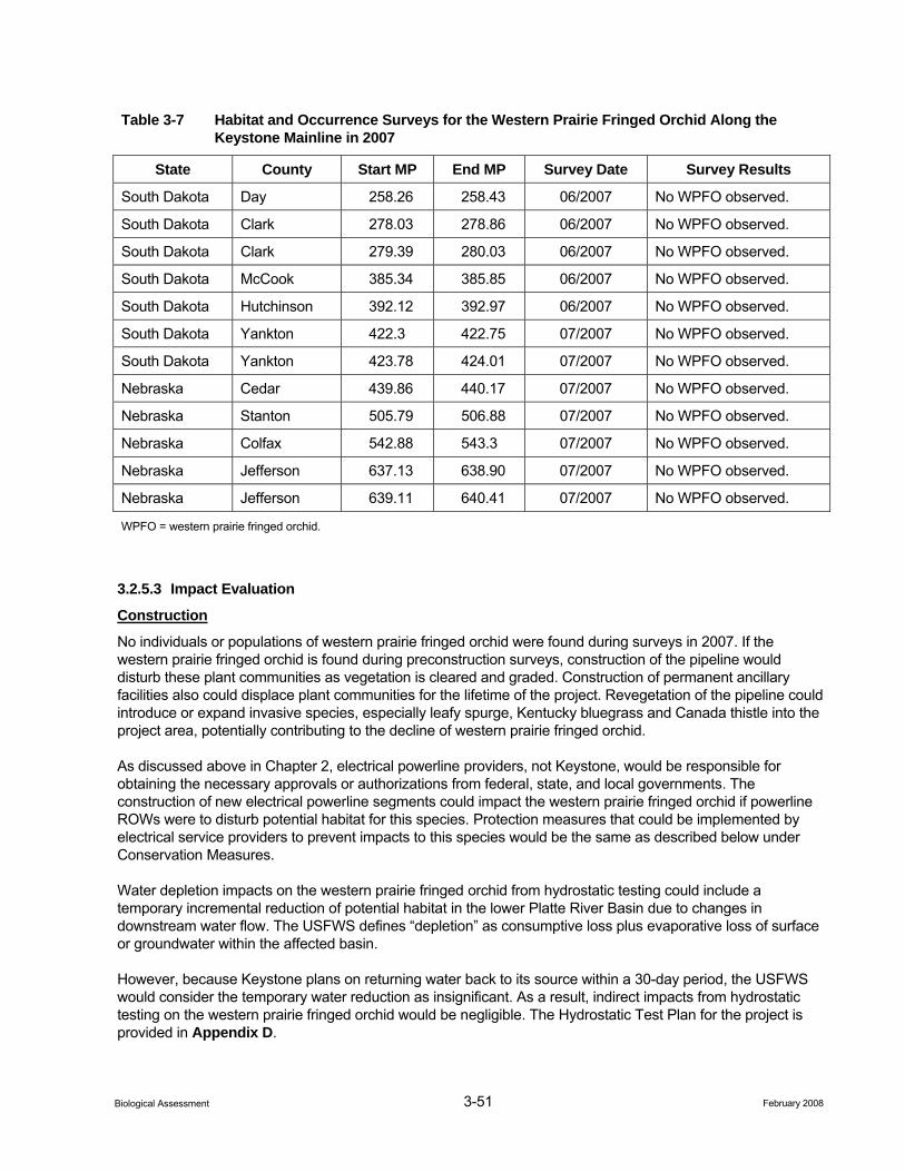
3-51 February 2008 Biological Assessment
Table 3-7 Habitat and Occurrence Surveys for the Western Prairie Fringed Orchid Along the Keystone Mainline in 2007
State County Start MP End MP Survey Date Survey Results
South Dakota Day 258.26 258.43 06/2007 No WPFO observed.
South Dakota Clark 278.03 278.86 06/2007 No WPFO observed.
South Dakota Clark 279.39 280.03 06/2007 No WPFO observed.
South Dakota McCook 385.34 385.85 06/2007 No WPFO observed.
South Dakota Hutchinson 392.12 392.97 06/2007 No WPFO observed.
South Dakota Yankton 422.3 422.75 07/2007 No WPFO observed.
South Dakota Yankton 423.78 424.01 07/2007 No WPFO observed.
Nebraska Cedar 439.86 440.17 07/2007 No WPFO observed.
Nebraska Stanton 505.79 506.88 07/2007 No WPFO observed.
Nebraska Colfax 542.88 543.3 07/2007 No WPFO observed.
Nebraska Jefferson 637.13 638.90 07/2007 No WPFO observed.
Nebraska Jefferson 639.11 640.41 07/2007 No WPFO observed.
WPFO = western prairie fringed orchid.
3.2.5.3 Impact Evaluation
Construction
No individuals or populations of western prairie fringed orchid were found during surveys in 2007. If the western prairie fringed orchid is found during preconstruction surveys, construction of the pipeline would disturb these plant communities as vegetation is cleared and graded. Construction of permanent ancillary facilities also could displace plant communities for the lifetime of the project. Revegetation of the pipeline could introduce or expand invasive species, especially leafy spurge, Kentucky bluegrass and Canada thistle into the project area, potentially contributing to the decline of western prairie fringed orchid.
As discussed above in Chapter 2, electrical powerline providers, not Keystone, would be responsible for obtaining the necessary approvals or authorizations from federal, state, and local governments. The construction of new electrical powerline segments could impact the western prairie fringed orchid if powerline ROWs were to disturb potential habitat for this species. Protection measures that could be implemented by electrical service providers to prevent impacts to this species would be the same as described below under Conservation Measures.
Water depletion impacts on the western prairie fringed orchid from hydrostatic testing could include a temporary incremental reduction of potential habitat in the lower Platte River Basin due to changes in downstream water flow. The USFWS defines “depletion” as consumptive loss plus evaporative loss of surface or groundwater within the affected basin.
However, because Keystone plans on returning water back to its source within a 30-day period, the USFWS would consider the temporary water reduction as insignificant. As a result, indirect impacts from hydrostatic testing on the western prairie fringed orchid would be negligible. The Hydrostatic Test Plan for the project is provided in Appendix D.
3-52 February 2008 Biological Assessment
Operations
Operation of the project would not result in permanent impacts to the western prairie fringed orchid. Clearing of trees/shrubs in the ROW would be required for operational monitoring, but since this species inhabits open, native prairie, no tree or shrub clearing would occur within suitable habitat. If herbicides must be used for noxious weed control, application would be conducted by spot spraying. Populations of western prairie fringed orchid would be identified and no herbicides would be used at those locations.
Direct contact with a crude oil spill could result in adverse toxicological effects to western prairie fringed orchid. While these exposure routes have the potential to cause adverse effects, the probability of adverse effects to western prairie fringed orchid are unlikely due to: 1) the low probability of a spill and 2) the low probability of the spill coinciding with the presence of western prairie fringed orchid (see Appendix E, Environmental Fate and Risk Associated with Crude Oil, for further information regarding impacts to wildlife from a potential spill event).
3.2.5.4 Cumulative Impacts
No future state, or local, or private actions that are reasonably certain to occur in the project area have been identified for the project.
3.2.5.5 Conservation Measures
Based on the results of the 2007 habitat and occurrence surveys for this species, construction activities would be permitted within potentially suitable habitat prior to the flowering period. If construction activities were to occur during the flowering period, preconstruction surveys would be conducted within suitable habitat. If surveys identify the western prairie fringed orchid, Keystone would consult with the USFWS to determine appropriate measures. Conservation measure for identified populations could include:
• Reducing the width of the construction ROW in areas where populations have been identified, to the extent possible.
• Salvaging and segregating topsoil appropriately where populations have been identified to preserve native seed sources in the soil for use in re-vegetation efforts in the ROW.
• Restoring habitat by using an approved seed mix provided by the NRCS or appropriate state agency.
• Collecting seed to repopulate the ROW or an appropriate offsite location, or for creation of a nursery population until viable natural populations have established themselves.
• Avoiding the population by rerouting around plants or boring under plants.
• Monitoring populations for 2 years after construction to identify and remove exotic weed, grass or legume species that could hinder the re-establishment of western prairie fringed orchid.
Other recommended conservation measures for populations of western prairie fringed orchid would be developed on a site-specific basis in consultation with the USFWS, if warranted.
3.2.5.6 Determination
Effect on Critical Habitat. No critical habitat has been identified for this species. Therefore, the project would have “no effect” on critical habitat for the western prairie fringed orchid.
Effect on Species. The project “may affect, but is not likely to adversely affect” the western prairie fringed orchid. This determination is based on Keystone’s CMR Plan and applicable protection measures that have been developed for this species. As a result no direct impacts would result from project construction. Indirect impacts could result from the incremental reduction of potential habitat for this species.
3-53 February 2008 Biological Assessment
The project would have no effect on the western prairie fringed orchid from water depletion issues resulting from hydrostatic testing. This finding is based on Keystone’s commitment to return the hydrostatic test water to its source within a 30-day period.
Although it is possible that a spill event could result in an adverse affect on this species, the probability of adverse effects to western prairie fringed orchid are unlikely due to: 1) the low probability of a spill and 2) the low probability of the spill coinciding with the presence of western prairie fringed orchid.
3.2.5.7 Literature Cited
Federal Register (FR). 1989. Endangered and Threatened Wildlife and Plants; Determination of Threatened Status for Eastern and Western Prairie Fringed Orchids. Final Rule. Federal Register 54(187):39857-39863.
Minnesota Department of Natural Resources. 2007. Western Prairie Fringed Orchid A Threatened Midwestern Prairie Plant. Minnesota Department of Natural Resources. (http://files.dnr.state.mn.us/ natural_resources/ets/fringed_orchid.pdf) April 2007.
NatureServe. 2006. NatureServe Explorer: An online encyclopedia of life [web application]. Version 6.1. NatureServe, Arlington, Virginia. Available http://www.natureserve.org/explorer (Accessed April 5, 2007).
Phillips, L. 2003. Pollination of Western Prairie Fringed Orchid, Platanthera praeclara: Implications for Restoration and Management. Restoration and Reclamation Review Student On-Line Journal (Hort 5015/5071). University of Minnesota, St. Paul, Minnesota (USA) Department of Horticultural Science. (http://hort.agri.umn.edu/h5015/rrr.htm).
Sheviak, C. J. and M. L. Bowles. 1986. The prairie fringed orchids: a pollinator-isolated species pair. Rhodora 88:267-290.
Sieg, C. H. 1997. The mysteries of a prairie orchid. Endangered Species Bulletin. XXII(4): 12-13.
Sieg, C. H. and A. J. Bjugstad. 1994. Five years of following the western prairie fringed orchid (Platanthera praeclara) on the Sheyenne National Grassland, North Dakota. In: Wickett, Robert G.; Lewis, Patricia Dolan; Woodliffe, Allen; and Pratt, Paul, eds. Spirit of the land, our prairie legacy. Proceedings of the Thirteenth North American Prairie Conference; 1992 August 6-9; Windsor, Ontario, Canada. Windsor, Ontario, Canada: Department of Parks and Recreation: 141-146.
Sieg, C. H. and P. M. Wolken. 1999. Dynamics of a threatened orchid in flooded wetlands. In: Springer, Joseph T. ed. The central Nebraska loess hills prairie: Proceedings of the sixteenth North American Prairie Conference, 16:193-201.
Sieg, C. H. and R. M. King. 1995. Influence of Environmental Factors and Preliminary Demographic Analyses of a Threatened Orchid, Platanthera praeclara. American Midland Naturalist 134:307-323.
U.S. Fish and Wildlife Service (USFWS). 2007. Western Prairie Fringed Orchid Platanthera praeclara. U.S. Fish and Wildlife Service Mountain-Prairie Region South Dakota Ecological Services Field Office. (http://www.fws.gov/southdakotafieldoffice/ORCHID.HTM) April 2007.
_____. 2006. U.S. Fish and Wildlife Service Mountain-Prairie Region. Letters dated April 2006.
_____. 1996. Western Prairie Fringed Orchid Recovery Plan (Platanthera praeclara). U.S. Fish and Wildlife Service. Fort Snelling, Minnesota. Vi + 101 pp.

3-54 February 2008 Biological Assessment
U.S. Geologic Service (USGS). 2006. North Dakota’s Endangered and Threatened Species Western Prairie Fringed Orchid Platanthera praeclara. USGS Northern Prairie Wildlife Research Center. (http://www.npwrc.usgs.gov/resource/wildlife/endanger/platprae.htm) April 2007.

February 2008 Biological Assessment
Appendices A through E Please See Attached CD for Appendices


![Keystone Pipeline – South Dakota Pump Stations 12, 2011 Revision 0 Keystone Project Document # RE-03 [2-4-22-3] ATCO Project # 762900-SD TransCanada Pipeline Ltd. Keystone Pipeline](https://static.fdocuments.in/doc/165x107/5ad387177f8b9a665f8dcef1/keystone-pipeline-south-dakota-pump-stations-12-2011-revision-0-keystone-project.jpg)