DEPARTMENT OF REGISTRATION AND EDUCATION
284
Transcript of DEPARTMENT OF REGISTRATION AND EDUCATION


BULLETIN NO. 35 1943
GROUND WATER SUPPLIES
OF THE
CHICAGO-JOLIET-CHICAGO HEIGHTS AREA
ISSUED BY
STATE WATER SURVEY DIVISIONA. M. BUSWELL, Chief
URBANA, ILLINOIS
ORGANIZATION
STATE OF ILLINOISDWIGHT H. GREEN, Governor
DEPARTMENT OF REGISTRATION AND EDUCATIONFRANK G. THOMPSON, Director
Board of Natural Resources and Conservation Advisers.FRANK G. THOMPSON, Chairman
ROGER ADAMS, Chemistry E. J. KRAUS, ForestryLouis R. HOWSON, Engineering WILLIAM TRELEASE, BiologyEDSON S. BASTIN, Geology ARTHUR C. WILLARD, President of
the University of Illinois
State Water Survey Division Committee.
FRANK G. THOMPSON LOUIS E. HOWSONARTHUR C. WILLARD ROGER ADAMS
STATE WATER SURVEY DIVISIONA. M. BUSWELL, Chief

LETTER OF TRANSMITTAL.
STATE OF ILLINOIS
DEPARTMENT OF REGISTRATION AND EDUCATIONSTATE WATER SURVEY DIVISION
URBANA, ILLINOIS, February 24, 1943.
Frank G. Thompson, Chairman, and Members of the Board of NaturalResources and Conservation:
GENTLEMEN : Herewith I submit a report entitled, "Ground WaterSupplies of the Chicago-Joliet-Chicago Heights Area" and recommendthat it be published as Illinois State Water Survey Bulletin No. 35.
This report has been compiled from data in the State Water Surveyfiles, which has been collected over a long period of years. The officecompilation was carried out largely by Mr. Ross Hanson, Engineer, andMr. W. D. Gerber, Engineer, with the assistance rendered from time totime by other members of the State Water Survey staff. Dr. T. E.Larson, Chemist for the State Water Survey, prepared and assembled thechemical data.
Respectfully submitted,A. M. BUSWELL, Chief.
4
INTRODUCTION.
The report on the ground water supplies in the Chicago-Joliet-Chicago Heights Area includes a large amount of physical and chemicaldata assembled from the files of the State Water Survey. The. purpose ofthis report is to furnish certain factual data that would be helpful indetermining the possibility of producing a suitable ground water supplyin any portion of the Area. This report does not purport to furnishconclusive estimation of the quality or quantity of the ground watersupply that may be desired at any specific location but should be helpfulin making approximations.
REASONS FOR THE REPORT.
Since the origin of the State Water Survey, there has been accumu-lated in the Water Survey files a large amount of technical and historicalinformation concerning ground water, throughout the State of Illinoisand particularly in the Chicago-Joliet-Chicago Heights Area. Owingto the very large extraction from the municipal and industrial wells inthe Area, it is thought advisable to record, in this manner, all the in-formation in the files which may be of value to the owner or driller whomay be planning to develop or increase water supply. The Water Surveyhas records of more than four thousand wells in the Area, ranging indepths from shallow drift to the Mt. Simon sandstone.
The Area is one of major industrial development and daily waterpumpage amounts to many million gallons.
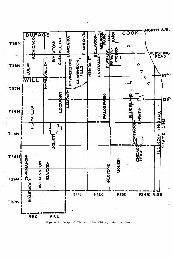
T H E AREA.
The Chicago-Joliet-Chicago Heights Area (Figure 1) comprises allof Will County and all of that part of Cook and DuPage Counties whichlies south of the north line of Township 39 North. Lake Michigan andthe Illinois-Indiana State line form the east boundary of the Area.State Highway No. 64, which traverses North Avenue, forms the northboundary of the area from Lake Michigan west to a point just north ofWheaton.
The west line of the Area coincides with the west line of Range 9Bast of the Third Principal Meridian.
T h e sou th l ine is t h e south l ine of Will County .

5
CLASSIFICATION OF WELLS.
In the Water Survey files there are physical data records for 3,312wells in the Chicago-Joliet-Chicago Heights Area. The records of thesewells are complete to the extent that a general classification is made,which indicates the source of ground water, types of water usage and theestimated amount of daily water usage. A large portion of the informa-tion on the estimated daily usage is obtained from actual pumpingrecords of individuals, industries, and municipal water plants. Wherethere were no actual water production records, estimates were made.
The Area has been divided into four zones, (Figure I-A) asfollows:
Zone 1—That part of the City of Chicago within the Area.Zone 2—That part of Cook County, outside of Chicago, within the
Area.Zone 3—That part of DuPage County within the Area.Zone 4—Will County, all of which is within the Area.There are four principal sources of ground water in the Area. The
shallow wells, commonly referred to as drift or limestone wells, are thosewhich do not penetrate the St. Peter sandstone. Other sources are theSt. Peter, Galesville and Mt. Simon sandstones.
Minimum and maximum depths of wells under each source of water show that some wells penetrate below the aquifer under which the wellis listed, but do not penetrate the next lower aquifer. This would indi-cate that an adequate or suitable supply of water was obtained beforepenerating the next lower aquifer.
Of the 3,312 wells (Table I) latest information shows that thereare 3,009 wells in active usage and 303 wells are not in use, due to theirbeing abandoned or retired. There are 2,796 drift or limestone wellswhich do not penetrate the St. Peter sandstone. There are 48 wellsranging in depth from 630 feet to 1,308 feet which penetrate into theSt. Peter sandstone. Some of the deeper wells in this group penetratebelow the St. Peter sandstone but do not reach into the Galesville. Thereare 120 wells, ranging in depths from 1,400 feet to 1,850 feet whichpenetrate the, Galesville sandstone, and there are 45 wells, ranging indepths from 1,900 feet to 2,756 feet which penetrate the Mt. Simonsandstone.
Of the 3,009 wells, which] are classified as In Use, there are 2,623wells which are classified as Private, there are 108 wells which are usedfor Municipal Water Supply and 278 wells are for Industrial uses.
From actual production records and some estimates, there is a totaldaily extraction of 12.70 million gallons of water from wells which donot penetrate the St. Peter sandstone, and there is a total daily extrac-tion of 60.05 million gallons from the sandstone acquifers. The totalground water extraction from all wells of record in the Chicago-Joliet-Chicago Heights Area is estimated to be 72.75 million gallons per day.
6
Figure I. Map of Chicago-Joliet-Chicago Heights Area.

7
Figure I-A. Zone map of the Chicago-Joliet-Chicago Heights Area.

TABLE ICLASSIFICATION OF WELLS
in theCHICAGO—JOLIET—CHICAGO HEIGHTS AREA

9
MINERAL QUALITY AND TEMPERATURE OF GROUNDWATERS.
The data presented on chemical analyses of samples) of water areobviously over-balanced with respect to location (Figures I I , I I I , IV) .Nevertheless it is possible to present a summary on the quality of thewater which is present in the main water-bearing strata below the drift.
Of the 579 analyses (Table III) listed, 279 represent samples ofwater from wells which do not penetrate the St. Peter sandstone (FigureIV). For the greater part, these waters are of exceptional hardness(400-1200 p.p.m.) and of high sulfate content. A high non-carbonatehardness is present and in general these waters are more or less corrosive.It is also noted that an iron content of more than 0.3 p.p.m. is presentin four waters out of five.
By exception, the limestone waters in Chicago within a few miles ofLake Michigan and south to Eiverdale and Lansing are of lower totalmineral content and hardness than that of Lake Michigan water. Thesewaters all lie within the area, inundated by Lake Michigan during theToleston stage.1
Also by exception, the moderately hard waters in the vicinity of theOrdnance Plant area are from the Maquoketa and Galena limestonebelow and at the feathered western edge of the Niaga.ran limestone.1 Itis notable that several of these waters are of low hardness and highalkalinity.
The chloride content of all waters from above the sandstones israrely more than a few parts per million.
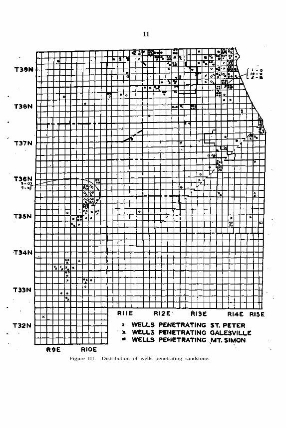
As for the St. Peter and Galesville sandstone waters it appears thatthis area must be divided into two sections by an indefinite zone extend-ing south from the west line of T. 39 N., E. 13 E. (Figure I I I ) .
To the west of this zone few analyses of St. Peter sandstone waterare available for wells in which the limestone water has been cased out.Between Joliet and Wilmington there is a general change in the mineralcontent which has been fully indicated in Bulletin 34. This water atJoliet is of about 35 p.p.m. chloride content, 100 p.p.m. sulfate content,275 p.p.m. alkalinity, 225 p.p.m. hardness, and 540 p.p.m. total mineralcontent. At Wilmington the chloride content is some 200-300 p.p.m.
and the total mineral content increased to 800-900 p.p.m.North of Joliet the St. Peter sandstone water is similar in mineral
content to that in Joliet.The Galesville sandstone water has been indicated in Bulletin 34
to be similar in mineral content to that of the St. Peter but of perhaps50 p.p.m. greater hardness. This is also true for the area north ofJoliet.
In the eastern section of the area the quality appears to be less definite for two important reasons. First, the pumpage particularly inthe Stock Yards area has been very excessive. One out of every fivesandstone wells in this area penetrates the Mt. Simon sandstone to alimited extent (Figure I I I ) . It is obvious that the heavy pumpage insome localities has lowered the non-pumiping level as well as the pumpinglevel of the St. Peter and Galesville waters below the non-pumping level
1 Illinois State Geological Survey Bulletin No. 65.

10
Figure II. Distribution of recorded wells which do not penetrate sandstone.
11
Figure III. Distribution of wells penetrating sandstone.

12
Figure IV. Distribution of analytical data for wells which do not penetrate thesandstone.

13
Figure V. Chloride concentrations of waters obtained from various elevations belowsea level.
14
of the Mt. Simon sandstone. This tends to promote the influx of highchloride Mt. Simon sandstone water into the upper sandstones to a moreor less limited extent, and is particularly noticeable where a well intothe Galesville or St. Peter sandstone is in close proximity to a well whichhas penetrated the Mt. Simon sandstone.
Limestone water is also apparent in analyses of a few samples fromsandstone wells in Chicago near the lake shore.
The second factor is the elevation of the top of the St. Peter andthe Galesville sandstones relative to their top elevations to the west.It is well known that these sandstones dip to the east and south, and liesome 100 to 200 feet lower in Chicago than at Bensenville and Elmhurst.
Nearly all of the waters from the St. Peter and Galesville sand-stones in the east section are of high mineral content and hardness. Thechloride content is generally 100-200 p.p.m., sulfate 200-450 p.p.m.,alkalinity 200-250, hardness 400-600 p.p.m. and mineral content 800-1500 p.p.m. Perhaps the most reliable data for Galesville water qualityare those for the Buda Motor Company, Harvey, and the Western Elec-tric Company, Chicago.
Mt. Simon sandstone is characterized by its high chloride content,increasing with depth. The available data have been plotted with respectto elevation above sea level and chloride content (Figure V). Fairlygood correlation has been obtained to indicate the rate of increase withdepth. From these data it is estimated that the chloride content isabout 400 p.p.m. at a sea level elevation of -1250 feet and increases ata rate of 400 p.p.m. (possibly 700 p.p.m.) per 100 feet of penetration.These concentrations refer specifically to the elevation in question. Ifan appreciable yield is obtained from two or more porous zones thechloride content will be a blend of the chloride contents of these strata.
The hardness of the Mt. Simon sandstone appears to be less thanthat of the upper sandstone and the total mineral content of the deepestMt. Simon sandstone waters can usually be estimated as about 350 plus1.65 times the chloride content. Many wells penetrate the Mt. Simonsandstone to an elevation above -1250 feet. The waters from these wellsare of lesser chloride content not only by nature of the Mt. Simon sand-stone water but also by blending with Galesville and St. Peter sa,ndstoneand limestone waters.
Selected available data on temperature of ground waters have beenplotted against the sea level elevation of the source of the water (FigureVI) . These data indicate that water at sea level is 56° F. and increasesor decreases by one degree per 160 feet. If the sea level temperature isconsidered as 55° F., the corresponding rate of increase or decrease isone degree per 120 feet. These temperatures refer to the temperatureof the water pumped or flowing from wells in which all or practicallyall the water is obtained from a single water-producing strata.
' By comparison, at Galesburg, Illinois, it appears that the tempera-ture at sea level is 61.5° F. with a gradient of one degree per 160 feet.Therefore it is evident that the above data are applicable, only locally,and not to other localities in the state.

15
Figure VI. Temperature of water from various elevations below sea level.
16
PHYSICAL DATA AND THEIR SOURCES.
The Water Survey has accumulated pertinent physical informationon wells in the Chicago-Joliet-Chieago Heights Area. This informationhas been assembled from sources such as:
Well logs from the State Geological Survey.Well logs and other well data from numerous Well Drillers.Historical data as to date of drilling, well depths, casing sizes,
water levels and pumpings from drillers, owners and municipalofficials and considerable factual data on ground water extractionand its mineral qualities has been recorded and filed by all theEngineers and Chemists of the Water Survey Staff. It has longbeen a policy of the Water Survey to make production" tests ofwells, upon the request of the owner or driller, particularly forindustrial or municipal water supply projects where it is neces-sary to know the quantity and mineral qualities of the waterproduced.
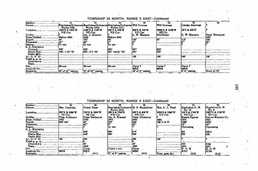
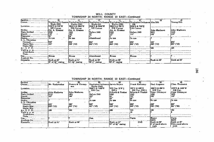
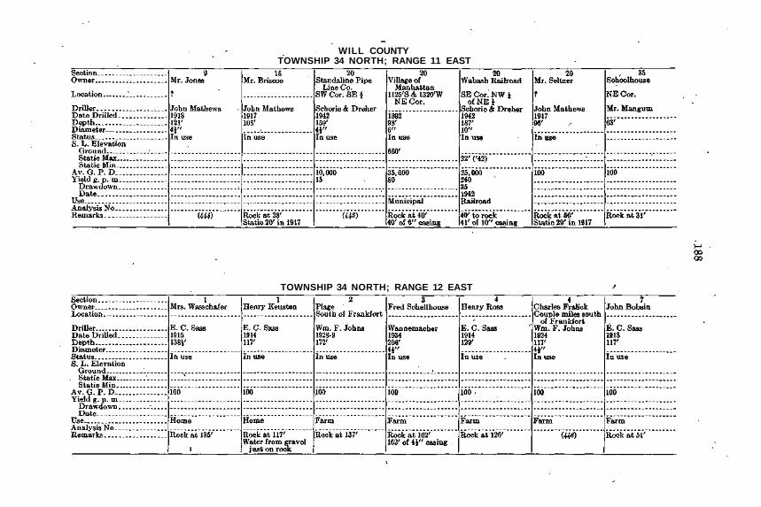
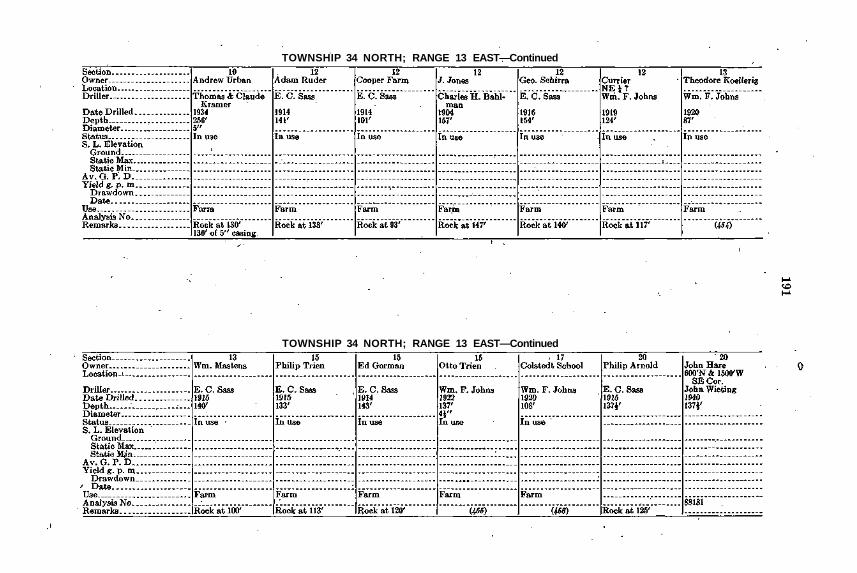
In Table II is listed all recorded physical data on the wells in theArea, which can be located in the field. The information set out hasbeen collected from reliable sources but some of the descriptive locationsmay not be precise. Sufficient information is given so that any listedwell should be readily identified for location. Some of the data arerather meager and the Water Survey would welcome any supplementalinformation, as well as information on wells which do not appear inTable II . If any of the tabulated physical data are erroneous the WaterSurvey would, appreciate correct information.
All ground and water level elevations are referred to "Mean SeaLevel datum (Biloxi, Mississippi)." The "average gallons per day" forindustrial and municipal plants is the actual pumping as given by plantofficials from their records. For farm wells and smaller industrial wells,'some of the daily extractions are estimated. Where water samples havebeen analyzed, the analyses numbers are given in numerical andchronological order and the mineral qualities for that analysis, identifiedby its number, may be found in Table III .
Where number in parenthesis is shown under "Remarks"—it refers tosame number under "Remarks" section in the pack part of this bulletin.
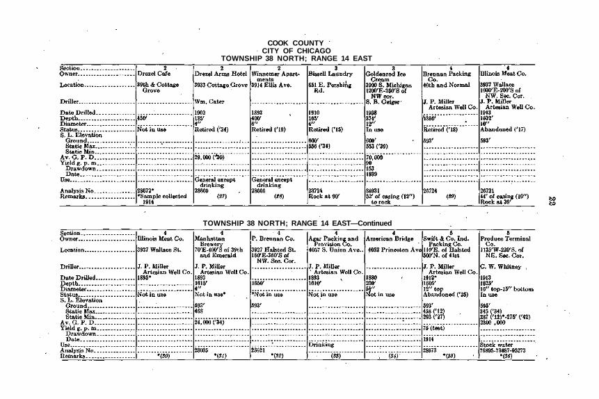
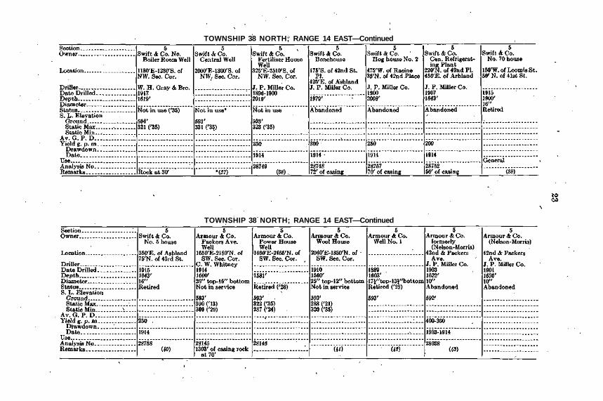
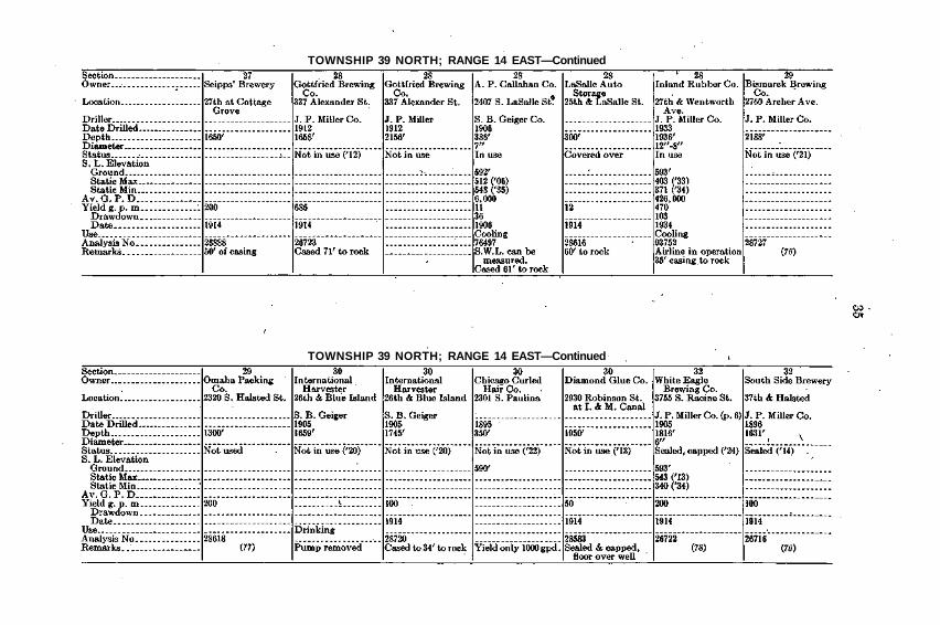
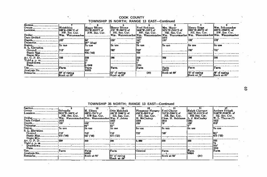
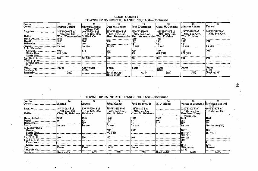
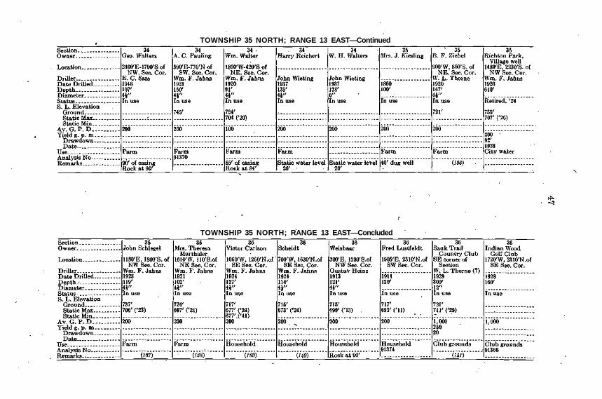
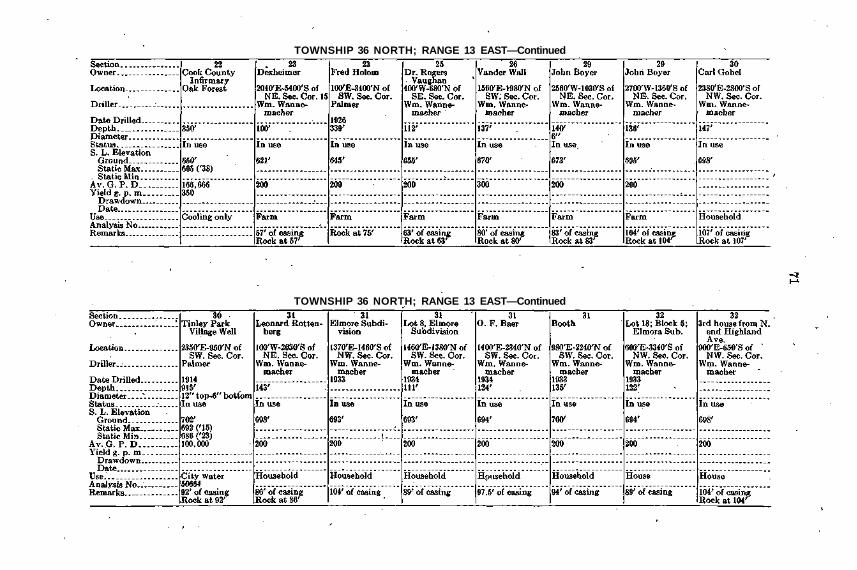
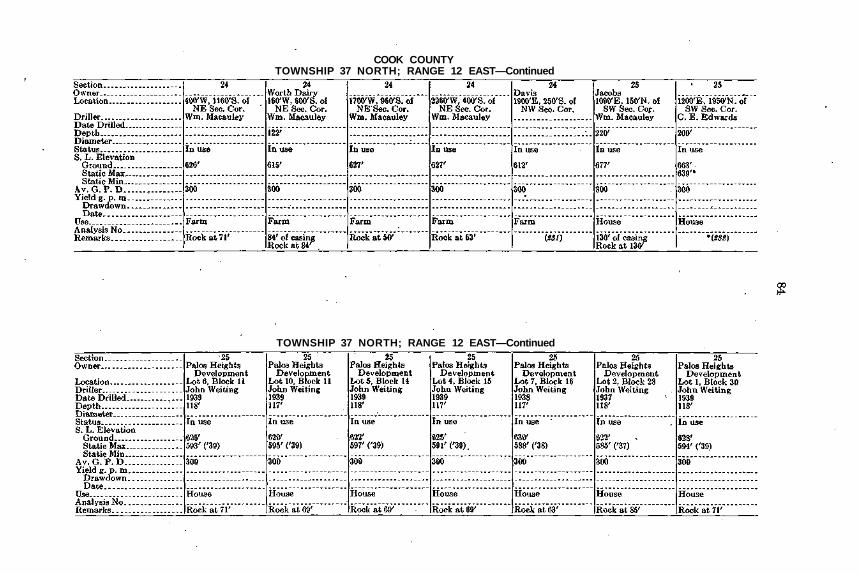
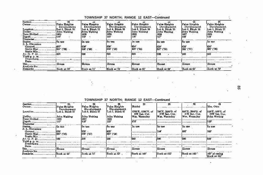
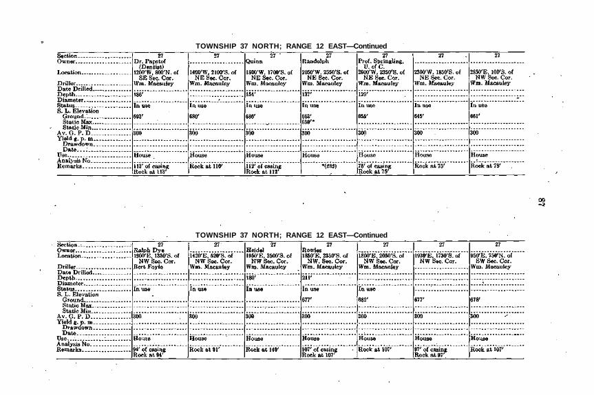
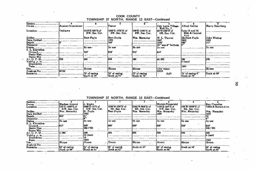
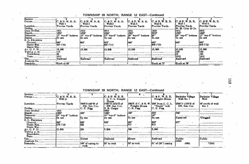
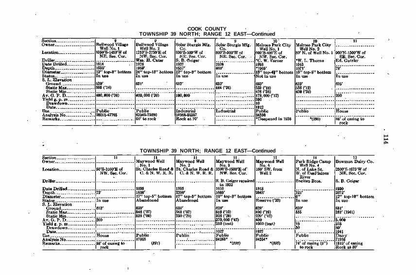
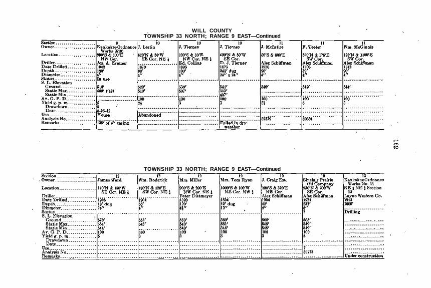
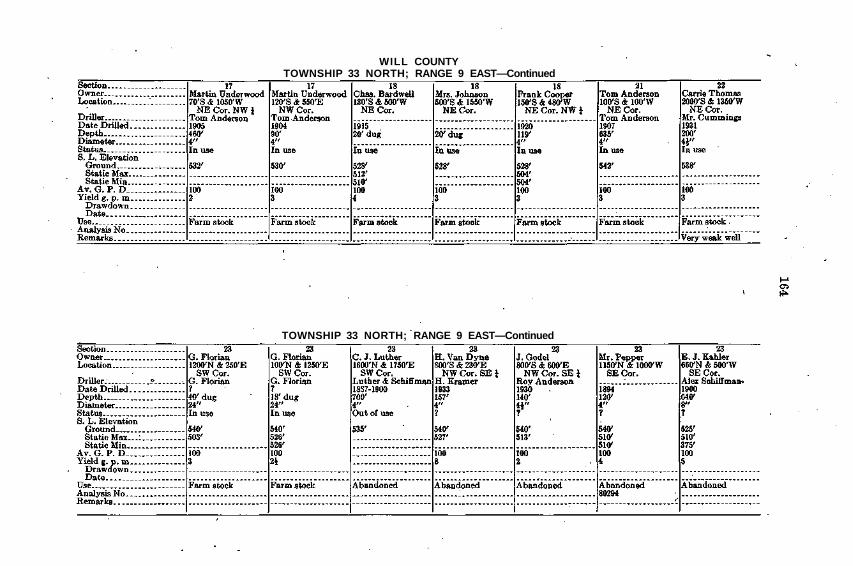
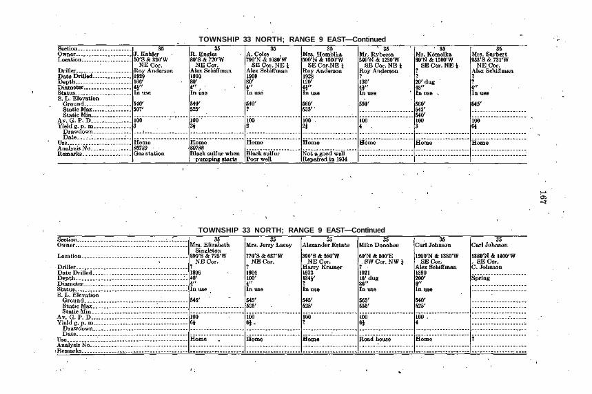
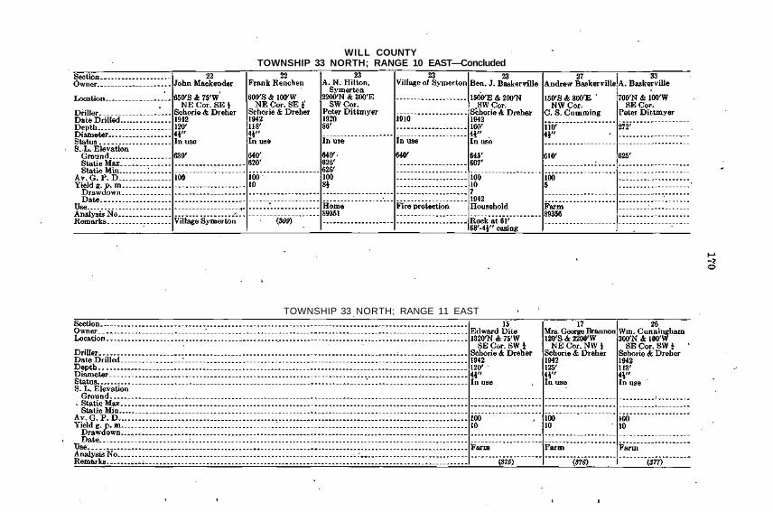
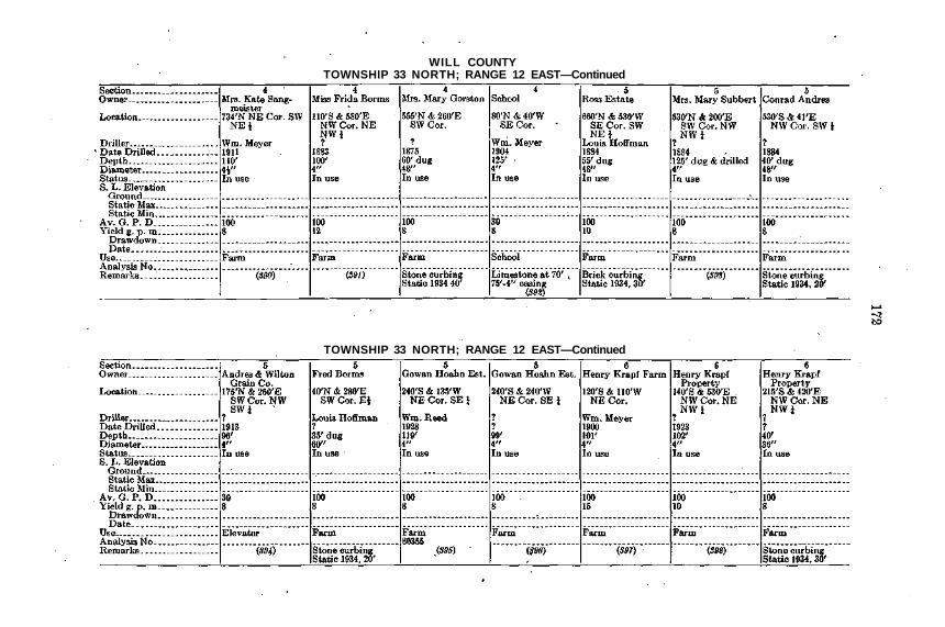
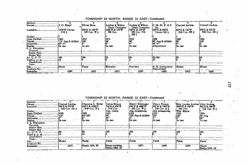
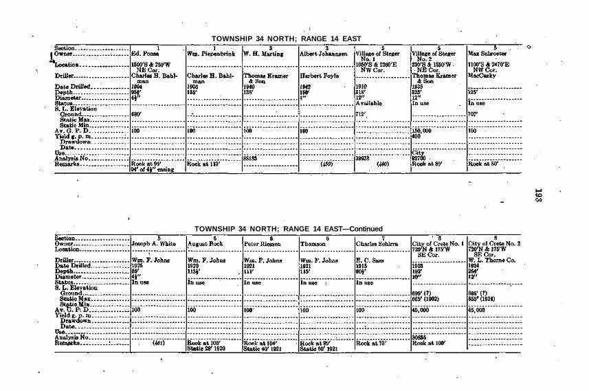
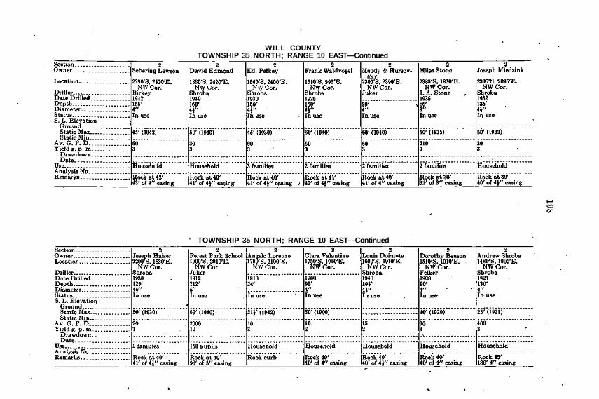
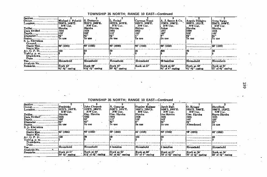
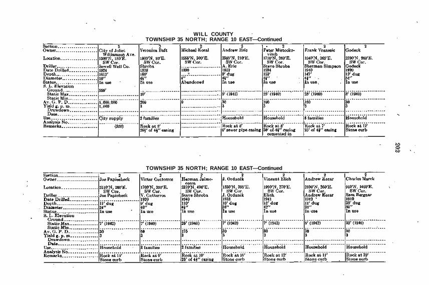
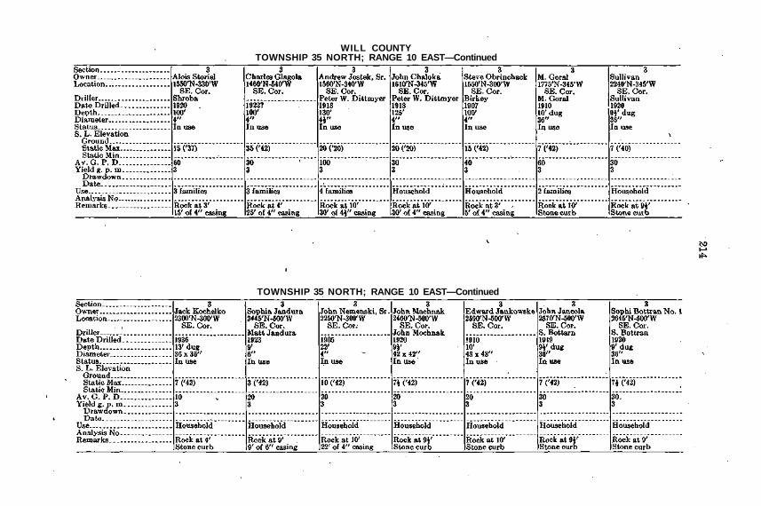
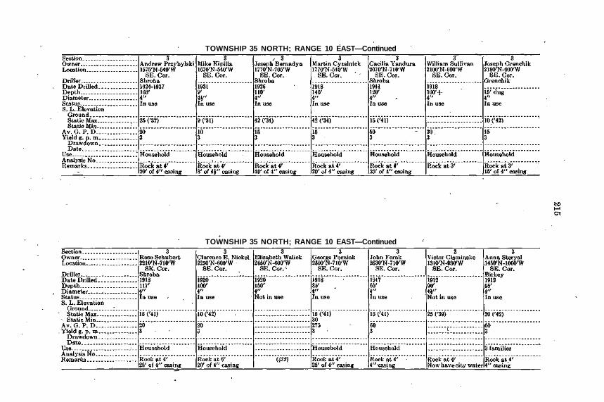
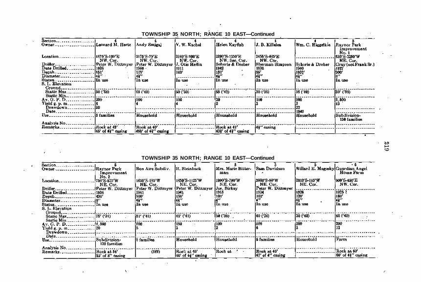
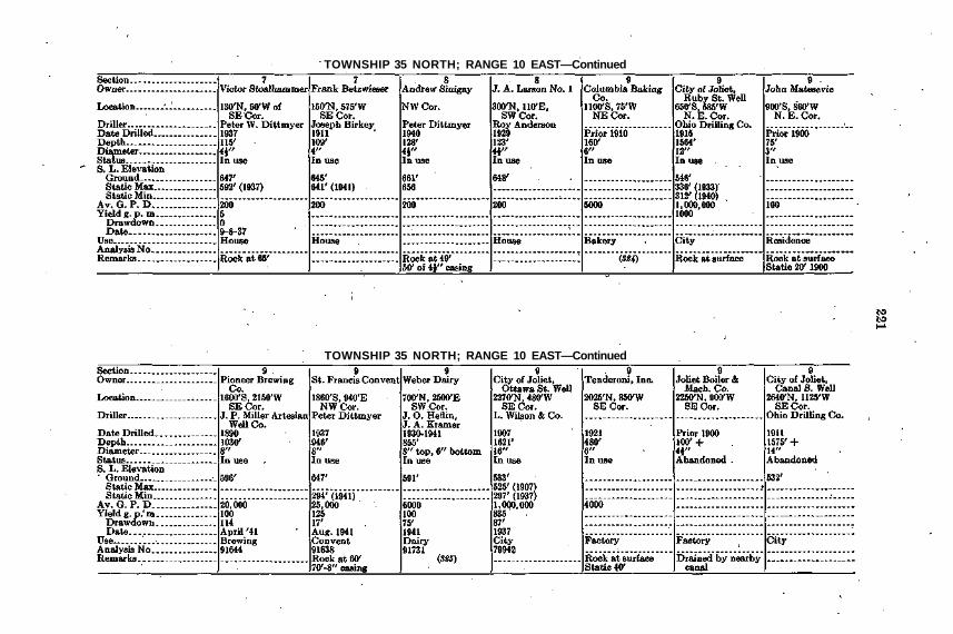
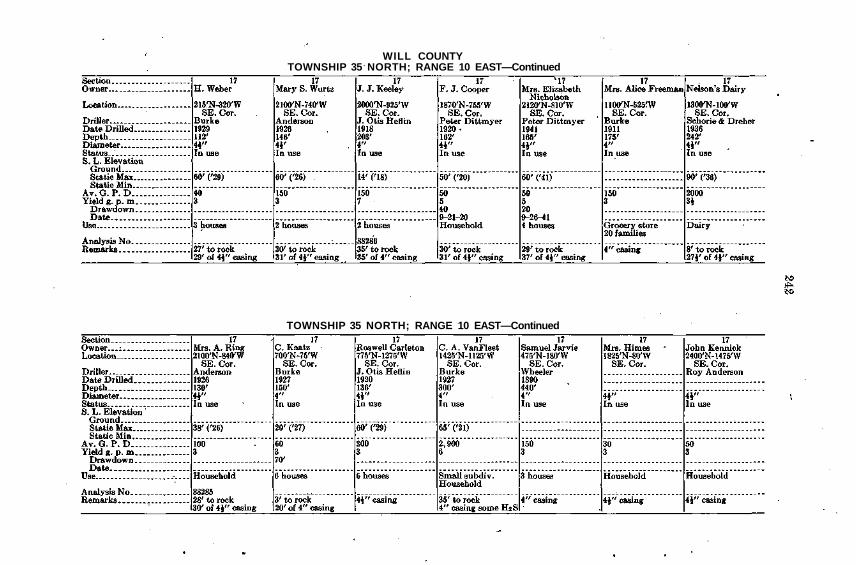
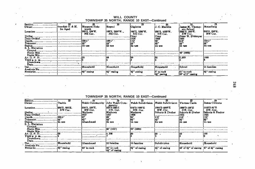
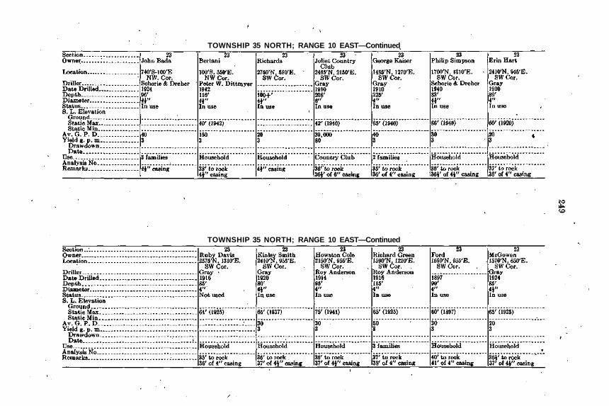
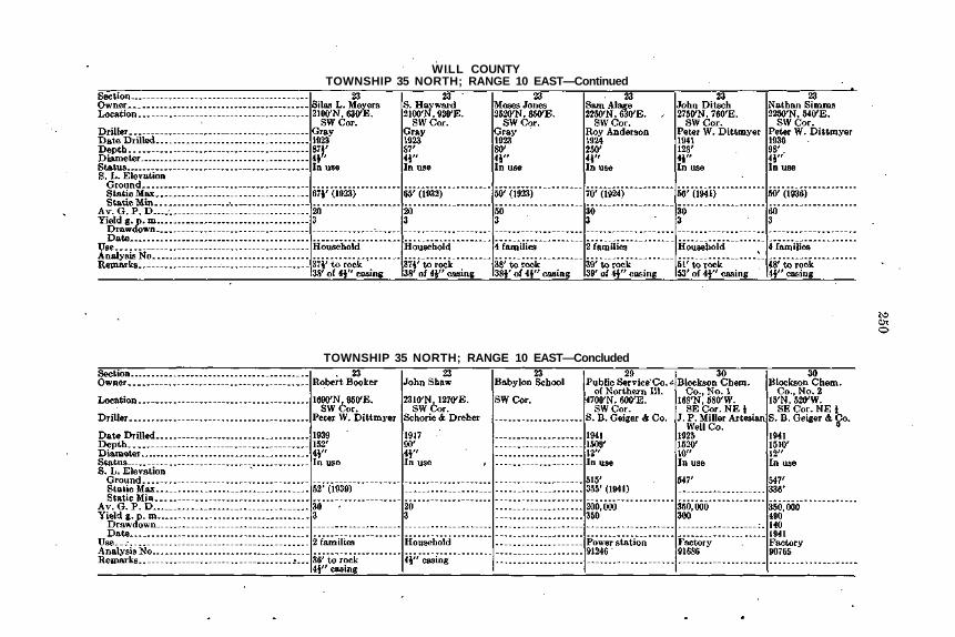
TABLE II
PHYSICAL DATA
ZONE I
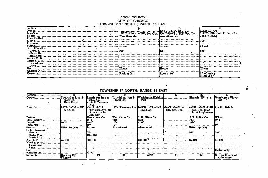
COOK COUNTYCITY OF CHICAGO
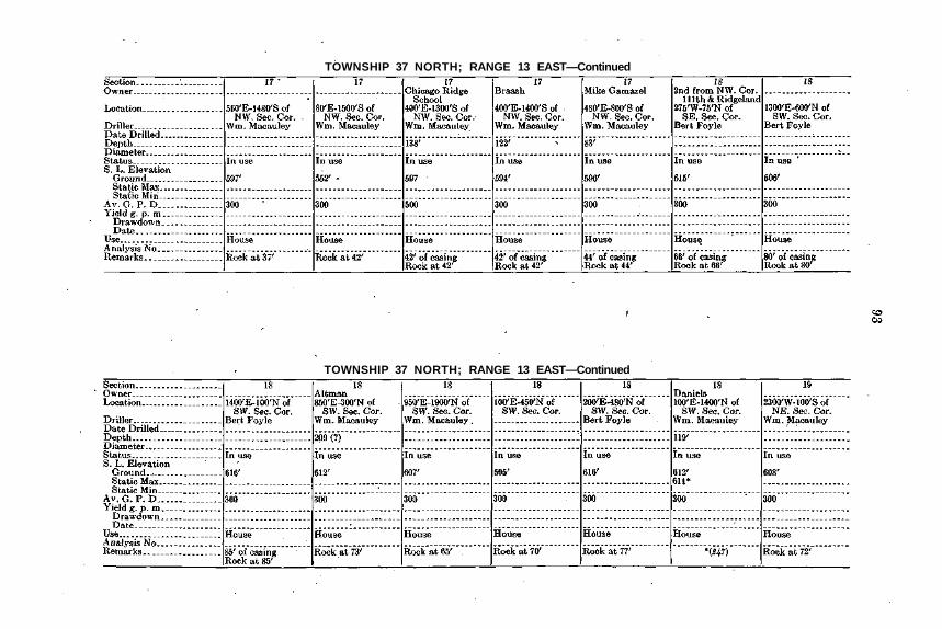
TOWNSHIP 37 NORTH; RANGE 13 EAST
TOWNSHIP 37 NORTH; RANGE 14 EAST

TOWNSHIP 37 NORTH; RANGE 14 EAST—Concluded
TOWNSHIP 37 NORTH; RANGE 15 EAST

COOK COUNTYCITY OF CHICAGO
TOWNSHIP 37 NORTH; RANGE 15 EAST—Continued
TOWNSHIP 37 NORTH; RANGE 15 EAST—Continued

TOWNSHIP 37 NORTH; RANGE 15 EAST—Concluded
, TOWNSHIP 38 NORTH; RANGE 13 EAST
COOK COUNTYCITY OF CHICAGO
TOWNSHIP 38 NORTH; RANGE 14 EAST
TOWNSHIP 38 NORTH; RANGE 14 EAST—Continued
TOWNSHIP 38 NORTH; RANGE 14 EAST—Continued
TOWNSHIP 38 NORTH; RANGE 14 EAST—Continued

COOK COUNTYCITY OF CHICAGO
TOWNSHIP 38 NORTH; RANGE 14 EAST—Continued
TOWNSHIP 38 NORTH; RANGE 14 EAST—Continued

TOWNSHIP 38 NORTH; RANGE 14 EAST—Continued
TOWNSHIP 38 NORTH; RANGE 14 EAST—Continued

COOK COUNTYCITY OF CHICAGO
TOWNSHIP 38 NORTH; RANGE 14 EAST—Continued
TOWNSHIP 38 NORTH; RANGE 14 EAST—Concluded

TOWNSHIP 38. NORTH; RANGE 15 EAST
TOWNSHIP 39 NORTH; RANGE 13 EAST

COOK COUNTYCITY OF CHICAGO
TOWNSHIP 39 NORTH; RANGE 13 EAST—Continued
TOWNSHIP 39 NORTH; RANGE 13 EAST—Continued

TOWNSHIP 39 NORTH; RANGE 13 EAST—Concluded
TOWNSHIP 39 NORTH; RANGE 14 EAST

COOK COUNTYCITY OF CHICAGO
TOWNSHIP 39 NORTH; RANGE 14 EAST—Continued
TOWNSHIP 39 NORTH; RANGE 14 EAST—Continued

TOWNSHIP 39 NORTH; RANGE 14 EAST—Continued
TOWNSHIP 39 NORTH; RANGE 14 EAST—Continued

COOK COUNTYCITY OF CHICAGO
TOWNSHIP 39 NORTH; RANGE 14 EAST—Continued
TOWNSHIP 39 NORTH; RANGE 14 EAST—Continued

TOWNSHIP 39 NORTH; RANGE 14 EAST—Continued
TOWNSHIP 39 NORTH; RANGE 14 EAST—Continued

COOK COUNTYCITY OF CHICAGO
TOWNSHIP 39 NORTH; RANGE 14 EAST—Continued
TOWNSHIP 39 NORTH; RANGE 14 EAST—Continued
TOWNSHIP 39 NORTH; RANGE 14 EAST—Continued
TOWNSHIP 39 NORTH; RANGE 14 EAST—Continued

COOK COUNTYCITY OF CHICAGO
TOWNSHIP 39 NORTH; RANGE 14 EAST—Concluded

37
ZONE II

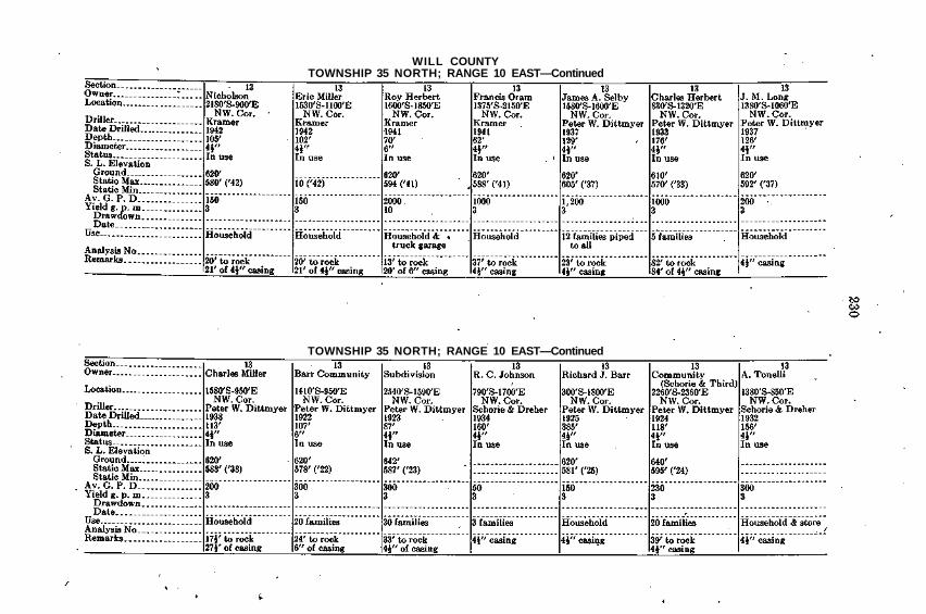
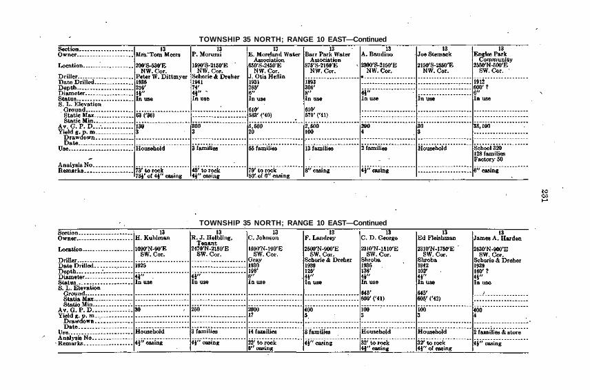
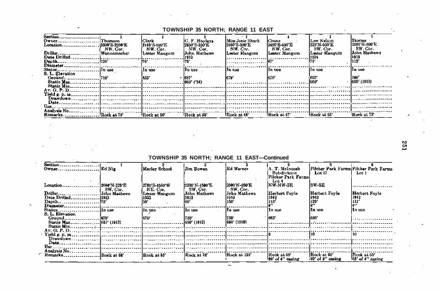
COOK COUNTYTOWNSHIP 35 NORTH; RANGE 13 EAST
TOWNSHIP 35 NORTH; RANGE 13 EAST—Continued

TOWNSHIP 35 NORTH; RANGE 13 EAST—Continued
TOWNSHIP 35 NORTH; RANGE 13 EAST—Continued
COOK COUNTYTOWNSHIP 35 NORTH; RANGE 13 EAST—Continued
TOWNSHIP 35 NORTH; RANGE 13 EAST—Continued

TOWNSHIP 35 NORTH; RANGE 13 EAST—Continued
TOWNSHIP 35 NORTH; RANGE 13 EAST—Continued

COOK COUNTYTOWNSHIP 35 NORTH; RANGE 13 EAST—Continued
TOWNSHIP 35 NORTH; RANGE 13 EAST—Continued

TOWNSHIP 35 NORTH; RANGE 13 EAST—Continued
TOWNSHIP 35 NORTH; RANGE 13 EAST—Continued
COOK COUNTYTOWNSHIP 35 NORTH; RANGE 13 EAST—Continued
TOWNSHIP 35 NORTH; RANGE 13 EAST—Continued

TOWNSHIP 35 NORTH; RANGE 13 EAST—Continued
TOWNSHIP 35 NORTH; RANGE 13 EAST— Continued

COOK COUNTYTOWNSHIP 35 NORTH; RANGE 13 EAST—Continued
TOWNSHIP 35 NORTH; RANGE 13 EAST—Continued
TOWNSHIP 35 NORTH; RANGE 13 EAST—Continued
TOWNSHIP 35 NORTH; RANGE 13 EAST—Concluded
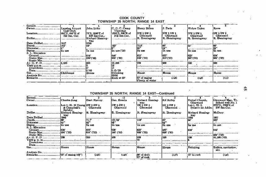
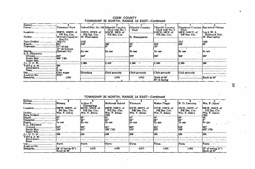
COOK COUNTYTOWNSHIP 35 NORTH; RANGE 14 EAST
TOWNSHIP 35 NORTH; RANGE 14 EAST—Continued

TOWNSHIP 35 NORTH; RANGE 14 EAST—Continued
TOWNSHIP 35 NORTH; RANGE 14 EAST—Continued
COOK COUNTYTOWNSHIP 35 NORTH; RANGE 14 EAST—Continued
TOWNSHIP 35 NORTH; RANGE 14 EAST—Continued
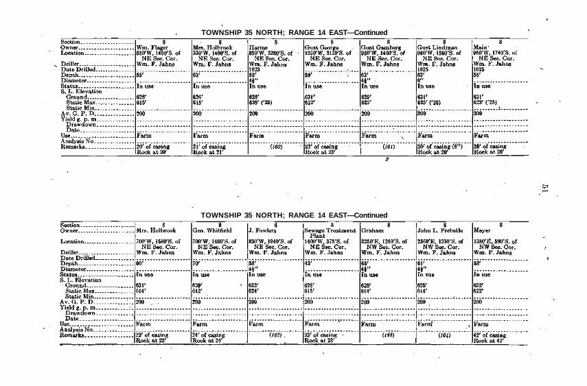
TOWNSHIP 35 NORTH; RANGE 14 EAST—Continued
TOWNSHIP 35 NORTH; RANGE 14 EAST—Continued

COOK COUNTYTOWNSHIP 35 NORTH; RANGE 14 EAST—Continued
TOWNSHIP 35 NORTH; RANGE 14 EAST—Continued
TOWNSHIP 35 NORTH; RANGE 14 EAST—Continued
TOWNSHIP 35 NORTH; RANGE 14 EAST—Continued
COOK COUNTYTOWNSHIP 35 NORTH; RANGE 14 EAST—Continued
TOWNSHIP 35 NORTH; RANGE 14 EAST—Continued

TOWNSHIP 35 NORTH; RANGE 14 EAST—Continued
TOWNSHIP 35 NORTH; RANGE 14 EAST—Continued

COOK COUNTYTOWNSHIP 35 NORTH; RANGE 14 EAST—Continued
TOWNSHIP 35 NORTH; RANGE 14 EAST—Continued

TOWNSHIP 35 NORTH; RANGE 14 EAST—Continued
. TOWNSHIP 35 NORTH; RANGE 14 EAST—Continued

COOK COUNTYTOWNSHIP 35 NORTH; RANGE 14 EAST—Concluded
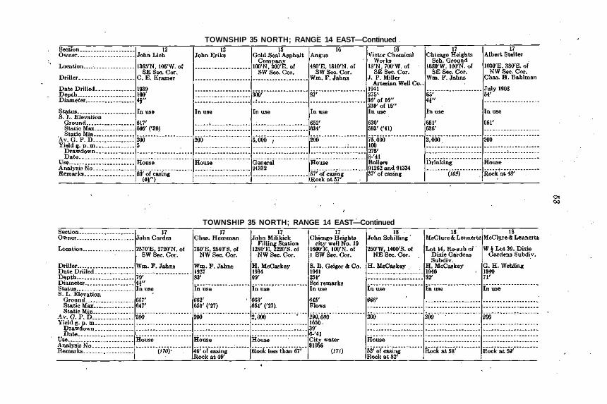
TOWNSHIP 35 NORTH; RANGE 15 EAST
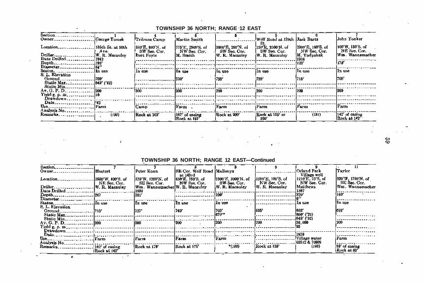
TOWNSHIP 36 NORTH; RANGE 12 EAST
TOWNSHIP 36 NORTH; RANGE 12 EAST—Continued

COOK COUNTYTOWNSHIP 36 NORTH; RANGE 12 EAST—Continued
TOWNSHIP 36 NORTH; RANGE 12 EAST—Continued

TOWNSHIP 36 NORTH; RANGE 12 EAST—Continued
TOWNSHIP 36 NORTH; RANGE 12 EAST—Concluded

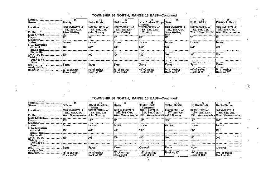
COOK COUNTYTOWNSHIP 36 NORTH; RANGE 13 EAST
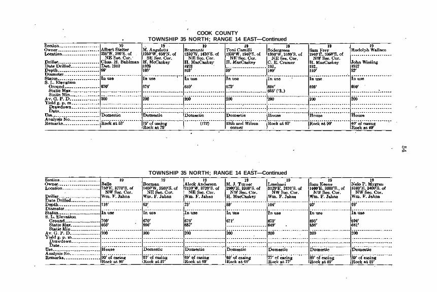
TOWNSHIP 36 NORTH; RANGE 13 EAST—Continued

TOWNSHIP 36 NORTH; RANGE 13 EAST—Continued
TOWNSHIP 36 NORTH; RANGE 13 EAST—Continued

COOK COUNTYTOWNSHIP 36 NORTH; RANGE 13 EAST—Continued
TOWNSHIP 36 NORTH; RANGE 13 EAST—Continued
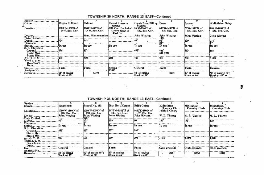
TOWNSHIP 36 NORTH; RANGE 13 EAST—Continued
TOWNSHIP 36 NORTH; RANGE 13 EAST—Continued

COOK COUNTYTOWNSHIP 36 NORTH; RANGE 13 EAST—Continued
TOWNSHIP 36 NORTH; RANGE 13 EAST—Continued

TOWNSHIP 36 NORTH; RANGE 13 EAST—Continued
TOWNSHIP 36 NORTH; RANGE 13 EAST—Continued
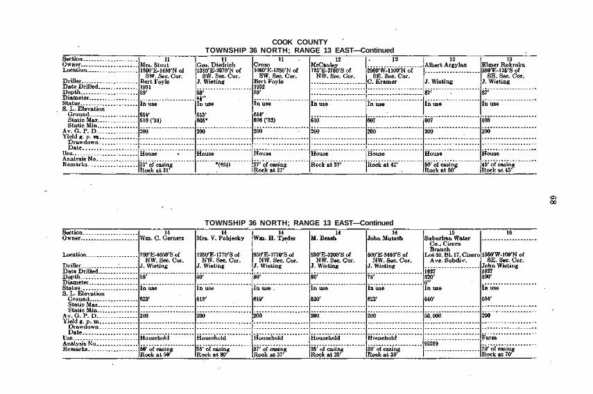
COOK COUNTYTOWNSHIP 36 NORTH; RANGE 13 EAST—Continued
TOWNSHIP 36 NORTH; RANGE 13 EAST—Continued
TOWNSHIP 36 NORTH; RANGE 13 EAST—Continued
TOWNSHIP 36 NORTH; RANGE 13 EAST—Continued

COOK COUNTYTOWNSHIP 36 NORTH; RANGE 13 EAST—Continued
TOWNSHIP 36 NORTH; RANGE 13 EAST—Continued
TOWNSHIP 36 NORTH; RANGE 13 EAST—Continued
TOWNSHIP 36 NORTH; RANGE 13 EAST—Continued

COOK COUNTYTOWNSHIP 36 NORTH; RANGE 13 EAST—Concluded
TOWNSHIP 36 NORTH; RANGE 14 EAST

TOWNSHIP 36 NORTH; RANGE 14 EAST—Continued
TOWNSHIP 36 NORTH; RANGE 14 EAST—Continued

COOK COUNTYTOWNSHIP 36 NORTH; RANGE 14 EAST—Continued
TOWNSHIP 36 NORTH; RANGE 14 EAST—Continued

TOWNSHIP 36 NORTH; RANGE 14 EAST—Continued
TOWNSHIP 36 NORTH; RANGE 14 EAST—Continued

COOK COUNTYTOWNSHIP 36 NORTH; RANGE 14 EAST—Concluded
TOWNSHIP 36 NORTH; RANGE 15 EAST

TOWNSHIP 37 NORTH; RANGE 11 EAST
TOWNSHIP 37 NORTH; RANGE 11 EAST—Continued

COOK COUNTYTOWNSHIP 37 NORTH; RANGE 11 EAST—Continued
TOWNSHIP 37 NORTH; RANGE 11 EAST—Continued
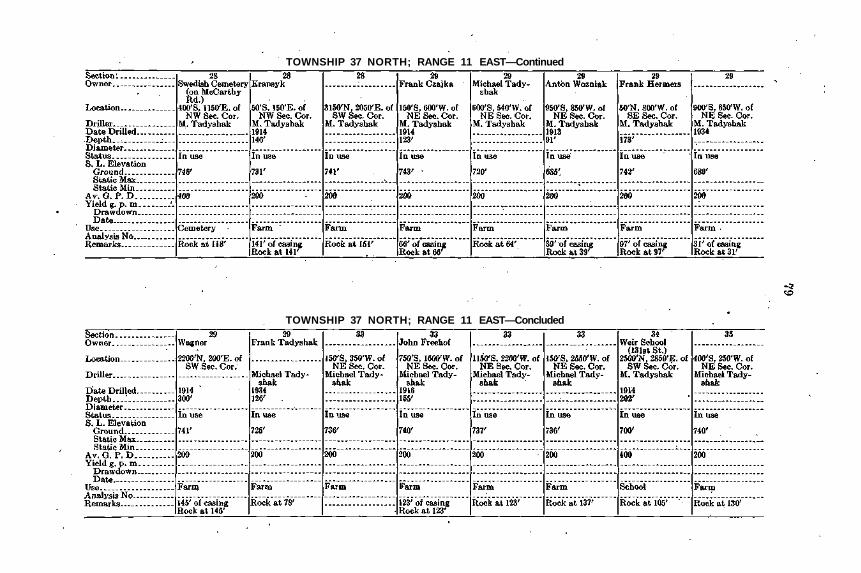
TOWNSHIP 37 NORTH; RANGE 11 EAST—Continued
TOWNSHIP 37 NORTH; RANGE 11 EAST—Concluded

COOK COUNTYTOWNSHIP 37 NORTH; RANGE 12 EAST
TOWNSHIP 37 NORTH; RANGE 12 EAST—Continued
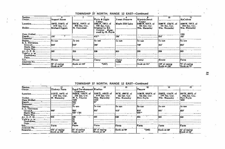
TOWNSHIP 37 NORTH; RANGE 12 EAST—Continued
TOWNSHIP 37 NORTH; RANGE 12 EAST—Continued

COOK COUNTYTOWNSHIP 37 NORTH; RANGE 12 EAST—Continued
TOWNSHIP 37 NORTH; RANGE 12 EAST—Continued
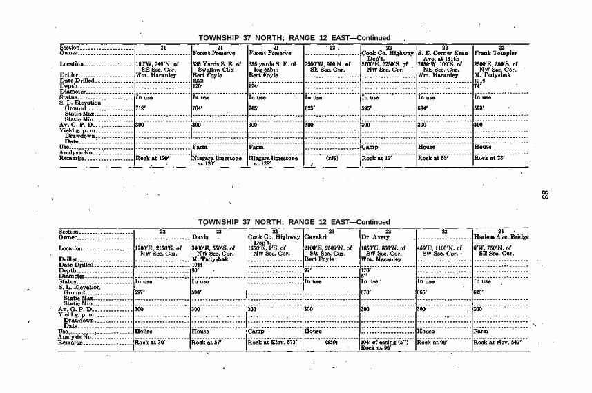
TOWNSHIP 37 NORTH; RANGE 12 EAST—Continued
TOWNSHIP 37 NORTH; RANGE 12 EAST—Continued
COOK COUNTYTOWNSHIP 37 NORTH; RANGE 12 EAST—Continued
TOWNSHIP 37 NORTH; RANGE 12 EAST—Continued
TOWNSHIP 37 NORTH; RANGE 12 EAST—Continued
TOWNSHIP 37 NORTH; RANGE 12 EAST—Continued

COOK COUNTYTOWNSHIP 37 NORTH; RANGE 12 EAST—Continued
TOWNSHIP 37 NORTH; RANGE 12 EAST—Continued
TOWNSHIP 37 NORTH; RANGE 12 EAST—Continued
TOWNSHIP 37 NORTH; RANGE 12 EAST—Continued

COOK COUNTYTOWNSHIP 37 NORTH; RANGE 12 EAST—Continued
TOWNSHIP 37 NORTH; RANGE 12 EAST—Concluded

TOWNSHIP 37 NORTH; RANGE 13 EAST
TOWNSHIP 37 NORTH; RANGE 13 EAST—Continued
COOK COUNTYTOWNSHIP 37 NORTH; RANGE 13 EAST—Continued
TOWNSHIP 37 NORTH; RANGE 13 EAST—Continued

TOWNSHIP 37 NORTH; RANGE 13 EAST—Continued
TOWNSHIP 37 NORTH; RANGE 13 EAST—Continued

COOK COUNTYTOWNSHIP 37 NORTH; RANGE 13 EAST—Continued
TOWNSHIP 37 NORTH; RANGE 13 EAST—Continued
TOWNSHIP 37 NORTH; RANGE 13 EAST—Continued
TOWNSHIP 37 NORTH; RANGE 13 EAST—Continued

COOK COUNTYTOWNSHIP 37 NORTH; RANGE 13 EAST—Continued
TOWNSHIP 37 NORTH; RANGE 13 EAST—Continued

TOWNSHIP 37 NORTH; RANGE 13 EAST—Continued
TOWNSHIP 37 NORTH; RANGE 13 EAST—Continued

COOK COUNTYTOWNSHIP 37 NORTH; RANGE 13 EAST—Continued
TOWNSHIP 37 NORTH; RANGE 13 EAST—Continued

TOWNSHIP 37 NORTH; RANGE 12 EAST—Continued
TOWNSHIP 37 NORTH; RANGE 13 EAST—Continued

COOK COUNTYTOWNSHIP 37 NORTH; RANGE 13 EAST—Continued
TOWNSHIP 37 NORTH; RANGE 13 EAST—Continued

TOWNSHIP 37 NORTH; RANGE 13 EAST—Continued
TOWNSHIP 37 NORTH; RANGE 13 EAST—Continued

COOK COUNTYTOWNSHIP 37 NORTH; RANGE 13 EAST—Continued
TOWNSHIP 37 NORTH; RANGE 13 EAST—Continued

TOWNSHIP 37 NORTH; RANGE 13 EAST—Continued
TOWNSHIP 37 NORTH; RANGE 13 EAST—Concluded
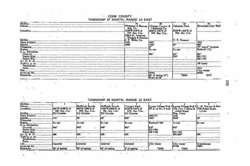
COOK COUNTYTOWNSHIP 37 NORTH; RANGE 14 EAST
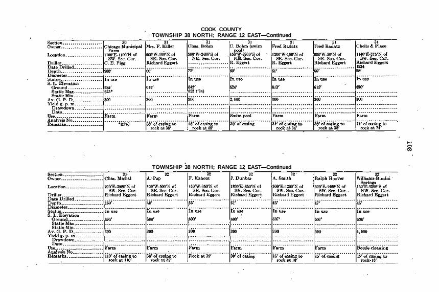
TOWNSHIP 38 NORTH; RANGE 12 EAST

TOWNSHIP 38 NORTH; RANGE 12 EAST—Continued
TOWNSHIP 38 NORTH; RANGE 12 EAST—Continued

COOK COUNTYTOWNSHIP 38 NORTH; RANGE 12 EAST—Continued
TOWNSHIP 38 NORTH; RANGE 12 EAST—Continued

TOWNSHIP 38 NORTH; RANGE 12 EAST—Continued
TOWNSHIP 38 NORTH; RANGE 12 EAST—Continued

COOK COUNTYTOWNSHIP 38 NORTH; RANGE 12 EAST—Continued
TOWNSHIP 38 NORTH; RANGE 12 EAST—Continued

TOWNSHIP 38 NORTH; RANGE 12 EAST—Continued
TOWNSHIP 38 NORTH; RANGE 12 EAST—Continued
COOK COUNTYTOWNSHIP 38 NORTH; RANGE 12 EAST—Continued
TOWNSHIP 38 NORTH; RANGE 12 EAST—Continued

TOWNSHIP 38 NORTH; RANGE 12 EAST—Continued
TOWNSHIP 38 NORTH; RANGE 12 EAST—Concluded
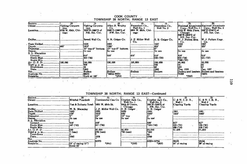
COOK COUNTYTOWNSHIP 38 NORTH; RANGE 13 EAST
TOWNSHIP 38 NORTH; RANGE 13 EAST—Continued

TOWNSHIP 38 NORTH; RANGE 13 EAST—Continued
TOWNSHIP 38 NORTH; RANGE 13 EAST—Concluded
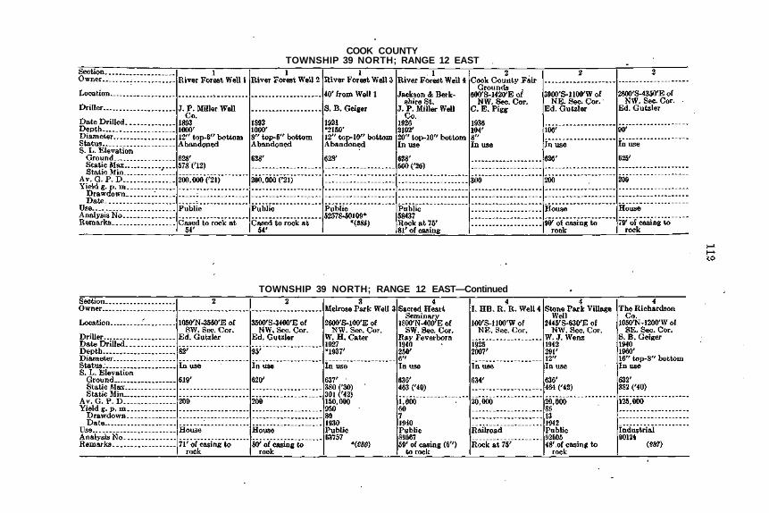
COOK COUNTYTOWNSHIP 39 NORTH; RANGE 12 EAST
TOWNSHIP 39 NORTH; RANGE 12 EAST—Continued
TOWNSHIP 39 NORTH; RANGE 12 EAST—Continued
TOWNSHIP 39 NORTH; RANGE 12 EAST—Continued
COOK COUNTYTOWNSHIP 39 NORTH; RANGE 12 EAST—Continued
TOWNSHIP 39 NORTH; RANGE 12 EAST—Continued

TOWNSHIP 39 NORTH; RANGE 12 EAST—Continued
TOWNSHIP 39 NORTH; RANGE 12 EAST—Continued

COOK COUNTYTOWNSHIP 39 NORTH; RANGE 12 EAST—Continued
TOWNSHIP 39 NORTH; RANGE 12 EAST—Continued

TOWNSHIP 39 NORTH; RANGE 12 EAST—Concluded
TOWNSHIP 39 NORTH; RANGE 13 EAST

COOK COUNTYTOWNSHIP 39 NORTH; RANGE 13 EAST—Concluded
119
ZONE I I I
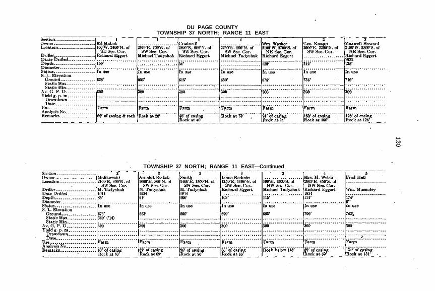
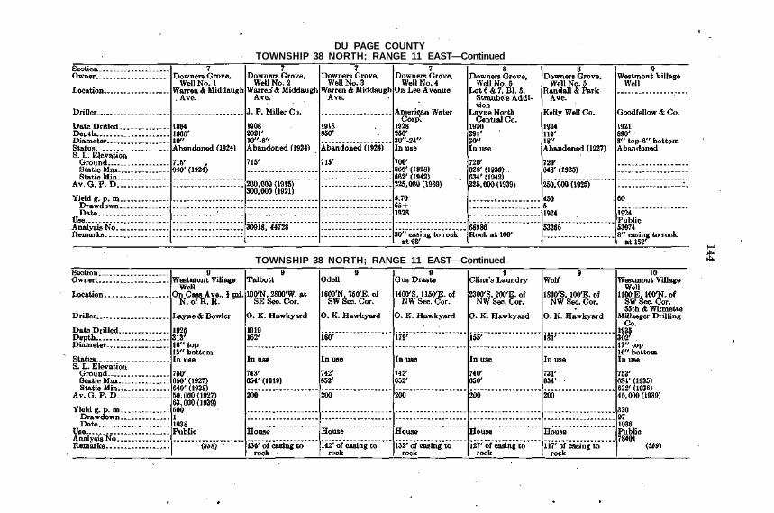
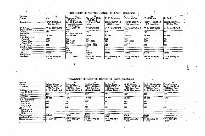
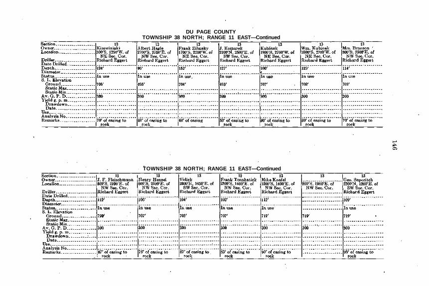
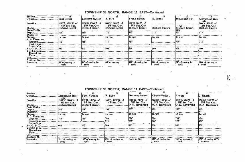
DU PAGE COUNTYTOWNSHIP 37 NORTH; RANGE 11 EAST
TOWNSHIP 37 NORTH; RANGE 11 EAST—Continued

TOWNSHIP 37 NORTH; RANGE 11 EAST—Continued
TOWNSHIP 37 NORTH; RANGE 11 EAST—Continued

DU PAGE COUNTYTOWNSHIP 37 NORTH; RANGE 11 EAST—Concluded
TOWNSHIP 38 NORTH; RANGE 9 EAST
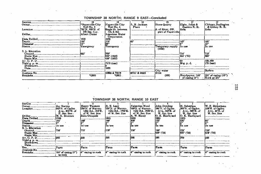
TOWNSHIP 38 NORTH; RANGE 9 EAST—Concluded
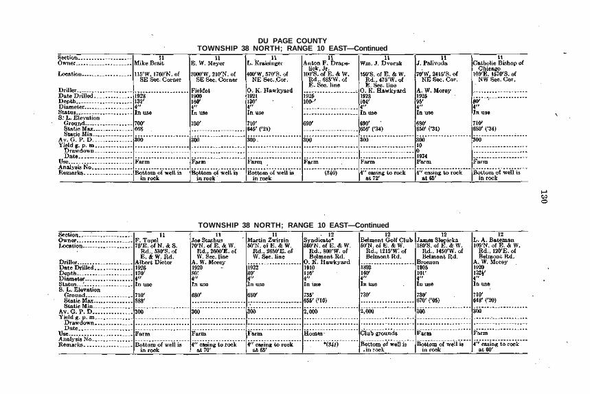
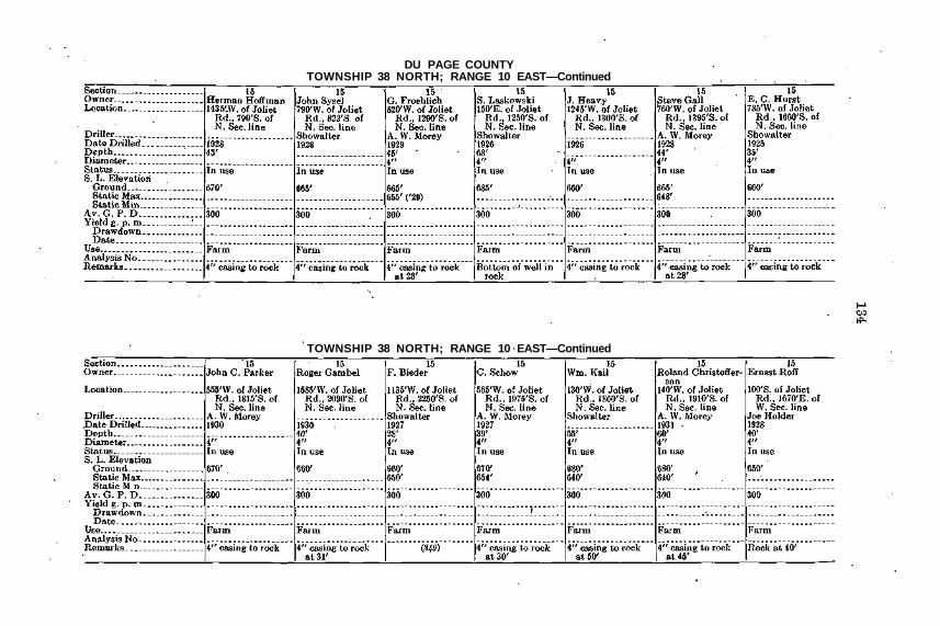
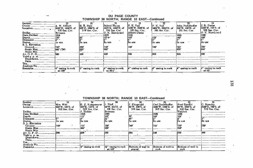
TOWNSHIP 38 NORTH; RANGE 10 EAST

DU PAGE COUNTYTOWNSHIP 38 NORTH; RANGE 10 EAST—Continued
TOWNSHIP 38 NORTH; RANGE 10 EAST—Continued

TOWNSHIP 38 NORTH; RANGE 10 EAST—Continued
TOWNSHIP 38 NORTH; RANGE 10 EAST—Continued
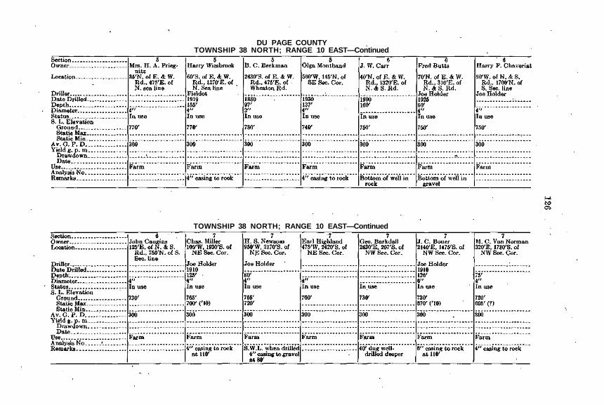
DU PAGE COUNTYTOWNSHIP 38 NORTH; RANGE 10 EAST—Continued
TOWNSHIP 38 NORTH; RANGE 10 EAST—Continued

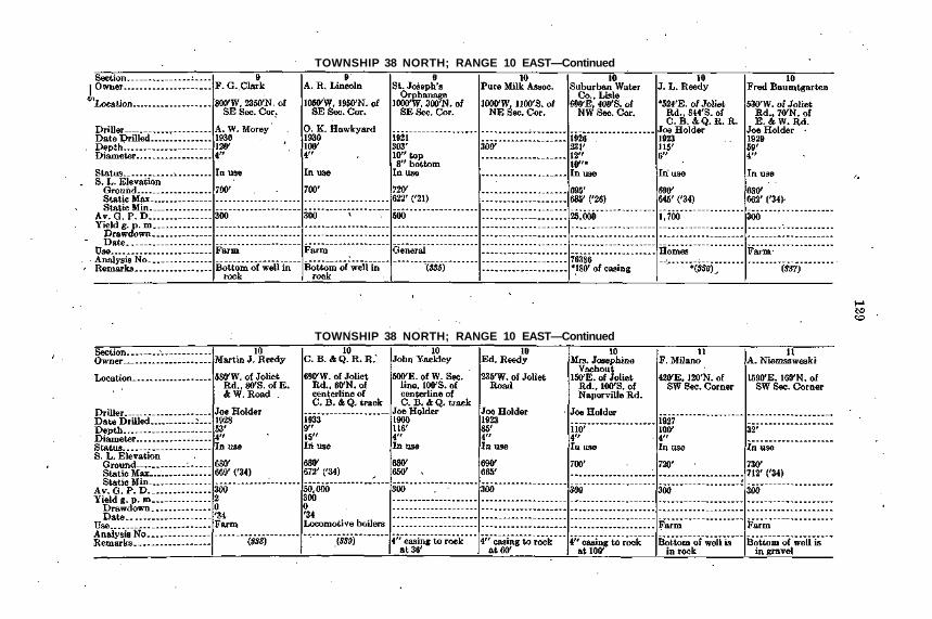
TOWNSHIP 38 NORTH; RANGE 10 EAST—Continued
TOWNSHIP 38 NORTH; RANGE 10 EAST—Continued

DU PAGE COUNTY .TOWNSHIP 38 NORTH; RANGE 10 EAST—Continued
TOWNSHIP 38 NORTH; RANGE 10 EAST—Continued
TOWNSHIP 38 NORTH; RANGE 10 EAST—Continued
TOWNSHIP 38 NORTH; RANGE 10 EAST—Continued
DU PAGE COUNTYTOWNSHIP 38 NORTH; RANGE 10 EAST—Continued
TOWNSHIP 38 NORTH; RANGE 10 EAST—Continued

TOWNSHIP 38 NORTH; RANGE 10 EAST—Continued
TOWNSHIP 38 NORTH; RANGE 10 EAST—Continued

DU PAGE COUNTYTOWNSHIP 38 NORTH; RANGE 10 EAST—Continued
TOWNSHIP 38 NORTH; RANGE 10 EAST—Continued

TOWNSHIP 38 NORTH; RANGE 10 EAST—Continued
TOWNSHIP 38 NORTH; RANGE 10 EAST—Continued
DU PAGE COUNTYTOWNSHIP 38 NORTH; RANGE 10 EAST—Continued
TOWNSHIP 38 NORTH; RANGE 10 EAST—Continued
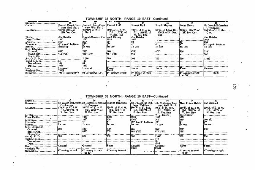
TOWNSHIP 38 NORTH; RANGE 10 EAST—Continued
TOWNSHIP 38 NORTH; RANGE 10 EAST—Continued

DU PAGE COUNTYTOWNSHIP 38 NORTH; RANGE 10 EAST—Continued
TOWNSHIP 38 NORTH; RANGE 10 EAST—Continued

TOWNSHIP 38 NORTH; RANGE 10 EAST—Continued
TOWNSHIP 38 NORTH; RANGE 10 EAST—Continued
DU PAGE COUNTYTOWNSHIP 38 NORTH; RANGE 10 EAST—Continued
TOWNSHIP 38 NORTH; RANGE 10 EAST—Continued

TOWNSHIP 38 NORTH; RANGE 10 EAST—Continued
TOWNSHIP 38 NORTH; RANGE 10 EAST—Continued

DU PAGE COUNTYTOWNSHIP 38 NORTH; RANGE 10 EAST—Continued
TOWNSHIP 38 NORTH; RANGE 10 EAST—Continued

TOWNSHIP 38 NORTH; RANGE 10 EAST—Continued
TOWNSHIP 38 NORTH; RANGE 10 EAST—Continued

DU PAGE COUNTYTOWNSHIP 38 NORTH; RANGE 10 EAST—Continued
TOWNSHIP 38 NORTH; RANGE 10 EAST—Concluded

TOWNSHIP 38 NORTH; RANGE 11 EAST
TOWNSHIP-38 NORTH; RANGE 11 EAST—Continued
DU PAGE COUNTYTOWNSHIP 38 NORTH; RANGE 11 EAST—Continued
TOWNSHIP 38 NORTH; RANGE 11 EAST—Continued
TOWNSHIP 38 NORTH; RANGE 11 EAST—Continued ,
TOWNSHIP 38 NORTH; RANGE 11 EAST—Continued
DU PAGE COUNTYTOWNSHIP 38 NORTH; RANGE 11 EAST—Continued
TOWNSHIP 38 NORTH; RANGE 11 EAST—Continued
TOWNSHIP 38 NORTH; RANGE 11 EAST—Continued
TOWNSHIP 38 NORTH; RANGE 11 EAST—Continued

DU PAGE COUNTYTOWNSHIP 38 NORTH; RANGE 11 EAST—Continued
TOWNSHIP 38 NORTH; RANGE 11 EAST—Continued
TOWNSHIP 38 NORTH; RANGE 11 EAST—Continued
TOWNSHIP 38 NORTH; RANGE 11 EAST—Concluded

DU PAGE COUNTYTOWNSHIP 39 NORTH; RANGE 9 EAST
TOWNSHIP 39 NORTH; RANGE 9 EAST—Continued

TOWNSHIP 39 NORTH; RANGE 9 EAST—Concluded
TOWNSHIP 39 NORTH; RANGE 10 EAST
DU PAGE COUNTYTOWNSHIP 39 NORTH; RANGE 10 EAST—Continued
TOWNSHIP 39 NORTH; RANGE 10 EAST—Concluded

TOWNSHIP 39 NORTH; RANGE 11 EAST
TOWNSHIP 39 NORTH; RANGE 11 EAST—Continued

DU PAGE COUNTYTOWNSHIP 39 NORTH; RANGE 11 EAST—Continued
TOWNSHIP 39 NORTH; RANGE 11 EAST—Continued
1
TOWNSHIP 39 NORTH; RANGE 11 EAST—Continued
TOWNSHIP 39 NORTH; RANGE 11 EAST—Continued

DU PAGE COUNTYTOWNSHIP 39 NORTH; RANGE 11 EAST—Concluded
157
ZONE IV

WILL COUNTY'TOWNSHIP 32 NORTH; RANGE 9 EAST
TOWNSHIP 32 NORTH; RANGE 10 EAST

TOWNSHIP 33 NORTH; RANGE 9 EAST
TOWNSHIP 33 NORTH; RANGE 9 EAST—Continued

WILL COUNTYTOWNSHIP 33 NORTH; RANGE 9 EAST—Continued
TOWNSHIP 33 NORTH; RANGE 9 EAST—Continued
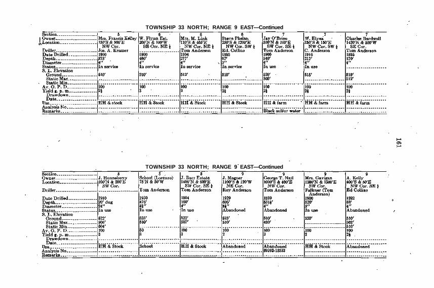
TOWNSHIP 33 NORTH; RANGE 9 EAST—Continued
TOWNSHIP 33 NORTH; RANGE 9 EAST—Continued
WILL COUNTYTOWNSHIP 33 NORTH; RANGE 9 EAST—Continued
TOWNSHIP 33 NORTH; RANGE 9 EAST—Continued

TOWNSHIP 33 NORTH; RANGE 9 EAST—Continued
TOWNSHIP 33 NORTH; RANGE 9 EAST—Continued
WILL COUNTYTOWNSHIP 33 NORTH; RANGE 9 EAST—Continued
TOWNSHIP 33 NORTH; RANGE 9 EAST—Continued

TOWNSHIP 33 NORTH; RANGE 9 EAST—Continued
TOWNSHIP 33 NORTH; RANGE 9 EAST—Continued

WILL COUNTYTOWNSHIP 33 NORTH; RANGE 9 EAST—Continued
TOWNSHIP 33 NORTH; RANGE 9 EAST—Continued
TOWNSHIP 33 NORTH; RANGE 9 EAST—Continued
TOWNSHIP 33 NORTH; RANGE 9 EAST—Continued

WILL COUNTYTOWNSHIP 33 NORTH; RANGE 9 EAST—Concluded
TOWNSHIP 33 NORTH; RANGE 10 EAST

TOWNSHIP 33 NORTH; RANGE 10 EAST—Continued
TOWNSHIP 33 NORTH; RANGE 10 EAST—Continued
WILL COUNTYTOWNSHIP 33 NORTH; RANGE 10 EAST—Concluded
TOWNSHIP 33 NORTH; RANGE 11 EAST
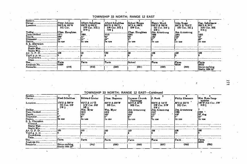
TOWNSHIP 33 NORTH; RANGE 12 EAST
TOWNSHIP 33 NORTH; RANGE 12 EAST—Continued
WILL COUNTYTOWNSHIP 33 NORTH; RANGE 12 EAST—Continued
TOWNSHIP 33 NORTH; RANGE 12 EAST—Continued
TOWNSHIP 33 NORTH; RANGE 12 EAST—Continued
TOWNSHIP 33 NORTH; RANGE 12 EAST—Continued

WILL COUNTYTOWNSHIP 33 NORTH; RANGE 12 EAST—Continued
TOWNSHIP 33 NORTH; RANGE 12 EAST—Continued
TOWNSHIP 33 NORTH; RANGE 12 EAST—Continued
TOWNSHIP 33 NORTH; RANGE 12 EAST—Continued

WILL COUNTYTOWNSHIP 33 NORTH; RANGE 12 EAST—Continued
TOWNSHIP 33 NORTH; RANGE 12 EAST—Continued

TOWNSHIP 33 NORTH; RANGE 12 EAST—Continued
TOWNSHIP 33 NORTH; RANGE 12 EAST—Concluded
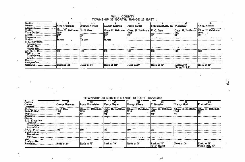
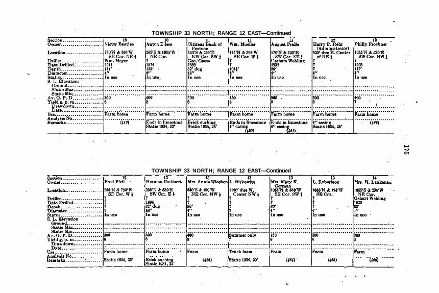
WILL COUNTYTOWNSHIP 33 NORTH; RANGE 13 EAST .
TOWNSHIP 33 NORTH; RANGE 13 EAST—Concluded

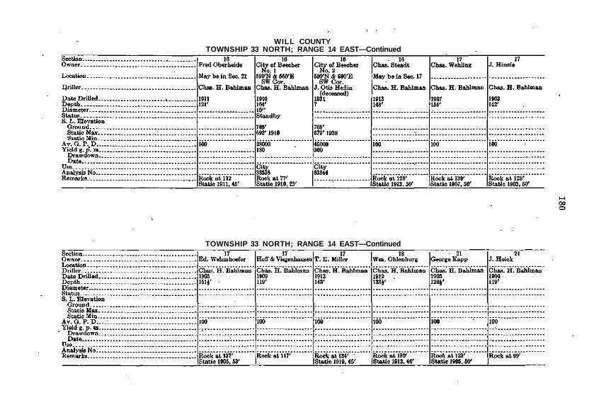
TOWNSHIP 33 NORTH; RANGE 14 EAST
TOWNSHIP 33 NORTH; RANGE 14 EAST—Continued
WILL COUNTYTOWNSHIP 33 NORTH; RANGE 14 EAST—Continued
TOWNSHIP 33 NORTH; RANGE 14 EAST—Continued

TOWNSHIP 33 NORTH; RANGE 14 EAST—Continued
TOWNSHIP 33 NORTH; RANGE 14 EAST—Concluded
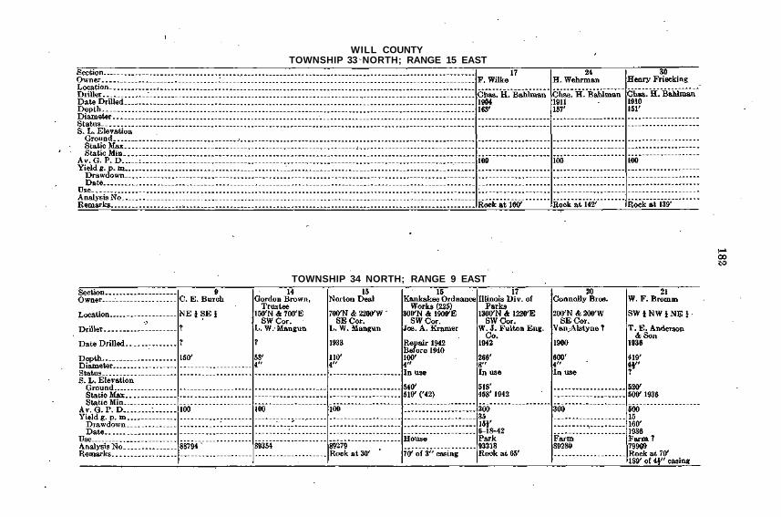
WILL COUNTYTOWNSHIP 33 NORTH; RANGE 15 EAST
TOWNSHIP 34 NORTH; RANGE 9 EAST
TOWNSHIP 34 NORTH; RANGE 9 EAST—Continued
TOWNSHIP 34 NORTH; RANGE 9 EAST—Continued

WILL COUNTYTOWNSHIP 34 NORTH; RANGE 9 EAST—Continued
TOWNSHIP 34 NORTH; RANGE 9 EAST—Continued

TOWNSHIP 34 NORTH; RANGE 9 EAST—Concluded
TOWNSHIP 34 NORTH; RANGE 10 EAST
WILL COUNTYTOWNSHIP 34 NORTH; RANGE 10 EAST—Continued
TOWNSHIP 34 NORTH; RANGE 10 EAST—Continued

TOWNSHIP 34 NORTH; RANGE 10 EAST—Continued
TOWNSHIP 34 NORTH; RANGE 10 EAST—Concluded
WILL COUNTYTOWNSHIP 34 NORTH; RANGE 11 EAST
TOWNSHIP 34 NORTH; RANGE 12 EAST

TOWNSHIP 34 NORTH; RANGE 12 EAST—Continued
TOWNSHIP 34 NORTH; RANGE 12 EAST—Concluded

WILL COUNTYTOWNSHIP 34 NORTH; RANGE 13 EAST
TOWNSHIP 34 NORTH; RANGE 13 EAST—Continued
TOWNSHIP 34 NORTH; RANGE 13 EAST—Continued
TOWNSHIP 34 NORTH; RANGE 13 EAST—Continued

WILL COUNTYTOWNSHIP 34 NORTH; RANGE 13 EAST—Continued
TOWNSHIP 34 NORTH; RANGE 13 EAST—Concluded
I
TOWNSHIP 34 NORTH; RANGE 14 EAST
TOWNSHIP 34 NORTH; RANGE 14 EAST—Continued

WILL COUNTYTOWNSHIP 34 NORTH; RANGE 14 EAST—Continued
TOWNSHIP 34 NORTH; RANGE 14 EAST—Continued

TOWNSHIP 34 NORTH; RANGE 14 EAST—Continued
TOWNSHIP 34 NORTH; RANGE 14 EAST—Concluded

WILL COUNTYTOWNSHIP 34 NORTH; RANGE 15 EAST
TOWNSHIP 35 NORTH; RANGE 9 EAST

TOWNSHIP 35 NORTH; RANGE 10 EAST
' TOWNSHIP 35 NORTH; RANGE 10 EAST—Continued
WILL COUNTYTOWNSHIP 35 NORTH; RANGE 10 EAST—Continued
' TOWNSHIP 35 NORTH; RANGE 10 EAST—Continued
TOWNSHIP 35 NORTH; RANGE 10 EAST—Continued
TOWNSHIP 35 NORTH; RANGE 10 EAST—Continued

WILL COUNTYTOWNSHIP 35 NORTH; RANGE 10 EAST—Continued
TOWNSHIP 35 NORTH; RANGE 10 EAST—Continued

TOWNSHIP 35 NORTH; RANGE 10 EAST—Continued
TOWNSHIP 35 NORTH; RANGE 10 EAST—Continued
WILL COUNTYTOWNSHIP 35 NORTH; RANGE 10 EAST—Continued
TOWNSHIP 35 NORTH; RANGE 10 EAST—Continued

TOWNSHIP 35 NORTH; RANGE 10 EAST—Continued
TOWNSHIP 35 NORTH; RANGE 10 EAST—Continued
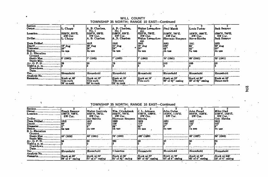
WILL COUNTYTOWNSHIP 35 NORTH; RANGE 10 EAST—Continued
TOWNSHIP 35 NORTH; RANGE 10 EAST—Continued
TOWNSHIP 35 NORTH; RANGE 10 EAST—Continued
TOWNSHIP 35 NORTH; RANGE 10 EAST—Continued

WILL COUNTYTOWNSHIP 35 NORTH; RANGE 10 EAST—Continued
TOWNSHIP 35 NORTH;'RANGE 10 EAST—Continued

TOWNSHIP 35 NORTH; RANGE 10 EAST—Continued
TOWNSHIP 35 NORTH; RANGE 10 EAST—Continued

WILL COUNTYTOWNSHIP 35 NORTH; RANGE 10 EAST—Continued
TOWNSHIP 35 NORTH; RANGE 10 EAST—Continued

TOWNSHIP 35 NORTH; RANGE 10 EAST—Continued
TOWNSHIP 35 NORTH; RANGE 10 EAST—Continued
WILL COUNTYTOWNSHIP 35 NORTH; RANGE 10 EAST—Continued
TOWNSHIP 35 NORTH; RANGE 10 EAST—Continued
TOWNSHIP 35 NORTH; RANGE 10 EAST—Continued
TOWNSHIP 35 NORTH; RANGE 10 EAST—Continued

WILL COUNTYTOWNSHIP 35 NORTH.; RANGE 10 EAST—Continued
TOWNSHIP 35 NORTH; RANGE 10 EAST—Continued

TOWNSHIP 35 NORTH; RANGE 10 EAST—Continued
TOWNSHIP 35 NORTH; RANGE 10 EAST—Continued
WILL COUNTYTOWNSHIP 35 NORTH; RANGE 10 EAST—Continued
TOWNSHIP 35 NORTH; RANGE 10 EAST—Continued
TOWNSHIP 35 NORTH; RANGE 10 EAST—Continued
TOWNSHIP 35 NORTH; RANGE 10 EAST—Continued

WILL COUNTYTOWNSHIP 35 NORTH; RANGE 10 EAST—Continued
TOWNSHIP 35 NORTH; RANGE 10 EAST—Continued

TOWNSHIP 35 NORTH; RANGE 10 EAST—Continued
TOWNSHIP 35 NORTH; RANGE 10 EAST—Continued

WILL COUNTYTOWNSHIP 35 NORTH; RANGE 10 EAST—Continued
TOWNSHIP 35 NORTH; RANGE 10 EAST—Continued
TOWNSHIP 35 NORTH; RANGE 10 EAST—Continued
TOWNSHIP 35 NORTH; RANGE 10 EAST—Continued

WILL COUNTYTOWNSHIP 35 NORTH: RANGE 10 EAST—Continued
TOWNSHIP 35 NORTH; RANGE 10 EAST—Continued
TOWNSHIP 35 NORTH; RANGE 10 EAST—Continued
TOWNSHIP 35 NORTH; RANGE 10 EAST—Continued
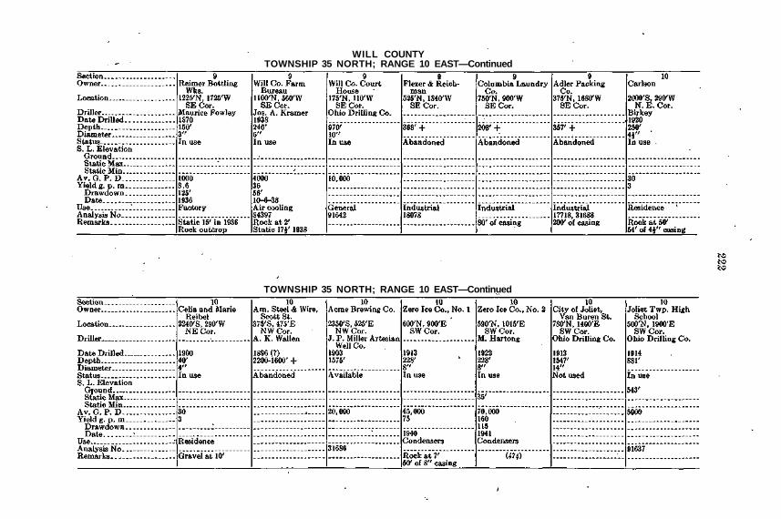
WILL COUNTYTOWNSHIP 35 NORTH; RANGE 10 EAST—Continued
TOWNSHIP 35 NORTH; RANGE 10 EAST—Continued

TOWNSHIP 35 NORTH; RANGE 10 EAST—Continued
TOWNSHIP 35 NORTH; RANGE 10 EAST—Continued

WILL COUNTYTOWNSHIP 35 NORTH; RANGE 10 EAST—Continued
TOWNSHIP 35 NORTH; RANGE 10 EAST—Continued
TOWNSHIP 35 NORTH; RANGE 10 EAST—Continued
TOWNSHIP 35 NORTH; RANGE 10 EAST—Continued

WILL COUNTYTOWNSHIP 35 NORTH; RANGE 10 EAST—Continued
TOWNSHIP 35 NORTH; RANGE 10 EAST—Continued

TOWNSHIP 35 NORTH; RANGE 10 EAST—Continued
TOWNSHIP 35 NORTH; RANGE 10 EAST—Continued

WILL COUNTYTOWNSHIP 35 NORTH; RANGE 10. EAST—Continued
TOWNSHIP 35 NORTH; RANGE 10 EAST—Continued

TOWNSHIP 35 NORTH; RANGE 10 EAST—Continued
TOWNSHIP 35 NORTH; RANGE 10 EAST—Continued
WILL COUNTYTOWNSHIP 35 NORTH; RANGE 10 EAST—Continued
TOWNSHIP 35 NORTH; RANGE 10 EAST—Continued
TOWNSHIP 35 NORTH; RANGE 10 EAST—Continued
TOWNSHIP 35 NORTH; RANGE 10 EAST—Continued

WILL COUNTYTOWNSHIP 35 NORTH; RANGE 10 EAST—Continued
TOWNSHIP 35 NORTH; RANGE 10 EAST—Continued

TOWNSHIP 35 NORTH; RANGE 10 EAST—Continued
TOWNSHIP 35 NORTH; RANGE 10 EAST—Continued

WILL COUNTYTOWNSHIP 35 NORTH; RANGE 10 EAST—Continued
TOWNSHIP 35 NORTH; RANGE 10 EAST—Continued
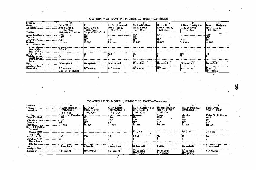
TOWNSHIP 35 NORTH; RANGE 10 EAST—Continued
TOWNSHIP 35 NORTH; RANGE 10 EAST—Continued

WILL COUNTYTOWNSHIP 35 NORTH; RANGE 10 EAST—Continued
TOWNSHIP 35 NORTH; RANGE 10 EAST—Continued

TOWNSHIP 35 NORTH; RANGE 10 EAST—Continued
TOWNSHIP 35 NORTH; RANGE 10 EAST—Continued
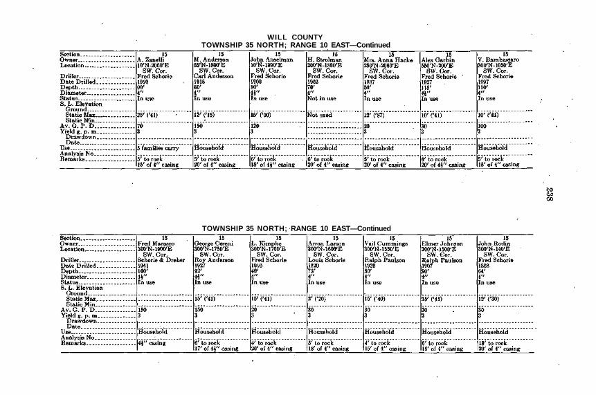
WILL COUNTYTOWNSHIP 35 NORTH; RANGE 10 EAST—Continued
TOWNSHIP 35 NORTH; RANGE 10 EAST—Continued
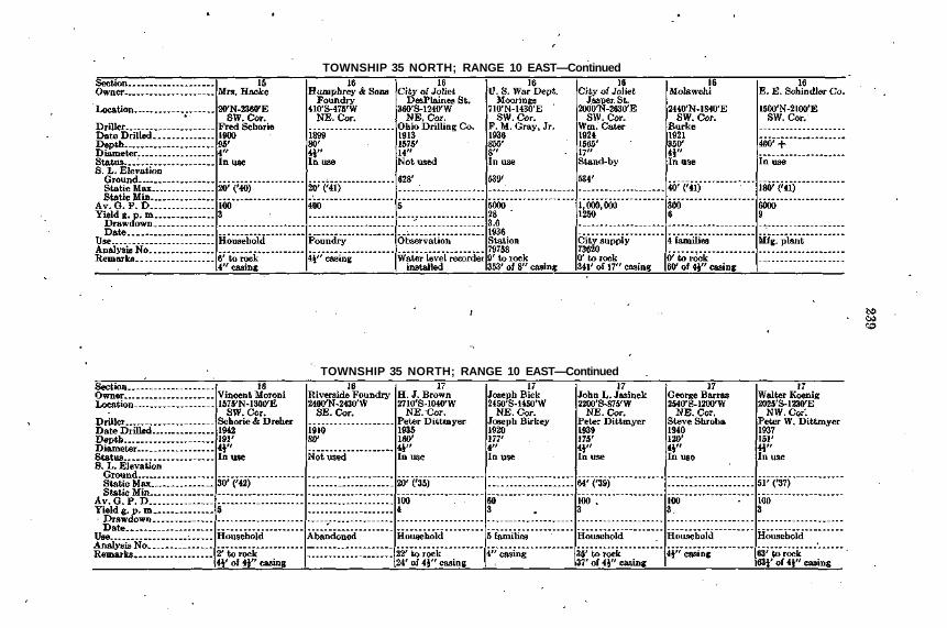
TOWNSHIP 35 NORTH; RANGE 10 EAST—Continued
TOWNSHIP 35 NORTH; RANGE 10 EAST—Continued
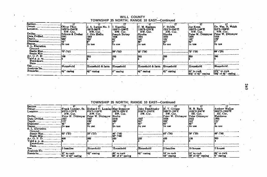
WILL COUNTYTOWNSHIP 35 NORTH; RANGE 10 EAST—Continued
TOWNSHIP 35 NORTH; RANGE 10 EAST—Continued

TOWNSHIP 35 NORTH; RANGE 10 EAST—Continued
TOWNSHIP 35 NORTH; RANGE 10 EAST—Continued
WILL COUNTYTOWNSHIP 35 NORTH; RANGE 10 EAST—Continued
TOWNSHIP 35 NORTH; RANGE 10 EAST—Continued

TOWNSHIP 35 NORTH; RANGE 10 EAST—Continued
TOWNSHIP 35 NORTH; RANGE 10 EAST—Continued

WILL COUNTYTOWNSHIP 35 NORTH; RANGE 10 EAST—Continued
TOWNSHIP 35 NORTH; RANGE 10 EAST—Continued

TOWNSHIP 35 NORTH; RANGE 10 EAST—Continued
TOWNSHIP 35 NORTH; RANGE 10 EAST—Continued

WILL COUNTYTOWNSHIP 35 NORTH; RANGE 10 EAST—Continued
TOWNSHIP 35 NORTH; RANGE 10 EAST—Continued

TOWNSHIP 35 NORTH; RANGE 10 EAST—Continued
TOWNSHIP 35 NORTH; RANGE 10 EAST—Continued
WILL COUNTYTOWNSHIP 35 NORTH; RANGE 10 EAST—Continued
TOWNSHIP 35 NORTH; RANGE 10 EAST—Continued
TOWNSHIP 35 NORTH; RANGE 10 EAST—Continued
TOWNSHIP 35 NORTH; RANGE 10 EAST—Continued
WILL COUNTYTOWNSHIP 35 NORTH; RANGE 10 EAST—Continued
TOWNSHIP 35 NORTH; RANGE 10 EAST—Concluded
TOWNSHIP 35 NORTH; RANGE 11 EAST
TOWNSHIP 35 NORTH; RANGE 11 EAST—Continued

WILL COUNTYTOWNSHIP 35 NORTH; RANGE 11 EAST—Continued
TOWNSHIP 35 NORTH; RANGE 11 EAST—Continued

TOWNSHIP 35 NORTH; RANGE 11 EAST—Continued
TOWNSHIP 35 NORTH; RANGE 11 EAST—Continued

WILL COUNTYTOWNSHIP 35 NORTH; RANGE 11 EAST—Continued
TOWNSHIP 35 NORTH; RANGE 11 EAST—Continued

TOWNSHIP 35 NORTH; RANGE 11 EAST—Continued
TOWNSHIP 35 NORTH; RANGE 11 EAST—Continued
WILL COUNTYTOWNSHIP 35 NORTH; RANGE 11 EAST—Continued
TOWNSHIP 35 NORTH; RANGE 11 EAST—Continued

TOWNSHIP 35 NORTH; RANGE 11 EAST—Continued
TOWNSHIP 35 NORTH; RANGE 11 EAST—Concluded

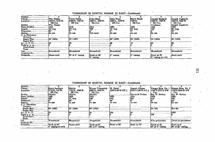
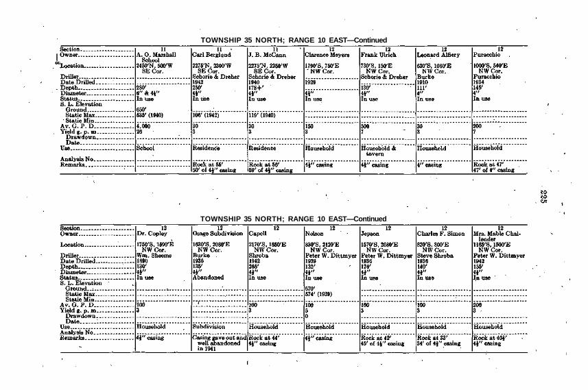
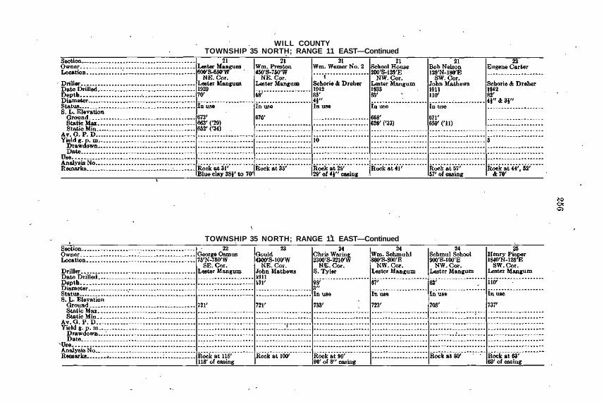
WILL COUNTYTOWNSHIP 35 NORTH; RANGE 12 EAST
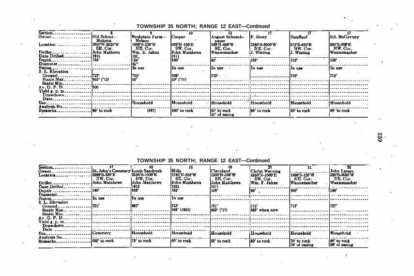
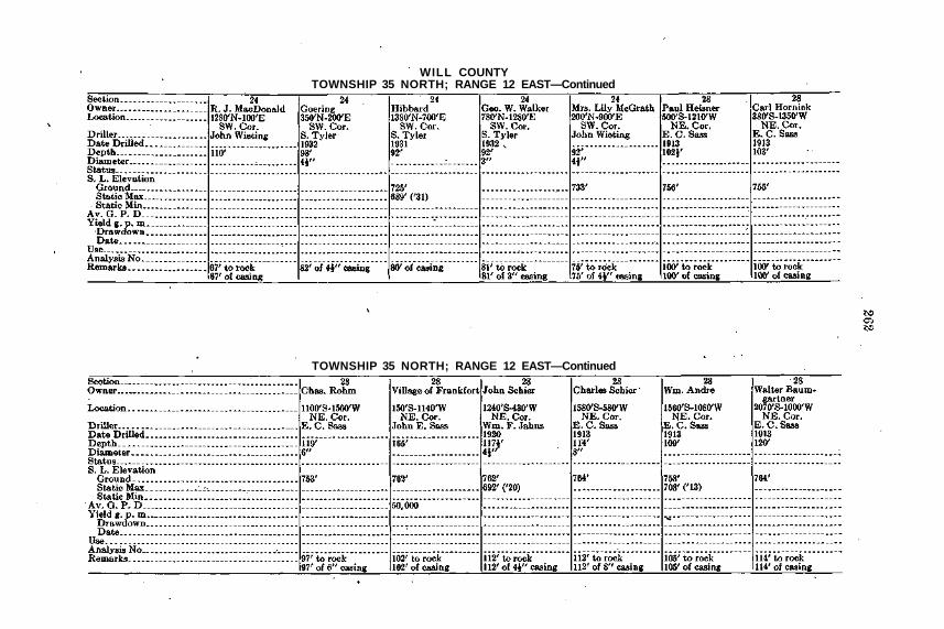
TOWNSHIP 35 NORTH; RANGE 12 EAST—Continued
TOWNSHIP 35 NORTH; RANGE 12 EAST—Continued
TOWNSHIP 35 NORTH; RANGE 12 EAST—Continued

WILL COUNTYTOWNSHIP 35 NORTH; RANGE 12 EAST—Continued
TOWNSHIP 35 NORTH; RANGE 12 EAST—Continued

TOWNSHIP 35 NORTH; RANGE 12 EAST—Continued
TOWNSHIP 35 NORTH; RANGE 12 EAST—Continued ' ,
WILL COUNTYTOWNSHIP 35 NORTH; RANGE 12 EAST—Continued
TOWNSHIP 35 NORTH; RANGE 12 EAST—Continued

TOWNSHIP 35 NORTH; RANGE 12 EAST—Continued
TOWNSHIP 35 NORTH; RANGE 12 EAST—Concluded

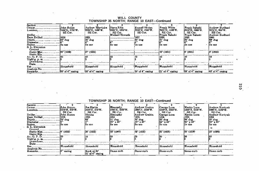
WILL COUNTYTOWNSHIP 36 NORTH; RANGE 9 EAST
TOWNSHIP 36 NORTH; RANGE 10 EAST

TOWNSHIP 36 NORTH; RANGE 10 EAST—Continued
TOWNSHIP 36 NORTH; RANGE 10 EAST—Continued

WILL COUNTYTOWNSHIP 36 NORTH; RANGE 10 EAST—Concluded
TOWNSHIP 36 NORTH; RANGE 11 EAST

TOWNSHIP 36 NORTH; RANGE 11 EAST—Concluded
TOWNSHIP 37 NORTH; RANGE 9 EAST

269
TABLE IIIMineral Qualities of Ground Water in the Chicago-Joliet-
Chicago Heights Area

270

271
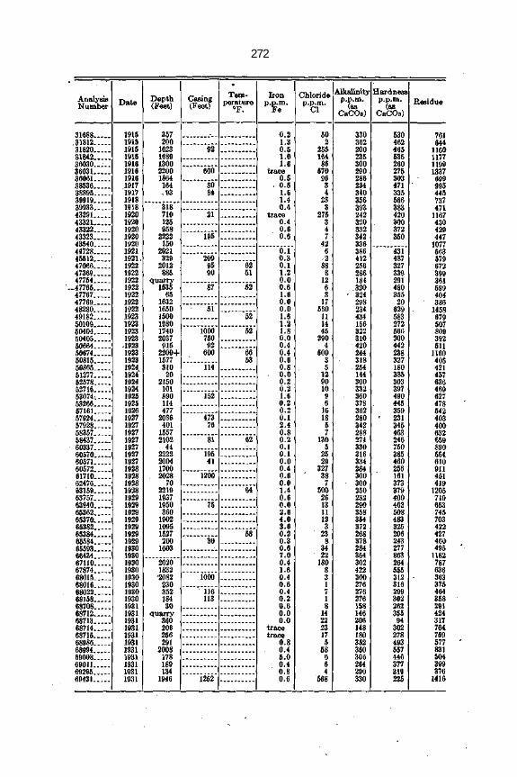
272
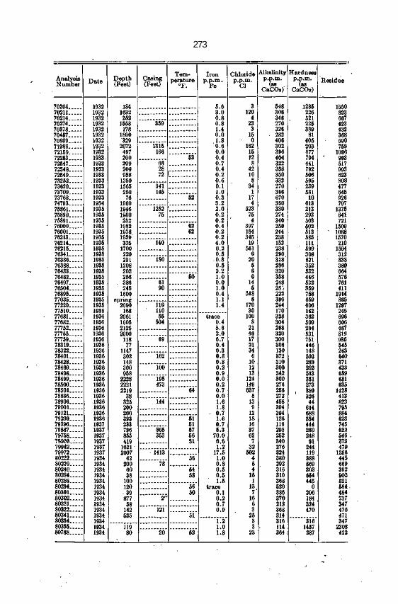
273

274

275

276

277
279
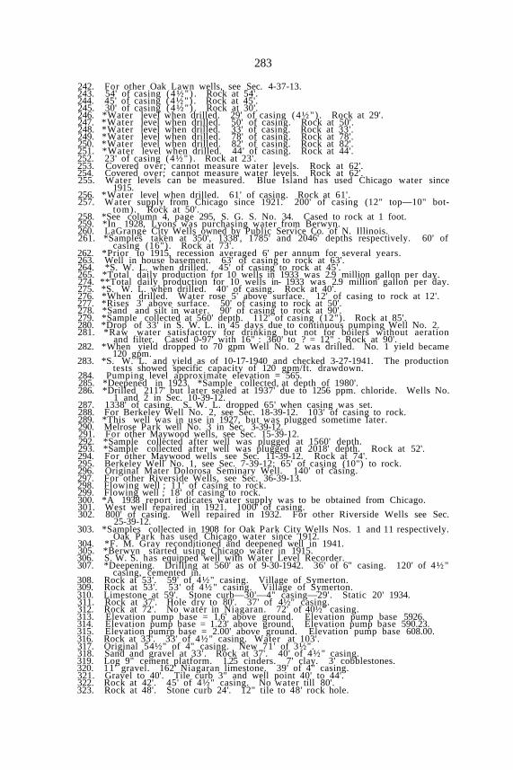
REMARKS

280
1. Well is 20' N. of Power Station. 95' of casing 10". .2. Well abandoned after losing tools at 1000'.3. Rock outcrop in roadside ditch on Cicero Ave. N. of 111th St.4. Not used since 1920. In 1934 report states "well is open, can be used."5. Sealed and capped ; not used since 1923. Rock at 90'.6. City water from Chicago since about 1921.7. 85' of casing. (4½") Rock at 85'.8. Known as Original Well—200' W. of S. Well. 81' of casing (4"). Rock at
80'.9. S.W.L. can be measured if head is removed. *Filtered.
10. 100' of casing. Pump 300 g.p.m. for 24 hrs. per day.11. *20' N. of Slip-end 93rd St. in "D" house. 95' of casing (6"). Rock at 95'.12. *On Slip at foot 93rd St. in "C" house. 95' of casing (6"). Rock at 95'.13. Sealed and capped, 1925. Well was shot but could not produce 22 g.p.m.14. S.W.L. cannot be measured. 85' of casing 06"). Rock at 85'.15. Building torn down 77' of casing (10"). Rock at 77'.16. S.W.L. cannot be measured. Well is 350' E. of Slip No. 2. Rock at 80'.17. Dry well since 1928. Well is 150' N. of Slip No. 2. . Rock at 60'.18. *Greatly reduced in 1934. S.W.L. cannot be measured. Rock at 75'.19. S.W.L. can be measured if cap is removed. Well in boiler room. Rock at 45'.20. S.W.L. can be measured if plug is removed. Well in boiler room. Rock at21. S.W.L. can be measured. Well in SW. corner of kiln room. Rock at 100'.22. S.W.L. can be measured. Well outside W. wall of pump room. 10" casing
to rock at 93'.23. S.W.L. can be measured if head is removed. 12" casing to rock at 100'.24. Top can be removed and S.W.L. measured. 93' of casing to rock.25. Well is at SE. corner of Power House in the open. 90' of casing to rock.26. Condemned for drinking 1934. *Originally 305' depth, deepened in 1913.27. S.W.L. can be measured if head is removed. Condemned.28. Sealed and capped; last used in 1919.29. Casing cemented over. 42' of casing (7"). Rock at 42'.30. *Repaired in 1911. History of drilling available in J. P. Miller files.31. *Out of service 1918 to 1933. Difficult to measure S.W.L.32. *Not used since 1926. 50' casing to rock.33. Went dry in 1929. 40' drift to rock.34. Well in blacksmith shop, north center of building. 52' of casing (6") to rock.35. *Repaired in 1916 and 1917. Original owner was Independent Packing Co.
Rock at 75'.36. *Note rise in S.W.L. Cannot measure S.W.L. 600' of 20" casing.37. In April, 1935 there was no pump and well was capped.38. S.W.L. can be measured. 72' of casing. Rock at 69'.39. S.W.L. can be measured. Last used in 1925.40. S.W.L. can be measured. 70' of casing.41. S.W.L. can be measured. Rock at 60'. Recorder.42. In Engine House No. 8 . Rock at 73'.43. Glue House No. 20. Rock at 68'.44. *Formerly J. C. Hately—probably Armour & Co. now. Rock at 58'.45. *Well is on E. side of engine room. S.W.L. can be measured.46. Miller files indicate this well was at Union Stock Yards.47. Abandoned and covered over; caved in. Rock at 66'.48. Abandoned and covered over; caved in.49. S.W.L. can be measured; weir box in place; NE. corner of Bldg. No. 16.50. Well may be property of Armour & Co. Rock at 28'.51. S.W.L. can be measured. Rock at 45'.52. Formerly Sulzbarger & Sons. 65' of casing.53. S.W.L. can be measured. Leake in casing at 60' (1931).54. Formerly Illinois Vinegar Works. S.W.L. can be measured. Rock at 56'.55. Deep well, but location indefinite. 300' of casing.56. S.W.L. can be measured. *Sample 22966 at original depth of 1960' and 1788'
casing. Sample 27950 taken after plugging well at 1868' and with casingremoved between 853' and 1547'.
57. Geiger has analysis by Dearborn Chemical Co. Rock at 75'.58. Used City water since 1923. Rock at 50'.59. 32' casing. Went dry in 1915.60. S.W.L. can be measured if airline is disconnected.61. Exact location of well not known. 90' to rock.63. Casing has been capped ; American Malting Co.64. High content sulphur for bottling purpose. 113' to rock.65. S.W.L. can be measured if pump head is removed. 100' to rock.66. Well went dry when Fulton Market well was constructed.67. Well went dry when Wacker Drive was constructed.68. Used occasionally. Unit ready for service. 103' of casing.69. Sealed and capped. Deepened from 1290' in 1914. Sample collected at 1290'
depth.70. Well covered up when building was remodeled in 1918 or 1919.71. Discontinued on account of scarcity of water.72. Formerly brewing plant; new warehouse; wells abandoned.73. Formerly brewing plant; new warehouse; wells abandoned.74. Formerly brewing plant; new warehouse; wells abandoned.75. Sealed and capped ; formerly Crane Co.76. Too expensive to return to service.; dismantled; sealed and capped.77. Well undoubtedly covered by Halsted Street bridge. 32' of casing.78. Use City water. Cased 57' to rock.79. Use City water. S.W.L. can be measured if top is removed.

281
80. *Depth in 1934; original depth 1408' (1891) and deepened to 2051' (1901).41' of casing. *Sample collected at 1595' depth.
81. Originally I. C. R. R. well No. 2. 85' of casing (10") to rock.82. Originally I. C. R. R. well No. 3. Casing 88' of 16" ; 379' of 13".83. 86' of casing (4"). Rock at 86'.84. Pump about 6 hrs. per day during summer.85. 96' of casing (4"). Rock at 96'.86. 90' of casing (4"). Rock at 90'.87. 100' of casing (4½") . Rock at 100'.88. 81' of casing. Rock at 81'. Sulphur at 150'.89. 85' of casing (6"). Rock at 85'.90. 100' of casing (4½") . Rock at 100'.91. 103' of casing (4") . Rock at 103'.92. *Average pumping period of 5 months per year.93. *Average pumping period of 5 months per year.94. 86' of casing (3"). Rock at 86'.95. 80' of casing (4½"). Rock at 80'.96. 70' of casing (4½") . Rock at 70'.97. 87' of casing (4½") . Rock at 87'.98. 78' of casing (4½"). Rock at 78'.99. 44' of casing (4½") . Rock at 44'.
100. 55' of casing (4½") . Rock at 55'.101. 54' of casing (4½") . Rock at 52'.102. 34' of casing in 7½" pit. Rock at 34'.103. 79½' of casing (4½") . Rock at 79'.104. 81' of casing (4½") . Rock at 80'.105. 40%' of casing (4½") . Rock at 40'.106. 89' of casing (4½"). Rock at 88'.107. 85' of casing (4½") . Rock at 83'.108. 65.5' of casing (8"). Rock at 64'8".109. 92' of casing (4½") . Rock at 91'.110. 85.5' of casing (4½") . Rock at 84'.111. 85' of casing (4½") . Rock at 85'.112. *When drilled—63.5' of casing (6"). Rock at 63'.113. 91' of casing (4½") . Rock at 90'.114. 74' of casing (4½"). Rock at 73'.115. 83' of casing (4½") . Rock at 82'.116. 88' of casing (4½") . Rock at 88'117. Casing 4.5" in rock. Rock at 70'.118. 100' of casing (6"). Rock at 100'.119. 46' of casing (4½") . Rock at 45'.120. 100' of casing (8"). Rock at 98'.121. 70' of casing (6") . Rock at 68.5'.122. 71' of casing (10" in 13' pit).) Rock at 70'.123. 80' of casing (4½") . Rock at 78.5'.124; 79' of casing (4½"). Rock at 78.5'. 3 houses on 1 well.125. 64' of casing (4½") . Rock at 63.5';126. 94' of casing (4½") . Rock at 93.5'.127. *When drilled—98' of casing (4½") . Rock at 97.5'.128. 80' of casing (4½") . Rock at 79.5'.129. 78' of casing (4½") . Rock at 77.5'.130. 115' of casing (4½") . Rock at 114.5'.131. 106' of casing (4½") . Rock at 105'.132. 87' of casing (4½") . Rock at 87r.133. 95' of casing (4½") . Rock at 94.5'.134. 40' of casing (6"). Rock at 45'.135. 53' of casing (4½") . Rock at 53'.136. 120' of casing (4½") . Rock at 119'.137. 110' of casing (4½") . Rock at 109.5'.138. 93' of casing (4½") . Rock at 92.5'.139. 95' of casing (4½") . Rock at 94.5'.140. 86' of casing (4½") . Rock at 85'.141. 73' of casing (12"). Rock at 73'.142. 34' of casing. Gray rock, fairly soft at bottom.143. 34' of casing. Hard rock at base; "blamed hard."144. Cased to 48'8" ; very hard rock at base.145. 43' of 4½" casing. Rock soft at 30'. Rock hard at 70'.146. 61' of 4½" casing; 4½" diameter at bottom. Soft blue rock at base.147. Cased to 53'10". Very hard, light gray rock at base.148. Casing record, 8' of 8", 12' of 6". 20' of drift overlying limestone.149. 6" casing through drift. Pumping either well influences the other.150. 63'4" of 12" casing. Drift 63'4". Limestone 282'.151. 48' of casing. Rock at 48'. No water; casing pulled.152. This well provided Flossmoor water supply until well No. 2 was deepened in153. Rock at 65'. This is well nearest clubhouse and in a cistern.154. Rock at 38'. 38' of casing. Artesian flow in wet season.155. 23' of casing (4½") . Rock at 23'.156. 25' of casing (4½") . Rock at 25'.157. 25' of casing (4½") . Rock at 25'.158. 21' of casing (4½") . Rock at 21'.159. 23' of casing (4½") . Rock at 23'.160. 22' of casing (4½") . Rock at 22'.161. 23' of casing (4½") . Rock at 23'.162. 21' of casing (4½") . Rock at 21'.

282
163. 22' of casing ( 4 ½ " ) . Rock at 22'.164. 23' of casing ( 4 ½ " ) . Rock at 23'.165. 39' of casing ( 4 ½ " ) . Bock at 39'.166. 28' of casing ( 4 ½ " ) . Bock at 28'.167. 38' of casing ( 4 ½ " ) . Bock at 38'.168. 28' of casing ( 4 ½ " ) . Bock at 28'.169. 25' of casing ( 4 ½ " ) . Bock at 25'.170. 40' of casing ( 4 ½ " ) . Rock at 40'.171. 26" casing from 2' above to 55' below ground surface. This well flows.172. 12th & Wilson. 3 wells in this group.173. 93' of casing ( 4 ½ " ) . Rock at 93'.174. City storm sewer in rock at depth from 14-17th Streets.175. Records indicate rise in static water level in deep wells.176. Due lowering water table. All wells were abandoned after 1910 and replaced
by deeper wells. Other Chicago Heights city wells in section 28 & 29.177. This well was originally drilled for an oil t e s t178. 77' of casing ( 4 ½ " ) . *Hand pump ( 3 " x 6"). 34' to cylinder.179. *Water level when drilled ; 38' of casing. Bock at 38'.180. Purchased from E. J. & E. Ry. about 1940. Other Chicago Heights city wells
in section 21 and 28.181. *Water level when drilled. 97' of casing ( 4 ½ " ) . Rock at 97'.182. *Water level when drilled. 62' of casing ( 4 ½ " ) . Rock at 62'.183. *Water level when drilled. 63' of casing ( 4 ½ " ) . Rock at 63'.184. *Water level when drilled. 73' of casing ( 4 ½ " ) . Rock at 73'.185. *Water level when drilled. 80' of casing. Rock at 80'.186. 72' of casing. "Nice white rock" at 72'.187. *Water level when drilled. 111' of casing ( 4 ½ " ) .188. *10 bbl. per day maximum pumping rate.189. 16" casing to 103'7" depth. 12" casing between depths of 483' to 873'. 12"
casing between depths of 1115' to 1121'. 8" casing between depths of 1504'to 1670'.
190. 170' of casing ( 4 ½ " ) . Limestone at 170'.191. 123' of casing; very hard, but no rock encountered.192. *Memory. 150' of casing. Rock at 150'.193. 209' of casing (6" ) . Well is 120' in limestone.194. *Water level when drilled. 140' of casing. Rock at 140'.195. 23' of casing. 12' to water. Rock at 23'.196. 7 wells closely spaced; exact location indefinite.197. 60' of casing. Rock at 60'. Well flowed at 66'.198. 54' of casing ( 4 ½ " ) . Rock at 84'.199. 45' of casing; clay boulders at 45 ' ; limestone at 80'.200. 65' of casing; clay at 65 ' ; limestone at 60'.201. 60' of casing; clay at 60' ; limestone at 115'.202. 32' of casing ( 4 ½ " ) . Bock at 32'.203. 30' of casing. *When drilled rock at 30'.204. 30' of casing ( 4 ½ " ) . *When drilled, rock at 30'.205. *W. L. when drilled. 70' of casing. Rock at 70'.206. *Water level when drilled. 82' of casing. Rock at 82'.207. *Harvey is supplied with water from Chicago since 1921.208. Harvey is supplied with water from Chicago since 1921.209. Harvey is supplied with water from Chicago since 1921.210. 12" casing 0-28'; 10"-287' to 538'; 8"-1325' to 1400'.211. Abandoned because of failure to supply sufficient water for stock.212. *Water level when drilled. 30' of casing. Bock at 30'.213. *Water level when drilled. 36' of casing. Bock at 36'.214. *Water level when drilled. 41' of casing. Bock at 41'.215. *Drilled to 2100', plugged at 1600' because of salty water.216. *Water level when drilled. 35' of casing. Bock at 35'.217. Sulphur water ; flowing well. Rock at 38'.218. *Water level when drilled. 39' of casing. Rock at 39'.219. *Water level when drilled. 17' of casing. Rock at 17'.220. *Water level when drilled. 30' of casing. Rock at 30'.221. *Water level when drilled. 35' of casing. Rock at 35'.222. *Water level when drilled. 33' of casing. Rock at 33'.223. 42.5' of casing (12"). Rock at 42.5'.224. No information since March, 1941 when plans were progressing for replace-
ment of water supply system.225. *When drilled. 80' of casing. Rock at 76'.226. *Water level when drilled. ,128' of casing (5" ) . Rock at 128'.227. Original depth 132'. 112' of casing. Rock at 145'.228. *Water level when drilled. 63' of casing. Rock at 63'.229. Rock outcrop on W. bank of Mill Creek at undercut bluff.230. 115th St. at 86th Ave. 20' of casing. Rock at 20'.231. Gravel 60'. 60' of casing. Rock at 60'.232. *Water level when drilled. 125' of casing. Rock at 117'.233. *Water level when drilled. 89' of casing. Rock at 89'.234. *Water level when drilled. 190' of casing. Rock at 185'.235. Water from gravel. Rock below 202'.236. Water from gravel. 148' of casing. Rock below 148'.237. *Water level when drilled. 75' of casing. Bock at 75'.238. 75' from cemetery. 76' of casing. Rock at 76'.239. For other Oaklawn Wells see Sec. 5-37-13. *Original depth 1946'. Plugged
to 1600' in 1937. Rock at 65'.240. *Water level when drilled. 76' of casing ( 4 ½ " ) . Rock at 76'.241. *Water level when drilled. 73' of casing (4 V ) . Rock at 73'.
283
242. For other Oak Lawn wells, see Sec. 4-37-13.243. 54' of casing (4½") . Rock at 54'.244. 45' of casing (4½") . Rock at 45'.245. 30' of casing (4½") . Rock at 30'.246. *Water level when drilled. 29' of casing (4½") . Rock at 29'.247. *Water level when drilled. 50' of casing. Rock at 50'.248. *Water level when drilled. 33' of casing. Rock at 33'.249. *Water level when drilled. 78' of casing. Rock at 78'.250. *Water level when drilled. 82' of casing. Rock at 82'.251. *Water level when drilled. 44' of casing. Rock at 44'.252. 23' of casing (4½") . Rock at 23'.253. Covered over; cannot measure water levels. Rock at 62'.254. Covered over; cannot measure water levels. Rock at 62'.255. Water levels can be measured. Blue Island has used Chicago water since
1915.256. *Water level when drilled. 61' of casing. Rock at 61'.257. Water supply from Chicago since 1921. 200' of casing (12" top—10" bot-
tom). Rock at 50'.258. *See column 4, page 295, S. G. S. No. 34. Cased to rock at 1 foot.259. *In 1928, Lyons was purchasing water from Berwyn.260. LaGrange City Wells owned by Public Service Co. of N. Illinois.261. *Samples taken at 350', 1338', 1785' and 2046' depths respectively. 60' of
casing (16"). Rock at 73'.262. *Prior to 1915, recession averaged 6' per annum for several years.263. Well in house basement. 63' of casing to rock at 63'.264. *S. W. L. when drilled. 45' of casing to rock at 45'.265. *Total daily production for 10 wells in 1933 was 2.9 million gallon per day.274. **Total daily production for 10 wells in- 1933 was 2.9 million gallon per day.275. *S. W. L. when drilled. 40' of casing. Rock at 40'.276. *When drilled. Water rose 5' above surface. 12' of casing to rock at 12'.277. *Rises 3' above surface. 50' of casing to rock at 50'.278. *Sand and silt in water. 90' of casing to rock at 90'.279. *Sample collected at 560' depth. 112' of casing (12"). Rock at 85'.280. *Drop of 33' in S. W. L. in 45 days due to continuous pumping Well No. 2.281. *Raw water satisfactory for drinking but not for boilers without aeration
and filter. Cased 0-97' with 16" : 360' to ? = 12" : Rock at 90'.282. *When yield dropped to 70 gpm Well No. 2 was drilled. No. 1 yield became
120 gpm.283. *S. W. L. and yield as of 10-17-1940 and checked 3-27-1941. The production
tests showed specific capacity of 120 gpm/ft. drawdown.284. Pumping level approximate elevation = 565.285. *Deepened in 1923. *Sample collected, at depth of 1980'.286. *Drilled 2117' but later sealed at 1937' due to 1256 ppm. chloride. Wells No.
1 and 2 in Sec. 10-39-12.287. 1338' of casing. S.. W. L. dropped 65' when casing was set.288. For Berkeley Well No. 2, see Sec. 18-39-12. 103' of casing to rock.289. *This well was in use in 1927, but was plugged sometime later.290. Melrose Park well No. 3 in Sec. 3-39-12.291. For other Maywood wells, see Sec. 15-39-12.292. *Sample collected after well was plugged at 1560' depth.293. *Sample collected after well was plugged at 2018' depth. Rock at 52'.294. For other Maywood wells see Sec. 11-39-12. Rock at 74'.295. Berkeley Well No. 1, see Sec. 7-39-12; 65' of casing (10") to rock.296. Original Mater Dolorosa Seminary Well. 140' of casing.297. For other Riverside Wells, see Sec. 36-39-13.298. Flowing well ; 11 ' of casing to rock.299. Flowing well ; 18' of casing to rock.300. *A 1938 report indicates water supply was to be obtained from Chicago.301. West well repaired in 1921. 1000' of casing.302. 800' of casing. Well repaired in 1932. For other Riverside Wells see Sec.
25-39-12.303. *Samples collected in 1908 for Oak Park City Wells Nos. 1 and 11 respectively.
Oak Park has used Chicago water since 1912.304. *F. M. Gray reconditioned and deepened well in 1941.305. *Berwyn started using Chicago water in 1915.306. S. W. S. has equipped well with Water Level Recorder.307. *Deepening. Drilling at 560' as of 9-30-1942. 36' of 6" casing. 120' of 4½"
casing, cemented in.308. Rock at 53'. 59' of 4½" casing. Village of Symerton.309. Rock at 53'. 53' of 4½" casing. Village of Symerton.310. Limestone at 59'. Stone curb—30'—4" casing—29'. Static 20' 1934.311. Rock at 37'. Hole dry to 80'. 37' of 4½" casing.312. Rock at 72'. No water in Niagaran. 72' of 40½" casing.313. Elevation pump base = 1.6' above ground. Elevation pump base 5926.314. Elevation pump base = 1.23' above ground. Elevation pump base 590.23.315. Elevation pumrp base = 2.00' above ground. Elevation pump base 608.00.316. Rock at 33'. 33' of 4½" casing. Water at 103'.317. Original 54½" of 4" casing. New 71' of 3½".318. Sand and gravel at 33'. Rock at 37'. 40' of 4½" casing.319. Log 9" cement platform. 1.25 cinders. 7' clay. 3' cobblestones.320. 11' gravel. 162' Niagaran limestone. 39' of 4" casing.321. Gravel to 40'. Tile curb 3" and well point 40' to 44'.322. Rock at 42'. 45' of 4½" casing. No water till 80'.323. Rock at 48'. Stone curb 24'. 12" tile to 48' rock hole.

284
324. Rock at 10'. 20' of 6" casing. Static water level can be measured. Static16' 1940.
325. 390' of 6" casing. Static water level can be measured. Static 280' 1941.326. Rock at 24'. 70' of 8" casing. Static water level can be measured.327. 90' to rock. 118' of 4½" casing, 3" liner, 140-145 quicksand.328. Water was obtained first at 80' depth. Water level dropped to 118' when
well was deepened to 126'. 73' of casing.329. Well became clogged at 700' (1915). 118' of casing. Rock at 20'.330. *For other Naperville wells (5-6), see Section 18-38-10.331. *In 1932, drawdown was 48' at 250 g.p.m. (44' of casing (30"). Rock at 44'.332. Naperville water supply for 4 months period (1923).333. 107' of quicksand. 4" casing to rock at 107'.334. 30' dug—15' driven. Bottom in sand and gravel.335. 10" and 8" casing at 256'. Limestone 90-235'; blue clay 235-256'; rock 256-
303'.336. (*This well supplies water to 8 houses through a 600' pipe line). 6" casing
to rock at 90'.337. Static Water Level can be measured. 4" casing to rock at 35'.338. Static Water Level can be measured. 4" casing to rock at 42'.339. Static Water Level can be measured. Gravel 0'-9'.340. In Sections 10 and 15, there are a number of wells—30 to 40 feet deep which
went dry prior to 1933 due to dredging of DuPage River.341. *Water supply for 9 houses. 4" casing to rock at 98'.342. *This well with 8000' pipe line supplies water to 30 homes. 5" casing to
rock at 58½'.343. *Water supply is piped to 11 families. 4" casing to rock at 122'.344. Static water level can be measured. 6" casing to rock at 100'.345. Formerly supplied water to subdivision. 4" casing to rock at 125'.346. Formerly supplied water to subdivision. 6" casing to rock at 130'.347. Static-water level can be measured. Bottom of well in gravel.348. Bottom of well is in gravel. No water in this well in dry weather.349. Bottom of well is in gravel. 4" casing to bottom.350. 6" casing to rock at 94'. 5" casing through clay at 230'-246'.351. Pump head enclosed and discharge into pressure tank. No data obtained.352. *For other Naperville wells (1-2-3-4) see Section 13-38-9.353. Dug to 30'—drilled 30' to 100'. 3" casing to rock at 30'.354. Static water level can be measured. 4" casing to rock at 9'.355. *Along the easterly bank of the DuPage River and extending from the north
line of Section 30 thence south to center line of the section are a numberof springs with varying rates of flow. Temperature 49°F. (This memomade in 1934.)
356. Static water level can be measured (1934). Bottom of well is in gravel.357. Log showed blue clay passing to yellow clay, thence to blue clay.358. 120' of 16" casing to rock. Last report (1939) indicated this well alternates
every other week with the well at 55th & Wilmette.359. 162½' of 17" casing; slotted between 145' and 160'.360. 140' of 8" casing to first rock; 202' of 6" casing through shale.361. *Static water level when well was drilled. 104' of casing to rock.362. Alternates weekly with well No. 3. 110' to rock.363. 38" curbing to 55'. 24" and 20" casing to rock at 113'.364. Note: For other City wells, see Secs. 2, 10 and 12.365. *Deepened in 1940. All samples collected at depth of 958'. 72' of casing
(17") to rock.366. From 1890-1919 the City of Elmhurst obtained its public water supply from
Mammoth Spring 3 miles south of the city. The daily demand in 1914amounted to 200,000 gallons.
367. *Sample 57924 for 2086' depth. Sample 78500 for 2221' depth. *Deepenedin 1933 by W. L. Thorne. 473' of casing 18". top—10" bottom.
368. Originally supplied north part of town. For other Village Park Villagewells see Sec. 9 and 10.
369. For other Village Park wells see Secs. 4 and. 10.370. *For other Elmhurst City wells see Secs. 1, 2 and 1'2.371. *With simultaneous pumping of well No. 9 (800' distant), the Drawdown be-
came 204.5'.372. Camp abandoned in 1939. 90' of casing (5") to rock.373. 75' of casing. Rock at 75'. Filled and plugged.374. 76.5' of casing 10". Rock at 74'. Filled and plugged.375. Rock at 39'. 44' of 4½" casing. Static 12" 1942.376. Rock at 40'. 48' of 48" casing. Static 40' 1942.377. Rock at 20'. 21' of 4½" casing. Static 12'.378. Limestone at 50'. 65' of 4½" casing. Static 50' 1934.379. Limestone at 61'. Stone Curbing. Static 50' 1934.380. Limestone at 62'. Stone curbing. Static 50' 1934.381. Limestone at 61½'. 62' 4" casing. Static 50' 1934.382. Limestone at 70'. Stone curbing to 44'—4" to 70'. Static 40' 1934.383. Limestone at 50'. 50' of 4" casing. Static 50' 1934.384. Limestone at 75'. 75' of 6" casing. Static 16' 1934.385. Limestone at 70'. 70' of 4" casing. Static 20' 1934.386. Limestone at 75'. 75' of 4" casing. Static 25' 1934.387. Limestone at 70'. 95' of 4" casing. Static 27' 1934.388. Limestone at 70'. 75' of 4" casing. Static 35' 1934.389. Stone curbing. Goes dry in summer. Static 32' 1934.390. Limestone at 70'. 110' of 4½" casing. Static 1934 35'.391. Limestone at 65'. 65' of 4" casing. Static 25' 1934.

285
392. Limestone at 70'. 75' of 4" casing. Static 25' 1934.393. Limestone at 75'. 75' of 4" casing. Static 30' 1934.394. Limestone to 70'. 70' of 4" casing. Static 20' 1934.395. . Limestone at 78'. 78' of 4" casing. Static 40' 1934.396. Limestone at 80'. 80' of 4" casing. Static 10' 1834.397. Limestone at 75'. 75' of 4" casing. Static 20' 1934.398. Limestone at 75'. 75' of 4" casing. Static 30' 1934.399. Limestone at 75'. 100' of 4" casing. Static 15' 1934.400. Limestone at 40'. 40' of 4" casing (? ) . Static ? 1934.401. Limestone at 70'. 70' of 4" casing. Static 20' 1934.402. Limestone at 70'. 70' of 4" casing. Static 20' 1934.403. Limestone at 45'. 12" stones. 33' of 8" casing. Static 25' 1934.404. Limestone at 75'. 75' of 4" casing. Static 20' 1934.405. Limestone at 75'. 75? of 4" casing. Static 20' 1934.406. Limestone at 75'. 75' of 4" casing. Static 20' 1934.407. Limestone at 60'. 60' of 4" casing. Static 55' 1934.408. Limestone at 70'. 70' of 4" casing. Static 35' 1934.409. Limestone at 90'. (90'—4")? Static 28' 1934.410. Ends in limestone. 4" casing. Static 20' 1934.411. Limestone at 75'. 75' of 4" casing. Static 22' 1934.412. Ends in limestone. 4" casing. Static 28' 1934.413. Ends in limestone. 4" casing. Static ? 1934.414. Ends in limestone. 4" casing. Static 15' 1934.415. Ends in limestone. 4" casing. Static 15' 1934.416. Limestone at 70'. 108' of 4" casing. Static 20' 1934.417. Limestone at 70'. 70' of 4" easing. Static 20' 1934.418. Limestone at 70'. 70' of 4" casing. Static 25' 1934.419. Limestone at 80'. 80' of 4" casing (?) . Static 20' 1934.420. Ends in limestone. 4" casing. Static 25' 1934.421. Ends in limestone. 4" casing. Static 20' 1934.422: Limestone at 80'. 80' of 4" casing. Static 20' 1934.423. Into limestone. 4" casing. Static 20' 1934.424. Into limestone. 4" casing. Static 20' 1934.425. Into limestone. 4" casing. Static 20' 1934.426. Into limestone. 4" casing. Static 10' 1934.427. Into limestone. 4" casing. Static 10' 1934.428. Limestone at 65'. 65' of 4" casing. Static 7' 1934.429. Limestone at 50'. 50' of 4" casing. Static 18' 1934.430. Into limestone. 4" casing. Static 10' 1934.431. Limestone at 60'. 60' of 4" casing. Static 10' 1934.432. Into limestone. 4" casing. Static 20' 1934.433. Into limestone. 4" casing. Static 20' 1934.434. Limestone at 65'. 65' of 4" casing. Static 16' 1934.435. Into limestone. Stone curbing. Static 28' 1934.436. Limestone at 7.0'. 70' of 4" casing. Static 20' 1934.437. Limestone at 60'. 66' of 4" casing. Static 18' 1934.438. Limestone at 42'. 42' of 4" casing. Static 26' 1934.439. Limestone at 42'. 42' of 4" casing. Static 28' 1934.440. Limestone at 41'. 41' of 4" casing. Static 12' 1934.441. Limestone at 50'. 50' of 4" casing. Static 30' 1934.442. Limestone at 21'. 21' of 4" casing. Static 0' 1934.443. Limestone at 43'. Stone curb. Static 14' 1934.444. Rock at 70'. 71' of 4½" casing. Static 20' 1918.445. -Rock at 84'. 84' of 4½" casing. Static 25'.446. Rock at 110'. 101' of 4½" casing. Static 63' 1924.447. Rock at 85'. 85' of 4" casing. Static 28' 1922.448. Rock at 107'. 107' of 4½" casing. Static 25' 1930.449. Rock at 116'. 116' of 4 ½ " casing. Static 38' 1922.450. Rock at 112'. 112' of 4½" casing. Static 35' 1923.451. Rock at 114'. 114' of 4½" casing. Static 46' 1925.452. Rock at 135'. 135' of 4½" casing. Static 60' 1922.453. Rock at 125'. 125' of 4½" casing. Static 44' 1922.454. Rock at 76'. 76' of casing. Static 46' in 1920.455. Rock' at 121'. 121' of 4½" casing. Static 55' 1922.456. Rock at 106'. 106' of casing. Static 42' 1920.457. Rock at 140'. 140' of 4½" casing. Static 54' 1925.458. Rock at 109'. 109' of 4½" casing. Static 67' 1920.459. Rock at 130'. 130' of 4" casing. Static 45' 1942.460. Rock at 94'. 147' of 12" casing. Static 75'.461. Rock at 70'. 70' of 4½" casing. Static 8' 1925.462. 87' of 8" casing. Pump broke suction at 100'. Static 16' 1935.463. Rock at 92'. 92' of casing. Static 25' 1932.464. Rock at 101'. 101' of casing. Static 35' 1932.465. Rock at 70'. 70' of casing. Flowed in 1928.466. Rock at 99'. . 99' of .4½" casing. Static 30' 1929.467. Rock at 119'. 119' of casing. Static 50' 1929.468. Rock at 110'. 110' of casing. Static 52' 1929.469. Rock at 104'. 181' of casing. Static 26' 1933.470. Rock at 52'. 56½' of 4" casing. Static 20' 1940.471. Rock at 5½' . 40' of 4 ½ " casing. Static 13' 1939.472. Rock at 55'. 56' of 4½'' casing. Gravel at 30'.473. Rock at 4'. 20' of 4" casing. Quarry blasting stopped supply.474. Rock at 7'. 50' of 8" casing. Static 35' 1940.475. Rock at 50'. Static water level can be measured. Static 15' 1938.476. Rock at 3'. 30' of 4½" casing. Static 15'.