Department of Mines, Minerals and Energy PermIT #: 3053 RU-47 · Department of Mines, Minerals and...
9
Department of Mines, Minerals and Energy DMsion of Gas and Oil Operations Name: V R SUTHERLAND VCP3569 PermIT #: 3053 RU-47 Department of Mines, Minerals and Energy DMsion of Gas and Oil P. O. Box 1416 Abingdon , Virginia 24210 703 /676-5423 COMPLETION REPORT WELL TYPE: Oil _ Gas __ Coal bed Methane or Injection __ well Date Well Completed: 5-30-96 Attach the Drilling Report; if not previously submitted . In addition , submIT any changes in casing or tubing that were approved after the Drilling Report was submitted. STIMULATION RECORD Zone 1: COAL SEAMS' Formation Stimulated With: 700 FOAM W127679# 12120 SAND - 985000 SCF N2 - 901 BF Perforated : 1349 to 1913 No. of Perforations: 18 Perforation size: .34 Formation Broke Down at: 1145 PSIG Average Injection Rate: 69 (DHl BPM ISIP: 1149 PSIG § Min SIP : 1058 PSIG Average Injection Pressure:3685 Date Stimulated: 5-30-96 • C-SEAM, WARCREEK RIDER, WARCREEK, UNNAMED "C", BECKLEY, L HORSEPEN, X-SEAM, POCO #6 Zone 2: Formation Stimulated With: Perforated: to No . of Perforations: Perforation size: Formation Broke Down at: PSIG Average Injection Rate: I SIP: PSIG Min SIP : PSIG Average Injection Pressure: Date Stimulated: Zone 3: Formation Stimulated Wrth : Perforated: to No. of Perforations: Perforation size: Formation Broke Down at: PSIG Average Injection Rate: I SIP: PSIG Min SIP: PSIG Average Injection Pressure: Date Stimulated: FINAL PRODUCTION: Natural After Stimulati on Zone (1) Zone (2) Zone (3) BOD MCFD HOURS TESTED ROCK PRESSURE HOURS TESTED Final Production if Gas Zones are Commingled ...§.. Hours Tested PSIG .... !!L Hours Tested • Use additional sheets with this forma t, if more than three (3) zones were stimUlated. Form DGO-GO-15 Rev. 9/91 By: ____
Transcript of Department of Mines, Minerals and Energy PermIT #: 3053 RU-47 · Department of Mines, Minerals and...

Department of Mines, Minerals and Energy DMsion of Gas and Oil
Operations Name: V R SUTHERLAND VCP3569 PermIT #: 3053 RU-47
Department of Mines, Minerals and Energy DMsion of Gas and Oil
P.O. Box 1416 Abingdon, Virginia 24210
703/676-5423
COMPLETION REPORT
WELL TYPE: Oil _ Gas __ Coal bed Methane ~ or Injection __ well
Date Well Completed: 5-30-96
Attach the Drilling Report; if not previously submitted. In addition, submIT any changes in casing or tubing that were approved after the Drilling Report was submitted.
STIMULATION RECORD Zone 1: COAL SEAMS' Formation Stimulated With: 700 FOAM W127679# 12120 SAND - 985000 SCF N2 - 901 BF Perforated: 1349 to 1913 No. of Perforations: 18 Perforation size: .34 Formation Broke Down at: 1145 PSIG Average Injection Rate: 69 (DHl BPM ISIP: 1149 PSIG § Min SIP: 1058 PSIG Average Injection Pressure:3685 Date Stimulated: 5-30-96
• C-SEAM, WARCREEK RIDER, WARCREEK, UNNAMED "C", BECKLEY, L HORSEPEN, X-SEAM, POCO #6
Zone 2: Formation Stimulated With:
Perforated: to No. of Perforations: Perforation size: Formation Broke Down at: PSIG Average Injection Rate: ISIP: PSIG Min SIP: PSIG Average Injection Pressure: Date Stimulated:
Zone 3: Formation Stimulated Wrth :
Perforated: to No. of Perforations: Perforation size: Formation Broke Down at: PSIG Average Injection Rate: ISIP: PSIG Min SIP: PSIG Average Injection Pressure: Date Stimulated:
FINAL PRODUCTION: Natural ~ After Stimulation
Zone (1) Zone (2) Zone (3)
BOD MCFD HOURS TESTED ROCK PRESSURE HOURS TESTED
Final Production if Gas Zones are Commingled ~MCFD ...§.. Hours Tested ~ PSIG ....!!L Hours Tested
• Use additional sheets with this format, if more than three (3) zones were stimUlated.
Form DGO-GO-15 Rev. 9/91
By: ____ ~~~~~~~~~---------------~(S~iggnwa~t~ur~el

Department of Mines, Minerals and Energy Division of Gas and Oil
Operations Name: V R SUTHERLAND VCP3569 Permit#: 3053 RU-47
Department of Mines, Minerals and Energy Division of Gas and Oil
P. O. Box 1410 Abingdon, Virginia 24210
703/676-5423
DRILLING REPORT
Pursuant to VR-480-05-22.1 , § 1.36, the undersigned Permittee submits this report on Well VCP3569 in the NEW GARDEN District of the RUSSELL County, Virginia on 31ST day, JULY month, 19 96 .
LOCATION
County: RUSSELL District NEW GARDEN Surface Elevation: 2521.60 Elevation of Kelly Bushing: 2531.60 Quadrangle: DUTY
280 FT S. of Latiitude 37" 02' 30' and 3990 FT W. of Longitude 82° 01' 30'
Attach a final location plat as required by VR 480-05-22.1, § 1.36.
DRILLING DATA
Date Drilling Commenced: 05-19-96 Drilling Contractor: Union Drilling Date Drilling Completed: 05-23-96 Rig Type: J! Rotary _ Cable Tool Total Depth of Well: LTD=2115 DTD=2111
GEOLOGICAL DATA
Fresh Water at feet GPM feet GPM feet GPM feet GPM
Salt Water at feet GPM feet GPM feet GPM feet GPM
COAL SEAMS: MINING IN AREA
NAME UPPER SEABOARD (SPLIT) GREASY CREEK LOWER SEABOARD UNNAMED "A" (SPLIT) WARCREEK RIDER WARCREEK BECKLEY (SPLIT) LOWER HORSEPEN (SPLIT) X-SEAM POCO #6
GAS AND OIL SHOWS:
FORMATION
Form DGO-GO-14 Rev. 9/91
TOP
TOP 713 880 1043 1112 1364 1387 1446 1514 1557 1910
BOTTOM
BOTTOM THICKNESS YES NO MINED OUT 715 2 882 2 1045 2 1115 3 1366 2 1389 2 1456 10 1522 8 1559 2 1913 3
THICKNESS IPF (MCFDIBOPD) PRESSURE HOURS TESTED
1 of 3

Department of Mines, Minerals and Energy Division of Gas and Oil
Operations Name: V R SUTHERLAND VCP3569 Permit #: 3053 RU-47
Cuttings or samples are Cuttings or samples have
are not is available for examination by a member of the Virginia Division of Mineral Resources have not Lbeen furnished to the Virginia Division of Mineral Resources
ELECTRIC LOGS AND SURVEYS
Ust logs run on wellbore: DENfrMP/GR
Did log disclose vertical location of a coal seam? Yes X No
SURVEY RESULTS
DEPTH OF SURVEY
DIRECTIONIDISTANCEIDEGREES FROM TRUE VERTICAL
DEPTH OF SURVEY
DIRECTIONIDISTANCEIDEGREES FROM TRUE VERTICAL
200 500 530 700 900 1100 1216 1300
Conductor
Surface
114' l ' l ' 1/4' 1/4' 112' l ' 1-1/4'
Water Protection
Coal Protection
Other Casing and Tubing Left in Well
SIZE
16"
11-3/4"
8-5/8"
4112" 2 3/8"
TOP
1348 1365 1387 1481 1576 1776 1906 1950
1-1/4' 1-1/4' 1-114" 1-114" 1_112' 1-112' 3/4' 314"
CASING AND TUBING
BOTTOM
20'
352'
594'
2082' 2003'
LENGTH
342'
584'
2072'
CEMENT USED DATE
(IN CU/FD CEMENTED
78(92) 5-20-96 48(57) 5-21-96 150(177) 5-21-96
315(397) 5-23-96
REMARKS: Shut down, fishing jobs, depths and dates, caving, lost circulation , etc. OPEN MINE@ 304-309': LOST CIRCULATION 520-96: LOST CIRCULATION 5-21-96
Form DGO-GO-14 Rev. 9/91
2 of 3
PACKERS OR BRIDGE PLUGS
KIND SIZE SET AT
SQUEEZE
Department of Mines, Minerals and Energy Division of Gas and Oil
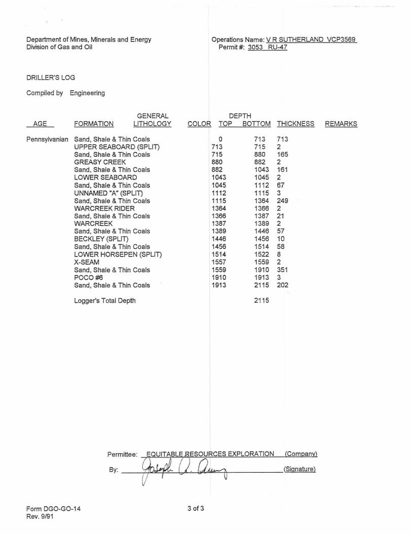
DRILLER'S LOG
Compiled by Engineering
GENERAL AGE FORMATION LITHOLOGY
Pennsylvanian Sand, Shale & Thin Coals UPPER SEABOARD (SPLIT) Sand, Shale & Thin Coals GREASY CREEK Sand, Shale & Thin Coals LOWER SEABOARD Sand, Shale & Thin Coals UNNAMED "A" (SPLIT) Sand, Shale & Thin Coals WARCREEK RIDER Sand, Shale & Thin Coals WARCREEK Sand, Shale & Thin Coals BECKLEY (SPLIT) Sand, Shale & Thin Coals LOWER HORSEPEN (SPLIT) X-SEAM Sand, Shale & Thin Coals POCO #6 Sand, Shale & Thin Coals
Logger's Total Depth
COLOR
Operations Name: V R SUTHERLAND VCP3569 Permrt #: 3053 RU-47
DEPTH TOP BOTTOM THICKNESS REMARKS
0 713 713 713 715 2 715 880 165 880 882 2 882 1043 161 1043 1045 2 1045 1112 67 1112 1115 3 1115 1364 249 1364 1366 2 1366 1387 21 1387 1389 2 1389 1446 57 1446 1456 10 1456 1514 58 1514 1522 8 1557 1559 2 1559 1910 351 1910 1913 3 1913 2115 202
211 5
By: __ +,[,!,l~~-6,;L..~UJ."""'iT-______ (Signature) V
Form DGO-GO-14 Rev. 9/91
30f3

Department of Mines, Minerals and Energy Division of Gas and Oil
Operations Name: V R SUTHERLAND VCP3569 Permit # : 3053 RU-47
Department of Mines, Minerals and Energy Division of Gas and Oil
P.O. Box 1416 Abingdon, Virginia 24210
703/676-5423 l ~US ~~~ ~ 2 RECE\\IED .~ C;; OWISIO~ Of :c
WELL TYPE: Oil _ Gas _ Coal bed Methane ~ or Injection _ well ~-" Gt.S" all A}',
COMPLETION REPORT
~, ,,,,C / C'9 > .... ,,1.1/
Date Well Completed: 5-30-96 Total Depth of Well : LTD =2115 DTD=21 11 ~SGPZ£?'<''' /
Attach the Drilling Report; if not previously submitted. In addition, submit any changes in casing or tubing that were approved after the Drilling Report was submitted.
STIMULATION RECORD Zone 1: COAL SEAMS' Formation Stimulated With: 700 FOAM W127679# 12120 SAND - 985000 SCF N2 - 901 BF Perforated: 1349 to 1913 No. of Perforations: 18 Perforation size: .34 Formation Broke Down at: 1145 PSIG Average Injection Rate: 69 IDH) BPM ISIP: 1149 PSIG § Min SIP: 1058 PSIG Average Injection Pressure:3685 Date Stimulated: 5-30-96
• C-SEAM, WARCREEK RIDER, WARCREEK, UNNAMED "C", BECKLEY, L HORSEPEN, X-SEAM, POCO #6
Zone 2: Formation Stimulated With:
Perforated: to No. of Perforations: Perforation size: Formation Broke Down at: PSIG Average Injection Rate: ISIP: PSIG Min SIP: PSIG Average Injection Pressure: Date Stimulated:
Zone 3: Formation Stimulated Wrth:
Perforated: to No. of Perforations: Perforation size: Formation Broke Down at: PSIG Average Injection Rate: ISIP: PSIG Min SIP: PSIG Average Injection Pressure: Date Stimulated:
FINAL PRODUCTION: Natural _X __ After Stimulation
Zone (1) Zone (2) Zone (3)
BOD MCFD HOURS TESTED ROCK PRESSURE HOURS TESTED
Final Production if Gas Zones are Commingled .J1.LMCFD ~ Hours Tested ..J!§.. PSIG ~ Hours Tested
• Use additional sheets with this format, if more than three (3) zones were stimulated.
Form DGO-GO-15 Rev. 9/91
By: ----.::;Jl.!o!!::J!1.<>.....J..<LU=::=i--------- (Signature)

Department of Mines, Minerals and Energy Division of Gas and Oil
Operations Name: V R SUTHERLAND VCP3569 Permit #: 3053 RU-47
Department of Mines, Minerals and Energy Division of Gas and Oil
P. O. Box 1410 Abingdon, Virginia 24210
703/676-5423
DRILLING REPORT
Pursuant to VR-480-05-22.1, § 1.36, the undersigned Permittee subm~s this report on Well VCP3569 in the NEW GARDEN District of the RUSSELL County, Virginia on 31ST day, JULY month, 19 96 .
LOCATION
County: RUSSELL District: NEW GARDEN Surface Elevation: 2521.60 Elevation of Kelly Bushing: 2531 .60 Quadrangle: DUTY
280 FT S. of Lamude 37° 02' 30" and 3990 FT W. of Long~ude 82° 01' 30"
Attach a final location plat as required by VR 480-05-22.1, § 1.36.
DRILLING DATA
Date Drilling Commenced: 05-19-96 Drilling Contractor: Union Drilling Date Drilling Completed: 05-23-96 Rig Type: ~ Rotary _ Cable Tool Total Depth of Well: L TD=2115 DTD-2111
GEOLOGICAL DATA
Fresh Water at: feet GPM feet GPM feet GPM feet GPM
Salt Water at: feet GPM feet GPM feet GPM feet GPM
COAL SEAMS: MINING IN AREA
NAME UPPER SEABOARD (SPLIT) GREASY CREEK LOWER SEABOARD UNNAMED "A" (SPLIT) WARCREEK RIDER WARCREEK BECKLEY (SPLIT) LOWER HORSEPEN (SPLIT) X-SEAM POCO #6
GAS AND OIL SHOWS:
FORMATION
Form DGO-GO-14 Rev. 9/91
TOP
TOP 713 880 1043 1112 1364 1387 1446 1514 1557 1910
BOTTOM
BOTTOM THICKNESS YES NO MINED OUT 715 2 882 2 1045 2 1115 3 1366 2 1389 2 1456 10 1522 8 1559 2 1913 3
THICKNESS IPF (MCFDIBOPDl PRESSURE HOURS TESTED
1 of 3

Department of Mines, Minerals and Energy Division of Gas and Oil
Operations Name: V R SUTHERLAND VCP3569 Permit # : 3053 RU-47
Cuttings or samples are Cuttings or samples have
are not ~ available for examination by a member of the Virginia Division of Mineral Resources have not £been furnished to the Virginia Division of Mineral Resources
ELECTRIC LOGS AND SURVEYS
List logs run on well bore: DENfTMP/GR
Did log disclose vertical location of a coal seam? Yes ~ No
SURVEY RESULTS
DEPTH DIRECTIONIDISTANCEIDEGREES DEPTH DIRECTION/DISTANCEIDEGREES OF SURVEY FROM TRUE VERTICAL OF SURVEY FROM TRUE VERTICAL
200 114' 500 l ' 530 l ' 700 1/4' 900 1/4' 1100 112' 1216 l ' 1300 1-1/4'
Conductor
Surface
Water Protection
Coal Protection
Other Casing and Tubing Left in Well
SIZE
16"
11-3/4"
8-5/8"
41/2" 2 3/8"
TOP
1348 1-1/4' 1365 1-1/4' 1387 1-1/4" 1481 1-1/4' 1576 1-112' 1776 1-112' 1906 3/4' 1950 3/4"
CASING AND TUBING
BOnOM
20'
352'
594'
2082' 2003'
LENGTH
342'
584'
2072'
CEMENT USED DATE
(IN CUIFTI CEMENTED
78(92) 5-20-96 48(57) 5-21-96 150(177) 5-21-96
315(397) 5-23-96
REMARKS: Shut down, fishing jobs, depths and dates, caving, lost circulation, etc. OPEN MINE @ 304-309': LOST CIRCULATION 5-20-96: LOST CIRCULATION 5-21-96
Form DGO-GO-14 Rev. 9/91
2 of 3
PACKERS OR BRIDGE PLUGS
KIND SIZE SET AT
SQUEEZE

Department of Mines, Minerals and Energy Division of Gas and Oil
DRILLER'S LOG
Compiled by Engineering
GENERAL AGE FORMATION LITHOLOGY
Pennsylvanian Sand, Shale & Thin Coals UPPER SEABOARD (SPUn Sand, Shale & Thin Coals GREASY CREEK Sand, Shale & Thin Coals LOWER SEABOARD Sand, Shale & Thin Coals UNNAMED "A" (SPLIn Sand, Shale & Thin Coals WARCREEK RIDER Sand, Shale & Thin Coals WARCREEK Sand, Shale & Thin Coals BECKLEY (SPUn Sand, Shale & Thin Coals LOWER HORSEPEN (SPUn X-SEAM Sand, Shale & Thin Coals POCO #6 Sand, Shale & Thin Coals
Logger's Total Depth
Form DGO-GO-14 Rev. 9/91
COLOR
30f3
Operations Name: V R SUTHERLAND VCP3569 Permit #: 3053 RU-47
DEPTH TOP BOTTOM THICKNESS REMARKS
0 713 713 713 715 2 715 880 165 880 882 2 882 1043 161 1043 1045 2 1045 1112 67 1112 1115 3 1115 1364 249 1364 1366 2 1366 1387 21 1387 1389 2 1389 1446 57 1446 1456 10 1456 1514 58 1514 1522 8 1557 1559 2 1559 1910 351 1910 1913 3 1913 2115 202
2115

JrAL UNIT AREA = 58.77 ACRES
EREX LEASE No. PO-14a / T-519 V.R. SUTHERLAND 82.0 ACRES CUNCHFlELD COAL COMPANY/ PYXIS RESOURCES COMPANY - coal 01< surface PINE MOUNTAIN OIL &< GAS, INC. - oil 01< gas
LATITUDE 37"02'30"
GAS 27.26 AC. 46.38 " i \'" UNIT BOUNDARY'"
3,990'
~----~~~-------------=~~~~~~----, " LJ./ / ! \, ~OUN~, UNE / .
" I "-- " ~~ IPF -NIT45'20.:w - - "i -, >- -__ 7,,("
00, ~ 217.D5ft \ ~ \
\JCHA~~~O VC-3569 \ \, ~ \ ~ ,~SSEL.L. IPS ::>0
/ ~'" >- S56'34'oo"E I CD 140.79ft I
~"' " ~ \~ I , 0 0 /A~ ,("', I EREX LEASE No. PO-14a / T-520
rOJ ... I
>-
" '" Z //, I -'- V.R. SUTHERLAND ~ ::> 7~~A~~ ·0, 0CD 300' --l /C/OORD TES" P \ 0 CUNCHFlELD COAL COMPANY/
o I ' / INA P / \ :n PYXIS RESOURCES COMPANY - coal 8 .', I // OF WELL VC-3569 / m PINE MOUNTAIN OIL 01< GAS INC -U J..Cf' S 21623.57 I / ttl GAS 19.01 AC. 32 . .35" '
, o n r---p N IX)
w a ::::l ~
(5 z o ...J
OJ ... ;::. ~ ~ , - - I E 71405.88 / / j'" .... ;V>LTli OJ;> z z vi f- b- - (AS DRILLED) f-I ~.....~ .. ~~~ §,' '------, -- ~.,§ ~
6 88~~ I , \ ::> ~ 0.. 0 ;;!~6~ EREX LEASE No. PO-14a / T-514 , 0 B,L.EMANKENDRICK .; :i: 0 U z 0 I V.R. SUTHERLAND , z -' U a:: «. I 20.64 ACRES ~ ~ 9 a ~ ';i I CUNCHFlELD COAL COMPANY / < jE Vl \!! ~ ::;, 0 PYXIS RESOURCES COMPANY - coal I.AJ wt..ccON -'::;, a:: I :::E o' PINE MOUNTAIN OIL 01< GAS, INC.
VI U (.)(,1) ~ . < Z - W V1 - oil &: gas a:: a:: _ ::J ~ ~ < , GAS 12.30 AC. 20.9.3" W>NU~~(,!)·
COORDINA TES OF BENCH MARK
S 21621.14 E 68707.84
ELEV. ~ 2672.34
STATE PLANE COORDINATES OF WELL VC-.3569
N 277950.96 E 9.38248.43
No. 1340 UNIT BOUNDARY
STATE PLANE WELL COORDINATES ARE CALCULATED FROM CUNCHFlELD COAL COMPANY COORDINATES.
PROPERTY INFORMATION PROVIDED BY EQUITABLE RESOURCES EXPLORATION.
ELEVA TIONS ARE 8ASED ON TRIANGULATION STA nON RIDGE LOCATED APPROXIMATELY 1890' WEST OF THE INTERSECTION OF ROUTES 621 AND 722 ON A KNOB.
WELL LOCA TION PLAT 1'-/ - G - g9 COMPANY Egu itabl e Resources Exploration WELL NAME AND NUMBER VC - 3569 TRACT No. T-519 ELEVATION 2520.42 (Tr ig) QUADRANGLE --2D~U~TY-!-___ _
COUNTY RUSSELL DISTRICT NEW GARDEN SCALE:'" = 400' DATE MAY 20,1996
THIS PLAT IS A NEW PLAT; AN UPDATED PLAT ; OR A FINAL LOCA nON PLAT x
PROPOSED TOTAL DEPTH OF WELL = ___ _
+ DENOTES THE LOCAnON OF A WELL ON UNITED STATES TOPOGRAPHIC MAPS, SCALE' TO 24,000, LATITUDE AND LONGITUDE LINES BEIN G REPRESENTED BY BORDER LINES AS SHOWN.
4. 1'" _ b~ ~ '-"' -J/Zo/,r~ (AFFIX SEAL)
LICENSED PROFESSIONAL -ENGINEER OR LICENSED LAND SURVEYOR
![[Chap6101]CHAPTER 61:01 MINES AND MINERALS … Mines and Minerals Act.pdf · MINES AND MINERALS ARRANGEMENT OF SECTIONS SECTION PART I ... Restrictions on exercise of rights in relation](https://static.fdocuments.in/doc/165x107/5b577b5c7f8b9a8f128db92d/chap6101chapter-6101-mines-and-minerals-mines-and-minerals-actpdf-mines.jpg)