Deltaic clinothems Digital data capture, geometries, … from the Panther Tongue Member and the...
32
Deltaic clinothems − Digital data capture, geometries, and reservoir implications Håvard D. Enge Dissertation for the degree philosophiae doctor (PhD) University of Bergen, Norway 2008
Transcript of Deltaic clinothems Digital data capture, geometries, … from the Panther Tongue Member and the...

Deltaic clinothems − Digital data capture, geometries, and
reservoir implications
Håvard D. Enge Dissertation for the degree philosophiae doctor (PhD)
University of Bergen, Norway 2008


Deltaic clinothems − Digital data capture, geometries, and reservoir
implications
Håvard D. Enge
Dissertation for the degree philosophiae doctor (PhD)
Department of Earth Science
University of Bergen
2008

Contents
Preface
7
Acknowledgements
11
Abstract
13
Introduction
15
Paper 1 Enge, H.D., Buckley, S.J., Rotevatn, A., and Howell, J.A., 2007, From outcrop to reservoir
simulation model: workflow and procedures: Geosphere, v. 3, p. 469-490.
27
Paper 2 Enge, H.D., Howell, J.A., and Buckley, S.J., Quantifying clinothem geometry in a forced-
regressive river-dominated delta, Panther Tongue, Utah, USA
Submitted to Sedimentology
51
Paper 3 Enge, H.D., Howell, J.A., and Buckley, S.J., Contrasting bedsets in river dominated deltas:
examples from the Panther Tongue Member and the Ferron Sandstone Member, Utah, USA
Submitted to Journal of Sedimentary Research
87
Paper 4 Enge, H.D. and Howell, J.A, Impact of deltaic clinothems on reservoir performance: dynamic
study of reservoir analogues from the Panther Tongue and Ferron Sandstone, Utah, USA.
Submitted to AAPG Bulletin
121
Conclusions and future research 157
Appendix Buckley, S.J., Howell, J.A., Enge, H.D., and Kurz, T.H., 2008, Terrestrial laser scanning in
geology: data acquisition, processing and accuracy considerations: Journal of the Geological
Society of London, v. 165, p. 625-638.
165
5

6

Preface
This dissertation, which has been submitted for the degree philosophiae doctor (PhD), is the
result of research conducted at the Centre for Integrated Petroleum Research (CIPR) and the
Department of Earth Science at the University of Bergen, Norway. The research was carried
out within the framework of a three-year scholarship as a part of the Virtual Outcrop Geology
(VOG) project at CIPR.
The VOG project was established to develop and utilise advanced methods of digital data
capture for outcropping hydrocarbon reservoir analogues: the part of the study presented in
this thesis focused on issues related to deltaic systems. Three main themes have been
addressed: 1) Establish and implementing a methodology for the routine collection of
analogue outcrop data with suitable accuracy to build virtual outcrop models (VOMs) in
computers; 2) Use analogue outcrop models to extract statistics for the better understanding of
the evolution of deltaic clinothem geometries, and; 3) Combining the collected data and the
results of the statistical analyses to test the sensitivity to simulated reservoir performance.
These goals have been addressed by: 1) Outcrop scanning by utilizing lidar (light detecting
and ranging) for the efficient collection of three outcrop data sets, and building VOMs from
the collected data; 2) Extraction of large amounts of sedimentary bed statistics directly from
the VOMs, and; 3) Export of surfaces mapped directly on the VOM to reservoir modelling
software to build outcrop based geocellular models for testing sensitivity of reservoir fluid
flow to geological heterogeneities associated with dipping clinothems.
The scientific contribution of the current work has been to establish a workflow for the
collection of the data that can be applied to any outcropping system; improved understanding
of clinothems in shallow marine, river dominated delta systems; and an increased
understanding of the influence of clinothem-related heterogeneities on hydrocarbon
production.
Whilst this project has focused on the application of virtual outcrop methods to deltaic
systems, the established workflows for data collection, processing and utilization are largely
independent of the geology in question. This implies that the methods and workflow
7

established are not only valid for sedimentary outcrops but also for structural geological and
hard rock problems. Within the VOG project, other subordinate research themes have utilized
the established workflow on coastal plain deposits, deformation bands related to fluid flow
problems and large scale (km to miles) mega surveys. Ground based hyperspectral imaging
(collecting data on a very wide spectrum of wavelengths) to remotely collect information on
mineralogy is also a part of VOG project. As such, the current project also contributes to the
other technological goals of the VOG project. The project is financed largely by the Petromax
Program offered by the Norwegian Research Council (NFR), and partially by StatoilHydro.
Readers guide
For the readers accustomed to monographic doctoral dissertations, this is a short explanation
of the layout of the current thesis. Following the Norwegian tradition for doctoral
dissertations in the natural sciences and medicine, the bulk of the thesis is comprised of
research articles published, or submitted, to relevant international peer-reviewed journals. As
they represent stand-alone contributions, there is some overlap between the different chapters.
As required by regulations for PhD theses at the University of Bergen, an authorship
statement is included in the next section. The research articles that make up the bulk of the
thesis are preceded by an introduction to the research, in which the primary research goals as
well as the existing literary framework are outlined. A final chapter, following the papers,
features a short discussion of the main results and conclusions from the research presented in
the foregoing chapters, and summarizes the main outcome of this work.
Authorship statement
As there are co-authors contributing to papers 1 through 4, the candidate’s contributions to
each paper are specified here. With the exception of the appendix, the candidate is the
principal investigator and author for all of the articles. The appendix includes a paper
elaborating on the technical basis for the methods utilized in collecting and preparing of the
scanning (lidar) results. Simon Buckley as the first author is responsible for the main part and
writing of the manuscript, and the candidate has contributed with examples, figures and
workflow development of the paper included in the appendix.
8

Paper 1
Enge, H.D., Buckley, S.J., Rotevatn, A., and Howell, J.A., 2007: From outcrop to reservoir
simulation model: workflow and procedures: Geosphere, v. 3, p. 469-490
The workflow developed in paper 1 is based on data collected by the four authors. S. Buckley
also took part in the ensuing technical preparation of processing the scanner data, and A.
Rotevatn built the reservoir models from the Grabens. B.L.S. Leren (not co-author)
introduced the Roda Sandstone field area, A. Rotevatn the Grabens field area. The time
consuming first preparation of the virtual outcrops models (VOMs) and development of the
workflow itself was performed by the first author who also built the Roda-reservoir models
and performed all comparative streamline simulations on the Grabens reservoir models. J.
Howell initiated the project, engaged in discussions, and performed manuscript review
together with S. Buckley.
Paper 2
Enge, H.D., Howell, J.A., and Buckley, S.J., Submitted: Quantifying clinothem geometry in a
forced-regressive river-dominated delta, Panther Tongue, Utah, USA
Paper 2 is based on scanner data collected by the three authors, and traditional sedimentary
field data were collected by the principal author with the assistance of C. Carlsson (not co-
author). S. Buckley also took part in the ensuing technical preparation of processing the
scanner data. Development of the principal methods was done in collaboration with J. Howell.
All preparations, building of an extensive database, interpretations and analysis were
performed by the first author. J. Howell provided ideas throughout the process and performed
manuscript review.
Paper 3
Enge, H.D., Howell, J.A., and Buckley, S.J., Submitted: Contrasting bedsets in river
dominated deltas: examples from the Panther Tongue Member and the Ferron Sandstone
Member, Utah, USA
Paper 3 is based on scanner data collected by the three authors and traditional sedimentary
field data were collected by the principal author with the assistance of C. Carlsson (not co-
author). S. Buckley also took part in the ensuing technical preparation of processing the
scanner data. Development of methods, building of and refinement of the database,
interpretations and analysis were performed by the first author. J. Howell introduced the field
areas, provided ideas throughout the process and performed manuscript review.
9

Paper 4
Enge, H.D. and Howell, J.A, Submitted: Impact of deltaic clinothems on reservoir
performance: dynamic study of reservoir analogues from the Panther Tongue and Ferron
Sandstone, Utah, USA
For paper 4, the first author was responsible for all geological interpretations, model building,
fluid flow simulations and interpretation of results. J. Howell engaged in discussions
throughout the process and performed manuscript review.
The papers are organized in a logical order. Paper 1 introduces the workflow used to collect
outcrop data by utilizing a laser scanner (lidar). This paper also presents the methods for
making geological interpretations directly on the VOMs, and shows how to use these as a
basis for building reservoir models. In paper 2 and 3 the methods developed in the previous
paper are used to extract bed and bedset scale statistics directly from the VOMs, and
providing the interpretations used in the last paper. Paper 4 demonstrates the utilization of
digital bed-interpretations from VOMs to build analogue geocellular reservoir models for full
scale fluid flow simulations. The appendix is considered a supplement to paper 1, and further
elaborates on the technical aspects of collecting outcrop data by the use of laser scanner
(lidar).
Note that, as manuscripts are submitted to or published in both European and US based
journals, both UK and US spelling appear throughout this thesis, but is kept consistent within
individual chapters.
10

Acknowledgements
Completion of this thesis has been thanks to a number of people who have assisted the cause
along the way. Firstly, I wish to thank my supervisor, John Howell, for steady scientific
guidance throughout the course of my enterprise and for sending me to different corners of the
world to learn and present. Especially John’s wells of ideas, thorough reviews of manuscripts
and his continuous supervisory efforts whilst getting much entangled in big oil is appreciated.
In addition, NFR is thanked for paying my salary, StatoilHydro for supporting big laser toys,
Roxar and Riegel for providing software.
The project benefited from a number of discourses with various geologists and other VOG
team members. Particular gratitude goes to researcher Simon Buckley at CIPR, UiB, without
whom there would have been no point clouds. At the University of Bergen, fellow PhD-
students Christian Carlsson and Beate L. S. Leren, together with the rest of the VOG-team,
are especially acknowledged for their contributions in the field and at home. Ex-master
students Tanja Aune and Åsmund Vassel are thanked for valuable contribution with regards to
the big pictures of the Panther Tongue and the Ferron Sandstone, respectively. Common
office-mates Anita Torabi and later Henning Nøttveit are thanked for their engagement in
helpful discussions, researcher Jan Tveranger for helping out through RMS’s sometimes
unpredictable mind, and Edin Alagic for his outspoken consistent opposition to what most
people hold sound (geological) ideas. My colleagues at the Department of Earth Science and
especially those at CIPR are acknowledged for their contribution to the general good
atmosphere on the top floor, and Jonny Hesthammer for providing the espresso machine!
Support from my family is very much appreciated and, given my Bergen expatriation, my
family in law is especially thanked for providing the safe framework for carrying this project
through whilst I have also been trying to stay with my family duties. Finally and most
importantly, the three people who mean the most to me: my son Hogne and daughter Tora,
who luckily yet don’t care about the venture at all, and my unique Ingrid – I am infinitely
grateful for all your patience, love and consistent support – I will try to make it up!
11

12

Abstract
Subsurface reservoir models are typically limited by a lack of spatially accurate geometric data on bedform architecture and geometry, which are key controls on fluid flow. Outcrop analogues have long been utilized as a source of such data, but the capture of sufficiently precise data has always been a challenge. This thesis demonstrates how advances in data capture and computer technology have made possible the collection of three-dimensional, high-resolution, digital geological data generated by ground based laser scanning (lidar) from steep and otherwise inaccessible outcrops. A complete workflow is documented — from outcrop selection through data collection, processing and building of virtual outcrop models (VOMs) — to geological interpretation, data extraction and the building and testing of geocellular models using an industry-standard, reservoir-modelling software. Examples from analogue systems such as the Roda Sandstone, Pyrenees, Spain, and Cretaceous deltaic systems from central Utah, USA, are used to demonstrate the methodology. A parallel objective of the study has been to utilise the developed techniques to improve understand the geometry, genesis and impact of shallow marine, deltaic clinothems. Clinothems are seaward dipping beds, formed when much of the sand in river-dominated deltas is laid down in distributary mouth bars that coalesce during the downstream accretion of the delta to form a delta front. Systematic collection of data from VOMs has allowed for the compilation of a detailed database on clinothems and associated clinoform geometry. Bed thickness and dip measurements have been collected from two ancient, river-dominated deltaic depositional systems, namely the forced regressive Panther Tongue and a high-stand portion of the Ferron Sandstone that both crop out in central Utah, USA. The extensive bed-thickness database of nearly 3000 measurements from 73 individual clinothems at hundreds of meters to about 1000 m. scale has been used to quantify aspects of delta clinothem-beds. A decay gradient parameter permits the thinning of the clinothems to be described as a single number and thus compared between beds, and measurements are used to calculate the average dip angle. Results demonstrate that clinothems in the Panther Tongue are much longer and more shallowly dipping than clinothems in the Ferron Sandstone. Both systems show similar patterns with regards to groups of gradient-values and groups of dip-values: Common boundaries exist between groups defined by gradient values and groups defined by dip values. A cyclic depositional pattern interpreted to be related to autocyclic processes in deltaic mouth bars is documented, and three and nine stratigraphic cycles or bedsets have been identified in the studied parts of the Ferron Sandstone and the Panther Tongue, respectively. The differences between the two systems are attributed to their sequence stratigraphic positions and hence accommodation. Deterministic geocellular reservoir models have been built from surfaces interpreted in the VOMs. The models have been used to test the influence of dipping siltstones heterogeneities on simulated reservoir performance in a reservoir modelling software. Siltstone drapes on clinothem sandstone beds have been modelled and various populations of holes have been placed in the siltstone beds (0, 30, 60, 90 and 100%). The effects of siltstone permeability (1, 0.1, 0.01 and 0.001 mD) have also been tested. A total of 41 individual models were built and flow simulated. Results quantify how the portion of holes governs the production rate/ recovery factor in the Panther Tongue models. Permeability values are more important in the Ferron models, although they are still influenced by the number of holes. Steeper dipping and closer spaced clinothems of the highstand system tract lower the recovery factor by several tens of percent if the related heterogeneities are all or close to continuous and have low enough permeability.
13

14

Introduction
Introduction
The aim of the current study is developing methods for digital data collection and improved
understanding of delta clinoforms and clinothems. The focus herein has been the smaller scale
clinothems laid down in marginal marine environments by river dominated deltas, and their
implications for hydrocarbon reservoir fluid-flow. The following section is a brief overview
of the existing literature covering these topics. The principal goals of this work are laid out at
the end of this section. As these literature reviews are also thoroughly covered in paper 1-4
and appendix, only a relative short introduction is given here.
Methods
The use of spatial data from geological outcrops is central to the earth sciences. Traditionally,
one main component of sedimentary outcrop studies have been sedimentary logging of
representative sections, often restricted to a limited number of accessible sections in otherwise
steep outcrop cliffs, supported by photos and sketches (e.g. Tucker, 1996 and others). Whilst
these give superb detailed information on the studied segment, it may be hard to capture
subtle changes in large scale geometries by these methods. The capturing of a large amount of
geometrical data within a reasonable time has also been a problem, and the digitization of the
data for use in analogue reservoir modelling studies is traditionally slow and cumbersome.
Methods introduced in this work aim to bridge the “scale gap” from the pore to the sequence
(Fig. 1.).
To overcome these obstacles, over the recent years a number of techniques typically used by
engineers and surveyors have been introduced to the geological community. An increase in
the number of methods available allows users to choose from numerous high technology
solutions that have the potential to give their applications enhanced quantitative input, often
revolutionizing field procedures (McCaffrey et al., 2005). Photogrammetry becomes more
accessible to non-expert users with shift from traditional film cameras to high-resolution
digital cameras and with better software processing available (Chandler, 1999). The advent of
the global positioning system (GPS) has also had a major impact on the way data are
collected, and dual-frequency real-time kinematic units allow for the collection of disparate
data to be referenced and integrated in a more rigorous way and analysed in a common
coordinate system (Adams et al., 2005; Pringle et al., 2006; Thurmond, 2006). Light
15

Introduction
Fig. 1. Typical length-scales of sedimentary structures in the horizontal and vertical directions, with scales of
commonly used measurements and reservoir model sizes. Note scale of the virtual outcrop, which covers a wide
range of levels. Modified from Pickup and Hern (2002).
detection and ranging, better known from its acronym “lidar” or simply as laser scanning, is a
technique that has come to the forefront of surveying in the last ten years, and which has been
utilised for collecting the datasets in this thesis. This laser-based measurement system allows
for the rapid acquisition of detailed point data over a range of scales, describing a terrain
surface, from both aerial and terrestrial platforms, and its application in geology is discussed
by Buckley et al.(2008), Enge et al. (2007), McCaffrey et al. (2005), and Pringle et al. (2006).
The use of ground based laser scanning of modern and ancient geological systems is
expanding, and since the early work of Bellian (2005), this method has shown its application
(e.g. Pringle et al., 2004; Olariu et al., 2005; Buckley et al., 2006; Pringle et al., 2006; Enge et
al., 2007; Redfern et al., 2007; Buckley et al., 2008; Jones et al., 2008).
Once collected, the dataset is used to build a Virtual Outcrop Model (VOM) or Virtual
Outcrop (VO). There are a number of important considerations in the data acquisition,
processing and interpretation workflow that must be addressed. It is also important for the
non-expert in the survey discipline to be aware of the challenges in the data collection and
16

Introduction
processing such as the effects of vegetation or other objects that create noise in the raw point
data (Enge et al., 2007; Buckley et al., 2008). As the VOM captures the outcrop morphology
in detail, geological surfaces and features can be traced, digitized and analysed statistically.
Clinothem beds and clinoform-surfaces
The term clinoform was originally coined by (Rich, 1951) to describe basinward dipping
surfaces that record the palaeo-position of the depositional profile. Clinoforms are observed
across a variety of scales from cm to hundreds of meters (Driscoll and Karner, 1999) and
accommodation influence the large scale geometries (Jervey, 1988; Posamentier et al., 1988;
Postma, 1990; Orton and Reading, 1993; Reading and Levell, 1996; Pirmez et al., 1998;
Posamentier and Morris, 2000). The term has commonly been used descriptively both
surfaces at outcrop (m to 10s of m) and for inclined seismic reflectors which are 100s of m in
extent (Vail et al., 1977). From seismic scale clinoforms it is known that inclination of
clinoforms varies, mainly on the basis of basin bathymetry (e.g. Berg, 1982).
In river-dominated marginal marine environments, clinothems separated by clinoform
surfaces represent the former position of the delta front as it prograded (Gilbert, 1885; Rich,
1951; Gani and Bhattacharya, 2005). The final body geometry is the result of the interplay
between sediment supply, accommodation and basin geometry, which controls its growth
style and thus its profile (Postma, 1990). Deltas are one of the most complex process settings
in all coastal environments (Coleman and Prior, 1982), and represent the zone of interaction
between freshwater and marine processes. Common discrimination of deltas have thus been
based on the dominant process of sediment dispersal (sensu Galloway, 1975), the relative role
of fluvial versus basinal processes (sensu Fisher et al., 1969), and the prevailing grain-size at
the delta front (sensu Orton and Reading, 1993). In river-dominated deltas, much of the sand
is laid down in distributary mouth bars that coalesce during the downstream accretion of the
delta to form a delta front with adjacent, seaward dipping beds (Elliott, 1986; Postma, 1990)
termed clinothems (Rich, 1951). Postma (1990) discriminates between gently inclined delta
front (“shoal-water profile”) often related to finer and sandy grained sediments, and steeply
inclined delta front, typically coarser grained sediments (Gilbert type profile), the former
being the case for the studied clinothems. For mouthbar deltas to develop in the first place,
relatively shallow-water depths are required immediately basinward of the outlet zone
(Postma, 1990). Fluvial energy sufficient to move sediments to the marine realm and build
clinothems may be present at any time during the relative sea level cycle (Yoshida et al.,
17

Introduction
2007), and clinothems form independently of position of relative sea-level (e.g. Vail et al.,
1977; Berg, 1982; Anderson et al., 2004; Lee et al., 2005; Lee et al., 2007). Deltaic systems
are volumetrically most abundant during highstand times (Galloway, 1975). During falling
sea level deltas move in a seaward direction and are typically highly progradational during
lowstand sea level (Bhattacharya and Willis, 2001).
Progradation of a sandy river dominated delta is typically by dispersion of sediments through
multiple terminal distributary channels (Anderson et al., 2004; Olariu and Bhattacharya,
2006). Sediment introduced to the basin by the river is deposited in the delta front. In mixed
bed- and suspended-load systems, deposition in the lower part of the delta front is from
suspension fall out of mud and silt, interspersed with sandy gravity flows. Turbidity flows are
initiated by the sudden introduction of large volumes of sand during periods of increased run-
off of upstream erosion of fluvial bars and the collapse of over-steepened upper delta front
mouth bars (Bates, 1953; Wright, 1977; Coleman and Prior, 1982; Mulder and Syvitski, 1995;
Bhattacharya, 2006). By these processes, distal mouthbar clinothems are constructed as sheets
of sands that dip, thin and fine in a seaward direction in an en-echelon pattern (Howell et al.,
2008). This leads the sandy portions of beds to commonly be interbedded with finer material
deposited during quieter periods (Posamentier and Morris, 2000; Bhattacharya and Willis,
2001; Anderson et al., 2004). In outcrop, the finer material typically occurs as recessive breaks
in the cliff face. Low permeability values for such siltstones relative to the sandstone, causes such
drapes to be important barriers to horizontal and vertical fluid flow within hydrocarbon
reservoirs (e.g. Howell et al., 2008).
Reservoir modelling
In order to optimise production from hydrocarbon reservoirs it is desirable to understand the
geometry and connectivity of the reservoir bodies. Geocellular models are commonly used
and the scale, design and population of the grid are heavily influenced by the understanding of
the geology. Despite recent advances in both understanding and modelling, delta clinoform
surfaces and clinothem beds associated with them are rarely accounted for in reservoir models
(e.g. Tyler and Finley, 1991; Ainsworth et al., 1999; Tye et al., 1999; Willis and White, 2000;
Bhattacharya and Willis, 2001; Howell et al., 2008; Skorstad et al., 2008). Dipping clinothems
and related smaller heterogeneities such as siltstone have significant implications for
production from such systems. These kinds of heterogeneities can generate barriers and
baffles to fluid flow. Despite being relatively well understood geologically, little work is
18
Introduction
available publicly that quantitatively assesses such controls on reservoir performance (Howell
et al., 2008).
Analogue reservoir models allow for testing the influence of smaller scale heterogeneities on
reservoir performance in reservoir modelling software. The building and testing of small scale
outcrop-based geocellular analogue models is an established method for representing and
investigating subsurface reservoirs (e.g. Bryant and Flint, 1993; Dreyer et al., 1993; Grammer
et al., 2004; Enge et al., 2007; Labourdette et al., 2008; Rotevatn et al., in press). Outcrop
studies provide vertical resolution superior to subsurface seismic data and also offer better
lateral information than spatially restricted, borehole-derived logs and cores.
As previously mentioned, a general hindrance for routinely building reservoir models from
outcrops has been the accurate capture and representation of geological outcrop data. The
utilisation of a ground-based laser scanning (lidar) addresses this issue. Laser scanning allows
for the rapid collection of a large amount of spatially accurate geometric data. Once collected,
these data can be used for building of virtual outcrops models and interpretation of large
volume of geological data that can form the basis for the building of analogue reservoir
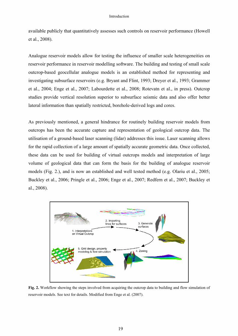
models (Fig. 2.), and is now an established and well tested method (e.g. Olariu et al., 2005;
Buckley et al., 2006; Pringle et al., 2006; Enge et al., 2007; Redfern et al., 2007; Buckley et
al., 2008).
Fig. 2. Workflow showing the steps involved from acquiring the outcrop data to building and flow simulation of
reservoir models. See text for details. Modified from Enge et al. (2007).
19

Introduction
A reservoir model is a three-dimensional quantitative representation, and a mathematical
expression in a computer environment of a volume of rock. Because of this, outcrop-based
geocellular reservoir models built from surfaces mapped from the virtual outcrops allow for
reservoir-examination through dynamic testing by flow simulations. As such, it is possible to
quantify the reservoir performance during simulated production. In a subsurface reservoir, the
results from analogue modelling can guide well drilling programs, spacing of injector and
producer wells, as well as aiding general planning with regards to optimised production and
recovery.
Objectives
The objectives of this study are a better understanding of shallow marine related delta
clinothem geometries requiring: improved insight into bed geometries and the role of
accommodation: examination of similarities and differences between different depositional
systems: and also an increased knowledge of how clinothem bed-related heterogeneities
influence fluid flow.
Specifically, the main objectives of this work have been to:
1. Establish a method for collecting large amounts of accurate data with a high accuracy
from geological outcrops, and to build virtual outcrop models (VOMs) for the
interpretation of clinothem bed geometries.
2. Extract large amounts of detailed clinothem bed-scale statistics from the VOMs for the
better understanding of delta-clinothem geometries such as decay gradient, dip
numbers, lengths and thicknesses.
3. Compare statistic results from two different accommodation settings; the falling- to
lowstand system of the Panther Tongue compared with a highstand segment of the
Ferron Sandstone.
4. Utilize bed-scale statistics and interpreted clinothem bed-surfaces (clinoforms) to
build analogue reservoir models for full scale reservoir modelling to test the effects of
dipping clinothems and heterogeneities on fluid flow.
20

Introduction
References
Adams, E.W., Grotzinger, J.P., Watters, W.A., Schroeder, S., McCormick, D.S. and Al, S.H.A. (2005) Digital characterization of thrombolite-stromatolite reef distribution in a carbonate ramp system (terminal Proterozoic, Nama Group, Namibia). AAPG Bulletin, 89, 1293-1318 Ainsworth, R.B., Sanlung, M. and Duivenvoorden, S.T.C. (1999) Correlation technique, perforation strategies, and recovery factors; an integrated 3-D reservoir modeling study, Sirikit Field, Thailand. AAPG Bulletin, 83, 1535-1551 Anderson, P.B., Chidsey, T.C., Ryer, T.A., Adams, R.D. and McClure, K. (2004) Geologic framework, facies, paleogeography, and reservoir analogs of the Ferron Sandstone in the Ivie Creek area, east-central Utah. In: Regional to wellbore analog for fluvial-deltaic reservoir modeling; the Ferron Sandstone of Utah (Eds T.C. Chidsey, R.D. Adams and T.H. Morris), American Association of Petroleum Geologists Studies in Geology 50, pp. 331-356. American Association of Petroleum Geologists, Tulsa, Oklahoma, United States. Bates, C.C. (1953) Rational theory of delta formation. Bulletin of the American Association of Petroleum Geologists, 37, 2119-2162 Bellian, J.A., Kerans, C. and Jennette, D.C. (2005) Digital outcrop models: Applications of terrestrial scanning LIDAR technology in stratigraphic modelling. Journal of Sedimentary Research, 75, 166-176 Berg, O.R. (1982) Seismic detection and evaluation of delta and turbidite sequences; their application to exploration for the subtle trap. AAPG Bulletin, 66, 1271-1288 Bhattacharya, J.P. (2006) Deltas. In: Facies models revisited: Tulsa, Oklahoma (Eds H.W. Posamentier and R.G. Walker), SEPM (Society for Sedimentary Geology) Special Publication 84, pp. 237-292. Bhattacharya, J.P. and Willis, B.J. (2001) Lowstand deltas in the Frontier Formation, Powder River basin, Wyoming: Implications for sequence stratigraphic models. AAPG Bulletin, 85, 261-294 Bryant, I.D. and Flint, S.S. (1993) Quantitative clastic reservoir geological modelling; problems and perspectives. In: The geological modelling of hydrocarbon reservoirs and outcrop analogues, 15, pp. 3-20. Blackwell, Oxford, International. Buckley, S.J., Howell, J.A., Enge, H.D. and Kurz, T.H. (2008) Terrestrial laser scanning in geology: data acquisition, processing and accuracy considerations. Journal of the Geological Society of London, 165, 625-638 Buckley, S.J., Howell, J.A., Enge, H.D., Leren, B.L.S. and Kurz, T.H. (2006) Integration of terrestrial laser scanning, digital photogrammetry and geostatistical methods for high-resolution modelling of geological outcrops. In: ISPRS Commission V Symposium September 25-27, International Archives of the Photogrammetry, Remote Sensing and Spatial Information Sciences, 36(B5). Commission V, WG III. http://rcswww.urz.tu-dresden.de/~isprs/proceedings/paper/1228_Dresden06.pdf, Dresden, Germany. Chandler, J. (1999) Effective application of automated digital photogrammetry for geomorphological research. Earth Surface Processes and Landforms, 24, 51-63 Coleman, J.M. and Prior, D.B. (1982) Deltaic environments of Deposition. In: Sandstone depositional environments, 31, pp. 139-178. American Association of Petroleum Geologists, Tulsa, OK, United States. Dreyer, T., Falt, L., Høy, T., Knarud, R., Steel, R. and Cuevas, J.-L. (1993) Sedimentary architecture of field analogues for reservoir information (SAFARI): A case study of the fluvial Escanilla Formation, Spanish Pyrenees. In: The Geological modelling of hydrocarbon
21

Introduction
reservoirs and outcrop analogues (Eds S.S. Flint and I.D. Bryant), London, International Association of Sedimentologists Special Publication, 15, pp. 57-79. Blackwell. Driscoll, N.W. and Karner, G.D. (1999) Three-dimensional quantitative modeling of clinoform development. In: The formation of continental-margin strata, 154; 1-4, pp. 383-398. Elsevier, Amsterdam, Netherlands. Elliott, T. (1986) Deltas. In: Sedimentary Environments and Facies (Ed H.G. Reading), pp. 113-154. Blackwell Scientific Publications, Oxford, U.K. Enge, H.D., Buckley, S.J., Rotevatn, A. and Howell, J.A. (2007) From outcrop to reservoir simulation model: workflow and procedures. Geosphere, 3, 469-490 Fisher, W.L., Brown, L.F., Scott, A.J. and McGowen, J.H. (1969) Delta Systems in the Exploration for Oil and Gas, Austin, USA, 78 pp. Galloway, W.E. (1975) Process framework for describing the morphologic and stratigraphic evolution of deltaic depositional systems. In: Deltas, models for exploration (Ed M.L. Brousard), pp. 87-98. Houston Geol. Soc., SEPM Foundation, Houston, TX, USA. Gani, M.R. and Bhattacharya, J.P. (2005) Lithostratigraphy versus chronostratigraphy in facies correlations of Quaternary deltas: Application of bedding correlation. In: River deltas; concepts, models, and examples, 83, pp. 31-48. Tulsa, Oklahoma, USA, SEPM (Society for Sedimentary Geology). Gilbert, G.K. (1885) The topographic features of lake shores. In: Annual Report: U.S. Geological Survey, 5, pp. 75-123. U.S. Geological Survey. Grammer, G.M., Harris, P.M. and Eberli, G.P. (2004) Integration of outcrop and modern analogs in reservoir modeling; overview with examples from the Bahamas. In: Integration of outcrop and modern analogs in reservoir modeling, 80, pp. 1-22. American Association of Petroleum Geologists, Tulsa, OK, United States. Howell, J.A., Skorstad, A., MacDonald, A., Fordham, A., Flint, S., Fjellvoll, B. and Manzocchi, T. (2008) Sedimentological parameterization of shallow-marine reservoirs. Petroleum Geoscience, 14, 17-34 Jervey, M.T. (1988) Quantitative geological modeling of siliciclastic rock sequences and their seismic expression. In: Sea-level changes; an integrated approach, 42, pp. 47-69. SEPM (Society for Sedimentary Geology), Tulsa, OK, United States. Jones, R.R., Wawrzyniec, T.F., Holliman, N.S., McCaffrey, K.J.W., Imber, J. and Holdsworth, R.E. (2008) Describing the dimensionality of geospatial data in the earth sciences; recommendations for nomenclature. Geosphere, 4, 354-359 Labourdette, R., Casas, J. and Imbert, P. (2008) 3D Sedimentological Modelling of a Miocene Deltaic Reservoir Unit, Sincor Field, Venezuela: A New Approach. Journal of Petroleum Geology, 31, 135-152 Lee, K., McMechan, G.A., Gani, M.R., Bhattacharya, J.P., Zeng, X. and Howell, C.D. (2007) 3-D architecture and sequence stratigraphic evolution of a forced regressive top-truncated mixed-influenced delta, Cretaceous Wall Creek Sandstone, Wyoming, U.S.A. Journal of Sedimentary Research, 77, 303-323 Lee, K., Zeng, X., McMechan, G.A., Howell, C.D., Bhattacharya, J.P., Marcy, F. and Olariu, C. (2005) A ground-penetrating radar survey of a delta-front reservoir analog in the Wall Creek Member, Frontier Formation, Wyoming. AAPG Bulletin, 89, 1139-1155 McCaffrey, K.J.W., Jones, R.R., Holdsworth, R.E., Wilson, R.W., Clegg, P., Imber, J., Holliman, N. and Trinks, I. (2005) Unlocking the spatial dimension: Digital technologies and the future of geoscience fieldwork. Journal of the Geological Society of London, 162, 927-938 Mulder, T. and Syvitski, J.P.M. (1995) Turbidity currents generated at river mouths during exceptional discharges to the world oceans. Journal of Geology, 103, 285-299
22

Introduction
Olariu, C. and Bhattacharya, J.P. (2006) Terminal distributary channels and delta front architecture of river-dominated delta systems. Journal of Sedimentary Research, 76, 212-233 Olariu, C., Bhattacharya, J.P., Xu, X., Aiken, C.L., Zeng, X. and McMechan, G.A. (2005) Integrated study of ancient delta-front deposits, using outcrop ground-penetrating radar, and three-dimensional photorealistic data: Cretaceous Panther Tongue Sandstone, Utah, USA. In: River Deltas — Concepts, models, and examples (Eds L. Giosan and J.P. Bhattacharya), Tulsa, Oklahoma, SEPM (Society for Sedimentary Geology), 83, pp. 155-177. Orton, G.J. and Reading, H.G. (1993) Variability of deltaic processes in terms of sediment supply, with particular emphasis on grain size. Sedimentology, 40, 475-512 Pickup, G.E. and Hern, C.Y. (2002) The development of appropriate upscaling procedures. In: A symposium on upscaling reservoir properties, upscaling downunder, 46; 2-3, pp. 119-138. Kluwer Academic Publishers, Dordrecht, Netherlands. Pirmez, C., Pratson, L.F. and Steckler, M.S. (1998) Clinoform development by advection-diffusion of suspended sediment; modeling and comparison to natural systems. Journal of Geophysical Research, B, Solid Earth and Planets, 103, 24,141-24,157 Posamentier, H.W., Jervey, M.T. and Vail, P.R. (1988) Eustatic controls on clastic deposition; I, Conceptual framework. In: Sea-level changes; an integrated approach, 42, pp. 109-124. SEPM (Society for Sedimentary Geology), Tulsa, OK, United States. Posamentier, H.W. and Morris, W.R. (2000) Aspects of the stratal architecture of forced regressive deposits. In: Sedimentary responses to forced regressions, 172, pp. 19-46. Geological Society of London, London, United Kingdom. Postma, G. (1990) Depositional architecture and facies of river and fan deltas; a synthesis. In: Coarse-grained deltas, 10, pp. 13-27. Blackwell, Oxford, International. Pringle, J., Gardiner, A. and Westerman, R. (2004) Virtual geological outcrops; fieldwork and analysis made less exhaustive? Geology Today, 20, 67-72 Pringle, J.K., Howell, J.A., Hodgetts, D., Westerman, A.R. and Hodgson, D.M. (2006) Virtual outcrop models of petroleum reservoir analogues: A review of the current state-of-the-art. First Break, 24, 33-42 Reading, H.G. and Levell, B.K. (1996) Controls on the sedimentary rock record. In: Sedimentary Environments; Processes, Facies and Stratigraphy (Ed H.G. Reading) 3 edn, pp. 5-36. Blackwell Science, Oxford, UK. Redfern, J., Hodgetts, D. and Fabuel-Perez, I. (2007) Digital analysis brings renaissance for petroleum geology outcrop studies in North Africa. First Break, 25, 81-87 Rich, J.L. (1951) Three critical environments of deposition, and criteria for recognition of rocks deposited in each of them. Geological Society of America Bulletin, 62, 1-19 Rotevatn, A., Buckley, S., Howell, J.A. and Fossen, H. (in press) Overlapping faults and their effect on fluid flow in reservoirs of different depositional origin: using LIDAR data in outcrop modeling of structural complex reservoir analogues. AAPG Bulletin Skorstad, A., Kolbjørnsen, O., Manzocchi, T., Carter, J.N. and Howell, J.A. (2008) Combined effects of structural, stratigraphic, and well controls on production variability in faulted shallow marine reservoirs. Petroleum Geoscience, 14, 45-54 Thurmond, J. (2006) Five years of 3D outcrop analysis: The past, present, and the future. In: Abstract volume: unlocking 3D earth systems — Harnessing new digital technologies to revolutionize multi-scale geologic models: Durham, United Kingdom, Geological Society of America Penrose Conference,17-21 September 2006, Durham University. Tucker, M. (1996) Sedimentary rocks in the field. Wiley, West Sussex, England, 153 pp. Tye, R.S., Bhattacharya, J.P., Lorsong, J.A., Sindelar, S.T., Knock, D.G., Puls, D.D. and Levinson, R.A. (1999) Geology and stratigraphy of fluvio-deltaic deposits in the Ivishak Formation; applications for development of Prudhoe Bay Field, Alaska. AAPG Bulletin, 83, 1588-1623
23

Introduction
Tyler, N. and Finley, R.J. (1991) Architectural controls on the recovery of hydrocarbons from sandstone reservoirs. In: The three-dimensional facies architecture of terrigenous clastic sediments and its implications for hydrocarbon discovery and recovery, 3, pp. 1-5. SEPM (Society for Sedimentary Geology), Tulsa, OK, United States. Vail, P.R., Mitchum, R.M. and Thompson, S., III (1977) Seismic stratigraphy and global changes of sea level; Part 3, Relative changes of sea level from coastal onlap. In: Seismic Stratigraphy; Applications to Hydrocarbon Exploration (Ed C.E. Payton), 26, pp. 63-81. American Association of Petroleum Geologists, Tulsa, OK, United States. Willis, B.J. and White, C.D. (2000) Quantitative outcrop data for flow simulation. Journal of Sedimentary Research, 70, 788-802 Wright, L.D. (1977) Sediment transport and deposition at river mouths; a synthesis. Geological Society of America Bulletin, 88, 857-868 Yoshida, S., Steel, R.J. and Dalrymple, R.W. (2007) Changes in depositional processes; an ingredient in a new generation of sequence stratigraphic models. Journal of Sedimentary Research, 77, 447-460
24

Conclusions and
future research
155

156

Conclusions and future research
The details of siliciclastic deltaic clinothems have in recent years again received a growing
attention, particularly because of petroleum occurrences in such systems. In addition, lately
the concept of the “double” (or even “triple” or “quadruple” clinoform) has been recently
accentuated, with its emphasis on the entire foreshore to offshore geometry, from the
mouthbar complex-clinoform, to the subaqueous delta and slope clinoform and/or the shelf
edge clinoform. The most accessible way of studying any part of deltaic rock deposits is in
outcrop, and outcrop analogues have long been utilized as a source of bedform architecture
and geometry for the better understanding of subsurface reservoirs, although the capture of
sufficiently precise data has been a challenge. The papers presented in the current dissertation
document a workflow for the capturing and utilization of bedform architecture and
geometries. A parallel objective of the study has been to utilise the developed techniques to
improve understand of the geometry, genesis and impact of shallow marine, deltaic
clinothems, and their implications for fluid flow in reservoirs.
The main methods, results and conclusions drawn from the current research are summarized
below:
Virtual outcrop models workflow
• A complete workflow is documented, from outcrop selection, through data collection,
processing and building of virtual outcrop models (VOMs) within a computer. The
workflow is illustrated with two case studies, which illustrate the application to
sedimentary and structural reservoir geology related problems. Laser scanning (lidar)
has been utilized for the collection of point clouds, decimation of point clouds is used
for reduction of the number of data points, and triangulation of points and texturing
with digital photos are applied to recreate the outcrop surface. The textured triangle-
surface is the virtual outcrop model (VOM). The VOM, typically accurate to better
than +/-10 cm, can be visually interrogated and points and polylines that represent key
geological surfaces can be digitized.
157

Conclusions and future research
Clinothem quantification
• A methodology for the quantitative description of delta clinothems has been
developed. Systematic collection of data from VOMs allowed for accurate, spatially
constrained measurement of individual clinothem bed thicknesses and associated
clinoform geometries. Clinothems from the two ancient, river-dominated deltaic
systems the Ferron Sandstone and the Panther Tongue that crop out in central Utah,
USA, have been examined in detail. From the Panther Tongue, a total of 2376
measurements were made from 50 separate clinothems in the 320 different positions
within the VOM. The database from the Ferron includes 450 measurements from 23
separate clinothems in 40 positions.
• A decay gradient parameter permitted the thinning of the clinothems to be described
as a single number and thus compared between beds. Combined measurements were
used to calculate the average dip angle of individual clinothems. Analysis of the
collected data have revealed that the clinothems in the Panther Tongue are much
longer and more shallowly dipping than the clinothems in the Ferron Sandstone, and
that the clinothems occur in groups or bedsets. In both systems, bedset boundary is
defined by a sudden increase in gradient-value and a sudden decrease in clinothem
dip, i.e. boundaries between groups defined by gradient-values and groups defined by
dip-values are common. Within single groups there is a tendency for successive
clinothems to have progressively higher gradient-values, i.e. a trend for the oldest beds
to thin down dip less quickly than the younger beds, which are also steeper.
• The groups of beds are interpreted to be genetically related and are in this dissertation
therefore termed bedsets (delta lobes). From analysis of the vertical and lateral
stacking of clinothems a series of three and nine stratigraphic cycles or bedsets were
identified in the studied parts of the Ferron Sandstone and in the Panther Tongue,
respectively. The surfaces that define the bedsets are typically unremarkable. The
differences between the two systems are attributed to their sequence stratigraphic
positions. During outbuilding and deposition, a relatively deeper basin in front of the
highstand portion of the Ferron Sandstone compared to the forced regressive Panther
Tongue gave more accommodation in the former. This would then be the reason for
158

Conclusions and future research
both the steeper and less extensive clinothems in Ferron compared to Panther Tongue,
whereas autocyclic processes related to lobe switching explains the formation of
groups of clinothems.
Implication for reservoir management
• Points and polyline data mapped and interpreted in three dimensions have been
exported to a reservoir modelling software, where they have been extrapolated to
recreate the geological surfaces in 3D and to build geocellular models. The models
have been used to test the influence of dipping siltstones heterogeneities on simulated
reservoir performance in reservoir modelling software. Siltstone drapes on clinothem
sandstone beds were modelled and the effects of siltstone permeability have also been
tested. A total of 41 individual models were built and flow simulated.
• Results from simulated production quantify how the continuity of siltstone governs the
production rate/ recovery factor in the Panther Tongue models. Permeability values
are more important in the Ferron models, although production rate/ recovery factor are
still influenced by the continuity of siltstone as well. More steeply dipping and more
closely spaced clinothems of the highstand system tract of the Ferron Sandstone lower
the recovery factor by several tens of percent if the related heterogeneities are all or
close to continuous and have low enough permeability.
Based on the above, it is concluded that although clinothems represent significant
hydrocarbon reservoirs, associated clinoform heterogeneities can significantly influence
production and represent potentially barriers to flow. The results indicate that compared to
longer and gentler dipping clinothems of a falling to lowstand system tract, the documented
steeper dipping and closer spaced clinothems of the highstand system tract lower the recovery
factor by several tens of percent if the related heterogeneities are close to continuous and have
low enough permeability. Hence, awareness of sequence stratigraphic position and its
implication for siltstone drapes and the dip of the clinothems are critical to develop river-
dominated deltaic reservoirs. Spacing of injector and producer wells in a subsurface reservoir
should ideally be guided be the actual condition of the clinothem spacing and related
permeability.
159

Conclusions and future research
Limitations related to the current study
There are limitations inherent in both the instruments used and in the methods that have been
utilised in this study as well as the representativeness of the chosen outcrops. The limitations
that are related to the individual steps of this research are as follows:
• All the outcrop studies presented herein are limited by the selection and
representativeness of the outcrops. Investigation of other outcrops is needed to
validate the results presented in this dissertation.
• Depending on the laser scanner and camera configuration used, and the point
spacing chosen, smaller entities may be insufficiently captured. As far as these
smaller scale portions of the clinothems contribute to the final results, this
lower limit skews the results. Furthermore, limits in computer power put
constrains on the point cloud size, enforcing a decimation that lowers the
original resolution. As the triangles that are textured with digital photos are
created between points, these triangles can then contribute towards inaccurate
measurements. The capture of all bends and corners of highly irregular
outcrops also represent a challenge with regards to representing the outcrop
details.
• The time consuming measuring of bed-details on the VOMs exclusively
involves manual extraction of data in several thousands positions along the
different clinothems. Accurate measurements and consistency within the
dataset may be a challenge in such detailed analyses with such numerical
proportions. The immense size of the dataset might lower or neutralise effects
of such inaccuracies.
• The principal methods such as the choice of linear regression as the basis for
the gradient parameter can be questioned. Ideally, the full length and hence the
true shape of the clinoform, not just the linear portion of it, should be recorded.
A linear approach is revealing new aspects of the clinothems in this
dissertation, but there might be other aspects as well not uncovered due to the
choice of method.
160

Conclusions and future research
• The collected clinothem data is limited in space, whereas reservoir simulation
requires whole square volumes. Extrapolation of data to create continuous
surfaces as well as the facies distribution require mathematical algorithms, and
thus introducing interpretation and not “true” representation of the outcrop.
Moreover, generally, the modelling and simulation studies are always
influenced by the choice of input parameters. However, as the aim of the
present study was to produce values that can be compared between different
models, the input parameters not modelled are always kept constant in all
models. Thus, any unwanted effects of input bias are minimized, and equal for
all models.
Suggestions for future work
The methods developed and the results of the current dissertation will be implemented in the
work currently being done in the VOG project. Interpretations from VOMs allow for
“deterministic” representation of outcrop details in reservoir models rather than using
mathematical algorithms to introduce the small scale entities.
In addition to the above mentioned utilization of methods and data for continued research in
areas specific to the papers presented herein, the following additional topics are identified as
suitable for future research in the wake of the current study:
• Further outcrop studies of shallow marine deltaic systems and other settings to
increase the understanding of clinothem gradients, dips and extensions, and for
the testing of the ideas introduced in the current dissertation.
• More detailed outcrop studies of the proximal sand prone clinothems, such as
the size and extension of the distributary channels, proximal mouthbar, and
along strike variability, for the better understanding of complete clinothems.
• Full integration of laser scanning and ground based hyperspectral imaging
(collecting data on a very wide spectrum of wavelengths) to further automate the extraction of outcrop data.
• Utilisation of laser scanning data from “mega-surveys”, e.g. the use of VOMs
to investigate shelf edge clinothem architecture in great detail.
161

162