defined post - University of California,...
30
CULTURE HISTORY OF THE NEW MELONES RESERVOIR AREA, CALAVERAS AND TUOLUMNE COUNTIES, CALIFORNIA Michael J. Moratto Summarized here are the results of archaeological studies (1948-1988) in the Stanislaus River locality of the central Sierra Nevada. A local sequence of culturalphases, spanning nearly 10,000 years, is defined in terms of land uselsettlement, subsistence, resource procurement, and technology. In the prehistoric record, three phases in particular-Clarks Flat (ca. 7650-4500 B.C.), Sierra (ca. 1000 B.C.-A.D. 500), and Horseshoe Bend (ca. A.D. 1300-1848)reflect intensive occupation. The sequence concludes with the Peoria Basin Phase (A.D. 1849-1910), representing historic transformations of Central Sierra Miwok lifeways in the study area. Introduction As a young graduate student during the late 1960s, 1 was awed by the prospect of meeting Franklin Fenenga - a major deity in the pantheon of Califomia archaeology. After all, he was one of the Holy Trinity who had handed down (what was then believed to be) the basic culture sequence in central Califomia pre- history (Heizer and Fenenga 1939; Lillard, Heizer, and Fenenga 1939). He was the first archaeologist (1948- 1950) of the University of Califomia Archaeological Survey (UCAS) (Heizer 1972:37), and a pioneer in archaeological surveys and excavations throughout central and southern Sierra Nevada, the San Joaquin Valley, and elsewhere in California on behalf of the Smithsonian Institution as well as the UCAS (Fenenga 1947a, 1947b, 1948a, 1948b, 1949, 1952; Fenenga and Riddell 1949; Heizer and Fenenga 1948). Thus, it was with the trepidation of an acolyte approaching the Pope that I first met Frank at his field camp on the Fresno River, not far from my own excavations on the Chowchilla River, in the foothills of Madera County. My timidity proved unwarranted. Frank was a gra- cious host, who spent hours acquainting me with vari- ous sites in the Hidden Reservoir (Hensley Lake) project area. I found him to be a skilled teacher, obvi- ously at ease with his students, and a man who in- volved his family in the work to which he was so de- voted. He patiently discussed his investigations of large prehistoric midden sites, historic-era Indian settlements, and James Savage's trading post (see Fenenga 1973, 1975; Kelly 1974; Munioz 1980b). During this and subsequent trips to the Fresno River, and during Frank's visits to my project, 1 learned a great deal about field methods, historical archaeology, and the prehistory and ethnohistory of the Sierra Ne- vada foothills. 1 remember, too, with deep apprecia- tion, that Frank treated me with respect and as a fel- low professional, even though 1 was many years his junior and probably knew less altogether than he was apt to forget on any given day. Looking back over the past three decades, 1 am sure that Frank Fenenga's warm welcome to Sierran archaeology influenced my own commitment to this fascinating region. Some years later, after working at Buchanan Res- ervoir, Lake Don Pedro, and on the Stanislaus Na- tional Forest (Moratto 1971, 1972, 1981), 1 was privi- leged to direct fieldwork, and later to synthesize the results of nearly 40 years of archaeological research, in the New Melones Reservoir area on the Stanislaus River. Highlights of that research are summarized in the following pages. The purpose of this paper is to review the Holocene archaeological record of Indian activity in the study area. Cultural phases and peri- ods are defmed, with emphasis on diachronic changes in land use, subsistence, resource procurement, and technology between ca. 8000 B.C. andA.D. 1910. The proposed sequence is offered as a model to be tested
Transcript of defined post - University of California,...

CULTURE HISTORY OF THE NEW MELONES RESERVOIR AREA,CALAVERAS AND TUOLUMNE COUNTIES, CALIFORNIA
Michael J. Moratto
Summarized here are the results of archaeological studies (1948-1988) in the Stanislaus River locality of thecentral Sierra Nevada. A local sequence ofculturalphases, spanning nearly 10,000 years, is defined in terms ofland uselsettlement, subsistence, resource procurement, and technology. In the prehistoric record, three phasesin particular-Clarks Flat (ca. 7650-4500 B.C.), Sierra (ca. 1000 B.C.-A.D. 500), and Horseshoe Bend (ca.A.D. 1300-1848)reflect intensive occupation. The sequence concludes with the Peoria Basin Phase (A.D.1849-1910), representing historic transformations ofCentral Sierra Miwok lifeways in the study area.
IntroductionAs a young graduate student during the late 1960s,
1 was awed by the prospect of meeting FranklinFenenga - a major deity in the pantheon of Califomiaarchaeology. After all, he was one of the Holy Trinitywho had handed down (what was then believed to be)the basic culture sequence in central Califomia pre-history (Heizer and Fenenga 1939; Lillard, Heizer, andFenenga 1939). He was the first archaeologist (1948-1950) of the University of Califomia ArchaeologicalSurvey (UCAS) (Heizer 1972:37), and a pioneer inarchaeological surveys and excavations throughoutcentral and southern Sierra Nevada, the San JoaquinValley, and elsewhere in California on behalf of theSmithsonian Institution as well as the UCAS (Fenenga1947a, 1947b, 1948a, 1948b, 1949, 1952; Fenenga andRiddell 1949; Heizer and Fenenga 1948). Thus, itwas with the trepidation of an acolyte approachingthe Pope that I first met Frank at his field camp on theFresno River, not far from my own excavations onthe Chowchilla River, in the foothills of MaderaCounty.My timidity proved unwarranted. Frank was a gra-
cious host, who spent hours acquainting me with vari-ous sites in the Hidden Reservoir (Hensley Lake)project area. I found him to be a skilled teacher, obvi-ously at ease with his students, and a man who in-volved his family in the work to which he was so de-voted. He patiently discussed his investigations of
large prehistoric midden sites, historic-era Indiansettlements, and James Savage's trading post (seeFenenga 1973, 1975; Kelly 1974; Munioz 1980b).During this and subsequent trips to the Fresno River,and during Frank's visits to my project, 1 learned agreat deal about field methods, historical archaeology,and the prehistory and ethnohistory of the Sierra Ne-vada foothills. 1 remember, too, with deep apprecia-tion, that Frank treated me with respect and as a fel-low professional, even though 1 was many years hisjunior and probably knew less altogether than he wasapt to forget on any given day. Looking back over thepast three decades, 1 am sure that Frank Fenenga'swarm welcome to Sierran archaeology influenced myown commitment to this fascinating region.
Some years later, after working at Buchanan Res-ervoir, Lake Don Pedro, and on the Stanislaus Na-tional Forest (Moratto 1971, 1972, 1981), 1 was privi-leged to direct fieldwork, and later to synthesize theresults of nearly 40 years of archaeological research,in the New Melones Reservoir area on the StanislausRiver. Highlights of that research are summarized inthe following pages. The purpose of this paper is toreview the Holocene archaeological record of Indianactivity in the study area. Cultural phases and peri-ods are defmed, with emphasis on diachronic changesin land use, subsistence, resource procurement, andtechnology between ca. 8000 B.C. andA.D. 1910. Theproposed sequence is offered as a model to be tested

FENENGA VOLUME
and refined in the course of future archaeological in-vestigations.
Project Location and SettingNew Melones Reservoir lies in the Stanislaus River
basin of the central Sierra Nevada foothills, approxi-mately 160 km (100 mi) east of San Francisco (Fig-ure 1.) The project area encompasses roughly10,250 ha (25,000 ac), including the reservoir pool(<5122 ha, or <12,500 ac), recreation areas, wildlifehabitat, and administrative facilities. At maximumgross pool, the impounded waters (913 million m3, or2.4 million ac-ft) extend upriver 38 km (24 mi), cre-ating a shoreline of more than 150 km (95 mi). Localelevations range between ~150 and 760 m (~500 and2500 ft) amsl; most of the project area falls below455 m (1500 ft) amsl (Moratto and Goldberg 1982).
Natural EnvironmentThis part of the Stanislaus River watershed fea-
tures diverse landforms. Prominent among these arerolling hills, steep-walled river canyons, alluvial"flats," and segments of latite-capped Tuolumne TableMountain (Moratto 1976b). The study locality exem-plifies the Mediterranean Warm Summer (Csa) cli-matic type. Temperatures recorded historically at NewMelones Dam have ranged from a summer high of45°C (113°F) to a winter low of -10°C (14°F). Innearby Sonora (Figure 1), mean temperatures are ar-rayed between 10°C (50°F) in January and 28.3°C(83°F) in July; the mean annual temperature is 18.3°C(65°F) (Corps of Engineers 1972:12). Precipitationoccurs mainly between October and March, with theheaviest rainfall normally in December and January.Summer rainfall is minimal. Normal annual precipi-tation averages about 686 mm (27.0 in) at NewMelones Dam and 1189 mm (46.8 in) in the drainagebasin upstream. At Sonora, mean annual precipita-tion during a 95-year period beginning in 1887-88 was826 mm (32.5 in) (The Union Democrat 1982:9).
As a northeast-southwest transect across the cen-tral Sierran foothills, this segment of the StanislausRiver drainage represents chiefly the Upper Sonoranlife zone, although marker species of the Transitionand Lower Sonoran zones (Merriam 1898) are alsopresent, respectively, in the northeastem and south-western parts of the study area. Five plant communi-ties or vegetation types (Munz 1968: 11) are common
at New Melones Reservoir: Yellow Pine Forest, Chap-arral, Foothill Oak Woodland, Grassland, and Ripar-ian. Of these, the most extensive are Chaparral andWoodland-Grass savanna (Moratto and Goldberg1982: 57-72).
Cultural BackgroundThe study area lies within the traditional home-
land of the Central Sierra Miwok (Aginsky 1943;Barrett and Gifford 1933; Kroeber 1925; Levy 1978;Powers 1976). While sharing a common language,the Miwok did not think of themselves as an inclusivetribal entity. Rather, political cohesion was limited tosmaller, corporate land-holding groups consisting ofa main or "royal" village and several tributary com-munities (Kroeber 1954; Merriam 1967). Each settle-ment within a tribelet was named, and appears to havebeen occupied by a localized patrilineage(Levy 1978:410). The province of the Central SierraMiwok included the foothill and mountain drainagesof the Stanislaus and Tuolumne rivers, except that theWasho had hunting and camping rights down the west-ern slope almost as far as Big Trees (in the Stanislauswatershed) in Calaveras County (Kroeber 1925: 442-443). Miwok concepts of territory were conditionedby the nature of their land use and social relations withother groups. Because land tenure was communal andintermarriage with other peoples common, boundarieswere often indistinct and subject to change. Althoughthe Indians of the study area were not profoundly af-fected by mission-era Spanish expeditions and laterMexican expansion into east-central Califomia (seeCook 1960), they were devastated by the Gold Rushand its aftermath (Castillo 1978; Cook 1976; Heizer1974; Hurtado 1988; Rawls 1976).
Situated at the heart of the Mother Lode gold belt,the Stanislaus River area was a major center of GoldRush activity beginning in 1848 (Borthwick 1917;Carson 1952; Jackson and Mikesell 1979a; Jenkins1948; Meyer 1938; Shoup and Greenwood 1984).Many immigrant groups sought their fortunes in thecentral Sierra during the mid-nineteenth century.Some of these people departed when the goldfieldswere depleted, but others settled as ranchers, farmers,and businessmen. They and their descendants havebeen responsible for local economic and social devel-opment. The history of the central Sierra Nevada hasbeen strongly influenced by environmental conditions.
26

NEW MELONES RESERVOIR
NEW MELONES RESERVOIRPROJECT AREA
Murphys
(N
TexasharlyGulch t
Copperopolis
NEW MELONES NRESERVOIR
New Melones Dam
v
Nt0 1 2 Mile
0 1 2 3 Km
Figure 1: New Melones Reservoir Project area.
27Moratto

FENENGA VOLUME
Terrain, climate, water, mineral resources, and veg-etation all have shaped the pattems of enterprise andsettlement. Accordingly, the regional economy hasbeen dominated by mining, logging, ranching, waterprojects, and recreation (Jackson 1976; Shoup 1986).Concomitantly, shallow soils, mountainous terrain, andpoor transportation routes have limited some kinds ofagricultural and industrial ventures. Abundant streamflows and high topographic relief along the StanislausRiver, however, have created ideal conditions for wa-ter projects (Jackson and Mikesell 1979b). The larg-est of these is New Melones Reservoir.
Synopsis of the New MelonesArcheological Project
Over a period of 30 years, beginning with a recon-naissance in 1948 (Fredrickson 1949), more than 700archeological sites were documented in the course ofnumerous surveys within the New Melones Reservoirstudy area. In 1968 the Central Califomia Archaeo-logical Foundation (CCAF) discovered 112 sites(Payen et al. 1969). Between 1969 and 1972 the CCAFand the Foundation for Archaeological Research(FAR) completed additional surveys and posted 68more sites to the inventory, for a total of 180 (Gage1969, 1970; Kenton 1973a, 1973b; Johnson 1973;Peak 1973). Concurrently, a listing of archeologicaland other caves was prepared (Squire 1972). A sys-tematic survey of the entire project area, performed in1974-1975 by San Francisco State University (SFSU),resulted in the documentation of 474 "new" and 155previously-recorded sites. Adding 25 known sites thatwere then inundated, otherwise inaccessible, or out-side of project boundaries, 654 prehistoric and his-toric sites were known by 1975 (Moratto 1974a,1974b, 1976c). The register of archeological caveswas also expanded at that time (Squire 1975).
During 1976 and 1977 Greenwood and Associatesevaluated 168 previously recorded historic sites, sur-veyed lands newly acquired by the project, and dis-covered 36 sites (Greenwood 1976, 1977a, 1977b).Subsequently, J. M. McEachern and M. A. Grady(1977, 1978) prepared an inventory and assessmentof 25 caves in the study area (see also McEachern1986); Science Applications, Inc. (SAI) encountered20 previously-unknown sites in the course of1978-1979 fieldwork throughout the project area (Fit-ting et al. 1979); and INFOTEC Development, Inc.
(IDI) added two sites in 1981. This brought to 737the grand total of archeological sites-including 442historic non-Indian properties and 295 Indian sites-recorded between 1948 and 1981 at New MelonesReservoir (Moratto et al. 1987; Oman 1982), exclud-ing cultural resources in the downriver segment of theproject near Knight's Ferry (Orlins 1977a, 1977b;Swemoff 1982).
The New Melones Archaeological Project (NMAP)involved many episodes of fieldwork and other stud-ies. Subsurface testing was initiated by the CCAF atfour sites in 1968 (Payen et al. 1969). Thereafter, sam-pling was performed: in 1969 and 1970 by the CCAFat 18 sites (Gage 1970; Johns 1970; Peak 1973;Pritchard 1973); in 1972 by the FAR at six sites(P. Johnson 1973) and by the University of Califor-nia, Davis at three sites (Richards 1973); by SFSU in1975 at four sites (Moratto 1976d); and in 1975 by M.J. Moratto (1976a) at one site (see Moratto et al. 1988:Tables 9.1, 9.2). Between 1976 and 1978 several re-search proposals and cultural resources managementplans were developed (cf. Greenwood 1977a, 1977c;Iroquois Research Institute 1978; Moratto 1976e,1976f, 1977a, 1977b). During this same interval, stud-ies of ethnography, history, and ethnohistory in theproject area also were completed (A. Hall 1976,1978;W. T. Jackson 1976; Theodoratus 1976). Four otherworks on local history and ethnohistory appeared soonthereafter (Jackson and Mikesell 1979a, 1979b, 1979c;Munioz 1980a).
Beginning in August, 1978 SAI undertook alarge-scale program of archeological testing ("StageF") and "mitigation" ("Stage II") at New MelonesReservoir (SAI 1979; Singleton 1986b). By April,1979 SAI had sampled 56 "prehistoric" (i.e., Indian)sites and 15 "historic" (non-Indian) sites. During StageII, which lasted until April, 1980, SAI excavated 20Indian sites, 19 of which had been tested during thefirst stage of fieldwork, and seven historic sites. Al-together, within a span of 21 months, SAI tested orexcavated 57 Indian sites and 22 historic non-Indiansites (Cooley-Reynolds 1980; Costello 1981, 1983;Crew 1980; Fitting et al. 1979).
Following SAI's investigations, IDI undertook aprogram of fieldwork and analytic studies between1981 and 1987 (Moratto and Greenwood 1982). In1981 IDI excavated: the prehistoric/protohistoricTexas Charley Gulch site (Moratto and Arguelles1984); the prehistoric Redbud site (O'Brien 1984);
28

NEW MELONES RESERVOIR
the protohistoric Albany Flat site (Goldberg 1984);the Vonich Gulch historic site cluster, and nine addi-tional historic sites with remains of early mining andresidential activities (Greenwood 1982). Subse-quently, IDI analyzed and reported data collected bythe NMAP between 1948 and 1980 at Indian sites(Moratto and Singleton 1986) and non-Indian sites(Greenwood and Shoup 1983; Shoup and Greenwood1984). A ten-volume final report of the NMAP cul-minated in a summary and synthesis of CultureChange in the Central Sierra Nevada, 8000 B.C.-A.D.1950 (Moratto et al. 1988).A related study by Professional Analysts, Inc.
(ProLysts) involved geological, biological, and archeo-logical research at Coral Cave in the Stanislaus RiverCanyon (Gehr et al. 1983). ProLysts also conductedarchival research, field survey, and subsurface testingat 16 proposed recreation areas along the lowerStanislaus River, from Goodwin Dam downstream tothe San Joaquin River confluence (Swernoff 1982).Lastly, J. G. Costello prepared overviews of histori-cal archeology in the project area (1981) and of thetown ofMelones (1983), and T. M. Van Bueren (1983)examined the archaeological record of the historicCentral Sierra Miwok.
In sum, taking into account all of the NMAP in-vestigations except those at cave sites and along thelower Stanislaus River, 34 historic (non-Indian) sitesand 68 Indian sites were sampled. Nearly all of thehistorical archeology was performed during the late1970s and early 1980s (Greenwood 1982; Greenwoodand Shoup 1983). Previous sampling of historic siteshad exposed four features at two sites (Peak 1973).SAI's (1978-1979) work involved clearing 40 featuresand excavating an areal sample of 115.4 m_ at a totalof 22 sites. IDI investigated 16 features and exca-vated units covering a total of 279.2 m2 at 10 sitesduring 1981. Altogether, the fieldwork at historic sitesresulted in the excavation of 60 features and 394.6 m2(Moratto et al. 1988: Table 9.1).
Subsurface samples at the Indian sites range from1.0 to 182 m2 per site (849 m2 total), with a mean of12.5 m2 per site, and from 0.3 to 134 m3 (544.7 m3total), with a mean of 8.01 m3 per site (Moratto et al.1988: Table 9.2). The grand totals of areal and volu-metric samples would rise to 1163 m2 and 858.7 m3,respectively, if the 314 m2/est. 314 m3 trench at04-Cal-S-286 were added. At 40 of the sites, test unitscovered 1 -9 m2. Sampled areas covered 20 m2 or more
at 19 sites. The excavated volume exceeded 15 m3 at11 sites; six were sampled at 10.0-14.9 m3, 14 at 5.0-9.9 m3, and all the rest (37 sites or 54.4%) weresampled at levels below 4.9 m3 each. With severalexceptions (04-Cal-S-276/344, 04-Cal- S-286,04-Tuo-S-313, and 04-Tuo-S-444/449), the excavatedvolumes were too small to reveal site structure or toprovide representative samples of site contents. Also,with few exceptions, the small samples preclude reli-able definitions of intra- and inter-site archeologicalpatterning. Knowledge of local prehistory thus is lim-ited by the nature and size of the available archeo-logical samples.
Archaeological Units: Time, Space, Form
An archeological sequence, tracing cultural devel-opments from the first evidence of early Holocenehunter-gatherers to the Gold Rush and its aftermath,can be outlined for the middle Stanislaus River local-ity. The following pages review significant culturalpattems, trends, and changes through time. Arbitrarytime periods provide a broad organizational structure,while cultural manifestations within periods are dis-cussed in terms of phases, components, and assem-blages (defined below). Topical foci include land-useand settlement, occupational intensity, subsistence,resource procurement, and technology. Locations ofsites representing various periods are shown in theaccompanying maps (Figures 2-6).
Organizing the archeological record by temporalperiods is a useful approach insofar as it allows inter-site comparisons and highlights cultural changethrough time. Like any organizational structure, how-ever, periods entail certain biases and limitations. Oneof these is the inherent perception of cultural homo-geneity in each temporal block; another is the impli-cation of rather abrupt cultural shifts at period bound-aries. In reality, cultural evolution is a continuousprocess, albeit one punctuated by episodes of rapidchange; moreover, there is no reason to think that, foreach time period, a single, monolithic culture prevailedthroughout the entire NMAP area. A more realisticmodel would allow for occupation of the study area atany point in time by one or more sociocultural enti-ties. Archeological remains in the project area thusmight evince significant formal variation in space ortime, or both, within a given period.
Another way to organize archeological data is by
Moratto 29

FENENGA VOLUME
cultural or formal, rather than temporal, units. Threesuch units phase, component, and assemblageare employed here to represent local culture historyand to provide a framework for regional comparisons.A phase is a distinctive formal unit including one or
more components, spatially limited to a locality or
region, and chronologically limited to a relatively briefinterval of time (Willey and Phillips 1958:22). Whenordered chronologically, phases comprise a local or
regional sequence. Phase may be viewed as the ar-
cheological manifestation of community or society,with each component representing a settlement or
special-activity site used by members of a definedsociocultural group. A component, then, is the ex-
pression of a phase at a single site. While a site maycontain multiple components, each component repre-
sents one or more occupations ascribable to a singlephase. The term assembiage refers to a discrete, con-
temporaneous group or class of artifacts (e.g., a func-tional toolkit or technologically related set of items)from a single component.
Described below are phases and other cultural unitsidentifiable in the New Melones archeological record.To the extent feasible, each such unit is defined for-mally, delimited in space and time, and discussed rela-tive to other units in the project area. As data permit,the issue of continuity vs. replacement is examinedfor each sequential unit. Comparisons with local andregional sequences elsewhere in central California are
presented in Moratto et al. (1988:541-562). The localchronology proposed for the NMAP area is summa-rized in Figure 7.
Culture History of the Project Area
Pre-6000 B.C.Flaked-stone assemblages from NMAP excava-
tions at 04-Cal-S-276/344, 04-Cal-S-321/ 418,04-Cal-S-347, and 04-Tuo-S-505 (Figure 2) includea total of seven Lanceolate Stemmed and LargeSquare-stemmed bifaces (Singleton 1984a, 1986a). Amuch larger sample of stemmed bifaces was obtainedin 1985 by Peak & Associates, mostly at 04-Cal-S-342but also at 04-Cal-S-275, on Clarks Flat (Peak 1987;Peak and Crew 1990). Typically, these specimens are
large, percussion-flaked, lanceolate-bladed bifaceswith long, broad, parallel-sided to slightly contract-ing stems and square to semi-excurvate bases. Chertis the preferred material, examples of obsidian being
rare; heat-pretreatment is evident on some specimens.These bifaces are comparable to projectile points ofthe Hell Gap, Lind Coulee, Lake Mojave, and Parmantypes, variously dated to ca. 6000-8000 B.C.(Daugherty 1956, 1962; Frison 1974, 1978; Layton1979; Warren 1984; Warren and DeCosta 1964).Closer to the NMAP area, "Parman points" have beenfound at 04-Pla-23 near the Truckee River, northwestof Lake Tahoe; these have been assigned to a provi-sional Tahoe Reach Phase, tentatively dated at ca. 6000B.C. (Elston et al. 1977:169, 171). In the upperStanislaus River watershed, similar bifaces, likenedto "Cougar Mountain points" (cf. Cowles 1960), wererecovered in 1986 from early Holocene archeologicalcontexts (Peak and Neuenschwander 1991). An earlyHolocene component typified by numerous large,stemmed, "Lake Mojave-like" points also has beenexcavated at the Skyrocket site near Copperopolis(Figure 1), a few kilometers west of the NMAP area(J. Pryor, personal communications 1989, 1993, 1995).These discoveries indicate fairly widespread occupa-tion of the central Sierra during early Holocene times.
The Clarks Flat Phase is here proposed as the cul-tural unit subsuming all components distinguished bylarge, stemmed bifaces of early Holocene age, in theNMAP locality (Figure 7). Minimal expressions ofthe Clarks Flat Phase are recognized at 04-Cal-S-275and 04-Cal-S-276/ 344, with unconfirmed evidenceof related occupations at 04-Cal-S-321/418,04-Cal-S-347, and 04-Tuo-S-505. lt is possible thatlarge side scrapers of basalt and Great Basin Trans-verse point (Moratto et al. 1988: Figures 4.4,4.5) fromZone 4 at 04-Cal-S-276/344 also belong to the ClarksFlat Phase component, or they might register somedifferent, largely unknown occupation(s).
The lower levels of 04-Cal-S-342 on Clarks Flat(Figure 2) provide the type component of the ClarksFlat Phase. Occupation beginning ca. 7650 B.C., orpossibly earlier, is evidenced by a "low density" and"restricted variety" of artifacts, notably 13 types ofstemmed and foliate projectile points, five kinds ofscrapers, notched tools, "discoidals," and beaked grav-ers; this assemblage marks an Early Clarks Flatsubphase (Peak and Crew 1990:227). A Late ClarksHat subphase (post ca. 4800 B.C.) is distinguished bythe addition of scraper-gravers, five more types ofscrapers, and four varieties of Western Stemmed Se-ries points as well as by increases in artifact density(Peak and Crew 1990:228). These findings suggest
30

NEW MELONES RESERVOIR
INDIAN ARCHEOLOGICAL SITESPre-1000 B.C.
NEW MELONES RESERVOIR VICINITY:.I
4;
eCI.
0.l,r,"i-
* Turm-snsve artacts/eatures prsent
(Q Minima or eqtmvocal use indicatbdCaJ-S-321/418
so Mile
NT o 1 Km
Figure 2: Map of New Melones Reservoir Vicinity Indian Archaeological Sites, Pre-1000 B.C.
Moratto

FENENGA VOLUME
INDIAN ARCHEOLOGICAL SITES1000 B.C. - A.D. 500
NEW MELONES RESERVOIR VICINITY:
.7
1!',
At'st1»
Zi
* Time*sensWve artifaclgeatures prent
A ) Minm or equivocal use ildiCatod
Cai-S-433
Cal-S-323@*
b Cal-S-329alC-S-330
, i-,...
Tuo-S-444/449
Tuo-S-459
0 t Mlh
N O 1 Km
Figure 3: Map of New Melones Reservoir Vicinity Indian Archaeological Sites, 1000 B.C. to A.D. 500.
32
NEW MELONES RESERVOIR
Cal-S-276/344-
INDIAN ARCHEOLOGICAL SITESA.D. 500-1 300
NEW MELONES RESERVOIR VICINITY.
c>.',Fo*..
/
CaI-S-433
Cal-S-323S
S Time-sensitive artifacts/eatures present
(o Minimal or equivocal use indicated
Dam öW
\ Tuo-S-444/449Cai-S-328
Tuo-S-459
306/314
* Tuo-S-505
*O 1 Mwis Tuo-S-493 i- ,
gr 0 1 Km
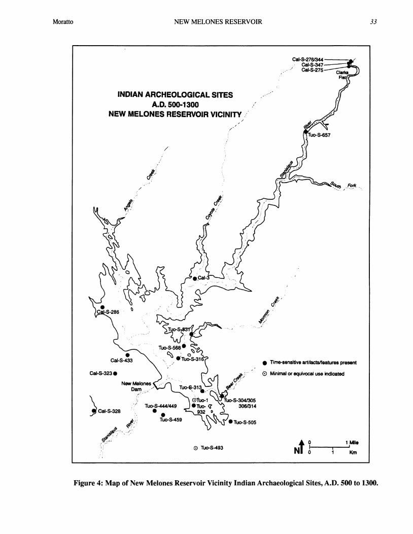
Figure 4: Map of New Melones Reservoir Vicinity Indian Archaeological Sites, A.D. 500 to 1300.
Moratto 33
34FENENGA VOLUME
INDIAN ARCHEOLOGICAL SITESA.D. 1300-1848
NEW MELONES RESERVOIR VICINITYfI
CalS-433* 0 eT oS-31
Cai-S-414 0® Cal-S-2Cal-S-323 @ CalS
Cai.S.321 O A.-New Melones Tuo-S
DamCal-S-326
Cal-S-328 Tuo-1Cai-S-329 1ljo-S-444 TuS70 * o-
1./440 Tuo-S-485 932 0Cai-S-331 * Tuo.S-459Cai-S-330. Tuo-S- TuoS-894
; .; .433 Tuo-S-536 *
* Tuo-S-
ä..-
- "..
* Time-snsitive artifacätfeatures present
}; ®(D Minimal or equivocal use indcated
,4980 Tuo-S493
* 1 MileN 0 1 Km
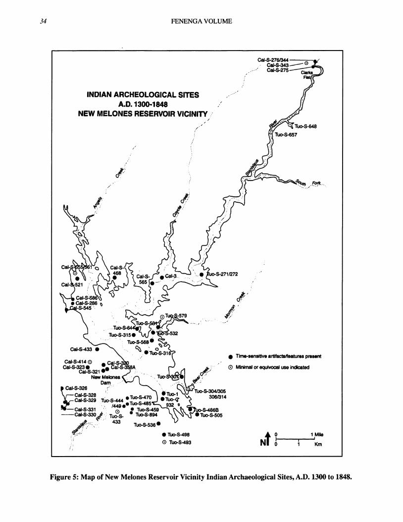
Figure 5: Map of New Melones Reservoir Vicinity Indian Archaeological Sites, A.D. 1300 to 1848.
34

NEW MELONES RESERVOIR
1
INDIAN ARCHEOLOGICAL SITESHISTORIC PERIOD
NEW MELONES RESERVOIR VICINITY.
1~~~~~~~~~~~~~~~~~~~~~~~~~~~~~~~~~~~~~~
* Tumsensitlve artfactsfeatures present
O Minmal or equtvocal use ndcated
Tuo-S-444*/449
* Tuo-S-498 0 1MieN| 1
O * Km
Figure 6: Map of New Melones Reservoir Vicinity Indian Archaeological Sites, Historic Period.
Moratto 35

3FENENGA VOLUME
Temporal and Formal Unitsin NMAP Culture History
Perlods Time Markers* Cultural Unis Comments
CENTRAL SIERRA MIWOK1910
Glass beads; HLstorAc Miwok; village communltyDSN, CT points. PEORIA BASIN PHASE pattem; acculturaton; depopulation.
1848-1848-
SS, CT, DSN, GB Large populations; Intensive occupatfon;w ~~~projectile points; acom-based economy" year-round
w 1500 OIivella E, K, M beads. HORSESHOE SEND PHASE setmements; 54 sltes.
di w 100o Rosegate senes Othr Phases? Ephemeral site use; small populations;1 t proectile points; minimal trade. Of 21 sites, only 3______OOliveIIa D, K, M beads. REDBUD PHASE hae anthrosois.
500-A.D. Bowl mortar; Large populaffons; intensive occupatfon;
0 cylindrical pestle; SIERRA PHASE houses, middens, cemeterles; extensive0
B.C. SCB, SSN, Elko series trade; 24 sites are known. EconomicUJ 500 points;Olivella F, G diversity; acorn use. Use of mortuary
series beads. caves; abundant funerary artifacts
1000-
1 500OtePhss1500 Other Phases? Poorly known; traces of minimal,2000 Pinto and Humboldt CALAVERAS PHASE tfmporary habitaton at 9 sites.
series prolectlle2500 points; milling stones. -HIATUS?
Large Lanceolate Dsndesrfr n-I 3000 Bifaces. TEXAS CHARLEY PHASE aDisrgLanc scrapers and
-D 3500Pinto and Humboldt Increasing artlfact densites and
o series projectlle points. Undeslgnated Components assemblage diversity In the Late ClarksZ 4000 Late Clarks Flat types Flat through Stanislaus Phase sequence
continue, but with the at 04-Cai-S-342 reflect diversification ofaddition of Stanislaus econorrc pursuit (notably expanding
4500 Broad Stemmed points uSTANISLAUS PHASE use of vegetal resources) andand abundant milling tools. (Peak and Crew 1990) occupatonal intenslfication. Elsewhere i
5000 Early Clarks Flat types the project area, poorly knowncontinue, but with the aemblages marked by Pinto and
$ addition of milling slabs, asHumboldt points seem unrelated to theuc 5500 manos, many types of LATE HumboFlat-Spoinseems conrltdntoum.w scrapers, and Western CLARKS FLAT SUBPHASE Clarks Flat-Stanislaus continuum.co QStemmed Series Points. (Peak and Crew 1990 )-C-- 6000-w Bipointed, foliate, and Several ites, most notably 04-Cal-S-34:3 stemmed points; scrapers; functoned as hunting camps as early1--w 6500 notched tools; beaked as 7650 B.C. Low assemblage diversityto gravers. Great Basin and artftact densities suggest lirdted,
700 Transverse points may temporary use of sites.be ascribed to this or EARLYpossibly an earHler, CLARKS FLAT SUBPHASE
7500 undesignated phase. (Peak and Crew 1990)
8000
Figure 7: Table of Temporal and Formal Units in NMAP Culture History.
36

NEW MELONES RESERVOIR
intensive use of the Clarks Flat vicinity: "Huntingand Game Processing was still the economic empha-sis, although the presence of milling stone bases andunshaped manos suggests the addition of vegetal food"(Peak and Crew 1990: 228).
6000-3500 B.C.Cultural materials older than 5500 years have been
recognized at 04-Cal-S-276/344, 04-Cal-S-342, andpossibly at 04-Cal-S-347-all on Clarks Flat (Fig-ure 2). The case for cultural activity at 04-Cal-S-347prior to 3500 B.C. is tenuous; the few biface frag-ments and pieces of debitage from Stratum D (ca.6000-4000 B.C.) may be coeval with the depositionof that stratum by the Stanislaus River, or possiblythe artifacts were intruded from overlying anthrosols(O'Brien 1984:152). Another site, 04-Cal-S-286 onTexas Charley Gulch in the Angels Creek drainage(Figure 2), also might have been occupied prior to3500 B.C. Evidence of cultural activity soon afterthis date, however, is more definitive (see 3500-1000B.C., below).
The 6000-3500 B.C. period is better representedby Zone 4 at 04-Cal-S-276/344 (Figure 2), character-ized by: a paucity of groundstone items (Riley andMoratto 1986); few bifaces but many backed scrap-ers, scraper-planes, backed bladelets, choppers, andhammerstones; a lower density of tools and debitagethan in any other zone at the site; and an emphasis onchert as the primary toolstone. Obsidian tools arepresent but account for only 45% of the Zone 4 flakedstone assemblage (Singleton 1986a). The low den-sity and remarkable variety of artifacts at04-Cal-S-276/344 indicate a wide range ofactivities-hunting, flaked stone tool production, scraping,pulping, and limited milling-but probably not inten-sive occupation. In fact, the Zone-4 ensemble mayreflect brief visits by diverse groups at various timesover a span of centuries. Multiple components maybe documented, albeit sparsely, in this zone. The evi-dent degree of mixing and the absence of clearly de-finable components within Zone 4 preclude defini-tion of represented phases.
The best-known archaeological record of the 6000-3500 B.C. interval in the study area is from 04-Cal-S-342, where Peak and Crew (1990) recovered ampleevidence of early (ca. 7650-4800 B.C.) and late (ca.4800-? B.C.) expressions of the Clarks Flat Phase (su-pra). Peak and Crew (1990:229-230) also defined a
Stanislaus Phase (ca.? 4250 B.C.), characterized bythe addition of Stanislaus Broad-stemmed projectilepoints and a marked increase in the use ofground stonetools, "to constitute the dominant tool category by theend of the phase" (Peak and Crew 1990:229). Onemay question the definition of a separate StanislausPhase, given its shared sedimentary context ("Spit B")with the Late Clarks Flat materials, the unclear tem-poral distinction between Late Clarks Flat andStanislaus assemblages, and given that "during theStanislaus Phase, the entire tool inventory of the pre-ceding Clark Phase (sic) was retained and the newertools appeared as an overlay on the older assemblage"(Peak and Crew 1990:229). Nonetheless, thediachronic changes in relative frequencies of variouskinds of implements would seem to evince an adap-tive shift:
The steadily increasing numbers ofground stone tools with a corre-sponding diversity in types may re-flect a change in the botanical re-sources of the locale. Hunting per-sisted as an economic pursuit.... Inshort, although direct evidence islacking, the changes observed in theartifact record may well indicate anenvironmental shift with a corre-sponding change in the interactiveresponses of the residents (Peak andCrew 1990:279).
Except for these findings at 04-Cal-S-342, the6000-3500 B.C. period remains poorly knownarchaeologically. Occupation is registered by mixedassemblages reflecting brief visits by diverse, smallgroups. Hunting, flaked-stone tool production andmaintenance, and milling with manos and mealingslabs are inferred, but elucidation of occupational in-tensity must await further study. The paucity of infor-mation for this and earlier periods, however, shouldnot be interpreted as evidence of either small popula-tions or limited site use in the project area.Paleoenvironmental surveys have not been undertakento inventory the relict landforms and paleosols mostlikely to harbor early and middle Holocene archeo-logical remains. All of the known cultural materialsof such antiquity in the study area were discoveredfortuitously (i.e., they occurred below younger, more
37Moratto

FENENGA VOLUME
visible archeological deposits). The apparent numberand distribution of early components thus are morethe products of coincidence than of systematic re-search, and they might not accurately represent thepatterns of prehistoric land use.
3500-1000 B.C.Archeological deposits at 04-Cal-S-275, -276/344,
-286, -347, and 04-Tuo-S-271/272 and -505 (Figure 2)have produced cultural materials ascribable to thisperiod. Pinto and Humboldt series points from thesesites (see Moratto et al. 1988) are thought to registertimes before ca. 1000 B.C. and possibly as early as5000 B.C. (Hester 1973; Singleton 1984a, 1986a;Warren 1984:410-414). Minimal archeological datafrom the 3500-1000 B.C. period was obtained at04-Tuo-S-505 and 04-Cal-S-347 (Figure 2). At04-Tuo-S-505, east of upper Long Gulch, SAI recov-ered a Humboldt Concave Base point, a core, a steppedbiface, a drill, and debitage at depths below 100 cmin sub-midden gravelly clay; no millingstones werefound below 90 cm at 04-Tuo-S-505, despite theirabundance in the overlying midden deposits. Unfor-tunately, the excavated sample at this site is very small(5.1 m3), and the nature of the sub-midden compo-nent is not well understood. Similarly, the small as-semblage from Stratum E (ca. 5320-2600 B.C.) at04-Cal-S-347 is poorly defined. Included are manos,scrapers, retouched pieces, bifaces, choppers, and ahammerstone fragment. Among the bifaces are a con-tracting-stem point fragment and two Large LanceolateBifaces comparable to specimens from themiddle-Holocene yellow clay deposits at 04-Cal-S-286(O'Brien 1984; Singleton 1984a). Similar assem-blages might be discovered at 04-Tuo-S-313, -531,and -567, if ever their known sub-midden deposits areexcavated.
Occupation at ca. 3500 B.C., or possibly earlier, isclearly evidenced at the Texas Charley Gulch site,04-Cal-S-286 (Figure 2). The oldest recognized ar-cheological component at this site occurs in sub-mid-den, alluvial over bank sediments and in old residualsoils (Haltenhoff 1984). These deposits exhibit nocharcoal, little if any bone or shell, almost no detect-able phosphates, approximately neutral pH, and mini-mal (11.6-19.3 kg/m3) fire-altered rock, much ofwhichmay be intrusive. In short, the matrix is developedonly weakly, or not at all, as an anthrosol. Best knownfrom Strata D and E of the Eastern zone but also from
Stratum D of the Central zone and Stratum C in theWestern zone (Moratto and Arguelles 1984: Figure1.2.4), the occupation is recognized by:
a percussion-flaked tool industry (pressure flak-ing is not represented); distinctive backed scrap-ers and Large Lanceolate Bifaces of chert...,cores, choppers, and scraper-planes; and abun-dant debitage (more than 7450 pieces in theEastern zone sample alone), of which chert rep-resents a much higher frequency (398.5m3) thando obsidian (84.2/m3) and other lithic materi-als (161.2/m3). The selection, heat pretreatment,and skillful percussion- flaking of exotic chertsreflect systems of lithic procurement and tech-nology not replicated in later components. Fi-nally, the Texas Charley component has pro-duced several pestle-like implements, a peckedbut apparently unfinished "charmstone," andseveral other groundstone artifacts; the asso-ciation of manos with this component remainsequivocal (Moratto et al. 1984:102-103).
These materials from the sub-midden clays at04-Cal-S-286 comprise the type component of theTexas Charley Phase (Figure 7). The entailed speci-mens show that the production of chert and green-stone tools was an important activity in Texas Char-ley Gulch some 5500 years ago. The lack ofanthrosols, coupled with the absence of recognizedfeatures and low density of artifacts other thandebitage, suggests that occupation was not intensive.Unfortunately, nothing is known about the subsistenceeconomy, land-use patterns, shelters, mortuary prac-tices, or ethnic identity of the people who left the TexasCharley Phase component. Nor does this componentseem to have known antecedents or successors at thetype-site. The phase, however, is well represented atthe Skyrocket site near Copperopolis (J. Pryor, per-sonal communication 1995).
At 04-Cal-S-286 erosion seems to have removedany deposits representing the 3500-2500 B.C. period.Whether the site was inhabited at any time during thisinterval is unknown. Occupation after ca. 2500 B.C.is evidenced by a few square and rectangular manos,millingslabs, and Pinto Sloping Shoulder and SierraSide-notched points in the lower levels of Stratum Bin the Western and Eastern zones (Moratto andArguelles 1984). This component does not appear to
38

NEW MELONES RESERVOIR
be extensive at the site, implying minimal culturalactivity there between ca. 2500 and 1000 B.C.
Aside from the assumed general contemporaneityof the Pinto-series points, none of the assemblagesassigned to the 3500-1000 B.C. period is necessarilycoeval with any other. Indeed, the variety of bifaces(Humboldt Concave Base, Pinto Sloping Shoulder,Pinto Square Shoulder, and Large Lanceolate) andvariable occurrences of millingstones may signal cul-tural diversity as well as temporal separation. Cer-tainly, the lithic technology expressed in the TexasCharley Phase component at 04-Cal-S-286 is verydifferent than the technology evinced by theHumboldt/Pinto assemblages. The latter thus seemto represent a distinct occupation, or occupations, towhich the name Calaveras Phase is applied provision-ally. Otherwise, current data provide little informa-tion about the economy and land-use strategies of theevidently small, mobile groups who inhabited severalsites in the NMAP locality at various times betweenca. 3500 and 1000 B.C.
1000 B.C. - A.D. 500This is the first period for which available evidence
shows widespread, relatively intensive occupation ofthe study area. Archeological materials at 24 sites(Figure 3) are attributed, with varying levels of confi-dence, to this interval. Additional components mayremain undetected; some sites may have been lost toerosion or buried by sediments; others likely weredestroyed by placer mining during the Gold Rush; andyet other sites, particularly those along the StanislausRiver below Coyote Creek, may have been inundatedby old Melones Reservoir. Consequently, the knowncomponents must be viewed as a very incompleterecord of land use and settlement during the 1000 B.C.-A.D. 500 time span.
Sites 04-Cal-S-320, -323, -329, -433, -468, -521,-565, and 04-Tuo-S-271/272, -315, -459, and -568have produced only minimal or equivocal evidenceof cultural activity during this period. The collectionsfrom each of these sites include from one to severaltime markers, notably bifaces of the Elko Eared, ElkoCorner-notched, Sierra Concave Base, and Eared Con-cave Base types; Olivella G series beads; and HaliotisH3c2 beads. Anthrosols or archaeological features(implying longterm or intensive occupation) definitelyrelated to the 1000 B.C.-A.D. 500 interval have notbeen detected at these sites.
The record is more substantial at 12 sites:04-Cal-S-275, -276/344, -286, -330, -342, -347, and04-Tuo-S-316, -44/449, -505, and -657 (Figure 3).Pre-A.D. 500 occupations at these sites are markedby brown midden soils (often stratigraphically belowdarker-colored, later prehistoric midden deposits);buried, earthen housefloors; numerous millingslabsand manos; infrequent cobble mortars and shapedpestles; conical pipes; Haliotis H2 and H3 beads;Olivella C and G series beads; atlatl weights;medium-to-large bifaces of Elko Eared, ElkoCorner-notched, Sierra Concave Base, TriangularContracting Stem, Medium Triangular ContractingStem, Medium Comer-notched, Bipoint, and SierraSide-notched types; abundant debitage, of which ob-sidian is the predominant material; and flexed buri-als, often under stone cairns and sometimes fumishedwith Olivella and/or Haliotis omaments. These traitscharacterize the Sierra Phase (Figure 7).
The well-developed midden deposits at these sitesattest to repeated or long-term habitation. Housefloorsand burials likewise indicate that the sites were resi-dential bases. Subsistence practices seem to have in-cluded hunting mostly deer, rabbits, and squirrels withatlatl and dart, and gathering vegetal foods, of whichsome were processed in mortars and on millingslabs.Although no acoms have been found among recov-ered plant macrofossils, the combination of mortarsand pestles, ashy midden soil, and fire-altered rockmakes a good circumstantial case for their use by theSierra Phase people. While shell beads and omaments,along with obsidian from the North Coast Ranges, sig-nal trade relationships with peoples to the west, bifacetypes and the large quantities of obsidian from BodieHills and Casa Diablo evince strong economic ties withgroups to the east. In the aggregate, these findingsattest to levels of economic activity, sedentism, andoccupational intensity apparently not documented byearlier components in the study area. For example,Zone 3 at 04-Cal-S-276/344 contains the deepest cul-tural deposits, highest densities of debitage and bothflaked and ground stone tools, highest proportion ofobsidian among both tools and debitage, and greatestvariety of artifact classes and types found at the site(Moratto and Singleton 1986:141-142). The SierraPhase components at 04-Cal-S-275, -330, and04-Tuo-S-316, -444/449, -505, and -657 (Moratto andSingleton 1986) are comparable.
Stratum B at 04-Cal-S-286 is consistent with the
39Moratto

FENENGA VOLUME
type component of the Sierra Phase. The extensive,deep midden deposits of Stratum B are dark, organicloams with neutral to basic pH, high phosphate lev-els, moderate quantities of faunal remains, and con-siderable amounts (26.8-124.0 kg/m3) of fire-alteredrock, showing that cooking with heated rocks was animportant activity. Culturally, the Sierra Phase com-ponent is marked by Haliotis H3b Flat Disc beads;Olivella beads of the F2 Saddle, Gl Round Saucer,G2a Small Saucer, and G2b Large Saucer types; ElkoCorner-notched, Medium Triangular ContractingStem, Medium Comer-notched/removed, MediumExpanding Stem, and Sierra Concave Base points;stepped bifaces; various scrapers and other flakedstone tools (Riley 1984a, 1984b; Singleton 1984a:Tables 2.6.104, 2.6.110, 2.6.116); quartz and chryso-tile crystals, manuports, and ochre; occasional pointedbone implements; manos, millingslabs, shaped andpossibly unshaped pestles, and cobble, boulder, andslab mortars (but not bedrock mortars); andhammerstones. Lithic debitage is generally abundant(244-472 pieces/m3), and obsidian achieves its high-est density (88-144 pieces/m3) in the Sierra Phase com-ponent.
Although artifactual cross-dating, reinforced byradiocarbon assays at 04-Cal-S-286 and 04-Cal-S-347(Moratto et al. 1988: Table 5.1), would assign all ofthe components discussed in this section to the 1000B.C.-A.D. 500 period, temporal control is poor atmost of the sites and synchroneity of occupation can-not be assumed. Thus, settlement patterns in the senseof population distribution at a given point in time can-not be reconstructed on the basis of current informa-tion. Nonetheless, it is interesting that the known Si-erra Phase midden sites in the foothill portion of thestudy area (namely, 04-Cal-S-286, -329/330, -468,possibly -565, and 04-Tuo-S-271/272, -316, -444/449together with -459, and -505) are approximately equi-distant at ~3 km from one another (Figure 3). Per-haps this distribution of sites reflects some proxemicreality, such as settlement spacing and the mutual cir-cumscription of primary catchments, in prehistory.Given the nature and limited extent of excavations atmost of these sites, however, the apparent patternmight as well be an artifact of sampling bias. In ei-ther case, additional data will be required to recon-struct Sierra Phase settlement pattems in the NewMelones project area.
Aside from the habitation sites, numerous caves
in the study area evidently were used as mortuarychambers during a time span beginning ca. 1000-500B.C. and ending ca. A.D. 500-700 (McEachem 1968;Moratto 1984: 304-308). These funerary cavems con-tain secondary burials and, rarely, cremations togetherwith stone pipes, bone daggers, large side-notchedprojectile points, fish vertebra beads, turtle bone arti-facts, quartz crystals, basketry, Haliotis omaments, anda profusion of Olivella beads (Beck 1970; Danehy1951; Gonsalves 1955; McEachem 1968; McEachemand Grady 1977; Orr 1952; Payen 1964; Payen andJohnson 1965; Wallace 195 la, 195 1b; Whitney 1867).In quantity and range of types, the artifact assemblagesfrom the mortuary caves are different than those fromthe habitation sites. This may reflect differential pres-ervation, formal distinctions between funerary andeconomic assemblages, or, possibly, the use of themortuary caves by cultural groups other than thosewho lived and interred their dead at the nearby mid-den sites. On present evidence, it would seem mostlikely that the caves were used by local groups, andthat the funerary offerings found in the caves eluci-date a range of artifact forms and inferred sociotechnicbehaviors not fully represented in the assemblagesfrom open sites.
A.D. 500-1300Unlike the relatively sedentary and intensive oc-
cupations of 1000 B.C.-A.D. 500, the subsequent pe-riod evidently witnessed sparse populations and lim-ited site use by small, presumably mobile groups.Moreover, all of the known Sierra Phase sites (Figure3) in the project area seem to have been abandoned,or inhabited only minimally, during the A.D. 500-1300interval. The archeological record apparently indi-cates cultural discontinuity from the preceding phase.The cessation of cave burial at ca. A.D. 500-700 sup-ports this reconstruction. A few time-sensitive artifactstypically one to several Rosegate series bifaces and/orOlivella B, D, K, or M series beads attest to minimalactivity during this period at 21 sites: 04-Cal-3,04-Cal-S-275, -276/344, -323, -328, -347, -433, and04-Tuo-1, 04-Tuo-S-304/305/306/314,-316, -44/449,-459, -505, -531, -568, and -932 (Figure 4). One othersite, 04-Tuo-S-493, produced a radiocarbon date of 910+ 60 B.P.: A.D. 1040, but no diagnostic artifacts. Cul-tural deposits, features, or other indications of signifi-cant occupation during theA.D. 500-1300time span havenot been recognized at any of these 22 sites.
40

NEW MELONES RESERVOIR
At three sites-04-Cal-S-286, 04-Tuo-S-313, and04-Tuo-S-657-the known records of activity betweenca. A.D. 500 and 1300 are more appreciable. TheRedbud Phase type component at 04-Cal-S-286, forexample, includes definite midden deposits with mam-mal bone, fragments of M. margaritifera shell, andmoderate amounts of fire-altered rock. Found in thismidden were two broad, shallow pits ofunknown func-tion and an apparent housefloor of compacted earthassociated with ash and charcoal. At least two inter-ments also seem related to this component (Morattoand Arguelles 1984:105-106). Faunal remains docu-ment the hunting of deer and small game as well asthe collecting of freshwater mussels. Vegetal foods,perhaps including acoms, were gathered and processedin portable mortars and millingslabs.
Hallmarks of the Redbud Phase at 04-Cal-S-286include: Olivella beads of B2 End-ground, C3 SplitOval Drilled, K2 Cupped, and Mla Plain Thin Rect-angular types; projectile points of the "Rosegate" se-ries (i.e., Rose Spring and Eastgate types [Thomas1981]), and, late in the period, Gunther Barbed type;flaked stone scrapers and other lithic tools of varioustypes (Singleton 1984a: Table 2.6.112); pestles of un-shaped cobbles, cobble mortars, manos andmillingslabs; and red ochre, together with quartz andchrysotile crystals. Like their predecessors, the Red-bud Phase residents of 04-Cal-S-286 continued to ac-quire Bodie Hills obsidian. However, "the quantitiesof obsidian reaching the site or at least the obsidiandensities in the midden were smaller than in earlierand later phases of prehistory. Indeed, the overalldensities of all kinds of lithic debitage tend to be low(245/m3) relative to those of the earlier...componentor later protohistoric and historic components at thesite" (Moratto and Arguelles 1984:106). Together, thecomparatively low debitage frequencies, small quan-tities of fire-altered rock, and paucity of Rosegate ar-tifacts and midden imply that the Redbud Phase oc-cupation of 04-Cal-S-286 was spatially limited andof small scale.
The A.D. 500-1300 period is also documented at04-Tuo-S-313 near Bear Creek (Figure 4) in strata forwhich temporal control is supplied only by threeRosegate-series bifaces, a single Olivella C1 bead, andhydration measurements of 5.7/7.1 and 4.1 microns,respectively, on pieces of Bodie Hills and Casa Diabloobsidian. Two charcoal samples from "random" testunits, and not associated with any of the 30 features
excavated at this site, provided modern radiocarbondates (i.e., <300 B.P.) and thus contribute no usefulinformation. The A.D. 500-1300 period at04-Tuo-S-313 witnessed the procurement and reduc-tion of local slate, manufacture and use of slate chop-pers and scraper-planes (function unknown), limitedproduction of small tools of chert, hunting with thebow and arrow, food processing with millingslabs/manos and portable mortars/pestles, and cooking insteatite vessels (Moratto and Singleton 1986).
At 04-Tuo-S-657, in the Stanislaus River canyon(Figure 4), occupation is registered by a dark brownmidden radiocarbon-dated between 850 ± 80 B.P.:A.D. 1225 and 415 ± 80: A.D. 1450. This componentis marked by triangular arrow points and a profusionof mano fragments. Biface preforms and abundantdebitage confirm that lithic reduction was a majoractivity at this site. Remarkably, obsidian pieces ac-counted for only about 24 percent of the otherwisesilicate (mostly chalcedonic) debitage. Hunting is at-tested by numerous bones of deer, lagomorphs, andsquirrels; fishing, too, is indicated. Given itscanyon-bottom setting next to the river, 04-Tuo-S-657perhaps served as summer hunting/gathering/fishingcamp between A.D. 1200 and 1450 (Moratto andSingleton 1986).
Aside from the modest evidence of habitation at04-Cal-S-286, 04-Tuo-S-313, and 04-Tuo-657, thearcheology of the A.D. 500-1300 period is poorlyknown. Even the assignment of 04-Tuo-S-313 and-657 to the Redbud Phase is tenuous, given their pe-culiar assemblages. The fact that they share with thetype component such traits as Rosegate points, abun-dant manos and millingslabs, and low frequencies ofobsidian tend to justify their place in the Redbud Phase.The variability among the three components may re-flect different environmental settings, site functions,and/or economic specializations. Nonetheless, thepossibility of more than one phase cannot be dis-counted for the A.D. 500-1300 period. By every indi-cation, die study area was sparsely populated and mini-mally used during much of this period. Older (SierraPhase) villages were abandoned, their sites used oc-casionally for ephemeral camps and perhaps as sourcesof obsidian to be reworked. Cultural continuity fromthe Sierra Phase is not implied by the meager archeo-logical remains of the subsequent Redbud and otherphases.
Moratto 41

FENENGA VOLUME
A.D. 1300-1848Late prehistoric occupation of the middle
Stanislaus River locality was both extensive and in-tensive, especially as compared with that of the A.D.500-1300 period. Fifty-four of the 68 sampled Indiansites in the project area can be assigned, definitely(43) or probably (11), to the A.D. 1300-1848 period(Figure 5; Moratto et al. 1988: Table 5.17); 42 of thesesites feature middens, bedrock mortars, and other evi-dence of substantial, long-term and/or repeated, oc-cupations as compared with only three such compo-nents recognized for the preceding period and 12 forthe 1000 B.C.-A.D. 500 period. The overall impres-sion derived from the sampled components is that lateprehistoric times witnessed larger populations, moresedentism, tighter spatial clustering of settlements, andhigher levels of both intra- and inter-site organizationthan in any earlier period.
Late prehistory in the NMAP area coincides withthe Horseshoe Bend Phase (Figure 7), of which thetype component is strongly registered in Stratum A at04-Cal-S-286 (Figure 5). This stratum is a deep, verydark, ashy loam midden with weakly basic pH, highphosphate and total organic content, abundant char-coal and other plant macrofossils, numerous faunalremains, and high densities (mean=212 kg/m3) offire-altered rock. Horseshoe Bend Phase activities at04-Cal-S-286 are further attested by numerous hearth,cairn, pit, and earthen-floor features, as well as cre-mations and burials (Moratto and Arguelles 1984:Goldberg 1984). Typical artifacts are Olivella El ThinLipped beads; Saxidomus A1 and A2 disc beads;Desert Side-notched, Cottonwood Triangular, andGunther Barbed points; inferred use of the bow andarrow; hammerstones, cores, choppers, and abundantflake tools of diverse types (Singleton 1984a); a ste-atite industry featuring disc beads, cooking vessels,ear ornaments, and other forms; manos, millingstones,unshaped (and possibly some shaped) pestles, andbedrock mortars; battered stones; and fairly high den-sities of debitage, ranging from 245 pieces/m3 in theWestern Zone to 500/m3 in the Central Zone. Thefrequency of late prehistoric obsidian (120-165/m3) isgreater than that of the underlying Redbud Phase com-ponent (68/m3) at this site (Moratto and Arguelles1984).
Several clusters of Horseshoe Bend Phase compo-nents can be defmed. Some ofthese such as the groupsof sites at Clarks Flat (04-Cal-S-275, -276/344, and
-343), Bowie Flat (04-Cal-S-326, -328, -329, -330,and -331) and on the southern flank of Bostick Moun-tain (04-Cal-S-320, -321, -323, and -358A) - reflectthe constraints of topography. Perhaps these compo-nents are absolutely contemporaneous and do reflectsome measure of intersite organization, but the dataare equivocal on this point. Other apparent clusters,such as 04-Cal-S-286 and -586 at Texas Charley Gulchand 04-Tuo-S-304/305/306/314 on Bear Creek, arein fact nothing more than nearly contiguous loci ofsingle sites. Other settlement clusters, however, seemto include synchronous components reflecting intersiteorganization. The best example of this pattern is thecluster focused upon 04-Tuo-S-444/449 (Cooley-Reynolds 1980) near Peoria Mountain (Figure 5;Moratto et al. 1988: 299-314).
Considering the extent of midden, number of bed-rock mortars, presence of a large structure (commu-nal dance house?), number of smaller structures(dwellings?), abundance of sociotechnic artifacts, andevident cemetery, 04-Tuo-S-449 probably functionedin late prehistoric and early historic times as the cen-ter of a village community (cf. Merriam 1967:340).If this inference is valid, 04-Tuo-S-449 might havebeen the social and political center for a communityof hamlets in the Peoria Basin-Peoria Mountain vi-cinity. In terms of propinquity and contemporaneity,this community might have encompassed04-Tuo-S-444, 449, -470, -485, -433, -459, and -894(Figures 5, 6). Village communities probably alsowere centered at 04-Cal-S-565 and 04-Tuo-S-27 1/272,and possibly near the confluences ofAngels and Bearcreeks with the Stanislaus River (both inundated byold Melones Reservoir); unfortunately, these impres-sions cannot be verified with available data. By A.D.1848, however, named villages existed at HorseshoeBend (Tipotoya [04-Tuo-S-271/272?]), RobinsonsFerry/Melones (Wüyü [04-Cal-S-565 and 04-Cal-3?]),on Mormon Creek (Pokto-no), and on Bear Creek(Suchumumu [04-Tuo-l? or 04-Tuo-S-304/305/ 306/314?]) (cf. Kroeber 1925). Some or all of these cen-ters might have emerged from late prehistoric ante-cedents.
The strong similarities between Horseshoe BendPhase assemblages and the ethnographic material cul-ture of the Central Sierra Miwok (cf. Barrett andGifford 1933), together with models of California lin-guistic prehistory (see Moratto 1984: Chapter 11), in-dicate that the post-A.D. 1300 occupants ofthe project
42

NEW MELONES RESERVOIR
area were, predominantly, the ancestors of the Cen-tral Sierra Miwok. Cultural discontinuities betweenRedbud and Horseshoe Bend Phase components im-ply that the ancestral Miwok did not come to occupythe study area until ca. A.D. 1300. Subsequently, theirpopulation spread seems to have been rapid and byca. A.D. 1500-1600, complete. While it would be niceto know the ethnolinguistic identity of the people(s)supplanted by the Miwok, it would be even more in-teresting to learn about the mechanisms of replace-ment. The archeological record is taciturn on bothcounts, although, as discussed above, a significantfactor might have been the minimal occupation of themiddle Stanislaus River locality prior to ca. A.D. 1300.In turn, both the limited Redbud Phase activity andthe intensive late-prehistoric (Miwok) occupation mayreflect paleoenvironmental conditions and changes(see Moratto et al. 1988: 39-86, 535-541).
The subsistence economy of the Horseshoe BendPhase involved hunting, fishing, collecting, and gath-ering, doubtless supplemented by trade (supra). Fau-nal remains show that deer, rabbits, squirrels, and vari-ous birds were hunted regularly; other animals amongthem, black bear, coyote, tule elk, antelope, and turtlesalso were taken, at least occasionally. While the bowand arrow served as the principal weapon, one mayassume (based upon ethnographic information [Barrettand Gifford 1933]) that various traps, snares, dead-falls, nets, and other devices also were employed. Thetechnology for processing vegetal foods changed sig-nificantly from that of earlier periods. Millingslabsand manos evidently were used less frequently thanbefore, and portable mortars were replaced almostentirely by bedrock mortars (BRMs). While not con-clusive, the absence of BRMs in Redbud Phase com-ponents and their ubiquitous correlation with Horse-shoe Bend Phase occupations imply that bedrock mill-ing technology spread within the project area some-time after ca. A.D. 1300. lt is probably significant,too, that the proliferation of fire-altered, clastic rocksin midden deposits largely coincided with the adventof BRMs. Both are thought to reflect an emphasis onacorns as a staple food, the mortars of course beingused as mills and the rocks attesting to stone-boiling.The increased reliance on acorns an abundant, nutri-tious, and storable food resource would have facili-tated year-round occupation and allowed for popula-tion expansion.
Trade was also an important aspect of the late pre-
historic economy. Olivella Ela, Eib, and Hla beads,Saxidomus and Tresus disc beads, and Haliotis orna-ments came ultimately from coastal groups, probablythrough the intermediacy of Valley peoples. Stock-ton Serrated points, while infrequent in the projectarea, also signal contacts with the west _ an inferencesustained not only by typologic similarities with pointsin the Stockton locality, but also by the distribution ofthese points at sites (04-Tuo-S-307, 04-Tuo-932, and04-Cal-S-328) in the western part of the NMAP area,and by the fact that at least one of the four recoveredStockton Serrated points is made ofNapa Glass Moun-tain obsidian. Obsidian, chiefly from the Bodie Hillssource, was acquired through trade with higher Sier-ran and/or Great Basin peoples. Debitage from thepost-A.D. 1300 components at New Melones typicallyincludes a larger proportion of obsidian than is foundin Redbud Phase debitage but less than in the SierraPhase components. The widespread occurrence ofDesert Side-notched and Cottonwood Triangularpoints throughout late prehistory further attests to sus-tained influences from the Great Basin. Nonetheless,the dominant cultural ties during this period were withthe central California area, as indicated by theacorn-based economy, settlement pattern, degree ofsedentism, community organization, complex ofsociotechnic artifacts, and participation in religiouscults. By A.D. 1848, the peoples of the middleStanislaus River locality had become well integratedinto the economic, social, and religious systems ofcentral California.
A.D. 1848-1910The ethnohistory and historical archeology of this
period are reviewed elsewhere in considerable detail(Goldberg et al. 1986; Greenwood 1982; Greenwoodand Shoup 1983; Hall 1978; Jackson 1976;Theodoratus 1976; Tordoff 1988a, 1988b; Van Bueren1983). Essentially, this was the time of the Gold Rushand its aftermath, when Miwok culture and societywere devastated. The early years of this period werecharacterized by environmental destruction, intercul-tural violence, decimation of Native populations, theincursion of non-local Indians, forced abandonmentof traditional villages and short-term occupation ofnew sites that would have been judged marginal orunsuitable by earlier settlement criteria. The historicperiod further witnessed the demise of Miwok socialand political institutions; collapse of obsidian trade;
Moratto 43
44 FENENGA VOLUME
adoption of Euro-American clothing, tools, weapons,musical instruments, and ornaments-all ofwhich areattested archeologically; significant dietary changes;and even a change in mortuary practices, from a pref-erence for cremation to a general pattern of coffinburial. By the end of this period, following more than100 centuries of adaptation to the local environments,Indian populations ceased to live in the New Melonesproject area.
Archeologically, these profound changes are re-flected in Peoria Basin Phase components, most ofwhich trace ephemeral occupation or use, at 33 sites(Figure 6; Moratto et al. 1988: Tables 5.16, 5.17;Moratto and Singleton 1986; Van Bueren 1983). ThePeoria Basin type component at 04-Cal-S-286 exhib-its flaked glass tools (e.g., Desert Side-notched andCottonwood Triangular points and scrapers) of tradi-tional form; Saxidomus disc, and Olivella series HGround and Rough Disc beads; glass beads of manytypes; cobble pestles and bedrock mortars; coiled bas-kets of varied forms; textile fragments, buttons, buck-les, and shoe parts; rings, brooches, and otherjewelryofmetal and glass; metal tableware; steel knives, shov-els, and picks; iron nails; pane, bottle, andlamp-chimney glass; stoneware, porcelain, and otherceramics; and parts of musical instruments (Fumis1984; Isaacs 1984; Van Bueren 1983). This compo-nent also features both cremations and burials, togetherwith the persistence ofceremonial structures (Morattoand Arguelles 1984).
In brief, the Peoria Basin Phase documents sweep-ing cultural changes from Gold Rush times until theearly twentieth century. During this period, traditionaleconomic patterns, domestic architecture, clothing,and most technology rapidly gave way to those of thedominant culture, while aspects of social organiza-tion, ceremonial architecture, ritual, and many nativefoods-together with their processing technology-were retained by the historic Miwok.
The middle Stanislaus River country, transectingperhaps the richest segment of the Mother Lode belt,was at the very heart of the Gold Rush. Beginning in1848, waves of foreigners: Anglo-Americans, Italians,Chinese, Mexicans, Chileans, as well as Californiosswept into the southem mines to seek their fortunes.The resulting population growth was phenomenal: "Atthe eve of the Gold Rush [Califomia's] population
[excluding Indians] had grown to about twenty-sixthousand. By mid-summer of 1849 it reached fiftythousand, and by the year's end it was probably near115,000. By 1860 the number had more than tripledto 380,000" (MacKinnon 1967:3-4). The early min-ers created a dependent economy (see Shoup 1988),and an ephemeral one at that. By 1860, having ex-hausted the easily-worked placers, most of the '49ershad left the Stanislaus. In their wake remained count-less abandoned camps and prospects, and vast areasof despoiled land.
But not all of the Argonauts pulled up stakes. Somestayed on, making their living by ranching, hard-rockmining, or commercial enterprises in the foothilltowns. Between the 1860s and 1890s, gold miningdeclined and agriculture emerged as dominate in thelocal economy. Thereafter, the economic base wasbroadened to include: corporate industrial mining;logging, aided by the Sierra Railroad; and hydroelec-tric developments, notably the Camp Nine Powerhouseand old Melones Dam. These varied activities, rang-ing from the placer mining of Gold Rush days totwentieth-century hydroelectric projects, are recordedby at least 442 historic archeological sites in theNMAParea (Tordoff 1988a). Grouped by function, these sitesrelated to mining, agriculture, residential activities,water systems, transportation, stone ovens, miscella-neous functions, and various combinations of these.Together, these sites represent the (undesignated) his-toric phases of the New Melones cultural sequence.
AcknowledgementsThis paper is an abridged and revised version of
the concluding chapter of the Final Report ofthe NewMelones Archaeological Project, Volume 9 (Moratto,Shoup, and Tordoff 1988). Funding for archaeo-logical fieldwork, data analyses, and preparationof the Final Report... was provided by the U.S. ArmyCorps of Engineers, Bureau of Reclamation, and Na-tional Park Service. I am particularly indebted to Drs.Bennie Keel (National Park Service) and G. JamesWest (Bureau of Reclamation) for their administra-tive support of the New Melones ArchaeologicalProject between 1981 and 1988. Any deficiencies inthe Project's technical work or resultant reports, how-ever, are claimed as my own.
44

NEW MELONES RESERVOIR
References Cited
Aginsky, B. W.1943 Culture Element Distribution, XXIV:
Central Sierra. University ofCalifornia Anthro-pological Records 8(4). Berkeley.
Barrett, S. A., and E. W. Gifford1933 Miwok Material Culture. Bulletin of
the Public Museum of the City of Milwaukee2(4):117-376. Milwaukee.
Beck, J. L.1970 Turtle-bone Artifacts from Pinnacle
Point Cave (4-Tuo-272), Tuolumne County,California. University ofCalifornia, CenterforArchaeological Research at Davis, Publications2:1-8. Davis.
Borthwick, J. D.1917 The Gold Hunters. Macmillan. New
York.Carson, J. H.
1952 Life in California. San Joaquin Re-publican. Stockton, CA.
Castillo, E. D.1978 The Impact ofEuro-American Explo-
ration and Settlement. In Handbook ofNorthAmerican Indians, Volume 8: California, pp.99-127. Robert Heizer, vol. ed. SmithsonianInstitution. Washington D.C.
Cook, S. F.1960 Colonial Expeditions to Interior Cali-
fornia: Central Valley, 1800-1820. Universityof California Anthropological Records16(6):239-292. Berkeley.
1976 The Conflict between the CaliforniaIndian and White Civilization. University ofCalifornia Press, Berkeley.
Cooley-Reynolds, K.1980 04-Tuo-S-449. Ms. prepared for Sci-
ence Applications, Inc., La Jolla. On file, U.S.Bureau of Reclamation, New Melones DamHeadquarters. Jamestown, CA.
Corps of Engineers (COE)1972 Environmental Impact Statement: New
Melones Lake, Stanislaus River California. Sac-ramento District, U.S. Army Corps of Engineers.Sacramento.
Costello, J. G.1981 Gold Rush Archaeology: Excavating
the Mother Lode. Archaeology 34(2): 18-26.
1983 Melones: A Story of a StanislausRiver Town. Submitted to the U. S. Departmentof the Interior, Bureau of Reclamation, Mid-Pacific Region, Sacramento. GovernmentPrinting Office, Washington D.C.
Cowles, J.1960 Cougar Mountain Cave. Privately
printed. Rainier, OR.Crew, H.
1980 Report on Prehistoric ArcheologyProgram, New Melones Reservoir. Paper readat the annual meeting of the Society for Cali-fornia Archaeology. Redding.
Danehy, E. A.1951 The Cave of the Catacombs and its
Archaeological History. Monthly Report oftheStanford Grotto, National Speleological Soci-ety 2(3): 14-23. Stanford, CA.
Daugherty, R. D.1956 The Archaeology of the Lind Coulee
Site, Washington. Proceedings of the Ameri-can Philosophical Society 100(3):223-278.Philadelphia.
1962 The Intermontane Western Tradi-tion.American Antiquity 28(2): 144-150.
Elston, R., J. 0. Davis, A. Leventhal, and C.Covington
1977 The Archaeology ofthe Tahoe Reachof the Truckee River. Nevada ArchaeologicalSurvey, University of Nevada, Reno. Submit-ted to the Tahoe-Truckee Sanitation Agency.Truckee, CA.
Fenenga, E F.1947a Archaeology of Terminus Reservoir,
Tulare County, California. Ms. on file, Uni-versity of California Archaeological ResearchFacility. Berkeley.
1947b Preliminary Survey of Archaeologi-cal Resources in the Isabella Reservoir, KernCounty, California. Pacific Coast Area, RiverBasin Surveys, Smithsonian Institution. Wash-ington D.C.
1948a Appraisal of the Archaeological Re-sources of Terminus Reservoir, Tulare County,California. Pacific Coast Area, River BasinSurveys, Smithsonian Institution. WashingtonD.C.
1948b Work of the California Archaeologi-cal Survey at the Isabella ReservoirArea, Kern
Moratto 45

FENENGA VOLUME
County, California. University of CaliforniaArchaeological Survey Manuscripts 24. Ber-keley.
1949 Methods of Recording and PresentStatus of Knowledge Concerning Petroglyphsin California. University of California Ar-chaeological Survey Reports 3. Berkeley.
1952 The Archaeology of the Slick RockVillage, Tulare County, California. AmericanAntiquity 17(4):339-347.
1973 Archaeological Work in the HiddenValley Reservoir Area, Madera County, Cali-fornia, 1972. California State University, LongBeach. Submitted to the National Park Service.San Francisco.
1975 The Post-contact ArchaeologicalSites on the Fresno and Chowchilla Rivers.Paper presented at the annual meeting of theSociety for CaliforniaArchaeology. Santa Cruz.
Fenenga, F., and F. A. Riddell1949 Excavation of Tommy Tucker Cave,
Lassen County, California. American Antiquity14(3):203-214.
Fitting, J. E., J. Costello, and H. Crew1979 Cultural Resources Mitigation Pro-
gram, New Melones Lake Project, Phase I DraftReport. Ms. on file, Sacramento District, U. S.Army Corps of Engineers, and U. S. Bureau ofReclamation. Sacramento.
Fredrickson, D. A.1949 Appraisal of the Archeological Re-
sources of New Melones Reservoir, Calaverasand Tuolumne Counties California. PacificCoast Division River Basin Surveys.Smithsonian Institution, Washington D.C.
Frison, G. C.1978 Prehistoric Hunters oftheHigh Plains.
Academic Press, New York and London.Frison, G. C. (editor)
1974 The Casper Site: A Hell Gap BisonKill on the High Plains. Academic Press. NewYork and London.
Furnis, C. L.1984 Artifact Descriptions: Non-Indian
Artifacts from 04-Cal-S-286. In New MelonesArcheological Project, California: Indian Sites04-Cal-S-286, 04-Cal-S-347, and O4-Cal-S-461by M. J. Moratto, M. R. Arguelles, S. K.Goldberg, S. O'Brien, L. Riley, and W. L.
Singleton, pp. 595-604. Final report of the NewMelones Archeological Project 4. INFOTECDevelopment, Inc., Sonora, CA. Submitted tothe National Park Service. Washington. D.C.
Gage, R.1969 Summary of Archaeological Recon-
naissance of the Proposed New MelonesReservoir. Central California ArchaeologicalFoundation, Sacramento. Submitted to theNational Park Service. San Francisco.
1970 Archeological Excavations in theNew Melones Reservoir Project: 1969 Season.Submitted to the National Park Service. SanFrancisco.
Gehr, E. A., C. B. Hanson, and J. Sowers1983 Investigations at Coral Cave, 04-Cal-
S-648, New Melones Dam and Reservoir, Cali-fornia. ProLysts, Eugene, OR. Submitted tothe National Park Service. Washington D.C.
Goldberg, S. K.1984 The Glory Hole Road Site, 04-Cal-
S-461. In NewMelonesArcheologicalProject,California: Indian Sites 04-Cal-S-286, 04-Cal-S-347, and 04-Cal-S461 by M. J. Moratto, M.R. Arguelles, S. K. Goldberg, S. O'Brien, L.Riley, and W. L. Singleton, pp. 155-184. Finalreport of the New Melones ArcheologicalProject 4. INFOTEC Development, Inc.,Sonora, CA. Submitted to the National ParkService. Washington D.C.
Goldberg, S. K., A. L. Hall, M. J. Moratto, L. H. Shoup,D. J. Theodoratus, and T. M. Van Bueren
1986 Cultural Background: Regional Ar-cheology, Ethnography, and History. Final re-port of the New Melones Archeological Project2. INFOTEC Development, Inc., Sonora, CA.Submitted to the National Park Service. Wash-ington D.C.
Gonsalves, W. C.1955 Winslow Cave, a Mortuary Site in
Calaveras County, California. University ofCalifornia Archaeological Survey Reports 29:31 47. Berkeley.
Greenwood, R. S.1976 (with V. Bente), Evaluation ofHistori-
cal Resources, New Melones Reservoir ProjectArea. Greenwood and Associates, Pacific Pali-sades, CA. Submitted to the Sacramento Dis-
46

NEW MELONES RESERVOIR
trict, U. S.Army Corps ofEngineers. Sacramento.1977a (with V. Bentqe), Evaluation of His-
toric Resources, New Melones Lake Project.Greenwood and Associates, Pacific Palisades,CA. Submitted to the Sacramento District, U.S. Army Corps of Engineers. Sacramento.
1977b (with V. Bente), Survey and SiteEvaluation, Tuttletown Access Road, NewMelones Lake Project. Greenwood and Asso-ciates, Pacific Palisades, CA. Submitted to theSacramento District, U. S. Army Corps of En-gineers. Sacramento.
1977c Review and Comments: "Manage-ment Plan for Cultural Resources for NewMelones Lake Recreation Area" by IroquoisResearch Institute. Submitted to InteragencyArcheological Services, National Park Service.San Francisco.
Greenwood, R. S., with J. M. Foster, S. A. Guedon,R. P. Hampson, P. W. Isaacs, M. J. Mclntyre, M.Parks, and L. H. Shoup1982 New Melones Archeological Project,
California: Data Recovery from HistoricalSites. Final Report of the New Melones Ar-cheological Project 5. INFOTEC Development,Inc., Sonora, CA. Submitted to the NationalPark Service. Washington D.C.
Greenwood, R. S., and L. H. Shoup1983 New Melones Archeological Project,
California: Review and Synthesis ofResearchat Historical Sites. Final Report of the NewMelones Archeological Project 7. INFOTECDevelopment, Inc., Sonora, CA. Submitted tothe National Park Service, Washington D.C.Coyote Press. Salinas, CA.
Hall, A. L.1976 Ethnohistory. In New Melones Ar-
chaeological Project, Stanislaus River,Calaveras, and Tuolumne Counties, Califomia:Phase VI, Part 2, Ethnography andEthnohistory. San Francisco State UniversityConservation Archaeology Papers 3(2):81 -110.San Francisco.
1978 Ethnohistorical Studies of the Cen-tral Sierra Miwok, 1800-1900. M.A. thesis.Department of Anthropology, San FranciscoState University. San Francisco.
Haltenhoff, R.1984 Soils Geomorphic Investigations of
the Texas Charley Gulch (04-Cal-S-286) andRedbud (04-Cal-S-347) Sites, CalaverasCounty, Califomia. In New Melones Archeo-logical Project, California: Indian Sites 04-Cal-S-286, 04-Cal-S-347, and 04-Cal-S-461 byM. J. Moratto, M. R. Arguelles, S. K. Goldberg,S. O'Brien, L. Riley, and W. L. Singleton, pp.787-828. Final Report of the New MelonesArcheological Project 4. INFOTEC Develop-ment, Inc., Sonora, CA. Submitted to the Na-tional Park Service. Washington D.C.
Heizer, R. F.1972 ABriefHistory ofthe UCAS andARF,
1948-1972. University ofCaliforniaArchaeologi-calSurveyReports75:3741. Berkeley.
Heizer, R. F. (editor)1974 The Destruction of California Indi-
ans. Peregrine Smith, Inc. Santa Barbara andSalt Lake City.
Heizer, R. F., and F. Fenenga1939 Archaeological Horizons in Central
California. American Anthropologist41(3):378-399.
1948 Survey of Building Structures of theSierran Gold Belt, 1848-70. In Geologic Guide-book along Highway 49-Sierran Gold Belt:The Mother Lode Country, prepared under thesupervision of 0. P. Jenkins, pp. 91-164. Cali-fomia Division of Mines Bulletin 141. SanFrancisco.
Hester, T. R.1973 Chronological Ordering of Great
Basin Prehistory. Contributions of the Univer-sity of Califomia Archaeological Research Fa-cility 17. Berkeley.
Hurtado, A. L.1988 Indian Survival on the California
Frontier. Yale University Press. New Havenand London.
Iroquois Research Institute (IRI)1977 Narrative Description, 4-Tuo- 1. Ms.
on file. U. S. Bureau of Reclamation, NewMelones Dam Headquarters. Jamestown, CA.
1978 Cultural Resources ManagementPlan, New Melones Lake Project Area, Cali-fornia. Submitted to the Sacramento District,U. S. Army Corps of Engineers. Sacramento.
Isaacs, P.1984 Artifact Descriptions: Non-Indian
Moratto 47

FENENGA VOLUME
Artifacts from 04-Cal-S-46 1. In New MelonesArcheological Project, California: Indian Sites04-Cal-S-286, 04-Cal-S-347, and 04-Cal-S-461by M. J. Moratto, M. R. Arguelles, S. K.Goldberg, S. O'Brien, L. Riley, and W. L.Singleton, pp. 621-641. Final Report of theNew Melones Archeological Project 4.INFOTEC Development, Inc., Sonora, CA.Submitted to the National Park Service. Wash-ington D.C.
Jackson, W. T.1976 Historical Survey ofthe New Melones
Reservoir Project Area. Submitted to the Sac-ramento District, U. S. Army Corps of Engi-neers. Sacramento.
Jackson W. T., and S. D. Mikesell1979a Mexican Melones. Las Calaveras
28(1):1-16. San Andreas, CA.1979b The Stanislaus River Drainage Ba-
sin and the New Melones Dam. University ofCalifomia, California Water Resources Center,Contributions 178. Davis.
1979c Transiency and Ethnic Diversity inMelones during the 1920s: QuantitativeAnaly-sis of Data Regarding the Carson Hill Indus-trial Workforce. Ms. on file, U. S. Bureau ofReclamation, New Melones Lake Project Head-quarters. Jamestown, CA.
Jenkins, 0. P., editor1948 Geologic Guidebook along Highway
49-Sierran Gold Belt: The Mother LodeCountry. Califomia Division of Mines Bulle-tin 141. San Francisco.
Johns, D. R.1970 The New Melones Archeological
Project: A Preliminary Report. Central Cali-fornia Archaeological Foundation, Sacramento.Submitted to the National Park Service. San Fran-cisco.
Johnson, P. J.1973 The New Melones Reservoir Archeo-
logical Project, Calaveras and Tuolumne Coun-ties, California: Phase IV. Foundation for Ar-chaeological Research, Sacramento. Submit-ted to the National Park Service. Tucson.
Kelly, J. F.1974 China Diggings, CA-Mad-173: An
Archaeological Site in the Upper Sonoran LifeZone of the Sierra Nevada. M.A. thesis. De-
partment of Anthropology, California StateUniversity. Long Beach.
Kenton, S. L.1973a Survey of Historical Resources, New
Melones Archaeological Project. In The NewMelones Reservoir Archaeological Project,Calaveras and Tuolumne Counties, California:Phase IV, edited by P. J. Johnson, pp. 238-288.Submitted to the National Park Service. Tucson.
1 973b Survey of Historical Resources, NewMelones Archeological Project. In NewMelones Archeological Project, Calaveras andTuolumne Counties, California: Phase III, ed-ited by A. S. Peak, pp. 298-345. Submitted tothe National Park Service. Tucson.
Kroeber, A. L.1925 Handbook of the Indians of Califor-
nia. Smithsonian Institution, Bureau ofAmeri-can Ethnology Bulletin 78. Washington D.C.
1954 The Nature of Land Holding Groupsin Aboriginal Califomia. University of Cali-fornia AnthropologicalRecords 56:19-58. Ber-keley.
Layton, T. N.1979 Archaeology and Paleo-ecology of
Pluvial Lake Parman, Northwestem Great Ba-sin. Journal of New World Archaeology3(3):41-56.
Levy, R.1978 Eastern Miwok. In Handbook of
North American Indians, Vol. 8: California,edited by R. F. Heizer, pp. 398-413.Smithsonian Institution. Washington D. C.
Lillard, J. B., R. F. Heizer, and F. Fenenga1939 An Introduction to the Archaeology
ofCentral California. Sacramento Junior Col-lege, Department of Anthropology Bulletin 2.Sacramento.
MacKinnon, R. M.1967 The Historical Geography of Settle-
ment in the Foothills ofTuolumne County, Cali-fornia. M.A. thesis. Department of Geogra-phy, University of Califomia. Berkeley.
McEachem, J. M.1968 Mortuary Caves of the Mother Lode
Region ofCalifornia. M.A. thesis. Departmentof Anthropology, Califomia State University.Sacramento.
1986 Preinundation Photodocumentation of
48

NEW MELONES RESERVOIR
Cultural Caves to be Impacted by the NewMelones Reservoir Project, Calaveras andTuolumne Counties, Califomia. In Archeologi-callnvestigations, 1968-1980, at 65 Indian Ac-tivity Sites near the Stanislaus River, Calaverasand Tuolumne Counties, California by M. J.Moratto and W. L. Singleton, pp. 1031-1095.Final report of the New Melones Archeologi-cal Project 6. INFOTEC Development, Inc.,Sonora, CA. Submitted to the National ParkService. Washington D.C.
McEachern, J. M., and M. A. Grady1977 New Melones Cave Inventory and
Evaluation Study Preliminary Report: Ar-chaeological Caves. Southern Methodist Uni-versity, Archaeological Research Program Re-search Report 103. Dallas.
1978 An Inventory and Evaluation of theCave Resources to be Impacted by the NewMelones Reservoir Project, Calaveras andTuolumne Counties, California. SouthernMethodist University, Archaeological ResearchProgram Research Report 109. Dallas.
Merriam, C. H.1898 Life Zones and Crop Zones in the
United States. U. S. Bureau of Biological Sur-vey. Washington D.C.
1967 Ethnographic Notes on CaliforniaIndian Tribes, Part III: Ethnological Notes onCentral California Indian Tribes. Universityof California Archaeological Survey Reports68(3):257-448. Berkeley.
Meyer, C.1938 Boundfor Sacramento. Saunders
Studio. Claremont, CA.Moratto, M. J.
1971 (Editor) A Study ofPrehistory in theTuolumne River Valley, California. San Fran-cisco State College, Treganza AnthropologyMuseum Papers 9. San Francisco.
1972 A Study ofPrehistory in the SouthernSierra Nevada Foothills, California. Ph.D. dis-sertation. Department of Anthropology, Uni-versity of Oregon. Eugene.
1974a Letter report regarding archeologicalsurvey of the Bostick Mountain vicinity,Calaveras County. Submitted to the NationalPark Service. San Francisco.
1974b (with L. Riley) An ArchaeologicalOverview oftheNew Melones Reservoir ProjectArea, Calaveras and Tuolumne Counties, Cali-fornia. Frederic Burk Foundation for Educa-tion, San Francisco State University. Submit-ted to the National Park Service. Tucson.
1976a Archaeological Investigations at Site4-Cal-S-414, a Rock Shelter in CalaverasCounty, California. Submitted to the Sacra-mento District, U. S. Arny Corps of Engineers.Sacramento.
1976b New Melones ArchaeologicalProject, Stanislaus River, Calaveras andTuolumne Counties, California: Phase VI, Part1, Introduetion and Environment. San Fran-cisco State University, Conservation Archae-ology Papers 3(1). San Francisco.
1976c New Melones ArchaeologicalProject, Stanislaus River, Calaveras andTuolumne Counties, California: Phase VI, Part3, Archaeological Inventory. San FranciscoState University, Conservation ArchaeologyPapers 3(3). San Francisco.
1976d New Melones ArchaeologicalProject, Stanislaus River, Calaveras andTuolumne Counties, California: Phase VI, Part4, Archaeological Sampling. San FranciscoState University, Conservation ArchaeologyPapers 3(4). San Francisco.
1976e New Melones ArchaeologicalProject, Stanislaus River, Calaveras andTuolumne Counties, California: Phase VI, Part5, Resources Management. San Francisco StateUniversity, Conservation Archaeology Papers3(5). San Francisco.
1976f New Melones Archaeological Project,Stanislaus River, Calaveras and Tuolumne Coun-ties, California: Phase VI, Supplement to Part 5,RecommendationsforMitigation. San FranciscoState University, Conservation Archaeology Pa-pers 3(5). San Francisco.
1977a A Review ofthe Draft "ManagementPlan for Cultural Resources for the NewMelones Lake Recreation Area" by IroquoisResearch Institute. Submitted to the NationalPark Service. San Francisco.
1977b Research prospects: New MelonesArchaeological Project. In ConservationArchae-
49Moratto

FENENGA VOLUME
ology, edited by M. B. Schiffer and G. J.Gumerman, pp.401-411. Academic Press. NewYork.
1981 (Editor) Mid-Sierran Archaeology:A Survey of14 Compartments in the StanislausNational Forest. INFOTEC Development, Inc.,Sonora, CA. Submitted to the Stanislaus Na-tional Forest. Sonora, CA.
1984 California Archaeology. AcademicPress. Orlando and London.
Moratto, M. J., and M. R. Arguelles1984 The Texas Charley Gulch Site, 04-
Cal-S-286. In New Melones ArcheologicalProject, California: Indian Sites 04-Cal-S-286, 04-Cal-S-347, 04-Cal-S-461 by M. J.Moratto, M. R. Arguelles, S. K. Goldberg, S.O'Brien, L. M. Riley, and W. Singleton, pp. 7-108. Final report of the New Melones Archeo-logical Project 4. INFOTEC Development,Inc., Sonora, CA. Submitted to the NationalPark Service. Washington D.C.
Moratto, M. J., M. R. Arguelles, S. K. Goldberg, S.O'Brien, L. M. Riley, and W. L. Singleton
1984 New Melones Archeological Project,California: Indian Sites 04-Cal-S-286, 04-Cal-S-347, and 04-Cal-S-461. Final report of theNew Melones Archeological Project 4.INFOTEC Development, Inc., Sonora, CA.Submitted to the National Park Service. Wash-ington D.C.
Moratto, M. J., and S. K. Goldberg1982 New Melones Archeological Project,
California: Natural History. Final Report ofthe New Melones Archeological Project 1.INFOTEC Development, Inc., Sonora, CA.Submitted to the National Park Service, Wash-ington D.C. Coyote Press. Salinas, CA.
Moratto, M. J., S. K. Goldberg, J. D. Tordoff, L. H.Shoup, R. S. Greenwood, and T. M. Van Bueren
1987 New Melones Archeological District.National Register of Historic Places Nomina-tion (3 vols.). Submitted to the National ParkService. Washington, D.C.
Moratto, M. J., and R. S. Greenwood1982 New Melones Archeological Project,
California: Research Background. Final Re-port of the New Melones Archeological Project3. INFOTEC Development, Inc., Sonora, CA.
Submitted to the National Park Service. Wash-ington D.C.
Moratto, M. J., and A. Hall1976 NewMelonesArcheological Project,
Stanislaus River, Calaveras and TuolumneCounties, California: Phase VI, Part 2, Eth-nography and Ethnohistory. San FranciscoState University, Conservation ArchaeologyPapers 3(2). San Francisco.
Moratto, M. J., L. H. Shoup, and J. D. Tordoff1988 Culture Change in the Central Sierra
Nevada, 8000 B.C.-A.D. 1950. Final Report ofthe New Melones Archeological Project 9.INFOTEC Research, Inc., Sonora, CA. Sub-mitted to the National Park Service. Washing-ton D.C.
Moratto, M. J., and W. L. Singleton1986 Archeological Investigations, 1968-
1980, at 65 Indian Activity Sites near theStanislaus River, Calaveras and TuolumneCounties, California. Final report of the NewMelones Archeological Project 6. INFOTECDevelopment, Inc., Sonora, CA. Submitted tothe National Park Service. Washington D.C.
Munz, R A., in collaboration with D. D. Keck1968 A California Flora and Supplement.
University of California Press. Berkeley andLos Angeles.
Munioz, N. J. H.1980a Ethnohistory of the New Melones
Project Area: Selected Topics. Submitted tothe Sacramento District, U. S. Army Corps ofEngineers. Sacramento.
1980b Political Middlemanship and theDouble Bind: James D. Savage and the FresnoRiver Reservation. Ph.D. dissertation. Depart-ment ofAnthropology, University of California.Riverside.
O'Brien, S.1984 The Redbud Site, 04-Cal-S-347. InNew Melones Archeological Project, Califor-nia: Indian Sites 04-Cal-S-286, 04-Cal-S-347,and 04-Cal-S-461 by M. J. Moratto, M. R.Arguelles, S. K. Goldberg, S. O'Brien, L. Riley,and W. L. Singleton, pp. 109-154. Final Re-port of the New Melones ArcheologicalProject 4. INFOTEC Development, Inc.,
so
NEW MELONES RESERVOIR
Sonora, CA. Submitted to the National ParkService. Washington D.C.
Oman, P.1982 New Melones Archeological Project,
California: EncodedArcheological Site Data.Final Report of the New Melones Archeologi-cal Project 10. INFOTEC Development, Inc.,Sonora, CA. Submitted to the National ParkService. Washington D.C.
Orlins, R. 1.1977a Cultural Resources Survey of Fee
Lands for Public Access, Lower StanislausRiver, California. Submitted to the SacramentoDistrict, U. S. Army Corps of Engineers. Sac-ramento.
1977b Cultural Resources Inventory,Knights Ferry Road Alignment, StanislausCounty, California. Submitted the SacramentoDistrict, U. S. Army Corps of Engineers. Sac-ramento.
Orr, P. C.1952 Excavations in Moaning Cave. Santa
Barbara Museum of Natural History, Depart-ment of Anthropology Bulletin 1. Santa Bar-bara.
Payen, L. A.1964 "Pipe" Artifacts from Sierra Nevada
Mortuary Caves. Cave Notes 6(4):25-32.Payen, L. A., and J. J. Johnson
1965 Current Cave Research in the Cen-tral Sierra Nevada Mountains: A Progress Re-port. Sacramento Anthropological Society Pa-pers 3:26-35. Sacramento.
Payen, L. A., L. R. Scott, and J. J. McEachem1969 Archaeological Reconnaissance in
the New Melones Reservoir, Calaveras andTuolumne Counties, California: 1968. Cen-tral CalifomiaArchaeological Foundation, Sac-ramento. Submitted to the National Park Ser-vice. San Francisco.
Peak, A. S.1973 New Melones ReservoirArchaeologi-
cal Project, Calaveras and Tuolumne Counties,California: Phase III. Central Califomia Ar-chaeological Foundation, Sacramento. Submit-ted to the National Park Service. Tucson.
1987 Archeclogical Data Recovery ofCA-CAL-S2 75, Clarks Flat, Calaveras County,California. Cultural Resource Studies, NorthFork Stanislaus River Hydroelectric Develop-ment Project, Volume 3. Peak & Associates,Sacramento. Submitted to Northem CalifomiaPower Agency. Roseville, CA.
Peak, A. S., and H. L. Crew1990 An Archeological Data Recovery
Project at CA-CAL-S342, Clarks Flat, CalaverasCounty, California. Cultural Resource Studies,North Fork Stanislaus River Hydroelectric De-velopment Project, Volume 2. Peak & Associ-ates, Sacramento. Submitted to Northem Cali-fornia Power Agency. Roseville, CA.
Peak, A. S., and N. J. Neuenschwander1991 Archeological Data Recovery of CA-
Alp-109, CA-Alp-149, CA-Alp-152, CA-Alp-192,CA-Alp-252, CA-Tuo-675, CA-Tuo-1289, CA-Tuo-1607, Upper Mountain Locale, Alpine andTuolumne Counties, California. Cultural Re-source Studies, North Fork Stanislaus River Hy-droelectric Development Project, Volume 5. Peak& Associates, Sacramento. Submitted to North-emn Califomia PowerAgency. Roseville, CA.
Powers, S.1976 Tribes of California. U. S. Depart-
ment of the Interior, Geographical and Geologi-cal Survey of the Rocky Mountain Region.Contributions to NorthAmerican Ethnology, III.Washington D.C. (Reprinted 1976 as Tribes ofCalifornia. University of California Press.Berkeley and Los Angeles.)
Pritchard, W. E. (editor)1973 Archaeological Excavations in theNew Melones Reservoir Project: 1969 Seasonby R. Gage. Central CalifomiaArchaeologicalFoundation, Sacramento. Submitted to theNational Park Service. San Francisco.
Rawls, J. J.1976 Gold Diggers: Indian Miners in the
Califomia Gold Rush. California HistoricalSociety Quarterly 55(1):28-45.
Richards, H. (editor)1973 Appendix 5. Tuo-S-271, Cal-S-285,
and Cal-S-345: Site Reports. In New Melones
Moratto 51

FENENGA VOLUME
Reservoir Archeological Project, Calaveras andTuolumne Counties, California: Phase III, ed-ited by A. S. Peak, pp. 263-297. Central Califor-nia Archaeological Foundation, Sacramento.Submitted to the National Park Service. Tucson.
Riley, L. M.1984a Artifact Descriptions, 5:
Groundstone. In New Melones ArcheologicalProject, California: Indian Sites 04-Cal-S-286,04-Cal-S-347, and 04-Cal-S-461 by M. J.Moratto, M. R. Arguelles, S. K. Goldberg, S.O'Brien, L. Riley, and W. L. Singleton, pp. 299-356. Final Report of the New Melones Archeo-logical Project 6. INFOTEC Development,Inc., Sonora, CA. Submitted to the NationalPark Service. Washington D.C.
1984b Artifact Descriptions, 4: Steatite,Crystals, Ochre, and Manuports. In NewMelones Archeological Project, California:Indian Sites 04-Cal-S-286, 04-Cal-S-347, and04-Cal-S-461 by M. J. Moratto, M. R.Arguelles, S. K. Goldberg, S. O'Brien, L. Riley,and W. L. Singleton, pp. 281-285. Final Re-port of the New Melones Archeological Project6. INFOTEC Development, Inc., Sonora, CA.Submitted to the National Park Service. Wash-ington D.C.
Riley, L. M., and M. J. Moratto1986 Groundstone Artifacts. In Archeo-
logical Investigations, 1968-1 980, at 65 IndianActivity Sites near the Stanislaus River,Calaveras and Tuolumne Counties, Californiaby M. J. Moratto and W. L. Singleton, pp.713-786. Final report of the New Melones Archeo-logical Project 6. INFOTEC Development,Inc., Sonora, CA. Submitted to the NationalPark Service. Washington D.C.
Science Applications, Inc. (SAI)1979 Cultural Resources Mitigation Pro-
gram, New Melones Lake Project, Project Pro-cedures. Ms. on file, U. S. Bureau ofReclama-tion, New Melones Dam headquarters.Jamestown, CA.
Shoup, L. H.1986 Historical Background of the New
Melones Project and Central Sierra Nevada. InCultural Background: Regional Archeology,
Ethnography, and History by S. K. Goldberg,A. L. Hall, M. J. Moratto, L. H. Shoup, D. JTheodoratus, and T. M. Van Bueren, pp. 135-193. Final Report of the New Melones Archeo-logical Project 2. INFOTEC Development,Inc., Sonora, CA. Submitted to the NationalPark Service. Washington D.C.
1988 Historical Overview of the NewMelones Locality, 1806-1942. In CultureChange in the Central Sierra Nevada, 8000B.C.-A.D. 1950 by M. J. Moratto, J. D. Tordoff,and L. H. Shoup, pp. 349-388. Final Report ofthe New Melones Archeological Project 9.INFOTEC Research, Inc., Sonora, CA. Sub-mitted to the National Park Service. Washing-ton D.C.
Shoup, L. H., and R. S. Greenwood1984 Robinson's FerrylMelones: History
ofa Mother Lode Town, 1848-1942. Final Re-port of the New Melones Archeological Project8. INFOTEC Development, Inc., Sonora, CA.Submitted to the National Park Service. Wash-ington D.C.
Singleton, W. L.1984a Artifact Descriptions, 6: Flaked
Stone Tools. In New Melones ArcheologicalProject, California: Indian Sites 04-Cal-S-286,04-Cal-S-347, and 04-Cal-S-461 by M. J.Moratto, M. R. Arguelles, S. K. Goldberg, S.O'Brien, L. Riley, and W. L. Singleton, pp. 357-593. Final Report of the New Melones Archeo-logical Project 4. INFOTEC Development,Inc., Sonora, CA. Submitted to the NationalPark Service. Washington D.C.
1984b Obsidian Hydration Dating, Introduc-tion. In New Melones Archeological Project,California: Indian Sites 04-Cal-S-286, 04-Cal-S-347, and 04-Cal-S-461 by M. J. Moratto, M.R. Arguelles, S. K. Goldberg, S. O'Brien, L.Riley, and W. L. Singleton, pp. 925-935. FinalReport of the New Melones ArcheologicalProject 4. INFOTEC Development, Inc.,Sonora, CA. Submitted to the National ParkService. Washington D.C.
1986a Flaked Stone Tools. In Archeologi-cal Investigations, 1968-1980, at 65 IndianActivity Sites near the Stanislaus River,
52

NEW MELONES RESERVOIR
Calaveras and Tuolumne Counties, Californiaby M. J. Moratto and W. L. Singleton, pp. 537-711. Final Report of the New Melones Archeo-logical Project 6. INFOTEC Development,Inc., Sonora, CA. Submitted to the NationalPark Service. Washington D.C.
1986b Science Applications, Incorporated,field and laboratory methods, "prehistoric"sites. In Archeological Investigations 1968-1980, at 65 Indian Activity Sites near theStanislaus River, Calaveras and TuolumneCounties, California by M. J. Moratto and W.L. Singleton, pp. 15-34. Final report of the NewMelones Archeological Project 6. INFOTECDevelopment, Inc., Sonora, CA. Submitted tothe National Park Service. Washington D.C.
Squire, R. E.1972 Stanislaus Cave Country. New
Melones Task Force, National SpeleologicalSociety. Submitted to the National Park Ser-vice. San Francisco.
1975 Report ofFieldlnvestigations, Cavesbelow Gross Pool, New Melones Lake, Cali-fornia. Submitted to the Sacramento District,U. S. Army Corps of Engineers. Sacramento.
Swernoff, M.1982 Archeological Investigations at the
Lower Stanislaus River Recreation Areas,Calaveras, Tuolumne, Stanislaus, and SanJoaquin Counties, California. ProLysts, Eu-gene, OR. Submitted to the National Park Ser-vice. Washington D.C.
Theodoratus, D. J.1976 An Ethnographic Study of the New
Melones Lake Project. Submitted to the Sac-ramento District, U. S. Army Corps of Engi-neers. Sacramento.
Thomas, D. H.1981 How to Classify the Projectile Points
from Monitor Valley, Nevada. Journal ofCali-fornia and Great Basin Anthropology 3(1):7-43.
The Union Democrat1982 Sonora Rainfall Chart. The Union
Democrat July 1:9. Sonora, CA.
Tordoff, J. D.1988a The Archeological Record: Historic
Sites. In Culture Change in the Central SierraNevada, 8000 B.C.-A.D. 1950 by M. J. Moratto,J. D. Tordoff, and L. H. Shoup, pp. 389-476.Final Report of the New Melones Archeologi-cal Project 9. INFOTEC Research, Inc.,Sonora, CA. Submitted to the National ParkService. Washington D.C.
1988b Historical Archeology: Interpreta-tions. In Culture Change in the Central SierraNevada, 8000 B.C.-A.D. 500 by M. J. Moratto,J. D. Tordoff, and L. H. Shoup, pp. 477-496.Final Report of the New Melones Archeologi-cal Project 9. INFOTEC Research, Inc.,Sonora, CA. Submitted to the National ParkService. Washington D.C.
Van Bueren, T. M.1983 Archaeological Perspectives on Cen-
tral Sierra Miwok Culture Change during theHistoric Period. M.A. thesis. Department ofAnthropology, San Francisco State University.San Francisco.
1986 Non-traditional Artifacts. In Archeo-logical Investigations, 1968-1980, at 65 IndianActivity Sites near the Stanislaus River,Calaveras and Tuolumne Counties, Californiaby M. J. Moratto and W. L. Singleton, pp. 883-926. Final Report of the New Melones Archeo-logical Project 6. INFOTEC Development,Inc., Sonora, CA. Submitted to the NationalPark Service. Washington D.C.
Wallace, W. J.1951a The Archaeological Deposits of
Moaning Cave, Calaveras County, California.University ofCalifornia Archaeological SurveyReports 12:29-40. Berkeley.
1951b The Mortuary Caves of CalaverasCounty, Califomia. Archaeology 4:199-203.
Warren, C. N.1984 The Desert Region. In California
Archaeology by M. J. Moratto, pp. 339-430.Academic Press. Orlando and London.
Warren, C. N., and J. DeCosta1964 Dating Lake Mojave Artifacts and
Beaches. American Antiquity 30(2):206-209.
Moratto 53

FENENGA VOLUME
Whitney, J. D.1867 Notice of a Human Skull Recently
Taken from a Shaft near Angels, CalaverasCounty. Proceedings of the California Acad-emy ofSciences 3:277-278. San Francisco.
Willey, G. R., and P. Phillips1958 Method and Theory in American Ar-
chaeology. University of Chicago Press. Chi-cago and London.
54