Defending Beer Head - East Devon AONB
1
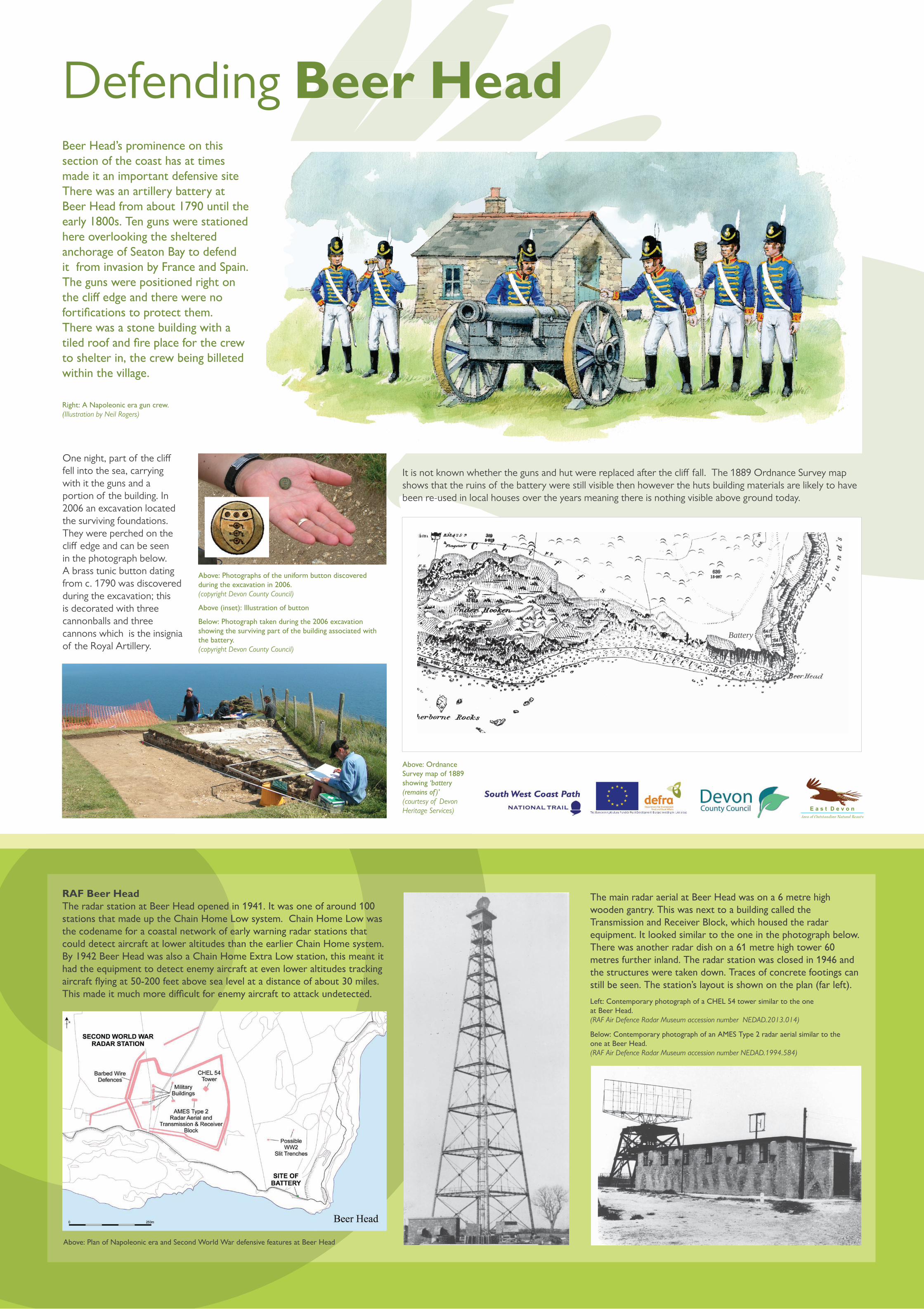
Defending Beer Head RAF Beer Head The radar station at Beer Head opened in 1941. It was one of around 100 stations that made up the Chain Home Low system. Chain Home Low was the codename for a coastal network of early warning radar stations that could detect aircraft at lower altitudes than the earlier Chain Home system. By 1942 Beer Head was also a Chain Home Extra Low station, this meant it had the equipment to detect enemy aircraft at even lower altitudes tracking aircraft flying at 50-200 feet above sea level at a distance of about 30 miles. This made it much more difficult for enemy aircraft to attack undetected. Beer Head Beer Head’s prominence on this section of the coast has at times made it an important defensive site There was an artillery battery at Beer Head from about 1790 until the early 1800s. Ten guns were stationed here overlooking the sheltered anchorage of Seaton Bay to defend it from invasion by France and Spain. The guns were positioned right on the cliff edge and there were no fortifications to protect them. There was a stone building with a tiled roof and fire place for the crew to shelter in, the crew being billeted within the village. One night, part of the cliff fell into the sea, carrying with it the guns and a portion of the building. In 2006 an excavation located the surviving foundations. They were perched on the cliff edge and can be seen in the photograph below. A brass tunic button dating from c. 1790 was discovered during the excavation; this is decorated with three cannonballs and three cannons which is the insignia of the Royal Artillery. It is not known whether the guns and hut were replaced after the cliff fall. The 1889 Ordnance Survey map shows that the ruins of the battery were still visible then however the huts building materials are likely to have been re-used in local houses over the years meaning there is nothing visible above ground today. Right: A Napoleonic era gun crew. (Illustration by Neil Rogers) Above: Photographs of the uniform button discovered during the excavation in 2006. (copyright Devon County Council) Above (inset): Illustration of button Below: Photograph taken during the 2006 excavation showing the surviving part of the building associated with the battery. (copyright Devon County Council) Left: Contemporary photograph of a CHEL 54 tower similar to the one at Beer Head. (RAF Air Defence Radar Museum accession number NEDAD.2013.014) Below: Contemporary photograph of an AMES Type 2 radar aerial similar to the one at Beer Head. (RAF Air Defence Radar Museum accession number NEDAD.1994.584) Above: Plan of Napoleonic era and Second World War defensive features at Beer Head Above: Ordnance Survey map of 1889 showing ‘battery (remains of )’ (courtesy of Devon Heritage Services) The main radar aerial at Beer Head was on a 6 metre high wooden gantry. This was next to a building called the Transmission and Receiver Block, which housed the radar equipment. It looked similar to the one in the photograph below. There was another radar dish on a 61 metre high tower 60 metres further inland. The radar station was closed in 1946 and the structures were taken down. Traces of concrete footings can still be seen. The station’s layout is shown on the plan (far left). Battery
Transcript of Defending Beer Head - East Devon AONB
Defending Beer Head
RAF Beer HeadThe radar station at Beer Head opened in 1941. It was one of around 100 stations that made up the Chain Home Low system. Chain Home Low was the codename for a coastal network of early warning radar stations that could detect aircraft at lower altitudes than the earlier Chain Home system. By 1942 Beer Head was also a Chain Home Extra Low station, this meant it had the equipment to detect enemy aircraft at even lower altitudes tracking aircraft fl ying at 50-200 feet above sea level at a distance of about 30 miles. This made it much more di� cult for enemy aircraft to attack undetected.
Beer HeadBeer Head’s prominence on this section of the coast has at times made it an important defensive site There was an artillery battery at Beer Head from about 1790 until the early 1800s. Ten guns were stationed here overlooking the sheltered anchorage of Seaton Bay to defend it from invasion by France and Spain. The guns were positioned right on the cli� edge and there were no fortifi cations to protect them. There was a stone building with a tiled roof and fi re place for the crew to shelter in, the crew being billeted within the village.
One night, part of the cli� fell into the sea, carrying with it the guns and a portion of the building. In 2006 an excavation located the surviving foundations. They were perched on the cli� edge and can be seen in the photograph below. A brass tunic button dating from c. 1790 was discovered during the excavation; this is decorated with three cannonballs and three cannons which is the insignia of the Royal Artillery.
It is not known whether the guns and hut were replaced after the cli� fall. The 1889 Ordnance Survey map shows that the ruins of the battery were still visible then however the huts building materials are likely to have been re-used in local houses over the years meaning there is nothing visible above ground today.
Right: A Napoleonic era gun crew.(Illustration by Neil Rogers)
Above: Photographs of the uniform button discovered during the excavation in 2006.(copyright Devon County Council)
Above (inset): Illustration of button
Below: Photograph taken during the 2006 excavation showing the surviving part of the building associated with the battery. (copyright Devon County Council)
Left: Contemporary photograph of a CHEL 54 tower similar to the one at Beer Head. (RAF Air Defence Radar Museum accession number NEDAD.2013.014)
Below: Contemporary photograph of an AMES Type 2 radar aerial similar to the one at Beer Head. (RAF Air Defence Radar Museum accession number NEDAD.1994.584)
Above: Plan of Napoleonic era and Second World War defensive features at Beer Head
Above: Ordnance Survey map of 1889 showing ‘battery (remains of )’ (courtesy of Devon Heritage Services)
The main radar aerial at Beer Head was on a 6 metre high wooden gantry. This was next to a building called the Transmission and Receiver Block, which housed the radar equipment. It looked similar to the one in the photograph below. There was another radar dish on a 61 metre high tower 60 metres further inland. The radar station was closed in 1946 and the structures were taken down. Traces of concrete footings can still be seen. The station’s layout is shown on the plan (far left).
Battery