DDH LOG JL-03-4 - Search GeologyOntario DRILL RECORD Company: Flag Resources (1985) Ltd. Property:...
29
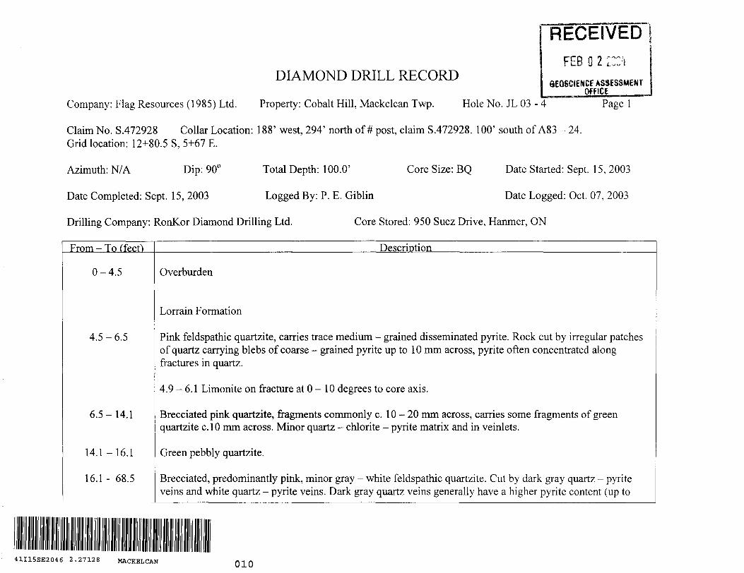
DIAMOND DRILL RECORD Company: Flag Resources (1985) Ltd. Property: Cobalt Hill, Mackelcan Twp. Hole No. JL 03 - 4 Claim No. S.472928 Collar Location: 188' west, 294' north of # post, claim S.472928. 100' south of A83 - 24. Grid location: 12+80.5 S, 5+67 E. "RECEIVED FEB O 2 ZCC'j 8EOSCIENCE ASSESSMENT OfPlCE—— Page l Azimuth: N/A Dip: 90" Total Depth: 100.0' Core Size: BQ Date Started: Sept 15, 2003 Date Completed: Sept. 15, 2003 Logged By: P. E. Giblin Date Logged: Oct. 07, 2003 Drilling Company: RonKor Diamond Drilling Ltd. Core Stored: 950 Suez Drive, Hanmer, ON From - To (feef) Description 0-4.5 4.5-6.5 6.5-14.1 14.1-16.1 16.1- 68.5 Overburden Lorrain Formation Pink feldspathic quartzite, carries trace medium - grained disseminated pyrite. Rock cut by irregular patches of quartz carrying blebs of coarse - grained pyrite up to 10 mm across, pyrite often concentrated along fractures in quartz. 4.9 -6.1 Limonite on fracture at O - 10 degrees to core axis. Brecciated pink quartzite, fragments commonly c. 10-20 mm across, carries some fragments of green quartzite c. l O mm across. Minor quartz - chlorite - pyrite matrix and in veinlets. Green pebbly quartzite. Brecciated, predominantly pink, minor gray - white feldspathic quartzite. Cut by dark gray quartz - pyrite veins and white quartz - pyrite veins. Dark gray quartz veins generally have a higher pyrite content (up to 41I15SE2046 2.27128 MACKELCAN 010
Transcript of DDH LOG JL-03-4 - Search GeologyOntario DRILL RECORD Company: Flag Resources (1985) Ltd. Property:...
DIAMOND DRILL RECORD
Company: Flag Resources (1985) Ltd. Property: Cobalt Hill, Mackelcan Twp. Hole No. JL 03 - 4
Claim No. S.472928 Collar Location: 188' west, 294' north of # post, claim S.472928. 100' south of A83 - 24. Grid location: 12+80.5 S, 5+67 E.
"RECEIVEDFEB O 2 ZCC'j
8EOSCIENCE ASSESSMENT OfPlCE——
Page l
Azimuth: N/A Dip: 90" Total Depth: 100.0' Core Size: BQ Date Started: Sept 15, 2003
Date Completed: Sept. 15, 2003 Logged By: P. E. Giblin Date Logged: Oct. 07, 2003
Drilling Company: RonKor Diamond Drilling Ltd. Core Stored: 950 Suez Drive, Hanmer, ON
From - To (feef) Description
0-4.5
4.5-6.5
6.5-14.1
14.1-16.1
16.1- 68.5
Overburden
Lorrain Formation
Pink feldspathic quartzite, carries trace medium - grained disseminated pyrite. Rock cut by irregular patches of quartz carrying blebs of coarse - grained pyrite up to 10 mm across, pyrite often concentrated along fractures in quartz.
4.9 -6.1 Limonite on fracture at O - 10 degrees to core axis.
Brecciated pink quartzite, fragments commonly c. 10-20 mm across, carries some fragments of green quartzite c. l O mm across. Minor quartz - chlorite - pyrite matrix and in veinlets.
Green pebbly quartzite.
Brecciated, predominantly pink, minor gray - white feldspathic quartzite. Cut by dark gray quartz - pyrite veins and white quartz - pyrite veins. Dark gray quartz veins generally have a higher pyrite content (up to
41I15SE2046 2.27128 MACKELCAN 010

DIAMOND DRILL RECORD
Company: Flag Resources (1985) Ltd. Property: Cobalt Hill Hole No. JL 03 - 4 Page 2
From - To (feet) Description
68.5-71.6
71.6-77.3
77.3 - 100
End
4007o pyrite) than do white quartz veins, and pyrite in them is generally coarser - grained, with pyrite grains up to 20 mm across. Veins are erratically distributed, overall pyrite content of rock variable, dependent largely on amount of vein material. Estimated average pyrite content c. l - 207o.
59.5 - 60.8 Predominantly white quartz, minor fragments of pink quartzite. Trace pyrite.
62.3 White quartz veining common, pyrite grains often clustered at contacts of quartz veins with quartzite fragments.
Green quartzite, cut by sparse thin pyrite - quartz veinlets, "^I 07o pyrite.
Predominantly white quartz - pyrite vein material, moinor pink quartzite fragments, c.5% pyrite.
Brecciated feldspathic quartzite, minor green quartzite fragments, sparse white quartz - pyrite veinlets, pyrite.
Notes:
Hole planned by and drilled on instructions from M. C. McLeod. Location data from R. J. Charron.
Assays by Swastika Laboratories Ltd., Assay Certificate 3W-3325-RAI, dated October 22, 2003.

SAMPLE AND ASSAY DATA
Company: Flag Resources (1985) Ltd. Property: Cobalt Hill Hole No. JL 03 - 4 Page3
SampleNo.
4496244963449644496544966
4496744968449694497044971
4497244973449744497544976
Interval (feet)
4.5-9.59.5-14.1
14.1-16.116.1-21.121.1-26.1
26.1-31.131.1-36.136.1 -41.141.1-46.146.1-51.1
51.1-56.156.1-61.161.1-66.166.1-68.568.5-71.6
Length (feet)
5.04.62.05.05.0
5.05.05.05.05.0
5.05.05.02.43.1
Au g/tonne
0.280.460.060.070.23
0.050.070.080.040.03
0.030.040.030.030.03
Au Oz/ton
Au Check g/tonne
0.08
0.03
Au Check oz/ton
Au 2nd
g/tonne
Au 2nd
oz/ton

SAMPLE AND ASSAY DATA
Company: Flag Resources (1985) Ltd. Property: Cobalt Hill Hole No. JL 03 - 4 Page 4
Sample No.
4497744978449794498044981
44982
Interval (feet)
71.6-76.676.6-81.681.6-86.686.6-91.691.6-96.6
96.6-100.0
Length (feet)
5.05.05.05.05.0
3.4
Au g/tonne
0.040.020.020.170.05
0.04
Au oz/ton
Au Checkg/tonne
Au Check oz/ton
Au 2nd
g/tonne
Au 2nd
oz/ton

Jones Lake
0.5
Kilometres
KEY MAPLOCATION OF CLAIM S.472928
MACKELCAN TOWNSHIP, SUDBURY MINING DISTRICT FLAG RESOURCES (1985) LTD.
JL03-3(-60", 205')
JL03-2(-450, 200')
Shatt
A 81-1(-500, 352')
A 81 -4(-50", 559')
CH92-1(-90", 2,491')
O
JL03-5(-90", 100')
JL 03-9 (-50", 162')
JL 03 -(-65", 200')
Note: Only certain older drill holes shown for reference purposes.
JL03-6(-90", 100')
OA 83 -24(-900, 400')
JL 03 - 4 (-90", 100')
N
O JL03-7 (-900, 100')
S.472928
#2 post
O'
SCALE200'
l
50m
PLAN OF 2003 DRILL HOLES
CLAIM S.472928
MACKELCAN TOWNSHIP, SUDBURY MINING DISTRICT
FLAG RESOURCES (1985) LTD.

JL 03 - 4(-900 , 100')
A 83 -24(-900 , 400')
JL03-6(-90", 100')
2,1
100'
Legend
Ov Overburden
3 Sudbury Breccia
2 Quartzite Breccia a Vein Breccia
Lorrain Formation
1 Quartzite, feldspathic quartzite, minor arkose
s Sampled interval
360"
100'
400'
SCALE200'
l
50m
SECTION ON DRILL HOLES JL 03 - 4 S - 6
LOOKING WEST
CLAIM S.472928
MACKELCAN TOWNSHIP, SUDBURY MINING DISTRICT
FLAG RESOURCES (1985) LTD.
DIAMOND DRILL RECORD
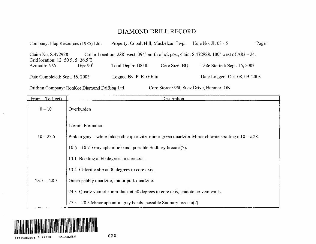
Company: Flag Resources (1985) Ltd. Property: Cobalt Hill, Mackelcan Twp. Hole No. JL 03 - 5 Page l
Claim No. S.472928 Collar Location: 288' west, 394' north of #2 post, claim S.472928. 100' west of A83 - 24.Grid location: 12+50 S, 5+36.5 E.Azimuth: N/A Dip: 900 Total Depth: 100.0' Core Size: BQ Date Started: Sept. 16, 2003
Date Completed: Sept. 16, 2003 Logged By: P. E. Giblin Date Logged: Oct. 08, 09, 2003
Drilling Company: RonKor Diamond Drilling Ltd. Core Stored: 950 Suez Drive, Hanmer, ON
From - To (feef) Description
0-10
10-23.5
23.5- 28.3
Overburden
Lorrain Formation
Pink to gray - white feldspathic quartzite, minor green quartzite. Minor chlorite spotting c. l O - c.28.
10.6 - 10.7 Gray aphanitic band, possible Sudbury breccia(?).
13.1 Bedding at 60 degrees to core axis.
13.4 Chloritic slip at 30 degrees to core axis.
Green pebbly quartzite, minor pink quartzite.
24.3 Quartz veinlet 5 mm thick at 50 degrees to core axis, epidote on vein walls.
27.5 - 28.3 Minor aphanitic gray bands, possible Sudbury breccia(?).
41I15SE2046 2.27128 MACKELCAN 020

DIAMOND DRILL RECORD
Company: Flag Resources (1985) Ltd. Property: Cobalt Hill Hole No. JL 03 - 5 Page 2
From - To (feet) Description
28.3-29.8
29.8-29.9
29.9-33.7
33.7-34.8
34.8-39.1
39.1-40.0
40.0-40.8
40.8-41.4
41.4-42.6
Pink feldspathic quartzite, carries sparse disseminated pyrite grains l - 2 mm across.
Green quartzite. Bedding at 70 degrees to core axis.
Pink feldspathic quartzite.
Green quartzite. Upper contact sharp at 70 degrees, lower contact on slip at 70 degrees to core axis.
33.8 Quartz vein 15 mm thick at 70 degrees to core axis.
Pink feldspathic quartzite, carries c.1% disseminated medium - grained pyrite. Minor thin beds of green quartzite.
36.0 Bedding at 60 degrees to core axis.
Green quartzite, contacts on broken core.
Pink feldspathic quartzite.
Arkose. Contacts on broken core.
Pink feldspathic quartzite.
DIAMOND DRILL RECORD
Company: Flag Resources (1985) Ltd. Property: Cobalt Hill Hole No. JL 03 - 5 Page 3
From - To (feet) Description
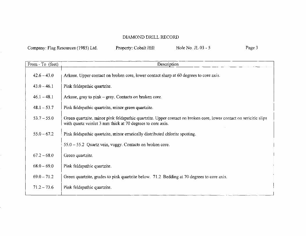
42.6-43.0
43.0-46.1
46.1-48.1
48.1-53.7
53.7-55.0
55.0-67.2
67.2-68.0
68.0-69.0
69.0-71.2
71.2-73.6
Arkose. Upper contact on broken core, lower contact sharp at 60 degrees to core axis.
Pink feldspathic quartzite.
Arkose, gray to pink - gray. Contacts on broken core.
Pink feldspathic quartzite, minor green quartzite.
Green quartzite, minor pink feldspathic quartzite. Upper contact on broken core, lower contact on sericitic slips with quartz veinlet 3 mm thick at 70 degrees to core axis.
Pink feldspathic quartzite, minor erratically distributed chlorite spotting.
55.0 - 55.2 Quartz vein, vuggy. Contacts on broken core.
Green quartzite.
Pink feldspathic quartzite.
Green quartzite, grades to pink quartzite below. 71.2 Bedding at 70 degrees to core axis.
Pink feldspathic quartzite.

DIAMOND DRILL RECORD
Company: Flag Resources (1985) Ltd. Property: Cobalt Hill Hole No. JL 03 - 5 Page 4
From - To (feet) Description
73.6-74.2
74.2-81.8
81.8-84.0
84.0 - 90.0
90.0-91.0
91.0-92.8
92.8-96.2
96.2 - 96.9
96.9- 100
End
Green - gray quartzite, considerable chlorite spotting.
Pink feldspathic quartzite.
Green quartzite, minor pink feldspathic quartzite. Lower contact sharp at 70 degrees to core axis.
83.6 Bedding at 70 degrees to core axis.
Pink quartzite, carries trace disseminated pyrite. Erratically distributed minor chlorite spotting.
Arkose.
Green quartzite.
92.3 Quartz - carbonate vein 10 mm thick at 50 degrees to core axis.
Pink feldspathic quartzite.
Green quartzite.
Pink feldspathic quartzite.
Notes: Hole planned by and drilled on instructions from M. C. McLeod. Location data from R. J. Charron.

&I .*@\^l
Jones Lake
0.5
Kilometres
KEY MAPLOCATION OF CLAIM S.472928
MACKELCAN TOWNSHIP, SUDBURY MINING DISTRICT FLAG RESOURCES (1985) LTD.

JL 03 - 3 (-60", 205')
JL 03 - 2 (-45", 200')
Shaft
A 81-1(-50", 352')
A 81 -4(-50", 559')
CH 92 - 1 (-90", 2,491')
JL 03 - 5(-90", 100')
JL 03-9(-50", 162')
JL 03 - (-65", 200')
Note: Only certain older drill holes shown for reference purposes.
JL03-6 (-90", 100')
OA 83 -24(-900, 400')
JL 03 - 4(-90", 100')
N t
O JL03-7 (-90", 100')
S.472928
#2 post
SCALEO' 200'
50m
PLAN OF 2003 DRILL HOLES
CLAIM S.472928
MACKELCAN TOWNSHIP, SUDBURY MINING DISTRICT
FLAG RESOURCES (1985) LTD.

JL 03 - 5 (-900 , 100')
. —Q —
A 83 - 24 (-900, 400')
JL03-7 (-900 , 100') 090G
100'
Legend
Ov Overburden
3 Sudbury Breccia
2 Quartzite Breccia a Vein Breccia
Lorrain Formation
1 Quartzite, feldspathic quartzite, minor arkose
s Sampled interval
100'
400'
SCALEO' 200'
ll
50 m
SECTION ON DRILL HOLES JL 03 - 5 8c - 7
LOOKING NORTH
CLAIM S.472928
MACKELCAN TOWNSHIP, SUDBURY MINING DISTRICT
FLAG RESOURCES (1985) LTD.

DIAMOND DRILL RECORD
Company: Flag Resources (1985) Ltd. Property: Cobalt Hill, Mackelcan Twp. Hole No. JL 03 - 6 Page l
Claim No. S.472928 Collar Location: 188' west, 476' north of #2 post, claim S.472928. 82' north of A83 - 24.Grid location: 12+25 S, 5+67 E.Azimuth: N/A Dip: 900 Total Depth: 100.0' Core Size: BQ Date Started: Sept. 17, 2003
Date Completed: Sept. 17, 2003 Logged By: P. E. Giblin Date Logged: Oct. 08, 09, 2003
Drilling Company: RonKor Diamond Drilling Ltd. Core Stored: 950 Suez Drive, Hanmer, ON
From - To (feet) Description
0-5.4
5.4-17.8
17.8-21.0
21.0-35.0
35.0-36.2
Overburden
Lorrain Formation
Gray to gray - pink feldspathic quartzite, intermittent heavy chlorite spotting. Minor arkose sections.
10.2 Bedding at 60 degrees to core axis.
Sparse chloritic slips at 20, 30, 50 degrees to core axis.
Pink arkose, minor pink quartzite, intermittent heavy chlorite spotting. Chlorite spots c. 2 - 10 mm across. No sulphides noted.
Pink feldspathic quartzite. 35.0 Chloritic slip at 20 degrees to core axis.
Pink arkose.
41I15SE2046 2.27128 MACKELCAN 030

DIAMOND DRILL RECORD
Company: Flag Resources (1985) Ltd. Property: Cobalt Hill Hole No. JL 03 - 6 Page 2
From-To (feet) Description
36.2-40.4
40.4-41.1
41.1-41.8
41.8-48.1
48.1-66.2
66.2-66.5
66.5-78.3
Green - gray quartzite.
Pink arkose, minor chlorite spots. Upper contact sharp at 80 degrees, lower contact fairly sharp at 60 degrees to core axis.
Green - gray quartzite. Lower contact fairly sharp at 70 degrees to core axis.
Pink arkose. Heavy chlorite spotting to 43.7, thereafter little to nil. Trace epidote in some chlorite spots. Lower contact fairly sharp at 90 degrees to core axis.
Green, green - gray, gray - white quartzite. Intermittent chlorite spotting, 46.5 -48.1, 49.7 - 50.9.
49.7 Several parallel chloritic slips at 30 degrees to core axis.
62.0 - 63.5 Several chloritic slips at O, 10, 20, 40 degrees to core axis.
Pink arkose.
Predominantly green, green - gray quartzite, minor pink - brown sections.
68.5 - 73.8 Fracture zone. Chlorite and limonite, minor hematite, on fractures at O, 10, 30 degrees to core axis.
DIAMOND DRILL RECORD
Company: Flag Resources (1985) Ltd. Property: Cobalt Hill Hole No. JL 03-6 PageS
From - To (feet) Description
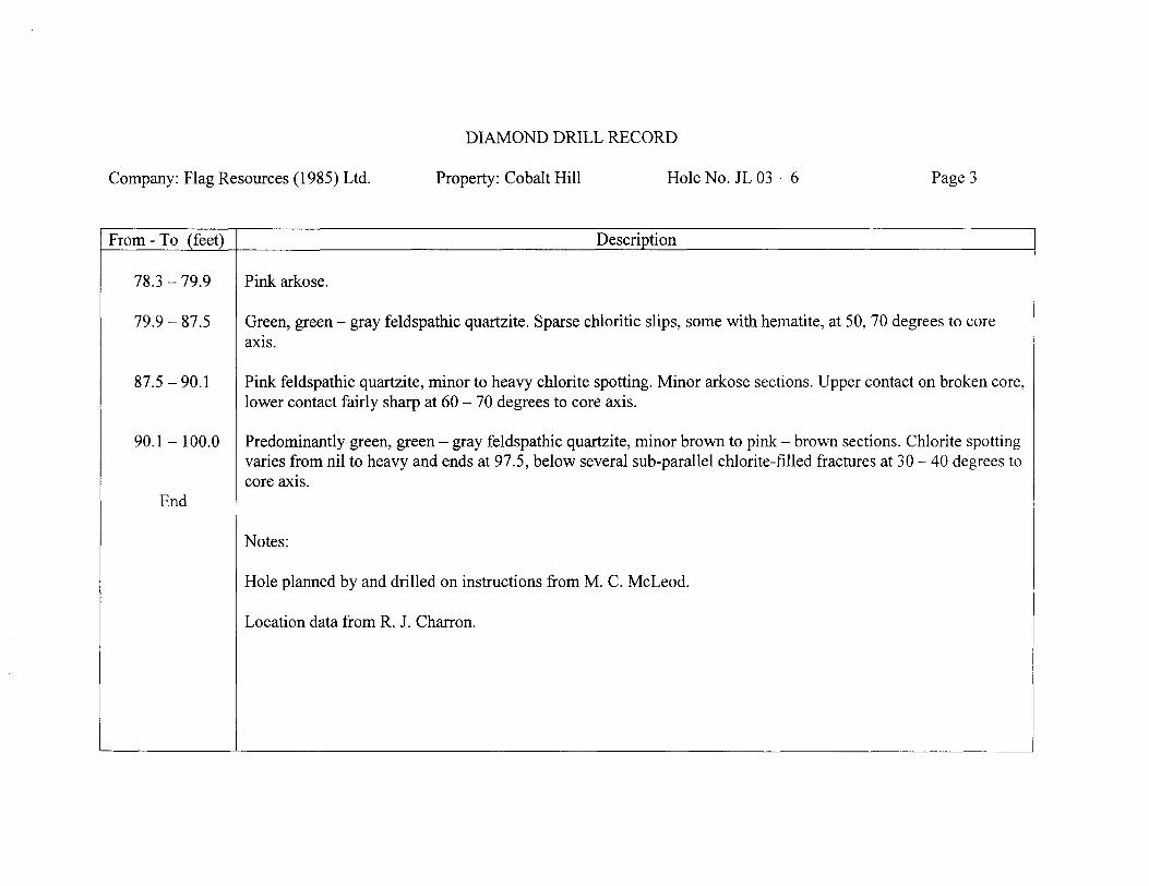
78.3-79.9
79.9-87.5
87.5-90.1
90.1 - 100.0
End
Pink arkose.
Green, green - gray feldspathic quartzite. Sparse chloritic slips, some with hematite, at 50, 70 degrees to core axis.
Pink feldspathic quartzite, minor to heavy chlorite sporting. Minor arkose sections. Upper contact on broken core, lower contact fairly sharp at 60 - 70 degrees to core axis.
Predominantly green, green - gray feldspathic quartzite, minor brown to pink - brown sections. Chlorite spotting varies from nil to heavy and ends at 97.5, below several sub-parallel chlorite-filled fractures at 30 - 40 degrees to core axis.
Notes:
Hole planned by and drilled on instructions from M. C. McLeod.
Location data from R. J. Charron.

Wolf Lake
S472927 S551336
Jones Lake
0.5
Kilometres
KEY MAPLOCATION OF CLAIM S.472928
MACKELCAN TOWNSHIP, SUDBURY MINING DISTRICT FLAG RESOURCES (1985) LTD.

JL03-3(-60", 205')
JL03-2(-450, 200')
Shaft
A 81-1(-50", 352')
A 81 -4(-50", 559')
CH 92 - 1 (-900 , 2,491')
JL03-5(-90", 100')
JL 03-9 (-500 , 162')
JL 03 -(-650 , 200')
Note: Only certain older drill holes shown for reference purposes.
JL03-6 (-90", 100')
OA 83 -24(-90", 400')
JL 03 - 4 (-90", 100')
N
O JL 03 - 7(-90", 100')
S.472928
#2 post
D
SCALEO' 200'
l
50m
PLAN OF 2003 DRILL HOLES
CLAIM S.472928
MACKELCAN TOWNSHIP, SUDBURY MINING DISTRICT
FLAG RESOURCES (1985) LTD.

Legend
Ov Overburden
3 Sudbury Breccia
2 Quartzite Breccia a Vein Breccia
Lorrain Formation
1 Quartzite, feldspathic quartzite, minor arkose
s Sampled interval
JL03-4 A 83 -24 JL 03 - 6f-900 , 100') (-900, 400') (-900 , 100')
s 2,1
100'
1
I 2
1
100'
2
1
400'
360"
SCALE200'
l
50 m
SECTION ON DRILL HOLES JL 03 - 4 Z - 6
LOOKING WEST
CLAIM S.472928
MACKELCAN TOWNSHIP, SUDBURY MINING DISTRICT
FLAG RESOURCES (1985) LTD.

DIAMOND DRILL RECORD
Company: Flag Resources (1985) Ltd. Property: Cobalt Hill, Mackelcan Twp. Hole No. JL 03 - 7 Page l
Claim No. S.472928 Collar Location: 88' west, 394' north of #2 post, claim S.472928. 100' east of A83 - 24.Grid location: 12+50 S, 5+97.5 E.Azimuth: N/A Dip: 900 Total Depth: 100.0' Core Size: BQ Date Started: Sept. 18, 2003
Date Completed: Sept. 19,2003 Logged By: P. E. Giblin Date Logged: Oct. 09,2003
Drilling Company: RonKor Diamond Drilling Ltd. Core Stored: 950 Suez Drive, Hanmer, ON
From - To (feet) Description
0-9
9-11.1
11.1-14.2
14.2-20.5
20.5-25.1
25.1-26.1
26.1-29.4
Overburden
Lorrain Formation
Gray, green - gray feldspathic quartzite.
Pink arkose and pebbly arkose.
Gray, green - gray feldspathic quartzite.
Arkose. Upper contact on chlorite - limonite slip at 50 degrees to core axis, lower contact sharply gradational at 50 degrees to core axis.
Gray, green - gray feldspathic quartzite.
Arkose. Upper contact on chloritic slip at 70 degrees to core axis, lower contact gradational.
41I15SE2046 2.27128 MACKELCAN 040
DIAMOND DRILL RECORD
Company: Flag Resources (1985) Ltd. Property: Cobalt Hill Hole No. JL 03 - 7 Page 2
From - To (feet) Description
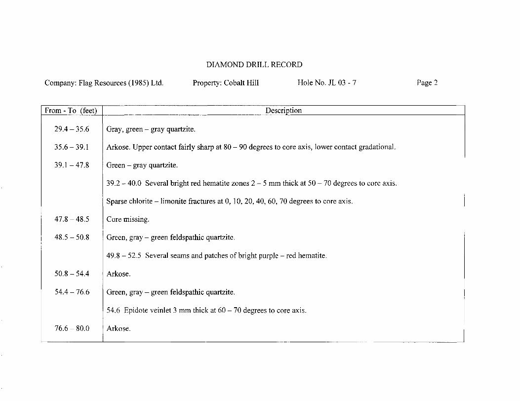
29.4-35.6
35.6-39.1
39.1-47.8
47.8-48.5
48.5-50.8
50.8-54.4
54.4 - 76.6
76.6-80.0
Gray, green - gray quartzite.
Arkose. Upper contact fairly sharp at 80 - 90 degrees to core axis, lower contact gradational.
Green - gray quartzite.
39.2 - 40.0 Several bright red hematite zones 2-5 mm thick at 50 - 70 degrees to core axis.
Sparse chlorite - limonite fractures at O, 10, 20, 40, 60, 70 degrees to core axis.
Core missing.
Green, gray - green feldspathic quartzite.
49.8 - 52.5 Several seams and patches of bright purple - red hematite.
Arkose.
Green, gray - green feldspathic quartzite.
54.6 Epidote veinlet 3 mm thick at 60 - 70 degrees to core axis.
Arkose.
DIAMOND DRILL RECORD
Company: Flag Resources (1985) Ltd. Property: Cobalt Hill Hole No. JL 03 - 7 Page 3
From - To (feet) Description
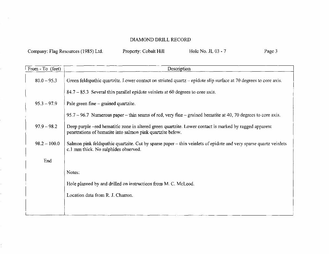
80.0-95.3
95.3-97.9
97.9 - 98.2
98.2-100.0
End
Green feldspathic quartzite. Lower contact on striated quartz - epidote slip surface at 70 degrees to core axis.
84.7 - 85.3 Several thin parallel epidote veinlets at 60 degrees to core axis.
Pale green fine - grained quartzite.
95.7 - 96.7 Numerous paper - thin seams of red, very fine - grained hematite at 40, 70 degrees to core axis.
Deep purple -red hematitic zone in altered green quartzite. Lower contact is marked by ragged apparent penetrations of hematite into salmon pink quartzite below.
Salmon pink feldspathic quartzite. Cut by sparse paper - thin veinlets of epidote and very sparse quartz veinlets c. l mm thick. No sulphides observed.
Notes:
Hole planned by and drilled on instructions from M. C. McLeod.
Location data from R. J. Charron.
Jones Lake
0.5
Kilometres
KEY MAPLOCATION OF CLAIM S.472928
MACKELCAN TOWNSHIP, SUDBURY MINING DISTRICT FLAG RESOURCES (1985) LTD.

JL 03 - 3(-60", 205')
JL03-2(-45", 200')
Shaft
A 81 -1(-500, 352')
A 81 -4(-50", 559')
CH 92 - 1 (-90", 2,491')
JL03-5 (-900 , 100') o
JL 03-9(-50", 162')
JL03-1 (-650 , 200')
Note: Only certain older drill holes shown for reference purposes.
JL03-6(-90", 100')
OA 83 -24(-90", 400')
JL 03 - 4(-90", 100')
N
i
O JL 03 - 7(-900 , 100')
S.472928
#2 post
SCALEO' 200'
l
50m
PLAN OF 2003 DRILL HOLES
CLAIM S.472928
MACKELCAN TOWNSHIP, SUDBURY MINING DISTRICT
FLAG RESOURCES (1985) LTD.

JL 03 - 5(-90", 100')
A 83 - 24(-90", 400')
100'
Legend
Ov Overburden
3 Sudbury Breccia
2 Quartzite Breccia a Vein Breccia
Lorrain Formation
1 Quartzite, feldspathic quartzite, minor arkose
s Sampled interval
JL03-7 (-900, 100')
—— Q ——
0900
100'
400'
SCALEO' 200'
ll
50 m
SECTION ON DRILL HOLES JL03-5&-7
LOOKING NORTH
CLAIM S.472928
MACKELCAN TOWNSHIP, SUDBURY MINING DISTRICT
FLAG RESOURCES (1985) LTD.
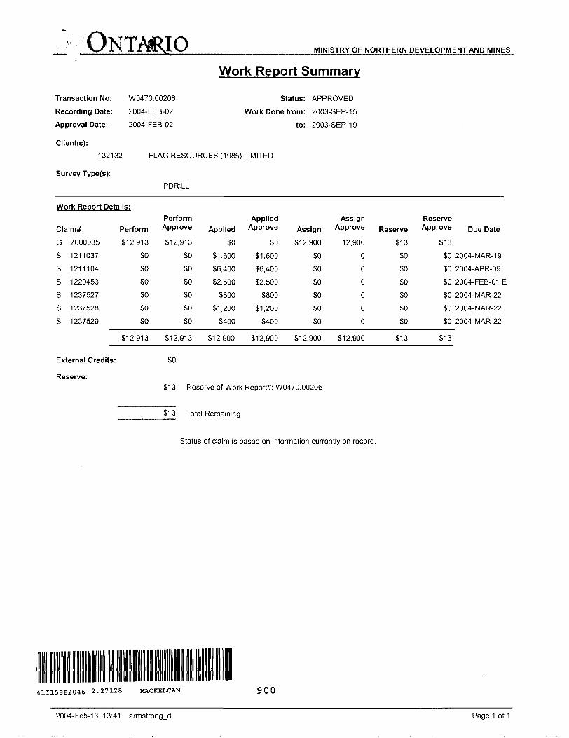
ONTARIO MINISTRY OF NORTHERN DEVELOPMENT AND MINES
Transaction No:
Recording Date:
Approval Date:
Client(s):
132132
Survey Type(s):
W0470.002062004-FEB-02
2004-FEB-02
Work Report Summary
Status: APPROVED
Work Done from: 2003-SEP-15
to: 2003-SEP-19
FLAG RESOURCES (1985) LIMITED
PDRILL
Work Report Details:
Claim#
G 7000035
S 1211037
S 1211104
S 1229453
S 1237527
S 1237528
S 1237529
External Credits:
Reserve:
Perform
312,913
SO
SO
SO
SO
SO
SO
512,913
Perform Approve
312,913
SO
SO
SO
SO
SO
SO
512,913
SO
Applied
SO
S1.600
S6.400
52,500
S800
S1.200
S400
S12.900
Applied Approve
SO
S 1,600
S6.400
52,500
S800
51,200
5400
512,900
Assign
512,900
50
SO
50
SO
5050
512,900
Assign Reserve Approve Reserve Approve Due Date
12,900
0
0
0
0
0
0
512,900
513
50
50
50
50
50
50
513
513
SO 2004-MAR-19
SO 2004-APR-09
SO 2004-FEB-01 E
SO 2004-MAR-22
SO 2004-MAR-22
SO 2004-MAR-22
513
513 Reserve of Work Report*: W0470.00206
513 Total Remaining
Status of claim is based on information currently on record.
41I15SE2046 2.27128 MACKELCAN 900
2004-Feb-13 13:41 armstrong-d Page 1 of 1

Ministry ofNorthern Developmentand Mines
Date: 2004-FEB-03
MURDO C. MCLEODFLAG RESOURCES (1985) LIMITED1210-540 5TH AVE. S.W.CALGARY, ALBERTAT2P OM2 CANADA
Ministers duDeveloppement du Nord et des Mines Ontario
GEOSCIENCE ASSESSMENT OFFICE 933 RAMSEY LAKE ROAD, 6th FLOOR SUDBURY, ONTARIO P3E 6B5
Tel: (888) 415-9845 Fax:(877)670-1555
Dear Sir or Madam
Submission Number: 2.27128 Transaction Number(s): W0470.00206
Subject: Approval of Assessment Work
We have approved your Assessment Work Submission with the above noted Transaction Number(s). The attached Work Report Summary indicates the results of the approval.
At the discretion of the Ministry, the assessment work performed on the mining lands noted in this work report may be subject to inspection and/or investigation at any time.
If you have any question regarding this correspondence, please contact STEVEN BENETEAU by email at [email protected] or by phone at (705) 670-5855.
Yours Sincerely,
/P,for Ron C. GashinskiSenior Manager, Mining Lands Section
Cc: Resident Geologist
Flag Resources (1985) Limited (Claim Holder)
Assessment File Library
Flag Resources (1985) Limited (Assessment Office)
Visit our website at http://www.gov.on.ca/MNDM/LANDS/mlsmnpge.htm Page: 1 Correspondence 10:19098

S25000E 530000E
5190000N 'i '5190000N
S25000E 530000E 535000E
UTM Zone 17 5000m grid
41I15SE2046 2.27128 MACKELCAN 200