
DDay - The American Surveyorarchive.amerisurv.com/PDF/TheAmericanSurveyor_D-Day...By 1942 the...
8
$4.95
Transcript of DDay - The American Surveyorarchive.amerisurv.com/PDF/TheAmericanSurveyor_D-Day...By 1942 the...
$4
.95

© British Crown Copyright 2004. Reproduced by permission of the Controller of Her Majesty’s Stationery Office and the UK Hydrographic Office (www.ukho.gov.uk).
Displayed with permission • The American Surveyor • June • Copyright 2005 Cheves Media • www.TheAmericanSurveyor.com

Mapping and Charting forthe Greatest CollaborativeProject Ever >> By Alan Gordon
On the cold grey morning of the 6th of June 1944 the greatest
armada that the world has ever seen slowly plowed its way toward
the heavily defended beaches of Normandy. Known universally as
D-Day, Operation Overlord, as it was then called, was an event
that to most is now remote history, overshadowed by recent conflicts
in the Gulf. But there is little comparison in terms of scale, complex-
ity and collaboration. D-Day could not have succeeded without
what was definitely the greatest mapping project ever. >>
An extract of the D-Day planning map of Gold Beach.The magenta symbols depicting enemy gun positions andfortifications were reproduced from hand drawings.
Displayed with permission • The American Surveyor • June • Copyright 2005 Cheves Media • www.TheAmericanSurveyor.com

Displayed with permission • The American Surveyor • June • Copyright 2005 Cheves Media • www.TheAmericanSurveyor.com
By 1942 the Germans were wellaware that the Allies would at somestage attempt an invasion of occupiedEurope and as time progressed itbecame more certain. However, therewere two great secrets. When would theattack come and where would it takeplace? In the case of the where ques-tion, among the first to know were thechart and map makers of the RoyalNavy and Royal Engineers. To helpmaintain the secret, bogus mapdemands for areas other thanNormandy were generated. And evenunmarked maps and charts ofNormandy were not to be left on thedesks of theplanners for,although show-ing no classifiedinformation,their very usewould giveaway the secret.
Maps andChartsAs with any mil-itary enterprise,maps and chartswere involved atall stages of theoperation from the very beginningwhen they were the basic tools used inchoosing the landing beaches throughto the infantryman reading his map inaction. This article gives a very briefoverview of the production and distri-bution of those millions of maps andcharts.
The Hydrographer of the Navy wasresponsible for the naval surveying andcharting. The Director of MilitarySurvey’s responsibility was to provideall the land mapping, air charts andassociated geodetic data necessary tosupport the planning and execution ofthe invasion whilst, of course, havingno access to the ground concerned. Thenautical and land products, as now,were fundamentally very different. Thehydrographic chart is a monochrome
product drawn to a Mercator projec-tion, showing predominantly soundingswith only the barest of detail of thecoastline and the geographic graticuleused to fix position. The land map userrelies on grid coordinates and wants awealth of topographical detail if possi-ble, shown in multiple colors. Tosupport the needs of the naval vesselsbombarding shore targets, theHydrographer produced special hybrid“chartmaps” that combined sea andland data.
The Hydrographer’s StoryThe disastrous Dieppe Raid in 1942showed that attacking a harbor wasunlikely to succeed, hence the assaultforces would have to land on a beachand provide their own harbors. TheHydrographer’s first task was to collect
and then present the data to allow theplanners to select the beaches againstcriteria relating to tidal range, beachgeology and gradients, etc., as well asthe military considerations. Having cho-sen the Normandy beaches, moredetailed information was required toselect the areas suitable for the prefabri-cated harbors, known as “Mulberries.”To do this, a small specialist hydro-graphic surveying unit was formed andequipped with landing craft convertedto carry the surveyor’s instruments.These vessels made a series of clandes-tine crossings on moonless nights and,using a ship-mounted version of theRAF’s radio position fixing system(later to be developed into the DeccaNavigation System), an early version ofthe echo sounder and a nine-mile long
taut wire measuring device, they sur-veyed the waters off the Normandycoast.
In addition to the standard charts ofthe Channel and the Bay of Seine, amass of special maritime products wereproduced during the lead up to theinvasion. These included chartmaps,beach chartlets, route and passagechartlets, berthing charts, charts for thecovering and hunting screens, radarcharts, fighter control gridded charts,plotting charts for the Mulberries, aspecial English Channel Handbook,coastal views, shoreline sketches, andtide and astronomical tables, all with avery high security classification. Packswere made up comprising the selectionof products needed by each unit for theassault. In all 30,720 packs were distrib-uted immediately prior to D-Day.
The hydrograph-ic vessels, HMShips Scott andFranklin and four-teen smaller craft,played a vital roleduring the assaultand the follow-upperiod. Their firsttask was to laybuoys to mark theassembly areas forthe huge fleet andthen to mark themine-swept chan-nels leading to
Normandy. As soon as troops landed,rapid surveys of the beach areas werecarried out to identify uncharted dangers and to assist the beachmastersin determining the best places for thefollow-up landings. At the same timedetailed surveys were made of the areasplanned for the two Mulberry harbors,and the positions of the piers andbreakwaters buoyed.
As each Channel harbor was in turnliberated, a survey vessel would imme-diately carry out a detailed survey sothat it could be used by Allied shippingto land vital stores and equipment, nomean task when you realize thatBoulogne alone was blocked by 26sunken ships.
The revision of charts continued asports were cleared, keeping pressure on
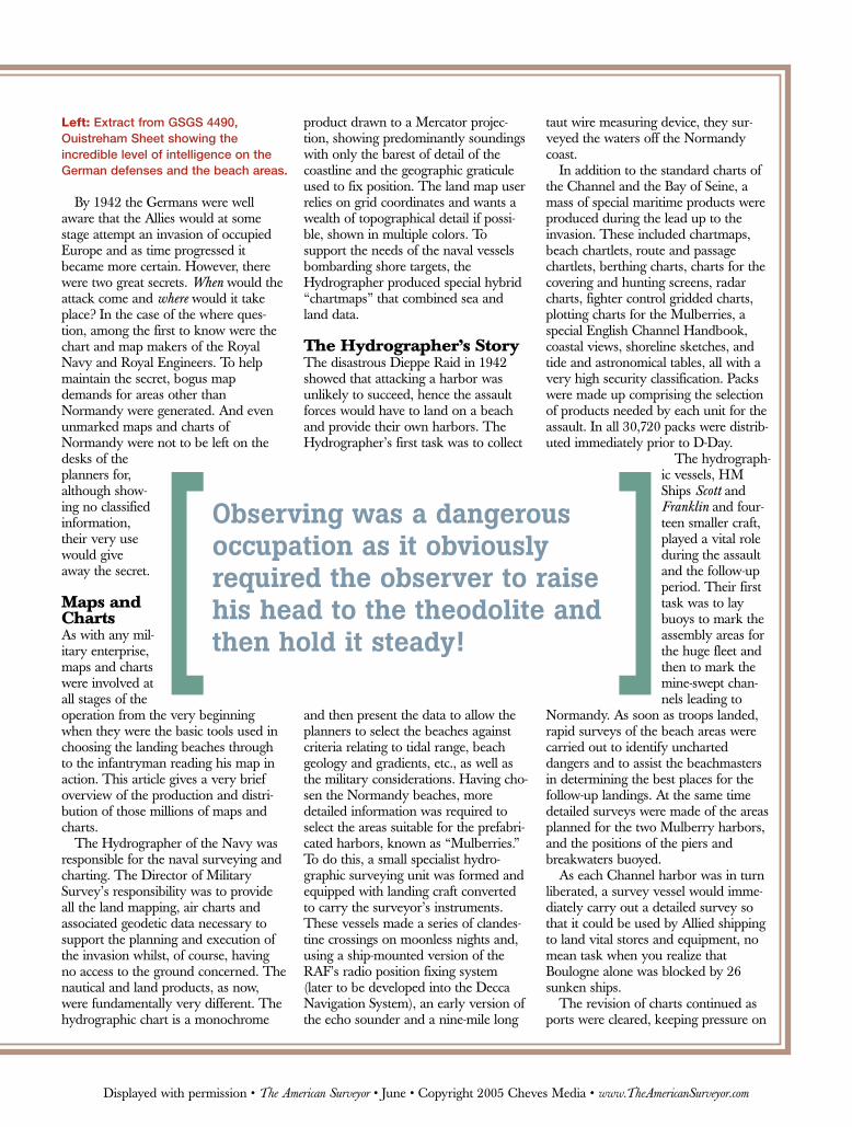
Left: Extract from GSGS 4490,Ouistreham Sheet showing the incredible level of intelligence on theGerman defenses and the beach areas.
Observing was a dangerousoccupation as it obviouslyrequired the observer to raisehis head to the theodolite andthen hold it steady!
Displayed with permission • The American Surveyor • June • Copyright 2005 Cheves Media • www.TheAmericanSurveyor.com
Displayed with permission • The American Surveyor • June • Copyright 2005 Cheves Media • www.TheAmericanSurveyor.com
both the civilian draftsmen andprinters and the surveyors at sea.
Mapping OccupiedFranceAmong the first tasks of the plan-ning staff were the definition ofthe geographical limits withinwhich it would be feasible for theinvasion to take place and theprobable time frame necessary toprepare for the assault. Armedwith this information the Directorof Survey, Colonel ArchieClough, carried out an evaluationof the mapping that would beneeded to support the planning,preparation and implementationof the assault. As a result of thisstudy a huge mapping programwas put into effect to revise themapping produced for the opera-tions in France at the beginning ofthe war: producing new1:250,000, 1:100,000 and1:50,000 series; extending cover at1:25,000 far to the south and west; andproducing 1:12,500 scale sheets of theimmediate invasion area. This hugeprogram was to fully occupy all theRoyal Engineers survey units in theUK and the Ordnance Survey frommid-1942 until the end of the war.
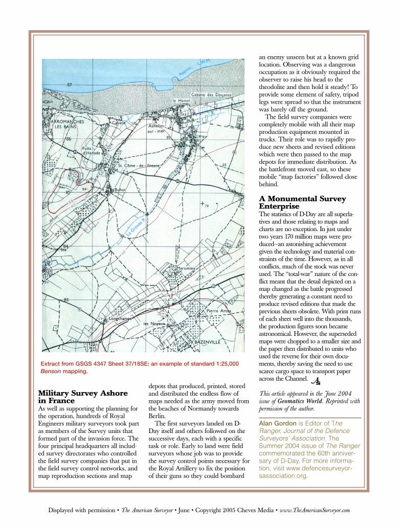
As there was no existing mappingavailable to assist in the production ofthe 1:25,000 and 1:12,500 sheets, amajor survey flying program was initi-ated to acquire the survey-standardimagery necessary to produce ab initiomapping by air survey methods. Thisproject was code named Benson afterthe airfield from which the photo recon-naissance Spitfires and Mosquitoes flew.Production was carried out solely bygraphical methods until Canadian, andlater US, survey units arrived in Britainbringing with them the slotted templatemethod of extending ground controland Multiplex machines to plot thedetail and contours. The Benson sheetsprovided the base mapping for a rangeof different overprints, some showingincredible intelligence detail of German
defensive positions and the make-up ofthe beach areas. Revised editions ofthese overprints were being producedright up to the time of the loading ofthe landing craft.
In addition to series mapping,Military Survey was involved in manyother tasks such as calculating beachgradients by measuring the height ofincoming waves, identifying from airphotographs the potential sites for for-ward airstrips and printing the TopSecret documents needed by the plan-ners. Perhaps one of the more unusualproducts was the Bogus map serieswhich comprised Benson sheets of theoperational area but with the real placenames replaced by others (e.g.,“Ouistreham” was renamed “Oslo”).This series allowed the assault troops tobecome familiar with the terrain but stillnot know the real operational location.
Distributing the maps presented theDirector of Military Survey with thesame problem as the Hydrographerhad with his charts. The millions ofmaps needed by the assault forces hadto be assembled and packed into the
unit-specific map packs and distributedwhilst still maintaining the great secretof “where” the invasion would takeplace until the very last moment. Thiswas achieved by sending the mapsimmediately after printing by the sur-vey units to a central Map Depot inHanwell. Here they were rolled intobundles, wrapped and labeled with theseries and sheet numbers in code. Therolls were then distributed betweenfour other map depots and stored toawait the final preparation stage of D-Day. In early April 1944 small mapdepots, stocked from these four largedepots, were set up in all the manymarshaling and concentration areasand the individual unit bundles madeup, wrapped in hessian [burlap] andlabeled, again in code. Several weeksbefore the 6th of June the first assaultunits moved into the concentrationareas which were then immediatelysealed off from the outside world. Herethey were issued their map packs andcommenced their final detailed briefin-gs before boarding the landing craftand sailing for France.
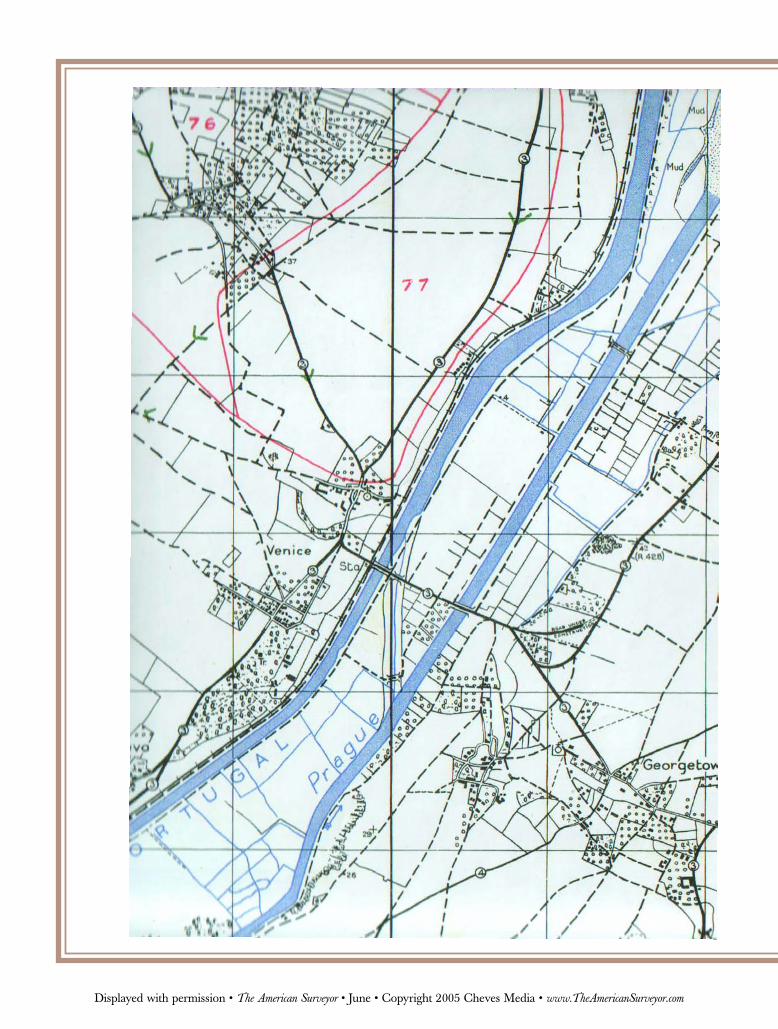
Left: Bogus mapping showingPegasus and Horsa bridges:Bénouville west of PegasusBridge is renamed “Venice.”
The central radial soundings were carried out during clandestine surveys in 1943 andused to plan the Arromanches Mulberry harbor. The two sets of parallel wereLieutenant Commander Ritchie’s boat soundings made on D+2.
Displayed with permission • The American Surveyor • June • Copyright 2005 Cheves Media • www.TheAmericanSurveyor.com
Military Survey Ashore in FranceAs well as supporting the planning forthe operation, hundreds of RoyalEngineers military surveyors took partas members of the Survey units thatformed part of the invasion force. Thefour principal headquarters all includ-ed survey directorates who controlledthe field survey companies that put inthe field survey control networks, andmap reproduction sections and map
depots that produced, printed, storedand distributed the endless flow ofmaps needed as the army moved fromthe beaches of Normandy towardsBerlin.
The first surveyors landed on D-Day itself and others followed on thesuccessive days, each with a specifictask or role. Early to land were fieldsurveyors whose job was to providethe survey control points necessary forthe Royal Artillery to fix the positionof their guns so they could bombard
an enemy unseen but at a known gridlocation. Observing was a dangerousoccupation as it obviously required theobserver to raise his head to thetheodolite and then hold it steady! Toprovide some element of safety, tripodlegs were spread so that the instrumentwas barely off the ground.
The field survey companies werecompletely mobile with all their mapproduction equipment mounted intrucks. Their role was to rapidly pro-duce new sheets and revised editionswhich were then passed to the mapdepots for immediate distribution. Asthe battlefront moved east, so thesemobile “map factories” followed closebehind.
A Monumental SurveyEnterpriseThe statistics of D-Day are all superla-tives and those relating to maps andcharts are no exception. In just undertwo years 170 million maps were pro-duced—an astonishing achievementgiven the technology and material con-straints of the time. However, as in allconflicts, much of the stock was neverused. The “total-war” nature of the con-flict meant that the detail depicted on amap changed as the battle progressedthereby generating a constant need toproduce revised editions that made theprevious sheets obsolete. With print runsof each sheet well into the thousands,the production figures soon becameastronomical. However, the supersededmaps were chopped to a smaller size andthe paper then distributed to units whoused the reverse for their own docu-ments, thereby saving the need to usescarce cargo space to transport paperacross the Channel.
This article appeared in the June 2004issue of Geomatics World. Reprinted withpermission of the author.
Alan Gordon is Editor of TheRanger, Journal of the DefenceSurveyors’ Association. TheSummer 2004 issue of The Rangercommemorated the 60th anniver-sary of D-Day. For more informa-tion, visit www.defencesurveyor-sassociation.org.
Extract from GSGS 4347 Sheet 37/18SE: an example of standard 1:25,000Benson mapping.
Displayed with permission • The American Surveyor • June • Copyright 2005 Cheves Media • www.TheAmericanSurveyor.com


![COLONIAL GERMANS - Dallas Genealogical Society...COLONIAL GERMANS [US] Ancestor Chart Project, 6 vols. [US] Bittinger, Lucy F. The Germans in Colonial Times. [US] Bockstruck, Lloyd](https://static.fdocuments.in/doc/165x107/5f05b0757e708231d41435cf/colonial-germans-dallas-genealogical-society-colonial-germans-us-ancestor.jpg)


