
DC - ReliefWeb · 2013-03-18 · The World Bank Group • South Asia Region Disaster Risk...
116
The World Bank Group • South Asia Region Disaster Risk Management and Climate Change Unit • Sustainable Development Network December 2012 D C DISASTER RISK & CLIMATE CHANGE UNIT South Asia Region - World Bank
Transcript of DC - ReliefWeb · 2013-03-18 · The World Bank Group • South Asia Region Disaster Risk...

The World Bank Group • South Asia Region Disaster Risk Management and Climate Change Unit • Sustainable Development Network
December 2012
DCDISASTER RISK &CLIMATE CHANGE UNITSouth Asia Region - World Bank


DCDISASTER RISK &CLIMATE CHANGE UNITSouth Asia Region - World Bank
Disaster Risk Management in South Asia: A Regional Overview
The World Bank, 1818 H Street, N.W.Washington, DC 20433, U.S.A.Internet: www.worldbank.org
All Rights ReservedPrinted in Washington, DC First Printing: December, 2012
The findings, interpretations, and conclusions expressed in this book are entirely those of the authors and should not be attributed in any manner to the World Bank, to its affiliated organizations, or to members of its Board of Executive Directors or the countries they represent.
The World Bank does not guarantee the accuracy of the data included in this publication and accepts no responsibility for any consequence of their use. The boundaries, colors, denomina-tions, and other information shown on any map in this volume do not imply on the part of The World Bank Group any judgment on the legal status of any territory or the endorsement or acceptance of such boundaries.
Rights and PermissionsThe material in this publication is copyrighted. The World Bank encourages dissemination of its work and will promptly grant permission to reproduce portions of the work under normal circumstances. For permission to photocopy or reprint any part of this work, as well as all other queries on rights and licenses, including subsidiary rights, please send a request with complete details to the Office of the Publisher, The World Bank, 1818 H Street NW, Washington, DC 20433, USA; fax: 202-522-2422; e-mail: [email protected].
The World BankArt direction: Vladimir Herrera
Disaster Risk Management in South Asia: A Regional Overview–Washington, DC : The World Bank : GFDRR, 2012.
106p: x.
1. Disaster Risk Management Natural Disasters 2. Sustainable Development World Bank

iii
Table of ConTenTs
Acknowledgments . . . . . . . . . . . . . . . . . . . . . . . . . . . . . . . . . . . . . . . . . . . . . . . . . . . . . . . . . . . . . . . vii
Introduction . . . . . . . . . . . . . . . . . . . . . . . . . . . . . . . . . . . . . . . . . . . . . . . . . . . . . . . . . . . . . . . . . . . . . 1
Natural Disasters: An Increasing Threat to Development . . . . . . . . . . . . . . . . . . . . . . . . . . . . . . . 3
The Forces of Nature: Hazards in the South Asia Region . . . . . . . . . . . . . . . . . . . . . . . . . . . . . . . . 9
Major Drivers of Increases in Disasters . . . . . . . . . . . . . . . . . . . . . . . . . . . . . . . . . . . . . . . . . . . . . . 13
Prevention is Better than Cure: Build Capacity and Reduce Vulnerability . . . . . . . . . . . . . . . . . 23
Annex 1: Regional Hazard Profile . . . . . . . . . . . . . . . . . . . . . . . . . . . . . . . . . . . . . . . . . . . . . . . . . . . 31
Floods. . . . . . . . . . . . . . . . . . . . . . . . . . . . . . . . . . . . . . . . . . . . . . . . . . . . . . . . . . . . . . . . . . . . 31
Cyclones. . . . . . . . . . . . . . . . . . . . . . . . . . . . . . . . . . . . . . . . . . . . . . . . . . . . . . . . . . . . . . . . . . 33
Earthquakes . . . . . . . . . . . . . . . . . . . . . . . . . . . . . . . . . . . . . . . . . . . . . . . . . . . . . . . . . . . . . . . 33
Droughts . . . . . . . . . . . . . . . . . . . . . . . . . . . . . . . . . . . . . . . . . . . . . . . . . . . . . . . . . . . . . . . . . 34
Landslides . . . . . . . . . . . . . . . . . . . . . . . . . . . . . . . . . . . . . . . . . . . . . . . . . . . . . . . . . . . . . . . . 35
Annex 2: Country Profiles . . . . . . . . . . . . . . . . . . . . . . . . . . . . . . . . . . . . . . . . . . . . . . . . . . . . . . . . . 37
Afghanistan . . . . . . . . . . . . . . . . . . . . . . . . . . . . . . . . . . . . . . . . . . . . . . . . . . . . . . . . . . . . . . . 39
Bangladesh. . . . . . . . . . . . . . . . . . . . . . . . . . . . . . . . . . . . . . . . . . . . . . . . . . . . . . . . . . . . . . . . 47
Bhutan . . . . . . . . . . . . . . . . . . . . . . . . . . . . . . . . . . . . . . . . . . . . . . . . . . . . . . . . . . . . . . . . . . . 57
India . . . . . . . . . . . . . . . . . . . . . . . . . . . . . . . . . . . . . . . . . . . . . . . . . . . . . . . . . . . . . . . . . . . . . 65
Maldives . . . . . . . . . . . . . . . . . . . . . . . . . . . . . . . . . . . . . . . . . . . . . . . . . . . . . . . . . . . . . . . . . . 73
Nepal . . . . . . . . . . . . . . . . . . . . . . . . . . . . . . . . . . . . . . . . . . . . . . . . . . . . . . . . . . . . . . . . . . . . 79
Pakistan . . . . . . . . . . . . . . . . . . . . . . . . . . . . . . . . . . . . . . . . . . . . . . . . . . . . . . . . . . . . . . . . . . 87
Sri Lanka. . . . . . . . . . . . . . . . . . . . . . . . . . . . . . . . . . . . . . . . . . . . . . . . . . . . . . . . . . . . . . . . . . 95
Figures
Figure 1: Number of Disaster Events in South Asia (1970-2010) . . . . . . . . . . . . . . . . . . . . . . . 4
Figure 2: Trends in Economic Losses Associated with Natural Disasters
in South Asia (1971-2010) . . . . . . . . . . . . . . . . . . . . . . . . . . . . . . . . . . . . . . . . . . . . . . 5
Figure 3: Events and Impacts of Disasters in SAR . . . . . . . . . . . . . . . . . . . . . . . . . . . . . . . . . . 6
Figure 4: Absolute and Relative Multi-Hazard Mortality Risk for Tropical Cyclones, Floods,
Earthquakes, and Landslides . . . . . . . . . . . . . . . . . . . . . . . . . . . . . . . . . . . . . . . . . . . 6
Figure 5: Monsoon Precipitation Patterns . . . . . . . . . . . . . . . . . . . . . . . . . . . . . . . . . . . . . . . . . 9
Figure 6: Flood and Cyclone Occurrence in South Asia (1971–2010) . . . . . . . . . . . . . . . . . . . 10
Figure 7: Population at Risk of Specific Hazards . . . . . . . . . . . . . . . . . . . . . . . . . . . . . . . . . . . 11

iv Disaster risk ManageMent in south asia: a regional overview
Figure 8: Actual and Projected Population Growth in SAR (1950-2050) . . . . . . . . . . . . . . . . . 13
Figure 9: Population at Risk in 2000 vs. 2050 . . . . . . . . . . . . . . . . . . . . . . . . . . . . . . . . . . . . . 14
Figure 10: Indexed Gross Fixed Capital Formation – 100 in base year 1965 . . . . . . . . . . . . . . 15
Figure 11: Population trends in SAR (1950-2050) . . . . . . . . . . . . . . . . . . . . . . . . . . . . . . . . . . 16
Figure 12: Growth of Cities in SAR (1950-2050) . . . . . . . . . . . . . . . . . . . . . . . . . . . . . . . . . . . 17
Figure 13: Global Land-Ocean Temperature Index (1880-2010) . . . . . . . . . . . . . . . . . . . . . . . . 20
Figure 14: Benefits of Investing in Risk Mitigation . . . . . . . . . . . . . . . . . . . . . . . . . . . . . . . . . 25
Figure 15: Combining Financial Instruments to Address Various Layers of Risk . . . . . . . . . . . 28
Figure 16: Total number of natural disasters in SA from 1960-2009 by type of event . . . . . . 32
Figure 17: Flood Risk in SAR . . . . . . . . . . . . . . . . . . . . . . . . . . . . . . . . . . . . . . . . . . . . . . . . . . 32
Figure 18: Cyclone Risk in SAR . . . . . . . . . . . . . . . . . . . . . . . . . . . . . . . . . . . . . . . . . . . . . . . . 33
Figure 19: Earthquake Risk in SAR. . . . . . . . . . . . . . . . . . . . . . . . . . . . . . . . . . . . . . . . . . . . . . 34
Figure 20: Drought Risk in SAR . . . . . . . . . . . . . . . . . . . . . . . . . . . . . . . . . . . . . . . . . . . . . . . . 34
Figure 21: Landslide Risk in SAR . . . . . . . . . . . . . . . . . . . . . . . . . . . . . . . . . . . . . . . . . . . . . . . 35
Figure 22: Map of Afghanistan . . . . . . . . . . . . . . . . . . . . . . . . . . . . . . . . . . . . . . . . . . . . . . . . . 39
Figure 23: Percentage distribution of reported disaster in Afghanistan (1970-2009) . . . . . . . . 39
Figure 24: Average Annual Economic Loss of Afghanistan . . . . . . . . . . . . . . . . . . . . . . . . . . . 39
Figure 25: Map of Bangladesh . . . . . . . . . . . . . . . . . . . . . . . . . . . . . . . . . . . . . . . . . . . . . . . . 47
Figure 26: Percentage Distribution of Reported Disaster in Bangladesh (1970-2009) . . . . . . . 47
Figure 27: Average Annual Economic Loss of Bangladesh . . . . . . . . . . . . . . . . . . . . . . . . . . . 47
Figure 28: Map of Bhutan . . . . . . . . . . . . . . . . . . . . . . . . . . . . . . . . . . . . . . . . . . . . . . . . . . . . 57
Figure 29: Percentage of Distribution of Reported Disasters in Bhutan (1970-2009) . . . . . . . 57
Figure 30: Map of India . . . . . . . . . . . . . . . . . . . . . . . . . . . . . . . . . . . . . . . . . . . . . . . . . . . . . . 65
Figure 31: Percentage Distribution of Reported Disasters in India (1970-2009) . . . . . . . . . . . 65
Figure 32: Average Annual Economic Loss of India . . . . . . . . . . . . . . . . . . . . . . . . . . . . . . . . . 65
Figure 33: Map of Maldives . . . . . . . . . . . . . . . . . . . . . . . . . . . . . . . . . . . . . . . . . . . . . . . . . . 73
Figure 34: Percentage Distribution of Reported Disasters in Maldives (1970-2009) . . . . . . . . 73
Figure 35: Map of Nepal . . . . . . . . . . . . . . . . . . . . . . . . . . . . . . . . . . . . . . . . . . . . . . . . . . . . . 79
Figure 36: Percentage Distribution of Reported Disasters in Nepal (1970-2009) . . . . . . . . . . . 79
Figure 37: Average Annual Economic Loss of Nepal . . . . . . . . . . . . . . . . . . . . . . . . . . . . . . . 79
Figure 38: VDC wise Distribution of Deaths Due to Natural Disasters . . . . . . . . . . . . . . . . . . 81
Figure 39: Map of Pakistan . . . . . . . . . . . . . . . . . . . . . . . . . . . . . . . . . . . . . . . . . . . . . . . . . . . 87
Figure 40: Percentage Distribution of Reported Disasters in Pakistan (1970-2009) . . . . . . . . 87
Figure 41: Average Annual Economic Loss of Pakistan . . . . . . . . . . . . . . . . . . . . . . . . . . . . . 87

vTABLE OF CONTENTS
Figure 42: Map of Sri Lanka . . . . . . . . . . . . . . . . . . . . . . . . . . . . . . . . . . . . . . . . . . . . . . . . . . 95
Figure 43: Percentage of Distribution of Reported Disasters in Sri Lanka (1970-2009) . . . . . . 95
Figure 44: Average Annual Economic Loss of Sri Lanka . . . . . . . . . . . . . . . . . . . . . . . . . . . . . 95
Figure 45: Hazard Profile of Sri Lanka . . . . . . . . . . . . . . . . . . . . . . . . . . . . . . . . . . . . . . . . . . . 96
Figure 46: National Council for Disaster Management . . . . . . . . . . . . . . . . . . . . . . . . . . . . . . 97
Figure 47: Overview of Disaster Management Coordination Mechanism in Sri Lanka . . . . . . 98
Boxes
Box 1: The Next Big Earthquake in Nepal . . . . . . . . . . . . . . . . . . . . . . . . . . . . . . . . . . . . . . . . 18
Box 2: Cyclone Disaster Mitigation in Bangladesh . . . . . . . . . . . . . . . . . . . . . . . . . . . . . . . . . 26
Tables
Table 1: World Bank and Key Multilateral and Bilateral Investments in
Afghanistan’s DRM Sector . . . . . . . . . . . . . . . . . . . . . . . . . . . . . . . . . . . . . . . . . . . . . . . . 43
Table 2: GFDRR Investments in Afghanistan’s DRM Sector . . . . . . . . . . . . . . . . . . . . . . . . . . 44
Table 3: World Bank and Key Multilateral and Bilateral Investments in
Bangladesh’s DRM Sector . . . . . . . . . . . . . . . . . . . . . . . . . . . . . . . . . . . . . . . . . . . . . . . 54
Table 4: GFDRR Investments in Bangladesh’s DRM Sector . . . . . . . . . . . . . . . . . . . . . . . . . . 55
Table 5: World Bank and Key Multilateral and Bilateral Investments
in Bhutan’s DRM Sector . . . . . . . . . . . . . . . . . . . . . . . . . . . . . . . . . . . . . . . . . . . . . . . . . . 62
Table 6: GFDRR Investments in Bhutan’s DRM Sector . . . . . . . . . . . . . . . . . . . . . . . . . . . . . 63
Table 7: World Bank and Key Multilateral and Bilateral Investments in
India’s DRM Sector . . . . . . . . . . . . . . . . . . . . . . . . . . . . . . . . . . . . . . . . . . . . . . . . . . . . . 70
Table 8: GFDRR Investments in India’s DRM Sector . . . . . . . . . . . . . . . . . . . . . . . . . . . . . . . 71
Table 9: World Bank and Key Multilateral and Bilateral Investments in
Maldives’ DRM Sector . . . . . . . . . . . . . . . . . . . . . . . . . . . . . . . . . . . . . . . . . . . . . . . . . . 76
Table 10: World Bank and Key Multilateral and Bilateral Investments in
Nepal’s DRM Sector . . . . . . . . . . . . . . . . . . . . . . . . . . . . . . . . . . . . . . . . . . . . . . . . . . . . 84
Table 11: GFDRR Investments in Nepal’s DRM Sector . . . . . . . . . . . . . . . . . . . . . . . . . . . . . . 85
Table 12: World Bank and Key Multilateral and Bilateral Investments
in Pakistan’s DRM Sector . . . . . . . . . . . . . . . . . . . . . . . . . . . . . . . . . . . . . . . . . . . . . . . . 92
Table 13: GFDRR Investments in Pakistan’s DRM Capacity . . . . . . . . . . . . . . . . . . . . . . . . . . 93
Table 14: World Bank and Key Multilateral and Bilateral Investments in
Sri Lanka’s DRM Sector . . . . . . . . . . . . . . . . . . . . . . . . . . . . . . . . . . . . . . . . . . . . . . . . 103
Table 15: GFDRR Investments in Sri Lanka’s DRM Sector . . . . . . . . . . . . . . . . . . . . . . . . . . 104


vii
aCKnoWleDGMenTs
This publication was composed by the South Asia Region Disaster Risk Management Team of the World Bank. The team would like to recognize the work of the following members: Bernice Van Bronkhorst, Sector Manager, Disaster Risk Management and Climate Change Unit; Saurabh Dani, Disaster Risk Management Specialist, India Country Office; Marc Forni, Senior Disaster Risk Management Specialist; Francis Ghesquiere, Manager, Disaster Risk Management Practice Group and Head of the Global Facility for Disaster Reduction and Recovery; Suranga Kahandawa, Disaster Risk Management Specialist, Sri Lanka Country Office; Swarna Kazi, Disaster Risk Management Specialist, Bangladesh Country Office; Haris Khan, Disaster Risk Management Specialist, Pakistan Country Office; Anil Pokhrel, Disaster Risk Management Specialist, Nepal Country Office; Deepak Singh, Senior Disaster Risk Management Specialist, Country India Office; Dechen Tshering, Disaster Risk Management Specialist, Bhutan Country Office; Erika Vargas, Knowledge Management Officer; and Sonam Velani, Disaster Risk Management Analyst.


1
InTRoDUCTIon
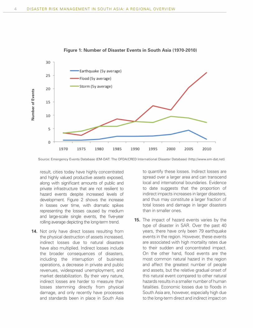
1. The increased frequency and intensity of disaster events is well documented and understood by most stakeholders across the world. Governments, international institutions, nonprofit organizations, and the private sector, among others, have committed significant resources to raising awareness of the exposure and vulnerability of populations to natural hazards such as earthquakes, cyclones, excess rainfall, and other events. In the 1970s, an awareness increased for good reason, worldwide, approximately 69 natural disasters were annually recorded; by the 2000s, this figure had increased to 350 per year1. Similarly, annual economic losses that averaged approximately US$12 billion per year in the 1970s have grown to approximately US$88 billion per year since 2000.2 The same patterns have been developing in the South Asia Region (SAR), where the number of disasters per year has quadrupled over the past four decades. Resulting damages have accumulated to over US$25 billion in the past five years alone3.
2. Despite increasing disaster risk in SAR, awareness and understanding of this risk among individuals and governments remains low. As an emerging topic, exposure and vulnerability to natural hazards and their consequential impacts are not yet at the forefront of development agendas. This is the case in SAR despite the fact that mitigating the unforeseen consequences of disasters is important for achieving development goals. The challenge lies in demonstrating results from investments that increase resilience to hazards. The costs
1 All data on Emergency Events Database (EM-DAT: The OFDA/CRED International Disaster Database); All figures in this report are in real 2010 USD.
2 lbid3 lbid
of investing in hazard resilience are clear; however, the benefits must be measured not by the infrastructure built or the services delivered, but rather by the lives saved and damages averted during a disaster.
3. Only through a clear understanding of disaster risks can policy makers prioritize increasing their population’s resilience to these events. Enhancing resilience to hazards in SAR is critical given the continued, steady path of economic development. Positive growth trends have increased the number of people and physical assets in harm’s way, but have not been coupled with investments in effective risk management practices in most SAR countries. Analyzing the root causes of disasters will increase the understanding of disaster risk and trigger action to enhance resiliency.
4. Disasters result from the combination of three key elements: i) natural hazards, including earthquakes, cyclones, excess rainfall, tsunamis, etc.; ii) exposure (of people and property to these hazards); and iii) vulnerability (of the human and physical capital exposed) due to physical, social, economic, governance, and environmental factors that increase the susceptibility of a community to the impact of a natural hazard.
5. The hazard element is the relatively fixed variable of the equation. Seismic activity, rainfall trends, and cyclone events remain relatively constant, although there is a threat that the latter two may rise in the future as a result of climate change. According to a report published by the Intergovernmental Panel on Climate Change (IPCC) in 2012, increases in global temperatures may have an impact on storm surge, the variability of rainfall, and the duration of heat waves.

2 Disaster risk ManageMent in south asia: a regional overview
6. The exposure element is increasing steadily in SAR due to economic growth, greater capital stocks, rising population, and continued urbanization. Each of these factors results in more people and assets exposed to hazard events. However, growth in exposure in itself does not necessarily imply that there will be greater risk. If the exposed assets are highly resilient to the hazards, losses may not increase. In SAR, because the assets lack resilience, higher concentration of assets will lead to greater loss.
7. The growth in the vulnerability of exposed assets to natural hazards is uncertain. Currently, the vulnerability of exposed assets in SAR is high. Unplanned human settlements, unsafe building practices, and high population densities, particularly in growing urban areas, have further compounded the complex matrix of hazards, exposure, and vulnerability of the region. The consequence is that disasters of every type and magnitude occur at regular intervals, consuming lives, property, and livelihoods across the region. Comparing vulnerability to hazards independently, vulnerability to earthquakes is increasing due to continuous construction of buildings which are not resilient to seismic activity, while the vulnerability to cyclones has decreased somewhat due to improved early warning systems.
8. The purpose of engaging in disaster and climate risk mitigation activities is to decrease the vulnerability of current and future assets exposed to natural hazards. The first step in the process is to identify disaster risks, which entails understanding the hazards, the assets exposed to the hazards, and the vulnerability of these assets to the hazards. Once the risk is understood,
activities can mitigate the risk through structural and non-structural measures. Structural measures include retrofitting existing buildings to increase resilience and constructing protective infrastructure. Non-structural measures aim to prevent the lock-in of future vulnerability. This is achieved, inter alia, through managing infrastructure development by enforcing building codes to ensure resilient construction and adhering to land use policies that prevent assets from being constructed in highly vulnerable environments. The third step is to develop risk financing strategies that ensure the availability of fiscal resources required to respond to disaster events. Incorporating disaster risk management practices into development planning and making specific investments today will increase resilience to hazard events tomorrow.
9. To promote engagement in disaster and climate risk management practices, this report informs readers about the elements that are driving increases in disaster risk in SAR. The report first examines the regional rise in disaster events and losses, the nature of the hazards, the drivers of current and future disaster loss, and provides an overview of activities that can reduce the vulnerability of exposed assets. A more detailed profile of each of the major hazards in SAR is then provided in Annex 1. Finally, Annex 2 examines the Disaster Risk Management (DRM) profile of each country in the region. These include the hazard profile, the DRM framework for each country, the progress made in reducing vulnerability to hazards, and ongoing activities to increase resilience that are being financed by the international community, including the World Bank and the Global Fund for Disaster Reduction and Recovery (GFDRR).

3
10. Natural disasters are caused by extreme occurrences in nature for which society is unprepared. Disasters have not only disrupted the normal course of life of affected communities and countries in SAR, but have also halted development efforts. Funds originally earmarked for new initiatives must be transferred to relief, response, and rehabilitation work, often crowding out new infrastructure and capital development. In the past ten years alone, it is estimated that the countries in the region have suffered from over US$50 billion worth of damages.4 These figures do not include losses in informal sectors of the economy or long term losses related to environmental and social capital, both of which are difficult to measure and often go unreported.
11. SAR is highly exposed and highly vulnerable to the impacts of hazard events. Between 1971 and 2009, South Asia has experienced 1,017 natural disasters that meet the criteria of EMDAT.5 The absolute number of disasters has increased steadily starting with 8 reported disasters in 1971 to more than 40 in 2009 – a fivefold increase. These events have cumulatively affected over 2 billion people and have caused over 800,000 deaths. Direct economic losses recorded over this time period amount to over US$80 billion, a figure that does not account for substantial indirect losses. In particular, high-impact single events have caused massive damage. However, it is important to note that the frequency and intensity of
4 Emergency Events Database (EM-DAT: The OFDA/CRED International Disaster Database) (http://www.em-dat.net).
5 For a disaster to be entered into the OFDA/CRED International Disaster Database (EM-DAT), at least one of the following criteria must be fulfilled: i) 10 or more people reported killed; ii) 100 or more people reported affected; iii) declaration of a state of emergency; iv) call for international assistance.
the hazards have not increased. This implies that the growth in the number and impact of disasters is related to increased exposure and/or greater vulnerability to hazard events.
12. The increase in reported disasters is driven, in large part, by a greater number of hydro-meteorological events. As shown in Figure 1 the number of seismic events has remained relatively steady over the past 40 years, but flood and storm events have become increasingly common despite relatively consistent rainfall patterns. The growth in the number of hydro-meteorological events is driven by the region’s limited capacity to manage high rainfall and storm events and an increased concentration of assets in high risk areas. Combined, this results in a greater number of disasters and higher economic losses. In fact, South Asia is the most exposed region in the world to flooding and highly exposed to cyclones. Of the world’s total population exposed to floods each year, 64 percent of them are in SAR. Furthermore, within the developing world, South Asia is the second most exposed region to cyclones.
13. Economic losses due to disaster are also on the rise both from an increase in the number of disaster events and from an increase in the average loss associated with each disaster event coupled with a greater concentration of exposed assets. As the population grows, urbanization increases, cities become more developed, and the accumulated economic wealth that is exposed to disaster events grows. Over the past 40 years, the total infrastructure spending in SAR has increased exponentially, with gross fixed capital formation being approximately 50 times greater in 2010 than it was in 1970. As a
naTURal DIsasTeRs: an InCReasInG THReaT To DeVeloPMenT
4 Disaster risk ManageMent in south asia: a regional overview
result, cities today have highly concentrated and highly valued productive assets exposed, along with significant amounts of public and private infrastructure that are not resilient to hazard events despite increased levels of development. Figure 2 shows the increase in losses over time, with dramatic spikes representing the losses caused by medium and large-scale single events, the five-year rolling average depicting the long-term trend.
14. Not only have direct losses resulting from the physical destruction of assets increased, indirect losses due to natural disasters have also multiplied. Indirect losses include the broader consequences of disasters, including the interruption of business operations, a decrease in private and public revenues, widespread unemployment, and market destabilization. By their very nature, indirect losses are harder to measure than losses stemming directly from physical damage, and only recently have processes and standards been in place in South Asia
to quantify these losses. Indirect losses are spread over a larger area and can transcend local and international boundaries. Evidence to date suggests that the proportion of indirect impacts increases in larger disasters, and thus may constitute a larger fraction of total losses and damage in larger disasters than in smaller ones.
15. The impact of hazard events varies by the type of disaster in SAR. Over the past 40 years, there have only been 79 earthquake events in the region. However, these events are associated with high mortality rates due to their sudden and concentrated impact. On the other hand, flood events are the most common natural hazard in the region and affect the greatest number of people and assets, but the relative gradual onset of this natural event compared to other natural hazards results in a smaller number of human fatalities. Economic losses due to floods in South Asia are, however, especially high due to the long-term direct and indirect impact on
Figure 1: Number of Disaster Events in South Asia (1970-2010)
Num
ber
of E
vent
s
Source: Emergency Events Database (EM-DAT: The OFDA/CRED International Disaster Database) (http://www.em-dat.net)

5NATURAL DISASTERS: AN INCREASING THREAT TO DEVELOPMENT
assets and production. Relative to the size of SAR’s GDP, flood losses are approximately 15 times greater than losses in OECD countries.6 In contrast, cyclones are rapid onset and high intensity events that lead to higher fatalities but fewer damages. Figure 3 summarizes the differentiated impacts of each type of disaster accumulated over the past 40 years.
16. Across all types of events, the human impact of disasters in SAR is high. In the last 40 years, an estimated 825,000 people in SAR lost their lives in natural disasters. In the past decade alone, nearly 700 million people, half of the region’s population, was affected by one or more disasters. Most countries in SAR are among those countries most at risk of mortality due to disasters, both on an absolute and a relative level as shown in Figure 4. (Absolute risk is the average annual expected mortality; relative risk describes the
6 Ibid.
average annual expected number of deaths as a proportion of national population.)
17. The damages caused by natural disasters are exerting more and more pressure on development opportunities. Public expenditure is placed under stress by the repeated need to reallocate capital budgets away from long term development planning and towards reconstruction activities in post-disaster environments. Several state governments spend significantly more on relief and damages than on their rural development programs. For example, in the state of Maharashtra, India, a single drought in 2003 and a flood in 2005 consumed more of the state budget (US$3.5 billion) than the entire planned expenditure (US$3.04 billion) on irrigation, agriculture, and rural development for the 2002–2007 planning period.7
7 World Bank. (2007). Climate Change Impacts in Drought and Flood-Affected Areas: Case Studies in India. IBRD 43946. Washington, D.C.
Figure 2: Trends in Economic Losses Associated with Natural Disasters in South Asia (1971-2010)
Econ
omic
loss
(US
D in
tho
usan
ds)
Source: Emergency Events Database (EM-DAT: The OFDA/CRED International Disaster Database) (http://www.em-dat.net)

6 Disaster risk ManageMent in south asia: a regional overview
Figure 3: Events and Impacts of Disasters in SAR
Flood Wind Earthquake
3%10%
33%
57%
44%
35%
21%
11%
86%
16%
23%
61%
No. of Events
No. Killed Total Affected
Total Damages
Source: Emergency Events Database (EM-DAT: The OFDA/CRED International Disaster Database) (http://www.em-dat.net)
Modelled fatalities per million per year (relative)
Modelled fatalities per year (absolute)
0.01 0.1 1 10 100 1 000 10 000 100 000
China
India
BangladeshIndonesia
Myanmar
ColombiaGuatemala
PakistanPhilippinesDRCTWN
Iran
UzbekistanAfghanistan
Romania
Peru
El Salvador
EcuadorAlgeria
Viet Nam
Turkey
Costa Rica
Armenia
Albania
ComorosVanuatu
Sao Tome and Principe
Ethiopia
USANigeria
EgyptItaly
Dominica
Fiji
Solomon Isl.
Timor-Leste
Tajikistan
Bhutan
Mauritius
Cap VerdeHaiti
Madagascar
Mexico
St. Kitts and Nevis
Samoa
Brazil
Saint Lucia
Montserrat
Palau
San Marino
Liechtenstein
GuamIceland
Guadeloupe
Suriname
Lithuania
Ghana
South AfricaGermany
Ukraine
UK
Jordan
Belgium
Cyprus
BotswanaMalta
Marshall Islands
US Virgin Isl.
BermudaCayman Isl.
Anguilla
Saudi Arabia
Norway
Luxembourg
Barbados
Faroe Islands
British Virgin Isl.
Cook Isl.
SwedenKuwait
Martinique
French Polynesia
American Samoa
Oman0.1
1
10
100
Japan
Russian Federation
Risk classes
9
10
8
7
6
4
5
3
2
1
Figure 4: Absolute and Relative Multi-Hazard Mortality Risk for Tropical Cyclones, Floods, Earthquakes, and Landslides
Source: Global Assessment Report on Disaster Risk Reduction, United Nations International Strategy for Disaster Reduction (2009)

7
THe foRCes of naTURe: HaZaRDs In THe soUTH asIa ReGIon

8
Bangladesh

9
18. South Asia is exposed to a variety of hazards due to the geo-climatic characteristics of the region. These hazards range from avalanches and earthquakes to glacial lake outburst floods (GLOF) in the Himalayas in the North, droughts and floods in the Plains, and cyclones that originate in the Bay of Bengal and the Arabian Sea. Importantly, many countries in the region share common geological formations and river basins, and natural hazards frequently transcend national boundaries.
19. Hazard exposure is primarily due to two geographic features of the region, the Himalayan mountain belt and the coastal waters of the Indian Ocean, including the Bay of Bengal and the Arabian Sea. The Himalayan ecosystem sustains almost 1.5 billion people, many of whom live in the floodplains of its main rivers (e.g., the Brahmaputra, Ganges, Indus, and Kosi). These rivers originate in the mountain region, carrying huge volumes of high sediment water into the plains of Pakistan, India, and Bangladesh. Given their size and sediment levels, the rivers are difficult to manage and cause significant flooding on a regular basis. The monsoon weather pattern, formed in the northern part of the region, traps humidity and causes intense rainfall that often leads to flooding. Major fault lines run through the mountainous regions as pressure builds from the Indian plate pushing north, resulting in large-scale seismic events. Finally, the warm waters of the Indian Ocean generate high intensity cyclones that impact nearly all coastal areas in the region.
20. The annual monsoon is the most significant hydro-meteorological threat in the region. In early summer, the westerly wind flow
breaks south of the Tibetan plateau and is coupled with converging temperatures between the highlands and the Indian Ocean. The tropical easterly jet forms over India, clearing the way for approximately 3,000 meters of powerful monsoon rains that move over South Asia. The summer monsoon flows to the equatorial trough of the Intertropical Convergence Zone, whose low pressure trough moves from southwest India to the northern part of the subcontinent. As a result, the first monsoon rains begin in southwest India in late May, with the monsoon front reaching its northern most position, by August.
21. The monsoon carries more than 70 percent of South Asia’s annual precipitation in a brief four-month period. A good monsoon brings strong harvests and financial security, but a poorly timed monsoon, can result in
Figure 5: Monsoon Precipitation Patterns
Source: Diercke International Atlas
THe foRCes of naTURe: HaZaRDs In THe soUTH asIa ReGIon

10 Disaster risk ManageMent in south asia: a regional overview
Figure 6: Flood and Cyclone Occurrence in South Asia (1971 – 2010)
Source: Emergency Events Database (EM-DAT: The OFDA/CRED International Disaster Database)
human suffering and economic loss due to either flooding or drought. In addition to the timing of rainfall for agricultural purposes, the intensity of rainfall over short periods of time can have serious effects. For example, excess rainfall may lead to oversaturation of watersheds and can cause flash flooding, which requires resilient flood control infrastructure and early warning systems. Lack of rainfall, or even delayed precipitation, can have a significant impact on agricultural output since approximately 60 percent of the region’s cultivated area is rain-fed.
22. Flooding is the most common disaster event in the region and impacts the greatest number of people. As shown in Figure 6, 64 percent of the global population affected by floods reside in SAR. Unlike earthquakes and cyclones, floods often take time to develop and are often known as slow-onset disasters. These events are not only the most common, they also impact the greatest number of people. Over the past 40 years in SAR, floods have accounted for approximately half of all disaster events, impacted approximately 82 percent of all individuals affected by disasters, and were responsible for 80 percent of all economic
loss caused by disasters in the areas affected by floods. However, due to the low value of the capital stock in the region, flood losses in SAR only accounted for 15.4 percent of the total value of global annual flood loss.
23. Cyclones are the second most commonly occurring hazard in the region. Two cyclone events in particular in Bangladesh had extremely strong impacts; the 1970 cyclone that killed approximately 300,000 people, and the 1991 cyclone that killed almost 140,000. While in 2010 human vulnerability to cyclones of low-income countries was about 20 percent lower than in 1980, it was still 225 times higher than in Organisation for Economic Cooperation and Development (OECD) countries.8 Although human vulnerability to cyclones has decreased somewhat, economic losses associated with tropical cyclones have increased. The average annual cost to GDP due to exposure to cyclones from observed events in South Asia is approximately US $ 4.3 billion, a 14 fold increase from 1970.
8 UNISDR (2011) Global Assessment Report on Disaster Risk Reduction. Geneva, Switzerland: United Nations International Strategy for Disaster Reduction.
Floods as a share of SAR eventsShare of people impacted by Flood

11THE FORCES OF NATURE: HAZARDS IN THE SOUTH ASIA REGION
24. With over 600 million people living along the fault line across the Himalayan belt, earthquake exposure is very high. The world‘s youngest mountain belt, the Himalaya and Hindu Kush, envelopes South Asia all along its northern fringe, from Afghanistan in the west to Bangladesh in the east. The Himalaya is still evolving due to the northward push of the Indian Plate towards the Eurasian plate, resulting in the largest active continent-continent collision zone on earth. On average, earthquakes affect 660,000 people per year across the region. Major earthquakes over the past 10 years include the 2001 Bhuj earthquake, 2004 Sumatra earthquake and tsunami, and 2005 Kashmir earthquake.
25. In South Asia, major population centers live on key fault lines and in coastal areas that are exposed to hazards, and exposure will increase significantly over the next 40 years. By 2050, there will be 246 million city dwellers in cyclone-prone areas in South Asia, in contrast
to 160 million people in OECD countries. The urban population exposed to cyclones is expected to grow at 2.2 percent per year up until 2050. Exposure to earthquake risk will increase significantly as well. The fastest exposure growth rate in the world is in South Asia, at 3.5 percent per year. The density of people and economic activity in major cities across the region such as Chittagong, Delhi, Dhaka, Karachi, Kathmandu, Lahore, and Mumbai will continue to increase and the exposure of economic assets to natural hazards will be considerably higher. Figure 7 demonstrates the size of populations exposed to earthquakes, and cyclones, and to both these hazards. The most striking element of the figure is the growth in urban populations exposed to these hazards between 2000 and 2050. Due to population growth and continued urbanization in the exposed megacities listed above, SAR may become the most vulnerable area in the world to disaster events.
Figure 7: Population at Risk to Specific Hazards
Source: Natural Hazards, UnNatural Disasters: The Economics of Effective Prevention (2010)
IBRD 37875AUGUST 2010
International boundaries
Other population:
add 2050
2000
Population with earthquakes:
add 2050
2000
Population with cyclones:
add 2050
2000
Population both hazards:
add 2050
2000

IndIa

13
26. The impacts of hazard events are escalating not only due to the increased incidence and intensity of events, but also because of changes in the underlying factors that influence exposure and vulnerability. Exposure is driven by a number of socio-economic dynamics, including: i) population growth and density in hazard prone areas; ii) economic expansion; and iii) concentration of economic assets in expanding megacities and rapidly growing secondary cities. The vulnerability of exposed assets increases due to i) mismanaged development that undermines the capacity of the population to withstand the impact of hazard events, and ii) environmental factors including climate change.
PoPulatIon growth
27. SAR has experienced a rapid pace of population growth in recent years. The population in the
region has doubled in the last 40 years to over 1.4 billion people, putting more people in areas exposed to natural hazards. Today, 65 cities in SAR have a population of more than 1 million, 5 of which are cities with populations of over 10 million, and another 4 cities have populations nearing these figures. Delhi, Dhaka, Karachi, Kolkata, and Mumbai are expected to reach the status of cities with populations of over 20 million in a few years. Currently, no other region of the world has a concentration of so many mega cities as South Asia.
28. The population of SAR is increasingly concentrated in hazard zones. People live in densely populated areas around the fertile river valleys of the Ganges, Indus and Brahmaputra that are prone to frequent and intense flooding. A large number have settled along coastal lines, such as nearly half of Bangladesh’s population or all of Maldives’ citizens. This population is confronted with substantial cyclone and
MaJoR DRIVeRs of InCReases In DIsasTeRs
Figure 8: Actual and Projected Population Growth in SAR (1950-2050)
Source: The UN World Urbanization Prospects, 2009
-‐
500,000
1,000,000
1,500,000
2,000,000
2,500,000
1950
1955
1960
1965
1970
1975
1980
1985
1990
1995
2000
2005
2010
2015
2020
2025
2030
2035
2040
2045
2050
Total Popula6on Rural Popula6on Urban Popula6on
Popu
lati
on (n
umbe
r in
tho
usan
ds)

14 Disaster risk ManageMent in south asia: a regional overview
Figure 9: Population at Risk in 2000 vs. 2050 2000 2050
Source: Natural Hazards, UnNatural Disasters: The Economics of Effective Prevention (2010)
flood risk. Large numbers of people also live around the Himalayan belt, prone to earthquakes, landslides, and excess rainfall. Figure 9 demonstrates the projected growth of population centers exposed to cyclones, earthquakes, and both these hazards in SAR.
economIc exPansIon
29. High levels of economic growth have increased the exposure of physical assets to hazards, but corresponding risk management practices to protect these assets have been limited in SAR. Between 1991 and 2009, annual gross fixed capital formation has grown by 320 percent. In other words, the amount of physical assets exposed to hazards has grown exponentially. Without proper building codes and land use planning, greater concentration of vulnerable assets exposed to natural hazards results in greater risk. For example, poor construction in high seismic risk areas can dramatically increase vulnerabilities to earthquake events. In SAR, the majority of the capital stock is not resilient to potential hazards and therefore vulnerable to loss during hazard events.
30. The proportion of GDP devoted to fixed investment has increased over time, correlating with progressively rising rates of economic growth. In SAR as a whole, annual growth in gross capital formation has been 7.79 percent. This measure includes investments in land, plant, machinery and equipment, and construction of social and economic infrastructure. As shown in Figure 10, investments have escalated significantly within the past 10 years. A larger share of this capital stock is located in areas that are highly exposed to natural hazards, but reductions in the vulnerability of these assets has not kept pace with such investments. Due to the lack of resilient development efforts, increased disaster risk is driven in part by such high rates of economic growth.
31. Despite recent advances in economic growth, SAR lags behind most of the world in GDP per capita, and the total value of disaster losses is lower relative to other regions. As such, the less developed economies are more vulnerable to the human impact of disasters, despite their low absolute value of losses. Weak intersectoral
2000 2050

15MAJOR DRIVERS OF INCREASES IN DISASTERS
linkages, a high degree of self-provisioning, and poor transport infrastructure may cause multiplier effects from disasters to be fairly limited. Nevertheless, the physical impact of a disaster can be severe, causing widespread destruction and sometimes high loss of life. Often, these disasters exacerbate existing problems of indebtedness and poverty that are endemic in the region.
32. High vulnerability to hazard events can undermine recent advances in economic development. South Asia has experienced significant economic growth over the past two decades, improving health, education, access to basic infrastructure and income-generating opportunities. However, a single, high-impact natural disaster can erase these advances in an instant in certain poor, highly vulnerable localities. In the aftermath of these events, governments are forced to reallocate scarce resources for recovery from hazard events, sometimes delaying or even halting important long-term programs that have contributed to the growth of the region. For example, of the Maldives’ 199 inhabited islands, 53 suffered severe damage as a
result of from the 2004 Indian Ocean tsunami and 20 islands were completely destroyed.9 Over one-third of the country’s population was severely affected by the event and the total cost of the damage was estimated to be over US$4.8 billion. In the aftermath of the tsunami, government officials estimated that the Maldives was set back at least two decades in terms of its socio-economic development.
urBanIzatIon 33. South Asia traditionally has been one of
the least urbanized regions in the world; however, today movement from rural to urban environments is steadily increasing. Urbanization has increased steadily since 1950. In 1950, when the steady growth in urbanization began, only about 15 percent of the region’s population lived in urban environments. This is in contrast to most other regions of the world, which started urbanizing earlier and have done so more
9 Republic of the Maldives, Tsunami: Impact and Recovery. Joint Needs Assessment, World Bank, Asian Development Bank, and the United Nations. February 8, 2005.
Figure 10: Indexed Gross Fixed Capital Formation – 100 in Base year 1965
Source: The World Bank
GD
P pe
r ca
pita
l (cu
rren
t U
S$)
-
1,000
2,000
3,000
4,000
5,000
6,000
7,000
8,000
9,000 19
65
1967
1969
1971
1973
1975
1977
1979
1981
1983
1985
1987
1989
1991
1993
1995
1997
1999
2001
2003
2005
2007
2009
Afghanistan Bangladesh India Nepal Pakistan Sri Lanka TOTAL

16 Disaster risk ManageMent in south asia: a regional overview
rapidly than SAR. As movement from rural to urban environments continues, it is estimated that the total urban population will increase from 449 million in 2007, to 913 million in 2025, and subsequently to 1.32 billion in 2050. In absolute numbers, such growth will be most pronounced in large countries like India, Pakistan, and Bangladesh.
34. Given the current size of the overall SAR population – 1.4 billion – the movement of people to cities has been unplanned and disruptive. Most of these urban centers are hazard prone, and as they grow, so does the exposure to the hazards. This steady rise in exposure is leading to greater disaster risk. Dhaka, the capital of Bangladesh, is home to 34 percent of the country’s population and is among the fastest growing cities in Asia. Around 40 percent of those living in Dhaka are slum dwellers. A quarter of Nepal’s population live in cities, while 36 percent of Pakistan’s population is now concentrated in urban centers. In India, 93 million people are estimated to be living in slums – half the population of the capital city of Delhi live
in slums, while the figure could be as high as 60 percent in Mumbai. Not only is the current and projected rate of urbanization significant, given the sheer size of the South Asian population and the conditions they live in, managing the migration of people from rural to urban areas is a key challenge across the region.
35. South Asia’s secondary cities are growing faster than the megacities. These locations are often in hazard prone areas and have fewer resources and lower capacity to develop in a manner that takes disaster risk into account. As a result, growth and expansion is typically more chaotic, which increases vulnerabilities to hazards. As these cities continue expanding, incorporating disaster risk management into development planning will be critical to their resilience.
36. The growth and high population density in SAR’s megacities will continue to make them vulnerable to disasters if development is not properly managed. With a projected population of 100 million inhabitants in 2015, Mumbai, Delhi, Dhaka, Kolkata and
Figure 11: Population trends in SAR (1950-2050)
Source: The UN World Urbanization Prospects, 2009
0%
10%
20%
30%
40%
50%
60%
70%
80%
90% 19
50
1955
1960
1965
1970
1975
1980
1985
1990
1995
2000
2005
2010
2015
2020
2025
2030
2035
2040
2045
2050
Percentage Urban Percentage Rural
Perc
ent
of T
otal
Pop
ulat
ion
17MAJOR DRIVERS OF INCREASES IN DISASTERS
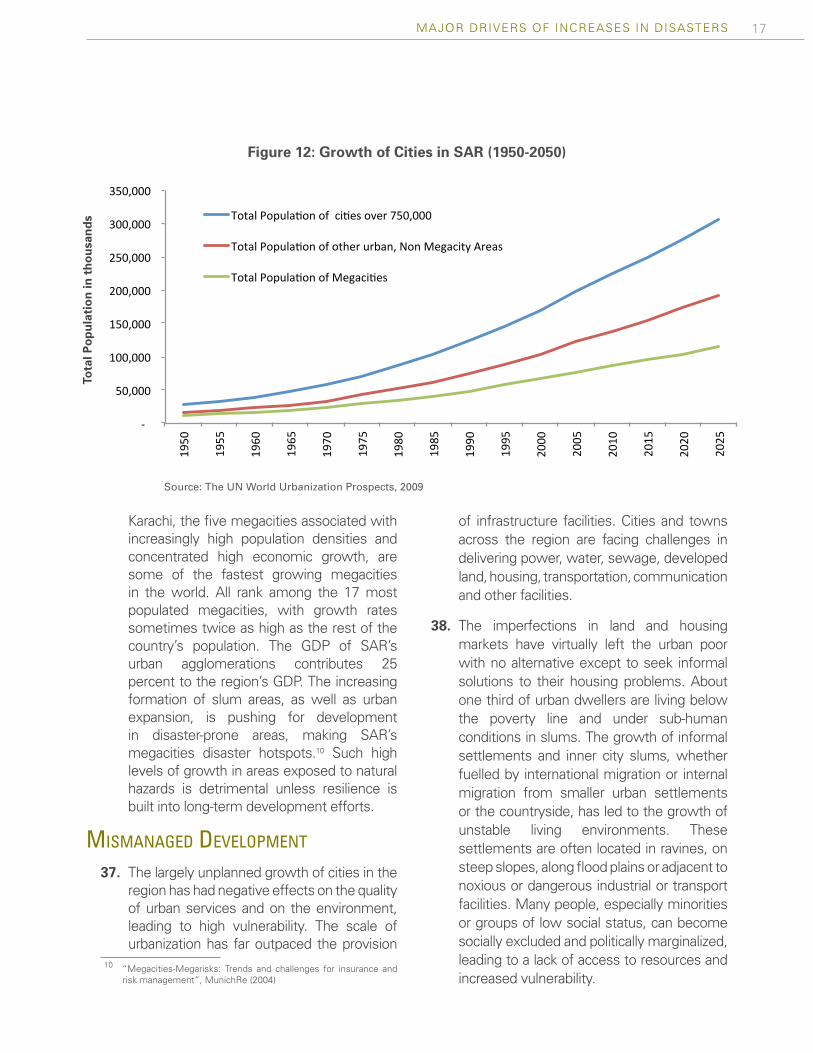
Karachi, the five megacities associated with increasingly high population densities and concentrated high economic growth, are some of the fastest growing megacities in the world. All rank among the 17 most populated megacities, with growth rates sometimes twice as high as the rest of the country’s population. The GDP of SAR’s urban agglomerations contributes 25 percent to the region’s GDP. The increasing formation of slum areas, as well as urban expansion, is pushing for development in disaster-prone areas, making SAR’s megacities disaster hotspots.10 Such high levels of growth in areas exposed to natural hazards is detrimental unless resilience is built into long-term development efforts.
mIsmanaged develoPment
37. The largely unplanned growth of cities in the region has had negative effects on the quality of urban services and on the environment, leading to high vulnerability. The scale of urbanization has far outpaced the provision
10 “Megacities-Megarisks: Trends and challenges for insurance and risk management”, MunichRe (2004)
of infrastructure facilities. Cities and towns across the region are facing challenges in delivering power, water, sewage, developed land, housing, transportation, communication and other facilities.
38. The imperfections in land and housing markets have virtually left the urban poor with no alternative except to seek informal solutions to their housing problems. About one third of urban dwellers are living below the poverty line and under sub-human conditions in slums. The growth of informal settlements and inner city slums, whether fuelled by international migration or internal migration from smaller urban settlements or the countryside, has led to the growth of unstable living environments. These settlements are often located in ravines, on steep slopes, along flood plains or adjacent to noxious or dangerous industrial or transport facilities. Many people, especially minorities or groups of low social status, can become socially excluded and politically marginalized, leading to a lack of access to resources and increased vulnerability.
Figure 12: Growth of Cities in SAR (1950-2050)
Source: The UN World Urbanization Prospects, 2009
-‐
50,000
100,000
150,000
200,000
250,000
300,000
350,000 19
50
1955
1960
1965
1970
1975
1980
1985
1990
1995
2000
2005
2010
2015
2020
2025
Total Popula5on of ci5es over 750,000
Total Popula5on of other urban, Non Megacity Areas
Total Popula5on of Megaci5es
Tota
l Pop
ulat
ion
in t
hous
ands

18 Disaster risk ManageMent in south asia: a regional overview
39. Poor land use planning and ill-enforced building codes result in structures that are highly vulnerable to hazard events. Without a strong culture of safety and proper enforcement mechanisms to ensure resilient construction of buildings, these structures are often not strong enough to withstand hazard events. As levels of economic growth in SAR increase, millions of people move into the middle classes and have adequate income levels to upgrade to masonry homes and apartment buildings. However, many residents live with a false sense of security that their professionally
engineered structure is a safe environment. In reality, many of these buildings are at greater risk to seismic events than informal slums due to sub-standard construction practices. Other infrastructure, including water, transport, and power are often not built with hazard exposure in mind. Due to the added marginal cost of building resilient structures, this is often overlooked by contractors, which creates significant vulnerability in the capital stock.
40. Interconnection among populations in hazard prone areas brings interdependency. South Asia faces enormous challenges in the task
Box 1. the next BIg earthquake In nePal
In the 20th century alone, over 11,000 people have lost their lives due to earthquakes in Nepal. The 1934 8.4 magnitude Bihar-Nepal Earthquake produced strong shaking in the Kathmandu Valley, damaging 40 percent of the area’s building stock. In Kathmandu itself, one quarter of all homes were destroyed along with several historic sites. The seismic record of the region, extending back to 1255, suggests that earthquakes of this size occur approximately once every 75 years, indicating that devastating earthquakes are inevitable in the long term.1
With an annual population growth rate of 6.5 percent per year and one of the highest urban densities in the world, the 5.3 million people living in the Kathmandu Valley are clearly facing a serious and growing earthquake risk. Among the 20 cities around the world in high risk seismic zones, Kathmandu is the most at risk, and the risk is increasing every year.2 This is mainly due to the increased vulnerability of exposed populations resulting from uncontrolled urban development and weak construction practices. To accommo-date the doubling of the population over the past decade, buildings have grown quickly in number and height, especially given the high demand by the increasing number of households who have benefited from the country’s 3.5 percent per annum GDP growth rate and are now a part of the middle classes. Though the quantity of capital stock has skyrocketed, the quality is lagging behind.
In the Kathmandu Valley, nearly 6,000 concrete houses are built every year, and mostly without proper engineering and seismic force considerations. Kathmandu’s buildings are unsafe, in part, because 90 percent are designed by traditional masons instead of profes-sional engineers. Less than 1 percent of Nepal’s schools and hospitals have received substantial safeguards, and over two-thirds of the capital’s structures are not fit to withstand an 8 magnitude earthquake on the Richter scale.
The government has failed to control the Valley’s rapid development, and nearly all construction that has taken place thus far has not accounted for the seismic risk of the area. The Ministry of Physical Planning and Works is in charge of urban development, but the country’s political instability undermines the agency’s ability to reign in municipal authorities, who control the distribution of build-ing permits and rarely enforce codes. Furthermore, the technical information about earthquake risk in the Kathmandu Valley is not applied to the infrastructure of modern-day Kathmandu Valley, and is not presented in a form that is comprehensible to the public and to government officials. The next large earthquake to strike will cause significant loss of life, structural damage, and economic hardships, unless immediate action is taken by public and private stakeholders to reduce the vulnerability of exposed populations in the Kathmandu Valley.
1 Government of Nepal, Department of Mines and Geology.2 GeoHazards International

19MAJOR DRIVERS OF INCREASES IN DISASTERS
of improving resilience to hazard events. Achieving resilience will require a continuous process that aims to build consensus among national decision makers and technical experts to pursue a common goal of reducing the disaster risk that could threaten the region’s long-term development. Such efforts can only be addressed by instilling a culture of prevention that permeates public and private spheres. Success in accomplishing this goal is dependent on the inclusion of multiple stakeholders and shifting mindsets to proactively address risk. As attitudes change, the collective understanding of risk may improve, the major disincentives for resilient development may be identified, and support may be provided for prevention.
41. Disaster management agencies have been established across the region since 2004, but they lack clout to influence planning and development agendas. In SAR, the mandate of most national and local disaster management agencies is to empower various line ministries to incorporate effective DRM practices into their day-to-day functioning. However, given limited fiscal resources and human capacity, these mandates have not yet been achieved. Policies and legislation for managing natural disasters are often insufficiently enforced in SAR. This is coupled with a highly vulnerable population that is neither well aware of the risks it faces, nor the response it should have in the case of a natural disaster.
envIronmental degradatIon and clImate change
42. South Asian countries suffer from rapid deforestation, with negative environmental repercussions. The deforestation rate in the region is approximately 1.1 percent annually, and about 88 percent of the region’s forest cover has been lost due to logging and other
human activities.11 South Asian countries account for only two percent of the world’s forest area. When compared to the world average forest cover, 25 percent, the region’s forest cover rates are much lower at 18.7 percent. Forests increase resilience to hydro-meteorological hazards by providing a buffer against landslides and tsunamis; in rural areas forests also provide essential resources and products that enhance the livelihoods of local communities and indigenous peoples.Planned adaptation in South Asia can help ensure that forests continue to provide these services while avoiding negative impacts on the ecosystem and the wider landscape.
43. By altering the hazard profile, climate change can exacerbate SAR’s risk of suffering from disaster events. The World Bank’s Climate Change Strategy for South Asia highlights the major climate change trends expected to take place in the future. While there is not yet consensus in the scientific community whether and to what extent climate change increases the number and severity of climatic events, there are several prominent studies suggesting that there exists a causal relationship. Moderate scenarios project less and less frequent precipitation in the already dry areas of Afghanistan, western India and parts of Pakistan, potentially increasing the frequency and duration of droughts. As shown in Figure 13, the mean global temperature has increased 0.7 degrees Celsius since 1975 and scientists expect the trend in global warming to continue. Higher and more variable rainfall, as well as increased glacier runoff, is expected to increase the frequency and intensity of floods, especially affecting monsoon-dependent areas. Sea level rise and eventually reduced glacier runoff are other areas of concerns of disaster risk management in the future.
11 Cal Poly Pomona, BioTrek.

20 Disaster risk ManageMent in south asia: a regional overview
44. The retreat of some glaciers in the Hima-layas presents a challenge to the region. The Himalayan ecosystem supports some 1.5 billion people that live directly in the floodplains of the many rivers it supports (e.g. Indus, Ganges, Brahmaputra, and Meghna). This system influences monsoon dynamics, acts as a natural reservoir to sustain crops, provides groundwater recharge, and is home to a unique ecosystem with an abundance of endemic species. With rising temperatures, the ice mass of the Himalayas and Hindu Kush are retreating more rapidly than the global average, which is increasing both flood and drought risks.
45. Sea-level rise is a further concern given the long and densely populated coastlines, and many low-lying islands. In the worst case climate-change scenarios, sea-level rise could pose an existential threat, potentially submerging much of the Maldives and inundating 18 percent of Bangladesh’s total land, directly impacting 11
Figure 13: Global Land-Ocean Temperature Index (1880-2010)
Source: NASA’s Goddard Institute for Space Studies (GISS), 2011-0.8
-0.6
-0.4
-0.2
0
0.2
0.4
0.6
0.8
1
1880
1885
1890
1895
1900
1905
1910
1915
1920
1925
1930
1935
1940
1945
1950
1955
1960
1965
1970
1975
1980
1985
1990
1995
2000
2005
2010
Annual Mean 5-year Mean
Tem
pera
ture
Ano
mal
y (o C
)
percent of the country’s population. Many of the region’s primary cities — Chennai, Cochin, Karachi, Kolkata, and Mumbai — are the en-gines of regional growth and are located on the coast and threatened by sea-level rise.
46. The most severe impacts of climate change are likely to be widespread and will call for coordinated regional responses. For example, Bangladesh shares 54 rivers with India. Changes in upstream runoff and demand due to climate change could significantly impact future water availability across all these rivers. Likewise, sea-level rise could displace much of the population along the coastal zone and induce cross-border migration. Adaptation to climate change might therefore require not just local action but also cross-boundary cooperative arrangements on disaster and climate risk management. Partnerships and coordinated approaches provide a cost-effective way of adapting to the impending climate related risks.

21
PReVenTIon Is beTTeR THan CURe: bUIlD CaPaCITY anD ReDUCe VUlneRabIlITY

22
IndIa

23
47. The traditional approach to disasters in SAR has been to focus on responding to events and reconstructing damaged assets in the aftermath. By and large, the response of the major stakeholders has been reactive rather than proactive, and this approach has resulted in accumulated casualties and economic losses that were higher than necessary. However, if the vulnerability of exposed people and assets had been understood and addressed through various preventative measures, the losses suffered over time would have been lower.
48. With a recent increase in awareness and a growing understanding of disaster risk, policy makers in SAR are beginning to take a more proactive approach to managing disaster risk. It is imperative that governments continue to mainstream disaster risk management into their planning and development processes. The first step is identifying the risk in terms of both the hazards that are prolific in a particular region, and the people and assets that are exposed to these hazards. Increasing the awareness of the potential risk across all levels of society will further enhance the importance that is given to this issue. Policymakers must then use this information on hazards and exposure to decrease the vulnerability of their populations through both structural and nonstructural activities designed to mitigate the overall disaster risk. For the residual vulnerability that cannot be addressed, governments should develop comprehensive risk financing strategies that include setting aside reserves for post disaster situations, and accessing financing mechanisms such as contingent credit and risk transfer facilities. Maintaining momentum and promoting sound disaster risk management practices will lead to safer, more resilient communities in the future.
rIsk IdentIfIcatIon 49. Any effective strategy to manage disaster
risk must begin with an identification of the factors that cause disasters. Inputs include physical hazard data and localized socio-economic and demographic data. More specifically, hazard mapping serves as the base layer of information and provides data on the probability of occurrence and intensity of a hazard event. The second layer required is an understanding of the nature of the people and assets exposed to the hazard prone area. Third, an assessment of the physical, social, economic, and environmental factors of an exposed area determines the vulnerability of human and physical capital. Such hazard, exposure, and vulnerability assessments are valuable tools for individuals and policymakers as they determine how to effectively mitigate disaster risk.
50. The process of collecting and maintaining data must be ingrained within strong institutional systems to be effective and reliable over the long-term. Technical experts can project future risks from historical information on the intensity of natural disasters and their consequential losses. However, SAR suffers from a dearth of historical disaster loss data, and national disaster management agencies have only recently begun to systematically determine the social and economic impact of disasters. Going forward, local agencies must continuously update information after each disaster in accordance with international standards. Accurate and comprehensive loss assessment practices must be employed, and governments should allow the data to be archived in geo-referenced, open-source databases that are easily accessible to relevant stakeholders. Fulfilling these tasks comprises clarifying institutional mandates, determining comparative advantages in
PReVenTIon Is beTTeR THan CURe: bUIlD CaPaCITY anD ReDUCe VUlneRabIlITY

24 Disaster risk ManageMent in south asia: a regional overview
generating and managing information on risk factors, and augmenting capacity where needed.
51. As risk identification advances, decision makers across all sectors need to be engaged in the planning process. Much of this work is undertaken by scientists and engineers; however, a collaborative approach between technical experts and government officials who act upon the data is required to ensure that the disaster risk characteristics are taken into account in the development process. Development planners and decision makers are not merely end users; they are collaborators in the task and their needs direct the components of the risk assessments that are developed. Assessments of disaster risks and corresponding risk levels can support the incorporation of risk mitigation and transfer activities into a country’s long-term development plans. With the input of relevant stakeholders, risk identification enables a government to establish its priorities, develop risk management plans, and create effective policies that strike a balance between minimizing risk and expending limited fiscal resources.
rIsk awareness
52. Once disaster risks have been identified, they must be communicated in a manner that motivates individuals to increase their resilience to disasters. Governments, civil society, and the private sector can raise awareness of risks and risk-mitigation principles at the national, regional, and community levels. Awareness leads to public demand for risk resilient policies and can in turn lead to sustainable development in the future. This is the crucial step in cultivating behavioral and institutional changes necessary to shift from a culture of emergency response to one of advance preparedness across SAR.
53. The process for initiating change can be bottom-up. Local governments, community based organizations, and NGOs can utilize various interactive tools to engage individuals at the local level. For example, in high-risk earthquake zones in Nepal, school awareness initiatives teach children from a young age about the hazards their communities are exposed to and the appropriate responses in case of a disaster. Programs that mobilize communities to implement disaster risk management measures in the cyclone-affected areas of Bangladesh continue to foster awareness in adult life and strengthen the self-help capabilities of endangered populations. Media campaigns utilizing multiple channels of communication such as picture-based signs and brochures, radio and television announcements, and mobile technology in tsunami-prone areas of India all disseminate messages to defy the psychological predispositions of denying disaster risk and cultivate responsibility. These small investments at the community level can result in large behavioral shifts over the long-term.
rIsk mItIgatIon 54. Reducing disaster risk calls for all stakehol-
ders to alter their perceptions and prioritize resilience in a country’s planning and development efforts. It comprises actions to prevent, mitigate, and prepare against the damaging impact of hazards and thus minimize the potential consequences on physical and human capital. A range of social, economic, environmental, and technical issues must be addressed through proper investments in infrastructure and holistic policies that promote safety throughout sectors. Examples of structural measures to improve existing infrastructure include embankments to control the flow of waterways during flood events, and physical reinforcements to strengthen vulnerable buildings. Non-structural measures include

25PREVENTION IS BETTER THAN CURE: BUILD CAPACITY AND REDUCE VULNERABILITY
land use policies to control development in hazard prone areas, and early warning systems to alert communities of approaching threats. To be most effective, these activities must be tailored to the context of local communities and integrated into long-term development plans.
55. Enhancing physical resilience of new infrastructure is one of the most important risk mitigation measures SAR governments can undertake to prevent the lock-in of future vulnerability. Demographic shifts, population growth, and steady rates of urbanization in the region are increasing the number of people and the amount of assets in harm’s way. It is impossible to move people away from their homes and livelihoods in megacities such as Mumbai, Karachi, Delhi, Dhaka, and Kolkata, but it is possible to institute planning processes that prevent weak construction in high risk areas. Engineering and academic experts can be consulted to identify best practices and develop enforceable building codes. The onus is on the government to enforce such codes and improve supervision of
building construction and maintenance. The public sector can also provide adequate economic incentives to owners of existing structures to retrofit their buildings for the benefit of tenants and the public at large. The economic rationale for pre-disaster investments in risk resilient infrastructure far outweighs the post-disaster costs governments would have to incur to rebuild affected communities.
rIsk fInancIng and transfer 56. In South Asia, the state bears much of
the costs related to disasters, including both explicit and implicit obligations. In the developed world, risk transfer mechanisms such as insurance cover approximately 30 percent of economic losses. In most low-income countries including those in South Asia, however, these tools only cover 1 percent of losses.12 As a result, funds are diverted from already strained public budgets to respond
12 Linnerooth-Beyer, J. and Mechler, R. (2007). Insurance against Losses from Natural Disasters in Developing Countries. Background paper for the United Nations World Economic and Social Survey.
Figure 14: Benefits of Investing in Risk Mitigation
Source: World Economic Forum, A Vision for Managing Natural Disaster Risk
CATASTROPHE
Impa
ct o
n So
ciet
y
Time
Investment in physical resilience...
... reduces the immediatee�ect of a catastrophe,
... and allows a faster recovery.
... longer term impact, ...
CATASTROPHE

26 Disaster risk ManageMent in south asia: a regional overview
to disaster emergencies, thus further delaying long-term economic and social advancement in the region. Tools have been developed by the World Bank to alleviate this burden and assist governments and their citizens to more effectively manage disaster risks. At the macro-level, these instruments can reduce the impact of disasters on a country’s overall growth prospects, and on the micro-level they protect individuals’ homes and livelihoods. As such,
strengthening the financial preparedness of communities is critical to a country’s overall resilience to natural disasters.
57. Governments should aim to develop risk financing strategies in which risks are distributed among a variety of capital bases that, in aggregate, can adequately withstand the costs of natural disasters. Fiscal reserves and contingencies built within a country’s annual budget are the most economical sources of ex-ante risk financing and can
Box 2. cyclone dIsaster mItIgatIon In Bangladesh
Bangladesh is highly exposed to cyclone hazards because of its location at the triangular shaped head of the Bay of Bengal and the sea-level geography of its coastal area. About 40 percent of the total global storm surges are recorded in Bangla-desh, and the deadliest cyclones in the past 50 years are those that have struck Bangladesh. However, the number and severity of cyclones in Bangladesh and the associated mortalities have varied greatly during this time period. The two dead-liest cyclones occurred in 1970 and 1991, resulting in 500,000 and 140,000 deaths, respectively. Most recently, Cyclone Sidr struck land in 2007, the most intense disaster event in the country’s history, but only caused 4,234 deaths, a 100-fold reduction compared to the 1970 cyclone.1
In the past 50 years, Bangladesh has learned how to adapt to recurrent cyclones and has succeeded in significantly reduc-ing cyclone-related deaths. Its programs aim to minimize vulnerability to cyclones by strengthening and developing disaster preparedness and response capacity in coastal communities, and by increasing the effectiveness of volunteers. This has been achieved by modernizing early warning systems, developing shelters and evacuation plans, constructing coastal embankments, maintaining and improving coastal forest cover, and raising awareness at the community level. Initiatives at central and local governmental, nongovernmental and community levels seem to be the key for success in minimizing cyclone-related mortality.
Bangladesh’s government has successfully utilized its increased revenues from 5.5 percent GDP growth per annum to invest in risk resilient infrastructure. Prior to 2007, the country had 1,500 shelters, each capable of offering refuge to up to 5,000 people in coastal districts. After Cyclone Sidr, the Bangladesh government initiated the construction of 2,000 new cyclone shelters in 15 low-lying coastal districts. Since 1960, a series of embankments have also been constructed to protect coastal regions, including 4,000 km of coastal embankments surrounding the Bay of Bengal and offshore islands. Reforestation of approximately 1,200 km of mangrove forests in Bangladesh has been carried out to mitigate cyclone risk, as it is known to serve as a protective barrier during cyclones. Under the Cyclone Preparedness Program, Bangladesh has implemented awareness campaigns to disseminate information about cyclone warning signals and preparedness mea-sures, using meetings, discussions, posters, leaflets, films, and demonstration performances. All in all, The Government of Bangladesh has invested more than US$10 billion during the past 35 years to make Bangladesh less vulnerable to natural disasters.2 The country has come a long way in its efforts and should continue to strengthen disaster planning in its long-term development goals and practices.
1 Reduced death rates from cyclones in Bangladesh: What more needs to be done?, Bulletin of the World Health Organization, 2012, 90:150-156.2 Bangladesh: Economics of Adaptation to Climate Change Study.

27PREVENTION IS BETTER THAN CURE: BUILD CAPACITY AND REDUCE VULNERABILITY
Box 2. cyclone dIsaster mItIgatIon In Bangladesh
Bangladesh is highly exposed to cyclone hazards because of its location at the triangular shaped head of the Bay of Bengal and the sea-level geography of its coastal area. About 40 percent of the total global storm surges are recorded in Bangla-desh, and the deadliest cyclones in the past 50 years are those that have struck Bangladesh. However, the number and severity of cyclones in Bangladesh and the associated mortalities have varied greatly during this time period. The two dead-liest cyclones occurred in 1970 and 1991, resulting in 500,000 and 140,000 deaths, respectively. Most recently, Cyclone Sidr struck land in 2007, the most intense disaster event in the country’s history, but only caused 4,234 deaths, a 100-fold reduction compared to the 1970 cyclone.1
In the past 50 years, Bangladesh has learned how to adapt to recurrent cyclones and has succeeded in significantly reduc-ing cyclone-related deaths. Its programs aim to minimize vulnerability to cyclones by strengthening and developing disaster preparedness and response capacity in coastal communities, and by increasing the effectiveness of volunteers. This has been achieved by modernizing early warning systems, developing shelters and evacuation plans, constructing coastal embankments, maintaining and improving coastal forest cover, and raising awareness at the community level. Initiatives at central and local governmental, nongovernmental and community levels seem to be the key for success in minimizing cyclone-related mortality.
Bangladesh’s government has successfully utilized its increased revenues from 5.5 percent GDP growth per annum to invest in risk resilient infrastructure. Prior to 2007, the country had 1,500 shelters, each capable of offering refuge to up to 5,000 people in coastal districts. After Cyclone Sidr, the Bangladesh government initiated the construction of 2,000 new cyclone shelters in 15 low-lying coastal districts. Since 1960, a series of embankments have also been constructed to protect coastal regions, including 4,000 km of coastal embankments surrounding the Bay of Bengal and offshore islands. Reforestation of approximately 1,200 km of mangrove forests in Bangladesh has been carried out to mitigate cyclone risk, as it is known to serve as a protective barrier during cyclones. Under the Cyclone Preparedness Program, Bangladesh has implemented awareness campaigns to disseminate information about cyclone warning signals and preparedness mea-sures, using meetings, discussions, posters, leaflets, films, and demonstration performances. All in all, The Government of Bangladesh has invested more than US$10 billion during the past 35 years to make Bangladesh less vulnerable to natural disasters.2 The country has come a long way in its efforts and should continue to strengthen disaster planning in its long-term development goals and practices.
1 Reduced death rates from cyclones in Bangladesh: What more needs to be done?, Bulletin of the World Health Organization, 2012, 90:150-156.2 Bangladesh: Economics of Adaptation to Climate Change Study.
be used for small-scale events which may occur frequently, but do not exert significant impacts on a country’s financial resources. As the severity of events increases, individuals and governments should transfer the risk they cannot retain under their own fiscal umbrellas. In addition, private catastrophe insurance schemes, developed in collaboration with the public sector, can help protect individuals from disaster risks. On a national and regional scale, catastrophe bonds and catastrophe pools can be used as mechanisms to prepay for natural disasters and serve as a backstop of additional risk coverage for governments. A blend of public and private resources shown in Figure 15 below that are customized to address location-specific risks will be the most comprehensive solutions for addressing financial risks associated with disasters.
ImProvIng InstItutIonal caPacIty
58. Institutional weaknesses increase vulnerabi-lities to disasters. Policies and legislations for managing natural disasters are often insuf-ficiently enforced in SAR. This is especially the case for building codes and land use planning. Technical capacity for dealing with natural disasters is often constrained. Fur-thermore, administrative bodies and public sector officials involved in disaster manage-ment, such as those managing health or edu-cation programs, often lack training in disas-ter risk management and show weaknesses in longer term planning. Sudden larger scale catastrophes sometimes overwhelm the governments’ response capacities, further exacerbating the impact of disasters.
59. The region has begun efforts to institu-tionalize and mainstream disaster risk mana-gement activities. To varying degrees, each country in the region has set out to establish institutional structures and an ex-ante approach to mitigate the impact of hazard
events at the national and sub-national levels. At the regional level, the South Asian Association for Regional Cooperation (SAARC) is promoting comprehensive DRM engagements. SAARC supports knowledge sharing initiatives to increase preparedness and mitigation efforts amongst all its member countries. In furthering this agenda, it is important to promote projects analyzing the possible roles of governments, NGOs, and private sector companies in risk reduction, local and regional workshops heightening the awareness of stakeholders to the threat of natural disasters, and educational and training activities that increase the understanding of policymakers, decision makers, and practitioners about disaster risk management.
60. Ultimately, individuals and governments across varying geographies and agencies must work together to mainstream disaster risk management initiatives and build resilient communities. Firstly, individuals need to have access to information about their exposure to particular hazards and the types of vulnerabilities they face due to the social, economic, and political characteristics of their particular habitats. Guidelines and resources often need to be provided by higher levels of authority within society, even as day-to-day decisions and individual commitments to participate in risk reduction activities are implemented at the local level. Furthermore, governments must use these guidelines as tools for determining investments in risk-resilient infrastructure and developing institutional structures and policies that enhance risk management. To be most effective, decision-makers across various lines of government must have a robust understanding of the complex matrix of hazards, exposure, and vulnerability, and use this information to devise measures to build safe and resilient communities.

28 Disaster risk ManageMent in south asia: a regional overview
Figure 15: Combining Financial Instruments to Address Various Layers of Risk
Source: Ghesquiere, F. and Mahul, O. (2010). Financial Protection of the State Against Natural Disasters: A Primer. The World Bank

29
anneX 1 – ReGIonal HaZaRD PRofIle

30
PakIstan

31
overvIew of natural hazards
Cyclones, earthquakes and related tsunamis, extreme precipitation especially during monsoon rains, droughts, landslides and Glacial Lake Outburst Floods (GLOFs) are all common natural hazards in the region. The variety and level of hazards is shaped by some key geographic, climatic, as well as geological features.
SAR’s geography is very diverse, ranging from high elevations in the Himalayas to long coast-al lines formed by the Arabian Gulf, the Indian Ocean and the Bay of Bengal. While Sri Lanka and the Maldives are island states, and India is surrounded by the sea, Afghanistan, Nepal, and Bhutan are landlocked. These distinct features create a diverse geography that includes glaciers, rainforests, valleys, deserts, and grasslands.
The Himalayan Mountains are mostly respon-sible for feeding the largest river systems in the region. These include the Ganges (India and Bangladesh) and its tributaries in Nepal, the Indus River (India and Pakistan), and the Brahmaputra River (India and Bangladesh). The drainage basin of all these three rivers is inhabited by a large proportion of the population.
The climate in most of the subcontinent is determined by the tropical monsoon, with the north characterized by more temperate conditions. The monsoon brings about 70 percent of SAR’s annual precipitation on average in a four-month period. The rains are associated with sea surface temperature and large scale pressure variation of the atmosphere over the southern Pacific Ocean (such as El Niño).
The natural characteristics are the cause for a number of prevailing hazards. Monsoon and seasonal glacial runoff make the major river systems subject to frequent severe flooding
on an annual basis, and across the bordering countries. The long coasts in the region are subject to frequent cyclones and tsunamis. The location of the region on the Indian plate exposes the region to substantial earthquake risk and frequently associated landslide hazards, especially around the Himalayas. Deserts such as in large parts of Afghanistan, and areas of pronounced precipitation shortfalls, make the region prone to droughts. Many of the above features are not confined to national borders, and can cause trans-boundary hazards. For example floods originating in Bhutan and Nepal make their way into Bangladesh and Nepal.
The number of reported disasters has been increasing over time. Figure 16 below highlights the increased frequency of disasters and demonstrates that flood risk, in particular, is on the rise.
IndIvIdual hazard assessments
Floods
Flooding is the most frequently occurring disaster in SAR, causing half of the total damages in the last 40 years. Floods persistently affect the largest number of people, on average approximately 27 million per year, and cause an average of over US$1 billion in annual losses. These events also lead to significant indirect losses that are often not measured. Indirect impacts include the degradation of agricultural land which subsequently diminishes agricultural productivity, impacting rural development and income opportunities. This is particularly important in SAR where dependence on agricultural production for livelihoods remains high.
anneX 1 – ReGIonal HaZaRD PRofIle

32 Disaster risk ManageMent in south asia: a regional overview
Besides excess rainfall, flooding is also caused by a number of environmental factors. Land use changes, such as land degradation, reduction of forest cover, and ecological degradation can and have significantly enhanced the risk of flooding in affected areas. For example, unplanned development in major urban centers has changed land use and led to poor drainage capacity, compounding vulnerability to high rainfall events.
Except for Bhutan and Maldives, all countries in the region are subject to considerable and partly extreme flood risk. The highest and most concentrated flood risk can be found around the foot-hills and the flood plains along the Himalayan belt, along with nearly all of low-lying Bangladesh and many coastal areas in the region (see Figure 17). India and Bangladesh have recorded the highest number of flood-related disasters.
The two last major flooding events in the region have been caused by unusual monsoon rain patterns combined with excess glacier melting and cyclones. The most recent major flood event
took place in 2010, and was the result of unusual
monsoon rain in Pakistan.
Figure 16: Total Number of Natural Disasters in SA from 1960-2009 by Type of Event
Source: EM-DAT: The OFDA/CRED International Disaster Database, www.em-dat.net – Universite Catholique de Louvain, Brussels, Belgium
Figure 17: Flood Risk in SAR
Source: RMSI (2010)

33ANNEX 1 – REGIONAL HAZARD PROFILE
The floods affected 20 million people and caused an estimated US10 billion in direct damage13. Simultaneous floods in Bangladesh caused the loss of over two thousand lives over the course of four weeks. Floods in 2007 severely impacted Pakistan, India, Bangladesh, Bhutan and Nepal.
Cyclones
The world’s deadliest reported storm events occur in SAR. Since 1970, 274 cyclones have been recorded, making it the second most common hazard in the region (see Figure 3). An estimated 3 million people are impacted annually. When extreme cyclone events occur, the death toll can be extremely high, such as the Bhola cyclone in 1970, which killed 300,000, or the 1991 cyclone in Bangladesh that was responsible for 140,000 fatalities. More recently, cyclone Sidr in 2007 was the strongest cyclone recorded in history. However, increased preparedness significantly decreased the number of fatalities, while still causing US$2 billion in damage.
Warm oceans, tropical climatic conditions, and specific wind patterns in the Bay of Bengal, the Andaman Sea, and the South China Sea expose the region to significant cyclone activity. Large parts of Bangladesh are subject to considerable cyclone risk, as are the coastal areas in West Bengal, Orissa, and Andhra Pradesh, in India. While the highest incidence of cyclone events is recorded in Bangladesh and India, parts of Pakistan and Sri Lanka are also at risk (see Figure 18).
Earthquakes
A considerable part of the region is exposed to earthquake hazard. On average, earthquakes affect 660,000 people per year and 145,000 people have lost their lives due to earthquakes
13 See joint WB-ADB Damage and Needs Assessment (2010). “Pakistan Floods 2010. Preliminary Damage and Needs Assessment”.
over the past ten years. Earthquake events occur infrequently, although losses from major events can be substantial.
SAR is one of the most seismically active regions in the world. The origins of the frequency and intensity of earthquakes lie to a large extent in the Himalayan belt, where the Indian plate is moving northward towards the Eurasian plate. Another sensitive hotspot is the friction between the Indian plate and the Burmese Micro-Plate in the Bay of Bengal and the Indian Ocean. The Indian peninsula also suffers from atypical earthquake events caused by intra-plate movements.
The seismic zone around the Himalayas affects Afghanistan, Pakistan, India, Nepal, and Bhutan. Almost all of Nepal is at high or very high risk of earthquake, as is the majority of Bhutan and northern parts of India. The Indian islands of Andaman and Nicobar are also at risk, along with Sri Lanka, Maldives, and the coastal regions of eastern India and southern Bangladesh.
Figure 18: Cyclone Risk in SAR
Source: RMSI (2010)

34 Disaster risk ManageMent in south asia: a regional overview
In the past 10 years several major earthquakes have occurred. These include the 2005 Kashmir earthquake, the 2001 Bhuj earthquake, and the 2004 Sumatra earthquake that triggered the Asian Tsunami in the Indian Ocean. Most recently, the 2009 Bhutan earthquake led to damage valued at 4 percent of the country’s GDP.
Droughts
Recorded drought events account for only a small fraction of the total hazard events and little data exists on the impact caused by droughts. A large number of people are reported to be affected by drought nearly as many as by flooding in the region. However, reported causalities and damages are low. Studies report a lower mortality rate and lower economic loss for SAR compared to other drought-prone regions in the world, suggesting that the impact may be underestimated due to under-reporting.
A drought disaster is generally caused by a combination of natural conditions and social vulnerability. Droughts occur under conditions of rainfall deficiency and low air humidity, as well
as high temperature and wind velocity, and these factors can last over several seasons. Human impacts, such as land degradation through multiple cropping, over-use, over-grazing, soil erosion, deforestation as well as poor management of water resources, can severely compound these natural effects. Economic, social and political vulnerability can turn these conditions into a disaster.
Drought affects nearly all countries in SAR. India and Sri Lanka have the highest record of drought events, not just in SAR, but across the entire Asian continent. In addition, significant parts of Afghanistan and Pakistan are affected by drought.
The region experienced an increase in reported droughts between the end of the 1990’s and the beginning of the 2000s, coinciding with severe precipitation deficits. However, recent events are difficult to quantify due to a lack of data. Some of the latest drought events reported includes the 2000 and 2002 droughts in Pakistan, during which, millions of cattle were reported dead and several thousand people were forced into migration.
Figure19: Earthquake Risk in SAR
Source: RMSI (2010)
Figure 20: Drought Risk in SAR
Source: RMSI (2010)

35ANNEX 1 – REGIONAL HAZARD PROFILE
Landslides
The Himalayan range from Bhutan, Nepal, Northern India and Pakistan, to Afghanistan is particularly exposed to landslide risk. The most recent recorded landslide event was the result of the Faizabad earthquake in Afghanistan in 1998, where the landslides were estimated to have caused thousands of casualties, burying whole villages.
The strong correlation of landslides with other hazards such as earthquakes and cyclones has resulted in an underestimation of the impact of landslides. In the past 40 years, only 500 fatalities due to landslides were reported and total estimated losses in the same period are valued at US$54 million. Several reasons have been advanced for the under reporting, such as the fact that 20 to 30 percent of the casualties reported from earthquakes were caused by landslides. In addition, small but numerous landslides are not recorded in certain disaster databases.
Landslides can be caused by ground acce-leration or major rainfall events and can be compounded by human intervention. They are considered either dry or wet, depending on whether they had been triggered by an earthquake or resulted from hydro-meteorological extreme events, like severe rainfall. The breaking of natural dams caused by landslides – locally known as bishyari in Nepali are common in the mountains, whilst river flooding occurs when rivers augmented by monsoon rains overflow their banks in the plains in the south of the country, as well as in
northern Uttar Pradesh, Bihar, West Bengal and Bangladesh. Unplanned construction and poor land use planning often leads to the construction of homes on steep slopes, which increases household vulnerability to landslides.
GLOFs occur infrequently and only in some specific areas. The risk posed by GLOFs is limited compared to other hazards in the region. Reported GLOFs in Bhutan and Nepal have led to a small number of casualties, but a sizeable amount of damage.
Figure 21: Landslide Risk in SAR
Source: RMSI (2010)

36

37
anneX 2: CoUnTRY PRofIles

afghanIstan

39ANNEX 2: COUNTRY PROFILES
afGHanIsTan
Figure 23: Percentage Distribution of Reported Disasters in Afghanistan
(1970-2009)
1 Estimates the probability (in percent) of annual economic losses exceeding specific amount of USD (in USD Million). The last column shows the probable annual economic loss as percent of GDP.
Landslides
10%
Cyclones 5% Droughts 4%
Earthquakes 25%
Floods 56%
Figure 24: Average Annual Economic Loss of Afghanistan
Floods 86%
Earthquakes 14%
Country Level Information Geographic Area (in sq km) 652,230
Population (in Millions) 28.39
Population Density (person per sq km) 44
Urban population (% of total population) 24
Arable land (% of total area) 13
Forest land (% of total area) 1
HDI country rank (out of 182) 181
GNI per capita (ATLAS method, in USD) 250
Agriculture, value added (% of GDP) 37
Industry, value added (% of GDP) 25
Services etc., value added (% of GDP) 38
Source: WDI, (2007, 2008), HDI (2007), UNICEF (2008), FAO (2007)
Disaster Statistics (1970-2009)
Disaster type
TotalDisaster
TotalCasualties
Total Affected People
Total Annual Total Annual Earthquake 26 9,200 240 623,000 16,000
Flood 58 3,500 90 1,1M. 29,000
Drought 4 40 1 4,8 M. 122,000
Landslide 11 950 25 302,000 7,700
Cyclone 5 1,700 40 193,000 5,000
Total 104 15,400 400 7 M. 180,000
Source: EM-DAT 2010, accumulated figures
Economic loss Potential 1 Annual Exceedance
ProbabilityEconomic Loss
(USD Million)Percentage
of GDP0.5% 280 3.3%
5% 80 0.95%
20% 25 0.30%
Source: RMSI 2010 (based on 1967-2006)
Figure 22: Map of Afghanistan
AFGHANISTAN

40 Disaster risk ManageMent in south asia: a regional overview
1. dIsaster rIsk ProfIle
Main sources of risk
Afghanistan’s rugged mountain landscape and generally arid climate make it prone to several natural hazards. Half of Afghanistan’s population lives at risk from at least two of the following natural hazards: droughts, floods, earthquakes. The country’s low protective capacity makes the population particularly vulnerable to such hazards, substantially increasing its risk to natural disasters.
The Hindu Kush Mountains divide Afghanistan into three distinct parts: 1) the Central Highlands, which are a part of the Himalayas, 2) the sandy Southwestern Plateau, and 3) the fertile Northern Plains. The terrain is marked by a rugged mountain landscape and increasing decertification, which has resulted in land degradation and water scarcity in some areas. The climate ranges from arid to semi-arid, with large temperature differences between altitudes and between warm and cold seasons. Areas of extreme heat are often the ones with the lowest precipitation.
Drought and flood are key challenges in Afgha-nistan. Drought events have deteriorated much of Afghanistan’s natural resource base and these events impact the largest proportion of the population – impacting over four times as many people as do floods. In addition, the high variability of precipitation throughout the country can cause unforeseen rainstorms, which in turn can cause flooding events in rivers that are only episodically flowing. Flood risk is amplified by increased seasonal and glacial snow melt as well as accelerated soil erosion and land degradation. To top all this off earthquake exposure is high, particularly in the northeast region, which includes Kabul. Over the past 40 years, several earthquakes have killed nearly 10,000 people. An estimated 6,500 people were killed in two 1998 earthquakes triggered near the Afghan-Tajik border region, and another 1,000 perished in the 2002 earthquake in the Hindu-Kush region.
Several human factors have contributed to Afghanistan’s vulnerability to disasters. Decades
of conflict and social unrest have undermined the country’s protective capacity. While the data quality is poor for Afghanistan, it can be estimated that the country is the poorest in South Asia in terms of income and second to last in human development outcomes worldwide, with exacerbating child and maternal mortality rates and very low life expectancy. The high levels of absolute poverty and the lack of income generating opportunities, as well as the poor protective infrastructure, add to the high vulnerability of the population.
Potential impact of climate change
Despite the reliably limited information available on climate change impacts in Afghanistan, the country is, and will continue to be, affected by climate change. Climate change projections for the region anticipate increasing temperatures and decreasing annual rainfall, which are expected to exacerbate the population’s vulnerability to natural disasters, particularly to drought.
Studies have shown that temperatures have been increasing while rainfall has been decreasing over the past 40 years. This trend will likely continue in the future, extending periods of heat and of low to zero precipitation, which will in turn cause more drought events, accelerate desertification, and cause severe flooding impacts, pronounced by increasingly rapid glacial melt.
2. dIsaster rIsk management framework
The original institutional framework for disaster risk management was put in place in the early 1980s. At the core of this structure was the Department for Disaster Preparedness (DDP). This Department was a ministerial level department and served the central disaster coordination agency and the secretariat of the National Commission for Emergency Response (NCER).
41ANNEX 2: COUNTRY PROFILES
Over the past ten years, due to several engagements with the international community, the Government of Afghanistan (GoA) embarked on a program to update the DRM framework. In 2007, the DDP developed a strategy to establish an effective system of disaster preparedness and response by the end of 2010. Policy documents such as the Afghanistan National Development Strategy 2008 (ANDS), which includes disaster risk reduction as a priority goal, the National Disaster Management Framework (NDMF), and the National Disaster Management Law spell out the revised DRM institutional framework.
Currently, the Afghanistan National Disaster Management Agency (ANDMA) is responsible for coordinating and managing all aspects of disaster preparedness and response. Under the ANDMA, the National Disaster Management Commission (NDMC) serves as the apex body within the country’s DRM institutional framework. The role of the Commission is to formulate national policy on disaster management, including periodic reviews. The NDMC is chaired by the Second Vice President and comprises representatives from key government ministries and national agencies. To ensure access to financial resour-ces, a National Emergency Fund (NEF) was established to mobilize funds in immediate post- disaster situations and is managed by the NDMC.
To effectively manage disaster preparedness and response activities, and based on the National Plan for Disaster Management (NPDM), a National Emergency Operations Centre (NEOC) is managed by the ANDMA. On a decentralized level, the ANDMA established functional offices in all 34 provinces of Afghanistan. The Provincial Disaster Management Agencies (PDMA)s are mandated to support the Provincial Disaster Management Commissions/Committees (PDMC) that are headed by the respective Provincial Governors. At the district level, District Development Committees (DDC) and Community Development Councils (CDC) have been established across the country and are responsible for disaster preparedness and response.
Despite these recent developments, the existing DRM structures and capacity remain weak, which is similar to the low capacity across the rest of the GoA. The political environment in Afghanistan, which has suffered from decades of war and civil conflict, has substantially eroded the capacity of all levels of government. Recent events have demonstrated that the GoA is not well prepared for natural disaster emergency and must rely heavily on the support of the international community. Specific to DRM, the GoA suffers from low levels of technical capacity at all levels. Early warning systems are non-existent, while comprehensive risk assessments have not been undertaken at any level. A weak education system and poor national-local linkage in disaster preparedness and response further exacerbates the vulnerability of communities.
3. Progress towards hyogo framework for actIon
HFA Priority # 1: Ensure that disaster risk reduction is a national and a local priority with a strong institutional basis for implementation
The disaster preparedness law developed three decades ago remains relevant for post-disaster response. The coordinating body for DRM is the DDP, a ministerial level department. Under the revised strategy, the DDP is now responsible for the identification of effective measures for disaster prevention, mitigation, and preparedness activities to reduce overall vulnerability to hazards.
The National DRR Platform was launched on February 28, 2010, which is an update of the 30 year old institutional structure. Based on the drafted national strategy for disaster preparedness and response, all the member ministries of the NCDM are expected to prepare disaster management and preparedness plans at sector level. Some of the ministries (e.g. Ministry of Interior and Ministry of Health) have already prepared their plans. In addition, the Ministry of Urban Development is

42 Disaster risk ManageMent in south asia: a regional overview
considering the establishment of building codes, and has begun research for proper practical building codes specified for different areas in Afghanistan.
HFA Priority # 2: Identify, assess, and monitor disaster risks and enhance early warning
In 2003, a hazard map was completed at the national level that ranked all provinces qualitatively in terms of hazards. Information was collected from local authorities and based on historical events instead of quantitative, empirical methods. In addition, community level organizations have provided training in hazard assessment and mapping to volunteers in order to prepare local assessments. Vulnerability assessments have been conducted after localized shocks/emergencies. The focus of these assessments has primarily been to determine the post-event needs for affected populations.
To improve early warning, a Famine Early Warning System Network (FEWSNET), is being developed that utilizes satellite imagery and provides regular weekly climate reports that are used to monitor changes or to signal impending changes/forthcoming/predicted crises. FEWSNET also circulates a monthly food security report for the country that highlights areas of change and concern, which allows partners to focus and follow up on areas where stress is acute or is projected to increase.
The Afghanistan Information Management Services (AIMS), in collaboration with DDP, will soon commence the development of a Disaster Management Information System (DMIS). DMIS will consist of data on hazards, vulnerability and risk assessments, and mapping, through a multi-hazard approach. The data for this system include historical data, elements at risk, inventory of hazards and their characteristics, and socio-economic data. Data will be collected through ground surveys, risk assessments, GPS, GIS, and Earth Observation Satellites. Data dissemination
will take the form of maps, reports and statistics through networking amongst members of the National Commission for Emergency and Disaster Management, the humanitarian agencies and local authorities.
HFA Priority # 3: Use of knowledge, innovation, and education to build a culture of safety and resilience at all levels
Each GoA department with a disaster/emergency management unit collects its own data for disaster risks. Information collected generally relates to disaster response, and to emergency events, such as the number of people affected, the area affected, crops and livestock affected, houses affected, etc. The DDP receives information from the provincial offices of the Ministry of Rural Rehabilitation and Development (MRRD) on floods, earthquakes, landslides, avalanches, sand movements, storms, locust plagues, epidemics, extreme temperatures, etc.
In Afghanistan, the education system is under stress due to decades of war. Schools lack infrastructure, teachers, and an updated teaching program. As a result, DRM related materials have not been introduced to the education system. Nevertheless, a new curriculum of study on disaster management has begun in the Faculty of Geosciences in Kabul University, where a comprehensive disaster risk management program is also ongoing. A bi-monthly periodical, published by InWent, informs authorities and citizens of disaster risk awareness and mitigation systems. Community based programs of education and awareness on disaster risk management have been designed and disseminated on a pilot basis.
HFA Priority # 4: Reduction of the underlying risk factors
Led by the GoA, a reforestation/environmental working group for drought mitigation has been

43ANNEX 2: COUNTRY PROFILES
established and convenes UN agencies and NGOs. Activities undertaken by the working group include construction of check dams, soil and water conservation schemes, hillside ditching and terracing, and reforestation of native forests and plantations, and managing restored public nurseries.
HFA Priority # 5: Strengthen disaster preparedness for effective response at all levels
The DPP is the main coordinating body and is responsible for coordination of all disaster response. Plans are underway to strengthen DDP in order to ensure its capacity to act as the GoA’s leading disaster coordination unit.
For the financing of disaster recovery, a national emergency fund managed by MRRD and DDP is made available by the central government and international donors. In addition, various ministries have allocated some part of their annual budget for emergency preparedness and response. However, since GoA resources are limited, the government depends on the direct support of international organizations and foreign support.
To reduce vulnerability to drought in Afghanistan, a cash-for-work instrument is being used to ensure continued income during times of drought. In addition, the national Emergency Employment Program utilizes the local experience of emergency response and coordination to distribute cash to targeted areas.
4. key donor engagements
A. World Bank and Key Multilateral and Bilateral Investments
The current Interim Strategy Note (ISN) for Afgha-nistan covers the period from 2012-2014. The Bank’s program is built around the following three interlocking themes: 1) Building the legitimacy and capacity of institutions; 2) Equitable service delivery; and 3) Inclusive growth and jobs. In particular, the ISN emphasizes the need to develop the capacity of the state to provide adequate basic services to Afghan citizens, emphasizing the susceptibility of the poor to shocks from natural disasters and the multiplier effects on poverty levels.
B. GFDRR
In the process of supporting inclusive growth, GFDRR will support initiatives to achieve the following goals as laid out in the ISN: 1) Increase and manage knowledge of disaster risks; 2) Increase emergency preparedness capacity; 3) Strengthen institutional capacity of selected institutions; and 4) Increase public awareness and community capacity. These issues will be tackled in the Afghan context and specifically implemented at the operational level.
GFDRR partners with the Aga Khan Development Network (AKDN) to launch the School Safety Initiative in Afghanistan, which aims to mainstream disaster risk reduction in Afghanistan’s education sector.
Table 1: World Bank and Key Multilateral and Bilateral Investments in Afghanistan’s DRM Sector
Project Year ap-proved
Year closed
Funding agencies
Project size (US$ mln)
HFA priori-ties
Comprehensive Disaster Risk Reduction Programme
2007 2010UNDP, ECHO, Norway
11.7 1, 5
National Disaster Management Project
2010 2011 UNDP 2.2 1

44 Disaster risk ManageMent in south asia: a regional overview
Over the course of two years, AKDN will collaborate with local officials to assess the physical, social, and functional vulnerability of the school environment and promote structural and non-structural mitigation measures in pilot schools across the country. The project will establish minimum standards for a safe school environment and support government stakeholders in replicating the school safety model
Table 2: GFDRR Investments in Afghanistan’s DRM Sector
Project Year approved
Year closed
Funding agencies
Project volume (USD)
HFA priori-
ties
GFDRR-AKDN School Safety Initiative 2012 2014 GFDRR 550,000 3
in hazard prone provinces across the country. In addition, the initiative will develop a cadre of school safety experts through capacity building, advocacy, and policy changes. Combined, these activities will create a culture of safety in Afghanistan’s education system that extends beyond the two-year project cycle.

45ANNEX 2: COUNTRY PROFILES

Bangladesh

47ANNEX 2: COUNTRY PROFILES
Figure 26: Percentage Distribution of Reported Disasters in Bangladesh
(1970-2009)
Figure 27: Average Annual Economic Loss of Bangladesh * Earlier World Bank documents have referred to population estimates
of about 166 million based on previous information from the United Nations Population Division’s (UNPD) World Population Prospects. The most recent 2010 Revision of the UNPD World Population Prospects estimates Bangladesh’s population at 150.6 million. The 2010 Revision is consistent with additional information (including the 2001 census, 2008 voter registration for adults age 18 and over, and estimates from the Sample Vital Registration System through 2009), which the 2008 Revision of the UNPD World Population Prospects did not take into account
1 Estimates the probability (in percent) of annual economic losses exceeding specific amount of USD (in USD Million). The last column shows the probable annual economic loss as percent of GDP.
Cyclones 59%
Droughts 3%
Earthquakes
3%
Floods 35%
Floods
75%
Cyclones
25%
Country level information Geographic Area (in sq km) 144,000
Population (in Millions) 150.613
Population Density (person per sq km) 1142
Urban population (% of total population) 28
Arable land (% of total area) 58.1
Forest land (% of total area) 11.1
HDI country rank (out of 182) 146
GNI per capita (ATLAS method, in USD) 760
Agriculture, value added (% of GDP) 18
Industry, value added (% of GDP) 29
Services etc., value added (% of GDP) 53
Source: WDI, HDI, UNICEF (2008), FAO (2007), UNPD (2010), DECDG
Disaster statistics (1970-2009)
Disaster type
TotalDisaster
TotalCasualties
Total Affected People
Total Annual Total Annual Earthquake 7 36 1 1.900 490
Flood 75 42,000 1.070 293 M 7.5 M
Drought 5 18 1 25 M 641.000
Landslide - - - - -
Cyclone 126 475,000 12,200 58 M 1,5 M
Total 213 516,000 132,000 376 M 9.6 M
Source: EM-DAT 2010, accumulated figures
Economic loss potential1
Annual exceedance Economic loss(USD Million)
Percentage of GDP
probability 4 0.65%
0.5% 2 0.30%
5% 900 0.15%
20%Source: RMSI 2010 (based on 1967-2006
Figure 25: Map of Bangladesh
BANGLADESH
banGlaDesH 1

48 Disaster risk ManageMent in south asia: a regional overview
1. dIsaster rIsk ProfIle
Disaster Risk Profile
The geographic and climatic features of Bangladesh, coupled with its social and economic environment, make it highly vulnerable to natural hazards including flood, drought, cyclone and earthquake. Disaster vulnerability in Bangladesh is exacerbated by high population density around the large river deltas and its coast. More than 80 percent of the population is potentially exposed to floods, earthquakes and droughts, and more than 70 percent to cyclones.
Bangladesh is a low-lying country with one of the highest population densities in the world. The country has the largest delta in the world, formed by the Ganges, the Brahmaputra, and the Meghna rivers. The climatic features of Bangladesh are driven by the annual monsoon, during which time about 80 percent of annual rainfall occurs, which, given the low lying nature of the terrain, often leads to major flooding. During the transitional pre- and post-monsoon periods there are also severe local storms and tornadoes. In addition to the monsoon rains, Bangladesh is exposed to cyclones, which have caused some of the world’s largest human disasters. Although no major events have occurred recently, there is still significant seismic risk throughout the country, with vulnerability especially high around major population centers. Seismic activity is a particular concern for Dhaka, given its dense population of 13 million people.
Cyclones and floods have been the most frequent causes of disaster, resulting in almost all of the nearly 520,000 deaths recorded over the last 40 years. Of this number, approximately 300,000 and 140,000 were caused by two cyclone events alone, in 1970 and in 1991 respectively. Floods have not caused as many casualties as cyclone events; however, the damage potential of major flooding is the highest of all hazards and the cumulative recorded loss due to flooding is estimated to be US$12 billion over the past 40 years. Droughts are also a common occurrence and cause of loss, affecting millions of people and causing widespread damage and losses,
with significant indirect effects on livelihoods. For example, the 1978-79 drought affected half of the cultivated land and population, destroying over 2 million tons of rice. Similar large-scale droughts followed in the 1980s and 1990s. While Bangladesh has high seismic risk, no major events have been recorded in the past 50 years, which has resulted in fewer efforts to increase resilience to such events.
Potential impact of climate change
Bangladesh is currently ranked as the most climate vulnerable country in the world, while, at the same time, it faces one of the highest rates of mortality risk from natural disasters. Climate change and the disproportionate impacts this will have due to the low-lying nature of the country, is likely to exacerbate this disaster vulnerability. Projections of the Intergovernmental Panel on Climate Change (IPCC) suggest that warmer temperatures will increase both the frequency and intensity of cyclones in the Bay of Bengal. In addition, rapid snow melt in the upper Himalayas, coupled with increased peak discharges, would likely increase the depth and spatial extent of flooding in the Ganges - Brahmaputra - Meghna Basin. Compounding this increased flood risk is the likely consequence of sea level rise, which has the potential to cause significant economic losses given the share of the population living in low - lying coastal lands.
2. dIsaster rIsk management framework
Recurring adverse events, which have caused significant human loss, have led the Government of Bangladesh (GoB) to change its approach to disaster risk management (DRM). Over mul-tiple decades, the GoB has put into place a robust response-oriented disaster management infrastructure that was proven successful during Cyclone Sidr in 2007. During this event, a strong emergency response and early recovery

49ANNEX 2: COUNTRY PROFILES
system effectively met the needs of the at-risk population. To continue increasing resilience to adverse natural events, the GoB is now beginning to proactively reduce risk to these events by introducing risk identification and mitigation measures.
Bangladesh’s DRM structure is organized on the national and sub-national-levels. On the highest level, the National Disaster Management Council (NDMC), headed by the Prime Minister, formu-lates and reviews disaster management policies. The Inter-Ministerial Disaster Management Coor-dination Committee (IMDMCC) was established to implement disaster management policies and decisions of the NDMC, assisted by the Nation-al Disaster Management Advisory Committee (NDMAC). The Ministry of Disaster Management and Relief (MoDMR), which has a central Disaster Management Bureau (DMB) coordinates disaster preparedness and mitigation interventions across all agencies. On the sub-national level commit-tees coordinate and review activities.
Bangladesh’s DRM strategy is detailed in the National Plan for Disaster Management. The Plan is in alignment with the objectives and priorities for action identified under various international conventions and provides a vision and policy direction for the period of 2010 to 2015, with a goal of integrating DRM into sectoral development plans. The model is based on identifying and understanding hazards and their interactions with communities. To support implementation of the model, resources must be mobilized and knowledge about hazards and vulnerabilities need to be utilized for response planning and early warning.
The Comprehensive Disaster Management Program (CDMP) II, funded by bilateral and multinational organizations, is the key DRM imple-mentation program for Bangladesh. It defines a number of interventions aimed at strengthening and improving disaster management and risk
mitigation capacities, while executing the national strategic priorities set out by the GoB. The program has begun to make contributions to improved DRM capacity through capacity building, professionalizing disaster management, advocating for mainstreaming disaster risk redu-ction across sectors, encouraging community empowerment for disaster risk reduction, and, strengthening response management. In Particular, the CDMP II is recognized for its work on community based risk assessments and risk reduction action plans for flood and cyclone events.
Despite considerable efforts and success at the community level in cyclone risk reduction, several challenges remain. Overall capacity within the DMB is weak and, as a result, the Bureau is limited in its ability to carry out its mandate. Implementation capacity for disaster preparedness and risk reduction plans, especially at the sub-national level, is also limited. Another important shortcoming is the neglect of seismic risks, which are believed to be substantial despite the infrequency of events. In addition, strategies and mechanisms for disaster risk financing are lacking. For example, the GoB has only a small contingency line in its budget for disaster risk reduction and recovery, and relies primarily on budget reallocations away from other development priorities. Finally, the threat of an increased risk caused by the impacts of climate change has not been sufficiently addressed.
3. Progress towards hyogo framework for actIon
The Hyogo Framework for Action, adopted in 2005, represents the international consensus on monitoring and evaluating capacity to manage natural disaster risk. The framework includes the five priorities listed below, along with a brief summary of progress achieved by the GoB in increasing resilience to adverse natural events.

50 Disaster risk ManageMent in south asia: a regional overview
HFA Priority # 1: Ensure that disaster risk reduction is a national and a local priority with a strong institutional basis for implementation
A National Disaster Management Policy has been drafted, and the National Disaster Management Act 2012 has been recently approved. A National Disaster Management Plan was approved in April 2010, while a 2010 revised Standing Orders on Disaster (SOD) has been approved which outlines key administrative procedures and responsibilities of government at the local and national levels. In addition, disaster and environmental risk issues have been incorporated into a number of sectoral plans. Finally a multi-sectoral National Platform for Disaster Risk Reduction has been established and regular meetings are being convened.
As a result of the DRM institutional framework put in place, local communities’ capacity to prepare for, and respond to, natural disasters has increased significantly. Capacity has been mobilized especially among vulnerable groups, including women and persons with disabilities. A number of Local Disaster Risk Reduction Action Plans have been developed through participatory community risk assessment tools, and 60,000 small scale risk reduction interventions have been implemented. In addition to community awareness, a number of stakeholders, including journalists, have been trained in DRM, sparking their engagement in disaster risk reduction businesses and services.
An increased dedication of financial resources for DRM has taken place in recent years. The Natural Disaster Risk Reduction Fund (Bishesh Onudhan), a contingency line financed through government revenue, has reached an annual allocation of US$15 million. The overall DRM budget, which finances structural and non-structural mitigation and preparedness measures, accounted for approximately 4.5 percent of the 2010-2011 National Budget2.
2 Bangladesh: National Progress Report on the Implementation of the Hyogo Framework for Action, April 2011
HFA Priority # 2: Identify, assess, and monitor disaster risks and enhance early warning
National risk assessment methods and tools have been created to better understand and prepare for monsoon rains and cyclones. Ro-bust early warning systems for flood and cyclone events have been prepared and have pro-ven successful during Cyclone Sidr, which resulted in very few deaths relative to similar historical events. To better understand seismic risk and vulnerability, assessments for earthquake and tsunami risk have been completed for the three major cities of Dhaka, Chittagong and Sylhet - and the same activity is planned for eight other major urban centers (Rangpur, Dinajpur, Tangail, Mymensingh, Bogra and Rajshahi Cox’s Bazar and Sirajgonj). At the local level, the GoB and hu-manitarian actors, using participatory tools, con-duct risk assessments in high-risk areas. Drought prone areas have been identified and adaption options pilot tested, while cyclone prone areas have also been identified. A Disaster Management Information Centre (DMIC), connecting district and sub-district level offices, monitor, archive, and disseminate key hazard information. Systems for early warning for flash floods and for location-specific flood warning are currently being developed. The establishment of cyclone early warning and dissemination system is also ongoing. Finally, a tsunami early warning has been established along with seismic observatories in Dhaka, Sylhet and Rangpur.
HFA Priority # 3: Use of knowledge, innovation, and education to build a culture of safety and resilience at all levels
The GoB has promoted a culture of improving flood and cyclone related knowledge and lessons through various means, including print and electronic media. At various levels of government, functional networks and forums have been established for DRM, which seek to involve civil society, NGOs, and other development partners.

51ANNEX 2: COUNTRY PROFILES
While awareness of flood and cyclone risk is widely disseminated, understanding of earthquake risk is still limited.
Initiatives have been taken to introduce DRM in various training institutions, universities, research institutions and public services training centers. A network of experts is housed in the Bangladesh Disaster Management Education Research and Training (BDMERT), which is responsible for producing education curricula for DRM. As a result, flood and cyclone risk information are included in textbooks from elementary to secondary level, along with supplementary learning materials. In addition, disaster management training modules have been integrated into the Bangladesh Civil Service Cadres and the Armed Forces Division along with several other administrative units.
The National Disaster Management Plan (2010-2015) includes an element of public awareness on different hazards, particularly flood and cyclone. To encourage media personnel in engaging in disaster related reporting, the GoB, has established an Annual Media Award to recognize figures that have helped promote awareness of disaster risk. In recent years, as a result of the 2007 Sidr cyclone and the 2009 Aila cyclone, and a number of low magnitude earthquakes, the media has been producing a significant number of discussions and talk shows on natural disaster risk, climate change risk, and the importance of disaster resilient infrastructure.
HFA Priority # 4: Reduction of the underlying risk factors
Structural and non-structural disaster mitigation measures have been scaled up, which has increased resilience, preparedness and response capacity, particularly for flood and cyclone events. To mitigate the severe impacts of cyclones, Bangladesh has invested in building over 2,000 multipurpose shelters along the coast, constructing a network of more than 6,000 km of coastal embankments and 130
polders3, and developing coastal green-belts. In addition, the country has built a 42,000 strong volunteer base to strengthen emergency response that disseminates early warnings in order to support evacuations in emergency situations. Apart from these cyclone adaptation measures, Bangladesh has built flood shelters and constructed nearly 5,000 km of drainage channels to increase preparedness against monsoon rain, the most recurring natural hazard in Bangladesh. The achievement that has been most noticeable is the impact of, and response to, the 2007 Cyclone Sidr - the strongest recorded in the Bay of Bengal. The investments and activities described above are estimated to have saved more than a million lives by providing emergency shelter to affected coastal communities. In contrast to the 300,000 and 140,000 estimated deaths due to the cyclones of 1970 and 1991, respectively, Cyclone Sidr caused around 4,234 deaths, despite economic losses estimated at 2.8 percent of GDP4.
To improve land use planning and construction resilience, a number of initiatives are ongoing. The result of these activities will be a revised National Building Code, which is being updated for the first time since 1993. The building code document includes a guideline on planning and conducting resettlement. It will incorporate work done following cyclone Sidr in 2007, when the GoB developed a minimum standard for housing reconstruction with a specific standard for disaster resistance. In parallel, the Ministry of Land is developing a National Land Zoning and National Land Use Planning, which will identify safe settlement zones.
Since disasters can be the result of environmental degradation, Environmental Impact Assessment (EIA) methodologies now incorporate disaster risk. These guidelines must be incorporated in any project prior to submission to the Executive Committee
3 Emergency 2007 Cyclone Recovery and Restoration Project (Additional Financing) Project Paper, 2010.
4 Cyclone Sidr in Bangladesh, Damage, Loss and Needs Assessment for Disaster Recovery and Reconstruction, A report prepared by the GoB with assistance from the International Development Community, April 2008.

52 Disaster risk ManageMent in south asia: a regional overview
of the National Economic Council (ECNEC) for approval by the GoB. This EIA guideline is applicable to all ministries, agencies, and sectoral departments. The issue of the need to adapt to climate change is receiving greater attention. Bangladesh has prepared the National Adaptation Program of Action (NAPA), and as a signatory of the Bali Action Plan, has also developed the Bangladesh Climate Change Strategy and Action Plan (BCCSAP, 2009), which prioritizes adaptation and risk reduction, but also addresses low carbon development, mitigation, and technology transfer. The GoB has also established a Climate Change Fund (CCF) and has allocated US$100 million to this effort. Bilateral and multilateral donors have also created a multi-donor trust fund to accelerate financing for research and adaptation in Bangladesh through the Bangladesh Climate Change Resilience Fund (BCCRF). Several projects financed by these facilities have been implemented, including the Sustainable Land Management Program, intended to cover land related risk reduction issues including mining, and the Coastal Land Zoning Project. Studies have also been initiated to improve the resilience of the agricultural sector to disasters, especially in light of variability in flood, saline-prone water, and drought-prone areas.
HFA Priority # 5: Strengthen disaster preparedness for effective response at all levels
To increase disaster preparedness, a National Disaster Management Plan (2010-2015) has been approved and the Standing Orders on Disaster (SOD) has been updated incorporating tsunami and earthquake hazards, and school safety and contingency plans. An Emergency Operation Centre (EOC), connecting all line agencies and ministries, has been established.
A total of 30,000 members of local Disaster Management Committees (DMCs) across the country have been trained on comprehensive disaster management, which primarily focused on disaster response. To accelerate capacity building
activities, both at national and city levels, training workshops on the incident command system for disaster management have been conducted. The national relief fund continues to be the key contingency funding mechanism for sudden disasters. In addition, contingency stocks of rice and non-food items (NFI), e.g. blankets, house building materials, etc. are stock in case of major disaster. To improve response capacity, the GoB is in the process of creating a Damage and Needs Assessment (DNA) Cell and a Multi-hazard Risk Vulnerability Assessment Modeling and Mapping (MRVA) Cell.
4. key donor engagements
A. World Bank and Key Multilateral and Bilateral Investments
The World Bank has been involved in post-disaster recovery and reconstruction for more than 25 years, with a trend toward increasing lending for risk reduction and mitigation. The Bank has accomplished this objective by integrating disaster risk reduction into its overall investment programs across sectors.
The Bank’s Country Assistance Strategy (2011-2014) clearly highlights the necessity to address Bangladesh’s vulnerability to natural disasters and climate change; this vulnerability risks increasing the country’s poverty rate. The strategy therefore sets out to explain the vulnerability in more detail, highlighting the need to support core capacity building activities for DRM, along with the financing preparedness, adaptation and mitigation measures.
The Bank has invested in strengthening Ban-gladesh’s resilience to natural disasters, both through various sectoral projects as well as through stand-alone DRM projects aimed at reducing risk and building institutional capacity. In particular, the Bank has a significant number of projects currently under implementation in response to the country’s

53ANNEX 2: COUNTRY PROFILES
recent cyclone events, namely Cyclone Sidr in 2007 and Cyclone Aila in 2009. The objectives of these projects are to support the GoB in its efforts to facilitate the restoration and recovery of the damages to livelihoods and infrastructure caused by the cyclones, to strengthen the institutional DRM structure, increase preparedness, and contribute to a culture of risk reduction. The Emergency 2007 Cyclone Recovery and Restoration Project is the Bank’s major ongoing DRM project and was recently approved for additional financing to continue building on the components initiated in 2009. These include: 1) Recovery of Agriculture Sector and Improvement Program; 2) Reconstruction and Improvement of Multipurpose Shelters; 3) Rehabilitation of Coastal Embankments; 4) Disaster Risk Mitigation and Reduction; and 5) Support for Emergency Recovery. Overall, the program’s components are critical for sustainable economic growth and poverty reduction, as they support cyclone-resistant infrastructure rehabilitation, livelihood restoration, and vulnerability reduction.
The multi-donor funded CDMP II is the key DRM implementation program in the country. It builds on CDMP I and aims to institutionalize the adoption of risk reduction approaches in its host Ministry of Food and Disaster Management, and across thirteen key ministries and agencies of Bangladesh. CDMP Phase II (2010-2014), at a cost of US$ 70 million, is designed around six outcomes:
1. The development of institutions to imple-ment a comprehensive range of risk reduction programs and interventions at the national level, contributing to regional actions as well as international learning and best practice.
2. Reduced risk to rural populations through structural and non-structural interventions, empowerment of rural communities and improved awareness of, and planning for, natural hazard events, including the likely impacts of climate change.
3. Reduced risk to urban populations through structural and non-structural interventions,
improved awareness of natural hazard events and the piloting of urban community risk reduction methodologies that target the extreme poor.
4. Improved overall effectiveness and timeliness of disaster preparedness and response in Bangladesh by strengthening early warning systems, national management capacity, and coordination facilities at all levels.
5. Improved disaster-proofing of development programming, and enhanced technical capacity to provide the incentive for po-sitive long-term changes in planning and investment decisions in targeted ministries.
6. Effective managed community-level adap-tation to disaster risks from a changing climate.
B. GFDRR
GFDRR has been actively supporting the GoB in reducing vulnerability to adverse natural events through a series of six completed investments, one ongoing, and one being prepared. These activities have focused on improving disaster response and on mitigating the impact of disaster. Projects have improved flood risk mapping and understanding of the feasibility of risk financing and insurance instruments, while also improving the GoB’s ability to effectively respond to major events.
GFDRR’s focus over the next three years will be to address Bangladesh’s DRM Challenge namely, earthquake resilience. The development objective of the new Bangladesh Earthquake Risk Mitigation Program is to establish the enabling environment required to create a National Earthquake Risk Management Strategy for Bangladesh and an Earthquake Disaster Risk Management Plan for Dhaka, both of which will catalyze the investment needed to protect the lives and assets of Dhaka and Bangladesh as a whole. The outcomes of the program, both at the local and national levels, will include: 1) consensus around improved enforcement of regulation for seismic risk reduction; 2) a platform of hazard

54 Disaster risk ManageMent in south asia: a regional overview
and vulnerability data to support awareness and stimulate resilience development and associated decision making tools for planners, developers, and policy makers; 3) widespread understanding of the seismic hazard and the ways in which risks can be reduced, particularly amongst the key stakeholders; and 4) a seismic engineering
certification program and mason and bar-bender training program. Overall, this program aims at building consensus among national decision makers and technical experts in order to pursue a common goal of reducing the seismic risk that could threaten the country’s long-term development.
Table 3: World Bank and Key Multilateral and Bilateral Investments in Bangladesh’s DRM Sector
Project Year approved
Year closed Funding agencies Project volume
(USD)HFA
priorities
Comprehensive Disaster Management Program (CDMP I)
2003 2009AusAid, DFID, European Union, Norway, Switzerland, UNDP
14,000,000 1,2,3,4,5
Water Management Improvement Project
2008 Ongoing The World Bank 102,000,000 4,5
Development Support Credit IV - Supplemental Financing II
2008 Closed The World Bank 100,000,000 4
Social Investment Program Additional Financing for Floods 2007
2008 Closed The World Bank 25,000,000 4
Municipal Services Additional Financing
2008 Ongoing The World Bank 25,000,000 4,5
Rural Transport Improvement Additional Financing
2008 Ongoing The World Bank 20,000,000 1,4,5
Post Cyclone Sidr and Aila Recovery 2009 Closed USAID 110,000,000 4,5
Emergency 2007 Cyclone Recovery and Restoration Project
2008 Ongoing The World Bank 109,000,000 1, 2,4,5
Livelihood Restoration in Cyclone Affected Area - Additional Financing-III SIPP
2009 Ongoing The World Bank 50,000,000 1,2,4,5
Comprehensive Disaster Management Program (CDMP II)
2010 OngoingAusAid, DFID, European Union, Norway, Switzerland, UNDP
70,000,000 1,2,3,4,5
Emergency 2007 Cyclone Recovery and Restoration Project – Additional Financing
2010 Ongoing The World Bank 75,000,000 1, 2,4,5

55ANNEX 2: COUNTRY PROFILES
Table 3: World Bank and Key Multilateral and Bilateral Investments in Bangladesh’s DRM Sector
Project Year approved
Year closed Funding agencies Project volume
(USD)HFA
priorities
Comprehensive Disaster Management Program (CDMP I)
2003 2009AusAid, DFID, European Union, Norway, Switzerland, UNDP
14,000,000 1,2,3,4,5
Water Management Improvement Project
2008 Ongoing The World Bank 102,000,000 4,5
Development Support Credit IV - Supplemental Financing II
2008 Closed The World Bank 100,000,000 4
Social Investment Program Additional Financing for Floods 2007
2008 Closed The World Bank 25,000,000 4
Municipal Services Additional Financing
2008 Ongoing The World Bank 25,000,000 4,5
Rural Transport Improvement Additional Financing
2008 Ongoing The World Bank 20,000,000 1,4,5
Post Cyclone Sidr and Aila Recovery 2009 Closed USAID 110,000,000 4,5
Emergency 2007 Cyclone Recovery and Restoration Project
2008 Ongoing The World Bank 109,000,000 1, 2,4,5
Livelihood Restoration in Cyclone Affected Area - Additional Financing-III SIPP
2009 Ongoing The World Bank 50,000,000 1,2,4,5
Comprehensive Disaster Management Program (CDMP II)
2010 OngoingAusAid, DFID, European Union, Norway, Switzerland, UNDP
70,000,000 1,2,3,4,5
Emergency 2007 Cyclone Recovery and Restoration Project – Additional Financing
2010 Ongoing The World Bank 75,000,000 1, 2,4,5
Table 4: GFDRR Investments in Bangladesh’s DRM Sector
Project Year approved
Year closed
Funding agencies
Project volume (USD)
HFA priorities
Agricultural Risk Insurance Feasibility Study 2008 2010 GFDRR 264,250 2, 4
Improving Bangladesh’s Response and Recovery Activities
2008 2010 GFDRR 200,000 5
Climate Change and Future Flood Risks 2008 2010 GFDRR 75,000 2
Support Rehabilitation in Cyclone Sidr-affected Areas through UP Block Grant System
2008 2013 GFDRR 2,200,000 1, 2, 4, 5
An International Conference on Climate Change, Natural Disasters and Cyclone Sidr
2009 2010 GFDRR 72,383 1, 5
Capacity Building in Damage and Loss Assessment
2008 2010 GFDRR 25,000 1, 5
Comprehensive Assessment of Socio-economic Impact and Recovery and Reconstruction Needs
2010 2010 GFDRR 382,670 2, 3, 5
Bangladesh Urban Earthquake Resilience Project - Phase 1
2012 2014 GFDRR 1,200,000 1, 2, 3, 5
Building safer cities by improving earthquake resilience
Preparation Preparation PHRD 3,000,000 1, 2, 3, 5

Bhutan

57ANNEX 2: COUNTRY PROFILES
bHUTan
Disaster statistics (1970-2009)*
Disaster type
TotalDisaster
TotalCasualties
Total Affected People
Total Annual Total Annual
Earthquake 1 13 - 12 -
Flood 3 220 6 1,600 41
GlacialLake Out-burst Flood
4 -17 - -1000 -
Landslide 0 - - - -
Cyclone 1 12 1 65,000 1,700
Total 6 260 7 67,000 1,700
Source: EM-DAT 2010, accumulated figures* limited data availability on past disaster events
Figure 29: Percentage Distribution of Reported Disasters in Bhutan
(1970-2009)
Cyclones
33%
Earth-quakes
17%
Floods 50%
Figure 28: Map of Bhutan
BHUTAN
Country Level Information Geographic Area (in sq km) 38,394
Population (in Millions) 0.69
Population Density (person per sq km) 15
Urban population (% of total population) 34
Arable land (% of total area) 3
Forest land (% of total area) 84
HDI country rank (out of 182) 132
GNI per capita (ATLAS method, in USD) 1,900
Agriculture, value added (% of GDP) 19
Industry, value added (% of GDP) 46
Services etc., value added (% of GDP) 35
Source: WDI, (2007, 2008), HDI (2007), UNICEF (2008), FAO (2007)

58 Disaster risk ManageMent in south asia: a regional overview
1. dIsaster rIsk ProfIle
Main sources of risk
Relative to its size, Bhutan has a wide diversity of geographic and climatic conditions, which are the sources of various types of natural hazards. Over the past 40 years, a total of nearly 300 people have been reported killed from natural disasters. Floods are reported to be the disaster that causes the greatest number of deaths, followed by cyclones (and related storms), and earthquakes.
Bhutan is a landlocked country with a geographic profile that is marked by substantially varying altitudes, including the mountainous Himalayas in the north, the Shiwalik foothills in the central zone, and the Duars plains in the south. Correspondingly, the climate varies from subtropical in the south, to temperate in the highlands, to polar-like in the north where there is year-round snow cover. The seasonal monsoon, which carries up to 90 percent of the annual rainfall, is most pronounced in western Bhutan.
The geographic and climatic features make Bhutan prone to flooding, landslides, Glacial Lake Outburst Floods (GLOFs), and earthquakes. Heavy seasonal monsoon rains and glacial melt are the general cause of flooding and landslides. Among the numerous glacial lakes, 25 have been identified as potentially endangering human and physical resources5. Bhutan’s seismic risk is considerable, due to its location in the proximity of the seismically active Himalayan belt, and several earthquakes above magnitude of 6 on the Richter scale have occurred over the past 40 years.
The relatively small Bhutanese population settles densely in some urban areas and along river valleys, as well as in difficult-access mountainous communities. These settlement patterns are among the factors that may make Bhutan more vulnerable to natural hazards than existing
5 Richardson, Shaun (2010). “Natural Disasters in South Asia – Rising to the Challenge: Glacial Lake Outburst Floods (GLOFs).”
figures indicate. The degradation in the quality of construction over the last few years has been identified as one of the main factors which have led to the increase in vulnerability of structures.
Potential impact of climate change
The 4th Assessment Report of the IPCC estimates that Bhutan will see climatic induced changes in its mountainous ecosystem that could exacerbate some of the natural hazards. Expected increases in temperatures, accelerated recession of glaciers, greater variability in precipitation, and potential increase in cyclonic activity in the Bay of Bengal, could lead to an increase in the incidence of landslides, flooding and GLOFs, potentially causing severe damage in terms of loss of life and economic impact.
2. dIsaster rIsk management framework
Bhutan’s 10th Five Year Plan highlights the importance of integrating disaster risk management into development planning and focuses in particular on GLOF and earthquake risk. For GLOFs, the Plan underlines the need to prepare hazard and risk maps, implement mitigation measures and monitor the underlying risks stemming from glaciers and glacial lakes. For earthquake risk, the Plan highlights the importance of increasing data availability on exposure of and vulnerability to seismic events.
A vision of holistic DRM was established in the 2006 DRM Framework paper. The DRM Framework was completed in recognition of the risks of large-scale disaster events and the increasingly frequent smaller events, to which the Royal Government of Bhutan (RGoB) has historically responded in an ad-hoc manner.
Based on the Hyogo Framework for Action, the DRM Framework is guided by an ex-ante, pro-active, DRM approach that seeks to mainstream

59ANNEX 2: COUNTRY PROFILES
DRM into the sectoral development agendas. The Framework was established through a broad consultative process that included national and international stakeholders and focuses on understanding hazards and vulnerabilities in order to identify and mitigate disaster risk, while increasing response capacity through improvements in technical expertise and institutional capacity.
To avoid redundancies and duplication of DRM activities across sectors, the RGoB created a formalized institutional structure that determines national and sub-national responsibilities for DRM. The Ministry of Home and Cultural Affairs (MoHCA) serves as the focal agency for DRM and is charged with coordinating activities on different administrative levels. The Department of Disaster Management (DDM), established in 2008 under MoHCA, leads all DRM activities in the country.
The RGoB is working towards adopting the National Disaster Risk Management Bill to further strengthen the disaster management system in the country. The Bill is an effort to decentralize disaster management activities and to empower the nodal institutions at all levels, with the legal status to implement disaster reduction strategies more effectively. The draft Bill underwent a number of reviews through a series of consultation meetings and workshops with various stakeholders. Although it was endorsed by the Cabinet during its 114th session on October 4th, 2011, the Bill is with the National Parliament and still pending. It will be discussed again in the joint session of the National Parliament in the upcoming 2013 session .
The National Disaster Management Bill provides establishment of National Disaster Management Authority (NDMA) under the leadership of the Prime Minister at national level as the highest decision-making body on disaster management in the country. The NDMA shall comprise the Prime Minister, who shall be the ex-officio Chairperson; the Minister of Home and Cultural Affairs, who
shall be the ex-officio Vice Chairperson; the Finance Minister; Secretaries of all Ministries, Dasho Zimpon, Office of the Gyalpoi Zimpon; the Head of the National Environment Commission; the Secretary of the Gross National Happiness Commission; and the Head of the Department of Disaster Management, who shall be the Member-Secretary.
The Department of Disaster Management shall serve as the secretariat and executive arm of the National Disaster Management Authority and also function as the National Coordinating Agency for disaster management. The National Disaster Management Authority shall constitute an Inter-Ministerial Task Force. The Inter-Ministerial Task Force shall comprise of technical experts from relevant Agencies. The Head of the Department of Disaster Management/Executive Head of the Secretariat shall be the ex-officio Chairperson of the Inter-Ministerial Task Force.
On the sub-national level, every Dzongkhag (District) administration shall constitute a Dzongkhag Disaster Management Committee under the leadership of the Dzongdag (Governor). The Dzongkhag Disaster Management Committee may, if it considers necessary, constitute a sub-committee at the Dungkhag (Sub-District), Thromde (Municipal), or Gewog (Block) level to assist the Dzongkhag Disaster Management Committee in the performance of its functions.
At the National and Dzongkhag level the Critical Disaster Management Facility which is essential during response and relief operations such as Emergency Operation Centre, Early Warning System, Emergency Medical Service, Search and Rescue Team etc. will be established.
It is essential for the success of the national and sectoral initiatives for disaster risk management and response capability strengthening that appropriate funding mechanisms are assured to support and sustain these activities. Funding

60 Disaster risk ManageMent in south asia: a regional overview
mechanisms for response and relief, recovery and reconstruction, and DM activities (preparedness and mitigation), have been envisaged in the National Disaster Management Bill 2012.
In addition, since every ministry is to mainstream disaster risk reduction into their development plans, they are required to allocate resources from their budgets to finance DRM related activities. In times of emergencies, His Majesty’s Relief Fund can provide financial assistance in the aftermath of a disaster and has previously distributed goods and cash benefits for emergency needs.
Despite recent progress in institutionalizing and mainstreaming a proactive DRM strategy, deficiencies remain. Many of the steps to tackle the existing DRM challenges that were proposed in the Framework remain to be implemented. For example, the existing administrative capacities at national and sub-national levels lack DRM expertise, especially technical expertise for the assessment of hazards and the management of monitoring operations. In addition, the 2009 and 2011 earthquakes emphasized the need for incorporating seismic resistant techniques into traditional building construction. Along these lines, in December 2010, the MoHCA organized an international conference on disaster management and cultural heritage with the theme, “Living in Harmony with the Four Elements” (of nature: Earth, Water, Fire and Wind). This conference was organized with the intention to highlight the importance of integrating cultural heritage, local knowledge, traditional practices and wisdom in the overall disaster management framework. The conference also offered a valuable opportunity for the international community to highlight and address these concerns, share knowledge and experiences, and increase the profile of cultural heritage and indigenous traditions in disaster risk management.
3. Progress towards hyogo framework for actIon
The Hyogo Framework for Action, adopted in 2005, represents the international consensus on how to monitor and evaluate capacity to manage natural disaster risk. The framework includes five priorities, which are listed below, along with a brief summary of progress achieved by the RGoB in increasing resiliency to adverse natural events.
HFA Priority # 1: Ensure that disaster risk reduction is a national and a local priority with a strong institutional basis for implementation
The 2005 establishment of the MoHCA as the nodal agency for DRM was an important step in Bhutan in establishing an institutional structure to manage disaster risks. Developed and endorsed in 2006, The National Disaster Risk Management Framework is a comprehensive multi-stakeholder strategy for DRM that seeks to mainstream DRM activities. To make the Framework legally binding, the National Disaster Management Bill has been drafted and currently envisages the decentralization of, and funding for, DRM activities. To this end, National Planning Guidelines and local level disaster management guidelines have been formulated, which includes establishing DMCs and Dzongkhag Emergency Operation Centers.
To address the impacts of climate change, a Climate Change Council, has been established, responsible for mitigation and adaptation measures against adverse impacts of climate change. The Council is in the process of developing a National Climate Change Policy and a National Adaption Program of Action.
To ensure funding for DRM activities, four types of funds are accessible. These include: His Majesty’s Relief Fund, the Disaster Mitigation, Prevention and Preparedness Budget Line, the Ministry of Finance contingency fund to be accessed in case of emergencies, and local emergency respond funds.
61ANNEX 2: COUNTRY PROFILES
HFA Priority # 2: Identify, assess, and monitor disaster risks and enhance early warning
To improve decision-making and planning for DRM, a multi-hazard atlas for the country is being developed. The Department of Geology and Mines has completed hazard analysis for GLOF risk in three vulnerable districts. In parallel, the DDM is preparing a disaster management manual that should facilitate vulnerability and risk assessment at national and local levels.
To address the increasing GLOF risk, an early warning system is being established in the Punakha, Wangdue, and Chamkar valleys, and the Department of Energy is establishing a system for flood early warnings. In addition to these technical measures, communities are being trained to respond to early warnings.
HFA Priority # 3: Use of knowledge, innovation, and education to build a culture of safety and resilience at all levels
To publicly disseminate DRM related information, a website for the DDM, the MoHCA and the Disaster Management Information System, has been launched. Training on maintaining this system has been provided to district DRM focal points and district statistical/IT officers. The database is expected to offer information on disaster incidents, including the number of casualties, affected people, and property loss. In addition, it would provide an inventory of trained personnel and available resources on DRM while also tracking funds and relief materials supplied to districts.
The RGoB is making efforts to incorporate DRM themes into school curricula. Approximately 300 schools have prepared their disaster management plans according to guidelines issued by the DDM, and the DDM has been conducting mock drills and training teachers to deliver safe school initiatives. In addition, awareness materials, such
as emergency safety handbooks, have been distributed to all schools.
To increase awareness of DRM themes at local levels, the DDM is collaborating on several awareness raising and training programs to build capacity. A community based DRM planning process has been initiated in a few districts that includes the training of district level officials, who in turn train block level officials to prepare community based DRM plans.
HFA Priority # 4: Reduction of the underlying risk factors
Several efforts are being undertaken to address the underlying disaster risk factors. A National Adaptation Program of Action has been launched, and projects are being implemented to reduce climate change induced risks and vulnerabilities from GLOFs. In addition, the National Environment Commission incorporates DRM themes when completing their Envi-ronmental Impact Assessments. Finally, drainage infrastructure has been put in place in flood prone areas, including slope stabilization for landslide prone areas.
As a result of the 2009 earthquake, resilient construction methods are being implemented in an effort to ensure newly rebuilt homes can better withstand the impact of earthquakes. Effectively mitigating the impact of earthquakes at cultural heritage sites has been identified by the RGoB as an important area of action. Successful implementation of such a plan requires additional resources and knowledge to build resilience into the structures.
HFA Priority # 5: Strengthen disaster preparedness for effective response at all levels
The Royal Bhutan Army and Police serve a coordinating function in the case of an emergency.

62 Disaster risk ManageMent in south asia: a regional overview
Despite this top-down structure, the DDM aims to train all administrative levels in relevant sectors in order to increase preparedness capacity.
To advance training in responding to disaster risk, a National Disaster Management Plan has been prepared. Following this plan, each sector and agency will draft their own disaster management plans and an inter-ministerial task force will be formed to endorse the plans. Local level disaster management committees will also be trained to prepare their own plans.
Several provisions have been made for financial and physical resources to be in place in case of an emergency. His Majesty’s Relief Fund is in place for financing relief in form of ration, building materials, cash, and other relief for affected communities.
4. key donor engagements
A. World Bank and Key Multilateral and Bilateral Investments
Bhutan’s Country Partnership Strategy (CPS) for 2011-2014 makes disaster risk management a clear and cross-cutting priority. It states that the Bank’s objective is to increase resilience to natural disasters by improving infrastructure, ensuring seismic safety, and applying a well-defined environmental safeguards framework. The CPS also seeks to promote the engagement of communities for disaster risk reduction, preparedness, and climate change adaptation activities.
The CPS encourages the use of trust funds to support technical assistance activities, as well as GFDRR funding to support the program more broadly. Through development policy operations,
Table 5: World Bank and Key Multilateral and Bilateral Investments in Bhutan’s DRM Sector
Project Year approved
Year closed
Funding agencies
Project volume (USD)
HFA priorities
Development Policy Credit 1 2011 Ongoing World Bank 24,750,000 4
UN 2011 windstorms and earthquake response and recovery
2011 2012UNDP, OCHA, CERF, UNICEF,
UNFPA1,887,000 3, 5
UNDP Regional Climate Risk Reduction project (Bhutan component)
2009 2010 UNDP-BCPR 1,080,000 3, 4, 5
UNDP Reducing Climate Change-induced Risks and Vulnerabilities of Glacial Lake Outburst Floods
2008 OngoingGEF-LDCF,
ADA, UNDP4,245,000 1, 2, 3 4, 5
Addressing the risk of climate-induced disasters through enhanced national and local capacity for effective actions
2012 Ongoing GEF 11,500,000 1, 3, 5
Development Policy Credit 2 2012 Ongoing World Bank 36,000,000 4

63ANNEX 2: COUNTRY PROFILES
the Bank intends to build the institutional capacity for DRM by supporting the development of a multi-hazard atlas and a macro-level hazard risk assessment.
B. GFDRR
Following the September 2009 and September 2011 earthquakes, GFDRR has supported the two Post-Earthquake Rapid Needs Assessment carried out jointly with RGoB and the UN. In addition, GFDRR has set the framework for developing the Bhutan Disaster Risk and Recovery Program. The initial set of activities in Phase I include: 1) International Conference on Disaster Management and Cultural Heritage, 2) Building Bhutanese Capacity for Seismic Resilience, and 3) Capacity building of National Search and Rescue Team members including procurement of equipment.
Table 5: World Bank and Key Multilateral and Bilateral Investments in Bhutan’s DRM Sector
Project Year approved
Year closed
Funding agencies
Project volume (USD)
HFA priorities
Development Policy Credit 1 2011 Ongoing World Bank 24,750,000 4
UN 2011 windstorms and earthquake response and recovery
2011 2012UNDP, OCHA, CERF, UNICEF,
UNFPA1,887,000 3, 5
UNDP Regional Climate Risk Reduction project (Bhutan component)
2009 2010 UNDP-BCPR 1,080,000 3, 4, 5
UNDP Reducing Climate Change-induced Risks and Vulnerabilities of Glacial Lake Outburst Floods
2008 OngoingGEF-LDCF,
ADA, UNDP4,245,000 1, 2, 3 4, 5
Addressing the risk of climate-induced disasters through enhanced national and local capacity for effective actions
2012 Ongoing GEF 11,500,000 1, 3, 5
Development Policy Credit 2 2012 Ongoing World Bank 36,000,000 4
Table 6: GFDRR Investments in Bhutan’s DRM Sector
Project Year approved
Year closed
Funding agencies
Project volume (USD)
HFA priorities
Bhutan Disaster Risk and Recovery Program – Phase I
2010 2010 GFDRR 600,000 1, 2, 3, 4, 5
Bhutan Post-Earthquake Rapid Needs Assessment
2009 2009 GFDRR 35,000 5
Bhutan Post-Earthquake Rapid Needs Assessment
2011 2011 GFDRR 45,000 5
Bhutan Disaster Risk and Recovery Program – Phase II (Improving Disaster Management Capacity in Bhutan)
2012 Ongoing GFDRR 440,000 1, 2, 3, 4, 5
Improving Resilience to Seismic Risk Preparation Preparation PHRD 1,414.050 2, 3, 5
In line with the priorities set forth by the DDM, GFDRR is further extending its support to the Phase II initiative that builds on the program that commenced in the Phase I engagement. In particular, the activities will focus on: 1)Formulation of rules and regulations to support the implementation of the DM Bill and setting up of DM institutions at various levels in line with the DM Bill, 2) Capacity assessment of key DRM agencies and the provision of priority capacity development needs, 3) Initiation of multi-hazard risk and vulnerability assessment, 4) Capacity strengthening of Search and Rescue team and development of training facilities. Active engagement with relevant government authorities and institutional strengthening will underlie each of these activities in order for them to have long-lasting impact.

IndIa

65ANNEX 2: COUNTRY PROFILES
Figure 30: Map of India in the Region
Figure 31: Percentage Distribution of Reported Disasters in India
(1970-2009)
Figure 32: Average Annual Economic Loss of India
1. Estimates the probability (in percent) of annual economic losses exceeding specific amount of USD (in USD Million). The last column shows the probable annual economic loss as percent of GDP.
Landslides
10%
Cyclones
31%
Droughts 2%Earthquakes
5%
Floods 52%
Floods 63%
Cyclones 19%
Earthquakes 10%Droughts 8%
Country Level Information Geographic Area (in sq km) 3,287,726
Population (in Millions) 1,140
Population Density (person per sq km) 380
Urban population (% of total population) 30
Arable land (% of total area) 48
Forest land (% of total area) 2
HDI country rank (out of 182) 134
GNI per capita (ATLAS method, in USD) 1070
Agriculture, value added (% of GDP) 18
Industry, value added (% of GDP) 29
Services etc., value added (% of GDP) 53
Source: WDI, (2007, 2008), HDI (2007), UNICEF (2008), FAO (2007)
Disaster Statistics (1970-2009)
Disaster type
TotalDisaster
TotalCasualties
Total Affected People
Total Annual Total Annual Earthquake 20 50,000 1,280 28 M. 715,000
Flood 192 48,000 1,230 783 M. 20 M.
Drought 9 320 8 961 M. 25 M
Landslide 37 3,200 83 3.8 M. 98,000
Cyclone 113 49,000 1,260 84 M 2.2 M.
Total 371 151,000 3,860 1.86 Bil. 48 M.
Source: EM-DAT 2010, accumulated figuresEconomic loss Potential 1 Annual Exceedance
ProbabilityEconomic Loss
(USD Million)Percentage
of GDP0.5% 10,987 1.2%
5% 4,913 0.5%
20% 2,035 0.2%
Source: RMSI 2010 (based on 1967-2006
InDIa 1
1
Afghanistan
Pakistan
INDIA
MaldivesSri Lanka
Bangladesh
BhutanNepal

66 Disaster risk ManageMent in south asia: a regional overview
1. dIsaster rIsk ProfIle
Main sources of risk
India is prone to all major natural hazards and has experienced the highest number of disasters in South Asia, with an increasing trend in terms of events and causalities over the past 40 years. The country is particularly exposed to earthquakes (and associated tsunamis), floods, droughts, cyclones, and landslides. About 60 percent of the landmass is prone to earthquakes of varying intensities, over 8 percent is prone to floods, 75 percent of coastline is prone to cyclones, and 68 percent of the area is susceptible to drought. Direct losses in India average 2 percent of India’s GDP, and have been as high as 12 percent of central government revenues.
Given this geographic diversity, the climate ranges from arid desert, alpine tundra and glaciers in the north, to humid tropical regions in the southwest and on the islands. Situated on the Indian Plate, India is surrounded by the Arabian Sea in the Southwest, where the Lakshadweep islands are located, the Indian Ocean in the South, and the Bay of Bengal in the Southeast, which includes the two island territories of Andaman and Nicobar. The north is marked by the mountain ranges of the Himalayas, the Hindu Kush, the Patkai, and also includes the Punjab Plain. The Thar Desert lies in the west, and the forested mountain regions lie in the east. Central India includes the watershed region of the Indo-Gangetic Plain and the Great Plain.
Several recent events have led to major disasters. The 1988 Nepal-India earthquake and the 2005 Kashmir earthquake are two of the largest disaster events over the past 40 years. In 2004, the Indian Ocean Tsunami heavily impacted the Andaman and Nicobar Islands, as well as the eastern coastline. Floods, the greatest driver of economic loss, occur in many areas on an annual basis. For example, the monsoon rains can cause for flooding in the north, northeast and south of India - most recently in 2008 and 2009. In addition, extreme precipitation also leads to flash floods such as the 2005 Mumbai flooding. Cyclones are also prevalent, driven by the Inter-Tropical Convergence Zones in the Bay of Bengal and the Arabian Sea, which can have devastating impacts, such as the 1970 Bhola, and the 1999 05B cyclones. Landslides are frequent
in the Himalayan ranges, caused by both heavy rainfall and degraded land caused by human interventions.
Highly vulnerable populations in hazard-prone rural areas, and large urban agglomerations with hazard exposure and concentrated economic activity, make India vulnerable to natural hazards. Rural vulnerability to hazards is high, particularly flood and drought risk, and 70 percent of India’s population lives in rural areas. Urban vulnerability to hazards is high given the rapid urban growth that is characterized by concentrated economic activity, unplanned developments, and growing slum populations. High population densities not only in urban areas, but also along large rivers and coasts compound increasing vulnerabilities.
Potential impact of climate change
The 4th assessment report of the IPCC predicts that the incidence and intensity of flood, drought, and cyclone events are going to increase in the future. The report highlights key trends for India, notably a general increase in temperature with high seasonal variations.
While the total amount of monsoon rainfall is expected to change comparably little, the number of days of rain is expected to decrease, especially in the western and central parts, and the days of extreme rainfall events are likely to increase. These projections are likely to reinforce the increasing trend of disaster incidences in India.
2. dIsaster rIsk management framework
Large-scale disasters, especially during the last decade, have contributed to the development of a proactive approach to disaster risk management (DRM) in India. The Gujarat earthquake in 2001 and the 2004 Asian Tsunami have served as platforms to move from a reactive emergency response to a pro-active risk reduction approach. As a result, India’s 11th Five Year Plan (2007-2012) for development makes provisions for a holistic approach to DRM, transitioning from the previous

67ANNEX 2: COUNTRY PROFILES
strategy that focused on an ex-post preparedness and response activities. Within the Five Year Plan, India established a DRM working group to develop a culture of disaster resilience through the integration of disaster prevention and mitigation in the development process. Key areas of focus to advance the DRM agenda include the: 1) integration of hazard exposure analysis into development planning, 2) implementation of early warning systems, and, 3) strengthening of technical capacity through knowledge networking and sharing of best practices.
In the aftermath of the 2004 tsunami, an ins-titutional framework for DRM was put in place at the national level. Approved in 2005, India’s Disaster Management Act (DMA) prescribes the establishment of a disaster risk reduction culture, to be implemented at the national, state and local level. At each level, development planning must integrate the prevention and mitigation of disasters in the respective general and sectoral development plans, and resources should be directed towards mitigation activities. As a consequence, India has implemented a number of disaster preparedness programs, introduced risk reduction initiatives, and begun building capacity for national risk mitigation programs. The 2005 DMA established the National Disaster Management Authority (NDMA), whose chairperson is the Prime Minister. Housed in the Ministry of Home Affairs, the NDMA is the policy making body for disaster management on the national level, and also provides guidelines for formulating state DRM plans. The NDMA is responsible for all types of natural disasters, except for droughts monitoring and management of droughts is spearheaded by the Ministry of Agriculture. At the state level, a State Disaster Management Authority (SDMA) is mandated to be established in each state, which functions in similar manner to the national equivalent.
To support the institutional framework put in place, the DMA established a National Institute for Disaster Management (NIDM) and the National Disaster
Response Force (NDRF). The NIDM is responsible for planning and promoting training and research in the area of disaster management. This includes documenting and developing a national level information base of disaster management policies, prevention mechanisms, and mitigation measures. Rapid response NDRF personnel are ready for deployment in any part of the country within a short time span to identify needs and allocate funds. Funding in the NDRF is earmarked specifically for emergency response needs, including relief and rehabilitation actions.
DRM capacity has improved as a result of the DMA and its supporting policies and institutions. The NDMA has proactively formulated guidelines and procedures for addressing various hazards and is applying lessons learned from the Gujarat State Disaster Management Authority (GSDMA) experi-ence to establish and strengthen institutions re-sponsible for disaster management in the other states. Despite significant progress in DRM, many cha-llenges remain. India has created strong leadership for DRM at the center, but implementation responsibility is left to the states where progress has been uneven. While some states, including Gujarat, Andra Pradesh, and Orissa, have created strong DRM capacities, other vulnerable states are less advanced. In addition, seismic risk awareness, mitigation, and reduction have not been mainstreamed into the country’s core DRM agenda. Finally, work remains to build a comprehensive disaster risk financing strategy at the national, sub-national and household level.
3. Progress towards hyogo framework for actIon
Adopted in 2005, the Hyogo Framework for Action, represents the international consensus on how to monitor and evaluate capacity to manage natural disaster risk. The framework includes five priorities, which are listed below, along with a brief summary of progress achieved by the Government of India (GoI) in increasing resilience to adverse natural events.

68 Disaster risk ManageMent in south asia: a regional overview
HFA Priority # 1: Ensure that disaster risk reduction is a national and a local priority with a strong institutional basis for implementation
The 11th Five Year Plan emphasizes the importance of mainstreaming DRM into development planning processes and programs. Every ministry at the national and state level has been directed to integrate DRM elements into their overall development plans and ongoing development programs.
The GoI has formulated the National Disaster Management Policy and the Disaster Management Act of 2005. Each line department at the national level is in the process of developing their DRM Plans. Another mandate of this Act is for State Governments to draft their respective state policies, following the national policy. As a result, draft national disaster response, mitigation, and human resource development plans have been prepared by respective bodies and are pending approval.
HFA Priority # 2: Identify, assess, and monitor disaster risks and enhance early warning
The DMA and resulting policies have articulated the need to conduct hazard risk and vulnerability assessments. Several state governments are conducting such assessments, while various development projects have a component for hazard and vulnerability assessments embedded. One such result from this work is a vulnerability atlas prepared by the Building Material Technology Promotion Council that provides macro scale hazard maps with risk assessments of various housing types.
To improve early warning systems, the GoI has identified key departments and organizations tasked to provide early warnings on different natural hazards. Respective state governments have set up emergency control rooms and have put in place early warning communication
systems to reach out to vulnerable communities. Efforts are ongoing to strengthen the last mile connectivity by imparting adequate training to community volunteers, civil society organizations, and local authorities. To strengthen community level disaster preparedness, NGO’s are working at the local level.
At the regional level, India hosts the South Asian Association of Regional Cooperation (SAARC) Disaster Management Centre (SDMC). The SDMC aims to put in place a regional disaster management system to reduce disaster risk and is currently undertaking a Regional Risk Assessment that will help to develop a better understanding of regional and trans-boundary risks.
HFA Priority # 3: Use of knowledge, innovation, and education to build a culture of safety and resilience at all levels
The level of awareness about disaster preparedness has increased and efforts are being made to reach out to the vulnerable communities with disaster preparedness information through print and electronic media. Nodal agencies have been identified to provide and maintain key hazard data and information. Hazard specific mitigation guidelines have been formulated, circulated, and made available through NDMA’s website. The India Disaster Knowledge Network is being developed to facilitate sharing of best practices among various stakeholders. State specific web portals are being developed by the SDMA’s.
To integrate DRM into education and training, the Central Board of Secondary Education and various State Education Boards have included DRM in the curriculum of secondary education, including supplementary textbooks and training of teachers. The University Grant Commission (UGC) has introduced university-accredited courses on DRM. In addition, NIDM has introduced online courses on disaster management for the various practitioners and academics.

69ANNEX 2: COUNTRY PROFILES
HFA Priority # 4: Reduction of the underlying risk factors
To reduce vulnerability to adverse natural events, the Ministry of Home Affairs has developed guidelines providing necessary recommendations for amendments to zoning regulations. The Ministry has also developed enforcement mechanisms, such as town and country planning acts and building bylaws, to promote structural safety in hazardous areas. State governments have revised their land use zoning regulations and amended their bylaws to incorporate DRM elements, and have established compliance mechanisms to ensure enforcement of the building codes. In addition, recent post-disaster reconstruction programs have integrated disaster risk reduction methodologies to reduce vulnerability.
In the area of disaster risk financing, a pilot initiative for agriculture insurance has been introduced the National Agricultural Insurance Scheme (NAIS) will provide coverage and financial support to farmers in the event of a crop failure due to natural disasters. Efforts are ongoing to scale this initiative.
HFA Priority # 5: Strengthen disaster preparedness for effective response at all levels
The Ministry of Home Affairs, in coordination with other ministries, is responsible for responding to emergencies of different types. The institutional and policy mechanisms for carrying out response, relief, and rehabilitation activities have been established. At the national level, a draft Crisis Management Plan, and a National Response and a Mitigation Plan have been prepared. Based on the crisis management plan, disaster response is primarily the responsibility of the state governments, while the central government plays a supplementary role by providing logistical and additional financial support. Disaster Contingency plans are being prepared, reviewed and updated by the state and/or district governments annually.
The DMA empowers local authorities to take responsibilities in carrying out post disaster relief, rehabilitation, and reconstruction activities. Local authorities are responsible for ensuring that construction activities under their jurisdiction conform with the mitigation guidelines laid down by NDMA and SDMAs. Disaster response and reconstruction has been implemented on a state level; however, in many states, municipal authorities, particularly in large cities, play a major role in providing various emergency services. In addition, some states provided either statutory provisions in their Municipal Acts or issued government orders to ensure greater participation of local authorities in disaster response and preparedness.
4. key donor engagements
A. World Bank and Key Multilateral and Bilateral Investments
India’s Country Assistance Strategy (CAS) has recognized the need for building disaster management capacity. In the past and to date (2009-2013), The World Bank have been committed to policy reform in order to improve institutional, technical and financial capacity for DRM. To ensure sustainability of DRM efforts, another priority of the CAS is to mainstream DRM in development policies and planning.
The Bank is currently engaged in several projects to address multiple hazards, including cyclones, tsunamis, floods, and droughts. Projects address both post-disaster rehabilitation and reconstruction needs, as well as adaptation and mitigation efforts. Each of the projects addresses ex-ante and ex-post DRM measures, in addition to enhancing institutional capacities throughout India.
Given the recent cyclones that have hit India’s coastal areas, the Bank has engaged with the GoI to carry out the National Cyclone Risk Mitigation Project (NCRMP). The objective of the NCRMP is to reduce vulnerability of coastal communities

70 Disaster risk ManageMent in south asia: a regional overview
to cyclones and other hydro-meteorological hazards through: 1) improved early warning and communication systems, 2) enhanced capacity of local communities to respond to disasters, 3) improved access to emergency shelter, evacuation, and protection against wind storms, flooding and storm surge in high risk areas, and 4) strengthening DRM capacity at central, state and local levels in order to enable mainstreaming of risk mitigation measures into the overall development agenda. The project is currently ongoing in Tamil Nadu and Orissa, with the potential of being extended to other coastal areas in the southern part of the country. India also suffers from the risk of floods, especially in the fertile north. The 2008 Kosi floods were some of the worst in India’s history, and the Bank responded with the development of the Bihar Kosi Flood Recovery Project – Phase I (BKFRP I). In partnership with the Government of Bihar, the Bank supported immediate flood recovery efforts and is orienting future risk reduction efforts through: 1) reconstruction of damaged
houses and road infrastructure, 2) strengthening the flood management capacity in Kosi Basin, 3) enhancing livelihood opportunities of the affected people, and 4) improving the emergency response capacity for future disasters.
The Bank is currently preparing a Phase II project that aims to enhance resilience to floods and to increase the production of agriculture in the greater Kosi River Basin. The project is developed under a multi-sector framework, with investment activities aimed at reducing the volatility of agricultural outputs and increasing overall economic productivity in the Kosi River Basin. At the base level, the investments in flood control decrease volatility and better protect the Kosi Basin from flooding that damages livelihoods and agriculture. To augment the benefits of a more stable environment, the project also makes a series of investments to unlock the agricultural potential of the area. Investments in irrigation will improve farmer access to the water necessary to grow crops year
Table 7: World Bank and Key Multilateral and Bilateral Investments in India’s DRM Sector
Project Year approved Year closed Funding agencies Project
volumeHFA
priorities
(USD)HFA
prioritiesOngoing World Bank 24,750,000 4
Disaster Management Support Project 2003 Ongoing USAID 9,700,000 1, 3, 5
Emergency Tsunami Project 2005 Ongoing The World Bank 465,000,000 2, 3, 4
Post-disaster Aid 2008 Ongoing EU 4,000,000 4, 5
Disaster Risk Reduction Program 2009 Closed UNDP 20,000,000 1, 3, 5
Assam Integrated Flood and Riverbank Erosion Risk Management Investment Program
2010 Ongoing ADB 120,000,000 4, 5
Integrated Coastal Zone Management 2010 Ongoing The World Bank 222,000,000 4, 5
Dam Rehabilitation and Improvement Project
2010 Ongoing The World Bank 350,000,000 2, 3, 5
National Cyclone Risk Mitigation Proj-ect
2010 Ongoing The World Bank 255,000,000 1, 2, 4
Bihar Kosi Flood Recovery Project 2011 Ongoing The World Bank 220,000,000 4, 5
Rajasthan Rural Livelihoods Project 2011 Ongoing The World Bank 163,000,000 1,4
Bihar Kosi Flood Recovery Project II 2012Under
PreparationThe World Bank 750,000,000 1,2,4

71ANNEX 2: COUNTRY PROFILES
round, and an improved road network will allow transportation of harvests to a wider market. In addition, significant institutional strengthening and capacity building efforts will complement investments in physical infrastructure.
B. GFDRR
The GFDRR has been engaged in several DRM activities since 2007. The overarching objective of these engagements is to help advance the GoI’s efforts to meet the Hyogo Framework for Action. Several training sessions and conferences have been organized to improve institutional capacity to conduct Post Disaster Needs Assessments and integrate DRM into development planning. In
addition, activities have been financed to collect and disseminate lessons learned from past disaster events, and to build capacity for assessing damages and losses from disasters aimed at strengthening the preparedness capacity of India to major disaster event.
Specific projects supported by GFDRR include the development of in-crop insurance proposals and improving disaster risk assessments. Two projects are currently ongoing, which support ongoing World Bank projects to mitigate cyclone risk at the national level and flood risk in the State of Bihar. The table below summarizes approved and ongoing activities financed by GFDRR.
Table 8: GFDRR Investments in India’s DRM Sector
Project Year approved Year closed Funding
agencies
Project volume (USD)
HFA priorities
Implementation Support for High Priority Disaster Risk Mitigation Program in India
2008 2011 GFDRR 450,000 4
Crop Insurance: Developing Market-based Products 2008 2011 GFDRR 306,875 4,5
Capacity Building Program in Risk Identification, Risk Assessment and Risk Analysis
2009 2011 GFDRR 362,15 2,3
Support to India’s National Cyclone Risk Mitigation Program
2011 Ongoing GFDRR 297,000 1,2,4
Support to Bihar Kosi Flood Recovery Project 2011 Ongoing GFDRR 400,000 1,2,4

maldIves

73ANNEX 2: COUNTRY PROFILES
MalDIVes
Figure 34: Percentage Distribution of Reported Disasters in Maldives
(1970-2009)
Cyclones
25%
Earth-quakes
25%
Floods 50%
Disaster statistics (1970-2009)
Disaster type
TotalDisaster
TotalCasualties
Total Affected People
Total Annual Total Annual Earthquake 1 102 3 27,200 700
Flood 2 - - 2,000 50
Drought - - - - -
Landslide - - - - -
Cyclone 1 - 3 24,000 600
Total 4 102 6 53,000 1,400
Source: EM-DAT 2010, accumulated figures
Country level information Geographic Area (in sq km) 300
Population (in Millions) 0.31
Population Density (person per sq km) 1035
Urban population (% of total population) 38
Arable land (% of total area) 13
Forest land (% of total area) 3
HDI country rank (out of 182) 95
GNI per capita (ATLAS method, in USD) 3630
Agriculture, value added (% of GDP) 5.6
Industry, value added (% of GDP) 16.9
Services etc., value added (% of GDP) 77.5
Source: WDI, (2007, 2008), HDI (2007), UNICEF (2008), FAO (2007)
Figure 33: Map of Maldives
MALDIVES

74 Disaster risk ManageMent in south asia: a regional overview
1. dIsaster rIsk ProfIle
Main sources of risk
Maldives is vulnerable to storms, tsunamis, excess rainfall, and sea level rise. Maldives is an island country with the lowest average elevation (1.5 meters above sea level), and lowest maximum elevation (2.5 meters) in the world. It is situated in the Indian Ocean with an archipelagic group that comprises 1,196 coral islands grouped in 26 atolls, out of which 200 islands are inhabited. The warm and humid tropical climate is marked by the wet southwest monsoon and the dry northeast monsoon, and the northern islands in particular are exposed to cyclones. A total of 11 cyclones have directly impacted the islands over the past 128 years The Sumatra Subduction zone lies to the east of the country and is the main source of tsunami risk.
While high impact events are relatively infre-quent, the country has experienced major disaster events, including the Indian Ocean Tsunami in 2004, and is confronted with a series of challenges related to sea level rise. The 2004 tsunami killed more than 100 people, destroyed approximately 13 islands, and severely damaged 56 more, destroying or severely damaging thousands of houses. Nearly 30,000 inhabitants were displaced and 12,000 were left homeless. The tsunami damaged or destroyed much of the physical infrastructure, such as hospitals, clinics, schools, transport, and communication. Economic damages were estimated at US$ 470 million, or around 62 percent of Maldives’ GDP2. In addition to tsunami risk, the risk threatening all of the Maldives, and undermining future development on the island, is sea level rise. Even the slightest rises are expected to have major impacts, such as for the capital, Male, which is predicated to lose 15 percent of its dry land by 20253.
2 Based on GDP 2004 (WDI database, 2010) and EM-DAT direct economic loss figures (2010).
3 “Developing a Disaster Risk Profile for Maldives”, UNDP and RMSI (2006).
Potential impact of climate change
The IPCC’s 4th assessment report suggests that temperatures and precipitation will increase in Maldives, and that the sea level will continue rising. Sea level rise will impact the protective capacity of the coral reefs, increase the salinity of groundwater resources, and increase incidence and strength of cyclones, flooding, and inundation. Maldives is highly vulnerable to the impacts of sea level rise given that it is the lowest-lying country in the world. Over the last century, the average sea level has risen about 20 centimeters and further rises of the ocean could threaten the country’s existence. Current estimates place sea level rise at 59 centimeters by the year 2100.
2. dIsaster rIsk management framework
The Maldives’s 7th Five Year Development Strategy sets out DRM priorities to protect the natural environment and livelihoods. Priorities include the mainstreaming of disaster risk management into relevant line ministries. A second priority is to improve public awareness of DRM themes to improve planning, preparedness and response capacity.
The catalyst to a comprehensive approach to DRM was the 2004 Indian Ocean Tsunami, which led to the rapid development of an institutional DRM framework. Prior to this event, few major disasters impacted Maldives and DRM structures were therefore absent. In the wake of the tsunami, the National Disaster Management Center (NDMC), under the Ministry of Defense and National Security (MDNS), was created. A permanent institution since then, the center is responsible for coordinating disaster management activities, providing relief assistance and temporary shelters, and coordinating reconstruction.

75ANNEX 2: COUNTRY PROFILES
The Disaster Management Act of 2006 established the institutional foundation for DRM. The Act defined the establishment of the National Disaster Management Council, which serves as the policy- making body led by the President and the Minister of the MDNS. The Council includes representatives from each of the relevant ministries, including from the political opposition. The Act defines the imple-mentation responsibility for the National Disaster Management Authority, housed under the Council and led by MDNS, with representation at the central, atoll, and island level. The Act also prescribes the development of the National Emergency Operations Plan and the National Disaster Management Plan. To implement the DRM agenda, the Act provides a budget line for the Disaster Management Authority, but leaves it to the treasury to establish a National Disaster Response Fund for immediate emergency assistance.
Considerable implementation efforts have been undertaken to address emergency preparedness and longer-term mitigation efforts. To improve emergency preparedness, the National Disaster Management Center has guided the construction of multi-purpose community shelters and developed national and local level early warning systems. To decrease the impact of natural hazards in the longer term, a national building code was introduced by the Ministry of Construction and Public Infrastructure, and community awareness programs have been launched to advance disaster mitigation and preparedness efforts.
Slow implementation progress has hampered the achievements of important goals. Maldives has set out to engage in a country-wide, pro-active, approach to manage potential future natural disasters including climate-change related hazards. However, insufficient human and financial resources, and accompanying policy frameworks, have slowed implementation.
3. Progress towards hyogo framework for actIon
The Hyogo Framework for Action, adopted in 2005, represents the international consensus on how to monitor and evaluate capacity to manage natural disaster risk. The framework includes five priorities, which are listed below, along with a brief summary of progress achieved by the Government in increasing resilience to adverse natural events.
HFA Priority # 1: Ensure that disaster risk reduction is a national and a local priority with a strong institutional basis for implementation
Considerable progress has been made in establi-shing a core institutional DRM structure. The National Disaster Management Center has been established and a Disaster Management Bill drafted, which includes DRM provisions for local administration levels. Provisions for local level implementation have also been made in the decentralization act, which requires local councils to integrate disaster risk reduction activities. In addition, a Strategic National Action Plan for disaster risk reduction and climate change adaptation has been formulated. However, while the structure has been established legally, the pace of implementation of the provisions of the legislation has been slow.
HFA Priority # 2: Identify, assess, and monitor disaster risks and enhance early warning
A disaster risk profile for the Maldives was developed and published in 2006, including a detailed study and hazard mapping exercise, and a more detailed island risk assessment has been conducted for 10 islands. The information from the risk assessments have been incorporated into DRM planning and decision-making only to a limited extent.

76 Disaster risk ManageMent in south asia: a regional overview
The Maldives meteorological service monitors meteorological and seismic hazards as well as sea level data. A Standard Operational Procedure has been formulated to provide guidance on how early warnings should be disseminated in case of a disaster, and early warning messages have been distributed across the islands through local radios and TV stations. The seismic monitoring station is connected to a global seismic network to allow for the monitoring of earthquakes across the region, and Maldives is also connected to a number of other regional disaster monitoring systems, including the Pacific Tsunami Warning Center and the Tropical Cyclone Warning Centers in Delhi and La Reunion.
HFA Priority # 3: Use of knowledge, innovation, and education to build a culture of safety and resilience at all levels
A national disaster event and disaster loss database was established in 2006 by the UNDP. In addition, the National Disaster Management Center has launched a national awareness raising campaign, on disaster risk reduction, early warning, and response actions to improve local understanding of disaster risks. As part of this campaign, websites, posters, TV, radio, and a number of social media tools were used to make existing information on hazards and prevention measures available to a wide audience. This included a campaign targeting children through adapted DRM books.
HFA Priority # 4: Reduction of the underlying risk factors
The national building code was revised in 2008 and disseminated through a Building Code Handbook by
the Ministry of Housing and Environment. A revised Planning Act is being considered to institutionalize this revised building code. The legislation would enable the development of land use planning guidelines and empower local authorities to carry out their own land use planning and building code control functions. Social Development plans have been implemented to reduce the vulnerability of populations at risk. As a consequence, relocation of some communities is ongoing, while some safe islands are being constructed.
In addition, the Ministry of Fisheries and Agriculture has a targeted subsidies program to help increase resilience of vulnerable farmers to disasters such as floods and tsunamis.
HFA Priority # 5: Strengthen disaster preparedness for effective response at all levels
To increase preparedness capacity, safe shelters have been established throughout the islands, and some schools have been retrofitted to also act as shelters in case of an emergency. The Ministry of Education has mandated that schools produce emergency management plans and train focal points in the Standard Operational Procedures for disaster events. In addition, community-based disaster preparedness plans have been developed in a number of islands, which have involved emergency drills among island communities. Given the importance of the tourism sector in the Maldives, a specific Standard Operational Procedure has been developed for hotel operators, and airport emergency drills have also been conducted. A National Contingency Fund, managed by the Ministry of Finance and Treasury, is aimed at responding to any national level emergencies.
Table 9: World Bank and Key Multilateral and Bilateral Investments in Maldive’s DRM Sector
Project Year approved
Year closed
Funding agencies
Project volume (USD)
HFA priorities
Post Tsunami Emergency Relief and Reconstruction Project
2005 Closed World Bank 14,000,000 4,5

77ANNEX 2: COUNTRY PROFILES
4. key donor engagements
A. World Bank and Key Multilateral and Bilateral Investments
The World Bank’s Country Assistance Strategy (CAS) (2008-2011) highlights the vulnerability of the Maldives to adverse natural events. As a consequence, the CAS commits to financing climate change adaptation activities to increase the Maldives’ resilience to climate change and natural disaster risks.
Shortly after the 2004 tsunami, the World Bank approved the Post Tsunami Emergency Relief and Reconstruction project, which helped finance cash grants, reconstruction of schools, health facilities, and other public infrastructure as well as some technical assistance. Since then, the Bank’s involvement in supporting DRM initiatives in the country has been limited.

nePal

79ANNEX 2: COUNTRY PROFILES
Figure 36: Percentage Distribution of Reported Disasters in Nepal
(1970-2009)
Figure 37: Average Annual Economic Loss of Nepal*
1 Estimates the probability (in percent) of annual economic losses
exceeding specific amount of USD (in USD Million). The last column
shows the probable annual economic loss as percent of GDP.
* Insufficient economic Loss Data for other hazards.
Landslides
27%
Cyclones and Storms
10%
Droughts 5%
Earthquakes 5%
Floods 53%
Floods 100%s
Disaster statistics (1970-2009)*
Disaster type
TotalDisaster
TotalCasualties
Total Affected People
Total Annual Total Annual
Earthquake 3 810 21 542,000 13,900
Flood 32 5,600 143 3.5 M 90,000
Drought 3 - - 4.6 M 118,000
Landslide 16 1,600 41 443,000 11,000
Cyclone 6 80 2 185 5
Total 60 8,100 207 9 M 233,000
Source: EM-DAT 2010, accumulated figures
Country level information Geographic Area (in sq km) 147,180
Population (in Millions) 28,6
Population Density (person per sq km) 200
Urban population (% of total population) 17
Arable land (% of total area) 16
Forest land (% of total area) 24
HDI country rank (out of 182) 144
GNI per capita (ATLAS method, in USD) 400
Agriculture, value added (% of GDP) 34
Industry, value added (% of GDP) 17
Services etc., value added (% of GDP) 50
Source: WDI, (2007, 2008), HDI (2007), UNICEF (2008), FAO (2007)
Economic loss potential 1 Annual exceedance
probabilityEconomic loss(USD Million)
Percentage of GDP
0.5% 807 9.0%
5% 321 3.59%
20% 119 1.33%
Source: RMSI 2010 (based on 1967-2006
Figure 35: Map of Nepal
NEPAL
nePal

80 Disaster risk ManageMent in south asia: a regional overview
dIsaster rIsk ProfIle
Main sources of risk
According to the Natural Disasters Hotspots Report1, Nepal is ranked as the 11th most vulnerable country in the world to earthquakes, and 30th to flood risks. Combining these hazards, and the high level of vulnerability to both, the country is ranked second in the world at mortality risk from two or more hazards. Approximately 80 percent of its geographic area is at risk from multiple natural hazards, with the vast majority of the population inhabiting these high-risk areas. Floods and landslides are the most frequently recurring hazards, and floods are the source of the greatest economic loss and highest casualty rate.
Nepal is a landlocked country with diverse geographic and climatic features that expose it to a number of natural hazards. The country can be divided into three regions, which expose it to different hazards. More than 6000 rivers including the four major basins Kosi, Gandaki, Karnali, and Mahakali drain into the Gangetic plains before feeding the southern lowland plains of Terai. The hill region, known as Pahad, has high altitude variations, while the mountainous region, known as Parbat, is formed by the Himalaya. Given the geographic profile, the climate varies from subtropical in the lower areas to alpine in its higher elevations in a short span of 200-300 Kilometers. Corresponding to this variation in geography and climate, the country is subject to multiple hazards, many of which may affect it simultaneously as a result of cascading effects. Nepal is extremely vulnerable to water-related hazards. Nepal’s hydrology is highly variable, with the monsoon bringing 80 percent of Nepal’s rainfall in less than three months during the summer.
Nepal’s Terai districts routinely suffer from devas-tating floods affecting large, poor populations.
High exposure to natural hazards, coupled with an agriculture-dependent population with a lack of adequate infrastructures such as roads, drinking water, irrigation etc., makes Nepal highly vulnerable
1 The World Bank: Natural Disaster Hotspots, A Global Risk Analysis (Washington, DC: Disaster Risk Management Series, 2005)
to hazards. The cities along the foot-hills are exposed to floods, landslides and earthquakes. In particular, rapid and unplanned urbanization in the Kathmandu Valley has significantly increased vulnerability to earthquakes.
Since 1970, more than 8,000 deaths as a result of natural hazards were recorded, with nearly 10 million cumulatively affected during that period. The most significant event during this period was the 1993 floods, which killed more than 1,300 people, a fifth of all Nepal’s flood victims between 1970 and 2010. Landslides, which impact seven times fewer people than floods, threaten a number of hill communities and disrupt economic activities through the destruction or blockage of infrastructure. Major events can cause serious losses, such as the 1993 floods and landslides, which killed over 1,336 people and caused economic losses of nearly US$1 billion. While the past 40 years have not seen many earthquake events, the risk is estimated to be considerable. Most recently, the 1988 earthquake killed over 700 people, while the last major event, which occurred in 1934, killed nearly 10,000. Droughts, storms, and Glacial Lake Outburst Floods (GLOFs) are hazards which also threaten livelihoods in Nepal.
Potential impact of climate change
In 2011, Nepal was ranked the 4th most climate vulnerable country in the world. Several of Nepal’s most important development opportunities (i.e., hydropower and agriculture) are highly susceptible to climate change, and its most extreme development risks (i.e., drought, flood, GLOFs and waterborne diseases), may be heightened by it. The 4th Assessment Report of the IPCC estimates that Nepal will experience the impacts of climate change through an increase in temperature, more frequent heat waves, and shorter frost durations in the future. Winters are expected to be drier and monsoon summers wetter, which could result in more frequent and intense summer floods and winter droughts. Even if total rainfall is not expected to decline, the increasingly rapid decline in glacial
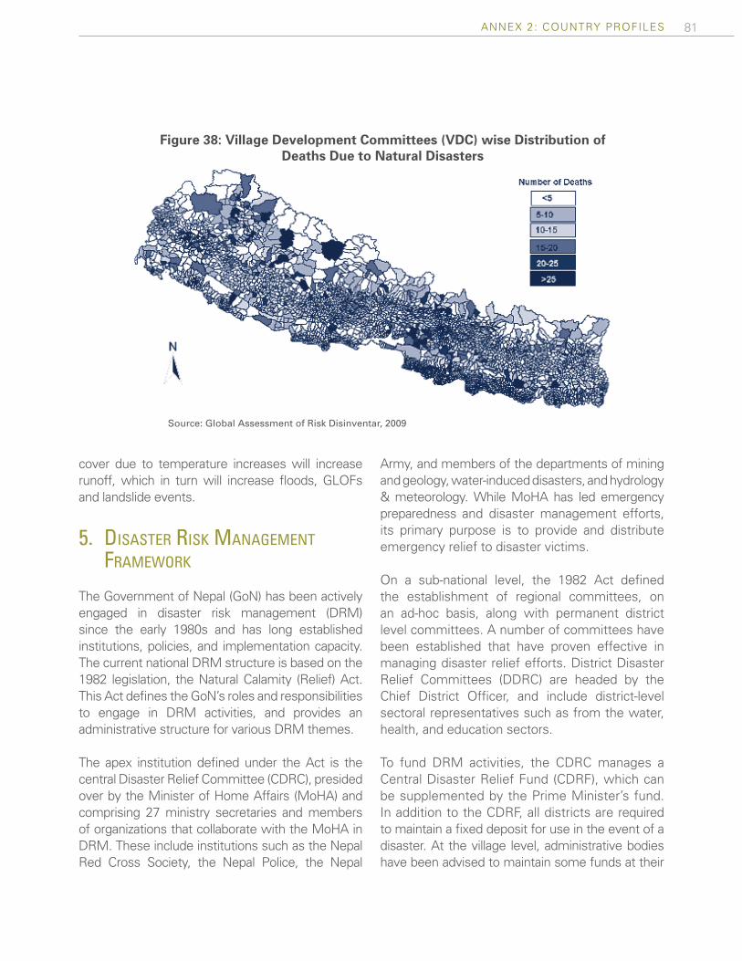
81ANNEX 2: COUNTRY PROFILES
cover due to temperature increases will increase runoff, which in turn will increase floods, GLOFs and landslide events.
5. dIsaster rIsk management framework
The Government of Nepal (GoN) has been actively engaged in disaster risk management (DRM) since the early 1980s and has long established institutions, policies, and implementation capacity. The current national DRM structure is based on the 1982 legislation, the Natural Calamity (Relief) Act. This Act defines the GoN’s roles and responsibilities to engage in DRM activities, and provides an administrative structure for various DRM themes.
The apex institution defined under the Act is the central Disaster Relief Committee (CDRC), presided over by the Minister of Home Affairs (MoHA) and comprising 27 ministry secretaries and members of organizations that collaborate with the MoHA in DRM. These include institutions such as the Nepal Red Cross Society, the Nepal Police, the Nepal
Army, and members of the departments of mining and geology, water-induced disasters, and hydrology & meteorology. While MoHA has led emergency preparedness and disaster management efforts, its primary purpose is to provide and distribute emergency relief to disaster victims.
On a sub-national level, the 1982 Act defined the establishment of regional committees, on an ad-hoc basis, along with permanent district level committees. A number of committees have been established that have proven effective in managing disaster relief efforts. District Disaster Relief Committees (DDRC) are headed by the Chief District Officer, and include district-level sectoral representatives such as from the water, health, and education sectors.
To fund DRM activities, the CDRC manages a Central Disaster Relief Fund (CDRF), which can be supplemented by the Prime Minister’s fund. In addition to the CDRF, all districts are required to maintain a fixed deposit for use in the event of a disaster. At the village level, administrative bodies have been advised to maintain some funds at their
Figure 38: Village Development Committees (VDC) wise Distribution of Deaths Due to Natural Disasters
Source: Global Assessment of Risk Disinventar, 2009

82 Disaster risk ManageMent in south asia: a regional overview
disposal. Finally, since 2008, municipal bodies have also been required to establish a relief and recovery fund in accordance with an amendment to the Local Self-Governance Act of 2007.
In 2008, based on the existing and functioning DRM structures, the GoN began to shift focus from an ex-post disaster response approach to ex-ante disaster risk mitigation activities. Guided by the principle of building resilience to hazards, and recognizing the need to build institutions capable of responding to large-scale disasters, the GoN passed a National Strategy for Disaster Risk Management (NSDRM) in 2008. The NSDRM serves as a guide for the transition towards a holistic approach to DRM, including a focus on risk identification, vulnerability reduction and improved preparedness and response capacity. Following this strategy, the GoN has embarked on the establishment of new institutional, legislative and policy frameworks for DRM. As part of the evolution to ex-ante DRM activities, the process to repeal the Natural Calamity Relief Act has been initiated.
The existing DRM structure faces several challenges, in particular, the fact that the current DRM approach is limited to a reactive approach to natural disasters. This constraint is being addressed in the NSDRM. Furthermore, the existing capacities and institutions are not realized to their full potential and enforcement legislation is lacking. Finally, there has been a lack of a broader awareness of the risks of natural disasters and possible response mechanisms, not only among the public, but also among government officials and public employees.
6. Progress towards hyogo framework for actIon
The Hyogo Framework for Action, adopted in 2005, represents the international consensus on how to monitor and evaluate capacity to manage natural disaster risk. The framework includes five priorities, which are listed below, along with a brief summary
of progress achieved by the GoN in increasing resilience to adverse natural events.
HFA Priority # 1: Ensure that disaster risk reduction is a national and a local priority with a strong institutional basis for implementation
The Natural Calamity (Relief) Act enacted in 1982 is primarily focused on post disaster relief and recovery. In 2008, the MoHA began revising this Act to move towards the formulation of a comprehensive Disaster Management Act. The MoHA has also initiated the development of a NSDRM covering all aspects of DRM. However the strategy is still not formally approved by the GoN and thus still remains a conceptual document.
In parallel to drafting new legislation, to advance the shift from ex-post to ex-ante, the MoHA has initiated a process to establish a multi-sectoral national platform. The platform includes representatives from concerned government agencies, UN agencies, donors, international and national NGOs, media, academic institutions, the private sector, and community based organizations.
The GoN allocates 2.5 billion Nepal rupees (US$36 million), which is approximately 1.5 percent of the total annual budget, for DRM activities. There is also a provision of Prime Minister Relief Fund and central Disaster Assistance Fund for Disaster Management. However these are primarily for relief and rescue activities, and resources for disaster risk reduction are not allocated on a priority basis.
The Local Self-Governance Act (1999) has given the authority and responsibility to the local government authorities, the District Development Committees (DDC), and the Municipalities and Village Development Committees (VDC) to design and implement DRM activities at the local level. However, there is no systematic and assured mechanism of resource allocation to the local authorities from the center.

83ANNEX 2: COUNTRY PROFILES
HFA Priority # 2: Identify, assess, and monitor disaster risks and enhance early warning
National and local level risk assessment is a new phenomenon in Nepal. There is no national level multi-hazard risk assessment covering regularly occurring disasters. However, there is a 37 year historical record of disaster occurrence and their impact available in Nepal, which is based on the “Desinventar” system, and is managed by National Society for Earthquake Technology (NSET).
Some work has begun to assess the impact of various hazard events, including GLOFs, floods and earthquakes. For example, international organizations such as the International Centre for Integrated Mountain Development (ICIMOD) have initiated a process to assess the socio-economic impacts of GLOFs and flash floods through case studies. In addition, the GoN has also established a seismic monitoring system within the Department of Mines and Geology.
There exists a body of scientific, engineering, and disaster preparedness experts that are engaged in monitoring natural hazards events and making early warning information accessible for a wider audience. In 2010, to support these efforts, the GoN began designing a comprehensive early warning system for hydro meteorological events, which is in the process of being installed and operationalized.
HFA Priority # 3: Use of knowledge, innovation, and education to build a culture of safety and resilience at all levels
A science-based DRM approach that seeks to identify hazard and understand vulnerability to these hazards has begun to take place in recent years. For example, the Department of Water Induced Disaster Prevention, the Nepal Red Cross Society, and other international NGOs have been collecting and disseminating national level information to
sensitize the population to disaster risk through data collection and dissemination. However, this effort is currently implemented on an ad-hoc basis as opposed to a systematic approach. This is due, in part, to the lack of a designated and functional central and district-level data clearing house that can collect, maintain, and disseminate information.
The current school curricula have a limited amount of information on DRM. In 2008, the secondary level of education curriculum incorporated information on DRM, with a focus on preparedness and response. Recently however, several international NGOs have been supporting the Ministry of Education to incorporate DRM into school curricula, teachers training on DRM, awareness building classes, and publication of various Information, Education and Communication (IEC) materials on seismic risk in Kathmandu.
HFA Priority # 4: Reduction of the underlying risk factors
Various line ministries are engaged in pilot programs to reduce disaster risk. In 2010, the GoN launched targeted initiatives in the areas of school earthquake preparedness and emergency response, which is managed by a consortium of actors. In addition, the Ministry of Health and NSET have initiated a pilot, non-structural vulnerability assessment of hospitals. Finally, the Ministry of Agriculture has been involved in vulnerability reduction activities such as drought risk reduction and food security, while also being in the early stages of developing agriculture insurance mechanisms.
Laws are in place, including the National Shelter Policy of 1996 and the National Urban Policy of 2007, which define land-use guidelines and building codes. Both these laws have been made compulsory in municipal areas; however, despite the legislation, there is a lack of implementation due to weak enforcement of the codes. As a result, unplanned urbanization and construction of unsafe houses is prevalent through the Kathmandu

84 Disaster risk ManageMent in south asia: a regional overview
Valley. Lack of management and planning of human settlement in the Valley has significantly increased the vulnerability of people to earthquakes because of the weak structural integrity of most buildings.
The National Disaster Management Plan, developed in 1993 and endorsed by the Government in 1996, emphasizes the need to match natural resource management, climate change, and development with disaster management. The new NSDRM is expected to combine these elements in order to holistically address the contributing factors of disaster risk. HFA Priority # 5: Strengthen disaster preparedness for effective response at all levels
A limited number of districts of Nepal had developed District Disaster Management Plans (DDMP) based on Geographic Information System (GIS) information. However, due to lack of coordination and technical capacity, these plans were not fully implemented and monitored. Furthermore , there is no early warning system in place for major hazards with outreach to disaster-prone communities. In a few localized areas, single hazard-oriented early warning systems are managed by the Department of Hydrology and Meteorology.
There is currently no systematic Disaster Impact Assessment carried out in the GoN. However, the proposed NSDRM seeks to mainstream Disaster impact Assessments across line ministries.
7. key donor engagements
A. World Bank and Key Multilateral and Bilateral Investments
Nepal’s Interim Strategy Note (ISN) for FY 2012-2013 recognizes the importance of ‘reducing vulnerability and increasing resilience’ and its commitment to actively engage in disaster risk management activities. The Bank is dedicated to helping Nepal manage disasters, particularly floods and earthquakes, and to continue non-lending technical assistance for DRM initiatives. The Bank further commits to exploring project support aimed at reducing disaster risks through collaboration with GFDRR.
In addition, the Bank has committed to participating in the Nepal Risk Reduction Consortium (NRRC), an initiaitive launched by the GoN and a group of international organizations working to promote the UN International Strategy for Disaster Reduction (ISDR) in 2009. NRRC exists to bridge the spectrum of development and humanitarian partners in order to support the GoN in taking action to implement long term DRM. The members of the NRRC include the Asian Development Bank (ADB), the International Federation of the Red Cross and Red Crescent Societies (IFRC), the United Nations Development Program (UNDP), the UN Office for the Coordination of Humanitarian Affairs (OCHA), the UN International Strategy for Disaster Reduction (ISDR), AusAid, the Department for International Development (DFID), the Humanitarian Aid Department of the European Commission (ECHO),
Table 10: World Bank and Key Multilateral and Bilateral Investments in Nepal’s DRM Sector
Project Year approved
Year closed Funding agencies Project volume
(USD)HFA
priorities
Building Resilience to Climate Related Hazards
2012 OngoingWorld Bank/Climate Investment Fund
25,000,000 2,4,5

85ANNEX 2: COUNTRY PROFILES
Japan International Cooperation Agency (JICA) the World Health Organization (WHO), and the World Bank /GFDRR.
The NRRC has developed a Disaster Risk Reduction Action Plan that builds on the GoN National Strategy for Disaster Risk Management. Based on consultations with key stakeholders to identify disaster risk reduction priorities that are urgent and viable, five flagship areas were identified and proposed: 1) School and Hospital Safety, 2) Emergency Preparedness and Response, 3) Flood Management in the Kosi River Basin, 4) Community Based Disaster Risk Management, and 5) Policy/Institutional Support for DRM.
The World Bank has taken a leading role in coor-dinating Flagship 3: Flood Management in the Kosi River Basin. The Kosi River Basin is the biggest river basin in Nepal and flooding in the Kosi severely impacts communities in Nepal as well as across the border in Bihar, India. Managing water induced disasters, primarily floods, is a priority for the government with both short and long term goals. The short term goals focus on enhancing institutional capabilities towards flood management while the long term goals focus on implementing effective flood mitigation measures. In its role, the World Bank continues to assist the GoN with flood risk assessments, structural risk mitigation, the development of flood forecasting models and early warning systems, and the strengthening of institutional capacity to manage floods.
B. GFDRR
The GFDRR has been engaged in ex-ante DRM activities since 2007. The overarching objective of these engagements is to help advance the GoN’s efforts to meet the Hyogo Framework for Action. Engagements are based around providing assistance to support the shift from ex-post to ax-ante DRM activities, including the initial foundation for a potential risk transfer mechanism for farmers. The table below summarizes approved and ongoing activities financed by GFDRR.
Over the next two years, GFDRR will support the Nepal Disaster Risk Management Country Program. In particular, the focus of the program is to build capacity within the GoN, in addition to investing in risk identification, awareness, and mitigation activities to enhance resilience to disasters. In particular, the program components include: 1) Institutional Strengthening and Building Technical Expertise, 2) Flood Management Project – Kosi River Basin, 3) Enhancing Emergency Response Capacity, 4) Enhancing Weather Forecast for Disaster Preparedness, 5) School and Hospital Emergency Planning and Safety Initiative, and 6) Support for Nepal Disaster Risk Management Flagship Program. These activities are being coordinated through partnerships with members of the NRRC as well as the GoN.
Table 10: World Bank and Key Multilateral and Bilateral Investments in Nepal’s DRM Sector
Project Year approved
Year closed Funding agencies Project volume
(USD)HFA
priorities
Building Resilience to Climate Related Hazards
2012 OngoingWorld Bank/Climate Investment Fund
25,000,000 2,4,5
Table 11: GFDRR Investments in Nepal’s DRM Sector
Project Year approved
Year closed
Funding agencies
Project Size (USD)
HFA priorities
Nepal: Agricultural Insurance Feasibility Study 2008 2010 GFDRR 159,000 2,4,5
Hazard Risk Management Program Nepal 2008 2011 GFDRR 914,000 2
Nepal Disaster Risk Management Country Program 2010 Ongoing GFDRR 1,800,000 2, 3, 4, 5
Pilot Program for Seismic School Safety in the Kath-mandu Valley
2010 Ongoing PHRD 1,500,000 3, 4

PakIstan

87ANNEX 2: COUNTRY PROFILES
Figure 40: Percentage Distribution of Reported Disasters in Pakistan
(1970-2009)
1 Estimates the probability (in percent) of annual economic losses exceeding specific amount of USD (in USD Million). The last column shows the probable annual economic loss as percent of GDP.
Landslides
15%
Cyclones 15%Droughts 1%
Earthquakes
18%
Floods 51%
Figure 41: Average Annual Economic Loss of Pakistan
Earthquakes
67%
Floods 33%
Disaster statistics (1970-2009)
Disaster type
No ofdisaster
total
No. ofcasualties
No. of affected people
Total Annualavg Total Anual
avgEarthquake 21 79,000 2,000 6.6 M 168,000
Flood 59 9,000 230 42 M 1.1 M
Drought 1 145 ,4 2.2 M 56,000
Landslide 17 580 15 3,600 95
Cyclone 17 1,450 40 2.2 M 37,000
Total 115 90,000 2,300 53 M 471,000
Source: EM-DAT 2010, accumulated figures
Economic loss potential 1 Annual exceedance
probabilityEconomic loss(USD Million)
Percentage of GDP
0.5% 4,024 3.17%
5% 1,258 0.99%
20% 382 0.30%
Source: RMSI 2010 (based on 1967-2006
Country level information Geographic Area (in sq km) 796,100
Population (in Millions) 166
Population Density (person per sq km) 215
Urban population (% of total population) 36
Arable land (% of total area) 27
Forest land (% of total area) 2.3
HDI country rank (out of 182) 141
GNI per capita (ATLAS method, in USD) 980
Agriculture, value added (% of GDP) 20
Industry, value added (% of GDP) 27
Services etc., value added (% of GDP) 53
Source: WDI, (2007, 2008), HDI (2007), UNICEF (2008), FAO (2007)
PaKIsTan 1
1
Figure 39: Map of Pakistan
PAKISTAN

88 Disaster risk ManageMent in south asia: a regional overview
1. dIsaster and clImate rIsk ProfIle
Disaster Risk Profile
Pakistan’s diverse geography exposes it to a large number of hazards, and the highly dense population that often resides in disaster prone areas makes the country highly vulnerable to adverse natural events. Flood events have been the most recurrent and have had the greatest impact, while earthquakes have happened less often but caused significant concentrated damages. Total deaths over the past 40 years exceed 90,000, and total recorded losses from disaster amount to US$20 billion, including the $10 billion in losses caused by the 2010 flood, and US$5 billion by the 2005 earthquake. Losses from another major flooding event in 2011 are being quantified by the ongoing Damage and Needs Assessment.
The country’s large size and location between the Himalayas to the north and the coast of the Arabian Sea to the South, give rise to its very distinct physiographic zones. The notable zones are the Northern Highlands, encompassing among others the Hindu Kush, Karakoram Range, and Himalayas, the Indus plain, and the Balochistan plateau. Earthquake exposure is very high in the northern region, while flood exposure is high throughout the country, due to the runoff from the mountain rivers and the monsoon rain season. The generally temperate climate varies between mostly arid and semi-arid areas, a warm, humid maritime climate along the coast, and a temperate alpine climate in the Karakoram ranges.
Pakistan has experienced a wide range of major disasters in the past 40 years. The country is one of the most flood prone in South Asia, and a number of floods have caused significant damage, particularly during 1950, 1992, 1998, 2010, and 2011. Major earthquakes occur with high relative frequency, with the last major event occurring in 2005, that killed 73,000 and caused US$5 billion in losses. Other major earthquakes over the past 40 years occurred in 1990, and in 1974. Most of Pakistan experiences low rainfall
and as much as 60 percent of the country is classified as semi-arid to arid, with the most susceptible regions experiencing drought 2 or 3 years every decade. Recent droughts include those of 2000 and 2002, which severely impacted livelihoods and forced thousands to migrate. Additionally, 14 cyclones have occurred over the past 40 years. These events can be especially impactful in the coastal areas, because the low-lying coastal belt allows storms to travel several hundred kilometers inland and, along the way, destroy crops and livelihoods.
Several underlying risk factors cause natural hazards to be potentially devastating in Pakistan. With a dense population, situated in areas subject to multiple hazards, most assets are not constructed to be resilient to major events. Additional risk factors contributing to Pakistan’s vulnerability include limited enforcement of existing building codes, weak early warning systems, and a lack of awareness and education on disasters and response.
Climate Risk Profile
Climate change could increase Pakistan’s vulne-rability to natural disasters. This phenomenon in Pakistan is expected to increase glacial melt, raise the sea level along Pakistan’s coast, and increase periods without precipitation. Increased glacial recession, estimated by some to be around 400 meters a year in the present and near future, will result in less water inflow to the Indus river basin. These factors may lead to increased intensity and frequency of flash flood and especially drought events that could compromise potable water supply, irrigation water, and power generation.
2. dIsaster rIsk management framework
Pakistan’s National Disaster Risk Management Framework (NDRMF) seeks to build and strengthen linkages with all applicable national and international protocols and sectorial developmental policies. At
89ANNEX 2: COUNTRY PROFILES
the national level, these include, inter alia, the Poverty Reduction Strategy Paper (PRSP), the Medium Term Development Framework 2006-10, or the Ten Year Perspective Development Plan 2001-11.
As a consequence of the 2005 earthquake, the GoP has made concerted efforts towards establishing a comprehensive disaster management regime. This has involved a strategic shift from the previous reactive to a proactive approach. To implement this proactive strategy, an integrated management structure has been set up that links the vital functions of preparedness/risk reduction and early recovery to longer term reconstruction and rehabilitation.
In 2006, the 1958 Calamity Act, which historically governed disaster response and recovery activities, was replaced by the National Disaster Management Ordinance (NDMO). The NDMO provides the institutional and regulatory framework for the functioning of the new proactive national DRM regime, including all federal, provincial, and local government institutions tasked with disaster management responsibilities.
Under the 2006 NDMO, the National Disaster Management Authority (NDMA) was established and has become operational. The NDMA is the national coordinating agency for disaster risk reduction and, together with the Earthquake Reconstruction and Rehabilitation Authority (ERRA), it is responsible for the all aspects of DRM from risk identification and mitigation to post-disaster recovery and reconstruction. The NDMA serves as a secretariat to the National Disaster Management Commission (NDMC), which is chaired by the Prime Minister and includes representatives from various federal ministries and provincial governments. The NDMA is tasked with coordination of all disaster risk management activities in the country. At the sub-national levels, the Provincial Disaster Management Authorities (PDMAs) and District Disaster Management Authorities (DDMAs) are mandated with undertaking disaster management functions. Recent developments include the creation of a Ministry of Climate Change, to coordinate all
disaster- related agencies and activities, and passage of the 18th Constitutional Amendment by Pakistan’s Parliament, which devolved some powers to the provinces, including overall responsibility to prepare for and respond to disaster.
The NDRMF, developed through a broad consultative process led by the NDMA, calls for the integration of risk assessment in the planning and design stages of all new infrastructure projects. The Framework holds the promotion of multi-stakeholder, multi-sectoral, and multidisciplinary approaches in disaster risk reduction as its foremost policy principle in order to effectively mainstream DRM into development planning. The projected impacts of global climate change are integrated into the Framework to help the GoP increase resilience to these emerging challenges, and builds on analytical work and studies carried out by various national and international agencies.
Significant progress in implementing the DRM agenda has been inhibited mostly by a lack of capacity within the government, particularly at the sub-national levels. The disaster risk agenda has not received sufficient resources to make significant progress. Compounding this constraint is the lack of dedicated professional staff at the disaster management authorities at the federal, provincial, and district levels. Finally, the limited progress on undertaking hazard risk assessments and limitations in collection and sharing of risk data has led to the absence of a comprehensive understanding of the overall risks and required mitigation interventions.
3. Progress towards hyogo framework for actIon
The Hyogo Framework for Action, adopted in 2005, represents the international consensus on how to monitor and evaluate capacity to manage natural disaster risk. The framework includes five priorities, which are listed below, along with a brief summary of progress achieved by the GoP in increasing resilience to adverse natural events.
90 Disaster risk ManageMent in south asia: a regional overview
HFA Priority # 1: Ensure that disaster risk reduction is a national and a local priority with a strong institutional basis for implementation
The NDM Act, which was approved in 2010 by the national legislature and supersedes the NDMO 2006, provides the legal framework for DRM in Pakistan. It outlines the creation of appropriate institutions at the national, provincial, and district levels. A policy making body, NDMC, and the national authority, the NDMA, have been established along with the creation of Provincial, and District authorities. In addition to the legal and organizational institutions that have been established, the NDRMF provides a national road map for institutional capacity building and identifying responsibilities of stakeholders.
The National Disaster Management Fund (NDMF), to which the GoP contributed PKR 300 million as an initial grant, is envisaged as a reserve fund to help the government deal with disasters. However, the fund has not been able to take off as planned, largely due to the absence of approved procedures. At the provincial level, some Provincial Disaster Management Authorities (PDMA)s are also trying to establish their own provincial funds for DRM. Additional funding is made available in the event of a catastrophe through the President’s and Prime Minister’s Relief Fund, which provided support after the 2005 earthquake and the floods of 2010.
HFA Priority # 2: Identify, assess, and monitor disaster risks and enhance early warning
Identified as a priority under the NDRMF, the NDMA has launched the National Working group (NWG) on risk assessments which would coordinate, collate, and provide strategic guidance to all risk assessments in the country. NDMA is also working with various partners on multi-hazard risk assessments and mapping forward in Pakistan. Local level risk assessments are also conducted by a number of stakeholders on a city and district level.
While data collection and sharing is at times constrained, a reasonably well-functioning national
system for collecting, archiving, and disseminating data on hydro-meteorological hazards is available through the Pakistan Meteorological Department. The same still needs to be put in place for all remaining hazards along with a compatible platform.
The GoP is building its capacity for the monitoring and warning of floods. An institutionalized process, managed by the Meteorological Department, ensures dissemination of flood early warnings to national stakeholders providing input to vulnerable communities using multiple channels. In addition, to strengthen tsunami early warning systems, the NDMA has initiated a project, with support of international donors, to strengthen capacities at National Tsunami Warning Centers in Karachi and Islamabad.
HFA Priority # 3: Use of knowledge, innovation, and education to build a culture of safety and resilience at all levels
To improve technical DRM capacity, the NDMA worked with the Ministry of Education to develop a strategy to integrate DRM in the education curricula. As a result, DRM themes are in the process of being integrated into primary and secondary level education in order to improve awareness. At the tertiary level, specialized courses in DRM are being offered at private and public universities. In addition, the NDMA is working on the integration of DRM themes into the training academies for civil servants, such as the National School of Public Policy.
To improve the capacity of DRM professionals, the National Institute for Disaster Management (NIDM) was established to provide state of the art facilities for planning and promoting training and research and developing core competencies in the area of DRM. The Institute will also document and develop national level information databases on DRM policies, documentation, and prevention mechanisms.
To increase awareness of DRM themes amongst the general population, the GoP has initiated a

91ANNEX 2: COUNTRY PROFILES
number of activities. First, it has declared October 8 (the day of the 2005 earthquake) as a national disaster awareness day. Second, the NDMA has conducted community awareness programs in the coastal areas of Pakistan, including mock evacuation drills during tsunamis. The NDMA has also conducted awareness raising programs in earthquake prone areas to increase preparedness, response, and recovery capacity. Finally, the NDMA works with different media groups to develop public DRM awareness through various media outlets.
HFA Priority # 4: Reduction of the underlying risk factors
Given the high vulnerability of the agricultural sector to hazards, the GoP directed the Ministry of Agriculture to analyze the sector’s vulnerability to natural disasters and to develop mitigation and prevention mechanisms. As a result, the Ministry developed early warning systems, encouraged contingency crop planning and diversification, and promoted supplementary off-farm and non-farm activities for income generation. The GoP is also piloting an insurance program to cover crops from adverse natural events in selected districts.
To safeguard industrial and productive activities from the impact of natural disasters, the Ministry of Industries and Special Initiatives has developed DRM strategies. Among these, the Ministry created guidelines for the industrial sector to ensure the safety of industry and its production processes in hazard-prone areas. It has also created incentives and disincentives for industries to implement disaster safety measures, awareness raising programs, and vulnerability reduction activities.
Following the 2005 earthquake, the GoP placed a high priority on enforcing building codes for safer construction against natural disasters, and housing reconstruction followed a strict earthquake resistant building technique. To promote the construction of disaster resilience structures across the country, the National
Building code is currently being updated to include seismic provisions as an integral part of the code. Similar to the rest of the region, enforcement of the code will likely pose a significant challenge, requiring a certain capacity and skillset from the concerned agencies for proper implementation.
HFA Priority # 5: Strengthen disaster preparedness for effective response at all levels
The NDMA is working on a number of initiatives to develop disaster preparedness and response capacities. These include the development of a national disaster response plan, the establishment of emergency operations centers, and contingency planning for key hydro-meteorological hazards. In addition, search and rescue teams for urban areas and districts as well as some communities are being established, trained, and equipped. To further increase response capacity, the NDMF has been established and will be used to meet the expenses of DRM activities. Apart from the NDMF, disaster relief funds are also available under the Prime Minister’s Disaster Relief Fund. Finally, there are province level resources available to respond to disasters through the Chief Minister’s Relief Fund. However, further work is required to systematically distribute relief funds to disaster affected areas.
4. key donor engagements
A. World Bank and Key Multilateral and Bilateral Investments
The World Bank’s current Country Assistance Strategy (CAS) 2010-2014, is committed to supporting the government in the development of a comprehensive hazard risk management strategy through dialogue, advisory activities, and technical assistance. The CAS supports the outcome of improvement in Pakistan’s disaster risk management capacity under the sustainable development strategic pillar. Through the CAS, the Bank is working to support the GoP’s paradigm shift in DRM, in which the Government has moved from a predominantly reactive approach

92 Disaster risk ManageMent in south asia: a regional overview
to a more pro-active engagement to reduce the impact of adverse natural events. While the CAS acknowledges advances made in the promotion of effective DRM strategy, it also underlines the various challenges remaining, including a general lack of awareness and the limited in-country technical capacity. The current constraints to the efficient operation of DRM systems and response mechanisms are also highlighted, while the national risk environment has not yet been identified and analyzed. The CAS also presents the current and ongoing activities and some of the broad planned interventions by the Bank in order to support effective DRM in the country.
In particular, the Bank has launched the Balochistan Disaster Risk Management Project in FY12 to help support DRM initiatives in Pakistan’s largest and highly vulnerable province. The objective of this project is to strengthen the capacity of the Provincial Disaster Management Agency of Balochistan (PDMA Balochistan) to prepare for and respond to natural disasters. In particular, the project focuses
on supporting PDMA Balochistan in strengthening institutional disaster risk management capacity and emergency response systems, developing a hazard and risk assessment in the provincial capital, and supporting PDMA Balochistan in establishing and piloting a CBDRM program to engage local communities on risk management activities and guide initiatives to improve DRM awareness. In addition, the project includes a contingent emergency response component. In the event of a natural disaster in Balochistan, critical emergency response and recovery costs in the Province may be supported through this component upon activation.
Additionally, the Bank is implementing a US$ 3 million programme financed by Government of Japan’s Policy and Human Resources Development (PHRD) fund to develop appropriate methodologies and guidelines for assessing and subsequently enhancing the multi-hazard early warning systems and the disaster response capacities of urban local authorities in two pilot cities.
Table 12: World Bank and Key Multilateral and Bilateral Investments in Pakistan’s DRM Sector
Project Year approved Status Funding
agenciesProject volume
(USD)HFA
priorities
Earthquake Emergency Recovery Credit
2006 Closed World Bank 400,000,000 1,4
Earthquake Recovery Credit II 2008 Closed World Bank 125,000,000 1,4
One UN DRM Programme 2008 Ongoing ONE UN 9,000,000 1,2,3,4,5
Project for National Disaster Management Plan
2010 Ongoing JICA 4,400,000 1,2,3,5
Pakistan flood emergency cash transfer project
2011 Ongoing World Bank 125,000,000 5
Balochistan Disaster Management Project
2012 Ongoing MDTF 5,000,000 1,2,3

93ANNEX 2: COUNTRY PROFILES
B. GFDRR
The table below sets out the GFDRR investments in DRM since 2007. The majority of the investments have been focused on ex-post support to post-disaster reconstruction, with a key objective of analyzing the lessons learned. The current operation, Development of Hazard Risk Assessment in Urban Areas is focused on improving the GoP’s understanding of the hazards
and vulnerabilities to adverse natural events. Another project has been approved by GFDRR for provision of support to the NDMA and other key government counterpart agencies in developing a national risk assessment platform and provision of recommendations for a comprehensive approach to financing disaster risk.
Table 13: GFDRR Investments in Pakistan’s DRM Sector
Project Year approved
Year closed
Funding agencies
Project volume (USD)
HFA priorities
Building capacity to effectively deliver Safety Nets in post-disaster situations in Pakistan
2008 2009 GFDRR 250,000 4,5
Results and Lessons in the Rural Housing Reconstruction Response to the 2005 Pakistan Earthquake
2008 2011 GFDRR 230,000 2,3,4
Flood Emergency Preparedness in Pakistan 2010 2011 GFDRR 280,000 2,3,4,5
Pakistan Floods DNA 2011 2011 GFDRR 550,000 5
Pakistan Development Forum 2011 2011 GFDRR 150,000 1,2,3,4,5
Development of a Program for Hazard and Risk Assessment in Urban Areas
2011 Ongoing GFDRR 500,000 2,3,4,5
Strengthening Pakistan's Urban Disaster Response Capacity
2012 Ongoing PHRD 3,000,000 2, 3, 4
Development of a National Platform for Risk Assesment and Cat Risk Financing Mechanisms
2012 Ongoing GFDRR 500,000 4

srI lanka

95ANNEX 2: COUNTRY PROFILES
sRI lanKa
Figure 43: Percentage Distribution of Reported Disasters in Sri Lanka
(1970-2009)
Figure 44: Average Annual Economic Loss of Sri Lanka*
1 Estimates the probability (in percent) of annual economic losses exceeding specific amount of USD (in USD Million)The last column shows the probable annual economic loss as percent of GDP.
* Insufficient economic Loss Data for other hazards.
Landslides
5%
Cyclones 6% Droughts 13%
Tsunami 1%
Floods 74%
Floods 100%
Figure 42: Map of Sri Lanka
Disaster statistics (1970-2009)
Disaster type
TotalDisaster
TotalCasualties
Total Affected People
Total Annual Total Annual Earthquake 1 35,000 - 1 M -
Flood 45 950 24 9.7 M 248,000
Drought 8 - - 6.3 M 56,000
Landslide 3 120 3 130 3
Cyclone 4 755 19 1.4 M 37,000
Total 61 37,200 954 18.4 M 471,000
Source: EM-DAT 2010, accumulated figures
Economic loss Potential 1 Annual Exceedance
ProbabilityEconomic Loss
(USD Million)Percentage
of GDP0.5% 275 1.02%
5% 107 0.40%
20% 39 0.14%
Source: RMSI 2010 (based on 1967-2006
Country Level Information Geographic Area (in sq km) 65,610
Population (in Millions) 20.85
Population Density (person per sq km) 312
Urban population (% of total population) 35
Arable land (% of total area) 15
Forest land (% of total area) 28
HDI country rank (out of 182) 97
GNI per capita (ATLAS method, in USD) 2240
Agriculture, value added (% of GDP) 11.2
Industry, value added (% of GDP) 29
Services etc., value added (% of GDP) 59.5
Source: Source: Sri Lanka Central Bank Report 2011, FAO (2007)
SRI LANKA

96 Disaster risk ManageMent in south asia: a regional overview
1. dIsaster rIsk ProfIle
Main Sources of Risk
The impacts of natural disasters have been sizable over the past four decades, particularly those of flood and drought. Floods have cumulatively affected more than 10 million people, while droughts have affected more than six million. Droughts occur three to four times a decade and have caused economic setbacks. Though less frequent, cyclones have had significant impacts, such as the 1978 cyclone that impacted over one million people and caused one thousand fatalities.
Sri Lanka’s geographic and climatic diversity exposes it to a number of risks from natural hazards, with the majority of hazard events being flood, drought, and cyclone. The mountain massif in the south-central part of the island divides the landscape into three distinctive zones - the central highlands, the plains, and the coastal
belt. This geography creates an uneven spatial and temporal distribution of rain, which exposes a significant portion of the island to flood and drought risk. Weather patterns are driven by the monsoon, with the southwest monsoon causing severe flooding in the Western, Southern and Sabaragamuwa provinces, and the northeast monsoon causes flooding in the Eastern, Northern, and North-Central provinces. The monsoon also exposes the country to drought risk, particularly in the southeastern, northern, north central, and northwestern regions. Originating from the Bay of Bengal, mostly during northeast monsoon, the north and eastern seaboards are exposed to cyclone risk. Sri Lanka is also exposed to landslides in the hilly central highlands. Figure 45 below provides a visualization of the various hazards Sri Lanka is exposed to.
Relative to its small size and concentrated economic activities, disaster incidence is high in Sri Lanka. Nearly 500,000 people are affected every year by disasters, and annual losses average
FloodsPeople Affected
LandslidesHouses Destroyed
CyclonesHouses Destroyed
DroughtCrop Losses (Ha)
www.desinventar.lk
Figure 45: Hazard Profile of Sri Lanka

97ANNEX 2: COUNTRY PROFILES
approximately US$50 million. Vulnerability to adverse natural events is significant due to high population density and concentrated economic activities in flood prone and coastal areas. This vulnerability is compounded by unplanned patterns of human settlement, economic development, and poor land-use planning. These human activities have resulted in severe encroachments not only into flood plains, but also, unstable slopes. A substantial number of conflict-related, newly resettled people, especially in the Northern Province, compound Sri Lanka’s vulnerability to disasters.
Potential impact of climate change
The 4th Assessment Report of the IPCC shows that climate change could impact Sri Lanka through increases in temperature and rainfall variability. By 2100, temperatures are projected to increase by 2.5°C, and mean rainfall is projected to change by 7 percent, with almost all models
showing a decrease in rainfall compared to historical records, with accompanying changes in the spatial distribution of rainfall.
Sri Lanka’s communication report to the UNFCC shows that extreme events across Sri Lanka are expected to increase in the future, leading to an increase in three risks. First, climate change could increase losses caused by floods and droughts, posing risks to economic productivity and human health due to more intense and frequent flooding and to higher frequency and duration of droughts. Second, landslide losses, which have been increasing over the past two decades, are expected to continue increasing due to greater soil saturation during extreme rainfall events. Third, the coastal population of Sri Lanka, representing 32 percent of the total population, is increasingly exposed to coastal hazards, both in terms of frequency and magnitude.
Figure 46: National Council for Disaster Management
Source: Road Map for Sri Lanka, 2005
Social Services
Rehabilitation and Reconstruction
Home Affairs
Health
Science and Technology
Housing
Coast Conservation
Irrigation
Power
Defense
Police
Finances
Land
Fisheries and Aquatic Resources
ForeignAffairs
Water Supply
Highways
Urban Development
Education
Environment
Chief Ministers
Opposition MPS
Ministry of Disaster Management
Disaster Management Centre
NatioNal CouNCil for DiSaSter MaNageMeNt
Chairman: H.E. PresidentVice Chair: Hon. Prime Minister
Leader of the Opposition
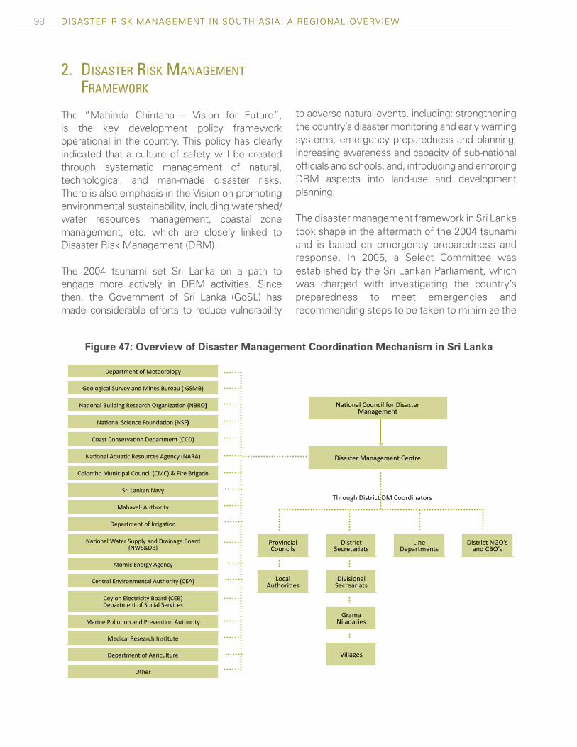
98 Disaster risk ManageMent in south asia: a regional overview
2. dIsaster rIsk management framework
The “Mahinda Chintana – Vision for Future”, is the key development policy framework operational in the country. This policy has clearly indicated that a culture of safety will be created through systematic management of natural, technological, and man-made disaster risks. There is also emphasis in the Vision on promoting environmental sustainability, including watershed/water resources management, coastal zone management, etc. which are closely linked to Disaster Risk Management (DRM).
The 2004 tsunami set Sri Lanka on a path to engage more actively in DRM activities. Since then, the Government of Sri Lanka (GoSL) has made considerable efforts to reduce vulnerability
to adverse natural events, including: strengthening the country’s disaster monitoring and early warning systems, emergency preparedness and planning, increasing awareness and capacity of sub-national officials and schools, and, introducing and enforcing DRM aspects into land-use and development planning.
The disaster management framework in Sri Lanka took shape in the aftermath of the 2004 tsunami and is based on emergency preparedness and response. In 2005, a Select Committee was established by the Sri Lankan Parliament, which was charged with investigating the country’s preparedness to meet emergencies and recommending steps to be taken to minimize the
Figure 47: Overview of Disaster Management Coordination Mechanism in Sri Lanka
Department of Meteorology
geological Survey and Mines Bureau ( gSMB)
National Building Research Organization (NBRO)
National Science Foundation (NSF)
Coast Conservation Department (CCD)
National Aquatic Resources Agency (NARA)
Colombo Municipal Council (CMC) & fire Brigade
Sri lankan Navy
Mahaveli Authority
Department of Irrigation
National Water Supply and Drainage Board (NWS&DB)
atomic energy agency
Central Environmental Authority (CEA)
Ceylon electricity Board (CeB) Department of Social Services
Marine Pollution and Prevention Authority
Medical Research Institute
Department of agriculture
Other
Provincial Councils
local Authorities
District Secretariats
Divisional Secreariats
grama Niladaries
Villages
line Departments
District Ngo’s and CBo’s
National Council for Disaster Management
Disaster Management Centre
Through District DM Coordinators

99ANNEX 2: COUNTRY PROFILES
damage caused by similar events. Based on the Select Committee’s recommendations, the Sri Lanka Disaster Management (DM) Act, No. 13 of 2005, was enacted in May 2005. Under this Act, the National Council for Disaster Management (NCDM), chaired by the President and vice-chaired by the Prime Minister, was established as the apex body for DRM coordination and monitoring in Sri Lanka.
The Ministry of Disaster Management was empowered as the leading ministry, and the Disaster Management Center (DMC) was established as the executing agency for DRM, responsible for implementing the directives of NCDM. Since the Act was created, the DMC has become the national level nodal agency responsible for coordinating all aspects of DRM, from disaster risk mitigation policies and plans, to damage assessments and post-disaster reconstruction. The Center has also promoted collaboration between local level DRM programs and has guided their development to ensure alignment with sector development programs.
The Sri Lanka DRM framework is based on two aspects of managing disaster risk, in addition to ongoing efforts to streamline the roles and responsibilities of the DMC. These include: 1) Risk Management, which entails risk evaluation, disaster preparedness and emergency response and recovery, and 2) Early Warning Systems, which involves the capture of risk and hazard early warning information, the evaluation of the intensity of events, and the communication of major warnings to various stakeholders. A mechanism for monitoring and evaluation, which includes agreement on specific risk reduction indicators, and the means of gathering information, is being improved to deliver early warnings and guide evacuation more effectively.
Advances in reducing vulnerability have been made through enhanced emergency preparedness, increased disaster awareness and improved land use planning. National early warning systems for rainfall, tsunami, cyclone, landslide, and sea surge
hazards are being developed, and some have been made operational at the community level. To increase disaster awareness, training programs have been launched for district level officials, school children and vulnerable communities. To improve land use planning, hazard maps for landslides and coastal hazards have been developed.
While progress has been made since the 2004 tsunami to improve institutional capacity to engage in DRM, challenges remain, which were highlighted in the Interim HFA Progress Report of 2008 and 2011. Gaps exist in the technical capacity of the agencies to implement a fully fledged national DRM plan. In addition, the legal and policy provisions to implement and to enforce the national DRM plan must continue to improve over time
3. Progress towards hyogo framework for actIon
The Hyogo Framework for Action, adopted in 2005, represents the international consensus on how to monitor and evaluate capacity to manage natural disaster risk. The framework includes five priorities, which are listed below, along with a brief summary of progress achieved by the GoSL in increasing resilience to adverse natural events.
HFA Priority #1: Ensure that disaster risk reduction is a national and a local priority with a strong institutional basis for implementation
A legal framework, with a supporting institutional structure, was put in place in 2005. The Sri Lanka Disaster Management (DM) Act, No. 13 of 2005, was enacted in May 2005. As directed by the Act, the NCDM was established as the apex body for DRM policy decisions and oversight. The Ministry of Disaster Management was empowered as the leading Ministry, and the DMC was established to implement the directives of NCDM. The DMC has been leading discussions with the Ministry of Local Government to include DRM in the local

100 Disaster risk ManageMent in south asia: a regional overview
government policy document approved by the Cabinet of Ministers. The Ministry has accepted the amendments suggested by the DMC for the new Act, which is currently under development.
Complementing the new institutional framework, the National Disaster Management Coordinating Committee (NDMCC), Sri Lanka’s national DRM platform that comprises 60 members representing state and private sector agencies, NGOs, and other stakeholders, has met regularly since 2007. The NDMCC has proved to be effective especially in disaster response and relief. The DMC is in the process of developing a common work program for the NDMCC reflecting the DRM activities of the stakeholder agencies for the next two years and this effort is expected to avoid duplication of DRM efforts by different stakeholder agencies.
To continue advancing DRM, there remain three broad challenges. First, coordination with the various line departments engaged in DRM activities — such as the Ministry of Irrigation & Water Management and the Ministry of Agricultural Development for Flood Risk Management — remains weak. Second, preparation of DRM plans for government agencies, as required by the DM Act, has been delayed because approval from the National Council for the National Disaster Management Plan has not yet been obtained. Finally, there has been inadequate institutional capacity within the ministries and district administrations to manage the resources mobilized for disaster response and recovery programs.
HFA Priority #2: Identify, assess, and monitor disaster risks and enhance early warning
Preliminary hazard mapping has been undertaken throughout Sri Lanka. The DMC has started developing a multi-hazard risk profile for Sri Lanka. Through this effort, relevant technical agencies are being supported to develop hazard profiles of five main hazards, which include landslides, coastal hazards, cyclone, floods, and drought, which are expected to be completed by
December 2012. Local level hazard maps have been prepared by communities affected by the 2004 tsunami as well as the communities highly vulnerable to floods and landslides. Community level hazard maps have been created for approximately 100 communities, and guidelines have been developed for the preparation of hazard maps at the village level.
In addition, a comprehensive Sri Lanka Disaster Information System (DesInventar), which records historic disaster losses, is being maintained and is available online at www.desinventar.lk. A system has been established at national level to regularly update Desinventar.
Strengthening of the early warning systems has been a key priority since the Act was approved, and improvements have been made in monitoring and dissemination. To improve data collection and analysis, the Department of Meteorology is in the process of installing a Doppler Weather Radar System that will improve short-term heavy rain forecasting. To improve dissemination and augment connectivity across the country, a total of 74 Early Warning Towers with satellite communication packages have been made operational along the coastal belt. In addition, a VHF and HF Radio Communication System has been established linking 10 highly disaster prone districts. To ensure effective dissemination of emergency messages, the DMC has established a system with Dialog GSM, a leading mobile telecom company having a customer base of over seven million, for disseminating disaster early warning through SMSs and Cell Broadcasting. HFA Priority #3: Use of knowledge, innovation, and education to build a culture of safety and resilience at all levels
The GoSL has supported the development and execution of disaster awareness campaigns across Sri Lanka. To improve DRM awareness among the population, the DMC engages in national and local level exhibitions to present

101ANNEX 2: COUNTRY PROFILES
the message of disaster resilience to the public. Several media tools have been produced to raise public awareness in relevant communities such as, inter alia, cartoons, films and booklets, computer games, and posters on different hazards.
Education programs have been developed across the education spectrum, from grade schools to universities. District level school DRM awareness and training programs, with special focus on 2004 tsunami were conducted along the coastal belt and mock drills were practiced in all schools identified as being vulnerable to a tsunami hazard. Teachers have been trained to convey the importance of disaster risk, and the National Institute of Education, under the coordination of the DMC, has developed supplementary textbooks on disasters. Degree programs have been developed within universities, including at the University of Peradeniya, which has developed a Postgraduate Degree Program in DRM. In addition, the University of Kelaniya offers a Diploma Course in Disaster Management, and the University of Colombo offers a certificate course in Disaster Management. The Civil Engineering Department of the University of Moratuwa has initiated a certificate course on ‘Disaster Resistant Construction Practices’; the first course was successfully completed in May 2011 with the participation of more than 30 engineers. Finally, initial discussions have been held with the Department of Technical Education and Training to introduce a module on Disaster Resistant Construction Practices into the Civil Engineering curriculum of the Technical Colleges which produces the majority of the Civil Engineering technical officers in the country.
Professional training programs have also been established. For example, district and divisional officers have been trained to improve their capacity to assess disaster risks and integrate DRM themes into development planning. In addition, a training program on disaster resistant housing has been developed for engineers and the technical officers
involved in the post conflict housing reconstruction programs in the Northern and Eastern provinces.
Advances have also been made to develop a usable web platform to share information and coordinate efforts. The DMC has established a website (www.dmc.gov.lk) where DRM information is published, and which has also built a resource center to share knowledge on DRM. In addition, the South Asian Association for Regional Cooperation (SAARC) Disaster Management Centre has supported Sri Lanka in establishing a web portal linking all DRM relevant institutions, to publish best practices and other material for the region (http://www.saarc-sadkn.org/countries/srilanka/default.aspx). The DMC has developed a web portal to host all climate change related information, and education and communication materials, and is responsible for information dissemination to different stakeholder groups (www.climateadaptation.lk).
HFA Priority #4: Reduction of the underlying risk factors
A number of risk factors, within two broad categories, have been addressed on the policy level in Sri Lanka. First, land-use policies, which are virtually non-existent, are being developed in consultation with stakeholders. Coastal reservation and setback zones have been declared in the coastal management plan, while environmentally sensitive areas have been declared as protected areas.
Disaster risk is now being integrated into social and environmental assessments. The DMC and the Central Environmental Authority are collaborating to carry out Integrated Strategic Environmental Assessments (ISEA) that inte-grate disaster risk. The first ISEA was undertaken to facilitate sustainable development in the Northern Province after the conflicts. Building on this success, the NDMC has advised Sri Lanka to undertake similar assessments across other provinces. Thus far, ISEAs have been completed for Central and Uva provinces, and for
102 Disaster risk ManageMent in south asia: a regional overview
the Gampaha district of the Western Province. A number of environmental measures have accompanied policy level decisions. Natural dense vegetation along coastal belts has been planted to guard against high winds and wave surges, while wetland mangrove restoration and conservation programs have been implemented.
To address the issue of climate change, the GoSL has developed the National Climate Change Adaptation Strategy (NCCAS). The NCCAS focuses both on climate change and DRM, recognizing the uncertainty of the projected changes and impacts of climate change, but also accepting that adaptation and DRM are imperative to ensure the country’s continued economic and social development. The NCCAS seeks to: 1) mainstream climate change adaptation into national planning and development, 2) enable climate resilient and healthy human settlements, 3) minimize climate change impacts on food security while improving climate resilience of key economic drivers, and, 4) safeguard natural resources and biodiversity from the impacts of climate change.
Under the DM Act of 2005, a provision was made for disaster financing. The Act stated that a fund shall be capitalized with monies received from the consolidated fund of the GoSL, in addition to other sources of funds such as loans and donations. However, at present, a fund has not been established. Insurance schemes for protecting against disaster losses are currently in their infancy, with discussions on-going to implement a pilot project that incorporates community-based organizations with financial institutions that serve as re-insurers.
HFA Priority #5: Strengthen disaster preparedness for effective response at all levels
The GoSL has identified disaster preparedness as a priority in the DRM Policy. Accordingly, National Disaster Management Plan and Disaster Preparedness and Response Plans for 16 districts out of 25, and 77 divisions out of 327, have been
developed. Village level plans have also been created in the most vulnerable areas. The National Emergency Response Committee (NERC) meets regularly to assess the readiness of member organizations in the event of a disaster. In addition, a National Emergency Operations Plan (NEOP) is currently being developed, in order to ensure a well-coordinated and effective disaster response.
In accordance with the DM Act, a number of preparedness measures have been implemented. The DMC has established an Emergency Operations Center which operates 24x7 to coordinate emergency response and early warning dissemination activities. To improve execution, the DMC has trained approximately 250 officers engaged in disaster response activities at the district and divisional levels on the Incident Command System, providing management tools for DRM. In addition, national, district, and local level officials, volunteers, and communities have received training for disaster preparedness and response. As a result, a number of skilled staff and volunteers are available to be deployed across the country in case of an emergency. Tsunami simulation exercises have also been carried out in all the prone villages to ensure timely evacuation. A resource database called Sri Lanka Disaster Resource Network (SLDRN) has been developed with district level resources available for emergency response. Finally, an intra-government network has been established to connect responsible departments to facilitate the sharing of GIS maps and other data to better coordinate early warning and response operations.
4. key donor engagements
A. World Bank and Key Multilateral and Bilateral Investments
Sri Lanka’s Country Assistance Strategy (CAS) for 2009-2012 made an explicit and concrete case for the Bank’s engagement in DRM. The weaknesses in Sri Lanka’s social protection mechanisms become most apparent during
Table 14: World Bank and Key Multilateral and Bilateral Investments in Sri Lanka’s DRM Sector
Project Year approved
Year closed
Funding agencies
Project volume (USD)
HFA priorities
Tsunami ERL 2005 Closed World Bank 75,000,000 1,4
Puttalam Housing Project 2007 Ongoing World Bank 32,000,000
Dam Safety and Water Resources Planning
2008 Ongoing World Bank 65,300,000 2
Disaster Management Communication and Re-sponse Capacity Develop-ment Project
2007 Completed Netherland Govt 7,500,000 4
Emergency Response Project phase I,II,III
2007
Phase I completed. Phase II on going Phase III under evaluation
Netherland GovtPhase I 15,000,000 Phase II 25,000,000 Phase III 37,500,000
2,4,5
Flood Recovery 2011 Ongoing World Bank 48,000,000 4,5
Metro Colombo Urban Development Project
2012 Ongiong World Bank 213,000,000 1,4, 5

103ANNEX 2: COUNTRY PROFILES
post-disaster situations, and therefore, the CAS aimed at improving the effectiveness of social protection systems, such as promoting a cash transfer system to be used in a post-disaster environment. The CAS also highlights the need to assist agricultural producers that are particularly vulnerable to negative impacts of natural disasters. The current Country Partnership Strategy (CPS) for FY2013 – FY2016 also highlight the need for the strengthening of the country’s disaster risk management system with special focus on mainstreaming DRM and Climate Change Adaptation into urban development.
In particular, the Bank has engaged with the GoSL to launch an ambitious economic and physical regeneration program for the Metro Colombo area through the Metro Colombo Urban Development Program (MCUDP). The objective of the MCUDP
is to support the Ministry of Defence and Urban Development to 1) reduce flooding in the Colombo sub catchment, and 2) strengthen the capacity of local authorities in the Colombo Metropolitan Area to rehabilitate, improve, and maintain local infrastructure and services through selected demonstration investments. B. GFDRR
The GFDRR has engaged in three DRM operations since 2007, with one of them completed in 2011 and the remaining two becoming effective recently. The first project, Improving Sri Lanka’s Response and Recovery in the Aftermath of Natural Disaster, was completed in 2011. This project focused on collecting and disseminating lessons learned from past disaster events and building capacity for assessing damages and losses from disasters.
Table 14: World Bank and Key Multilateral and Bilateral Investments in Sri Lanka’s DRM Sector
Project Year approved
Year closed
Funding agencies
Project volume (USD)
HFA priorities
Tsunami ERL 2005 Closed World Bank 75,000,000 1,4
Puttalam Housing Project 2007 Ongoing World Bank 32,000,000
Dam Safety and Water Resources Planning
2008 Ongoing World Bank 65,300,000 2
Disaster Management Communication and Re-sponse Capacity Develop-ment Project
2007 Completed Netherland Govt 7,500,000 4
Emergency Response Project phase I,II,III
2007
Phase I completed. Phase II on going Phase III under evaluation
Netherland GovtPhase I 15,000,000 Phase II 25,000,000 Phase III 37,500,000
2,4,5
Flood Recovery 2011 Ongoing World Bank 48,000,000 4,5
Metro Colombo Urban Development Project
2012 Ongiong World Bank 213,000,000 1,4, 5

104 Disaster risk ManageMent in south asia: a regional overview
The second project, Mainstreaming Disaster Risk Management in Sri Lanka, was approved in 2011. This project is the consolidated engagement for the next three years and aims to strengthen the technical capacity of Sri Lankan government agencies to assess and quantify disaster risk, in particular flood risk, and to formulate appropriate policy and operational responses to this risk.
A third project, a GFDRR activity financed by a Japanese PHRD grant, is the Metro Colombo – Towards a Flood Resilient Urban Environment Project. This activity will finance the technical inputs and studies necessary to advance preparation of a flood management program aimed at improving the flood resilience of the country’s capital city and surrounding areas. Table 15 below summarizes the approved and ongoing activities financed by GFDRR.
Table15: GFDRR Investments in Sri Lanka’s DRM Sector
Project Year approved
Year closed
Funding agencies
Project volume (USD)
HFA priorities
Improving Sri Lanka's response and recovery in the aftermath of natural disaster
2008 2011 GFDRR 230,000 5
Mainstreaming Disaster Risk Management in Sri Lanka
2011 2014 GFDRR 1,4300,000 2,3,4,5
Metro Colombo – Towards a Flood Resilient Urban Environment
2012 2013 PHRD 990,000 2,3,4,5


Global Facility for Disaster Reduction and Recovery1818 H Street, NWWashington, DC 20433, USATelephone: 202-458-0268Facsimile: 202-522-3277Website: www.gfdrr.org