Daws Hill & Abbey Barn Planning and Infrastructure Framework - Appendices
85
M40 Gateway Daws Hill Abbey Barn Planning and Infrastrucure Framework Wycombe District Council August 2009 In association with Drivers Jonas and Ech 2 o Volume 3 - Appendices
-
Upload
skm-colin-buchanan -
Category
Documents
-
view
218 -
download
0
Transcript of Daws Hill & Abbey Barn Planning and Infrastructure Framework - Appendices

8/8/2019 Daws Hill & Abbey Barn Planning and Infrastructure Framework - Appendices
http://slidepdf.com/reader/full/daws-hill-abbey-barn-planning-and-infrastructure-framework-appendices 1/85
M40 Gateway
Daws Hill
Abbey Barn
Planning and Infrastrucure Framework
Wycombe District Council
August 2009
In association with Drivers Jonas and Ech2o
Volume 3 - Appendices

8/8/2019 Daws Hill & Abbey Barn Planning and Infrastructure Framework - Appendices
http://slidepdf.com/reader/full/daws-hill-abbey-barn-planning-and-infrastructure-framework-appendices 2/85Colin Buchanan Wycombe District Council July 2009
M40 Gateway Daws Hill and Abbey Barn Area
Planning and Inrastrucure Framework
VOLUME 3: Appendices
Project No: 5083
August 2009
0 Eastbourne Terrace
London, W2 6LG
T: 020 7053 300
F: 020 7053 30
Prepared by: Approved by:
____________________________________________ ____________________________________________
Martina Juvara John Pounder
Status: Final 003 Issue no: 3 Date: 3 August 2009
(C) Copyright Colin Buchanan and Partners Limited. All rights reserved.
This report has been prepared or the exclusive use o the commissioning party and unless otherwise agreed in writing by Colin
Buchanan and Partners Limited, no other party may copy, reproduce, distribute, make use o, or rely on the contents o the report.
No liability is accepted by Colin Buchanan and Partners Limited or any use o this report, other than or the purposes or which it
was originally prepared and provided.
Opinions and inormation provided in this report are on the basis o Colin Buchanan and Partners Limited using due skill, care and
diligence in the preparation o the same and no explicit warranty is provided as to their accuracy. It should be noted and is expressly
stated that no independent verifcation o any o the documents or inormation supplied to Colin Buchanan and Partners Limited has
been made.

8/8/2019 Daws Hill & Abbey Barn Planning and Infrastructure Framework - Appendices
http://slidepdf.com/reader/full/daws-hill-abbey-barn-planning-and-infrastructure-framework-appendices 3/85Colin Buchanan Wycombe District Council July 2009 3
Contents VOLUME 3 - APPENDICES Appendix - Consultation
Appendix 2 - Transport inrastructure schedules
Appendix 3 - Cost Assumptions
Appendix 4 - Sustainability Appraisal
Appendix 5 - Business land use competing locations
Other documents:
VOLUME 1 - MAIN REPORT
VOLUME 2 - EXECUTIVE SUMMARY

8/8/2019 Daws Hill & Abbey Barn Planning and Infrastructure Framework - Appendices
http://slidepdf.com/reader/full/daws-hill-abbey-barn-planning-and-infrastructure-framework-appendices 4/85

8/8/2019 Daws Hill & Abbey Barn Planning and Infrastructure Framework - Appendices
http://slidepdf.com/reader/full/daws-hill-abbey-barn-planning-and-infrastructure-framework-appendices 5/85
APPENDIX 1:Consultation

8/8/2019 Daws Hill & Abbey Barn Planning and Infrastructure Framework - Appendices
http://slidepdf.com/reader/full/daws-hill-abbey-barn-planning-and-infrastructure-framework-appendices 6/85
8/8/2019 Daws Hill & Abbey Barn Planning and Infrastructure Framework - Appendices
http://slidepdf.com/reader/full/daws-hill-abbey-barn-planning-and-infrastructure-framework-appendices 7/85
c o l i n b u
c h a n a n . c o m
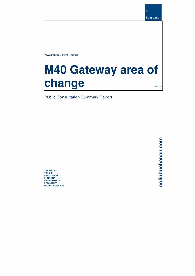
WQycombe District Council
M40 Gateway area ofchange July 2009
Public Consultation Summary Report

8/8/2019 Daws Hill & Abbey Barn Planning and Infrastructure Framework - Appendices
http://slidepdf.com/reader/full/daws-hill-abbey-barn-planning-and-infrastructure-framework-appendices 8/85
M40 Gatew ay area o f changePublic Consultation Summary Report
Project No: 150831
July 2009
10 Eastbourne Terrace,
London,
W2 6LG
Telephone: 020 7053 1300
Fax: 020 7053 1301
Email : [email protected]
Prepared by: Approved by:
____________________________________________ ____________________________________________
Sorwar Ahmed Martina Juvara
Status: Final Issue no: 1 Date: 09 July 2009
150831 appendix daws hill abbey barn consultation report.doc
(C) Copyright Colin Buchanan and Partners Limited. All rights reserved.
This report has been prepared for the exclusive use of the commissioning party and unless otherwise agreed in writing by ColinBuchanan and Partners Limited, no other party may copy, reproduce, distribute, make use of, or rely on the contents of the report.No liability is accepted by Colin Buchanan and Partners Limited for any use of this report, other than for the purposes for which itwas originally prepared and provided.
Opinions and information provided in this report are on the basis of Colin Buchanan and Partners Limited using due skill, care anddiligence in the preparation of the same and no explicit warranty is provided as to their accuracy. It should be noted and is expresslystated that no independent verification of any of the documents or information supplied to Colin Buchanan and Partners Limited haseen made b

8/8/2019 Daws Hill & Abbey Barn Planning and Infrastructure Framework - Appendices
http://slidepdf.com/reader/full/daws-hill-abbey-barn-planning-and-infrastructure-framework-appendices 9/85
M40 Gateway area of changePublic Consultation Summary Report
Contents
1 Introduction 1 2 Consultation Programme 2 3 Workshop Format 3 4 Workshop results 4 4.2 Traffic and transport issues 4 4.3 Public Transport, pedestrian and cycling facilities 5 4.4 Open Space facilities 6 4.5 Community Facilities 6 4.6 Balance of uses and scale 7 5
Additional consultation responses 9
Tables
Table 4.1: Response table 4

8/8/2019 Daws Hill & Abbey Barn Planning and Infrastructure Framework - Appendices
http://slidepdf.com/reader/full/daws-hill-abbey-barn-planning-and-infrastructure-framework-appendices 10/85
1
M40 Gateway area of changePublic Consultation Summary Report
1 In t roduc t ion
1.1.1 This summary report sets out the results of the resident consultation programmeundertaken as part of the M40 Gateway Area of Change Study. The purpose of the Studyis the exploration of development options for the Daws Hill and Abbey Barn (North andSouth) sites of High Wycombe. This paper aims to summarise the key issues andmessages emerging from local residents in the study area, and to inform the study teamand Wycombe District Council about residents’ views on the key issues in the area and ofthe development options presented.

8/8/2019 Daws Hill & Abbey Barn Planning and Infrastructure Framework - Appendices
http://slidepdf.com/reader/full/daws-hill-abbey-barn-planning-and-infrastructure-framework-appendices 11/85
2
M40 Gateway area of changePublic Consultation Summary Report
2 Consul ta t ion Programm e
2.1.1 The resident consultation programme comprised of:
A public meeting on 20 October 2008 (receiving a presentation about the study andinitial analysis) held at Amersham & Wycombe College – Flackwell Heath Campus
A public workshop on 6 November (exploring key issues, needs and developmentoptions) held at Amersham & Wycombe College – Flackwell Heath Campus
A public workshop on 12 November (duplicating the activities above) held at MarshSchool, High Wycombe.
2.1.2 Participation in the programme comprised primarily of local residents, but also someinterested groups and local representatives. The events were publicised through directinvitation (mail drop) in the neighbourhood and the Council planning bulletin.
2.1.3 Attendance at the public meeting was of approximately 180 people, while workshopscomprised 47 participants (6 November workshop) and 43 participants (12 Novemberworkshop). In parallel with these activities, a series of meetings were held with keystakeholders, including landowners and highway authorities. Letters submitted to theCouncil as part of the consultation feedback have also been considered.

8/8/2019 Daws Hill & Abbey Barn Planning and Infrastructure Framework - Appendices
http://slidepdf.com/reader/full/daws-hill-abbey-barn-planning-and-infrastructure-framework-appendices 12/85
3
M40 Gateway area of changePublic Consultation Summary Report
3 Work shop Form at
3.1.1 The resident consultation workshops followed the format below:
Presentation on the analysis of key issues, study findings and development options Breakout groups to discuss the key issues, local needs and character, and
development options Summarising to review the results of each breakout group.
3.1.2 Each breakout considered the following issues:
Traffic and transport issues, and measures to reduce congestion Public transport, pedestrian and transport facilities Open space and leisure facilities Community facilities Scale and character of development
3.1.3 The breakout groups were run as interactive discussions, using a structured, highly visualtechnique to gather the views of all participants, identify common themes and discussissues, concerns and ideas.
3.1.4 The breakouts addressed the following questions:
Is our understanding of the traffic and transport issues correct? What have we missed? What measures are critical to reduce congestion? What type of public transport services and pedestrian and cycling facilities would
benefit the local area? What type of open space and leisure facilities would be most suitable as part of a
new development? Are we moving in the right direction in terms of balance of uses and scale of
development? What are the key features of local character that need to be reflected in new
development?
8/8/2019 Daws Hill & Abbey Barn Planning and Infrastructure Framework - Appendices
http://slidepdf.com/reader/full/daws-hill-abbey-barn-planning-and-infrastructure-framework-appendices 13/85
4
M40 Gateway area of changePublic Consultation Summary Report
4 Work shop resu l ts
4.1.1 The text below summarises the comments made by the participants to the consultationprocess. It uses as far as possible the language and direct suggestions made. Commentsand suggestions are not professionally or technically identified solutions, nor do theyrepresent final recommendation by the consultants or Wycombe District Council.
4.1.2 All comments will be considered when progressing the Study, and will inform futuredecision making.
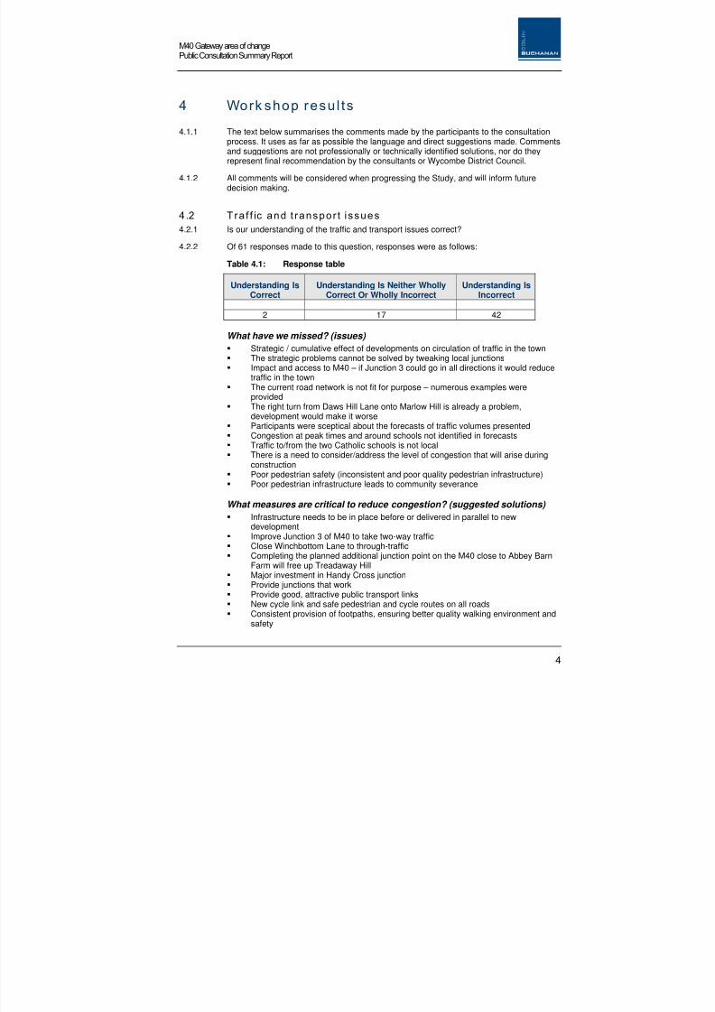
4.2 Tra f f ic and t ranspor t i ssues
4.2.1 Is our understanding of the traffic and transport issues correct?
4.2.2 Of 61 responses made to this question, responses were as follows:
Table 4.1: Response table
Understanding IsCorrect
Understanding Is Neither WhollyCorrect Or Wholly Incorrect
Understanding IsIncorrect
2 17 42
What have we missed? (issues)
Strategic / cumulative effect of developments on circulation of traffic in the town The strategic problems cannot be solved by tweaking local junctions Impact and access to M40 – if Junction 3 could go in all directions it would reduce
traffic in the town The current road network is not fit for purpose – numerous examples were
provided The right turn from Daws Hill Lane onto Marlow Hill is already a problem,
development would make it worse Participants were sceptical about the forecasts of traffic volumes presented Congestion at peak times and around schools not identified in forecasts Traffic to/from the two Catholic schools is not local There is a need to consider/address the level of congestion that will arise during
construction Poor pedestrian safety (inconsistent and poor quality pedestrian infrastructure) Poor pedestrian infrastructure leads to community severance
What measures are critical to reduce congestion? (suggested solutions)
Infrastructure needs to be in place before or delivered in parallel to newdevelopment
Improve Junction 3 of M40 to take two-way traffic Close Winchbottom Lane to through-traffic Completing the planned additional junction point on the M40 close to Abbey Barn
Farm will free up Treadaway Hill Major investment in Handy Cross junction Provide junctions that work Provide good, attractive public transport links New cycle link and safe pedestrian and cycle routes on all roads Consistent provision of footpaths, ensuring better quality walking environment and
safety

8/8/2019 Daws Hill & Abbey Barn Planning and Infrastructure Framework - Appendices
http://slidepdf.com/reader/full/daws-hill-abbey-barn-planning-and-infrastructure-framework-appendices 14/85
5
M40 Gateway area of changePublic Consultation Summary Report
Encourage people out of car and encourage cycling Road pricing Stagger school hours Move St.Augustine’s and St.Bernard’s to RAF site / Daws Hill South.
Key messages:
Current traffic issues need to be addressed irrespective ofdevelopment
Development will make the existing traffic situation worse There is little confidence that junction improvements will be
sufficient to address the likely level of traffic congestion
Improvements are needed ahead of development.
4.3 Publ ic Transport , pedestr ian and cyc l ing fac i l i t ies
4.3.1 What type of public transport services and pedestrian and cycling facilities would benefitthe local area?
Issues
Not all participants use public transport, but there was extensive support for publictransport improvements as part of the traffic solution
Some participants expressed a reluctance to use public transport no matter howgood it is
Service reliability, frequency and affordability is an issue Bus prices are too high – it is cheaper to park in the town centre Bus timetable needs to be extended beyond 7pm Bus services/routes need to be more direct Direct, dedicated rapid transport to the town centre was indicated as the best way
to encourage reduced car use Alternatives to rail should be considered, e.g. light rail The High Wycombe to Bourne End railway route could be used for cycling /
walking Countryside area east of A404 is ideal for walking – this should not be ruined Link footpaths and make into a network Improved maintenance of existing footpaths is needed Paths must be accessible, well-lit and safe Dedicated, safe and segregated cycle routes are needed Suggested Solutions
A modern, high quality bus service was suggested, e.g. like the Fastrack service inMedway
Separate cycle lanes from fast traffic by providing dedicated / segregated lanes A cycle route should be implemented from the M40 bridge by Daws Hill on the
track leading to Winchbottom Lane and beyond Encourage cycle to school / cycle to work options Road awareness training is needed for cyclists and walkers Plan for reduced need to travel.

8/8/2019 Daws Hill & Abbey Barn Planning and Infrastructure Framework - Appendices
http://slidepdf.com/reader/full/daws-hill-abbey-barn-planning-and-infrastructure-framework-appendices 15/85
6
M40 Gateway area of changePublic Consultation Summary Report
Key messages:
Major public transport investment such as a dedicated rapid bus way/ transit would make be the only way to make a difference
There maybe reluctance to use improved public transport High quality, high frequency and integrated bus routes are needed A consistent and comprehensive set of cycling and walking
improvements are needed Safe routes to and around schools are needed.
4.4 Open Space fac i l i t ies
4.4.1 What type of open space and leisure facilities would be suitable as part of new
development?
Issues
Large park could bring more traffic to the area No municipal-type park – do not create urban style but retain the informal / natural
character Informal football pitches for children Re-locate athletics track Facilities are needed for older children– link to an expanded ski-slope Re-instate blocked footpath up the valley floor of Abbey Barn Open walks through wood Extend paths and woodland walks Protection for wildlife Keep avenue and other areas where there are trees for walking Suggested Solutions
One large park Play areas for children within the development Consider a ski-lift/pommel lift for walkers Respect wildlife and bio-diversity
Key messages:
One large park Maintain open space and wooded character Range of informal space and sports facilities Facilities for young people and children needed within the
development Well-maintained parkland Respect wildlife and bio-diversity
4.5 Communi ty Fac i l i t ies
4.5.1 What type of community facilities would you like to see?

8/8/2019 Daws Hill & Abbey Barn Planning and Infrastructure Framework - Appendices
http://slidepdf.com/reader/full/daws-hill-abbey-barn-planning-and-infrastructure-framework-appendices 16/85
7
M40 Gateway area of changePublic Consultation Summary Report
Issues
Pub/restaurant
Medical/health centre (but not the expense of the surgery at Flackwell Heath) Facilities for teenagers Policing promises have not been fulfilled Heritage Centre (make wartime Map Room and bunker into tourist attraction) General concern abut impact of new development on facilities at Flackwell Heath
(the developers must ensure that the facilities do not affect their viability) Do not duplicate facilities Some participants felt that no community facilities should be provided ‘Proximity shopping’ should be provided Facilities should reflect what a village should have.
Suggested Solutions
Relocate St.Augustine and St.Bernard’s school to resolve traffic and safety issues Proximity shopping at Daws Hill New hotel to attract business Play group/nursery Medical Centre Community meetings rooms.
Key messages:
Celebrate the military history of the site Youth facilities are needed Facilities should not duplicate those at nearby centres A range of facilities appropriate to a village should be provided
4.6 Balance of uses and scale
4.6.1 Are we moving in the right direction in terms of balance of uses and scale ofdevelopment?
Issues and suggestions
Village style development Two – three storey scale Human scale No big supermarket/golf course/big business Homes and recreational uses favoured, not employment Option A (Residential-led) preferred Need to provide some employment – small start up units Shared equity homes Provide discount homes for local people A new road purely on commercial grounds is not justifiable through the AONB A strategic approach to green infrastructure needed – e.g. more proactive
management strategies across all parts of the site Eco-friendly design Relocate the school with a merged secondary school Low rise, village style development Re-locate Athletics track to Abbey Barn South to maintain openness.

8/8/2019 Daws Hill & Abbey Barn Planning and Infrastructure Framework - Appendices
http://slidepdf.com/reader/full/daws-hill-abbey-barn-planning-and-infrastructure-framework-appendices 17/85
8
M40 Gateway area of changePublic Consultation Summary Report
4.6.2 What are the features of local character that any new development should take accountof?
High quality building/design Interesting and imaginative architecture Individuality Use of bricks, tiles Reflect character of development in Chiltern Hills Residential uses preferred Business and employment required, but low scale Limit to low rise development, at 30 dwellings per hectare Maximise and optimise gradient for views, to screen business units Non-car dominated development recommended No through-roads through the woods Respect existing trees Use eco-design principles and maintain rural scale
Keep Abbey Barn as a wildlife area Avoid land-take in the AONB.
Key messages:
Mixed use is fine No business park-type development – provide small starter business
units and homes for families with gardens (not flats) Use eco-friendly design

8/8/2019 Daws Hill & Abbey Barn Planning and Infrastructure Framework - Appendices
http://slidepdf.com/reader/full/daws-hill-abbey-barn-planning-and-infrastructure-framework-appendices 18/85
9
M40 Gateway area of changePublic Consultation Summary Report
5 Addi t iona l consu l t a t ion responses
5.1.1 In addition to the workshop results, further comments were received as writtenconsultation responses. These are summarised below:
The selection of this area for new development is unsuitable as the roads networkcannot be expanded.
The need for new homes is questioned as there appears to be a large number ofunoccupied dwellings/flats that could be used to meet need.
Many older Victorian buildings in the town could be improved / renovated and usedto provide more affordable housing.
Large areas of vacant employment land could be used to facilitate building to meetgovernment housing requirements.
There appears to more than enough empty office space to accommodate newoffices/businesses rather than build more.
High Wycombe should not be competing with the likes Reading and Basingstokebut should have regard to High Wycombe’s character.
The town lies in a valley, with accessible restraints that should be accepted. Thetown’s character should be consolidate and improved to make it a more pleasantplace to live
While the new shopping centre ' Eden ' with its much needed Bus Station iswelcomed, this seems too big and has created a town of two halves.

8/8/2019 Daws Hill & Abbey Barn Planning and Infrastructure Framework - Appendices
http://slidepdf.com/reader/full/daws-hill-abbey-barn-planning-and-infrastructure-framework-appendices 19/85
APPENDIX 2:Transport infrastructure schedules

8/8/2019 Daws Hill & Abbey Barn Planning and Infrastructure Framework - Appendices
http://slidepdf.com/reader/full/daws-hill-abbey-barn-planning-and-infrastructure-framework-appendices 20/85
8/8/2019 Daws Hill & Abbey Barn Planning and Infrastructure Framework - Appendices
http://slidepdf.com/reader/full/daws-hill-abbey-barn-planning-and-infrastructure-framework-appendices 21/85

8/8/2019 Daws Hill & Abbey Barn Planning and Infrastructure Framework - Appendices
http://slidepdf.com/reader/full/daws-hill-abbey-barn-planning-and-infrastructure-framework-appendices 22/85
M40 Gateway – Daws Hill and Abbey Barn Planning and Infrastructure FrameworkColin Buchanan/ 150831/ July 2009
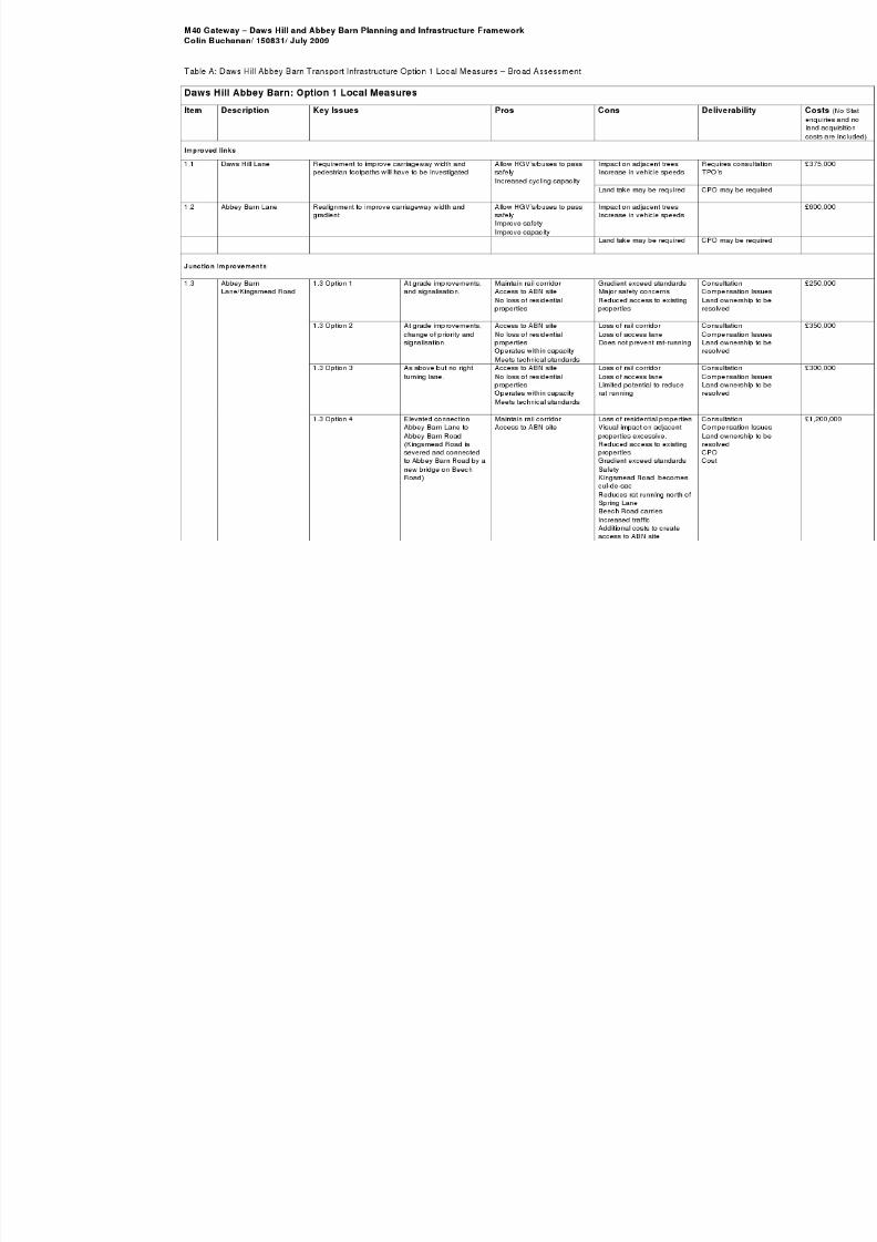
1.3 Option 5 At grade improvements,and signalisation.
Maintain rail corridorAccess to ABN site
Loss of residential propertiesVisual impact on adjacentproperties excessive.Reduced access to existingpropertiesAdditional costs to createaccess to ABN siteReduces rat running north ofSpring Lane
ConsultationCompensationLand ownershresolvedCPOCost
1.3 Option 6 Grade separated: Abbey
Barn Lane to Abbey BarnRoad with KingsmeadRoad passing under, butsevered from Abbey BarnRoad. New connectionthrough allotments toconnect Kingsmead withWycombe Marsh
Maintain rail corridor
Access to ABN site
Loss of residential properties
Visual impact on adjacentproperties excessive.Reduced access to existingpropertiesPartial loss of allotmentsReduces rat running north ofSpring LaneKingsmead Road becomescul-de-sacAdditional costs to createaccess to ABN site
Consultation
CompensationLand ownershresolvedCPOCost
1.4 Abbey Barn Road/A40 Abbey Barn Road – one way onto A40Ford Street – one way off A40
Operates within capacity Increased traffic on FordStreet
ConsultationCompensationLand ownershresolved
1.5 Abbey Barn Lane/HeathEnd Road
Construct standard roundabout. Improved east west linkDiscourages rat running
through site
Attracts traffic from otherareas
Landownershi
1.6 Daws Hill Lane/SchoolAccess
Construct mini-roundabout Improved traffic flowImproved traffic calming
Landownershi
1.7 Daws Hill Lane /MarlowHill
Improve left turning lane Satisfies TA Landownershi
1.8 Daws Hill Lane/Daws Lea Signalise junction Provides bus priorityImproved traffic calming
Land take unlikely Consultation r
1.9 Leisure Centre/MarlowHill(If school drop off isallowed at LeisureCentre)
Improvements to signalised junction, and additionallanes
Reduce school impacts onDaws Hill LaneEncourages walking as partof the school trip
Land take requirementsunknownDrop off zone required
LandownershiTraffic impactsneed to be tesapproved by B

8/8/2019 Daws Hill & Abbey Barn Planning and Infrastructure Framework - Appendices
http://slidepdf.com/reader/full/daws-hill-abbey-barn-planning-and-infrastructure-framework-appendices 23/85

8/8/2019 Daws Hill & Abbey Barn Planning and Infrastructure Framework - Appendices
http://slidepdf.com/reader/full/daws-hill-abbey-barn-planning-and-infrastructure-framework-appendices 24/85

8/8/2019 Daws Hill & Abbey Barn Planning and Infrastructure Framework - Appendices
http://slidepdf.com/reader/full/daws-hill-abbey-barn-planning-and-infrastructure-framework-appendices 25/85
8/8/2019 Daws Hill & Abbey Barn Planning and Infrastructure Framework - Appendices
http://slidepdf.com/reader/full/daws-hill-abbey-barn-planning-and-infrastructure-framework-appendices 26/85

8/8/2019 Daws Hill & Abbey Barn Planning and Infrastructure Framework - Appendices
http://slidepdf.com/reader/full/daws-hill-abbey-barn-planning-and-infrastructure-framework-appendices 27/85

8/8/2019 Daws Hill & Abbey Barn Planning and Infrastructure Framework - Appendices
http://slidepdf.com/reader/full/daws-hill-abbey-barn-planning-and-infrastructure-framework-appendices 28/85
APPENDIX 3:Cost Assumptions

8/8/2019 Daws Hill & Abbey Barn Planning and Infrastructure Framework - Appendices
http://slidepdf.com/reader/full/daws-hill-abbey-barn-planning-and-infrastructure-framework-appendices 29/85
8/8/2019 Daws Hill & Abbey Barn Planning and Infrastructure Framework - Appendices
http://slidepdf.com/reader/full/daws-hill-abbey-barn-planning-and-infrastructure-framework-appendices 30/85
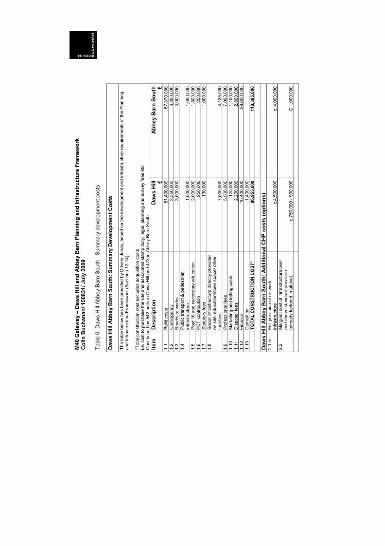
M 4 0 G
a t e w a y – D a w s H i l l a n d A
b b e y B a r n P l a n n i n g a n d I n
f r a s t r u c t u r e F r a m e w o r k
C o l i n
B u c h a n a n / 1 5 0 8 3 1 / J u l y 2
0 0 9
T a
b l e
0 :
D a w s
H i l l A b b e y
B a r n
S o
u t h -
S u m m a r y
d e v e
l o p m e n
t c o s
t s
D a w s
H i l l A b b e y B a r n S o u t h : S u m m a r y D e v e l o p m e n t C o s
t s
T h e t a b l e b e l o w
h a s b e e n p r o v i d e d b y D
r i v e r s J o n a s ,
b a s e d o n t h e d e v e l o
p m e n t a n d i n f r a s t r u c t u r e r e q u i r e m
e n t s o f t h e P l a n n i n g
a n d I n f r a s t r u c t u r e F r a m e w o r k ( S e c t i o n s
1 2 - 1 4 ) .
* T o t a l c o n s t r u c t i o n c o s t e x c l u d e s a c q u i s
i t i o n c o s t s
i . e . c o s
t t o p u r c h a s e t h e s i t e a n d a s s o c i a
t e d s t a m p d u t y ,
l e g a l , p l a n n i n g a n d s u r v e y f e e s e t c .
C o s t b a s e d o n 5 4 2 u n i t s i n D a w s H i l l a n d 4 7 3 i n A b b e y B a r n S o u t h
I t e m
D e s c r i p t i o n
D
a w s H i l l £
A b b e y B a r n S o u t h £
1 . 1
B u i l d c o s t s
5
1 , 4
0 0 , 0
0 0
6 7 , 3
7 0 , 0
0 0
1 . 2
C o n t i n g e n c y
2 , 5
5 0 , 0
0 0
3 , 3
5 0 , 0
0 0
1 . 3
R o a d / s i t e w o r k s
3 , 0
0 0 , 0
0 0
3 , 0
0 0 , 0
0 0
1 . 4
P u b l i c t r a n s p o r t & p e d e s t r i a n
i n f r a s t r u c t u r e
1 , 0
0 0 , 0
0 0
1 , 0
0 0 , 0
0 0
1 . 5
P o s t 1 6 a n d s e c o n d a r y e d u c a t i o n
2 , 0
0 0 , 0
0 0
1 , 8
0 0 , 0
0 0
1 . 6
P C T c o n t r i b u t i o n
2 5 0 , 0
0 0
2 5 0 , 0
0 0
1 . 7
S t a t u t o r y f e e s
1 3 0 , 0
0 0
1 , 0
0 0 , 0
0 0
1 . 8
S o c i a l i n f r a s t r u c t u r e d i r e c t l y p r
o v i d e d
o n s i t e : e d u c a t i o n / o p e n s p a c e / o t h e r
f a c i l i t i e s
7 , 0
0 0 , 0
0 0
3 , 1
2 5 , 0
0 0
1 . 9
P r o f e s s i o n a l f e e s
5 , 5
0 0 , 0
0 0
7 , 0
0 0 , 0
0 0
1 . 1
0
M a r k e t i n g a n d l e t t i n g c o s t s
1 2 5 , 0
0 0
1 , 1
0 0 , 0
0 0
1 . 1
1
D i s p o s a l f e e s
2 , 2
0 0 , 0
0 0
2 , 8
0 0 , 0
0 0
1 . 1
2
F i n a n c e
1
0 , 4
0 0 , 0
0 0
2 6 , 6
0 0 , 0
0 0
1 . 1
3
D e m o l i t i o n
1 , 4
0 0 , 0
0 0
T O T A L C O N S T R U C T I O N C O
S T *
8
6 , 9 5 5 , 0 0 0
1 1 8 , 3 9 5 , 0 0 0
D a w s
H i l l A b b e y B a r n S o u t h : A d d i t i o n a l C H P c o s t s ( o p t i o
n s )
2 . 1 o r
F u l l p r o v i s i o n o f n e t w o r k
i n f r a s t r u c t u r e
c . 4 , 5
0 0 , 0
0 0
c .
4 , 0
0 0 , 0
0 0
2 . 2
M a r g i n a l c o s t o f i n f r a s t r u c t u r e
o v e r
a n d a b o v e s t a n d a r d p r o v i s i o n
( a l r e a d y f a c t o r e d i n a b o v e )
c . 7
5 0 , 0
0 0
- 9 0 0 , 0
0 0
C
1 , 0
0 0 , 0
0 0
8/8/2019 Daws Hill & Abbey Barn Planning and Infrastructure Framework - Appendices
http://slidepdf.com/reader/full/daws-hill-abbey-barn-planning-and-infrastructure-framework-appendices 31/85
M 4 0 G
a t e w a y – D a w s H i l l a n d A
b b e y B a r n P l a n n i n g a n d I n
f r a s t r u c t u r e F r a m e w o r k
C o l i n
B u c h a n a n / 1 5 0 8 3 1 / J u l y 2
0 0 9
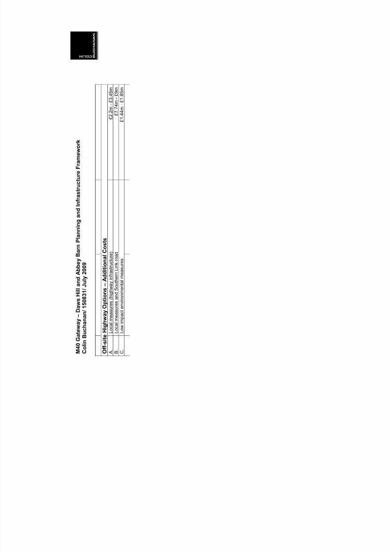
O f f - s i t e H i g h w a y O p t i o n s – A d d
i t i o n a l C o s t s
A .
L o c a l m e a s u r e s ( h i g h w a y i n f r a
s t r u c t u r e )
£ 2 . 2 m -
£ 3 . 4
5 m
B .
L o c a l m e a s u r e s a n d S o u t h e r n
L i n k r o a d
£ 7 . 7
4 m -
£ 9 m
C .
L o w
i m p a c t e n v i r o n m e n t a l m e a s u r e s
£ 1 . 4
4 m -
£ 1 . 8
5 m

8/8/2019 Daws Hill & Abbey Barn Planning and Infrastructure Framework - Appendices
http://slidepdf.com/reader/full/daws-hill-abbey-barn-planning-and-infrastructure-framework-appendices 32/85
M40 Gateway – Daws Hill and Abbey Barn Planning and Infrastructure FrameworkColin Buchanan/ 150831/ July 2009
Table 1: Daws Hill Abbey Barn Transport Infrastructure Option 1 Local Measures Costs
Daws Hill Abbey Barn: Option 1 Local Measures Costs
Item Description Key Issues
Improved links
1.1 Daws Hill Lane Requirement to improve carriageway width will needto be investigated
1km @ £1,500/m x 25%No pedestrian or cycle facilities. See Table 5No Stats enquiries. No Land acquisition
1.2 Abbey Barn Lane Realignment to improve carriageway width andgradient
1.4km @ £1,500/m x 30%No pedestrian or cycle facilities. See Table 5No Stat enquiries. No Land acquisition
Junction Improvements
1.3 Option 1 At grade improvements,and signalisation.
No Stats enquiriesNo Land acquisition
1.3 Option 2 At grade improvements,change of priority andsignalisation.
No Stats enquiriesNo Land acquisition
1.3 Option 3 As above but no rightturning lane.
No Stats enquiriesNo Land acquisition
1.3 Option 4 Elevated connectionAbbey Barn Lane to
Abbey Barn Road(Kingsmead Road issevered and connectedto Abbey Barn Road by anew bridge on BeechRoad)
No Stats enquiriesNo Land acquisition
1.3 Option 5 Grade separated: AbbeyBarn Lane to WycombeMarsh
No Stats enquiriesNo Land acquisition
1.3 Abbey BarnLane/Kingsmead Road
1.3 Option 6 Grade separated: AbbeyBarn Lane to Abbey BarnRoad with KingsmeadRoad passing under, butsevered from Abbey BarnRoad. New connectionthrough allotments toconnect Kingsmead withWycombe Marsh
No Stats enquiriesNo Land acquisition
1.4 Abbey Barn Road/A40 Abbey Barn Road – one way onto A40Ford Street – one way off A40
No Stats enquiriesNo Land acquisition
1.5 Abbey Barn Lane/HeathEnd Road
Construct standard roundabout. No Stats enquiriesNo Land acquisition
1.6 Daws Hill Lane/SchoolAccess
Construct mini-roundabout No Stats enquiriesNo Land acquisition
1.7 Daws Hill Lane /MarlowHill
Improve left turning lane No Stats enquiriesNo Land acquisition
1.8 Daws Hill Lane/Daws Lea Signalise junction See Table 5 Total Range

8/8/2019 Daws Hill & Abbey Barn Planning and Infrastructure Framework - Appendices
http://slidepdf.com/reader/full/daws-hill-abbey-barn-planning-and-infrastructure-framework-appendices 33/85
M40 Gateway – Daws Hill and Abbey Barn Planning and Infrastructure FrameworkColin Buchanan/ 150831/ July 2009
Table 2: Daws Hill Abbey Barn Transport Infrastructure Option 2: Local Measures and Southern Link Costs
Daws Hill Abbey Barn Transport Infrastructure Option 2: Local Measures and Southern Link Costs
Item Description Key Issues
Improved links
2.1 Daws Hill Lane Requirement to improve carriageway width will need
to be investigated.
1km @ £1,500/m x 25%
No pedestrian or cycle facilities. See Table 5No Stats enquiries. No Land acquisition
2.2 Abbey Barn Lane Realignment to improve carriageway width andgradient
1.4km @ £1,500/m x 30%No pedestrian or cycle facilities. See Table 5No Stat enquiries. No Land acquisition
2.3 Southern Link Create a direct link from A40 London Road to A404South and Wycombe Road
2.5km @£1,600/m2 slips @ £1,500/m x 200mImproved junctions with Wycombe Road and Heath End Road : 2 x £400KPedestrian or cycle facilities. 1.4km x 2m @£35/m2No Stat enquiriesNo Land acquisition
Junction Improvements
2.4 Option 1 At grade improvements,and signalisation.
No Stats enquiriesNo Land acquisition
2.4 Option 2 At grade improvements,change of priority andsignalisation.
No Stats enquiriesNo Land acquisition
2.4 Option 3 As above but no rightturning lane.
No Stats enquiriesNo Land acquisition
2.4 Option 4 Elevated connectionAbbey Barn Lane toAbbey Barn Road(Kingsmead Road issevered and connectedto Abbey Barn Road by anew bridge on BeechRoad)
No Stats enquiriesNo Land acquisition
2.4 Option 5 Grade separated: AbbeyBarn Lane to WycombeMarsh. Kingsmead Roadremains connected withAbbey Barn Road andBassetsbury Lane
No Stats enquiriesNo Land acquisition
2.4 Abbey BarnLane/Kingsmead Road
2.4 Option 6 Grade separated: AbbeyBarn Lane to Abbey BarnRoad with KingsmeadRoad passing under, butsevered from Abbey BarnRoad. New connectionthrough allotments to
No Stats enquiriesNo Land acquisition

8/8/2019 Daws Hill & Abbey Barn Planning and Infrastructure Framework - Appendices
http://slidepdf.com/reader/full/daws-hill-abbey-barn-planning-and-infrastructure-framework-appendices 34/85
M40 Gateway – Daws Hill and Abbey Barn Planning and Infrastructure FrameworkColin Buchanan/ 150831/ July 2009
connect Kingsmead withWycombe Marsh
2.5 Abbey Barn Road/A40 Abbey Barn Road – one way onto A40Ford Street – one way off A40
No Stats enquiriesNo Land acquisition
2.6 Abbey Barn Lane/HeathEnd Road
Construct standard roundabout. No Stats enquiriesNo Land acquisition
2.7 Daws Hill Lane/SchoolAccess
Construct mini-roundabout No Stats enquiriesNo Land acquisition
2.8 Daws Hill Lane /MarlowHill
Improve left turning lane No Stats enquiriesNo Land acquisition
2.9 Daws Hill Lane/Daws Lea Signalise junction See Table 5 Total Range

8/8/2019 Daws Hill & Abbey Barn Planning and Infrastructure Framework - Appendices
http://slidepdf.com/reader/full/daws-hill-abbey-barn-planning-and-infrastructure-framework-appendices 35/85
M40 Gateway – Daws Hill and Abbey Barn Planning and Infrastructure FrameworkColin Buchanan/ 150831/ July 2009
Table 3: Daws Hill Abbey Barn Transport Infrastructure Option 3 Low Impact Environmental Measures
Daws Hill Abbey Barn: Option 3 Low Impact Environment Measures
Item Description Key Issues
Improved links
3.1 Daws Hill Lane Local improvements to carriageway 1km @ £1,500/m x 20%
No pedestrian or cycle facilities. See Table 5No Stats enquiriesNo Land acquisition
Option 3.2A Signalisation of one wayworking
No Stats enquiriesNo Land acquisition
3.2 Abbey Barn Lane
Option 3.2B Remove one way andimprove alignment
300m@£1,5000/mNo Stats enquiriesNo Land acquisition
3.3 Winchbottom Lane Low Impact Measures: Minor improvements to 4 junctions, localised road widening, and construction ofpassing places.
5 km length from Heath End Road to Wycombe Road and to Marlow RoadNo Stat enquiriesNo Land acquisition
Junction Improvements
3.3 Abbey BarnLane/Kingsmead Road
At grade improvements, and signalisation. No Stats enquiriesNo Land acquisition
3.4 Abbey Barn Road/A40 Minor improvements to existing junction No Stats enquiriesNo Land acquisition
3.5 Abbey BarnLane/Heathend Road
Minor improvements: Right turning lanes, etc No Stats enquiriesNo Land acquisition
3.6 Daws Hill Lane/SchoolAccess
Construct mini-roundabout No Stats enquiriesNo Land acquisition
3.7 Daws Hill Lane /MarlowHill
Improve left turning lane No Stats enquiriesNo Land acquisition
3.8 Daws Hill Lane/Daws Lea Signalise junction See Table 5 Total Range

8/8/2019 Daws Hill & Abbey Barn Planning and Infrastructure Framework - Appendices
http://slidepdf.com/reader/full/daws-hill-abbey-barn-planning-and-infrastructure-framework-appendices 36/85
M40 Gateway – Daws Hill and Abbey Barn Planning and Infrastructure FrameworkColin Buchanan/ 150831/ July 2009
Table 4: Daws Hill Abbey Barn Public Transport Infrastructure Options:
Daws Hill Abbey Barn: Public Transport Options
Item Description Key Issues
Public Transport
Construction costsConstruct new link: 3.7m widePedestrian and cycle facilities included in Table 5500m @ £1,500/m£15,000 for drop off zone£25,000 turning zone£70,000 signalisation for 1way workingSignalised Daws Lea/Daws Hill Lane junction £150,000
Option 1: Create direct link from Wycombe SportsCentre to Daws Hill Lane via Daws Lea. New drop offzone south of schools
Running CostsAssume 2 buses
Construction costsConstruct new link: 3.7m widePedestrian and cycle facilities included in Table 5500m @ £1,500/m£15,000 for drop off zone
£25,000 turning zone£70,000 signalisation for 1way workingImprove School Access Road 300m @£2,000/m x 50%
4.1 High quality service fromsite to Town Centre15min frequencyPhase 1: 15 seaterPhase 2: 25 seater
Option 2: Create direct link from Wycombe SportsCentre to Daws Hill Lane via School Access. Newdrop off zone south of schools
Running CostsAssume 2 buses
4.2 Extend the above serviceto Wycombe Marsh
Phase 1: Enter and exit site at Daws Hill LanePhase 2: Enter at Daws Hill Lane and exit at Abbey Barn Lane: 1 additional bufreguency
4.3 Divert existing route Divert Route 36
8/8/2019 Daws Hill & Abbey Barn Planning and Infrastructure Framework - Appendices
http://slidepdf.com/reader/full/daws-hill-abbey-barn-planning-and-infrastructure-framework-appendices 37/85
M40 Gateway – Daws Hill and Abbey Barn Planning and Infrastructure FrameworkColin Buchanan/ 150831/ July 2009
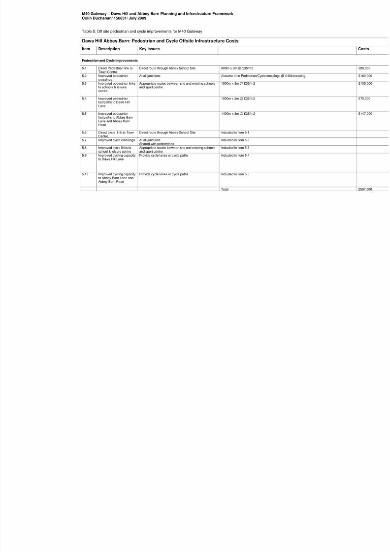
Table 5: Off site pedestrian and cycle improvements for M40 Gateway
Daws Hill Abbey Barn: Pedestrian and Cycle Offsite Infrastructure Costs
Item Description Key Issues
Pedestrian and Cycle Improvements
5.1 Direct Pedestrian link toTown Centre
Direct route through Abbey School Site 800m x 3m @ £35/m2
5.2 Improved pedestriancrossings
At all junctions Assume 4 no Pedestrian/Cycle crossings @ £40k/crossing
5.3 Improved pedestrian linksto schools & leisurecentre
Appropriate routes between site and existing schoolsand sport centre
1000m x 3m @ £35/m2
5.4 Improved pedestrianfootpaths to Daws HillLane
1000m x 2m @ £35/m2
5.5 Improved pedestrianfootpaths to Abbey BarnLane and Abbey BarnRoad
1400m x 3m @ £35/m2
5.6 Direct cycle link to Town
Centre
Direct route through Abbey School Site Included in item 5.1
5.7 Improved cycle crossings At all junctionsShared with pedestrians
Included in item 5.2
5.8 Improved cycle links toschool & leisure centre
Appropriate routes between site and existing schoolsand sport centre
Included in item 5.3
5.9 Improved cycling capacityto Daws Hill Lane
Provide cycle lanes or cycle paths Included in item 5.4
5.10 Improved cycling capacityto Abbey Barn Lane andAbbey Barn Road
Provide cycle lanes or cycle paths Included in item 5.5
Total
8/8/2019 Daws Hill & Abbey Barn Planning and Infrastructure Framework - Appendices
http://slidepdf.com/reader/full/daws-hill-abbey-barn-planning-and-infrastructure-framework-appendices 38/85
APPENDIX 4:Sustainability Appraisal

8/8/2019 Daws Hill & Abbey Barn Planning and Infrastructure Framework - Appendices
http://slidepdf.com/reader/full/daws-hill-abbey-barn-planning-and-infrastructure-framework-appendices 39/85

8/8/2019 Daws Hill & Abbey Barn Planning and Infrastructure Framework - Appendices
http://slidepdf.com/reader/full/daws-hill-abbey-barn-planning-and-infrastructure-framework-appendices 40/85
c o l i n b u
c h a n a n . c o m
Wycombe District Council
M40 Gateway DawsHill and Abbey Barn
DevelopmentFramework July 2009
Sustainability Appraisal
8/8/2019 Daws Hill & Abbey Barn Planning and Infrastructure Framework - Appendices
http://slidepdf.com/reader/full/daws-hill-abbey-barn-planning-and-infrastructure-framework-appendices 41/85
M40 Gatew ay Daw s Hi l l and Abbey Barn
Development Framew orkSustainability Appraisal
Project No: 150831
July 2009
10 Eastbourne Terrace,
London,
W2 6LG
Telephone: 020 7053 1300
Fax: 020 7053 1301
Email : [email protected]
Prepared by: Approved by:
____________________________________________ ____________________________________________
CarolineG Martina J
Status: Final Issue no: 1 Date: 07 July 2009
06072009 sustinability appraisal
(C) Copyright Colin Buchanan and Partners Limited. All rights reserved.
This report has been prepared for the exclusive use of the commissioning party and unless otherwise agreed in writing by ColinBuchanan and Partners Limited, no other party may copy, reproduce, distribute, make use of, or rely on the contents of the report.No liability is accepted by Colin Buchanan and Partners Limited for any use of this report, other than for the purposes for which itwas originally prepared and provided.
Opinions and information provided in this report are on the basis of Colin Buchanan and Partners Limited using due skill, care anddiligence in the preparation of the same and no explicit warranty is provided as to their accuracy. It should be noted and is expresslystated that no independent verification of any of the documents or information supplied to Colin Buchanan and Partners Limited haseen made b

8/8/2019 Daws Hill & Abbey Barn Planning and Infrastructure Framework - Appendices
http://slidepdf.com/reader/full/daws-hill-abbey-barn-planning-and-infrastructure-framework-appendices 42/85
M40 Gateway Daws Hill and Abbey Barn Development FrameworkSustainability Appraisal
Contents
1 Introduction 1 1.2 Appraisal methodology 1 2 Alternative options 4 2.2 Summary appraisals of options 10 3 Recommendations and final option appraisal 15 3.1 Recommendation 15 3.2 Final option summary appraisal 18

8/8/2019 Daws Hill & Abbey Barn Planning and Infrastructure Framework - Appendices
http://slidepdf.com/reader/full/daws-hill-abbey-barn-planning-and-infrastructure-framework-appendices 43/85
1
M40 Gateway Daws Hill and Abbey Barn Development FrameworkSustainability Appraisal
1 In t roduc t ion
1.1.1 This report has been prepared in support of the M40 Gateway Daws Hill and Abbey BarnPlanning and Infrastructure Framework study carried out by Colin Buchanan on behalf ofWycombe District Council in 2008-2009.
1.1.2 The purpose of Sustainability Appraisal (SA) is to promote sustainable developmentthrough the integration of social, environmental and economic considerations into thepreparation of new or revised Development Plan Documents, including SupplementaryPlanning Documents. In the case of this study, SAs were carried out during the firstphases of the study to test initial options and inform option development, and towards theend of the study, to help refine the preferred master plan framework.
1.1.3 Planning authorities must conduct an environmental assessment in accordance with therequirements of the European Directive 2001/42/EC “on the assessment of the effects ofcertain plans and programmes on the environment” (the Strategic EnvironmentalAssessment or SEA Directive), transposed in the UK under Environmental Assessment ofPlans and Programmes Regulations 2004 (SI 2004 No.1633). Although the requirementsto carry out SA and SEA are distinct, advice from the Department of Communities andLocal Government (DCLG) is to satisfy both through a single appraisal process.
1.2 Appra isa l methodology
1.2.1 The sustainability appraisal utilises the sustainability framework criteria as set out in theSustainability Appraisal of Preferred Options Site Allocations Document (Feb 2007). Theframework has been subject to public consultation as follows:
25th October - 6th December 2004 - Introductory SA paper – concept of SA as well
as draft sustainability objectives to be considered for the Core Strategy andPreferred Options Site Allocation DPD.
14th
January - 21st
February 2005 - Joint draft SA Scoping Report for the CoreStrategy and Preferred Options Site Allocation DPD.
1.2.2 From this information, a sustainability framework was produced, against which theemerging options and the final option have been assessed.
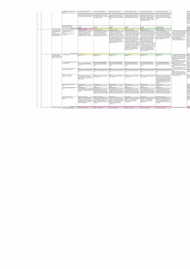
Objectives
1.2.3 The options were tested against 20 sustainability objectives as follows:
1. To provide the residents of Wycombe District Council with the opportunity to live ina quality home;
2. To reduce crime, fear of crime and antisocial activity through the creation of saferplaces to live and work;
3. To improve accessibility to essential services and facilities and to provideopportunities to obtain good access to high quality health, education, recreationand other community facilities and services;
4. Encourage a sense of community identity and welfare;5. Improve and maintain health and well-being of the population and reduce
inequalities in health ;6. To reduce contributions to climate change through:
a) Sustainable building practices;b) Maximising the potential for renewable energy and energy conservation;
7. To encourage the use of sustainable methods of transport to reduce negativeeffects on the environment;
8/8/2019 Daws Hill & Abbey Barn Planning and Infrastructure Framework - Appendices
http://slidepdf.com/reader/full/daws-hill-abbey-barn-planning-and-infrastructure-framework-appendices 44/85
2
M40 Gateway Daws Hill and Abbey Barn Development FrameworkSustainability Appraisal
8. To provide for sustainable levels of water use, supply and management, includingquality of water sources;
9. To maintain and enhance biodiversity, flora and fauna and avoid irreversible losses10. To protect and enhance the landscape and townscape character of the District and
in particular, those areas of designated importance;11. To conserve and where appropriate enhance the historic environment;12. Minimise waste and then re-use it through recycling or composting or recovering
energy from waste that has not been recycled or composted ;13. To conserve soil resources and quality;14. To improve the efficiency of land use through the re-use of previously developed
land;15. To minimise the risk of flooding (in relation to both new and existing development)16. To encourage economic growth and competitiveness;17. To achieve a broad balance in the growth of housing, population and employment;18. To encourage a diverse economy including a vibrant and sustainable tourism
sector;19. To develop and maintain a skilled workforce to support long-term competitiveness
of the District;20. To reduce levels of social polarisation and levels of deprivation.
Assessment of effect
1.2.4 The assessment takes into account both on site proposed provision under each optionand off-site infrastructure improvement which will be required to enable the development.
1.2.5 The scoring system used is set out in the Sustainability Appraisal of Preferred OptionsSite Allocations Document (Feb 2007) has been used to assess the effect of the optionsand is reproduced here:
- Major positive impact
- Minor positive impact
?/0 – Uncertain impact or lack of information/neutral impact
x – Minor negative impact
xx – Major negative impact
Baseline data
1.2.6 Baseline data on the sites were extracted from the following documents and maps:
Bucks online – GIS mapping - http://www.bucksonline.gov.uk/bucksmaps/
MAGIC website and DEFRA The Environment Agency website – Flood maps Wycombe Local Plan to 2011 Wycombe Development Framework Core Strategy to 2026 Infrastructure baseline – discussions with service providers Abbey Barn South Ecological Study, including Phase 1 habitat survey was
undertaken by consultants appointed by the developer in July 1998 Wycombe District Open Space Study (2005) Initial Land Quality Assessment for Daws Hill Abbey Barn North Ecological Study carried out by consultants appointed by the
Local Authority in (March 2000) Abbey Barn North - Badger Survey (February 2000)

8/8/2019 Daws Hill & Abbey Barn Planning and Infrastructure Framework - Appendices
http://slidepdf.com/reader/full/daws-hill-abbey-barn-planning-and-infrastructure-framework-appendices 45/85
3
M40 Gateway Daws Hill and Abbey Barn Development FrameworkSustainability Appraisal
Abbey Barn North Botanical survey was undertaken by consultants appointed bythe Local Authority (2000)
RAF Daws Hill Disposal Report – Ecology - August 2008 Entec response to SHLAA RAF Daws Hil Wycombe District Website – air quality

8/8/2019 Daws Hill & Abbey Barn Planning and Infrastructure Framework - Appendices
http://slidepdf.com/reader/full/daws-hill-abbey-barn-planning-and-infrastructure-framework-appendices 46/85
4
M40 Gateway Daws Hill and Abbey Barn Development FrameworkSustainability Appraisal
2 Al ter nat ive opt ions
2.1.1 The assessment tables are produced in Table 2.1 and Table 2.2 below and a summary ofeach option is provided thereafter.

8/8/2019 Daws Hill & Abbey Barn Planning and Infrastructure Framework - Appendices
http://slidepdf.com/reader/full/daws-hill-abbey-barn-planning-and-infrastructure-framework-appendices 47/85
8/8/2019 Daws Hill & Abbey Barn Planning and Infrastructure Framework - Appendices
http://slidepdf.com/reader/full/daws-hill-abbey-barn-planning-and-infrastructure-framework-appendices 48/85

8/8/2019 Daws Hill & Abbey Barn Planning and Infrastructure Framework - Appendices
http://slidepdf.com/reader/full/daws-hill-abbey-barn-planning-and-infrastructure-framework-appendices 49/85

8/8/2019 Daws Hill & Abbey Barn Planning and Infrastructure Framework - Appendices
http://slidepdf.com/reader/full/daws-hill-abbey-barn-planning-and-infrastructure-framework-appendices 50/85
8/8/2019 Daws Hill & Abbey Barn Planning and Infrastructure Framework - Appendices
http://slidepdf.com/reader/full/daws-hill-abbey-barn-planning-and-infrastructure-framework-appendices 51/85
Option 1 Option 2 Option 3 Option 4 Option 5 Option 6
Brownfield housing led Housing-led development Business Campus development Housing-led mixed-use development ( A) Housing led mixed use (B) Leisure-led development
1 To provide the residents of Wycombe
District Council with the opportunity to live in
a quality home
2 To reduce crime, fear of crime and antisocial
activity through the creation of safer places
to live and work
3 To improve accessibility to essential
services and facilities and to provide
opportunities to obtain good access to high
quality health, education, recreation and
other community facilities and services
0
4 Encourage a sense of community identity
and welfare
0
5 Improve and maintain health and well-being
of the population and reduce inequalities in
health x
6 To reduce contributions to climate change
through:
a) Sustainable building practices
b) Maximising the potential for renewable
energy and energy conservation
7 To encourage the use of sustainable
methods of transport to reduce negative
effects on the environment x x x x x x
8 To provide for sustainable levels of water
use, supply and management, including
quality of water sources 0 0 0 0 0 0
9 To maintain and enhance biodiversity, flora
and fauna and avoid irreversible losses
xx xx xx xx xx xx
10 To protect and enhance the landscape and
townscape character of the District and in
particular, those areas of designated
importance0 x xx xx x xx
11 To conserve and where appropriate enhance
the historic environment
13 To conserve soil resources and quality
0 x x x x
14 To improve the efficiency of land use
through the re-use of previously developed
land 0 0 0 0 0
15 To minimise the risk of flooding (in relation
to both new and existing development)
x x x x x
16 To encourage economic growth and
competitiveness
0
17 To achieve a broad balance in the growth ofhousing, population and employment
18 To encourage a diverse economy including
a vibrant and sustainable tourism sector
x 0
19 To develop and maintain a skilled workforce
to support long-term competitiveness of the
District
20 To reduce levels of social polarisation and
levels of deprivation
Table 2.2 Assessment
summary table
S o c i a
l
Sustainability Objective
8/8/2019 Daws Hill & Abbey Barn Planning and Infrastructure Framework - Appendices
http://slidepdf.com/reader/full/daws-hill-abbey-barn-planning-and-infrastructure-framework-appendices 52/85
10
M40 Gateway Daws Hill and Abbey Barn Development FrameworkSustainability Appraisal
2.2 Summ ary appra isa ls o f opt ions
Option 1
Social
2.2.2 This option would provide the least residential development as it excludes Abbey BarnNorth and Abbey Barn South (apart from open space provision). However it would resultin the regeneration of an underutilised brownfield site
2.2.3 This option will have a more limited impact on affordable housing provision and will notprovide the critical mass necessary to support community facilities and therefore form anisolated development.
2.2.4 Contributions towards community facilities will not be as substantial as other options. Theoption includes the provision of a new primary school, although this will require external
funding, as the scale of the development will be insufficient to justify the requirement).
2.2.5 Open space provision could not be provided on site, and would require offsite provision.
Environment
2.2.6 This option excludes Abbey Barn North and Abbey Barn South (except for open space)from the development area and therefore results in a less negative environmental impactthan all other options. Buffer zones will be required for the Daws Hill site adjacent toDeangarden Wood.
2.2.7 It would be difficult to provide high quality public transport service for this option aspatronage would be low. Traffic impact for this option is the lowest compared to all otheroptions, although limited scope for offsite contributions. The site also has poor access as
there is only one access point and therefore a concern in terms of safety.
2.2.8 Limited scope for CHP although other forms of on-site renewables may be an option.
Economic
2.2.9 This option provides the least employment development of all the options and therefore ithas very limited positive effects on economic objectives. The option will have a limitedcontribution in terms of adding to the labour force and to the provision of high qualityemployment space.
Option 2
Social
2.2.10 This option would provides the most residential development, providing the greatestopportunity to deliver a range of housing types and affordability levels. The optionincludes the provision of a primary school and would also generate a significantdeveloper’s contribution for community facilities as compared to other options.
2.2.11 The utilisation of all development sites will also ensure that synergies are maintained andthat development is planned in a comprehensive manner. However, greenfield land willbe used to deliver the option.

8/8/2019 Daws Hill & Abbey Barn Planning and Infrastructure Framework - Appendices
http://slidepdf.com/reader/full/daws-hill-abbey-barn-planning-and-infrastructure-framework-appendices 53/85
11
M40 Gateway Daws Hill and Abbey Barn Development FrameworkSustainability Appraisal
Environment
2.2.12 This option would result in a negative impact as Abbey Barn North site is included as part
of the development area. This site contains a designated Landscape Area and alsoecological important areas (Biological Notification Area). Provision of open space/bufferzones will be necessary in Abbey Barn North to reduce pressure associated with leisureactivities on the retained calcareous grassland. Buffer zones will also be required forDaws Hill and Abbey Barn South adjacent to Deangarden Wood.
2.2.13 Public transport should be encouraged in all options due to current inaccessibility bypublic transport in the study area. The option would be able to support high frequencypublic transport. Traffic impact would not be as substantial as options with high levels ofemployment uses during peak times. More than one access is required for this optionwhich could be accommodated from Daws Hill, Abbey Barn South and North.
2.2.14 Limited scope for CHP although other forms of on-site renewables may be an option.
Economic
2.2.15 This option provides for some employment development and therefore it has positiveeffects on economic objectives. It does however; contribute significantly to the labourforce.
Option 3
Social
2.2.16 This option would provide a significant amount of housing but also employmentdevelopment. This will create a positive contribution towards affordable housing and alsocontributions towards community facilities, including a primary school, although not asmuch as Option 2.
2.2.17 The utilisation of all development sites will also ensure that synergies are maintained andthat development is planned in a comprehensive manner. However, greenfield land willbe used to deliver the option.
Environment
2.2.18 This option would result in a negative impact as it would generate the most number oftrips in the am and pm peaks as compared to other options, therefore creating anunacceptable impact on the existing transport network. Public transport should beencouraged in all options due to current inaccessibility by public transport in the studyarea. The option would be able to support high frequency public transport. More than
one access is required for this option which could be accommodated from Daws Hill,Abbey Barn South and North.
2.2.19 Abbey Barn North site is included as part of the development area. This site contains adesignated Landscape Area and Biological Notification Area. Provision of openspace/buffer zones will be necessary in Abbey Barn North to reduce pressure associatedwith leisure activities on the retained calcareous grassland. Buffer zones will also berequired for Daws Hill and Abbey Barn South adjacent to Deangarden Wood.
2.2.20 This option is also a good match for CHP as energy use is required throughout the dayand night.

8/8/2019 Daws Hill & Abbey Barn Planning and Infrastructure Framework - Appendices
http://slidepdf.com/reader/full/daws-hill-abbey-barn-planning-and-infrastructure-framework-appendices 54/85
12
M40 Gateway Daws Hill and Abbey Barn Development FrameworkSustainability Appraisal
Economic
2.2.21 This option provides for substantial employment development and therefore it has major
positive effect on economic objectives as compared to all other options. It would also bepossible to include education and skill training as part of the business campus andprovide a major positive contribution in terms of providing high quality employment space.
Option 4
Social
2.2.22 This option would provide for some residential development although not as substantialas option 2. The option includes the provision of a primary school and a secondary school(relocation of John Hampden Grammar School) and would also generate developercontributions for additional community facilities.
2.2.23 The utilisation of all development sites will also ensure that synergies are maintained,including the wider area of the M40 gateway, and that development is planned in acomprehensive manner. However, greenfield land will be used to deliver the option.
Environment
2.2.24 The option would generate a significant amount of additional trips in the am and pmpeaks on Marlow Hill and Daws Hill Lane, therefore creating a significant impact on theexisting transport network. Public transport should be encouraged in all options due tocurrent inaccessibility by public transport in the study area. Out of all options, the mixeduse led options would generate the highest bus patronage and therefore have the bestchance of services being maintained beyond any pump priming period.
2.2.25 Abbey Barn North site is included as part of the development area. This site contains adesignated Landscape Area and Biological Notification Area. Provision of openspace/buffer zones will be necessary in Abbey Barn North to reduce pressure associatedwith leisure activities on the retained calcareous grassland. Buffer zones will also berequired for Daws Hill and Abbey Barn South adjacent to Deangarden Wood.
2.2.26 This option is also a good match for CHP as energy use is required throughout the dayand night.
Economic
2.2.27 This option provides for substantial employment development due to the relocation ofJohn Hampden School and therefore it has major positive effect on economic objectives.It also provides for the opportunity to develop sites along Marlow Hill for employment
uses, creating an employment gateway into High Wycombe from the Handy CrossJunction. New school facilities within the option provide the opportunity for use as acommunity facility (i.e. open space/sports pitches etc) but also the possibility that theschools can be used after hours as a training centre.
Option 5
Social
2.2.28 This option would provide for some additional housing although not as substantial asoption 2. The option includes the provision of a new primary school and relocation of theRoman Catholic schools and would also generate developer contributions for additionalcommunity facilities.

8/8/2019 Daws Hill & Abbey Barn Planning and Infrastructure Framework - Appendices
http://slidepdf.com/reader/full/daws-hill-abbey-barn-planning-and-infrastructure-framework-appendices 55/85
13
M40 Gateway Daws Hill and Abbey Barn Development FrameworkSustainability Appraisal
2.2.29 The utilisation of all development sites will also ensure that synergies are maintained,including the wider area of the M40 gateway, and that development is planned in acomprehensive manner. However, greenfield land will be used to deliver the option.
Environment
2.2.30 This option would result in a negative environmental impact. The option would generate asignificant amount of additional trips in the am and pm peaks at Handy Cross and DawsHill Lane, even when taking account of the synergies provided by the new interchangehub of the proposed Coachway/ Park and Ride within walking distance of the proposedoffices. Public transport should be encouraged in all options due to current inaccessibilityby public transport in the study area. Out of all options, the mixed use led options wouldgenerate the highest bus patronage and therefore have the best chance of services beingmaintained beyond any pump priming period.
2.2.31 Abbey Barn North site is included as part of the development area. This site contains a
designated Landscape Area and Biological Notification Area. Provision of openspace/buffer zones will be necessary in Abbey Barn North to reduce pressure associatedwith leisure activities on the retained calcareous grassland. Buffer zones will also berequired for Daws Hill and Abbey Barn South adjacent to Deangarden Wood.
2.2.32 This option is also a good match for CHP as energy use is required throughout the dayand night.
Economic
2.2.33 This option provides for substantial employment development and therefore it has majorpositive effect on economic objectives. It also provides for the opportunity to develop theexisting RC school sites as an office quarter. New school facilities within the optionprovide the opportunity for use as a community facility (i.e. open space/sports pitches etc)
but also the possibility that the schools can be used after hours as a training centre.
Option 6
Social
2.2.34 This option would provide for significant additional housing. The option includes theprovision of a primary school only and would also generate developer contributions foradditional community facilities.
2.2.35 The utilisation of all development sites will also ensure that synergies are maintained,including the wider area of the M40 gateway, and that development is planned in acomprehensive manner. However, greenfield land will be used to deliver the option.
Environment
2.2.36 This option would result in a negative impact as Abbey Barn North site is included as partof the development area. This site contains a designated Landscape Area and alsoecological important areas (Calcareous grassland). Provision of open space/buffer zoneswill be necessary in Abbey Barn North to reduce pressure associated with leisureactivities on the retained calcareous grassland. Buffer zones will also be required forDaws Hill and Abbey Barn South adjacent to Deangarden Wood.
2.2.37 Good public transport patronage could be supported in this option. However tripsassociated with a major commercial sporting venue are likely to take place at certaintimes of the week / year and may be able to be catered for through targeted travel
planning measures linking the site with the rail station and coachway.

8/8/2019 Daws Hill & Abbey Barn Planning and Infrastructure Framework - Appendices
http://slidepdf.com/reader/full/daws-hill-abbey-barn-planning-and-infrastructure-framework-appendices 56/85
14
M40 Gateway Daws Hill and Abbey Barn Development FrameworkSustainability Appraisal
2.2.38 This option is also a good match for CHP as energy use is required throughout the dayand night. However, there will be a large energy requirement from the snow dome andother leisure facilities.
Economic
2.2.39 This option provides a range of employment space, including leisure and office space andtherefore it has a major positive effect on economic objectives.

8/8/2019 Daws Hill & Abbey Barn Planning and Infrastructure Framework - Appendices
http://slidepdf.com/reader/full/daws-hill-abbey-barn-planning-and-infrastructure-framework-appendices 57/85
15
M40 Gateway Daws Hill and Abbey Barn Development FrameworkSustainability Appraisal
3 Recom mendat ions and f ina l opt ion appra isa l
3.1 Recommendat ion
3.1.1 The following recommendations should be taken forward into the final option:
1. To provide the residents of Wycombe District Council with the opportunity tolive in a quality home:
Provide a mix of tenures in accordance with Core Strategy. Provide a quantum of housing that would sustain a mix use community. Provide a quantum of housing development that would contribute significantly
towards overall housing requirement of the District.
2. To reduce crime, fear of crime and antisocial activity through the creation ofsafer places to live and work:
Need to ensure that a mix of uses (employment, residential, leisure, retail) isprovided on all sites to ensure surveillance during the day and night.
Active frontages to ensure surveillance - any cycle/pedestrian network needs to belocated near active frontages.
The resultant masterplan will need to incorporate designing out crime measures.
3. To improve accessibility to essential services and facilities and to provideopportunities to obtain good access to high quality health, education, recreationand other community facilities and services:
There are very few existing facilities within walking distance of Abbey Barn South
and Daws Hill and both sites are in accessibility zone 5. Therefore, a range offacilities and services need to be provided on site in the final option utilising bothareas.
Abbey Barn North would not include facilities onsite therefore the final optionshould not include development on this site (amongst other reasons). Provision ofsafe.
The highest amount of developer contributions will be generated from thoseoptions that have significant amounts of housing therefore a. However, the finaloption needs to balance the amount of housing with other uses so that trafficgeneration is minimised.
4. Encourage a sense of community identity and welfare:
Development of Daws Hill only (Option 1) would only partially contribute to theprovision of facilities to the area and to an enhanced gateway. Therefore the sitesneed to be masterplanned together to create a consolidated development.
Abbey Barn North has limited prospect of integrating with existing development atWycombe Marsh and also the proposed development at Abbey Barn South andDaws Hill. Therefore it is recommended that Abbey Barn North should not be takenforward into the final option.
5. Improve and maintain health and well-being of the population and reduceinequalities in health:
Recommended that no residential development is located within the AQMA andthat a buffer zone is incorporated along the M40 to reduce noise pollution.
Open space provision should address existing deficiency.
8/8/2019 Daws Hill & Abbey Barn Planning and Infrastructure Framework - Appendices
http://slidepdf.com/reader/full/daws-hill-abbey-barn-planning-and-infrastructure-framework-appendices 58/85
16
M40 Gateway Daws Hill and Abbey Barn Development FrameworkSustainability Appraisal
Retention of tennis courts, baseball pitch, and avenue. Provision of LEAP, NEAP and MUGA facilities in accordance with policy.
6. To reduce contributions to climate change through:
a) Sustainable building practices
b) Maximising the potential for renewable energy and energy conservation
Recommend that a mix of uses needs to be incorporated within the sites so thatthere is an electricity demand throughout the day to make CHP a viable option.
Recommend that alternatives to air conditioning should be considered forcommercial development and a balance between different land uses.
Final option needs to include sustainable building practices and SUD's.
7. To encourage the use of sustainable methods of transport to reduce negative
effects on the environment:
The sites currently suffer from poor accessibility. It is therefore recommended thatthe final option provides sufficient housing and other uses to support high qualitypublic transport (i.e. above that proposed in option 1).
Business options generate significant peak hour traffic therefore business landuses should be reduced from those proposed in Option 3, 4 and 5.
Comprehensive cycle and pedestrian network to be taken forward into the finaloption.
All sites have only limited entry options and therefore require through-links throughadjacent land to ensure safe access (emergency access point) and distribution oftraffic.
Different combinations of highway infrastructure investment and land use should
be proposed. At least one option should not require the creation of a new link roadsouth of the M40.
8. To provide for sustainable levels of water use, supply and management,including quality of water sources:
It is recommended that due to the sensitivity of the water environment in this areathat the final option should include mitigation measures to minimise the risk ofcontamination and that development within the north east part of Daws Hill is usedby a non-contaminating use.
9. To maintain and enhance biodiversity, flora and fauna and avoid irreversiblelosses:
Final option needs to ensure the retention of The Ride (avenue of trees withinAbbey Barn South).
Mitigation measures including green buffer areas surrounding Deangarden wood,which could be utilised as a cycle and walking network.
It is recommended that Abbey Barn North is not used for development purposesapart from creating a safer road link due to its environmental sensitivity.
10. To protect and enhance the landscape and townscape character of the Districtand in particular, those areas of designated importance:
Recommended that the final option retains designated open space. Development should not exceed 4 storeys to prevent adverse impact on views
from the AONB.

8/8/2019 Daws Hill & Abbey Barn Planning and Infrastructure Framework - Appendices
http://slidepdf.com/reader/full/daws-hill-abbey-barn-planning-and-infrastructure-framework-appendices 59/85
17
M40 Gateway Daws Hill and Abbey Barn Development FrameworkSustainability Appraisal
Mitigation measures to protect Deangarden Wood such as buffer zones should beused.
Abbey Barn North should not be used for development in the final option apart fromcreating a safer road link.
Different combinations of highway infrastructure investment and land use shouldbe proposed. At least one option should not require the creation of a new link roadsouth of the M40.
11. To conserve and where appropriate enhance the historic environment:
Retention of the historic ride/park. Low density development adjacent to historic park and garden and conservation
area.
12. Minimise waste and then re-use it through recycling or composting or
recovering energy from waste that has not been recycled or composted: Recommended that a recycling scheme should form part of the new development.
13. To conserve soil resources and quality:
Re-use of top soil within the development.
14. To improve the efficiency of land use through the re-use of previouslydeveloped land:
Development at Daws Hill should be included within the final option.
15. To minimise the risk of flooding (in relation to both new and existing
development):
Exclude Abbey Barn North from final option due to flood risk from run off.
16. To encourage economic growth and competitiveness:
Office development to be provided on site to provide for higher value employmentactivities.
Provision of school on site will provide further higher value employment activities.
17. To achieve a broad balance in the growth of housing, population andemployment:
Provision of residential development above that identified within option 1 to add to
the labour force although needs to be balanced with employment uses on or nearsite.
18. To encourage a diverse economy including a vibrant and sustainable tourismsector:
Provide for a range of different employment uses on site and also site sizes.
19. To develop and maintain a skilled workforce to support long-termcompetitiveness of the District:
Recommend the inclusion of a new primary school.
20. To reduce levels of social polarisation and levels of deprivation:

8/8/2019 Daws Hill & Abbey Barn Planning and Infrastructure Framework - Appendices
http://slidepdf.com/reader/full/daws-hill-abbey-barn-planning-and-infrastructure-framework-appendices 60/85
18
M40 Gateway Daws Hill and Abbey Barn Development FrameworkSustainability Appraisal
Provision of a range of different commercial uses and also educational uses.
3.2 Final opt ion sum mary appra isa l
Social
3.2.2 The final option would provide for significant amounts of additional housing although notas high as some of the options first generated. The option would provide a mix of tenuresand also provide for affordable housing to meet identified need. The option also includesthe provision of extra care housing for older people.
3.2.3 The master plan includes the provision of a new primary school and would also generatedeveloper contributions for additional community facilities.
3.2.4 The buffer zones between the site and environmentally sensitive areas such asDeangarden Wood are used for a cycle/walking network and are overlooked by activefrontages.
3.2.5 The final option would consolidate and enhance the sense of community identify byproviding a comprehensive masterplan for the sites.
Environment
3.2.6 Development at Abbey Barn North is subject to environmental feasibility and is notidentified for housing/employment etc. development. However, part of the site will berequired by the suggested re-alignment of Abbey Barn Lane. Buffer zones will also berequired for Abbey Barn South adjacent to Deangarden Wood to mitigate against theminor adverse impact. This is to be used as a cycle/walking network. A green corridor
between the woods and the countryside is retained.
3.2.7 Mature trees within Daws Hill are broadly retained. The conversion of the Ride into a parkwill ensure the required long term tree maintenance and rejuvenation.
3.2.8 The proposal will be able to sustain a high frequency/quality bus service. The level oftraffic impact will not be as significant as other mixed use options as the developmentquantum’s are lower.
3.2.9 This proposal is also a good match for CHP as energy use is required throughout the dayand night with either the business or education campus.
3.2.10 The proposal also provides a range of open spaces and recreational facilities addressingopen deficiency in the area.
Economic
3.2.11 This option provides a significant amount of employment space although it is dependenton option chosen for the campus area - a business campus or relocation of the schoolson site. Even with the relocation of the schools, the option would free-up land foreconomic development.

8/8/2019 Daws Hill & Abbey Barn Planning and Infrastructure Framework - Appendices
http://slidepdf.com/reader/full/daws-hill-abbey-barn-planning-and-infrastructure-framework-appendices 61/853Colin Buchanan Wycombe District Council July 2009
APPENDIX 5:Business land use competing
locations

8/8/2019 Daws Hill & Abbey Barn Planning and Infrastructure Framework - Appendices
http://slidepdf.com/reader/full/daws-hill-abbey-barn-planning-and-infrastructure-framework-appendices 62/85

8/8/2019 Daws Hill & Abbey Barn Planning and Infrastructure Framework - Appendices
http://slidepdf.com/reader/full/daws-hill-abbey-barn-planning-and-infrastructure-framework-appendices 63/85
Analysis of the office market andoffice supply pipeline in High
Wycombe and competing
locations
Daw s Hill and Abbey Barn Lane Sites
14083968/1
Version Date Amended by Principal Changes
Draft Version 1 28 October 2008 PJD First draft issued to MJ at CB
Draft Version 2 5 November 2008 DW Issued to MJ at CB
Draft Version 3 21 January 2009 PJD Issued to MJ at CB
Final 26 January 2009 DW Responds to MJ email dated 22/1/09 – issued toMJ
8/8/2019 Daws Hill & Abbey Barn Planning and Infrastructure Framework - Appendices
http://slidepdf.com/reader/full/daws-hill-abbey-barn-planning-and-infrastructure-framework-appendices 64/85
A N A L Y S I S O F T H E O F F I C E M A R K E T A N D O F F I C E S U P P L Y P I P E L I N E I N H I G H W Y C O M B E
A N D C O M P E T I N G L O C A T I O N S
D A W S H I L L A N D A B B E Y B A R N L A N E S I T E S
1 4 0 8 3 9 6 8 / 1
Analysis of the office market and
office supply pipeline in High
Wycombe and competing
locations
Daw s Hill and Abbey Barn Lane Sites
1. Introduction 1 2. High Wycombe office market 2 3. Competing locations 6 4. Analysis 14 5. Conclusions 17

8/8/2019 Daws Hill & Abbey Barn Planning and Infrastructure Framework - Appendices
http://slidepdf.com/reader/full/daws-hill-abbey-barn-planning-and-infrastructure-framework-appendices 65/85
A N A L Y S I S O F T H E O F F I C E M A R K E T A N D O F F I C E S U P P L Y P I P E L I N E I N H I G H W Y C O M B E
A N D C O M P E T I N G L O C A T I O N S
D A W S H I L L A N D A B B E Y B A R N L A N E S I T E S
1
1. Introduction
1.1 Drivers Jonas LLP have been instructed to undertake a review of the officemarket and supply pipeline within those locations that directly competeagainst High Wycombe as a location for commercial office development.
1.2 The purpose of this report is to assess the relative attractiveness of HighWycombe as an office location (against the existing and pipelinecompetition) and support the development of appropriate land use optionsfor the development of the M40 Gateway sites at Daws Hill and Abbey BarnLane.
1.3 After considering in detail the High Wycombe office market, this report willconsider in detail Slough, Reading and Oxford as key competitive locations.It will detail the office stock, availability, take-up and supply pipeline in eachof these locations. In addition it will highlight other possible locations, that
are further afield, but still a competitor in terms of attracting officeoccupiers.
Overview
1.4 The Thames Valley and the M4 and M40 corridors experienced a rapidexpansion in their office markets in the 1990s as a result of the high techand telecommunications boom.
1.5 Since that time, Slough, Reading and Oxford all have establishedthemselves as significant office markets. Although High Wycombebenefitted from the boom in the 1990s, it never established itself as a keyoffice location.
1.6 In the early 2000s the economic downturn, and in particular the problems inthe “dot com” market, have significantly impacted upon the Thames Valleyarea and particularly the more secondary locations.
1.7 Although 2007 and 2008 saw a reasonable level of speculativedevelopment, as decisions to develop were made before the property andfinancial markets hit serious difficulties, our discussions with developersand agents active in the market suggested that there is unlikely to be agreat deal of further speculative development in the short to medium term.This is due to a reduction in demand, and the impact of this has been areliance by developers on pre-let arrangements.
1.8 Due to the lowered demand in the occupier market, the demand that willoccur is likely to be able to be met by the office parks that already have
planning permission for development, as there is a large amount ofpermitted development still available. This is evident at Green Park,Reading, Oxford Science and Business Park, Glory Park, Marlow andWinnersh Triangle, Reading.
1.9 At present, taking the above into account, in particular relating to the severedifficulties in the global financial markets, development in the ThamesValley is likely to see a significant period of inactivity as the markets look tostabilise and eventually improve.
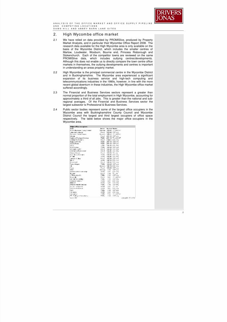
8/8/2019 Daws Hill & Abbey Barn Planning and Infrastructure Framework - Appendices
http://slidepdf.com/reader/full/daws-hill-abbey-barn-planning-and-infrastructure-framework-appendices 66/85
A N A L Y S I S O F T H E O F F I C E M A R K E T A N D O F F I C E S U P P L Y P I P E L I N E I N H I G H W Y C O M B E
A N D C O M P E T I N G L O C A T I O N S
D A W S H I L L A N D A B B E Y B A R N L A N E S I T E S
2
2. High Wycom be off ice m arket
2.1 We have relied on data provided by PROMISlive, produced by PropertyMarket Analysts, and in particular their Wycombe Office Report 2008. Theresearch data available for the High Wycombe area is only available on thebasis of the Wycombe District, which includes the smaller centres ofMarlow, Loudwater, Wooburn, Bourne end, Princess Risborough andStokenchurch. Each of the competitor towns are reviewed on the samePROMISlive data, which includes outlying centres/developments.Although this does not enable us to directly compare the town centre officemarkets in themselves, the outlying developments and centres is importantin understanding an areas property market.
2.2 High Wycombe is the principal commercial centre in the Wycombe Districtand in Buckinghamshire. The Wycombe area experienced a significant
expansion of its business service and high-tech computing andtelecommunications industries in the 1990s, however, in line with the morerecent global downturn in these industries, the High Wycombe office marketsuffered accordingly.
2.3 The Financial and Business Services sectors represent a greater thannormal proportion of the total employment in High Wycombe, accounting forapproximately a third of all jobs. This is greater than the national and sub-regional averages. Of the Financial and Business Services sector thelargest subsector is Professional & Business Services.
2.4 Public sector bodies represent some of the largest office occupiers in theWycombe area with Buckinghamshire County Council and WycombeDistrict Council the largest and third largest occupiers of office space
respectively. The table below shows the major office occupiers in theWycombe area.

8/8/2019 Daws Hill & Abbey Barn Planning and Infrastructure Framework - Appendices
http://slidepdf.com/reader/full/daws-hill-abbey-barn-planning-and-infrastructure-framework-appendices 67/85
A N A L Y S I S O F T H E O F F I C E M A R K E T A N D O F F I C E S U P P L Y P I P E L I N E I N H I G H W Y C O M B E
A N D C O M P E T I N G L O C A T I O N S
D A W S H I L L A N D A B B E Y B A R N L A N E S I T E S
3
2.5 Information and Communication Technologies industries are importantoffice occupiers in Wycombe. Although most of this sector tend to be small
to medium sized firms, there are a number of significant occupiers in thetown including Maritz Wolff & Co, Insignia Solutions, JD Edwards, LysanderSystems and Maindec.
2.6 As with the IT sector most of the professional service sector tend to besmall to medium sized firms although there are larger professional servicesoccupiers, such as Dun & Bradstreet, which is the second largest occupierin the district.
2.7 Manufacturing firms also represent an important office occupier inWycombe, particularly the pharmaceutical and car manufacturing sectors.Johnson & Johnson are the fourth largest office occupier and GeneralMotors, Saab, Volvo and Hyundai all represent significant local officeoccupiers.
Stock
2.8 Wycombe District had an estimated office stock of 4.4m sq.ft (408,770sq.m) at the end of 2007. This stock is located across the district and notconcentrated solely in High Wycombe itself. In terms of the total stock only2.7% represents “new” (post 2002) stock which shows the lack of activity inthe local office development market. The most recent significant officedevelopment was Aria, Oxford Road, High Wycombe, a development of44,000 sq.ft (4,087 sq.m) in 2002.
Key Locations
2.9 There have been very few significant office development schemes built in
High Wycombe in recent years and this is reflected in the poor quality ofoffice stock. The office core in High Wycombe is based around EastonStreet to the eastern side of the town centre. More modern officedevelopment is based around Oxford Street to the north west of the towncentre.
2.10 Surrounding central High Wycombe are a number of business parks;Cressex Park to the west of High Wycombe, Kingsmead Business Park2km to the east of High Wycombe, Chess Business Park in Chesham to thenorth and Globe Park, Globeside and Marlow International Park, all locatedin Marlow.
2.11 Local agents comment that Kingsmead Business Park is currentlyconsidered as the prime office location in the High Wycombe area.
Office tak e-up
2.12 Take-up in Wycombe in 2007 was estimated at 52,000 sq.ft (4,831 sq.m),which represents a 78% fall from the 2006 take up figure of 243,000 sq.ft(22,575 sq.m). From our investigations, this appears to be due to anabsence of space, both grade A and second hand, and a lack ofdevelopment opportunities. This is in comparison to the wider, the M25West market, that recorded a 14% take-up increase over the same timeperiod.
2.13 In context, the 5 year average take up in Wycombe has been 213,000 sq.ft(19,788 sq.m) so the take-up in 2007 represents a very poor year in termsof the High Wycombe office market.
2.14 Market commentators and the agents that we contacted have attributed thislow level of take up due primarily to a lack of new office space coming to

8/8/2019 Daws Hill & Abbey Barn Planning and Infrastructure Framework - Appendices
http://slidepdf.com/reader/full/daws-hill-abbey-barn-planning-and-infrastructure-framework-appendices 68/85
A N A L Y S I S O F T H E O F F I C E M A R K E T A N D O F F I C E S U P P L Y P I P E L I N E I N H I G H W Y C O M B E
A N D C O M P E T I N G L O C A T I O N S
D A W S H I L L A N D A B B E Y B A R N L A N E S I T E S
4
the market but also due to the success of some of High Wycombe’scompetitors, Reading, Maidenhead and Slough, all of which had significant
increases in take up from 2006 to 2007.2.15 The only significant deal of note in 2007 was the letting of 33,400 sq.ft
(3,102 sq.m) at Centro, in the nearby Beaconsfield to Adventis Group.Although this is located in South Buckinghamshire District Council, webelieve it is relevant as it represents the largest recent deal in the area.
Availability
2.16 At the end of 2007 the estimated availability in High Wycombe is 518,000sq.ft (48,123 sq.m). This compares with a peak of circa 1.2m sq.ft (111,482sq.m) at the end of 2003. The fall in availability is primarily due to lack ofsupply coming to the market and the removal, following lettings of a numberof large units from the market.
Supply Pipeline
2.17 There is very limited office space under construction.
2.18 In terms of the supply pipeline there is an estimated 1.9 million sq.ft(176,514 sq.m) in the Wycombe development pipeline. Of this 1.3m sq.ft(120,772 sq.m) has planning permission. The remainder of the supplypipeline is at a more preliminary stage, being sites that have beenhighlighted as office locations but are at a pre-permission stage.
2.19 Of the office pipeline with permission the majority is located out of town withtwo planned schemes over 100,000 sq.ft (9,290 sq.m). These are at GloryPark, Wooburn Green and at Globeside, Marlow. The remainder of thepipeline comprises small to medium sized developments.
2.20 There is currently 26,000 sq.ft (2,415 sq.m) of development underconstruction at Anglo Office Park, near Cressex Business Park,High Wycombe. This represents less than 1% of the total office stock.Anglo Park is a development of 10 new office buildings with space availablefrom 944 sq.ft (88 sq.m), with the smallest whole building available at 1,968sq.ft (183 sq.m). This development has just come to the market.
2.21 Recently HGB have begun construction of three speculative office units aspart of the first phase at their Glory Park development. The 16,000 sq.ft(1,486 sq.m), 19,000 sq.ft (1,765 sq.m) and 29,000 sq.ft (2,694 sq.m) unitsare being quoted at £29.50 per sq.ft (£318 per sq.m). The 10.2 acre site,which is located at Woodburn Green, 1 mile from junction 3 of the M40, willeventually be a 180,000 sq.ft (16,722 sq.m) development. This speculative
development was commenced before the latest financial difficultiesoccurred.
2.22 There are a number of sites in and around High Wycombe that representlong term employment development opportunities.
2.23 There is planned further employment development located in the vicinity ofthe Handy Cross roundabout. The Council have modelled between 20,000sq.m (215,276 sq.ft) and 32,000 sq.m (344,444 sq.m) of office floorspaceadjacent to the motorway at Handy Cross as part of a draft masterplan. Itis understood from a conversation with Charles Brocklehurst that an outlineplanning application is due to be made shortly including officeaccommodation at, or around, the upper level of this range.
2.24 High Wycombe hospital are currently undertaking an estates review andthere is a possibility that the hospital will relocate as a whole, which wouldrelease their site, which is circa 20 acres, for development. It must be

8/8/2019 Daws Hill & Abbey Barn Planning and Infrastructure Framework - Appendices
http://slidepdf.com/reader/full/daws-hill-abbey-barn-planning-and-infrastructure-framework-appendices 69/85
A N A L Y S I S O F T H E O F F I C E M A R K E T A N D O F F I C E S U P P L Y P I P E L I N E I N H I G H W Y C O M B E
A N D C O M P E T I N G L O C A T I O N S
D A W S H I L L A N D A B B E Y B A R N L A N E S I T E S
5
noted that the release of land at this site is unlikely in the next decade andtherefore would not represent direct competition to any office development
at the Daws Hill / Abbey Barn Lane sites.2.25 There is also the possibility of the Council considering a relocation from the
current 80,000 sq.ft (7,432 sq.m) premises at Queen Victoria Road. Thiswould be in the long term but any relocation would release a significantland holding in a location very close to the town centre.
2.26 There is a six acre site at the Hughenden Quarter that represents adevelopment opportunity, although not necessarily an office development.It is a cleared site with spine roads already in place. This site, which isnorth of the town centre, has potential for development under a number ofdifferent use classes.
2.27 The site known as Swan Frontage which currently houses the fire stationand the British Legion will potentially be rationalised to provide adevelopment opportunity of circa 40,000 sq.ft (3,716 sq.m) for a standalone office development. This opportunity has the potential to come to themarket within three years.
2.28 In addition, the Council has identified land at Baker Street backlands(Desborough Square) for office development. This 5 acre site, located onthe north and south side of Baker Street, west of the town centre, has thepotential to access onto the A40 (West Wycombe Road) and is located in apredominantly employment location.

8/8/2019 Daws Hill & Abbey Barn Planning and Infrastructure Framework - Appendices
http://slidepdf.com/reader/full/daws-hill-abbey-barn-planning-and-infrastructure-framework-appendices 70/85
A N A L Y S I S O F T H E O F F I C E M A R K E T A N D O F F I C E S U P P L Y P I P E L I N E I N H I G H W Y C O M B E
A N D C O M P E T I N G L O C A T I O N S
D A W S H I L L A N D A B B E Y B A R N L A N E S I T E S
6
3. Compet ing locations
Reading
3.1 Reading is located approximately 20 km south west of High Wycombe andis located on the M4.
3.2 Reading is a major commercial centre and forms the core of the ThamesValley property market, which has been described as the UK’s SiliconValley. Reading’s office market is dominated by the high-tech sector thatwent through a revolution in the 1990s. As well as its attraction to high-techindustries, its position as a regional centre adds to its economy.
3.3 Key occupiers in Reading include Microsoft, Oracle, Symamtec, Worldcomand Cisco.
Stock
3.4 Reading has an estimated office stock of 10.9m sq.ft (1,012,600 sq.m) atthe end of 2007, which ranks highly when compared to other office centresaround the country.
3.5 At the end of 2007, 4.6% of the Reading office stock was completed in thelast five years, which is lower than might have been expected. However,as previously mentioned, there was a significant amount of officedevelopment in the 1990s.
3.6 In the last 20 years completions in Reading have totalled 6.1m sq.ft(566,708 sq.m) with a peak in completions in 2002 with over 600,000 sq.ft(55,740 sq.m) completed in Green Park alone.
3.7 Completions in 2003/4 were very low as a result of low demand and highavailability.
3.8 In the last five years 24% of development in Reading has been speculativewith 76% purpose built. This represents a far lower than averagespeculative development and is likely to have been skewed by the largepre-lets at Green Park and Winnersh Triangle.
Key locations
3.9 The majority of Readings office stock is found in the town centre and anumber of major business parks within the area.
Green Park
3.10 Located just south of the town centre on junction 11 of the M4 Green Parkis Reading’s best known office park. Developed by PRUPIM, beginning in1999, the park expanded quickly as a result of the high tech boom withlarge pre-lets to Cisco and Symantec. Cisco took a pre-let of over 600,000sq.ft (55,740 sq.m) in 2000 in order to accommodate up to 5,000 staff,however, following changes in the sector Cisco have only occupied 4 of the8 buildings, which are still vacant.
3.11 Despite significant vacancies PRUPIM are currently speculativelyconstructing 80,000 sq.ft (7,430 sq.m) of office space.
Thames Valley Park
3.12 Thames Valley Park is located approximately 3km east of Reading station.The park is largely built out and comprises purpose built headquarter
accommodation. In terms of recent activity Microsoft completed a further60,000 sq.ft (5,574 sq.m) building in 2007.
8/8/2019 Daws Hill & Abbey Barn Planning and Infrastructure Framework - Appendices
http://slidepdf.com/reader/full/daws-hill-abbey-barn-planning-and-infrastructure-framework-appendices 71/85
A N A L Y S I S O F T H E O F F I C E M A R K E T A N D O F F I C E S U P P L Y P I P E L I N E I N H I G H W Y C O M B E
A N D C O M P E T I N G L O C A T I O N S
D A W S H I L L A N D A B B E Y B A R N L A N E S I T E S
7
3.13 Occupiers include Oracle, Microsoft, Regus, Xansa and ING direct.
Winnersh Triangle
3.14 Approximately 10 km west of Reading is Winnersh Triangle, whichoriginally developed as an industrial location but has since become a mixeduse park.
3.15 Occupiers include Virgin media, Harris Systems and Agilent Technologies.
3.16 Harris Systems and Jacobs took significant pre-lets in 2007 (72,500 sq.ft(6,735 sq.m) and 113,000 sq.ft (10,500 sq.m) (respectively) at the park andconstruction is currently underway for 89,000 sq.ft (8,268 sq.m) ofspeculative space.
Arlington Business Park
3.17 Located at junction 12 of the M4, this development which began in the1980s has occupiers such as KPMR, Walkers, RBS and Vodafone.
3.18 In 2007 the final stage of the development, 108,000 sq.ft (10,030 sq.m) ofoffice space was developed, representing the largest speculative officedevelopment in Reading in recent years.
Reading International Business Park
3.19 A significant office park located close to Green Park and junction 11 of theM4. Some space remains available.
3.20 Occupiers include Worldcom.
Town Centre
3.21 Reading town centre’s office market is contained by the Thames to thenorth and by the inner ring road on all other sides. Key office
developments in the town centre are Apex Plaza (a large 1980sdevelopment), Great Bringhams Mead (a development of 84,400 sq.ft(7,840 sq.m) in 2000) and Forbury Square (an 2003 Argent development of150,000 sq.ft (13,935 sq.m)). In addition to these schemes Kier/Invista aredeveloping Reading central, the first phase of which comprises 216,000sq.ft (20,067 sq.m) of development.
3.22 The town centre has a wide mix of office accommodation ranging from highspec modern office accommodation to 1960s dated office properties.
Take up
3.23 During the 1990s, with the boom in the High Tech industry, Reading’sproperty market thrived and 2000 saw record levels of take up. After 2000,
and the end of the High Tech boom, take up in Reading fell away and 2003saw a record low level of take up. Since 2003 take up has been recoveringand 2007 saw the highest take up since 2000, supported by two large pre-lets.
3.24 In terms of figures take up in 2000 was 1,784,000 sq.ft (165,740 sq.m) andthe five year average to the end of 2007 was 481,000 sq.ft (44,690 sq.m).take up in 2007 was estimated at 896,000 sq.ft (83,240 sq.m) whichincludes 351,000 sq.ft (32,610 sq.m) of pre-lets. Wyeth, a pharmaceuticalcompany, took a pre-let at Green Park of 115,000 sq.ft (10,684 sq.m) for anew UK HQ. Wyeth will occupy this space upon completion in 2009.Jacobs, a US engineering firm, took 133,000 sq.ft (12,356 sq.m) on a pre-let at Winnersh Triangle in December 2007.
8/8/2019 Daws Hill & Abbey Barn Planning and Infrastructure Framework - Appendices
http://slidepdf.com/reader/full/daws-hill-abbey-barn-planning-and-infrastructure-framework-appendices 72/85
A N A L Y S I S O F T H E O F F I C E M A R K E T A N D O F F I C E S U P P L Y P I P E L I N E I N H I G H W Y C O M B E
A N D C O M P E T I N G L O C A T I O N S
D A W S H I L L A N D A B B E Y B A R N L A N E S I T E S
8
3.25 In terms of lettings the most significant (non pre let) in 2007 were; to FosterWheeler, who took 76,000 sq.ft (7,060 sq.m) at Abbey Gardens South and
to Harris Systems, who to 72,500 sq.ft (6,735 sq.m) at Winnersh Triangle.3.26 In 2008 Yell have taken a 154,000 sq.ft (14,307 sq.m) pre-let at Reading
Central development in the town centre.
Availability
3.27 At mid 2008 EG property link estimate availability in Reading at 1,860,000sq.ft (172,800 sq.m), equating to 17.1%, a higher than average figure.
Supply pipeline
3.28 At the end of 2007 there was 880,000 sq.ft (81,755 sq.m) underconstruction in Reading, 718,000 sq.ft (66,704 sq.m) of which was due tocomplete in 2008. Of the total 37% is under construction in the town
centre, largely made up of the Reading Central development and AbbeyMill House development, with the remainder in out of town locations inparticular Winnersh Triangle and Green Park.
3.29 There is 6.3m sq.ft (585,290 sq.m) in the Reading office pipeline with 4.4msq.ft (408,780 sq.m) with planning permission. 73% of this is out of townwith the remainder in the town centre. Of the total there are 18 plannedschemes of over 100,000 sq.ft (9,290 sq.m).
Oxford
3.30 Oxford’s economy is heavily linked to its two universities and it’s localoccupiers are made up of a large number of research and biotechnologyfirms, research and development occupiers, telecommunication companies
and IT occupiers.
3.31 The two universities are the principal occupiers of employment space.Outside the universities the largest occupiers are within the publishingsector including Oxford University Press, Blackwell Publishing, Elsevier andTaylor & Francis.
3.32 Other important occupiers are Power Med, Sharp Laboratories andSyntaxin from the biotechnology and research industry and Sophos andRM from the IT industry.
Stock
3.33 Oxford has an estimated office stock of 4.2m sq.ft (390,192 sq.m) at theend of 2007.
3.34 At the end of 2007 18.3% of Oxford office stock had been completed since2002. Of this completions 39% of the space was completed on aspeculative basis with 61% on a pre-let basis. The figure of 39%speculative development is below the market norm.
3.35 In 2007 a record 277,000 sq.ft (25,735 sq.m) of office space wascompleted. This was largely made up of the speculative space developedat Oxford Science Park. This figure of 277,000 sq.ft (25,735 sq.m) is farhigher than the 20 year average of 108,000 sq.ft (10,033 sq.m) per annum.
3.36 Due to the huge presence of Oxford University in the town centre it meansthere is very little office stock in the centre, and as such, much if the officestock is outside the town centre.
Take up

8/8/2019 Daws Hill & Abbey Barn Planning and Infrastructure Framework - Appendices
http://slidepdf.com/reader/full/daws-hill-abbey-barn-planning-and-infrastructure-framework-appendices 73/85
A N A L Y S I S O F T H E O F F I C E M A R K E T A N D O F F I C E S U P P L Y P I P E L I N E I N H I G H W Y C O M B E
A N D C O M P E T I N G L O C A T I O N S
D A W S H I L L A N D A B B E Y B A R N L A N E S I T E S
9
3.37 Take up in 2007 was estimated at 160,000 sq.ft (14,865 sq.m), down 45%from 2006 with no deals agreed over 35,000 sq.ft (3,251 sq.m). 2006
represented a strong year for take up in Oxford with large lettings at OxfordBusiness Park and Oxford Science Park.
3.38 This 160,000 sq.ft (14,865 sq.m) take up compares to an average, over thelast five years of 216,000 sq.ft (20,067 sq.m) per annum.
3.39 The most significant deal in 2007 was the letting of Winchester House atthe Oxford Science Park to Amey. The building was 28,000 sq.ft (2,601sq.m).
Key locations
3.40 Central Oxford, due to the nature of its historical buildings, its restrictiveplanning policy and the presence of large numbers of students andeducational staff in the centre does not have a town centre office market to
note.
3.41 The office market in Oxford is generally made up of out of towndevelopments, the majority of which are located in the Cowley area. Themost significant of which are detailed below.
Oxford Business Park
3.42 Development at this scheme began in 1994 and it has grown to be a wellestablished office park. Key occupiers include Manches solicitors,Blackwell Publishing, Quorum, Henmans LLP, Oxfam and HMRC. Thepark is a mix of HQ properties and multi-let office buildings.
3.43 There is currently a 25,000 sq.ft (2,323 sq.m) vacant property.
Oxford Science Park 3.44 Oxford Science Park is a joint venture development between PRUPIM &
Magdalen college. It comprises a 75 acre site and it has a planningpermission for phase 1 & 2 comprising B1 with a restriction to a scienceuse until 2011.
3.45 The scheme is occupied by R&D and Biochemical companies.
3.46 There is 30,000 sq.ft (2,787 sq.m) of vacant space at Fletcher House onthe site.
3.47 Planning permission has been permitted for Plot 26 – where a significantpre-let opportunity is available. There are 7 further plots yet to bedeveloped. PRUPIM commented that they would not consider any
development without a pre-let.3.48 Key occupiers include Amey and Sharp Technology.
Availability
3.49 Estates Gazette estimate that in mid 2008 the office availability in Oxfordstands at 345,000 sq.ft (32,052 sq.m). This equates to 8.3% of the totalstock and is lower than the average for town of Oxford’s size.
3.50 It is understood that the majority of this availability is in second hand stockas a result of the low level of speculative space having been developed inOxford in recent years.
Supply pipeline
3.51 There is currently 197,000 sq.ft (18,301 sq.m) of office space underconstruction in Oxford. This equates to circa 1% of stock.

8/8/2019 Daws Hill & Abbey Barn Planning and Infrastructure Framework - Appendices
http://slidepdf.com/reader/full/daws-hill-abbey-barn-planning-and-infrastructure-framework-appendices 74/85
A N A L Y S I S O F T H E O F F I C E M A R K E T A N D O F F I C E S U P P L Y P I P E L I N E I N H I G H W Y C O M B E
A N D C O M P E T I N G L O C A T I O N S
D A W S H I L L A N D A B B E Y B A R N L A N E S I T E S
1 0
3.52 The majority of the space that is under construction is due to complete thisyear.
3.53 There is 3.1m sq.ft (288,000 sq.m) in the Oxford office pipeline with 2.1msq.ft (195,096 sq.m) with planning permission. The large majority of this isout of town with the remainder in the town centre. Of the total there are 9planned schemes of over 100,000 sq.ft (9,290 sq.m).
Slough
3.54 Although not as important a commercial centre as nearby Reading, Sloughhas seen significant growth as an office centre, particularly during the1990s. It is well located for the M4 and M25 and for Heathrow airport.Slough, as a commercial centre, includes the district of Windsor.
3.55 The high tech sector represents a high proportion of the Sloughoccupational market.
3.56 Key occupiers in Slough include Amazon, O2, Centrica, Celltech andcomputer Associates.
Stock
3.57 Slough has an estimated office stock of 4.6m sq.ft (427,354 sq.m) at theend of 2007, of which 7% has been completed since the end of 2002.
3.58 83,000 sq.ft (7,710 sq.m) of stock was completed in 2003, some way belowthe historic peak of 360,000 sq.ft (33,445 sq.m) completed in 2002.
3.59 Over the last 20 years completions in Slough have totalled 3m sq.ft(278,709 sq.m), increasing the office stock by 124% compared to anaverage increase across other office centres of 43%.
3.60 2002 saw the historic peak in completions, which, coupled with thedownturn in the high tech industry at the time, led to no significantcompletions in 2005/6. 2007 saw a pick up in development.
3.61 In the last five years 58% of development in Slough has been speculativewith 42% purpose built. This represents a higher than average speculativedevelopment.
Key locations
3.62 Slough town centre, with its secondary and unattractive 1950s and 1960soffice stock, is not considered to be an attractive office location. Recentdevelopment has therefore been focused to the west of the town centre at
the town’s more established out of town office locations.Bath Road & Slough Trading Estate
3.63 The Bath Road area has seen a large amount of recent developmentactivity due to its available land, good access and ability to have high carparking ratios. Segro own much of the stock on the Bath Road and the keyoccupiers are LG Electronics, Fiat, Celltech and Black and Decker. Recentactivity includes the 100,000 sq.ft (9,290 sq.m) pre-let to 02. Segro and theSlough Trading estate are located on the north side of Bath Road, on thesouth side development has also occurred in recent times with the Turnerbuilding now being occupied by Reckitt Benckiser.
Axis Park
3.64 Axis Park is the newest business park in the area and, whilst predominantlyan industrial park, 100,000 sq.ft (9,290 sq.m) of office space completed in2002 in two buildings.
8/8/2019 Daws Hill & Abbey Barn Planning and Infrastructure Framework - Appendices
http://slidepdf.com/reader/full/daws-hill-abbey-barn-planning-and-infrastructure-framework-appendices 75/85
A N A L Y S I S O F T H E O F F I C E M A R K E T A N D O F F I C E S U P P L Y P I P E L I N E I N H I G H W Y C O M B E
A N D C O M P E T I N G L O C A T I O N S
D A W S H I L L A N D A B B E Y B A R N L A N E S I T E S
1 1
Take up
3.65 Take up in 2007 was 330,000 sq.ft (30,658 sq.m) up 99% from the 2006figure of 166,000 sq.ft (15,422 sq.m). The 5 year average up to the end of2007 was 232,000 sq.ft (21,553 sq.m). Take up in 2007 was skewed by a100,000 sq.ft (9,290 sq.m) pre-letting to 02 on Bath Road.
3.66 Slough, amongst other towns that rely on the high tech industry, hassuffered as a result in the slow down in that sector particularly in the early2000s. However, due to it proximity to Heathrow and road links Slough stillremains an attractive location to international companies and demand isreasonably high.
3.67 As previously mentioned, 02 took a 100,000 sq.ft (9,290 sq.m) pre-lettingon Bath Road next to their existing offices.
3.68 The only other recent significant deals were, the letting to Motion, the
makers of the Blackberry, of 70,000 sq.ft (6,503 sq.m) on Bath Road in2005 for their European HQ, the pre-letting of 63,500 sq.ft (5,900 sq.m) toCelltech as their research plant and the letting of 87,000 sq.ft (8,082 sq.m)to Reckitt Benckiser on Bath Road.
3.69 In early 2008 Savvis, a data centre provider, took 61,000 sq.ft (5,667 sq.m)on Leigh Road.
Availability
3.70 It was estimated that in mid-2008 availability in Slough was 815,000 sq.ft(75,715 sq.m) equating to 17.8%, which is above average for similar officecentres.
Supply pipeline3.71 There is currently 198,000 sq.ft (18,394 sq.m) of office space under
construction which equates to 4.4% of existing floor space. 100,000 sq.ft(9,290 sq.m) of this will complete in 2008.
3.72 There is 1.6m sq.ft (148,645 sq.m) in the Slough office pipeline with 1msq.ft with planning permission. 27% of this is out of town with theremainder in the town centre. Of the total there are 6 planned schemes ofover 100,000 sq.ft (9,290 sq.m).
Other com peting locations
Heathrow/Uxbridge
3.73 The Heathrow and Uxbridge markets benefit from excellent road links viathe M4 and M25 and the proximity to Heathrow airport. The market inthese locations is strongly driven by air-related firms and multinationalheadquarters.
3.74 The total stock in these locations was 8.6m sq.ft (798,966 sq.m) at the endof 2007. Key occupiers include British Airways, BAA, BP, BT and VirginAtlantic.
3.75 Take up in 2007 was estimated at 675,000 sq.ft (62,710 sq.m) with a keydeal to BAA of 200,000 sq.ft (18,508 sq.m) at the Compass centre close toHeathrow airport
3.76 Key locations include Stockley Park, one of the UK’s largest business parks
at 1.6m sq.ft (148,644 sq.m), Bedfont Lakes, a development of 700,000sq.ft (65,032 sq.m) and Uxbridge town centre.

8/8/2019 Daws Hill & Abbey Barn Planning and Infrastructure Framework - Appendices
http://slidepdf.com/reader/full/daws-hill-abbey-barn-planning-and-infrastructure-framework-appendices 76/85
A N A L Y S I S O F T H E O F F I C E M A R K E T A N D O F F I C E S U P P L Y P I P E L I N E I N H I G H W Y C O M B E
A N D C O M P E T I N G L O C A T I O N S
D A W S H I L L A N D A B B E Y B A R N L A N E S I T E S
1 2
3.77 There is currently no significant office space under construction, howeverthere is circa 2.1m sq.ft (195,096 sq.m) of potential space in the pipeline.
Office development in these locations is generally carried out on a pre-letbasis, which explains the lack of current development as compared with thesubstantial potential development.
Abingdon Business Park & Abingdon Scienc e Park
3.78 Located just south of Oxford Abingdon Business Park is an establishedoffice park on the edge of Abingdon. Large occupiers at the park includeSchlumberger, EBI Foods and ITV Thames valley. There has been nodevelopment for some time at this park, however, the developersIVG/Asticus/AXA have recently refurbished a circa 40,000 sq.ft (3,716sq.m) building on the park.
3.79 Abingdon Science Park is located close to the business park and houses
occupiers such as Sophos, Barclay Homes and Pwenlon.Milton Park, Didcot
3.80 This large, 250 acre development of 3,000,000 sq.ft (278,709 sq.m),contains a mixture of office and R&D occupiers. Substantial developmenthas occurred over the last few years and 150 occupiers are located here.There is a mix of stand alone HQ buildings as well as multi-let offices.
3.81 Circa 40,000 sq.ft (3,716 sq.m) of office/R&D space was completed in 2007and there is office space currently under construction.
3.82 Key occupiers include RM Group.
Maidenhead
3.83 In general, the Maidenhead market is limited by a lack of readily availabledevelopment land. There are significant occupiers such as 3G, Norten andAlcatel which all benefits from Maidenhead’s strong transport links.
3.84 The data for Maidenhead, like High Wycombe, includes Marlow, due to itsproximity and so analysis is difficult.
3.85 Maidenhead represents the most similar competing town in our opinion as ithas a less established office market when compared to Oxford, Slough andReading.
Aylesbury
3.86 Due to the limited nature of the Aylesbury office market there is little
information on the quantum of office space.3.87 Aylesbury has a mix of public and private sector occupiers. The County and
District Council offices are located in Aylesbury, and it is also a base forprivate sector occupiers such as HBOS, the financial services subsidiarywho have a major presence in the town.
3.88 “Aylesbury Vale Advantage” (a partnership formed between Aylesbury ValeDistrict Council, Buckinghamshire County Council, The Vale of AylesburyPrimary Care Trust, SEEDA and English Partnerships) has been formed tochampion growth in Aylesbury both in terms of housing and commercialuses. The partnership is in part there to oversee growth in businessdevelopment, infrastructure and regeneration.
3.89 This growth includes involves two major employment developments atAston Clinton (26ha – 64 acres) and Berryfields (10ha - 24.71 acres).

8/8/2019 Daws Hill & Abbey Barn Planning and Infrastructure Framework - Appendices
http://slidepdf.com/reader/full/daws-hill-abbey-barn-planning-and-infrastructure-framework-appendices 77/85
A N A L Y S I S O F T H E O F F I C E M A R K E T A N D O F F I C E S U P P L Y P I P E L I N E I N H I G H W Y C O M B E
A N D C O M P E T I N G L O C A T I O N S
D A W S H I L L A N D A B B E Y B A R N L A N E S I T E S
1 3
Hemel Hempstead
3.90 Hemel Hempstead is a small office centre with a total stock of 353,035sq.m (3.8 m sq.ft).
3.91 Take up in 2007 was 4,459.4 sq.m (48,000 sq.ft).
3.92 Whilst only 1,765.2 sq.m (19,000 sq.ft) of office space is currently underconstruction. There is currently no other significant office space underconstruction, however there is circa 2.1m sq.ft (195,096 sq.m) of potentialspace in the pipeline. Of this 0.4m sq.ft has planning permission and theremainder at a preliminary stage in the development process.

8/8/2019 Daws Hill & Abbey Barn Planning and Infrastructure Framework - Appendices
http://slidepdf.com/reader/full/daws-hill-abbey-barn-planning-and-infrastructure-framework-appendices 78/85
A N A L Y S I S O F T H E O F F I C E M A R K E T A N D O F F I C E S U P P L Y P I P E L I N E I N H I G H W Y C O M B E
A N D C O M P E T I N G L O C A T I O N S
D A W S H I L L A N D A B B E Y B A R N L A N E S I T E S
1 4
4. Analysis
Total Stock
Total office s tock - end 2007
-
2,000,000.00
4,000,000.00
6,000,000.00
8,000,000.00
10,000,000.00
12,000,000.00
Wycombe Dis tric t Ox ford Slough Dis tr ic t Reading
Total off ice stock
4.1 The table above shows the total office stock of Wycombe District and itscompetitive locations. Reading clearly has the largest office market withWycombe District, Slough District and Oxford having similar levels of stock.
4.2 It is worth noting that the figure used for Wycombe District, as discussedabove, incorporates the office stock in the surrounding areas such as
Marlow and Stokenchurch.
4.3 Given a scenario where the office stock in the locations surrounding HighWycombe is removed, it is our view that High Wycombe would have thesmallest office market by some margin.
Take up
Estimated office take up 2007
-
100,000.00
200,000.00
300,000.00
400,000.00
500,000.00
600,000.00
700,000.00
800,000.00
900,000.00
1,000,000.00
Wycombe District Oxford Slough District Reading
Location
s q . f
t
Estimated office take up 2007

8/8/2019 Daws Hill & Abbey Barn Planning and Infrastructure Framework - Appendices
http://slidepdf.com/reader/full/daws-hill-abbey-barn-planning-and-infrastructure-framework-appendices 79/85
A N A L Y S I S O F T H E O F F I C E M A R K E T A N D O F F I C E S U P P L Y P I P E L I N E I N H I G H W Y C O M B E
A N D C O M P E T I N G L O C A T I O N S
D A W S H I L L A N D A B B E Y B A R N L A N E S I T E S
1 5
4.4 The chart which highlights estimated take up in 2007, clearly shows thestatic nature of the market in Wycombe District. As mentioned previously,
this can in some way be attributed to the lack of new office space coming tothe market over the last 12-24 months, however, it is also as a result of alack of demand in Wycombe District when compared to its competitors.
4.5 The graph also illustrates that Reading, with its more significant officemarket, saw an incomparable level of take up in 2007. Its take up was 17times greater than that in Wycombe District. Although a much higher levelof take up is expected compared to Wycombe District it does show theinherent differences between an established office location and a town likeHigh Wycombe.
4.6 Both Slough District and Oxford have considerably higher take up as aresult of more office space being developed over the last two years andtheir greater attractiveness as office locations.
Availability
Estim ated current availability
-
200,000.00
400,000.00
600,000.00
800,000.00
1,000,000.00
1,200,000.00
1,400,000.00
1,600,000.00
1,800,000.00
2,000,000.00
Wycombe Distr ic t Oxford Slough Distr ic t Reading
Estimated current availability
4.7 The availability graph shows similar trends as the total office stock graph,as would be expected.
4.8 There is clearly a significant level of office availability in all locations, someof which will be secondary stock, but some of which will be modernspeculative development. The high levels of available space does concernus as it directly impacts upon the supply and demand level in theselocations.
4.9 The higher the office availability, the less likely an office developmentscheme is likely to be commenced unless a pre-let is arranged.
4.10 The longer space in speculative developments across all of the locationsremains available, the more likely developers would be able to offerattractive incentives and lower rents to obtain tenants. This would have aknock on affect across the office development market.

8/8/2019 Daws Hill & Abbey Barn Planning and Infrastructure Framework - Appendices
http://slidepdf.com/reader/full/daws-hill-abbey-barn-planning-and-infrastructure-framework-appendices 80/85
A N A L Y S I S O F T H E O F F I C E M A R K E T A N D O F F I C E S U P P L Y P I P E L I N E I N H I G H W Y C O M B E
A N D C O M P E T I N G L O C A T I O N S
D A W S H I L L A N D A B B E Y B A R N L A N E S I T E S
1 6
Supply pipeline
Office space unde r construction - e nd 2007
-
100,000.00
200,000.00
300,000.00
400,000.00
500,000.00
600,000.00
700,000.00
800,000.00
900,000.00
1,000,000.00
Wycombe Distr ic t Oxford Slough Distr ic t Reading
Office space under construction
4.11 The supply pipeline graph shows a dramatic picture in terms of the lack ofdevelopment in Wycombe District and the level of development elsewhere.
4.12 The lack of development in Wycombe District can be attributed to two mainfactors; a lack of readily available development land and a lack of demandfor office space in High Wycombe itself.
Supply pipeline (wit h planning permission)
Pipeline wi th planning permission - end 2007
-
500,000.00
1,000,000.00
1,500,000.00
2,000,000.00
2,500,000.00
3,000,000.00
3,500,000.00
4,000,000.00
4,500,000.00
5,000,000.00
Wycombe District Oxford Slough District Reading
Pipeline with planning permission

8/8/2019 Daws Hill & Abbey Barn Planning and Infrastructure Framework - Appendices
http://slidepdf.com/reader/full/daws-hill-abbey-barn-planning-and-infrastructure-framework-appendices 81/85
A N A L Y S I S O F T H E O F F I C E M A R K E T A N D O F F I C E S U P P L Y P I P E L I N E I N H I G H W Y C O M B E
A N D C O M P E T I N G L O C A T I O N S
D A W S H I L L A N D A B B E Y B A R N L A N E S I T E S
1 7
4.13 In terms of the longer term supply pipeline, for schemes, with planningpermission, it is clear that there is significant scope for development in all of
the towns discussed. Reading has a significant supply pipeline of 4.4msq.ft (408,773 sq.m) which has the potential to absorb a large amount ofthe demand over the next few years. Each location has significant supplyand it is clear that new office development schemes coming forward willface significant competition.
4.14 It must be noted again that High Wycombe’s figure includes the pipeline atMarlow and is artificially high.
5. Conclusions
5.1 This report provides baseline information required to assess the relativeattractiveness of High Wycombe as an office location (against the existingand pipeline competition) and support the development of appropriate land
use options for the development of the M40 Gateway sites at Daws Hill andAbbey Barn Lane.
5.2 Two main scenarios are considered:
n The development of a large scale business campus; and
n The provision of a significant quantity of employment with a mixed use
area.
5.3 The first key difficulty highlighted is that High Wycombe is not anestablished office location and has not been developed as one over thepast two decades. It has not attracted the same level of quality occupierswhen compared to its competing towns and lacks the quality of stock foundelsewhere. In addition to this, there has been little suitable office
development land close to the High Wycombe and to the M40 and thusdevelopment has occurred further afield towards Marlow. As a result it hasleft High Wycombe with a lesser office market compared to comparabletowns, despite its strong transport and communication links.
5.4 The M40 Gateway sites represent a virtually unique opportunity to considera major business-led development, which may be deliverable in the shortand medium term. This opportunity needs to be considered within thecontext of a variety of other factors, such as those described below.
5.5 Where land is available within the town centre, certainty regardingtimescales for delivery of key sites, particularly the longer termopportunities such as the Council’s office campus on Queen Victoria Roadand High Wycombe Hospital (currently undertaking an estates strategyreview) would improve the marketability of the town.
How can High Wycombe re-establish its posit ion as an office
locat ion and succ essfully market a large scale business
development?
5.6 In our view, the Council should give consideration to the following points:
n Firstly, ensuring that a supply of deliverable development land is available
(or has the potential to be available) within the short to medium term; the
M40 Gateway sites are a great opportunity, which should be seriously
considered;
n Secondly, although we have entered a period of severe difficulties in the
economy and occupiers will be looking to rationalise and not necessarilyexpand, in our view and based on market trends, the current downturn is
cyclical and the Council should continue to use this time to set an
8/8/2019 Daws Hill & Abbey Barn Planning and Infrastructure Framework - Appendices
http://slidepdf.com/reader/full/daws-hill-abbey-barn-planning-and-infrastructure-framework-appendices 82/85
A N A L Y S I S O F T H E O F F I C E M A R K E T A N D O F F I C E S U P P L Y P I P E L I N E I N H I G H W Y C O M B E
A N D C O M P E T I N G L O C A T I O N S
D A W S H I L L A N D A B B E Y B A R N L A N E S I T E S
1 8
appropriate policy basis for longer term commercial development and
await the first signs of economic recovery;
n Thirdly, the creation of an inward investment agency – having the benefitof a successful inward investment agency championing High Wycombe’s
assets has the potential to increase both the town’s business profile andpresence and promote short term and long term opportunities in the M40
gateway and elsewhere. By way of example, inward investment promotion
agencies such as the successful “Locate in Kent” has created 20,000 new jobs for Kent, following the promotion of employment led sites; and
n Fourthly, ensuring that a dialogue is created and/or continued with major
commercial investors active in the area such as Argent, Prudential and
Arlington.
5.7 Given that there is a significant amount of existing and pipeline competitionin the immediate area and further afield, if High Wycombe strives to re-
establish its position within the office market hierarchy and improve itsrange and quality of stock, then there is potential to encourage occupiersaway from those more established locations.
5.8 In order to bring about a greater competitiveness in High Wycombe’s officemarket we believe that the town would need to create an ‘angle’ that setsitself aside from its rivals.
5.9 We believe that one of the key factors in encouraging occupiers away fromcompeting locations would be establishing High Wycombe as a cheaperplace to take office space. Strong rental value competitiveness wouldmake High Wycombe a more attractive proposition for office occupiers.However, it is difficult to control the rental value levels in a town/area asthere are so many factors that impact upon this level such as appropriate
supply, developers profit requirements, section 106 requirements and ofcourse demand.
5.10 If rental competitiveness could be achieved their would be a good chanceof an initial influx of office occupiers. It is our belief however that this wouldonly benefit the area in the short/medium term as the increased demand,taking account a simple supply/demand theory, would eventually drive upthe rents in the area. This would halt the competitive advantage resultingfrom the reduced rents. As such, although we believe that addressingrental competitiveness could bring about initial office occupationalincreases, it does not guarantee that that the area would become a moreestablished office location in the long run.
5.11 Without an improvement in the range and quality of stock there is a risk that
High Wycombe could effectively be ‘left behind’, while other competingtowns would almost certainly strengthen their positions, and thereforeprovide occupiers with a much expanded choice over time.
Key st eps to succ essfully developing a business campus as part of
the development of the M40 Gatew ay sites:
5.12 Occupiers seeking accommodation for large HQ facilities would consider afairly wide target area – driven primarily by proximity to motorways, rail andairport connections as well as the quality of the environment and itsassociated amenities.
5.13 In addition to Reading and Oxford competition comes from Slough and theHeathrow/Uxbridge locations which benefit from excellent road transport
links to the M25 and M4 as well of the proximity to Heathrow, the UK’s

8/8/2019 Daws Hill & Abbey Barn Planning and Infrastructure Framework - Appendices
http://slidepdf.com/reader/full/daws-hill-abbey-barn-planning-and-infrastructure-framework-appendices 83/85
A N A L Y S I S O F T H E O F F I C E M A R K E T A N D O F F I C E S U P P L Y P I P E L I N E I N H I G H W Y C O M B E
A N D C O M P E T I N G L O C A T I O N S
D A W S H I L L A N D A B B E Y B A R N L A N E S I T E S
1 9
largest airport. This location is particularly attractive to the multinationalsevidenced by the Intercontinental Hotels letting in Uxbridge.
5.14 The comparative towns of Reading and Oxford have, over the last 10-20years attracted the likes of Prudential, the Kier Group, Argent and Invista asdevelopers of significant office schemes. The inward investment by thesedevelopers in terms of infrastructure, marketing and creation ofemployment destinations has established these locations as significantoffice centres. These centres attract multinational corporations as well asUK based firms and can boast some of the largest out of town officetransactions over the last 10 years.
5.15 In order to achieve a campus development of comparable scale and qualityto High Wycombe’s competitors, the following factors would need to betaken into account:
n A solution to traffic congestion at Junction 4 of the M40 would need to be
vigorously pursued;
n Where land is available within close proximity to Junction 4, improvements
to existing road access and certainty regarding the timescale forinfrastructure improvements would have a significant impact on the
marketability of these sites for substantial office development;
n Additionally, dedicated access, strong public transport links (to rail and bus
links) are highly sought after and are often essential prerequisites to large
occupier site searches;
n In terms of actual business campus format, in order to compete, the style
of a new office campus scheme in High Wycombe would need to be of
high quality, potentially arranged as blocks and squares set within a well
manicured environment. Adequate on site car parking is essential, as isthe development of on site amenities (shops, cafes, gym, etc.), such as
those provided at Stockley Park for example.
n The introduction of an inward investment agency championing the town’sassets has the potential to improve the relative attractiveness of the town
(compared to its competitors), and in particular large office occupiers’
perception of High Wycombe as an office location. Nonetheless, theinterest of a major developer/ investor such as Prudential, Kier Group etc.
will be required.
5.16 Given that High Wycombe does not have the benefit of a significantknowledge base in the form of ‘red brick’ universities, particularly those witha strong science bias (such as Oxford or Cambridge), the type of largeoccupier that could be attracted to High Wycombe is less likely to be fromthe R&D and biochemical sector. Large occupiers within these industriestend to locate together and benefit from the economies of scale.
5.17 However, occupiers within the business services sector, the telecomssector, and the finance sector, who already make up a significantproportion of the office occupancy in the town, ,have potential for furtherexpansion. There are some significant occupiers in the area, notably, Dun& Bradstreet, Johnson & Johnson, Maritz Wolff & Co, Capstone MortgageServices and SAS Software, that could in the future, with more favourablemarket conditions, require expansion and therefore provide increaseddemand for office accommodation. In addition to this, occupiers withinthese sectors, who currently are not represented within the town could beattracted to the area, particularly if their business have any synergy with
occupiers already in the High Wycombe office market.

8/8/2019 Daws Hill & Abbey Barn Planning and Infrastructure Framework - Appendices
http://slidepdf.com/reader/full/daws-hill-abbey-barn-planning-and-infrastructure-framework-appendices 84/85
A N A L Y S I S O F T H E O F F I C E M A R K E T A N D O F F I C E S U P P L Y P I P E L I N E I N H I G H W Y C O M B E
A N D C O M P E T I N G L O C A T I O N S
D A W S H I L L A N D A B B E Y B A R N L A N E S I T E S
2 0
5.18 In addition to this, the local government sector, including BuckinghamshireCounty Council and Wycombe District Council, two of the most significant
office occupiers in the area, could provide demand for officeaccommodation if they decide to change their occupational needs/strategyat any stage in the future.
5.19 Taking into account our analysis of existing stock, take up and pipelinesupply within High Wycombe and at competing locations, and given thecurrent and uncertain market conditions, our view would be that a largescale (c.50,000 sq m/538,200 sq ft) HQ business campus option within amasterplan context could be challenging scenario to pursue, which willrequire a significant commitment on the side of the Council in terms ofinfrastructure delivery, marketing and facilitation of development.
Key st eps to succ essfully developing a business area as part of a
mix ed use neighbourhood/ distric t c entre in the M40 Gatew ay
area:
5.20 This report addresses the potential for office development at sites locatedat Daws Hill and Abbey Barn Lane. In our view, given the characteristics ofsites and assuming that adequate infrastructure improvements would beprovided, demand for offices within a mixed use masterplan option willprimarily derive from local occupiers, potentially rationalising or expandingtheir businesses as well as regional companies. At present, good qualityrelocation options are unavailable at Cressex, Kingsmead or within thetown centre itself.
5.21 As this provision is likely to be a medium to long term development option,we would consider a total quantity in the region of 25,000 sq m (269,000sq
ft) be appropriate in property marketing terms, particularly as this would bebrought forward on a phased basis to meet market demand.
5.22 We would anticipate that this accommodation could take the form of pre-lets and flexible blocks, potentially in the region of c. 2,787 sq m (c.30,000sq ft) on a speculative basis, that could be subdivided to ensure maximumflexibility to meet specific occupier requirements.
5.23 Without the benefit of a clear infrastructure improvement strategy, in ourview, the marketability of this site for business space within a mixed usemasterplan option would be affected.

8/8/2019 Daws Hill & Abbey Barn Planning and Infrastructure Framework - Appendices
http://slidepdf.com/reader/full/daws-hill-abbey-barn-planning-and-infrastructure-framework-appendices 85/85