Davies, S. R. ‘Location, Location, Location: A landscape ... · Neolithic longhouses tend to date...
46
Davies, S. R. ‘Location, Location, Location: A landscape based study of early Neolithic longhouses in Britain’ Rosetta 7: 57-101. http://rosetta.bham.ac.uk/issue7/location-longhouses/
Transcript of Davies, S. R. ‘Location, Location, Location: A landscape ... · Neolithic longhouses tend to date...

Davies, S. R. ‘Location, Location, Location: A landscape based study of early Neolithic longhouses in Britain’ Rosetta 7: 57-101. http://rosetta.bham.ac.uk/issue7/location-longhouses/

http://rosetta.bham.ac.uk/issue7/location-longhouses/
57
Location, Location, Location: A landscape based study of early Neolithic longhouses in Britain.
Simon R. Davies
University of Birmingham.
Abstract
This paper applies a landscape archaeology approach to the locations of
timber longhouses in the British early Neolithic. Rather than concentrating
solely upon the themes of domestication, and the cultural versus economic
change debate, which some studies of early Neolithic longhouses have
tended towards, this paper attempts an understanding of how people viewed
the world around them based upon data collected from examining the
characteristics of longhouse locations.
Introduction: the aims of this study.
This paper seeks to examine the phenomena of early Neolithic longhouses
(timber halls) in mainland Britain from a landscape archaeology perspective.
In many cases the topic of longhouses has been seen as a side issue to those
of mobility and economy in the early Neolithic (e.g. Richmond 1999; Rowley-
Conwy 2003; Thomas 1996a). On one hand, parallels with Linearbandkeramik
(LBK) longhouses, and the discovery of relatively large amounts of charred
cereal at some longhouses (Fairweather & Ralston 1993, 316; Garton 1987,
251), has been used to portray the British examples as the domestic
habitations of settled farmers. On the other hand, the scarcity of known
longhouses and the perceived lack of evidence for farming (Richmond 1999)
have been used to suggest that longhouses were special places more
concerned with formal ritual and ceremony than day to day living (Thomas
1996b; 2004). While this argument is undeniably of prime importance to
understanding the early Neolithic, it does deflect from study of the longhouses
themselves. Therefore, this paper initially puts aside the issue of

http://rosetta.bham.ac.uk/issue7/location-longhouses/
58
domestication in order to ask what the longhouses can say about the way in
which Neolithic people viewed the landscape around them.
The nature of the subject.
For the purposes of this paper a longhouse is assumed to be a wooden
rectangular or sub-rectangular structure that was at least five metres long and
had a roof. As this paper is concerned with the longhouses’ relationships to
their landscapes, those that may have been incorporated into larger
structures, such as the Hembury longhouse (Liddell 1931), have not been
included. Neolithic longhouses tend to date from the first half of the fourth
millennium BC and in mainland Britain there are around 25 known examples
(see Fig. 1 and Table 2).
With virtually no surviving floor levels, knowledge of the layouts of these
structures is often based upon the lower remains of postholes, wall trenches
and possible fire pits. These buildings appear to have been based around a
framework of timber uprights that were sunken deeply into the ground, often
steadied by post packing. Walls are defined by rows of postholes and,
infrequently, wall base slots. Where slots exist, for instance at White Horse
Stone (Hayden & Stafford 2006), it has been postulated that planking was
used for the walls. In other cases the walls may have been of wattle or wattle
and daub. The surviving ground plans of larger English and Welsh examples,
such as White Horse Stone and Lismore Fields (Fig. 4), tend to suggest a roof
design of five longitudinal poles (purlins) supported by uprights, and
supporting the latitudinal roof rafters. A purlin would have sat atop each long
wall, another would have formed the roof’s ridgeline and two more would have
been mid-way between the ridge and sidewalls. The smaller English
examples, such as Padholm Road, appear to have followed a three-purlin
design, and the larger Scottish structures (Claish and Balbridie) a seven-purlin
design. End wall layouts suggest that the roofs were gable ended, although
the southern end of White Horse Stone might conceivably have been hipped.
Based upon the strength of the conflagration that destroyed it, the roof at
Claish was probably of thatch (Barclay et al. 2002, 98), and there is no reason

http://rosetta.bham.ac.uk/issue7/location-longhouses/
59
to assume that roofs at other examples were not also thatched. There is
sometimes a difficulty in identifying entrances due to the lack of surviving
floors. The majority of the sites have been interpreted as having had internal
partitions, often incorporating the uprights that supported the roof.
Megaw and Simpson (1979, 86) stated that it was likely that a large number of
longhouses originally existed. Their current, relatively small representation in
the archaeological record could be due to a number of reasons. Compared to
other roughly contemporary structures, such as barrows and causewayed
enclosures, longhouses were relatively fragile and did not incorporate major
earthworks in their design, thus they would not be expected to survive as well
as these other more solid erections. Until excavated they can easily be
mistaken for later buildings, for example, based on aerial photography
Balbridie was thought to be of much later origin (Barclay 1996, 75). Megaw
and Simpson (1979, 86) suggested that many are now buried under deep
alluvium in river valleys, although Thomas (1995, 2) disagrees, citing the
Raunds Project as a wide scale excavation where more tombs but no
longhouses were found. Some longhouses may have been covered by later
monuments; this seems to be the case at Gwernvale (Britnell & Savory 1984)
and Hazelton North (Saville 1990). The nature of British field archaeology may
also limit the numbers found; in Ireland, where much larger areas are opened
for investigation, more longhouses have been discovered (Rowley-Conwy
2003, 125) and the same appears to be happening in northwest Wales (Jane
Kenney pers. com.). Nonetheless, one cannot escape from the possibility that
they have been found in such small numbers largely because they were only
built in small numbers. After all, Neolithic pits containing structured deposition
are even less substantial than longhouses but have still been found in great
numbers. A list of known examples of probable longhouses is given in Table
2.
The case studies and methodology.
Six case study landscapes (see Table 1), incorporating a total of eleven
longhouses, were used. The case studies were chosen to give a relatively

http://rosetta.bham.ac.uk/issue7/location-longhouses/
60
good coverage of the whole of Britain, and because they represented the
most convincing examples of longhouses due to superior preservation.
The study used two digital methodologies. The first was a landscape
approach using a Geographical Information System (GIS), and the second a
digital modelling approach using 3-D reconstruction to attempt to experience
how the architecture of the buildings structured movement through, and
perception of, these longhouses. It is the first approach that this paper will
concentrate on.
The landscape approach was based around a bespoke GIS package, using
topographical data acquired from the Ordnance Survey via its DigiMap
service, to model the area of each case study. An area around each
longhouse, or pair of longhouses, was examined to determine the attributes of
its physical characteristics, and to compare these to the siting of the
longhouse(s). From this it was hoped to attempt an understanding of why
particular locations were chosen. The siting of the longhouses was also
compared to the siting of roughly contemporary man-made features in the
landscape to identify the relationships between the longhouse(s) and the
cultural landscape, and also the differences in siting characteristics between
the longhouse(s) and local monuments. It is unfortunate that many of the
surrounding monuments, used in the case studies, have not been precisely
dated and so may only have been broadly contemporary.
The terrains and watercourses of the case study areas will have changed over
time. The in-depth environmental work required to accurately model these
was far beyond the scope of this paper and so the modern data is used
virtually as is. Watercourses such as canals have been removed but as can
be seen in the Lismore Fields case study the effects of quarrying are retained.
Likewise, the changes in vegetation cover remain a problem when trying to
determine both what could be seen from a particular location, and the ease of
movement across a landscape. The pitfalls of viewsheds have been covered
many times in the past (e.g. Wheatley & Gillings 2000, 11). In this paper the

http://rosetta.bham.ac.uk/issue7/location-longhouses/
61
viewsheds demonstrate the lack of views from the longhouses, thus changes
in vegetation cover have a reduced effect, but should still be borne in mind.
Results of the analysis.
A number of interesting trends can be picked out in many of the case studies
concerning the positioning of the longhouses. There are pitfalls of adopting a
pattern identification approach (Gaffney 1995, 373), however if anything is to
be learnt from the data then a certain amount of controlled normalisation will
always be called for.
The first trend is that of the elevation characteristics of the longhouse sites
compared to the surrounding areas. At Balbridie and Warren Field, Claish
(Fig. 2) and Lismore Fields (Fig. 3) the longhouses are situated in some of the
lowest ground in the whole area. Taking the Balbridie and Warren Field pair
as an example, the study area ranges from just above sea level to over 600 m
OD, with an average of around 160 m OD and a mode of around 100 m OD.
The longhouses are situated at around 50 m OD: substantially below both the
average and the mode. One might suggest that this is just a reflection of the
builders’ attempts to be near to the river, but there is a further element
concerning location with respect to elevation that should be noted. Not only
did the builders choose some of the lowest ground available, but they also
seem to have chosen a particular area of low ground that allowed the best
access (in terms of proximity, and accessibility in sometimes difficult to
traverse areas) to some of the area’s highest ground. The Balbridie and
Warren Field longhouses could have been built further to the east on slightly
lower ground but this would have taken them away from the higher ground of
the area. They could have been built a little nearer to the higher ground but
this would have meant building at an elevation much nearer the average for
the area.
This characteristic is clearly repeated at Claish (Fig. 2) and Lismore Fields. At
Llandegai the situation is not so clear-cut as there is lower ground, equally
proximal to the higher ground, available for several kilometres northeast along

http://rosetta.bham.ac.uk/issue7/location-longhouses/
62
the coast. Despite this, the trend might still hold true as the Llandegai
longhouses were situated on one of the main route ways into the Snowdonia
mountains, thus they were still on low ground that offered the best access (as
demonstrated by the historical routeway next to them) to the higher ground
even if they were not as close to the high ground, as the crow flies, as some
other locations in the local area. The White Horse Stone and Pilgrim’s Way
pair were also not on the lowest ground available but were still on lower than
average ground, and in ideal positions to access the area’s higher ground.
Lack of elevation variation around Yarnton makes it difficult to fit it to the
trend.
The long barrows near Balbridie and Warren Field, Claish (Fig. 2) and
Lismore Fields tend to be at a greater elevation than the longhouses and are
found around, or much higher than, the averages for their areas. In the White
Horse Stone and Pilgrim’s Way area and Yarnton area, the local barrows are
grouped into a more compact cluster but are still, on average, at a slightly
greater elevation than the longhouses.
A second apparent trend is proximity to water. Not only are the longhouses in
many of the case studies closer to watercourses than the average for the
surrounding area; it is the area’s main river that they are close to. Balbridie
and Warren Field are sited either side of the River Dee, Claish stands next to
the River Teith, the Lismore Fields longhouses are near the River Wye,
Yarnton is next to the River Thames, and White Horse Stone and Pilgrim’s
Way are on the valley side of the River Medway (although not as close as the
others, the arid nature of the chalk-lands makes the longhouses much closer
than the average for the area). These sites average a distance of around 0.5
km to the modern course of the nearby river, and are often on the edge of the
flood plain. Only the Llandegai longhouses are not next to a major
watercourse, if one discounts the Menai Straights, however they do stand
within 0.5 km of the stream flows runs down from the heart of the Snowdonia
mountains.

http://rosetta.bham.ac.uk/issue7/location-longhouses/
63
When compared to the local barrows’ average proximity to all watercourses,
there is little difference to that of the longhouses. However, the barrows tend
to be near smaller watercourses, such as mountain streams, rather than the
main river of the areas. Furthermore, whereas access to the river from the
longhouses would have been across very gently sloping or almost flat land,
access to the streams from barrows was often over much steeper and harder
to negotiate ground.
A third trend is that of alignment. Initial inspection suggests that the
longhouses were built with their long axes aligned in random directions.
However, when compared to the direction of nearby watercourses this does
not seem the case. The longhouses of the majority of the case studies tend to
be aligned such that their long axes were roughly parallel to the nearby major
river or river valley. The two longhouses at Lismore Fields were aligned on
each other, as were the White Horse Stone and Pilgrim’s Way longhouses,
further underlining the intentionality behind longhouse alignments. The
Llandegai longhouses were not built parallel to the streams that flowed on
either side of them, but were built roughly parallel to the Menai Straights.
The fourth trend is that of the visibility characteristics within the case studies.
Generally, visibility from the longhouses to the surrounding landscape was
somewhat limited. At a number of sites, such as Lismore Fields, moving less
than 1 km away could have increased the visibility dramatically. Of course it is
impossible to model the exact viewshed properties of the ancient landscape
due to changes in the local vegetation cover, but it does seem that there was
little desire to make the longhouses prominent in the landscape. This
suggestion is further supported when their viewsheds are compared to those
of some of the surrounding long barrows. Although the viewsheds of the long
barrows are variable in their extents, on the whole they tend to be noticeably
wider than those of the longhouses. A number of these, for instance Five
Wells near Lismore Fields, were sited on prominent highpoints in the
landscape, and as such vegetation cover may have had a lesser impact.

http://rosetta.bham.ac.uk/issue7/location-longhouses/
64
Intervisibility between longhouses and long barrows is also limited in most
case studies. Claish is only a little over 1 km across the valley floor from the
massive Auchenlaich long mound, yet there is no intervisibility between them.
White Horse Stone stands less than 1 km from a number of possible long
barrow sites known as the Medway Megaliths, but the three most convincing
of the long barrows are not visible from the longhouse. At the other case
studies the only barrows that are visible are at such a distance that it is
questionable whether the sites could be made out.
Discussion.
Hodder (1994, 77), Whittle (1997, 20) and Bradley (1998, 36; 2003, 220) all
see the origin of continental long barrows stemming from the remembrance of
ancestors via the decaying remains of LBK longhouses: on the death of the
head of the household the house was vacated and left to die also. A new
house was built nearby, but never over the decaying building, and as the old
structure crumbled it formed a long mound that was associated with, initially,
the deceased head of the household, and later with the ancestors in general.
However, the only areas where long barrows were found close to longhouses,
both physically and chronologically, in the LBK was in Poland and possibly
Northern France (Bradley 1998, 38; 2003, 220). It is suggested that this
progression from longhouses to long barrows allowed the people to regain a
mobile lifestyle. Where the longhouse gave residential permanence, the long
barrow would have offered tethered mobility (Thomas 1996a, 318). If long
barrows, and causewayed enclosures, represented a way of marking the
place where the ancestors lived then could the British longhouses be used in
the same way? A LBK inspired longhouse to long mound metamorphosis is
problematic due to the large spatial and chronological distance between the
British Neolithic and the continental LBK.
The people of the British Neolithic would not have had longhouse dwelling
ancestors to remember unless either there was a mass migration of barrow
builders from the continent, for which there is little supporting evidence, or the

http://rosetta.bham.ac.uk/issue7/location-longhouses/
65
native population were attempting to build a new history that declared that
they were Neolithic just like the assumedly small number of continental
travellers that they had contact with. This phenomenon could be viewed in
much the same way as elements of the native population of early Roman
Britain building Roman style villas to create new identities for themselves
(Millet 1990, 82). Therefore, if long barrows were adopted from the continental
practice of ancestral remembrance to proclaim identity, then longhouses could
also have fulfilled this role as a reflection of either appropriated folk memories
of LBK longhouses, or of the contemporary, but scarcer, post-LBK continental
longhouses. That British longhouses are sometimes placed on sites used for
occupation in their pasts adds further weight to this having been an attempt to
display identity through a remembrance of or reference to ancestors.
But, when the positioning of long barrows is compared to that of longhouses it
seems that there are differences. Proximity to long barrows varies amongst
the case study longhouses. The White Horse Stone longhouse is almost
between two of the eastern Medway Megalith group, less than 100 m from the
closest. But Lismore Fields and Llandegai are situated around 4 km from their
respective nearest barrow. Nonetheless, despite their differing proximities all
of the case study longhouses are situated on or near to the edge of a group of
barrows. With the exception of White Horse Stone, the relationship that the
longhouses have with the landscape seems to differ to that between the long
barrows and the landscape when elevation, views, proximity to major
watercourses and steepness of ground are taken into account (above). This
suggests that although remembrance of the ancestors may have had an
influence upon the longhouses, it was not the primary reason for construction
in the same way that it might have been with long barrows. Furthermore, the
finds from the longhouses rarely contain human remains, so tend to differ
from those of the barrows; despite the lack of surviving floor levels being
detrimental to the survival of bone at longhouse sites both animal bones and
plant remains have managed to survive at several. Thus, as longhouses and
long barrows each appear to have specific positional characteristics and
contain a different array of material culture, it does not seem that there was a
http://rosetta.bham.ac.uk/issue7/location-longhouses/
66
straight choice of structure type for the same purpose: longhouses and long
barrows were not interchangeable as special places.
After several possible longhouses went out of use, long barrows were built
over them. The Gwernvale structure has a Cotswold Severn barrow partially
over it but it is unclear whether the six large postholes are part of the original
structure or part of the barrow’s façade (Britnell & Savory 1984). The line of
postholes and hearth that may represent a longhouse at Hazelton North
(Darvill 1996) also have a Cotswold Severn barrow placed over them. In both
of these cases it seems clear that the barrows were erected with respect to
the earlier structure and thus were indeed a remembrance of the past; of a
time when the site was occupied by the living ancestors.
After long barrows, causewayed enclosures are probably the most numerous
type of major construction in the early Neolithic of Britain. In her work on
competitive feasting Cross (2003, 211) suggests that the longhouses of
Britain and Ireland served the same function as causewayed enclosures: that
of housing ritual feasting and aggregations. She bases this on the similarity in
status foodstuff remains found at some longhouses and at some causewayed
enclosures, and on what she sees as the mutually exclusive distribution of the
two structures: longhouses being more prevalent in Ireland and causewayed
enclosures in England. Where they are found in close proximity, for instance
White Horse Stone and Burham causewayed enclosure which are around 3
km apart, she suggests chronological separation.
The landscape position of the two site types does appear to show similarities.
Oswald et al. (2001, 91) divide causewayed enclosures into riverine and
upland types, the riverine class being further divided into those on slight rises
in valley floors and those on valley sides. Those of the valley floor variety
were virtually all built near watercourses, sometimes even incorporating the
watercourse into their perimeters. Those that were not next to major rivers
were usually within a few kilometres of a confluence with one. In many cases
higher ground was available nearby but the lower areas were deliberately
chosen (ibid, 95). The valley-side causewayed enclosures also eschewed the

http://rosetta.bham.ac.uk/issue7/location-longhouses/
67
nearby higher ground and were oriented towards the valley and river rather
than potentially wider vistas in other directions (ibid, 97). Thus, it seems that
the locations of several longhouses matched closely the ideal situation for
riverine causewayed enclosures, for example White Horse Stone was on a
valley side overlooking a major watercourse but had a limited view despite its
elevation. Claish, Balbridie and Warren Field were near the valley floors and,
again, near major watercourses. Several of the lowland causewayed
enclosures also had a position that focuses in a slightly upstream direction
(Oswald et al. 2001, 96); a characteristic found at longhouses such as
Lismore Fields and Balbridie. Several causewayed enclosures were sited on
the interfaces between ecological zones; a common occurrence with
longhouses, the majority of which in the case studies were sited in the
marginal areas between upland and lowland areas.
But do these similarities mean that the two types of structure served a
common purpose? Cross’s suggestion that they were mutually exclusive is
questionable. There is a causewayed enclosure at Burham, near White Horse
Stone, and at Bryn Celli Wen, just across the Menai Straits from Llandegai.
Likewise the Chelmer and Padholm Road longhouse sites have causewayed
enclosures relatively nearby too (Oswald et al. 2001, 80). The distribution of
known causewayed enclosures does favour southern Britain whereas the
distribution of longhouses is a little more uniform across the whole of the
country, making northern longhouses more likely to have been a greater
distance from them. Where there is evidence for timber buildings within
causewayed enclosures there is often a problem assessing the relationship
between the earthworks and the possible longhouses (Oswald et al. 2001,
125) making a significant chronological separation possible; thus one could
have been built to mark an ancestral special place rather than to carry on the
function of the other.
There is also the question of scale: even for quite large numbers of people the
causewayed enclosure could have been a fairly inclusive structure, but the
longhouse was comparatively exclusive as it could only contain a relatively
small number of people, suggesting different social practices were carried out

http://rosetta.bham.ac.uk/issue7/location-longhouses/
68
at each. Cross (2003, 211) counters this argument by proposing that
longhouses suited smaller linage groups with tight kinships and causewayed
enclosures suited larger groups with looser kinships. Cross’s association of
longhouses and causewayed enclosures based upon the existence of status
food stuffs at both only holds true if those food stuffs were indeed regarded as
status items. Rowley-Conwy (2003, 122; 2004, 90; Jones & Rowley-Conwy
2007) suggests that the evidence for cereal and other domesticates being
associated with special places is not as straight forward as thought by some
(e.g. Thomas 1999, 62-88; Richmond 1999, 35).
So, perhaps it is the case that these two types of site, longhouse and
causewayed enclosure, had similar positional characteristics not necessarily
because they served the exact same purpose, but because they were both
built by people who viewed, used and moved through the landscape around
them in a similar way. That the longhouses, and a number of causewayed
enclosures, were close to relatively major watercourses suggests that these
watercourses presented key corridors through the landscape. This may have
been either through the use of simple craft combined with portage, or as a
navigational aid: in a heavily forested landscape both movement and
navigation would have been difficult especially if that movement were over
any great distance beyond the locally known paths through the forest. The
importance of rivers is further shown when the orientation of the longhouses is
examined. One might expect the longhouses to be oriented east-west if they
were lived in during the winter, thus allowing maximum warming by the sun
along their long axes. There certainly seem to have been many east-west
aligned examples in Ireland (Cooney 2000, 62). However, of the case study
longhouses only Balbridie and Warren Field are aligned roughly east-west
and that may be coincidental. As outlined above, all of the case study
longhouses are aligned parallel to the nearby major watercourse or general
direction of its river valley except the Llandegai longhouses which were built
roughly parallel to the Menai Straights. This alignment cannot be explained as
an attempt to build with respect to the land’s riverside contours - at some
examples the slope is unnoticeable and at others, Llandegai 2 and White
Horse Stone, it appears that the builders went to the trouble of constructing a

http://rosetta.bham.ac.uk/issue7/location-longhouses/
69
terrace to allow their desired alignments. Instead, it might be suggested that
movement through the longhouse paralleled movement through the
landscape.
The positioning of the longhouses on the interface between low and high
ground (above) meant that they were ideally placed to access several varied
ecologies, and thus resources. In the summer the uplands would have been
ideal grazing for both domesticated cattle and sheep, and for migratory
animals such as deer. It is likely that the higher ground in several of the case
study areas may have had lesser tree cover in places, making it good for
summer pasture and the growth of wild plants that would have attracted
grazing animals. Even if not naturally clear, the lesser cover in these areas of
rock outcrops and thinner soils might have been easier to clear. In the winter
the denser forest of the lower areas would have offered more shelter, and the
lesser elevation a longer growing season for plants utilised by people and
animals. Growing cereal (whether as a staple or exotic foodstuff) would have
required a period of sedentism for at least part of the group while the crops
were tended. If other parts of the group were leaving the cultivation site to
acquire wild resources or move animals between grazing areas, a central
location within this territory might have been preferred for the cultivation site.
A point near to the area’s major watercourse and with the best access both to
the lower and higher ground seems ideal for this central point.
Although no remains of field boundaries or ploughing have been found at
longhouses, Robinson (2000, 89) points out that for small scale cultivation, as
is likely in the early Neolithic, ploughing is not needed and field boundaries
could have been in the form of hedges rather than walls. Indeed, some pollen
diagrams show a rise in hawthorn, sloe and hazel at this time (Gibson 2003,
139) and recent environmental work at the Warren Field longhouse site has
demonstrated that cereal was grown nearby (Murray et al. 2009, 14). It must
also be remembered that large amounts of cereal grain are not easily
transported, thus it seems probable that the relatively large quantities of
cereal found at the Balbridie and Lismore Fields longhouses were from the
local area. This does not necessarily mean, however, that longhouses were
http://rosetta.bham.ac.uk/issue7/location-longhouses/
70
permanently occupied farmhouses; at some of them, Lismore Fields and
Padholm Road for example, the poor drainage may have made them far from
ideal places to be during the winter.
Even if domesticates were not grown at all longhouse sites, their positions
would still have been ideal for a group operating partial tethered mobility. As
outlined by Whittle (1997) and Pollard (1999), the early British Neolithic may
have seen, at least among some groups, cyclical return to one or more
places, either based upon seasonal or social time. The main group itself may
have broken up into subgroups, one of which could have stayed at the
tethering site, and others of which would have moved out into the landscape
to collect resources or tend animals. This model is similar to the world of the
North American Dakota Indians, where longhouses located next to the
summer planting areas were used by part of the population, while others
ranged around the landscape on hunting and trapping expeditions; after the
growing season the longhouses were left and tepees were used elsewhere
(Spector 1993, 71). There is little evidence for how long the tethering site
would have been occupied in each visit, it may have been anything from a
season to a generation; therefore this way of living within the landscape does
not easily fit into explanations of the early Neolithic as either strictly sedentary
or strictly mobile.
As an occupied tethering point the longhouse would fulfil a number of
functions. It would provide a shelter for those that did not move out to satellite
camps and it could have provided storage for the foodstuffs that were either
grown on site or brought back from the wider landscape. A similar system of
base camp and satellite sites is postulated to have been used in the later
Mesolithic (Young 2000) but without the need for longhouses, or other
monuments, to mark the tethering point – so why were longhouses built in the
early Neolithic? As discussed above, this may have been due to the growing
of crops, either as special status foodstuffs or as staples, at the tethering
points. It would seem logical to reuse the same area each season rather than
clearing a new area. Although there have been arguments against this on
grounds of soil degradation, Jones (2000, 83) suggests that early, non-

http://rosetta.bham.ac.uk/issue7/location-longhouses/
71
intensive forms of agriculture would not have rapidly damaged the soil. If the
longhouses were not (solely) built to mark a site where crops were grown they
may still have been built to mark sites of, or house ceremonies of, aggregation
- it would seem that in the early Neolithic display of status and identity
became more formalised with new media of expression such as pottery and
new forms of lithics, leading in turn to the formalisation of meeting places, for
instance the building of enclosures. These aggregations could have consisted
of either sub groups coming together to reform the main group, or of visits
from outsider groups. Space inside longhouses was smaller than that within
causewayed enclosures, was often linear in nature and was divided by
internal walls, suggesting that fewer people attended ceremonies in
longhouses than in causewayed enclosures, and that there may have been an
element of social ranking based upon where each individual could position
themselves within the longhouse. Therefore, it is more likely that the
longhouse would house a reuniting of a single group or extended family rather
than the meeting of different groups. This, in part, is a return to Cross’s (2003,
211) point that longhouses suited linage groups with tight kinships and
causewayed enclosures suited those with looser kinships. Yet there is no
reason why all of the attendees at an aggregation would have been expected
to be within the longhouse.
Spikins (2000, 110) suggests that in the later Mesolithic aggregation took
place in late summer and early autumn. It is not unreasonable to suggest that
social practise in the early Neolithic would have carried on many traditions
from the later Mesolithic even if the economic basis may have differed to
some extent. That the remains of some foodstuffs found at longhouses tend to
suggest late summer and early autumn occupation adds further weight to this
group aggregation model. However, one should note Rowley-Conwy’s caution
in viewing foodstuff remains in this way: hazelnuts shells, the prominent
marker for autumn, tend to survive better than most other plant remains
(Rowley-Conwy 2004, 90).
An alternative, or addition, to the tethering point explanation for the positioning
of longhouses, is that of a transitional or transformative place. Many of the

http://rosetta.bham.ac.uk/issue7/location-longhouses/
72
case study longhouses were placed in a position that despite being in low-
lying areas, were very close to high ground (above). Furthermore, they are
often found near rivers or routeways that offered easier passage between
areas of different elevation - the case study rivers, flowing from areas of high
ground, tend to offer a less severe climb up to the high ground from the
longhouses, and, of course, they would also have offered navigational
benefits in dense forest. It could be suggested that longhouses were located
to mark boundaries between different worlds, both in terms of physical
landscape and spiritual meaning. High ground and the interfaces between low
and high ground were often seen as spiritually and socially important in many
past societies (Bradley 2000, 26). An ethnographic parallel might be drawn
from the Kets of western Siberia (Zvelebil 2003). The Kets used major
watercourses as a means of travelling across the landscape, just as has been
postulated from the longhouse case studies above. Their belief system
involved a three layered universe: the underworld, the earth and the sky, all
linked by a cosmic river just as the varying parts of the landscape; sea-
underworld, lowlands-earth and highlands-sky, were linked by major rivers.
The transitional places between these worlds were seen as liminal and
dangerous places of transformation, sometimes marked by a shrine and
ceremony to allow safe movement across thresholds. In the British early
Neolithic, the positioning of several longhouses suggests that they were in
pre-eminent locations for such ceremonies to have been held as people left
the low lands and started the climb upwards towards the heavens.
The importance of these sites might be further heightened by folk histories
and traditions that dated back to the later Mesolithic when a seasonal round
was enacted between lowlands and highlands. Young (2000, 189) suggests
that the Mesolithic late summer residential base camps that served the upland
logistical camps were actually situated on the lower parts of the uplands
rather than in their centres. This allowed easier access to the base camp by
following the minor rivers and streams that flowed out of the high ground. The
idea of the importance of this type of location may have been carried forward
into the Neolithic to mark these positions as special places even if the mobility
models had changed; indeed, Thomas (1999, 223) feels that mobility patterns

http://rosetta.bham.ac.uk/issue7/location-longhouses/
73
with aspects not dissimilar to those of the Mesolithic may have still been in
place at the time that the longhouses were built. The tradition of remembering
places of ancestral importance is demonstrated at Hazelton North (Gardiner
2003, 106) and Gwernvale (Britnell & Savory 1984), where longhouses were
built upon previous Mesolithic occupation sites and, even later, when long
barrows were built over the longhouse sites.
Indeed, that several longhouse sites (for instance: White Horse Stone and
Pilgrim’s Way, Yarnton, Lismore Fields and Claish) also lie on the edge of
groups of barrows, either grouped closely together such as in the Medway
Valley or just north of Yarnton, or in a wider distribution such as the Peak
District, might further support the suggestion that these structures were
placed in liminal locations between worlds, in this case perhaps between the
worlds of the living and the ancestors. There is no requirement that the worlds
for which the longhouse may have marked the borders (low ground – high
ground, earth – heaven, winter – summer, living – dead) had to be mutually
exclusive as the relevance of each would depend upon context: time of year,
people present, reason for attendance, direction of movement, and so forth.
Conclusion.
The debate as to whether longhouses can be viewed as a sign of an
economic change to full sedentism and use of domesticates as a staple,
continues. However one can still glean certain information regarding how
people of the early Neolithic understood and used their landscapes from the
study of longhouses. The view that watercourses had long been important for
moving around the landscape (Darvill 1987, 44; 2003, 98; Richards &
Schulting 2003, 122; Noble, 2007) is further supported by the locations of the
longhouses. Indeed, Noble’s (2007) work on other monument types might
suggest that the longhouses were on routeways that passed over areas of
high ground that divided territories, further underlining the suggestion that
longhouses were places of movement and transformation. The notion that
watercourses might have become important in a spiritual sense (Thomas

http://rosetta.bham.ac.uk/issue7/location-longhouses/
74
2003, 70) might also be supported by this data as there seems no practical
reason for aligning the longhouses parallel to the nearby major rivers.
Longhouses and long barrows were regarded in different ways. If barrows
were special places concerned with the dead and the ancestors then it might
be inferred that longhouses were special places concerned with the living.
Being concerned with the living, perhaps they reflect better the lives of the
living? Ascribing the phrase ‘special place’ to them does not deny their
potential to represent the day-to-day or domestic lives of their builders. To
reuse a later example: some of the earlier villas built in Roman Britain were
seen as very ‘special places’ by the native population, but they also
represented a way of living a practical day-to-day life for others. Bradley
(2005, 9) uses Galician storage buildings to demonstrate a similar argument
in the historical period; despite being functional storage buildings these
structures also demonstrate ritualistic features in adornment and location.
The longhouses, then, present a view of a world that was oriented on the flow
of the major river that ran through it. The longhouses were positioned near
these rivers, were built parallel to them and often contained a central linear
passageway along the house’s long axis, possibly reflecting the flow of the
river. Often the rivers also linked the highlands and the lowlands; the
longhouses were placed at a position where this transformation in landscape
took place, inferring a further importance upon this location. Thus, in the early
Neolithic, the builders of a longhouse may have regarded their world in terms
of downstream and upstream; of downhill and uphill; of earthward and
heavenward, and of many transitions between different worlds - a history that
revolved around place, movement and transition rather than time (Morphy
1995, 187). Movement around, and positioning within, the landscape would
have been thought of in terms of relationships to the watercourses and the
hills. A centring of oneself within the world, or between the many worlds, may
have occurred at the longhouse site itself.
Finally, returning as one inevitably must to the debate concerning the
economic-change verses cultural-change nature of the British early Neolithic,

http://rosetta.bham.ac.uk/issue7/location-longhouses/
75
the evidence gathered from writing this paper does not tend to sway one
wholly to either side of the argument or the other. Indeed, perhaps for the
communities studied here, this is the answer - the early Neolithic, to them,
could not be defined as either a change to full domestication or as only a
cultural change that carried on Mesolithic derived subsistence practise.
Instead it was a combination of elements of both; a combination that could
change and change back over time. Many still thought of the landscape as a
place to move around making use of the varying resources, but part of a
group would remain at a specific point for periods of time. Part of the
community continued to hunt and gather wild resources from the landscape
around them, but they also moved around the landscape to graze animals,
and part of the community would become sedentary while it tended crops.
The cereals that they grew and meat that they reared could have been viewed
as special or status foods, but that does not mean that they were not also
staple foods. Indeed, to separate foodstuffs merely into two categories:
wild/staple and domestic/status, seems a little too simplistic as each individual
foodstuff would have been seen as special in its own way. An example of this
can be seen among the Australian aboriginal people who have songs and
ceremonies unique to each specific foodstuff (Mears & Hillman 2007, 38).
Thus, a foodstuff would not merely be either exotic or mundane, rather each
would have been special to some extent, and thus would have conferred
status and identity in its own way depending upon the time of year and the
context of consumption. Just like the longhouses could be both a day-to-day
habitation and a special place, a particular food type would present a
combination of staple and status depending upon the occasion and the
attendees. The status of a foodstuff might even change with processing, for
instance Dinley & Dinley (2000) suggest that ale might have been malted at
longhouses, thus it could have been this transformation that marked the
significance of cereal, a transformation that took place at a location where the
landscape also transformed from lowland to upland.
It should, however, be noted that explanations given within this paper are not
proposed as a general solution to the question of the early Neolithic of Britain.

http://rosetta.bham.ac.uk/issue7/location-longhouses/
76
Not all longhouses fit the patterns described by the case studies. The cases
chosen were based partly upon best preservation of the evidence, and this
might skew the data towards a specific set of longhouses near upland areas
where good preservation was more likely than in less hilly areas that have
undergone more intensive farming and development. But, could it be argued
that some of the lowland longhouses, such as Padholm Road or Chelmer,
might mark places that are also transformative, not between lowland and
upland, but between wetlands and dry land? Yarnton might, thus, mark a
further transition that is no longer apparent in the archaeological record. One
aspect of the Neolithic may have been a tendency to appropriate common
cultural objects or forms, and give them localised meaning, therefore allowing
longhouses to mean different things to people in different places. Thus, there
is still much to be gained by applying landscape archaeology approaches to
the remaining and new longhouse sites.
Acknowledgements.
I would like to thank Paul Garwood of the University of Birmingham for
support and encouragement during the M. Phil. upon which this paper is
based. I would also like to thank Jane Kenney of the Gwynedd Archaeological
Trust, Daryl Garton of Nottingham University, Gill Hey of Oxford Archaeology,
Hilary Murray of Murray Archaeological Services and Stuart Foreman of
Oxford Archaeology for the assistance they supplied regarding their Neolithic
longhouses.

http://rosetta.bham.ac.uk/issue7/location-longhouses/
77
Figure 1: locations of probable early Neolithic longhouses in mainland Britain.
Numbers refer to Table 2.

http://rosetta.bham.ac.uk/issue7/location-longhouses/
78
Figure 2: Landscape around Claish longhouse. Topographical data:
© Crown Copyright/database right 2005. An Ordnance
Survey/EDINA supplied service

http://rosetta.bham.ac.uk/issue7/location-longhouses/
79
Figure 3: Landscape around Lismore Fields longhouses.
Topographical data: © Crown Copyright/database right 2005. An
Ordnance Survey/EDINA supplied service.

http://rosetta.bham.ac.uk/issue7/location-longhouses/
80
Figure 4: cut away model of Lismore Fields longhouse
.

http://rosetta.bham.ac.uk/issue7/location-longhouses/
81
Table 1: a list of longhouses used in the case studies.
Area Longhouses
Grampian Region of Scotland Balbridie
Warren Field
Near Callander, Stirling, Scotland Claish
Buxton, Derbyshire, England Lismore Fields 1 (possibly two
separate buildings)
Lismore Fields 2
Near Bangor, North Wales Llandegai 1
Llandegai 2
Medway Valley, Kent, England White Horse Stone
Pilgrim’s Way
Thames Valley, near Oxford, England Yarnton
Table 2: a summary of possible longhouses found in mainland Britain.
The table below summarises possible longhouses of early Neolithic Britain.
Those highlighted were used as case studies in this paper.
Name Location Description Probable date
References
Balbridie (Fig. 1: 1)
1km south of
River Dee,
Grampian
region of
Scotland
Post built
rectangular
structure
around 24m
by 12m with
several
interior
partitions.
20,000
charred
cereal grains
3900BC –
3500BC
Barclay et al.
2002.
Fairweather &
Ralston 1993.
Ralston 1982.

http://rosetta.bham.ac.uk/issue7/location-longhouses/
82
– largest
Neolithic
assemblage
in Britain.
Design
remarkably
similar to
Claish.
Balfarg
Riding
School
Structure 2
(Fig.1: 2)
Fife, Scotland. Two post built
structures
similar in
outline to
Balbridie,
24m by 10m.
Debate as to
whether the
structures
were roofed.
Early
Neolithic.
Barclay &
Russell-White
1993
Barclay 1996
Barclay 2002
Chigboroug
h
(Fig. 1: 3)
Maldon, Essex. 8m by 7m
rectangular
structure.
Possibly two
smaller
structures as
west wall
alignment is
poor in
centre.
Early
Neolithic
based on
ceramic
types.
Adkins &
Adkins 1991
Darvill 1996
Brown 1997

http://rosetta.bham.ac.uk/issue7/location-longhouses/
83
Claish (Fig. 1: 4)
On flood plain
of the River
Teith, near
Callander,
Stirling,
Scotland
Post built
rectangular
structure 24m
by 9m.
Design
remarkably
similar to
Balbridie but
smaller
assemblage
of finds.
3800BC -
3500BC
Barclay et al.
2002
Barclay 2002
Etton
(Fig. 1: 5)
Near Maxey,
Cambridgeshire
.
Post built 7m
by 4m timber
structure.
Situated
inside a
causewayed
enclosure.
Described as
“Gatehouse”
by Pryor.
Early
Neolithic by
association.
Pryor 1988;
2003
Darvill 1996
Gorhambury
(Fig. 1: 6)
Hertfordshire. 9m by 7m.
Posts and
bedding
trenches.
Wattle and
daub found.
3696BC -
3389BC
Neal et al.
1990
Darvill 1996

http://rosetta.bham.ac.uk/issue7/location-longhouses/
84
Gwernvale
(Fig. 1: 7)
Black
Mountains,
Wales.
Post and
trench
structure,
11m by 6m.
Covered by
later
Cotswold-
Severn
barrow, part
of the
assumed
longhouse
could, in fact,
be a forecourt
structure for
the barrow.
c. 3100BC Britnell &
Savory 1984
Darvill 1996
Haldon
(Fig. 1: 8)
Devon Trapezoid 6m
log by 5m
tapering to
4.5m wide.
Stone based
with wall
posts and
central post
row.
Dating
difficult –
probably
later early
Neolithic by
association.
Willock 1936;
1937
Piggott 1954
Griffith 1995
Darvill 1996
Hazelton
North
(Fig. 1: 9
Gloucestershire Collection of
postholes,
10m in
length, below
barrow. Also
contains
hearth. Plan
not
3780BC –
33690BC
Saville 1990
Darvill 1996

http://rosetta.bham.ac.uk/issue7/location-longhouses/
85
conclusively a
longhouse.
Hembury
(Fig. 1: 10)
Devon Sub
rectangular,
7m by 3.6m
post
structure.
Plan not
conclusively a
longhouse.
Early
Neolithic by
association.
Liddell 1931
Piggott 1954
Darvill 1996
Lismore Fields 1 & 2 (Fig. 1: 11)
Buxton,
Derbyshire,
England
LF1: 15m by
5m, possible
plank walling,
three internal
partitions and
two hearths.
LF2: 5m by
5m, possible
plank walling
and one
internal
partition. LF1
may be a
modular
building or
two non-
contemporary
structures.
Large amount
of charred
plant remains
were
recovered
LF1:
3800BC -
3650BC
LF2:
3650BC -
3350BC
Darvill 1996
Garton 1987;
1991

http://rosetta.bham.ac.uk/issue7/location-longhouses/
86
from both
buildings
including
cereal and
chaff, flax
seeds,
hazelnut
shells and
crab apple
fruit and
seeds.
Llandegai 1 (Fig. 1: 12)
Near Bangor,
Wales
13m by 6m
timber
structure with
possible
internal
partitions.
Site partly
damaged by
later Neolithic
ceremonial
site.
4000BC -
3600BC
Lynch &
Musson 2004
Darvill 1996
Gwynedd
Archaeologica
l Trust 2005
Llandegai 2 (Fig. 1: 12)
Near Bangor,
Wales
12m by 7m
timber
structure with
possible
internal
partitions.
Overlooked
site of
Llandegai 1.
Better
preservation
Early
Neolithic
based upon
ceramic
types.
Gwynedd
Archaeologica
l Trust 2005

http://rosetta.bham.ac.uk/issue7/location-longhouses/
87
than
Llandegai 1.
Mill Street
(Fig. 1: 13)
Driffield,
Humberside.
8m by 7m.
Postholes
and
correspondin
g area of
disturbed soil.
Lots of lithic
finds.
Later early-
Neolithic.
Dent (no date)
Darvill 1996
Padholm
Road
(Fig. 1: 14)
Fengate,
Peterbough,
England.
7m by 8.5m
rectangular
structure with
wall bedding
trenches.
Reinterpreted
from house to
ritual
structure by
Pryor based
upon flooding
and
alignment
among other
factors.
3140BC –
2920BC
Pryor 1974;
2001; 2003
Darvill 1996
Pilgrim’s
Way (Fig. 1: 15)
Medway Valley,
Kent, England
10.5m by
3m+ cluster
of postholes.
Only traces
remain.
Layout
vaguely
similar to
Early
Neolithic
based on
comparison
.
Hayden &
Stafford 2006

http://rosetta.bham.ac.uk/issue7/location-longhouses/
88
White Horse
Stone.
Sale’s Lot
(Fig. 1: 16)
Gloucestershire Collection of
postholes
below barrow
and in
forecourt.
Plan not
conclusively a
longhouse.
Early
Neolithic
based on
relationship
with
barrow.
O’Neil 1966
Darvill 1982;
1987; 1996;
2004
Stretton-on-
Fosse 5
(Fig. 1: 17)
Warwickshire Disturbed
collection of
postholes, at
least 5m by
3m with wall
slot, possible
internal
partitions and
hearth.
Dating
uncertain,
probably
later early-
Neolithic by
association.
Gardiner et al.
1980
Darvill 1996
The
Stumble
(Fig. 1: 18)
Maldon, Essex. 7m by 5m
posthole
structure. In
inter-tidal
zone. Plan
not
conclusively a
longhouse.
Later early
Neolithic.
Wilkinson &
Murphy 1985;
1986; 1987
Darvill 1996
Tatershall
Thorpe
(Fig. 1: 19)
Lincolnshire. Partial
remains of
post and slot
structure.
Evidence
heavily
4782BC –
4609BC
Chowne et al.
1993
Darvill 1996

http://rosetta.bham.ac.uk/issue7/location-longhouses/
89
truncated and
thus hard to
judge size
and layout.
Warren Field
(Fig. 1: 1)
1km north of
River Dee,
Grampian
region of
Scotland
Post built
rectangular
structure
around 24m
by 8.5m with
several
interior
partitions.
Design
dissimilar to
nearby
Balbridie.
3800BC -
3700BC
White Horse
Stone (Fig. 1: 15)
Medway Valley,
Kent, England
18m by 8m
timber
structure,
possible
plank walling,
with internal
partitions.
Situated very
close to
eastern group
of Medway
Megaliths.
3980BC –
3630BC
OAU 1999;
2000
Hayden &
Stafford 2006
Willington –
A
(Fig. 1: 20)
Derbyshire Post built 8m
by 4m
structure. A
number of
structures at
Early
Neolithic
Wheeler
1972; 1979
Vine 1982
Darvill 1996
http://rosetta.bham.ac.uk/issue7/location-longhouses/
90
site, mainly
dated to later
Neolithic.
Plan not
conclusively a
longhouse.
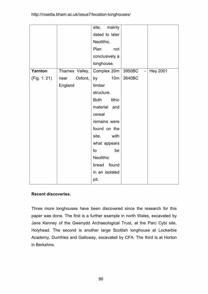
Yarnton (Fig. 1: 21)
Thames Valley,
near Oxford,
England
Complex 20m
by 10m
timber
structure.
Both lithic
material and
cereal
remains were
found on the
site, with
what appears
to be
Neolithic
bread found
in an isolated
pit.
3950BC -
3640BC
Hey 2001
Recent discoveries.
Three more longhouses have been discovered since the research for this
paper was done. The first is a further example in north Wales, excavated by
Jane Kenney of the Gwenydd Archaeological Trust, at the Parc Cybi site,
Holyhead. The second is another large Scottish longhouse at Lockerbie
Academy, Dumfries and Galloway, excavated by CFA. The third is at Horton
in Berkshire.

http://rosetta.bham.ac.uk/issue7/location-longhouses/
91
Unlikely timber long halls. Darvill (1996) lists a number of potential longhouses that are omitted from the
above list, such as Chew Valley (Rahtz & Greenfield 1977), Carn Brea
(Mercer 1981; 2003), Crickley Hill (Dixon 1988), Kemp Knowe (Mortimer
1905; Piggott 1935; 1954), Eaton Heath (Wainwright & Donaldson 1972;
Wainwright 1973) and Windmill Hill (Smith 1965). These are omitted from the
above list due to lack of size, the unconvincing layout of the remains or
because they appear to be part of a larger structure.

http://rosetta.bham.ac.uk/issue7/location-longhouses/
92
Bibliography
Adkins, K.P. & Adkins, P.C. 1991. A Neolithic settlement on the north bank of
the River Blackwater. Colchester Archaeological Group Annual Bulletin 34,
15-28.
Barclay, G.J. 1996. Neolithic buildings in Scotland. In Darvill, T. & Thomas, J.
(eds.), Neolithic Houses in Northwest Europe and Beyond. (Oxbow
Monograph 57), (Oxford: Oxbow), 61-76.
Barclay, G.J. 2002. Neolithic settlement in the lowlands of Scotland: a
preliminary survey. In Armit, I., Murphy, E., Nelis, E., and Simpson, E.
(eds.),Neolithic Settlement in Ireland and Western Britain. Oxford: Oxbow, 71-
83.
Barclay, G.J. & Russell-White, C.J. 1993. Excavations in the cerimonial
complex of the fourth to second millennium BC at Balfarg/Balbirnie,
Glenrothers, Fife. Proceedings of the Society of Antiquaries of Scotland, 123,
43-210.
Barclay, G.J., Brophy, K. & MacGregor, G. 2002. Claish, Stirling: an early
Neolithic structure in its context. Proceedings of the Society of Antiquaries of
Scotland, 132, 65-137.
Bradley, R. 1998. The significance of monuments. London: Routledge.
Bradley, R. 2000. An Archaeology of Natural Places. London: Routledge.
Bradley, R. 2005. Ritual and Domestic Life in Prehistoric Europe. London:
Routledge.
Bradley, R. 2003. Neolithic expectations. In Armit, I., Murphy, E., Nelis, E.,
and Simpson, E. (eds.), Neolithic Settlement in Ireland and Western Britain.
Oxford: Oxbow, 218-222.

http://rosetta.bham.ac.uk/issue7/location-longhouses/
93
Britnell, W.J. & Savory, H.N. 1984. Gwernvale and Penywyrlod: Two Neolithic
Long Cairns in the Black Mountains of Brecknock (CAA Monograph 2).
Cardiff: Cambrian Archaeological Association.
Brown, N. 1997. A landscape of two halves: the Neolithic of the Chelmer
Valley/Blackwater Estuary, Essex. In Topping, P. (ed.), Neolithic Landscapes
(Oxbow Monograph 86). Oxford: Oxbow, 87-98.
Chowne, P., Healy, F. & Bradley, R. 1993. The excavation of a Neolithic
settlement at Tattershall Thorpe, Lincolnshire. In Bradley, R., Chowne, P.,
Cleal, R.M.J., Healey, F. & Kinnes, I. Excavations at Redgate Hill,
Hunstanton, Norfolk, and at Tattershall Thorpe, Lincolnshire. (East Anglian
Archaeology 57), Norwich: East Anglican Archaeology, 79-124.
Cooney, G. 2000. Landscapes of Neolithic Ireland. London: Routledge.
Cross, S. 2003. Irish Neolithic settlement architecture – a reappraisal. In
Armit, I., Murphy, E., Nelis, E., and Simpson, E. (eds.), Neolithic Settlement in
Ireland and Western Britain. Oxford: Oxbow, 195-202.
Darvill, T. 1982. The megalithic chambered tombs of the Cotswold-Severn
region (VORDA Research Series 5), Highworth: VORDA.
Darvill, T. 1987. Prehistoric Gloucestershire. Gloucester: Alan Sutton and
Gloucestershire County Library.
Darvill, T. 1996. Neolithic buildings in England, Wales and the Isle of Man. In
Darvill, T. & Thomas, J. (eds.), Neolithic Houses in Northwest Europe and
Beyond. (Oxbow Monograph 57), Oxford: Oxbow, 77-112.
Darvill, T. 2003. Analytical scale, populations and the Mesolithic-Neolithic
transition in the far northwest of Europe. In Bevan, L. & Moore, J. (eds.),

http://rosetta.bham.ac.uk/issue7/location-longhouses/
94
Peopling the Mesolithic in a Northern Environment. Oxford: British
Archaeological Reports International Series 1157, 95-102.
Darvill, T. 2004. Long barrows of the Cotswolds and surrounding areas.
Stroud: Tempus.
Dent, J. (no date). A Neolithic House site at Driffield. Beverley: Humberside
County Council.
Dinley, M. & Dinley, G. 2000. Neolithic ale: Barley as a source of malt sugars
for fermentation. In Fairbairn, A.S. (ed.), Plants in Neolithic Britain and
beyond. Oxford: Oxbow, 137-154.
Dixon, P. 1988. The Neolithic settlements at Crickley Hill. In Bugess, C.,
Topping, P., Mordant, C. & Madison, M. (eds.), Enclosures and defences in
the Neolithic of Western Europe. Oxford: BAR International Series 403, 75-88.
Fairweather, A.D. & Ralston, I.B.M. 1993. The Neolithic building at Balbridie,
Grampion Region, Scotland: the building, the date, the plant macrofossils,
Antiquity 67, 313-323.
Gaffney, V. & van Leusen, P.M. 1995. Postscript – GIS, environmental
determinism and archaeology. In Lock, G. & Stancic, Z. (eds.), Archaeology
and geographical information systems: a European perspective. London:
Taylor & Francis, 367-382.
Gardiner, P. 2003. Caught in the act – where is the transition? In Bevan, L. &
Moore, J. (eds.), Peopling the Mesolithic in a Northern Environment. Oxford:
BAR International Series 1157, 103-112.
Gardiner, P.J., Haldon, R. & Malam, J. 1980. Prehistoric, Roman and
Medieval settlement at Stretton-on-Fosse. Excavations and salvage 1971-76.
Transactions of the Birmingham and Warwickshire Archaeological Society,
90, 1-35.

http://rosetta.bham.ac.uk/issue7/location-longhouses/
95
Garton, D. 1987. Buxton. Current Archaeology 9.8. Number 103, 250-253.
Garton, D. 1991. Neolithic Settlement in the Peak District: perspective and
prospects. In Hodges, R. & Smith, K. (eds.), Recent Developments in the
Archaeology of the Peak District. Sheffield : Sheffield University, 3-22.
Gibson, A. 2003. What do we mean by Neolithic settlement? Some
approaches ten years on. In Armit, I., Murphy, E., Nelis, E. and Simpson, E.
(eds.), Neolithic Settlement in Ireland and Western Britain. Oxford: Oxbow,
136-145.
Griffith, F. 1995. Watching brief at Haldon, Belvedere. Devon Archaeological
Society Newsletter 63, 3.
Gwynedd Archaeological Trust, 2005. Archaeology at Parc Bryn Cegin,
Llandygai. http://www.heneb.co.uk/llandegaiweblog/llandygaiintro.html
accessed 12/2005.
Hayden, C. & Stafford, E. (2006). The Prehistoric Landscape at White Horse
Stone, Boxley, Kent. ADS: CTRL Integrated Site Report Series.
Hey, G. 2001. Yarnton. Current Archaeology 173. 216-225.
Hodder, I. 1994. Architecture and meaning: the example of Neolithic houses
and tombs. In Parker Pearson, M. & Richards, C. (eds.), Architecture and
Order. Approaches to Social Space. London: Routledge, 73-86.
Jones, G. 2000. Evaluating the importance of cultivation and collecting in
Neolithic Britian. In Fairbairn, A.S. (ed.), Plants in Neolithic Britain and
beyond. Oxford: Oxbow, 79-84.
Jones, G. & Rowley-Conwy, P. 2007. On the Importance of Cereal Cultivation
in the British Neolithic. In Colledge, S. & Conolly, J. (eds.), Origin and Spread
http://rosetta.bham.ac.uk/issue7/location-longhouses/
96
of Agriculture in SW Asia and Europe: Archaeobotanical Investigations of
Neolithic Plant Economics. London: UCL Press.
Liddell, D.M. 1931. Report of the excavations at Hembury Fort, Devon.
Second season 1931. Proceedings of the Devon Archaeological and
Exploration Society. 1.3. 90-120.
Lynch, F. & Musson, C. 2004. A prehistoric and early medieval complex at
Llandegai, near Bangor, North Wales. Archaeologia Cambrensis 150, 17-
142.
Mears, R. & Hillman, G. 2007. Wild Food. London: Hodder & Stoughton.
Megaw, J.V.S. & Simpson, D.D.A. 1979. An introduction to British prehistory.
Leicester: Leicester University Press.
Mercer, R.J. 1981. Excavations at Carn Brea, Illogen, Cornwall, 1970-3. A
Neolithic fortified complex of the third millennium bc. Cornish Archaeology 20,
1-204.
Mercer, R.J. 2003. The early farming settlement of southwest England in the
Neolithic. In Armit, I., Murphy, E., Nelis, E. & Simpson, E. (eds.), Neolithic
Settlement in Ireland and Western Britain. Oxford: Oxbow, 56-70.
Millet, M. 1990. The Romanization of Britain. Cambridge: Cambridge
University Press.
Morphy, H, 1995. Landscape and the ancestral Past. In Hirsch, E, &
O’Hanlon, M, (eds) The anthropology of Landscape: perspectives on place
and space. Oxford: Oxford University Press, 184-209.
Mortimer, J.R. 1905. Forty year’s researches in the British and Saxon burial
mounds of East Yorkshire. London: A Brown & Sons.

http://rosetta.bham.ac.uk/issue7/location-longhouses/
97
Murray, H., Murray, C., & Fraser, S. 2009. Crathes Warren Field. British
Archaeology July August 2009, 12-17.
Neal, D., Wardle, A. & Hunn, J. 1990. Excavation of the Iron Age, Roman and
Medieval Settlement at Gorhambury, St. Albans. (Historic Buildings and
Monuments Commission for England Archaeological Report 14). London:
English Heritage.
Noble, G., 2007. Monumental journeys: Neolithic monument complexes and
routeways across Scotland. In Cummings, V, & Johnston, R, (eds.) Prehistoric
Journeys. Oxford: Oxbow. 64-74.
O’Neal, H.E. 1966. Sale’s Lot long barrow, Withington, Gloucestershire, 1962-
65. Transactions of the Bristol and Gloucestershire Archaeological Society 85.
5-35.
Oswald, A., Dyer, C. & Barber, M. 2001. The Creation of Monuments:
Neolithic Causewayed Enclosures in the British Isles. Swindon: English
Heritage.
Oxford Archaeological Unit, 1999. White Horse Stone, Pilgrim’s Way and
West of Boarley Farm, ARC WHS 98, ARC PIL 98, ARC BFW 98, Detailed
archaeological works interim report, final.
http://ads.ahds.ac.uk/catalogue/adsdata/ctrl_2003/bfw98/html/arc_bfw98_inter
im.html accessed 02/01/2006
Oxford Archaeological Unit, 2000. White Horse Stone: A Neolithic longhouse.
Current Archaeology 168, 450-453.
Piggott, S. 1935. A note on the relative chronology of the English long
barrows. Proceedings of the Prehistoric Society 1, 115-126.

http://rosetta.bham.ac.uk/issue7/location-longhouses/
98
Piggott, S. 1954. The Neolithic cultures of the British Isles. Cambridge:
Cambridge University Press.
Pollard, J. 1999. ‘These places have their moments’: thoughts on settlement
practices in the British Neolithic. In Brück, J. & Goodman, M. (eds.), Making
places in the prehistoric world: themes in settlement archaeology. London:
UCL Press, 76-93.
Pryor, F. 1974. Excavation at Fengate, Peterborough, England: The First
Report. (Royal Ontario Museum Archaeology Monograph 3) Toronto: Royal
Ontario Museum.
Pryor, F. 2001. The Flag Fen Basin. Swindon: English Heritage.
Pryor, F. 2003. Britain BC. London: Harper Collins.
Pryor, F. 1988. Etton near Maxey, Cambridge: A causewayed enclosure on
the fen-edge. In Burgess, C., Topping, P., Mordant, C., & Madison, M. (eds.),
Enclosures and defences in the Neolithic of Western Europe. Oxford: BAR
International Series 403, 107-126.
Ralston, I.B.M. 1982. A Timber Hall at Balbridie Farm. Aberdeen University
Review 168. 238-249.
Rahtz, P.A. & Greenfield, E. 1977. Excavations at Chew Valley Lake,
Somerset. (Department of the Environment Archaeological Reports 8),
London: HMSO.
Richards, M.P. & Schulting, R. J. 2003. Characterising subsistence in
Mesolithic Britain using stable isotope analysis. In Bevan, L. & Moore, J.
(eds.), Peopling the Mesolithic in a Northern Environment. Oxford: BAR
International Series 1157, 1–26.
Richmond, A. 1999. Preferred Economies. Oxford: BAR British Series 290.

http://rosetta.bham.ac.uk/issue7/location-longhouses/
99
Robinson, M.A. 2000. Further considerations of Neolithic charred cereals, fruit
and nuts. In Fairbairn, A.S. (ed.), Plants in Neolithic Britain and beyond.
Oxford: Oxbow, 27-36.
Rowley-Conwy, P. 2003. No fixed abode? Nomadism in the northwest
European Neolithic. In Burenhult, G. & Westergaard, S. (eds.), Stones and
Bones. Oxford: BAR International Series 1201, 115-143.
Rowley-Conwy, P. 2004. How the West was Lost: A reconstruction of
Agricultural Origins in Britain, Ireland and Southern Scandinavia. Current
Anthropology. Vol. 45. 83-113.
Saville, A. 1990. Hazelton North: The excavation of a Neolithic long cairn of
the Cotswold-Severn Group (Historic Buildings and Monuments Commission
for England Archaeological Monograph 13) London: English Heritage.
Smith, I.F. 1965. Windmill Hill and Avebury. Excavations by Alexander Keiller
1925-1939. Oxford: Claredon Press.
Spector, J.D. 1993. What This Awl Means: Feminist Archaeology at a
Wahpeton Dakota Village. Minnesota: Minnesota Historical Society Press.
Thomas, J. 1996a. The cultural context of the first use of domesticates in
north-west Europe. In Harris, D.R. (ed.), The Origins and Spread of
Agriculture and Pastoralism in Eurasia. London: UCL Press, 310-322.
Thomas, J. 1996b. Neolithic houses in mainland Britain and Ireland – A
sceptical view in Thomas, J. & Darvill, T. (eds.), Neolithic Houses in
Northwest Europe and Beyond. Neolithic Studies Group Seminar Papers 1.
(Oxbow Monograph 57), Oxford: Oxbow, 1-12.
Thomas, J. 1999. Understanding the Neolithic. London: Routledge.

http://rosetta.bham.ac.uk/issue7/location-longhouses/
100
Thomas, J. 2003. Thoughts on the ‘repacked’ Neolithic revolution. Antiquity
77, 67-74.
Thomas, J. 2004. Comments. In Rowley-Conwy, P. How the West was Lost:
A reconstruction of Agricultural Origins in Britain, Ireland and Southern
Scandinavia. Current Anthropology. Vol. 45. 105-106.
Vine, P.M. 1982. The Neolithic and Bronze Age cultures of the middle and
upper Trent Basin. Oxford: BAR British Series, 105.
Wainwright, G.J. 1973. The excavation of Prehistoric and Romano-British
settlements at Eaton Heath, Norwich. Archaeological Journal 130, 1-43.
Wainwright, G.J. & Donaldson, P. 1972. Ritual shafts and wells: a Neolithic
settlement near Norwich. Antiquity 46, 321-234.
Wheatley, D. & Gillings, M. 2000 Vision, perception and GIS: developing
enriched approaches to the study of archaeological visibility. in Lock, G. (ed.)
Beyond the map. Archaeology and Spatial Technologies. Oxford: IOS Press.
1-27.
Wheeler, A. 1972. A late Neolithic site at Whillington, Derbyshire. Antiquity 46,
314-316.
Wheeler, A. 1979. Excavation at Whillington, Derbyshire, 1970-1972.
Derbyshire Archaeological Journal, 99, 58-220.
Whittle, A. 1997. Moving on and moving around: Neolithic settlement mobility.
In Topping, P. (ed.), Neolithic Landscapes, (Oxbow Monograph 86), Oxford:
Oxbow, 15-22.
Wilkinson, T.J. & MURPHY, P. 1985. The Hullbridge Basin Survey 1985.
Interim Report 6. Chelmsford: Archaeology Section Essex County Council.

http://rosetta.bham.ac.uk/issue7/location-longhouses/
101
Wilkinson, T.J. & MURPHY, P. 1986. The Hullbridge Basin Survey 1986.
Interim Report 7. Chelmsford: Archaeology Section Essex County Council.
Wilkinson, T.J. & MURPHY, P. 1987. The Hullbridge Basin Survey 1987.
Interim Report 8. Chelmsford: Archaeology Section Essex County Council.
Willock, E.H. 1936. A Neolithic site on Haldon, Proceedings of the Devon
Archaeological Exploration Society 2, 240-63.
Willock, E.H. 1937. A further note on the Neolithic site on Haldon,
Proceedings of the Devon Archaeological Exploration Society 3, 33-43.
Young, R. 2000. Aspects of the coastal Mesolithic of the northeast of England.
In Young, R. (ed.), Mesolithic Lifeways. (Leicester Archaeology Monographs
No7), Leicester: University of Leicester Press, 179-190.
Zvelebil, M. 2003. Enculturation of Mesolithic landscapes. In Larsson, L.,
Kindgren, H., Knutsson, K., Leoffler, D. and Åkerlund, A. (eds.), Mesolithic on
the Move. Papers presented at the Sixth International Conference on the
Mesolithic in Europe, Stockholm 2000. Oxford: Oxbow, 65-73.