DATE: September 25, 2017 TO: RMC Governing Board FROM ... Project and Liaison... · Parque Dos...
22
DATE: September 25, 2017 TO: RMC Governing Board FROM: Mark Stanley, Executive Officer SUBJECT: Item 7D: Project and Liaison Activities RMC ACTIVITY Lower Los Angeles River Working Group (AB 530): Since May 3, 2016, the Lower LA River Working Group has been meeting for the past 6 months to discuss the Lower LA River Revitalization Plan (LLARRP). The Working Group was created by Assembly Speaker Anthony Rendon through Assembly Bill 530. The working group's goal is to create a robust restoration plan that lays the groundwork for a revitalized Lower Los Angeles River that connects residents to the river that flows through their communities. Members of the working group were appointed by Secretary of Natural Resources John Laird and include 39 members including 12 southeast cities, 16 Non-governmental organizations (NGOs), the First, Second and Fourth Supervisorial Districts, the Gateway Water Management Authority, and the business sector. Meetings have been rotating throughout cities in the Southeast and the most recent meeting was held earlier this month on September 7, 2017 in the City of Huntington Park at the First Supervisorial District office of Supervisor Solis. The meeting included a review of the overall project schedule, presentation on Hydraulics 101, finalization of the Community Economics Goals & Objectives and confirmation and discussion of the 12 Signature Projects. There are over 100 projects that have been identified as potential projects once the plan is completed in February 2018. There are various community engagement events that will be taking place in September and October including community meetings, Pop-up events, festivals, and Bike Rides, in coordination with various NGO partners. Information can be found on the website at www.lowerlariver.org The Working Group meetings are being facilitated by the Los Angeles County Department of Public Works with the assistance of the consulting firm of Tetra Tech and MIG. RMC also provides coordination assistance for the meetings and will be actively involved for the duration of this process. Meetings are held the first Thursday of every month, from 6:00- 9:00 pm and are open to the public. The next meeting will be held on October 5, 2017 in the City of Downey at the Barbara Riley Community & Senior Center located at 4801 E. 58 th Street, Maywood, CA 90270. Additional information can be found on the new Lower LA River Working Group website: www.lowerlariver.org Item 7D 1
Transcript of DATE: September 25, 2017 TO: RMC Governing Board FROM ... Project and Liaison... · Parque Dos...

DATE: September 25, 2017 TO: RMC Governing Board FROM: Mark Stanley, Executive Officer SUBJECT: Item 7D: Project and Liaison Activities
RMC ACTIVITY
Lower Los Angeles River Working Group (AB 530): Since May 3, 2016, the Lower LA River Working Group has been meeting for the past 6 months to discuss the Lower LA River Revitalization Plan (LLARRP). The Working Group was created by Assembly Speaker Anthony Rendon through Assembly Bill 530. The working group's goal is to create a robust restoration plan that lays the groundwork for a revitalized Lower Los Angeles River that connects residents to the river that flows through their communities. Members of the working group were appointed by Secretary of Natural Resources John Laird and include 39 members including 12 southeast cities, 16 Non-governmental organizations (NGOs), the First, Second and Fourth Supervisorial Districts, the Gateway Water Management Authority, and the business sector. Meetings have been rotating throughout cities in the Southeast and the most recent meeting was held earlier this month on September 7, 2017 in the City of Huntington Park at the First Supervisorial District office of Supervisor Solis. The meeting included a review of the overall project schedule, presentation on Hydraulics 101, finalization of the Community Economics Goals & Objectives and confirmation and discussion of the 12 Signature Projects. There are over 100 projects that have been identified as potential projects once the plan is completed in February 2018. There are various community engagement events that will be taking place in September and October including community meetings, Pop-up events, festivals, and Bike Rides, in coordination with various NGO partners. Information can be found on the website at www.lowerlariver.org The Working Group meetings are being facilitated by the Los Angeles County Department of Public Works with the assistance of the consulting firm of Tetra Tech and MIG. RMC also provides coordination assistance for the meetings and will be actively involved for the duration of this process. Meetings are held the first Thursday of every month, from 6:00- 9:00 pm and are open to the public. The next meeting will be held on October 5, 2017 in the City of Downey at the Barbara Riley Community & Senior Center located at 4801 E. 58th Street, Maywood, CA 90270. Additional information can be found on the new Lower LA River Working Group website: www.lowerlariver.org
Item 7D
1

RMC Board Meeting & Project Tour, July 24, 2017: RMC Board members and staff participated in a project tour including a variety of projects that began at the River Wilderness Park in Azusa and ended in Orange County at Anaheim Coves. The total project sites visited included the River Wilderness Park (Azusa), Peck Water Conservation Park (Irwindale), East LA Civic Center, Parque Dos Rios (South Gate), Colorado Lagoon (Long Beach), Los Cerritos Wetlands (Long Beach) and Anaheim Coves (Anaheim). Below are a few photos of that tour.
San Gabriel National Monument: The August meeting of the San Gabriel Mountain Community Collaborative (SGMCC) was cancelled, the next meeting is September 28, 2017, Big Pines Lodge in Wrightwood. The Forest Service provided notice that it is extending the time for completion of the Plan EA, Decision Notice, and related comments for the San Gabriel Valley National Monument Plan. Action items from the July meeting included:
• The SGMCC decided to keep focusing on the four topics that were brought to the top during the June 22 meeting (Transportation, Trails/Recreation, Conservation Education, and Visitor
Peck Water Conservation Park, Irwindale
Parque Dos Rios, South Gate
Los Cerritos Wetlands, Long Beach
Anaheim Coves
Colorado Lagoon, Long Beach Anaheim Coves
Item 7D
2

Engagement). The SGMCC agreed that the four Ad Hoc Committees would develop the goals/objectives for each of these four topics by September 10 for circulation via email to the SGMCC and then have a vote during the full SGMCC September 28 meeting.
• NFF will provide a form the ad-hoc committees can use to develop their goals/objectives, where to put funding etc.
• SGMCC Planning Committee will develop potential dates for review and submittal of comments on the final Monument Management Plan.
• Jack Sahl and Liz Reilly, Collaborative Board Members, to draft a Blog Write Up/Press Release regarding the Building Bridges Award from Congresswoman Chu to post to NFF Website.
In October 2014, President Barack Obama designated 346,177 acres of land as the San Gabriel Mountains National Monument (Attachment A), the eighth national monument under Forest Service management. All the land included in the National Monument was already existing federal land as part of the National Forest. The designation provided additional resources for the San Gabriel Mountains and ensured that thousands of miles of streams, hiking trails, and other outdoor recreation opportunities would be protected.
On April 26, 2017, President Trump signed an executive order directing the Secretary of the Interior to review all National Monuments established under the Antiquities Act over the past 21 years where the designation covers more than 100,000 acres which includes San Gabriel Mountains National Monument. The Secretary of the Interior is to review all National Monuments based on the following criteria:
• The requirements and original objectives of the Act, including the Act's requirement that reservations of land not exceed "the smallest area compatible with the proper care and management of the objects to be protected";
• Whether designated lands are appropriately classified under the Act as "historic landmarks, historic and prehistoric structures, or other objects of historic or scientific interest";
• The effects of a designation on the available uses of designated Federal lands, including consideration of the multiple-use policy of the Federal Land Policy and Management, as well as the effects on the available uses of Federal lands beyond the monument boundaries;
• The effects of a designation on the use and enjoyment of non-Federal lands within or beyond monument boundaries;
• Concerns of State, tribal, and local governments affected by a designation, including the economic development and fiscal condition of affected States, tribes, and localities; and
• The availability of Federal resources to properly manage designated areas.
The Secretary of the Interior is providing an interim report within 45 days to the President and a final report within 120 days of the date of the order.
RMC ACTIVE PROJECTS
De Forest Park Wetland Restoration Project (RMC10006): This project is in full construction which began in late Spring 2017 and the City of Long Beach has started construction and anticipates completion by early 2018. Camp Shiwaka Urban Forest and Discovery Trail (RMC 13005): RMC provided funding for the development and enhancement of Camp Fire’s urban forest and a new trail at Camp Shiwaka which includes extensive native landscaping, interpretive signage, improved ADA accessibility and additional improvements to the
Item 7D
3

outdoor amphitheater. Camp Shiwaka has received additional funds to complete their trail improvements as part of the Long Beach Bike Trail and with matching funds from the LA County Prop A funds. Currently, Camp Shiwaka is working towards finalizing all aspects of construction from the RMC Grant funds. Willowbrook Walking Path/Compton Creek (14003): The RMC provided a grant in the amount of $300,000 to the Los Angeles Conservation Corps as part of the Willowbrook Walking Path Compton Creek extension. The LACC applied for an Urban Greening Grant through the Strategic Growth Council and was awarded the full request in the amount of $798,815. Additional matching funds were committed by other project partners including the State Coastal Conservancy and the Office of Supervisor Mark Ridley-Thomas (2nd District). Matching funds provided by the funding partners and the grant funds received by the Strategic Growth Council bring the total project cost to $1,698,815. Due to a change in staff by the Coastal Conservancy, the LACC will resubmit their funding request at their upcoming Coastal Conservancy board meeting in 2017. There have also been slight delays due to the approvals required by the Army Corps of Engineers for the construction documents, since the improvements are adjacent to the Compton Creek. Progress pending approval from Army Corps. This project includes the creation of a ½ mile permeable walking path and 2,700 linear foot by 6 foot riprap swale constructed with river rock to capture debris and treat runoff before it enters Compton Creek. El Dorado Nature Center South Lake Restoration Project (RMC13004): The project is located at the El Dorado Nature Center in the City of Long Beach and includes an improved arrival experience with a new entry statement and signage, improvements to the outdoor amphitheater for educational sessions and events and an ADA compliant pedestrian bridge and trails. The City of Long Beach has completed construction, all payments have been processed for this grant. A grand opening was held in April 2017. Los Cerritos Wetlands Trails Improvement Project (RMC14002): This project is nearly complete. The RMC $98,000 in grant funds for the project located in the City of Long Beach at intersection of Studebaker Road and Westminster Avenue included the following enhancements: (1) development and improvements of a trail network in and around Los Cerritos Wetlands specifically at Zedler Marsh, (2) install interpretive signage and associated native landscaping and (3) remove trash, debris, non-native plants, improve fencing and gates, install temporary irrigation and improve the native plant nursery through development of an outdoor laboratory and classroom. A Grand Opening Celebration is scheduled for Saturday September 30, 2017. Coyote Creek-Los Alamitos Improvement Project (RMC3318): The City of Los Alamitos park and trail improvement included finalizing a Joint Use Agreement with the LA County Flood Control District to update the existing Use Agreement for the bikeway to include operation and maintenance of the Coyote Creek river trail that runs through the city’s limits. The City held a Grand Re-Opening for this project on Monday July 31, 2017. The park includes a walking trail, native landscape, seating area, interpretive graphics and decorative ironwork sculpted gate to the River trail. RMC and the City of Los Alamitos are working on closing out the grant and process reimbursements. Recycled Water Campus, San Gabriel River Parkway (RMC 17004): Grant was approved by RMC Board and the project is underway. Grant from the RMC is for $1,000,000. This project supports low-impact development stormwater management features, such as swales, landscaping and permeable pavements and walkways; a stormwater capture system to augment the recycled water supply and reduce flood risk. In addition, this project will create habitat for Monarch butterflies, a migratory species proposed for endangered species candidate status; and create 3.5 acres of park-like open space with public access to the San Gabriel River. The project includes many interpretive and education
Item 7D
4

aspects with an outdoor amphitheater, demonstration gardens for native plants, eco-friendly gardening, stormwater and butterflies, multi-lingual signage, and other visitor facilities focused on water education, and provides multiple benefits to economically disadvantaged communities. This project is part of the Groundwater Reliability Improvement Project (GRIP), fully funded at $119 million. GRIP broke ground in July 2016. Bassett High School Campus Green Infrastructure Project (RMC 17005): Grant from the RMC is for $652,520, project is underway. This project will enhance campus “green infrastructure”, urban habitat, and demonstrate sustainable public landscaping in terms of water use, improved infiltration, and storm water management. Bassett High School is located in underserved area of La Puente, in San Gabriel River sub watershed. The region’s impervious grey infrastructure impairs groundwater recharge and infiltration. Proposed Green Infrastructure retrofits will reduce water use on campus by systematic turf grass reduction: planting over 2700 native, drought-tolerant trees & shrubs in mulched planters to enhance biodiversity, and absorb storm water and run-off. Creating a thriving Urban Forest on campus will clean air and sequester greenhouse gas emissions and reduce Urban Heat Island Effect through shade cover. The project will encourage underserved students and community residents to participate in habitat restoration and water resources protection, explore and enjoy the campus, and learn how to connect to the region’s surrounding natural areas. City of Cudahy Long Range Water Conservation and Park Plan (RMC 17003): The City of Cudahy Long Range Water Conservation and Park Plan is underway, the RMC Planning grant is for $ 293,000. The Plan seeks to develop a long range water conservation and park plan to establish a blueprint that will identify and create an inventory of: water efficiency, conservation, runoff, filtration, infiltration, etc. problems and solutions; and sites available for new parks or green space, including pocket parks along the Los Angeles River Bike Path bordering the eastern City boundary. The plan will act as a tool to identify future funding opportunities to perform the necessary infrastructure projects that will address the City’s water and park issues. Studies will be performed citywide to explore much needed water and park infrastructure projects. These identified projects and issues will be examined and solutions found based on existing design strategies available in the City’s drafted “Green Streets Manual” and “Low Impact Development (LID) Guidelines” specific to managing wet weather and urban runoff. The Long Range Plan will work in collaboration with the LID Guidelines and Green Streets Manual. View Park and Recycled Water System Development Project (RMC17001): The View Park and Recycled Water Development Project is underway, this grant to the City is for 2,000,000 which includes a wildlife corridor project in the City of Signal Hill that will establish a new 1.86 acre park and the associated construction of a recycled water system. The project will reclaim a municipally owned industrial site and provide a recycled water system to serve the proposed park as well as retrofit three existing parks and the Promontory Home Owner's Association common landscaped areas, connect an urban trail system, prevent runoff pollution from contaminating the Los Angeles and San Gabriel Rivers and annually save approximately 40 acre feet of potable water. Long Beach Municipal Urban Stormwater Treatment (LB_MUST) Project (RMC 17009): The Long Beach Municipal Urban Stormwater Treatment (LB-MUST) Project is underway, this grant to the City is for $2,000,000 and will improve water quality by intercepting and treating the dry weather flows and a portion of the first flush of stormwater runoff normally discharging into the Los Angeles River. The byproduct of the LB-MUST water quality treatment is recycled water which can be used to sustain proposed wetlands riparian habitat. The wetlands will be part of the total treatment train of the LB-MUST as well as function as a storage basin for the recycled water.
Item 7D
5

West Coyote Hills Open Space Acquisition (17007): Grant to the City is in the amount of $2,000,000 for this acquisition. The City of Fullerton is aggressively pursuing funds to acquire 38.3 acres of available remaining undeveloped land that, when acquired, will enable 359 species to thrive and two million residents living within 10 miles to enjoy about 340 acres of the last remaining contiguous natural open space in north Orange County. The City of Fullerton requests the maximum of $2 million in land acquisition funding to acquire “Neighborhood 1” of West Coyote Hills. Funding for acquisition of this property would assist in purchasing 10.4 acres of open space adjacent to Robert E. Ward Nature Preserve. This acquisition provides the opportunity to preserve important urban space and contribute to additional natural lands, maintain a wildlife corridor, and restore and sustain important habitat and biological species. Los Cerritos Wetlands Acquisition of the Bryant Properties (RMC 17013): This grant to the LCWA is in the amount of $1,000,000. The Los Cerritos Wetlands Authority (LCWA) currently owns approximately 172 acres of coastal wetland habitat within the Lower San Gabriel River watershed in the Cities of Seal Beach and Long Beach and the LCWA is seeking to acquire the frontage and remaining Bryant-Dakin, LLC Properties located along 2nd Street/Westminster Avenue in the City of Long Beach, totaling approximately 18 acres (Los County Assessor Parcel Nos 7237-020-053 and 7237-020-054). The LCWA is seeking to acquire the remaining two Bryant-Dakin LLC retained parcels that extend across the San Gabriel River and along the Haynes Cooling Channel at 2nd Street/Westminster Avenue. The west parcel is approximately 12 acres in size and is south along 2nd Street/Westminster Avenue and the east parcel is approximately 6 acres located on the isthmus just north of the LCWA Property on the east side of the San Gabriel River. Planning for the Urban Orchard Development (17006): Planning for the Urban Orchard Development grant to the Trust for Public Land is in the amount of $845,000 and is an exciting project that will transform 30 acres of unused, vacant land between the I-710 Freeway and the LA River into new, critically needed green infrastructure and an urban park, including an urban orchard and over one-mile of new riverfront walking and bike paths. Project deliverables include a detailed concept plan for the entire 30-acre site, a feasibility study to determine the most appropriate stormwater best management practices to be utilized at the site, and a complete set of construction drawings for the upper 18.2 acres of the project area that include an orchard with culturally-relevant tree species, community gathering spaces, picnic areas, interpretive elements, native plants, and walking and bicycle paths that will eventually connect with the existing bike path along the LA River. Parkway Basin Water Quality Improvement Project (17011): The Parkway Basin Water Quality Improvement Project grant is to the County of Los Angeles is in the amount of $268,500 and includes the construction of 30 parkway basins in the unincorporated Los Angeles County. A Parkway is typically defined as the area between a road’s curb and the sidewalk. Parkway basins are designed to capture and treat stormwater and dry season flow (urban runoff), utilizing urban runoff for irrigation and facilitating infiltration to groundwater. These basins are constructed by excavating and lowering a portion of parkway, then cutting an opening in the curb to facilitate the flow of water from the street. The basins contain rock reinforced slopes to prevent erosion, along with the vegetation which will detain, remediate, and help infiltrate urban runoff. When a basin is full, any additional urban runoff will be unable to enter and will continue to travel in the gutter eventually to the storm drain system. Parkway basins have been successfully constructed for many years in
Item 7D
6

numerous cities including: Tucson, Arizona; New York City; Portland, Oregon; and other municipalities. Locally, parkway basins have been constructed successfully in Panorama City and Studio City. Los Cerritos Wetlands Planning and Restoration Project (17014): This grant is to the Los Cerritos Wetlands Authority (LCWA) in the amount of $1,000,000. The Los Cerritos Wetlands is one of the last remaining estuarine systems in southern California, located in the Cities of Long Beach and Seal Beach. The LCWA recently adopted the Final Los Cerritos Wetlands Complex Conceptual Restoration Plan (CRP) in August 2015 with the next step being environmental review of the CRP. The LCWA is seeking grants funds to complete the environmental review of the CRP which is required to satisfy the California Environmental Quality Act and the National Environmental Policy Act. Environmental review of the CRP’s three proposed alternatives or a hybrid alternative may result in joint Environmental Impact Report and Environmental Impact Statement.
San Gabriel River Wetland Restoration Development (17012): This grant to the SGRDCA is in the amount of $541,384 and is a multi-disciplinary endeavor that will enhance a wetland area, provide a regional model of stormwater best management practices, integrate educational and recreational activities, and provide for a new outdoor classroom and interpretive features. The 9-acre site is located within the Whittier Narrows Recreation Area between the San Gabriel River and the Rio Hondo (a tributary of the Los Angeles River), and is an integral element of the San Gabriel River Corridor Master Plan (2006). The greater area development project entails construction on 5.9 acres featuring the constructed wetland and naturalized bioswale as well as implementation of walnut woodland restoration, habitat buffer, a covered outdoor classroom, outdoor interpretive features, vehicular access, parking, and pedestrian pathways. Project benefits of the constructed wetland and bioswales include improved water quality and capture of onsite stormwater through sustainable site hydrology improvements. Area development and landscape improvements will enhance native habitat and provide living demonstration of the benefits of natural
systems and watershed function to a large and diverse population. The project provides a regional watershed education center and serves as a destination that can be reached via the San Gabriel River Bike Trail linking communities along over 38 miles from the Mountains to the ocean. The SGRWRD, as part of the San Gabriel River Discovery Center, will reach approximately 8.5 million residents, including several disadvantaged communities. Together, this project will promote passive recreational use, spread awareness on values of watershed health and positively influence visitors to protect water resources and implement conservation improvements at home. Currently in the permitting phase, this project has
received plan check approvals from most County departments and is pending on United States Army Corps plan check approval. Once Army Corps plan check approval is received, the project will move forward into the Bidding phase for construction.
Lynwood Park Infiltration, Restoration and Water Quality Improvement Project (RMC 17017): Grant to the City of Lynwood in the amount of $1,692,575. The Lynwood Park Infiltration, Restoration, and Water Quality Improvement Project will replace the parking lot asphalt at Lynwood Park with permeable pavers; establishment of green space with native plans and shrubs in the parking lot perimeter; and
Item 7D
7

installation of a bio-swale along the parking lot median, to improve stormwater management. This project is part of the Gateway Cities Regional Recycled Water System Expansion Project. The City of Lynwood along with 2 other cities in the southeast area of Los Angeles County and Central Basin received a grant to complete the design for an extension of the Central Basin recycled water system. This design has been completed and includes a stub out at Lynwood Park. Additional Funding for construction is being sought by the cities. Emerald Necklace Rio Hondo and Peck Park Water Conservation Project (RMC 17015): Grant to Amigos de los Rios in the amount of $617,385 for this project which will enhance biodiversity, water quality, stormwater & urban run-off management along Rio Hondo Emerald necklace & within Peck Park by adding green infrastructure elements along River Parkway. This area is located within eastern Los Angeles County’s underserved El Monte and is adjacent to County Bike Trail, residential areas and schools. Arterials cross the right of way and produce runoff and air pollution that negatively impacts river parkway and local ecosystems. The proposed multi-objective water quality project will improve watershed health, habitat, and trails along the Emerald Necklace’s Rio Hondo River. It will remove invasive plants and restore biodiversity by planting over 1175 native & drought-tolerant trees and shrubs suited to multi-year droughts. CSUF Low Impact Development and Green Infrastructure Improvement Project: The request for the RMC grant of $1,000,000 towards the total project cost of $3,324,655 has been withdrawn. WATERSHED CONSERVATION AUTHORITY
Duck Farm Project: Team has received permit plan check approvals from LA County Building and Safety Divisions (Architectural and Plumbing) and are awaiting resubmittal of Landscape Development Division’s Roads and Streets plan by AECOM which is the last remaining County plan check approval needed. Once received, County Grading department will clear the project for permit. Additionally, WCA received approval of two extensions. One from LA County Department of Health regarding the restroom waste system: that approval be based on the current septic system approval received last week. The other approval extension is for Land Development Division Landscape Plan Check, and is pending confirmation. WCA is presenting for Board consideration a Labor Compliance Program (LCP) for adoption and authorization to submit an LCP application to California Department of Industrial Relations as a requirement of the State Bond funding WCA was granted for implementation of this project. A Caltrans ROW Ingress/Egress easement is pending final review and recording by CALTRANS, once recorded a fully executed Maintenance and Operations Agreement will be issued and a permit will be ready to pull. A consultant contract was awarded to BlueGreen, under the Construction Management Master Agreement, to prepare an updated 2017 project engineering estimate, provide value engineering recommendations and prepare bid packages. Due to the prolonged nature of the permitting process for this project it is anticipated that the available budget for the project will be less than the full scope of work of the current design. The estimating and bid strategy will be presented at the WCA’s November 2017 board meeting. At that time, it is expected a series of small specialty contracts will be presented for pre-award consideration. By breaking the scope of work down into smaller contracts for which the work is common to the contractor or fabricator thus resulting in both higher quality work for a lower price than having a single contractor complete all the work. This strategy is being considered to ensure the greatest extent of work can be accomplished with remaining funding for Construction which is approximately $2.8M not including contingency of $200K. Additionally, the previously completed irrigation system will be repaired so it is 100% operational when the new contracts start to avoid any future warranty issues. The intent of this multi-prong strategy is to complete critical aspects of the park that meet funding expectations and provide a good user experience, as well as,
Item 7D
8

stage work in a manner to complete reimbursable grant scope first to ensure availability of cash flow. February 2018 is targeted for the major riparian area ground-breaking.
The Phase 1A Duck Farm project involves the development of a 30+ acre river adjacent park project that includes a neighborhood park entry, public access trails, riparian landscape, a native plant demonstration garden, native and low water meadows, a river overlook and interpretation features.
Item 7D
9

The Phase 1A Duck Farm project involves the development of a 30+ acre river adjacent park project that includes a neighborhood park entry, public access trails, riparian landscape, a native plant demonstration garden, native and low water meadows, a river overlook and interpretation features. Emerald Necklace: On May 16, 2017 the Board of Supervisors approved the San Gabriel Valley Greenway Network Strategic Implementation Plan. The motion directs the Los Angeles County Departments of Public Works (Public Works) and Parks and Recreation to consult with various groups and organizations—specifically naming the WCA—to develop a strategic implementation plan for the San Gabriel Valley Greenway Network. This effort follows the San Gabriel Valley Greenway Task Force convened by the First District, and has strong overlap with the Emerald Necklace Plan which will be referenced as a precedent. WCA staff continues to actively engage in the process, and in the ongoing dialog on next steps and securing funding for priority implementations.
Item 7D
10

The Emerald Necklace is a 17-mile interconnected network of existing and envisioned bikeways, multi-use trails, parks, and greenways along the Rio Hondo and the San Gabriel River. Along the Rio Hondo the Emerald Necklace stretches from Peck Road Water Conservation Park in the north to the Whittier Narrows Recreation Areas in the south. Along the San Gabriel River it stretches from Hanson Quarry in the north to Whittier Narrows Recreational Area in the south. The Emerald Necklace Implementation Plan – Phase 1 (Proposed Project) includes 15 related projects that would close gaps in a regional recreational trails network and increase access to the trails to hundreds of thousands of people in the project area. GREEN Project: WCA Staff is coordinating with Sabio LA—a local programmer training program—on web development for both the GREEN Project Portal and the pilot Gateway Greening Plan content, which will be the final format for the Gateway Cities and Rivers Urban Greening Master Plan. WCA staff is also development content for the web platform for a soft launch planned for December 2017. http://www.sabio.la/
Item 7D
11

The Green Regional Environmental Enhancement Network (GREEN) Project is a planning and project implementation initiative supporting watershed-based greening efforts to help support collaboration in the wider Los Angeles and Orange County area. The scope of the project includes regional data collection and assessments, identification of priority projects, and community engagement strategies culminating in the launch of an online GREEN project portal to share data and information, and to catalyze investments and positive change. Gateway Cities and Rivers Urban Greening Master Plan: The first phase of outreach was concluded and compiled for discussion at the last Advisory meeting held July 17, 2018. Outreach has included the ongoing quarterly advisory meetings, workshops and events, surveys, and representation in parallel efforts. WCA staff both hosted and attended 7 workshops and events reaching approximately 417 participants representing more than 80 organizations, agencies, and cities focusing on the LA and San Gabriel Rivers. An online survey launched May-July 2017 presented 17 questions, additionally disseminated at 9 events reaching more than 70 organizations, agencies, and cities with 201 participants. Findings included overwhelming interest in improving and expanding open spaces through increasing urban canopy and plant cover, more programs and amenities, safety and security, improving access, water capture, and maintenance concerns. Detailed findings will be submitted in the next report to the Natural Resources Agency. Staff continues to develop content for the soft launch planned for December as a pilot and module of the GREEN Project web platform. The completed content will be the final deliverable for the plan. Advisory
Item 7D
12

meetings are held quarterly on the third Tuesday of every third month at the Gateway COG offices, with the next meeting planned for Tuesday October 17, 2017.
With a grant from the Strategic Growth Council and partner collaboration the WCA is developing a green infrastructure plan for the Gateway Cities Region. The WCA is advancing collaborative integration of regional efforts as staff continues to engage in compatible regional planning initiatives—including the AB530 Lower LA River Working Group. Together with the RMC-funded GREEN Project the plan is organized as an interactive web platform positioned to facilitate coordination, planning efforts, and funding for greening projects across the Gateway Cities and beyond. Mt. Baldy Wilderness Preserve: WCA and The Conservation Fund will be hosting a Dedication Ceremony with a commemorative sign and ribbon cutting event on Friday September 22, 2017 at 10 am sharp. Invited dignitaries include LA County 5th District Supervisor Kathryn Barger, San Bernardino County 2nd District Supervisor Janice Rutherford, U.S. Forest Supervisor Jeffery Vail, and San Gabriel Mountains National Monument, California Natural Resource Agency, WCA Board members and staff, RMC Board members and staff among other dignitaries, non-profits, environmental groups and community members.
Item 7D
13

Item 7D
14

Acquired in 2014, the Mt. Baldy Wilderness Preserve is a 237+/- acre property located on the eastern extent of the Authority’s territory, directly south of Mt. Badly Village. This open space being preserved is in its undeveloped state. The site is publicly accessible for passive recreational use. River Wilderness Park: The design for RWP Entry Improvements Project is commencing toward 90% construction drawings for shovel-ready implementation. WCA staff is scheduling meetings to advance the permitting process, and working toward demolition and minor site work on an expedited timeline. Active Transportation Program Augmentation funds are also available through SB-1, and staff will also be reapplying to fund the roundabout on Highway 39 as part of the new main entrance into the park.
The RWP is an approx. 118-acre property envisioned to provide unique wilderness experiences in the lower San Gabriel River Canyon comprised of engaging landscapes, gathering spaces, thriving habitats, and a regional hub and welcome center for the San Gabriel Mountains National Monument. San Gabriel River Confluence with Cattle Canyon Project: WCA, Forest Service, and consultants BlueGreen and ESA have nearly finalized Draft environmental technical assessment and report (Draft EIR/EIS) for the Forest Service to review. The Draft EIR/EIS is expected to be publicly released for 45-day comment period by the end of October. The Notice of Availability will appear on the federal register on 10/27/17, and will be mailed to interested parties during the week of 10/23/17. A legal notice will be posted in the LA Times. There are currently two planned outreach meetings (both on Saturdays). The First public outreach meeting will be held at the US Forest Service office in Arcadia on November 4th. The Second public outreach meeting will be held on November 18th at WCA’s office (Azusa River Wilderness Park). There may also be an on-site outreach event on October 28th, pending coordination with Forest Service.
Item 7D
15

Along a 2.5-mile segment of the East Fork San Gabriel River recreational use is highly concentrated. This heavy use combined with the lack of facilities has resulted in degraded conditions. In response, the Cattle Canyon Project seeks to better manage the recreational use, and balance the needs for resource project within this area of the San Gabriel Mountains. South Gate Habitat Restoration Project/Parque dos Rios: WCA Staff is currently working on a recommendation to authorize negotiation and authority to award a Construction Contract to begin project implementation. Upon award, Conservation Corps/Contractor will develop SWPPP and pull applicable permits from Caltrans and LA County Flood Control District prior to work commencing.
Item 7D
16

Parque Dos Rios is a 7.8-acre site situated along the Lower Los Angeles River (LLAR) at the confluence with the Rio Hondo in the City of South Gate. The project will create a bike stop amenity for the LLAR trail, with overlook, shade structure, seating and interpretive graphics. The land will be planted with natives and a raptor perch installed.
Item 7D
17

Walnut Creek Habitat & Open Space: The WCA and City of San Dimas anticipate pending further developments until a County Conditional Use Permit (CUP) exemption is confirmed. Together with an interim agreement pending with the Tzu Chi Foundation these approvals would expedite the West Phase developments making the site available to the public. An item on the agenda concerns approval of grant funds for a comparative study of the Land Life Company Cocoon strategy for planting, including funds to augment planting implementation.
WALNUT CREEK – WEST PHASE ONLY
Acquired in 2008, the Walnut Creek Habitat and Open Space Property is a total of approx. 60.8 acres. The location is directly east of Bonelli Regional Park and along the Walnut Creek riparian corridor. Approximately 6.7 acres are owned by the City of San Dimas and 54 acres are owned by the WCA. After completing a conceptual development plan in coordination with the City of San Dimas the City secured County Proposition A funding in the amount of $850,000 to begin initial West Phase development. The initial phase includes site clean-up, trail development and amenities (interpretive signage, benches, etc.) for a looped spur trail, habitat enhancements, and the planting of a vegetated buffer for neighbors. This will realize the improvements necessary to provide public access over a portion of the Project Site through the Antonovich Trail, accessible from four nearby County-operated trail staging areas. San Gabriel Valley Greenway Network: WCA provided LA County’s Watershed Management staff with draft proposals outlining three Level of Effort planning scenarios in which WCA staff would provide consultant
Item 7D
18

services to develop and implement a plan for the San Gabriel Valley Greenway Network. In August, the Department of Public Works (DPW) submitted a report (available online) back to the Board on the preliminary schedule, resources, and funding required to develop a strategic implementation plan for transforming the Los Angeles County Flood Control Channels right of way into a world class greenway network across the San Gabriel Valley. Next steps include:
1. In September, DPW will initiate meetings with WCA staff to finalize a scope of work based on the previously submitted proposal and to develop a formal agreement to use WCA’s services; and
2. In October, DPW will hold the kick-off meeting with other Project Team members, WCA and Department of Parks and Recreation, to discuss developing scope of work for the consultant
On May 16, 2017, The Board of Supervisors unanimously approved a motion by Supervisors Hilda Solis and Kathryn Barger to begin the transformation of County flood control channels, washes and creeks in the San Gabriel Valley into bike able, walkable, and pedestrian-friendly networks. Dubbed the “San Gabriel Valley Greenway Network,” this is an effort being undertaken by the County in collaboration with the San Gabriel Valley Council of Governments (SGVCOG), its member cities, and numerous community-based organizations, including WCA and Bike SGV. A greenway network was listed as a priority active transportation project by the SGVCOG, and has received grant funding from Southern California Association of Governments (SCAG), and will be eligible to tap into Measure A funding and up to $231 million in available Measure M funding.
SAN GABRIEL RIVER DISCOVERY CENTER AUTHORITY SGRDCA continues to submit monthly project progress reports to LA Sanitation Districts as the Authority continues to receive funds from the Supplemental Environmental Project for design fees and administrative costs. Remaining plan check approval for grading permit and license is dependent on obtaining Army Corps of Engineers (ACOE) approval, LA County Parks and SGRDCA consultants are engaged to respond to ACOE response letter dated May 2, 2017. A meeting with LA County Parks and SGRDCA has been scheduled for September 21, 2017 to discuss the project plans and move forward in the ACOE review process. WCA has received a permit extension for Los Angeles County Department of Building and Safety that is set to expire on October 21, 2017. The SGRDCA Board work session was held on May 22nd where the Board provided direction for staff to explore additional opportunities for completion of the Discovery Center Project. Review of these options will take place at the next scheduled SGRDCA Board Meeting anticipated for November 9, 2017.
Item 7D
19
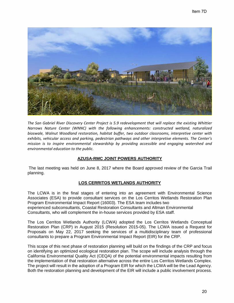
The San Gabriel River Discovery Center Project is 5.9 redevelopment that will replace the existing Whittier Narrows Nature Center (WNNC) with the following enhancements: constructed wetland, naturalized bioswale, Walnut Woodland restoration, habitat buffer, two outdoor classrooms, interpretive center with exhibits, vehicular access and parking, pedestrian pathways and other interpretive elements. The Center’s mission is to inspire environmental stewardship by providing accessible and engaging watershed and environmental education to the public.
AZUSA-RMC JOINT POWERS AUTHORITY
The last meeting was held on June 8, 2017 where the Board approved review of the Garcia Trail planning.
LOS CERRITOS WETLANDS AUTHORITY
The LCWA is in the final stages of entering into an agreement with Environmental Science Associates (ESA) to provide consultant services on the Los Cerritos Wetlands Restoration Plan Program Environmental Impact Report (16003). The ESA team includes two experienced subconsultants, Coastal Restoration Consultants and Altman Environmental Consultants, who will complement the in-house services provided by ESA staff. The Los Cerritos Wetlands Authority (LCWA) adopted the Los Cerritos Wetlands Conceptual Restoration Plan (CRP) in August 2015 (Resolution 2015-05). The LCWA issued a Request for Proposals on May 22, 2017 seeking the services of a multidisciplinary team of professional consultants to prepare a Program Environmental Impact Report (EIR) for the CRP. This scope of this next phase of restoration planning will build on the findings of the CRP and focus on identifying an optimized ecological restoration plan. The scope will include analysis through the California Environmental Quality Act (CEQA) of the potential environmental impacts resulting from the implementation of that restoration alternative across the entire Los Cerritos Wetlands Complex. The project will result in the adoption of a Program EIR for which the LCWA will be the Lead Agency. Both the restoration planning and development of the EIR will include a public involvement process.
Item 7D
20

The LCWA Budget FY17/18 identifies a total amount not-to-exceed $800,000.00 for a contract term of 2-years and 3-months set to expire on November 3, 2019. Please visit the LCWA website at http://intoloscerritoswetlands.org/ for more detailed information. LCWA has ongoing monthly public programs at Los Cerritos Wetlands through the Los Cerritos Wetlands Stewardship Program. A Grand Opening Celebration of Zedler Marsh is scheduled for Saturday September 30, 2017, 9am-3pm.
Item 7D
21

Item 7D
22