Date: 9/15/11
62
SOLUTION NO. � 3 1 A RESOLUTION ADOPTING A MASTER PLAN ENTITLED PASCO BICYCLE & PEDESTRIAN MASTER PLAN WHEAS, the Ci of Pasco, as required by the Growth Managemt Act, is reible r land use pling wit the Pao Uan Grow Boda; and, WHEAS, e Gwth Managent Act [RCW 36.70A.070(6)(a)(iii)] requires the City to address pedest d bicycle cilities to encoage community access d to pmote healthy listyles; and, WHEREAS, vous Comphensive Pl goals and policies courage eater use of bicycle and pedesan cilities throughout the City; and, WHEREAS, llowing a public heå on Septem 15, 2011, the Plning Commission unimously recommended the Pasco Bicycle & Pedesan Master Pl r appv al; and, WHE, the Ci Cocil has reviewed the Planning Commission's recommention r a Bicycle & Pedestan Mast Plan; NOW, THEREFORE, BE IT SOLVED BY THE CITY COCIL OF THE CITY OF PCO: 1. That the Pasco Bicycle & Pedestrian Master Plan atched hereto as "Exhibit 1" is hereby adted as a supplemt to the Comprehensive Pl. Passed by e Ci Council of the Ci of Pasco this 17 y of October, 2011. Matt Watkins, Mayor
Transcript of Date: 9/15/11

RESOLUTION NO. � 3'1 1
A RESOLUTION ADOPTING A MASTER PLAN ENTITLED PASCO BICYCLE & PEDESTRIAN MASTER PLAN
WHEREAS, the City of Pasco, as required by the Growth Management Act, is responsible for land use planning within the Pasco Urban Growth Boundary; and,
WHEREAS, the Growth Management Act [RCW 36.70A.070(6)(a)(iii)] requires the City to address pedestrian and bicycle facilities to encourage community access and to promote healthy lifestyles; and,
WHEREAS, various Comprehensive Plan goals and policies encourage greater use of bicycle and pedestrian facilities throughout the City; and,
WHEREAS, following a public hearing on September 15, 2011, the Planning Commission unanimously recommended the Pasco Bicycle & Pedestrian Master Plan for approval; and,
WHEREAS, the City Council has reviewed the Planning Commission's recommendation for a Bicycle & Pedestrian Master Plan;
NOW, THEREFORE,
BE IT RESOLVED BY THE CITY COUNCIL OF THE CITY OF PASCO:
1. That the Pasco Bicycle & Pedestrian Master Plan attached hereto as "Exhibit 1" ishereby adopted as a supplement to the Comprehensive Plan.
Passed by the City Council of the City of Pasco this 17th day of October, 2011.
Matt Watkins, Mayor

Date: 9/15/11
City of Pasco
Pasco Bicycle & Pedestrian Master Plan
Community & Economic Development Department

1
ContentsIntroduction ......................................................................................................................................2
Master Plan Purpose Statement ...........................................................................................2 Time Frame ..........................................................................................................................2 Background ..........................................................................................................................2 Legal Requirements .............................................................................................................2 Adopted Local Plans ............................................................................................................3
Goal, Policies & Objectives .............................................................................................................5 Goal ......................................................................................................................................5 Policies and Objectives ........................................................................................................5
Existing Conditions ..........................................................................................................................7 City-Wide Challenges ......................................................................................................................8
Proposed Facilities ...............................................................................................................9 Area Descriptions (1-6)..................................................................................................................11
Overview Map ...................................................................................................................11 Area 1 .................................................................................................................................12 Area 2 .................................................................................................................................19 Area 3 .................................................................................................................................21 Area 4 .................................................................................................................................25 Area 5 .................................................................................................................................28 Area 6 .................................................................................................................................33
Alternative Solutions .....................................................................................................................38 Sharrows ............................................................................................................................39 Signage ...............................................................................................................................39 Bike Boxes/Green Boxes ...................................................................................................40
Potential Funding Sources .............................................................................................................41 Federal................................................................................................................................41 State....................................................................................................................................41 Local ..................................................................................................................................43
Prioritization and Ranking .............................................................................................................43 Scoring ...............................................................................................................................45
Maps ...............................................................................................................................................45 Additional Bicycle Facility Components .......................................................................................45
Transportation SYSTEM Plan ...........................................................................................45 Install municipal bike racks (identify effective locations) .................................................46

2
IntroductionBicycling and walking as means of recreation and transportation have been growing in popularity as many communities work to create more balanced transportation systems by giving bicyclists and pedestrians a greater share in use of the roadway networks. In addition, recent national surveys find that more people are willing to cycle more frequently if better bicycle facilities are provided.
MasterPlanPurposeStatementThe purpose of this document is to consolidate existing efforts addressing bicycle and pedestrian facilities; to provide a prioritized action plan for improving listed travel routes; and to analyze the costs and potential funding sources.
TimeFramePasco’s Comprehensive Plan has a horizon to year 2027; this Plan will adhere to the same time frame.
BackgroundIn 2006 the Pasco City Council authorized appointment of an ad hoc advisory Committee to assist staff in developing policies relating to the design, location and maintenance of bikeways throughout the City. The Committee was charged with the following tasks: 1) propose design standards and options for bikeways throughout the City; 2) propose policies regarding bicycle accommodation in the City; and, 3) propose maintenance standards for the bikeway system. This Committee convened a total of six times in late 2006 and early 2007. In 2007 City Council approved Resolution No. 3021 adopting a three page “Bikeway Plan”. The Bikeway Plan is the culmination of ideas generated by the ad hoc committee and contains a total of one (1) overall goal, six (6) policies and thirty (30) related objectives aimed at creating a contiguous network of safe and convenient bicycle pathways. The Plan provides insight into the values of the local bicycling community, but lacks specific data needed for cost estimates and construction planning. The Committee also produced a map (see attached Bike Route Map) delineating both existing and proposed routes and pathways where bicycles should be able to travel safely and comfortably.
LegalRequirementsWith the intent of promoting healthier and more physically active communities two pertinent bills (ESSB 5186 and 2SHB 1565) were passed by the State of Washington. Engrossed Substitute Senate Bill (ESSB) 5186, passed in 2005, requires communities to consider urban planning approaches that promote physical activity, and also requires a bicycle and pedestrian component be included in the Transportation Element of a comprehensive plan. ESSB 5186 also added a

3
requirement to the Land Use Element of the comprehensive plan for jurisdictions fully planning under the GMA: “Wherever possible, the Land Use Element should consider utilizing urban planning approaches that promote physical activity” [RCW 36.70A.070(1)] citing that several studies have demonstrated that a person’s immediate environment is the most important determination of physical activity. Bill 2SHB 1565 also passed in 2005, specifies that multiple modes of transportation may be included in concurrency programs when reviewing the transportation impacts of new development. This Plan together with the Pasco Comprehensive Plan and the Benton Franklin Council of Governments 2010 Regional Bicycle and Pedestrian Transportation Plan, are all collaborative efforts aimed at meeting the requirements set by ESSB 5186 and 2SHB 1565.
AdoptedLocalPlansPasco Comprehensive Plan Pasco’s Comprehensive Plan contains a number of Goals and Policies which support the objectives of this Plan. The following Comprehensive Plan Goals and Policies apply:
- Goal TR-1 aims to continue to provide and maintain an effective and convenient street system.
- Policy TR-1-G supports development of an interconnected network of streets, trails and other public ways while preserving neighborhood identity; and building streets and sidewalks without interrupted or patchwork rights-of-way or construction.
- Goal TR-2 aims to encourage efficient, alternate and multi-modal transportation systems.
- Policy TR-2-D encourages greater use of bicycles and walking by providing safe and purposeful bicycle and pedestrian routes.
- Policy TR-2-E encourages park-and-ride lots for bicycles and automobiles.
- Policy CF-3-A aims to assure land development proposals provide land and/or for facilities for pedestrian and bicycle trails.
Pasco Parks and Recreation Plan The city’s 2010 Park and Recreation Plan indicates trail corridors should be developed to include trees, landscaped areas, open lawn areas, seating areas, and some picnic facilities. The plan proposes ten future parks and improvements or expansions at many existing parks. Locations containing the amenities listed above may at least serve as rest areas or destinations for bicyclists. Adding landscaping features to pathways will require irrigation and continuous maintenance creating additional costs.

4
Landscaping feasibility should consider a sites’ proximity to FCID irrigation water and relative benefits of the additional amenities. Benton Franklin Council of Governments (BFCG) 2010 Regional Bicycle and Pedestrian Transportation Plan The Benton-Franklin Council of Governments (BFCG) 2010 Regional Bicycle and Pedestrian Transportation Plan discusses many aspects of pedestrian and bicycle related issues throughout Benton, Franklin and Walla Walla Counties. The 2010 BFCG Regional Bicycle and Pedestrian Plan fulfills federal requirements (23 CFR 450) that a metropolitan transportation plan contain a bicycle and pedestrian component as well as state mandates (RCW 36.70A) that regional transportation plans encourage efficient multi-modal transportation systems which are based on regional priorities and coordinated with city and county comprehensive plans. The BFCG Bike/Ped. Plan includes a useful bike route map at the Tri-Cities scale. The map is included in the appendices for reference. It is the policy (Policy 13) of the BFCG to promote pedestrian and bicycle travel as essential modes of transportation both within existing communities and new development and to provide opportunities for the safe and efficient use of pedestrian and bicycle facilities as a legitimate alternative to motorized travel and for improved health. Pasco Municipal Code (PMC) Titles 12 (Streets & Sidewalks), 25 (Zoning) & 26 (Residential Subdivision Regulations) Pasco Municipal Code does not require installation of sidewalks in the Suburban (RS-12 and RS-20) zones and bicycle facilities are not presently required as part of residential, commercial or industrial development in any zone. The absence of concurrency requirements for bicycle/pedestrian infrastructure improvements acts as a barrier to achieving the overall goal of this Plan by transferring the responsibility of pedestrian facilities (sidewalks) from private developers to the City. Modifications to PMC Title 26 (Pasco Urban Area Subdivision Regulations) and Title 12 (Streets & Sidewalks) requiring sidewalks on arterial and collector streets in Suburban (RS-1, RS-12 and RS-20) zoning districts may be an effective approach to establishing development requirements relative to bicycle/pedestrian infrastructure on arterial and collector streets. Amending Title 12 to require curbs, gutters, sidewalks and bicycle lanes be installed concurrent with both commercial and residential development in Suburban zones would help meet the Goal of this Plan.

5
Goal,Policies&Objectives
GoalCreate and maintain a high-quality bikeway and pedestrian network that is safe, direct, comfortable, aesthetically pleasing, and which allows cyclist to access destinations accessible to automobiles where practical.
PoliciesandObjectives: The overall Goal can be broken down into Policies and Objectives that help quantify the goal statement.
1) Policy: Connectivity/Access—Bicyclists should have safe access to City destinations accessible by motorized vehicles, where practical.
Objectives a) Encourage bicycle lanes, paths, or trails and bicycle access points in new
development design. b) Design bike paths for the most direct routes possible. c) Mitigate major barriers such as freeways and railroad crossings by
including over/underpass facilities. Crossing points should be at right angles and to be as short as possible.
d) Provide for bike path continuity. e) Loop and interconnect paths, or trails to provide a variety of trail lengths
and destinations including small and large loops for a broad range of experiences and ability levels.
f) Provide safe bicycle access and parking facilities for major commercial destinations, where practical.
g) Provide safe bicycle access and parking facilities for major civic destinations, (e.g., library, post office, schools) where practical.
h) Design bicycle routes and paths to minimize conflicts between motorists and bicyclists and increase the separation of cyclists from motorized vehicles.
i) Design intersections with bicycle-friendly facilities such as bicycle-first signaling so as not to interfere with traffic flow.
j) Include secure bicycle lock-up facilities at appropriate destinations. k) Design landscaping to be open and “visually secure”. l) Install clear right-of way indicators such as 8” wide edge line stripes,
sharrow stencils and freestanding bicycle signs for automobiles and bicyclists.
m) Utilize “Traffic Calming” measures where appropriate. n) Mark bike paths and lanes for safety. o) Install lighting along bike paths and trails as appropriate.

6
2) Policy: Comfort/Convenience - Bikeways shall be designed to encourage non-motorized travel citywide.
Objectives: a) Plant shade trees along bicycle paths that do not possess a destructive
root pattern. b) Include rest areas with water, air, and toilet facilities at convenient
intervals along bicycle routes. c) Design bicycle lanes, paths, or trails for “flow,” with as few stops as
possible. d) Mark trails for distance monitoring.
3) Policy: Aesthetics - Bikeways shall be aesthetically pleasing so as to encourage non-motorized travel citywide.
Objectives: a) Plan bike paths and trails to provide visual and physical access to
natural areas and to the Columbia/Snake Rivers. b) Landscape bicycle lanes, paths, or trails to be interesting and attractive
to the user.
4) Policy: Incentives/Promotion - Encourage non-motorized travel
Objectives: a) Develop bikeway maps that are easily available (brochures and internet)
and provide safety guides/education.
5) Policy: Maintenance - Establish bike path maintenance policies and schedules.
Objectives: a) Maintain roadways and bikeways to a relatively hazard-free standard. b) Encourage bicyclists to report maintenance problems and other hazards. c) Include maintenance costs and maintenance procedures in bicycle
facility projects as appropriate. d) Include reasonable estimates for the maintenance costs in the project
budget. e) Establish clear maintenance responsibilities in advance of construction.

7
ExistingConditions
Much of the residential development west of SR395 and south of Hwy I-182 is developed to a rural standard, without curbs, gutters and sidewalks and edge lines. The absence of the fore mentioned improvements facilitates road widening and bike lane striping by eliminating physical barriers which may complicate project implementation and add to the costs. A large majority of roadways east of SR395 and south of Hwy I-182 are fully developed with curbs, gutters and sidewalks. Right-of-way widths on proposed routes vary from 50ft. to 150ft. The most common right-of-way width is 60 feet. Roadways within residential development north of Hwy I-182 and west of Road 36 contain curbs, gutters and sidewalks. Most streets in this area have a 60ft. wide right-of-way with curbs, gutters and sidewalks adjacent to the roadway. Road 60 between Burden Boulevard and Sandifur Parkway is a fully developed roadway containing bike lanes and sidewalks and could be used as a model for many routes identified on the Overview Map. This Plan contains an Overview Map of roadways with needed bicycle and pedestrian facilities; though many facilities are needed some currently exist. There are existing bicycle and pedestrian facilities throughout the City which provide excellent opportunities for establishing connectivity to the proposed bicycle lanes and bicycle/ pedestrian pathways listed in this Plan. These existing amenities include the following:
- A paved east-west bicycle/pedestrian pathway north of I-182 extending from Road 100 to the Argent underpass at I-182.
- The Sacajawea Heritage Trail (a paved east-west bicycle/pedestrian pathway traversing the river shore from the I-182 overpass at Court Street to Sacajawea State Park) covers approximately 14 miles of the Columbia River shoreline.
- Road 60 from Sandifur Parkway to Burden Blvd. contains
stripped bicycle lanes and sidewalks along both travel lanes.
- Court Street contains paved shoulders with striping between the I-182 Bridge and approximately Road 48.
- Road 84 adjacent Chiawana High contains approximately 1200
feet of bike lane and sidewalk.

8
- Road 36 north of I-182 and south of Burden Blvd. contains striped bicycle lanes in both directions. Intermittent segments of sidewalks exist on the west side of the Road 36 (adjacent residential development). The east side of Rd 36 abuts the Pasco Airport. This undeveloped area contains the runway and will remain in the current condition unless right-of-way improvements are initiated via a City Public Works project.
City‐WideChallenges Although each Area contained in this Plan contains the sub-heading “Challenges”, it is important to address challenges at a larger (City-wide) scale. The following list generally describes challenges to project implementation/construction. For more detailed descriptions of issues and conditions see the Area Descriptions section for Areas 1-6.
- Sandifur Parkway between Convention Drive and Road 68 lacks bike lanes and sidewalks. Edge lines are present, but paved shoulders are of insufficient width to accommodate bike lanes. The paved shoulder is 22 inches wide eastbound 3 feet wide westbound. Each travel lane is 14 feet wide with no left-hand turn lane.
- Burden Blvd. between Road 60 and Road 68 is a fully developed roadway and lacks bicycle lanes. This section of roadway may play an important role in the Plan by providing enhanced transportation at a location experiencing ever increasing traffic congestion. This location is arguably the most congested roadway in Pasco.
- Bike lanes are needed on Sandifur Parkway from Road 100 to Road 44. Sidewalks are needed along most of the undeveloped properties fronting Sandifur Parkway. A significant challenge related to bicycle lanes on this roadway segment is that most of Sandifur Parkway is fully developed curb-to-curb without edge lines or shoulders.
- Areas 5 & 6 are proposed in long established areas of Pasco.
The proposed facilities primarily front residential development which do not contain curbs, gutters, sidewalks or edge line striping. Many of the road shoulders are too narrow to support the addition of a bicycle lane. In such instances, fill material and additional paving may be needed to provide the minimum

9
four (4) foot wide bike lane with 8” stripes. This is the predominant condition in areas south of I-182.
- 20th Avenue, contained in Area 5, presents significant
constraints. Much of 20th Ave. experiences very high traffic volumes, especially around Court Street. Current roadway features impeded bicycle facility construction.
- Areas 3 & 5 contain primarily residential roadways developed to
rural standards. This means sidewalks and wire road shoulders are largely lacking throughout both areas. Substantial infrastructure improvements are required to meet the goals of this Plan.
- The Road 100/I-182 Overpass Bridge contains edge line striping
and five (5) foot wide shoulders in both directions. The existing shoulder may be wide enough to accommodate either a bike lane or a sidewalk, but not both adjacent one another. The ideal solution to this spatial constraint is widening the bridge.
Right-of-way Policies This Plan poses policy changes related to right-of-way development requirements for new development proposals in suburban zones. Contrary to past practices, development proposals on arterial and collector roads in suburban zoning districts will be required to accommodate right-of-way facility needs in the way of sidewalks, bike lanes and ADA features. Materials costs estimate tables indicate sidewalks are needed on various roadways however, the cost estimate dollar amounts do not include sidewalk construction costs because it is unlikely the City will construct sidewalks as part of any right-of-way project. Rather, sidewalk construction will be a concurrency requirement for new development.
ProposedFacilitiesThe Master Plan Overview Map (Map “M-1”) illustrates a connected network of proposed bicycle and pedestrian routes to serve as a structural “backbone”. Proposed bicycle/pedestrian routes generally follow arterial streets. All routes identified as solid lines in the Overview Map are in need of bicycle facilities. City-wide, bicycle lanes are needed on the following street segments:
- Sandifur Parkway (Rd 100 to Rd 44) - Road 100 (Powerline Road to Court Street) - Road 103 (Court Street to Argent Rd) - Argent Road (Rd 103 to 4th Ave) *with the exception of segments in front
of McLoughlin and Chiawana Schools - Road 60 (Argent Road to the river shore)

10
- Road 76 (Sandifur to I-182) - Burden Blvd. (Convention to Road 36) - Madison Ave (Burden to Road 44) - Road 44 (Sandifur Parkway to Argent Rd) - Road 52 (Sandifur Parkway to Burden Blvd) - Road 88 (Argent Rd to pathway south of Whipple Ave.) - Road 52 (Argent to Sylvester) - Road 60 (Court St to Sylvester St.) - Livingston Rd (Rd 48 to Rd 36) - Wernett Rd (Rd 48 to Rd 36) - Pearl St (Rd 48 to Rd 32) - Road 36 (I-182 to Havstad St) - Road 40 (Sylvester St to Riverhaven St) - Riverhaven St (Rd 40 to Rd 39) - Rd 39 (Riverhaven St to Havstad St) - Havstad St (Rd 39 to Rd 36) - Road 40 (Livingston Rd to Wernett Rd) - Court Street (Rd 48 to 26th Ave) - 26th Ave (Court St to Henry Street) to 24th Ave to West Henry Pl to
22nd Ave to Henry St to 20th Ave) - Henry Street (26th Ave to 24th Ave) - 24th (Henry St to Henry Pl) (Approx. 180 feet) - Henry Pl (24th Ave to 22nd Ave) - 22nd Ave (Henry Pl to Henry St.) (Approx. 180 feet) - Henry St (22nd Ave to 18th Ave) - 20th Ave (Argent Rd to “A” St) - West Lewis Street (Rd 28 to Heritage Blvd) - Road 28 (Sylvester to “A” St) - “A” St (Road 28 to Heritage Blvd) - Hopkins St (Sacajawea Trail @ 395 Bridge to Road 28) - 4th Ave (Boeing St to 3rd Ave) - 3rd (4th to Columbia St) - Columbia St (3rd Ave to 4th Ave) - Elm Ave (Sheppard St to Lewis St) - 4th (Columbia to Ainsworth Ave) - Beech Ave (Sheppard St to Park View Blvd) - Wehe Ave (Park View Blvd to “A” St) - Oregon Ave (“A” St to Ainsworth Ave) - 14th Ave (Pearl St to “A” St) - Pearl St (20th to 14th) - Octave St (18th Ave to 16th Ave) - Henry St (16th Ave to 3rd Ave) - 5th Ave (Henry St to Margaret St) - Margaret St (5th Ave to 4th Ave) - Nixon St (4th Ave to 3rd Ave) - 4th Ave (Washington St to Ainsworth Ave) - Sheppard St (Beech Ave to Elm Ave)
11
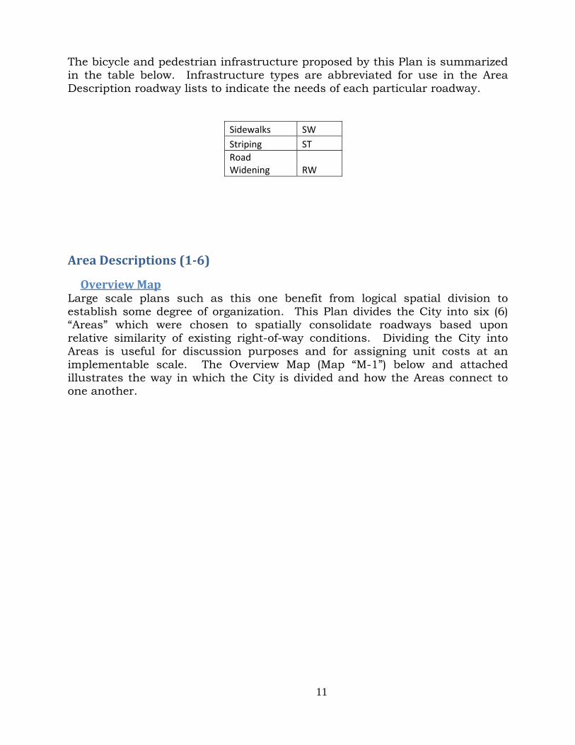
The bicycle and pedestrian infrastructure proposed by this Plan is summarized in the table below. Infrastructure types are abbreviated for use in the Area Description roadway lists to indicate the needs of each particular roadway.
Sidewalks SW Striping ST Road Widening RW
AreaDescriptions(1‐6)
OverviewMapLarge scale plans such as this one benefit from logical spatial division to establish some degree of organization. This Plan divides the City into six (6) “Areas” which were chosen to spatially consolidate roadways based upon relative similarity of existing right-of-way conditions. Dividing the City into Areas is useful for discussion purposes and for assigning unit costs at an implementable scale. The Overview Map (Map “M-1”) below and attached illustrates the way in which the City is divided and how the Areas connect to one another.

AACp
AreaArea descrArea 1 is bChapel Hilproposed o
1ription bound by ll Boulevaon the follo
RHSRCHB
the Columard to the owing road
Road
Road 100 Harris RoaSandifur PRoad 76 ConventionHomerun RBurden Blv
mbia Riversouth anddways:
dway
ad Parkway
n Drive Road vd.
12
r to the wed Road 60
Imp SW, ST NA ST SW, ST ST ST ST
2
est, Power0 to the ea
Needed provementT, RW
T
rline Roadast. Bicycl
ts
d to the noe facilities
orth, s are

ExistingMost ofcontainSandifu NeededNo sideand Coboth thSandifuright-of
g Facilitiesf the prop
n standardur Parkway
Facilities ewalks or onvention he north aur Parkwaf-way impr
s posed roud sidewalksy to Burde
bicycle lanDrive. Th
and south ay the adjrovements
tes indicas. The ween Bouleva
nes exist ohis portio sides (seeoining pro
s.
13
ated in thest side of ard.
on the Sann of Sande photo beoperties w
3
he Bike Ma Road 76 c
ndifur Pardifur Parkelow). As
will be req
aster Plancontains s
rkway betwkway is un
developmquired to
n Area 1 sidewalks f
ween Roadndevelopedent occursconstruct
Map from
d 68 d on s on t the

Sandifuresidenshould betweenbut exilanes. westbouDevelopon their Area 1construRoad. embankwhich cApproxiconnectpedestrdirectly
(S
ur Parkwantial subdiv be placedn residencisting pavThe paveund. Eacpment pror portion o
1 includeucted fromThe pathw
kment gracurrently imately 2,tion. To rian/bicycly to Road 1
Sandifur Par
ay serves visions an
d on the inces and thed shouldd shouldech travel oposals adof Sandifur
s the prm Court Sway wouldadient; exleads ride
,600 linea avoid thle travel 100.
rkway betwe
as a prnd the Roanstallationhe Rd 68 cders are oer is 22 lane is 1
djacent to r Parkway
roposal foStreet at td parallel tending toers and w
ar feet of phe need t
in both
14
een Rd. 68 &
rimary/artad 68 comn of bike lacommerciaof insufficiinches w4 feet widSandifur
y.
or a bicythe I-182 I-182 at t
o Harris Rwalkers uppathway isto cross Hdirections
4
& Convention
terial conmmercial canes to pral center. ient width
wide eastbde with nParkway
ycle/pedes river ovethe base oRoad fromp to the ss needed iHarris Ros, the pa
n Dr.)
nnection borridor. A
rovide a saEdge line
h to accomound and
no left-hanmust inst
strian paerpass briof the elevm the exissidewalk oin order toad, whileathway sh
between lA high prioafe connecs are presmmodate d 3 feet wnd turn ltall bike la
athway toidge to Havated roadsting pathon the brio achieve e maintaihould con
large ority ction sent, bike wide lane. anes
o be arris dway hway idge. this ning
nnect

(Existing p The Roand strtravel lshoulde
(Future
pathway @ I
ad 100/I-ripped bicylanes. Ters on both
pathway ext
I-182/Court
-182 overpycle lanes
The bridgeh sides wi
tension from
t St. Bridge)
pass bridgs without e currentlithout side
15
m Court St @
(Area pro
ge should reducing ly containewalks.
5
@ I-182 to Ha
oposed to ext
be widenethe existi
ns edge l
arris Road)
tend pathwa
ed to proving numbelines with
ay to Harris
vide sidewer or widt
h 5 foot w
Rd.)
walks th of wide

(R The ensidewalsubdivicommerFacilitamarketaDescripthe I-18 Road 1Road. T
(Road 100 ChallenConnecI-182 (b(117530Natural Convenconstrulargely
Rd.100/I-18
ntire lengtlks to fosisions andrcially zon
ating intraability of t
ption table82 Bridge
00 currenThe west s
south of Vin
nges cting bicycbehind Lo0015 & 1l Resource
ntion Drivucted to ½undevelop
2 Overpass
th of Roaster neighd commercned land s-neighborhthese vacae indicatesis the only
ntly terminside of Roa
ncenzo Dr. –
cle/pedestrwe’s) pres
117500118es (DNR).
ve from F½ the stanped.
Bridge)
ad 100 shhborhood cially zonesurroundinhood non-ant tracts s road widy portion o
nates at tad 100 at
– looking sou
rian facilitsents some8) owned
Fairchild ndard widt
16
(Rd.
hould be scale tra
ed lands. ng the Ro-vehicular and invite
dening is nof Rd 100 n
he north its norther
uth) (Road
ties on Roe challengby the W
Cinema tth as the
6
100/I-182 o
treated wansportatio A signifioad 100 cor transporte commercneeded on needing to
city limitsrn terminu
100 north o
oad 76 to tges createdWashington
to Powerlwest side
overpass bri
with bicycon betweeficant percorridor remtation maycial investo Road 100o be widen
s, soon tous remain
of Vincenzo D
the existind by the vn State D
line Road of Conve
dge 5’ shoul
cle lanes en residencentage ofmains vacy promoteors. The A0 when in ned.
o be Powerns vacant.
Dr. - looking
ng pathwavacant parDepartmen
d is curreention Driv
lder)
and ntial f the cant. e the Area fact
rline
g south)
ay by rcels nt of
ently ve is

Road 1containfreewayroadwalanes w Sandifuwithout
(S
Undeveroadwacurrentvacant infrastrthis roaand a 1feet. The patright-ofgrantinThe exifor the OpportuPhysicasolutionfor the located are a csurfacedrawbastreets
100 north ns varied sy on-rampay layout while maint
ur Parkwayt edge line
Sandifur Par
eloped comay, sidewatly contigu
parcels ructure is adway is l10.5 wide
thway parf-way. Pr
ng permissisting pathproposed
unities al constrans for accchallenges roadside combinatioe. Whileacks. Descan create
of Chapetriping con
ps and twmay requtaining ac
y betweenes or shoul
rkway at Rd
mmercial alks, curuous fromon the n not configaid out wicenter tur
rallel to Hrior to begsion to thehway is lopathway.
aints creacommodatis presenteat a minimon of free
e sharrowsignating e a false se
el Hill Blvnfiguration
wo (2) freeuire creativcceptable v
n Road 100lders to all
d 76)
parcels ebs, gutte
m Road 68north sidgured to aith a singlrn lane, p
arris Roadginning coe City, muocated in W
ated by fuing bicycle
ed along Samum rate estanding
ws are a a travel lense of sec
17
vd. is a rns. This reway off-rve solutiovehicle traf
0 and Roalow for wid
exist on Sers and to Road
de of Sanallow for sle 25.5’ wroviding a
d is propoonstriction
ust be madWSDOT ri
ully devele infrastruandifur Pa of 1/blocksigns anfeasible
lane for bcurity in th
7
relatively roadway sramps. Tns to accffic flow.
ad 68 is a fdening.
(Sandifur P
Sandifur landscapi100 with
ndifur Parsafe bicycl
wide travel a total roa
osed to be n of the pde betweenight-of-wa
oped roaducture. Sarkway inck; and/or
nd paintedmethod
bicyclists he riders’
high-traffiegment coThis relatcommodat
fully devel
Parkway at R
Parkway, ing impro the exceprkway. le travel. lane in ei
ad surface
located wpathway, n the City
ay and the
dways reqSome possclude frees, “sharrow
d symbolsthey are to share
mind.
ic area wontains twtively come safe bic
loped road
Rd. 90)
however ovements ption of aThis exis A majoritither direc width of
within WSDan agreem
y and WSDe same is
quire creasible solutstanding sws”. Sharrs on the r not withalready b
which wo (2) mplex cycle
dway
the are
a few sting ty of ction 61.5
DOT ment DOT. true
ative tions signs rows road hout busy

18
Sandifur Parkways’ 25.5’ wide travel lanes could each be reduced by 4’8” resulting in approximately 21’ wide travel lanes; allowing the minimum 4’ wide bike lanes. This Plan supports the need for widening the I-182/Rd 100 Overpass Bridge. During the planning stage of the I-182 Bridge construction project, a larger width than currently exists was requested of the WSDOT. The request for extra width was denied at that time. The high rate of residential development in Pasco in recent years has greatly contributed to the need for this bridge to be widened. The bridge has edge lines and five (5) foot wide shoulders bound by a wall. The five foot shoulders are sufficient to accommodate bike lanes or sidewalks on both sides, but not both bike lanes and sidewalks on both sides. These factors support the need to widen the bridge. Key Route Key routes are identified within each Area as having particular importance based on a variety of factors; particular emphasis is placed on the function of east/west connectivity. Key routes can be interpreted as having high implementation priorities. Not all key routes connect in a contiguous fashion. The key route in Area 1 is Sandifur Parkway which extends from Road 100 to Road 60. Sandifur Parkway is a main thoroughfare connecting dense pockets of homes to the Road 68 commercial corridor. Materials Cost Estimate Materials cost estimates developed by the City Engineering Department are shown below. Area-wide materials cost estimate tables provide detailed estimates of cost and quantity as they relate to the individual components of construction. Subsequently, estimates have been pared down into linear foot cost figures which can be applied when attempting to estimate costs for various project configurations within an area. Materials Cost Estimate tables apply to an entire Area; not individual roadway segments within an Area.
# Roadway(s) Required Improvements Cost
1a Broadmoor Blvd. (Pwrline to Bedford)
SW, ST, RW $13,260.00
1b Rd 100 Bridge SW, ST, RW
1c Harris Rd (pathway)
NA $148,568.60
1d Rd 76 (Sandifur ‐ I‐182)
SW, ST $7,710.00
1e Convention Dr. & Homerun Rd. ST $41,650.00
1f Sandifur Prkwy (Rd 100 ‐ Rd 60)
ST $18,230.00
1g Burden Blvd. (Convtn ‐ Rd 60) ST $4,500.00
TOTAL $197,518.60

AreaArea DeArea 2 is a stacanal eunderpFrankli
ExistingThe irriFCID rapproxiterminuapproxiand bicplaced i NeededAdditionTranspohttp://ww
a2escription is unique and-alone extending ass. The n County
g Facilitiesigation canright-of-waimately, frus of Valleimately 13cycle pathwin undergr
Facilities nal informortation F
ww.fhwa.dot
in that th pathway from Roapaved biIrrigation
s nal and gray (see pfrom 134ey View Pla30 feet; prway. Theround pip
mation abo
ederal Higt.gov/environ
he propose located oad 111 aticycle/ped District F
ravel serviphotos bel4 feet to ace. This roviding e irrigationing severa
ut pathwaghway Admnment/sidew
19
ed bicycle/on the Frat Court S
destrian pFCID canal
ice road arlow taken55 feet eright-of-w
enough spn canal froal years ag
ays can beministratiowalk2/sidewa
9
/pedestriaanklin Co
Street to tpathway isl right-of-w
re currentn at Roaeast of Roway varies pace for a om Court go.
e found onon websitealks214.htm
an facility ounty Irrigthe I-182s proposeway.
tly containd 84) whoad 84 toin width f future peStreet to R
n the US D:
and key rgation Dis/Argent Red within
ned withinhich narro the wesfrom 50 feedestrian Road 100
Department
route strict Road the
n the ows,
stern et to trail was
t of

(A wel
(Fre
ChallenTiming work to
l designed shar
equent rest area
nges of Area 2o undergro
red-use paths tconfli
as that include
2 facilitiesound the c
that provide dificts between u
benches and w
(FCID c
s constrictcanal by F
20
fferent lanes foser groups on h
wheelchair spac
canal @ R
tion is deFCID. An
0
or users who trhigh use trails.
ces provide rel
Road 84)
pendent uagreement
ravel at differen.)
lief from preva
upon the t between
nt speeds preve
ailing grades.)
completio the Irriga
ent
on of ation

21
District and the City securing shared use of the FCID right-of-way must also be arranged. Opportunities The right-of-way trail would be ideal for walking/biking. Opportunities for using existing public rights-of-way for augmentation of the trail network will likely occur in the future following completion of the FCID plan to bury the canal. Materials Cost Estimate
# Pathway Required Improvements Cost
2 Court St. @ Rd 111 ‐ Rd. 68
Pedestrian/Bike Pathway $609,637.30
Area3Area Description Area 3 is bound by Road 103 to the west, Chapel Hill Boulevard to the north, the Columbia River shoreline to the south and Road 60 to the east. Bicycle facilities are proposed on the following roadways:
Roadway Needed Improvements
Chapel Hill Boulevard ST (future) Chapel Hill Blvd. ST, SW Argent Rd SW, ST Road 103 (350’) ST Road 100 ST, SW Road 88 SW, RW, ST Road 84 SW, RW, ST Road 76 SW, RW, ST Road 68 SW, RW, ST Road 92 SW, RW, ST

ExistingBike lalimited NeededThe edgbike lanPlan Arproposeborderifrom whwhen fsidewal
g Facilitiesnes exist sections o
Facilities ge lines onnes. All ofrea 3 Map ed routes lng public hich to extfronting alks.
s on certain
of Court St
n Court Sf the propo require colack sidew schools. tend faciliarterial st
n portionstreet west
treet needosed routeonstructio
walks with The schties outwatreets, do
22
s of Court of Road 1
d to be wides indicateon of bicyc the consis
hools may ard. Develoes not c
2
t Street. S00.
dened to ted on the cle facilitiestent exce serve as lopment incurrently
Sidewalks
the 8 inchBike/Pede
es. As weleption of th good begn Suburbarequire i
exist on
h standardestrian Mall, many ofhose segmginning poan zones, enstallation
very
d for aster f the
ments oints even n of

A moreCourt SroadwaCourt S42) hasrequire needed meet th
Chapel roadwadevelopof Chapstriping
(Ch
e detailed Street roaday bike lanStreet will s steep sh modifica in some
he minimu
Hill Boulay without ped parcelspel Hill Bg.
apel Hill Blv
site surved surface nes and w be very lioulders intion to acareas to d
um 8 inch w
(Existing
levard from a left-hans fronting Blvd., but
vd. westboun
ey should needs to
wide shouimited. Pantended toccommodadefine thewide strip
bike lanes o
m Road 1nd turn lathis roadw travel lan
nd)
23
be perforbe widene
ulders, theart of Couo facilitate ate widene outer boing standa
on Court Str
00 to Roaane or edgway. Bike nes could
3
rmed to ided. Due te need forurt Street stormwat
ning. Addioundary ofard for bic
reet at I-182
ad 84 is age lines. S lanes do n
d be redu
(Chape
dentify spto the exter shoulder(between Rter drainational strf the bikecycle lanes
looking eas
a fully devSidewalks not exist oced to all
el Hill Blvd.
ots whereent of exisr wideningRd 48 and
age which riping maye lanes ans.
st)
veloped 4-exist alonon any porlow bike
eastbound)
e the sting g on d Rd may y be
nd to
-lane g all rtion lane

Road 8shown Argent west sidof Sterlindicatefunction ChallenRoad 1largely lane. and cen
(R Chapel where blanes oand/or reducin The extthe curdevelop OpportuThe wesAs in needed irrigatiowidth accommsouth o
84 betweenon the AreRoad. Betde of Roading Road (es existingnal.
nges 00 north developedThis shor
nter-turn l
Road 100 no
Hill Blvd.bike lanes on Chapel sharrow
ng the widt
tension of rrent own
p this exten
unities st side of most case bicycle inon canal exists on
modate a of Maple D
n the FCIea 3 Map. tween the d 84 only. (fronting Cg bicycle
of the irrd with twot segmentlanes.
orth of the F
. east of R could be Hill Blvd stencils th of trave
Chapel Hnership (Wnsion are c
Road 100 es, undev
nfrastructuhas wide
n both eabicycle lan
Drive.
ID canal The bike FCID cana A bike la
Chiawana facilities,
rigation cao travel lat of roadw
FCID canal)
Road 100 installed.
d. is the upainted o
el lanes to
Hill Blvd. frWA Dept. contingen
between Iveloped prure. Much paved orast and ne with th
24
and Arge lanes are al and Stene exists oHigh Schoimprovem
anal is a ranes in eit
way contain
does not One possuse of freeon the ro provide bi
rom Road of Natur
t upon tra
I-182 and roperties h of the wer graveled west sidehe excepti
4
nt Road not contig
erling Roadon the easool). Evenments are
relatively hther direcns right an
(Ro
contain ansibility for estanding oad surfacike lanes.
84 to Roaral Resouransfer of ow
the FCID present oest side of shoulderes to alloion of the
contains guous fromd the bike st side of Rn though th needed t
high traffiction and nd left-ha
oad 100 at M
n unimpror the inclu
bicycle loce. Anot
ad 68 is crces). Oppwnership
canal is mopportunitf Road 100rs. Sufficow re-str east side
bike lanesm the can lane is onRoad 84 sohe Area 3 to make t
ic area ana center
and turn la
Massey Drive
oved shousion of bicogo pole sther optio
omplicateportunitieand rezon
mostly vacties to in0 south ofcient shouriping ande of Road
s as al to
n the outh Map
them
nd is turn anes
e)
ulder cycle signs n is
d by s to
ning.
cant. nstall f the ulder d to 100

25
Plans exist to extend Chapel Hill Blvd, from Road 84 to Road 68 concurrent with development proposals. At the time development is proposed in this location, conditions should be placed on all land divisions/development projects to require 4’ wide bicycle lanes be stripped in both eastbound and westbound directions. Chapel Hill Blvd from Road 100 to Road 84 contains a total of four (4) travel lanes, two in each direction, and each lane is 14 feet wide. If each travel lane were reduced to twelve (12) feet, six (6) feet would become available on each side of the road where bike lanes could be installed without affecting the level of service. Once the roadway striping configuration has been decided, the same should be applied to the future extension of Chapel Hill Blvd. Key Route The key route in Area 3 is Argent Road. Within Area 3 Argent Road extends from Road 100 to Road 60. This key route will extend into Areas 5 & 6 finally connecting with 4th Avenue. Materials Cost Estimate
# Roadway(s) Required Improvements Cost
3a
Rd. 100 (I‐182 ‐ Court) Chapel Hill (Rd. 100 ‐ Rd 84) Rd 84 (Chapel Hill ‐ Argent)
ST, SW, RW $68,816.00
3b
Rd. 92 (Court ‐ River), Rd. 88 (Argent ‐ s/Whipple), Rd. 84 (Argent ‐ S/Sunset), Rd. 76 (Argent ‐ S/River Blvd.)
ST, SW, RW $106,885.00
3c Future Chapel Hill (84 ‐ 68) NA 3d Rd. 68 (Argent ‐ River) ST, SW, RW $57,590.00
3e Argent Rd. & Rd. 103 (Court ‐ Rd 60)
ST, SW, RW $116,860.00
TOTAL $350,151.00
Area4 Area Description Area 4 is bound by Road 60 to the west, Sandifur Parkway to the north, Argent Road to the south and Road 36 to the east. Bicycle facilities are proposed on the following roadways:

ExistingBike lacontinurounda Sidewal
SaBuMaRoRo
g Facilitiesanes existuing to Babout at Ro
lks exist o
Road
andifur Parurden Bouadison Aveoad 52 oad 44
s t along b
Burden Bload 44 con
on Burden
dway
rkway levard enue
both travelvd. to Rntains bike
Boulevard
26
Im ST, S ST ST ST ST, S
el lanes oRoad 60. e lanes an
d.
6
Needed mprovemeW, RW
W, RW
on Road Madison
nd sidewal
ents
36 from n Avenue ks.
Argent R west of
Road the

27
Needed Facilities Additional shoulder widening on the east side of Road 44 is needed to accommodate bike lanes. Sandifur Parkway is currently developed at one half of the standard width bordering the County island between Road 60 and Road 52. To date, Madison Avenue is incomplete. Madison Avenue lies within the Linda Loviisa and First Place residential subdivisions. No connection exists between Madison Avenue at Salem Drive and Madison Avenue at El Paso Drive. Sidewalks are lacking on the east side of Road 36 bordering the Paso Airport. No sidewalks exist along Burden Blvd. when bordering undeveloped parcels. Several undeveloped parcels exist on Burden Blvd. between Road 60 and Road 68 creating the need for approximately 1235 feet of sidewalk in order to complete pedestrian facilities on Burden Blvd. Promoting safe bicycle travel on Burden Blvd. has the potential to alleviate traffic congestion by providing a reasonable option to access the Road 68 commercial corridor. Challenges The Franklin County “island” bordering Sandifur Parkway and Road 60 presents a challenge for concurrency development of bicycle and pedestrian facilities as the timeline for annexation is undetermined. The roadway on Burden Blvd. from Road 60 to Road 68 is fully developed with two travel lanes in both directions and a landscaped median with street lights. No edge lines or shoulders exist on which to locate bike lanes and the edge of road ends in curbs. Reduction of vehicle travel lanes is not advisable due to the existing traffic volume at this location. Opportunities The landscaped area with sidewalk on the south side of Burden Blvd. west of Road 60 is twenty five (25) feet wide. This may be the only area allowing for the installation of bicycle facilities. The sidewalk in this area is constructed as an asphalt pathway. The pathway could be widened and striped to provide a designated a bicycle lane. Key Route The key route in Area 4 is Sandifur Parkway combined with Road 44. In Area 4 Sandifur Parkway extends from Road 60 eastbound to connect with Road 44 continuing southbound to Argent Place.

28
Materials Cost Estimate
# Roadway(s) Required Improvements Cost
4a Road 52 (Sandifr ‐ Burdn) Madison Ave. (Brdn ‐ El Paso) ST
$19,950.00 4b Rd. 44 (Sandifr ‐Madison Ave) ST, SW, RW $43,680.00 4c Sandifur Prkwy (Rd 60 ‐ Rd 44) ST, SW, RW $42,030.00
TOTAL $105,660.00
Area5 Area Description Area 5 is bound by Road 60 to the west, Argent Road to the north, the Columbia River shore to the south and 20th Avenue to the east. Most of the rights-of-way within this area is rural residential, 2 lane roads lacking edge lines (designated shoulders), curbs, gutters or sidewalks. Bicycle facilities are proposed on the following roadways:
Roadway Needed Improvements
Road 60 ST, SW, RW Road 52 ST, SW, RW Road 48 ST, SW, RW Livingston Road ST, SW, RW Wernett Road ST, SW, RW Pearl Street ST, SW, RW Court Street ST, SW Sylvester Street ST, RW, SW Road 32 ST, SW, RW Road 36 ST, SW, RW Road 40 ST, SW, RW Havstad Street ST, SW, RW 26th Avenue ST Henry Street (fragmented) ST 24th Ave (200 ft.) ST 22nd Ave (200 ft.) ST Henry Place ST 20th Avenue ST, RW “A” Street ST, SW, RW W. Lewis Street ST Road 28 ST Hopkins Street ST, SW, RW Road 39 (300 ft.) ST, SW, RW

ExistingGeneraa major48 & 36this segbike lan NeededAll of tstripingexceptio
g Facilitieslly, sidewarity of the 6 containsgment of nes.
Facilities the proposg. Most on of tho
s alks exist proposed s 5’-6’ widCourt Stre
sed routesof the pr
ose segme
adjacent troutes eas
de shouldeeet only r
s indicatedroposed roents bord
29
to commerst of Hwy 3ers on bothrequires ed
d on the outes are
dering com
9
rcial devel395. Courh sides of dge line s
Area 5 M in need
mmercially
opment anrt Street bf the roadwtriping (4”
Map requirof sidewa
y develope
nd adjacenbetween Roway. Mean”) to estab
re bicycle alks with ed proper
nt to oads ning, blish
lane the rties.

Shouldbike laidentifie CriticalStreet aprimarycore eas
A thirdstriped,is bifuparticu ChallenRoad 40this timimprove The neeexamin
- - - - -
20th Avfor instway imlocation Bike labridge iThe sam
er wideninane width ed routes
l features and Sylvesy connectist of Hwy
d critical , will provrcated bylar attenti
nges 0 between
me. Right-ements pr
ed for righned on the
WernettRoad 40Road 52SylvesteCourt S
enue, partalling bike
mprovemenn.
anes are pis currentlme is true
ng should of four fin the Are
of Area 5ster Streeing routes 395.
(Sylvester
feature ivide much y the I-18ion and pr
n W. Pearl of-way dedoposed in
ht-of-way following
t Road 0 2 er Street treet
ticularly ne lanes dunts. Sharr
proposed oly too narre for the S
be complefeet. Shoua Map.
5 are the et. These between
St./Hwy 39
s the Arg needed n82 freewariority.
and Ella Sdications n this Plan.
dedicationroadways:
north of Coe to high trows may
on the Corow to accSylvester
30
eted whereulder wide
east/west State Higresidentia
95 Overpass
gent Roadnorth-southay this c
Street has need to be.
ns, althoug:
ourt Streetraffic voluy be an u
ourt StreecommodatStreet/SR
0
e needed tening is n
crossingsghway crosal west Pas
- looking ea
d/I-182 uh connect
connection
not been e obtained
gh fragme
et, presentumes and unsafe re
et/SR 395te bike lanR 395 Ove
to achieve needed on
s over SR-ssings wilsco and th
ast)
underpass tivity. Sinn point s
dedicated prior to c
ented, sho
ts significafully devel
ecommend
5 Overpasnes; widenerpass Brid
the minimn most of
-395 at Cll serve ashe comme
which, once west Pahould rec
d to the Citconstructio
ould be clo
ant challenloped righ
dation at
s Bridge. ning is needge. Overp
mum f the
Court s the rcial
once asco ceive
ty at on of
osely
nges ht-of-
this
The eded. pass

(Sylv
wideninreflect sin any f All bikeBicycle howeveimprove Argent portion Rd in tprovidefacilitie OpportuThe lacspecificpotentiabicycle/ Compleeight (8which wthe Trato the S
vester Street
ng is beyostriping onfuture proj
e routes pr lanes arer; the Bements. S
Road, from of Argentthis locatioed for this s is not lik
unities ck of righc limitational to c/pedestria
etion of bi8) separatewill clearly
ail. ParticuSacajawea
between Ro
ond the snly. Bicycject to wid
roposed one needed ridge reqSidewalks
m 20th Ave belongs ton, but di portion ofkely to be
ht-of-way ns causedcontain an routes.
cycle facile connectiy indicateularly use Trail.
oad 45 & Roa
cope of thcle and peden the ov
n Sylvesteron the S
quires wid are also n
enue to 4th
to the Portid not prof Argent, ha City fun
infrastrucd by existin
comparat
lities on Sion points connectioful are the
ad 40 – look
3
his Plan. edestrian ferpass.
r Street reSylvester Sdening toneeded on
h Avenue, it of Pasco.ovide bicychowever innded or imp
cture wesng infrastrtively un
Sylvester S to the Saon betweee Road 44
king east) (S
1
Cost estimfacilities w
equire roadStreet /SRo accomm much of S
is identifie In 2011 tcle faciliti
nstallationplemented
st of Hwyructure.
niform a
Street andacajawea Hen residen4 and Hav
Sylvester Str
mates in will have t
d wideningR 395 Ov
modate adSylvester S
ed as a bikthe Port wes. Cost
n of bicycled project.
y 395 posImprovem
and easy
d “A” StreeHeritage T
ntial neighvstad Stree
reet/Road 6
this situato be inclu
g and striperpass Br
dditional rStreet.
ke route. widened Ar
estimatese & pedest
ses fewer ments havey to fo
et will proTrail; six (6hborhoods et connect
60 pathway c
ation uded
ping. ridge road
Said rgent s are trian
site e the ollow
ovide 6) of and tions
connection)

(Road 26/H
Once cunderpHighwaThe soucontaineliminaa bike l Key RouTwo keyto 20th key rou Materia
#
5a
5b
5c 5d 5e
Hopkins St.
constructeass will
ay I-182. uthbound
ns a 6.5’ ates the nelane for ap
ute y routes aAvenue, a
utes enable
als Cost Es
Rd. 60 (CouRd. 52 (Arg
Rd. 48 (ArgLivingston Rd. 40 (LiviWernett (RPearl St. (RCourt St (RRd. 36 (LiviSylvester S
pathway co
ed, bicyclprovide
lane on Rwide sho
eed to addpproximate
are identifiand 2) Sylve cyclists t
stimate
Roadway(s
urt ‐ S/Sylvestegent ‐ Riversho
gent ‐ Pearl) Rd. (Rd. 48 ‐ Rngston ‐ WernRd.84 ‐ Rd. 36) Rd. 48 ‐ Rd. 32)Rd. 48 ‐ Rd. 36)ngston ‐ riversSt. (Rd. 60 ‐ Rd
onnection po
le/pedestrmuch ne
Road 52 boulder wit paving toely 616 lin
ied in Areavester Streto cross St
s)
er) re)
Rd 36) nett)
)
shore) d. 28)
32
oint)
rian facilieeded nor
between Cthout an o the road near feet on
a 5; they aeet from Rotate highw
RImpr
ST, SW, R
ST, SW, R
ST, SW ST, SW, RST, RW, S
2
(Pathw
ities at rth/south
Court Streedge line surface inn Road 52
are: 1) Argoad 60 to
ways.
equired rovements
RW
RW
RW SW
way @ Wade
the Arge connecti
eet and We. This wn order to 2.
gent Road Road 28.
Cos
$9,75
$225,95$23,31$85,10
$301,12
Park boat l
ent Rd./I-ivity cros
Whitetail Cwide shou accommo
from Road Both of th
st
50.00
58.40 10.00 08.40 25.60
aunch)
-182 ssing
Court ulder odate
d 60 hese

33
5f
Rd. 32 (Pearl ‐ Court) Court St. (Rd. 32 ‐ 26th Ave.) 26th Ave. (Court St ‐ Henry St.) W. Henry Pl. (24th Ave. ‐ 20th Ave.) 24th Ave. (Henry St ‐ W. Henry Pl.) 22nd Ave. (W. Henry Pl. ‐ Henry St)
ST, SW, RW
$97,768.80 5g 20th Ave. (Argent ‐ "A" St.) ST, RW $7,500.00
5h Rd. 28 (Sylvester ‐ "A" St.) W. Lewis St. (Rd. 28 ‐ 20th) "A" St. (Rd. 28 ‐ 20th Ave.) Hopkins St. (HWY 395 ‐ Rd. 28)
ST, SW, RW
$72,290.00 5i Argent (Rd 60 ‐ 20th Ave) ST, SW, RW $104,372.00 5j Court (26th – 24th)
24th (Court – Pearl) ST $5,220.50 Pearl (24th – 20th)
TOTAL $932,403.70
Area6Area Description Area 6 is bound by 20th Avenue to the west, Argent Road/Boeing Street to the north, the Columbia River shore to the south and Heritage Blvd. to the east. Bicycle facilities are proposed on the following roadways:
Roadway Needed Improvements
Argent Road ST, SW, RW Boeing Street ST, SW, RW Pearl Street ST Henry Street ST Henry Place ST E. Lewis Street ST 5th Avenue ST “A” Street ST, SW 4th Avenue ST 3rd Avenue ST Ainsworth Avenue ST, SW Whehe Avenue ST Elm Avenue ST Sheppard Street (1,000’) ST Highland Street (300’) ST Beech Avenue ST

18th Ave (Octave St16th Ave ( 5th Ave (3Margaret Nixon StrColumbiaWashingt9th Ave (6
(270’) treet (620’)(200’) 350’) St (450’) reet (450’) a Street (45ton Street 600’)
34
S) S
S S S S
50’) S(350’) S
S
4
ST ST ST ST ST ST ST ST, SW ST, SW, RWW

35
Approximate distances are provided in the preceding list for those bicycle/pedestrian facilities proposed on relatively short sections of a road. This circumstance occurs when routes make a “jog” in order to make the desired connection between points. The proposed route containing Henry Street; extending from 20th Ave to 3rd Ave. is a good example. Existing Facilities Bike lanes exist on “A” Street from unimproved Spokane Street to Road 40 East. Said section of “A” Street also contains sidewalk on the north side of the road and a 9’ wide asphalt pathway with a 6’ landscaping strip on the south side of the road. A large majority of routes indicated in the Area 6 map currently contain sidewalks with some exceptions. Needed Facilities All routes indicated in the Area 6 map are in need of bicycle facilities. Sidewalks are needed on those roadways indicated in the Area Description table. Challenges A large majority of the proposed routes in Area 6 are located on fully developed roadways in older established areas of town. Most roadways are fully developed without striping. Traffic from the Highland Park neighborhood (north of Lewis St. and east of Wehe Ave.) is funneled through the Lewis Street underpass in order to access the central downtown area. There are plans to convert this underpass into an overpass. Bike lanes are incorporated into the design of this project. Much of the roadway design work has been completed at this time. The City has established a high priority to conversion of the existing underpass to an overpass. The current design of the Lewis Street/railroad overpass includes a six (6) foot wide sidewalk and five (5) foot wide bike lanes. The C-2 (Central Business) District zoning regulations do not require businesses to provide off-street parking. On-street parking is the predominant condition while some small off-street parking lots are scattered throughout the downtown area. Lewis Street provides only parallel parking stalls which cannot be eliminated to install bicycle facilities. Opportunities The downtown area east of Hwy 395 is an active commercial area serving residents of the surrounding neighborhoods. The C-2 zoning regulations in the central downtown area emphasize pedestrian access and circulation. Enhancing pedestrian and bicycle safety in the downtown area will promote the economy of the Pasco downtown area.

36
Residential neighborhoods east of Oregon Avenue and north of “A” Street contain three public schools: Whittier and Robinson Elementary Schools and Helen Ochoa Middle School. Establishing safe, well marked bicycle facilities on Wehe Ave., Elm Ave., Lewis St. and short segments of other roadways will enhance bicycle/pedestrian travel in the neighborhood. Railroad tracks intersect “A” Street at two points east of Oregon Avenue. Curbing extends approximately eight (8) feet into the travel lanes; reducing the lanes’ width and interfering with the availability of area to locate a uniform bike lane. It is recommended the curbing be removed and the area within it be paved to match the roadway allowing bike lanes to be striped.
(“A” Street @ Railroad tracks – note extended curbing)

A recenand sidlayout/match t Key RouTwo keyto HeritStreet busines
(B
ntly compdewalk andesign of the propos
ute y routes atage Blvd.route pr
ss areas an
(Pe
Bicycle & ped
leted Locand pathwa these impsed faciliti
re identifie, and 2) “A
rovides acnd a schoo
edestrian pat
destrian faci
al Improveay along provementes in Area
ed in AreaA” Street frccess to ol.
37
thway along
ilities on “A”
ement Disthe easterts should a 6.
a 6; they arfrom Road
residentia
7
g “A” Street)
” Street – loo
strict (LIDrn portionserve as a
re: 1) Lewi 28 to Heral neighb
oking east)
D) installedn of “A” Sa model w
is Street frritage Blvdborhoods,
d bike lanStreet. T
with which
rom Road d. The Lew
commerc
nes The h to
28 wis cial

38
Materials Cost Estimate
# Roadway(s) Required Improvements Cost
6a 4th Ave. (Argent ‐ X/3rd&4th) 3rd (4th ‐ Columbia) ST $32,375.00
6b W. Lewis St. (20th ‐ Heritage) ST $106,550.006c "A" St. (20th ‐ Heritage) ST,SW $106,490.006d Columbia (3rd ‐ 4th) ST $33,700.00
6e
Pearl St. (20th ‐ 14th) 14th Ave. (Pearl ‐ W. Lewis St) Henry St. (20th ‐ 5th) 5th Ave. (Henry ‐ Margaret) Margaret St. (5th ‐ 4th) 4th Ave. (Maragret ‐ Nixon) Nixon St. (4th ‐ 3rd)
ST, SW, RW $118,630.00
6f
Owen Ave. (Sheppard ‐ Park View) Park View Blvd (Owen ‐ Wehe) Wehe Ave. (Park View ‐ "A" St.) Elm Ave. (Sheppard St. ‐ E. Lewis)
ST $87,260.00
6g Argent Rd. (20th ‐ 4th) ST, SW, RW $41,710.00 6h Heritage Blvd. (E. Lewis ‐ "A" St.) ST, SW $20,580.00
6i
10th Ave./397 (shore ‐ Washington) Washington St. (10th ‐ 9th) 9th Ave. (Washington ‐ Ainsworth) Ainsworth Ave. (9th ‐ Oregon Ave/397)
ST, SW, RW $52,040.00
TOTAL $599,335.00
AlternativeSolutions It should be noted that all of the bicycle and pedestrian facilities proposed in this Plan should be designed and constructed in accordance with the most current edition of the Manual of Uniform Traffic Control Devices (MUTCD) at the time of design. The following methods are presented as ways to accommodate bicycle and pedestrian infrastructure improvements where physical constraints exists due to the layout of previously constructed right-of-way infrastructure. Incorporating bicycle facilities into existing roadways without eliminating vehicle travel lanes is paramount. Facilities serving pedestrians and bicyclists should not come at the expense of vehicle traffic flow rates.

Sharr Sharrowroadwaa freestor curbsharrowThe intidentifiecenter/withoutsuppos The Citthe nesharrowsharrow
Signa Either freestansign deControl
rows
ws are a ray is marketanding pob at a miws requireent of the ed bike rleft-hand t stoppinged to wait
ty of Spokcessity of
ws can crews should
age
as stand-nding poleesigns extrl Devices (
relatively ned on the ole sign wiinimum rae an educa sharrow iroute andturn lane
g. If a cen until on-c
kane has imf an edueate a fals be more c
-alone feate signs maracted fromMUTCD) a
new methoroad surfaith the imaate of 1/bational cois to indicad to use e exists, t
nter/left-hacoming tra
mplementucational se sense oclosely exa
(
tures or tay be instam the 200are provide
39
od of bicycace (see roage of a biblock. Dmponent ate to the caution
the vehicland turn laffic clears
ted sharrocomponenof safety inamined pri
Sharrow ste
together walled adjac09 edition ed below.
9
cle route ioadway suicycle is pl
Due to thein order t motorist twhen pasle can palane is nos before pa
ows with lint in ordn the cyclior to their
encil)
with sharrcent to theof the Ma
identificatiurface stenlaced neareir recent to be safe they are trssing a b
ass the bict present,
assing the
imited sucder to faclists’ mindr implemen
row roadwe roadsideanual of U
ion wherencil below) r the edge introduct and effecraveling onbicycle. cyclists sa the vehic bicyclist.
ccess. Ducilitate sad. The usntation.
way markie. ExampleUniform Tr
by a and line tion,
ctive. n an If a afely cle is
ue to afety, se of
ings, es of raffic
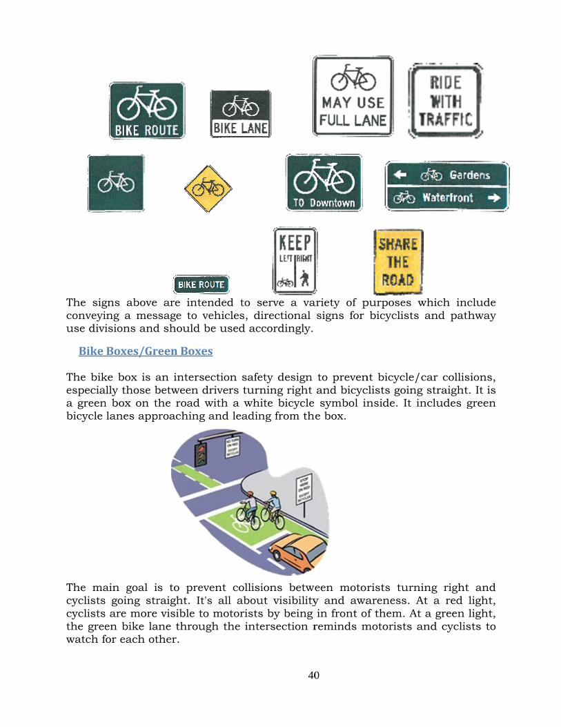
The sigconveyiuse divi
Bike The bikespeciaa greenbicycle
The macyclistscycliststhe greewatch f
gns above ing a mesisions and
Boxes/Gr
ke box is aally those bn box on t lanes app
ain goal is going strs are more en bike lafor each ot
are intensage to ve
d should b
reenBoxes
an intersebetween drthe road wproaching a
s to preveraight. It's visible to
ane througther.
nded to sehicles, die used acc
s
ction saferivers turn
with a whiand leadin
ent collisis all abou motoristsgh the inte
40
erve a vairectional cordingly.
ety design ning right ite bicycle ng from th
ions betweut visibilitys by being ersection r
0
ariety of psigns for
to preven and bicyc symbol ine box.
een motory and awa in front oreminds m
purposes wbicyclists
nt bicycle/clists goingnside. It i
rists turnareness. Af them. At
motorists a
which inc and path
car collisig straight. ncludes g
ning right At a red lit a green liand cyclist
clude hway
ions, It is
green
and ight, ight, ts to

41
PotentialFundingSources
There are a wide range of potential funding sources for improving pedestrian and bicycle transportation options. Federal funding is administered through the state and regional planning agencies. Most, but not all, of these funding programs are oriented toward transportation versus recreation, with an emphasis on reducing auto trips and providing inter-modal connections. Federal funding is intended for capital improvements and safety and education programs and projects must relate to the surface transportation system. Many of the funding sources included below require local cities to take the lead to provide bicycle facility improvements.
FederalThe Intermodal Surface Transportation Efficiency Act of 1991 included several funding categories wherein improvements for pedestrian and bicycle transportation could be funded, either as part of a road improvement project or an independent improvement. The 1998 TEA 21 legislation perpetuated those funding categories. Of particular significance is the ten percent set aside of surface transportation funds for enhancements, which contains a specific category for pedestrian and bicycle facilities. 2005 marked the passage of the Safe, Accountable, Flexible, Efficient Transportation Act – A Legacy For Users (SAFETEA-LU), which reauthorizes the federal highway and transit programs through FY 2009. The bill increased funding of the Surface Transportation Program (STP) by roughly 30 percent. Tansportation Enhancements continue to be funded through a 10 percent set-aside of STP funds or the amount set aside in 2005, whichever is greater. As of 2009, over $5.3 million in enhancement funds have been allocated to projects in the RTPO area since the inception of the program, with $3.0 million, or 57 percent, awarded to bicycle/pedestrian.
State Pedestrian and Bicycle Safety Funding In 2005, the Governor and Washington State Legislature increased the state’s role in safety by providing funding that supports pedestrian and bicycle safety and safe routes to school projects (ESSB 6091). In addition, with the passage of SAFETEA-LU in 2005, a new federal Safe Routes to School program was established that provided federal funding to the state. Pedestrian and Bicycle Safety Grant This program focuses on pedestrian and bicycle safety and providing children a safe, healthy alternative to riding the bus or being driven to school. Its purpose is to aid public agencies in funding cost-effective projects that improve pedestrian and bicycle safety through engineering, education and enforcement.

42
Safe Routes to School Grant The purpose of this program is to aid public agencies in funding cost-effective projects within two-miles of primary and middle schools (K-8) that provide children a safe, healthy alternative to riding the bus or being driven to school. These two programs are very lightly funded and highly desired. Grant cycles are based on the budget biennium, so there have been three full funding periods to date: 2005-2007, 2007-2009 and 2009-2011. The Pedestrian and Bicycle Safety program, over the combined 2005-2007 and 2007-2009 periods, had $15 million available which funded 47 projects from the over $63 million in requests. In the RTPO, a single project in Kennewick was funded during these two cycles. Safe Routes to Schools had a total of $10 million available to fund 39 projects from the over $49 million requested. In the RTPO, two projects were funded in Walla Walla during these two cycles. For the 2009-2011 biennium, approximately $11 million was available to fund the over $82 million in requests received. WSDOT received 92 Pedestrian and Bicycle Safety project applications totaling approximately $35 million. Statewide, 16 projects were funded. Four were submitted from within the RTPO and one, from Richland was funded. The State received 112 Safe Routes to Schools project applications and funded 21. Three were submitted from the RTPO and none were funded. Additional Funding Sources Under RCW 47.30, Paths and Trails, 0.3 percent of state construction expenditures must be spent on paths and trails: WSDOT estimates that it spends about 0.5 percent. This amounted to about $2.4 million in 1994. Some of these monies are distributed to cities and counties. The Transportation Improvement Board (TIB) has assorted legislatively funded categories wherein cities and counties annually compete for project funds. Some of these categories are specifically earmarked for pedestrian or bicycle improvements. Other categories for roadway and street improvement projects require pedestrian elements on either one or both sides. Community Development Block Grants target communities and neighborhoods that are principally low and moderate income. Such communities tend to have high demand for pedestrian and bicycle travel and public transit services. Funding is for street improvement projects, presumably including non-motorized and transit elements.

43
LocalLocal revenue sources include: the road portion of “impact fees,” county-wide vehicle license fees, commercial parking tax, local street utility tax, county-wide fuel tax, property tax, Local Improvement Districts, real estate excise tax, Transportation Benefit Districts, toll roads, and bonds. Funding and Implementation Practices Bike lanes, shoulder bikeways, and sidewalks, which make up the majority of the bicycle and pedestrian system, are usually implemented as part of a standard roadway project and represent a small fraction of a project’s cost. As new arterials and collectors are constructed or old ones are reconstructed to current standards, appropriate bikeways and walkways should be included in the project. Walkways and bikeways may also be provided as a part of routine roadway repairs. Resurfacing of an arterial or collector is an excellent time to restripe for bike lanes at little additional cost. In this way a bikeway system can develop incrementally in step with the road system. In private developments, pedestrian and bicycle facilities are made a condition of approval, just as are the roads and parking lots. In some cases, System Development Charges (SDCs) or transportation impact fees can be imposed. If the impact of a development on adjacent streets is not immediate, the developer may participate in future improvements through a Local Improvement District (LID).
PrioritizationandRanking Roughly forty (40) miles of bikeways, in all of their various forms, are needed in order to meet the Plan goals. The total mileage of needed striping is twice the length of the total roadways needing striping due to the need for striping on both sides of the road. Clear guidance for dedicating funds is needed. The materials cost estimates separate and list roadways (or groups of roadways) within each Area to organize construction phasing and to narrow the scale of individual projects for the purpose of securing reasonable funding amounts. When funding becomes available ranking scores can be used to quickly choose roadway improvement projects based on their effective importance. The following criteria were developed to serve as a guide for implementing roadway improvement projects. Ranking scores should apply to individual projects and be used to prioritize the project list. The criteria scale ranges from 0 to 3. The prioritization criteria are as follows:

44
1) Traffic Volume 2) Gap Closure/Increase Connectivity 3) Land Use
Definition of Terms: The definitions below are included to assist in conducting an objective scoring of routes. The following terms are used in the evaluation criteria:
1) SIGNIFICANT ROUTE. “Significant route” includes all key routes and other routes located on major/minor arterial roads.
2) MINOR ROUTE. “Minor route” means a route on a collector road.
3) MAJOR BARRIER. “Major barrier” means a feature preventing or obstructing access or travel (i.e. SR 395, I-182, BNSF Rail).
Traffic Volume The traffic volume criterion is based on gross volume. Data used to inform this criterion is based on actual traffic volumes or public works estimates. A higher ranking value indicates higher traffic volumes and therefore a greater likelihood of dangerous incidents, and a greater number of people that would benefit from this improvement. The higher speeds that tend to accompany higher traffic corridors typically require improvements to allow separation of users. This criterion was given a scale of 0 to 3 based on the following guidelines: 0. Very Low volume. 1. Low to moderate traffic volumes and low speeds. Average daily traffic is
less than 4,000 vehicles and speeds less than or equal to 30 mph. 2. Moderate traffic volumes and/or vehicle speeds. Average daily traffic
equals 4,000 vehicles or greater and speeds equal 30 mph or greater. 3. Traffic volumes exceed 10,000 vehicles per day and/or traffic speeds are
35 mph or greater. Closure of a Gap / Increases Connectivity This criterion focuses on facilities that would close a gap or remove a barrier along an existing route, or would address a major safety concern for pedestrians and bicyclists at transition points such as bridges, interchanges, and other difficult environments for pedestrians and bicyclists to navigate. This criterion was given a scale of 0 to 3 based on the following guidelines: 0. Does not provide significant connection, safety improvement or improved
access. 1. Provides limited connection or safety improvement to a minor route. 2. Provides connection on significant route and/or makes pedestrian and
bicyclist environments better.

45
3. Provides multiple connections, closes significant gap, significantly improves safety or mitigates major barriers such as I-182, SR 395, BNSF Rail Line, or others.
Land Use Criterion The land use criterion ranks projects based on connections or access to multiple land uses. Facilities that provide access to schools, shopping, transit, and public open space or parks rank favorably according to this criterion. Projects that connect compatible land uses or provide a critical link between two or more major land uses rank higher than projects that do not connect origins with destinations. This criterion was given a scale of 0 to 3 based on the following guidelines: 0. Does not go to specified destination; is not part of school, employment, or
transit route. 1. Makes some connection to, or part of, a significant route. 2. Multiple connections or school route. 3. Multiple connections and school route or significant employment/
shopping route.
ScoringThe simple chart below can be used to evaluate and compare priority ranking scores amongst the various roadway improvement projects identifiable in this Plan.
Roadway Criterion Score
Traffic
Gap Closure/Connectivity
Land Use
TOTAL
Maps(see attached)
AdditionalBicycleFacilityComponents
TransportationSYSTEMPlan The Pasco Public Works Department plans to initiate a City-wide comprehensive traffic study to evaluate various needs related to vehicle circulation. The Transportation SYSTEM Plan is proposed to include elements

46
addressing needed bicycle and possibly pedestrian facilities. The Plan may duplicate and contribute to efforts made in compiling this Bicycle/Pedestrian Master Plan.
Installmunicipalbikeracks(identifyeffectivelocations)A concurrency requirement for the installation of bicycle lock-up racks should be considered for new businesses locating on roadways identified as proposed bike/pedestrian routes in the Master Plan Overview Map. Such a development requirement may be imposed by amending PMC Title 12 (Streets and Sidewalks). The availability of convenient ways to secure bicycles in front of businesses may foster bicycle transportation; thereby advancing the stated goal, policies and objectives of this Plan.

Bikeway Advisory CommitteeDraft MapFebruary 2007
Legend
Proposed Route/Path
Bike Route
Pathway
CITY LIMITS
Library
Post Office
Schools
Parks

Pasco Bicycle/Pedestrian Master Plan Overview Map
Legend
Area #1
Area #2
Area #3Area #4
Area #5
Area #6
River Shore
Bike Pathway
City Limits

Bicycle/Pedestrian Master Plan - Area #1
I-182R
oad
84
Road
111
Chapel Hill Blvd. (Future) Chapel Hill Blvd. Homerun Rd.
Road 76
CO
NVEN
TION
DR
IVE RO
AD
60
S
Legend
FCID Canal
River Shore
Proposed RoutesCity Limits
Bike Pathway

I-182
Roa
d 88
RO
AD
76
ROAD 103
Roa
d 84
Road
111
Chapel Hill Blvd. (Future) Chapel Hill Blvd.
Madison
Homerun Rd.
Road 76
E
MA
DISO
N A
VE
OA
D 60
AD
5 2
Legend
Project #2/FCID Canal
Pathway
River Shore
City Limits
Bicycle/Pedestrian Master Plan - Area #2

Bicycle/Pedestrian Master Plan Area #3
I-182
Roa
d 88
Roa
d60
Court St.R
OA
D 7
6
Roa
d 60
ROAD 103
Roa
d 84Ro
ad 11
1Chapel Hill Blvd. (Future) Chapel Hill Blvd.
Homerun Rd.
oad 76
VE
Legend
Proposed Routes
FCID Canal
River Shore
BikePathway
City Limits
Existing Bike Lanes

I-182
Madison Ave
Homerun Rd.
Road 76
NTIO
N D
RIVE
MA
DISO
N A
VE
RO
AD
60
Sandifur Parkway
RO
AD
5 2
LIVINGSTON ROAD
Argent Place
Bicycle/Pedestrian Master Plan - Area #4
Legend
Proposed Routes
FCID Canal
Existing Bike Lanes
Bike Pathway
City Limits

Bicycle/Pedestrian Master Plan - Area #5
SR-3
95
I-18
Roa
d 60
Roa
d 60
Havstad St
Roa
d 44
Roa
d 40
RO
AD
36
Roa
d 52
Hopkin
s St.
Roa
d 2 8
W. Lewis St.
PEARL STREET
WERNETT ROAD
LIVINGSTON ROAD
26th
Ave
Pearl St
Argent PlaceArge
Roa
d 60
Roa
d 60
Havstad St
Roa
d 44
Roa
d 40
RO
AD
36
Roa
d 52
Hopkin
s St.
Roa
d 2 8
W. Lewis St.
PEARL STREET
WERNETT ROAD
LIVINGSTON ROAD
26th
Ave
Pearl St
Argent PlaceArge
Legend
Proposed Routes
City Limits
Bike PathwayRiver Shore
FCID Canal
Existing Bike Lanes

Bicycle/Pedestrian Master Plan - Area #6
I-182
Elm A
ve.
W. Lewis St.
Pearl St.
Lewis St.
14th Ave
Henry St. 3rd Ave
"A" St.
Wehe A
ve.
Court St
Sheppard St.
Argent Rd.
"A" St.
Legend
Proposed Routes
Bike PathwayCity LimitsRiver Shore
Existing Bike Lanes

Pasco Bicycle/Pedestrian Master Plan OverviewKey Route Map
I-182
I-182
SRSR-3
95
Elm A
v e.
Roa
d 88
Roa
d 60
Court St.
RO
AD
76
Roa
d 52
Roa
d 60
ROAD 103
Madison Ave
Road
111
Homerun Rd.
CO
NVEN
TION
DR
IVE
Roa
d 84
Chapel Hill Blvd.(Future) Chapel Hill Blvd.
Road 76
Sandifur Parkway
MA
DISO
N A
VE
RO
AD
60
RO
AD
36
RO
AD
5 2
Roa
d 44
Havstad StR
oad
40
Hopkin
s St.
Roa
d 2 8 W. Lewis St.
PEARL STREET
WERNETT ROAD
LIVINGSTON ROAD
26th
Ave
Pearl St.
Lewis St.
14th Ave
Henry St. 3rd Ave
"A" St.
Wehe A
ve.
Court St
Sheppard St.
Argent Place Argent Rd.
"A" St.
Legend
Area #1
Area #2
Area #3Area #4
Area #5
Area #6
River Shore
Bike Pathway
City Limits
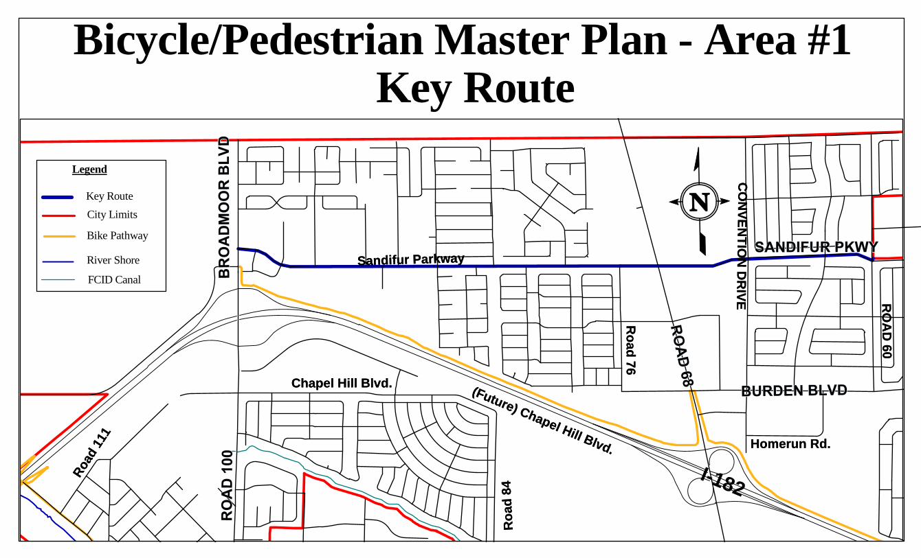
Bicycle/Pedestrian Master Plan - Area #1
I-182
Road
111
Homerun Rd.
CO
NVEN
TION
DR
IVE
Roa
d 84
Chapel Hill Blvd. (Future) Chapel Hill Blvd.
Road 76
Sandifur Parkway
RO
AD
60
Road
111
Homerun Rd.
CO
NVEN
TION
DR
IVE
Roa
d 84
Chapel Hill Blvd. (Future) Chapel Hill Blvd.
Road 76
Sandifur Parkway
RO
AD
60
Legend
FCID Canal
River Shore
Key RouteCity Limits
Bike Pathway
Key Route

Bicycle/Pedestrian Master Plan Area #3 Key Route
I-182
Roa
d 88
Roa
d60
Court St.R
OA
D 7
6
Roa
d 60
ROAD 103
Road
111
Homerun Rd.
Roa
d 84
apel Hill Blvd.
Roa
d 88
Roa
d60
Court St.R
OA
D 7
6
Roa
d 60
ROAD 103
Road
111
Homerun Rd.
Roa
d 84
apel Hill Blvd.
Legend
Key Route
FCID Canal
River Shore
BikePathway
City Limits

I-182
Madison Ave
Homerun Rd.
ENTIO
N D
RIVE
Road 76
MA
DISO
N A
VE
RO
AD
60
RO
AD
5 2
Argent Place
Madison Ave
Homerun Rd.
ENTIO
N D
RIVE
Road 76
MA
DISO
N A
VE
RO
AD
60
RO
AD
5 2
Argent Place
Bicycle/Pedestrian Master PlanArea #4 Key Route
Legend
Key Route
FCID Canal
Bike Pathway
City Limits

Bicycle/Pedestrian Master PlanArea #5 Key Routes
I-18
SR-3
95
Roa
d 60
Roa
d 52
Roa
d 60
RO
AD
36
Roa
d 44
Roa
d 40
2 8W
PEARL STREET
WERNETT ROAD
LIVINGSTON ROAD
26th
Ave
Pearl St
Argent PlaceArgen
Roa
d 60
Roa
d 52
Roa
d 60
RO
AD
36
Roa
d 44
Roa
d 40
2 8W
PEARL STREET
WERNETT ROAD
LIVINGSTON ROAD
26th
Ave
Pearl St
Argent PlaceArgen
LegendKey RouteCity Limits
Bike PathwayRiver Shore
FCID Canal

Bicycle/Pedestrian Master PlanArea #6 Key Routes
I-182
SR-3
95
Elm A
v e.
Hopkin
s St.
Roa
d 2 8 W. Lewis St.
26th
Ave
Pearl St.
Lewis St.
14th Ave
Henry St. 3rd Ave
"A" St.
Wehe A
ve.
Court St
Sheppard St.
"A" St.
Elm A
v e.
Hopkin
s St.
Roa
d 2 8 W. Lewis St.
26th
Ave
Pearl St.
Lewis St.
14th Ave
Henry St. 3rd Ave
"A" St.
Wehe A
ve.
Court St
Sheppard St.
"A" St.
Legend
Key Routes
Bike Pathway
City Limits
River Shore