Databases and Simplified Geology for Mineralized … and Simplified Geology for Mineralized Areas,...
28
Databases and Simplified Geology for Mineralized Areas, Claims, Mines and Prospects in Colorado Part A: Data Files and Formats Part B: Figures and Maps Part C: Metadata by Anna B. Wilson Open File Report 03-090 2003 This report is preliminary and has not been reviewed for conformity with U.S. Geological Survey editorial standards. Any use of trade names is for descriptive purposes only and does not imply endorsement by the U.S. Government. Although these data have been used by the USGS and have been successfully imported into a number of database and spreadsheet programs, no warranty, expressed or implied, is made by the USGS as to how successfully or accurately the data can be imported into any specific application software running on any specific hardware platform. The fact of distribution shall not constitute any such warranty, and no responsibility is assumed by the USGS in connection therewith. U.S. DEPARTMENT OF THE INTERIOR U.S. GEOLOGICAL SURVEY 1 U.S. Geological Survey, Denver, Colorado
-
Upload
nguyendang -
Category
Documents
-
view
223 -
download
2
Transcript of Databases and Simplified Geology for Mineralized … and Simplified Geology for Mineralized Areas,...

Databases and Simplified Geology for Mineralized Areas, Claims, Mines and Prospects in
Colorado
Part A: Data Files and FormatsPart B: Figures and Maps
Part C: Metadata
by Anna B. Wilson
Open File Report 03-090
2003
This report is preliminary and has not been reviewed for conformity with U.S. GeologicalSurvey editorial standards. Any use of trade names is for descriptive purposes only and does notimply endorsement by the U.S. Government. Although these data have been used by the USGSand have been successfully imported into a number of database and spreadsheet programs, nowarranty, expressed or implied, is made by the USGS as to how successfully or accurately thedata can be imported into any specific application software running on any specific hardwareplatform. The fact of distribution shall not constitute any such warranty, and no responsibility isassumed by the USGS in connection therewith.
U.S. DEPARTMENT OF THE INTERIOR
U.S. GEOLOGICAL SURVEY
1 U.S. Geological Survey, Denver, Colorado

i
CONTENTS
Introduction . . . . . . . . . . . . . . . . . . . . . . . . . . . . . . . . . . . . . . . . . . . . . . . . . . . . . . . . . . . . . . . . . . 1Mine and prospect data . . . . . . . . . . . . . . . . . . . . . . . . . . . . . . . . . . . . . . . . . . . . . . . . . . . 1Mineralized areas and mining districts . . . . . . . . . . . . . . . . . . . . . . . . . . . . . . . . . . . . . . . 4Claim density . . . . . . . . . . . . . . . . . . . . . . . . . . . . . . . . . . . . . . . . . . . . . . . . . . . . . . . . . . . 4Simplified geology . . . . . . . . . . . . . . . . . . . . . . . . . . . . . . . . . . . . . . . . . . . . . . . . . . . . . . . 5Additional data . . . . . . . . . . . . . . . . . . . . . . . . . . . . . . . . . . . . . . . . . . . . . . . . . . . . . . . . . . 6References cited . . . . . . . . . . . . . . . . . . . . . . . . . . . . . . . . . . . . . . . . . . . . . . . . . . . . . . . . . 8
APPENDICESA. Data files showing file names, formats, and projections . . . . . . . . . . . . . . . . . . . . . . . . . . 9B. Files used to construct Workspaces (.wor) or Projects (.apr or .aep) . . . . . . . . . . . . . . . 10C. List of files included in Figures 1-8 (PartB\PDF\...) . . . . . . . . . . . . . . . . . . . . . . . . . . . . 11
FIGURES (.pdf)1. Index map of Colorado. (CO_index.pdf) 2. Map showing mineralized areas in Colorado. (CO_mnarea)3. Map showing distribution of selected metallic minerals in Colorado. (CO_metdep.pdf)4. Map showing land ownership in Colorado. (CO_lndown.pdf)5. Simplified geologic map of Colorado. (CO_geol.pdf)6. Map showing intensity of claim activity in Colorado from 1976 to 1996. (claimact.pdf)7. Map showing distribution of mineral deposits in Colorado. (CO_alldep.pdf)8. Map showing location of placer claims and deposits in Colorado. (CO_placer.pdf)
ii
FILES ON CD-ROM
Root Directory:Introduction (text) . . . . . . . . . . . . . . . . . . . . . . . . . . . . . . . . . . . . . . . . . . . . . . . . . . . . CO_text.pdfInformation sources listed in MRDS mine and prospect database
Published or verifiable sources . . . . . . . . . . . . . . . . . . . . . . CO_mrds_published_refs.pdfUnpublished or unverifiable sources . . . . . . . . . . . . . . . . CO_mrds_unpublished_refs.pdf
ArcExplorer instructions . . . . . . . . . . . . . . . . . . . . . . . . . . . . . . . . . . . . . . . . . . . ArcExplorer.pdfArcExplorer v.2 (Program installation file) . . . . . . . . . . . . . . . . . . . . . . . . . . . . . . . . ae2setup.exeGeology ArcExplorer project file . . . . . . . . . . . . . . . . . . . . . . . . . . . . . . . . . . . . . . . CO_geol.aepMines and prospects ArcExplorer project file . . . . . . . . . . . . . . . . . . . . . . . . . . . . . . CO_data.aep
Part A:Data Files and Formats
MRDS Mine and Prospect Database (original, unedited) . . . . . . . CO_MRDS.xlsMAS/MILS database (original, unedited) . . . . . . . . . . . . . . . . . . . . . CO_MAS.xls
MapInfo (.tab. dat, .id, .map, and ind. [if applicable] files including CO_data.wor andCO_geol.wor workspaces) AND ArcView (.shp, .shx, .dbf files including CO_data.aprand CO_geol.apr projects)
MRDS mines and prospects . . . . . . . . . . . . . . . . . . . . . . . . . . . . . . . . . CO_MRDSMAS/MILS mines and prospects . . . . . . . . . . . . . . . . . . . . . . . . . . . . . . CO_MASMineralized areas . . . . . . . . . . . . . . . . . . . . . . . . . . . . . . . . . . . . . . . . . . . CO_distsCounty boundaries . . . . . . . . . . . . . . . . . . . . . . . . . . . . . . . . . . . . . . . . . . CO_cnty250k quadrangles . . . . . . . . . . . . . . . . . . . . . . . . . . . . . . . . . . . . . . . . . . . CO_250k100k quadrangles . . . . . . . . . . . . . . . . . . . . . . . . . . . . . . . . . . . . . . . . . . . CO_100k24k quadrangles . . . . . . . . . . . . . . . . . . . . . . . . . . . . . . . . . . . . . . . . . . . . CO_024kClaim density . . . . . . . . . . . . . . . . . . . . . . . . . . . . . . . . . . . . . . . . . . . . . CO_claimPublic Lands Survey System . . . . . . . . . . . . . . . . . . . . . . . . . . . . . . . . . CO_PLSSLand ownership . . . . . . . . . . . . . . . . . . . . . . . . . . . . . . . . . . . . . . . . . . . CO_publdHighways . . . . . . . . . . . . . . . . . . . . . . . . . . . . . . . . . . . . . . . . . . . . . . . . . CO_hwysTowns . . . . . . . . . . . . . . . . . . . . . . . . . . . . . . . . . . . . . . . . . . . . . . . . . . . . . CO_cityColorado state . . . . . . . . . . . . . . . . . . . . . . . . . . . . . . . . . . . . . . . . . . . . . CO_stateIndustrial mineral mines . . . . . . . . . . . . . . . . . . . . . . . . . . . . . . . . . . . . CO_indusIndustrial mineral mine permit locations . . . . . . . . . . . . . . . . . . . . . . CO_permitsAirports . . . . . . . . . . . . . . . . . . . . . . . . . . . . . . . . . . . . . . . . . . . . . . . . . . CO_airptCreeks and streams . . . . . . . . . . . . . . . . . . . . . . . . . . . . . . . . . . . . . . . . CO_creekLakes and water bodies . . . . . . . . . . . . . . . . . . . . . . . . . . . . . . . . . . . . . . CO_lakeColorado mineral belt . . . . . . . . . . . . . . . . . . . . . . . . . . . . . . . . . . . . . . . . CO_mbRailroads . . . . . . . . . . . . . . . . . . . . . . . . . . . . . . . . . . . . . . . . . . . . . . . . . CO_railrCounty roads . . . . . . . . . . . . . . . . . . . . . . . . . . . . . . . . . . . . . . . . . . . . CO_RdCouForest Service roads . . . . . . . . . . . . . . . . . . . . . . . . . . . . . . . . . . . . . . . . . CO_RDfsLocal roads . . . . . . . . . . . . . . . . . . . . . . . . . . . . . . . . . . . . . . . . . . . . . . CO_RdLocMajor rivers . . . . . . . . . . . . . . . . . . . . . . . . . . . . . . . . . . . . . . . . . . . . . . . CO_riverMajor water bodies (lakes, reservoirs, wide rivers) . . . . . . . . . . . . . . . . CO_water

iii
Geology . . . . . . . . . . . . . . . . . . . . . . . . . . . . . . . . . . . . . . . . . . . . . . . . . . . . . . . . . .Water bodies (as mapped on Tweto, 1979; Green, 1992)) . . . . . . . . . H2OQuaternary unconsolidated sediments . . . . . . . . . . . . . . . . . . . . Q_unconsQuaternary basalt . . . . . . . . . . . . . . . . . . . . . . . . . . . . . . . . . . . . . Q_basaltTertiary unconsolidated sediments . . . . . . . . . . . . . . . . . . . . . . . T_unconsTertiary sedimentary rocks . . . . . . . . . . . . . . . . . . . . . . . . . . . . . . . . T_sedTertiary volcaniclastic rocks . . . . . . . . . . . . . . . . . . . . . . . . . . . . . T_vclastTertiary volcanic rocks . . . . . . . . . . . . . . . . . . . . . . . . . . . . . . . . . . T_volcTertiary plutonic rocks . . . . . . . . . . . . . . . . . . . . . . . . . . . . . . . . . T_plutonCretaceous sedimentary rocks . . . . . . . . . . . . . . . . . . . . . . . . . . . . . K_sedCretaceous and Jurassic sedimentary rocks . . . . . . . . . . . . . . . . . . . KJ_sedJurassic sedimentary rocks . . . . . . . . . . . . . . . . . . . . . . . . . . . . . . . . . J_sedJurassic and Triassic sedimentary rocks . . . . . . . . . . . . . . . . . . . . JTr_sedTriassic sedimentary rocks . . . . . . . . . . . . . . . . . . . . . . . . . . . . . . . . Tr_sedTriassic and Permian sedimentary rocks . . . . . . . . . . . . . . . . . . . . TrP_sedPermian sedimentary rocks . . . . . . . . . . . . . . . . . . . . . . . . . . . . . Perm_sedTriassic, Permian, and Pennsylvanian sedimentary rocks . . . Tr_Penn_sedPermian and Pennsylvanian sedimentary rocks . . . . . . . . . . . . P_Penn_sedPennsylvanian sedimentary rocks . . . . . . . . . . . . . . . . . . . . . . . . Penn_sedMississippian to Cambrian sedimentary rocks . . . . . . . . . . . . MDOC_sedMesozoic sedimentary rocks . . . . . . . . . . . . . . . . . . . . . . . . . . . . . Mz_sedCambrian sedimentary rocks . . . . . . . . . . . . . . . . . . . . . . . . . . . Camb_sedCambrian intrusive rocks . . . . . . . . . . . . . . . . . . . . . . . . . . . . . . . Camb_intMiddle Proterozoic sedimentary rocks . . . . . . . . . . . . . . . . . . . . . . Y_sedMiddle and Early Proterozoic metamorphic rocks . . . . . . . . . . . . YX_metMiddle and Early Proterozoic intrusive rocks . . . . . . . . . . . . . . . . YX_intrArchean metamorphic rocks . . . . . . . . . . . . . . . . . . . . . . . . . . . . . . W_met
Volcanic necks . . . . . . . . . . . . . . . . . . . . . . . . . CO_asterisk_volcanicneckGeologic map units, attributed . . . . . . . . . . . . . . . . CO_attributed_geologyBalls, as decorations on faults . . . . . . . . . . . . . . . . . . . . . . CO_fault_ballsBars, as decorations on faults . . . . . . . . . . . . . . . . . . . . . . . CO_fault_barsFaults, all types, as lines . . . . . . . . . . . . . . . . . . . . . . CO_faults_all_typesFaults and contacts, as lines (contains all of CO_faults_all_types)
. . . . . . . . . . . . . . . . . . . . . . . . . . . . . . . . . CO_faults_and_contactsStructural axes (anticlines, synclines, etc.) . . . . . . . . . CO_structure_axesThin rock units such as dikes and sills . . . . CO_thin_units_dikes_as_linesTriangles, as decorations on thrust faults . . . . . . CO_thrustfault_triangles
*File names in the ArcView directory include _region, _polyline, or _point, indicating the typeof data contained, after the name given above.
iv
Part B. Illustrations (.pdf)Adobe Acrobat Reader (installation file) . . . . . . . . . . . . . . . AcroReader51_ENU_full.exePDF (Figures 1-8, all in .pdf format)
Figure 1. Colorado index map . . . . . . . . . . . . . . . . . . . . . . . . . . . . . . . CO_indexFigure 2. Mineralized areas . . . . . . . . . . . . . . . . . . . . . . . . . . . . . . . . CO_mnareaFigure 3. Distribution of metallic minerals . . . . . . . . . . . . . . . . . . . . . CO_metdepFigure 4. Land ownership . . . . . . . . . . . . . . . . . . . . . . . . . . . . . . . . . . CO_lndownFigure 5. Simplified geologic map . . . . . . . . . . . . . . . . . . . . . . . . . . . . . CO_geolFigure 6. Claim activity map . . . . . . . . . . . . . . . . . . . . . . . . . . . . . . . CO_minclmFigure 7. Distribution of mineral deposits . . . . . . . . . . . . . . . . . . . . . . CO_allminFigure 8. Placer claims and deposits . . . . . . . . . . . . . . . . . . . . . . . . . . . CO_placer
Part C: Metadata (all are ASCII text files, .txt)Geology . . . . . . . . . . . . . . . . . . . . . . . . . . . . . . . . . . . . . . . . . . . . . ofr_92_0507_metadataMineralized areas . . . . . . . . . . . . . . . . . . . . . . . . . . . . . . . . . . . . . . . . . . . . . . . . . CO_distsMRDS data . . . . . . . . . . . . . . . . . . . . . . . . . . . . . . . . . . . . . . . . . . . . . . . . . . . . CO_MRDSMAS/MILS data . . . . . . . . . . . . . . . . . . . . . . . . . . . . . . . . . . . . . . . . . . . . . . . . CO_MASCounty boundaries . . . . . . . . . . . . . . . . . . . . . . . . . . . . . . . . . . . . . . . . . . . . . . . . CO_cnty250,000-, 1:100,00-, and 1:24,000-scale Quadrangles . . . . . . . . . . . . . . . . . . . CO_quadsClaims . . . . . . . . . . . . . . . . . . . . . . . . . . . . . . . . . . . . . . . . . . . . . . . . . . . . . . . . CO_claimState outline . . . . . . . . . . . . . . . . . . . . . . . . . . . . . . . . . . . . . . . . . . . . . . . . . . . . . CO_statePublic Lands Survey System . . . . . . . . . . . . . . . . . . . . . . . . . . . . . . . . . . . . . . . CO_PLSSLand Ownership . . . . . . . . . . . . . . . . . . . . . . . . . . . . . . . . . . . . . . . . . . . . . . . . . CO_publdColorado mineral belt . . . . . . . . . . . . . . . . . . . . . . . . . . . . . . . . . . . . . . . . . . . . . . CO_mbMajor rivers . . . . . . . . . . . . . . . . . . . . . . . . . . . . . . . . . . . . . . . . . . . . . . . . . . . . . CO_riverMajor water bodies . . . . . . . . . . . . . . . . . . . . . . . . . . . . . . . . . . . . . . . . . . . . . . CO_waterMajor highways . . . . . . . . . . . . . . . . . . . . . . . . . . . . . . . . . . . . . . . . . . . . . . . . . . CO_hwysLakes . . . . . . . . . . . . . . . . . . . . . . . . . . . . . . . . . . . . . . . . . . . . . . . . . . . . . . . . . . CO_lakeCreeks . . . . . . . . . . . . . . . . . . . . . . . . . . . . . . . . . . . . . . . . . . . . . . . . . . . . . . . . CO_creekCities . . . . . . . . . . . . . . . . . . . . . . . . . . . . . . . . . . . . . . . . . . . . . . . . . . . . . . . . . . . CO_cityRailroads . . . . . . . . . . . . . . . . . . . . . . . . . . . . . . . . . . . . . . . . . . . . . . . . . . . . . . . CO_railrCounty roads . . . . . . . . . . . . . . . . . . . . . . . . . . . . . . . . . . . . . . . . . . . . . . . . . . CO_RdCouForest Service roads . . . . . . . . . . . . . . . . . . . . . . . . . . . . . . . . . . . . . . . . . . . . . . CO_RdFSLocal roads . . . . . . . . . . . . . . . . . . . . . . . . . . . . . . . . . . . . . . . . . . . . . . . . . . . . CO_RdLoc
Colorado Department of Transportation (CDOT directory) . . . . . . . . . . . . . . . . . . . . . . . .airportsrailroadsstreamslakesCounty roadsLocal roads
Forest Service roadsHighwaysCountiesLand status dataMajor roadsMunicipal boundaries

v
Files on CD
DATA FILES
CO_MRDS
CO_MAS
CO_250k
CO_100k
CO_024k
CO_state
CO_cnty
CO_dists
CO_city
CO_hwys
CO_claim
CO_PLSS
CO_publd
CO_airpt
CO_creek
CO_lake
CO_river
CO_water
CO_railr
CO_RdCou
CO_Rdfs
CO_RdLoc
CO_indus
CO_perm
CO_mb
SIMPLIFIED GEOLOGY
CO_geol
H2O
Q_uncons
Q_basalt
T_uncons
T_sed
T_vclast
T_volc
T_pluton
K_sed
KJ_sed
J_sed
JTr_sed
Tr_sed
TrP_sed
Perm_sed
Tr_Penn_sed
P_Perm_sed
Penn_sed
Mz_sed
MDOC_sed
Camb_sed
Camb_intr
Y_sed
YX_intr
YX_met
W_met
pCplut
GEOLOGIC MAP*
CO_attributed_geology
CO_thin_units_dikes_as_lines
CO_faults_and_contacts
CO_faults_all_types
CO_asterisk_volcanicneck
CO_structure_axes
CO_fault_bars
CO_fault_balls
CO_thrustfault_triangles
*(Geologic map layers fromGreen’s 1992 geologic mapformatted for MapInfo andArcView, and attributed byWilson in 2002. CO_thin_units_dikes_as_linescreated by selecting theoriginal “line_line.e00” file ofGreen. CO_faults_and_contacts fromthe “contact_line.e00” file. All other datasets created byselecting individual codesfrom Green’s data files.)

1 Registered trademark of ESRI2 Registered trademark of MapInfo Corporation
1
INTRODUCTION
This data release contains mineral resource data for metallic and nonmetallic mineral
sites in the State of Colorado. Along with the resource data, there is additional data, such as
mineralized areas and mining districts; mine, prospect and commodity information; claim
density by section; county boundaries; quadrangles; and simplified geology. All the geographic
data are provided in formats for two commonly used Geographic Information Systems (GIS)
software packages (MapInfo and ESRI’s ArcView). Not only does GIS software allow the data
to be shown as layers in “map” views that can be displayed with various geographic and
geologic data, but the data can be queried and analyzed relative to data in any of the layers. Free
shareware, ArcExplorer, is provided with this report so users may display the data in “map”
views and query the various datasets (Appendix A) without requiring a GIS program such as
Arc/Info1, ArcView1, or MapInfo1. Additional data, such as original and unedited mine and
prospect files, bibliography and references, and text are provided in appropriate formats such as
in spreadsheets (Microsoft Excel), or documents (text, WordPerfect, or Microsoft Word).
Explanatory material is in the Introduction (and root directory on the CD release and
online). Part A includes all the data files with subdirectories for ArcView and MapInfo. Part B
contains illustrations as .pdf maps (an installation file for Adobe Acrobat Reader for viewing the
.pdf files is on the CD). Part C contains metadata, explanatory details on the structure and
content of each data file.
To use ArcExplorer, run ae2setup. Once the program is installed you may work with
either of the ArcExplorer project files (CO_geol.aep or CO_data.aep) or create your own. Run
ArcExplorer and then open the .aep file from within the program.
MINE AND PROSPECT DATA
Mineral resource data for metallic and nonmetallic mineral sites in the State of Colorado
were initially extracted from the U.S. Geological Survey’s large worldwide databases: Mineral
Resources Data System (MRDS) and Minerals Availabilty System/Mineral Industry Location

2
System (MAS/MILS) (McFaul and others, 2000; U.S. Geological Survey, 2001). For this report,
many of the existing records for Colorado in both databases were corrected or revised. The
changes have not yet been incorporated into the USGS’s active databases. This report uses the
modified and revised records.
The MRDS and MAS/MILS (McFaul and others, 2000; U.S. Geological Survey, 2001)
databases were originally compiled for different purposes and contain different information,
although some information is common to both. MRDS was constructed by the USGS and
MAS/MILS was built by the U.S. Bureau of Mines (USBM). After the Bureau of Mines was
abolished in 1996, custody of MAS/MILS was transferred to the USGS. MAS/MILS includes
records for geothermal, coal, ash, nitrogen, oil, and sand and gravel, none of which are normally
included in the MRDS database. The MRDS database is primarily descriptive and contains
historical data about mineral deposit sites, including mines, prospects, and occurrences, deposit
description, geologic characteristics, production, reserves, potential resources, and references.
Most of the additions and corrections to the MRDS database in this report are limited to location
information, commodities, geologic data, and deposit types. MAS/MILS contains less geologic
information but more information regarding extraction and processing operations.
In each database, records are identified by a unique alphanumeric code and describe a
site. A “site” may be a single mine, block of claims, group of mines or workings, mining
district, or even a region. Each record contains the location (usually by latitude and longitude),
name of the deposit, information about the mineral deposit, and commodities present. Locations
for many, but by no means all, of the metallic mineral deposits in the MRDS database were
verified by plotting locations given in the original references on 1:24,000 scale USGS digital
raster graphics images (DRGs) of topographic maps, and digitizing them on screen. All the data
from both databases were imported into GIS (MapInfo) and the locations of dozens of
mislocated deposits were adjusted so that they would plot in Colorado. In addition, the locations
of a large number of deposits were adjusted to plot within the correct county, quadrangle, or
township and range. Each of these adjustments was made for different reasons, with different
levels of confidence, none of which are recorded in the database. There will certainly be
erroneous locations–but in nearly every case, they will be better located than previously.

3
Minor attempts were made to coordinate or reconcile the difference between the
locations in the MRDS and MAS/MILS databases. In general, the MRDS location records the
approximate center of the deposit, whereas the MAS/MILS location is often the main access to
the deposit. In some cases the two locations can be many miles apart. In the CO_MRDS
database, the second data column contains the corresponding MAS/MILS record number, if it
could be determined. Many fewer MAS/MILS sites contain a corresponding MRDS record
(column labeled “GEOLSURV”). For many records, where MRDS and MAS/MILS records
clearly correlate, the locations were adjusted to plot at the same point. It must be emphasized
that these locations are estimates based on descriptions provided in the literature, various
databases, topographic, or geologic maps–they have not been measured by a geographic
positioning system (GPS) in the field.
MRDS data structure
The original MRDS database contains at least 226 variable-length fields. Many records
exceed the approximately 254 characters per field and 4000 character limitation per record of
most GIS programs. Due to this constraint, we have restructured the data to be compatible with
MapInfo and ESRI’s ArcView. Certain fields from the original database were extracted, based
on the percentage of data population for each field and its importance related to mineral resource
assessment. Some of these 5,470 records have been newly created, most others were revised in
some way in the course of preparing data for this publication. The selected fields and their
formats in CO_MRDS are listed in the corresponding metadata file in the Part C, the metadata
subdirectory.
MAS/MILS data structure
16,151 deposits are included in the MAS/MILS database. This database contains many
deposit types and mining-related sites that are not included in the MRDS database such as mills,
tunnel sites, and non-metallic resources such as coal, sand and gravel, and geothermal energy.
Several fields with minimal information or deemed non-essential for this study were deleted.
4
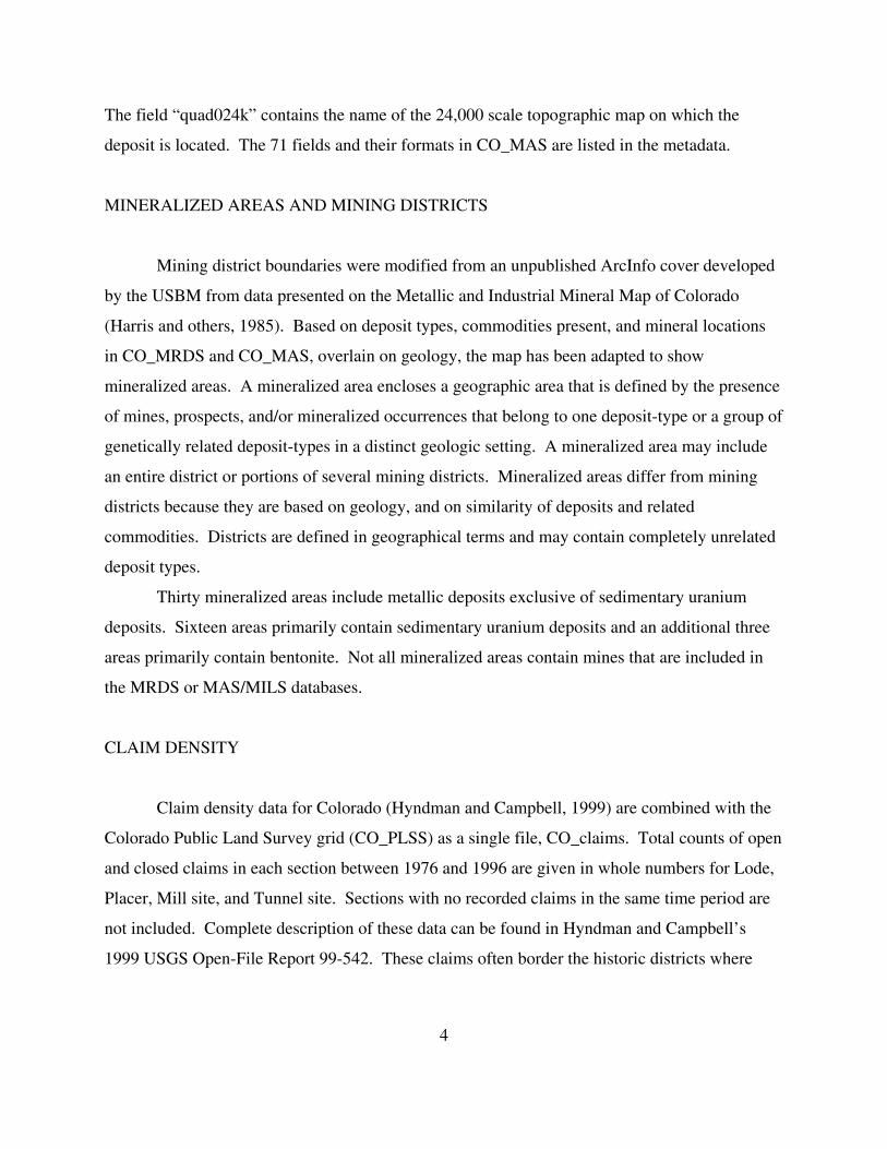
The field “quad024k” contains the name of the 24,000 scale topographic map on which the
deposit is located. The 71 fields and their formats in CO_MAS are listed in the metadata.
MINERALIZED AREAS AND MINING DISTRICTS
Mining district boundaries were modified from an unpublished ArcInfo cover developed
by the USBM from data presented on the Metallic and Industrial Mineral Map of Colorado
(Harris and others, 1985). Based on deposit types, commodities present, and mineral locations
in CO_MRDS and CO_MAS, overlain on geology, the map has been adapted to show
mineralized areas. A mineralized area encloses a geographic area that is defined by the presence
of mines, prospects, and/or mineralized occurrences that belong to one deposit-type or a group of
genetically related deposit-types in a distinct geologic setting. A mineralized area may include
an entire district or portions of several mining districts. Mineralized areas differ from mining
districts because they are based on geology, and on similarity of deposits and related
commodities. Districts are defined in geographical terms and may contain completely unrelated
deposit types.
Thirty mineralized areas include metallic deposits exclusive of sedimentary uranium
deposits. Sixteen areas primarily contain sedimentary uranium deposits and an additional three
areas primarily contain bentonite. Not all mineralized areas contain mines that are included in
the MRDS or MAS/MILS databases.
CLAIM DENSITY
Claim density data for Colorado (Hyndman and Campbell, 1999) are combined with the
Colorado Public Land Survey grid (CO_PLSS) as a single file, CO_claims. Total counts of open
and closed claims in each section between 1976 and 1996 are given in whole numbers for Lode,
Placer, Mill site, and Tunnel site. Sections with no recorded claims in the same time period are
not included. Complete description of these data can be found in Hyndman and Campbell’s
1999 USGS Open-File Report 99-542. These claims often border the historic districts where

5
many of the known deposits are on patented ground. Unfortunately, the claim information does
not date back to the 1800s. If they did, the distribution may look quite different.
SIMPLIFIED GEOLOGY
Simplified geology was constructed from Green’s (1992) digital rendering of Tweto’s
(1979) geologic map of Colorado. For this report, the ArcInfo coverages were imported and
converted to MapInfo where map units were combined to create a simplified map with only 25
combined rock units and another unit for water bodies. The 25 combined units include:
Q_uncons Quaternary unconsolidated sedimentsQ_basalt Quaternary igneous rocksT_uncons Tertiary unconsolidated rocksT_sed Tertiary sedimentary rocksT_vclast Tertiary volcaniclastic rocksT_volc Tertiary volcanic rocksT_plut Tertiary plutonic rocksK_sed Cretaceous sedimentary rocksKJ_sed Cretaceous and Jurassic sedimentary rocksJ_sed Jurassic sedimentary rocksJTr_sed Jurassic and Triassic sedimentary rocksTrP_sed Triassic and Permian sedimentary rocksPerm_sed Permian sedimentary rocksTr_Penn_sed Triassic, Permian, and Pennsylvanian sedimentary rocksP_Perm_sed Pennsylvanian and Permian sedimentary rocksPenn_sed Pennsylvanian sedimentary rocksMz_sed Mesozoic sedimentary rocks, undifferentiatedMDOC_sed Mississippian to Cambrian sedimentary rocksCamb_sed Cambrian sedimentary rocksCamb_intr Cambrian intrusive rocksY_sed Middle Proterozoic sedimentary rocksYX_intr Early and Middle Proterozoic sedimentary rocksYX_met Early and Middle Proterozoic metamorphic rocksW_met Archean metamorphic rocksH20 Major water bodies, lakes, reservoirs, rivers
For more geologic detail, an “attributed” version of Green’s digital map is included
(CO_attributed_geology). Attributing is subject to interpretation. However, it allows the user to
query the map based on dominant lithology (the rock type most prevalent in the unit, general
lithology (an overall estimate of the rock type), or age, as interpreted by the attributer. Also
included are files containing the very thin units (CO_thin_units_dikes_as_lines) and volcanic
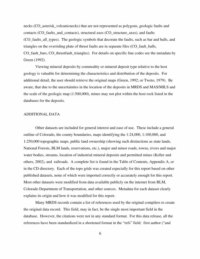
6
necks (CO_asterisk_volcanicnecks) that are not represented as polygons, geologic faults and
contacts (CO_faults_and_contacts), structural axes (CO_structure_axes), and faults
(CO_faults_all_types). The geologic symbols that decorate the faults, such as bar and balls, and
triangles on the overriding plate of thrust faults are in separate files (CO_fault_balls,
CO_fault_bars, CO_thrustfault_triangles). For details on specific line codes see the metadata by
Green (1992).
Viewing mineral deposits by commodity or mineral deposit type relative to the host
geology is valuable for determining the characteristics and distribution of the deposits. For
additional detail, the user should retrieve the original maps (Green, 1992; or Tweto, 1979). Be
aware, that due to the uncertainties in the location of the deposits in MRDS and MAS/MILS and
the scale of the geologic map (1:500,000), mines may not plot within the host rock listed in the
databases for the deposits.
ADDITIONAL DATA
Other datasets are included for general interest and ease of use. These include a general
outline of Colorado, the county boundaries, maps identifying the 1:24,000, 1:100,000, and
1:250,000 topographic maps, public land ownership (showing such distinctions as state lands,
National Forests, BLM lands, reservations, etc.), major and minor roads, towns, rivers and major
water bodies, streams, location of industrial mineral deposits and permitted mines (Keller and
others, 2002), and railroads. A complete list is found in the Table of Contents, Appendix A, or
in the CD directory. Each of the topo grids was created especially for this report based on other
published datasets, none of which were imported correctly or accurately enough for this report.
Most other datasets were modified from data available publicly on the internet from BLM,
Colorado Department of Transportation, and other sources. Metadata for each dataset clearly
explains its origin and how it was modified for this report.
Many MRDS records contain a list of references used by the original compilers to create
the original data record. This field, may in fact, be the single most important field in the
database. However, the citations were not in any standard format. For this data release, all the
references have been standardized in a shortened format in the “refs” field: first author (“and

7
others”, if appropriate), date, condensed and abbreviated mode of publication, page number (if
given). All of the published and verifiable references were extracted from the database and the
complete citation listed alphabetically by author is in CO_MRDS_published_refs.pdf.
References that are unpublished, could not be verified, located, deciphered, or were clearly
wrong, are in CO_MRDS_unpublished_refs.pdf. The bibliography very well might be the most
useful feature of this report.

8
REFERENCES CITED
Green, G.N., 1992, The digital geologic map of Colorado in ARC/INFO format: U.S.
Geological Survey Open-File Report 92-507.
Harris, R.E., Hausel, W.D., Meyer, J.E., compilers, 1985, Metallic and industrial minerals map
of Colorado: Geological Survey of Colorado, Map Series 14, scale 1:500,000.
Hyndman, P.C., and Campbell, H.W., 1999, Digital mining claim density map for Federal lands
in Colorado--1996: U.S. Geological Survey Open-File Report 99-542.
Keller, J.W., Phillips, R.C., and Morgan, K., 2002, Digital inventory of industrial mineral mines
and mine permit locations in Colorado (includes shapefiles and ESRI Arc Explorer
software): Colorado Geological Survey Information Series 62.
McFaul, E.J., Mason, G.T., Jr., Ferguson, W.B., and Lipin, B.R., 2000, U.S. Geological Survey
mineral databases--MRDS and MAS/MILS: U.S. Geological Survey Digital Data Series
DDS-52.
Tweto, Ogden, 1979, Geologic map of Colorado: U.S. Geological Survey Special Geologic Map,
scale 1:500,000.
U.S. Bureau of Mines, 1996, Minerals Availability System (MAS) database–Deposit information
manual and data dictionary, U.S. Bureau of Mines.
U.S. Geological Survey, 2001, Mineral Resource Data System [MRDS: active computer file;
data available from U.S. Geological Survey, Mineral Resources Program, Mail Stop 913,
National Center, Reston, VA 21092].
U.S. Geological Survey, 2001, Minerals Availability System [MAS: active computer file; data
available from U.S. Geological Survey, Minerals Information Team (formerly U.S.
Bureau of Mines), Building 20, Denver Federal Center, Denver CO 80225].

9
Appendix A. Data files showing file names, formats, and projections.
[Three character file extensions throughout this report are as follows: .shp, ArcView shape file;.tab, MapInfo table file; .xls, Microsoft Excel spreadsheet; .met, metadata in text format; .aep,ArcExplorer Project file; pdf, Adobe Acrobat Reader portable document file; *, refers to anyextension. All spatial data is recorded in latitude and longitude coordinates and is unprojected.]
DATA TYPE FILE .shp .tab .xls .met projecti
onMRDS CO_MRDS X X X X latlongMAS/MILS CO_MAS X X X X latlong250k quadrangles CO_250k X X X latlong100k quadrangles CO_100k X X X latlong24k quadrangles CO_024k X X X latlongclaim density CO_claim X X X latlongcounty boundaries CO_cnty X X X latlongpublic land survey system CO_PLSS X X X latlongpublic land ownership CO_publd X X X latlongmineralized areas/districts CO_dists X X X latlongtowns/cities CO_city X X X latlonghighways CO_hwys X X X latlong local roads CO_RdLoc X X X latlongcounty roads CO_RdCou X X X latlongforest roads CO_Rdfs X X X latlongrailroad lines CO_railr X X X latlongairports CO_airpt X X X latlongrivers CO_river X X X latlongmajor water bodies CO_water X X X latlongcreeks and streams CO_creek X X X latlonglakes CO_lake X X X latlongstate outline CO_state X X X latlongindustrial mineral mines CO_indus X X X latlongindustrial permits CO_perm X X X latlongColorado mineral belt CO_mb X X X latlong
Geology CO_geol X X X latlongH2O, Q_uncons, Q_basalt,T_uncons, T_sed, T_vclast, T_volc,T_pluton, K_sed, KJ_sed, J_sed,JTr_sed, Tr_sed, TrP_sed, Perm_sed,Tr_Penn_sed, P_Perm_sed,Penn_sed, Mz_sed, MDOC_sed,Camb_sed, Camb_int, Y_sed,YX_intr, YX_met, W_met
X X latlong
Detailed Geology CO_asterisk_volcanicneck,CO_attributed_geology,CO_fault_balls, CO_fault_bars,CO_faults_all_types,CO_faults_and_contacts,CO_structure_axes,CO_thin_units_dikes_as_lines,CO_thrustfault_triangles
X X latlong

10
Appendix B. ArcView shape (.shp) files used to construct ArcExplorer project (aep) andArcView Project (.apr) files and MapInfo (.tab) files used to construct MapInfo workspace(.wor) files.
PROJECT/WORKSPACE FILE(.AEP, .APR, .WOR) (.shp, .tab)
CO_DATA CO_MRDSCO_MASCO_250kCO_100kCO_024kCO_cntyCO_stateCO_claimCO_publdCO_PLSSCO_hwysCO_townCO_dists
CO_GEOL H2OQ_unconsQ_basaltT_unconsT_sedT_vclastT_volcT_plutonK_sedKJ_sedJ_sedJTr_sedTr_sedTrP_sedPerm_sedTr_Penn_sedP_Perm_sedPenn_sedMz_sedMDOC_sedCamb_sedCamb_intY_sedYX_intrYX_metW_met
11
Appendix C. List of files included in Figures 1-8 (PartB\PDF\...).
FIGURE CONTENT (.pdf filename) FILES USED
1 Index map CO_state(CO_index.pdf) CO_city
CO_cntyCO_hwys
2 Mineralized areas CO_state(CO_mnarea.pdf) CO_dists
CO_cnty
3 Metallic mineral deposits CO_MRDS (thematic)(CO_metdep.pdf) CO_MAS (thematic)
CO_cnty
4 Land Ownership CO_publd (thematic)(CO_lndown.pdf)
5 Simplified geologic map (CO_simpgeol.pdf) andexplanation(CO_geolexpl.pdf)
H2O, Q_uncons, Q_basalt, T_uncons, T_sed, T_vclast,T_volc, T_pluton, K_sed, KJ_sed, J_sed, JTr_sed,Tr_sed, TrP_sed, Perm_sed, Tr_Penn_sed, P_Perm_sed,Penn_sed, Mz_sed, MDOC_sed, Camb_sed, Camb_int,Y_sed, YX_intr, YX_met, W_met
6 Claim Activity CO_claim (thematic)(CO_minclm.pdf) CO_state
CO_distsCO_cnty
7 Mineral Deposits CO_MRDS(CO_allmin.pdf) CO_MAS
CO_distsCO_cntyCO_state
8 Placers CO_MRDS(CO_placer) CO_MAS
CO_distsCO_claim (thematic)Q_uncons
12
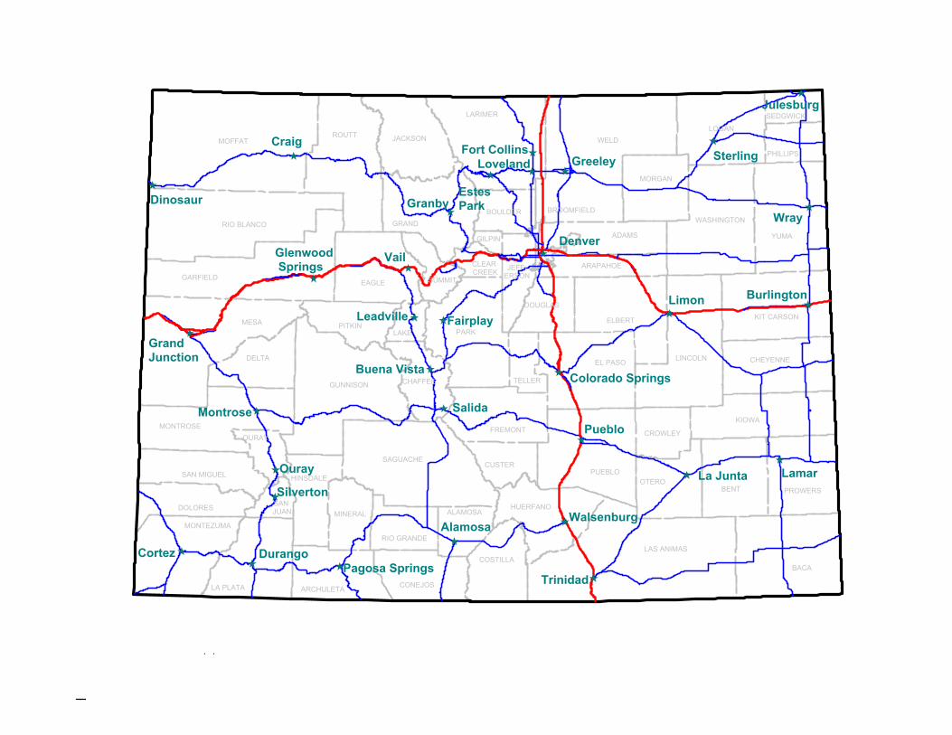
FIGURES (.pdf)1. Index map of Colorado, showing location of mineralized areas, counties, major towns
and highway. (CO_index.pdf)2. Map showing mineralized areas in Colorado. (CO_mnarea.pdf)3. Map showing distribution of selected metallic minerals in Colorado. MRDS shown as
squares, MAS/MILS locations as circles. Any deposit containing, as the primarycommodity, chromium, cobalt, or nickel shown in blue; tin or tungsten in lavender;molybdenum in pink; gold, silver, or platinum group elements in red; copper, lead, orzinc in green; and iron or titanium in brown. (CO_metdep.pdf).
4. Thematic map showing simplified land ownership in Colorado. (CO_lndown.pdf)5. Simplified geologic map of Colorado (CO_geol.pdf) and explanation
(CO_geolmap_expl.pdf).6. Map showing intensity of claim activity in Colorado from 1976 to 1996. Intensity of
open claim activity shown in shades of red superimposed on closed claims in shades ofblue. (CO_minclm.pdf)
7. Map showing distribution of mineral deposits in Colorado (CO_allmin.pdf). CO_MRDSshown as squares, CO_MAS locations as circles, industrial materials may use differentsymbols (see map explanation for details, CO_allmin_expl.pdf).
8. Map showing location of placer claims and deposits in Colorado. (CO_placer.pdf)
YUMA
WASHINGTON
SAGUACHE
BENT
KIOWA
PHILLIPS
SEDGWICK
ADAMS
BROOMFIELD
GILPIN
JEFF-ERSON
CLEAR CREEK
TELLER
EL PASO LINCOLN
GRAND
SUMMIT
LAKE
CHEYENNE
KIT CARSON
MORGAN
EAGLE
FREMONT
PUEBLOOTERO
HUERFANO
LAS ANIMAS
PROWERS
BACA
ALAMOSA
RIO GRANDE
CONEJOSLA PLATA ARCHULETA
MONTEZUMA
HINSDALE
SAN JUAN
OURAYMONTROSE
DELTA
MESA
ROUTT
LARIMER
WELD
GARFIELD
Wray
Burlington
La Junta
Sterling
Denver
Estes Park
Fairplay
Colorado Springs
Limon
Granby
Julesburg
Vail
Leadville
Buena Vista
Salida
Pueblo
Walsenburg
Lamar
Trinidad
Alamosa
Pagosa SpringsDurangoCortez
Silverton
Ouray
Montrose
Grand Junction
Fort CollinsLoveland Greeley
Glenwood Springs
Dinosaur
CraigMOFFAT
LOGANJACKSON
RIO BLANCO
BOULDER
ARAPAHOE
ELBERTPARK
DOUGLAS
PITKIN
GUNNISON CHAFFEE
CROWLEY
CUSTERSAN MIGUEL
MINERALDOLORES
COSTILLA
awilson
Figure 1
awilson
Index map of Colorado showing major highways, counties, and selected towns

GILPIN
BROOMFIELD
JEFF-ERSON
GRAND
SUMMITADAMS
EAGLE
LAKE
FREMONT
TELLER
EL PASO
SAGUACHE
OURAY
SAN JUAN
HINSDALEMONTEZUMA
LA PLATA ARCHULETA
RIO GRANDE
ALAMOSA
CONEJOS
MONTROSE
DELTA
HUERFANO
LARIMER
YUMA
WASHINGTON
BENT
KIOWA
PHILLIPS
SEDGWICK
LINCOLN CHEYENNE
KIT CARSON
MORGAN
PUEBLOOTERO
LAS ANIMAS
PROWERS
BACA
MESA
WELD
GARFIELDMontezuma-Geneva Crk.
Blackhawk
North Gilpin
Grand Island-Caribou
Magnolia
Central City-Idaho Springs
Silver Plume-GeorgetownArgentine
Sugarloaf Ward
Gold HillJamestown
Henderson
BreckenridgeGilman-Redcliff
Drake
Tenn. Pass
Tenmile-KokomoClimax
Alma
St. Kevin-Sugarloaf
LeadvilleHorseshoe-Sacramento
Aspen
Elk Mountains
Weston PassWinfield
Cripple-Creek Victor
Ashcroft
Mt. Emmons
Tincup-Cumberland Pass
Ruby
Gold Brick
Whitepine
Monarch
BonanzaVulcan
Poncha Spr.
Cotopaxi
SilverCliff
St. Peters Dome
Lake City
Henson Creek
Bondholder
Eureka
Creede
Silverton
OurayTelluride
Ophir
Needle Mtns.
Spar City
La Plata
Rico
East Mancos
Summitville
Manhattan
Crestone
Liberty
Hahn's Peak
MOFFAT
LOGANJACKSON
RIO BLANCO
BOULDER
ARAPAHOE
ELBERTPARK
DOUGLAS
PITKIN
GUNNISON CHAFFEE
CROWLEY
CUSTERSAN MIGUEL
MINERALDOLORES
COSTILLA
awilson
Figure 2
awilson
Generalized map showing mineralized areas in Colorado
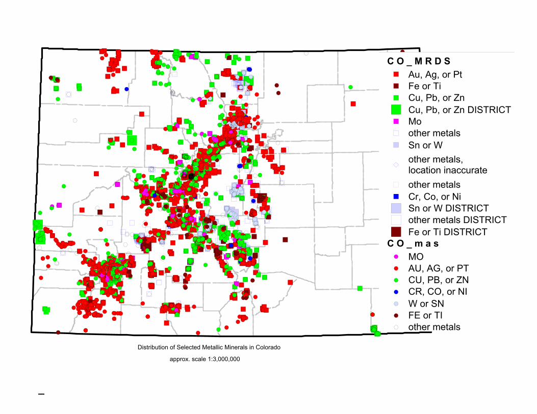
C O _ m a s
C O _ M R D S
MOAU, AG, or PTCU, PB, or ZNCR, CO, or NIW or SNFE or TIother metals
Au, Ag, or PtFe or TiCu, Pb, or ZnCu, Pb, or Zn DISTRICTMoother metalsSn or Wother metals, location inaccurateother metalsCr, Co, or NiSn or W DISTRICTother metals DISTRICTFe or Ti DISTRICT
Distribution of Selected Metallic Minerals in Colorado
approx. scale 1:3,000,000
awilson
Figure 3

Public Land Ownership, simplified
Bureau of Land ManagementDepartment of DefenseDepartment of EnergyFederal LandIndian ReservationMilitary, PrivateNational ForestNational Forest Wilderness AreaNational Forest, private inholdingsNational GrasslandNational MonumentNational ParkNational Recreation AreaNational Wildlife RefugePrivate LandState LandState Land BoardState ParkState Recreation AreaState Wildlife Area
awilson
Simplified Public Land Ownership in Colorado
awilson
Figure 4
awilson
approx. scale 1:3,000,000
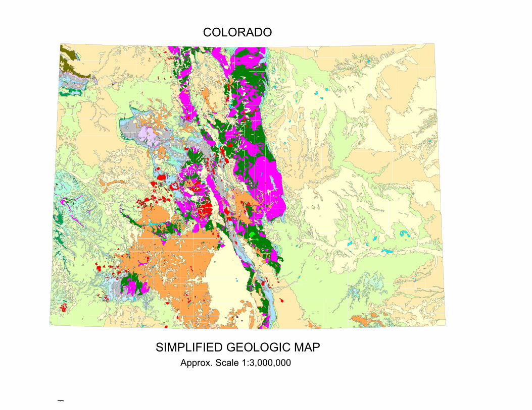
SIMPLIFIED GEOLOGIC MAPApprox. Scale 1:3,000,000
COLORADO
awilson
Figure 5

T r _ s e d
J T r _ s e d
J _ s e d
K _ s e d
K J _ s e d
T _ p l u t o n
T _ v o l c
T _ v c l a s t
T _ s e d
T _ u n c o n s
Q _ b a s a l t
Q _ u n c o n s
H 2 O
T r _ s e dTriassic, sedimentary rocks
J T r _ s e dJurassic and Triassic, sedimentary rocks
J _ s e dJurassic, sedimentary rocks
K _ s e dCretaceous, sedimentary rocks
K J _ s e dCretaceous to Jurassic, sedimentary rocks
T _ p l u t o nTertiary, plutonic rocks
T _ v o l cTertiary, volcanic rocks
T _ v c l a s tTertiary, volcaniclastic rocks
T _ s e dTertiary, sedimentary rocks
T _ u n c o n sTertiary, unconsolidated sediments
Q _ b a s a l tQuaternary, basalt and other igneous rocks
Q _ u n c o n sQuaternary, unconsolidated sediments
H 2 Owater
W _ m e t
Y X _ i n t r
Y X _ m e t
Y _ s e d
C a m b _ i n t
C a m b _ s e d
M z _ s e d
M D O C _ s e d
P e n n _ s e d
P _ P e n n _ s e d
T r _ P e n n _ s e d
P e r m _ s e d
T r P _ s e d
W _ m e tArchean,metamorphic rocks
Y X _ i n t rMiddle and Early Proterozoic,intrusive rocks
Y X _ m e tMiddle and Early Proterozoic,metamorphic rocks
Y _ s e dMiddle Proterozoic,sedimentary rocks
C a m b _ i n tCambrian,intrusive rocks
C a m b _ s e dCambrian,sedimentary rocks
M z _ s e dMesozoic rocks, undifferentiated
M D O C _ s e dMississippian, Devonian, Ordovician, and Cambrsedimentary rocks
P e n n _ s e dPennsylvanian,sedimentary rocks
P _ P e n n _ s e dPermian and Pennsylvanian,sedimentary rocks
T r _ P e n n _ s e dTriassic, Permain, and Pennsylvanian, sedimentary rocks
P e r m _ s e dPermian, sedimentary rocks
T r P _ s e dTriassic and Permian, sedimentary rocks
awilson
Figure 5 explanation
awilson
Explanation of Map Units for Simplified Geologic Map of Colorado
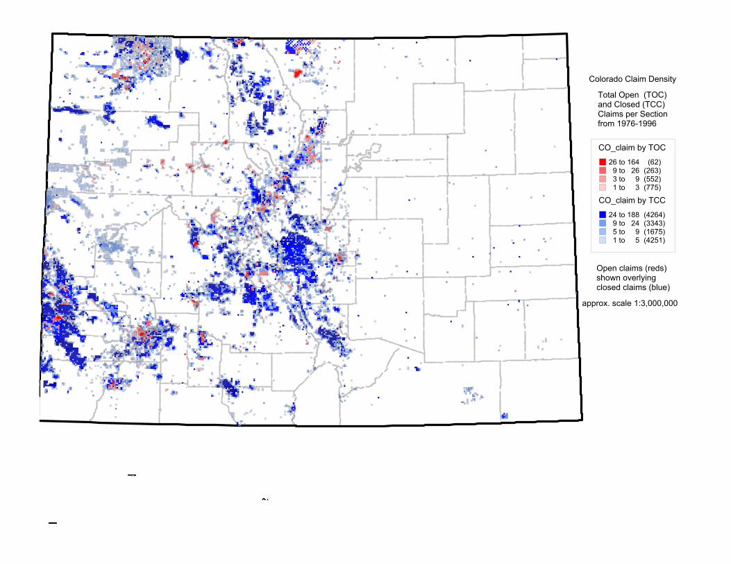
CO_claim by TOC
26 to 164 (62)9 to 26 (263)3 to 9 (552)1 to 3 (775)
CO_claim by TCC
24 to 188 (4264)9 to 24 (3343)5 to 9 (1675)1 to 5 (4251)
Colorado Claim Density
Total Open (TOC) and Closed (TCC) Claims per Sectionfrom 1976-1996
Open claims (reds) shown overlyingclosed claims (blue)
approx. scale 1:3,000,000
awilson
Figure 6
awilson
Mining Claim Density 1976-1996 (after Hyndman and Campbell, 1999) in Colorado
awilson
approx. scale 1:3,000,000

Distribution of Mineral Deposits in Colorado by Commodity
approx. scale 1:3,000,000
awilson
Figure 7

C O _ M A S
C O _ M R D S
U or V (uranium or vanadium)CU (copper)SDG (sand and gravel)AU (gold)COA (coal)unknownAG (silver)PB (lead)ZN (zinc)MO (molybdenum)MN (manganese)SDG (sand and gravel plant)
U or V (uranium and vanadium)CU (copper)CU DistrictIndustrial mineralsand and gravelAU (gold)MO (molybdenum)U or V, unverified locationcoalAG (silver)PB (lead)ZN (zinc)
industrial mineral, poorly locatedother metallicPB DistrictmillZN Districtother, Districtotherpegmatite minerals,poorly located
awilson
Figure 7 explanation
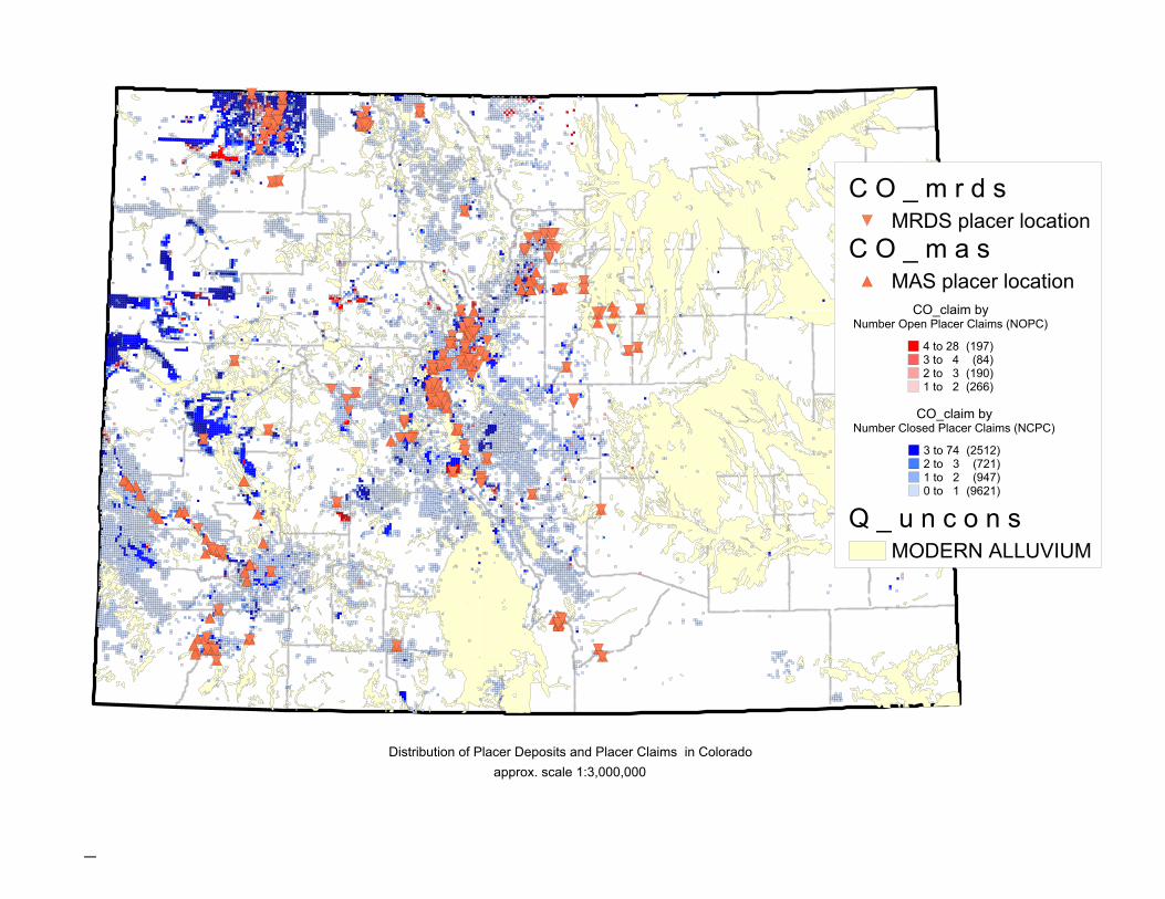
Distribution of Placer Deposits and Placer Claims in Colorado approx. scale 1:3,000,000
CO_claim byNumber Closed Placer Claims (NCPC)
3 to 74 (2512)2 to 3 (721)1 to 2 (947)0 to 1 (9621)
CO_claim byNumber Open Placer Claims (NOPC)
4 to 28 (197)3 to 4 (84)2 to 3 (190)1 to 2 (266)
Q _ u n c o n s
C O _ m a s
C O _ m r d s
MODERN ALLUVIUM
MAS placer location
MRDS placer location
awilson
Figure 8


