DATA IN THE CLASSROOM: LEVEL 1 How is Sea Level Calculated?
7
DATA IN THE CLASSROOM: LEVEL 1 How is Sea Level Calculated? 1. Understanding the Mean: Understanding the concept of a mean is important to interpreting sea level data. 2. Calculating the Mean: Imagine that at a particular location, the sea level (also known as sea surface height) was measured 5 times. These 5 measurements are shown in the diagram below. 3. Calculating the Deviation from the Mean: Sea surface height data and local tide gauge data are both reported as deviations from an expected or mean height. Once the mean is calculated, any measurement that is different than the mean is called a deviation. Some deviations are above the mean and some are below the mean. How do you calculate the mean? Answer the question using words or a formula (or both). The mean is calculated by adding all measurements of sea surface height in a data set and then dividing by the number of measurements. Mean = (Sum of all measurements) / (# of measurements) Sea Surface Height Measurements (cm) Calculate the mean of the 5 measurements. Show your work. Mean = (Sum of all measurements) / (# of measurements) = 575 + 350 + 650 + 460 + 380 / 5 = 2415 / 5 = 483 How do you calculate deviation? Answer the question using words or a formula (or both). The deviation is any measurement that is different than the mean. It is the difference between the mean and the observed measurement. Deviation = observed measurement - mean Sea Surface Height Measurement (cm) What is the deviation between each measurement and the mean (from question 2)? Show your work. 575 575 - 483 = 92 350 350 - 483 = -133 650 650 - 483 = 167 460 460 - 483 = -23 380 380 - 483 = -103
Transcript of DATA IN THE CLASSROOM: LEVEL 1 How is Sea Level Calculated?
DATA IN THE CLASSROOM: LEVEL 1
How is Sea Level Calculated?
1. Understanding the Mean: Understanding the concept of a mean is important to interpreting sea level data.
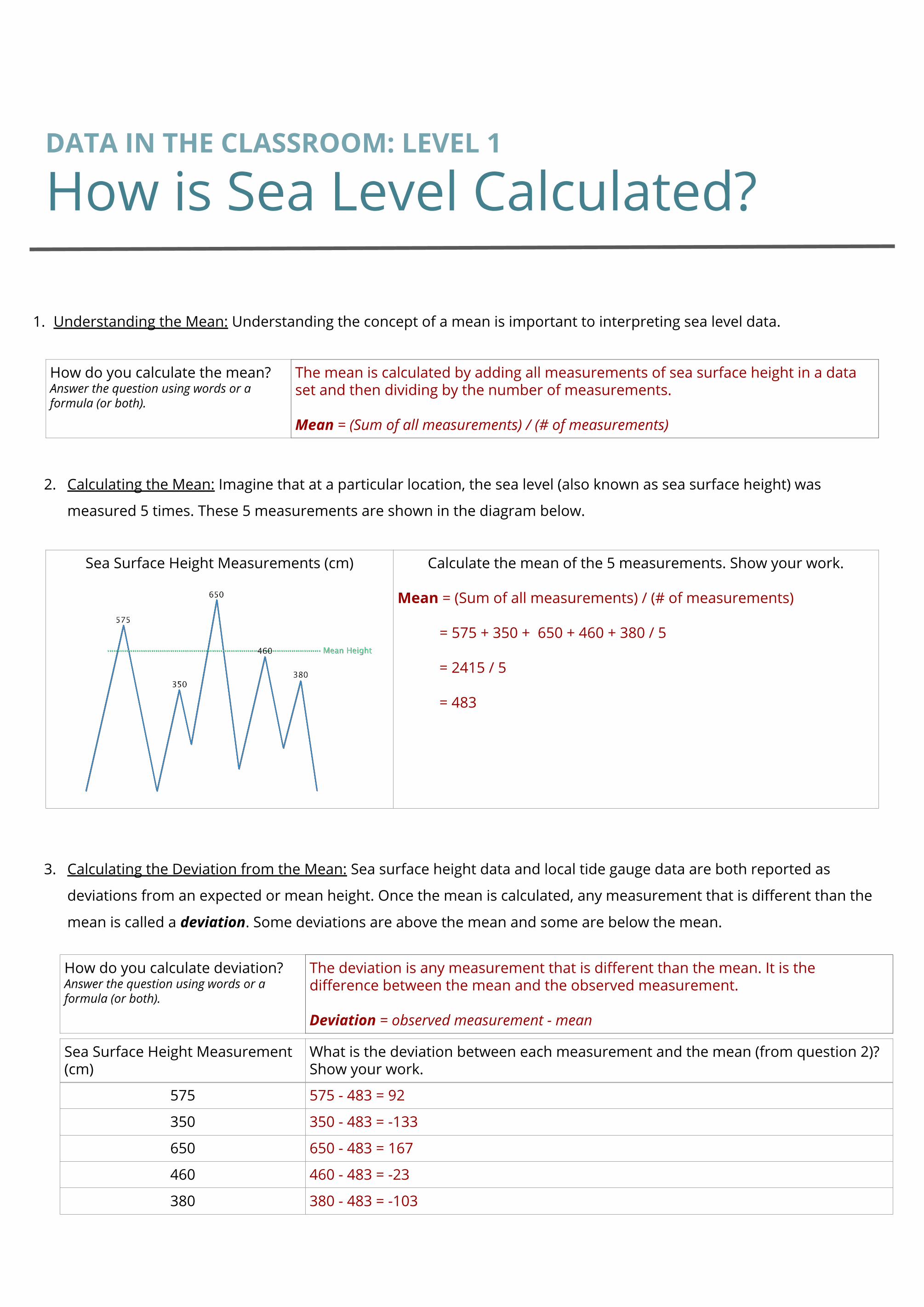
2. Calculating the Mean: Imagine that at a particular location, the sea level (also known as sea surface height) was
measured 5 times. These 5 measurements are shown in the diagram below.
3. Calculating the Deviation from the Mean: Sea surface height data and local tide gauge data are both reported as
deviations from an expected or mean height. Once the mean is calculated, any measurement that is different than the
mean is called a deviation. Some deviations are above the mean and some are below the mean.
How do you calculate the mean? Answer the question using words or a formula (or both).
The mean is calculated by adding all measurements of sea surface height in a data set and then dividing by the number of measurements.
Mean = (Sum of all measurements) / (# of measurements)
Sea Surface Height Measurements (cm) Calculate the mean of the 5 measurements. Show your work.
Mean = (Sum of all measurements) / (# of measurements)
= 575 + 350 + 650 + 460 + 380 / 5
= 2415 / 5
= 483
How do you calculate deviation? Answer the question using words or a formula (or both).
The deviation is any measurement that is different than the mean. It is the difference between the mean and the observed measurement.
Deviation = observed measurement - mean
Sea Surface Height Measurement (cm)
What is the deviation between each measurement and the mean (from question 2)? Show your work.
575 575 - 483 = 92
350 350 - 483 = -133
650 650 - 483 = 167
460 460 - 483 = -23
380 380 - 483 = -103

DATA IN THE CLASSROOM: LEVEL 2
How Much Do Sea Levels Vary?
1. Understanding ‘Sea Surface Height Deviation’:
2. Interpreting Global Sea Level Data: Let’s examine a data map that shows sea surface height deviations (SSHD) over the
entire planet from January 2016.
3. Comparing Sea Levels Across the Pacific: How much do sea levels vary across the Pacific Ocean? Examine the SSHD
data map from April 2013 to help you find out.
What is Sea Surface Height Deviation?
Use both words and a formula in your description.
The difference between the average ocean height and the measured height
SSHD = observed height - historical average height
Question Answer
What do the yellow and orange colors on the map represent?
Areas where the sea surface height is higher than the historical mean height.
In January 2016, what was the approximate SSHD off the coast of Los Angeles, USA?
0.1 meters (10 centimeters)
Los Angeles
How is the sea level in the tropical western Pacific different than the eastern Pacific?
My claim:
Example: Sea levels in the western Pacific are generally higher than the eastern Pacific.
Include specific data measurements from the map.
My evidence: * SSHD values between Hong Kong and Australia mostly range between 0.2 and 0.3 m.* SSHD values along the Pacific coast of Mexico mostly range between -0.2 and 0.1 m.
Connect the evidence to your claim
My reasoning: Though sea levels across the Pacific are variable, SSHD measurements show that sea levels in the western Pacific are about 20-40 cm higher than in the eastern Pacific (in April 2013).
Propose an explanation for the change in sea level across the Pacific Ocean.
Example: Trade winds blow from east to west along the equator. These winds push surface water westward and cause surface water to ‘pile up’ in the west.

DATA IN THE CLASSROOM: LEVEL 2
How Much Do Sea Levels Vary?
4. Comparing Sea Levels Over Time: How much have sea levels changed over time? Compare the SSHD data maps from
December 1993 and December 2016 to find out.
Los Angeles
How have sea levels changed globally, from 1993 to 2016?
My claim:
Example: Sea levels have increased from 1993 to 2016.
Include specific data measurements from the map
My evidence:
* In 1993, SSHD values along the equator ranged from -0.2 to 0.1 m.* In 2016, SSHD values along the equator ranged from 0.0 to 0.3 m.
Connect the evidence to your claim
My reasoning: Between 1993 and 2016, SSHD measurements along the equatorial Pacific have increased by approximately 0.2 meters (20 cm).
Propose an explanation for the change in sea level over time.
Example: As global air temperatures increase, land-based ice (such as glaciers) melt and cause sea levels to rise.
1993
2016

DATA IN THE CLASSROOM: LEVEL 3
How Do Tides Affect Sea Level?
1. How Does Moon Phase Affect the Tides? The position of the Moon relative to Earth and the Sun affects not only the
apparent shape of the Moon from Earth, but also its pull on the tides. Observe each of the Moon phases in the online
activity. Then answer the question below.
2. Interpreting a Tide Chart: Let’s examine a tide chart that shows the changing tides in Monterey, California over a three
day period. Use the chart to answer the questions below.
3. Answering a Question with Tide Data:
Your Question: Travel back in time to May 2016. You are taking a trip to Delaware to see the largest concentration of
spawning horseshoe crabs in the world. Spawning is highest during the new and full moons, and the highest numbers
of crabs are often present during high tides that occur at night. What is likely the best date and time to see horseshoe
crab spawning in May 2016?
Get the Data: Produce a tide chart, as instructed in the online activity. Use the chart to answer the questions below.
What do you notice about the rise and fall of the tides during each phase of the moon (from new moon to full moon)?
Take note of any observed similarities and differences.
Similarities: the tide rises and falls in a regular pattern 2 times per day.
Differences: During new and full moons, the tides have a larger range. During the quarter moon, the high tides are not as high. The low tides are not as low.
Calculate the tidal range:
The difference in height between a high tide and a succeeding low tide.
~ 4.3 ft
Calculate the tidal period:
The length of time between consecutive low tides or consecutive high tides.
~ 12 hours
What is likely the best date and time to see horseshoe crab spawning in May 2016?
My claim:
Example: In May 2016, the best time to see horseshoe crab spawning is May 6th at midnight.
Include specific data from the tide chart.
My evidence : The highest tide of the month was 6.8 ft high and occurred on May 6th at midnight.
Connect the evidence to your claim
My reasoning: Tides and spawning activity are both highest during new and full moons. It is likely that you would see spawning during the highest (nighttime) tide of the month (May 6th).

DATA IN THE CLASSROOM: LEVEL 3
How Do Tides Affect Sea Level?
4. Make a Model: Draw a diagram of the approximate orientation of the Moon relative to the Earth and Sun on the date
that you concluded would be the best time to see horseshoe crab spawning (from Question 3). Color a tidal bulge
around the earth, indicating an approximate spring tide or neap tide. Label all parts of your diagram. Include a brief
description of your model.
Sample model description: This model shows the approximate orientation of the moon relative to the Earth and Sun
on May 6th, 2016. The moon was in a New Moon phase. The Earth, Moon and Sun were in alignment, as shown in the
model. The solar tide had an additive effect on the lunar tide, creating an extra-high high tide at midnight that night.
May 6th, 2016
Image credit: https://oceanservice.noaa.gov/

DATA IN THE CLASSROOM: LEVEL 4
How Do Storms Affect Sea Level?
1. How Do Storms Affect Sea Level?
2. Research Project – Determining Storm Surge Height
Your Mission: You are joining a team of scientists who are studying the effects of storms along the U.S. coast. Your task
is to pick a storm event for a coastal location and gather data about the water height before, during, and after the
storm. What effect did the storm have on local sea levels?
Make a Claim: Use the internet and search for news stories using keywords such as 'flooding,' and 'storm tides.'
Include the location you are interested in, such as 'Miami, Florida.' Once you have found a storm to study, complete
the table below.
Collect Evidence: Use the tide data tool to produce a tide chart, as instructed in the online activity. Use the chart & the
moon phase calendar to answer the questions below.
Record the date(s) when flooding occurred. September 2-3, 2019
Record the location(s), coastal cities or beaches where the flooding occurred.
West Palm Beach, FL
Develop a claim about the storm you identified above. Example student claim: The tides caused flooding from Hurricane Dorian to be more severe in West Palm Beach, Florida.
What causes sea levels to change during a storm?
Use the term ‘storm tide’ in your answer.
Storm surge is an abnormal rise of water generated by a storm, over and above the predicted tides. It is produced by water being pushed toward the shore by the force of the winds. Storm tide is the combination of storm surge and normal high tide.
On the tide chart, is there evidence that the sea levels were higher than expected during the storm? If yes, how can you tell?
Yes, the expected high tides (in blue) on Sept 2-3, 2019 were predicted to be ~3.5 ft. The actual sea level (in green) were higher than the predicted levels.
What was the height of the highest storm tide? 5.17 feet on Sept 3rd, 2019 at 4:00 pm.
At the time of the highest storm tide, how much did the sea level rise above the predicted sea level?
Sea level was 1.7 feet above the predicted level.
What was the approximate moon phase during the storm (use the online moon phase calendar)?
Waxing crescent, 4 days after the new moon.
Was the monthly tidal cycle in a spring or neap phase? Spring: higher high tides and lower low tides were occurring during this period.

DATA IN THE CLASSROOM: LEVEL 4
How Do Storms Affect Sea Level?
2. Research Project – continued
Analyze Your Storm Data:
Tide chart for West Palm Beach, FL (August 27-September 8, 2019): Hurricane Dorian passed through the area on
September 2nd and 3rd, 2018.
Explain why you think each piece of
evidence supports your claim.
If possible, paste or attach your tide
chart(s) to this document.
● On September 3rd, when Hurricane Dorian was passing by West Palm Beach,
the height of the high tide was 1.7 feet above what was predicted.
● This 1.7 ft storm surge coincided with the higher high ‘spring’ tides during this
time of the month. Storms that coincide with spring tides can often cause
more severe flooding.
● Minor flooding was reported in West Palm Beach on September 3rd, 2019.


![The Multi-Level Language Classroom [RELO Andes Webinar]](https://static.fdocuments.in/doc/165x107/5a647ded7f8b9a27568b50d3/the-multi-level-language-classroom-relo-andes-webinar.jpg)