Data Dictionary. Improved Attribute Entry Big buttons Not just picklists –Radio buttons –Check...
15
Data Dictionary
-
Upload
mustafa-herd -
Category
Documents
-
view
222 -
download
3
Transcript of Data Dictionary. Improved Attribute Entry Big buttons Not just picklists –Radio buttons –Check...

Data Dictionary

Improved Attribute Entry
• Big buttons
• Not just picklists– Radio buttons – Check boxes for Boolean values – Images
• User Friendly Prompts– Group separators– Conditional attribute behavior

Big Buttons• Quick visual
selection of features from a button panel
• Easy to use with gloves on
• Easier to use when moving
• Limited to 8 Features

Menu Attribute - Radio Buttons
• Easy visualization
• Limited to 7 attributes
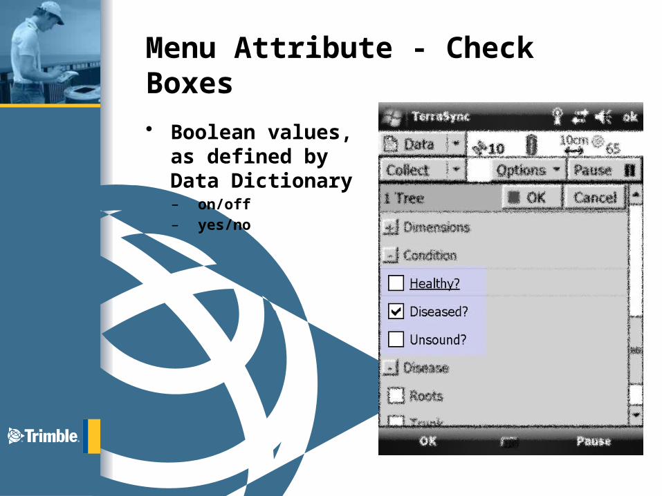
Menu Attribute - Check Boxes
• Boolean values, as defined by Data Dictionary– on/off– yes/no

Menu Attribute - Images
• Select attribute from an image gallery
• Great for non-domain specialists
• No need to translate
• Instant visual confirmation
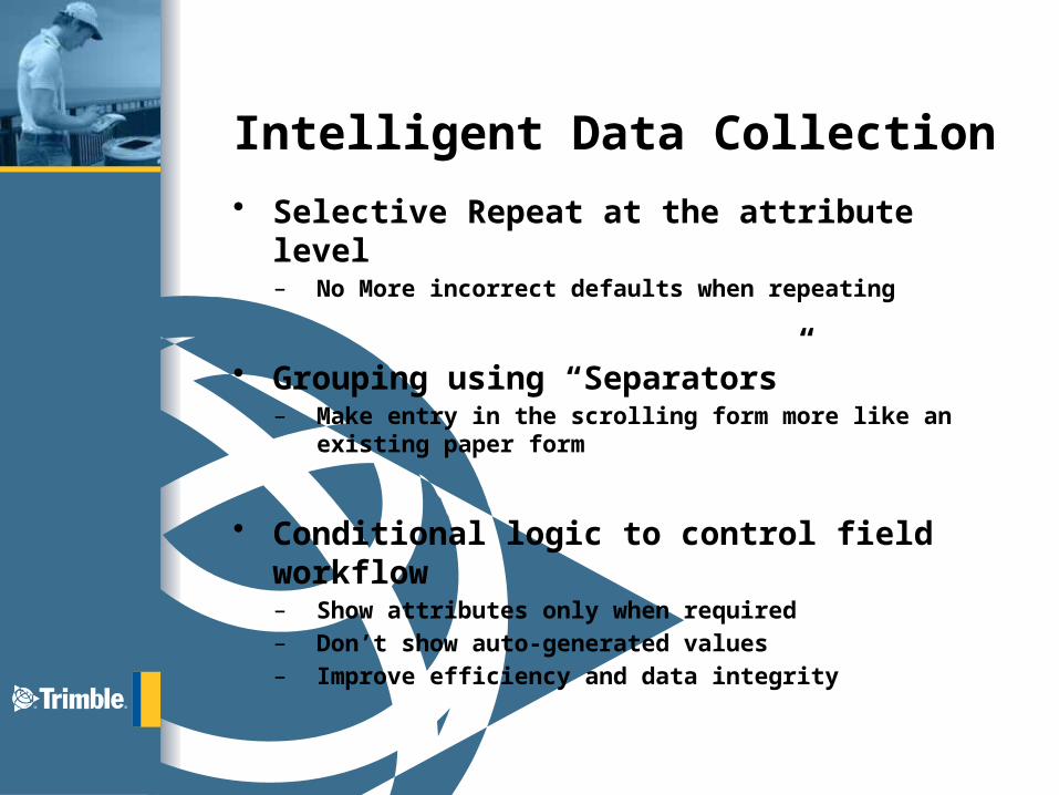
Intelligent Data Collection
• Selective Repeat at the attribute level– No More incorrect defaults when repeating
• Grouping using “Separators”– Make entry in the scrolling form more like an existing paper
form
• Conditional logic to control field workflow– Show attributes only when required– Don’t show auto-generated values– Improve efficiency and data integrity

Grouping Separators
• Easy to adapt paper forms to electronic screen
• Collapsible and expandable sections
• Visible or hidden

Intelligent data collection
• Adapt the form to the data already entered
• Changes attribute behavior and default values
• Visible or hidden
• Read-only or required

Intelligent data collection
• Field worker only sees the fields needed to complete the job
• Less clutter – less distraction
• higher quality data
• Higher productivity

User-friendly feature and attribute naming
• Clear and understandable: – No longer constrained by cryptic GIS database terms
• Less abbreviations:– Extended 40-character length
• Greater flexibility:– Doesn’t have to fit GIS database naming constraint
• Greater guidance to field workers:– Better understanding leads to higher quality data
Data Dictionary Editor
• The enhanced Data Dictionary Editor is included in GPS Pathfinder Office v5.30
• You can upgrade existing Data Dictionaries for use in TerraSync v5.30
• Previewing the DDF with TerraSync Desktop

Your DDF for Field Exercise
• Minimum: Point, Line and Poly• Try to use all types of fields, buttons,
conditions, etc.• Point Requirement
– Develop one for trees and/or signs and use sample images to use for thumbnails – this is only an example…
– Add a File field to hold an in field image taken with handheld
• Line Requirement– Develop with at least one attribute with multiple values to
support segmenting
• Symbols… Be creative and understand how the sunlight and layers affects your view!

Further information
• www.trimble.com/terrasync– FAQs– Datasheets– Support– Documentation
• Check the compatibility matrix

EASY TO USE
Intelligent
EffortlessUser Friendly
Visual
Questions?
TerraSync
5.30