DATA COLLECTION SURVEY ON ASEAN REGIONAL ...open_jicareport.jica.go.jp/pdf/12085619.pdfFinal Report...
75
JR GE 12-171 DECEMBER 2012 JAPAN INTERNATIONAL COOPERATION AGENCY NIPPON KOEI CO., LTD. ALMEC CORPORATION MITSUBISHI RESEARCH INSTITUTE, INC. DATA COLLECTION SURVEY ON ASEAN REGIONAL COLLABORATION IN DISASTER MANAGEMENT FINAL REPORT COUNTRY REPORT MALAYSIA
Transcript of DATA COLLECTION SURVEY ON ASEAN REGIONAL ...open_jicareport.jica.go.jp/pdf/12085619.pdfFinal Report...
JRGE
12-171
DECEMBER 2012
JAPAN INTERNATIONAL COOPERATION AGENCY
NIPPON KOEI CO., LTD. ALMEC CORPORATION
MITSUBISHI RESEARCH INSTITUTE, INC.
DATA COLLECTION SURVEY ON
ASEAN REGIONAL COLLABORATION IN
DISASTER MANAGEMENT
FINAL REPORT COUNTRY REPORT
MALAYSIA
JRGE
12-171
DECEMBER 2012
JAPAN INTERNATIONAL COOPERATION AGENCY
NIPPON KOEI CO., LTD. ALMEC CORPORATION
MITSUBISHI RESEARCH INSTITUTE, INC.
DATA COLLECTION SURVEY ON
ASEAN REGIONAL COLLABORATION IN
DISASTER MANAGEMENT
FINAL REPORT COUNTRY REPORT
MALAYSIA
Final Report Country Report - Malaysia Abbreviation
Nippon Koei Co., Ltd. I Data Collection Survey on ASEAN ALMEC Corporation, Mitsubishi Research Institute, Inc. Regional Collaboration in Disaster Management
List of Abbreviations and Acronyms
A AADMER : ASEAN Agreement on Disaster Management and Emergency Response ACDM : ASEAN Committee for Disaster Management ADMIS : ASEAN Disaster Management Information System AHA Center : ASEAN Coordination Center for Humanitarian Assistance on Disaster
Management ASEAN : Association of South East Asian Nations B BCP : Business Continuity Plan BMKG : Badan Meteorologi, Klimatologi, dan Geofisika (Meteorological,
Climatological and Geophysical Agency) BPBD : Badan Penanggulangan Bencana Daerah (Regional Disaster Management
Agency) C CBDRM : Community-Based Disaster Risk Management CCFSC : Central Committee for Flood and Storm Control CDMRC : Central Disaster Management and Relief Committee CRED : Center for Research on the Epidemiology of Disasters CVGHM : Centre for Volcanology and Geological Hazard Mitigation D DDMFSC : Department of Dyke Management, Flood and Storm Control DDMRC : District Disaster Management and Relief Committee DID : Department of Irrigation and Drainage DKI : Daerah Khusus Ibukota (Special Capital Territory) DMD : Disaster Management Division DMH : Department of Meteorology and Hydrology DMIS : Disaster Management Information System DOCC : Disaster Operations Control Centre DRR : Disaster Risk Reduction E EM-DAT : Emergency Disaster Database EOS : Emergency Operating System EWS : Early Warning System F FFWS : Flood Forecasting and Warning System FLAS : Fixed-Line Disaster Alert System G GDP : Gross Domestic Product GIRN : Government Integrated Radio Network GIS : Geographic Information System GPS : Global Positioning System GTS : Global Telecommunication System H, I HFA : Hyogo Framework for Actions ICHARM : International Centre for Water Hazard and Risk Management
Final Report Abbreviation Country Report - Malaysia
Data Collection Survey on ASEAN II Nippon Koei Co., Ltd. Regional Collaboration in Disaster Management ALMEC Corporation, Mitsubishi Research Institute, Inc.
ICT : Information and Communication Technology InaTEWS : Indonesia Tsunami Early Warning System INGO : International Non-government Organisation J JICA : Japan International Cooperation Agency JKR : Jabatan Kerja Raya JMG : Minerals and Geoscience Department Malaysia L Lao PDR : Lao People's Democratic Republic LIPI : National Institute of Science M MACRES : Malaysian Centre for Remote Sensing MERS : Malaysia Emergency Response System MES : Myanmar Engineering Society MGB : Mines and Geosciences Bureau MGS : Myanmar Geosciences Society MMD : Malaysian Meteorological Department MMDA : Metro Manila Development Authority MNTEWC : Malaysian National Tsunami Early Warning Center MONRE : Ministry of Natural Resources and Environment MOSTI : Ministry of Science, Technology and Innovation MPWT : Ministry of Public Works and Transportation MRSA : Malaysia Remote Sensing Agency N NADDI : National Disaster Data and Information Management System NDMC : National Disaster Management Center NDMC : National Disaster Management Committee NFP : National Focal Point NGDC : National Geophysical Data Center NGO : Non-governmental Organization NSC : National Security Council O~R OFDA : Office of Foreign Disaster Assistance OSCP : On Scene Command Post PHIVOLCS : Philippine Institute of Volcanology and Seismology REDAS : Rapid Earthquake Damage Assessment System S SATREPS : Science and Technology Research Partnership for Sustainable DevelopmentSDMRC : State Disaster Management and Relief Committee SMART : Special Malaysia Disaster Assistance and Rescue Team SMS : Short Message Service SOP : Standard Operating Procedure T~ TMD : Thai Meteorological Department USGS : United States Geological Survey YCDC : Yangon City Development Committee
Final Report Country Report - Malaysia Abbreviation
Nippon Koei Co., Ltd. III Data Collection Survey on ASEAN ALMEC Corporation, Mitsubishi Research Institute, Inc. Regional Collaboration in Disaster Management
Abbreviations of Measures
Length mm = millimeter cm = centimeter m = meter km = kilometer
Money BND = Brunei Dollar KHR = Cambodian Riel IDR = Indonesian Rupiah LAK = Lao Kip MMK = Myanmar Kyat MYR = Malaysian Ringgit PHP = Philippine Peso SGD = Singapore Dollar THB = Thai Baht USD = U.S. Dollar VND = Vietnamese Dong
Area ha = hectare m2 = square meter km2 = square kilometer
Volume 1, lit = liter m3 = cubic meter m3/s, cms = cubic meter per second MCM = million cubic meter m3/d, cmd = cubic meter per day
Energy Kcal = Kilocalorie KW = kilowatt MW = megawatt KWh = kilowatt-hour GWh = gigawatt-hour
Weight mg = milligram g = gram kg = kilogram t = ton MT = metric ton
Others % = percent o = degree ' = minute " = second °C = degree Celsius cap. = capital LU = livestock unit md = man-day mil. = million no. = number pers. = person mmho = micromho ppm = parts per million ppb = parts per billion lpcd = litter per capita per day Mw = moment magnitude scale
Time sec = second hr = hour d = day yr = year
Final Report Abbreviation Country Report - Malaysia
Data Collection Survey on ASEAN IV Nippon Koei Co., Ltd. Regional Collaboration in Disaster Management ALMEC Corporation, Mitsubishi Research Institute, Inc.
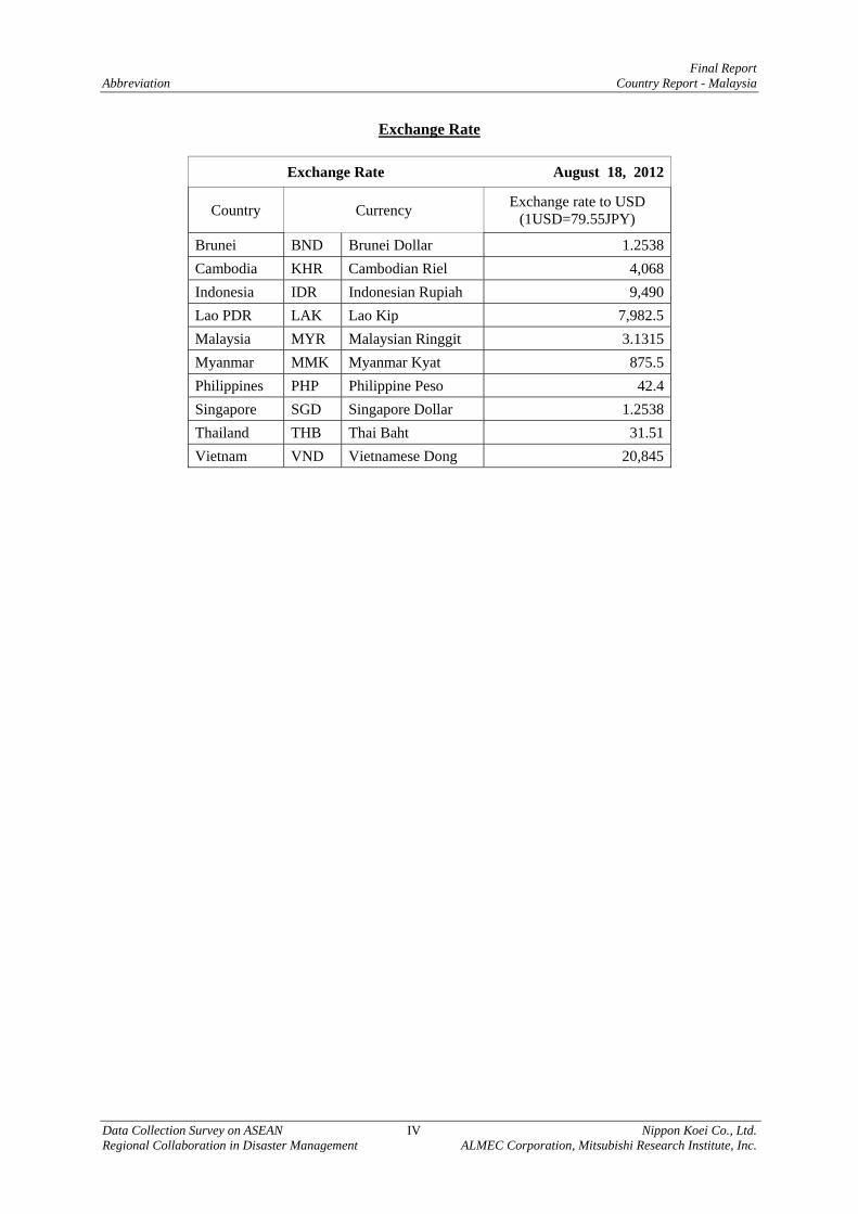
Exchange Rate
Exchange Rate August 18, 2012
Country Currency Exchange rate to USD (1USD=79.55JPY)
Brunei BND Brunei Dollar 1.2538 Cambodia KHR Cambodian Riel 4,068 Indonesia IDR Indonesian Rupiah 9,490 Lao PDR LAK Lao Kip 7,982.5 Malaysia MYR Malaysian Ringgit 3.1315 Myanmar MMK Myanmar Kyat 875.5 Philippines PHP Philippine Peso 42.4 Singapore SGD Singapore Dollar 1.2538 Thailand THB Thai Baht 31.51 Vietnam VND Vietnamese Dong 20,845

Final Report Country Report - Malaysia Table of Contents
Nippon Koei Co., Ltd. i Data Collection Survey on ASEAN ALMEC Corporation, Mitsubishi Research Institute Inc. Regional Collaboration in Disaster Management
DATA COLLECTION SURVEY
ON ASEAN REGIONAL COLLABORATION
IN DISASTER MANAGEMENT
FINAL REPORT
COUNTRY REPORT
MALAYSIA
Abbreviation
Table of Contents
Page CHAPTER 1 INTRODUCTION .................................................................................................. 1-1
CHAPTER 2 HAZARD PROFILE .............................................................................................. 2-1
2.1 Introduction ........................................................................................................................... 2-1
2.2 Natural Disasters in ASEAN Region ...................................................................................... 2-2
2.3 Outline of Natural Disaster ..................................................................................................... 2-5
2.4 Appendix to Chapter-2: Data Set Utilized for the Descriptions .............................................. 2-6 CHAPTER 3 ORGANIZATION AND INSTITUTION ............................................................ 3-1
3.1 Disaster Management Law and Policy .................................................................................... 3-1
3.2 Disaster Management Plan and Budget ................................................................................... 3-1
3.3 Disaster Management Organization ........................................................................................ 3-1
3.4 Disaster Management at Community Level ............................................................................ 3-2
3.5 Issues and Needs concerning Organization and Institution ..................................................... 3-2 CHAPTER 4 PRESENT SITUATION OF DISASTER MANAGEMENT
AGAINST PREVAILING NATURAL DISASTERS IN MALAYSIA ............. 4-1
4.1 Flood ....................................................................................................................................... 4-1
4.2 Earthquake and Tsunami ......................................................................................................... 4-3
Final Report Table of Contents Country Report - Malaysia
Data Collection Survey on ASEAN ii Nippon Koei Co., Ltd. Regional Collaboration in Disaster Management ALMEC Corporation, Mitsubishi Research Institute Inc.
4.3 Volcano ................................................................................................................................... 4-4
4.4 Sediment Disaster .................................................................................................................... 4-4 CHAPTER 5 DISASTER MANAGEMENT INFORMATION, EARLY
WARNING AND DISASTER EDUCATION...................................................... 5-1
5.1 Disaster Management Information System (DMIS) ................................................................ 5-1
5.2 Education for Disaster Prevention and Mitigation .................................................................. 5-4
5.3 Issues and Needs Identified - Malaysia ................................................................................... 5-5 CHAPTER 6 PREPAREDNESS FOR EFFECTIVE RESPONSE ........................................... 6-1
6.1 Current Situation of Preparedness for Emergency Response .................................................. 6-1
6.2 Issues and Needs of Assistance for Emergency Response ...................................................... 6-1 CHAPTER 7 NEEDS IDENTIFICATION FOR DISASTER MANAGEMENT .................... 7-1
7.1 Issues and Needs According to Themes .................................................................................. 7-1 7.1.1 Institution / Organization ...................................................................................... 7-1 7.1.2 Risk Assessment, Early Warning and Mitigation ................................................. 7-4 7.1.3 Disaster Management, Early Warning and Disaster Education.......................... 7-17 7.1.4 Preparedness for Effective Response ................................................................. 7-21
7.2 Aid Projects Identified .......................................................................................................... 7-25 7.2.1 Integrated Disaster Management Plan for Megacities in the ASEAN
Region ................................................................................................................ 7-25 7.2.2 ASEAN Disaster Management – Satellite Imagery Analysis
Technology Centre ............................................................................................. 7-27 7.2.3 Natural Disaster Risk Assessment and Formulation of BCP for
Industrial Clusters ............................................................................................... 7-30 7.2.4 Earthquake and Tsunami Disaster Management in Member Countries
Facing South China Sea, Sulu Sea, and Celebes Sea ......................................... 7-34 7.2.5 Development of ASEAN Disaster Management Information System
(ADMIS) ............................................................................................................ 7-36 7.2.6 Disaster Information System in Major Cities of ASEAN Region with
ASEAN Common Data Format .......................................................................... 7-39 7.2.7 Others Subjects for Collaborative Research ....................................................... 7-41
List of Tables
Page Table 2.4.1 Disaster Data Set of ASEAN Member States – Number of Disaster ....................... 2-7
Table 2.4.2 Disaster Data Set of ASEAN Member States – Total Number of Affected People ....................................................................................................................... 2-7
Final Report Country Report - Malaysia Table of Contents
Nippon Koei Co., Ltd. iii Data Collection Survey on ASEAN ALMEC Corporation, Mitsubishi Research Institute Inc. Regional Collaboration in Disaster Management
Table 2.4.3 Disaster Data Set of ASEAN Member States – Total Number of Deaths .............. 2-8
Table 2.4.4 Disaster Data Set of ASEAN Member States – Estimated Cost ............................... 2-8
Table 4.1.1 Major Projects for Flood Mitigation in Malaysia ..................................................... 4-2
Table 5.1.1 Information System on Disaster Management (Malaysia) ....................................... 5-1
Table 5.2.1 Activities for Enhancement of Public Awareness (Malaysia) .................................. 5-5
Table 7.1.1 Institutional Conditions of Disaster Management in ASEAN Countries ................. 7-2
Table 7.1.2 Issues and Need on Institution/ Organization ........................................................... 7-3
Table 7.1.3 Issues and Needs for Onstitutional Improvement of ASEAN Countries .................. 7-4
Table 7.1.4 Summary on the Preparation of Flood Hazard Map ................................................. 7-5
Table 7.1.5 Purposes of Flood Risk Assessment and the Corresponding Description ................ 7-6
Table 7.1.6 Required Information for Policy Making and Flood Management Planning .................................................................................................................... 7-6
Table 7.1.7 Required Information for Preparedness and Damage Analysis ................................ 7-6
Table 7.1.8 Issues and Needs on Flood Disasters ........................................................................ 7-7
Table 7.1.9 List of Proposed Aid Projects on Flood Disasters in Each ASEAN Country ..................................................................................................................... 7-8
Table 7.1.10 Present Situation of Monitoring and Early Warning System in ASEAN Region ....................................................................................................................... 7-9
Table 7.1.11 List of Main Projects on Seismic and Tsunami Disaster Management .................. 7-14
Table 7.1.12 List of Draft Main Cooperation Project for Volcanic Disaster ............................... 7-15
Table 7.1.13 Issues and Needs on Sediment Disasters ................................................................ 7-15
Table 7.1.14 List of Draft Cooperation Project for Sediment Disaster Management .................. 7-16
Table 7.1.15 Present Situation of DMIS and Early Warning System .......................................... 7-18
Table 7.1.16 Issues and Needs for DMIS .................................................................................... 7-19
Table 7.1.17 Issues and Needs for Education on Disaster Prediction and Mitigation ................. 7-20
Table 7.1.18 Present Situation of Early Warning ........................................................................ 7-21
Table 7.1.19 Needs for Early Warning ........................................................................................ 7-22
Table 7.1.20 Core Indicators of HFA 4: “Reduce the Underlying Risk Factors” ....................... 7-23
Table 7.1.21 Issues by HFA 4 Core Indicators: 10 ASEAN Countries ....................................... 7-24
Table 7.1.22 Preparedness for Emergency Response: 10 ASEAN Countries ............................. 7-25
Table 7.2.1 Hazard Prone Capital Cities and Large Cities - Needs for Multi-Hazard Integrated Disaster Risk Management Plan- ................. 7-27
Table 7.2.2 Establishment of the AHA Satellite Image Analysis Technology Center .............. 7-29
Table 7.2.3 Inputs Required for the Establishment of the AHA Satellite Image Analysis Technology Center .................................................................................. 7-30
Table 7.2.4 Draft Work Items – Bi-lateral Cooperation ............................................................ 7-32
Table 7.2.5 Implementation Framework (Draft) ....................................................................... 7-33
Table 7.2.6 Activities to be Conducted (Draft) ......................................................................... 7-35
Table 7.2.7 Implementation Framework (Draft) ....................................................................... 7-36
Final Report Table of Contents Country Report - Malaysia
Data Collection Survey on ASEAN iv Nippon Koei Co., Ltd. Regional Collaboration in Disaster Management ALMEC Corporation, Mitsubishi Research Institute Inc.
Table 7.2.8 Example of Information to be Collected ................................................................ 7-37
Table 7.2.9 Activities to be conducted ...................................................................................... 7-39
Table 7.2.10 Implementation Framework ................................................................................... 7-39
Table 7.2.11 Targeted Institutions/ Organizations ....................................................................... 7-41
List of Figures
Page Figure 2.2.1 Nos. of Natural Disasters in ASEAN Region (1980-2011) ...................................... 2-2
Figure 2.2.2 Total Number of Affected People in the ASEAN Region (1980-2011) ................... 2-3
Figure 2.2.3 Total Number of Deaths in the ASEAN Region (1980-2011) .................................. 2-3
Figure 2.2.4 Estimated Cost per Disaster in the ASEAN Region (1980 – 2011) ......................... 2-4
Figure 2.3.1 Outline of Natural Disasters in Malaysia .................................................................. 2-5
Figure 3.3.1 Malaysia’s Disaster Management Structure ............................................................. 3-1
Figure 4.4.1 Slope Assessment and Management Work Flow Diagram ...................................... 4-5
Figure 5.1.1 National Disaster Data and Information Management System (NADDI) ................ 5-2
Figure 5.1.2 Visual Strong Wind Warning System ....................................................................... 5-2
Figure 5.1.3 Malaysian National Tsunami Early Warning Center (MNTEWC) (left) and Tsunami Siren Network (right) .......................................................................... 5-3
Figure 5.1.4 MNTEWS System Overview ................................................................................... 5-3
Figure 5.1.5 Dissemination Flow of Early Warning ..................................................................... 5-4
Figure 7.1.1 Results of Grading HFA 4 Core Indicators by 10 ASEAN Countries .................... 7-23
Figure 7.2.1 Comparison between Current Situation and Future Vision on ASEAN Regional Support .................................................................................................... 7-28
Figure 7.2.2 Recommended Flow of Steps to be Taken ............................................................. 7-29
Figure 7.2.3 Concept of Disaster Preparedness and BCP ........................................................... 7-33
Figure 7.2.4 Techtronic Trenches in South China Sea, Sulu Sea and Celebes Sea .................... 7-34
Figure 7.2.5 Concept of ADMIS ................................................................................................. 7-37
Figure 7.2.6 Conceptual Image of DMIS .................................................................................... 7-40
Final Report Introduction Country Report - Malaysia Chapter 1
Nippon Koei Co., Ltd. 1 - 1 Data Collection Survey on ASEAN ALMEC Corporation, Mitsubishi Research Institute, Inc. Regional Collaboration in Disaster Management
CHAPTER 1 INTRODUCTION
1.1 Background of the Survey
Frequency of natural disasters has been increasing for last 30 years in the world, having caused great damages/losses. Among those damages/losses, about 90 % are concentrated in the Asian region where natural disasters are one of the serious issues not only for humanitarian but also for economic and industrial point of view.
1.2 AADMER, HFA and AADMER Work Program
Under such circumstance, the ASEAN 10 countries had reached an agreement of “the ASEAN Agreement on Disaster Management and Emergency Response (AADMER)” on 26th July, 2005 (ratified on 24th December, 2009); in order to strengthen the disaster management structure in the region for the implementation of the Hyogo Framework for Actions (HFA) 2005-2015.
In relation to those activities above, the ASEAN Committee for Disaster Management (ACDM) adopted “AADMER Work Program 2010-2015” as the guideline of the activities for the AADMER, at its 15th Meeting of March, 2010 held in Singapore.
1.3 AHA Centre
At the same time, the ASEAN countries recognized the necessity to establish “the ASEAN Coordination Centre for Humanitarian Assistance on Disaster Management (AHA Centre)” and set up as a provisional status in Jakarta, Indonesia in October, 2007.
As the first phase of the AADMER Work Program 2010-2015, the AHA Centre has formally been established in November 2011 at the ASEAN Summit Meeting in Bali, Indonesia; and to be ratified in due course. The AHA Centre has started various activities with such assistance as procurement of facilities/equipment, provision of technical supports and so on from donors including Japan.
1.4 Cooperation between ASEAN and Japan
On the other hand, it was re-affirmed that Japan and the ASEAN would continue the mutual cooperation in the field of disaster management, at the Special Japan-ASEAN Ministerial Meeting in Jakarta on April 9, 2011 held soon after the Great East Japan Great Earthquake; at the ASEAN Post Ministerial Conference of July 21, 2011; and at the Japan-ASEAN Summit on November 18, 2011. At the meeting/conference, Japan has expressed its commitment to support the activities of AHA Centre not only directly to the Centre but also through bi-lateral cooperation with each ASEAN country for the regional natural disaster management.
Introduction Final Report Chapter 1 Country Report - Malaysia
Data Collection Survey on ASEAN 1 - 2 Nippon Koei Co., Ltd. Regional Collaboration in Disaster Management ALMEC Corporation, Mitsubishi Research Institute, Inc.
1.5 Data Collection Survey
The activities of the AHA Centre have just started and therefore they do not have much information even fundamental on natural disasters and disaster management of the ASEAN countries.
Japan International Cooperation Agency (JICA) has therefore decided to conduct “the Data Collection Survey on ASEAN Regional Collaboration in Disaster Management” for considerations of future plans of assistances to the AHA Centre and each ASEAN country in the field of natural disaster management.
1.6 Purposes of the Survey
The purposes of the survey are as follows:
To collect basic information on disaster management of the ASEAN counties; To conduct needs and potential assessment for development of disaster management
in the ASEAN region; and,
To propose an ASEAN guideline/reference for flood risk assessment.
1.7 Outputs to Be Expected
Inventory of information on disaster management of each ASEAN country; List of programs/projects/schemes for future assistances for disaster management;
Bi-lateral assistance; Regional assistance;
ASEAN guideline/reference for flood risk assessment.
This report presents the country report of Malaysia. The full reports for the study were prepared separately as Main Report.
Final Report Hazard Profile Country Report - Malaysia Chapter 2
Nippon Koei Co., Ltd. 2 - 1 Data Collection Survey on ASEAN ALMEC Corporation, Mitsubishi Research Institute, Inc. Regional Collaboration in Disaster Management
CHAPTER 2 HAZARD PROFILE
2.1 Introduction
The ASEAN countries are geographically located in Southeast Asia and north of Australia continent. The region is generally in areas of a tropical hot and humid climate zone the exception of the north-western part that experiences a humid sub-tropical climate. The region receives plentiful rainfall and remains humid in years. Generally, the countries have a dry and wet season due to seasonal shifts in monsoon, while the mountainous areas in the northern part have a milder and drier climate at high attitude.
The ASEAN region is geographically diverse and includes high hills and rugged mountains, elevated plateaus, highlands, floodplains, coastal plains and deltas underlined by various types of geology. The region is also home to large river systems such as the Mekong and Ayeyarwady River, and major water bodies as the Tonle Sap and Lake Tobe. There are several tectonic plates in the region that have cause earthquakes, volcanic eruptions and tsunamis; also locate the two great oceans of the Pacific and the Indians that are origins of seasonal typhoons or cyclones and tsunami. All these natural set-up are the background of a history of devastating disasters of various types that have caused economic and human losses across the regions.
Hereafter Chapter 2 describes an overview of disasters for the past 32 years from 1980 to 2011 based mainly on the data from “EM-DAT: The OFDA/CRED International Disaster Database: www.emdat.be - Université Catholique de Louvain - Brussels – Belgium.1” “Criteria and definitions” by EM-DAT; and the full set of data used this chapter are shown in Chapter 2.4.
The Team notes that there are such issues in EM-DAT to be improved/ clarified that definitions of some hazards including multi-hazard are unclear, disasters of small scales are not, so on. However, this data base is considered useful when outlines of disasters among different states are compared on a same assumption. The Team presents this chapter with intention that ASEAN states may share the knowledge of disasters in neighboring states and that the states may re-recognize that a data base on the basis of the unified ASEAN criteria, instead of EM-DAT, should be needed for detail analysis/understanding of disasters in the ASEAN region.
1 Among the data set categorized as natural disaster in EM-DAT, “epidemic”, “insect infestation” and “wildfire” are not included in this survey.
Hazard Profile Final Report Chapter 2 Country Report -Malaysia
Data Collection Survey on ASEAN 2 - 2 Nippon Koei Co., Ltd. Regional Collaboration in Disaster Management ALMEC Corporation, Mitsubishi Research Institute, Inc.
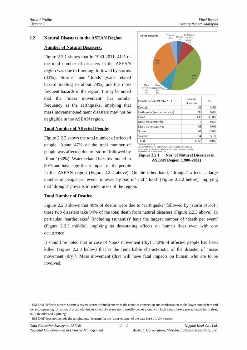
2.2 Natural Disasters in the ASEAN Region
Number of Natural Disasters:
Figure 2.2.1 shows that in 1980-2011, 41% of the total number of disasters in the ASEAN region was due to flooding, followed by storms (33%). ‘Storms2’ and ‘floods’ (water related hazard totaling to about 74%) are the most frequent hazards in the region. It may be noted that the ‘mass movement’ has similar frequency as the earthquake, implying that mass movement/sediment disasters may not be negligible in the ASEAN region.
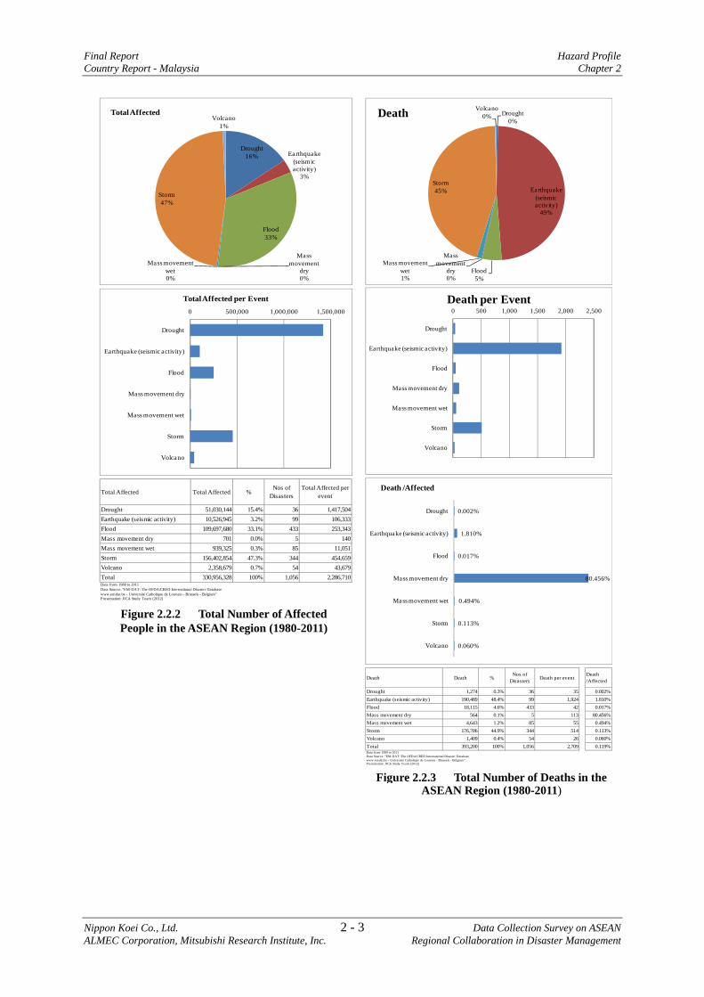
Total Number of Affected People:
Figure 2.2.2 shows the total number of affected people. About 47% of the total number of people was affected due to ‘storm’ followed by ‘flood’ (33%). Water related hazards totaled to 80% and have significant impact on the people in the ASEAN region (Figure 2.2.2 above). On the other hand, ‘drought’ affects a large number of people per event followed by ‘storm’ and ‘flood’ (Figure 2.2.2 below), implying that ‘drought’ prevails in wider areas of the region.
Total Number of Deaths:
Figure 2.2.3 shows that 49% of deaths were due to ‘earthquake’ followed by ‘storm (45%)’; these two disasters take 94% of the total death from natural disasters (Figure 2.2.3 above). In particular, ‘earthquakes3 (including tsunamis)’ have the largest number of ‘death per event’ (Figure 2.2.3 middle), implying its devastating effects on human lives even with one occurrence.
It should be noted that in case of ‘mass movement (dry)’, 80% of affected people had been killed (Figure 2.2.3 below) that is the remarkable characteristic of the disaster of ‘mass movement (dry)’. Mass movement (dry) will have fatal impacts on human who are to be involved.
2 EM-DAT defines: Severe Storm: A severe storm or thunderstorm is the result of convection and condensation in the lower atmosphere and the accompanying formation of a cumulonimbus cloud. A severe storm usually comes along with high winds, heavy precipitation (rain, sleet, hail), thunder and lightning” 3 EM-DAT does not include the terminology ‘tsunami’ in the ‘disaster type’ of the data base of July version.
Figure 2.2.1 Nos. of Natural Disasters in ASEAN Region (1980-2011)
Disasters from 1980 to 2011 Nos ofDisasters
%
Drought 36 3.4%Earthquake (seismic activity) 99 9.4%Flood 433 41.0%Mass movement dry 5 0.5%Mass movement wet 85 8.0%Storm 344 32.6%Volcano 54 5.1%Total 1,056 100.0%Data from 1980 to 2011Source: "EM-DAT: The OFDA/CRED International Disaster Databasewww.emdat.be - Université Catholique de Louvain - Brussels - Belgium"Presentation: JICA Study Team (2012)
Drought3%
Earthquake (seismic activity)
9%
Flood41%
Mass movement
dry1%
Mass movement
wet8%
Storm33%
Volcano5%
Nos of Disasters
Final Report Hazard Profile Country Report - Malaysia Chapter 2
Nippon Koei Co., Ltd. 2 - 3 Data Collection Survey on ASEAN ALMEC Corporation, Mitsubishi Research Institute, Inc. Regional Collaboration in Disaster Management
Figure 2.2.2 Total Number of Affected People in the ASEAN Region (1980-2011)
Drought16% Earthquake
(seismic activity)
3%
Flood33%
Mass movement
dry0%
Mass movement wet0%
Storm47%
Volcano1%
Total Affected
0 500,000 1,000,000 1,500,000
Drought
Earthquake (seismic activity)
Flood
Mass movement dry
Mass movement wet
Storm
Volcano
Total Affected per Event
Total Affected Total Affected %Nos of
DisastersTotal Affected per
event
Drought 51,030,144 15.4% 36 1,417,504Earthquake (seismic activity) 10,526,945 3.2% 99 106,333Flood 109,697,680 33.1% 433 253,343Mass movement dry 701 0.0% 5 140Mass movement wet 939,325 0.3% 85 11,051Storm 156,402,854 47.3% 344 454,659Volcano 2,358,679 0.7% 54 43,679Total 330,956,328 100% 1,056 2,286,710Data from 1980 to 2011Data Source: "EM-DAT: The OFDA/CRED International Disaster Databasewww.emdat.be - Université Catholique de Louvain - Brussels - Belgium"Presentation: JICA Study Team (2012)
Figure 2.2.3 Total Number of Deaths in theASEAN Region (1980-2011)
Drought0%
Earthquake (seismic activity)
49%
Flood5%
Mass movement
dry0%
Mass movement wet1%
Storm45%
Volcano0%Death
0 500 1,000 1,500 2,000 2,500
Drought
Earthquake (seismic activity)
Flood
Mass movement dry
Mass movement wet
Storm
Volcano
Death per Event
0.002%
1.810%
0.017%
80.456%
0.494%
0.113%
0.060%
Drought
Earthquake (seismic activity)
Flood
Mass movement dry
Mass movement wet
Storm
Volcano
Death /Affected
Death Death %Nos of
Disasters Death per eventDeath/Affected
Drought 1,274 0.3% 36 35 0.002%Earthquake (seismic activity) 190,489 48.4% 99 1,924 1.810%Flood 18,115 4.6% 433 42 0.017%Mass movement dry 564 0.1% 5 113 80.456%Mass movement wet 4,643 1.2% 85 55 0.494%Storm 176,706 44.9% 344 514 0.113%Volcano 1,409 0.4% 54 26 0.060%Total 393,200 100% 1,056 2,709 0.119%
Data Source: "EM-DAT: The OFDA/CRED International Disaster Databasewww.emdat.be - Université Catholique de Louvain - Brussels - Belgium"Presentation: JICA Study Team (2012)
Data from 1980 to 2011
Hazard Profile Final Report Chapter 2 Country Report -Malaysia
Data Collection Survey on ASEAN 2 - 4 Nippon Koei Co., Ltd. Regional Collaboration in Disaster Management ALMEC Corporation, Mitsubishi Research Institute, Inc.
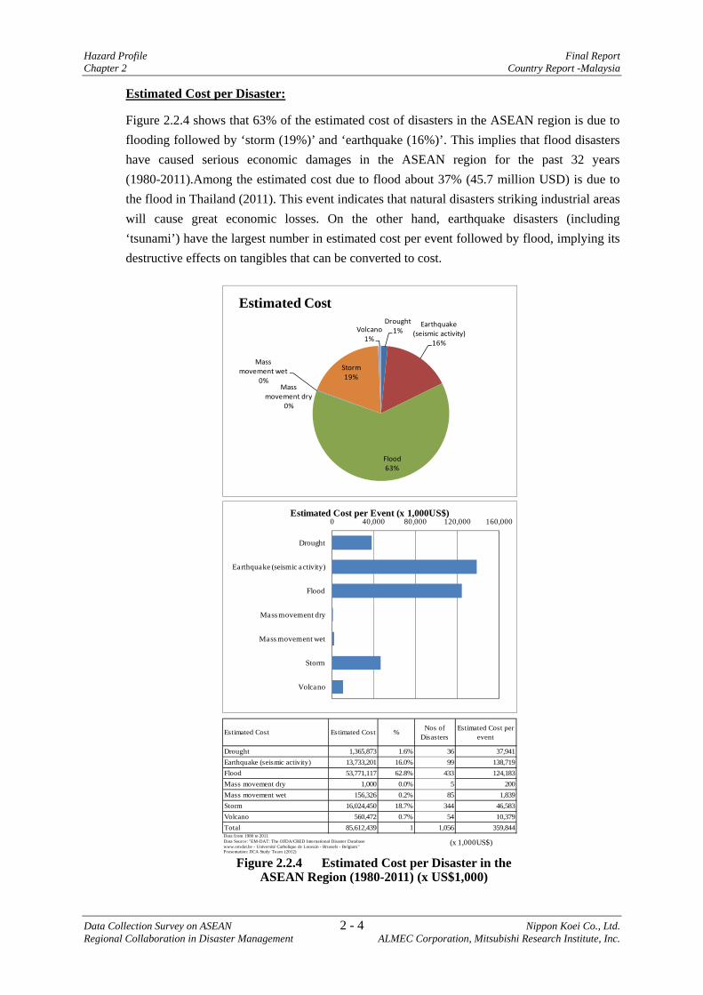
Estimated Cost per Disaster:
Figure 2.2.4 shows that 63% of the estimated cost of disasters in the ASEAN region is due to flooding followed by ‘storm (19%)’ and ‘earthquake (16%)’. This implies that flood disasters have caused serious economic damages in the ASEAN region for the past 32 years (1980-2011).Among the estimated cost due to flood about 37% (45.7 million USD) is due to the flood in Thailand (2011). This event indicates that natural disasters striking industrial areas will cause great economic losses. On the other hand, earthquake disasters (including ‘tsunami’) have the largest number in estimated cost per event followed by flood, implying its destructive effects on tangibles that can be converted to cost.
Figure 2.2.4 Estimated Cost per Disaster in the ASEAN Region (1980-2011) (x US$1,000)
Drought1%
Earthquake (seismic activity)
16%
Flood63%
Mass movement dry
0%
Mass movement wet
0%
Storm19%
Volcano1%
Estimated Cost
0 40,000 80,000 120,000 160,000
Drought
Earthquake (seismic activity)
Flood
Mass movement dry
Mass movement wet
Storm
Volcano
Estimated Cost per Event (x 1,000US$)
Estimated Cost Estimated Cost % Nos ofDisasters
Estimated Cost perevent
Drought 1,365,873 1.6% 36 37,941Earthquake (seismic activity) 13,733,201 16.0% 99 138,719Flood 53,771,117 62.8% 433 124,183Mass movement dry 1,000 0.0% 5 200Mass movement wet 156,326 0.2% 85 1,839Storm 16,024,450 18.7% 344 46,583Volcano 560,472 0.7% 54 10,379Total 85,612,439 1 1,056 359,844
Presentation: JICA Study Team (2012)
Data Source: "EM-DAT: The OFDA/CRED International Disaster Databasewww.emdat.be - Université Catholique de Louvain - Brussels - Belgium"
Data from 1980 to 2011
(x 1,000US$)

Final Report Hazard Profile Country Report - Malaysia Chapter 2
Nippon Koei Co., Ltd. 2 - 5 Data Collection Survey on ASEAN ALMEC Corporation, Mitsubishi Research Institute, Inc. Regional Collaboration in Disaster Management
2.3 Outline of Natural Disasters
Figure 2.3.1 shows that 71% of the total number of disasters was caused by floods followed by storm (14%) which affected 90% and 8% number of people, respectively. On the other hand, people were killed not only by floods (27%) and storm (38%) but also due to mass movement (wet and dry) (24%) and earthquake (11%) that attributed to 35% of the total death due to disasters. Flooding (65%) and earthquake (32%) are the two major causes of estimated damage cost. Though flooding, storm, and earthquake will be the major three disasters, mass movement (-wet, -dry) is also a noteworthy disaster that affects human life.
Cost (x1,000US$)
Figure 2.3.1 Outline of Natural Disasters in Malaysia
Drought2%
Earthquake (seismic activity)
2%
Flood71%
Mass movement
dry2%
Mass movement
wet9%
Storm14%
1 Nos. of Disasters - MalaysiaDrought
1%
Earthquake (seismic activity)
1%
Flood90%
Storm8%
2 Total Affected - Malaysia
Earthquake (seismic activity)
11%
Flood27%
Mass movement
dry10%
Mass movement
wet14%
Storm38%
3. Death - Malaysia
Earthquake (seismic activity)
32%
Flood65%
Storm3%
4. Estimated Cost - Malaysia
DroughtEarthquake
(seismicactivity)
FloodMass
movementdry
Massmovement
wetStorm Volcano Total
1 Nos. of Disasters - Malaysia 1 1 32 1 4 6 0 452 Total Affected - Malaysia 5,000 5,063 566,058 0 291 47,946 0 624,3583. Death - Malaysia 0 80 196 72 96 275 0 7194. Estimated Cost - Malaysia 0 500,000 1,012,500 0 0 53,000 0 1,565,500Data from 1980 to 2011Data Source: "EM-DAT: The OFDA/CRED International Disaster Databasewww.emdat.be - Université Catholique de Louvain - Brussels - Belgium"Presentation: JICA Study Team (2012)

Hazard Profile Final Report Chapter 2 Country Report -Malaysia
Data Collection Survey on ASEAN 2 - 6 Nippon Koei Co., Ltd. Regional Collaboration in Disaster Management ALMEC Corporation, Mitsubishi Research Institute, Inc.
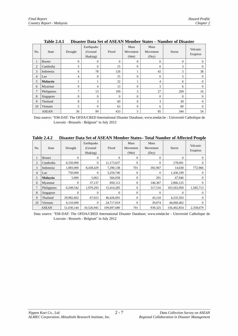
2.4 Appendix to Chapter 2: Data Set Utilized for the Descriptions
The data set for the period of 1980 – 2011 were used for the description of the disaster outline in ASEAN region in this Chapter 2; and are presented in the tables for further reference.
The data were downloaded from "EM-DAT: The OFDA/CRED International Disaster Database; www.emdat.be - Université Catholique de Louvain - Brussels - Belgium" in July 2012.
The followings are criteria for a disaster to be entered in the database and definitions for classification for damages. Please refer to the web-site indicated above, for further information.
CRITERIA AND DEFINITION
CRITERIA
For a disaster to be entered into the database, at least one of the following criteria must be fulfilled:
• Ten or more people reported killed.
• One hundred or more people reported affected.
• Declaration of a state of emergency.
• Call for international assistance. DEFINITION
EM-DAT data include the main following information: Country: Country (ies) in which the disaster has occurred.
Disaster type: Description of the disaster according to a pre-defined classification Date: When the disaster occurred. The date is entered as follow: Month/Day/Year
Killed: Persons confirmed as dead and persons missing and presumed dead (official figures when available)
Injured: People suffering from physical injuries, trauma or illness, requiring medical treatment as a direct result of a disaster
Homeless: People needing immediate assistance for shelter Affected: People requiring immediate assistance during a period of emergency; it can also include
displaced or evacuated people
Total affected: Sum of injured, homeless, and affected Estimated Damage: Several institutions have developed methodologies to quantify these losses in
their specific domain. However, there is no standard procedure to determine a global figure for
economic impact. Estimated damage are given (000’) US$
(http://www.emdat.be/criteria-and-definition)
Final Report Hazard Profile Country Report - Malaysia Chapter 2
Nippon Koei Co., Ltd. 2 - 7 Data Collection Survey on ASEAN ALMEC Corporation, Mitsubishi Research Institute, Inc. Regional Collaboration in Disaster Management
Table 2.4.1 Disaster Data Set of ASEAN Member States – Number of Disaster
No. State Drought Earthquake
(Ground Shaking)
Flood Mass
Movement(Wet)
Mass Movement
(Dry) Storm
Volcanic Eruption
1 Brunei 0 0 0 0 0 0 02 Cambodia 5 0 15 0 0 3 03 Indonesia 6 78 126 1 42 5 384 Lao 4 0 15 0 0 5 05 Malaysia 1 1 32 1 4 6 06 Myanmar 0 4 13 0 3 6 07 Philippines 7 13 109 3 27 209 168 Singapore 0 0 0 0 0 0 09 Thailand 8 3 60 0 3 30 010 Vietnam 5 0 63 0 6 80 0
ASEAN 36 99 433 5 85 344 54
Data source: "EM-DAT: The OFDA/CRED International Disaster Database; www.emdat.be - Université Catholique de Louvain - Brussels - Belgium" in July 2012
Table 2.4.2 Disaster Data Set of ASEAN Member States– Total Number of Affected People
No. State Drought Earthquake
(Ground Shaking)
Flood Mass
Movement(Wet)
Mass Movement
(Dry) Storm
Volcanic Eruption
1 Brunei 0 0 0 0 0 0 02 Cambodia 6,550,000 0 11,173,637 0 0 178,091 03 Indonesia 1,083,000 8,438,429 7,290,138 701 392,967 14,638 772,9664 Lao 750,000 0 3,259,740 0 0 1,436,199 05 Malaysia 5,000 5,063 566,058 0 291 47,946 06 Myanmar 0 37,137 850,112 0 146,367 2,866,125 07 Philippines 6,549,542 1,979,293 15,414,285 0 317,516 103,563,950 1,585,7138 Singapore 0 0 0 0 0 0 09 Thailand 29,982,602 67,023 46,426,691 0 43,110 4,235,503 010 Vietnam 6,110,000 0 24,717,019 0 39,074 44,060,402 0
ASEAN 51,030,144 10,526,945 109,697,680 701 939,325 156,402,854 2,358,679
Data source: "EM-DAT: The OFDA/CRED International Disaster Database; www.emdat.be - Université Catholique de Louvain - Brussels - Belgium" in July 2012

Hazard Profile Final Report Chapter 2 Country Report -Malaysia
Data Collection Survey on ASEAN 2 - 8 Nippon Koei Co., Ltd. Regional Collaboration in Disaster Management ALMEC Corporation, Mitsubishi Research Institute, Inc.
Table 2.4.3 Disaster Data Set of ASEAN Member States – Total Number of Deaths
No. State Drought Earthquake
(Ground Shaking)
Flood Mass
Movement(Wet)
Mass Movement
(Dry) Storm
Volcanic Eruption
1 Brunei 0 0 0 0 0 0 02 Cambodia 0 0 1,382 0 0 44 03 Indonesia 1,266 179,378 5,382 131 1,757 6 6904 Lao 0 0 135 0 0 72 05 Malaysia 0 80 196 72 96 275 06 Myanmar 0 145 422 0 109 138,709 07 Philippines 8 2,540 2,396 361 2,304 26,055 7198 Singapore 0 0 0 0 0 0 09 Thailand 0 8,346 3,493 0 47 895 010 Vietnam 0 0 4,709 0 330 10,650 0
ASEAN 1,274 190,489 18,115 564 4,643 176,706 1,409
Data source: "EM-DAT: The OFDA/CRED International Disaster Database; www.emdat.be - Université Catholique de Louvain - Brussels - Belgium" in July 2012
Table 2.4.4 Disaster Data Set of ASEAN Member States – Estimated Cost (x US$1,000)
No. State Drought Earthquake
(Ground Shaking)
Flood Mass
Movement(Wet)
Mass Movement
(Dry) Storm
Volcanic Eruption
1 Brunei 0 0 0 0 0 0 02 Cambodia 138,000 0 919,100 0 0 10 03 Indonesia 89,000 11,349,576 2,452,016 1,000 120,745 0 344,1904 Lao 1,000 0 22,828 0 0 405,951 05 Malaysia 0 500,000 1,012,500 0 0 53,000 06 Myanmar 0 503,600 136,655 0 0 4,067,688 07 Philippines 64,453 380,025 1,234,883 0 33,281 6,265,657 216,2828 Singapore 0 0 0 0 0 0 09 Thailand 424,300 1,000,000 44,355,408 0 0 892,039 010 Vietnam 649,120 0 3,637,727 0 2,300 4,340,105 0
ASEAN 1,365,873 13,733,201 53,771,117 1,000 156,326 16,024,450 560,472
Data source: "EM-DAT: The OFDA/CRED International Disaster Database; www.emdat.be - Université Catholique de Louvain - Brussels - Belgium" in July 2012
Final Report Organization and Institution Country Report - Malaysia Chapter 3
Nippon Koei Co., Ltd. 3 - 1 Data Collection Survey on ASEAN ALMEC Corporation, Mitsubishi Research Institute, Inc. Regional Collaboration in Disaster Management
CHAPTER 3 ORGANIZATION AND INSTITUTION
3.1 Disaster Management Law and Policy
Malaysia has no specific disaster management law. However, it has a disaster management policy and mechanism known as the National Security Council (NSC) Directive No. 20 approved by the Prime Minister in 1997. NSC Directive No.20 is in the course of revision to shift its paradigm from emergency response to disaster prevention and mitigation as agreed among ASEAN countries. This revised NSC No.20 is to be approved by the Prime Minister in March or April 2012. NSC is considering to prepare a disaster management law once the new NSC No.20 is approved.
3.2 Disaster Management Plan and Budget
There is no specific disaster management plan but preparation of one is intended once the new NSC No.20 is approved. Due to the absence of a disaster management law, NSC has not enough allocation of budget in an integrated manner for disaster prevention and mitigation activities. A budget for mitigation measures for flood and its monitoring activities is allocated to the implementing agency, i.e., the Department of Irrigation and Drainage.
Local disaster management plans have not been considered necessary.
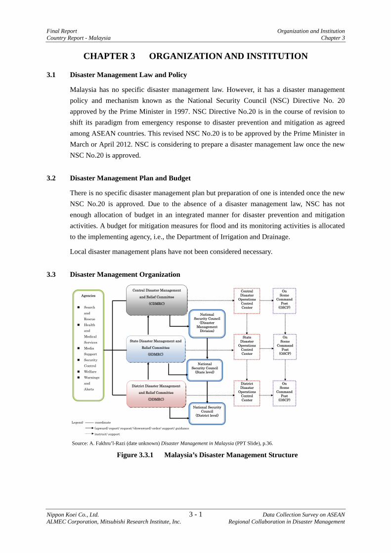
3.3 Disaster Management Organization
Legend: coordinate
(upward) report/ request/ (downward) order/ support/ guidance
instruct/ support
Central Disaster Management
and Relief Committee
(CDMRC)
State Disaster Management and
Relief Committee
(SDMRC)
District Disaster Management
and Relief Committee
(DDMRC)
On Scene
Command Post
(OSCP)
State Disaster
Operations Control Center
National Security Council
(Disaster Management
Division)
Agencies
Search and Rescue
Health and Medical Services
Media Support
Security Control
Welfare Warnings
and Alerts
National Security Council
(State level)
National Security Council
(District level)
Central Disaster
Operations Control Center
District Disaster
Operations Control Center
On Scene
Command Post
(OSCP)
On Scene
Command Post
(OSCP)
Source: A. Fakhru’l-Razi (date unknown) Disaster Management in Malaysia (PPT Slide), p.36.
Figure 3.3.1 Malaysia’s Disaster Management Structure
Organization and Institution Final Report Chapter 3 Country Report - Malaysia
Data Collection Survey on ASEAN 3 - 2 Nippon Koei Co., Ltd. Regional Collaboration in Disaster Management ALMEC Corporation, Mitsubishi Research Institute, Inc.
The Central Disaster Management and Relief Committee (CDMRC) were established at the federal state level, which is chaired by the Minister1 and appointed by the Prime Minister. Also established are the state (SDMRC) and district (DDMRC) committees at their respective levels. It depends on the scale of the affected area what level of committee is responsible for principal response. Monsoon-related flood is seasonal and tends to have nationwide effect, which is mainly handled by CDMRC.
The NSC is the implementing agency for disaster management. NSC Directive No.20 mandates NSC to establish a Disaster Management Division (DMD). The DMD at the headquarters has 17 staff members as of March 20122. The NSC local departments play the secretariat roles for respective state and district levels of the committee.
3.4 Disaster Management at Community Level
Malaysia has disseminated disaster information to communities and implemented community-based disaster management programs, which helps in improving people’s awareness of disaster management. Disaster drills are also conducted regularly. In 2011, a “Disaster Awareness Day” campaign was organized with selected role-model cities, which is aimed in particular to encourage other cities to be active in disaster awareness in respective local context.
3.5 Issues and Needs Concerning Organization and Institution
(1) Issues3
a) To have a disaster management law as well as national disaster management plan; b) To improve the organizational structure, adjusting the shift of disaster management
orientation from emergency response to prevention and mitigation; and c) To mobilize resources to develop capacity and tools for most disaster-prone areas,
encouraging community participation.
(2) Needs
a) Preparation of disaster management law and national plan; b) Mainstreaming disaster management into local plans; c) Integration of prevention and mitigation aspects into institutional and organizational
setups; and d) Promotion of community-based disaster management activities and planning in most
disaster-prone areas.
1 It is the Deputy Prime Minister as of March 2012. 2 About 360 personnel in total (all federal, state and district administrative levels) 3 The views in a) and c) are identified by NSC in the interview with the JICA Study Team, while the view in b) is attributed to the JICA Study Team.
Final Report Present Situation of Disasters Management against Prevailing Natural Disasters in Malaysia Country Report - Malaysia Chapter 4
Nippon Koei Co., Ltd. 4 - 1 Data Collection Survey on ASEAN ALMEC Corporation, Mitsubishi Research Institute, Inc. Regional Collaboration in Disaster Management
CHAPTER 4 PRESENT SITUATION OF DISASTER MANAGEMENT AGAINST PREVAILING NATURAL DISASTERS IN MALAYSIA
4.1 Flood
(1) Present Situation of Flood Disaster
Flood has been recognized as a disaster that is relatively frequent in the country. In December 2007, floods occurred in a wide extent of the country, particularly at Northeast Kelantan, Central Pahang, and Southern Johor Provinces, due to heavy rains. Such floods caused 33 deaths and affected 158,000 people. In recent years, the occurrence of flash floods in urban areas has increased due to urban development.
(2) Risk Assessment
The Department of Irrigation and Drainage (DID) under the Ministry of Natural Resources and Environment (MONRE) is responsible for overall flood management. The DID has categorized three types of flood maps, namely inundation map, flood hazard map, and flood risk map. Inundation maps have been completely developed through site observation and satellite images. Flood hazard maps for 12 areas have been prepared by using hydro-dynamic models with input of hydrological and hydraulic data. Development of flood risk maps will be started soon by adding vulnerability data to flood hazard maps.
(3) Monitoring / Early Warning System
Flood forecast and weather forecast are made by the DID and the Malaysian Meteorological Department (MMD) under the Ministry of Science, Technology and Innovation (MOSTI), respectively.
The Klang Valley basin where Kuala Lumpur is located has been recognized as an important area due to the high population therein. The first FFWS was thus established in this basin. At present, the forecast accuracy is 80-85%, and the model is being improved with a goal of 90% accuracy.
The FFWS in the Muda River basin was completed in 2010. This system is able to forecast the flood condition two days in advance. Radar rainfall data observed by the MMD are also incorporated into the system. Currently, similar systems are being established in the areas of Pahang, Kelantan, and Johor, and then will be adopted in the areas of Padas, Dungun, and Sarawak in the future.
The above FFWS is centrally managed at the National Flood Monitoring Center located in the headquarters of the DID. Warning information automatically issued by the system is transmitted to authorized officers of the DID through short message service (SMS). Furthermore, information such as river water level and rainfall data are uploaded in respective websites for disclosure to the public and concerned organizations.

Present Situation of Disasters Management against Prevailing Natural Disasters in Malaysia Final Report Chapter 4 Country Report - Malaysia
Data Collection Survey on ASEAN 4 - 2 Nippon Koei Co., Ltd. Regional Collaboration in Disaster Management ALMEC Corporation, Mitsubishi Research Institute, Inc.
(4) Preparedness / Prevention and Mitigation
During the past few decades, various flood mitigation projects have been completed in order to mainly increase the discharge capacity of rivers. The major projects are summarized in Table 4.1 below.
Table 4.1.1 Major Projects for Flood Mitigation in Malaysia
Project Name Objectives Implemented Measures
SMART (Stormwater Management and Road Tunnel)
Mitigation of drainage issues due to heavy rain in Kuala Lumpur
Construction of 9.7 km long tunnel used for both flood diversion and highway
Batu Jinjang Ponds and Related Diversions Project
Mitigation of drainage issues due to heavy rain in Kuala Lumpur
Construction of weirs, widening of existing diversion, construction of new diversion, expanding of existing retarding basin
Sungai Muda Flood Mitigation Project
Flood mitigation in the Muda River basin
Widening of the Muda River channel, construction of dikes, sluices and weirs
Sungai Perai Flood Mitigation Project
Flood mitigation in the Perai River basin
River improvement works including deepening, widening and re-alignment, construction of dikes and tidal gates
Bertam - Kepala Batas Flood Mitigation Project
Flood mitigation in Bertam / Kepala Batas areas
Improvement of existing drainage system, construction of retarding basin and dikes
Source: DID
There are 15 dams under the management of the DID. Out of 15 dams, 7 dams have flood control capacities. Also a number of hydropower dams and water supply dams are operated by other ministries. Although the National Security Council (NSC) is responsible for coordination of water volume released from each dam during flood, an integrated rule has not been prepared yet. In addition, there are some reservoir operation rules that are no longer applicable in old dams.
(5) Emergency Response
The SOP during floods was formulated by NSC in June 2001. Also the Disaster Aid and Management Committee called JPBBN have been established at the national, provincial, and district levels. Evacuation plans have been prepared by each district.
Disaster education and awareness campaigns are implemented by concerned organizations and the Red Cross.
(6) Issues and Needs
Review of old reservoir operation rules and introduction of a legal system on reservoir operation rules.1.
Implementation of measures for urban drainage issues in developed areas.1, 2 Implementation of flood mitigation projects for rivers with improvement levels not satisfying
the standard return period of a 100-year flood.2
1 The view is attributed to the JICA Study Team. 2 The study on integrated urban drainage improvement for Melaka and Sungai Petani in Malaysia: Final Report
Final Report Present Situation of Disasters Management against Prevailing Natural Disasters in Malaysia Country Report - Malaysia Chapter 4
Nippon Koei Co., Ltd. 4 - 3 Data Collection Survey on ASEAN ALMEC Corporation, Mitsubishi Research Institute, Inc. Regional Collaboration in Disaster Management
4.2 Earthquake and Tsunami
(1) Present Situation of Earthquake and Tsunami Disaster
Earthquake disaster is not common in Malaysia; however the potential of a tsunami hitting Saba Sarawak has been considered. The Meteorological Agency of Malaysia is responsible for monitoring the occurrence of earthquakes and tsunamis in the country. For tsunami monitoring, modern equipment and a warning system have been installed in the Tsunami Monitoring Center at Kuala Lumpur. Recently, this center is focused on a possible tsunami disaster in Sarawak area should a strong earthquake occurs along the Philippine Island and the Celebes Sea.
At Sarawak, warning siren towers have been constructed and are managed by the Tsunami Monitoring Center.
(2) Risk Assessment
Tsunami risk assessment has not been fully conducted yet in tsunami expected areas. A possible earthquake and tsunami scenario should be assumed. Based on the scenario, tsunami simulation analysis including damage estimation is carried out. Also, the socioeconomic condition and infrastructure distribution in the possible tsunami area should be assessed for taking necessary mitigation measures or evacuation planning.
(3) Monitoring / Early Warning System
A seismograph network and tsunami monitoring and early warning system has already been established (MNTEWS). Seventeen broadband seismographs, 191 GPS, 3 buoys, 23 sirens and others have already installed. MMD has already possessed the simulation results of the possible tsunami to be generated in Manila Trench, though it is not practically exercised yet.
(4) Preparedness / Prevention and Mitigation
A tsunami disaster management plan needs to be compiled based on simulation analysis as already mentioned above. Along with this guideline, detailed tsunami disaster management activities will be conducted such as CBDRM, evacuation drills, checking of food and water supplies, operation of evacuation sites, and so on.
(5) Emergency Response
Enhancement of emergency response to tsunami disaster depends on community-based disaster management practice. In a potential tsunami disaster area or community, regular carrying out of drills and trainings for evacuation are recommended. Through drills and trainings together with school education, people’s awareness on tsunami disaster would improve. For emergency response, modern equipment and an information system for early warning are also necessary; however, people’s awareness on disaster management is the key issue.
Present Situation of Disasters Management against Prevailing Natural Disasters in Malaysia Final Report Chapter 4 Country Report - Malaysia
Data Collection Survey on ASEAN 4 - 4 Nippon Koei Co., Ltd. Regional Collaboration in Disaster Management ALMEC Corporation, Mitsubishi Research Institute, Inc.
(6) Issues and Needs
1) Issues3
a) Conduct risk assessment of tsunami disaster in Sarawak area, and strengthen the existing tsunami monitoring system.
2) Needs4
a) Formulation of a tsunami disaster management plan including disaster risk assessment, and proposal of enhancing tsunami monitoring and early warning systems.
b) Regional collaborative research on the mechanism and characteristics of earthquakes and tsunamis induced by the Manila Trench.
4.3 Volcano
There is not volcano in Malaysia.
4.4 Sediment Disaster
(1) Present Situation of Sediment Disaster
Minerals and Geosciences Department (JMG) of Ministry of Natural Resources and Environment (NRE) pointed out that the following three areas are subject to problematic landslide disasters.
- Kundasang (Kota Kinabalu) of Sabah district, - Uluk Klang of Selangor district, and - Cameron Highlands of Pahang district
Much information is not available on those landslides, but an outline of the landslide of Kota Kinabalu is that for the last 86 years (1924 – 2010) a total of 58 landslides occurred; sacrificing 118 people, destructing buildings, roads, cars, bridges, public facilities etc. To mitigate the landslides structural works were implemented with a cost of 50 billion RM (LARAM 2012; www.laram.unisa.it).
It was reported5 that the government had commissioned the study in 206 following a spate of landslide in the Klang Valley notably in Buki Antarabangsa area; the study cheeked 583 slopes and for a detailed report a thorough study on the stability of the slopes needs to be done; the landslide claimed the lives of five people in December 2008, with 14 bungalows destroyed and hundreds of residents displaced. About 60% of the RM 300 million stadium’s roof collapsed (June 2, 2008) only after a year of construction.
3 All views were identified by MMD in the interview with the JICA Study Team. 4 All views are attributed to the JICA Study Team. 5 The star (December 20, 2009)
Final Report Present Situation of Disasters Management against Prevailing Natural Disasters in Malaysia Country Report - Malaysia Chapter 4
Nippon Koei Co., Ltd. 4 - 5 Data Collection Survey on ASEAN ALMEC Corporation, Mitsubishi Research Institute, Inc. Regional Collaboration in Disaster Management
On August 8, 2011, a massive landslide occurred in an indigenous settlement near the Cameron Highland hill resort claiming 7 people, and dozens of families be evacuated6. The areas.
(2) Risk Assessment
Since the study conducted in Klang Valley was preliminary, the JMG proposed that detail hazard map study should be conducted; such hazard map studies also have to be conducted in the other two landslide areas mentioned above. The Study Team considers that not only development of the hazard maps of the three nominated areas, comprehensive sediment disaster management plans that include basic investigations, countermeasure plan and monitoring and early warning plan; have to be conducted
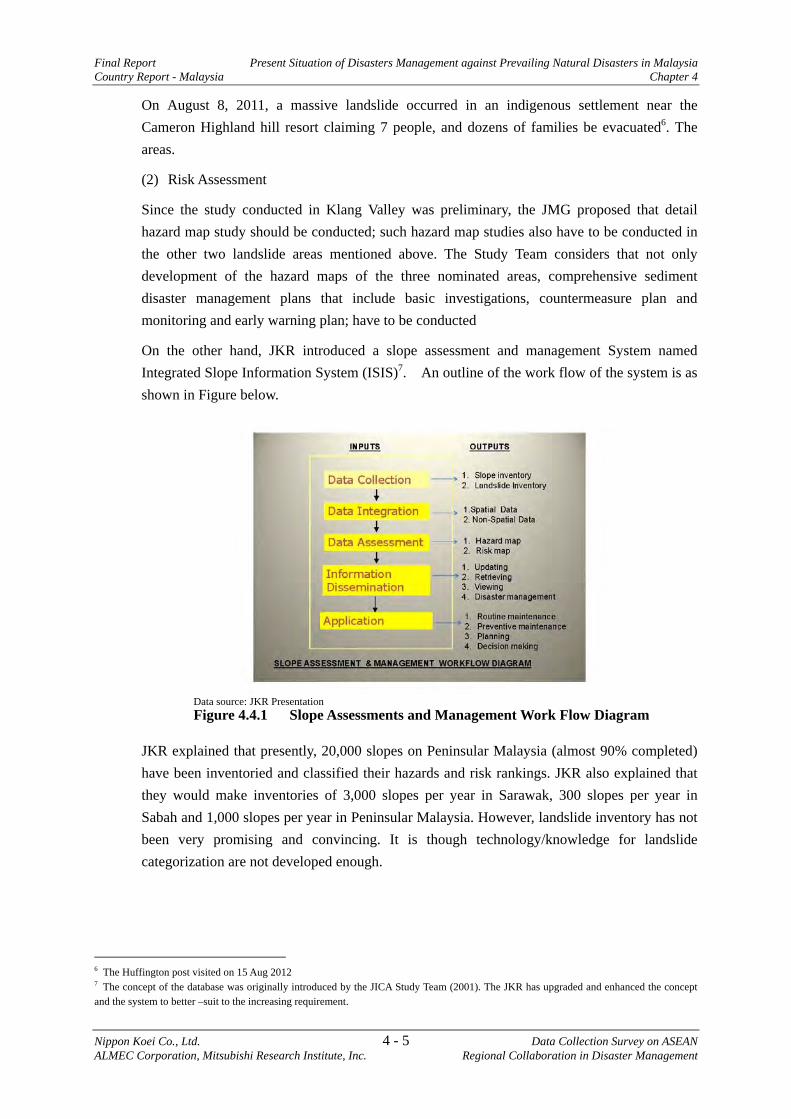
On the other hand, JKR introduced a slope assessment and management System named Integrated Slope Information System (ISIS)7. An outline of the work flow of the system is as shown in Figure below.
JKR explained that presently, 20,000 slopes on Peninsular Malaysia (almost 90% completed) have been inventoried and classified their hazards and risk rankings. JKR also explained that they would make inventories of 3,000 slopes per year in Sarawak, 300 slopes per year in Sabah and 1,000 slopes per year in Peninsular Malaysia. However, landslide inventory has not been very promising and convincing. It is though technology/knowledge for landslide categorization are not developed enough.
6 The Huffington post visited on 15 Aug 2012 7 The concept of the database was originally introduced by the JICA Study Team (2001). The JKR has upgraded and enhanced the concept and the system to better –suit to the increasing requirement.
Data source: JKR Presentation Figure 4.4.1 Slope Assessments and Management Work Flow Diagram
Present Situation of Disasters Management against Prevailing Natural Disasters in Malaysia Final Report Chapter 4 Country Report - Malaysia
Data Collection Survey on ASEAN 4 - 6 Nippon Koei Co., Ltd. Regional Collaboration in Disaster Management ALMEC Corporation, Mitsubishi Research Institute, Inc.
(3) Monitoring / Early Warning System
Landslide prone areas should be installed with monitoring and early warning systems for evacuation; however, more research on the landslide prone areas should be conducted by relevant agencies. Based on such research results, priority areas should be selected for future installation of monitoring and warning systems.
(4) Issues and Needs
1) Issues
- To develop the hazard maps in strategic areas; - To conduct comprehensive sediment disaster study in strategic areas; - To install early warning systems in strategic areas; - To introduce countermeasures in strategic areas;
2) Needs
Study on sediment disaster management plan in strategic priority areas in Kundasang (Kota Kinabalu) of Sabah district, Uluk Klang of Selangor district, and Cameron Highlands of Pahang district.
Final Report Disaster Management Information, Early Warning and Disaster Education Country Report - Malaysia Chapter 5
Nippon Koei Co., Ltd. 5 - 1 Data Collection Survey on ASEAN ALMEC Corporation, Mitsubishi Research Institute, Inc Regional Collaboration in Disaster Management
CHAPTER 5 DISASTER MANAGEMENT INFORMATION, EARLY WARNING AND DISASTER EDUCATION
The HFA-3 mentions that stakeholders need to use knowledge, innovation and education to build a culture of safety and resilience at all levels. In order to achieve that, it is important to collect and integrate various types of information on disaster management to be able to share, and freely use it.
In this chapter, the JICA Study Team organized an overview of the current situation and challenges of each ASEAN country regarding Disaster Management Information System (DMIS) and education for disaster prevention and mitigation.
5.1 Disaster Management Information System (DMIS)
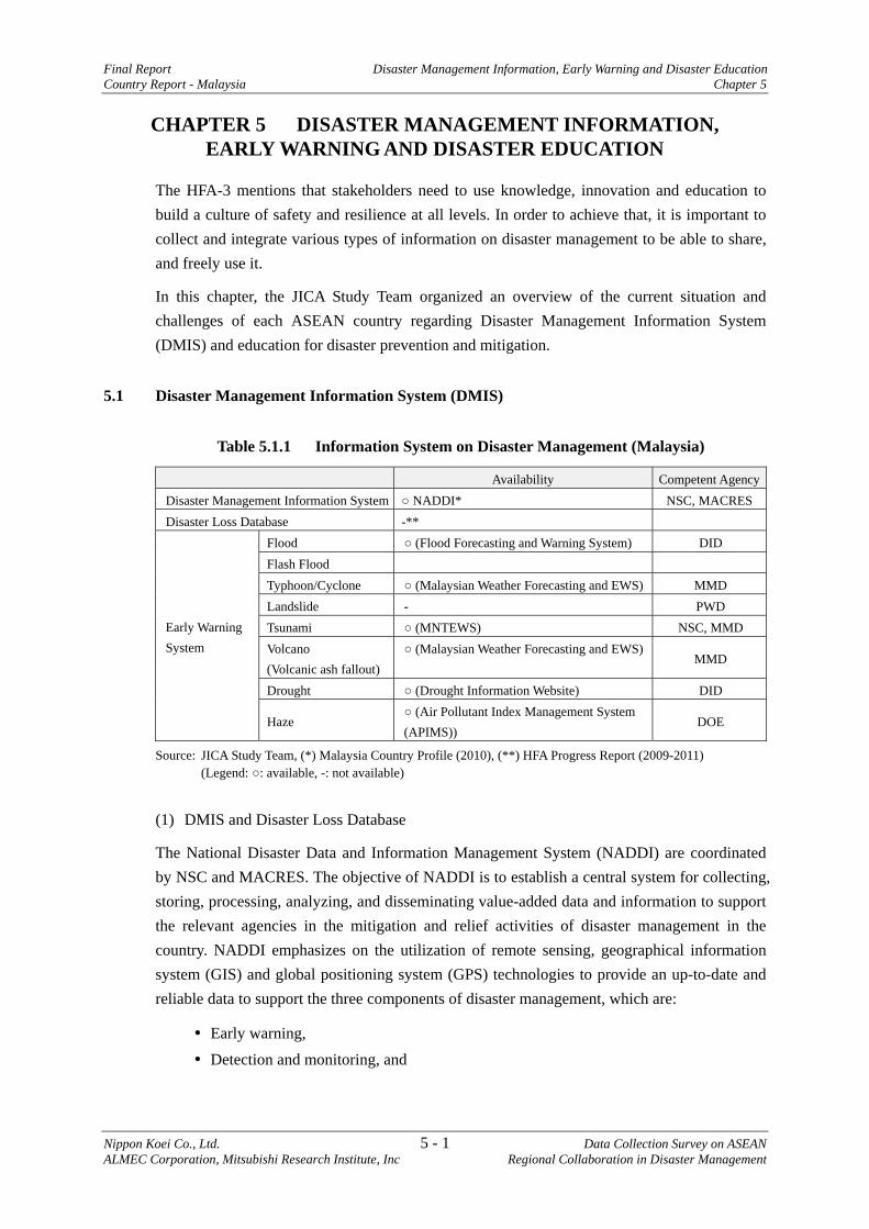
Table 5.1.1 Information System on Disaster Management (Malaysia)
Availability Competent AgencyDisaster Management Information System ○ NADDI* NSC, MACRES Disaster Loss Database -**
Early Warning System
Flood ○ (Flood Forecasting and Warning System) DID Flash Flood Typhoon/Cyclone ○ (Malaysian Weather Forecasting and EWS) MMD Landslide - PWD Tsunami ○ (MNTEWS) NSC, MMD Volcano (Volcanic ash fallout)
○ (Malaysian Weather Forecasting and EWS) MMD
Drought ○ (Drought Information Website) DID
Haze ○ (Air Pollutant Index Management System (APIMS))
DOE
Source: JICA Study Team, (*) Malaysia Country Profile (2010), (**) HFA Progress Report (2009-2011) (Legend: ○: available, -: not available)
(1) DMIS and Disaster Loss Database
The National Disaster Data and Information Management System (NADDI) are coordinated by NSC and MACRES. The objective of NADDI is to establish a central system for collecting, storing, processing, analyzing, and disseminating value-added data and information to support the relevant agencies in the mitigation and relief activities of disaster management in the country. NADDI emphasizes on the utilization of remote sensing, geographical information system (GIS) and global positioning system (GPS) technologies to provide an up-to-date and reliable data to support the three components of disaster management, which are:
Early warning, Detection and monitoring, and
Disaster Management Information, Early Warning and Disaster Education Final Report Chapter 5 Country Report - Malaysia
Data Collection Survey on ASEAN 5 - 2 Nippon Koei Co., Ltd. Regional Collaboration in Disaster Management ALMEC Corporation, Mitsubishi Research Institute, Inc.
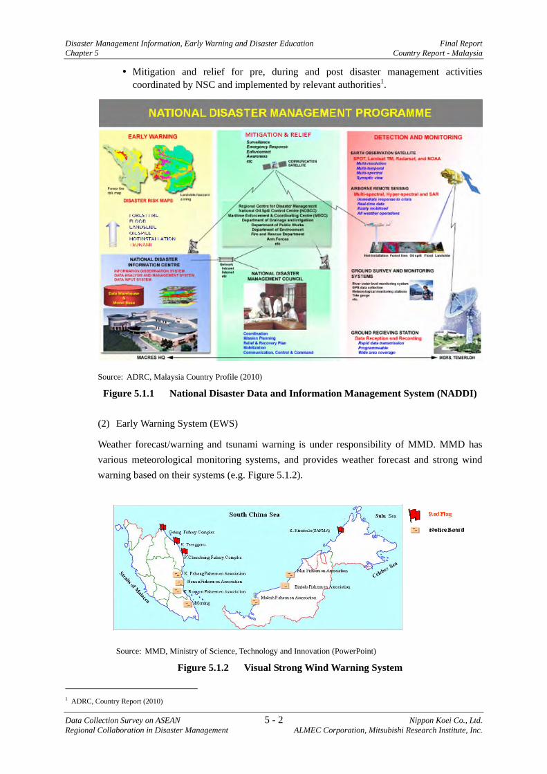
Mitigation and relief for pre, during and post disaster management activities coordinated by NSC and implemented by relevant authorities1.
Source: ADRC, Malaysia Country Profile (2010)
Figure 5.1.1 National Disaster Data and Information Management System (NADDI)
(2) Early Warning System (EWS)
Weather forecast/warning and tsunami warning is under responsibility of MMD. MMD has various meteorological monitoring systems, and provides weather forecast and strong wind warning based on their systems (e.g. Figure 5.1.2).
Source: MMD, Ministry of Science, Technology and Innovation (PowerPoint)
Figure 5.1.2 Visual Strong Wind Warning System
1 ADRC, Country Report (2010)
Final Report Disaster Management Information, Early Warning and Disaster Education Country Report - Malaysia Chapter 5
Nippon Koei Co., Ltd. 5 - 3 Data Collection Survey on ASEAN ALMEC Corporation, Mitsubishi Research Institute, Inc Regional Collaboration in Disaster Management
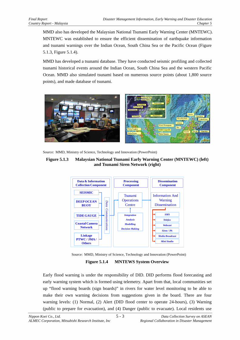
MMD also has developed the Malaysian National Tsunami Early Warning Center (MNTEWC). MNTEWC was established to ensure the efficient dissemination of earthquake information and tsunami warnings over the Indian Ocean, South China Sea or the Pacific Ocean (Figure 5.1.3, Figure 5.1.4).
MMD has developed a tsunami database. They have conducted seismic profiling and collected tsunami historical events around the Indian Ocean, South China Sea and the western Pacific Ocean. MMD also simulated tsunami based on numerous source points (about 1,800 source points), and made database of tsunami.
Source: MMD, Ministry of Science, Technology and Innovation (PowerPoint)
Figure 5.1.3 Malaysian National Tsunami Early Warning Center (MNTEWC) (left) and Tsunami Siren Network (right)
DEEP OCEAN BUOY
TIDE GAUGE
Tsunami Operations
Centre
Information And Warning
Dissemination
Coastal Camera Network
Integration
Analysis
Modelling
Decision Making
Data C
omm
unications
Linkage PTWC / JMA /
Others
SMS
Telefax
Webcast
Siren / PA
Media Broadcast
Mini Studio
Data & Information Collection Component
Processing Component
Dissemination Component
SEISMIC
Source: MMD, Ministry of Science, Technology and Innovation (PowerPoint)
Figure 5.1.4 MNTEWS System Overview
Early flood warning is under the responsibility of DID. DID performs flood forecasting and early warning system which is formed using telemetry. Apart from that, local communities set up “flood warning boards (sign boards)” in rivers for water level monitoring to be able to make their own warning decisions from suggestions given in the board. There are four warning levels: (1) Normal, (2) Alert (DID flood center to operate 24-hours), (3) Warning (public to prepare for evacuation), and (4) Danger (public to evacuate). Local residents use

Disaster Management Information, Early Warning and Disaster Education Final Report Chapter 5 Country Report - Malaysia
Data Collection Survey on ASEAN 5 - 4 Nippon Koei Co., Ltd. Regional Collaboration in Disaster Management ALMEC Corporation, Mitsubishi Research Institute, Inc.
their own judgement in identifying danger by observing the board and reports the situations to the DID district office.
As for landslide disasters, the National Slope Master Plan will be expanded in the long term, to provide early warning system in landslide prone areas2.
(3) Means of Dissemination of Early Warning
Early warnings are disseminated through sirens, SMS, hotlines (between MNTEWC and national television), fixed lines (whenever necessary), telefax, websites, mass media broadcasting systems (mini studio at MNTEWC) and public announcements. The ICT is also utilized to promote awareness and disseminate early warnings to the public via Fixed-Line Disaster Alert System (FLAS). A separate system known as the Government Integrated Radio Network (GIRN) provides radio communication between responders during emergency or disaster. Disaster reporting is now more efficient with the centralized Malaysia Emergency Response System (MERS) emergency hotline.
Relevant personnel and agencies
Commun
ity
SMS
National TelevisionHotline
Tsunami Siren
Website
Mini StudioMNTEWC
Source: JICA Study Team based on the interview survey for MMD
Figure 5.1.5 Dissemination Flow of Early Warning
5.2 Education for Disaster Prevention and Mitigation
Several programs have been implemented to improve the resilience of schools and hospitals against disasters, but the education sector do not have primary and secondary school curriculum for disaster risk reduction.
In conjunction with the Disaster Awareness Day 2011, Malaysia launched the national level campaign on ‘One Million Safe Schools and Hospitals’ and organized the ASEAN Knowledge Sharing Workshop on Mainstreaming DRR in Education. The Workshop provided the platform for capacity building in mainstreaming DRR in the education sector, particularly in the primary and secondary school curriculum by, inter-alia, sharing sound practices and lessons acquired by ASEAN member states, assessing the state-of-the-art of mainstreaming DRR in
2 HFA Progress Report (2009-2011), Malaysia
Final Report Disaster Management Information, Early Warning and Disaster Education Country Report - Malaysia Chapter 5
Nippon Koei Co., Ltd. 5 - 5 Data Collection Survey on ASEAN ALMEC Corporation, Mitsubishi Research Institute, Inc Regional Collaboration in Disaster Management
education in the ASEAN region and determining performance areas of DRR mainstreaming in curriculum and standards that may be adaptable in the region3.
Table 5.2.1 Activities for Enhancement of Public Awareness (Malaysia)
Systems, Activities Type of Disasters Public awareness on disasters and disaster risks
Public awareness campaigns, tsunami drills (at selected high risk areas)
Tsunami (MMD)
Pamphlet, website (http://www.met.gov.my/, http://typhooncommittee.org.com.my/)
Typhoon (MMD)
Pamphlet, website (http://www.met.gov.my/) Earthquake, Tsunami (MMD)
Public education and awareness programs at landslide -prone areas
Landslide (PWD)
Zero Burnings Campaign Haze (DOE) Exhibition on space-based related to disaster activities Multi-disasters
(MRSA)
Source: HFA Implementation Review-Simplified Version for ACDR2010 (NSC), PowerPoint (MMD)
MMD has some issues and challenges, which include the following:
i) Budget constraints, difficulty in reaching out to the public in masses and campaigns only being done on a small-scale basis.
ii) Closer cooperation with national TV networks, the information and education ministries are very much needed for the outreach program to reach a greater mass of public and school children in order to build a greater awareness and response capability toward a reliance community.
(Source: Questionnaire responses from MMD)
5.3 Issues and Needs Identified - Malaysia
Though the disaster loss database is not presently available, the Team considers that Malaysia is capable to build it.
No particular issues and needs were identified in Malaysia.
3 HFA Progress Report (2009-2011), Malaysia, modified by the JICA Study Team
Final Report Preparedness for Effective Response Country Report - Malaysia Chapter 6
Nippon Koei Co., Ltd. 6 - 1 Data Collection Survey on ASEAN ALMEC Corporation, Mitsubishi Research Institute, Inc. Regional Collaboration in Disaster Management
CHAPTER 6 PREPAREDNESS FOR EFFECTIVE RESPONSE
6.1 Current Situation of Preparedness for Emergency Response
Malaysia has prepared SOPs in seven different disasters, namely, i) flood, ii) forest fire/open burning and haze, iii) industrial disasters, iv) bencana industry petroleum, gas dan petrochemicals, v) earthquake, vi) tsunami, and, vii) drought. The Safety Guidelines for Facing Crisis and Disasters have also been prepared.
In case of a disaster, an On Scene Command Post (OSCP) is established as a command structure and control base. The Royal Malaysia Police appoints an officer to head the OSCP. The OSCP mobilizes its communication items to create a communication network and coordinates with the Disaster Operations Control Center (DOCC) at each management level. DOCCs are set up according to the level of disaster. Below are the disaster levels and DOCC locations:
a) Level 1 disaster (a disaster struck within a district managed by DDMRC) - District Office;
b) Level 2 disaster (a disaster struck in wider areas than a district managed by SDMRC) - State NSC Operations Room;
c) Level 3 disaster (a disaster struck in wider areas than a state managed by CDMRC) - NSC Operations Room.
The NSC has formed the Special Malaysia Disaster Assistance and Rescue Team (SMART) since 1995. SMART has approximately 90 staffs as secondments from various ministries for a period of three years or more. They are called when a disaster level is more than what the local disaster management level can handle and when a request comes nationwide especially during the monsoon season.
6.2 Issues and Needs of Assistance for Emergency Response
(1) Issues
a) Not specifically identified
(2) Needs1
Malaysia is rather in a position to address the needs of other member countries of ASEAN in the following areas.
Provision of training for extended joint exercise of rescue teams among ASEAN countries
1 The view is identified by the JICA Study Team.
Final Report Needs Identification for Disaster Management Country Report - Malaysia Chapter 7
Nippon Koei Co., Ltd. 7 - 1 Data Collection Survey on ASEAN ALMEC Corporation, Mitsubishi Research Institute, Inc. Regional Collaboration in Disaster Management
CHAPTER 7 NEEDS IDENTIFICATION FOR DISASTER MANAGEMENT
This chapter summarizes the survey results and describes the proposals for ASEAN regional collaboration in disaster management.
7.1 Issues and Needs According to Themes
7.1.1 Institution / Organization
(1) Institutional Issues: Disaster Management Law
In keeping with the strategic goals of Hyogo Framework for Action (HFA), ASEAN countries have shifted their disaster management policy focus from responsive to preventive and mitigating orientation. As such policy shift is still in transition, not all ASEAN countries have established their institutional foundation in terms of legal and organizational arrangements.
Out of ten ASEAN countries, four countries (Brunei, Indonesia, the Philippines, and Thailand) have disaster management law. Three countries, namely Cambodia, Myanmar, and Vietnam, are in the process of enacting their disaster management law within 2012 or in 2013. Lao PDR expects to formulate and enact disaster management law by 2013. Malaysia needs more steps to start preparing its disaster management law. It seems unnecessary for Singapore to have its comprehensive disaster management law aside from other related laws, because it is relatively free from natural hazards.
Disaster management law is fundamental especially for effectively conducting disaster preventive/mitigating activities as government budget allocation for disaster management attributes to its legal basis. While many countries have spared a portion of special budget through emergency funds when disaster strikes, an integrated budget for comprehensive disaster prevention and mitigating activities is scarcely prepared as these resources are normally allocated to respective sector ministry without sufficient coordination. Such integration of the budget will, on the other hand, require a comprehensive disaster management plan and a specialized agency as its preconditions.
(2) Institutional Issues: Disaster Management Plan and Organization
1) Readiness of Disaster Management Plan of ASEAN countries
Preparation of disaster management plan varies from country to country among ASEAN countries. Four out of ten ASEAN countries (Indonesia, the Philippines, Thailand, and Vietnam) possess disaster management plans. Brunei’s disaster management plan consists of: i) Strategic National Action Plan and ii) Standard Operating Procedure. Cambodia had a plan for some years but has not been implemented as intended because its legal basis was not yet put into place. Lao PDR is currently drafting the plan to obtain legal approval. Myanmar is in the process of revising its plan together with necessary legal re-arrangement including organizational re-structuring (to be completed within 2012). It seems enough for Singapore to have existing national contingency plan. Disaster management plans at the local level are also

Needs Identification for Disaster Management Final Report Chapter 7 Country Report - Malaysia
Data Collection Survey on ASEAN 7 - 2 Nippon Koei Co., Ltd. Regional Collaboration in Disaster Management ALMEC Corporation, Mitsubishi Research Institute, Inc.
expected to be prepared; however, it is an issue for most of ASEAN countries in terms of how these will be well-prepared.
2) Disaster Management Organization at the National Level
All ASEAN countries have disaster management organizations. Most of them are composed of committees presided by high level government authority and secretariats, which are most likely under the leading ministry for disaster management. These committees are organized mainly for emergency response, and the secretariats are expected to deal with disaster prevention, mitigation and preparedness apart from emergency arrangements, without enough resources and authority in most cases. Although a shift of policy focus on disaster management from emergency response to prevention, mitigation, and preparedness has been observed in most of ASEAN countries, it would be necessary for existing secretariat organizations to have clearer mandates and authority or to be an independent agency just like a case of Indonesia in order to make inter-governmental coordination as well as disaster management activities smooth.
Table 7.1.1 Institutional Conditions of Disaster Management in ASEAN Countries
Institutional Conditions
Bru
nei
Cam
bodi
a
Indo
nesi
a
Lao
PDR
Mal
aysi
a
Mya
nmar
Phili
ppin
es
Sing
apor
e
Thai
land
Vie
tnam
Disaster Management Law
Presence O
<201
3>
O
<201
3>
-*2
<201
2>
O
-*3
O
<201
3>
Enacted <Planned> Year
2006
*1
2007
2010
2007
Disaster Management
Plan
Presence at the National Level O*4 O*5 O -*6 -*7 O O O*8 O O*9
Presence at the Local Level O O O O*10 O*11 . O -*12 O O
Disaster Management Organization
National Level
Committee O O O*13
O O O O O O O
Secretariat O*14 O O O O O O O O
Local Level O O O O O O O -*15 -*16 O
Community-based Disaster Management O -*17 -*17 -*17 -*17 -*17 -*17 O -*17 -*17
Source: JICA Study Team Note: ‘O’: Available; ‘-’: Not Available
1*: Disaster Management Order subrogates the law; 2*: Malaysia needs more steps to start preparing disaster management law; 3*: It seems unnecessary for Singapore to have comprehensive disaster management law aside from other related laws because it is relatively free from natural hazards; *4: It consists of SNAP and SOP; *5: Implementation issue exists; *6: It will be approved within 2012; *7: SOPs subrogate it; having the plan is considered unnecessary; *8: Emergency plan subrogates it; *9: The plan is to be revised; *10: Five out of 16 provinces prepared it; *11: It will be revised; *12: It seems not necessary; *13: Committee is within the implementing organization; *14: It is still an interim arrangement; *15: It seems not necessary; *16: Local administrations provided its function; *17: Implemented mainly through donor-led program.
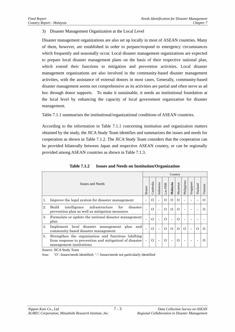
Final Report Needs Identification for Disaster Management Country Report - Malaysia Chapter 7
Nippon Koei Co., Ltd. 7 - 3 Data Collection Survey on ASEAN ALMEC Corporation, Mitsubishi Research Institute, Inc. Regional Collaboration in Disaster Management
3) Disaster Management Organization at the Local Level
Disaster management organizations are also set up locally in most of ASEAN countries. Many of them, however, are established in order to prepare/respond to emergency circumstances which frequently and seasonally occur. Local disaster management organizations are expected to prepare local disaster management plans on the basis of their respective national plan, which extend their functions to mitigation and prevention activities. Local disaster management organizations are also involved in the community-based disaster management activities, with the assistance of external donors in most cases. Generally, community-based disaster management seems not comprehensive as its activities are partial and often serve as ad hoc through donor supports. To make it sustainable, it needs an institutional foundation at the local level by enhancing the capacity of local government organization for disaster management.
Table 7.1.1 summarises the institutional/organizational conditions of ASEAN countries.
According to the information in Table 7.1.1 concerning institution and organization matters obtained by the study, the JICA Study Team identifies and summarizes the issues and needs for cooperation as shown in Table 7.1.2. The JICA Study Team considers that the cooperation can be provided bilaterally between Japan and respective ASEAN country, or can be regionally provided among ASEAN countries as shown in Table 7.1.3.
Table 7.1.2 Issues and Needs on Institution/Organization
Issues and Needs
Country
Bru
nei
Cam
bodi
a
Indo
nesi
a
Lao
PDR
Mal
aysi
a
Mya
nmar
Phili
ppin
es
Sing
apor
e
Thai
land
Vie
tnam
1. Improve the legal system for disaster management - O - O O O - - - O
2. Build intelligence infrastructure for disaster prevention plan as well as mitigation measures - O - O O O - - - O
3. Formulate or update the national disaster management plan - O - O - O - - - -
4. Implement local disaster management plan and community based disaster management - O - O O O O - O O
5. Strengthen the organization and functions (shifting from response to prevention and mitigation) of disaster management institutions
- O - O - O - - - O
Source: JICA Study Team Note: ‘O’: Issues/needs identified; ‘-’: Issues/needs not particularly identified

Needs Identification for Disaster Management Final Report Chapter 7 Country Report - Malaysia
Data Collection Survey on ASEAN 7 - 4 Nippon Koei Co., Ltd. Regional Collaboration in Disaster Management ALMEC Corporation, Mitsubishi Research Institute, Inc.
Table 7.1.3 Issues and Needs for Institutional Improvement of ASEAN Countries
Issues and Needs Countries Bilateral/ ASEAN Regional Cooperation
Improvement of legal system for disaster management
Cambodia Lao PDR Malaysia Myanmar Vietnam
(1) Bilateral cooperation International survey for information collection to standardize disaster management law for preparation, modification, and enforcement. (2) ASEAN cooperation Standardization of ASEAN disaster management institutional arrangement. (Lead countries: Indonesia and Thailand)
Building intelligence infrastructure for disaster prevention as well as mitigation measures to be planned
Cambodia Lao PDR Malaysia Myanmar Vietnam
(1) Bilateral cooperation Information collection on disaster management plans and its frameworks for replication referring Japan’s plan and framework as a basic case. Mitigation measures of every disaster are also collected for reference. (2) ASEAN cooperation Sharing basic information on disaster management plans and mitigation measures with each other in a comparative manner, for regional knowledge base to be created.
National disaster management plan to be formulated or updated
Cambodia Lao PDR Myanmar
(1) Bilateral cooperation Using the frameworks of national disaster management plan of Japan, comprehensive framework is clarified. (2) ASEAN cooperation Standardization and modelling of national disaster management plan extracting good practices of ASEAN countries for replication and mutual learning.
Local disaster management plan and implementation of community based disaster management
Cambodia Lao PDR Malaysia Myanmar Philippines Thailand Vietnam
(1) Bilateral cooperation Using the frameworks of local level disaster management plan of Japan, comprehensive framework is clarified for local level planning (community based disaster management component is also included). (2) ASEAN cooperation Standardization and modelling of local disaster management plan as well as community based disaster management practices extracted from ASEAN countries for replication and mutual learning.
Organizational and functional strengthening (shifting from response to prevention and mitigation) of disaster management institutions
Cambodia Lao PDR Myanmar Vietnam
(1) Bilateral cooperation Optimization of disaster management organizations including law revision. Support capacity development of professional staffs in the area of disaster management. (2) ASEAN cooperation Standardization of disaster management organizational structures and functions by referring the cases of advanced ASEAN countries (e.g., Indonesia and Thailand) and support latecomers.
Source: JICA Study Team
7.1.2 Risk Assessment, Early Warning and Mitigation
(1) Flood Disaster Management
1) Recent Trends of Flood Damages and Overview of Needs of Countermeasures
The Typhoon Ketsana caused extensive flood damages to the Philippines, Vietnam, Cambodia, Laos, and Thailand in 2009. Moreover, the compounded impact of Tropical Storm Haima and Typhoon Nock-ten caused extensive damages to Myanmar, Thailand, Laos, and Cambodia in
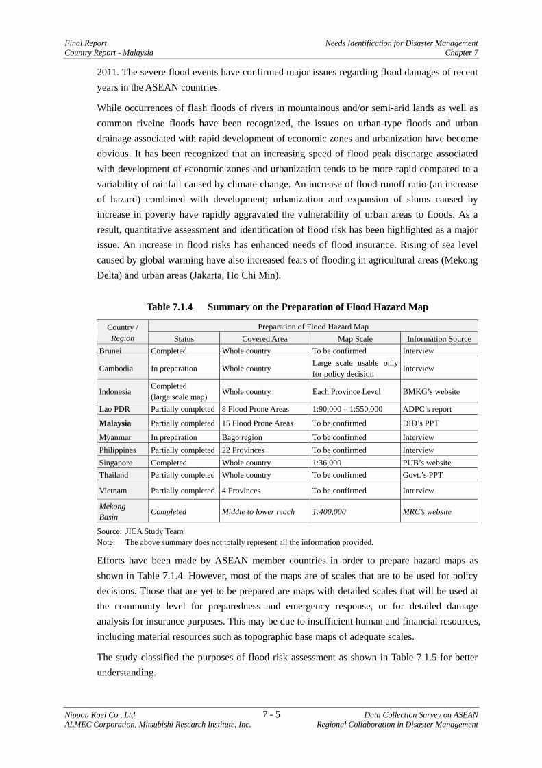
Final Report Needs Identification for Disaster Management Country Report - Malaysia Chapter 7
Nippon Koei Co., Ltd. 7 - 5 Data Collection Survey on ASEAN ALMEC Corporation, Mitsubishi Research Institute, Inc. Regional Collaboration in Disaster Management
2011. The severe flood events have confirmed major issues regarding flood damages of recent years in the ASEAN countries.
While occurrences of flash floods of rivers in mountainous and/or semi-arid lands as well as common riveine floods have been recognized, the issues on urban-type floods and urban drainage associated with rapid development of economic zones and urbanization have become obvious. It has been recognized that an increasing speed of flood peak discharge associated with development of economic zones and urbanization tends to be more rapid compared to a variability of rainfall caused by climate change. An increase of flood runoff ratio (an increase of hazard) combined with development; urbanization and expansion of slums caused by increase in poverty have rapidly aggravated the vulnerability of urban areas to floods. As a result, quantitative assessment and identification of flood risk has been highlighted as a major issue. An increase in flood risks has enhanced needs of flood insurance. Rising of sea level caused by global warming have also increased fears of flooding in agricultural areas (Mekong Delta) and urban areas (Jakarta, Ho Chi Min).
Table 7.1.4 Summary on the Preparation of Flood Hazard Map
Country / Region
Preparation of Flood Hazard Map Status Covered Area Map Scale Information Source
Brunei Completed Whole country To be confirmed Interview
Cambodia In preparation Whole country Large scale usable only for policy decision
Interview
Indonesia Completed (large scale map)
Whole country Each Province Level BMKG’s website
Lao PDR Partially completed 8 Flood Prone Areas 1:90,000 – 1:550,000 ADPC’s report
Malaysia Partially completed 15 Flood Prone Areas To be confirmed DID’s PPT
Myanmar In preparation Bago region To be confirmed Interview Philippines Partially completed 22 Provinces To be confirmed Interview Singapore Completed Whole country 1:36,000 PUB’s website Thailand Partially completed Whole country To be confirmed Govt.’s PPT
Vietnam Partially completed 4 Provinces To be confirmed Interview
Mekong Basin
Completed Middle to lower reach 1:400,000 MRC’s website
Source: JICA Study Team Note: The above summary does not totally represent all the information provided.
Efforts have been made by ASEAN member countries in order to prepare hazard maps as shown in Table 7.1.4. However, most of the maps are of scales that are to be used for policy decisions. Those that are yet to be prepared are maps with detailed scales that will be used at the community level for preparedness and emergency response, or for detailed damage analysis for insurance purposes. This may be due to insufficient human and financial resources, including material resources such as topographic base maps of adequate scales.
The study classified the purposes of flood risk assessment as shown in Table 7.1.5 for better understanding.
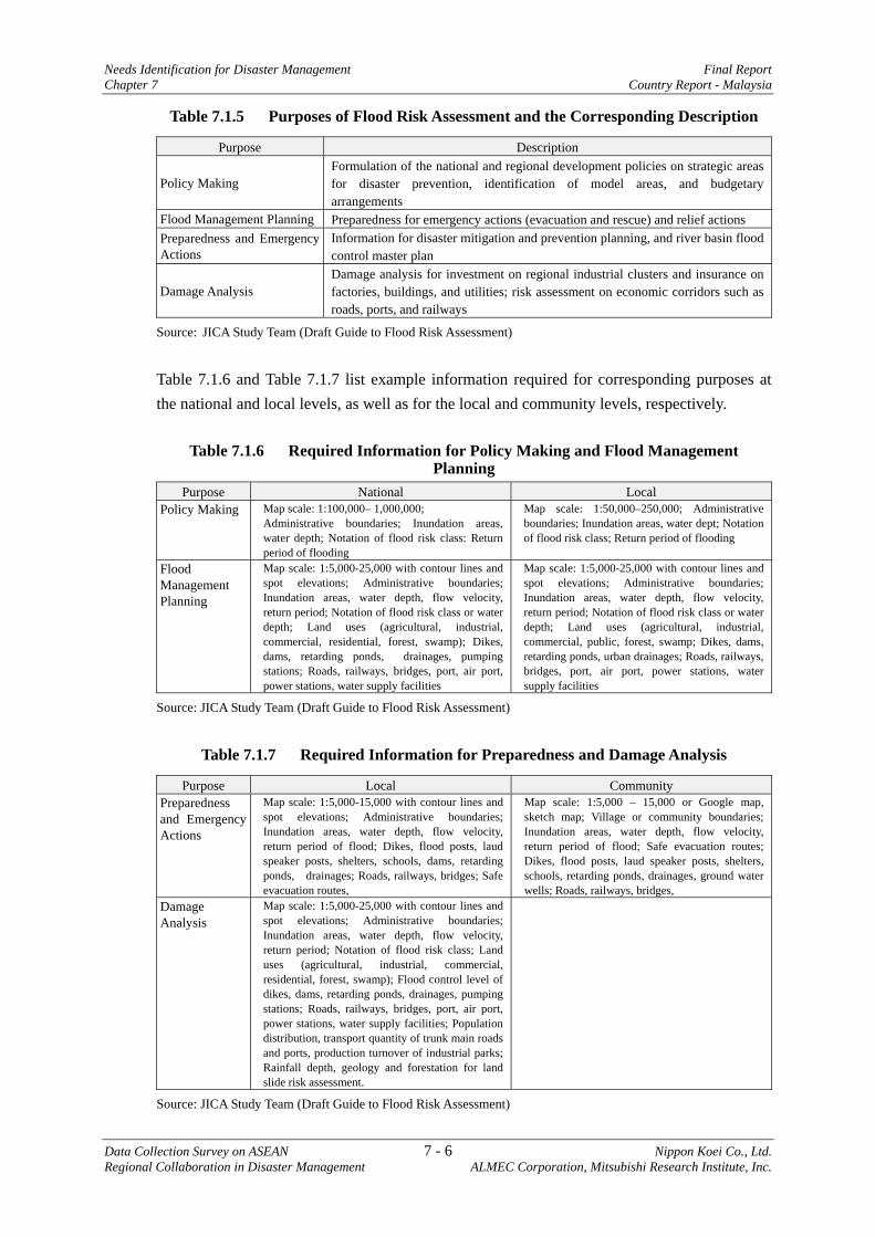
Needs Identification for Disaster Management Final Report Chapter 7 Country Report - Malaysia
Data Collection Survey on ASEAN 7 - 6 Nippon Koei Co., Ltd. Regional Collaboration in Disaster Management ALMEC Corporation, Mitsubishi Research Institute, Inc.
Table 7.1.5 Purposes of Flood Risk Assessment and the Corresponding Description
Purpose Description
Policy Making Formulation of the national and regional development policies on strategic areas for disaster prevention, identification of model areas, and budgetary arrangements
Flood Management Planning Preparedness for emergency actions (evacuation and rescue) and relief actions Preparedness and Emergency Actions
Information for disaster mitigation and prevention planning, and river basin flood control master plan
Damage Analysis Damage analysis for investment on regional industrial clusters and insurance on factories, buildings, and utilities; risk assessment on economic corridors such as roads, ports, and railways
Source: JICA Study Team (Draft Guide to Flood Risk Assessment)
Table 7.1.6 and Table 7.1.7 list example information required for corresponding purposes at the national and local levels, as well as for the local and community levels, respectively.
Table 7.1.6 Required Information for Policy Making and Flood Management Planning
Purpose National Local Policy Making Map scale: 1:100,000– 1,000,000;
Administrative boundaries; Inundation areas, water depth; Notation of flood risk class: Return period of flooding
Map scale: 1:50,000–250,000; Administrative boundaries; Inundation areas, water dept; Notation of flood risk class; Return period of flooding
Flood Management Planning
Map scale: 1:5,000-25,000 with contour lines and spot elevations; Administrative boundaries; Inundation areas, water depth, flow velocity, return period; Notation of flood risk class or water depth; Land uses (agricultural, industrial, commercial, residential, forest, swamp); Dikes, dams, retarding ponds, drainages, pumping stations; Roads, railways, bridges, port, air port, power stations, water supply facilities
Map scale: 1:5,000-25,000 with contour lines and spot elevations; Administrative boundaries; Inundation areas, water depth, flow velocity, return period; Notation of flood risk class or water depth; Land uses (agricultural, industrial, commercial, public, forest, swamp; Dikes, dams, retarding ponds, urban drainages; Roads, railways, bridges, port, air port, power stations, water supply facilities
Source: JICA Study Team (Draft Guide to Flood Risk Assessment)
Table 7.1.7 Required Information for Preparedness and Damage Analysis
Purpose Local Community Preparedness and Emergency Actions
Map scale: 1:5,000-15,000 with contour lines and spot elevations; Administrative boundaries; Inundation areas, water depth, flow velocity, return period of flood; Dikes, flood posts, laud speaker posts, shelters, schools, dams, retarding ponds, drainages; Roads, railways, bridges; Safe evacuation routes,
Map scale: 1:5,000 – 15,000 or Google map, sketch map; Village or community boundaries; Inundation areas, water depth, flow velocity, return period of flood; Safe evacuation routes; Dikes, flood posts, laud speaker posts, shelters, schools, retarding ponds, drainages, ground water wells; Roads, railways, bridges,
Damage Analysis
Map scale: 1:5,000-25,000 with contour lines and spot elevations; Administrative boundaries; Inundation areas, water depth, flow velocity, return period; Notation of flood risk class; Land uses (agricultural, industrial, commercial, residential, forest, swamp); Flood control level of dikes, dams, retarding ponds, drainages, pumping stations; Roads, railways, bridges, port, air port, power stations, water supply facilities; Population distribution, transport quantity of trunk main roads and ports, production turnover of industrial parks; Rainfall depth, geology and forestation for land slide risk assessment.
Source: JICA Study Team (Draft Guide to Flood Risk Assessment)
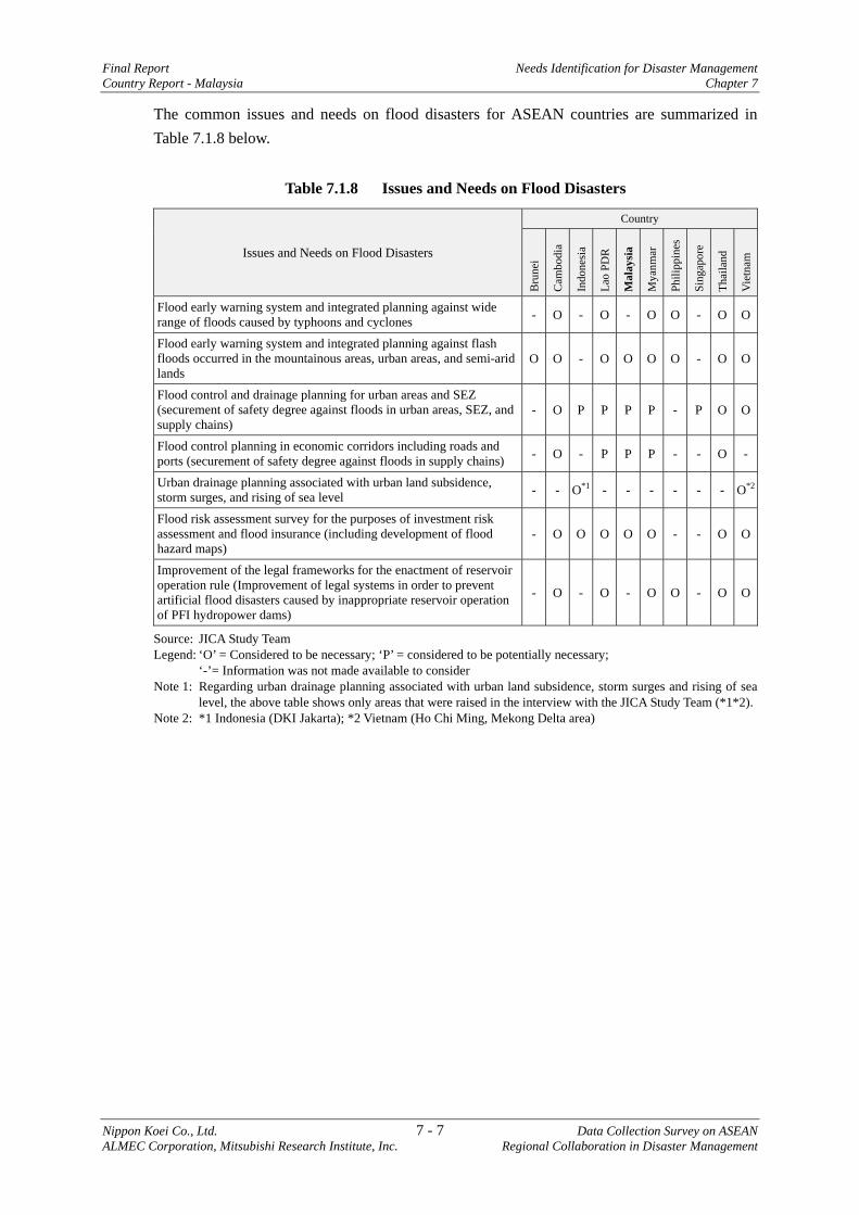
Final Report Needs Identification for Disaster Management Country Report - Malaysia Chapter 7
Nippon Koei Co., Ltd. 7 - 7 Data Collection Survey on ASEAN ALMEC Corporation, Mitsubishi Research Institute, Inc. Regional Collaboration in Disaster Management
The common issues and needs on flood disasters for ASEAN countries are summarized in Table 7.1.8 below.
Table 7.1.8 Issues and Needs on Flood Disasters
Issues and Needs on Flood Disasters
Country
Bru
nei
Cam
bodi
a
Indo
nesi
a
Lao
PDR
Mal
aysi
a
Mya
nmar
Phili
ppin
es
Sing
apor
e
Thai
land
Vie
tnam
Flood early warning system and integrated planning against wide range of floods caused by typhoons and cyclones - O - O - O O - O O
Flood early warning system and integrated planning against flash floods occurred in the mountainous areas, urban areas, and semi-arid lands
O O - O O O O - O O
Flood control and drainage planning for urban areas and SEZ (securement of safety degree against floods in urban areas, SEZ, and supply chains)
- O P P P P - P O O
Flood control planning in economic corridors including roads and ports (securement of safety degree against floods in supply chains) - O - P P P - - O -
Urban drainage planning associated with urban land subsidence, storm surges, and rising of sea level - - O*1 - - - - - - O*2
Flood risk assessment survey for the purposes of investment risk assessment and flood insurance (including development of flood hazard maps)
- O O O O O - - O O
Improvement of the legal frameworks for the enactment of reservoir operation rule (Improvement of legal systems in order to prevent artificial flood disasters caused by inappropriate reservoir operation of PFI hydropower dams)
- O - O - O O - O O
Source: JICA Study Team Legend: ‘O’ = Considered to be necessary; ‘P’ = considered to be potentially necessary;
‘-’= Information was not made available to consider Note 1: Regarding urban drainage planning associated with urban land subsidence, storm surges and rising of sea
level, the above table shows only areas that were raised in the interview with the JICA Study Team (*1*2). Note 2: *1 Indonesia (DKI Jakarta); *2 Vietnam (Ho Chi Ming, Mekong Delta area)
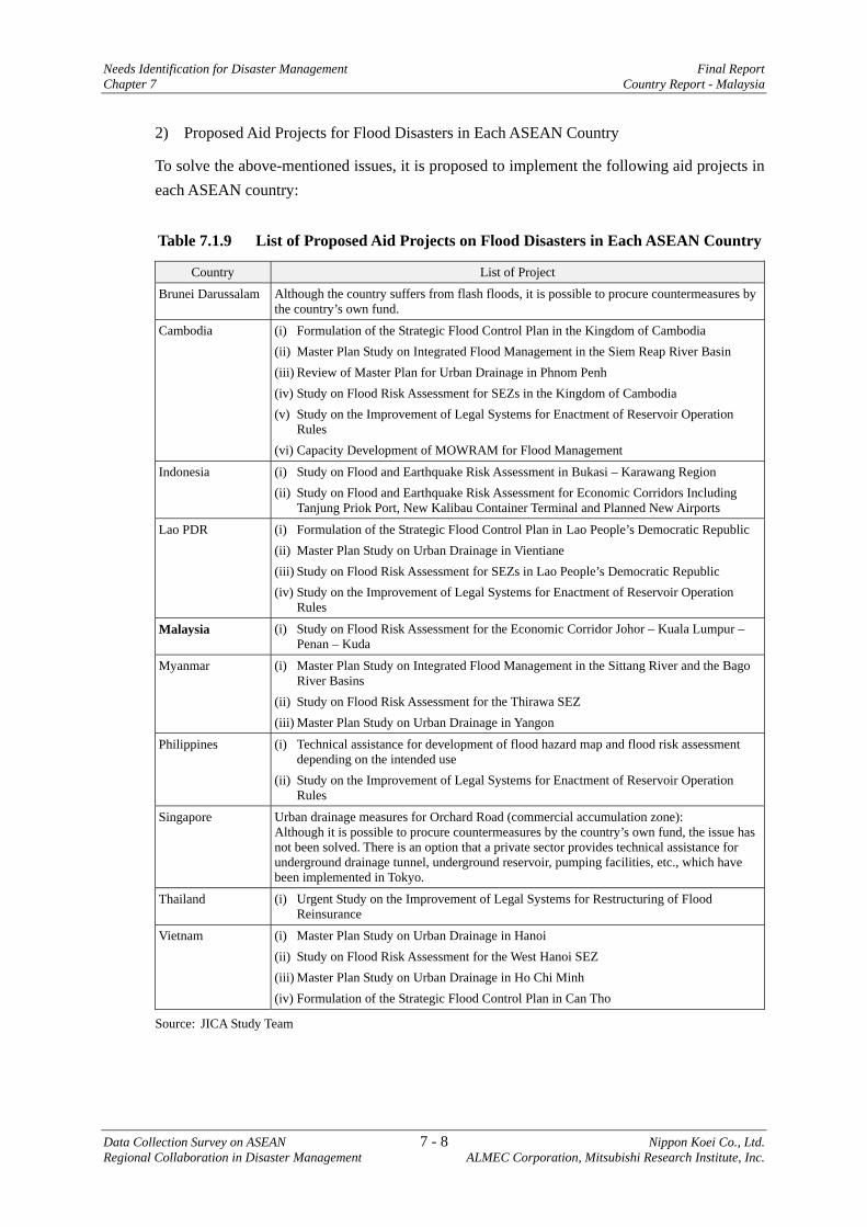
Needs Identification for Disaster Management Final Report Chapter 7 Country Report - Malaysia
Data Collection Survey on ASEAN 7 - 8 Nippon Koei Co., Ltd. Regional Collaboration in Disaster Management ALMEC Corporation, Mitsubishi Research Institute, Inc.
2) Proposed Aid Projects for Flood Disasters in Each ASEAN Country
To solve the above-mentioned issues, it is proposed to implement the following aid projects in each ASEAN country:
Table 7.1.9 List of Proposed Aid Projects on Flood Disasters in Each ASEAN Country
Country List of Project
Brunei Darussalam Although the country suffers from flash floods, it is possible to procure countermeasures by the country’s own fund.
Cambodia (i) Formulation of the Strategic Flood Control Plan in the Kingdom of Cambodia (ii) Master Plan Study on Integrated Flood Management in the Siem Reap River Basin (iii) Review of Master Plan for Urban Drainage in Phnom Penh (iv) Study on Flood Risk Assessment for SEZs in the Kingdom of Cambodia (v) Study on the Improvement of Legal Systems for Enactment of Reservoir Operation
Rules (vi) Capacity Development of MOWRAM for Flood Management
Indonesia (i) Study on Flood and Earthquake Risk Assessment in Bukasi – Karawang Region (ii) Study on Flood and Earthquake Risk Assessment for Economic Corridors Including
Tanjung Priok Port, New Kalibau Container Terminal and Planned New Airports
Lao PDR (i) Formulation of the Strategic Flood Control Plan in Lao People’s Democratic Republic (ii) Master Plan Study on Urban Drainage in Vientiane (iii) Study on Flood Risk Assessment for SEZs in Lao People’s Democratic Republic (iv) Study on the Improvement of Legal Systems for Enactment of Reservoir Operation
Rules
Malaysia (i) Study on Flood Risk Assessment for the Economic Corridor Johor – Kuala Lumpur – Penan – Kuda
Myanmar (i) Master Plan Study on Integrated Flood Management in the Sittang River and the Bago River Basins
(ii) Study on Flood Risk Assessment for the Thirawa SEZ (iii) Master Plan Study on Urban Drainage in Yangon
Philippines (i) Technical assistance for development of flood hazard map and flood risk assessment depending on the intended use
(ii) Study on the Improvement of Legal Systems for Enactment of Reservoir Operation Rules
Singapore Urban drainage measures for Orchard Road (commercial accumulation zone): Although it is possible to procure countermeasures by the country’s own fund, the issue has not been solved. There is an option that a private sector provides technical assistance for underground drainage tunnel, underground reservoir, pumping facilities, etc., which have been implemented in Tokyo.
Thailand (i) Urgent Study on the Improvement of Legal Systems for Restructuring of Flood Reinsurance
Vietnam (i) Master Plan Study on Urban Drainage in Hanoi (ii) Study on Flood Risk Assessment for the West Hanoi SEZ (iii) Master Plan Study on Urban Drainage in Ho Chi Minh (iv) Formulation of the Strategic Flood Control Plan in Can Tho
Source: JICA Study Team
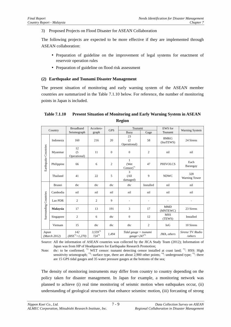
Final Report Needs Identification for Disaster Management Country Report - Malaysia Chapter 7
Nippon Koei Co., Ltd. 7 - 9 Data Collection Survey on ASEAN ALMEC Corporation, Mitsubishi Research Institute, Inc. Regional Collaboration in Disaster Management
3) Proposed Projects on Flood Disaster for ASEAN Collaboration
The following projects are expected to be more effective if they are implemented through ASEAN collaboration:
Preparation of guideline on the improvement of legal systems for enactment of reservoir operation rules
Preparation of guideline on flood risk assessment
(2) Earthquake and Tsunami Disaster Management
The present situation of monitoring and early warning system of the ASEAN member countries are summarized in the Table 7.1.10 below. For reference, the number of monitoring points in Japan is included.
Table 7.1.10 Present Situation of Monitoring and Early Warning System in ASEAN Region
Country Broadband Seismograph
Accelero-graph GPS Tsunami EWS for
Tsunami Warning SystemBuoy Gage
Earth
quak
e C
ount
ries
Indonesia 160 216 20 23 (2
Operational) 58 BMKG
(InaTEWS) 24 Sirens
Myanmar 12 (5
Operational) 11 0 0 2 nil nil
Philippine 66 6 2 1
(Wet Censor)*1
47 PHIVOLCS Each Barangay
Thailand 41 22 5 3
(All damaged)
9 NDWC 328 Warning Tower
Surr
ound
ing
Cou
ntrie
s
Brunei tbc tbc tbc tbc Installed nil nil
Cambodia nil nil nil nil nil nil nil
Lao PDR 2 2 9 - - - -
Malaysia 17 13 191 3 17 MMD (MNTEWC) 23 Sirens
Singapore 2 6 tbc 0 12 MSS (TEWS) Installed
Vietnam 15 tbc tbc tbc 2 IoG 10 Sirens
Japan (March 2012)
142 (HSS*2=1,270)
3,559*3 724*4 1,494 Tidal gauge + tsunami
gauge=247*5 JMA, others Sirens/ TV /Radio /others
Source: All the information of ASEAN countries was collected by the JICA Study Team (2012); Information of Japan was from HP of Headquarters for Earthquake Research Promotion;
Note: tbc: to be confirmed; *1 WET censor: tsunami detecting censor installed at coast land; *2: HSS: High sensitivity seismograph; *3: surface type, there are about 2,900 other points; *4: underground type; *5: there are 15 GPS tidal gauges and 35 water pressure gauges at the bottoms of the sea;
The density of monitoring instruments may differ from country to country depending on the policy taken for disaster management. In Japan for example, a monitoring network was planned to achieve (i) real time monitoring of seismic motion when eathquakes occur, (ii) understanding of geological structures that enhance seisminc motion, (iii) forcasting of strong
Needs Identification for Disaster Management Final Report Chapter 7 Country Report - Malaysia
Data Collection Survey on ASEAN 7 - 10 Nippon Koei Co., Ltd. Regional Collaboration in Disaster Management ALMEC Corporation, Mitsubishi Research Institute, Inc.
seismic motion when earthquakes occur, (iv) real time forcasting of tsunami when earthquakes occur and (v) evaluation of possibility of tunami-earthquake (stealth earthquake). To realize those, the plan is to propose intervals of monitoring devices, which are 15-20 km for height sensitivity monitoring seismograph, 100 km for broadband seismograph, 15-20 km for accelerograph, and 20-25 km for GPS1. As a result, considerably dense monitoring networks have been established as shown in Table 7.1.10.
1) Indonesia
a) Enhancement of the tsunami observation system for Indonesia Tsunami Early Warning System (InaTEWS).
Indonesia intended to establish the monitoring network for InaTEWS consisting of 160 broadband seismographs, 500 accelerometers, 40 GPSs, 80 tide gauges and 23 buoys2.
As shown in Table 7.1.10, the number of monitoring facilities excluding broadband seismographs, has to be increased to achieve the plan. In particular, tsunami observation buoys or other observation facilities have to be installed to the original level. Presently, the buoy observation facilities are proven to be not sustainable3; therefore, options such as new submarine water pressure gauge system or other alternatives have to be considered.
As for the tide gauges, information from some gauges are transmitted to BMKG via satellite with 15 minutes delay. It is understood that the system is being upgraded to transmit data via GTS to achieve near real time monitoring.
b) Formulation of disaster management plan and BCP for Jakarta
The Study Team also recommends an earthquake disaster management plan for Jakarta City since large scale earthquakes have not occurred for a long period. Considering that Jakarta is now being developed as an economic center of the ASEAN region, such plan is necessary to minimize effects to the city due to damage caused by large scale earthquakes.
As recommended in the other section of this report, a comprehensive disaster management plan that includes not only earthquake/tsunami but flood as well, is recommended for formulation.
Based on the comprehensive disaster management plan, BCP for the city will have to be formulated.
c) Research on seismology and tsunami
Research in seismology for east Indonesia is needed, in particular for the regions facing Cleves Sea where large earthquakes are observed to occur.
Detailed tsunami simulations have been conducted by various agencies. It is necessary to integrate these results of tsunami simulation into InaTEWS.
1 “Fundamental Research and Monitoring Plan for Earthquake”, August 1997, Headquarters for Earthquake Research Promotion, Japan (in (In Japanese) 2 Indonesia Tsunami Early Warning System (InaTEWS): Concept and Implementation (2008)
Final Report Needs Identification for Disaster Management Country Report - Malaysia Chapter 7
Nippon Koei Co., Ltd. 7 - 11 Data Collection Survey on ASEAN ALMEC Corporation, Mitsubishi Research Institute, Inc. Regional Collaboration in Disaster Management
2) Myanmar
a) Development of earthquake and tsunami observation network and capacity development for observation and analysis
Earthquake monitoring facilities are obviously not enough as shown in Table 7.1.10. It is recognized by the Department of Meteorology and Hydrology (DMH) that seismic and tsunami observation network and early warning system should be urgently developed.
Also, capacity development is indispensable to engineers in charge of the operation of observation system and early warning system, and analysis of earthquake characteristics (hypocenter, magnitude, and so on).
b) Formulation of disaster management plan and BCP for the main cities
The main cities including Yangon City are located at an earthquake prone area where Sagaing Fault lies nearby and many large earthquakes have occurred. On the other hand, Yangon City as well as a new economic special zone is being developed rapidly. It is necessary to develop an earthquake and tsunami disaster management plan and BCP for Yangon City, including the special economic zone.
3) Philippines
a) Enhancement of earthquake and tsunami monitoring networks
Under the Science and Technology Research Partnership for Sustainable Development (SATREPS), efforts were made for real-time earthquake monitoring, advanced source analyses and intensity observation, and evaluation of earthquake generation potential. For this purpose, broadband seismographs and accelerographs were installed, and integrated to the existing satellite telemeter monitoring network in order to realize/improve rapid estimation of ground motion, liquifaction, landslide, and tsunami through enhanced Rapid Earthquake Damage Assessment System (REDAS).
On the other hand, it is understood that the Philippine Institute of Volcanology and Seismology (PHIVOLCS) intends to increase the number of tsumani monitoring guages rather than increasing the number of broadband seismometer. Presently, tsunami is monitored using one ‘wet censor’ (see Table 7.1.10) that is a water level guage installed at the coast remote islands, although a total of ten wet censors were originally considered to be installed4.
In any case, the number of tsunami observation facilities off the coast are not sufficient and should be increased.
Similarly, the number of GPSs and accelerometer should also be increased to monitor the activities of numerous active faults traversing in the Philippines archipelago.
b) Integrated Urban Disaster Management Plan for Metropolitan Manila and Surrounding Areas
An earthquake disaster management plan for Metropolitan Manila was conducted through JICA’s technical cooperation project in 2004. Through the detailed discussions on damage estimation, emergency response, Community-Based Disaster Risk Management (CBDRM)
4http://tsunami.ihs.ncu.edu.tw/~scstw/2007/doc/5a_01_(Dr.Dimalanta)_Tsunami%20research%20activities_Dimalanta.pdf
Needs Identification for Disaster Management Final Report Chapter 7 Country Report - Malaysia
Data Collection Survey on ASEAN 7 - 12 Nippon Koei Co., Ltd. Regional Collaboration in Disaster Management ALMEC Corporation, Mitsubishi Research Institute, Inc.
and other existing conditions in Manila, and necessary mitigation measures were recommended.
Since the JICA project was conducted, urbanization of Manila area has progressed rapidly towards outside the Metropolitan area such as Marikina, Rizal, Bulacan, Cavite, and Laguna, with a total population reaching 25 million. Systematic consideration to disaster protection infrastructures have not been given to these areas, which has increased the vulnerability of Mega-Manila to disasters.
The JICA Study Team therefore considers that review and updating of earthquake damage estimation is required in Manila including surrounding areas of Metropolitan Manila.
Also, it is necessary to review the tsunami disasters along the coastal area of Manila Bay based on possible earthquake warning raised by the United States Geological Survey (USGS) at the Manila Trench.
c) Earthquake Damage Estimation and Integrated Urban Disaster Management for Large Local Cities such as Cebu and Davao.
The basic concept of this project is same as that proposed for Metropolitan Manila. Cebu City and Davao City are big cities in the central and southern Philippines. Both cities are located at earthquake prone areas, where topographical condition is mainly coastal lowland. Thus, in case strong earthquakes occur, extensive damages of both ground shakings and tsunamis are expected.
In order to take necessary earthquake disaster prevention measures, it is necessary to conduct damage estimation and formulate integrated disaster management plans.
Based on the disaster management plan, priority projects for damage reduction should be selected and implemented.
4) Thailand
The Thai Meteorological Department (TMD) has installed 41 broadband seismographs installed (see the Table 7.1.10) with intervals shorter than 150 km except at some points; nine tidal gauges covering tsunami prone coastal area; and 22 accelerometer in the northwest part where many active faults are located. This deployment was achieved based on the two phased Seismic Network Project (Phase-I: 2005-2006; Phase-II: 2006-2009) initiated after the Sumatra earthquake in 2004. There may not be urgent needs for increasing monitoring stations, except replacing the damaged tsunami buoys. Issues and needs that the Study Team identified are as follows:
a) Study on the development of earthquake monitoring system and disaster prevention plan in northern Thailand
Earthquakes epicenters in Myanmar and Lao PDR also caused damages to Thailand. However, the seismic observation networks in Myanmar and Lao PDR have not been developed well. The Study Team considers that Thailand may be in a position to assist its surrounding countries in establishing a seismic monitoring network in the bordering areas through installation of monitoring equipment and/or providing technical assistances.
Final Report Needs Identification for Disaster Management Country Report - Malaysia Chapter 7
Nippon Koei Co., Ltd. 7 - 13 Data Collection Survey on ASEAN ALMEC Corporation, Mitsubishi Research Institute, Inc. Regional Collaboration in Disaster Management
Based on the results of seismic observations, an earthquake disaster prevention plan on earthquake-resistant design and earthquake-induced landslides in northern Thailand is necessary.
5) Other Countries
a) Brunei, Malaysia, and Vietnam
Tsunamis possibly induced by earthquakes along the Manila Trench in the South China Sea will reach the coastal areas of Brunei, Malaysia, and Vietnam. These countries raised this subject and recognized the need for the establishment of monitoring and early warning system. Consequently, the Study Team recommended the formulation of tsunami disaster management plans while conducting risk/impact assessment. In particular, Brunei and Vietnam should enhance their tsunami monitoring and early warning system (Malaysia has developed their own systems).
b) Lao PDR
Development of seismic observation network and capacity development for the operation of observation network
Earthquakes have occurred in the areas bordering Thailand and Myanmar. Monitoring facilities are definitely insufficient as shown in Table 7.1.10. Moreover, there is a need for capacity building of seismic engineers in terms of operation and maintenance of instruments and analysis of data as well.
With the growing economy in main cities such as Vientiane, analysis technique for strong motion observation data need to be improved; and quake-resistance standards need to be developed.
c) Cambodia and Singapore
Both Cambodia and Singapore are almost free from earthquake and tsunami disasters. No urgent issues and needs were identified.
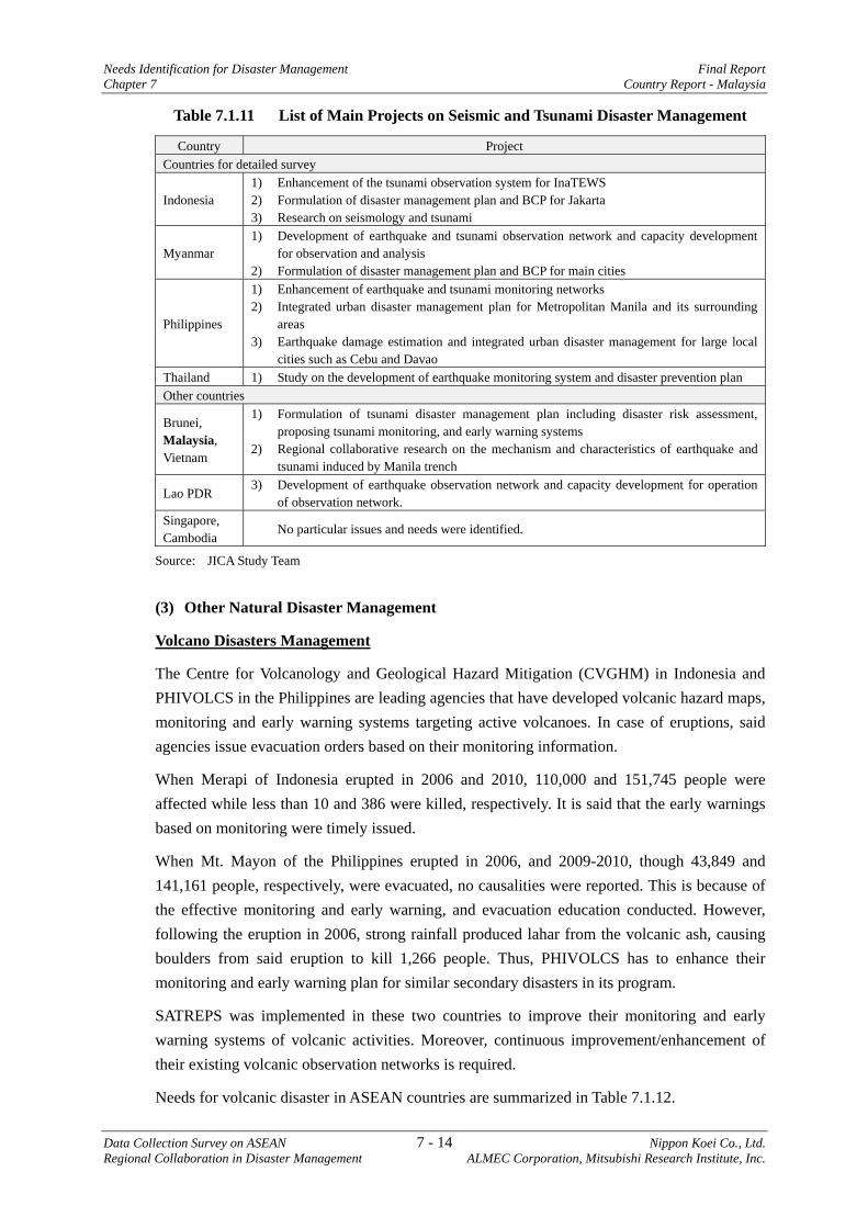
Needs Identification for Disaster Management Final Report Chapter 7 Country Report - Malaysia
Data Collection Survey on ASEAN 7 - 14 Nippon Koei Co., Ltd. Regional Collaboration in Disaster Management ALMEC Corporation, Mitsubishi Research Institute, Inc.
Table 7.1.11 List of Main Projects on Seismic and Tsunami Disaster Management
Country Project Countries for detailed survey
Indonesia 1) Enhancement of the tsunami observation system for InaTEWS 2) Formulation of disaster management plan and BCP for Jakarta 3) Research on seismology and tsunami
Myanmar 1) Development of earthquake and tsunami observation network and capacity development
for observation and analysis 2) Formulation of disaster management plan and BCP for main cities
Philippines
1) Enhancement of earthquake and tsunami monitoring networks 2) Integrated urban disaster management plan for Metropolitan Manila and its surrounding
areas 3) Earthquake damage estimation and integrated urban disaster management for large local
cities such as Cebu and Davao Thailand 1) Study on the development of earthquake monitoring system and disaster prevention plan Other countries
Brunei, Malaysia, Vietnam
1) Formulation of tsunami disaster management plan including disaster risk assessment, proposing tsunami monitoring, and early warning systems
2) Regional collaborative research on the mechanism and characteristics of earthquake and tsunami induced by Manila trench
Lao PDR 3) Development of earthquake observation network and capacity development for operation
of observation network. Singapore, Cambodia
No particular issues and needs were identified.
Source: JICA Study Team
(3) Other Natural Disaster Management
Volcano Disasters Management
The Centre for Volcanology and Geological Hazard Mitigation (CVGHM) in Indonesia and PHIVOLCS in the Philippines are leading agencies that have developed volcanic hazard maps, monitoring and early warning systems targeting active volcanoes. In case of eruptions, said agencies issue evacuation orders based on their monitoring information.
When Merapi of Indonesia erupted in 2006 and 2010, 110,000 and 151,745 people were affected while less than 10 and 386 were killed, respectively. It is said that the early warnings based on monitoring were timely issued.
When Mt. Mayon of the Philippines erupted in 2006, and 2009-2010, though 43,849 and 141,161 people, respectively, were evacuated, no causalities were reported. This is because of the effective monitoring and early warning, and evacuation education conducted. However, following the eruption in 2006, strong rainfall produced lahar from the volcanic ash, causing boulders from said eruption to kill 1,266 people. Thus, PHIVOLCS has to enhance their monitoring and early warning plan for similar secondary disasters in its program.
SATREPS was implemented in these two countries to improve their monitoring and early warning systems of volcanic activities. Moreover, continuous improvement/enhancement of their existing volcanic observation networks is required.
Needs for volcanic disaster in ASEAN countries are summarized in Table 7.1.12.
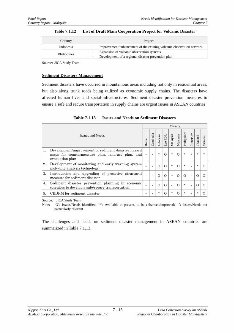
Final Report Needs Identification for Disaster Management Country Report - Malaysia Chapter 7
Nippon Koei Co., Ltd. 7 - 15 Data Collection Survey on ASEAN ALMEC Corporation, Mitsubishi Research Institute, Inc. Regional Collaboration in Disaster Management
Table 7.1.12 List of Draft Main Cooperation Project for Volcanic Disaster
Country Project
Indonesia - Improvement/enhancement of the existing volcanic observation network
Philippines - Expansion of volcanic observation systems - Development of a regional disaster prevention plan
Source: JICA Study Team
Sediment Disasters Management
Sediment disasters have occurred in mountainous areas including not only in residential areas, but also along trunk roads being utilized as economic supply chains. The disasters have affected human lives and social-infrastructures. Sediment disaster prevention measures to ensure a safe and secure transportation in supply chains are urgent issues in ASEAN countries
Table 7.1.13 Issues and Needs on Sediment Disasters
Issues and Needs
Country
Bru
nei
Cam
bodi
a
Indo
nesi
a
Lao
PDR
Mal
aysi
a
Mya
nmar
Phili
ppin
es
Sing
apor
e
Thai
land
Vie
tnam
1. Development/improvement of sediment disaster hazard maps for countermeasure plan, land-use plan, and evacuation plan
- - * O * O * - * *
2. Development of monitoring and early warning system including analysis technology - - O O * O * - * O
3. Introduction and upgrading of proactive structural measure for sediment disaster - - O O * O O - O O
4. Sediment disaster prevention planning in economic corridors to develop a safe/secure transportation - - O O - O * - O O
5. CBDRM for sediment disaster - - * O * O * - * O
Source: JICA Study Team Note: ‘O’: Issues/Needs identified; ‘*’: Available at present, to be enhanced/improved; ‘-’: Issues/Needs not
particularly relevant
The challenges and needs on sediment disaster management in ASEAN countries are summarized in Table 7.1.13.
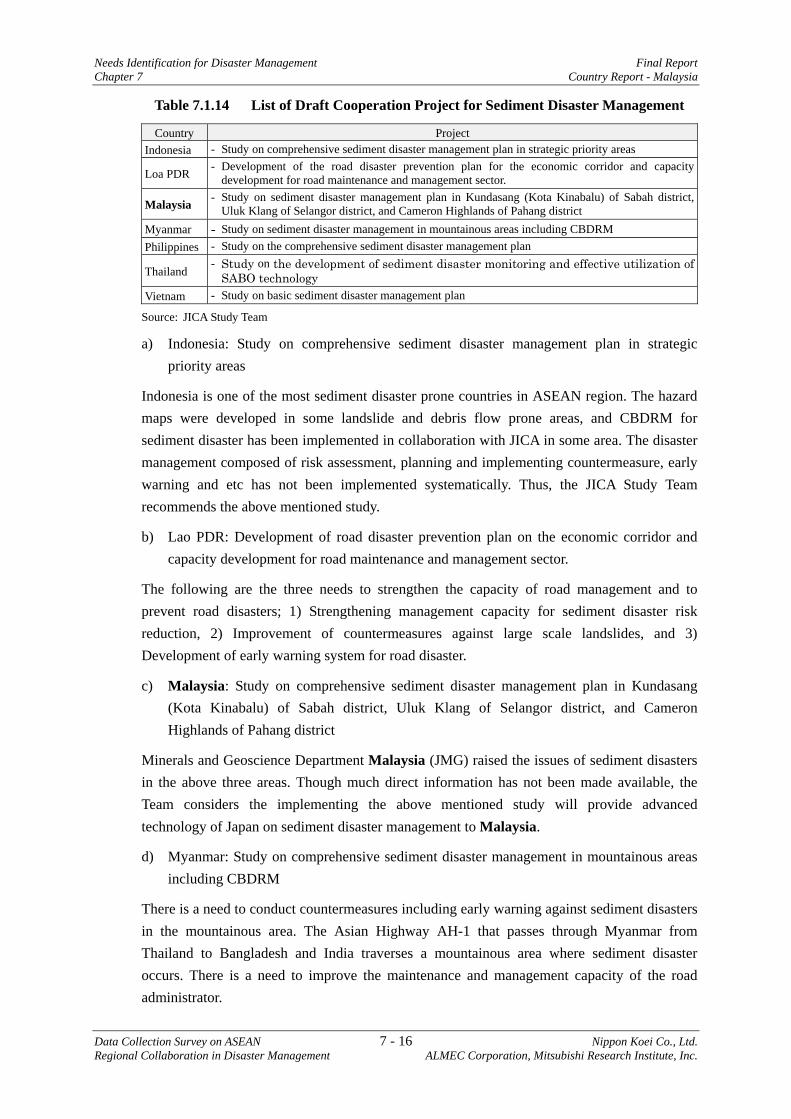
Needs Identification for Disaster Management Final Report Chapter 7 Country Report - Malaysia
Data Collection Survey on ASEAN 7 - 16 Nippon Koei Co., Ltd. Regional Collaboration in Disaster Management ALMEC Corporation, Mitsubishi Research Institute, Inc.
Table 7.1.14 List of Draft Cooperation Project for Sediment Disaster Management
Country Project Indonesia - Study on comprehensive sediment disaster management plan in strategic priority areas
Loa PDR - Development of the road disaster prevention plan for the economic corridor and capacity development for road maintenance and management sector.
Malaysia - Study on sediment disaster management plan in Kundasang (Kota Kinabalu) of Sabah district, Uluk Klang of Selangor district, and Cameron Highlands of Pahang district
Myanmar - Study on sediment disaster management in mountainous areas including CBDRM Philippines - Study on the comprehensive sediment disaster management plan
Thailand - Study on the development of sediment disaster monitoring and effective utilization of
SABO technology Vietnam - Study on basic sediment disaster management plan
Source: JICA Study Team
a) Indonesia: Study on comprehensive sediment disaster management plan in strategic priority areas
Indonesia is one of the most sediment disaster prone countries in ASEAN region. The hazard maps were developed in some landslide and debris flow prone areas, and CBDRM for sediment disaster has been implemented in collaboration with JICA in some area. The disaster management composed of risk assessment, planning and implementing countermeasure, early warning and etc has not been implemented systematically. Thus, the JICA Study Team recommends the above mentioned study.
b) Lao PDR: Development of road disaster prevention plan on the economic corridor and capacity development for road maintenance and management sector.
The following are the three needs to strengthen the capacity of road management and to prevent road disasters; 1) Strengthening management capacity for sediment disaster risk reduction, 2) Improvement of countermeasures against large scale landslides, and 3) Development of early warning system for road disaster.
c) Malaysia: Study on comprehensive sediment disaster management plan in Kundasang (Kota Kinabalu) of Sabah district, Uluk Klang of Selangor district, and Cameron Highlands of Pahang district
Minerals and Geoscience Department Malaysia (JMG) raised the issues of sediment disasters in the above three areas. Though much direct information has not been made available, the Team considers the implementing the above mentioned study will provide advanced technology of Japan on sediment disaster management to Malaysia.
d) Myanmar: Study on comprehensive sediment disaster management in mountainous areas including CBDRM
There is a need to conduct countermeasures including early warning against sediment disasters in the mountainous area. The Asian Highway AH-1 that passes through Myanmar from Thailand to Bangladesh and India traverses a mountainous area where sediment disaster occurs. There is a need to improve the maintenance and management capacity of the road administrator.
Final Report Needs Identification for Disaster Management Country Report - Malaysia Chapter 7
Nippon Koei Co., Ltd. 7 - 17 Data Collection Survey on ASEAN ALMEC Corporation, Mitsubishi Research Institute, Inc. Regional Collaboration in Disaster Management
e) Philippines: Study on the comprehensive sediment disaster management plan
The Mines and Geosciences Bureau (MGB) has developed a sediment disaster hazard map and conducted workshop and evacuation drill in areas susceptible to disasters. Consequently, it enlightened the community on disaster prevention. However, accuracy of the sediment disaster hazard map is so low due to small-scale base topographic map, which is not applicable for establishing a disaster prevention plan and evacuation plan. Monitoring system including early warning system has yet to be developed. Moreover, proactive countermeasures have not been constructed in disaster areas and thus, the main response is rehabilitation after disaster occurrence. There is a need to formulate a comprehensive sediment disaster prevention plan, where priority orders of areas susceptible to sediment disasters are decided based on the existing risk assessment. Based on the plan, improvement of the hazard map and implementation of structural and non-structural measures need to be conducted economically and effectively.
f) Thailand: Study on the development of sediment disaster monitoring and effective utilization of SABO technology
The CBDRM has been actively conducted in many communities in the mountainous areas. There are two needs to strengthen the sediment disaster management, namely, 1) Improvement of the existing monitoring system by introducing automatic observation instruments such as rainfall and river level gauge, and developing the criteria based on correlation between rainfall intensity and disaster occurrence; 2) Introduction of advanced technology on debris flow detection censor and countermeasures against the debris flow and landslides.
g) Vietnam: Study on basic sediment disaster management plan
Not much information was made available in Vietnam regarding sediment disaster management. SATREPS conducted research on disaster management in the central Vietnam. The Team considers that such assistance should be extended to other sediment disaster prone areas in Vietnam. The Study proposed will identify sediment disaster prone areas and prioritize such areas for implementation of disaster management projects.
7.1.3 Disaster Management, Early Warning and Disaster Education
The HFA-3 states that stakeholders need to use knowledge, innovation, and education to build a culture of safety and resilience at all levels. This section describes an overview of the current situation and challenges of each ASEAN country about disaster management information system and education for disaster prevention and mitigation.
(1) Knowledge Management - Disaster Management Information System (DMIS)
The DMIS is a system that supports disaster management planning and decision making effectively and timely for preparedness, emergency response, and recovery activities. Disaster management agencies should accumulate historical disaster data for conducting risk assessment in a normal situation. During emergency situations, such agencies shall issue early
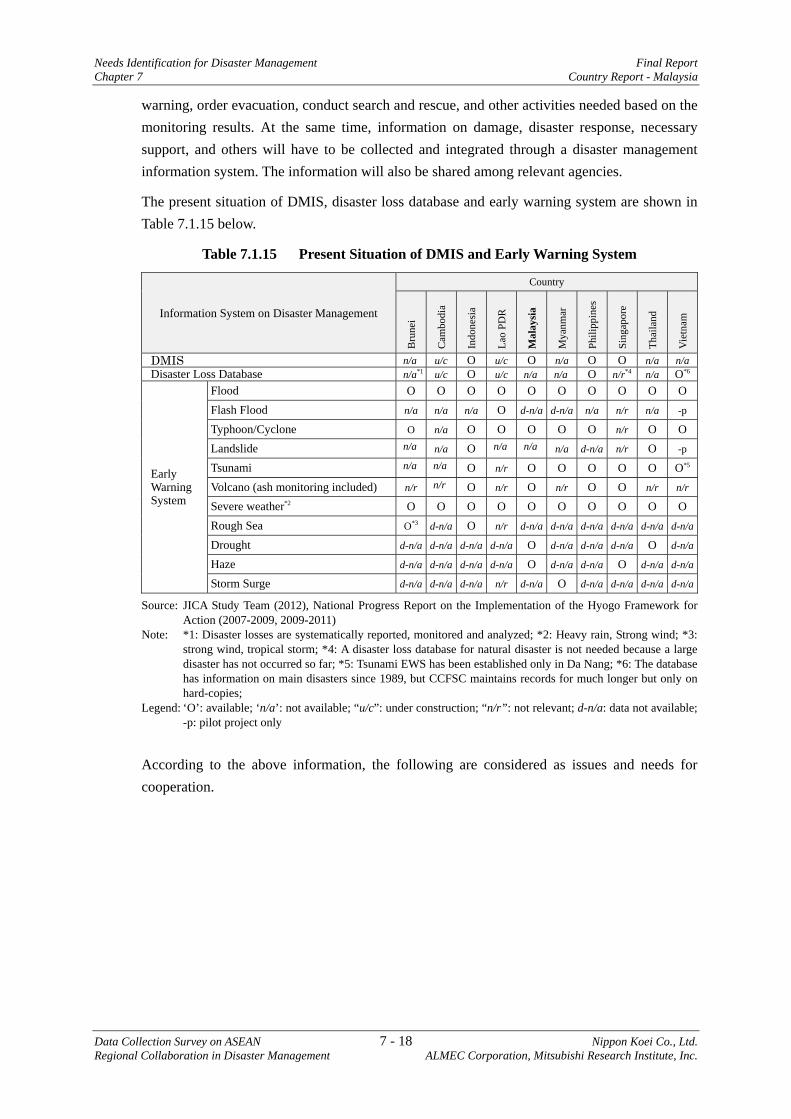
Needs Identification for Disaster Management Final Report Chapter 7 Country Report - Malaysia
Data Collection Survey on ASEAN 7 - 18 Nippon Koei Co., Ltd. Regional Collaboration in Disaster Management ALMEC Corporation, Mitsubishi Research Institute, Inc.
warning, order evacuation, conduct search and rescue, and other activities needed based on the monitoring results. At the same time, information on damage, disaster response, necessary support, and others will have to be collected and integrated through a disaster management information system. The information will also be shared among relevant agencies.
The present situation of DMIS, disaster loss database and early warning system are shown in Table 7.1.15 below.
Table 7.1.15 Present Situation of DMIS and Early Warning System
Information System on Disaster Management
Country
Bru
nei
Cam
bodi
a
Indo
nesi
a
Lao
PDR
Mal
aysi
a
Mya
nmar
Phili
ppin
es
Sing
apor
e
Thai
land
Vie
tnam
DMIS n/a u/c O u/c O n/a O O n/a n/aDisaster Loss Database n/a*1 u/c O u/c n/a n/a O n/r*4 n/a O*6
Early Warning System
Flood O O O O O O O O O OFlash Flood n/a n/a n/a O d-n/a d-n/a n/a n/r n/a -p
Typhoon/Cyclone O n/a O O O O O n/r O OLandslide n/a n/a O n/a n/a n/a d-n/a n/r O -p
Tsunami n/a n/a O n/r O O O O O O*5
Volcano (ash monitoring included) n/r n/r O n/r O n/r O O n/r n/r
Severe weather*2 O O O O O O O O O ORough Sea O*3 d-n/a O n/r d-n/a d-n/a d-n/a d-n/a d-n/a d-n/a
Drought d-n/a d-n/a d-n/a d-n/a O d-n/a d-n/a d-n/a O d-n/a
Haze d-n/a d-n/a d-n/a d-n/a O d-n/a d-n/a O d-n/a d-n/a
Storm Surge d-n/a d-n/a d-n/a n/r d-n/a O d-n/a d-n/a d-n/a d-n/a
Source: JICA Study Team (2012), National Progress Report on the Implementation of the Hyogo Framework for Action (2007-2009, 2009-2011)
Note: *1: Disaster losses are systematically reported, monitored and analyzed; *2: Heavy rain, Strong wind; *3: strong wind, tropical storm; *4: A disaster loss database for natural disaster is not needed because a large disaster has not occurred so far; *5: Tsunami EWS has been established only in Da Nang; *6: The database has information on main disasters since 1989, but CCFSC maintains records for much longer but only on hard-copies;
Legend: ‘O’: available; ‘n/a’: not available; “u/c”: under construction; “n/r”: not relevant; d-n/a: data not available; -p: pilot project only
According to the above information, the following are considered as issues and needs for cooperation.

Final Report Needs Identification for Disaster Management Country Report - Malaysia Chapter 7
Nippon Koei Co., Ltd. 7 - 19 Data Collection Survey on ASEAN ALMEC Corporation, Mitsubishi Research Institute, Inc. Regional Collaboration in Disaster Management
Table 7.1.16 Issues and Needs for DMIS5
Issues and Needs Country Bilateral/ ASEAN Regional Cooperation Development of Disaster Management Information System
Brunei Myanmar Philippines*a (Thailand)*b Vietnam
1. Bilateral cooperation - Development of disaster management information system based on GIS.
2. ASEAN cooperation - (proposed in the other section called “ADMIS”)
Development of DMIS
Brunei (Malaysia)*b Myanmar Vietnam
1. Bilateral cooperation - Establishment of a mechanism for collecting and accumulating disaster
loss data. - Development of disaster loss database and sharing system.
2. ASEAN cooperation - Improvement of ASEAN DRR Portal and accumulating disaster loss data
of each county. (Lead organization: ASEAN Secretariat and/or AHA Centre)
- Development of disaster loss database and sharing system for ASEAN Region. (Lead organization: AHA Centre)
Source: JICA Study Team Note: *a: Available DMIS is not GIS basis; *b: The countries are considered to be capable to establish it by
herself.
(2) Education for Disaster Prevention and Mitigation
Disaster education is necessary to raise people’s awareness on disaster management in general. Knowledge on disasters such as scientific information, simulating earthquake intensities by shaking tables, and evacuation drills should be practiced in schools, communities, and private sectors. It is important to know how to respond to disaster in order to save own lives during its occurrence. Moreover, it is also important to promote cooperation during emergency cases as a family or community unit, in order to achieve possible evacuation support, maintain evacuation sites, manage social safety, and so on.
School education serves as basic public disaster education. In order to promote school education on disaster management, education system needs to be developed systematically such as enhancement of school curriculum, textbooks, and other necessary materials.
Several ASEAN countries already prepared these education materials including pamphlets, posters, and videos. NGOs are supporting the preparation of education materials and community education.
For effective disaster education, the following items will be developed:
a) Teaching guidelines and teacher’s training, b) Education materials according to grade level, c) Disaster simulator for earthquake, and smoke/fire extinguisher training, and d) Regular disaster drill in schools.
In addition to school disaster education, community education is also necessary based on CBDRM. Interchange of disaster knowledge and sharing information among communities are
5 All the views are attributed to JICA Study Team.
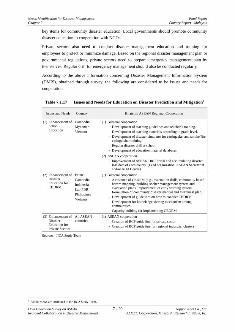
Needs Identification for Disaster Management Final Report Chapter 7 Country Report - Malaysia
Data Collection Survey on ASEAN 7 - 20 Nippon Koei Co., Ltd. Regional Collaboration in Disaster Management ALMEC Corporation, Mitsubishi Research Institute, Inc.
key items for community disaster education. Local governments should promote community disaster education in cooperation with NGOs.
Private sectors also need to conduct disaster management education and training for employees to protect or minimize damage. Based on the regional disaster management plan or governmental regulations, private sectors need to prepare emergency management plan by themselves. Regular drill for emergency management should also be conducted regularly.
According to the above information concerning Disaster Management Information System (DMIS), obtained through survey, the following are considered to be issues and needs for cooperation.
Table 7.1.17 Issues and Needs for Education on Disaster Prediction and Mitigation6
Issues and Needs Country Bilateral/ ASEAN Regional Cooperation
(1) Enhancement of School Education
Cambodia Myanmar Vietnam
(1) Bilateral cooperation - Development of teaching guidelines and teacher’s training. - Development of teaching materials according to grade level. - Development of disaster simulator for earthquake, and smoke/fire
extinguisher training. - Regular disaster drill at school. - Development of education material databases.
(2) ASEAN cooperation - Improvement of ASEAN DRR Portal and accumulating disaster
loss data of each county. (Lead organization: ASEAN Secretariat and/or AHA Centre)
(2) Enhancement of Disaster Education for CBDRM
Brunei Cambodia Indonesia Lao PDR Philippines Vietnam
(1) Bilateral cooperation - Assistance of CBDRM (e.g., evacuation drills, community based
hazard mapping, building shelter management system and evacuation plans, improvement of early warning system, formulation of community disaster manual and awareness plan)
- Development of guidelines on how to conduct CBDRM. - Development for knowledge sharing mechanism among
communities. - Capacity building for implementing CBDRM
(3) Enhancement of Disaster Education for Private Sectors
All ASEAN countries
(1) ASEAN cooperation - Creation of BCP guide line for private sector. - Creation of BCP guide line for regional industrial clusters
Source: JICA Study Team
6 All the views are attributed to the JICA Study Team.
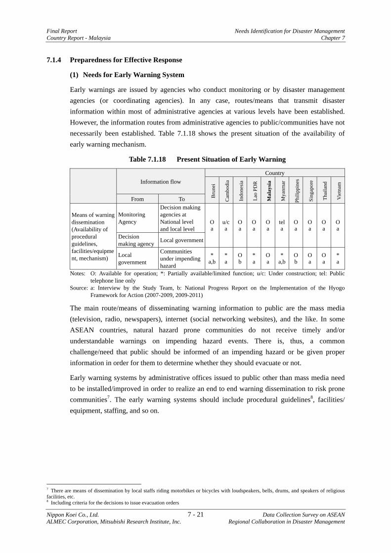
Final Report Needs Identification for Disaster Management Country Report - Malaysia Chapter 7
Nippon Koei Co., Ltd. 7 - 21 Data Collection Survey on ASEAN ALMEC Corporation, Mitsubishi Research Institute, Inc. Regional Collaboration in Disaster Management
7.1.4 Preparedness for Effective Response
(1) Needs for Early Warning System
Early warnings are issued by agencies who conduct monitoring or by disaster management agencies (or coordinating agencies). In any case, routes/means that transmit disaster information within most of administrative agencies at various levels have been established. However, the information routes from administrative agencies to public/communities have not necessarily been established. Table 7.1.18 shows the present situation of the availability of early warning mechanism.
Table 7.1.18 Present Situation of Early Warning
Information flow
Country
Bru
nei
Cam
bodi
a
Indo
nesi
a
Lao
PDR
Mal
aysi
a
Mya
nmar
Phili
ppin
es
Sing
apor
e
Thai
land
Vie
tnam
From To
Means of warning dissemination (Availability of procedural guidelines, facilities/equipment, mechanism)
Monitoring Agency
Decision making agencies at National level and local level
Oa
u/ca
Oa
Oa
Oa
tel a
O a
O a
Oa
Oa
Decision making agency Local government
Local government
Communities under impending hazard
*a,b
*a
Ob
*a
Oa
* a,b
O b
O a
Oa
*a
Notes: O: Available for operation; *: Partially available/limited function; u/c: Under construction; tel: Public telephone line only
Source: a: Interview by the Study Team, b: National Progress Report on the Implementation of the Hyogo Framework for Action (2007-2009, 2009-2011)
The main route/means of disseminating warning information to public are the mass media (television, radio, newspapers), internet (social networking websites), and the like. In some ASEAN countries, natural hazard prone communities do not receive timely and/or understandable warnings on impending hazard events. There is, thus, a common challenge/need that public should be informed of an impending hazard or be given proper information in order for them to determine whether they should evacuate or not.
Early warning systems by administrative offices issued to public other than mass media need to be installed/improved in order to realize an end to end warning dissemination to risk prone communities7. The early warning systems should include procedural guidelines8, facilities/ equipment, staffing, and so on.
7 There are means of dissemination by local staffs riding motorbikes or bicycles with loudspeakers, bells, drums, and speakers of religious facilities, etc. 8 Including criteria for the decisions to issue evacuation orders
Needs Identification for Disaster Management Final Report Chapter 7 Country Report - Malaysia
Data Collection Survey on ASEAN 7 - 22 Nippon Koei Co., Ltd. Regional Collaboration in Disaster Management ALMEC Corporation, Mitsubishi Research Institute, Inc.
Table 7.1.19 Needs for Early Warning Country Needs
Brunei9, Cambodia10, Lao PDR11, Myanmar12 Vietnam13
- Development means of early warning (procedural guidelines and/or facilities/equipment, mechanism) , from government agencies to communities;
- Implementation of CBDRM
Source: JICA Study Team
Recently, possibly due to the prevailing climate change, flash floods occur more frequently in various areas in the world. This is also an impending issue for disaster management. Efforts have been made in various countries to predict such flash floods, though needs to be established firmly. Concurrently, with the efforts for prediction, effective and timely early warning systems should be established for flash floods.
It has also been identified that there will be significant scales of earthquakes that could happen at ocean trenches of western and southwestern islands of the Philippines. Such earthquakes are considered to trigger considerable scale of tsunamis that may reach surrounding countries like the Philippines, Malaysia (Saba, Sarawak), Brunei, Indonesia, and Vietnam facing South China Sea, Sulu Sea, and Celebs Sea.
A concentrated research on earthquake and tsunami, hazard mapping, and so on needs to be conducted.
At the same time, tsunami early warning systems should be installed in those coastal areas together with formulation of (tsunami) disaster management plan including public awareness programs, evacuation exercises and so on.
9 According to interview survey to Tutong District Office by the JICA Study Team (2012) 10 Interview survey to NCDM (Cambodia) by the JICA Study Team 11 Proposed by the JICA Study Team based on the interview with MDMO (Lao PDR) 12 Proposed by the JICA Study Team based on the interview with MDPA (Myanmar) 13 Proposed by the JICA Study Team based on the interview with DDMFSC (Vietnam)
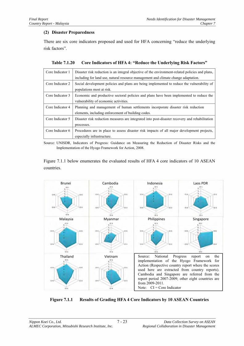
Final Report Needs Identification for Disaster Management
Country Report - Malaysia Chapter 7
Nippon Koei Co., Ltd. 7 - 23 Data Collection Survey on ASEAN
ALMEC Corporation, Mitsubishi Research Institute, Inc. Regional Collaboration in Disaster Management
(2) Disaster Preparedness
There are six core indicators proposed and used for HFA concerning “reduce the underlying risk factors”.
Table 7.1.20 Core Indicators of HFA 4: “Reduce the Underlying Risk Factors”
Core Indicator 1 Disaster risk reduction is an integral objective of the environment-related policies and plans, including for land use, natural resource management and climate change adaptation.
Core Indicator 2 Social development policies and plans are being implemented to reduce the vulnerability of populations most at risk.
Core Indicator 3 Economic and productive sectoral policies and plans have been implemented to reduce the vulnerability of economic activities.
Core Indicator 4 Planning and management of human settlements incorporate disaster risk reduction elements, including enforcement of building codes.
Core Indicator 5 Disaster risk reduction measures are integrated into post-disaster recovery and rehabilitation processes.
Core Indicator 6 Procedures are in place to assess disaster risk impacts of all major development projects, especially infrastructure.
Source: UNISDR, Indicators of Progress: Guidance on Measuring the Reduction of Disaster Risks and the Implementation of the Hyogo Framework for Action, 2008.
Figure 7.1.1 below enumerates the evaluated results of HFA 4 core indicators of 10 ASEAN countries.
Thailand
Malaysia
Vietnam
Philippines Singapore Myanmar
Brunei Cambodia Indonesia Laos PDR
Source: National Progress report on the implementation of the Hyogo Framework for Action (Respective country report where the scores used here are extracted from country reports). Cambodia and Singapore are referred from the report period 2007-2009; other eight countries are from 2009-2011. Note: CI = Core Indicator
Figure 7.1.1 Results of Grading HFA 4 Core Indicators by 10 ASEAN Countries
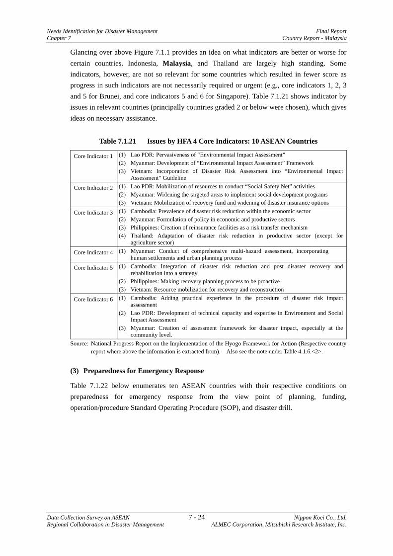
Needs Identification for Disaster Management Final Report Chapter 7 Country Report - Malaysia
Data Collection Survey on ASEAN 7 - 24 Nippon Koei Co., Ltd. Regional Collaboration in Disaster Management ALMEC Corporation, Mitsubishi Research Institute, Inc.
Glancing over above Figure 7.1.1 provides an idea on what indicators are better or worse for certain countries. Indonesia, Malaysia, and Thailand are largely high standing. Some indicators, however, are not so relevant for some countries which resulted in fewer score as progress in such indicators are not necessarily required or urgent (e.g., core indicators 1, 2, 3 and 5 for Brunei, and core indicators 5 and 6 for Singapore). Table 7.1.21 shows indicator by issues in relevant countries (principally countries graded 2 or below were chosen), which gives ideas on necessary assistance.
Table 7.1.21 Issues by HFA 4 Core Indicators: 10 ASEAN Countries
Core Indicator 1 (1) Lao PDR: Pervasiveness of “Environmental Impact Assessment” (2) Myanmar: Development of “Environmental Impact Assessment” Framework (3) Vietnam: Incorporation of Disaster Risk Assessment into “Environmental Impact
Assessment” Guideline
Core Indicator 2 (1) Lao PDR: Mobilization of resources to conduct “Social Safety Net” activities (2) Myanmar: Widening the targeted areas to implement social development programs (3) Vietnam: Mobilization of recovery fund and widening of disaster insurance options
Core Indicator 3 (1) Cambodia: Prevalence of disaster risk reduction within the economic sector (2) Myanmar: Formulation of policy in economic and productive sectors (3) Philippines: Creation of reinsurance facilities as a risk transfer mechanism (4) Thailand: Adaptation of disaster risk reduction in productive sector (except for
agriculture sector)
Core Indicator 4 (1) Myanmar: Conduct of comprehensive multi-hazard assessment, incorporating human settlements and urban planning process
Core Indicator 5 (1) Cambodia: Integration of disaster risk reduction and post disaster recovery and rehabilitation into a strategy
(2) Philippines: Making recovery planning process to be proactive (3) Vietnam: Resource mobilization for recovery and reconstruction
Core Indicator 6 (1) Cambodia: Adding practical experience in the procedure of disaster risk impact assessment
(2) Lao PDR: Development of technical capacity and expertise in Environment and Social Impact Assessment
(3) Myanmar: Creation of assessment framework for disaster impact, especially at the community level.
Source: National Progress Report on the Implementation of the Hyogo Framework for Action (Respective country report where above the information is extracted from). Also see the note under Table 4.1.6.<2>.
(3) Preparedness for Emergency Response
Table 7.1.22 below enumerates ten ASEAN countries with their respective conditions on preparedness for emergency response from the view point of planning, funding, operation/procedure Standard Operating Procedure (SOP), and disaster drill.
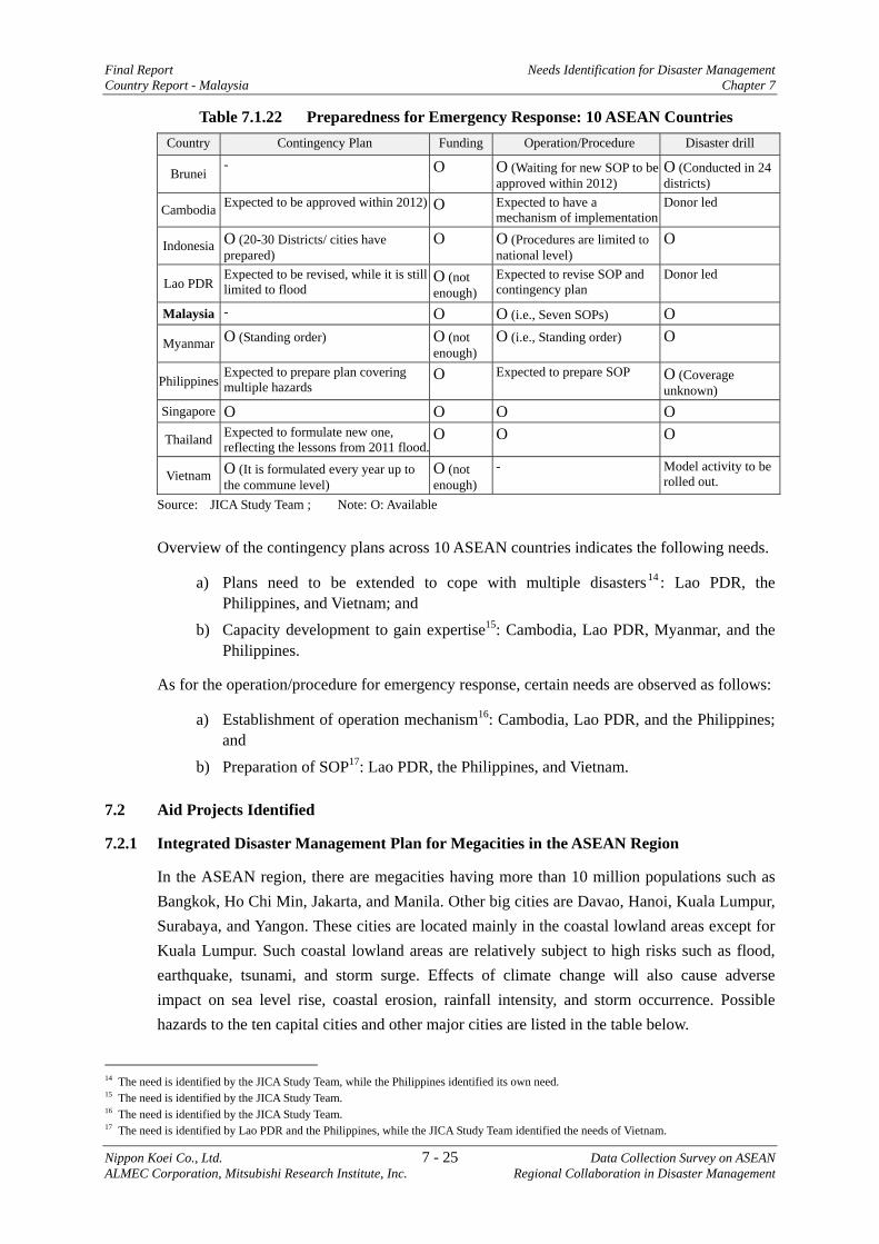
Final Report Needs Identification for Disaster Management Country Report - Malaysia Chapter 7
Nippon Koei Co., Ltd. 7 - 25 Data Collection Survey on ASEAN ALMEC Corporation, Mitsubishi Research Institute, Inc. Regional Collaboration in Disaster Management
Table 7.1.22 Preparedness for Emergency Response: 10 ASEAN Countries Country Contingency Plan Funding Operation/Procedure Disaster drill
Brunei - O O (Waiting for new SOP to be
approved within 2012) O (Conducted in 24 districts)
Cambodia Expected to be approved within 2012) O Expected to have a mechanism of implementation
Donor led
Indonesia O (20-30 Districts/ cities have prepared)
O O (Procedures are limited to national level)
O
Lao PDR Expected to be revised, while it is still limited to flood
O (not enough)
Expected to revise SOP and contingency plan
Donor led
Malaysia - O O (i.e., Seven SOPs) O
Myanmar O (Standing order) O (not enough)
O (i.e., Standing order) O
Philippines Expected to prepare plan covering multiple hazards
O Expected to prepare SOP O (Coverage unknown)
Singapore O O O O
Thailand Expected to formulate new one, reflecting the lessons from 2011 flood.
O O O
Vietnam O (It is formulated every year up to the commune level)
O (not enough)
- Model activity to be rolled out.
Source: JICA Study Team ; Note: O: Available
Overview of the contingency plans across 10 ASEAN countries indicates the following needs.
a) Plans need to be extended to cope with multiple disasters14 : Lao PDR, the Philippines, and Vietnam; and
b) Capacity development to gain expertise15: Cambodia, Lao PDR, Myanmar, and the Philippines.
As for the operation/procedure for emergency response, certain needs are observed as follows:
a) Establishment of operation mechanism16: Cambodia, Lao PDR, and the Philippines; and
b) Preparation of SOP17: Lao PDR, the Philippines, and Vietnam.
7.2 Aid Projects Identified
7.2.1 Integrated Disaster Management Plan for Megacities in the ASEAN Region
In the ASEAN region, there are megacities having more than 10 million populations such as Bangkok, Ho Chi Min, Jakarta, and Manila. Other big cities are Davao, Hanoi, Kuala Lumpur, Surabaya, and Yangon. These cities are located mainly in the coastal lowland areas except for Kuala Lumpur. Such coastal lowland areas are relatively subject to high risks such as flood, earthquake, tsunami, and storm surge. Effects of climate change will also cause adverse impact on sea level rise, coastal erosion, rainfall intensity, and storm occurrence. Possible hazards to the ten capital cities and other major cities are listed in the table below.
14 The need is identified by the JICA Study Team, while the Philippines identified its own need. 15 The need is identified by the JICA Study Team. 16 The need is identified by the JICA Study Team. 17 The need is identified by Lao PDR and the Philippines, while the JICA Study Team identified the needs of Vietnam.
Needs Identification for Disaster Management Final Report Chapter 7 Country Report - Malaysia
Data Collection Survey on ASEAN 7 - 26 Nippon Koei Co., Ltd. Regional Collaboration in Disaster Management ALMEC Corporation, Mitsubishi Research Institute, Inc.
Among the megacities, Jakarta, Yangon, Manila and Bangkok should be highlighted from multi-hazard point of view.
In Jakarta, accumulation of social and economic infrastructure is so huge at present. Java Island is located in an earthquake prone area; however, detailed earthquake damage estimation and disaster management plan have not been prepared yet. In order to avoid or minimize earthquake disaster damage, earthquake disaster management plan shall at least be prepared at the soonest. Flooding is also a long lasting issue of this city. Rapid urbanization including excessive groundwater extraction ground subsidence has led to frequent and severe flooding, resulting in frequent disruption of capital functions. A comprehensive and integrated disaster management plan will therefore be needed. This is also necessary for risk management of business continuity with international investors.
Yangon is one of the hottest cities in the world in terms of economic investment. It is expected that its present population of 6 million will increase to 12 million by year 2030. Rapid urbanization will be unavoidable. It is understood that development master plan studies are in the pipe lines for urban development plan, water supply and drainage plan and plan for transportation sector. These master plan studies will incorporate factors of possible natural hazards. However, because Yangon is exposed to various types of hazard such as earthquake/tsunami originated by the Sagaing active fault, urban type floods prevailing even now, and storm surge such as Cyclone Nargis, comprehensive and integrated disaster management plan is considered to be indispensable, based on scientific hazard identification, risk and impact assessments.
In Manila, urbanization of its metropolitan area has extended to the north and south. Population of Mega Manila will soon reach 25 million including Bulacan, Marikina, Laguna, Rizal, and Cavite. Under this circumstance, the existing earthquake disaster management plan needs to be reviewed and updated based on recent statistics. Also, surrounding urbanized areas of Metropolitan Manila need to be included in this review. It is noted that Manila suffered from strong typhoon causing big flood disasters in 2009 and 2011, including the one caused by Typhoon Ondoy in 2009, which is compounded with storm surge. Flood disaster management is also important and necessary, especially in Metropolitan Manila. Although it is understood that a study on urban flood management in Metropolitan Manila is being conducted, a comprehensive and integrated disaster risk reduction management plan will be needed, taking into consideration the above-mentioned complexity caused by multi-hazard risks.
In Bangkok, after experiencing huge flood disaster in 2011, various disaster management plans for flood risk management are being prepared. However, it is also understood that the ground subsidence being caused by groundwater extraction has worsened the situation. Further, storm surge in coastal area has become a main challenging issue in addition to the risk from tsunami. Under this circumstance, comprehensive and integrated disaster risk reduction management will be needed as well for Bangkok.
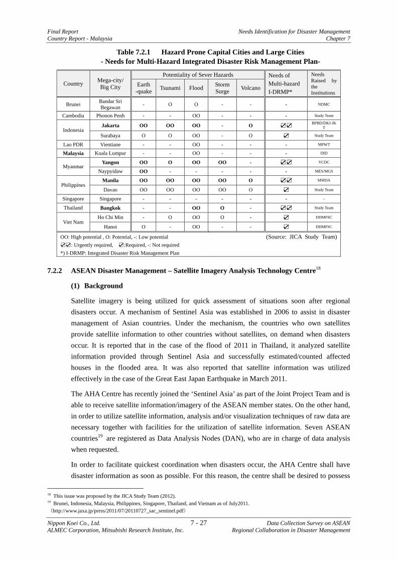
Final Report Needs Identification for Disaster Management Country Report - Malaysia Chapter 7
Nippon Koei Co., Ltd. 7 - 27 Data Collection Survey on ASEAN ALMEC Corporation, Mitsubishi Research Institute, Inc. Regional Collaboration in Disaster Management
Table 7.2.1 Hazard Prone Capital Cities and Large Cities - Needs for Multi-Hazard Integrated Disaster Risk Management Plan-
Country Mega-city/ Big City
Potentiality of Sever Hazards Needs of Multi-hazard I-DRMP*
Needs Raised by the Institutions
Earth -quake Tsunami Flood Storm
Surge Volcano
Brunei Bandar Sri Begawan - O O - - - NDMC
Cambodia Phonon Penh - - OO - - - Study Team
Indonesia Jakarta OO OO OO - O ☑☑ BPBD/DKI-JK
T
Surabaya O O OO - O ☑ Study Team
Lao PDR Vientiane - - OO - - - MPWT
Malaysia Kuala Lumpur - - OO - - - DID
Myanmar Yangon OO O OO OO - ☑☑ YCDC
Naypyidaw OO - - - - - MES/MGS
Philippines Manila OO OO OO OO O ☑☑ MMDA
Davao OO OO OO OO O ☑ Study Team
Singapore Singapore - - - - - - -
Thailand Bangkok - - OO O - ☑☑ Study Team
Viet Nam Ho Chi Min - O OO O - ☑ DDMFSC
Hanoi O - OO - - ☑ DDMFSC
OO: High potential , O: Potential, -: Low potential ☑☑: Urgently required, ☑:Required, -: Not required *) I-DRMP: Integrated Disaster Risk Management Plan
(Source: JICA Study Team)
7.2.2 ASEAN Disaster Management – Satellite Imagery Analysis Technology Centre18
(1) Background
Satellite imagery is being utilized for quick assessment of situations soon after regional disasters occur. A mechanism of Sentinel Asia was established in 2006 to assist in disaster management of Asian countries. Under the mechanism, the countries who own satellites provide satellite information to other countries without satellites, on demand when disasters occur. It is reported that in the case of the flood of 2011 in Thailand, it analyzed satellite information provided through Sentinel Asia and successfully estimated/counted affected houses in the flooded area. It was also reported that satellite information was utilized effectively in the case of the Great East Japan Earthquake in March 2011.
The AHA Centre has recently joined the ‘Sentinel Asia’ as part of the Joint Project Team and is able to receive satellite information/imagery of the ASEAN member states. On the other hand, in order to utilize satellite information, analysis and/or visualization techniques of raw data are necessary together with facilities for the utilization of satellite information. Seven ASEAN countries19 are registered as Data Analysis Nodes (DAN), who are in charge of data analysis when requested.
In order to facilitate quickest coordination when disasters occur, the AHA Centre shall have disaster information as soon as possible. For this reason, the centre shall be desired to possess
18 This issue was proposed by the JICA Study Team (2012). 19 Brunei, Indonesia, Malaysia, Philippines, Singapore, Thailand, and Vietnam as of July2011.(http://www.jaxa.jp/press/2011/07/20110727_sac_sentinel.pdf)
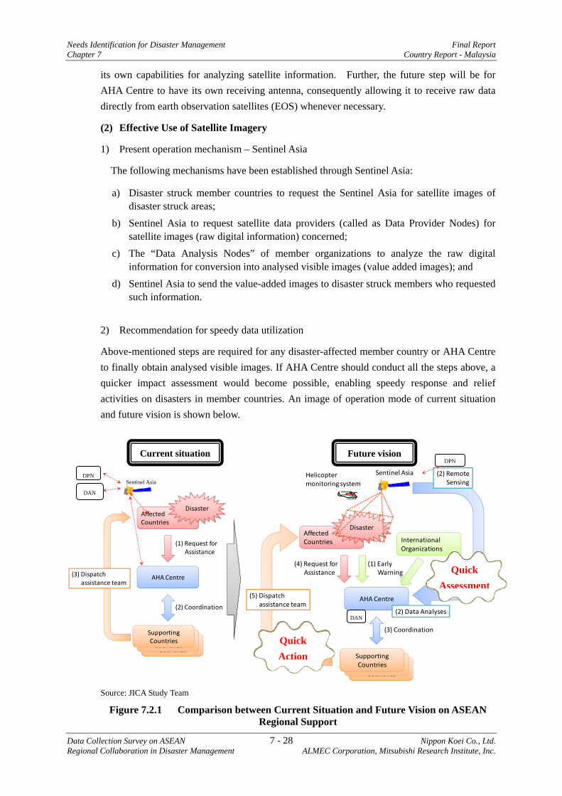
Needs Identification for Disaster Management Final Report Chapter 7 Country Report - Malaysia
Data Collection Survey on ASEAN 7 - 28 Nippon Koei Co., Ltd. Regional Collaboration in Disaster Management ALMEC Corporation, Mitsubishi Research Institute, Inc.
its own capabilities for analyzing satellite information. Further, the future step will be for AHA Centre to have its own receiving antenna, consequently allowing it to receive raw data directly from earth observation satellites (EOS) whenever necessary.
(2) Effective Use of Satellite Imagery
1) Present operation mechanism – Sentinel Asia
The following mechanisms have been established through Sentinel Asia:
a) Disaster struck member countries to request the Sentinel Asia for satellite images of disaster struck areas;
b) Sentinel Asia to request satellite data providers (called as Data Provider Nodes) for satellite images (raw digital information) concerned;
c) The “Data Analysis Nodes” of member organizations to analyze the raw digital information for conversion into analysed visible images (value added images); and
d) Sentinel Asia to send the value-added images to disaster struck members who requested such information.
2) Recommendation for speedy data utilization
Above-mentioned steps are required for any disaster-affected member country or AHA Centre to finally obtain analysed visible images. If AHA Centre should conduct all the steps above, a quicker impact assessment would become possible, enabling speedy response and relief activities on disasters in member countries. An image of operation mode of current situation and future vision is shown below.
Source: JICA Study Team
Figure 7.2.1 Comparison between Current Situation and Future Vision on ASEAN Regional Support
Affected Countries
AHA Centre
Disaster
Supporting Countries
Supporting Countries
Supporting Countries
(1) Request for Assistance
(2) Coordination
(3) Dispatch assistance team
Affected Countries
AHA Centre
Disaster
Supporting Countries
Supporting Countries
Supporting Countries
(3) Coordination
Sentinel AsiaHelicoptermonitoring system
(4) Request for Assistance
InternationalOrganizations
(1) EarlyWarning
(5) Dispatch assistance team
(2) RemoteSensing
(2) Data Analyses
Current situation Future vision
Quick Action
Quick Assessment
DPN
DAN
Sentinel Asia
DPN
DAN
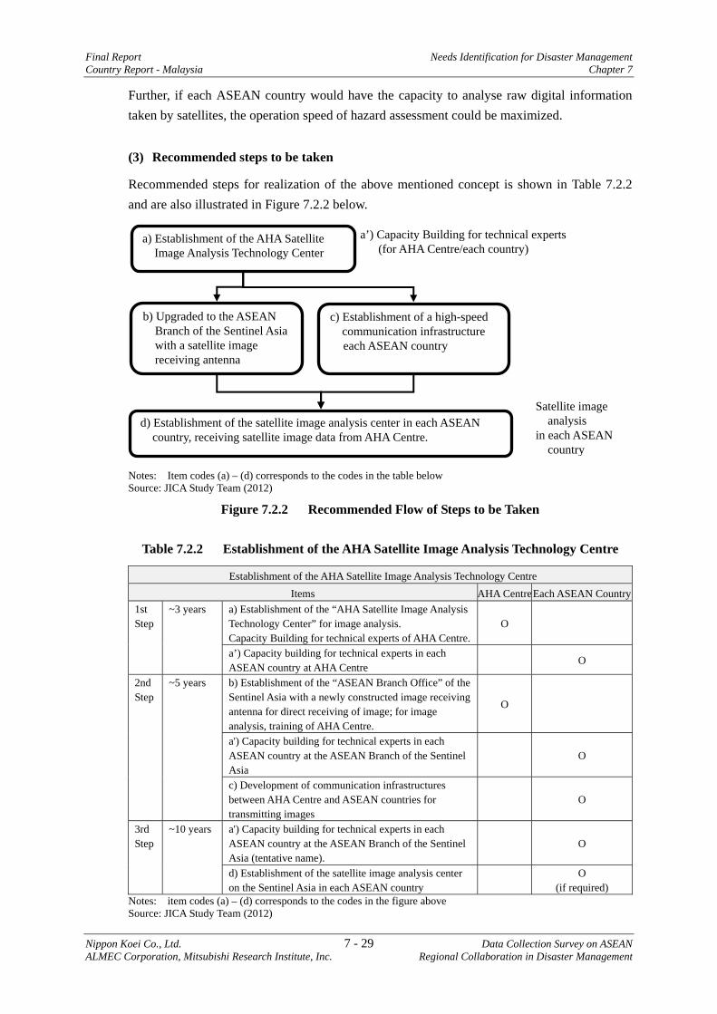
Final Report Needs Identification for Disaster Management Country Report - Malaysia Chapter 7
Nippon Koei Co., Ltd. 7 - 29 Data Collection Survey on ASEAN ALMEC Corporation, Mitsubishi Research Institute, Inc. Regional Collaboration in Disaster Management
Further, if each ASEAN country would have the capacity to analyse raw digital information taken by satellites, the operation speed of hazard assessment could be maximized.
(3) Recommended steps to be taken
Recommended steps for realization of the above mentioned concept is shown in Table 7.2.2 and are also illustrated in Figure 7.2.2 below.
Notes: Item codes (a) – (d) corresponds to the codes in the table below Source: JICA Study Team (2012)
Figure 7.2.2 Recommended Flow of Steps to be Taken
Table 7.2.2 Establishment of the AHA Satellite Image Analysis Technology Centre
Establishment of the AHA Satellite Image Analysis Technology Centre Items AHA CentreEach ASEAN Country
1st Step
~3 years
a) Establishment of the “AHA Satellite Image Analysis Technology Center” for image analysis. Capacity Building for technical experts of AHA Centre.
O
a’) Capacity building for technical experts in each ASEAN country at AHA Centre
O
2nd Step
~5 years
b) Establishment of the “ASEAN Branch Office” of the Sentinel Asia with a newly constructed image receiving antenna for direct receiving of image; for image analysis, training of AHA Centre.
O
a') Capacity building for technical experts in each ASEAN country at the ASEAN Branch of the Sentinel Asia
O
c) Development of communication infrastructures between AHA Centre and ASEAN countries for transmitting images
O
3rd Step
~10 years
a') Capacity building for technical experts in each ASEAN country at the ASEAN Branch of the Sentinel Asia (tentative name).
O
d) Establishment of the satellite image analysis center on the Sentinel Asia in each ASEAN country
O
(if required) Notes: item codes (a) – (d) corresponds to the codes in the figure above Source: JICA Study Team (2012)
a) Establishment of the AHA Satellite Image Analysis Technology Center
b) Upgraded to the ASEAN Branch of the Sentinel Asia with a satellite image receiving antenna
a’) Capacity Building for technical experts (for AHA Centre/each country)
c) Establishment of a high-speed communication infrastructure each ASEAN country
d) Establishment of the satellite image analysis center in each ASEAN country, receiving satellite image data from AHA Centre.
Satellite image analysis
in each ASEAN country
Needs Identification for Disaster Management Final Report Chapter 7 Country Report - Malaysia
Data Collection Survey on ASEAN 7 - 30 Nippon Koei Co., Ltd. Regional Collaboration in Disaster Management ALMEC Corporation, Mitsubishi Research Institute, Inc.
(4) Input needed
The following inputs will be required for the establishment of the AHA Satellite Image Analysis Technology Center:
Table 7.2.3 Inputs Required for the Establishment of the AHA Satellite Image Analysis Technology Center
Step Goal Input required
First Step To introduce satellite image analysis technology to the AHA Centre
a. Provide equipment for data analysis and relevant computer software
b. Dispatch experts on satellite image analysis to AHA Centre (a number of short period assignment)
c. Invite experts from ASEAN member countries for training on satellite image analysis (a number of short period training)
d. Employ experts to AHA Centre who are in charge of satellite image analysis
Second Step
For the AHA Centre to upgrade to “ASEAN Branch of Sentinel Asia” with own satellite data receiving antenna
a. Expand/enforce the function of the the satellite image analysis center
b. Construct a data receiving antenna and provide necessary equipment
c. Continue training to AHA Centre and the ASEAN member countries
For ten ASEAN member states to be connected with high-speed communication infrastructure
a. Provide high-speed communication infrastructure connecting the ten ASEAN countries, and necessary capacity building and training
Third Step (in future)
To establish the satellite image analysis center in each ASEAN state, receiving satellite image data from AHA Centre
(as required)
Source: JICA Study Team
7.2.3 Natural Disaster Risk Assessment and Formulation of BCP for Regional Industrial Clusters20
(1) Background
Flood disasters in 2011 had caused serious and historical damages to ASEAN countries. In particular, the flooding of the Chao Phraya River of Thailand has not only caused direct economic losses of USD 45.7 billion21 to firms in industrial parks and clusters of Thailand, but also indirectly and considerably affected economies of other ASEAN member countries and Japan, who are closely linked through networks of supply chains.
As a result, the flood disaster forced industries engaged in electronics, automotive parts, machinery parts, and others to shut down, which adversely affected the worldwide production of related businesses such as automotive industries, for a long period. According to the Office
20 This subject was presented by the Study Team to the representative from ten ASEAN countries at the workshop held on 11 June 2011 in Jakarta 21 According to the estimation of the World Bank as of December 2011
Final Report Needs Identification for Disaster Management Country Report - Malaysia Chapter 7
Nippon Koei Co., Ltd. 7 - 31 Data Collection Survey on ASEAN ALMEC Corporation, Mitsubishi Research Institute, Inc. Regional Collaboration in Disaster Management
of Insurance Commission, insured losses from the floods in Thailand 2011 were expected to be in excess of USD 10.8 billion22, which would be further adjusted in the final loss figures. Consequently, they were forced to withdraw from the affected areas or revise their terms and conditions, causing investors/industries to be hesitant in continuing their activities in the affected areas.
From the experiences of the Chao Phraya River flood in 2011, it was reaffirmed that natural disasters will have severe and adverse impacts not only on humanitarian aspects but also on national and inter-regional nations, as well as worldwide economy. It has also been recognized that against such huge natural disasters, efforts by individual firm/factory will experience limited effects. Therefore, an approach where industrial park/cluster acting as one unit of economic body, will have to be taken into consideration for disaster management.
Under such circumstance, formulation of business continuity plan (BCP)23 is indispensable for each regional industrial cluster based on scientific risk assessment to minimize economic losses/damages resulting from natural disasters.
(2) Purpose
a) To conduct natural disaster risk assessment for industrial clusters in the ASEAN region,
b) To formulate a BCP for the target industrial cluster based on risk assessment, and c) To propose an ASEAN standard procedure for natural disaster risk assessment, and
formulate business continuity plan for industrial clusters.
(3) Target Area for Research/Study
Industrial clusters in ASEAN member countries are to be nominated and selected through dialogues among relevant organizations.
(4) Contents/Outputs from Research/Study
The items for research and study are, but not limited to, the following shown in table below:
22 As of December 2011: Office of Insurance Commission 23 In a broad sense, it is called as “Incident Preparedness and Operational Continuity Management (IPOCM)”
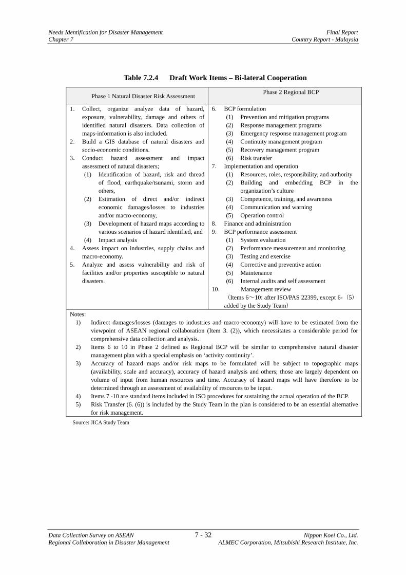
Needs Identification for Disaster Management Final Report Chapter 7 Country Report - Malaysia
Data Collection Survey on ASEAN 7 - 32 Nippon Koei Co., Ltd. Regional Collaboration in Disaster Management ALMEC Corporation, Mitsubishi Research Institute, Inc.
Table 7.2.4 Draft Work Items – Bi-lateral Cooperation
Phase 1 Natural Disaster Risk Assessment Phase 2 Regional BCP
1. Collect, organize analyze data of hazard,
exposure, vulnerability, damage and others of identified natural disasters. Data collection of maps-information is also included.
2. Build a GIS database of natural disasters and socio-economic conditions.
3. Conduct hazard assessment and impact assessment of natural disasters; (1) Identification of hazard, risk and thread
of flood, earthquake/tsunami, storm and others,
(2) Estimation of direct and/or indirect economic damages/losses to industries and/or macro-economy,
(3) Development of hazard maps according to various scenarios of hazard identified, and
(4) Impact analysis 4. Assess impact on industries, supply chains and
macro-economy. 5. Analyze and assess vulnerability and risk of
facilities and/or properties susceptible to natural disasters.
6. BCP formulation (1) Prevention and mitigation programs (2) Response management programs (3) Emergency response management program (4) Continuity management program (5) Recovery management program (6) Risk transfer
7. Implementation and operation (1) Resources, roles, responsibility, and authority (2) Building and embedding BCP in the
organization’s culture (3) Competence, training, and awareness (4) Communication and warning (5) Operation control
8. Finance and administration 9. BCP performance assessment
(1) System evaluation (2) Performance measurement and monitoring (3) Testing and exercise (4) Corrective and preventive action (5) Maintenance (6) Internal audits and self assessment
10. Management review (Items 6~10: after ISO/PAS 22399, except 6-(5) added by the Study Team)
Notes: 1) Indirect damages/losses (damages to industries and macro-economy) will have to be estimated from the
viewpoint of ASEAN regional collaboration (Item 3. (2)), which necessitates a considerable period for comprehensive data collection and analysis.
2) Items 6 to 10 in Phase 2 defined as Regional BCP will be similar to comprehensive natural disaster management plan with a special emphasis on ‘activity continuity’.
3) Accuracy of hazard maps and/or risk maps to be formulated will be subject to topographic maps (availability, scale and accuracy), accuracy of hazard analysis and others; those are largely dependent on volume of input from human resources and time. Accuracy of hazard maps will have therefore to be determined through an assessment of availability of resources to be input.
4) Items 7 -10 are standard items included in ISO procedures for sustaining the actual operation of the BCP. 5) Risk Transfer (6. (6)) is included by the Study Team in the plan is considered to be an essential alternative
for risk management. Source: JICA Study Team
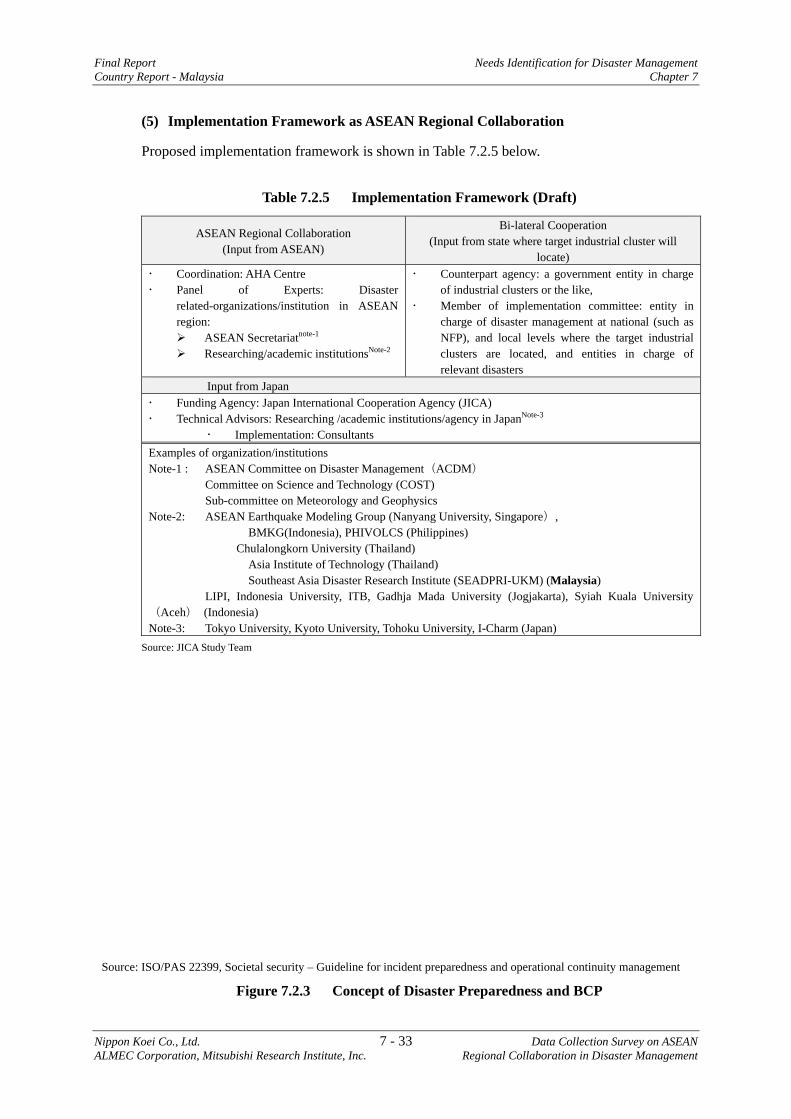
Final Report Needs Identification for Disaster Management Country Report - Malaysia Chapter 7
Nippon Koei Co., Ltd. 7 - 33 Data Collection Survey on ASEAN ALMEC Corporation, Mitsubishi Research Institute, Inc. Regional Collaboration in Disaster Management
(5) Implementation Framework as ASEAN Regional Collaboration
Proposed implementation framework is shown in Table 7.2.5 below.
Table 7.2.5 Implementation Framework (Draft)
ASEAN Regional Collaboration (Input from ASEAN)
Bi-lateral Cooperation (Input from state where target industrial cluster will
locate) Coordination: AHA Centre Panel of Experts: Disaster
related-organizations/institution in ASEAN region:
ASEAN Secretariatnote-1 Researching/academic institutionsNote-2
Counterpart agency: a government entity in charge of industrial clusters or the like,
Member of implementation committee: entity in charge of disaster management at national (such as NFP), and local levels where the target industrial clusters are located, and entities in charge of relevant disasters
Input from Japan Funding Agency: Japan International Cooperation Agency (JICA) Technical Advisors: Researching /academic institutions/agency in JapanNote-3
Implementation: Consultants Examples of organization/institutions Note-1 : ASEAN Committee on Disaster Management(ACDM) Committee on Science and Technology (COST) Sub-committee on Meteorology and Geophysics Note-2: ASEAN Earthquake Modeling Group (Nanyang University, Singapore),
BMKG(Indonesia), PHIVOLCS (Philippines) Chulalongkorn University (Thailand) Asia Institute of Technology (Thailand) Southeast Asia Disaster Research Institute (SEADPRI-UKM) (Malaysia)
LIPI, Indonesia University, ITB, Gadhja Mada University (Jogjakarta), Syiah Kuala University(Aceh) (Indonesia) Note-3: Tokyo University, Kyoto University, Tohoku University, I-Charm (Japan)
Source: JICA Study Team
Source: ISO/PAS 22399, Societal security – Guideline for incident preparedness and operational continuity management
Figure 7.2.3 Concept of Disaster Preparedness and BCP

Needs Identification for Disaster Management Final Report
Chapter 7 Country Report - Malaysia
Data Collection Survey on ASEAN 7 - 34 Nippon Koei Co., Ltd.
Regional Collaboration in Disaster Management ALMEC Corporation, Mitsubishi Research Institute, Inc.
7.2.4 Earthquake and Tsunami Disaster Management in Member Countries Facing South China Sea, Sulu Sea, and Celebes Sea24
(1) Background
In the western offshore area of the Philippine Island, many trench structures are formed such as Manila Trench, Negros Trench, Sulu Trench, and Cotabato Trench. In the northern offshore area of Sulawesi Island in Indonesia, Minahasa Trench and Celebes Trench are distributed.
Out of these, USGS pointed out that there is a possibility of strong earthquake occurrence at M 8.5~9.0 in Manila Trench in near future. In case of occurrence of earthquake at this magnitude, not only an earthquake damage the Philippines, but also tsunami disaster will occur at the east central coast of Vietnam, Saba Sarawak area in Malaysia, and coastal area of Brunei. Other five trenches are also considered to be as possible sources of strong earthquakes accompanied with tsunamis.
Disaster management agencies of each country have already recognized the possibility of strong earthquake and tsunami originating in Manila Trench. The coastal area of the central Vietnam is beach resort areas having a world heritage. Similarly, the coastal area of Saba Sarawak in Malaysia is designated as a priority development area according to Saba Development Corridor Blue Print 2008~2025. At Seria coast in Brunei, petroleum and natural gas processing and exporting facilities are developed.
Once a strong earthquake and tsunami occur as pointed out by USGS and other researchers, such areas will possibly be severely affected. It is therefore recommended to implement (a) research on earthquake and tsunami and (b) formulation of disaster management plan in the western coast of the Philippines, central part of Vietnam coast, coastal area of Saba Sarawak, Brunei, and northern coast of Sulawesi Island in Indonesia.
Source: Tsunami simulation by MHD, Malaysia; locations of trenches added by JICA Study Team
Figure 7.2.4 Techtronic Trenches in South China Sea, Sulu Sea and Celebes Sea
24 This issue was raised by the countries facing the seas; and was presented by the Study Team to the representatives from 10 ASEAN countries at the workshop held on 11 June 2011 in Jakarta.
Final Report Needs Identification for Disaster Management Country Report - Malaysia Chapter 7
Nippon Koei Co., Ltd. 7 - 35 Data Collection Survey on ASEAN ALMEC Corporation, Mitsubishi Research Institute, Inc. Regional Collaboration in Disaster Management
(2) Purpose
a) To conduct research on earthquakes/tsunamis that could possibly occur in South China Sea, Sulu Sea, and Celebes Sea (ASEAN Collaboration),
b) To conduct impact/damage assessment through hazard mapping, c) To formulate disaster management plans, including monitoring, early warning
system and evacuation plan ( option only for bi-lateral cooperation),
(3) Target Area for Research/Study
a) The western coast of the Philippines, b) The coastal area of the central part of Vietnam, c) Coastal area of Saba Sarawak of Malaysia, d) Coastal area of Brunei, e) Northern coast of Sulawesi Island of Indonesia
(4) Research/Study Contents
Activities of collaborative research and study are proposed as follows.
Table 7.2.6 Activities to be Conducted (Draft)
ASEAN Regional Collaboration (ASEAN Collaborative Research)
Development Study for Bi-Lateral CooperationNote-1 (Brunei, Indonesia, Malaysia, Philippines, Vietnam)
(1) To conduct collaborative research on earthquake/tsunami in South China Sea, Sulu Sea, and Celebes Sea.
(2) To develop earthquake/tsunami models for the target hypo-central region.
(3) To conduct computerized tsunami simulations with various assumptions.
(4) To propose a scenario of earthquake for each hypo-central region.
(5) To propose overall framework of earthquake and tsunami monitoring and warning system.
(1) To review the scenario of earthquake in view of selected target areas.
(2) To conduct tsunami simulation based on scenario earthquake with bathymetric information.
(3) To estimate damages/losses with reasonably accurate topographic maps, especially for industry-invested area.
(4) To evaluate impact on economic activities and supply chain.
(5) To propose monitoring system for earthquake and tsunami.
(6) To propose tsunami early warning system. (7) To propose disaster management plan. (8) To conduct training on disaster management in related
countries. Source: JICA Study Team Note-1: Development study in member countries may start after scenario earthquakes are proposed from the
collaborative research.
(5) Implementation Framework
A similar framework as in the previous section is proposed in Table 7.2.5.
(6) Implementation Period
ASEAN Regional Collaboration : 24 months Bi-lateral cooperation : 24 months
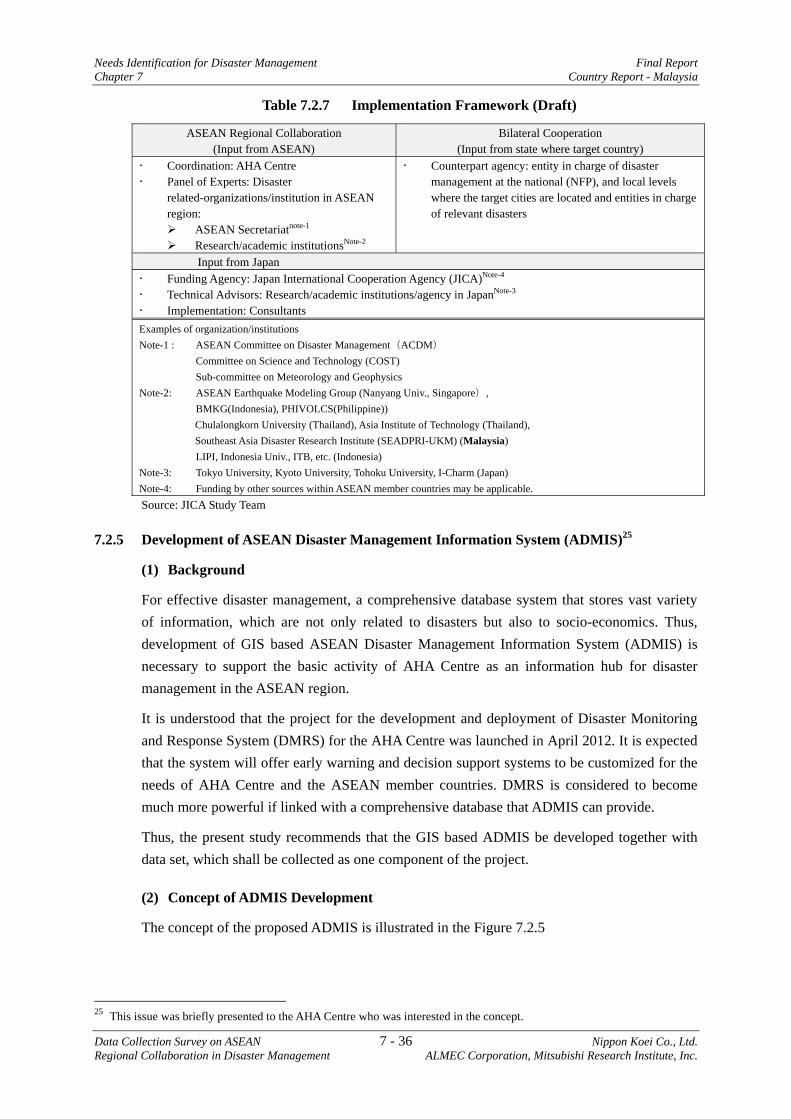
Needs Identification for Disaster Management Final Report Chapter 7 Country Report - Malaysia
Data Collection Survey on ASEAN 7 - 36 Nippon Koei Co., Ltd. Regional Collaboration in Disaster Management ALMEC Corporation, Mitsubishi Research Institute, Inc.
Table 7.2.7 Implementation Framework (Draft)
ASEAN Regional Collaboration (Input from ASEAN)
Bilateral Cooperation (Input from state where target country)
Coordination: AHA Centre Panel of Experts: Disaster
related-organizations/institution in ASEAN region:
ASEAN Secretariatnote-1 Research/academic institutionsNote-2
Counterpart agency: entity in charge of disaster management at the national (NFP), and local levels where the target cities are located and entities in charge of relevant disasters
Input from Japan Funding Agency: Japan International Cooperation Agency (JICA)Note-4 Technical Advisors: Research/academic institutions/agency in JapanNote-3 Implementation: Consultants
Examples of organization/institutions Note-1 : ASEAN Committee on Disaster Management(ACDM) Committee on Science and Technology (COST) Sub-committee on Meteorology and Geophysics Note-2: ASEAN Earthquake Modeling Group (Nanyang Univ., Singapore), BMKG(Indonesia), PHIVOLCS(Philippine))
Chulalongkorn University (Thailand), Asia Institute of Technology (Thailand), Southeast Asia Disaster Research Institute (SEADPRI-UKM) (Malaysia)
LIPI, Indonesia Univ., ITB, etc. (Indonesia) Note-3: Tokyo University, Kyoto University, Tohoku University, I-Charm (Japan) Note-4: Funding by other sources within ASEAN member countries may be applicable. Source: JICA Study Team
7.2.5 Development of ASEAN Disaster Management Information System (ADMIS)25
(1) Background
For effective disaster management, a comprehensive database system that stores vast variety of information, which are not only related to disasters but also to socio-economics. Thus, development of GIS based ASEAN Disaster Management Information System (ADMIS) is necessary to support the basic activity of AHA Centre as an information hub for disaster management in the ASEAN region.
It is understood that the project for the development and deployment of Disaster Monitoring and Response System (DMRS) for the AHA Centre was launched in April 2012. It is expected that the system will offer early warning and decision support systems to be customized for the needs of AHA Centre and the ASEAN member countries. DMRS is considered to become much more powerful if linked with a comprehensive database that ADMIS can provide.
Thus, the present study recommends that the GIS based ADMIS be developed together with data set, which shall be collected as one component of the project.
(2) Concept of ADMIS Development
The concept of the proposed ADMIS is illustrated in the Figure 7.2.5
25 This issue was briefly presented to the AHA Centre who was interested in the concept.
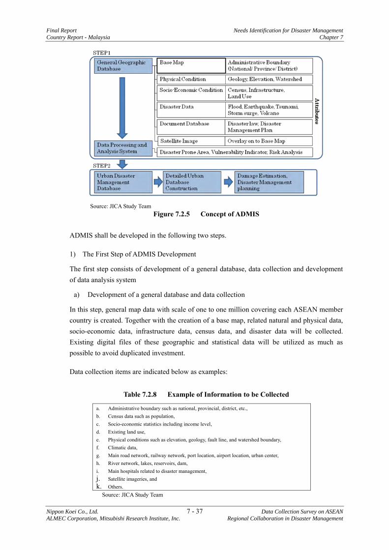
Final Report Needs Identification for Disaster Management
Country Report - Malaysia Chapter 7
Nippon Koei Co., Ltd. 7 - 37 Data Collection Survey on ASEAN
ALMEC Corporation, Mitsubishi Research Institute, Inc. Regional Collaboration in Disaster Management
Source: JICA Study Team
Figure 7.2.5 Concept of ADMIS
ADMIS shall be developed in the following two steps.
1) The First Step of ADMIS Development
The first step consists of development of a general database, data collection and development of data analysis system
a) Development of a general database and data collection
In this step, general map data with scale of one to one million covering each ASEAN member country is created. Together with the creation of a base map, related natural and physical data, socio-economic data, infrastructure data, census data, and disaster data will be collected. Existing digital files of these geographic and statistical data will be utilized as much as possible to avoid duplicated investment.
Data collection items are indicated below as examples:
Table 7.2.8 Example of Information to be Collected
a. Administrative boundary such as national, provincial, district, etc., b. Census data such as population, c. Socio-economic statistics including income level, d. Existing land use, e. Physical conditions such as elevation, geology, fault line, and watershed boundary, f. Climatic data, g. Main road network, railway network, port location, airport location, urban center, h. River network, lakes, reservoirs, dam, i. Main hospitals related to disaster management, j. Satellite imageries, and k. Others.
Source: JICA Study Team
Needs Identification for Disaster Management Final Report Chapter 7 Country Report - Malaysia
Data Collection Survey on ASEAN 7 - 38 Nippon Koei Co., Ltd. Regional Collaboration in Disaster Management ALMEC Corporation, Mitsubishi Research Institute, Inc.
Collected map data will be specifically manipulated to adjust its scale and legends, and finally integrated into a uniform projection system.
b) Development of data analysis system
Data processing and analysis system are among the important aspects, which will be developed for effective use of geographic database using the overlay technique, for example, the spatial analysis.
In addition to the development of data processing and analysis system, many numerical data will be analyzed and mapped to generate indicators to support decision making. General vulnerability indicators for example will be generated through the numerical data analysis, and mapped using the data processing and analysis system. These will result in general vulnerability maps. Thereafter, existing disaster prone areas will be combined with the general vulnerability maps to identify fundamentally problematic areas in the ASEAN region.
ADMIS will be linked with related database system or existing regional disaster management system such as flood risk analysis and earthquake disaster analysis.
2) The Second Step of ADMIS Development
The second step of ADMIS development will focus on detailed geographic database development for large or megacity disaster management system. Large topographic maps with scales such as 1:2,500 or 1:5,000 will be collected /generated in this system for the creation of a detailed database system. Similar information is listed in Table 7.2.8 although more detailed information shall be collected.
AHA Centre will conduct the necessary systems operation and maintenance through effective use of GIS-based ADMIS for disaster management.
(3) Issues to be solved for ADMIS Development
In order to develop ADMIS, the member countries shall agree on map data sharing system including the scale, projection system and accuracy, data collection and dissemination methodology in disaster management field.
Specific cooperation with AHA Centre will be needed to make a general agreement for ADMIS development, similar to the cooperation being conducted for the development of ASEAN Guideline on flood risk assessment.
(4) Implementation Framework
The study proposes the following framework for implementation. The AHA Centre is expected to act as the coordinator for the project.
Final Report Needs Identification for Disaster Management Country Report - Malaysia Chapter 7
Nippon Koei Co., Ltd. 7 - 39 Data Collection Survey on ASEAN ALMEC Corporation, Mitsubishi Research Institute, Inc. Regional Collaboration in Disaster Management
Table 7.2.9 Activities to be conducted
ASEAN Regional Collaboration In Each Member State Creation of ADMIS Collection of information for the database system.
The information to be collected will also be provided to each member state for the creation of their own database system, which may be implemented in the next stage.
Source: JICA Study Team
Table 7.2.10 Implementation Framework
ASEAN Regional Collaboration In Each Member State Counterpart/coordination: AHA Centre Implementation: Consultants Cooperation: PDC*1
Collaboration: the ASEAN member countries
Funding agency: Japan International Cooperation Agency (JICA) Note *1: Pacific disaster center implemented DMRS project Source: JICA Study Team
(5) Implementation Period
1. Preparation : 6 months 2. Data collection in the ASEAN member countries : 6 months 3. Development of database, creation of analysis system : 9 months Total : 21 months
7.2.6 Disaster Information System in Major Cities of ASEAN Region with ASEAN Common Data Format26
(1) Background
In order to materialize the disaster risk reduction, conducting disaster risk assessment should be a prerequisite condition. This will require various sets of information regarding past disaster records, socio-economic conditions, natural, and physical constitutions, and so on. Therefore, DMIS should be introduced to integrate such valuable information. The DMIS will also be utilized for formulation of disaster management plan, as a decision making tool when disasters occur as well as data accumulation of disaster related information. Though little autonomy of ASEAN countries has introduced such DMIS at present, it is expected for them to introduce soon the DMIS for disaster risk management.
The AHA Centre, as the coordinating body of ASEAN disaster management, should be linked to the DMIS of ASEAN member countries for smooth coordination with shared information. For this purpose, data type, accuracy, format, and so on of essential information will have to be standardized among the ASEAN member countries.
This proposed program will provide standard format of data, which will be stored as part of the database in DMIS of the ASEAN member countries. It will also build the DMIS for
26 This issue is proposed by the JICA Study Team in this report.
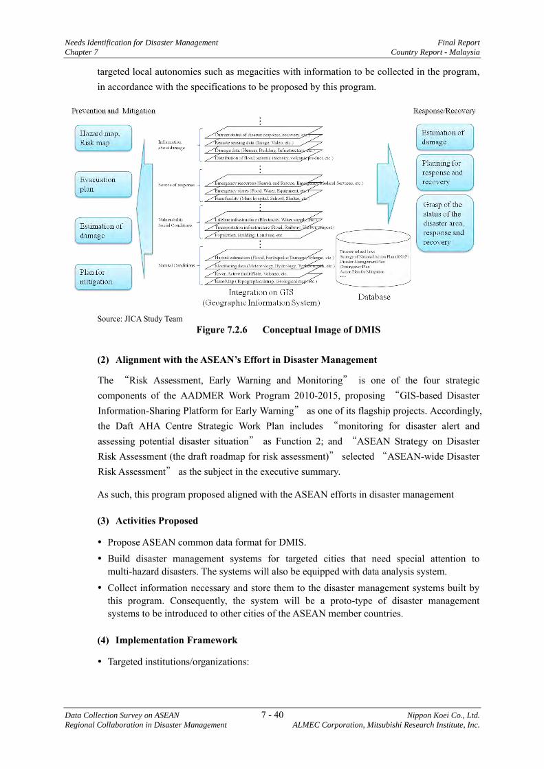
Needs Identification for Disaster Management Final Report
Chapter 7 Country Report - Malaysia
Data Collection Survey on ASEAN 7 - 40 Nippon Koei Co., Ltd.
Regional Collaboration in Disaster Management ALMEC Corporation, Mitsubishi Research Institute, Inc.
targeted local autonomies such as megacities with information to be collected in the program, in accordance with the specifications to be proposed by this program.
Source: JICA Study Team
Figure 7.2.6 Conceptual Image of DMIS
(2) Alignment with the ASEAN’s Effort in Disaster Management
The “Risk Assessment, Early Warning and Monitoring” is one of the four strategic components of the AADMER Work Program 2010-2015, proposing “GIS-based Disaster Information-Sharing Platform for Early Warning” as one of its flagship projects. Accordingly, the Daft AHA Centre Strategic Work Plan includes “monitoring for disaster alert and assessing potential disaster situation” as Function 2; and “ASEAN Strategy on Disaster Risk Assessment (the draft roadmap for risk assessment)” selected “ASEAN-wide Disaster Risk Assessment” as the subject in the executive summary.
As such, this program proposed aligned with the ASEAN efforts in disaster management
(3) Activities Proposed
Propose ASEAN common data format for DMIS. Build disaster management systems for targeted cities that need special attention to
multi-hazard disasters. The systems will also be equipped with data analysis system. Collect information necessary and store them to the disaster management systems built by
this program. Consequently, the system will be a proto-type of disaster management systems to be introduced to other cities of the ASEAN member countries.
(4) Implementation Framework
Targeted institutions/organizations:
Final Report Needs Identification for Disaster Management Country Report - Malaysia Chapter 7
Nippon Koei Co., Ltd. 7 - 41 Data Collection Survey on ASEAN ALMEC Corporation, Mitsubishi Research Institute, Inc. Regional Collaboration in Disaster Management
Table 7.2.11 Targeted Institutions/ Organizations
Outputs Target institutions/organization Proposing ASEAN common data format of disaster management systems
ASEAN member countries through AHA Centre
Building DMIS with necessary data collection Mega cities to be proposed Source: JICA Study Team
Coordination: AHA Centre Implementation: Consultants Funding Agency: JICA
(5) Period Required
Formulation ASEAN Common data format :6 months Data collection in targeted cities :6 months Database design, data input and data analysis system :9 months
7.2.7 Others Subjects for Collaborative Research
1) Research community based disaster, management with consideration of national/local cultures of ASEAN regions
2) Case studies of community disaster management exercised in the Great East Japan Earthquake and their applicability to the ASEAN region.
3) Research on psychology and reactions in cases of huge disaster, and its applicability to disaster management.
4) Research on effectiveness of mangrove forest against tsunami – case studies. 5) Research on effective promotion of evacuation exercise in ASEAN Countries 6) Research on disaster-proof infrastructure with optimized cost and benefits. 7) Research on comprehensive disaster risk assessment of megacities in ASEAN
countries. 8) Research on worst case scenario simulation for disaster management in ASEAN
region, leaning from the Great East Japan Earthquake.